Total solar eclipse of 03/18/2360
| Day of week: | Friday |
| Maximum duration of eclipse: | 04m33s |
| Maximum width of eclipse path: | 181 km |
| Saros cycle: | 145 |
| Coverage: | 100% |
| Magnitude: | 1.0549 |
| Gamma: | -0.0177 |
Wo kann man die Sonnenfinsternis vom 03/18/2360 sehen?
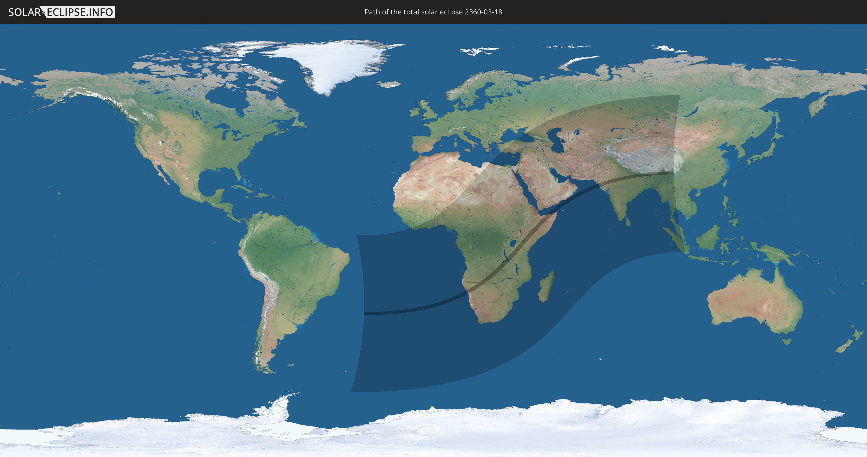
Die Sonnenfinsternis am 03/18/2360 kann man in 89 Ländern als partielle Sonnenfinsternis beobachten.
Der Finsternispfad verläuft durch 15 Länder. Nur in diesen Ländern ist sie als total Sonnenfinsternis zu sehen.
In den folgenden Ländern ist die Sonnenfinsternis total zu sehen
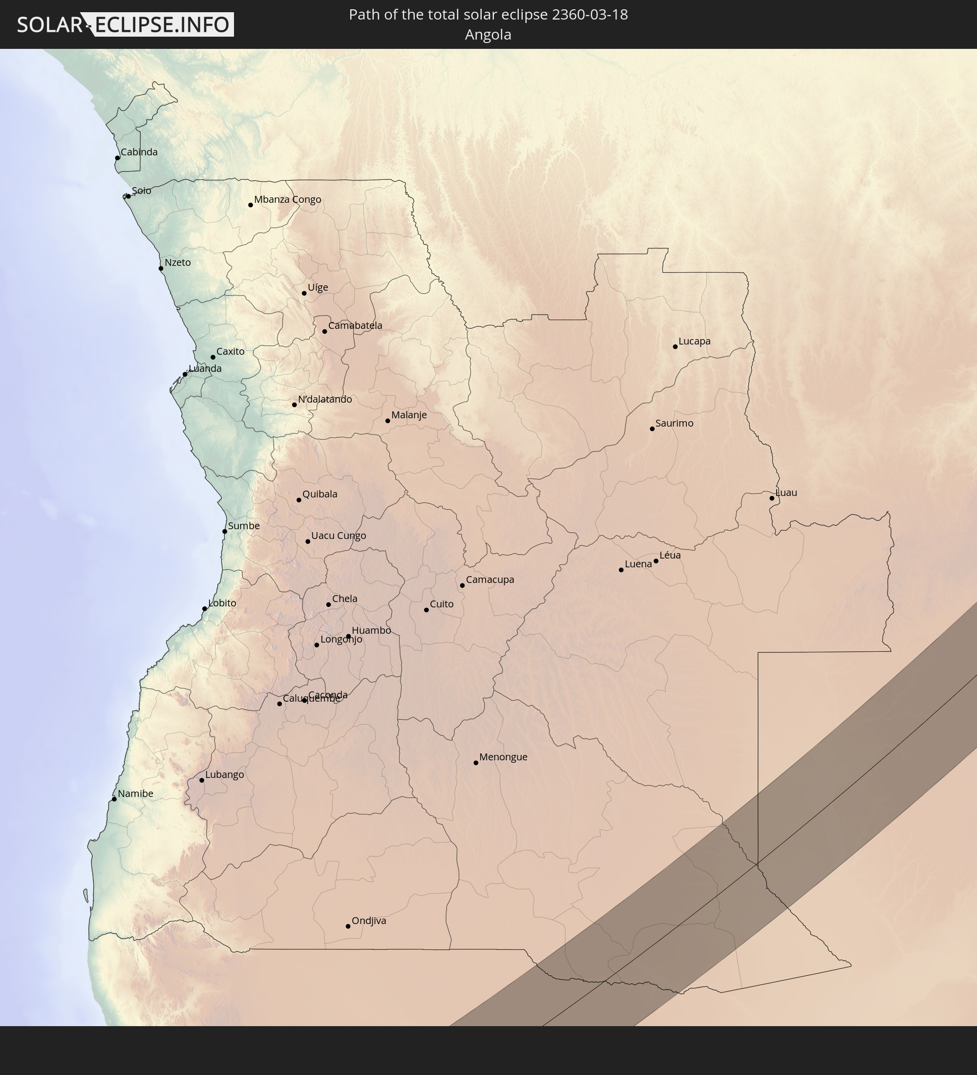 Angola
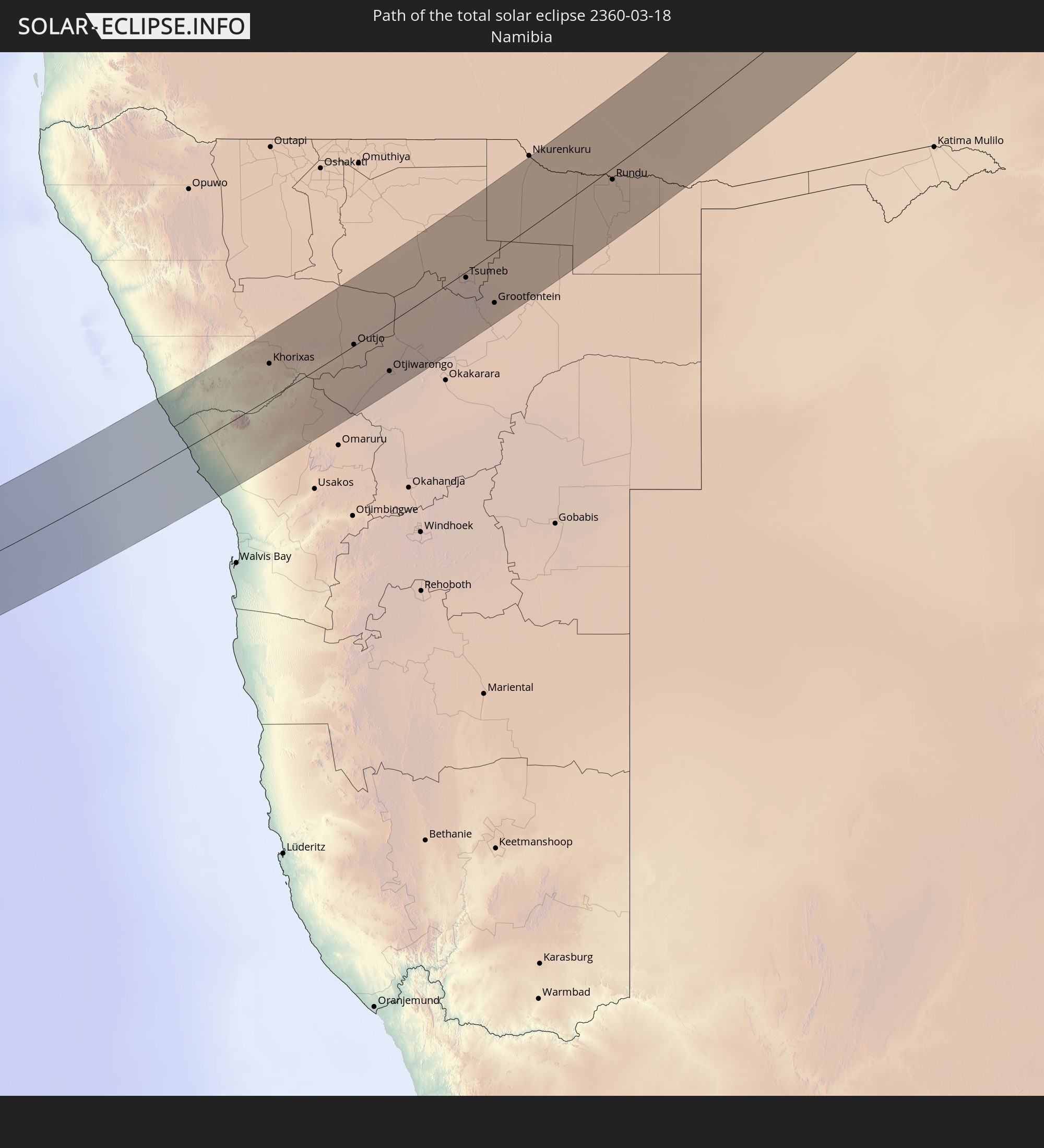 Namibia
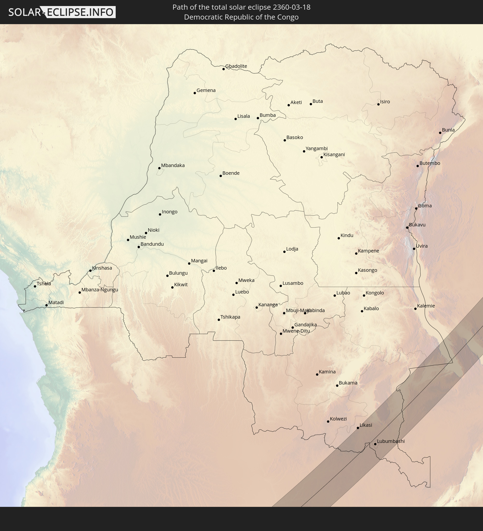 Democratic Republic of the Congo
 Zambia
 Tanzania
 Ethiopia
 Kenya
Kenya
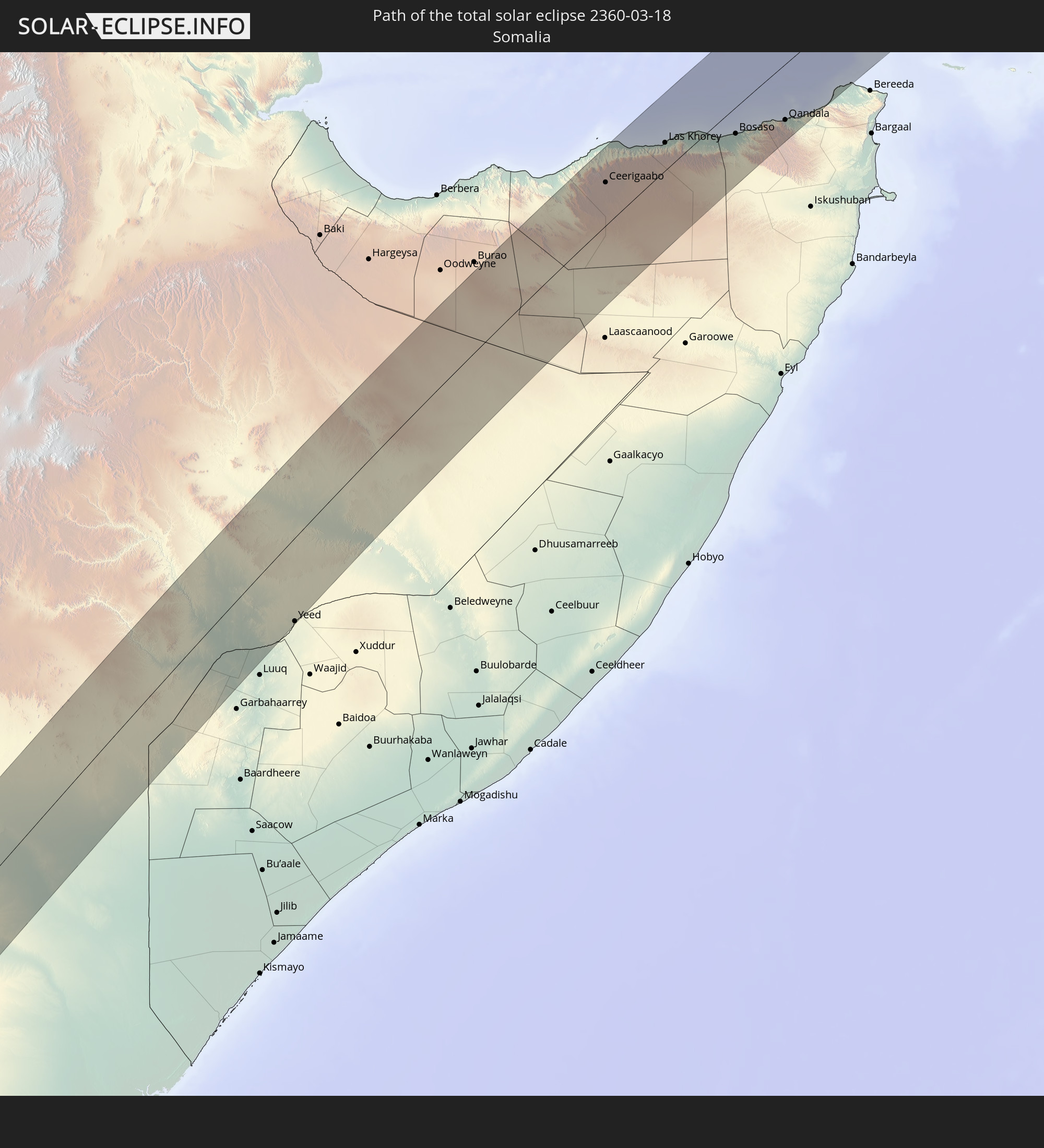 Somalia
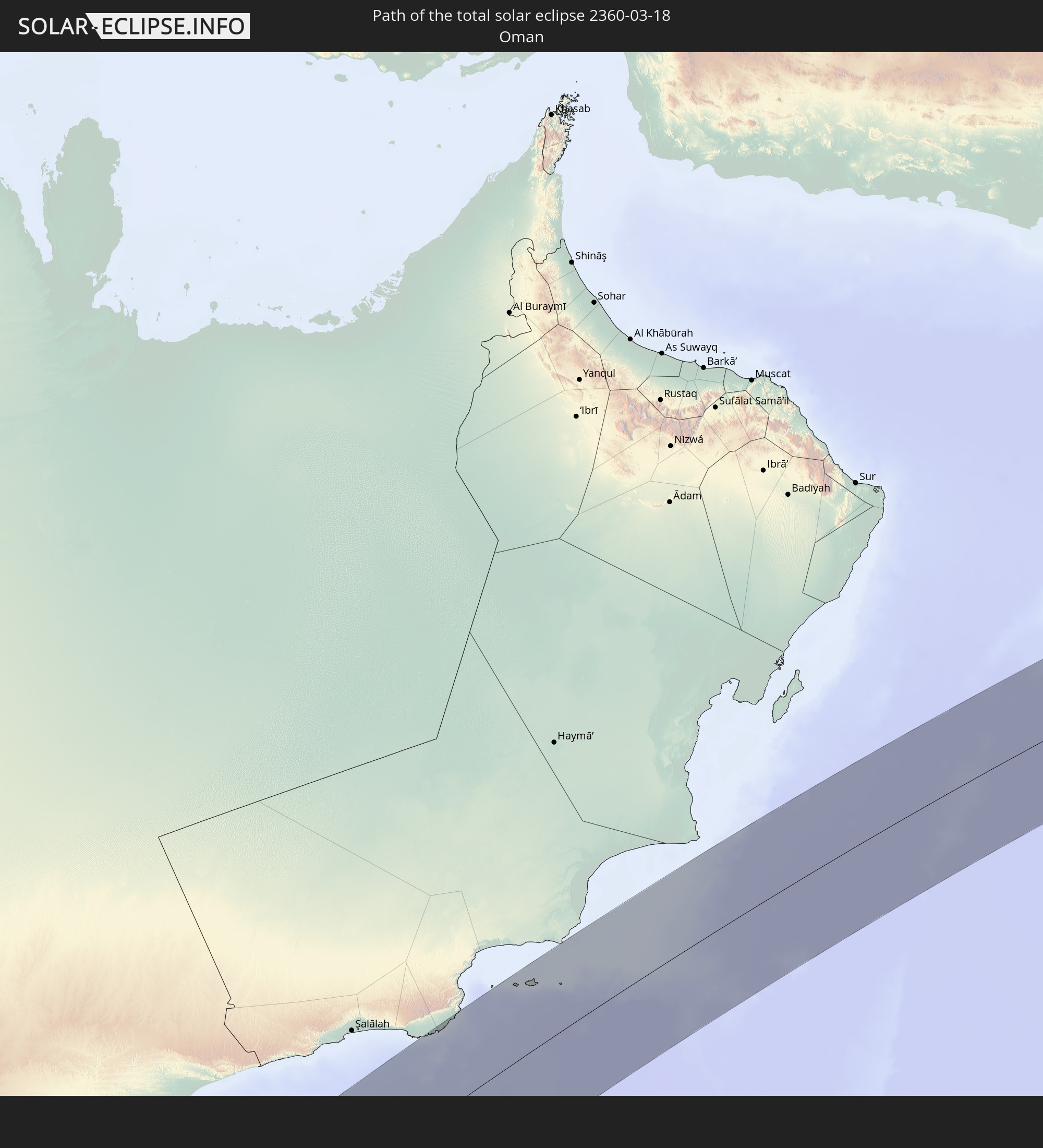 Oman
Oman
 Pakistan
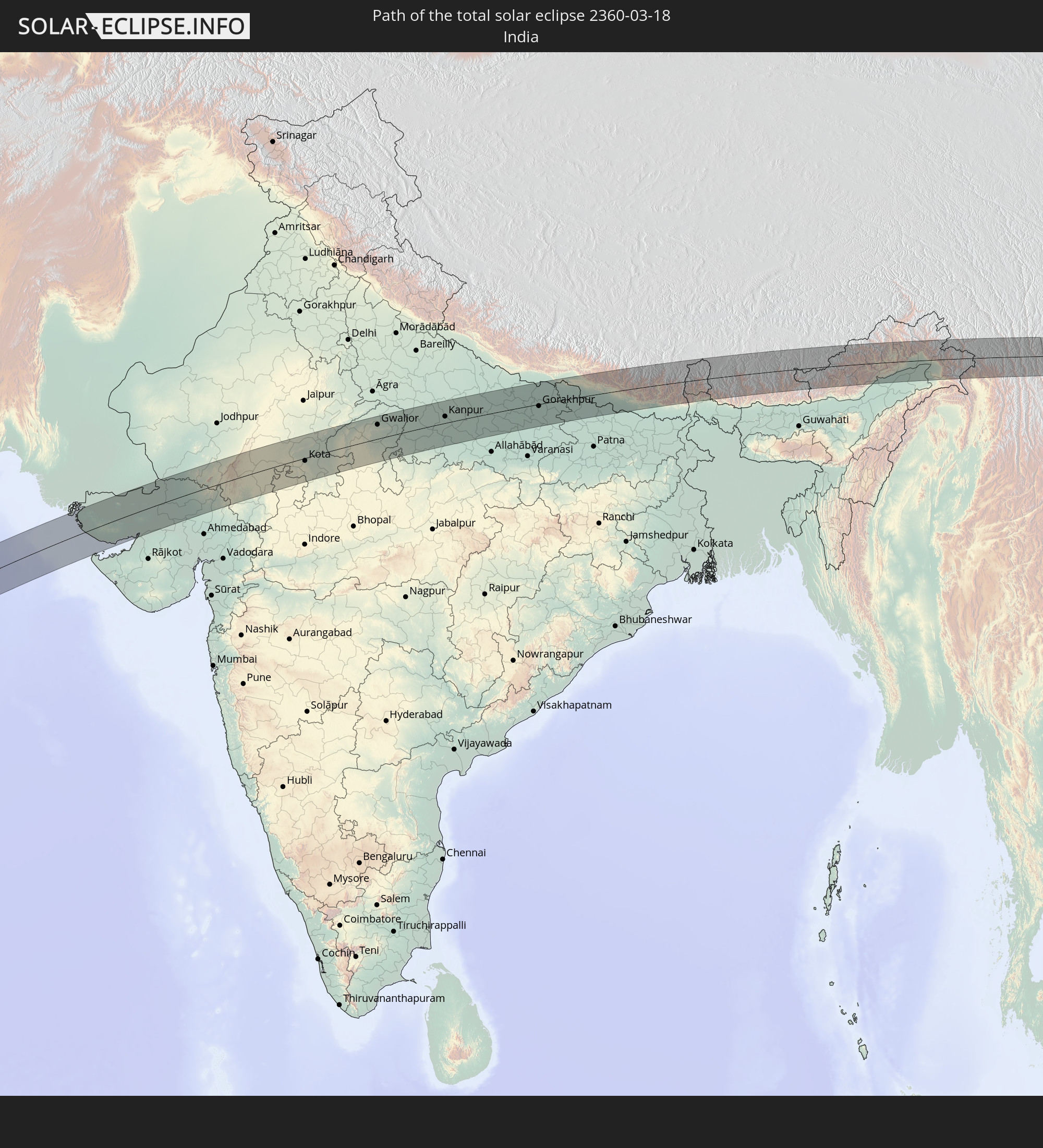 India
India
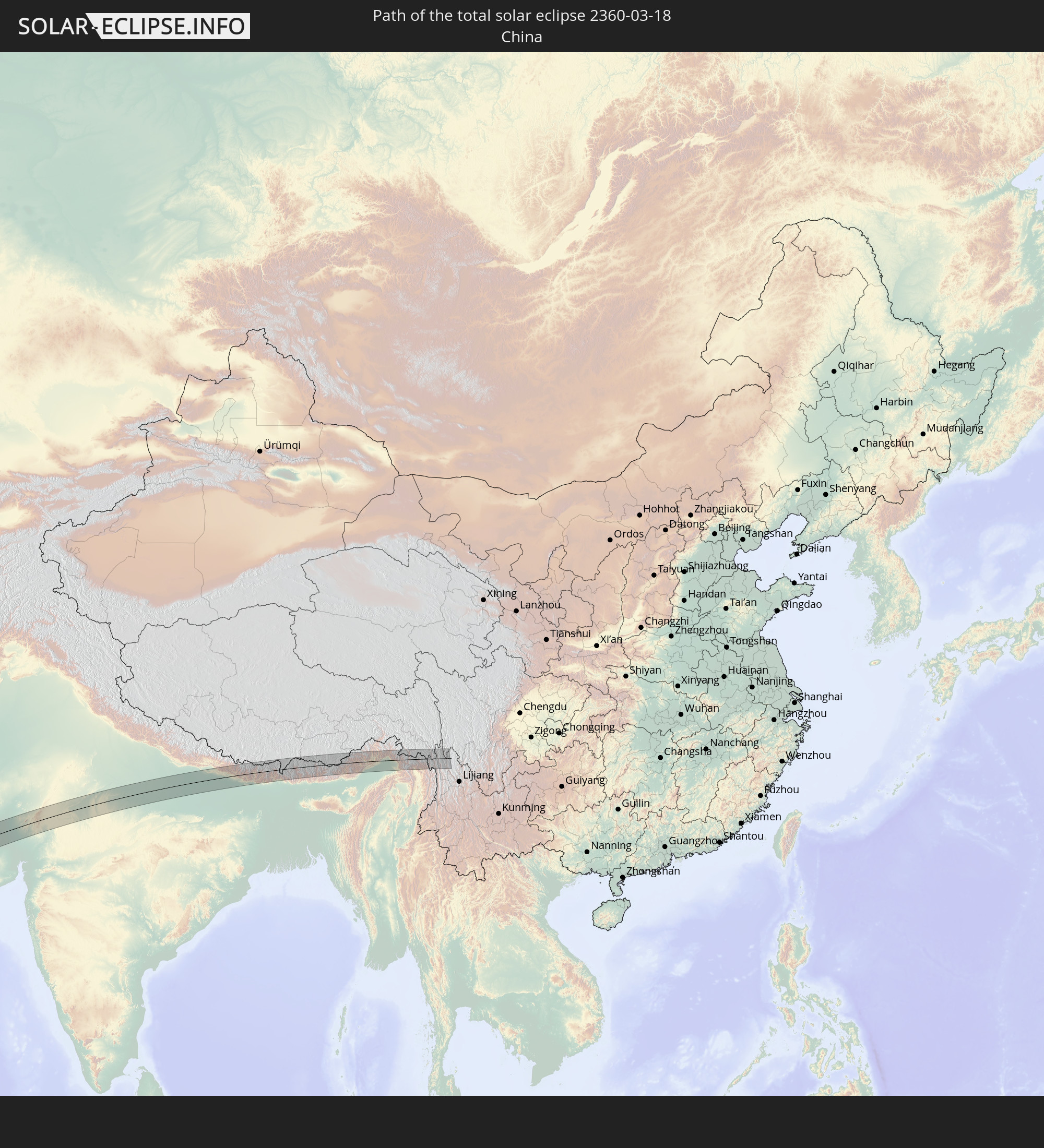 China
China
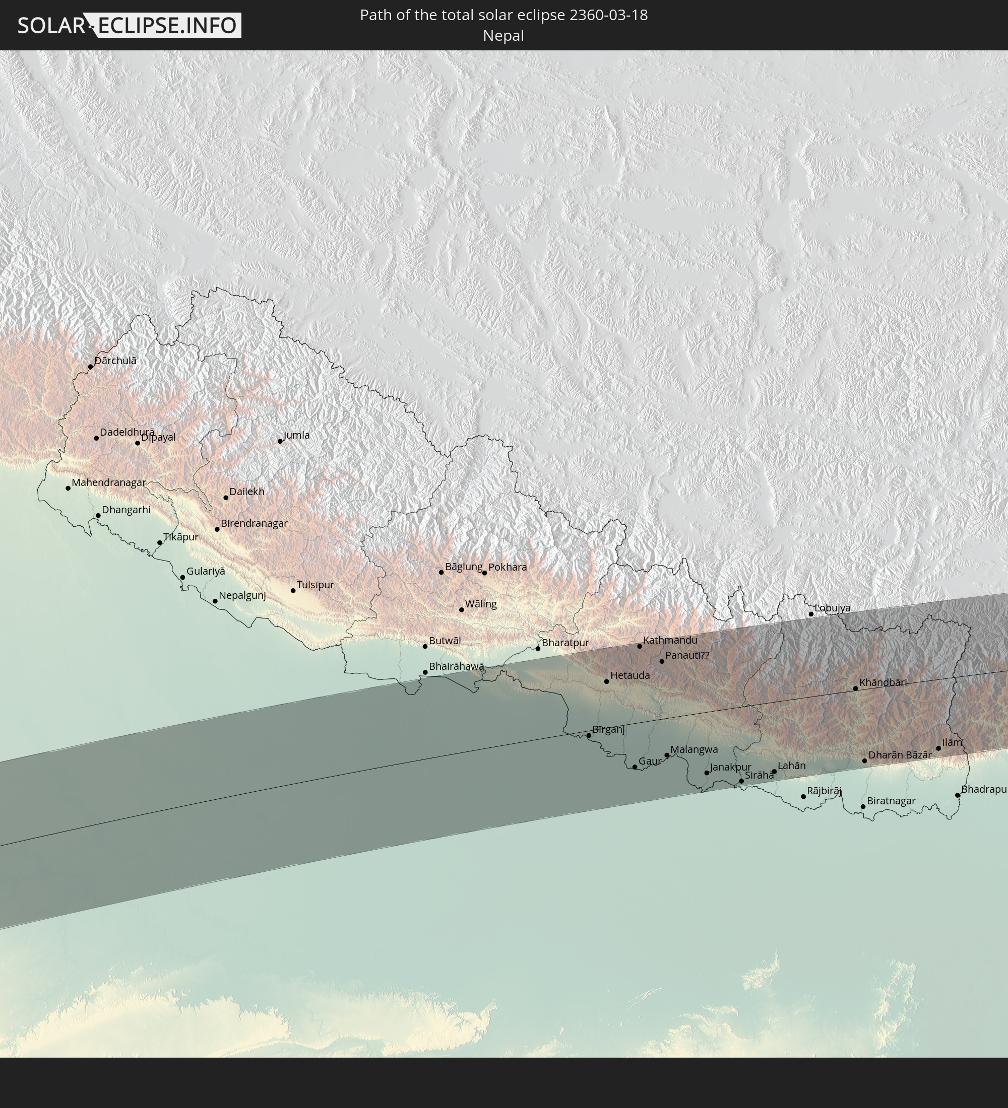 Nepal
Nepal
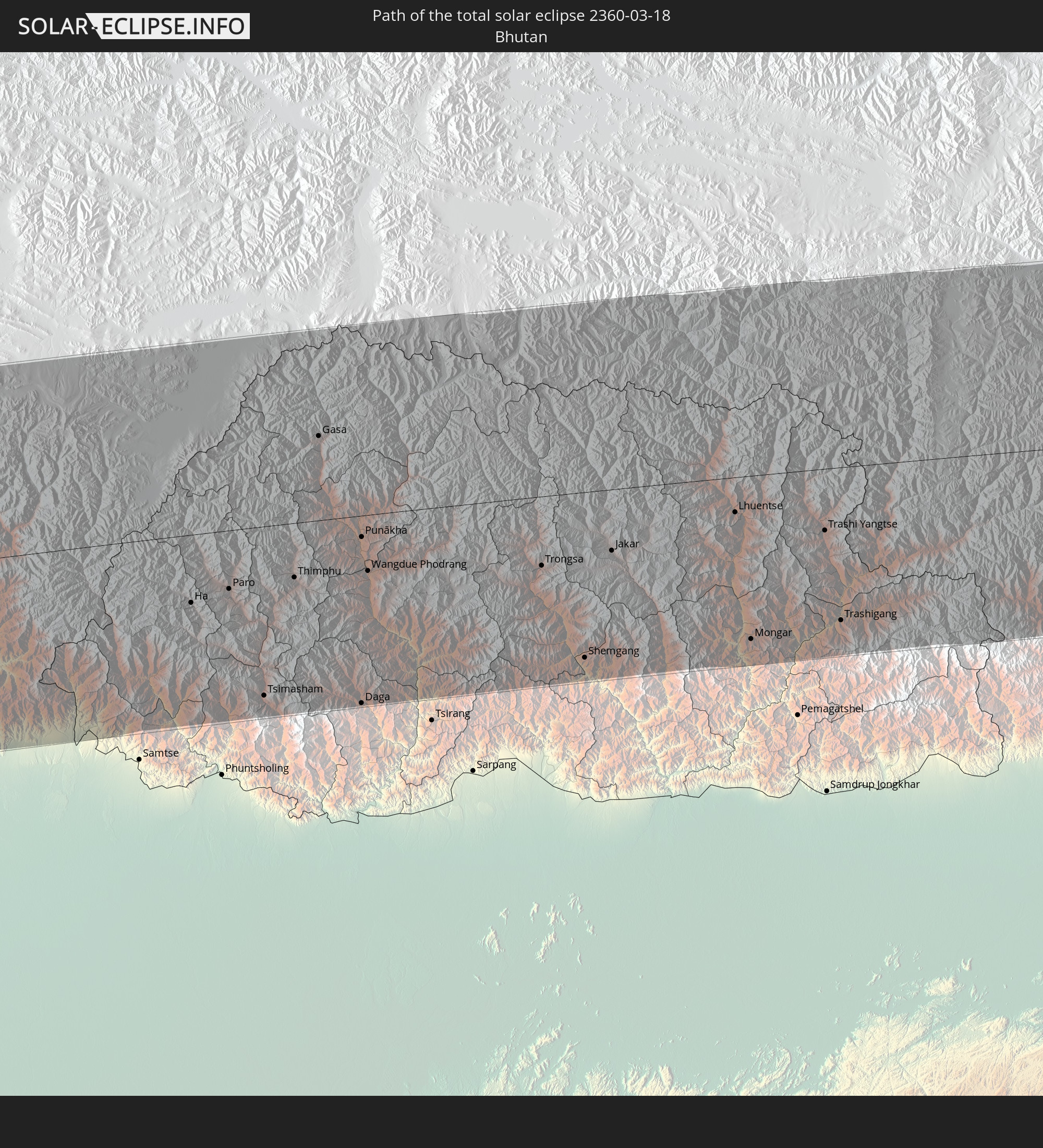 Bhutan
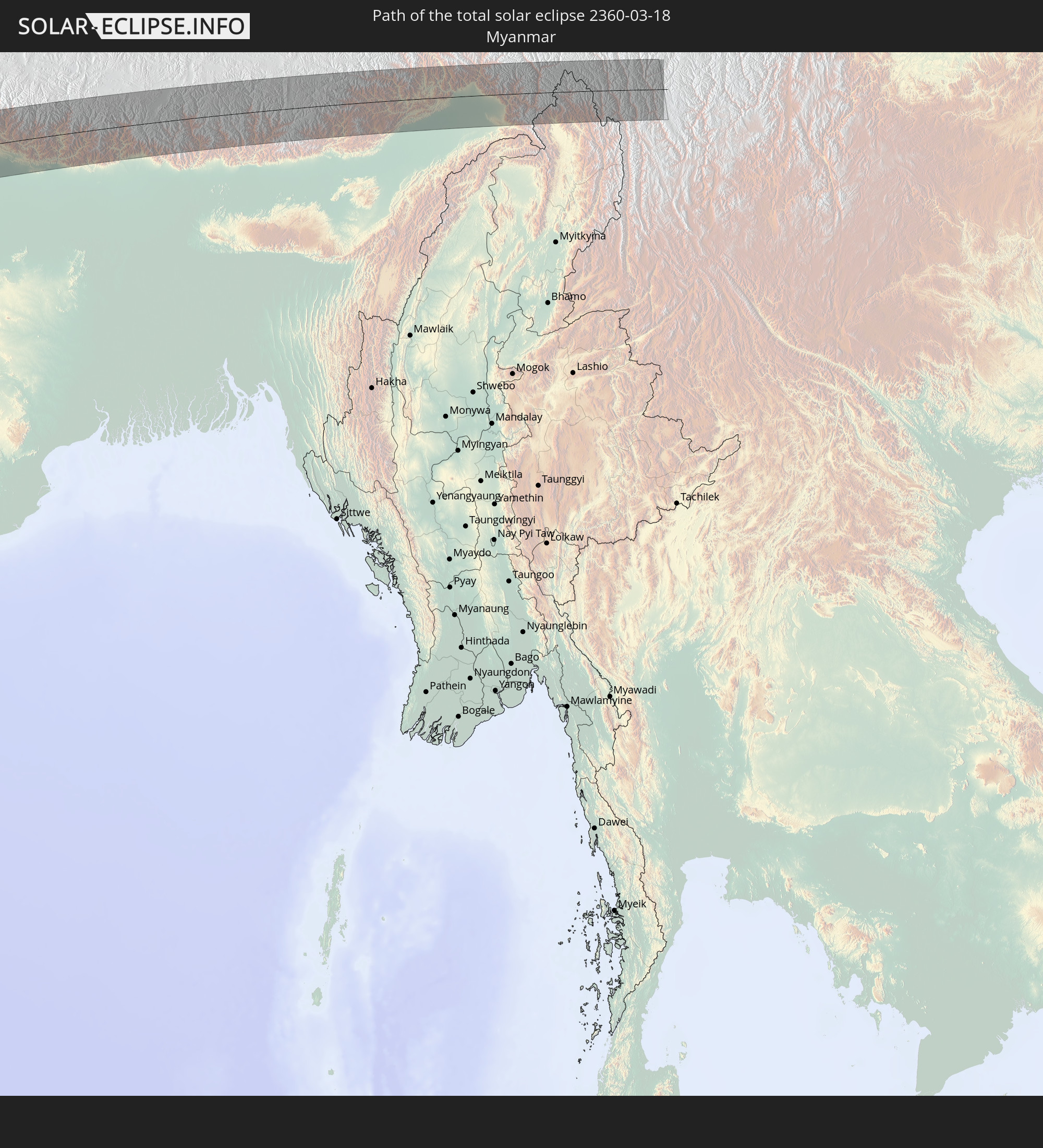 Myanmar
In den folgenden Ländern ist die Sonnenfinsternis partiell zu sehen
 Russia
 South Georgia and the South Sandwich Islands
 Saint Helena, Ascension and Tristan da Cunha
 Liberia
 Ivory Coast
 Ghana
Ghana
 Togo
Togo
 Niger
Niger
 Benin
Benin
 Nigeria
 Bouvet Island
 Equatorial Guinea
 São Tomé and Príncipe
 Cameroon
 Gabon
Gabon
 Libya
Libya
 Republic of the Congo
 Angola
 Namibia
 Democratic Republic of the Congo
 Chad
Chad
 Central African Republic
 South Africa
 Greece
 Botswana
 Sudan
Sudan
 Zambia
 Egypt
Egypt
 Zimbabwe
 Turkey
 Lesotho
 Rwanda
 Burundi
 Tanzania
 Uganda
 Mozambique
 Swaziland
 Cyprus
 Malawi
 Ethiopia
 Kenya
Kenya
 State of Palestine
 Israel
 Saudi Arabia
 Jordan
 Lebanon
 Syria
Syria
 Eritrea
 Iraq
Iraq
 Georgia
 French Southern and Antarctic Lands
 Somalia
 Djibouti
 Yemen
Yemen
 Madagascar
 Comoros
 Armenia
 Iran
Iran
 Azerbaijan
 Mayotte
 Seychelles
 Kazakhstan
 Kuwait
 Bahrain
 Qatar
Qatar
 United Arab Emirates
 Oman
Oman
 Turkmenistan
 Réunion
 Uzbekistan
 Mauritius
 Afghanistan
 Pakistan
 Tajikistan
 India
India
 Kyrgyzstan
 British Indian Ocean Territory
 Maldives
 China
China
 Sri Lanka
 Nepal
Nepal
 Mongolia
 Bangladesh
 Bhutan
 Myanmar
 Indonesia
 Thailand
 Malaysia
 Laos
Laos
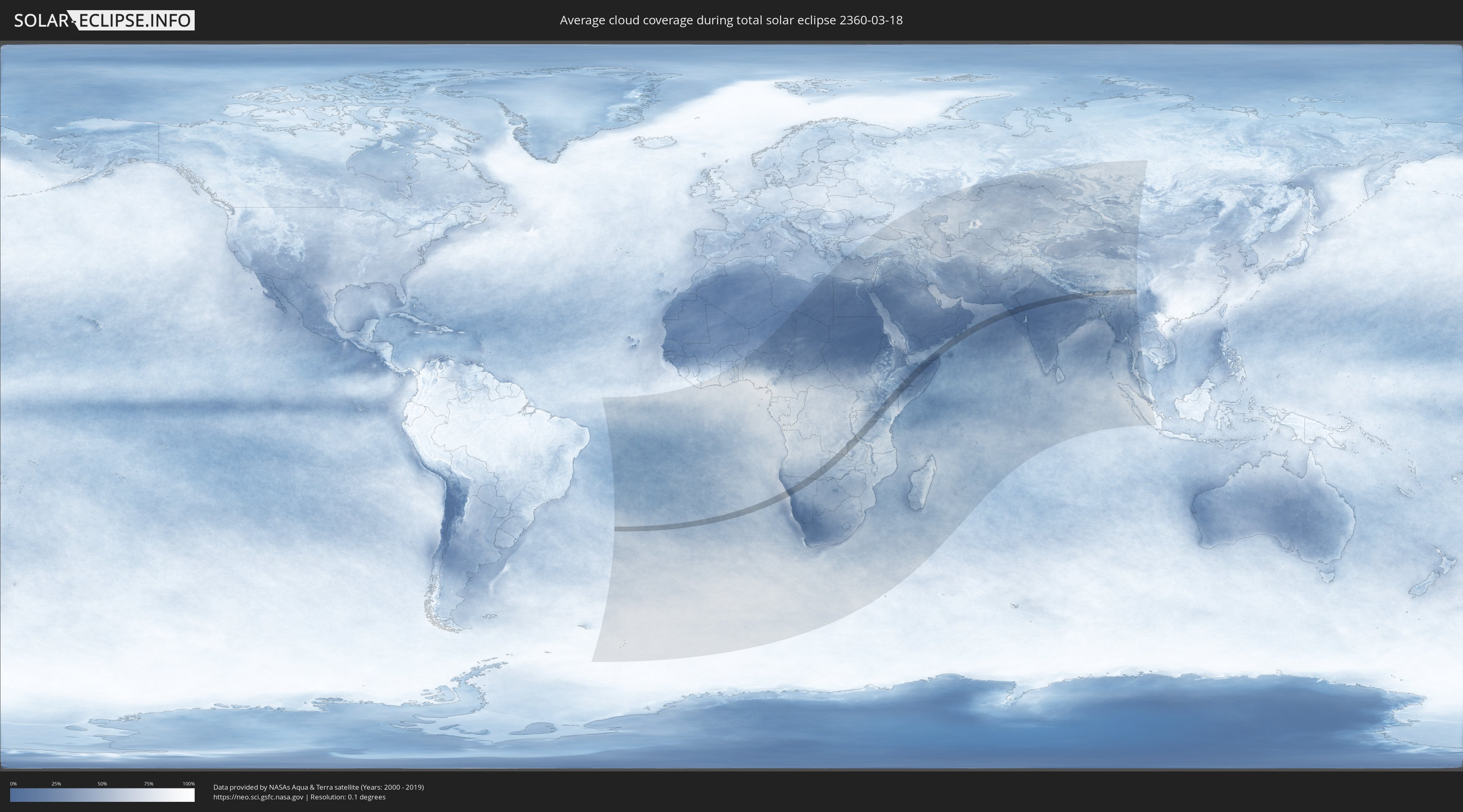
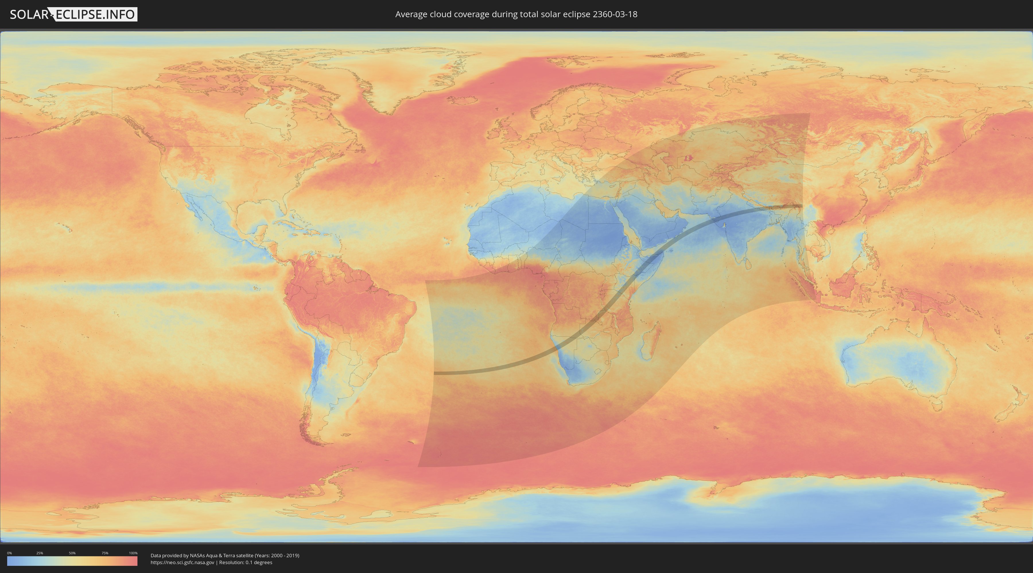
How will be the weather during the total solar eclipse on 03/18/2360?
Where is the best place to see the total solar eclipse of 03/18/2360?
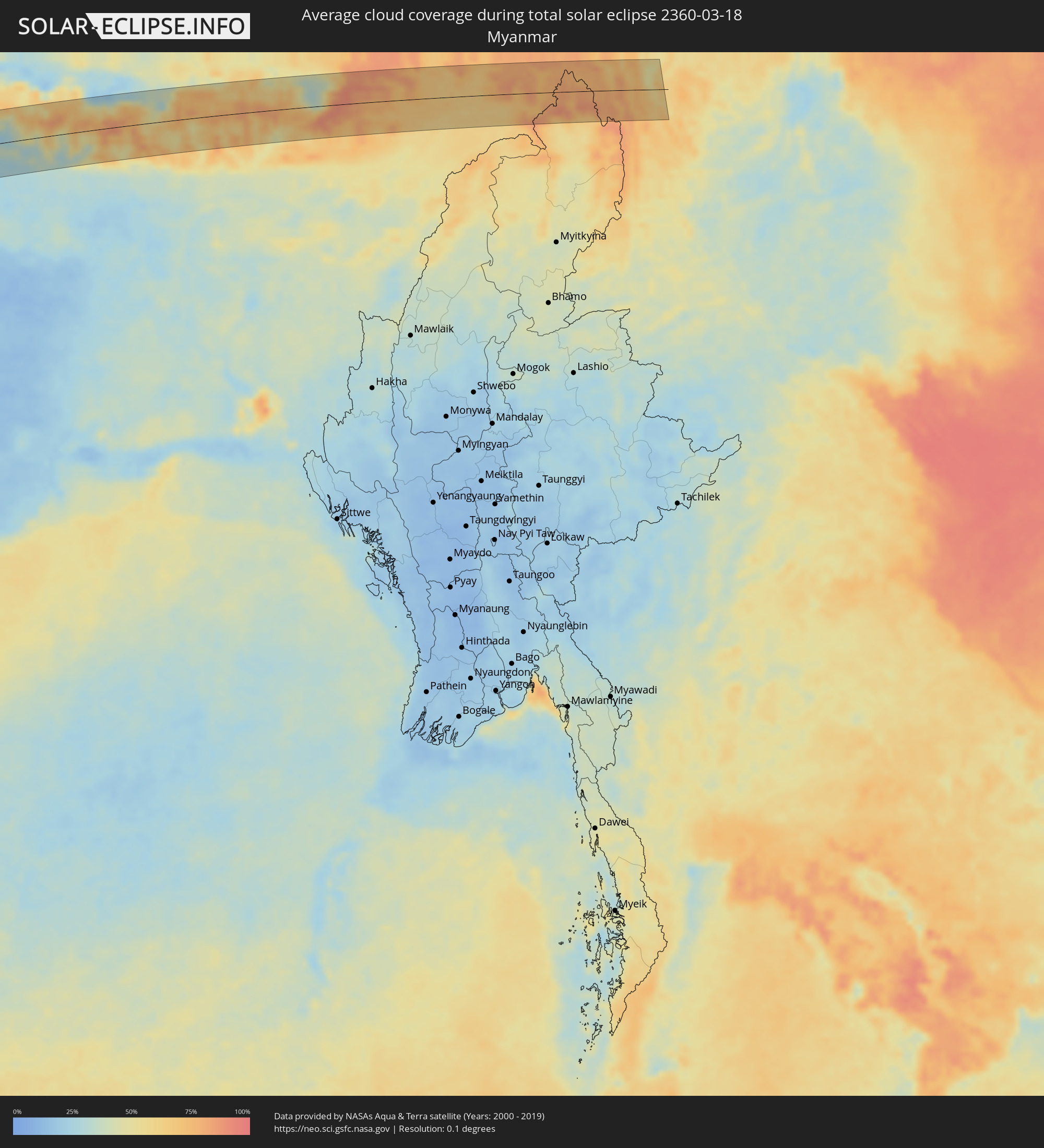
The following maps show the average cloud coverage for the day of the total solar eclipse.
With the help of these maps, it is possible to find the place along the eclipse path, which has the best
chance of a cloudless sky.
Nevertheless, you should consider local circumstances and inform about the weather of your chosen
observation site.
The data is provided by NASAs satellites
AQUA and TERRA.
The cloud maps are averaged over a period of 19 years (2000 - 2019).
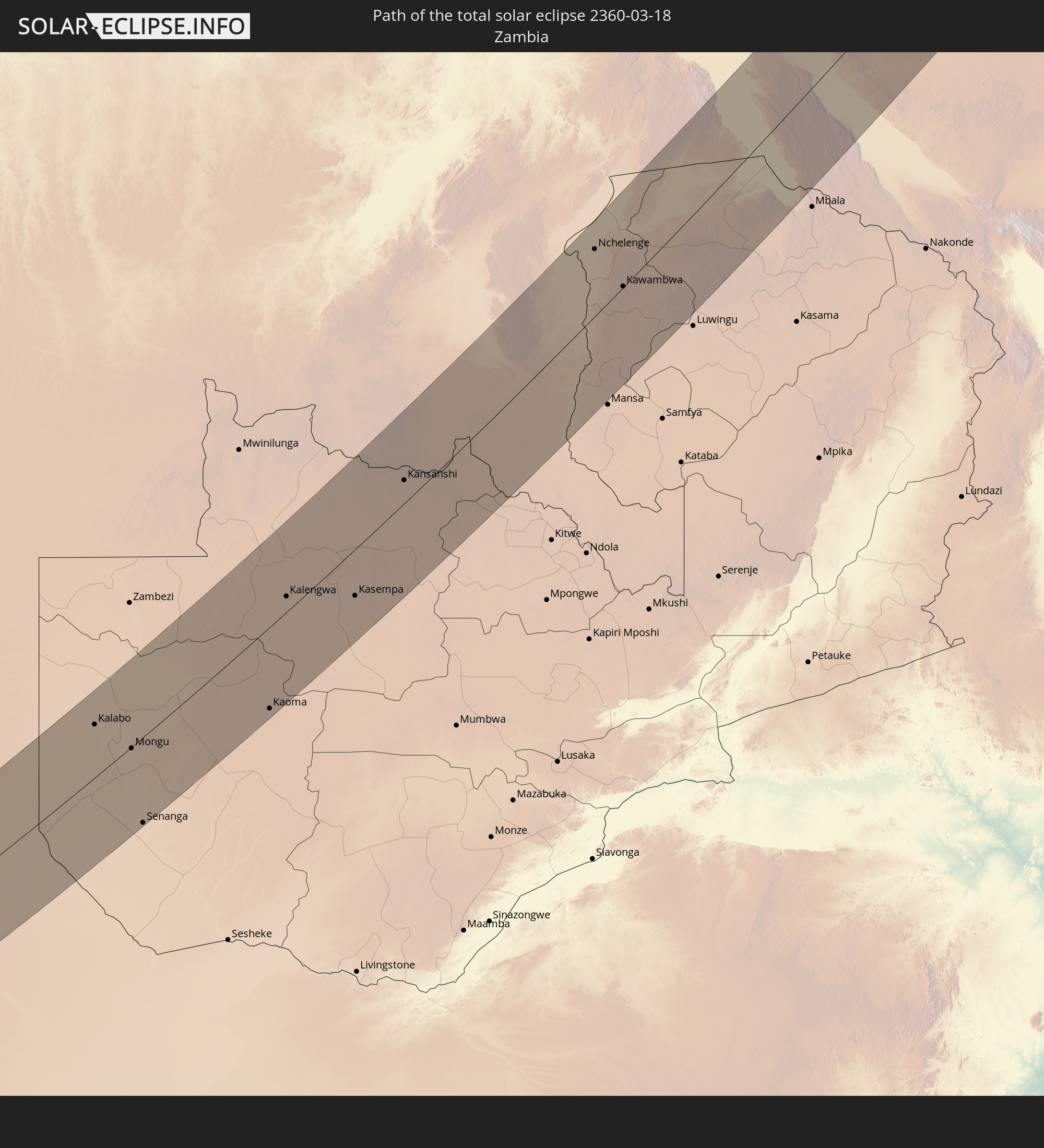
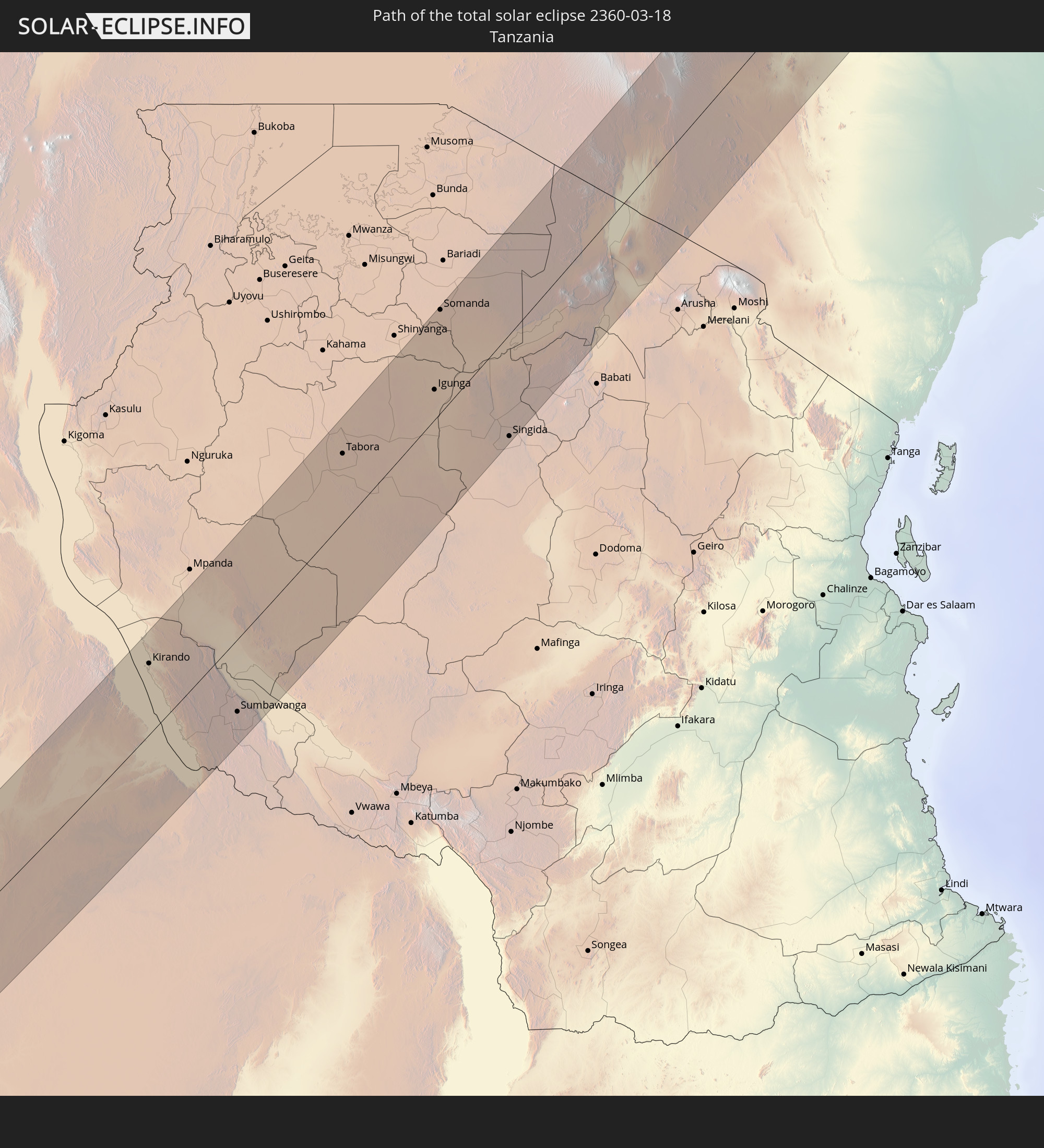
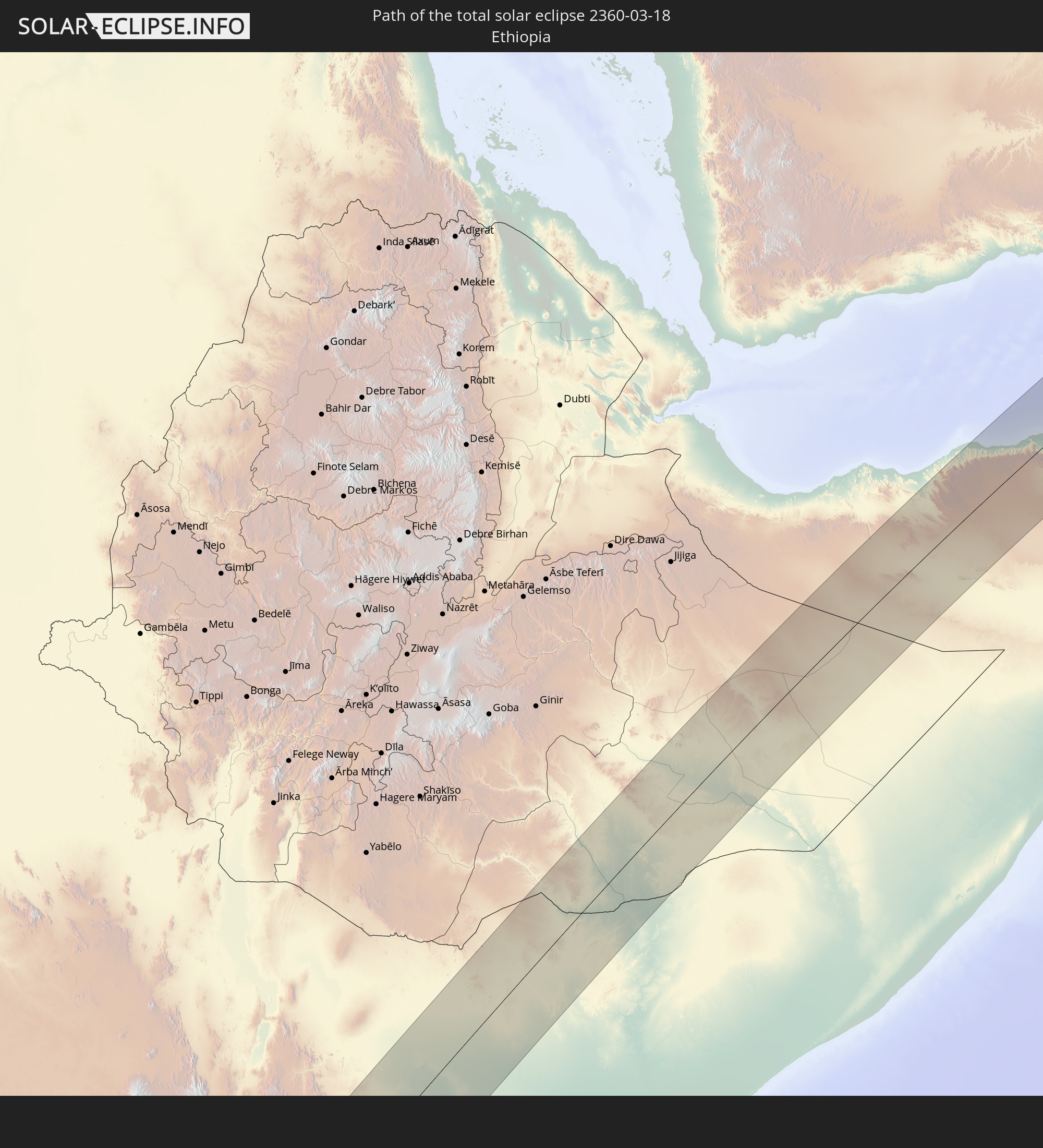
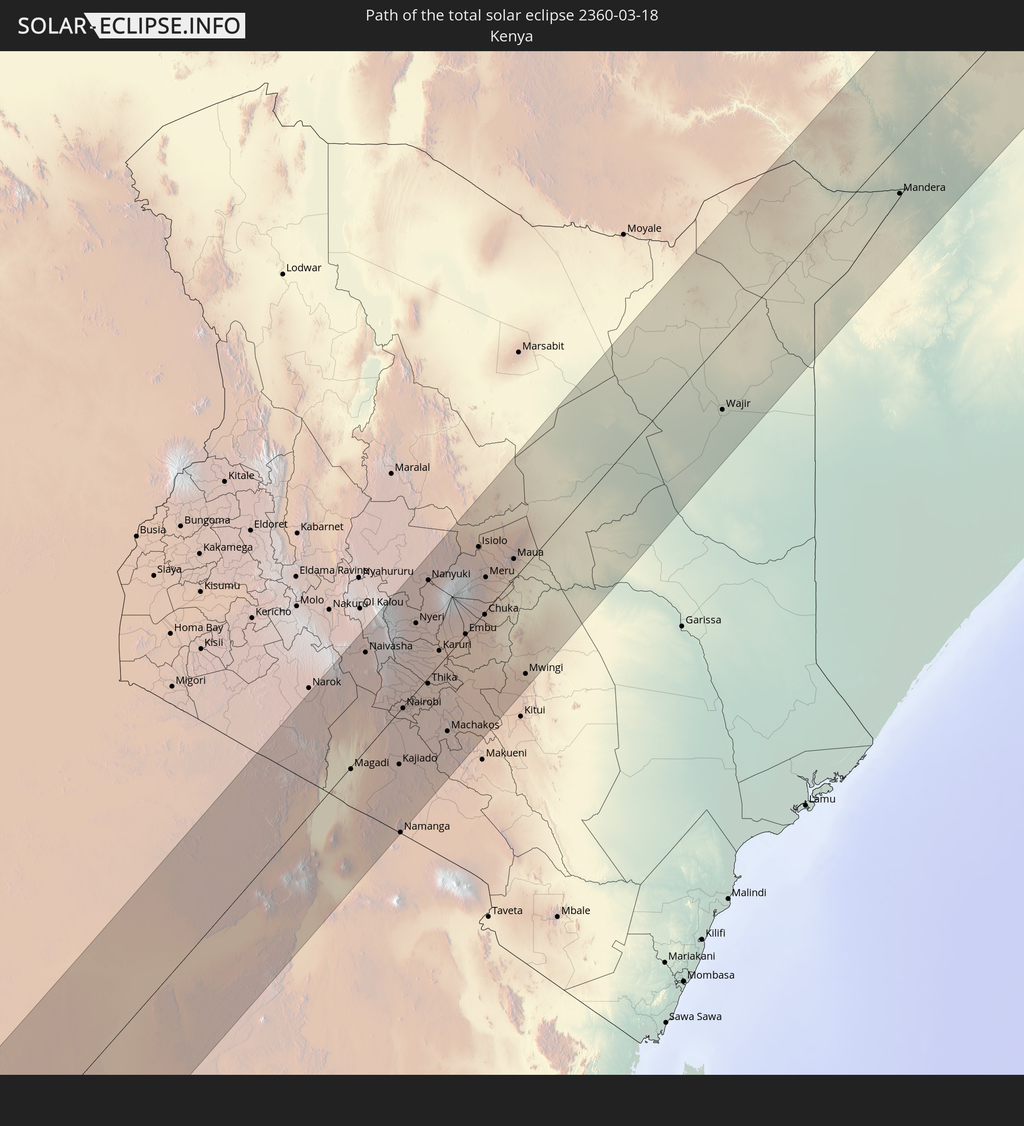
Detailed country maps
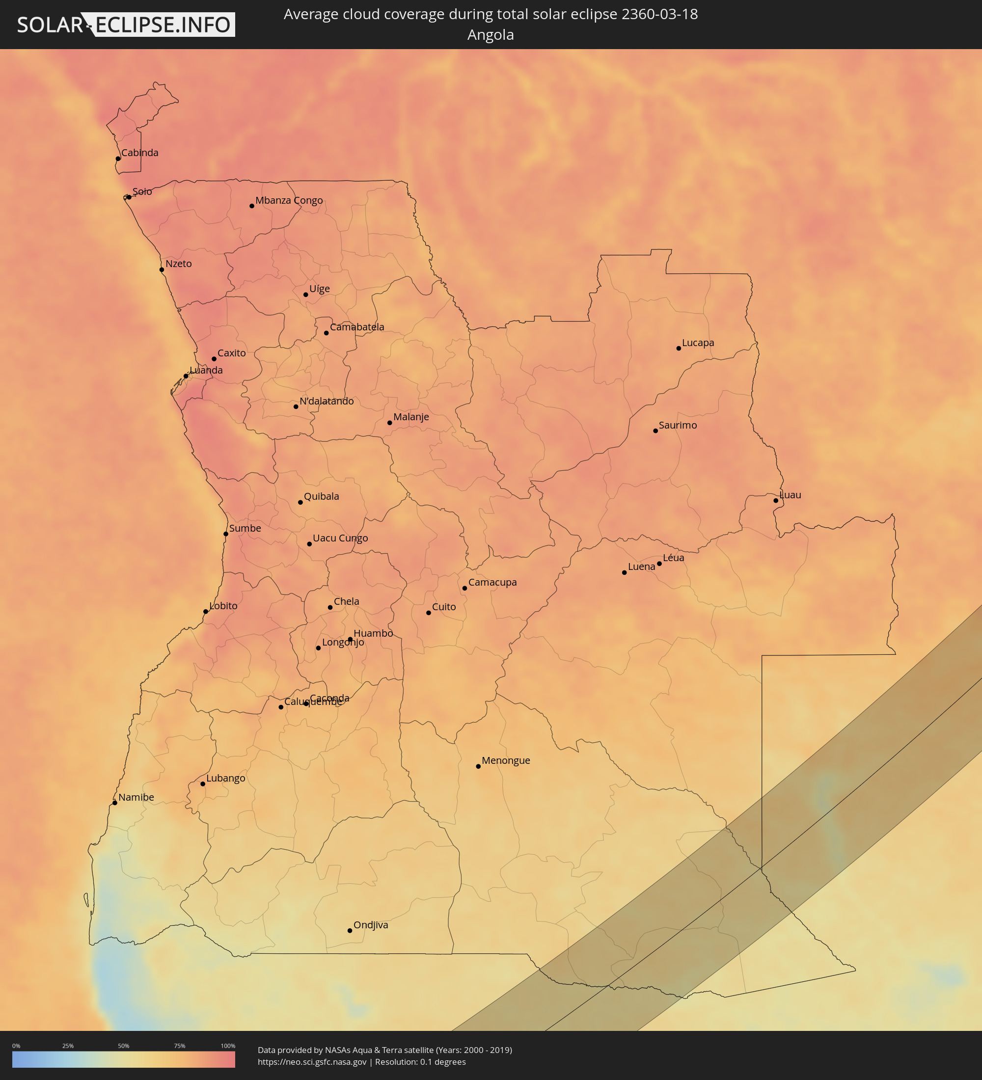 Angola
 Namibia
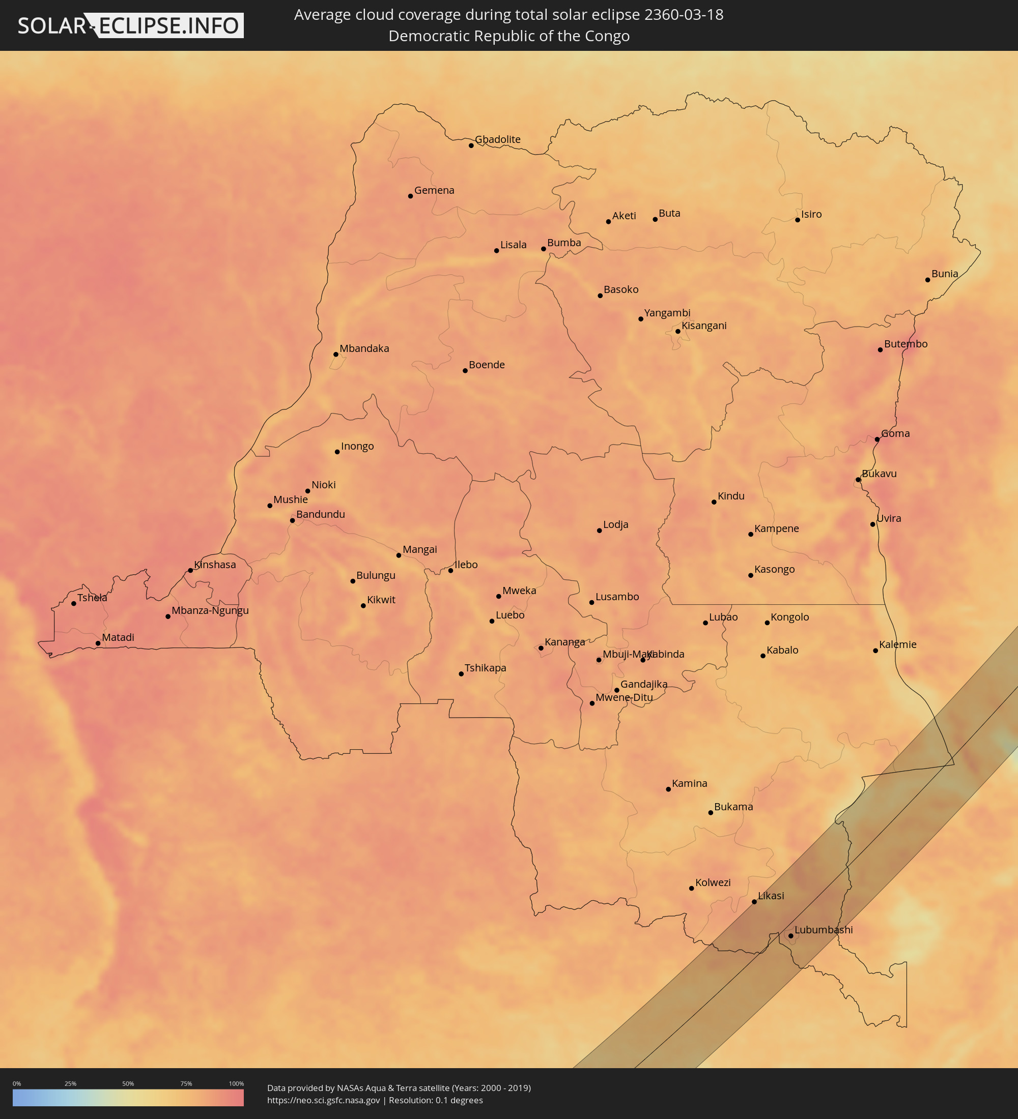 Democratic Republic of the Congo
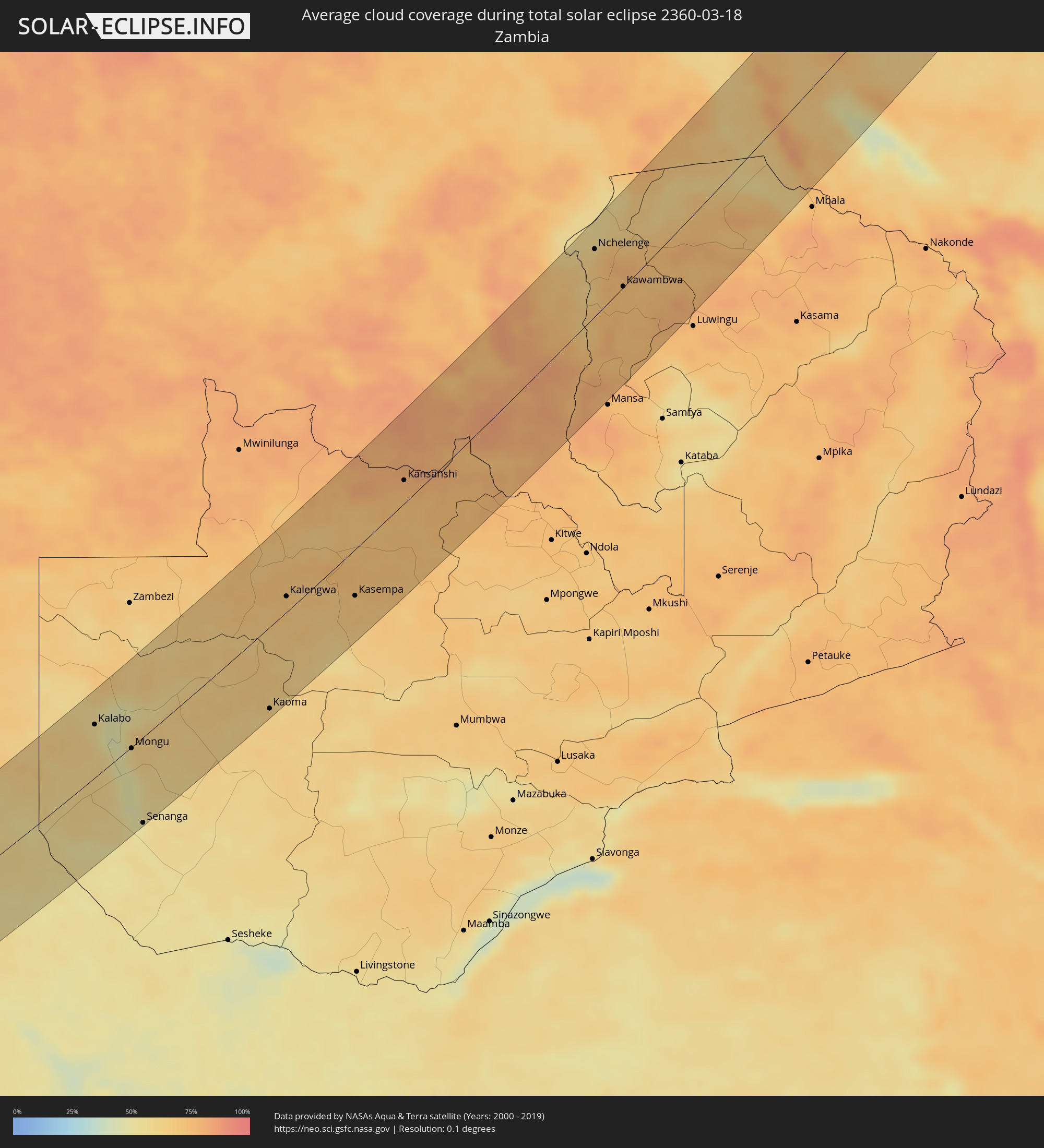 Zambia
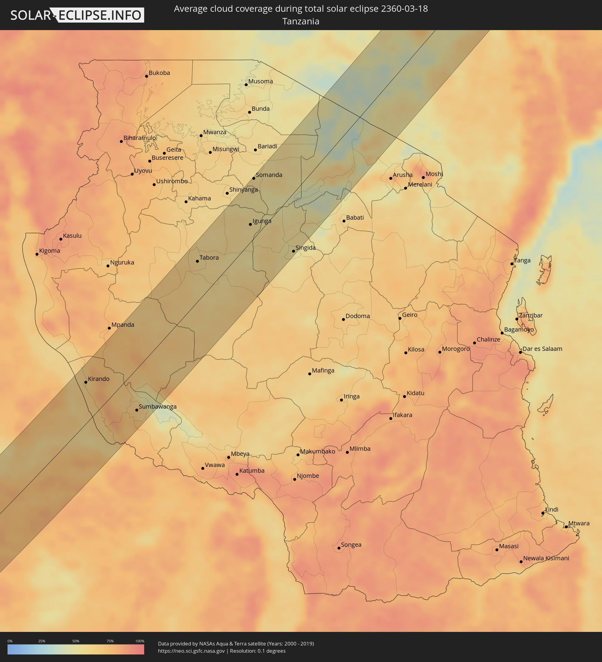 Tanzania
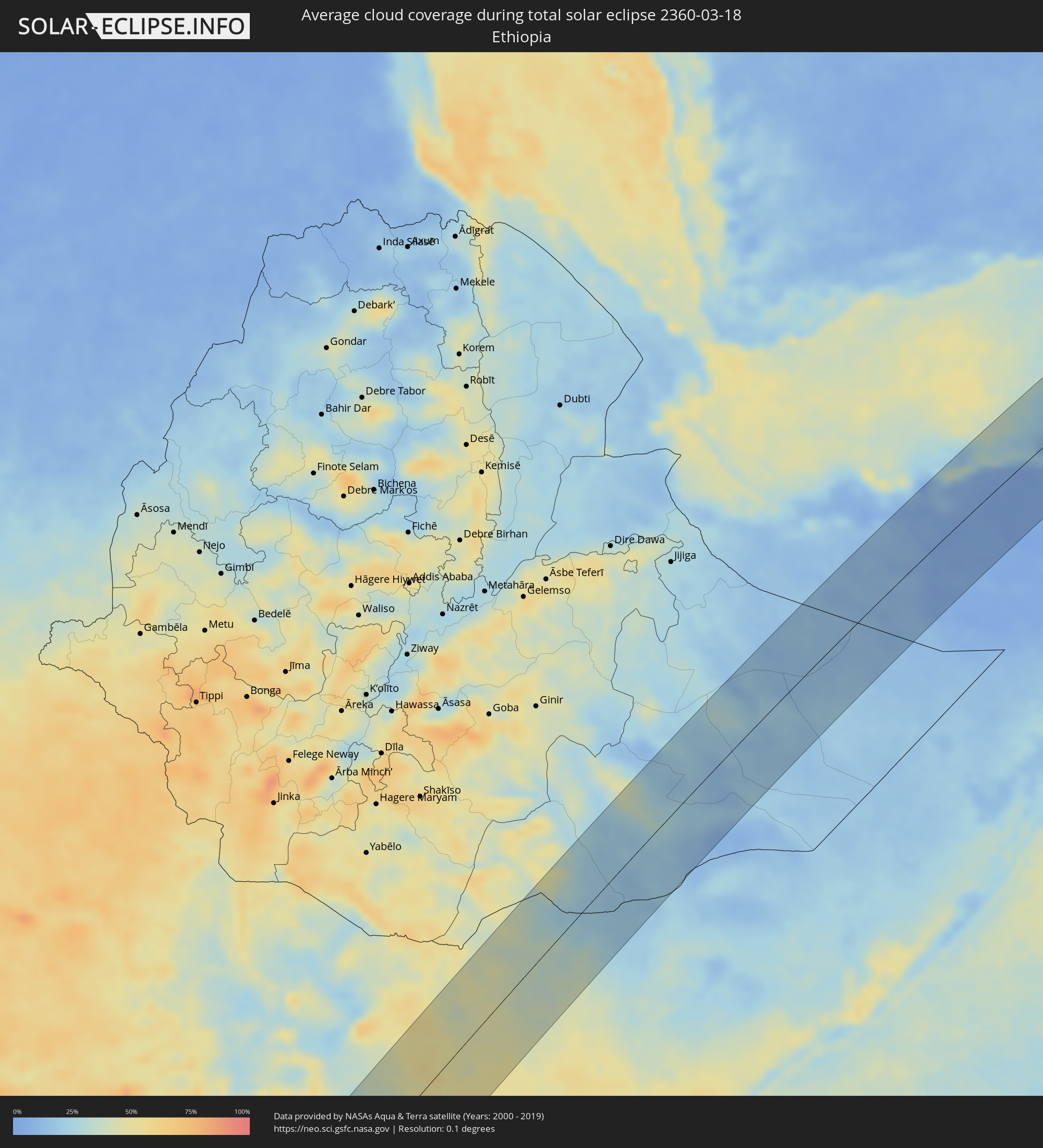 Ethiopia
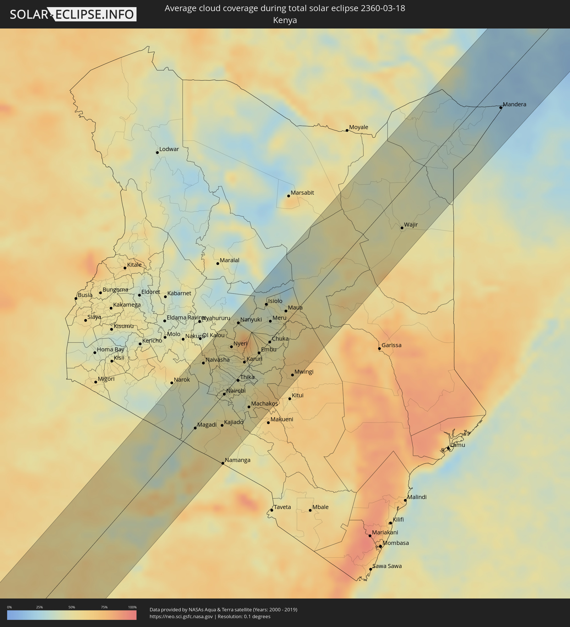 Kenya
Kenya
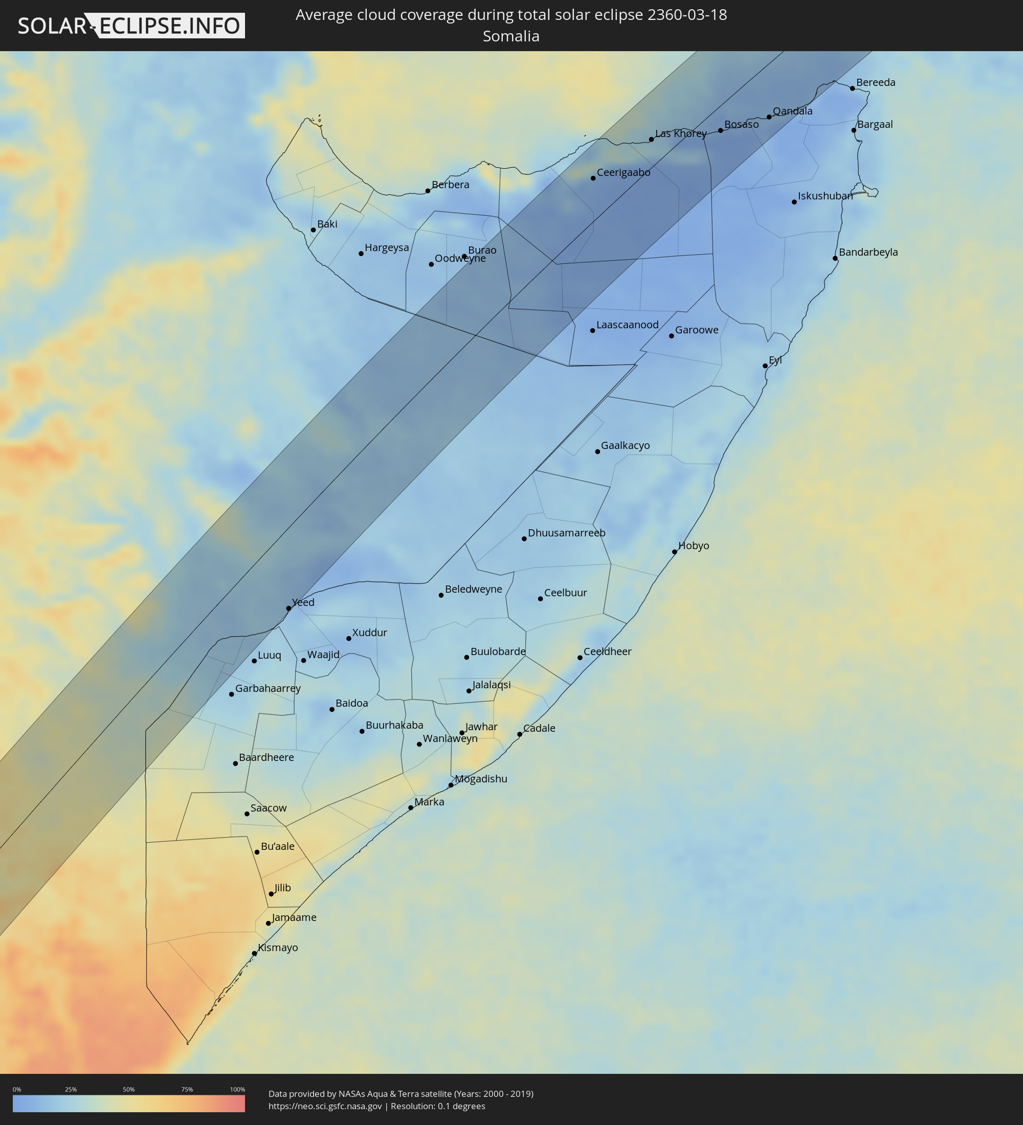 Somalia
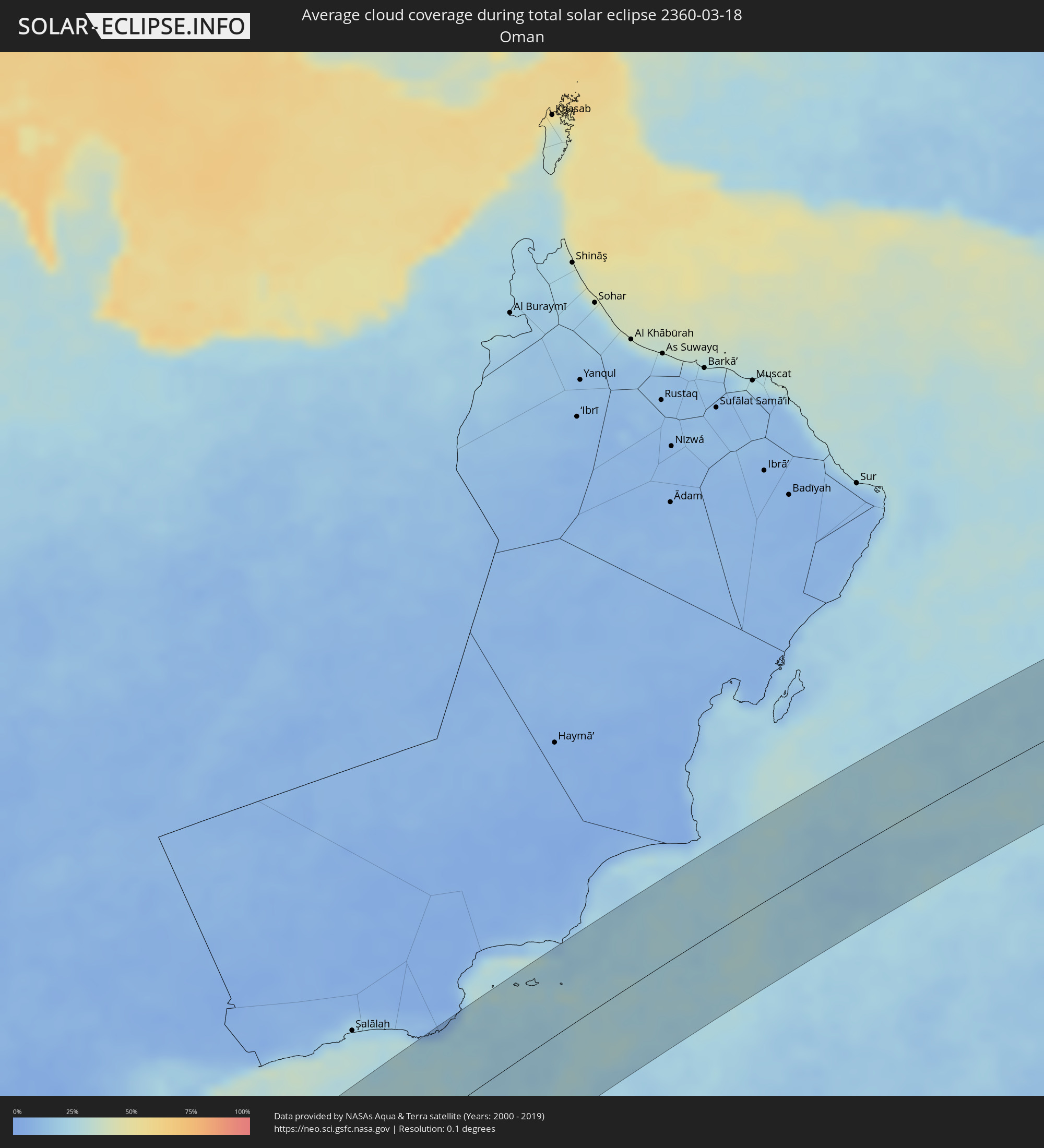 Oman
Oman
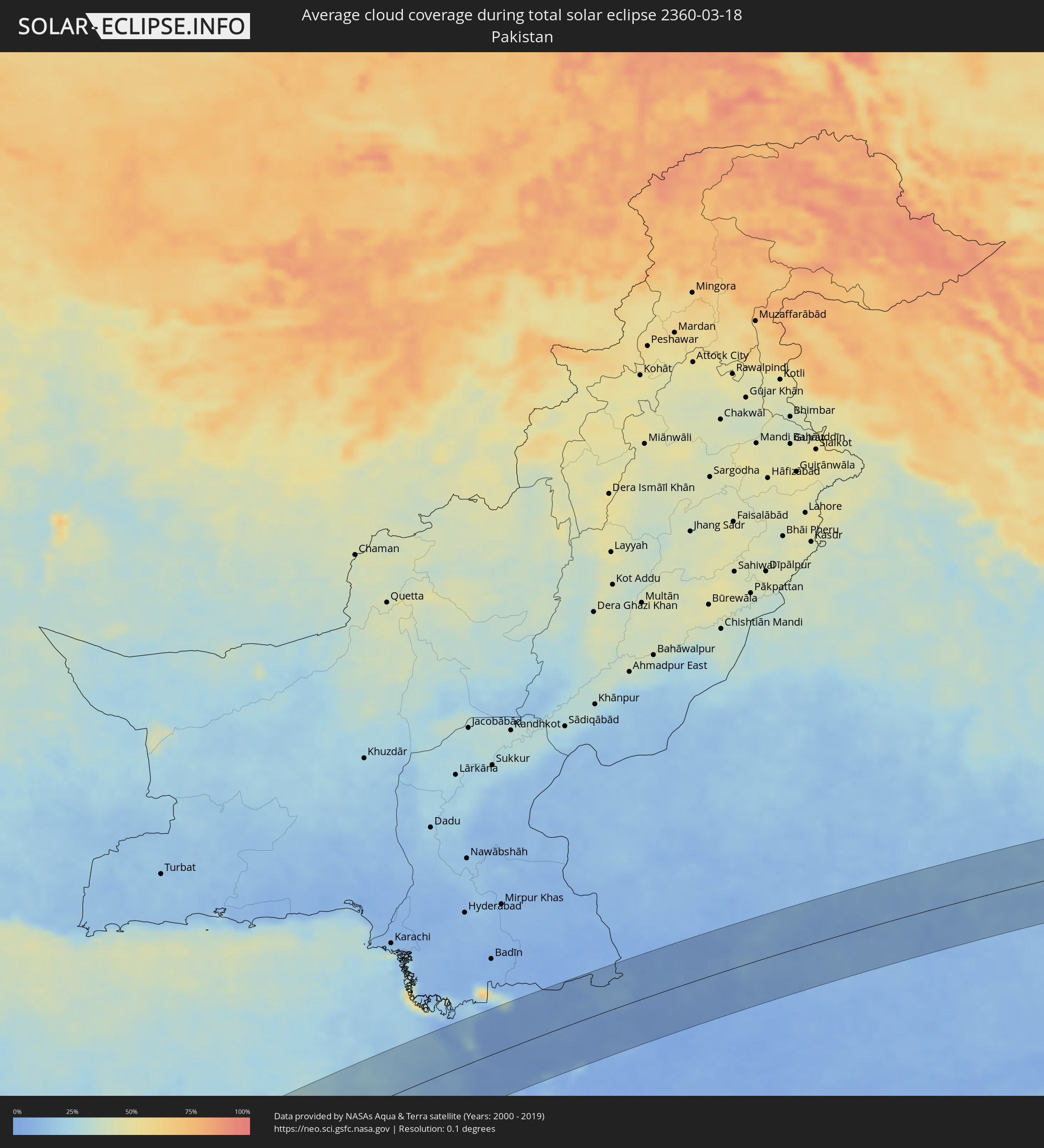 Pakistan
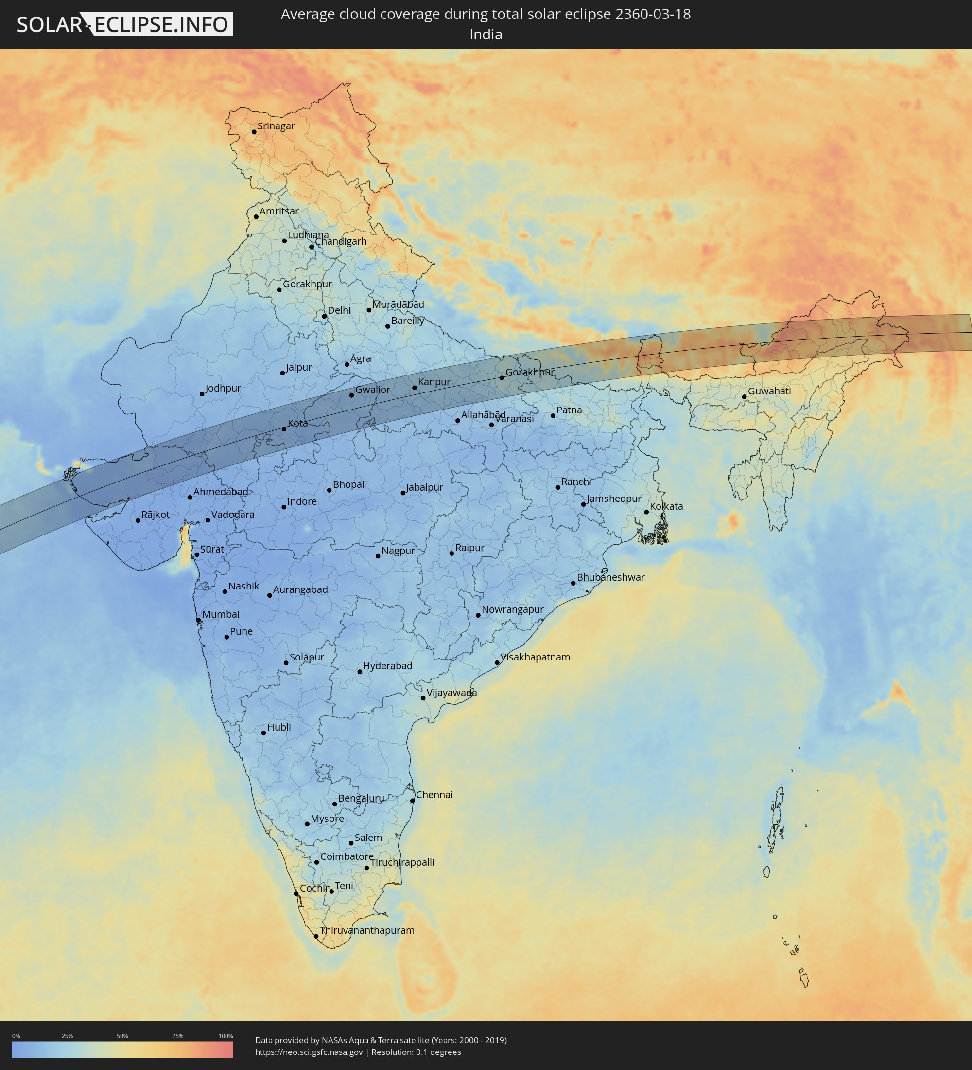 India
India
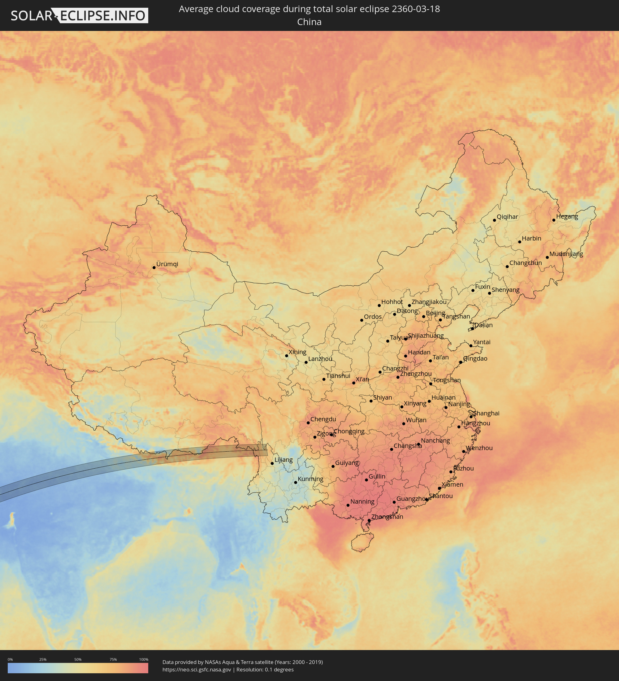 China
China
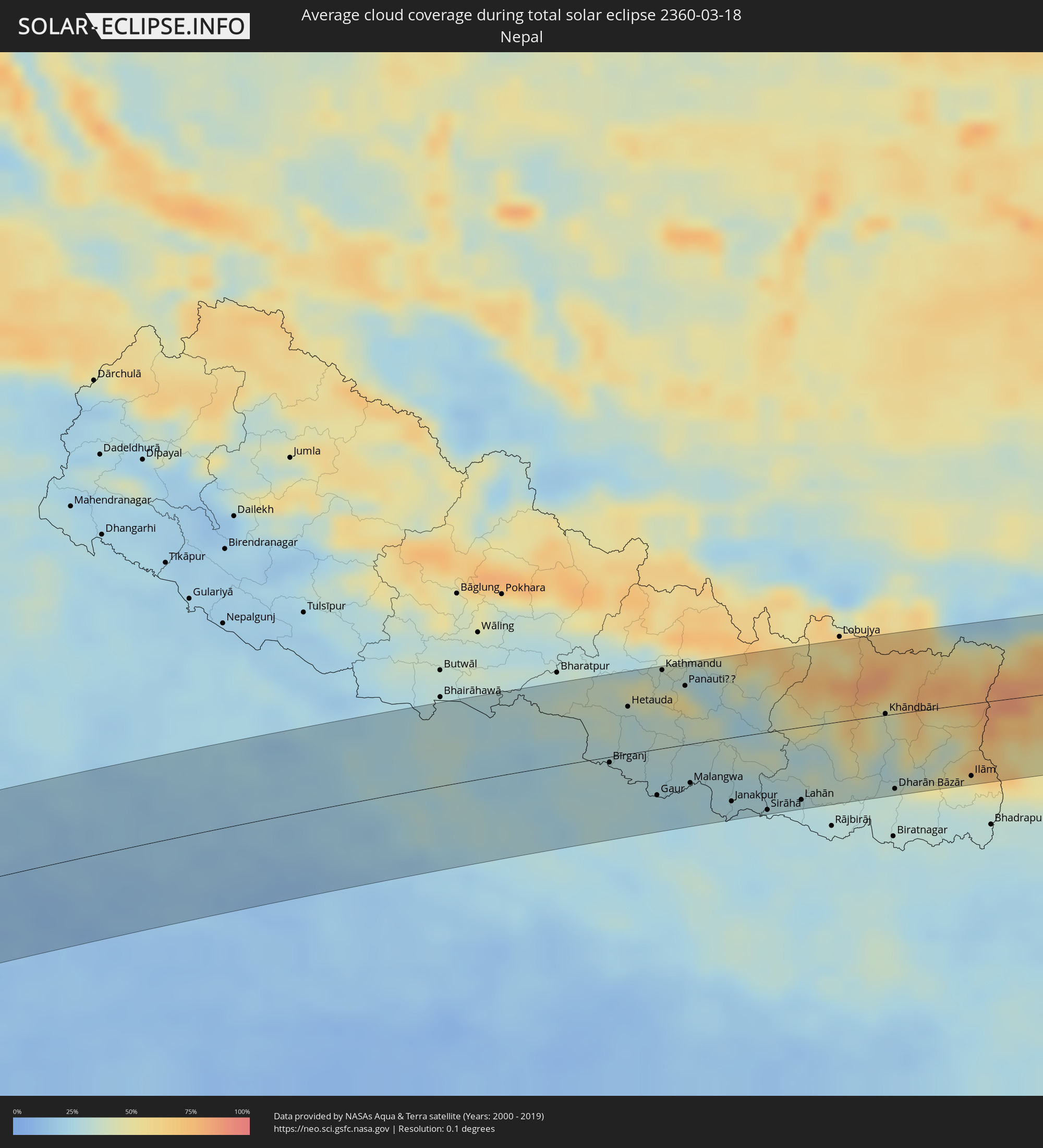 Nepal
Nepal
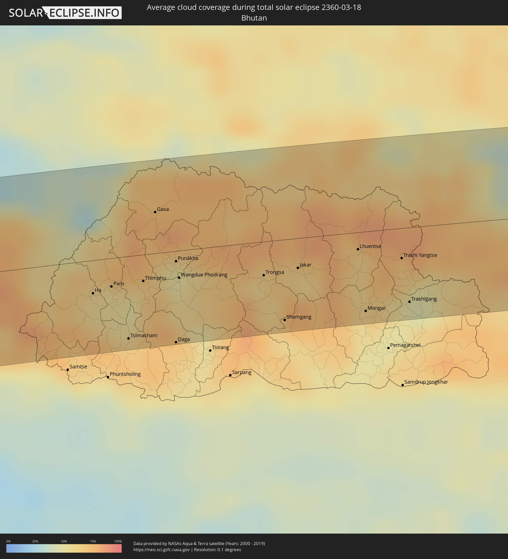 Bhutan
 Myanmar
Cities inside the path of the eclipse
The following table shows all locations with a population of more than 5,000 inside the eclipse path. Cities which have more than 100,000 inhabitants are marked bold. A click at the locations opens a detailed map.
| City | Type | Eclipse duration | Local time of max. eclipse | Distance to central line | Ø Cloud coverage |
|
Khorixas, Kunene
|
total | - | 10:35:18 UTC+02:00 | 43 km | 36% |
|
Outjo, Kunene
|
total | - | 10:37:15 UTC+02:00 | 1 km | 51% |
|
Otjiwarongo, Otjozondjupa
|
total | - | 10:37:32 UTC+02:00 | 59 km | 52% |
|
Tsumeb, Oshikoto
|
total | - | 10:40:36 UTC+02:00 | 7 km | 58% |
|
Grootfontein, Otjozondjupa
|
total | - | 10:40:46 UTC+02:00 | 61 km | 55% |
|
Rundu, Kavango East
|
total | - | 10:45:25 UTC+02:00 | 14 km | 56% |
|
Kalabo, Western
|
total | - | 10:54:29 UTC+02:00 | 53 km | 54% |
|
Mongu, Western
|
total | - | 10:54:47 UTC+02:00 | 1 km | 55% |
|
Limulunga, Western
|
total | - | 10:55:02 UTC+02:00 | 11 km | 56% |
|
Senanga, Western
|
total | - | 10:53:38 UTC+02:00 | 85 km | 52% |
|
Mufumbwe, North-Western
|
total | - | 11:00:08 UTC+02:00 | 12 km | 69% |
|
Kaoma, Western
|
total | - | 10:58:18 UTC+02:00 | 80 km | 63% |
|
Kalengwa, North-Western
|
total | - | 11:00:51 UTC+02:00 | 15 km | 70% |
|
Kasempa, North-Western
|
total | - | 11:02:16 UTC+02:00 | 45 km | 70% |
|
Solwezi, North-Western
|
total | - | 11:05:29 UTC+02:00 | 19 km | 75% |
|
Kansanshi, North-Western
|
total | - | 11:05:41 UTC+02:00 | 22 km | 78% |
|
Likasi, Katanga
|
total | - | 11:08:14 UTC+02:00 | 88 km | 80% |
|
Kipushi, Katanga
|
total | - | 11:07:43 UTC+02:00 | 13 km | 72% |
|
Lubumbashi, Katanga
|
total | - | 11:08:18 UTC+02:00 | 23 km | 77% |
|
Nchelenge, Luapula
|
total | - | 11:14:50 UTC+02:00 | 63 km | 61% |
|
Kawambwa, Luapula
|
total | - | 11:14:36 UTC+02:00 | 1 km | 73% |
|
Kirando, Rukwa
|
total | - | 12:21:57 UTC+03:00 | 62 km | 65% |
|
Namanyere, Rukwa
|
total | - | 12:22:34 UTC+03:00 | 18 km | 68% |
|
Mpulungu, Northern
|
total | - | 11:20:13 UTC+02:00 | 82 km | 66% |
|
Usevia, Katavi
|
total | - | 12:23:44 UTC+03:00 | 34 km | 64% |
|
Chala, Rukwa
|
total | - | 12:22:50 UTC+03:00 | 5 km | 66% |
|
Matai, Rukwa
|
total | - | 12:21:51 UTC+03:00 | 79 km | 68% |
|
Sumbawanga, Rukwa
|
total | - | 12:22:42 UTC+03:00 | 62 km | 67% |
|
Sikonge, Tabora
|
total | - | 12:29:29 UTC+03:00 | 18 km | 60% |
|
Tabora, Tabora
|
total | - | 12:30:51 UTC+03:00 | 59 km | 59% |
|
Nzega, Tabora
|
total | - | 12:33:09 UTC+03:00 | 88 km | 59% |
|
Igunga, Tabora
|
total | - | 12:34:18 UTC+03:00 | 25 km | 53% |
|
Lalago, Simiyu
|
total | - | 12:36:09 UTC+03:00 | 81 km | 54% |
|
Somanda, Simiyu
|
total | - | 12:36:19 UTC+03:00 | 87 km | 55% |
|
Shelui, Singida
|
total | - | 12:34:42 UTC+03:00 | 7 km | 60% |
|
Kiomboi, Singida
|
total | - | 12:35:13 UTC+03:00 | 14 km | 59% |
|
Sepuka, Singida
|
total | - | 12:34:31 UTC+03:00 | 63 km | 56% |
|
Igugunu, Singida
|
total | - | 12:35:05 UTC+03:00 | 58 km | 52% |
|
Singida, Singida
|
total | - | 12:34:46 UTC+03:00 | 86 km | 53% |
|
Mtinko, Singida
|
total | - | 12:35:31 UTC+03:00 | 75 km | 52% |
|
Ilongero, Singida
|
total | - | 12:35:18 UTC+03:00 | 85 km | 52% |
|
Basotu, Manyara
|
total | - | 12:36:19 UTC+03:00 | 81 km | 52% |
|
Dongobesh, Manyara
|
total | - | 12:37:30 UTC+03:00 | 84 km | 47% |
|
Kiratu, Arusha
|
total | - | 12:39:32 UTC+03:00 | 54 km | 49% |
|
Mto wa Mbu, Arusha
|
total | - | 12:39:50 UTC+03:00 | 71 km | 55% |
|
Magadi, Kajiado
|
total | - | 12:43:40 UTC+03:00 | 2 km | 50% |
|
Naivasha, Nakuru
|
total | - | 12:46:24 UTC+03:00 | 72 km | 46% |
|
Ngong, Kajiado
|
total | - | 12:45:28 UTC+03:00 | 6 km | 47% |
|
Kajiado, Kajiado
|
total | - | 12:44:40 UTC+03:00 | 39 km | 57% |
|
Nairobi, Nairobi Area
|
total | - | 12:45:55 UTC+03:00 | 1 km | 44% |
|
Kiambu, Kiambu
|
total | - | 12:46:12 UTC+03:00 | 6 km | 45% |
|
Pumwani, Nairobi Area
|
total | - | 12:45:59 UTC+03:00 | 4 km | 42% |
|
Nyeri, Nyeri
|
total | - | 12:47:58 UTC+03:00 | 51 km | 49% |
|
Athi River, Machakos
|
total | - | 12:45:51 UTC+03:00 | 28 km | 51% |
|
Thika, Nairobi Area
|
total | - | 12:46:54 UTC+03:00 | 4 km | 48% |
|
Nanyuki, Laikipia
|
total | - | 12:49:06 UTC+03:00 | 72 km | 56% |
|
Murang’a, Murang'A
|
total | - | 12:47:43 UTC+03:00 | 12 km | 44% |
|
Karuri, Murang'A
|
total | - | 12:47:49 UTC+03:00 | 10 km | 44% |
|
Machakos, Machakos
|
total | - | 12:46:16 UTC+03:00 | 56 km | 47% |
|
Keruguya, Kirinyaga
|
total | - | 12:48:25 UTC+03:00 | 17 km | 56% |
|
Kangundo, Machakos
|
total | - | 12:46:52 UTC+03:00 | 47 km | 48% |
|
Embu, Embu
|
total | - | 12:48:39 UTC+03:00 | 0 km | 48% |
|
Isiolo, Isiolo
|
total | - | 12:50:45 UTC+03:00 | 54 km | 46% |
|
Meru, Meru
|
total | - | 12:50:14 UTC+03:00 | 25 km | 43% |
|
Maua, Isiolo
|
total | - | 12:51:09 UTC+03:00 | 15 km | 52% |
|
Mwingi, Kitui
|
total | - | 12:48:56 UTC+03:00 | 81 km | 61% |
|
Wajir, Wajir
|
total | - | 12:58:09 UTC+03:00 | 52 km | 49% |
|
Mandera, Mandera
|
total | - | 13:05:52 UTC+03:00 | 38 km | 20% |
|
Yeed, Bakool
|
total | - | 13:09:11 UTC+03:00 | 88 km | 16% |
|
Ceerigaabo, Sanaag
|
total | - | 13:28:05 UTC+03:00 | 48 km | 7% |
|
Las Khorey, Sanaag
|
total | - | 13:30:24 UTC+03:00 | 31 km | 23% |
|
Bosaso, Bari
|
total | - | 13:32:13 UTC+03:00 | 30 km | 4% |
|
Qandala, Bari
|
total | - | 13:33:39 UTC+03:00 | 64 km | 8% |
|
Bhuj, Gujarat
|
total | - | 16:42:51 UTC+05:30 | 17 km | 4% |
|
Gāndhīdhām, Gujarat
|
total | - | 16:43:09 UTC+05:30 | 51 km | 4% |
|
Pālanpur, Gujarat
|
total | - | 16:45:45 UTC+05:30 | 15 km | 6% |
|
Udaipur, Rajasthan
|
total | - | 16:46:57 UTC+05:30 | 12 km | 10% |
|
Bhīlwāra, Rajasthan
|
total | - | 16:48:01 UTC+05:30 | 43 km | 6% |
|
Kota, Rajasthan
|
total | - | 16:48:47 UTC+05:30 | 9 km | 8% |
|
Shivpuri, Madhya Pradesh
|
total | - | 16:50:05 UTC+05:30 | 30 km | 12% |
|
Gwalior, Madhya Pradesh
|
total | - | 16:50:42 UTC+05:30 | 44 km | 12% |
|
Jhānsi, Uttar Pradesh
|
total | - | 16:50:39 UTC+05:30 | 49 km | 11% |
|
Bhind, Madhya Pradesh
|
total | - | 16:51:10 UTC+05:30 | 66 km | 13% |
|
Orai, Uttar Pradesh
|
total | - | 16:51:21 UTC+05:30 | 12 km | 15% |
|
Kanpur, Uttar Pradesh
|
total | - | 16:52:00 UTC+05:30 | 20 km | 14% |
|
Unnāo, Uttar Pradesh
|
total | - | 16:52:06 UTC+05:30 | 26 km | 17% |
|
Fatehpur, Uttar Pradesh
|
total | - | 16:52:05 UTC+05:30 | 48 km | 14% |
|
Lucknow, Uttar Pradesh
|
total | - | 16:52:25 UTC+05:30 | 49 km | 17% |
|
Raebareli, Uttar Pradesh
|
total | - | 16:52:24 UTC+05:30 | 24 km | 16% |
|
Gondā City, Uttar Pradesh
|
total | - | 16:53:00 UTC+05:30 | 60 km | 20% |
|
Fyzābād, Uttar Pradesh
|
total | - | 16:53:00 UTC+05:30 | 18 km | 21% |
|
Gorakhpur, Uttar Pradesh
|
total | - | 16:53:34 UTC+05:30 | 6 km | 26% |
|
Deoria, Uttar Pradesh
|
total | - | 16:53:40 UTC+05:30 | 42 km | 26% |
|
Bettiah, Bihar
|
total | - | 16:54:03 UTC+05:30 | 21 km | 29% |
|
Bīrganj, Central Region
|
total | - | 17:09:15 UTC+05:45 | 5 km | 29% |
|
Hetauda, Central Region
|
total | - | 17:09:24 UTC+05:45 | 39 km | 32% |
|
Kirtipur, Central Region
|
total | - | 17:09:33 UTC+05:45 | 63 km | 36% |
|
Gaur, Central Region
|
total | - | 17:09:21 UTC+05:45 | 38 km | 27% |
|
Pātan, Central Region
|
total | - | 17:09:34 UTC+05:45 | 62 km | 36% |
|
Kathmandu, Central Region
|
total | - | 17:09:34 UTC+05:45 | 64 km | 36% |
|
Hari Bdr Tamang House, Central Region
|
total | - | 17:09:36 UTC+05:45 | 54 km | 48% |
|
kankrabari Dovan, Central Region
|
total | - | 17:09:36 UTC+05:45 | 54 km | 48% |
|
Panauti̇̄, Central Region
|
total | - | 17:09:37 UTC+05:45 | 49 km | 48% |
|
Banepā, Central Region
|
total | - | 17:09:38 UTC+05:45 | 54 km | 48% |
|
Malangwa, Central Region
|
total | - | 17:09:29 UTC+05:45 | 32 km | 27% |
|
Jaleswar, Central Region
|
total | - | 17:09:32 UTC+05:45 | 59 km | 28% |
|
Janakpur, Central Region
|
total | - | 17:09:35 UTC+05:45 | 53 km | 26% |
|
Sirāhā, Eastern Region
|
total | - | 17:09:41 UTC+05:45 | 64 km | 28% |
|
Lahān, Eastern Region
|
total | - | 17:09:48 UTC+05:45 | 60 km | 28% |
|
Khāndbāri, Eastern Region
|
total | - | 17:10:10 UTC+05:45 | 1 km | 42% |
|
Dharān Bāzār, Eastern Region
|
total | - | 17:10:05 UTC+05:45 | 62 km | 33% |
|
Dhankutā, Eastern Region
|
total | - | 17:10:08 UTC+05:45 | 44 km | 31% |
|
Ilām, Eastern Region
|
total | - | 17:10:19 UTC+05:45 | 60 km | 44% |
|
Dārjiling, West Bengal
|
total | - | 16:55:27 UTC+05:30 | 50 km | 70% |
|
Ha, Haa District
|
total | - | 17:25:48 UTC+06:00 | 23 km | 58% |
|
Paro, Paro
|
total | - | 17:25:50 UTC+06:00 | 20 km | 56% |
|
Tsimasham, Chukha District
|
total | - | 17:25:49 UTC+06:00 | 58 km | 71% |
|
Thimphu, Thimphu
|
total | - | 17:25:54 UTC+06:00 | 19 km | 60% |
|
Lungtenzampa, Thimphu
|
total | - | 17:25:54 UTC+06:00 | 18 km | 60% |
|
Gasa, Gasa District
|
total | - | 17:25:59 UTC+06:00 | 29 km | 73% |
|
Daga, Dagana District
|
total | - | 17:25:54 UTC+06:00 | 64 km | 64% |
|
Punākha, Punakha
|
total | - | 17:25:59 UTC+06:00 | 7 km | 50% |
|
Wangdue Phodrang, Wangdi Phodrang
|
total | - | 17:25:58 UTC+06:00 | 19 km | 51% |
|
Trongsa, Tongsa
|
total | - | 17:26:07 UTC+06:00 | 24 km | 59% |
|
Shemgang, Shemgang
|
total | - | 17:26:07 UTC+06:00 | 57 km | 57% |
|
Jakar, Bumthang
|
total | - | 17:26:11 UTC+06:00 | 21 km | 62% |
|
Lhuentse, Lhuntse District
|
total | - | 17:26:18 UTC+06:00 | 12 km | 61% |
|
Mongar, Mongar District
|
total | - | 17:26:16 UTC+06:00 | 56 km | 54% |
|
Trashi Yangtse, Trashi Yangste
|
total | - | 17:26:22 UTC+06:00 | 21 km | 65% |
|
Trashigang, Tashigang
|
total | - | 17:26:20 UTC+06:00 | 53 km | 57% |
|
Dibrugarh, Assam
|
total | - | 16:56:55 UTC+05:30 | 61 km | 59% |