Annular solar eclipse of 03/21/2490
| Day of week: | Tuesday |
| Maximum duration of eclipse: | 05m36s |
| Maximum width of eclipse path: | 195 km |
| Saros cycle: | 147 |
| Coverage: | 94.8% |
| Magnitude: | 0.9482 |
| Gamma: | -0.2288 |
Wo kann man die Sonnenfinsternis vom 03/21/2490 sehen?
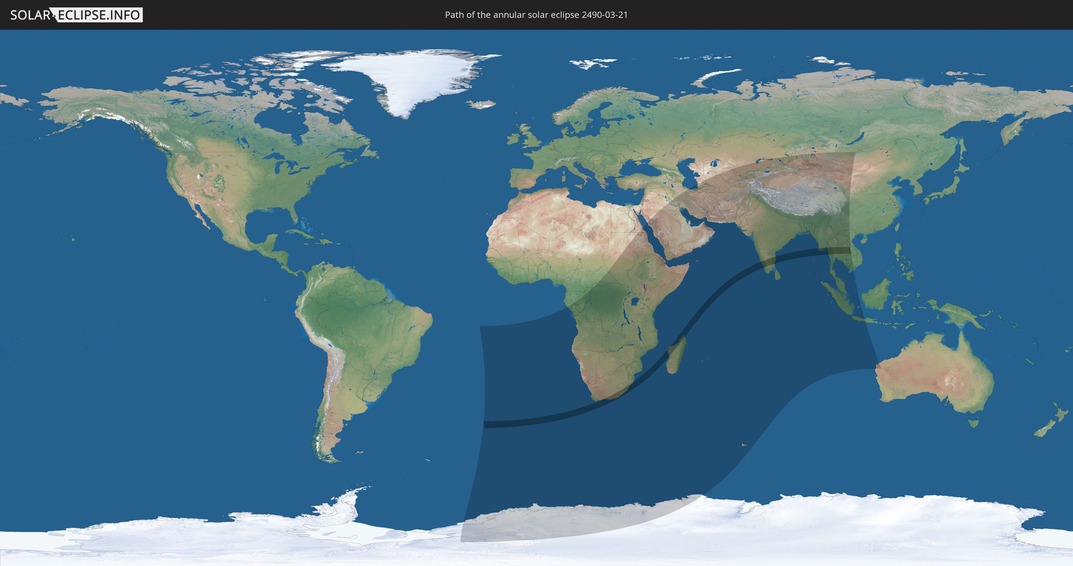
Die Sonnenfinsternis am 03/21/2490 kann man in 71 Ländern als partielle Sonnenfinsternis beobachten.
Der Finsternispfad verläuft durch 8 Länder. Nur in diesen Ländern ist sie als annular Sonnenfinsternis zu sehen.
In den folgenden Ländern ist die Sonnenfinsternis annular zu sehen
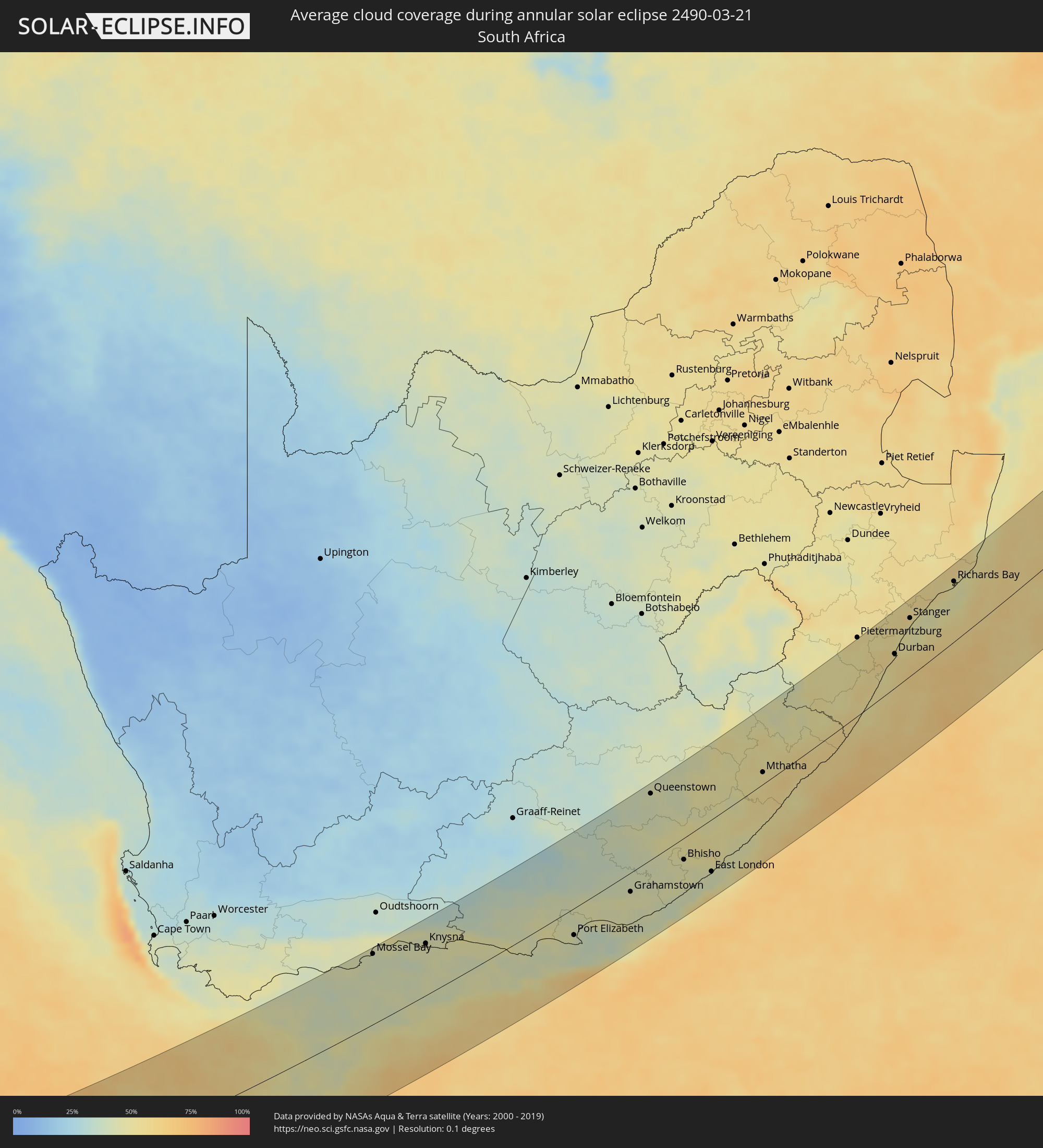
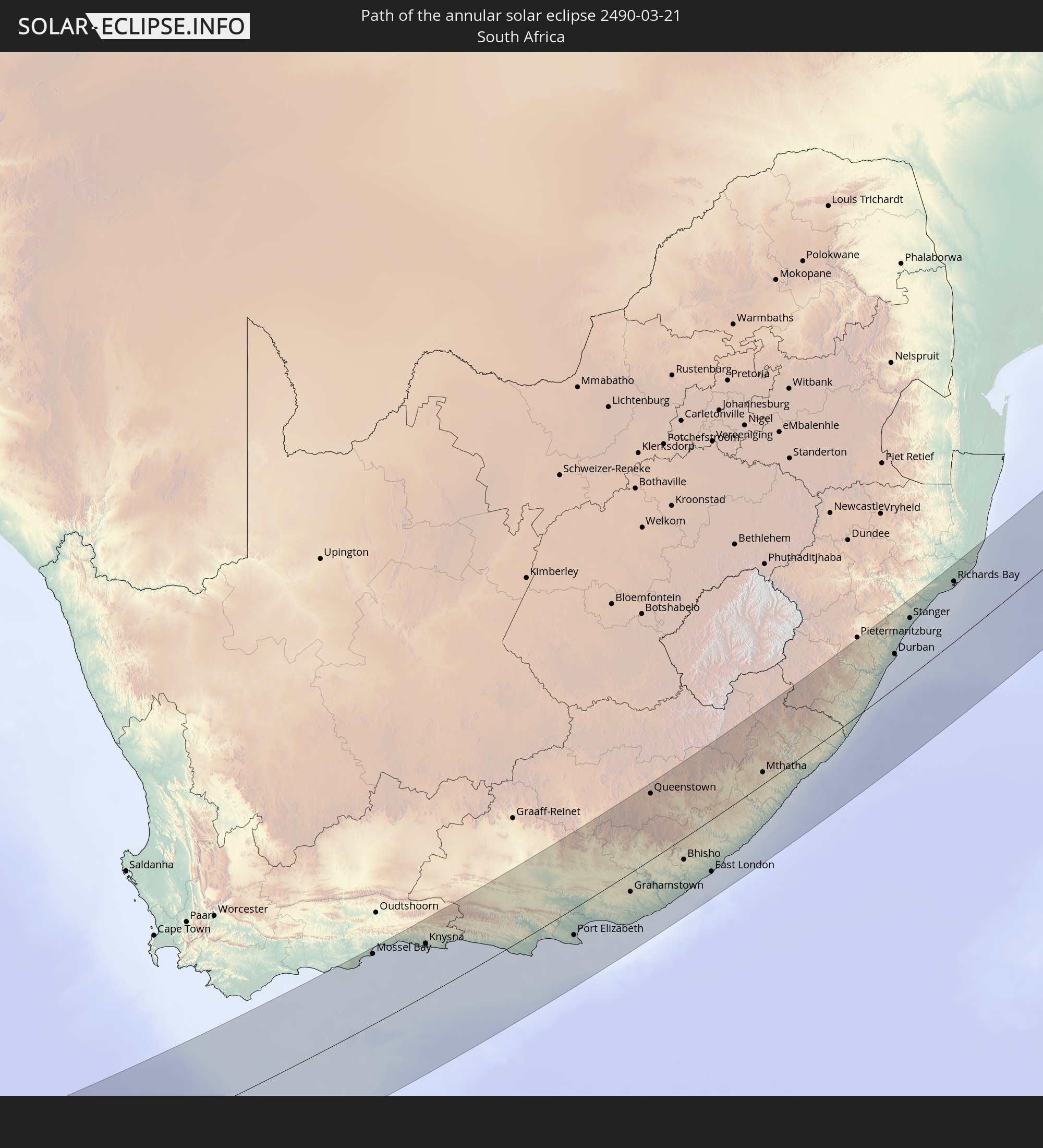 South Africa
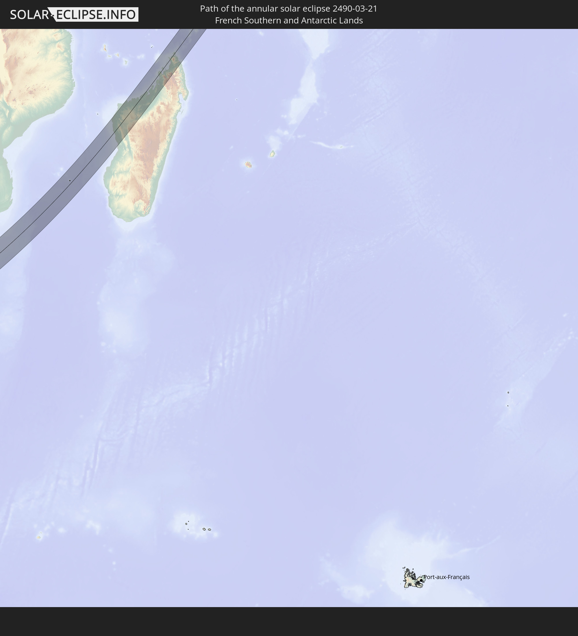 French Southern and Antarctic Lands
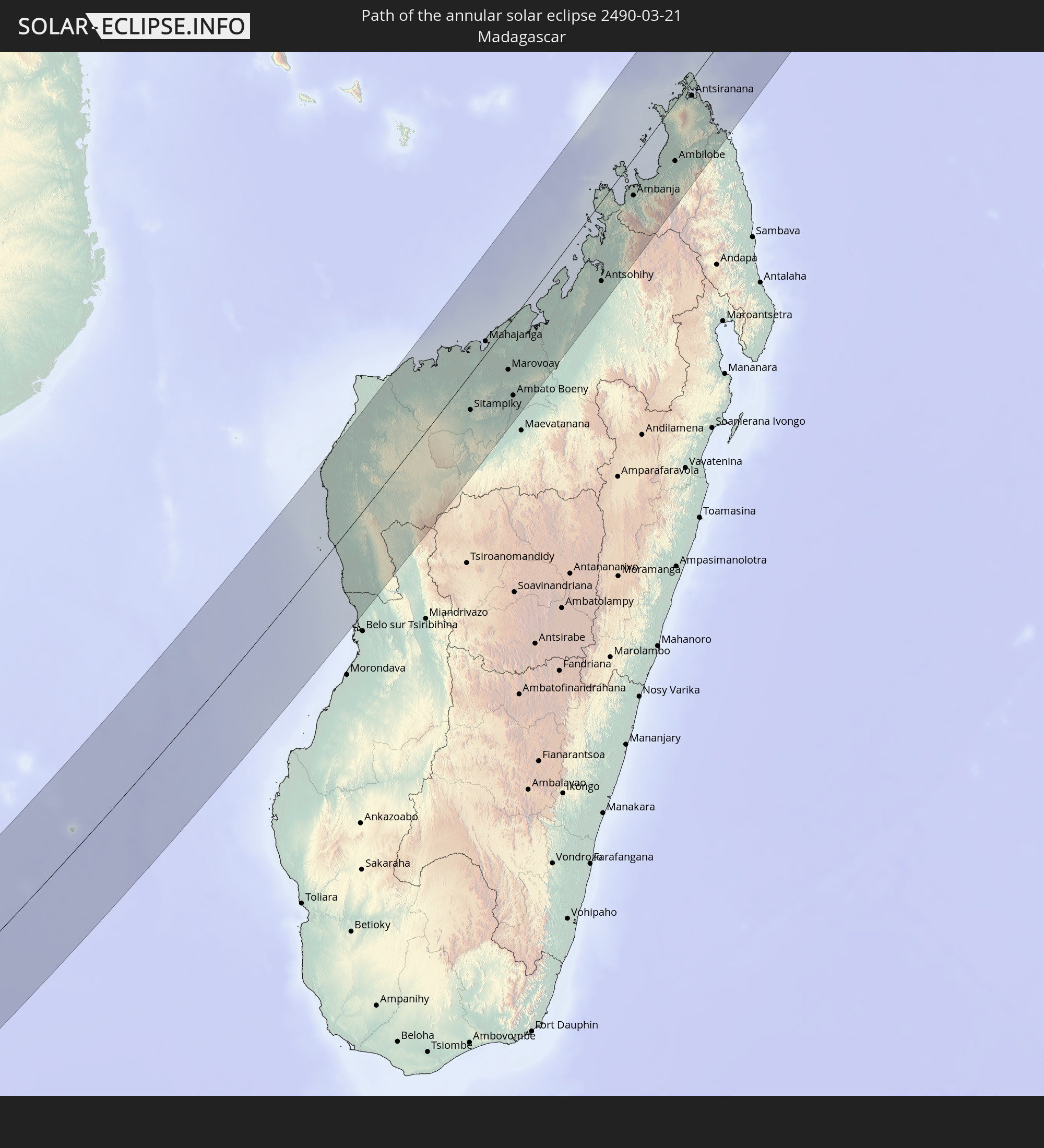 Madagascar
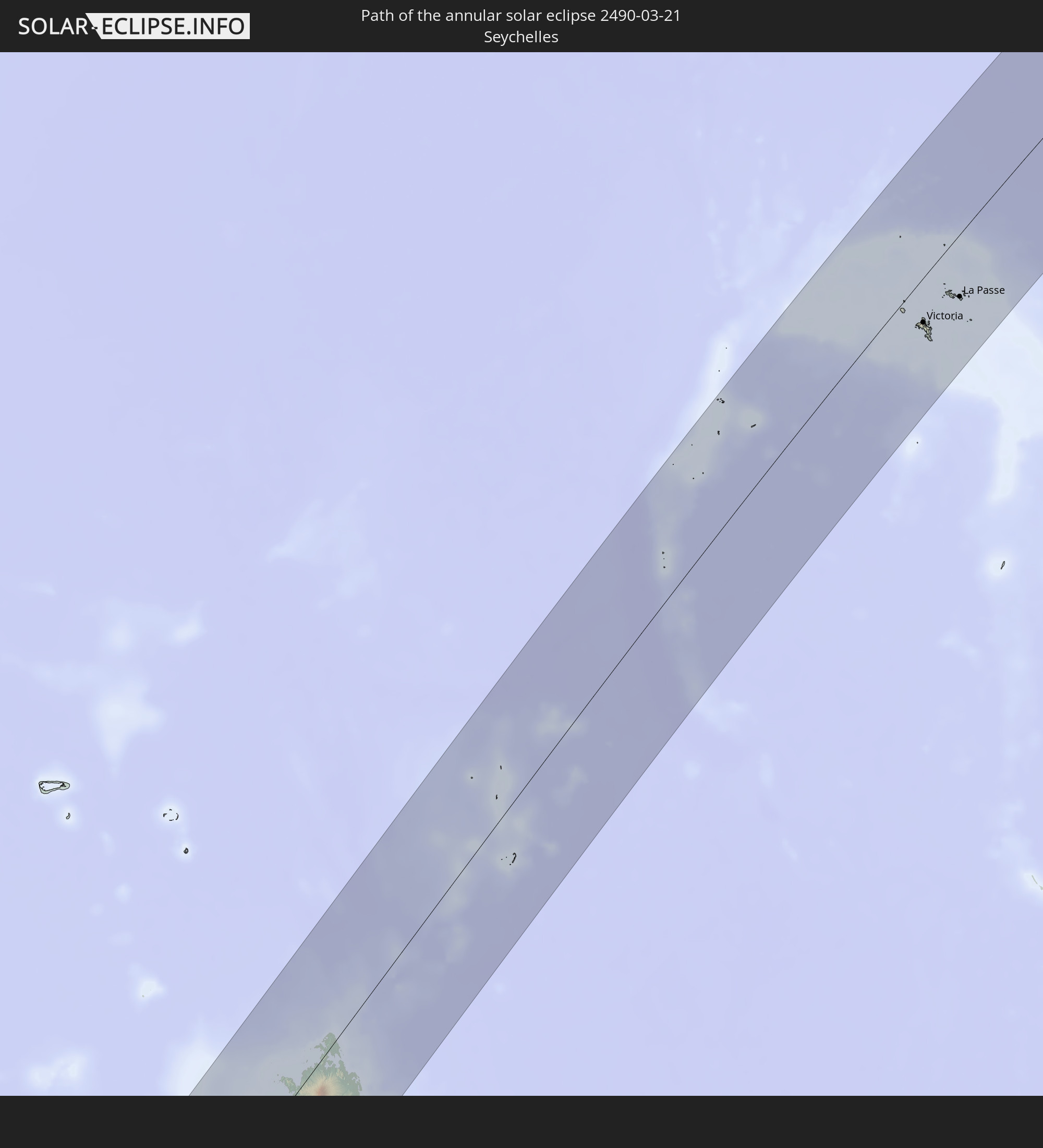 Seychelles
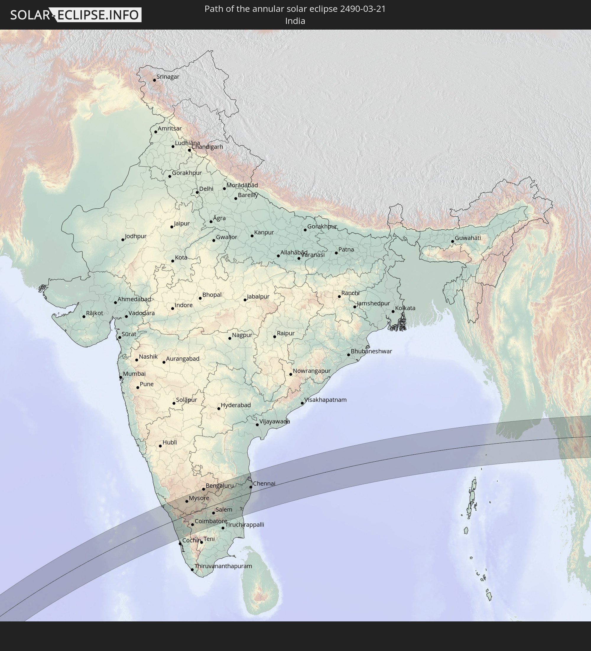 India
India
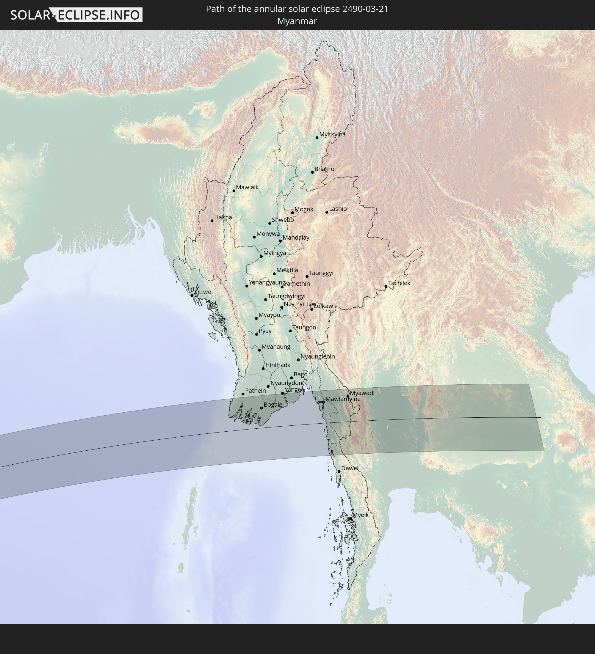 Myanmar
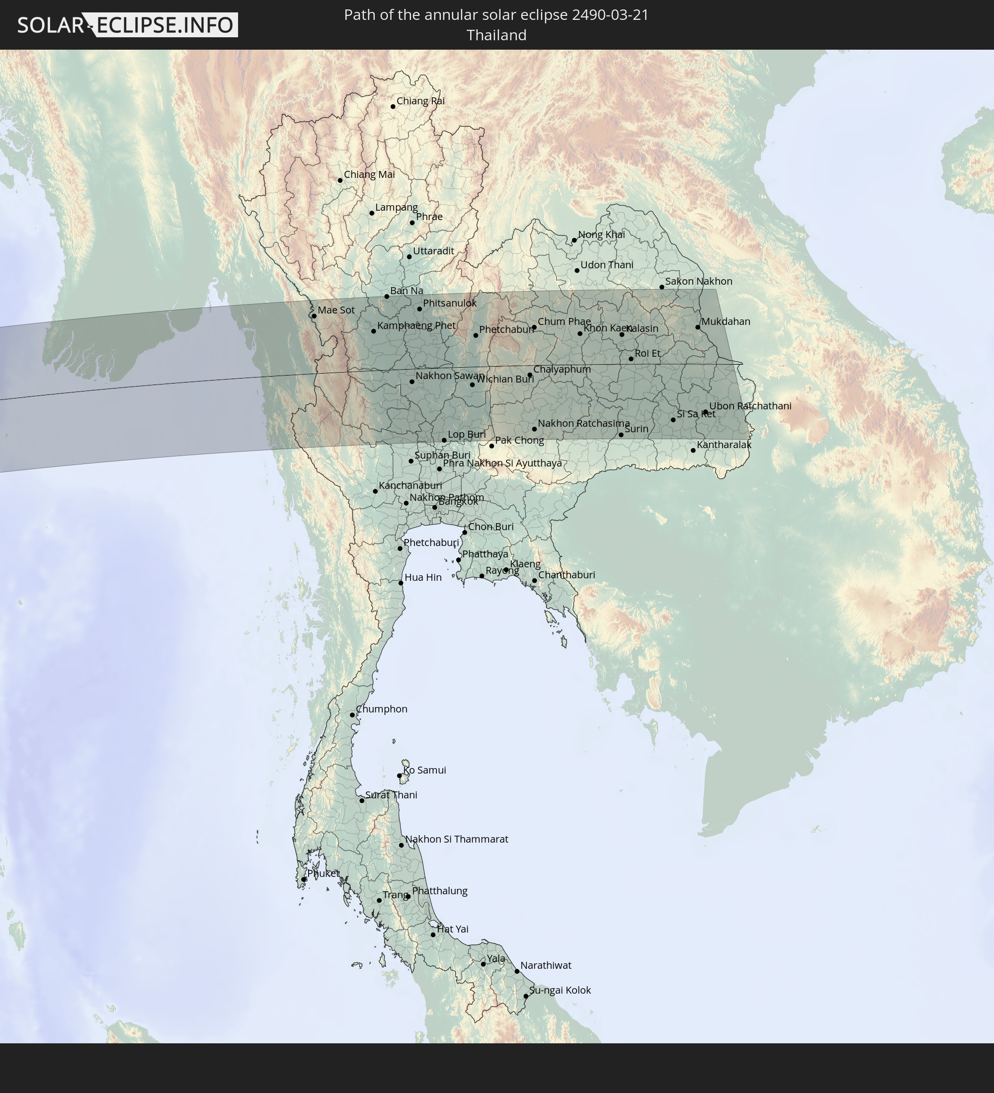 Thailand
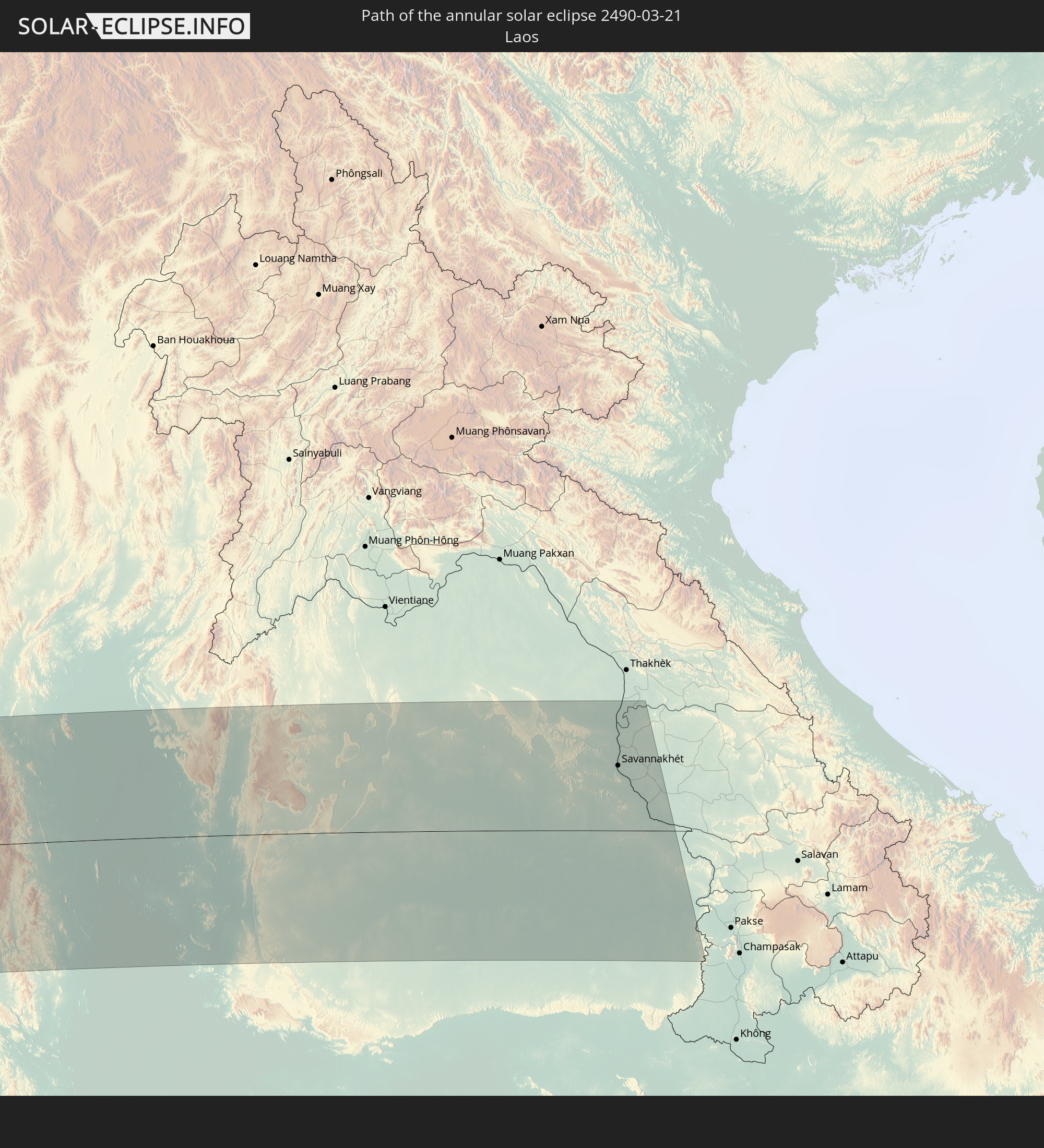 Laos
Laos
In den folgenden Ländern ist die Sonnenfinsternis partiell zu sehen
 Antarctica
 Saint Helena, Ascension and Tristan da Cunha
 Bouvet Island
 Gabon
Gabon
 Republic of the Congo
 Angola
 Namibia
 Democratic Republic of the Congo
 Central African Republic
 South Africa
 Botswana
 Sudan
Sudan
 Zambia
 Egypt
Egypt
 Zimbabwe
 Lesotho
 Rwanda
 Burundi
 Tanzania
 Uganda
 Mozambique
 Swaziland
 Malawi
 Ethiopia
 Kenya
Kenya
 Saudi Arabia
 Eritrea
 Iraq
Iraq
 French Southern and Antarctic Lands
 Somalia
 Djibouti
 Yemen
Yemen
 Madagascar
 Comoros
 Iran
Iran
 Mayotte
 Seychelles
 Kazakhstan
 Kuwait
 Bahrain
 Qatar
Qatar
 United Arab Emirates
 Oman
Oman
 Turkmenistan
 Réunion
 Uzbekistan
 Mauritius
 Afghanistan
 Pakistan
 Tajikistan
 India
India
 Kyrgyzstan
 British Indian Ocean Territory
 Maldives
 China
China
 Sri Lanka
 Nepal
Nepal
 Mongolia
 Bangladesh
 Bhutan
 Myanmar
 Indonesia
 Cocos Islands
 Thailand
 Malaysia
 Laos
Laos
 Vietnam
 Cambodia
 Singapore
 Christmas Island
 Australia
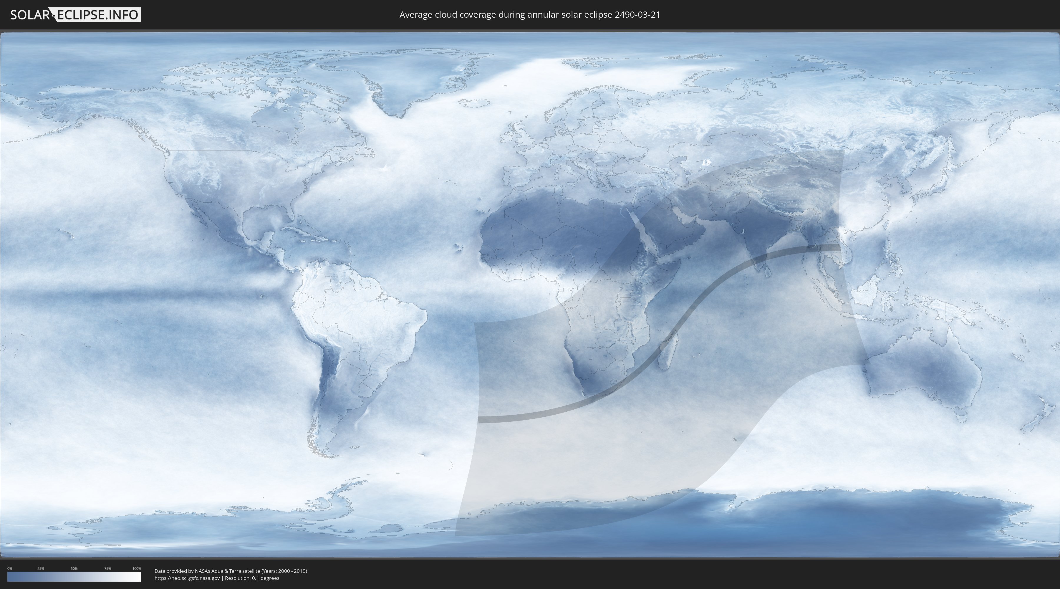
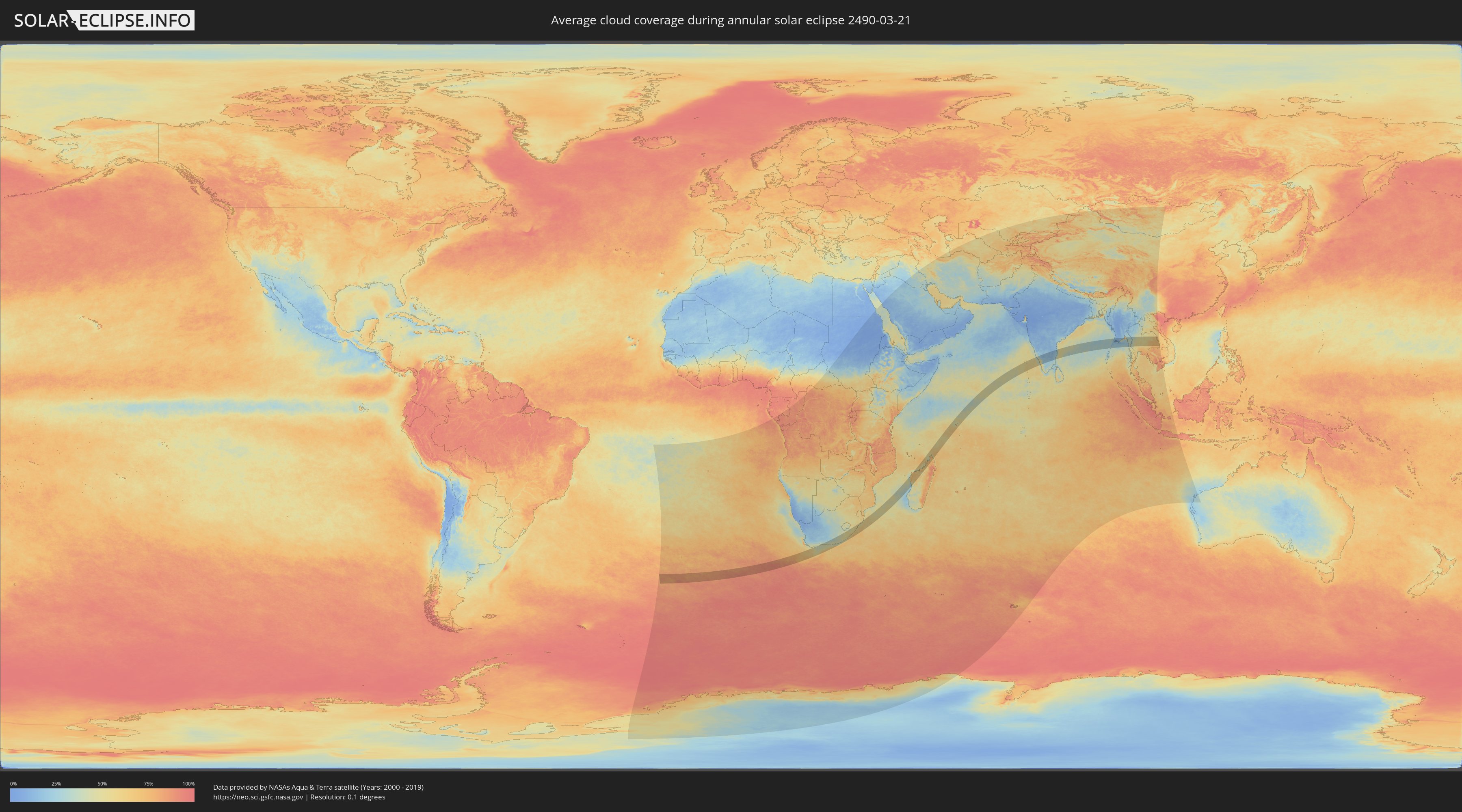
How will be the weather during the annular solar eclipse on 03/21/2490?
Where is the best place to see the annular solar eclipse of 03/21/2490?
The following maps show the average cloud coverage for the day of the annular solar eclipse.
With the help of these maps, it is possible to find the place along the eclipse path, which has the best
chance of a cloudless sky.
Nevertheless, you should consider local circumstances and inform about the weather of your chosen
observation site.
The data is provided by NASAs satellites
AQUA and TERRA.
The cloud maps are averaged over a period of 19 years (2000 - 2019).
Detailed country maps
 South Africa
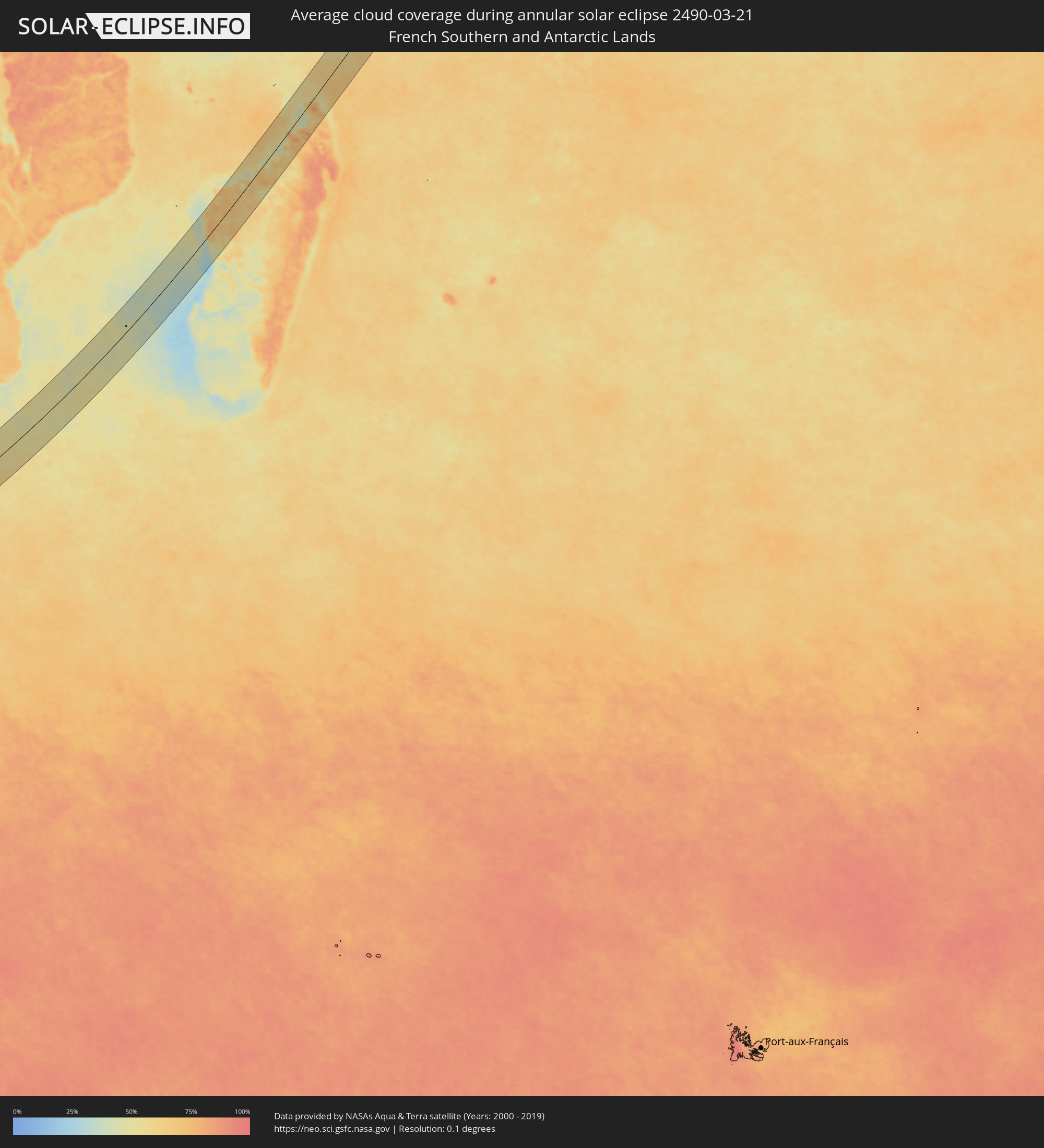 French Southern and Antarctic Lands
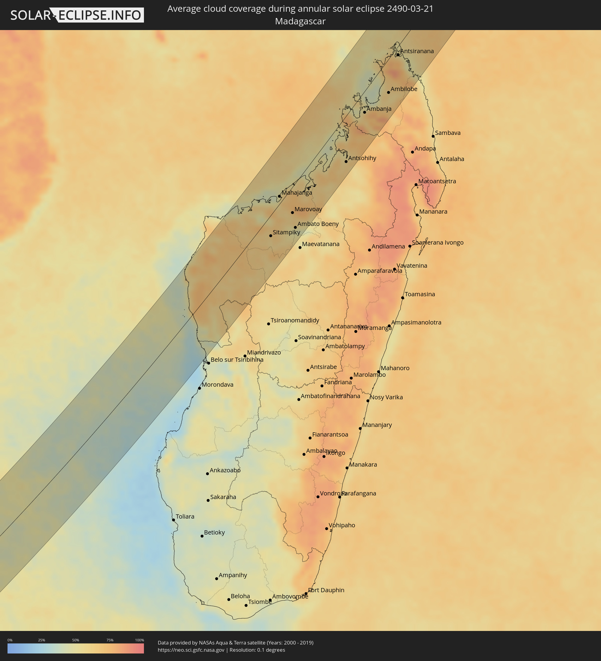 Madagascar
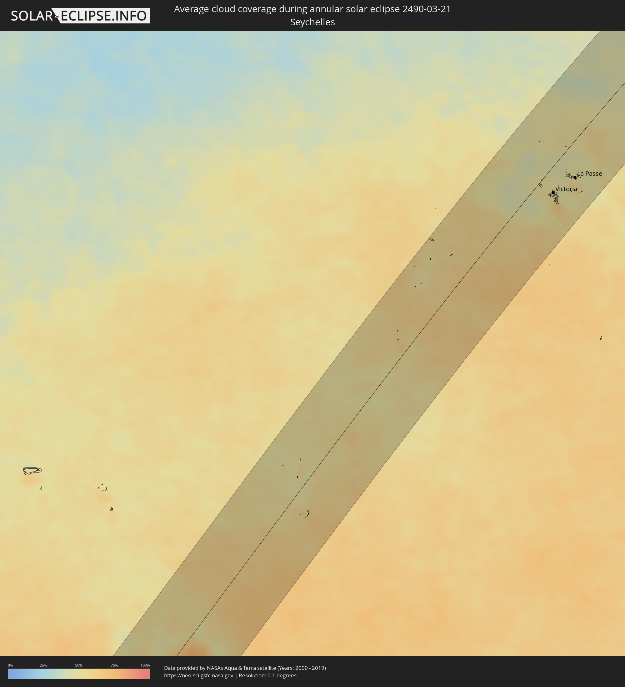 Seychelles
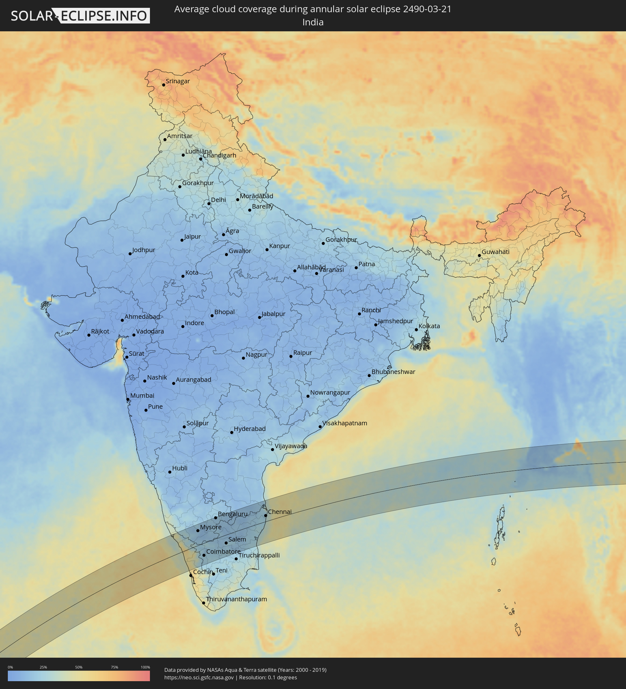 India
India
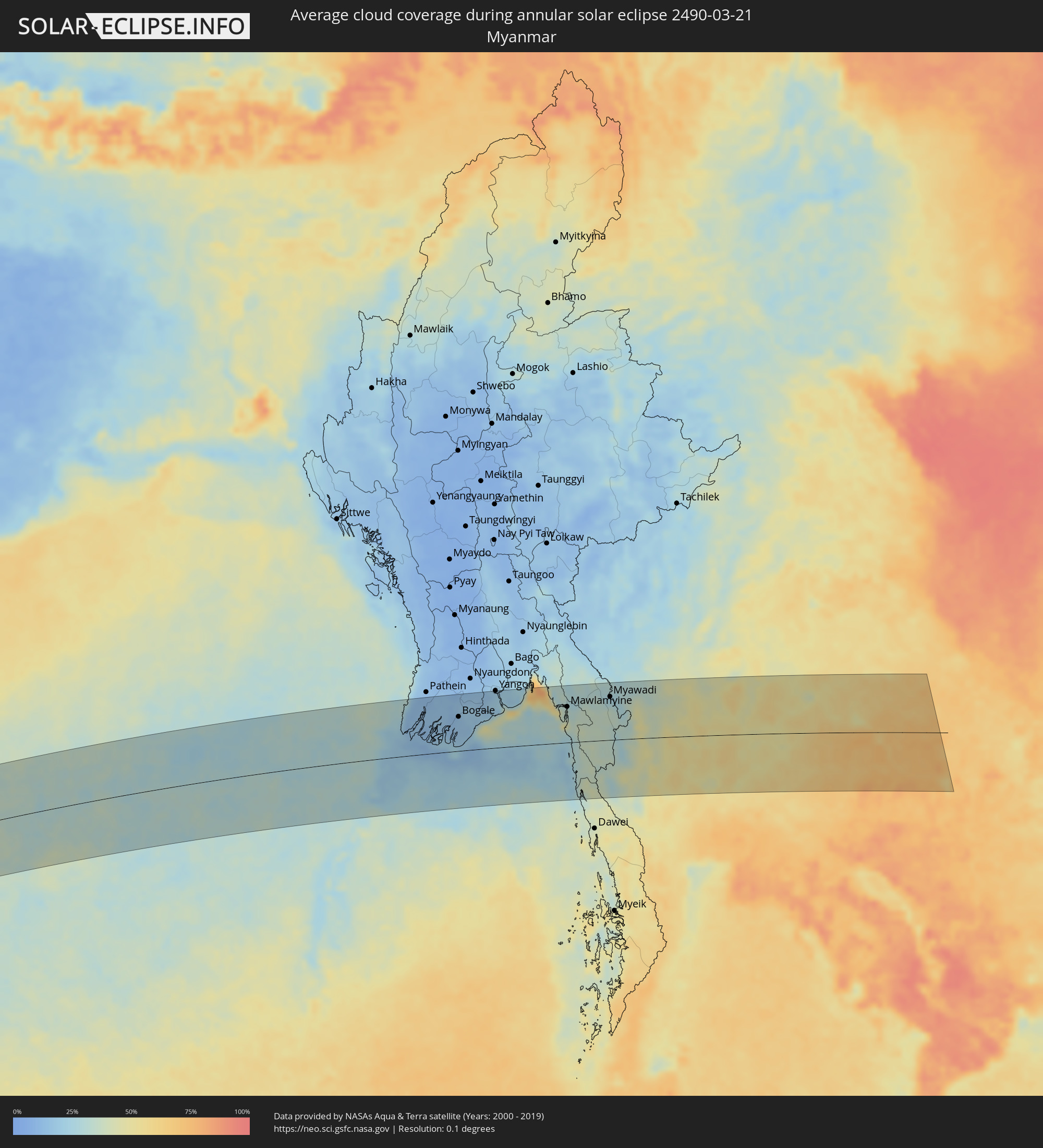 Myanmar
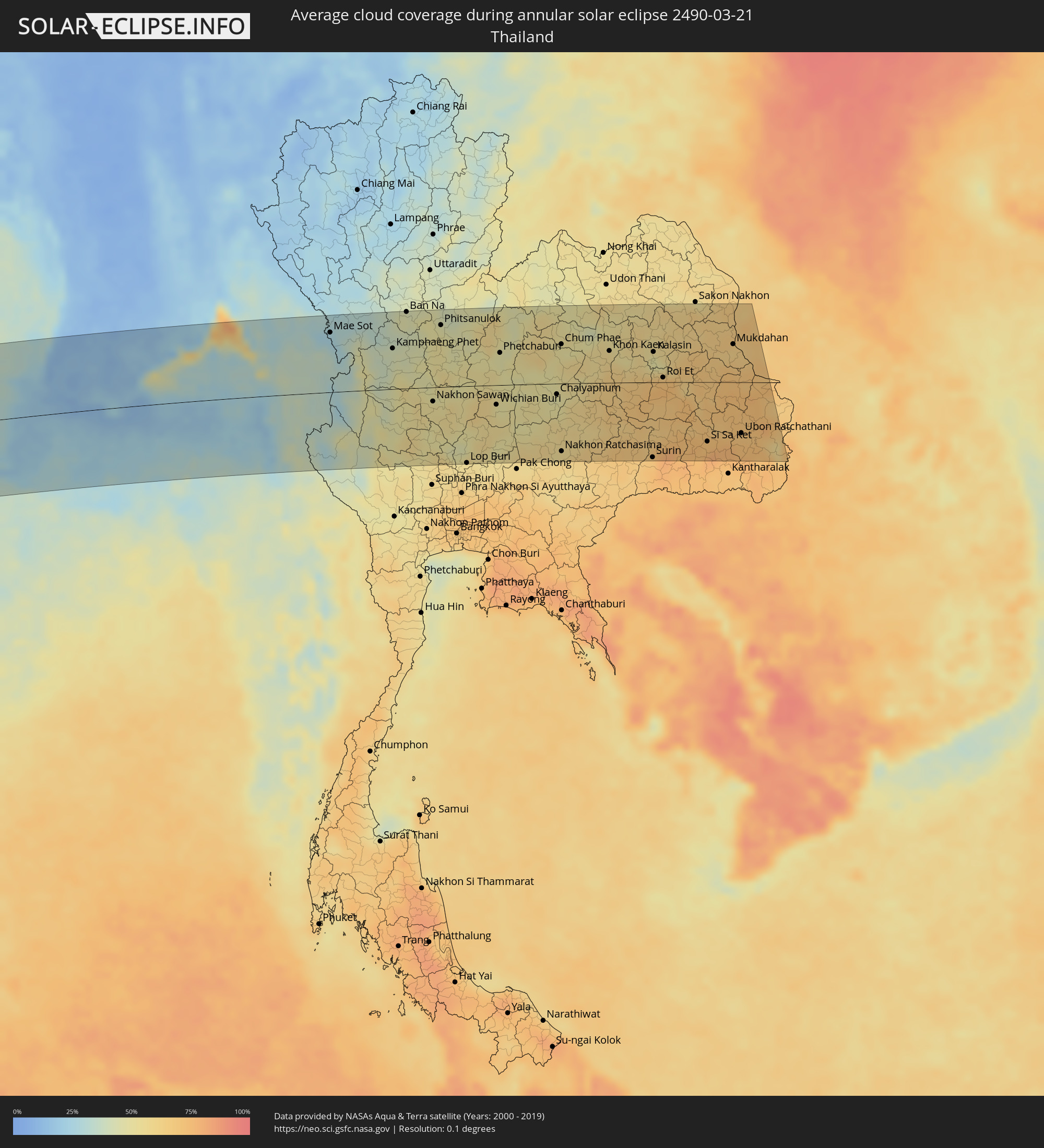 Thailand
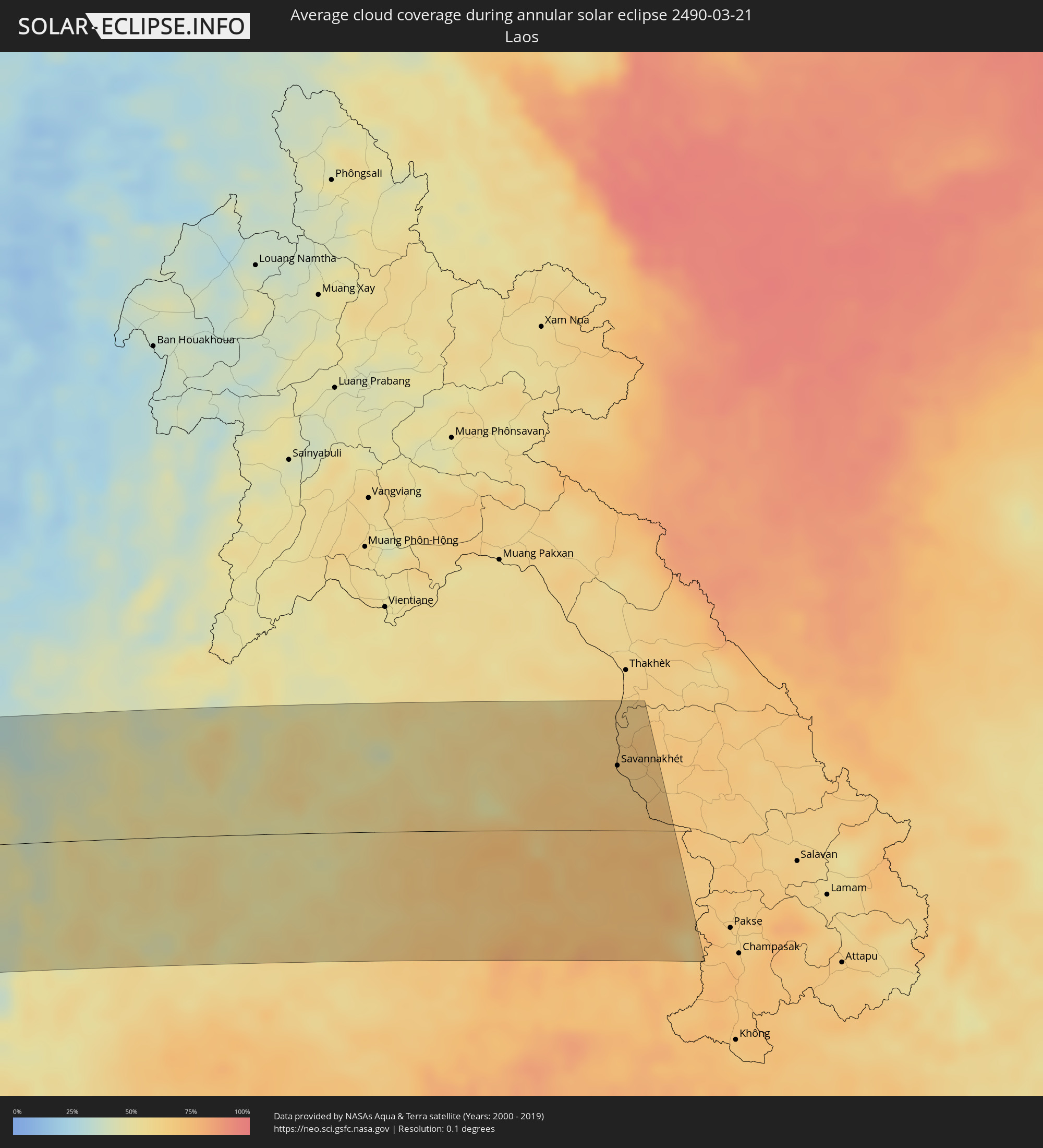 Laos
Laos
Cities inside the path of the eclipse
The following table shows all locations with a population of more than 5,000 inside the eclipse path. Cities which have more than 100,000 inhabitants are marked bold. A click at the locations opens a detailed map.
| City | Type | Eclipse duration | Local time of max. eclipse | Distance to central line | Ø Cloud coverage |
|
Mossel Bay, Western Cape
|
annular | - | 09:43:06 UTC+02:00 | 97 km | 41% |
|
Knysna, Western Cape
|
annular | - | 09:44:19 UTC+02:00 | 71 km | 44% |
|
Plettenberg Bay, Western Cape
|
annular | - | 09:44:43 UTC+02:00 | 54 km | 46% |
|
Kruisfontein, Eastern Cape
|
annular | - | 09:46:29 UTC+02:00 | 4 km | 45% |
|
Uitenhage, Eastern Cape
|
annular | - | 09:47:32 UTC+02:00 | 12 km | 45% |
|
Port Elizabeth, Eastern Cape
|
annular | - | 09:47:38 UTC+02:00 | 36 km | 42% |
|
Grahamstown, Eastern Cape
|
annular | - | 09:49:25 UTC+02:00 | 25 km | 45% |
|
Fort Beaufort, Eastern Cape
|
annular | - | 09:50:01 UTC+02:00 | 19 km | 41% |
|
Queenstown, Eastern Cape
|
annular | - | 09:51:10 UTC+02:00 | 89 km | 42% |
|
Port Alfred, Eastern Cape
|
annular | - | 09:49:39 UTC+02:00 | 69 km | 41% |
|
Queensdale, Eastern Cape
|
annular | - | 09:51:20 UTC+02:00 | 86 km | 44% |
|
Lady Frere, Eastern Cape
|
annular | - | 09:51:52 UTC+02:00 | 88 km | 41% |
|
Stutterheim, Eastern Cape
|
annular | - | 09:51:18 UTC+02:00 | 2 km | 49% |
|
Bhisho, Eastern Cape
|
annular | - | 09:51:04 UTC+02:00 | 29 km | 46% |
|
East London, Eastern Cape
|
annular | - | 09:51:34 UTC+02:00 | 69 km | 41% |
|
Butterworth, Eastern Cape
|
annular | - | 09:52:33 UTC+02:00 | 18 km | 50% |
|
Mthatha, Eastern Cape
|
annular | - | 09:54:12 UTC+02:00 | 16 km | 53% |
|
Kokstad, KwaZulu-Natal
|
annular | - | 09:56:17 UTC+02:00 | 75 km | 45% |
|
Richmond, KwaZulu-Natal
|
annular | - | 09:58:21 UTC+02:00 | 87 km | 50% |
|
Margate, KwaZulu-Natal
|
annular | - | 09:57:20 UTC+02:00 | 7 km | 55% |
|
Port Shepstone, KwaZulu-Natal
|
annular | - | 09:57:36 UTC+02:00 | 1 km | 51% |
|
Mpumalanga, KwaZulu-Natal
|
annular | - | 09:58:59 UTC+02:00 | 71 km | 55% |
|
Scottburgh, KwaZulu-Natal
|
annular | - | 09:58:35 UTC+02:00 | 22 km | 53% |
|
Umkomaas, KwaZulu-Natal
|
annular | - | 09:58:45 UTC+02:00 | 27 km | 51% |
|
Durban, KwaZulu-Natal
|
annular | - | 09:59:32 UTC+02:00 | 44 km | 55% |
|
Stanger, KwaZulu-Natal
|
annular | - | 10:00:36 UTC+02:00 | 75 km | 51% |
|
Empangeni, KwaZulu-Natal
|
annular | - | 10:02:18 UTC+02:00 | 88 km | 52% |
|
eSikhawini, KwaZulu-Natal
|
annular | - | 10:02:10 UTC+02:00 | 79 km | 49% |
|
Richards Bay, KwaZulu-Natal
|
annular | - | 10:02:30 UTC+02:00 | 78 km | 48% |
|
Maintirano, Melaky
|
annular | - | 11:43:49 UTC+03:00 | 42 km | 45% |
|
Mahabe, Melaky
|
annular | - | 11:48:36 UTC+03:00 | 2 km | 67% |
|
Sitampiky, Boeny
|
annular | - | 11:51:04 UTC+03:00 | 34 km | 57% |
|
Mahajanga, Boeny
|
annular | - | 11:53:46 UTC+03:00 | 12 km | 54% |
|
Marovoay, Boeny
|
annular | - | 11:53:27 UTC+03:00 | 42 km | 60% |
|
Ambato Boeny, Boeny
|
annular | - | 11:52:44 UTC+03:00 | 73 km | 49% |
|
Antsohihy, Sofia
|
annular | - | 11:59:04 UTC+03:00 | 75 km | 63% |
|
Hell-Ville, Diana
|
annular | - | 12:03:17 UTC+03:00 | 1 km | 53% |
|
Ambanja, Diana
|
annular | - | 12:02:57 UTC+03:00 | 35 km | 67% |
|
Antsohimbondrona, Diana
|
annular | - | 12:05:14 UTC+03:00 | 30 km | 59% |
|
Ambarakaraka, Diana
|
annular | - | 12:04:13 UTC+03:00 | 59 km | 67% |
|
Ambilobe, Diana
|
annular | - | 12:05:20 UTC+03:00 | 55 km | 55% |
|
Antsiranana, Diana
|
annular | - | 12:08:08 UTC+03:00 | 15 km | 64% |
|
Sadjoavato, Diana
|
annular | - | 12:07:24 UTC+03:00 | 42 km | 74% |
|
Port Glaud, Port Glaud
|
annular | - | 13:39:42 UTC+04:00 | 34 km | 56% |
|
Bel Ombre, Bel Ombre
|
annular | - | 13:39:50 UTC+04:00 | 30 km | 63% |
|
Beau Vallon, Beau Vallon
|
annular | - | 13:39:50 UTC+04:00 | 32 km | 63% |
|
Victoria, English River
|
annular | - | 13:39:53 UTC+04:00 | 33 km | 64% |
|
Anse Boileau, Anse Boileau
|
annular | - | 13:39:42 UTC+04:00 | 43 km | 64% |
|
Takamaka, Takamaka
|
annular | - | 13:39:36 UTC+04:00 | 48 km | 60% |
|
Cascade, Cascade
|
annular | - | 13:39:52 UTC+04:00 | 41 km | 64% |
|
Anse Royale, Anse Royale
|
annular | - | 13:39:43 UTC+04:00 | 47 km | 64% |
|
La Passe, Inner Islands
|
annular | - | 13:41:19 UTC+04:00 | 47 km | 59% |
|
Tellicherry, Kerala
|
annular | - | 16:15:26 UTC+05:30 | 68 km | 37% |
|
Kozhikode, Kerala
|
annular | - | 16:15:07 UTC+05:30 | 5 km | 39% |
|
Ponnāni, Kerala
|
annular | - | 16:14:39 UTC+05:30 | 51 km | 40% |
|
Trichūr, Kerala
|
annular | - | 16:14:39 UTC+05:30 | 89 km | 51% |
|
Mysore, Karnataka
|
annular | - | 16:17:25 UTC+05:30 | 78 km | 18% |
|
Palakkad, Kerala
|
annular | - | 16:15:30 UTC+05:30 | 80 km | 28% |
|
Ooty, Tamil Nadu
|
annular | - | 16:16:22 UTC+05:30 | 16 km | 29% |
|
Mandya, Karnataka
|
annular | - | 16:17:58 UTC+05:30 | 92 km | 12% |
|
Coimbatore, Tamil Nadu
|
annular | - | 16:16:09 UTC+05:30 | 69 km | 24% |
|
Closepet, Karnataka
|
annular | - | 16:18:37 UTC+05:30 | 98 km | 17% |
|
Tiruppur, Tamil Nadu
|
annular | - | 16:16:44 UTC+05:30 | 72 km | 23% |
|
Bengaluru, Karnataka
|
annular | - | 16:19:14 UTC+05:30 | 112 km | 16% |
|
Erode, Tamil Nadu
|
annular | - | 16:17:25 UTC+05:30 | 63 km | 22% |
|
Hosūr, Tamil Nadu
|
annular | - | 16:19:13 UTC+05:30 | 79 km | 15% |
|
Kolār, Karnataka
|
annular | - | 16:19:59 UTC+05:30 | 110 km | 16% |
|
Salem, Tamil Nadu
|
annular | - | 16:18:16 UTC+05:30 | 47 km | 21% |
|
Robertsonpet, Karnataka
|
annular | - | 16:19:55 UTC+05:30 | 85 km | 16% |
|
Ambur, Tamil Nadu
|
annular | - | 16:20:11 UTC+05:30 | 52 km | 17% |
|
Gudiyatham, Tamil Nadu
|
annular | - | 16:20:31 UTC+05:30 | 63 km | 13% |
|
Tiruvannāmalai, Tamil Nadu
|
annular | - | 16:19:54 UTC+05:30 | 20 km | 18% |
|
Vellore, Tamil Nadu
|
annular | - | 16:20:44 UTC+05:30 | 51 km | 14% |
|
Tirupati, Andhra Pradesh
|
annular | - | 16:21:48 UTC+05:30 | 117 km | 14% |
|
Villupuram, Tamil Nadu
|
annular | - | 16:19:59 UTC+05:30 | 64 km | 23% |
|
Kānchipuram, Tamil Nadu
|
annular | - | 16:21:12 UTC+05:30 | 23 km | 21% |
|
Cuddalore, Tamil Nadu
|
annular | - | 16:20:02 UTC+05:30 | 94 km | 31% |
|
Puducherry, Pondicherry
|
annular | - | 16:20:19 UTC+05:30 | 77 km | 30% |
|
Āvadi, Tamil Nadu
|
annular | - | 16:21:54 UTC+05:30 | 39 km | 22% |
|
Pallāvaram, Tamil Nadu
|
annular | - | 16:21:47 UTC+05:30 | 22 km | 24% |
|
Chennai, Tamil Nadu
|
annular | - | 16:22:02 UTC+05:30 | 31 km | 30% |
|
Wakema, Ayeyarwady
|
annular | - | 17:34:12 UTC+06:30 | 111 km | 12% |
|
Mawlamyinegyunn, Ayeyarwady
|
annular | - | 17:34:06 UTC+06:30 | 85 km | 12% |
|
Bogale, Ayeyarwady
|
annular | - | 17:34:05 UTC+06:30 | 75 km | 15% |
|
Maubin, Ayeyarwady
|
annular | - | 17:34:25 UTC+06:30 | 121 km | 17% |
|
Pyapon, Ayeyarwady
|
annular | - | 17:34:11 UTC+06:30 | 71 km | 17% |
|
Kyaiklat, Ayeyarwady
|
annular | - | 17:34:17 UTC+06:30 | 88 km | 18% |
|
Twante, Yangon
|
annular | - | 17:34:29 UTC+06:30 | 116 km | 16% |
|
Kanbe, Yangon
|
annular | - | 17:34:31 UTC+06:30 | 115 km | 18% |
|
Yangon, Yangon
|
annular | - | 17:34:37 UTC+06:30 | 125 km | 22% |
|
Syriam, Yangon
|
annular | - | 17:34:37 UTC+06:30 | 120 km | 22% |
|
Thongwa, Yangon
|
annular | - | 17:34:41 UTC+06:30 | 117 km | 22% |
|
Kyaikkami, Mon
|
annular | - | 17:34:36 UTC+06:30 | 33 km | 34% |
|
Martaban, Mon
|
annular | - | 17:34:51 UTC+06:30 | 83 km | 34% |
|
Mawlamyine, Mon
|
annular | - | 17:34:50 UTC+06:30 | 78 km | 34% |
|
Hpa-an, Kayin
|
annular | - | 17:35:03 UTC+06:30 | 123 km | 28% |
|
Mudon, Mon
|
annular | - | 17:34:44 UTC+06:30 | 52 km | 33% |
|
Myawadi, Kayin
|
annular | - | 17:35:08 UTC+06:30 | 95 km | 26% |
|
Mae Sot, Tak
|
annular | - | 18:05:10 UTC+07:00 | 97 km | 25% |
|
Tak, Tak
|
annular | - | 18:05:21 UTC+07:00 | 111 km | 33% |
|
Kamphaeng Phet, Kamphaeng Phet
|
annular | - | 18:05:14 UTC+07:00 | 66 km | 41% |
|
Ban Na, Sukhothai
|
annular | - | 18:05:32 UTC+07:00 | 125 km | 46% |
|
Nakhon Sawan, Nakhon Sawan
|
annular | - | 18:04:56 UTC+07:00 | 23 km | 52% |
|
Phitsanulok, Phitsanulok
|
annular | - | 18:05:32 UTC+07:00 | 101 km | 48% |
|
Phichit, Phichit
|
annular | - | 18:05:21 UTC+07:00 | 58 km | 51% |
|
Lop Buri, Lop Buri
|
annular | - | 18:04:32 UTC+07:00 | 126 km | 57% |
|
Nong Phai, Phetchabun
|
annular | - | 18:05:14 UTC+07:00 | 5 km | 50% |
|
Wichian Buri, Phetchabun
|
annular | - | 18:05:04 UTC+07:00 | 32 km | 51% |
|
Chai Badan, Lop Buri
|
annular | - | 18:04:50 UTC+07:00 | 83 km | 50% |
|
Phetchabun, Phetchabun
|
annular | - | 18:05:27 UTC+07:00 | 53 km | 47% |
|
Amphoe Sikhiu, Nakhon Ratchasima
|
annular | - | 18:04:45 UTC+07:00 | 118 km | 58% |
|
Chaiyaphum, Chaiyaphum
|
annular | - | 18:05:16 UTC+07:00 | 17 km | 47% |
|
Chum Phae, Khon Kaen
|
annular | - | 18:05:38 UTC+07:00 | 64 km | 50% |
|
Nakhon Ratchasima, Nakhon Ratchasima
|
annular | - | 18:04:51 UTC+07:00 | 111 km | 57% |
|
Kaeng Khro, Chaiyaphum
|
annular | - | 18:05:26 UTC+07:00 | 15 km | 54% |
|
Ban Phai, Khon Kaen
|
annular | - | 18:05:27 UTC+07:00 | 9 km | 60% |
|
Khon Kaen, Khon Kaen
|
annular | - | 18:05:39 UTC+07:00 | 52 km | 58% |
|
Buriram, Buriram
|
annular | - | 18:04:58 UTC+07:00 | 110 km | 68% |
|
Maha Sarakham, Maha Sarakham
|
annular | - | 18:05:33 UTC+07:00 | 22 km | 61% |
|
Surin, Surin
|
annular | - | 18:04:56 UTC+07:00 | 123 km | 69% |
|
Kalasin, Kalasin
|
annular | - | 18:05:41 UTC+07:00 | 50 km | 48% |
|
Roi Et, Roi Et
|
annular | - | 18:05:31 UTC+07:00 | 8 km | 69% |
|
Si Sa Ket, Sisaket
|
annular | - | 18:05:06 UTC+07:00 | 97 km | 73% |
|
Amnat Charoen, Amnat Charoen
|
annular | - | 18:05:28 UTC+07:00 | 14 km | 72% |
|
Mukdahan, Mukdahan
|
annular | - | 18:05:47 UTC+07:00 | 62 km | 62% |
|
Savannakhét, Savannahkhét
|
annular | - | 18:05:47 UTC+07:00 | 64 km | 65% |
|
Ubon Ratchathani, Changwat Ubon Ratchathani
|
annular | - | 18:05:11 UTC+07:00 | 83 km | 73% |
|
Det Udom, Changwat Ubon Ratchathani
|
annular | - | 18:05:02 UTC+07:00 | 120 km | 71% |