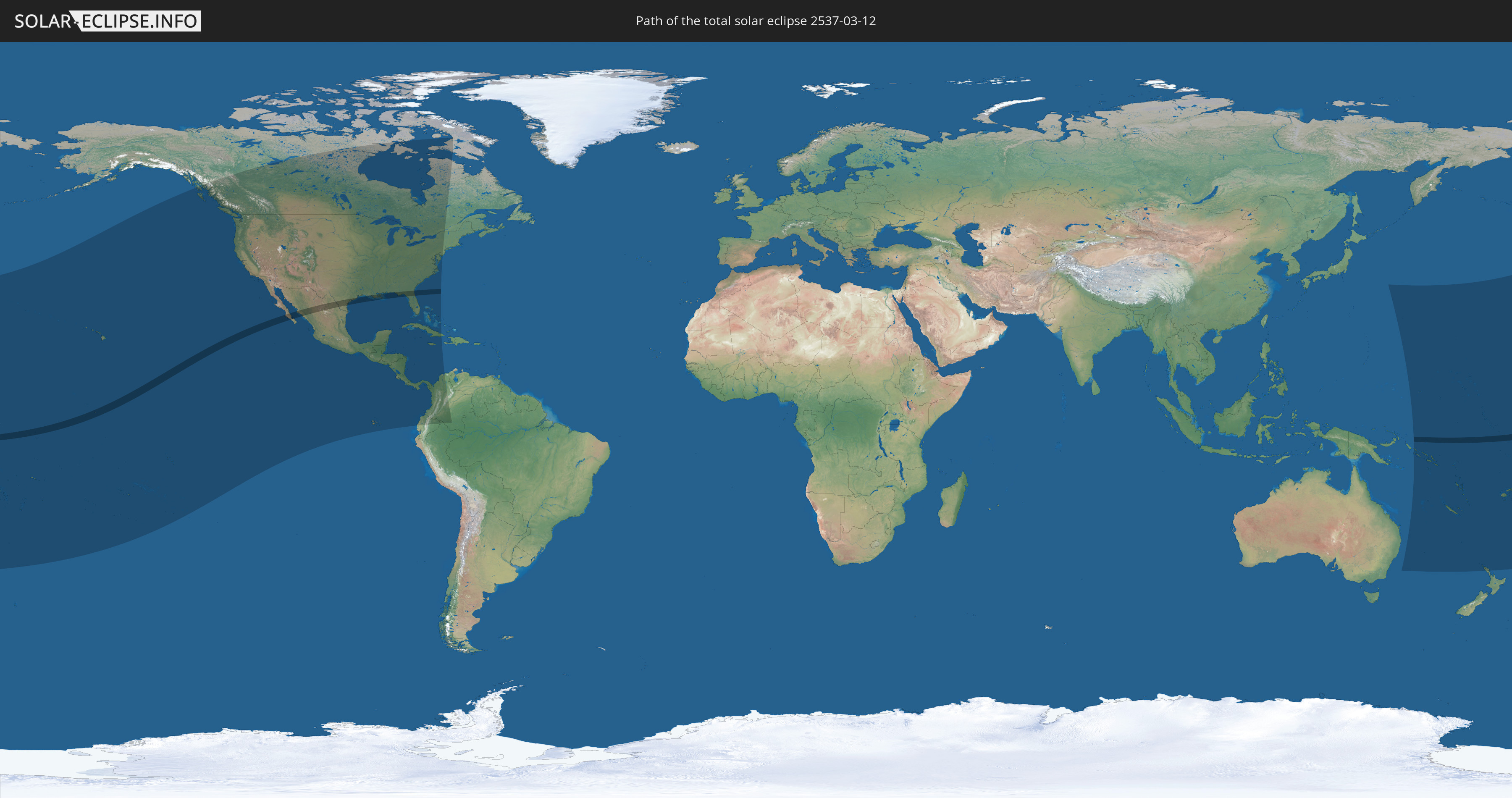
Total solar eclipse of 03/12/2537
| Day of week: | Tuesday |
| Maximum duration of eclipse: | 04m53s |
| Maximum width of eclipse path: | 184 km |
| Saros cycle: | 148 |
| Coverage: | 100% |
| Magnitude: | 1.0542 |
| Gamma: | 0.2254 |
Wo kann man die Sonnenfinsternis vom 03/12/2537 sehen?
Die Sonnenfinsternis am 03/12/2537 kann man in 40 Ländern als partielle Sonnenfinsternis beobachten.
Der Finsternispfad verläuft durch 4 Länder. Nur in diesen Ländern ist sie als total Sonnenfinsternis zu sehen.
In den folgenden Ländern ist die Sonnenfinsternis total zu sehen
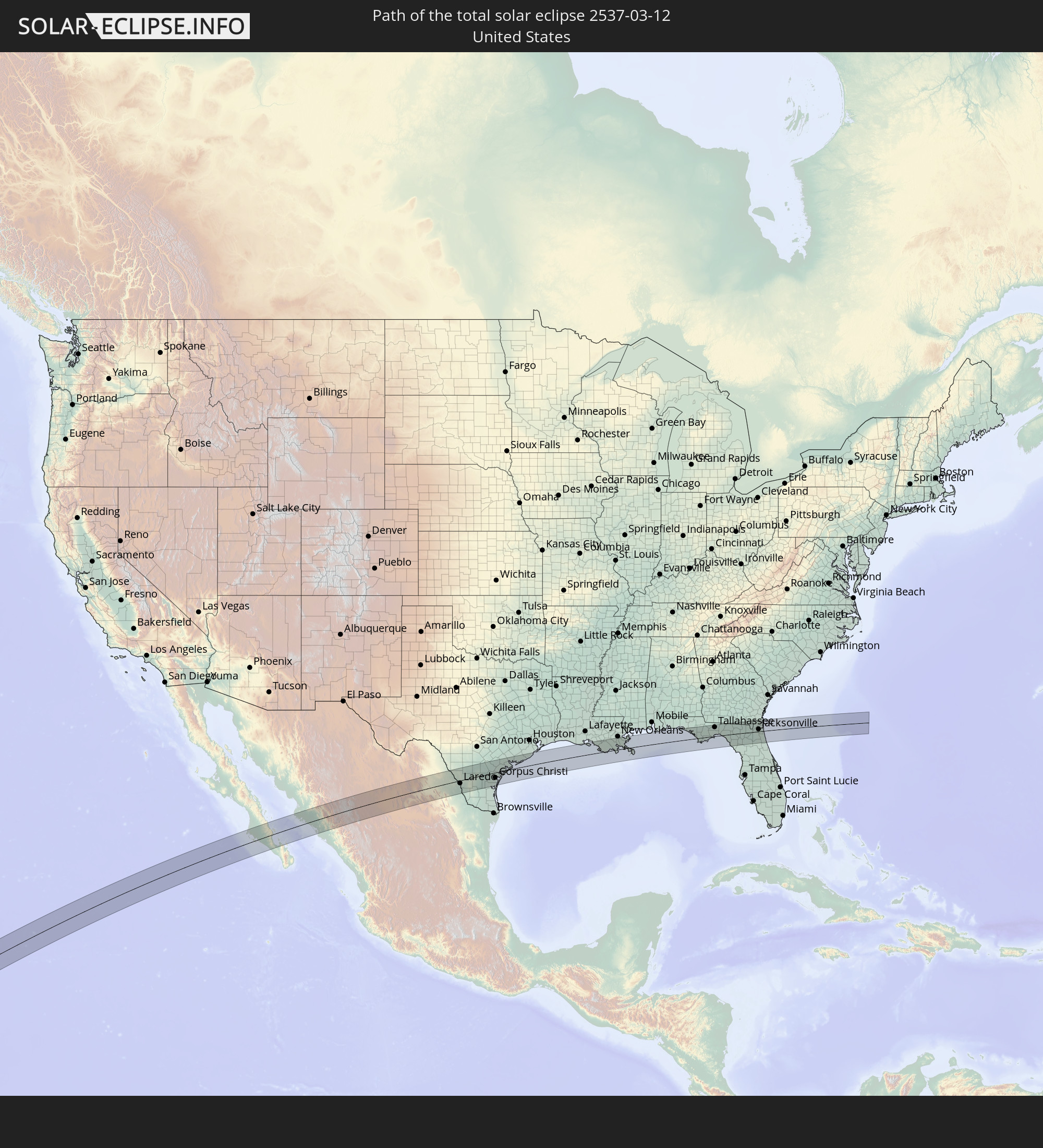 United States
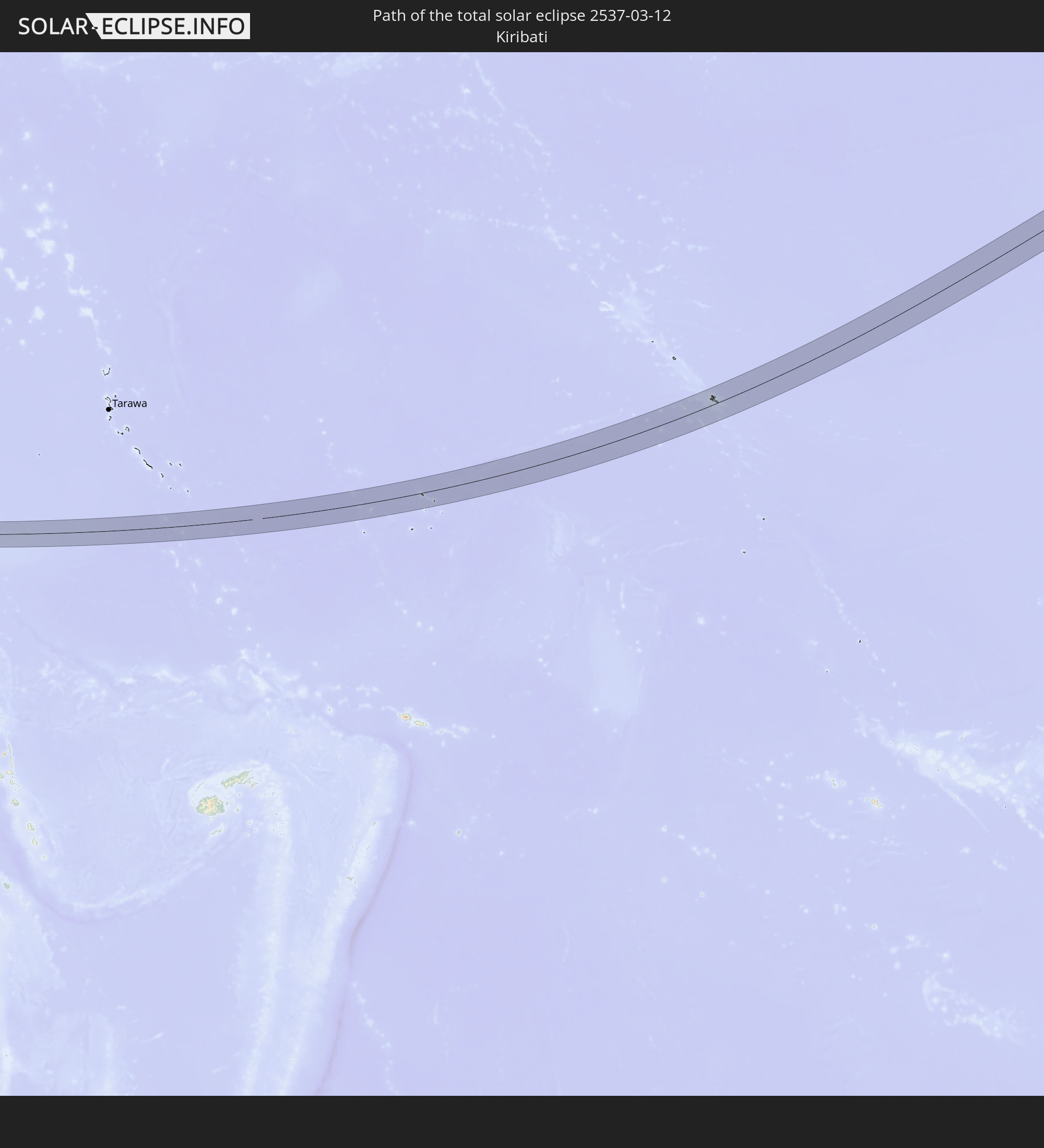 Kiribati
 Mexico
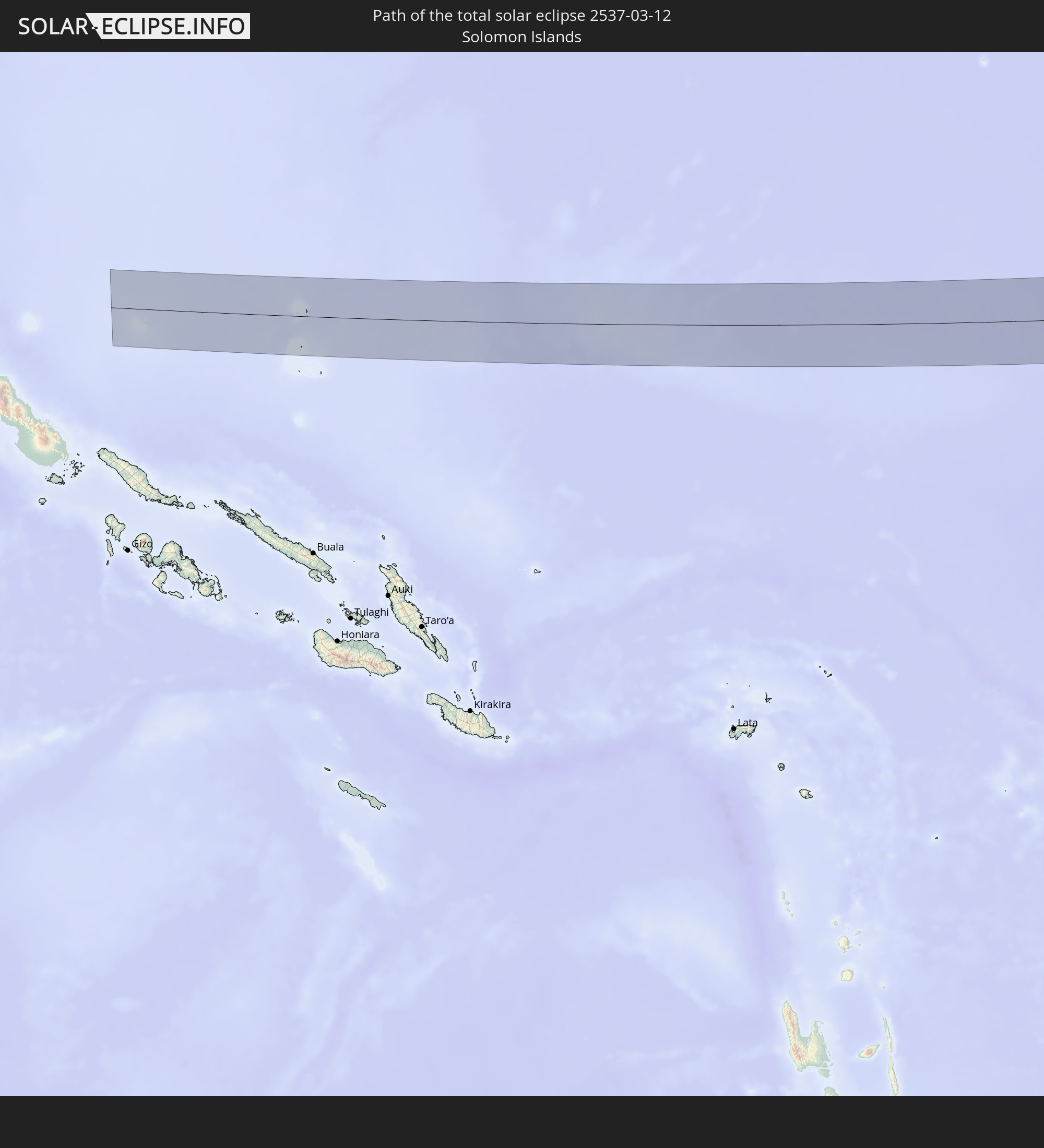 Solomon Islands
In den folgenden Ländern ist die Sonnenfinsternis partiell zu sehen
 Fiji
Fiji
 United States
 New Zealand
 United States Minor Outlying Islands
 Wallis and Futuna
 Tonga
Tonga
 Kiribati
 Samoa
Samoa
 Tokelau
 American Samoa
 Niue
Niue
 Cook Islands
 French Polynesia
 Canada
 Mexico
 Greenland
 Guatemala
 Ecuador
 El Salvador
 Honduras
 Belize
 Nicaragua
 Costa Rica
 Cuba
Cuba
 Panama
 Colombia
 Cayman Islands
 Peru
Peru
 The Bahamas
 Jamaica
 Australia
 Japan
Japan
 Federated States of Micronesia
 Solomon Islands
 New Caledonia
 Marshall Islands
 Vanuatu
 Nauru
Nauru
 Norfolk Island
 Tuvalu
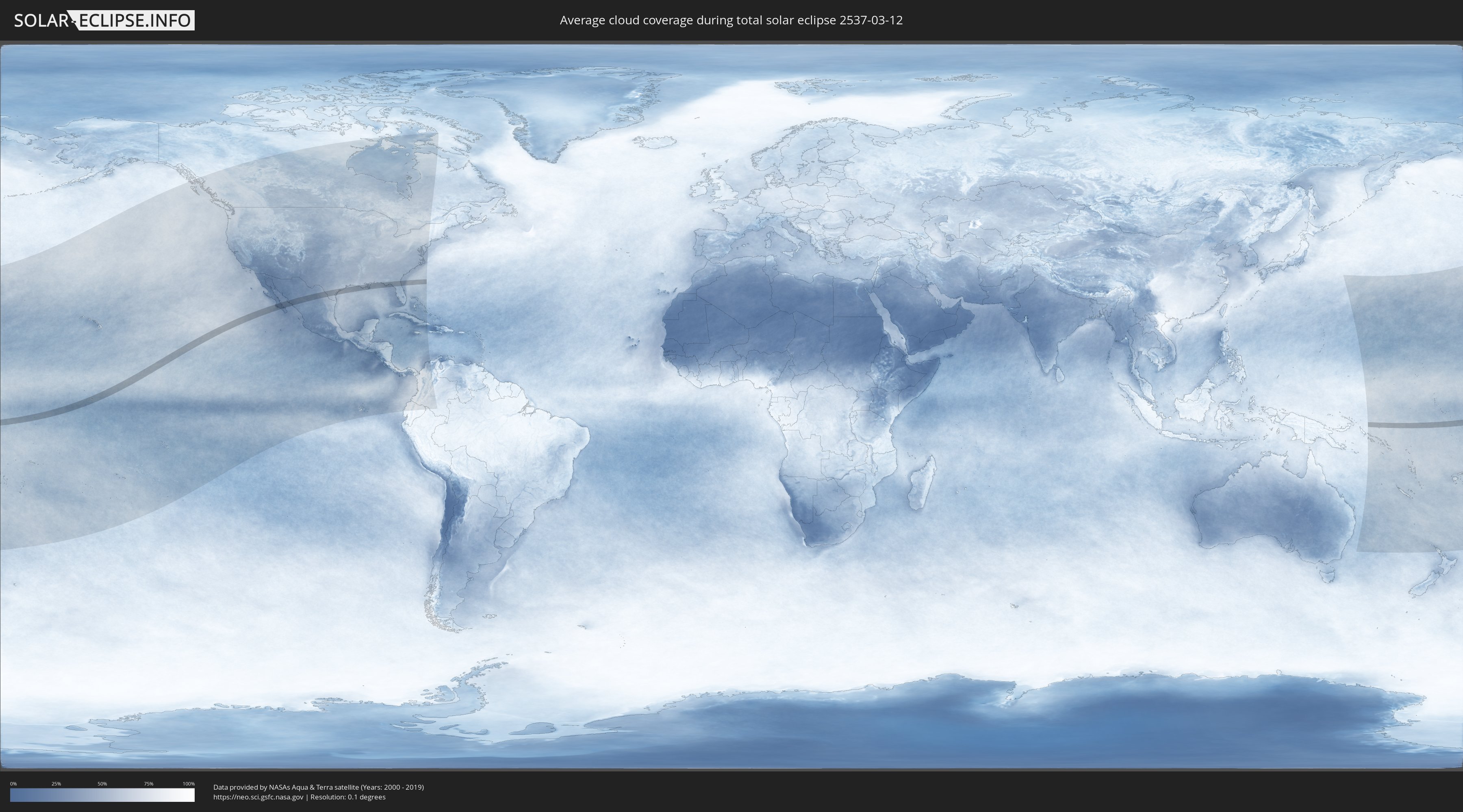
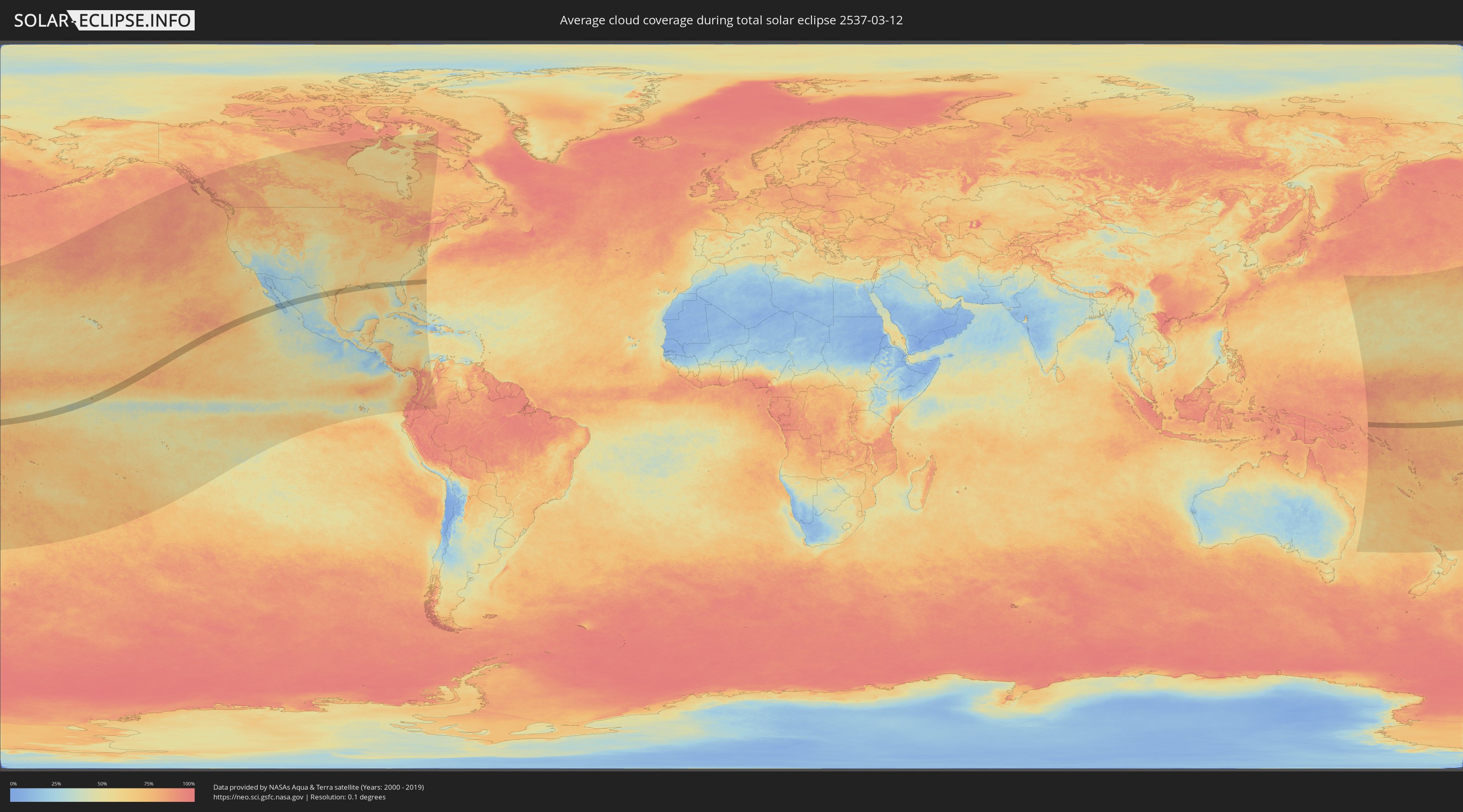
How will be the weather during the total solar eclipse on 03/12/2537?
Where is the best place to see the total solar eclipse of 03/12/2537?
The following maps show the average cloud coverage for the day of the total solar eclipse.
With the help of these maps, it is possible to find the place along the eclipse path, which has the best
chance of a cloudless sky.
Nevertheless, you should consider local circumstances and inform about the weather of your chosen
observation site.
The data is provided by NASAs satellites
AQUA and TERRA.
The cloud maps are averaged over a period of 19 years (2000 - 2019).
Detailed country maps
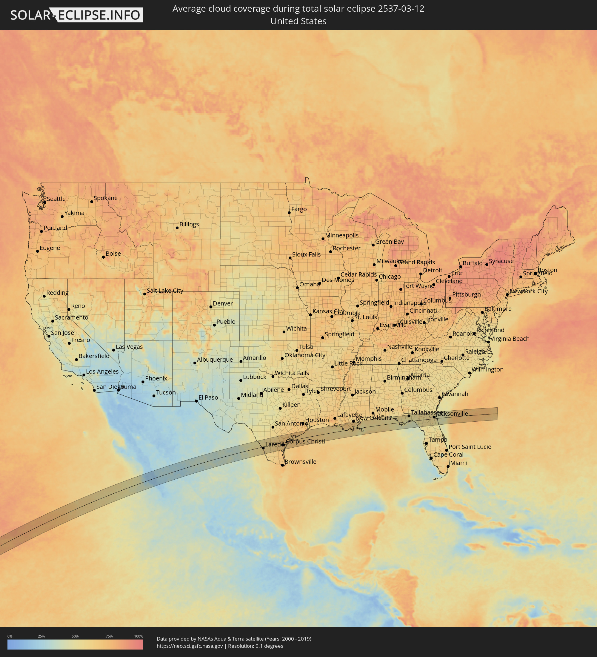 United States
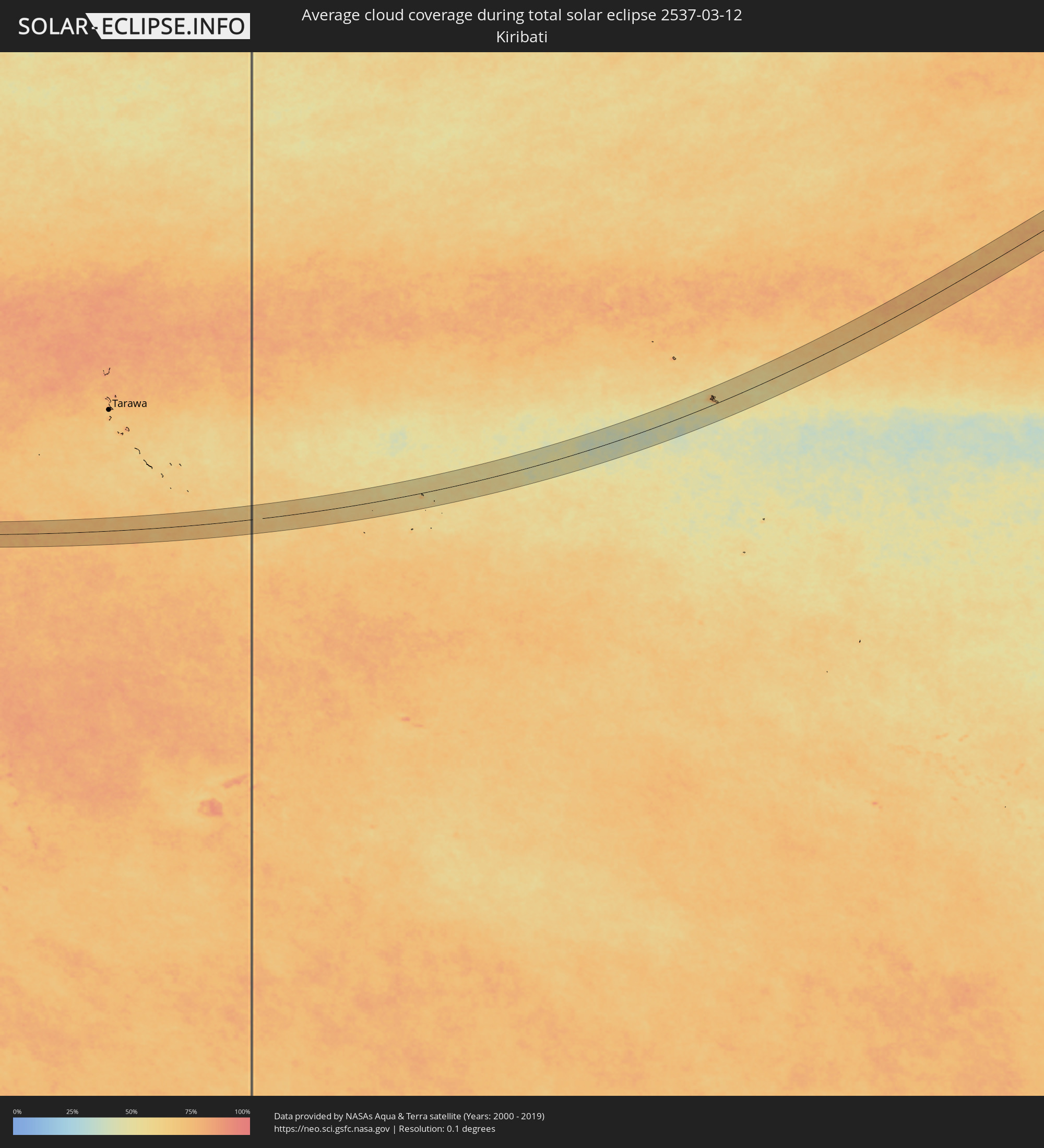 Kiribati
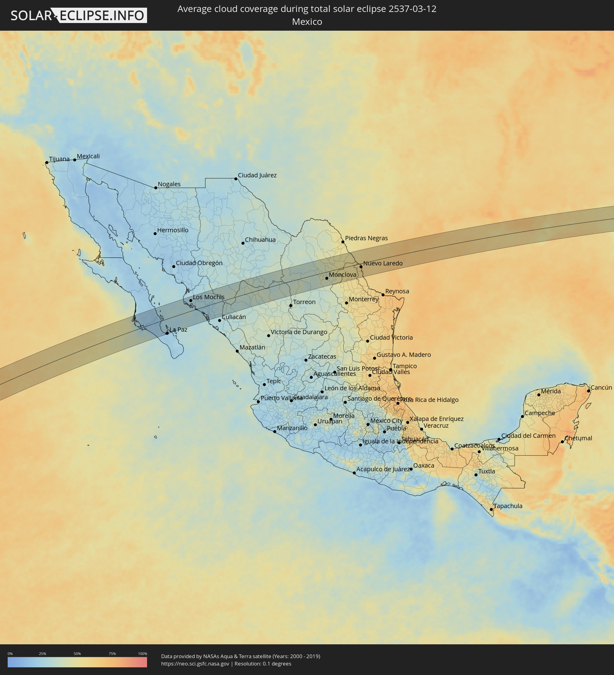 Mexico
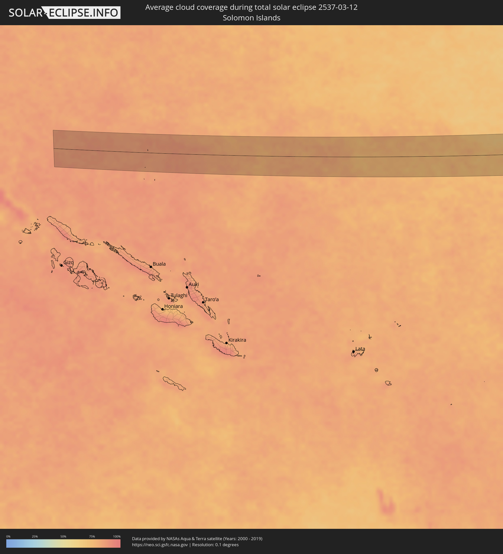 Solomon Islands
Cities inside the path of the eclipse
The following table shows all locations with a population of more than 5,000 inside the eclipse path. Cities which have more than 100,000 inhabitants are marked bold. A click at the locations opens a detailed map.
| City | Type | Eclipse duration | Local time of max. eclipse | Distance to central line | Ø Cloud coverage |
|
Ciudad Constitución, Baja California Sur
|
total | - | 15:40:31 UTC-07:00 | 60 km | 16% |
|
La Paz, Baja California Sur
|
total | - | 15:42:06 UTC-07:00 | 79 km | 20% |
|
Ahome, Sinaloa
|
total | - | 15:43:52 UTC-07:00 | 73 km | 26% |
|
Topolobampo, Sinaloa
|
total | - | 15:43:58 UTC-07:00 | 35 km | 29% |
|
San Miguel Zapotitlan, Sinaloa
|
total | - | 15:44:02 UTC-07:00 | 72 km | 27% |
|
Los Mochis, Sinaloa
|
total | - | 15:44:04 UTC-07:00 | 54 km | 26% |
|
Juan Jose Rios, Sinaloa
|
total | - | 15:44:16 UTC-07:00 | 45 km | 29% |
|
San Blas, Sinaloa
|
total | - | 15:44:23 UTC-07:00 | 77 km | 26% |
|
Adolfo Ruíz Cortínes, Sinaloa
|
total | - | 15:44:21 UTC-07:00 | 42 km | 29% |
|
Leyva Solano, Sinaloa
|
total | - | 15:44:29 UTC-07:00 | 29 km | 29% |
|
Guasave, Sinaloa
|
total | - | 15:44:40 UTC-07:00 | 13 km | 25% |
|
Guamúchil, Sinaloa
|
total | - | 15:45:07 UTC-07:00 | 10 km | 24% |
|
La Reforma, Sinaloa
|
total | - | 15:45:05 UTC-07:00 | 51 km | 27% |
|
Mocorito, Sinaloa
|
total | - | 15:45:18 UTC-07:00 | 12 km | 27% |
|
Santa Bárbara, Chihuahua
|
total | - | 15:47:47 UTC-07:00 | 68 km | 35% |
|
Santa María del Oro, Durango
|
total | - | 16:48:13 UTC-06:00 | 37 km | 35% |
|
Tlahualilo de Zaragoza, Durango
|
total | - | 16:50:11 UTC-06:00 | 72 km | 34% |
|
San Buenaventura, Coahuila
|
total | - | 16:51:58 UTC-06:00 | 16 km | 40% |
|
Melchor Múzquiz, Coahuila
|
total | - | 16:51:57 UTC-06:00 | 71 km | 44% |
|
Ciudad Frontera, Coahuila
|
total | - | 16:52:03 UTC-06:00 | 33 km | 42% |
|
Castaños, Coahuila
|
total | - | 16:52:04 UTC-06:00 | 49 km | 39% |
|
Palau, Coahuila
|
total | - | 16:52:02 UTC-06:00 | 70 km | 45% |
|
Monclova, Coahuila
|
total | - | 16:52:05 UTC-06:00 | 36 km | 42% |
|
Minas de Barroterán, Coahuila
|
total | - | 16:52:10 UTC-06:00 | 41 km | 43% |
|
Nueva Rosita, Coahuila
|
total | - | 16:52:12 UTC-06:00 | 70 km | 46% |
|
Ciudad Sabinas, Coahuila
|
total | - | 16:52:18 UTC-06:00 | 59 km | 46% |
|
Lampazos de Naranjo, Nuevo León
|
total | - | 16:52:52 UTC-06:00 | 45 km | 50% |
|
Ciudad Anáhuac, Nuevo León
|
total | - | 16:53:11 UTC-06:00 | 30 km | 52% |
|
Anáhuac, Nuevo León
|
total | - | 16:53:11 UTC-06:00 | 31 km | 52% |
|
El Campanario y Oradel, Tamaulipas
|
total | - | 16:53:35 UTC-06:00 | 17 km | 57% |
|
Nuevo Laredo, Tamaulipas
|
total | - | 16:53:40 UTC-06:00 | 19 km | 58% |
|
Laredo, Texas
|
total | - | 16:53:40 UTC-06:00 | 16 km | 58% |
|
Alice, Texas
|
total | - | 16:54:47 UTC-06:00 | 21 km | 62% |
|
Kingsville, Texas
|
total | - | 16:54:58 UTC-06:00 | 51 km | 67% |
|
Beeville, Texas
|
total | - | 16:54:56 UTC-06:00 | 42 km | 65% |
|
Robstown, Texas
|
total | - | 16:55:04 UTC-06:00 | 26 km | 65% |
|
Sinton, Texas
|
total | - | 16:55:10 UTC-06:00 | 2 km | 65% |
|
Corpus Christi, Texas
|
total | - | 16:55:16 UTC-06:00 | 30 km | 67% |
|
Portland, Texas
|
total | - | 16:55:19 UTC-06:00 | 23 km | 66% |
|
Ingleside, Texas
|
total | - | 16:55:24 UTC-06:00 | 26 km | 69% |
|
Aransas Pass, Texas
|
total | - | 16:55:26 UTC-06:00 | 23 km | 66% |
|
Rockport, Texas
|
total | - | 16:55:29 UTC-06:00 | 13 km | 68% |
|
Victoria, Texas
|
total | - | 16:55:24 UTC-06:00 | 71 km | 71% |
|
Port Lavaca, Texas
|
total | - | 16:55:42 UTC-06:00 | 43 km | 66% |
|
Bay City, Texas
|
total | - | 16:56:05 UTC-06:00 | 70 km | 71% |
|
Lake Jackson, Texas
|
total | - | 16:56:25 UTC-06:00 | 65 km | 71% |
|
Clute, Texas
|
total | - | 16:56:27 UTC-06:00 | 63 km | 71% |
|
Freeport, Texas
|
total | - | 16:56:29 UTC-06:00 | 55 km | 71% |
|
Patterson, Louisiana
|
total | - | 16:58:38 UTC-06:00 | 65 km | 65% |
|
Morgan City, Louisiana
|
total | - | 16:58:41 UTC-06:00 | 64 km | 63% |
|
Thibodaux, Louisiana
|
total | - | 16:58:50 UTC-06:00 | 68 km | 69% |
|
Schriever, Louisiana
|
total | - | 16:58:52 UTC-06:00 | 62 km | 71% |
|
Gray, Louisiana
|
total | - | 16:58:53 UTC-06:00 | 57 km | 71% |
|
Bayou Cane, Louisiana
|
total | - | 16:58:55 UTC-06:00 | 48 km | 69% |
|
Houma, Louisiana
|
total | - | 16:58:57 UTC-06:00 | 45 km | 69% |
|
Raceland, Louisiana
|
total | - | 16:58:58 UTC-06:00 | 57 km | 68% |
|
Larose, Louisiana
|
total | - | 16:59:06 UTC-06:00 | 37 km | 67% |
|
Cut Off, Louisiana
|
total | - | 16:59:08 UTC-06:00 | 33 km | 65% |
|
Galliano, Louisiana
|
total | - | 16:59:11 UTC-06:00 | 21 km | 61% |
|
Estelle, Louisiana
|
total | - | 16:59:10 UTC-06:00 | 63 km | 67% |
|
Marrero, Louisiana
|
total | - | 16:59:09 UTC-06:00 | 68 km | 68% |
|
Woodmere, Louisiana
|
total | - | 16:59:10 UTC-06:00 | 64 km | 68% |
|
Harvey, Louisiana
|
total | - | 16:59:10 UTC-06:00 | 69 km | 68% |
|
Terrytown, Louisiana
|
total | - | 16:59:11 UTC-06:00 | 69 km | 68% |
|
Timberlane, Louisiana
|
total | - | 16:59:11 UTC-06:00 | 65 km | 68% |
|
Belle Chasse, Louisiana
|
total | - | 16:59:13 UTC-06:00 | 62 km | 68% |
|
Panama City Beach, Florida
|
total | - | 17:00:44 UTC-06:00 | 40 km | 52% |
|
Upper Grand Lagoon, Florida
|
total | - | 17:00:46 UTC-06:00 | 38 km | 51% |
|
Panama City, Florida
|
total | - | 17:00:47 UTC-06:00 | 36 km | 51% |
|
Lynn Haven, Florida
|
total | - | 17:00:46 UTC-06:00 | 46 km | 49% |
|
Springfield, Florida
|
total | - | 17:00:48 UTC-06:00 | 35 km | 49% |
|
Callaway, Florida
|
total | - | 17:00:49 UTC-06:00 | 35 km | 49% |
|
Tallahassee, Florida
|
total | - | 18:01:06 UTC-05:00 | 51 km | 53% |
|
Perry, Florida
|
total | - | 18:01:24 UTC-05:00 | 8 km | 49% |
|
Live Oak, Florida
|
total | - | 18:01:29 UTC-05:00 | 21 km | 53% |
|
Lake City, Florida
|
total | - | 18:01:36 UTC-05:00 | 6 km | 55% |
|
High Springs, Florida
|
total | - | 18:01:43 UTC-05:00 | 35 km | 56% |
|
Alachua, Florida
|
total | - | 18:01:47 UTC-05:00 | 45 km | 55% |
|
Gainesville, Florida
|
total | - | 18:01:50 UTC-05:00 | 57 km | 53% |
|
Macclenny, Florida
|
total | - | 18:01:41 UTC-05:00 | 11 km | 56% |
|
Starke, Florida
|
total | - | 18:01:48 UTC-05:00 | 27 km | 56% |
|
Middleburg, Florida
|
total | - | 18:01:48 UTC-05:00 | 15 km | 58% |
|
Asbury Lake, Florida
|
total | - | 18:01:49 UTC-05:00 | 18 km | 57% |
|
Nassau Village-Ratliff, Florida
|
total | - | 18:01:40 UTC-05:00 | 33 km | 56% |
|
Lakeside, Florida
|
total | - | 18:01:48 UTC-05:00 | 9 km | 57% |
|
Bellair-Meadowbrook Terrace, Florida
|
total | - | 18:01:47 UTC-05:00 | 4 km | 52% |
|
Orange Park, Florida
|
total | - | 18:01:48 UTC-05:00 | 6 km | 52% |
|
Kingsland, Georgia
|
total | - | 18:01:35 UTC-05:00 | 64 km | 54% |
|
Green Cove Springs, Florida
|
total | - | 18:01:52 UTC-05:00 | 26 km | 55% |
|
Jacksonville, Florida
|
total | - | 18:01:45 UTC-05:00 | 12 km | 53% |
|
Fruit Cove, Florida
|
total | - | 18:01:50 UTC-05:00 | 13 km | 53% |
|
Palatka, Florida
|
total | - | 18:01:59 UTC-05:00 | 64 km | 51% |
|
Yulee, Florida
|
total | - | 18:01:40 UTC-05:00 | 45 km | 51% |
|
St. Marys, Georgia
|
total | - | 18:01:38 UTC-05:00 | 55 km | 51% |
|
Fernandina Beach, Florida
|
total | - | 18:01:41 UTC-05:00 | 48 km | 51% |
|
Atlantic Beach, Florida
|
total | - | 18:01:48 UTC-05:00 | 10 km | 48% |
|
Neptune Beach, Florida
|
total | - | 18:01:49 UTC-05:00 | 7 km | 48% |
|
Jacksonville Beach, Florida
|
total | - | 18:01:49 UTC-05:00 | 5 km | 48% |
|
Palm Valley, Florida
|
total | - | 18:01:52 UTC-05:00 | 8 km | 47% |
|
Ponte Vedra Beach, Florida
|
total | - | 18:01:50 UTC-05:00 | 1 km | 47% |
|
Saint Augustine, Florida
|
total | - | 18:01:58 UTC-05:00 | 40 km | 46% |
|
Saint Augustine Shores, Florida
|
total | - | 18:02:00 UTC-05:00 | 49 km | 48% |
|
Saint Augustine Beach, Florida
|
total | - | 18:01:59 UTC-05:00 | 45 km | 46% |