Total solar eclipse of 03/24/2555
| Day of week: | Monday |
| Maximum duration of eclipse: | 05m04s |
| Maximum width of eclipse path: | 195 km |
| Saros cycle: | 148 |
| Coverage: | 100% |
| Magnitude: | 1.0574 |
| Gamma: | 0.2502 |
Wo kann man die Sonnenfinsternis vom 03/24/2555 sehen?
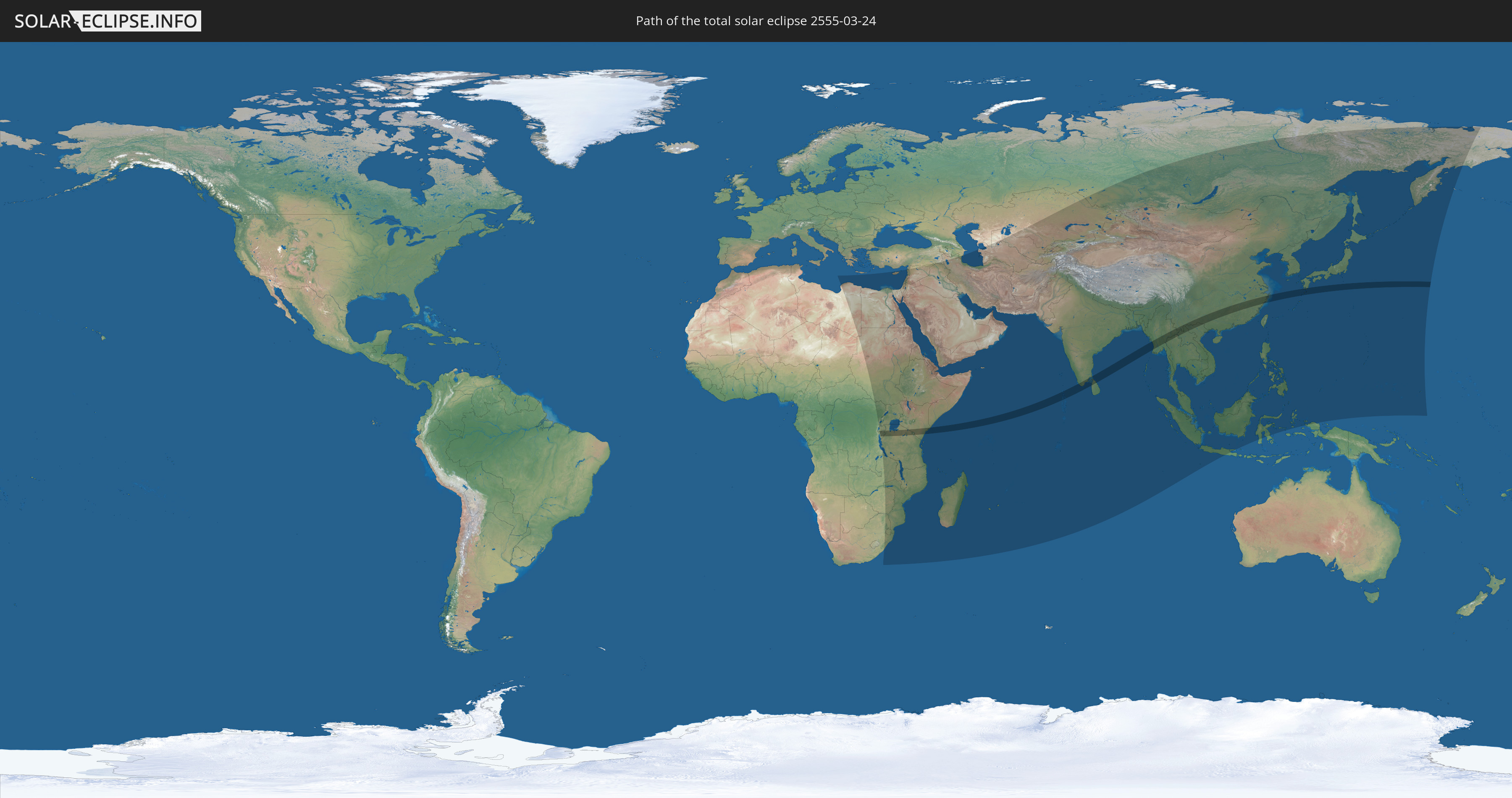
Die Sonnenfinsternis am 03/24/2555 kann man in 82 Ländern als partielle Sonnenfinsternis beobachten.
Der Finsternispfad verläuft durch 13 Länder. Nur in diesen Ländern ist sie als total Sonnenfinsternis zu sehen.
In den folgenden Ländern ist die Sonnenfinsternis total zu sehen
 Rwanda
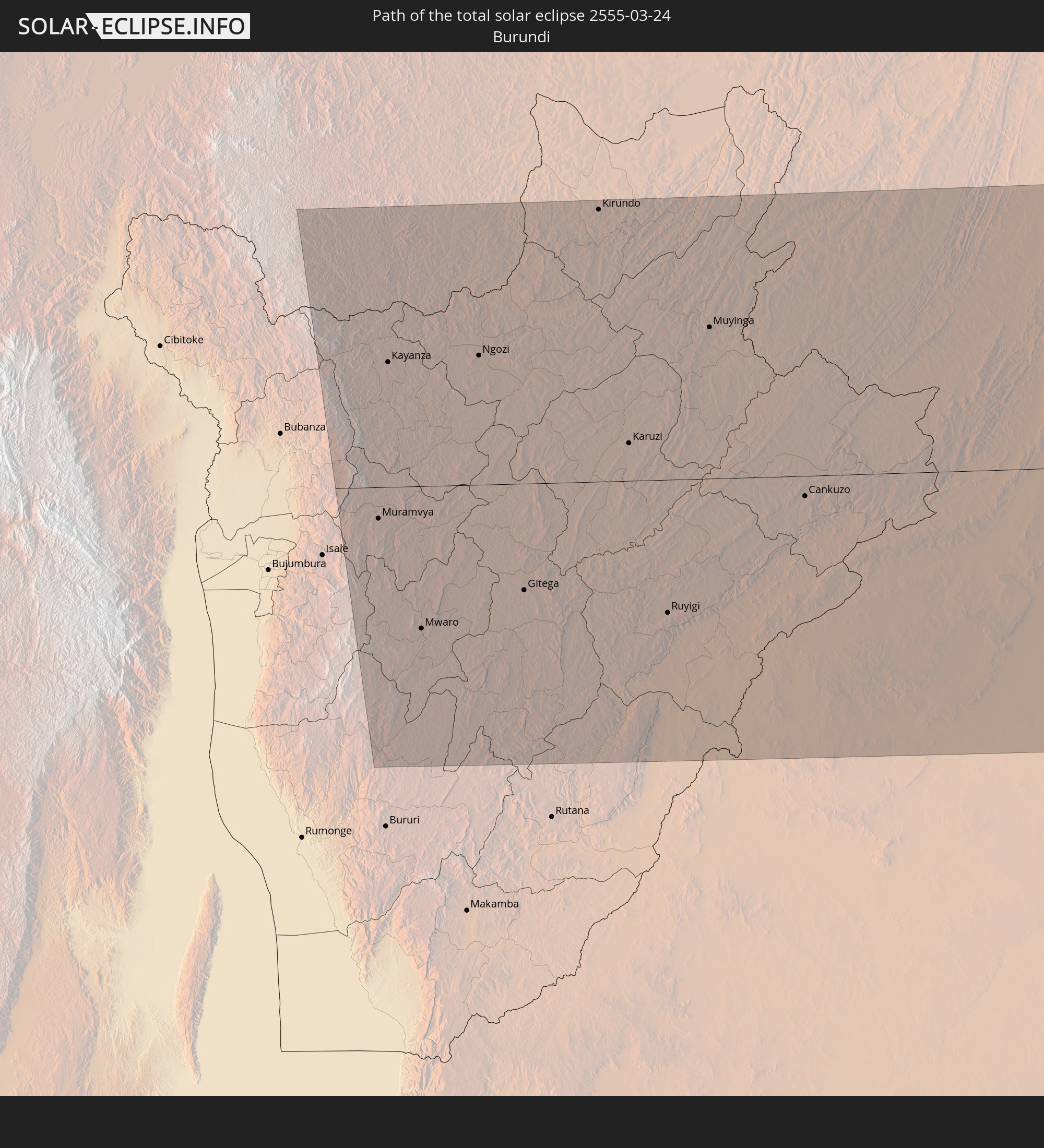 Burundi
 Tanzania
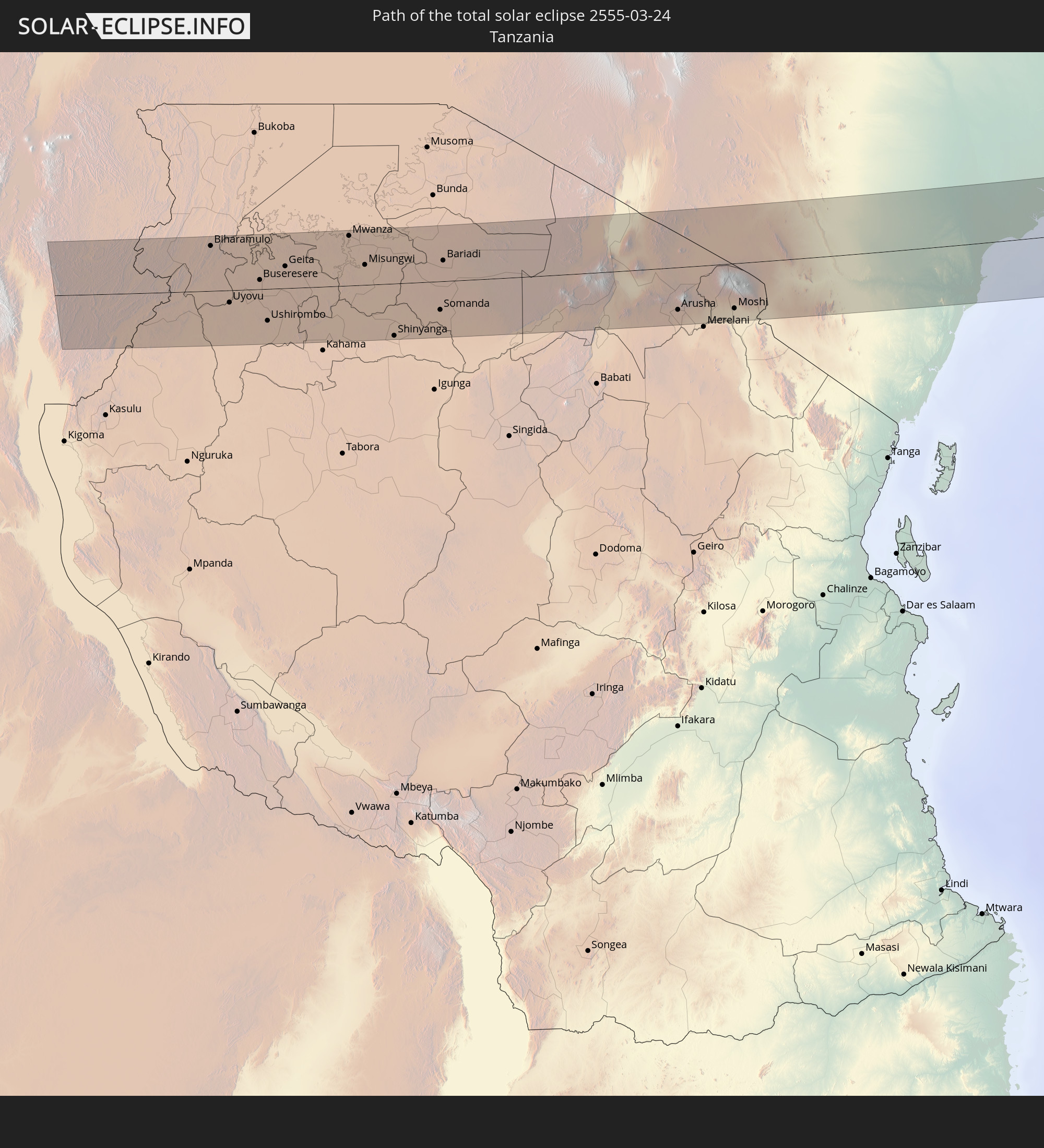
 Kenya
Kenya
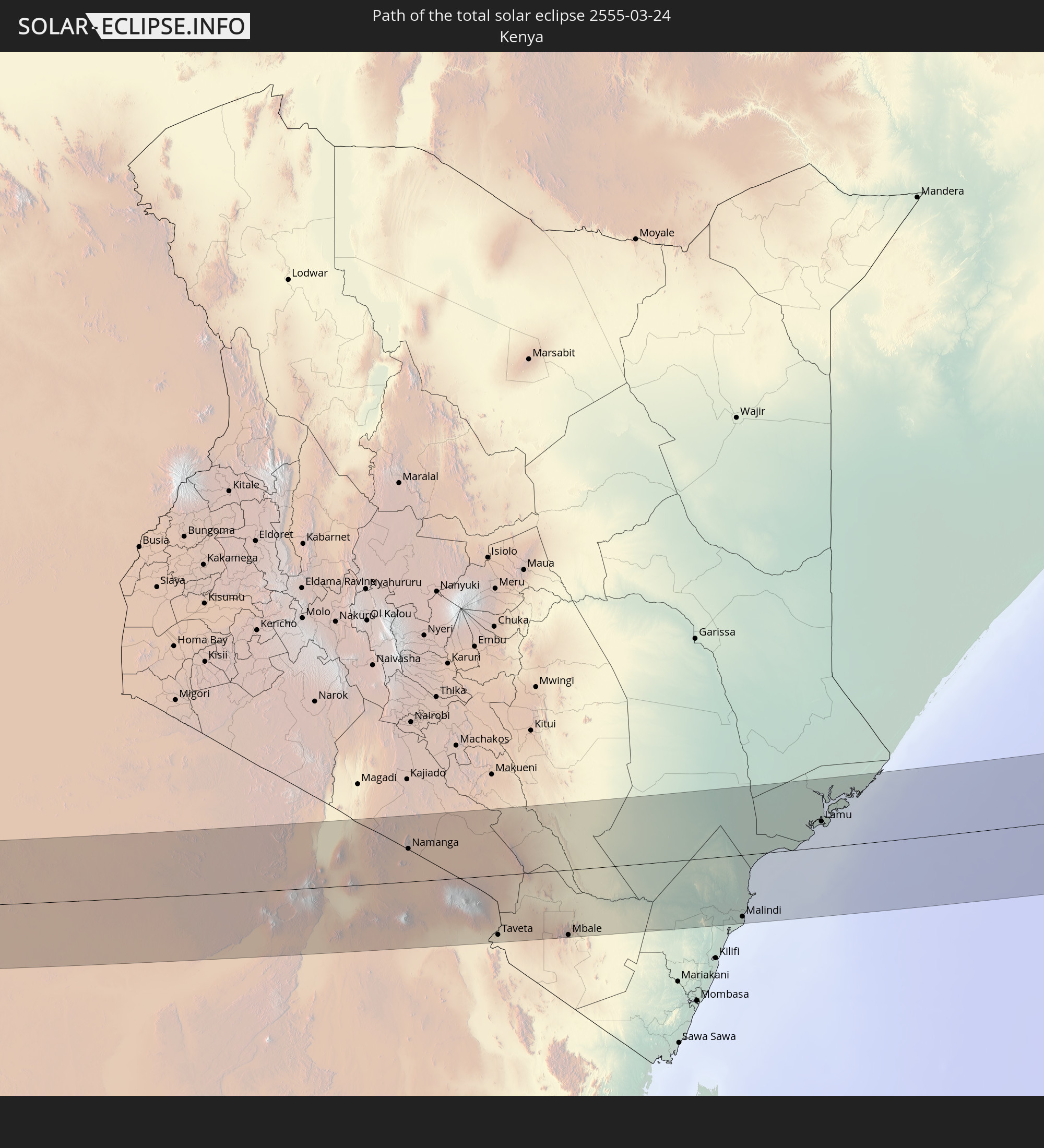
 India
India
 Maldives
 China
China
 Sri Lanka
 Myanmar
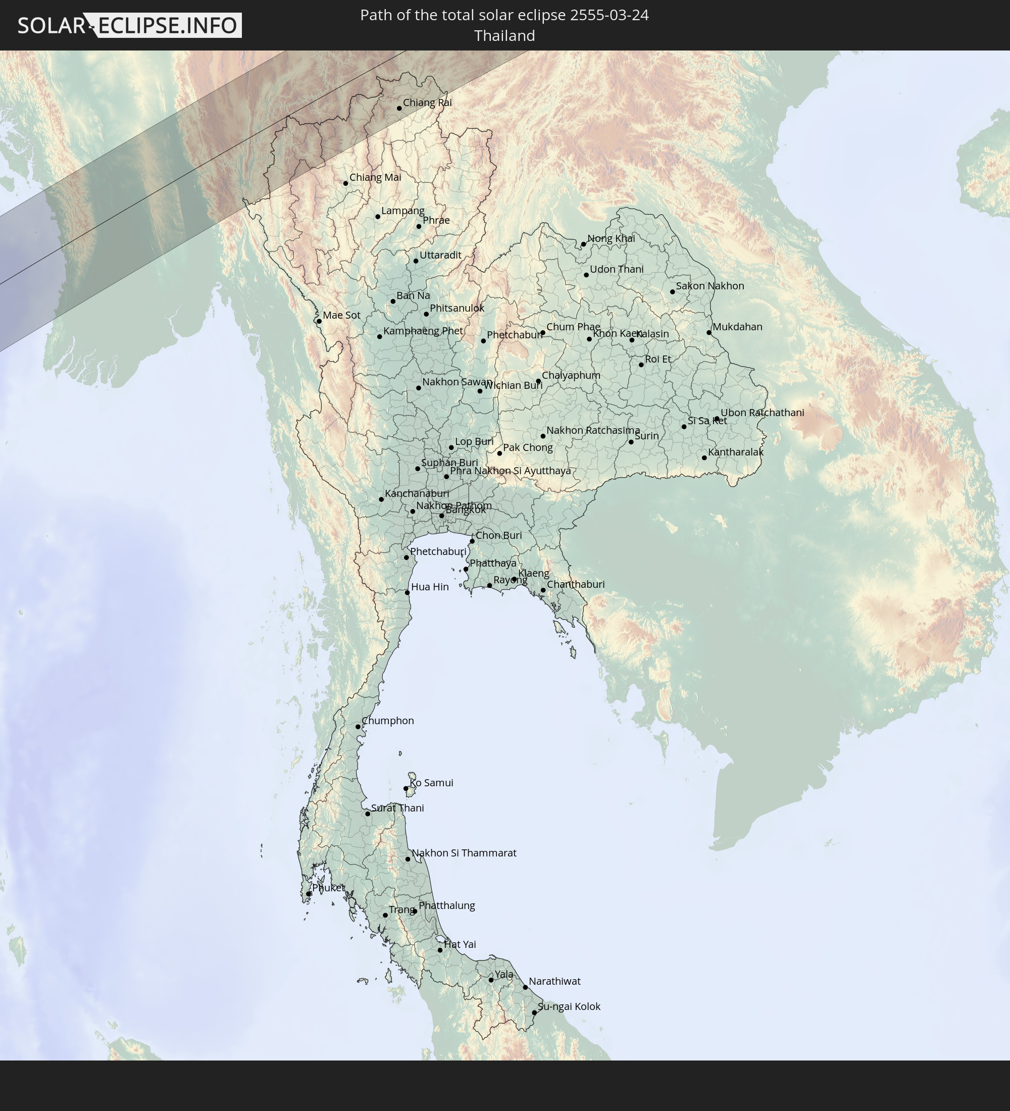 Thailand
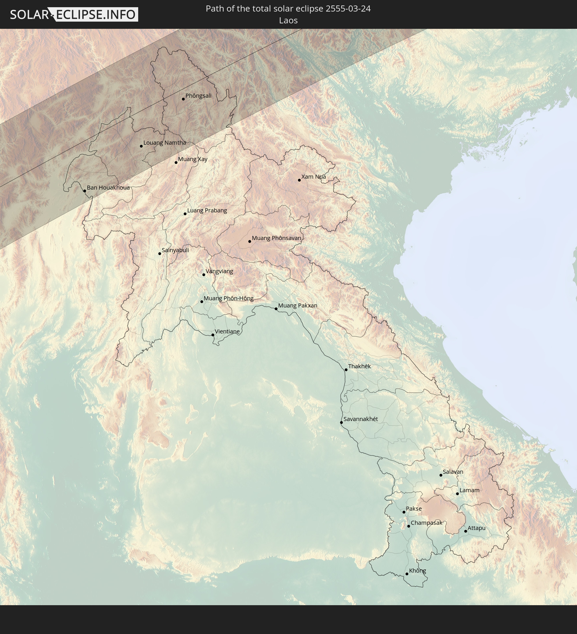 Laos
Laos
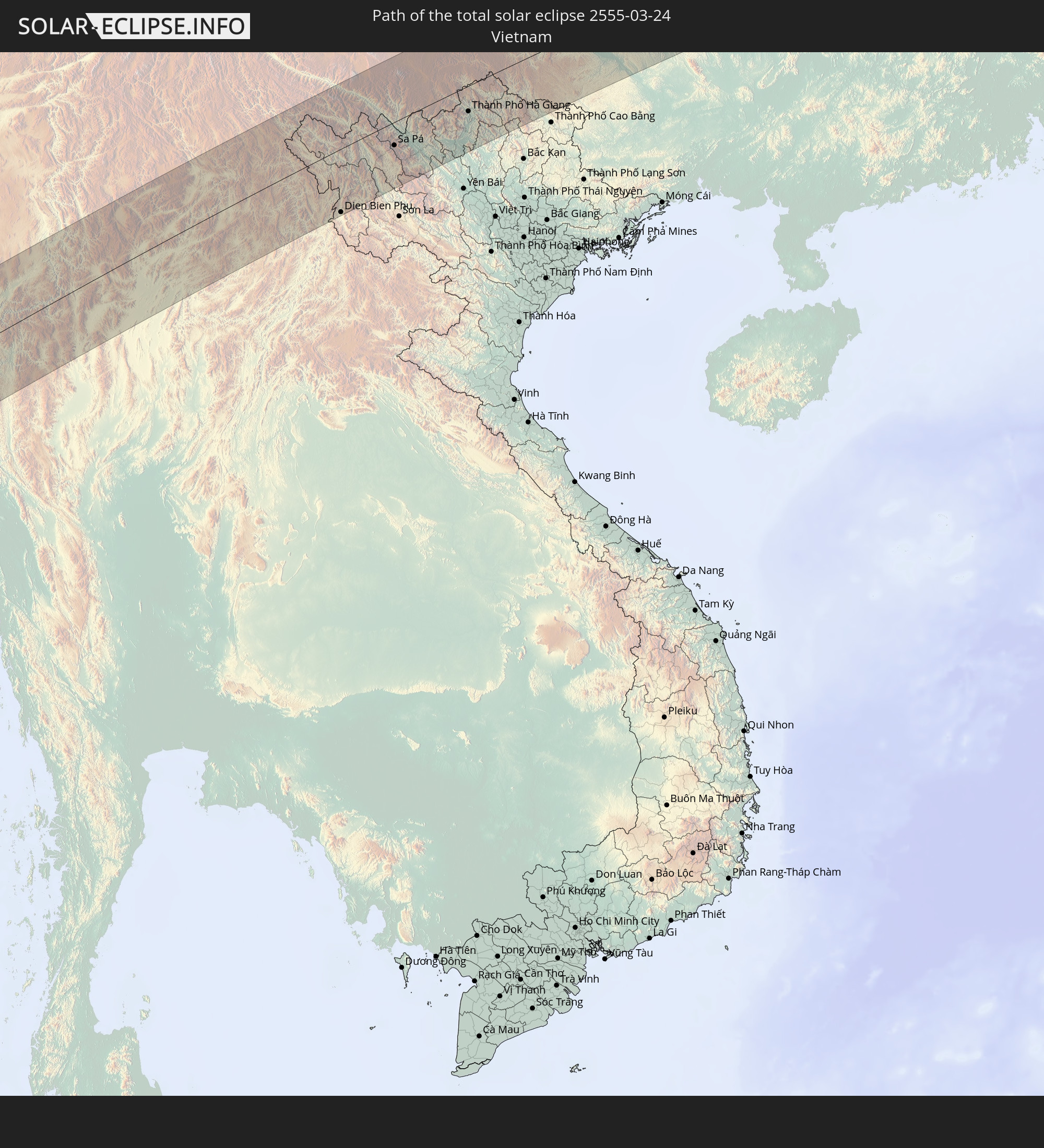 Vietnam
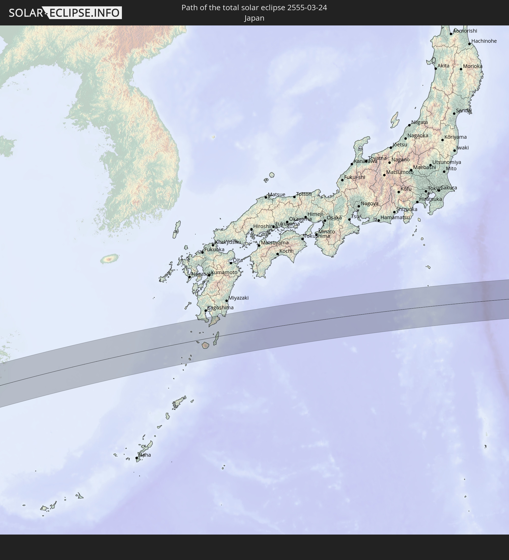 Japan
Japan
In den folgenden Ländern ist die Sonnenfinsternis partiell zu sehen
 Russia
 Libya
Libya
 Democratic Republic of the Congo
 South Africa
 Sudan
Sudan
 Zambia
 Egypt
Egypt
 Zimbabwe
 Turkey
 Rwanda
 Burundi
 Tanzania
 Uganda
 Mozambique
 Swaziland
 Cyprus
 Malawi
 Ethiopia
 Kenya
Kenya
 State of Palestine
 Israel
 Saudi Arabia
 Jordan
 Lebanon
 Syria
Syria
 Eritrea
 Iraq
Iraq
 French Southern and Antarctic Lands
 Somalia
 Djibouti
 Yemen
Yemen
 Madagascar
 Comoros
 Iran
Iran
 Azerbaijan
 Mayotte
 Seychelles
 Kazakhstan
 Kuwait
 Bahrain
 Qatar
Qatar
 United Arab Emirates
 Oman
Oman
 Turkmenistan
 Réunion
 Uzbekistan
 Mauritius
 Afghanistan
 Pakistan
 Tajikistan
 India
India
 Kyrgyzstan
 British Indian Ocean Territory
 Maldives
 China
China
 Sri Lanka
 Nepal
Nepal
 Mongolia
 Bangladesh
 Bhutan
 Myanmar
 Indonesia
 Cocos Islands
 Thailand
 Malaysia
 Laos
Laos
 Vietnam
 Cambodia
 Singapore
 Christmas Island
 Macau
Macau
 Hong Kong
 Brunei
 Taiwan
 Philippines
 Japan
Japan
 North Korea
 South Korea
 Palau
Palau
 Federated States of Micronesia
 Guam
Guam
 Northern Mariana Islands
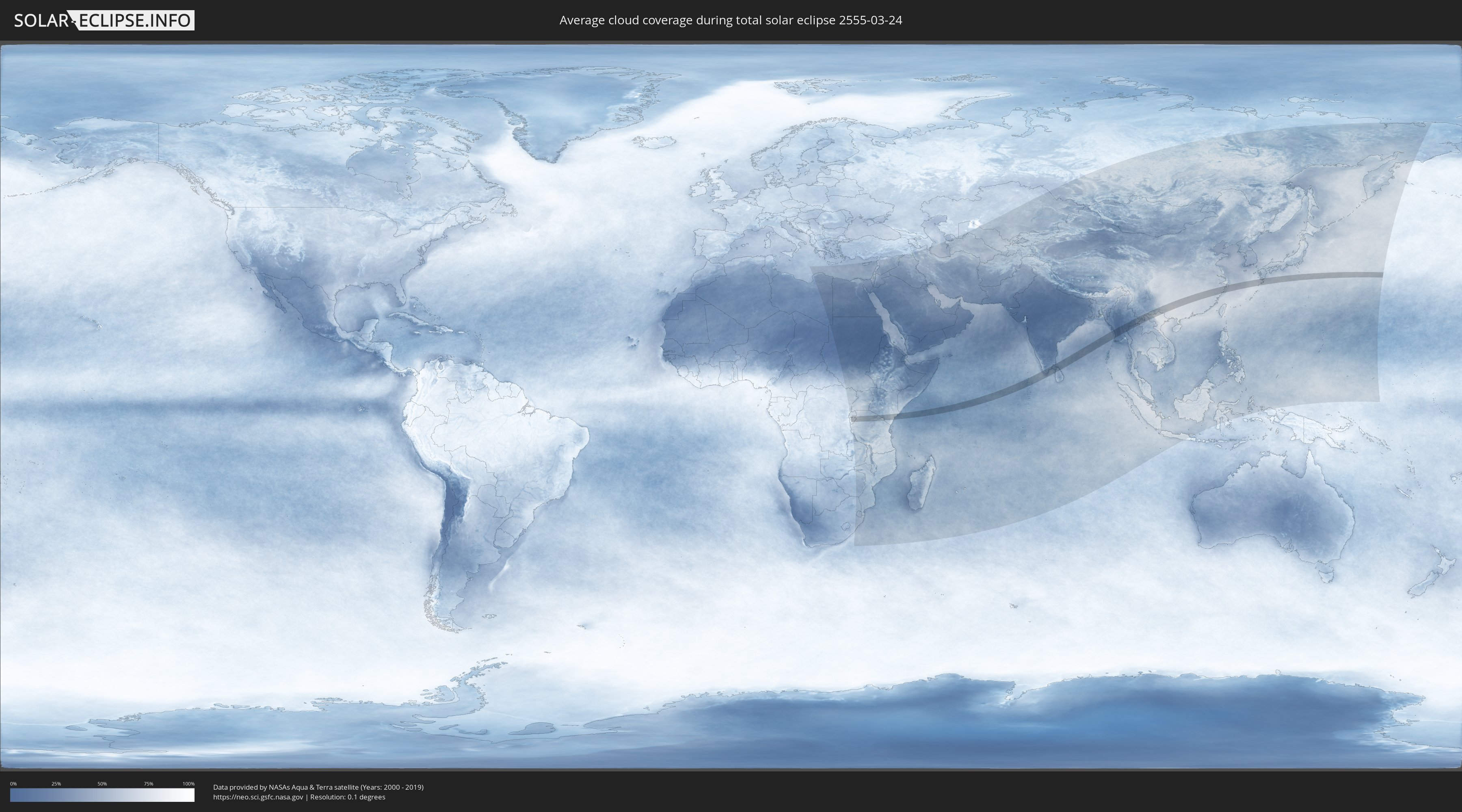
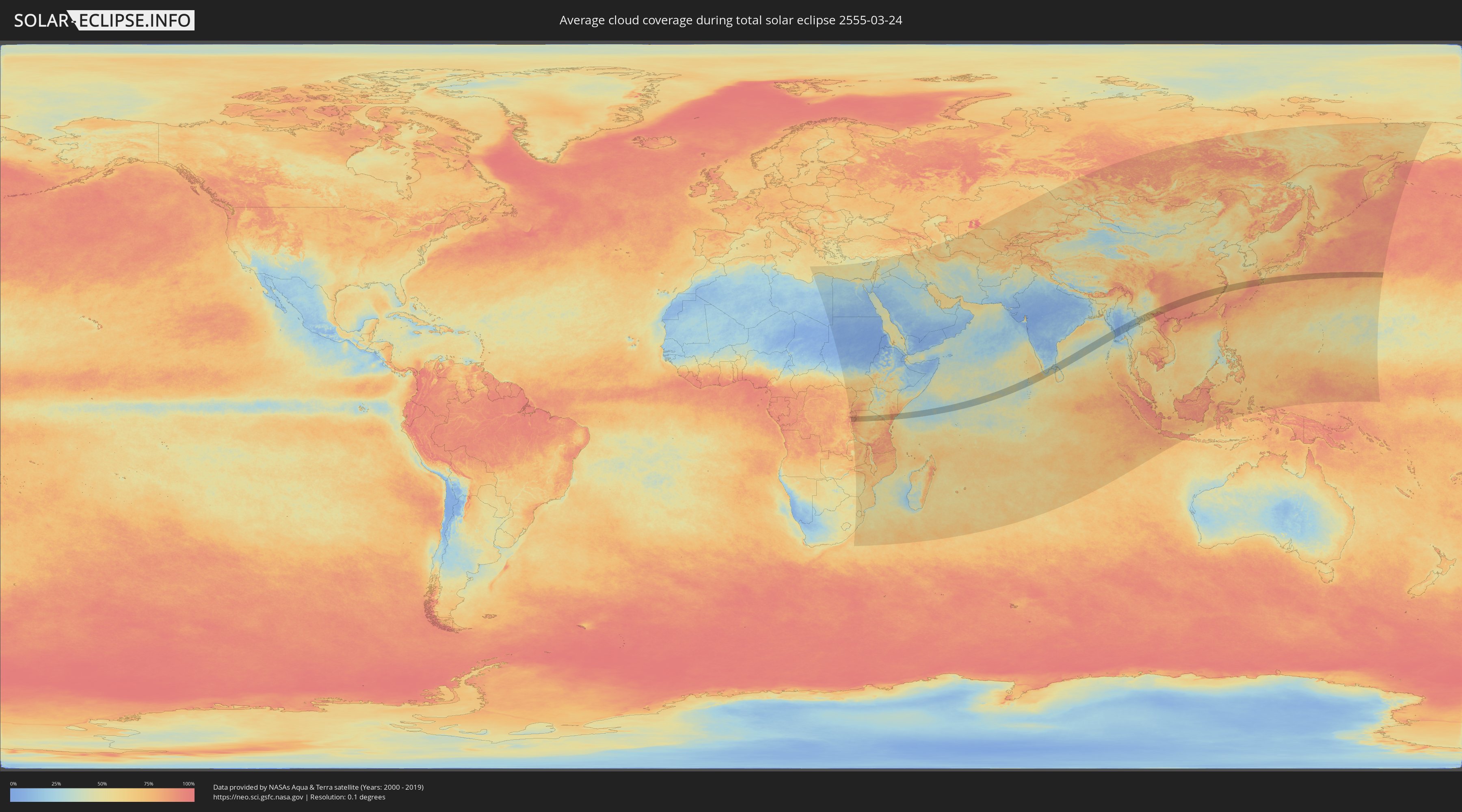
How will be the weather during the total solar eclipse on 03/24/2555?
Where is the best place to see the total solar eclipse of 03/24/2555?
The following maps show the average cloud coverage for the day of the total solar eclipse.
With the help of these maps, it is possible to find the place along the eclipse path, which has the best
chance of a cloudless sky.
Nevertheless, you should consider local circumstances and inform about the weather of your chosen
observation site.
The data is provided by NASAs satellites
AQUA and TERRA.
The cloud maps are averaged over a period of 19 years (2000 - 2019).
Detailed country maps
 Rwanda
 Burundi
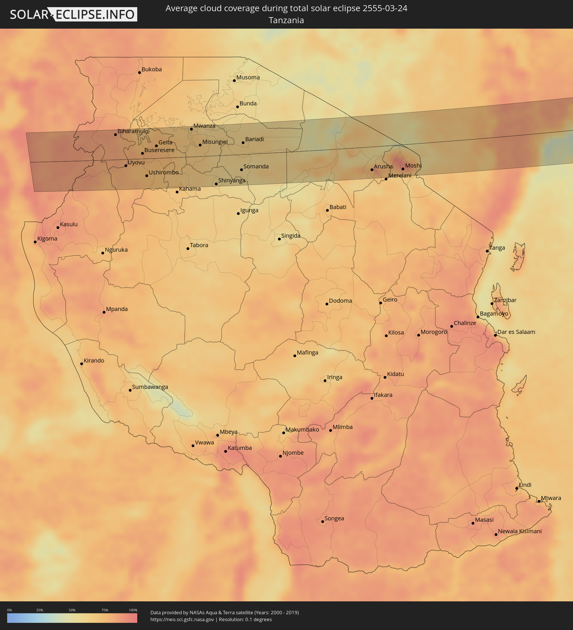 Tanzania
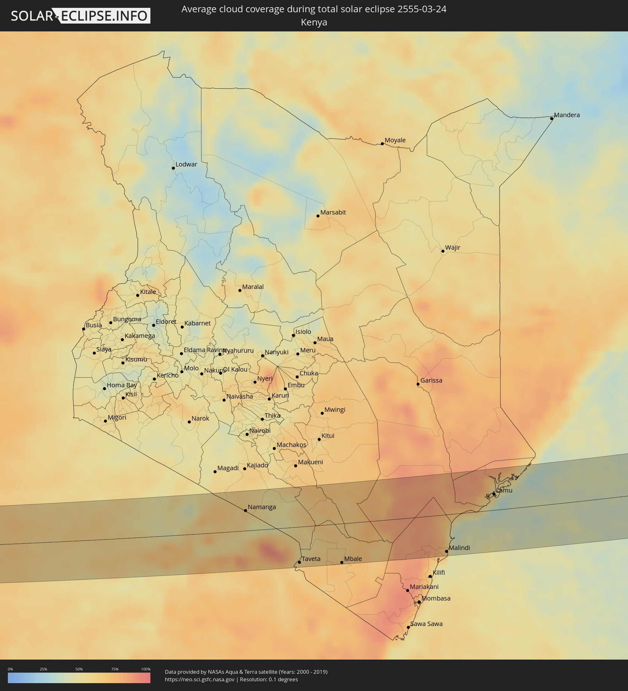 Kenya
Kenya
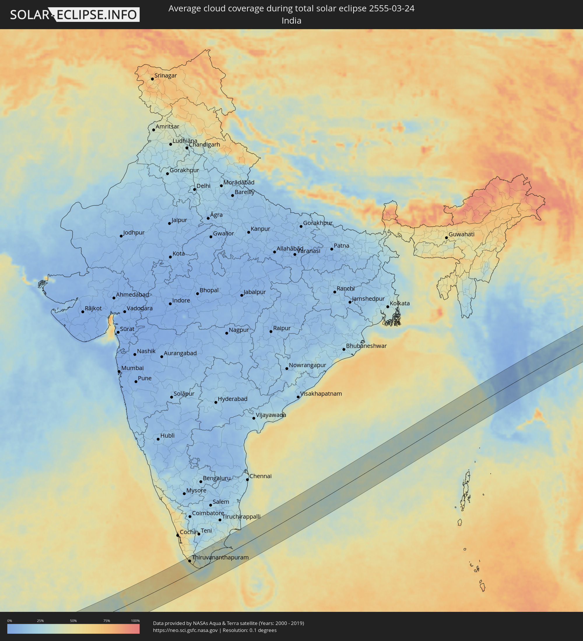 India
India
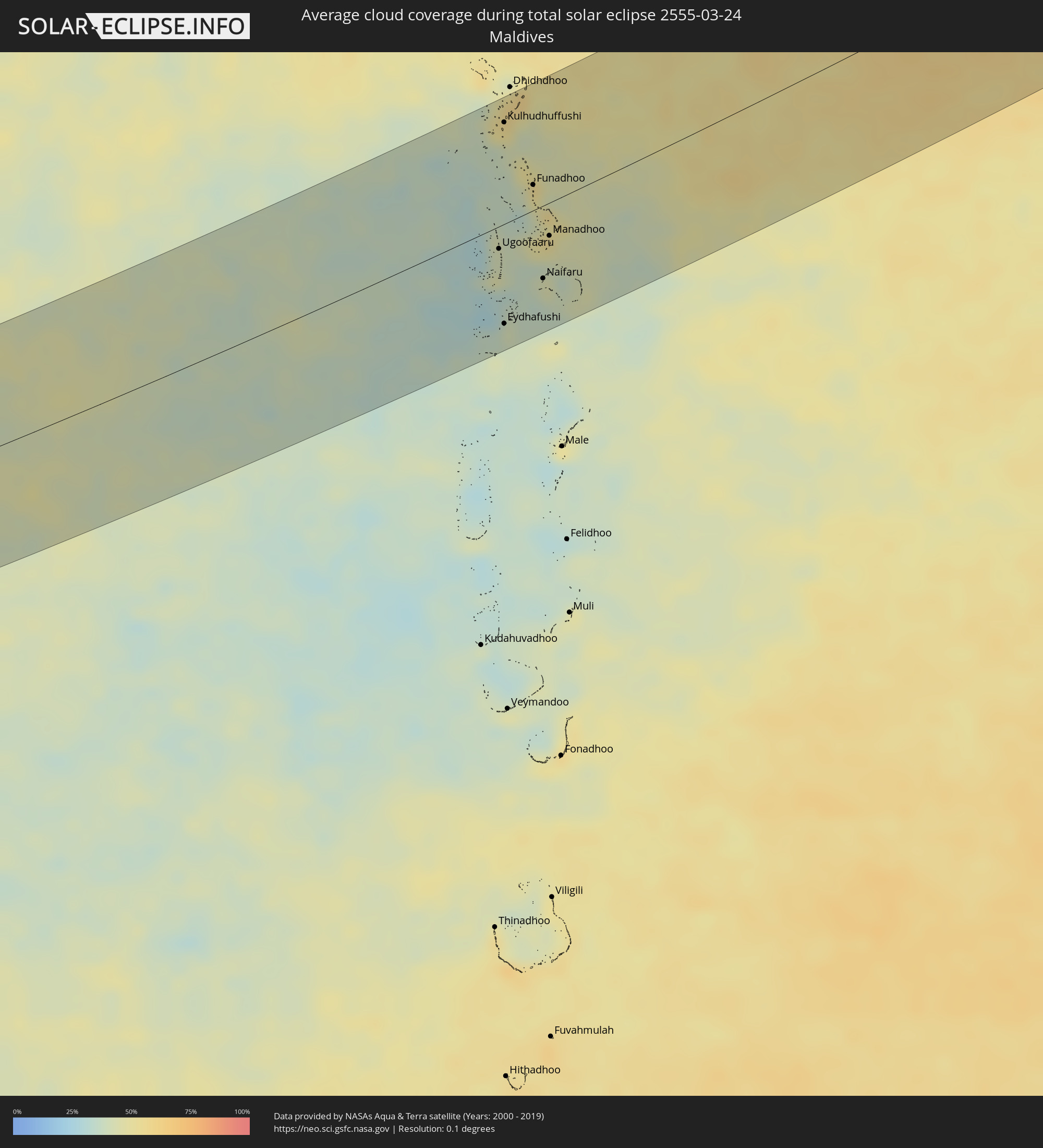 Maldives
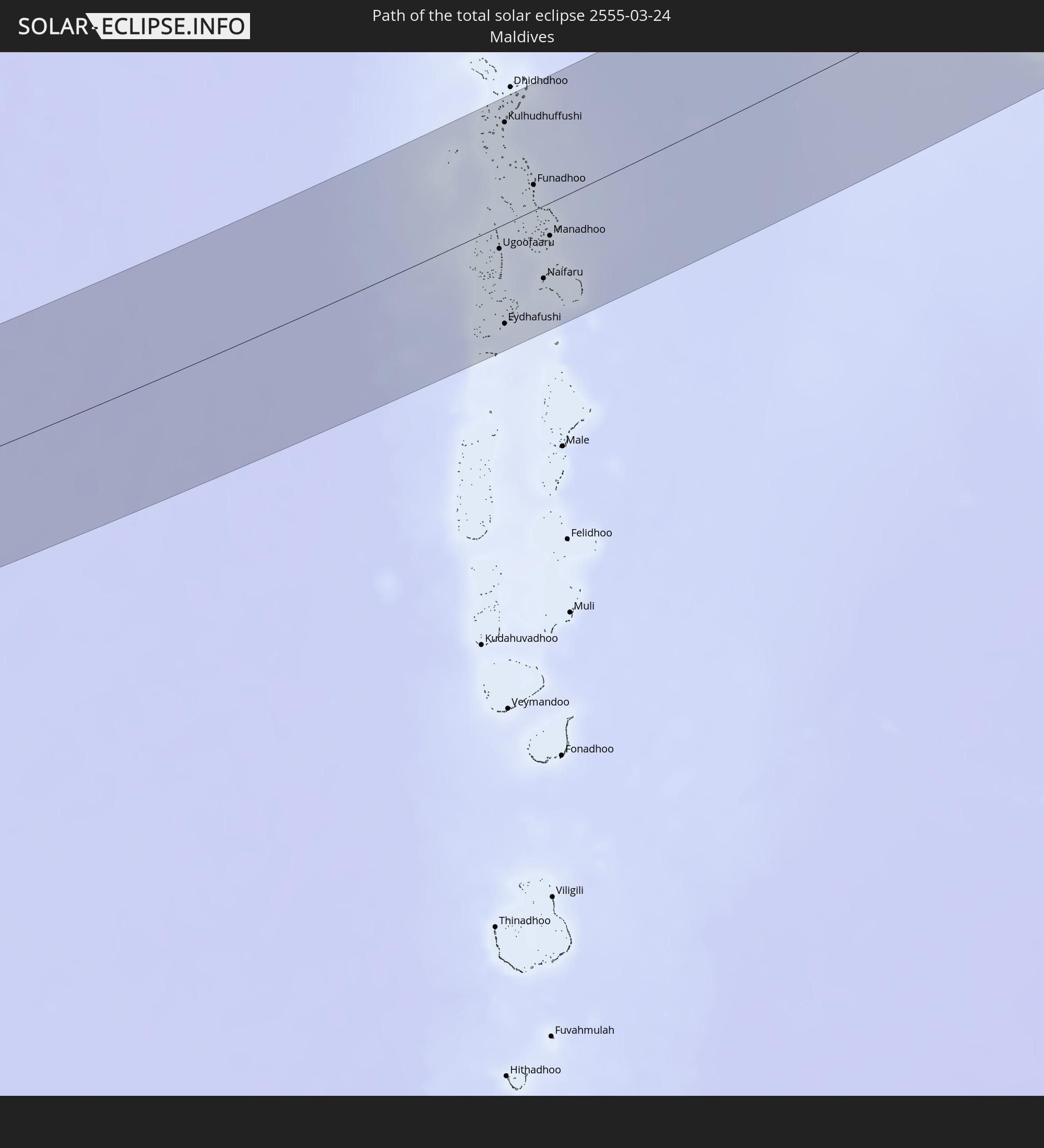
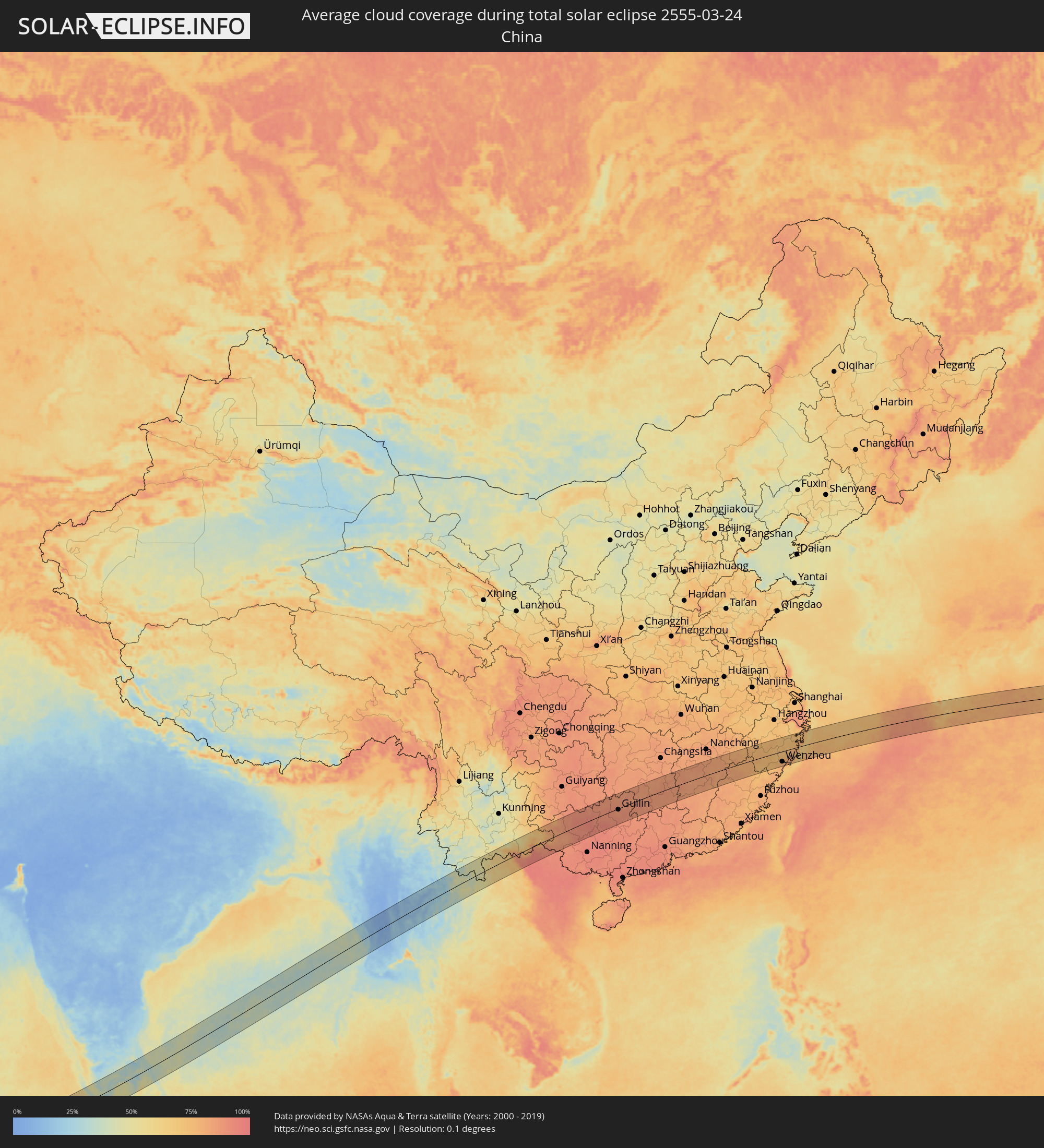 China
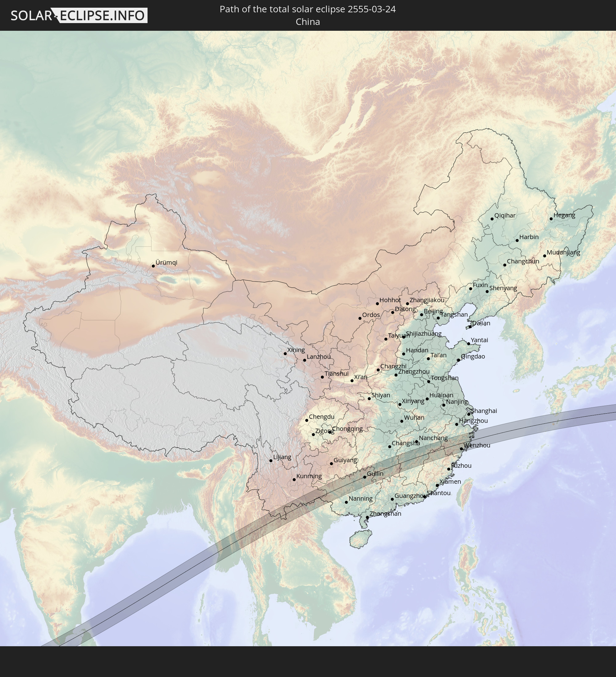
China
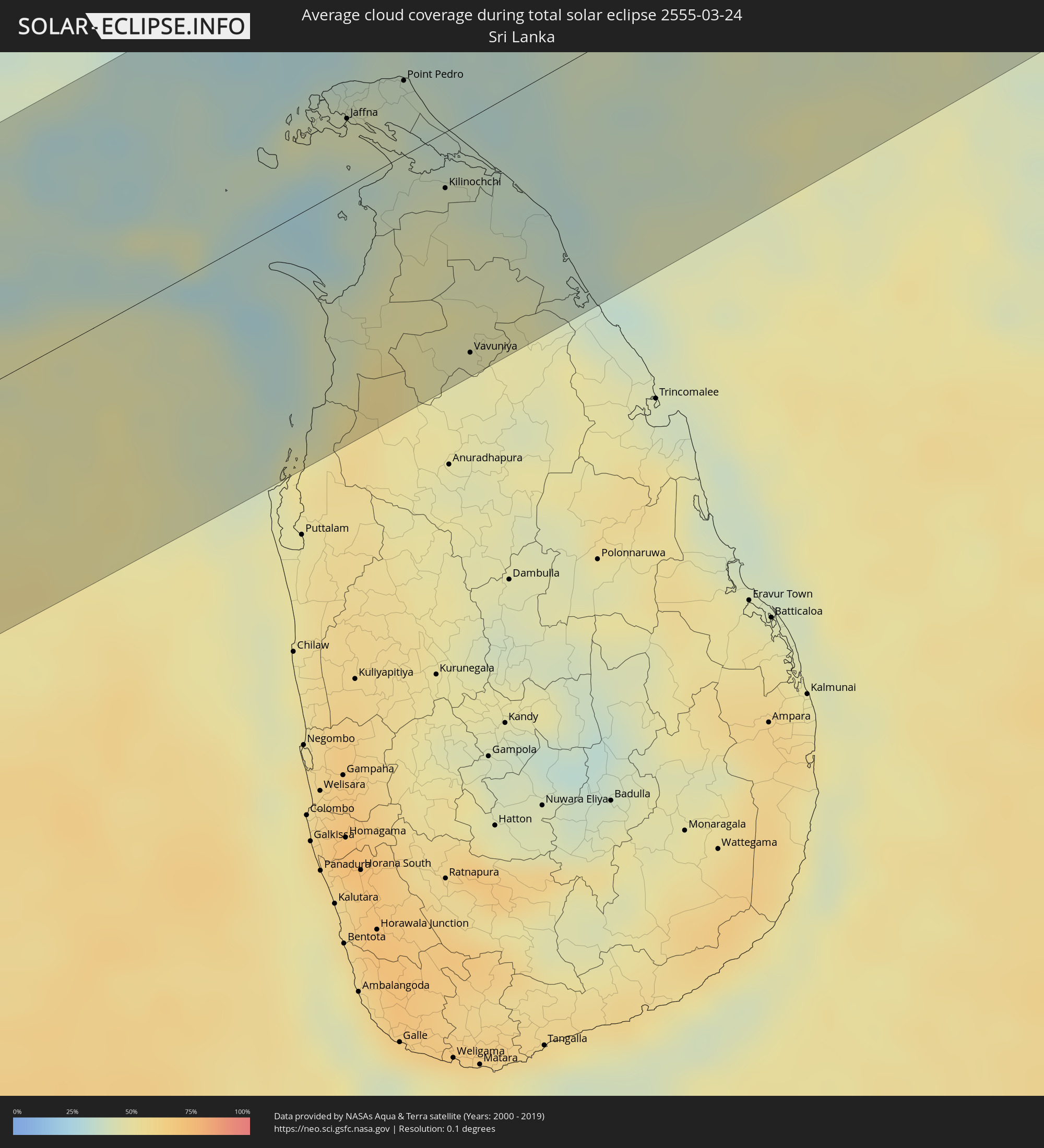 Sri Lanka
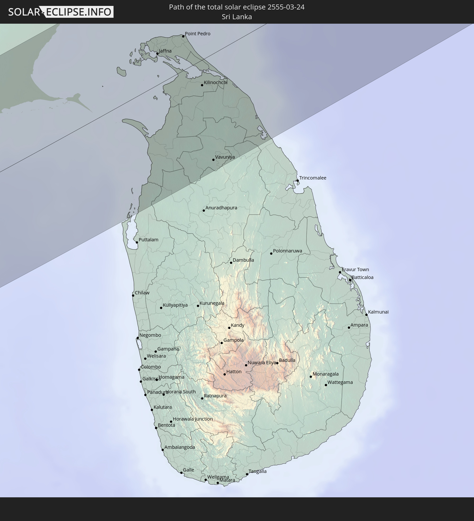
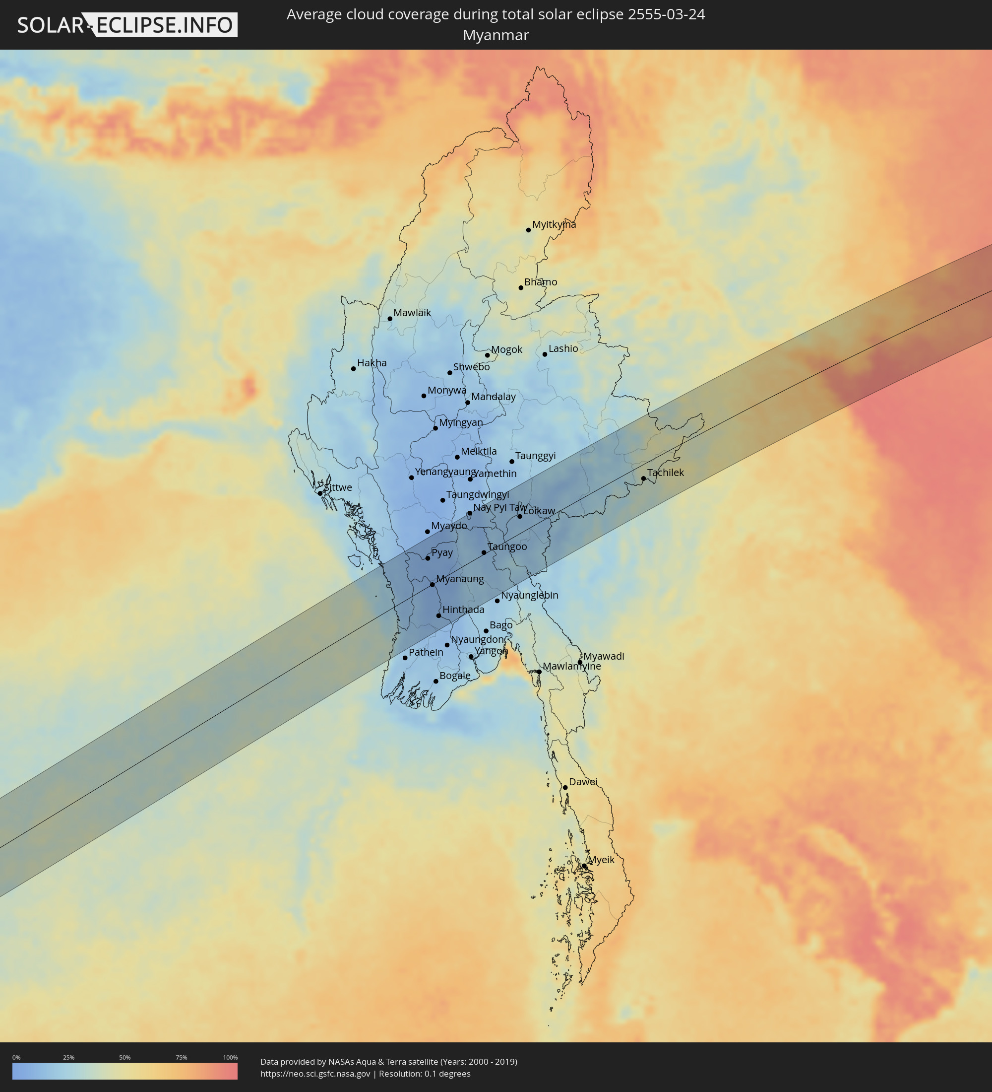 Myanmar
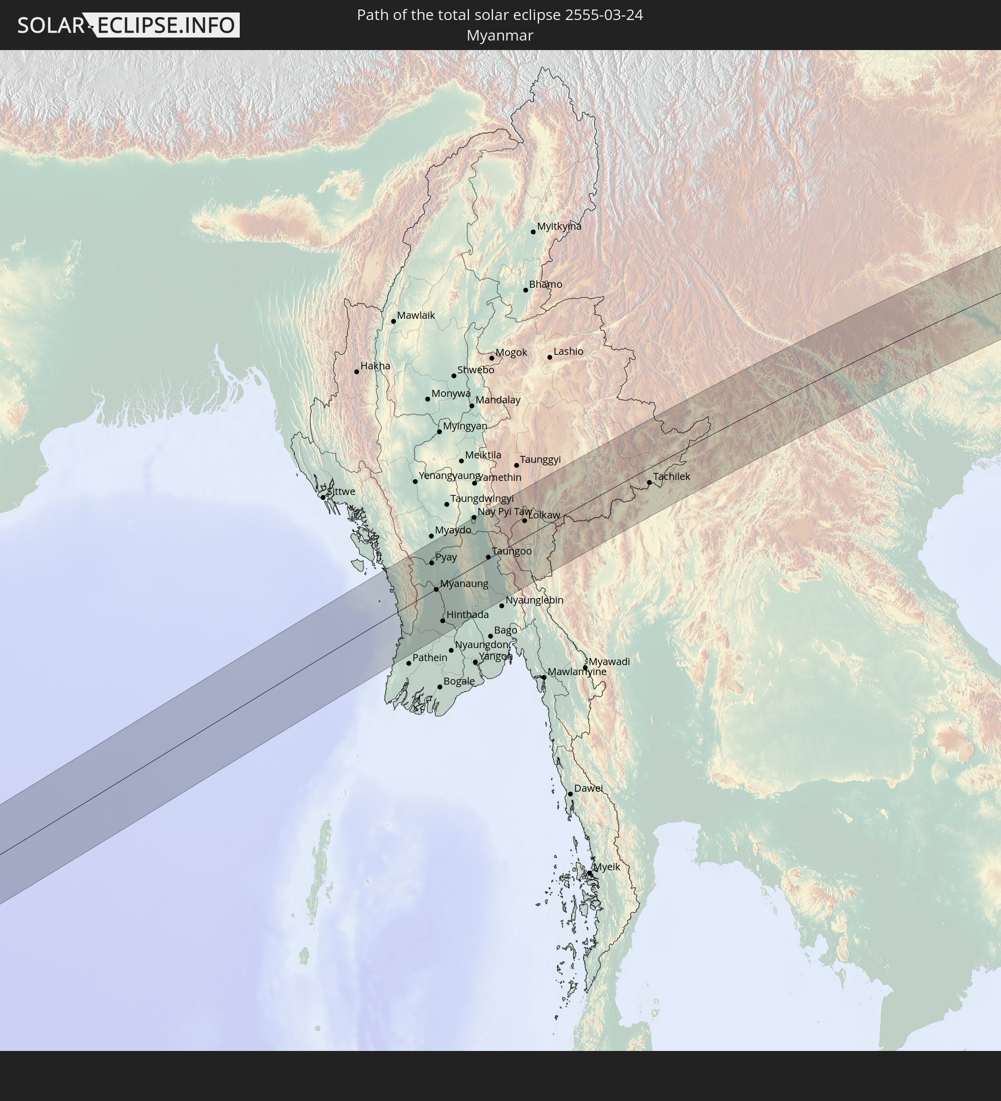
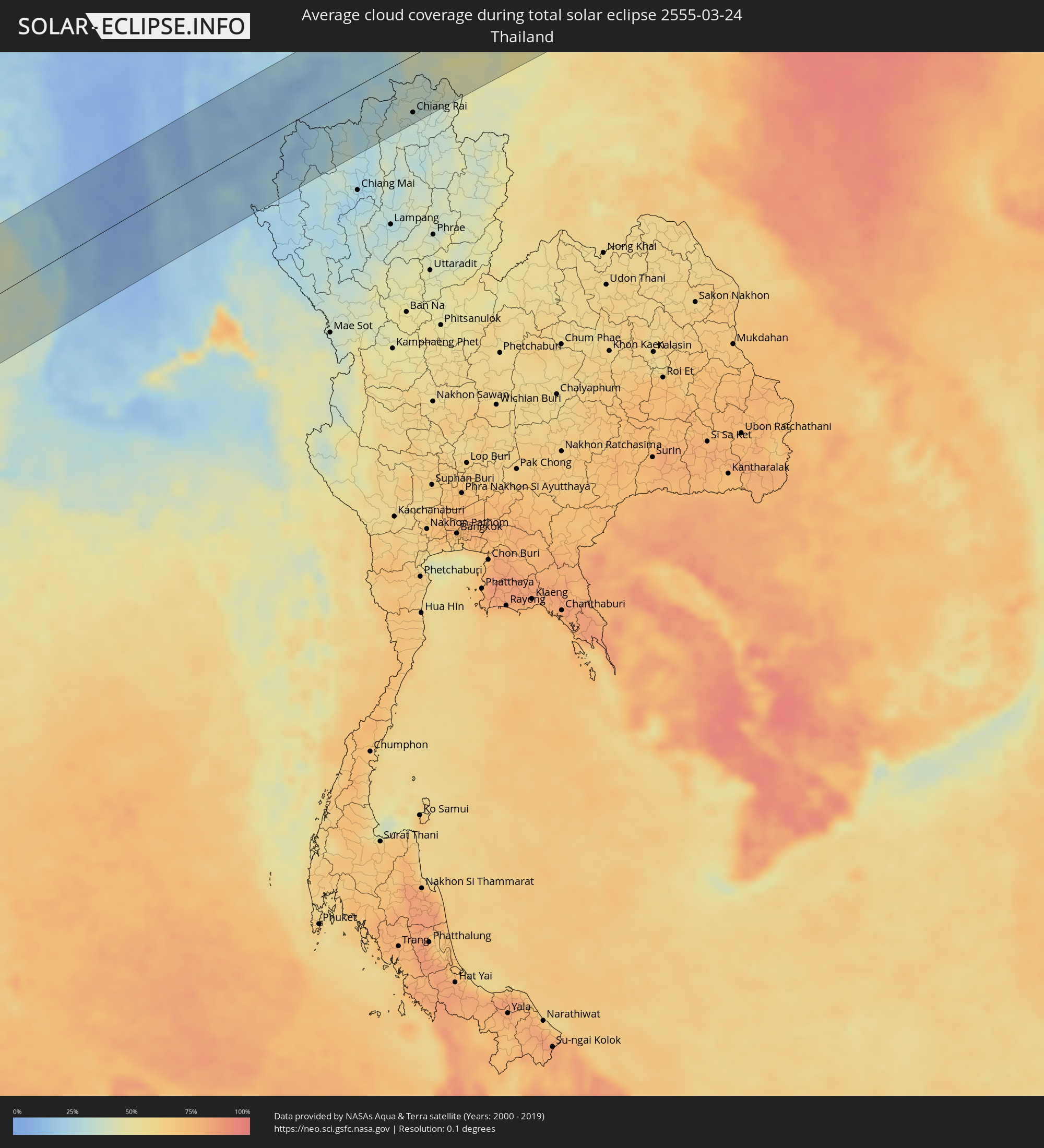 Thailand
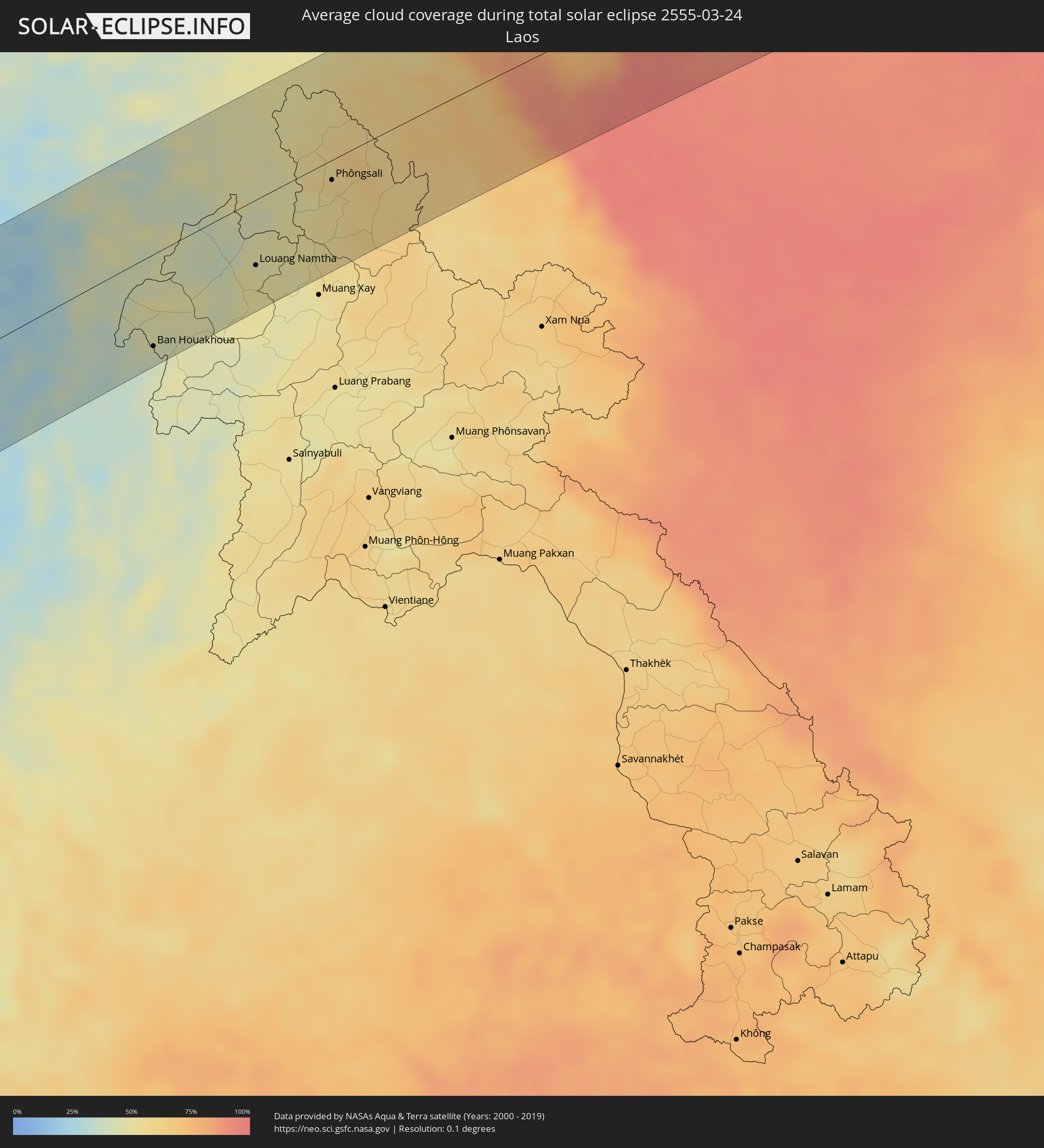 Laos
Laos
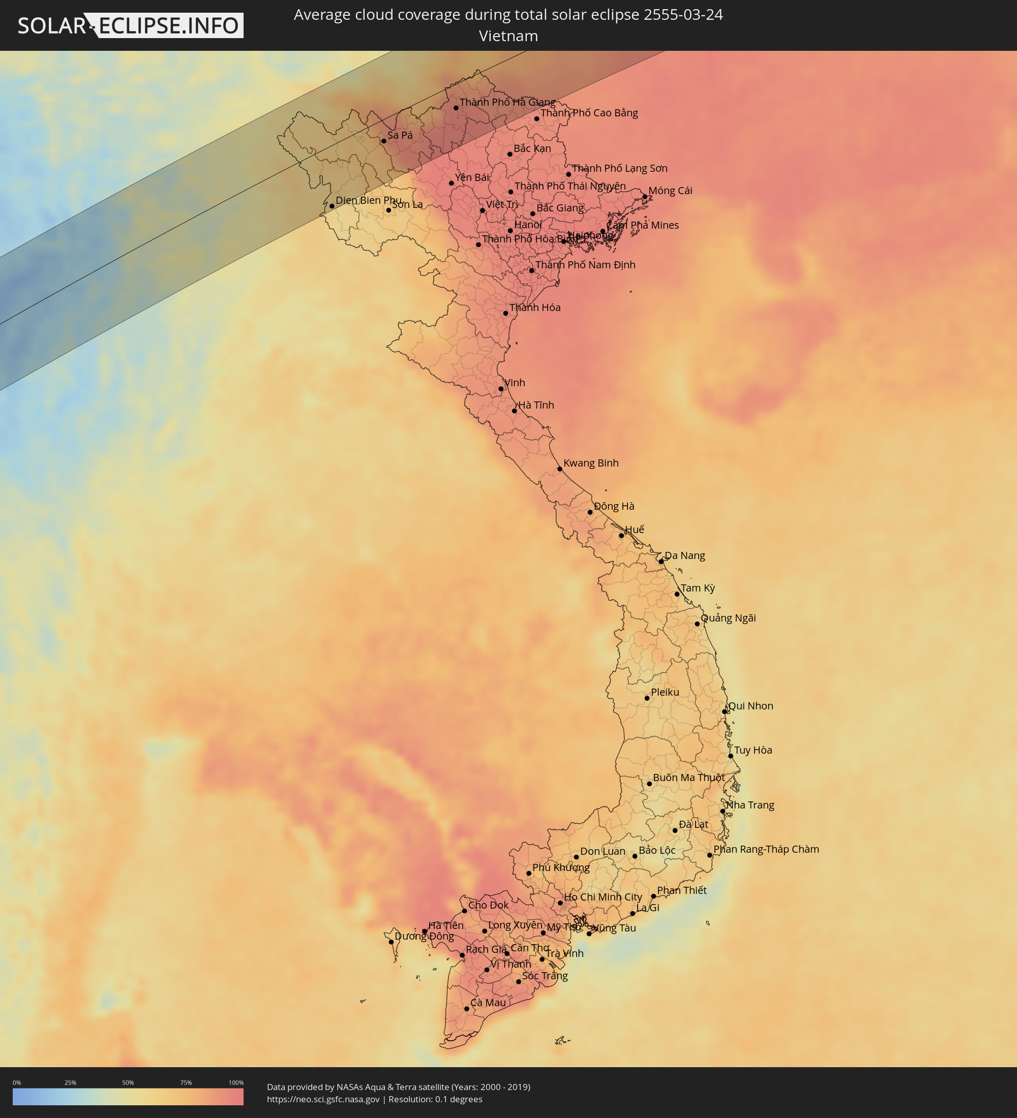 Vietnam
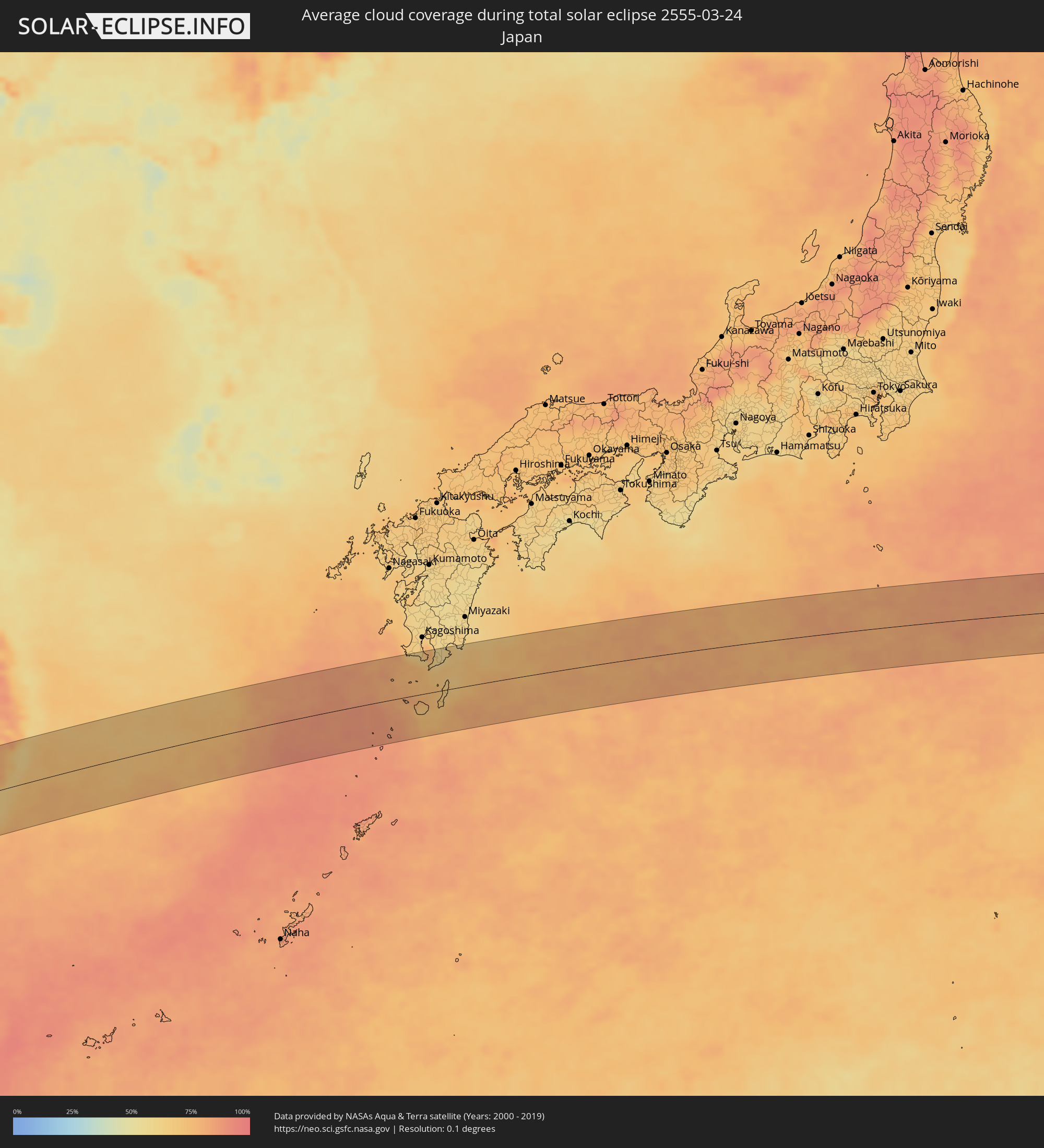 Japan
Japan
Cities inside the path of the eclipse
The following table shows all locations with a population of more than 5,000 inside the eclipse path. Cities which have more than 100,000 inhabitants are marked bold. A click at the locations opens a detailed map.
| City | Type | Eclipse duration | Local time of max. eclipse | Distance to central line | Ø Cloud coverage |
|
Muramvya, Muramvya
|
total | - | 06:08:18 UTC+02:00 | 8 km | 86% |
|
Kayanza, Kayanza
|
total | - | 06:08:27 UTC+02:00 | 31 km | 86% |
|
Mwaro, Mwaro
|
total | - | 06:08:11 UTC+02:00 | 35 km | 86% |
|
Butare, Southern Province
|
total | - | 06:08:37 UTC+02:00 | 67 km | 83% |
|
Ngozi, Ngozi
|
total | - | 06:08:28 UTC+02:00 | 32 km | 83% |
|
Gitega, Gitega
|
total | - | 06:08:13 UTC+02:00 | 26 km | 86% |
|
Kirundo, Kirundo
|
total | - | 06:08:37 UTC+02:00 | 67 km | 86% |
|
Karuzi, Karuzi
|
total | - | 06:08:22 UTC+02:00 | 9 km | 87% |
|
Ruyigi, Ruyigi
|
total | - | 06:08:12 UTC+02:00 | 33 km | 84% |
|
Muyinga, Muyinga
|
total | - | 06:08:30 UTC+02:00 | 37 km | 87% |
|
Bugarama, Kagera
|
total | - | 07:08:29 UTC+03:00 | 34 km | 86% |
|
Cankuzo, Cankuzo
|
total | - | 06:08:19 UTC+02:00 | 5 km | 84% |
|
Kibondo, Kigoma
|
total | - | 07:08:09 UTC+03:00 | 46 km | 84% |
|
Biharamulo, Kagera
|
total | - | 07:08:38 UTC+03:00 | 58 km | 81% |
|
Uyovu, Geita
|
total | - | 07:08:19 UTC+03:00 | 16 km | 78% |
|
Buseresere, Geita
|
total | - | 07:08:28 UTC+03:00 | 12 km | 79% |
|
Ushirombo, Geita
|
total | - | 07:08:15 UTC+03:00 | 41 km | 75% |
|
Geita, Geita
|
total | - | 07:08:34 UTC+03:00 | 28 km | 76% |
|
Masumbwe, Geita
|
total | - | 07:08:12 UTC+03:00 | 57 km | 72% |
|
Mwanza, Mwanza
|
total | - | 07:08:48 UTC+03:00 | 64 km | 67% |
|
Misungwi, Mwanza
|
total | - | 07:08:39 UTC+03:00 | 26 km | 66% |
|
Shinyanga, Shinyanga
|
total | - | 07:08:17 UTC+03:00 | 67 km | 59% |
|
Somanda, Simiyu
|
total | - | 07:08:29 UTC+03:00 | 36 km | 58% |
|
Bariadi, Simiyu
|
total | - | 07:08:47 UTC+03:00 | 26 km | 64% |
|
Kisesa, Simiyu
|
total | - | 07:08:39 UTC+03:00 | 6 km | 58% |
|
Arusha, Arusha
|
total | - | 07:08:57 UTC+03:00 | 54 km | 69% |
|
Namanga, Kajiado
|
total | - | 07:09:25 UTC+03:00 | 36 km | 65% |
|
Moshi, Kilimanjaro
|
total | - | 07:09:06 UTC+03:00 | 57 km | 64% |
|
Taveta
|
total | - | 07:09:10 UTC+03:00 | 66 km | 63% |
|
Wundanyi, Taita Taveta
|
total | - | 07:09:20 UTC+03:00 | 72 km | 72% |
|
Mbale, Vihiga
|
total | - | 07:09:21 UTC+03:00 | 72 km | 72% |
|
Voi, Taita Taveta
|
total | - | 07:09:24 UTC+03:00 | 73 km | 72% |
|
Malindi, Kilifi
|
total | - | 07:09:58 UTC+03:00 | 68 km | 66% |
|
Witu, Lamu
|
total | - | 07:10:33 UTC+03:00 | 21 km | 72% |
|
Lamu, Lamu
|
total | - | 07:10:47 UTC+03:00 | 29 km | 47% |
|
Ugoofaaru, Raa Atoll
|
total | - | 09:54:40 UTC+05:00 | 17 km | 41% |
|
Kulhudhuffushi, Haa Dhaalu Atholhu
|
total | - | 09:56:05 UTC+05:00 | 77 km | 51% |
|
Eydhafushi, Baa Atholhu
|
total | - | 09:53:58 UTC+05:00 | 76 km | 41% |
|
Funadhoo, Shaviyani Atholhu
|
total | - | 09:55:51 UTC+05:00 | 19 km | 55% |
|
Naifaru, Lhaviyani Atholhu
|
total | - | 09:55:01 UTC+05:00 | 55 km | 43% |
|
Manadhoo, Noonu Atoll
|
total | - | 09:55:33 UTC+05:00 | 25 km | 55% |
|
Thiruvananthapuram, Kerala
|
total | - | 10:36:46 UTC+05:30 | 71 km | 47% |
|
Neyyāttinkara, Kerala
|
total | - | 10:36:55 UTC+05:30 | 56 km | 45% |
|
Colachel, Tamil Nadu
|
total | - | 10:36:58 UTC+05:30 | 25 km | 43% |
|
Sūrandai, Tamil Nadu
|
total | - | 10:38:31 UTC+05:30 | 95 km | 31% |
|
Nāgercoil, Tamil Nadu
|
total | - | 10:37:20 UTC+05:30 | 16 km | 43% |
|
Ambasamudram, Tamil Nadu
|
total | - | 10:38:11 UTC+05:30 | 67 km | 32% |
|
Ālangulam, Tamil Nadu
|
total | - | 10:38:31 UTC+05:30 | 80 km | 35% |
|
Kalakkādu, Tamil Nadu
|
total | - | 10:38:06 UTC+05:30 | 43 km | 34% |
|
Vadakku Valliyūr, Tamil Nadu
|
total | - | 10:38:02 UTC+05:30 | 27 km | 38% |
|
Tirunelveli, Tamil Nadu
|
total | - | 10:38:43 UTC+05:30 | 57 km | 36% |
|
Kovilpatti, Tamil Nadu
|
total | - | 10:39:48 UTC+05:30 | 91 km | 37% |
|
Kayalpattinam, Tamil Nadu
|
total | - | 10:39:26 UTC+05:30 | 19 km | 34% |
|
Paramagudi, Tamil Nadu
|
total | - | 10:41:57 UTC+05:30 | 90 km | 40% |
|
Keelakarai, Tamil Nadu
|
total | - | 10:41:54 UTC+05:30 | 49 km | 32% |
|
Ramanathapuram, Tamil Nadu
|
total | - | 10:42:13 UTC+05:30 | 60 km | 36% |
|
Rameswaram, Tamil Nadu
|
total | - | 10:43:10 UTC+05:30 | 26 km | 42% |
|
Jaffna, Northern Province
|
total | - | 10:45:19 UTC+05:30 | 26 km | 43% |
|
Valvedditturai, Northern Province
|
total | - | 10:45:54 UTC+05:30 | 32 km | 37% |
|
Point Pedro, Northern Province
|
total | - | 10:46:03 UTC+05:30 | 28 km | 37% |
|
Kilinochchi, Northern Province
|
total | - | 10:45:47 UTC+05:30 | 21 km | 42% |
|
Vavuniya, Northern Province
|
total | - | 10:45:00 UTC+05:30 | 89 km | 45% |
|
Pyay, Bago
|
total | - | 12:35:48 UTC+06:30 | 54 km | 6% |
|
Myanaung, Ayeyarwady
|
total | - | 12:35:20 UTC+06:30 | 2 km | 6% |
|
Hinthada, Ayeyarwady
|
total | - | 12:34:49 UTC+06:30 | 71 km | 11% |
|
Paungde, Bago
|
total | - | 12:36:03 UTC+06:30 | 7 km | 6% |
|
Letpandan, Bago
|
total | - | 12:35:43 UTC+06:30 | 74 km | 11% |
|
Tharyarwady, Bago
|
total | - | 12:35:38 UTC+06:30 | 88 km | 10% |
|
Nay Pyi Taw, Nay Pyi Taw
|
total | - | 12:39:10 UTC+06:30 | 95 km | 10% |
|
Pyinmana, Nay Pyi Taw
|
total | - | 12:39:20 UTC+06:30 | 90 km | 9% |
|
Taungoo, Bago
|
total | - | 12:38:53 UTC+06:30 | 1 km | 13% |
|
Pyu, Bago
|
total | - | 12:38:18 UTC+06:30 | 43 km | 18% |
|
Loikaw, Kayah
|
total | - | 12:41:39 UTC+06:30 | 32 km | 14% |
|
Mae Hong Son, Mae Hong Son
|
total | - | 13:12:59 UTC+07:00 | 44 km | 16% |
|
Fang, Chiang Mai
|
total | - | 13:16:40 UTC+07:00 | 48 km | 26% |
|
Chiang Rai, Chiang Rai
|
total | - | 13:18:06 UTC+07:00 | 80 km | 32% |
|
Mae Chan, Chiang Rai
|
total | - | 13:18:25 UTC+07:00 | 58 km | 34% |
|
Mae Sai, Chiang Rai
|
total | - | 13:18:48 UTC+07:00 | 31 km | 37% |
|
Tachilek, Shan
|
total | - | 13:18:50 UTC+07:00 | 30 km | 37% |
|
Chiang Saen, Chiang Rai
|
total | - | 13:19:07 UTC+07:00 | 57 km | 35% |
|
Chiang Khong, Chiang Rai
|
total | - | 13:19:50 UTC+07:00 | 74 km | 40% |
|
Ban Houayxay, Bokeo Province
|
total | - | 13:19:52 UTC+07:00 | 73 km | 40% |
|
Ban Houakhoua, Bokeo Province
|
total | - | 13:19:56 UTC+07:00 | 78 km | 39% |
|
Louang Namtha, Loungnamtha
|
total | - | 13:22:52 UTC+07:00 | 56 km | 52% |
|
Phôngsali, Phôngsali
|
total | - | 13:25:13 UTC+07:00 | 17 km | 56% |
|
Dien Bien Phu, Tỉnh Ðiện Biên
|
total | - | 13:26:58 UTC+07:00 | 90 km | 60% |
|
Lai Châu, Lai Châu
|
total | - | 13:28:54 UTC+07:00 | 10 km | 64% |
|
Sa Pá, Lào Cai
|
total | - | 13:29:41 UTC+07:00 | 33 km | 75% |
|
Lào Cai, Lào Cai
|
total | - | 13:30:05 UTC+07:00 | 24 km | 90% |
|
Wenshan City, Yunnan
|
total | - | 14:31:28 UTC+08:00 | 51 km | 58% |
|
Thành Phố Hà Giang, Hà Giang
|
total | - | 13:32:34 UTC+07:00 | 36 km | 92% |
|
Guilin, Guangxi Zhuang Autonomous Region
|
total | - | 14:45:01 UTC+08:00 | 7 km | 86% |
|
Yangshuo, Guangxi Zhuang Autonomous Region
|
total | - | 14:45:07 UTC+08:00 | 66 km | 89% |
|
Hengyang, Hunan
|
total | - | 14:50:04 UTC+08:00 | 73 km | 84% |
|
Leiyang, Hunan
|
total | - | 14:50:17 UTC+08:00 | 14 km | 87% |
|
Chenzhou, Hunan
|
total | - | 14:50:19 UTC+08:00 | 55 km | 86% |
|
Ji’an, Jiangxi
|
total | - | 14:54:12 UTC+08:00 | 16 km | 84% |
|
Shaowu, Fujian
|
total | - | 14:58:18 UTC+08:00 | 39 km | 83% |
|
Shangrao, Jiangxi
|
total | - | 14:59:16 UTC+08:00 | 65 km | 81% |
|
Jinhua, Zhejiang
|
total | - | 15:01:52 UTC+08:00 | 85 km | 72% |
|
Lishui, Zhejiang
|
total | - | 15:02:10 UTC+08:00 | 9 km | 75% |
|
Guli, Zhejiang
|
total | - | 15:02:24 UTC+08:00 | 51 km | 74% |
|
Wenzhou, Zhejiang
|
total | - | 15:03:11 UTC+08:00 | 61 km | 77% |
|
Linhai, Zhejiang
|
total | - | 15:03:55 UTC+08:00 | 18 km | 74% |
|
Huangyan, Zhejiang
|
total | - | 15:04:05 UTC+08:00 | 7 km | 77% |
|
Jiaojiang, Zhejiang
|
total | - | 15:04:20 UTC+08:00 | 9 km | 78% |
|
Makurazaki, Kagoshima
|
total | - | 16:14:31 UTC+09:00 | 79 km | 72% |
|
Ibusuki, Kagoshima
|
total | - | 16:14:51 UTC+09:00 | 70 km | 67% |
|
Nishinoomote, Kagoshima
|
total | - | 16:15:17 UTC+09:00 | 9 km | 66% |