Total solar eclipse of 11/13/2710
| Day of week: | Sunday |
| Maximum duration of eclipse: | 04m20s |
| Maximum width of eclipse path: | 191 km |
| Saros cycle: | 154 |
| Coverage: | 100% |
| Magnitude: | 1.0486 |
| Gamma: | 0.5489 |
Wo kann man die Sonnenfinsternis vom 11/13/2710 sehen?
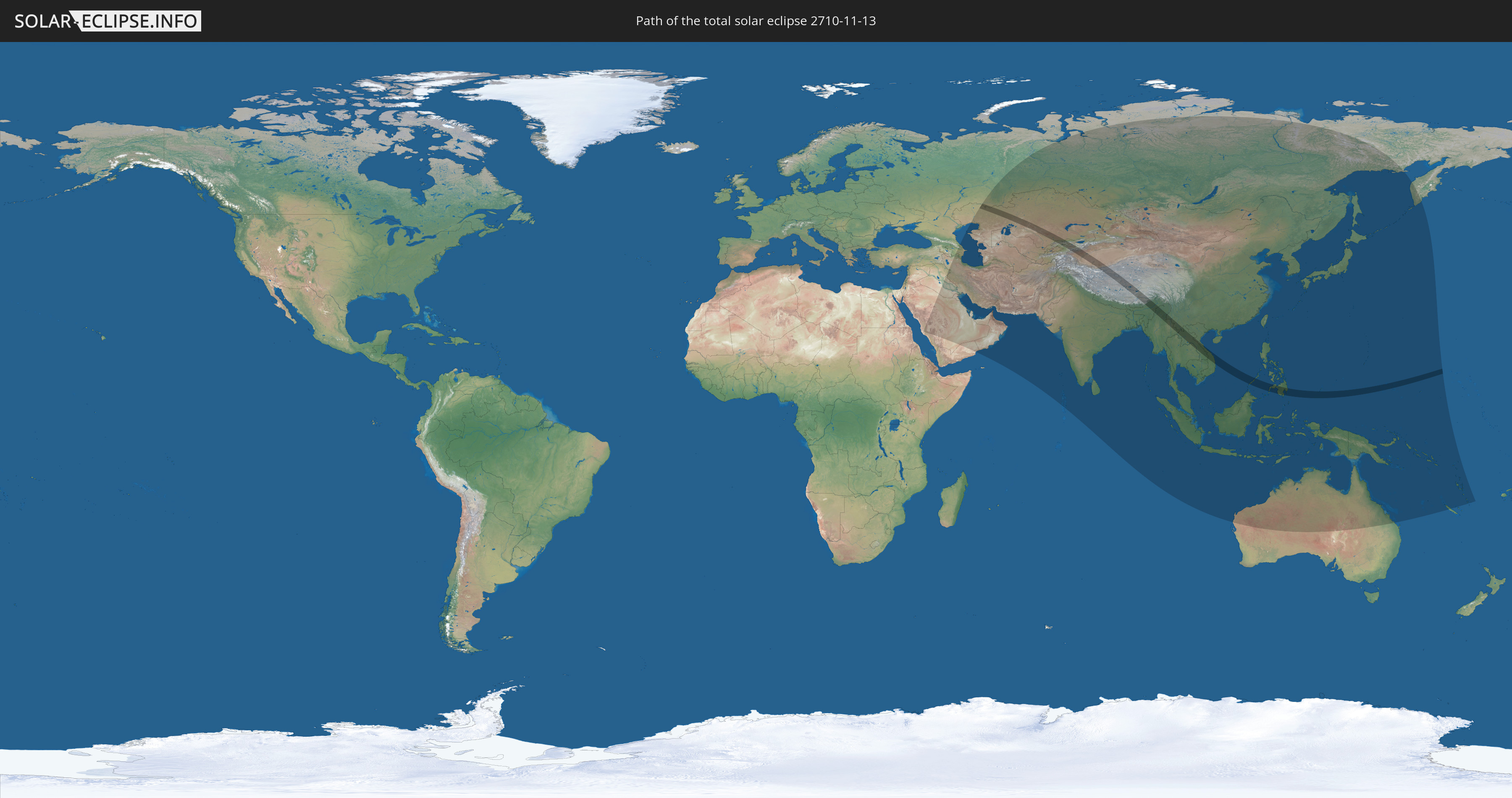
Die Sonnenfinsternis am 11/13/2710 kann man in 55 Ländern als partielle Sonnenfinsternis beobachten.
Der Finsternispfad verläuft durch 13 Länder. Nur in diesen Ländern ist sie als total Sonnenfinsternis zu sehen.
In den folgenden Ländern ist die Sonnenfinsternis total zu sehen
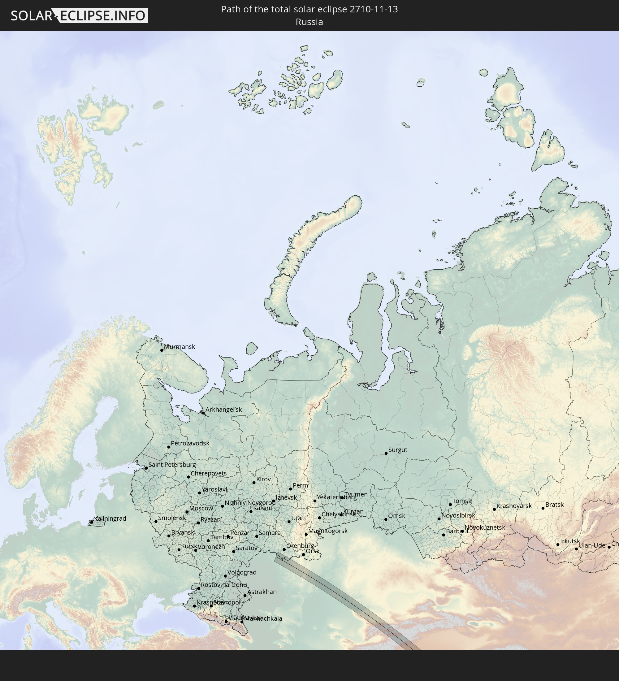 Russia
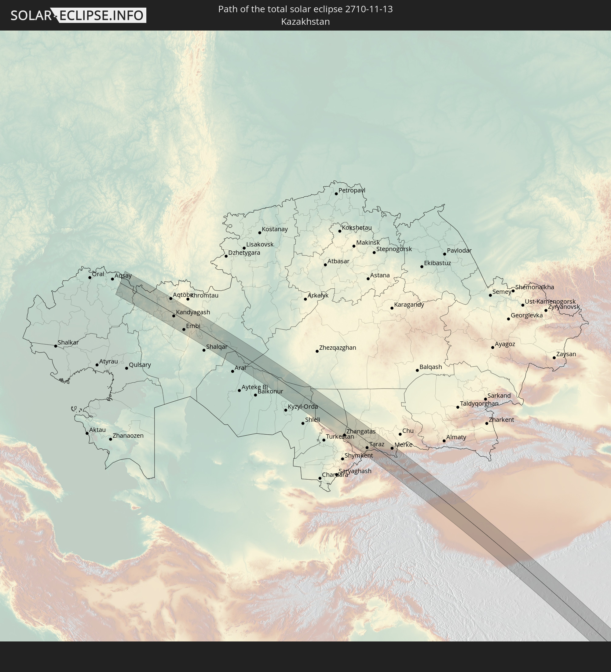 Kazakhstan
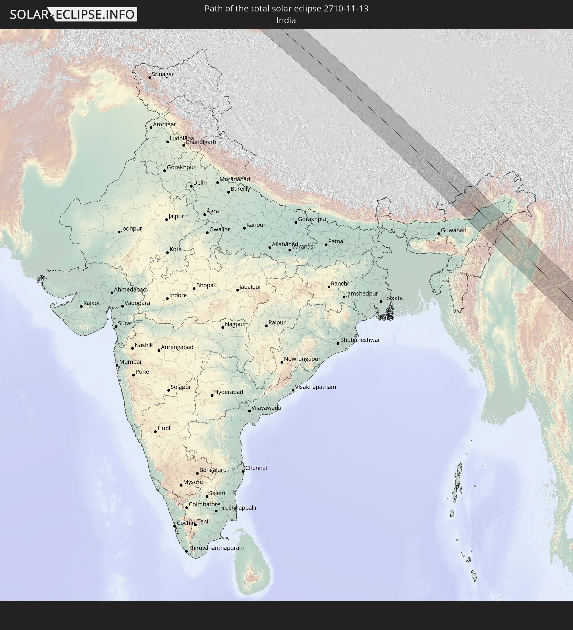 India
India
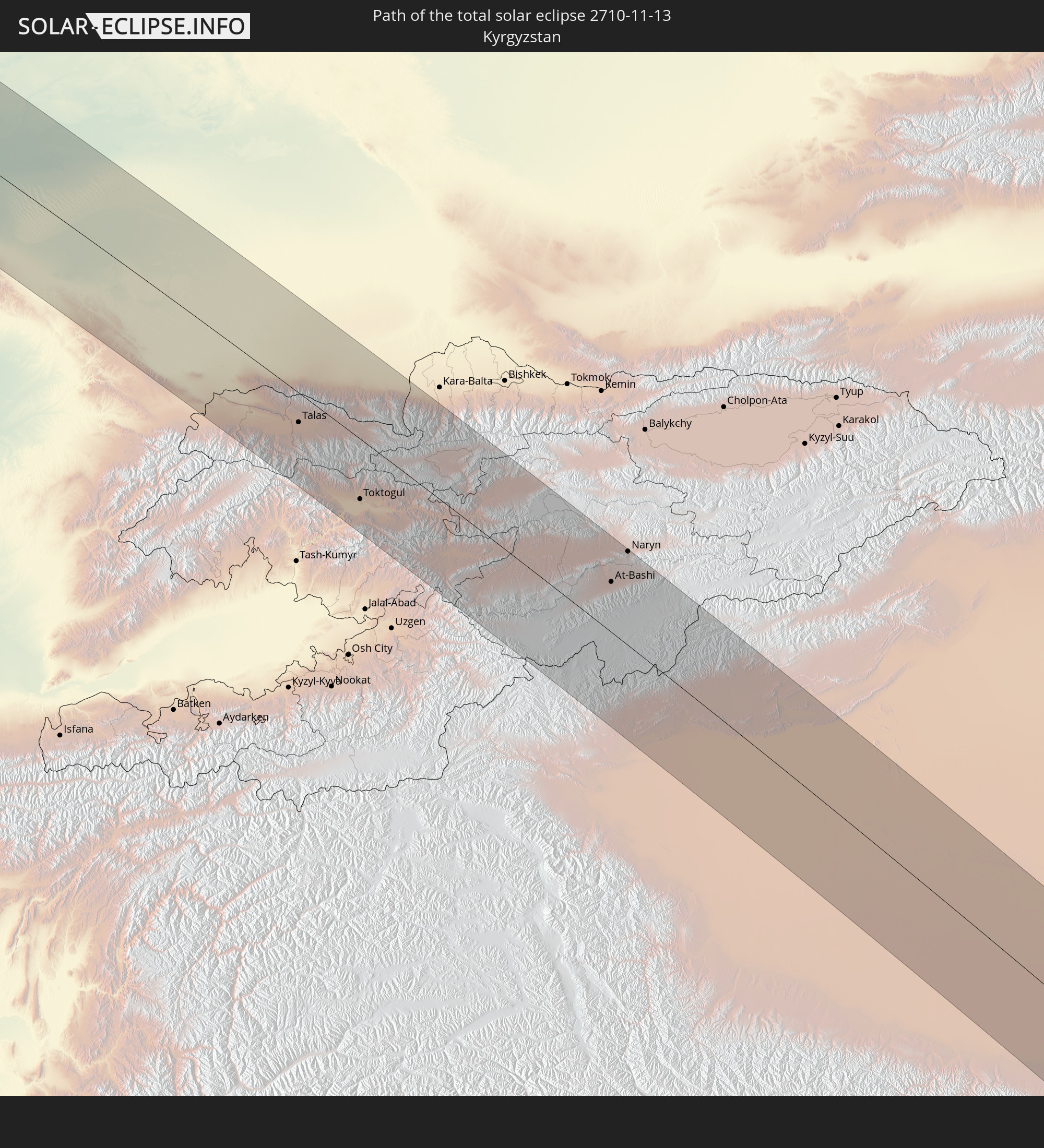 Kyrgyzstan
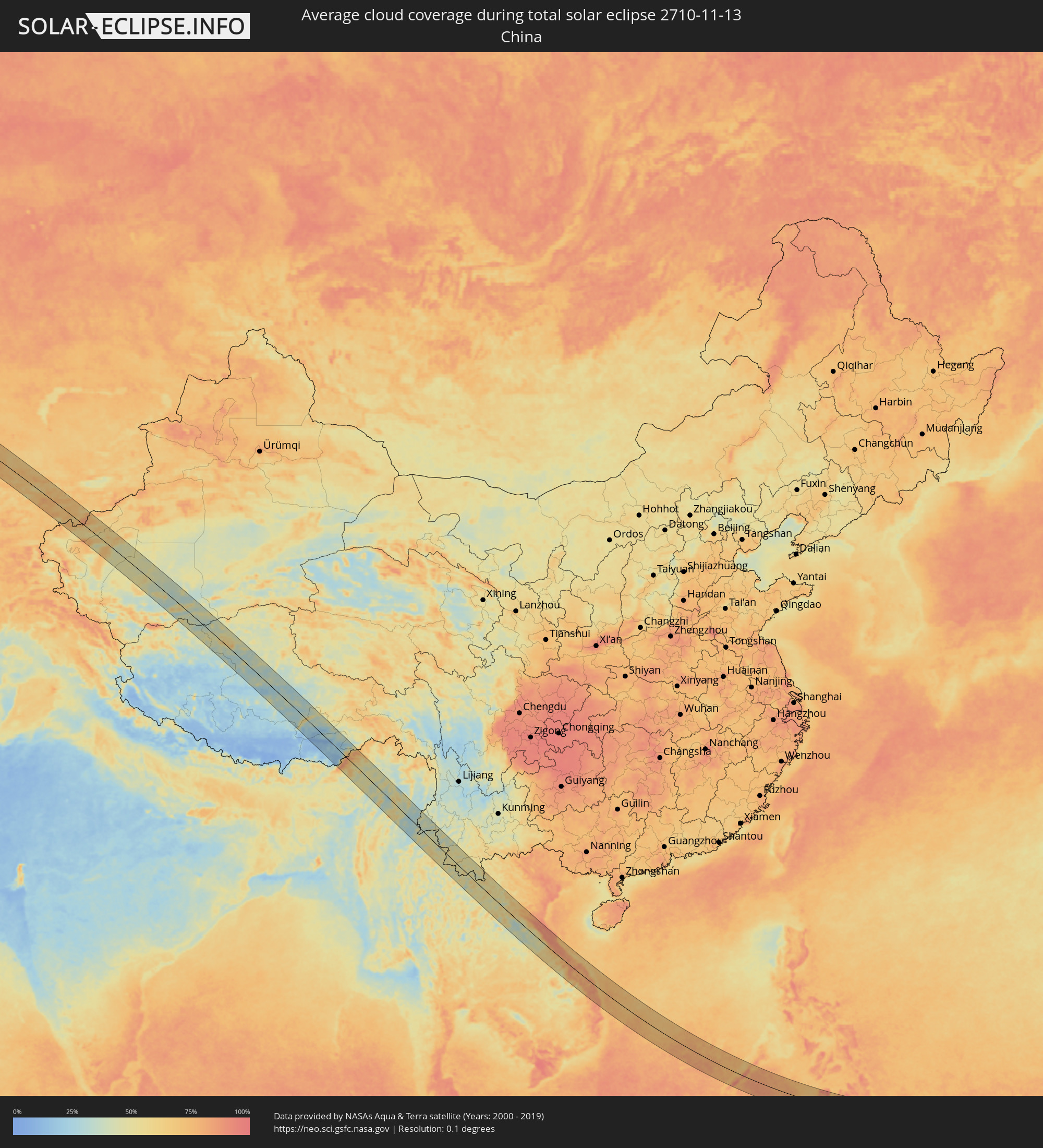
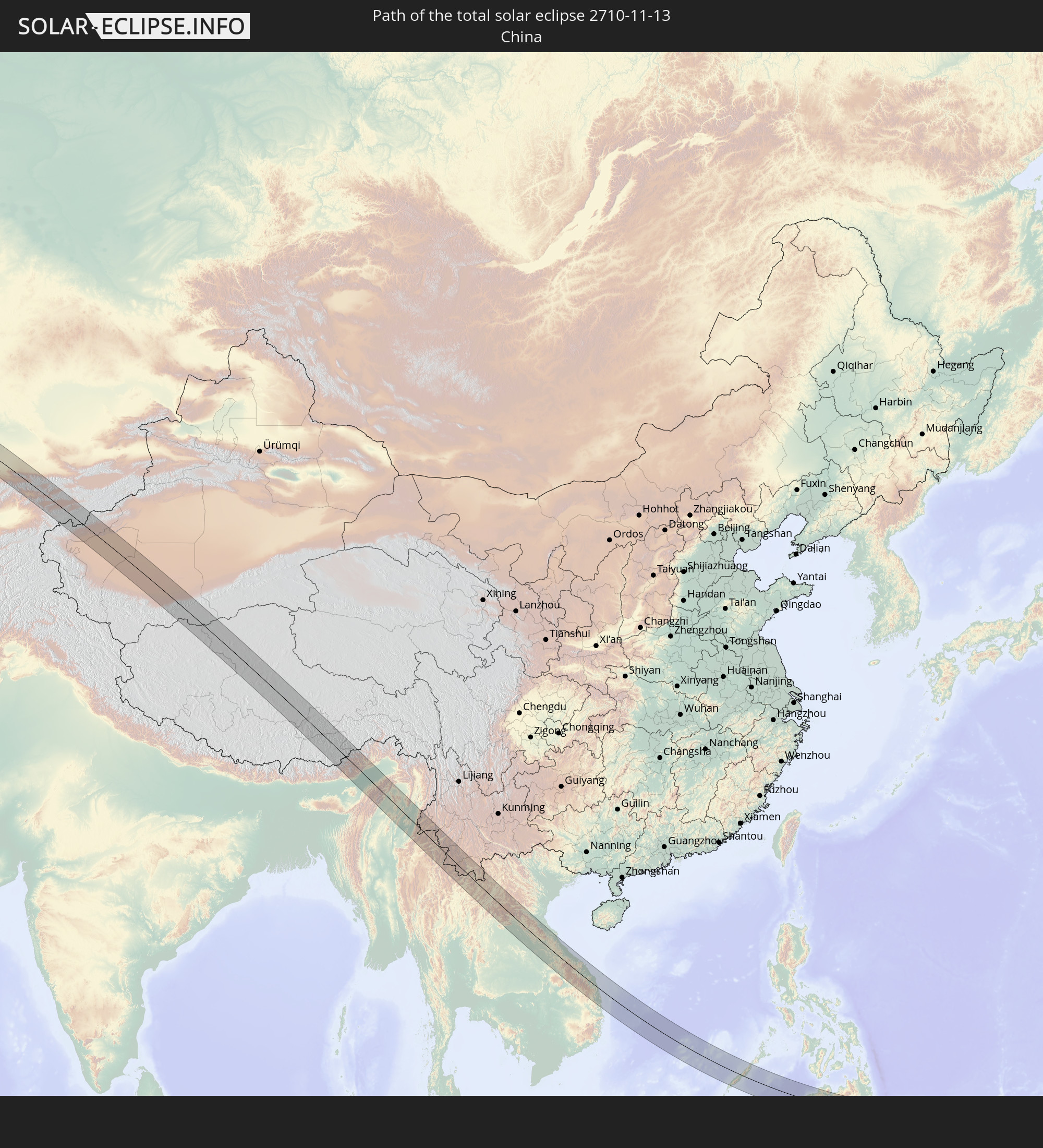 China
China
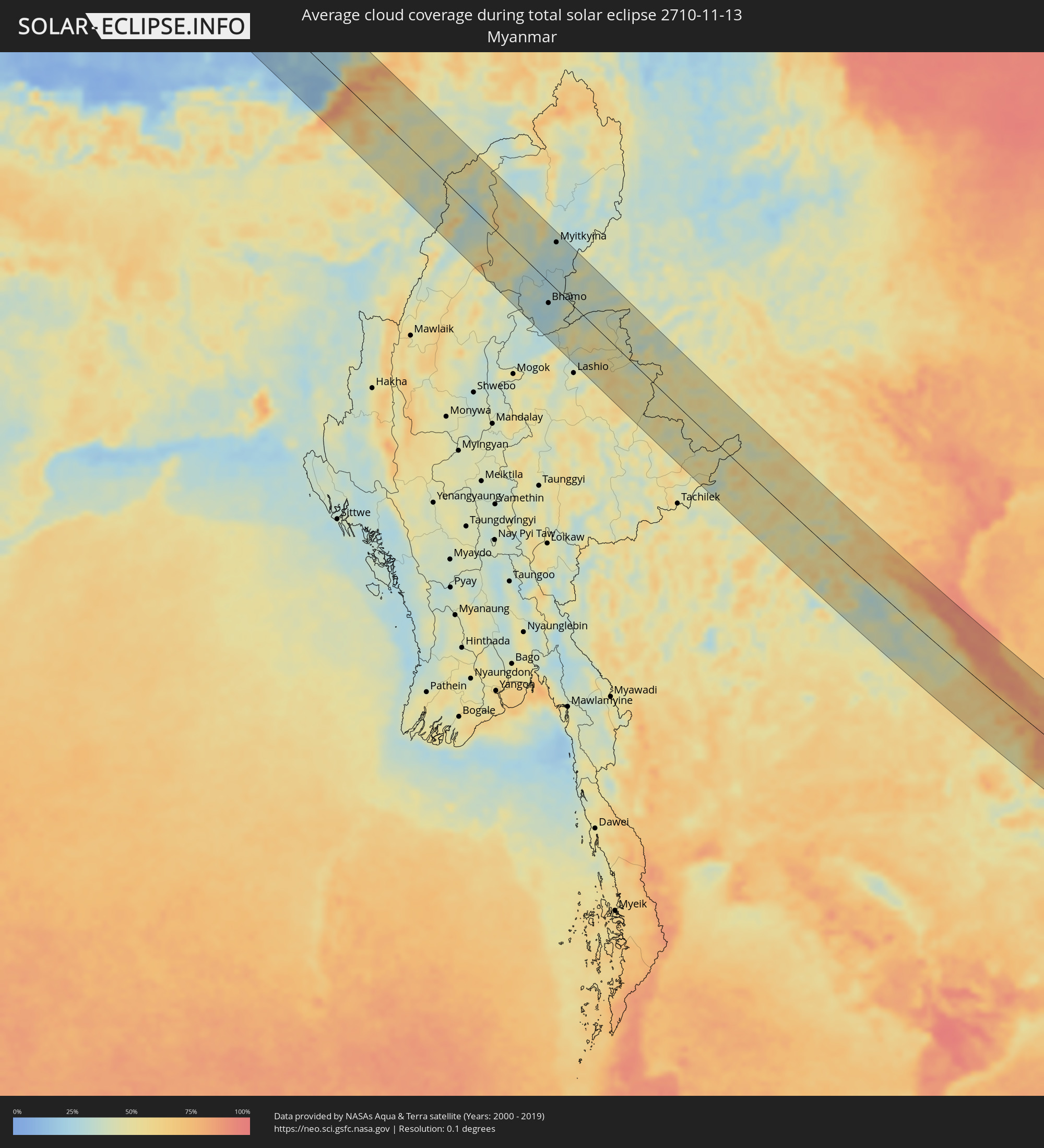
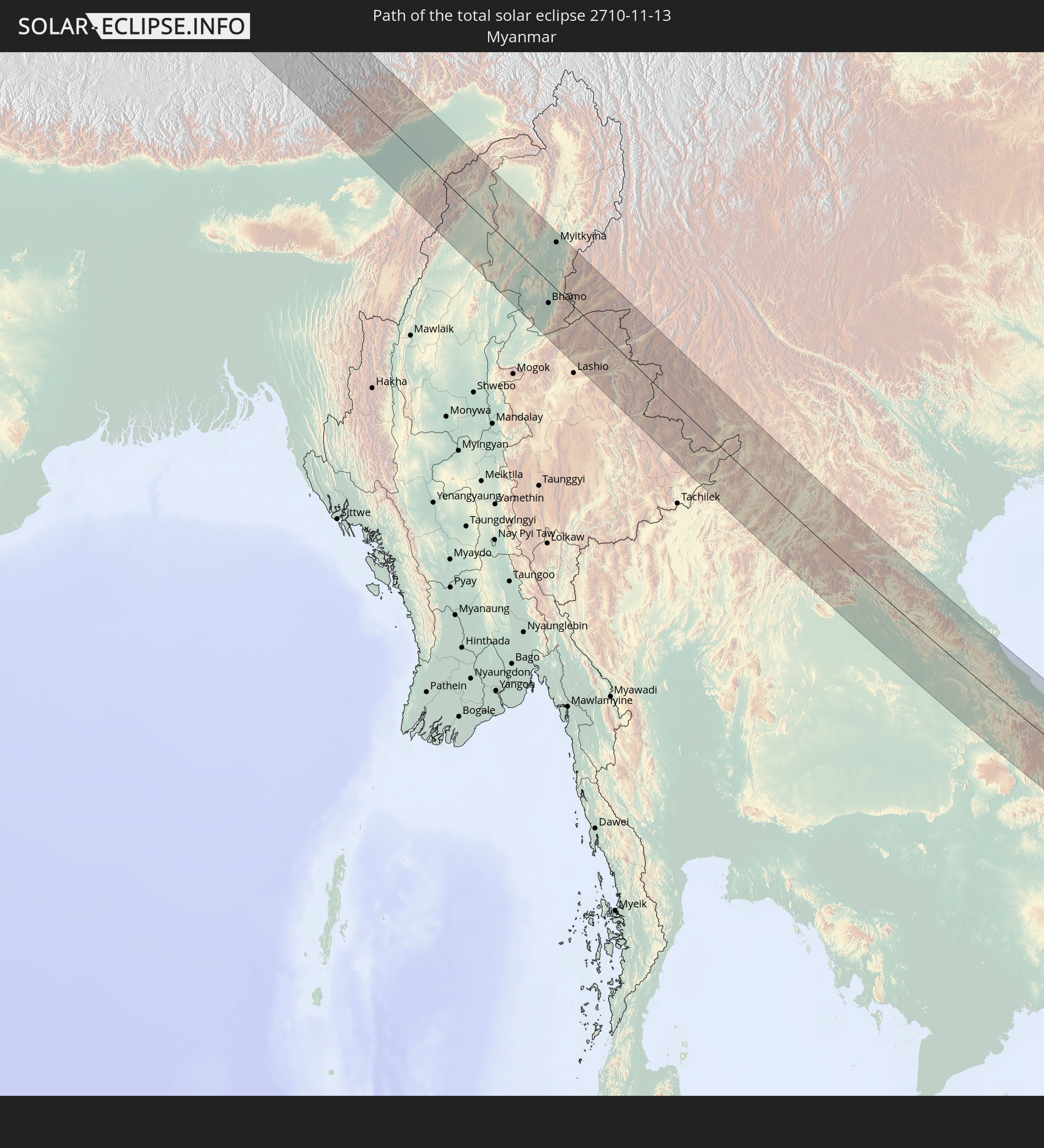 Myanmar
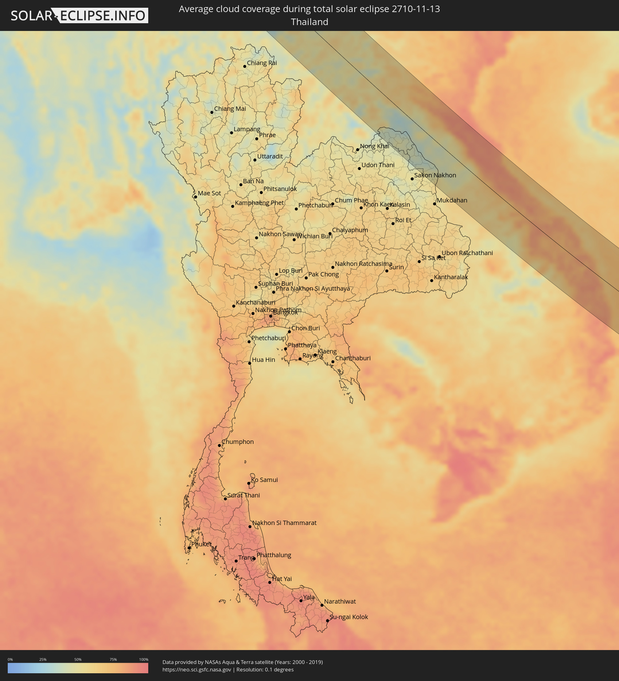
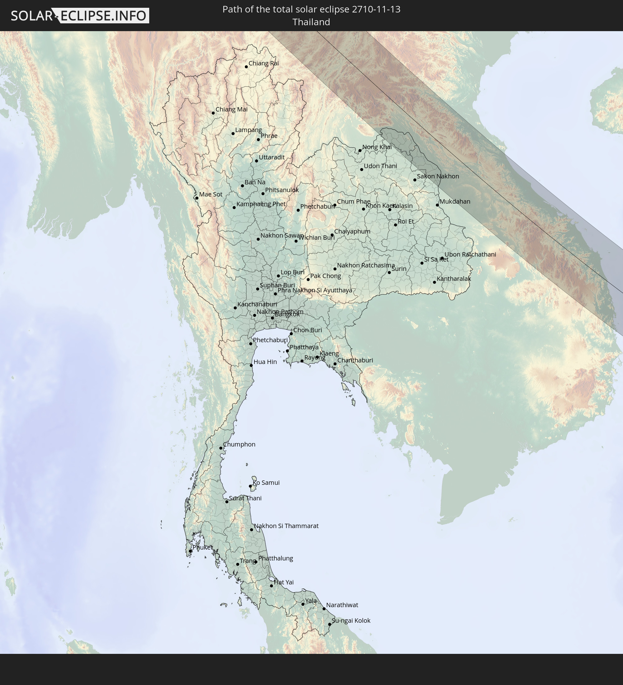 Thailand
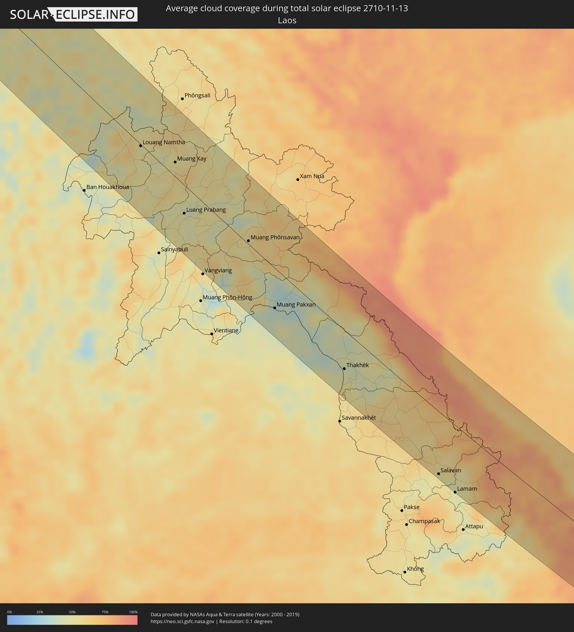
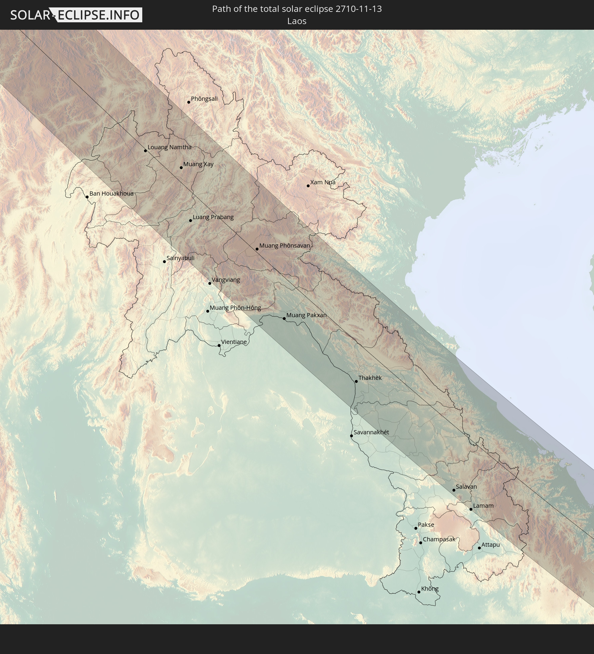 Laos
Laos
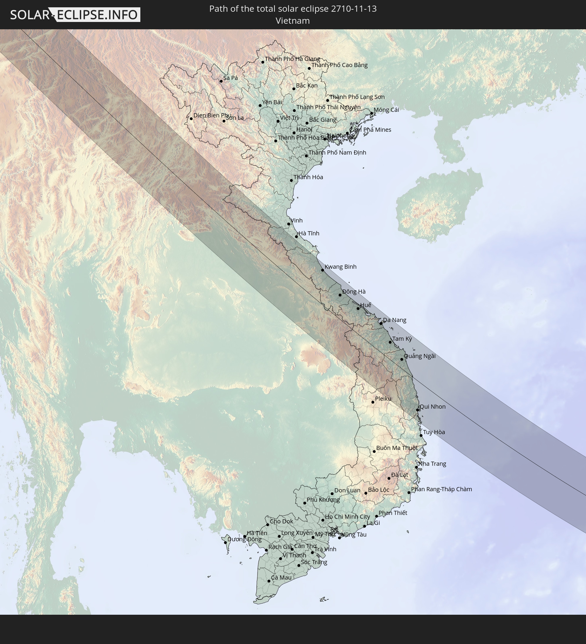 Vietnam
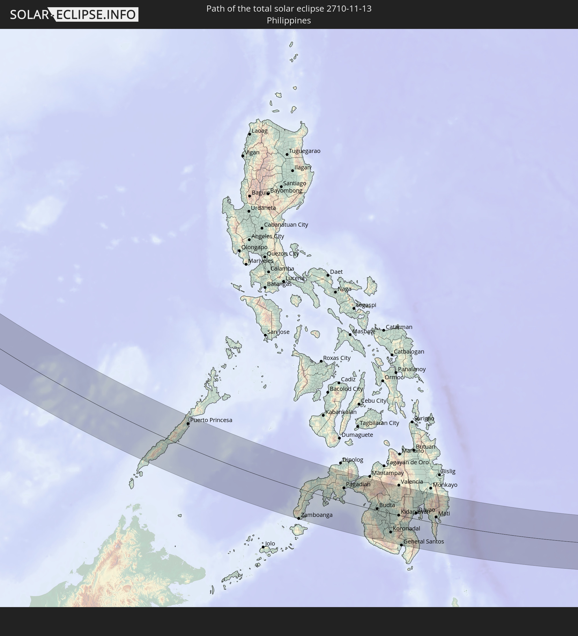 Philippines
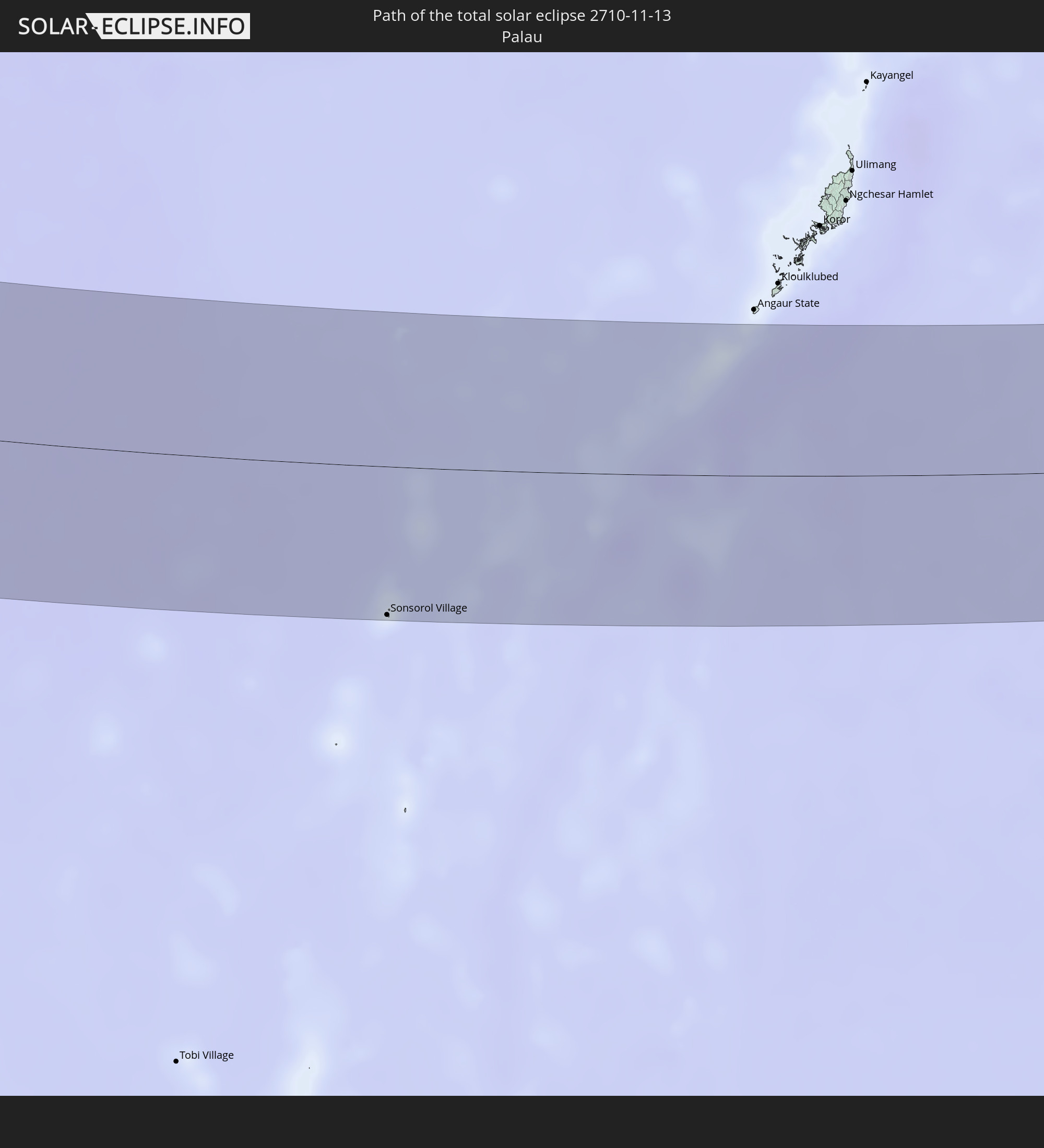 Palau
Palau
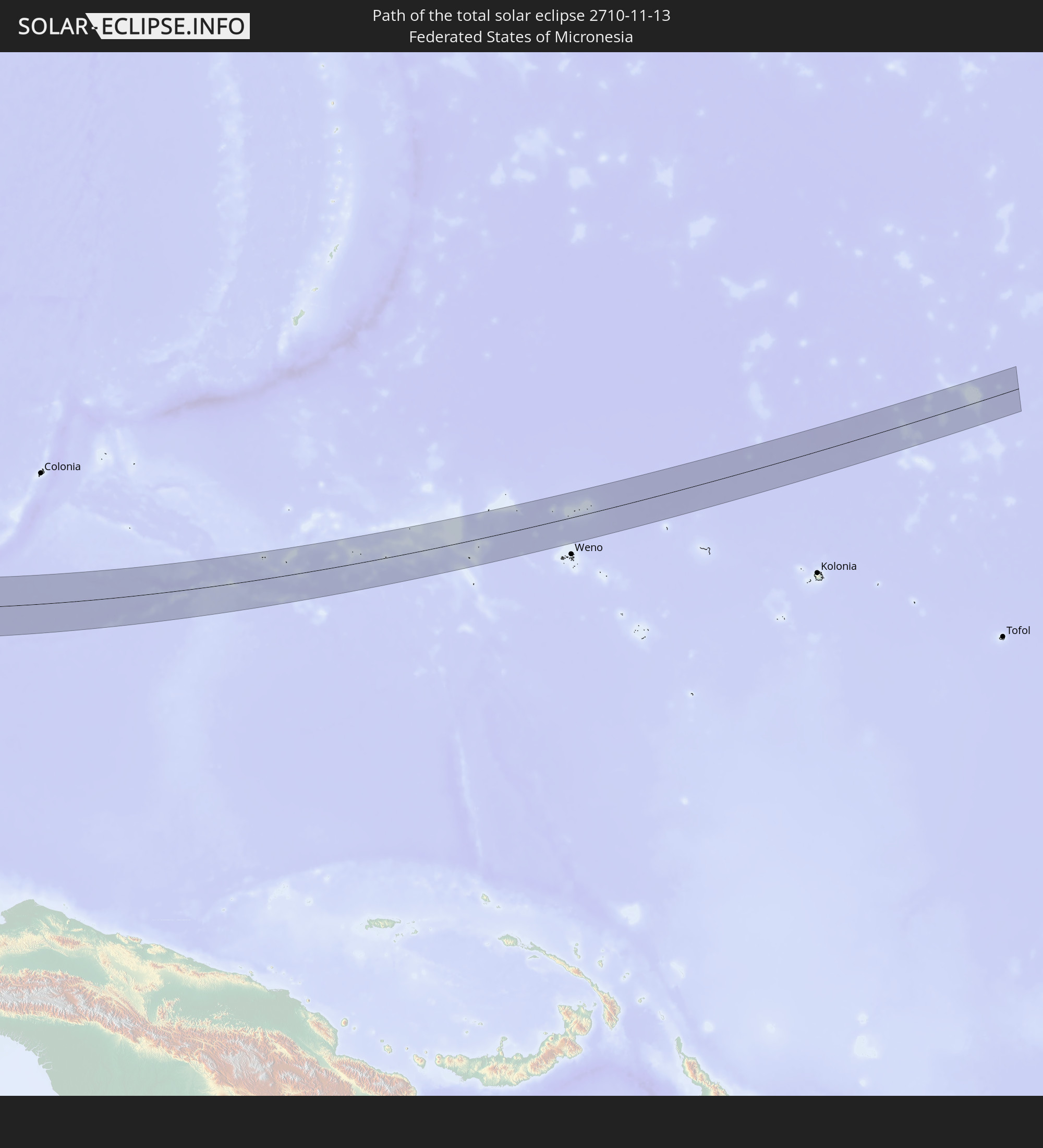 Federated States of Micronesia
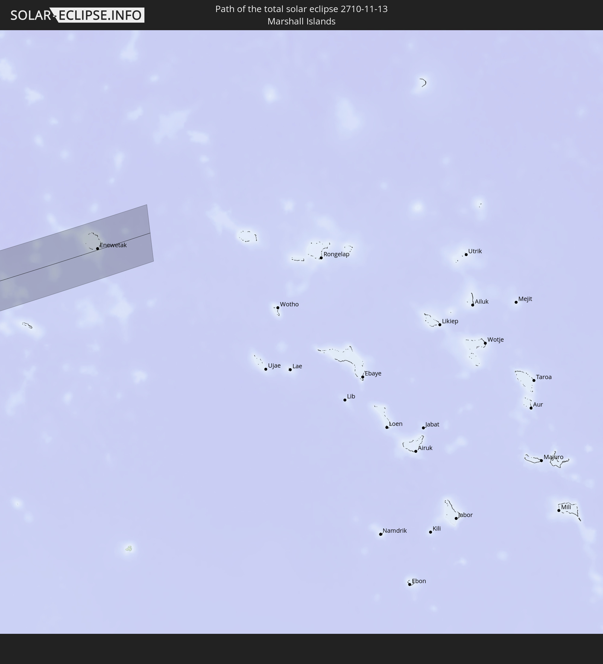 Marshall Islands
In den folgenden Ländern ist die Sonnenfinsternis partiell zu sehen
 Russia
 Saudi Arabia
 Iraq
Iraq
 Yemen
Yemen
 Iran
Iran
 Azerbaijan
 Kazakhstan
 Kuwait
 Bahrain
 Qatar
Qatar
 United Arab Emirates
 Oman
Oman
 Turkmenistan
 Uzbekistan
 Afghanistan
 Pakistan
 Tajikistan
 India
India
 Kyrgyzstan
 Maldives
 China
China
 Sri Lanka
 Nepal
Nepal
 Mongolia
 Bangladesh
 Bhutan
 Myanmar
 Indonesia
 Cocos Islands
 Thailand
 Malaysia
 Laos
Laos
 Vietnam
 Cambodia
 Singapore
 Christmas Island
 Australia
 Macau
Macau
 Hong Kong
 Brunei
 Taiwan
 Philippines
 Japan
Japan
 East Timor
 North Korea
 South Korea
 Palau
Palau
 Federated States of Micronesia
 Papua New Guinea
 Guam
Guam
 Northern Mariana Islands
 Solomon Islands
 New Caledonia
 Marshall Islands
 Vanuatu
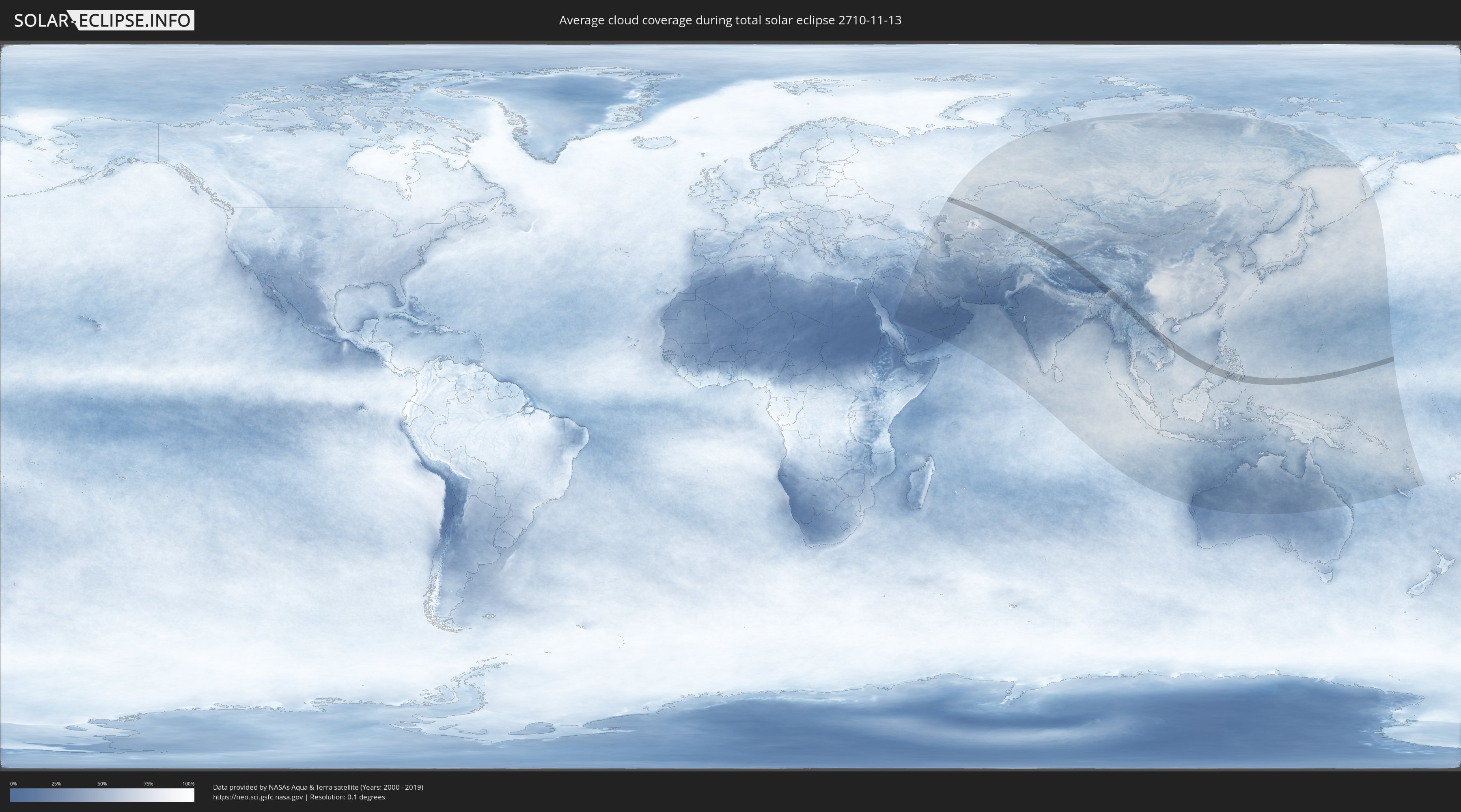
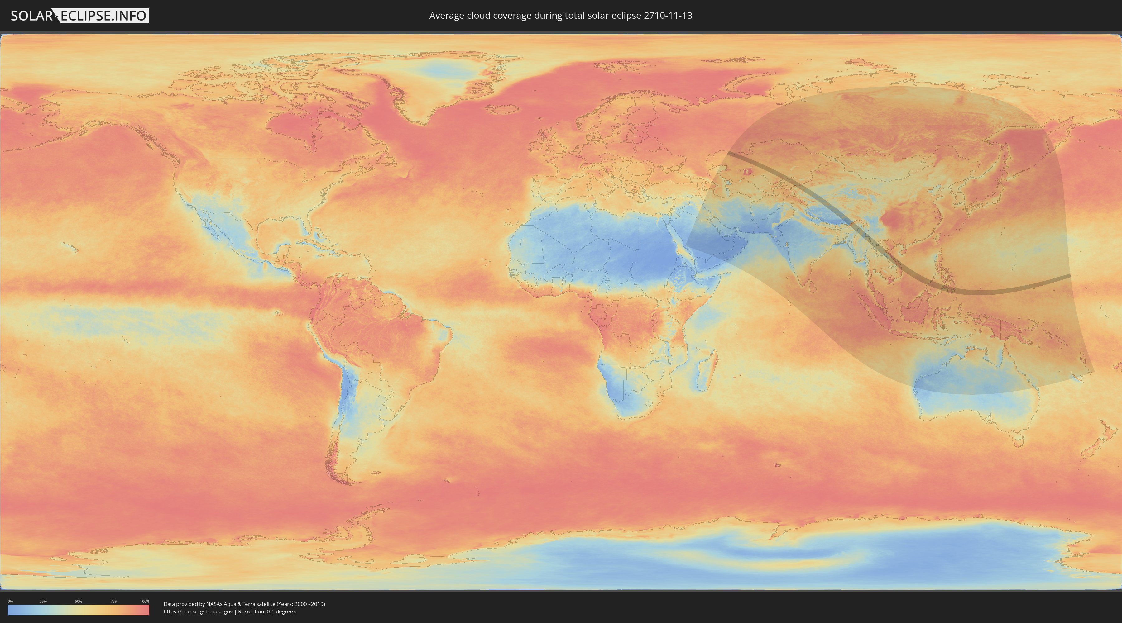
How will be the weather during the total solar eclipse on 11/13/2710?
Where is the best place to see the total solar eclipse of 11/13/2710?
The following maps show the average cloud coverage for the day of the total solar eclipse.
With the help of these maps, it is possible to find the place along the eclipse path, which has the best
chance of a cloudless sky.
Nevertheless, you should consider local circumstances and inform about the weather of your chosen
observation site.
The data is provided by NASAs satellites
AQUA and TERRA.
The cloud maps are averaged over a period of 19 years (2000 - 2019).
Detailed country maps
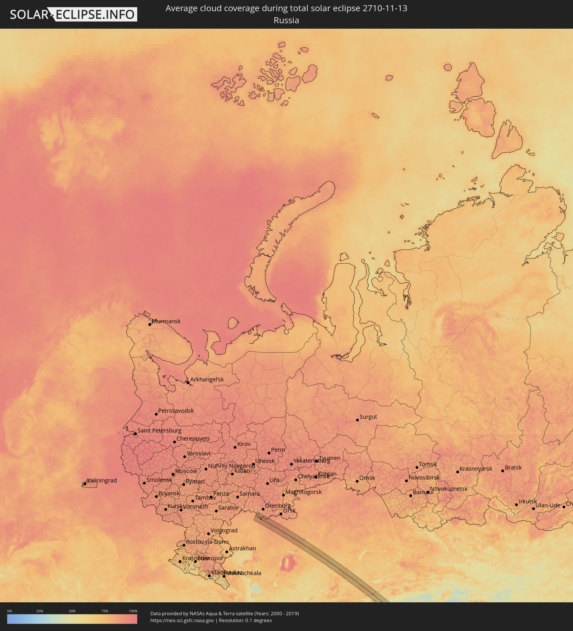 Russia
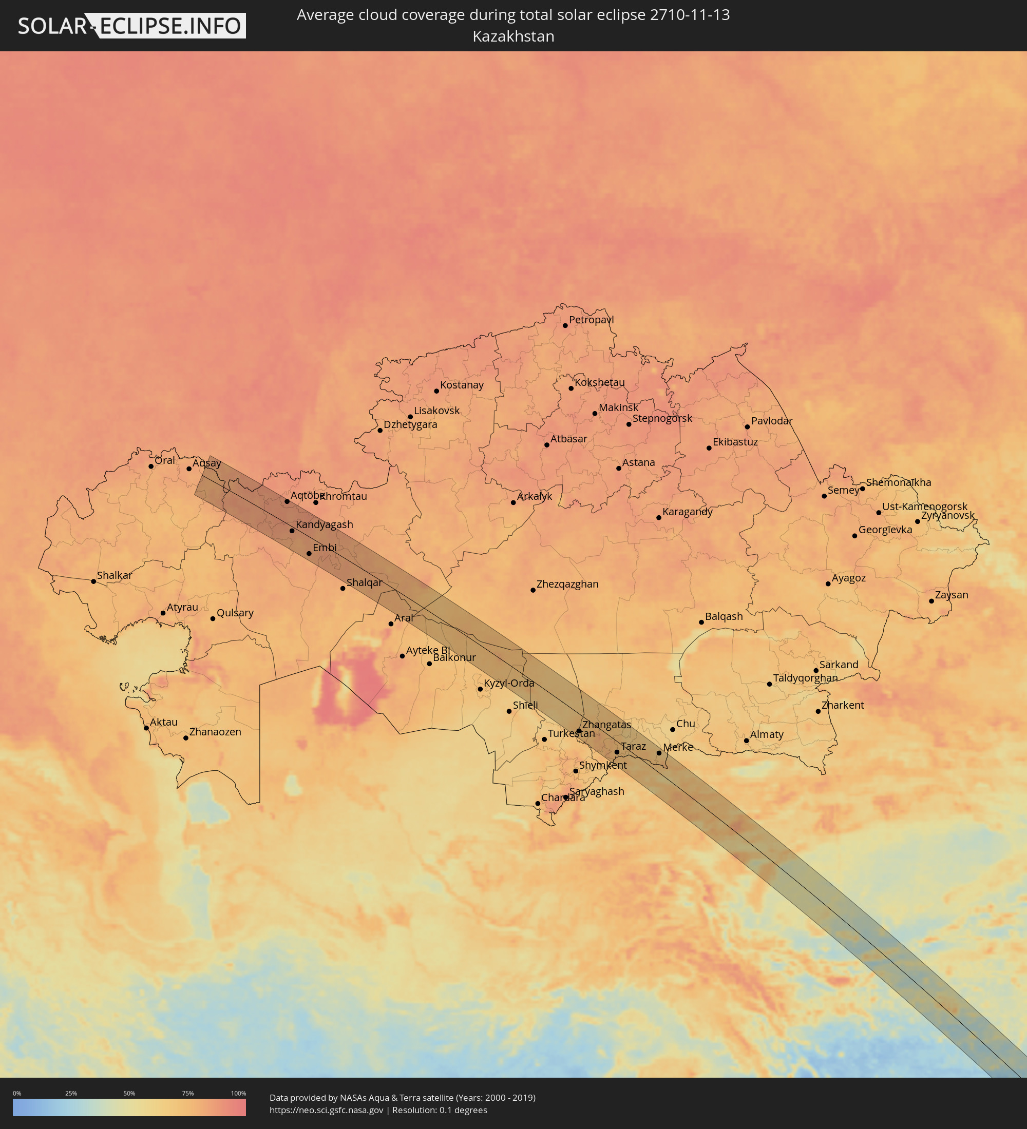 Kazakhstan
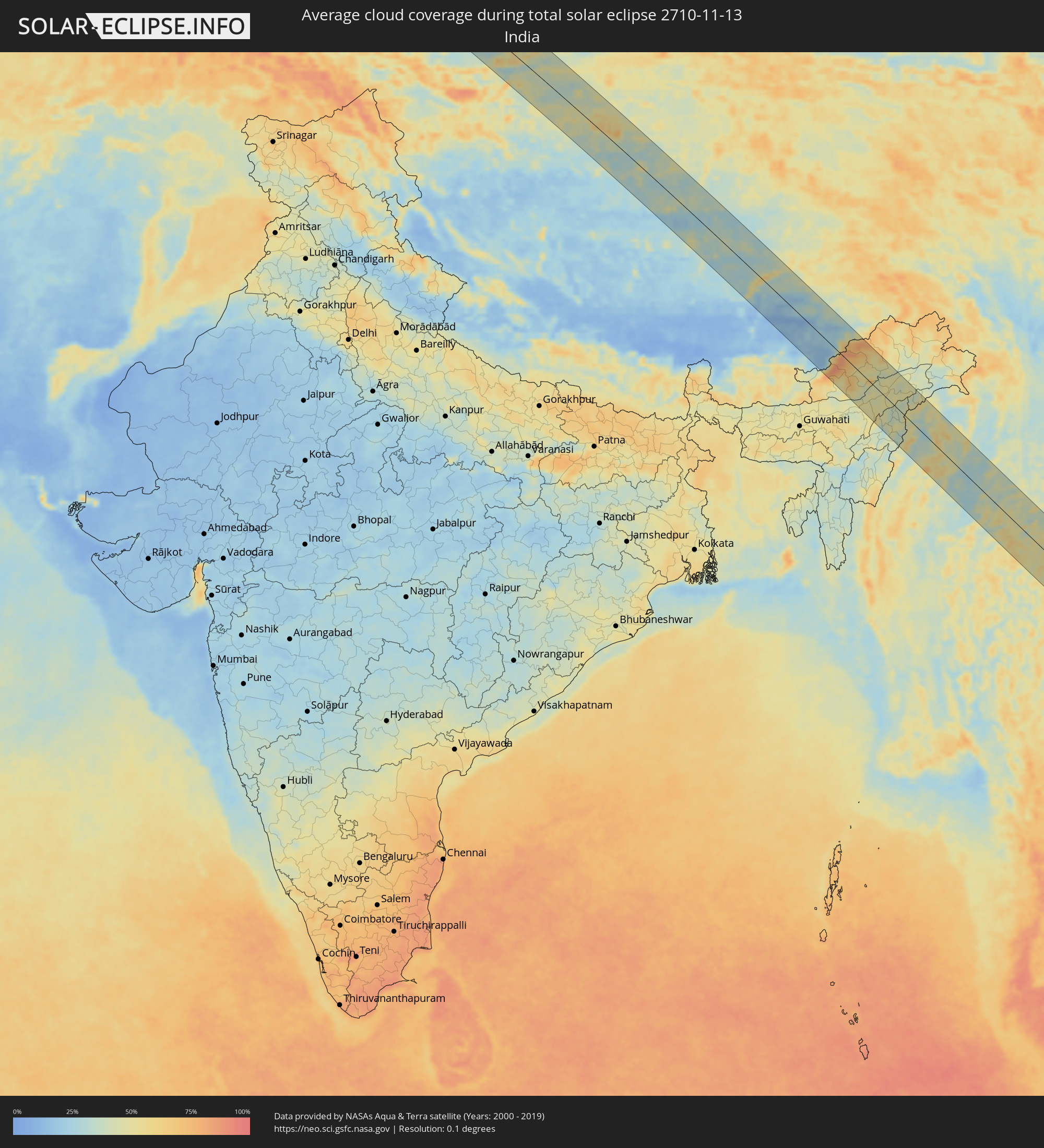 India
India
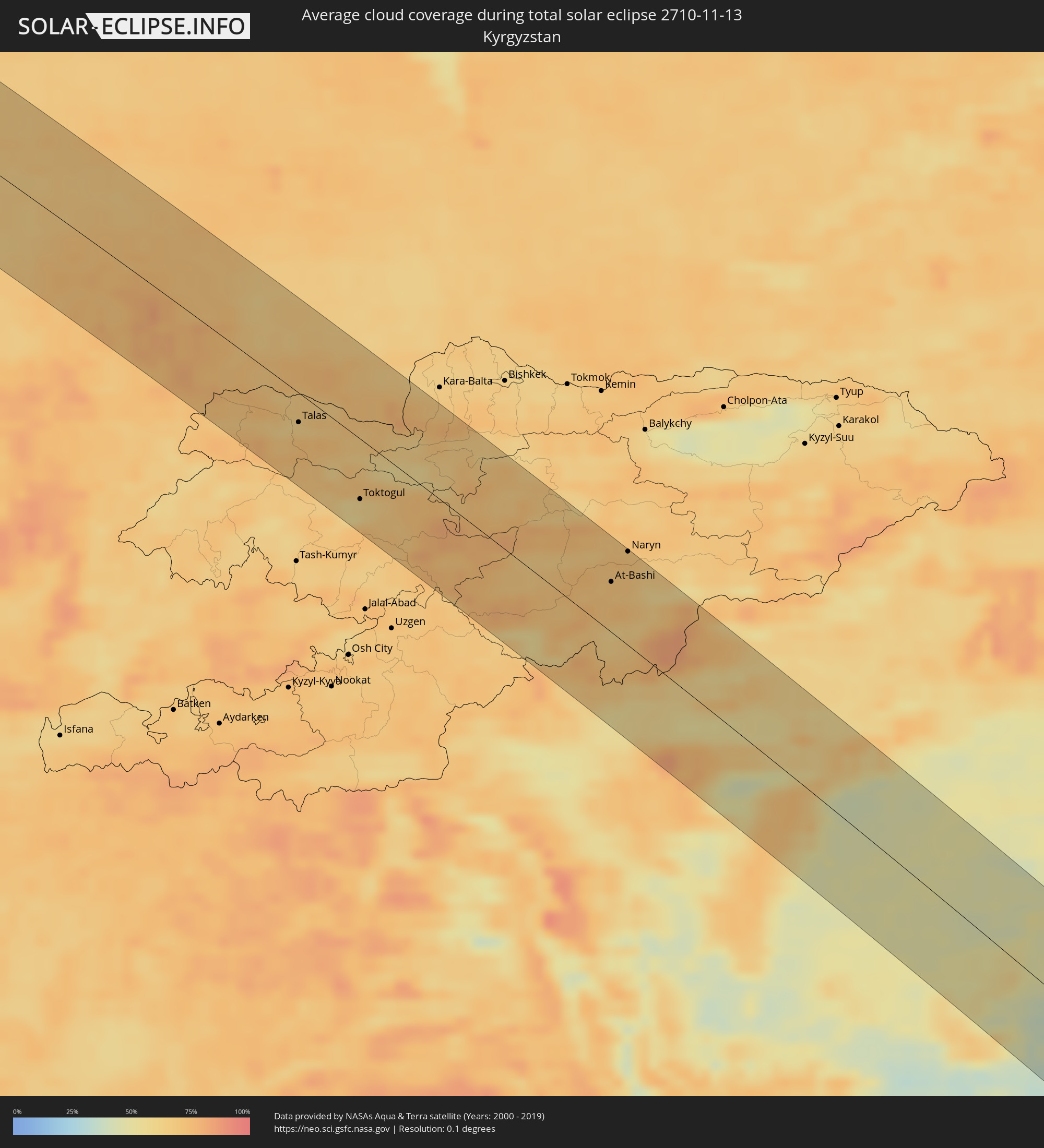 Kyrgyzstan
 China
China
 Myanmar
 Thailand
 Laos
Laos
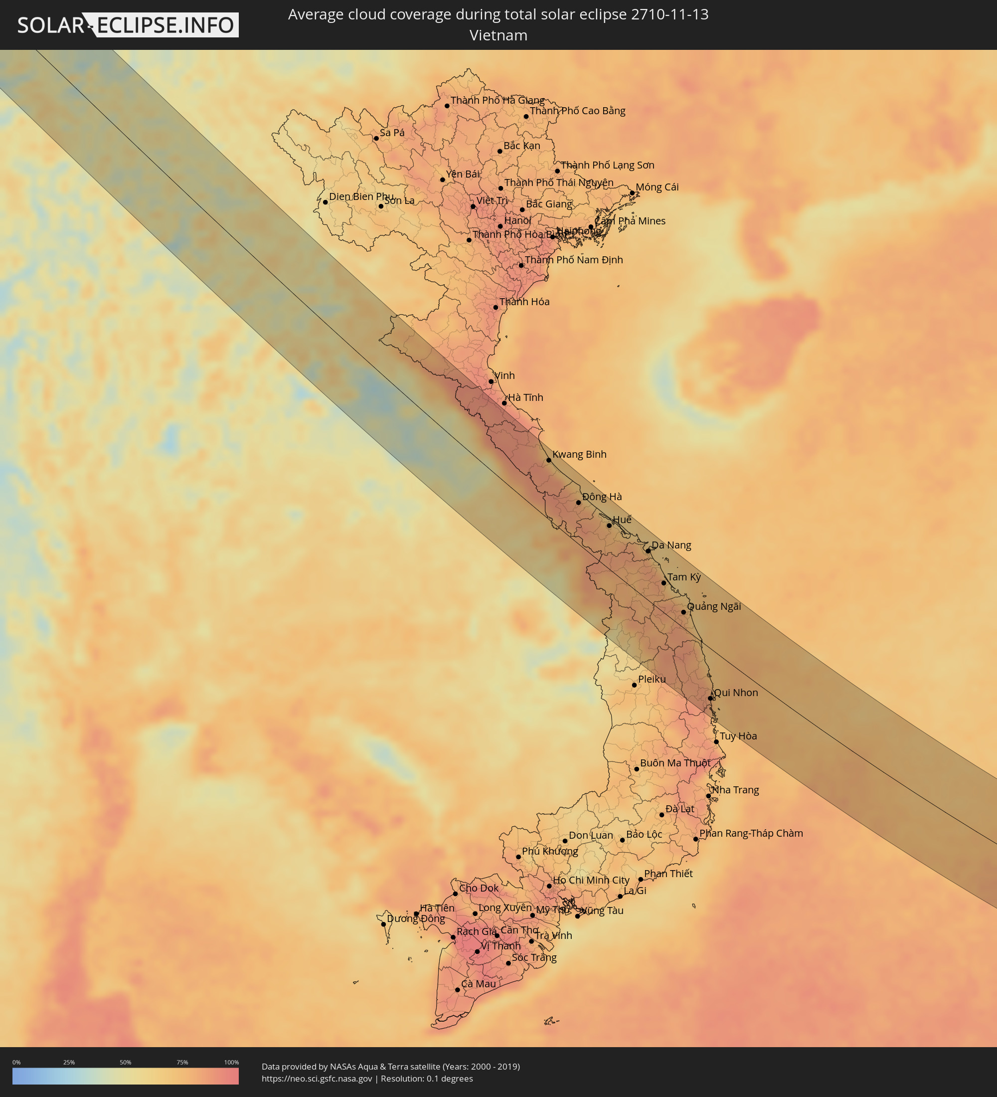 Vietnam
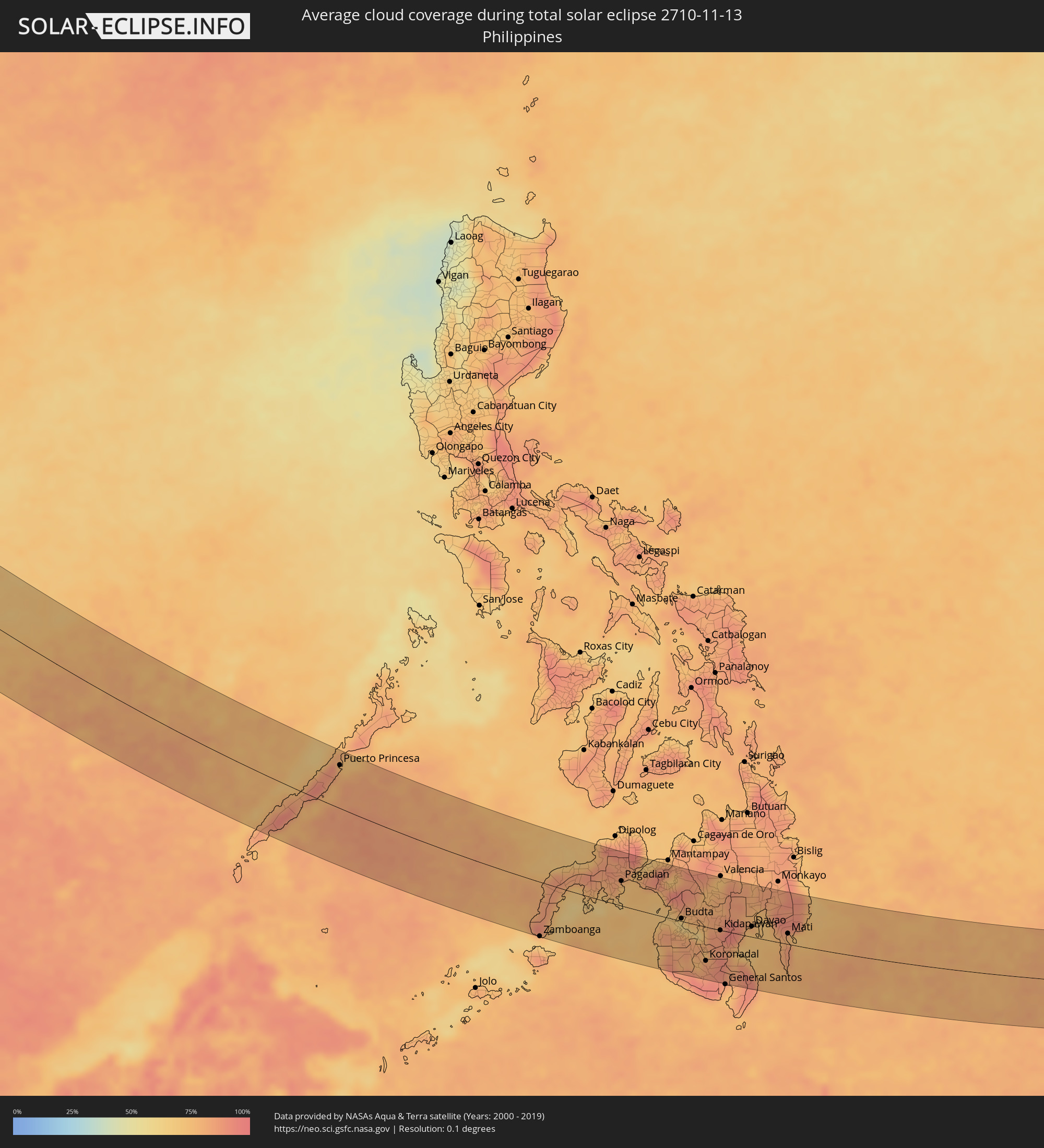 Philippines
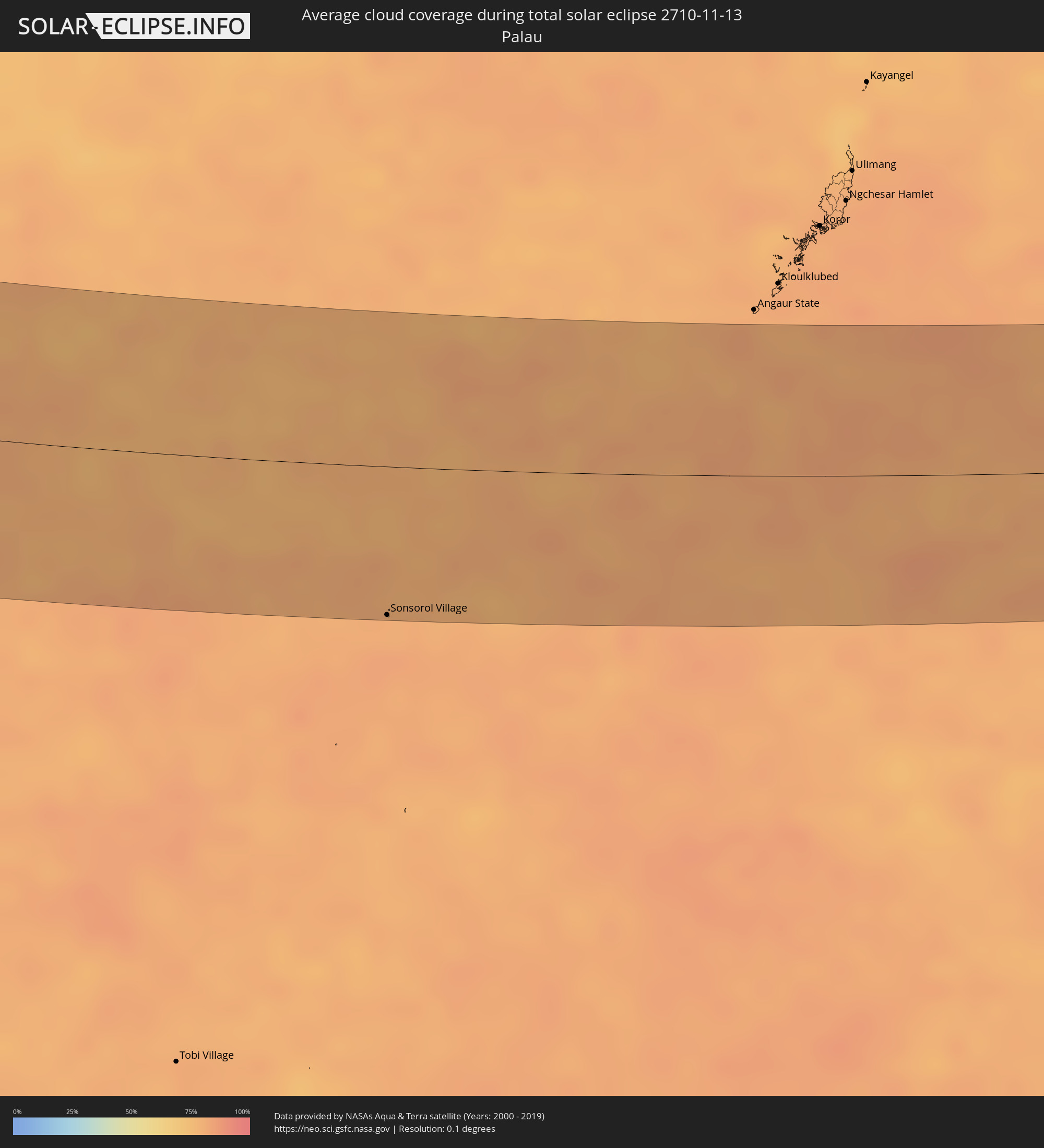 Palau
Palau
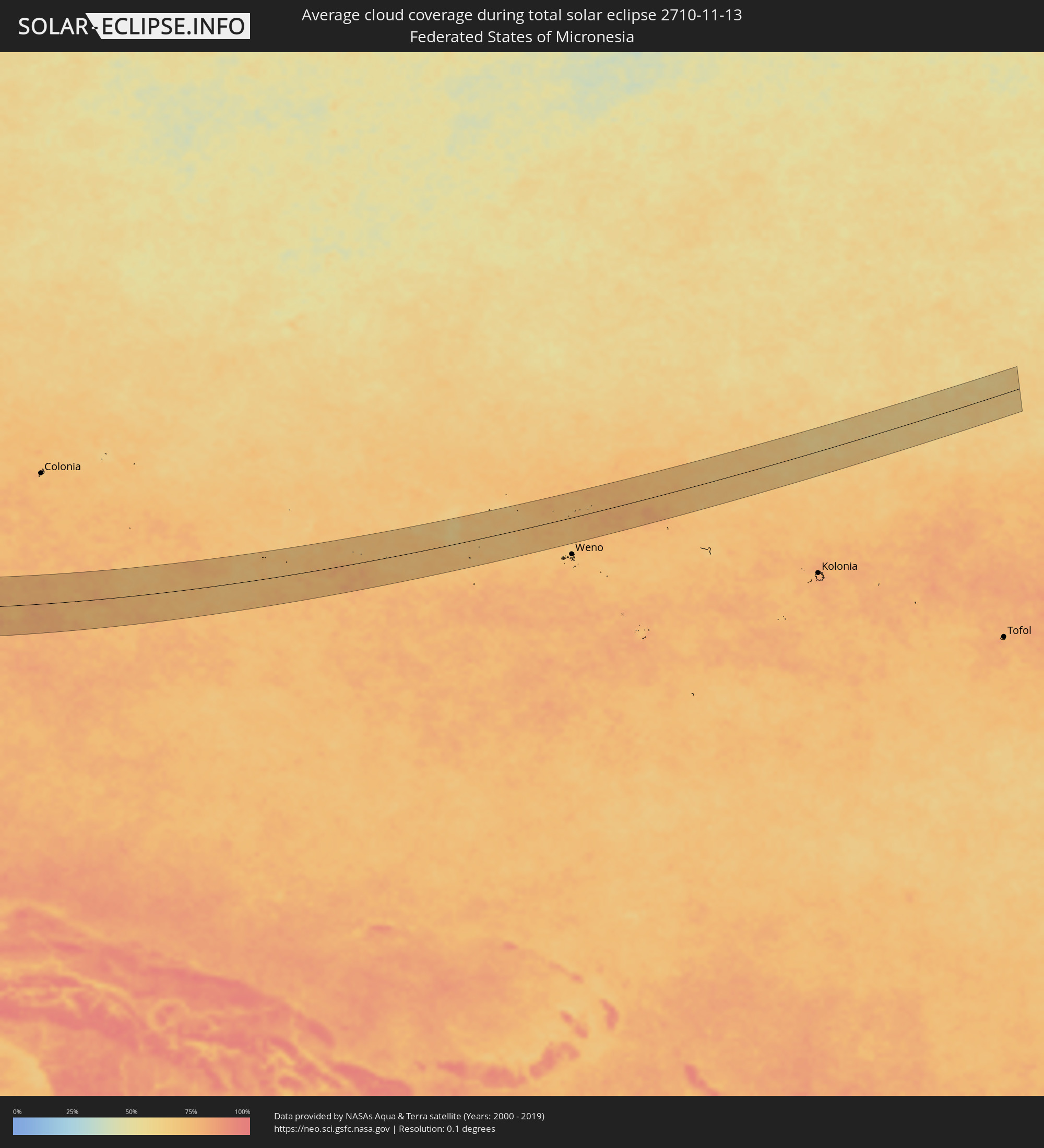 Federated States of Micronesia
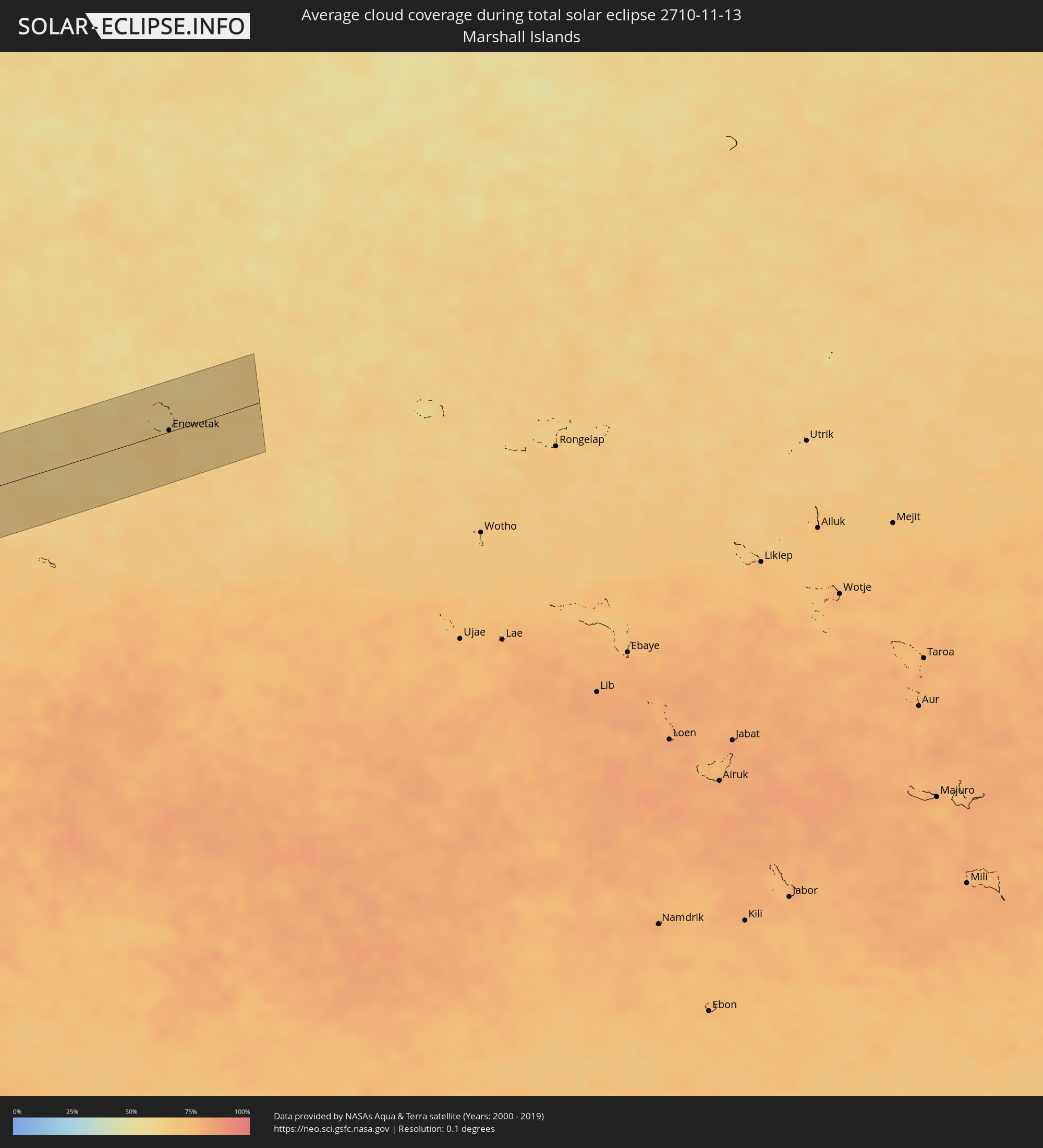 Marshall Islands
Cities inside the path of the eclipse
The following table shows all locations with a population of more than 5,000 inside the eclipse path. Cities which have more than 100,000 inhabitants are marked bold. A click at the locations opens a detailed map.
| City | Type | Eclipse duration | Local time of max. eclipse | Distance to central line | Ø Cloud coverage |
|
Chingirlau, Batys Qazaqstan
|
total | - | 08:42:25 UTC+05:00 | 27 km | 79% |
|
Aqtöbe, Aqtöbe
|
total | - | 08:42:46 UTC+05:00 | 58 km | 86% |
|
Kandyagash, Aqtöbe
|
total | - | 08:42:17 UTC+05:00 | 12 km | 84% |
|
Embi, Aqtöbe
|
total | - | 08:42:07 UTC+05:00 | 46 km | 81% |
|
Chulakkurgan, Ongtüstik Qazaqstan
|
total | - | 08:45:05 UTC+05:00 | 56 km | 68% |
|
Zhangatas, Zhambyl
|
total | - | 08:45:23 UTC+05:00 | 49 km | 72% |
|
Karatau, Zhambyl
|
total | - | 08:45:46 UTC+05:00 | 49 km | 78% |
|
Taraz, Zhambyl
|
total | - | 08:46:19 UTC+05:00 | 31 km | 72% |
|
Mikhaylovka, Zhambyl
|
total | - | 08:46:26 UTC+05:00 | 15 km | 71% |
|
Talas, Talas
|
total | - | 09:46:51 UTC+06:00 | 22 km | 64% |
|
Lugovoye, Zhambyl
|
total | - | 08:47:19 UTC+05:00 | 36 km | 73% |
|
Lugovoy, Zhambyl
|
total | - | 08:47:21 UTC+05:00 | 41 km | 70% |
|
Toktogul, Jalal-Abad
|
total | - | 09:47:13 UTC+06:00 | 45 km | 59% |
|
Merke, Zhambyl
|
total | - | 08:47:39 UTC+05:00 | 55 km | 67% |
|
Oytal, Zhambyl
|
total | - | 08:47:44 UTC+05:00 | 63 km | 67% |
|
Sosnovka, Chüy
|
total | - | 09:48:09 UTC+06:00 | 70 km | 74% |
|
At-Bashi, Naryn
|
total | - | 09:49:25 UTC+06:00 | 38 km | 70% |
|
Naryn, Naryn
|
total | - | 09:49:37 UTC+06:00 | 70 km | 71% |
|
Dêqên, Tibet Autonomous Region
|
total | - | 12:09:20 UTC+08:00 | 20 km | 23% |
|
Lhasa, Tibet Autonomous Region
|
total | - | 12:10:06 UTC+08:00 | 19 km | 15% |
|
Itānagar, Arunachal Pradesh
|
total | - | 09:46:01 UTC+05:30 | 57 km | 41% |
|
Naharlagun, Arunachal Pradesh
|
total | - | 09:46:08 UTC+05:30 | 49 km | 41% |
|
Ziro, Arunachal Pradesh
|
total | - | 09:45:59 UTC+05:30 | 0 km | 54% |
|
Golāghāt, Assam
|
total | - | 09:47:05 UTC+05:30 | 79 km | 53% |
|
Dergaon, Assam
|
total | - | 09:46:56 UTC+05:30 | 63 km | 47% |
|
North Lakhimpur, Assam
|
total | - | 09:46:44 UTC+05:30 | 11 km | 48% |
|
Jorhāt, Assam
|
total | - | 09:47:17 UTC+05:30 | 42 km | 48% |
|
Mariāni, Assam
|
total | - | 09:47:34 UTC+05:30 | 43 km | 47% |
|
Mokokchūng, Nagaland
|
total | - | 09:48:12 UTC+05:30 | 55 km | 43% |
|
Dhemāji, Assam
|
total | - | 09:47:21 UTC+05:30 | 42 km | 49% |
|
Sibsāgar, Assam
|
total | - | 09:47:51 UTC+05:30 | 6 km | 45% |
|
Nāzirā, Assam
|
total | - | 09:48:04 UTC+05:30 | 7 km | 45% |
|
Tuensang, Nagaland
|
total | - | 09:48:47 UTC+05:30 | 39 km | 49% |
|
Dibrugarh, Assam
|
total | - | 09:47:54 UTC+05:30 | 64 km | 42% |
|
Sonāri, Assam
|
total | - | 09:48:28 UTC+05:30 | 35 km | 39% |
|
Mon, Nagaland
|
total | - | 09:48:47 UTC+05:30 | 15 km | 44% |
|
Duliāgaon, Assam
|
total | - | 09:48:41 UTC+05:30 | 83 km | 46% |
|
Nāmrup, Assam
|
total | - | 09:48:51 UTC+05:30 | 70 km | 43% |
|
Nahorkatiya, Assam
|
total | - | 09:48:49 UTC+05:30 | 79 km | 48% |
|
Bhamo, Kachin
|
total | - | 10:55:03 UTC+06:30 | 32 km | 30% |
|
Myitkyina, Kachin
|
total | - | 10:54:14 UTC+06:30 | 70 km | 38% |
|
Jinghong, Yunnan
|
total | - | 12:34:25 UTC+08:00 | 35 km | 47% |
|
Louang Namtha, Loungnamtha
|
total | - | 11:37:03 UTC+07:00 | 2 km | 49% |
|
Muang Xay, Oudômxai
|
total | - | 11:38:36 UTC+07:00 | 18 km | 56% |
|
Luang Prabang, Louangphabang
|
total | - | 11:39:57 UTC+07:00 | 37 km | 48% |
|
Muang Phônsavan, Xiangkhoang
|
total | - | 11:42:52 UTC+07:00 | 4 km | 53% |
|
Bueng Kan, Changwat Bueng Kan
|
total | - | 11:45:16 UTC+07:00 | 55 km | 35% |
|
Muang Pakxan, Bolikhamsai Province
|
total | - | 11:45:15 UTC+07:00 | 53 km | 35% |
|
Seka, Changwat Bueng Kan
|
total | - | 11:46:32 UTC+07:00 | 70 km | 43% |
|
Nakhon Phanom, Nakhon Phanom
|
total | - | 11:49:07 UTC+07:00 | 55 km | 46% |
|
Thakhèk, Khammouan
|
total | - | 11:49:14 UTC+07:00 | 52 km | 46% |
|
Salavan, Salavan
|
total | - | 11:55:20 UTC+07:00 | 86 km | 53% |
|
Kwang Binh, Quảng Bình
|
total | - | 11:53:18 UTC+07:00 | 77 km | 82% |
|
Lamam, Xékong
|
total | - | 11:56:26 UTC+07:00 | 93 km | 46% |
|
Ðông Hà, Quảng Trị
|
total | - | 11:55:21 UTC+07:00 | 54 km | 82% |
|
Huế, Thừa Thiên-Huế
|
total | - | 11:57:02 UTC+07:00 | 58 km | 77% |
|
Da Nang, Đà Nẵng
|
total | - | 11:59:07 UTC+07:00 | 66 km | 77% |
|
Hội An, Quảng Nam
|
total | - | 11:59:40 UTC+07:00 | 57 km | 80% |
|
Tam Kỳ, Quảng Nam
|
total | - | 12:00:27 UTC+07:00 | 40 km | 77% |
|
Quảng Ngãi, Quảng Ngãi
|
total | - | 12:01:54 UTC+07:00 | 21 km | 80% |
|
Qui Nhon, Bình Định
|
total | - | 12:04:58 UTC+07:00 | 70 km | 82% |
|
Puerto Princesa, Mimaropa
|
total | - | 13:34:51 UTC+08:00 | 73 km | 78% |
|
Zamboanga, Zamboanga Peninsula
|
total | - | 13:46:55 UTC+08:00 | 96 km | 72% |
|
Pagadian, Zamboanga Peninsula
|
total | - | 13:48:50 UTC+08:00 | 44 km | 74% |
|
Lala, Northern Mindanao
|
total | - | 13:49:21 UTC+08:00 | 69 km | 73% |
|
Ozamiz City, Northern Mindanao
|
total | - | 13:49:20 UTC+08:00 | 90 km | 68% |
|
Cotabato, Autonomous Region in Muslim Mindanao
|
total | - | 13:51:30 UTC+08:00 | 2 km | 71% |
|
Parang, Autonomous Region in Muslim Mindanao
|
total | - | 13:51:21 UTC+08:00 | 18 km | 76% |
|
Marawi City, Autonomous Region in Muslim Mindanao
|
total | - | 13:50:32 UTC+08:00 | 87 km | 75% |
|
Budta, Autonomous Region in Muslim Mindanao
|
total | - | 13:51:57 UTC+08:00 | 5 km | 62% |
|
Tacurong, Soccsksargen
|
total | - | 13:53:09 UTC+08:00 | 45 km | 81% |
|
Koronadal, Soccsksargen
|
total | - | 13:53:47 UTC+08:00 | 61 km | 84% |
|
Polomolok, Davao
|
total | - | 13:54:37 UTC+08:00 | 86 km | 88% |
|
Kidapawan, Soccsksargen
|
total | - | 13:53:40 UTC+08:00 | 0 km | 91% |
|
Maluñgun, Soccsksargen
|
total | - | 13:55:02 UTC+08:00 | 75 km | 84% |
|
Digos, Davao
|
total | - | 13:54:35 UTC+08:00 | 22 km | 67% |
|
Davao, Davao
|
total | - | 13:54:44 UTC+08:00 | 19 km | 78% |
|
Panabo, Davao
|
total | - | 13:54:36 UTC+08:00 | 46 km | 72% |
|
Tagum, Davao
|
total | - | 13:54:41 UTC+08:00 | 64 km | 76% |
|
Mati, Davao
|
total | - | 13:56:12 UTC+08:00 | 19 km | 80% |
|
Sonsorol Village, Sonsorol
|
total | - | 15:10:05 UTC+09:00 | 85 km | 80% |
|
Enewetak, Enewetak Atoll
|
total | - | 18:34:50 UTC+12:00 | 2 km | 66% |