Annular solar eclipse of 07/02/2801
| Day of week: | Monday |
| Maximum duration of eclipse: | 07m03s |
| Maximum width of eclipse path: | 191 km |
| Saros cycle: | 159 |
| Coverage: | 94.9% |
| Magnitude: | 0.9492 |
| Gamma: | -0.221 |
Wo kann man die Sonnenfinsternis vom 07/02/2801 sehen?
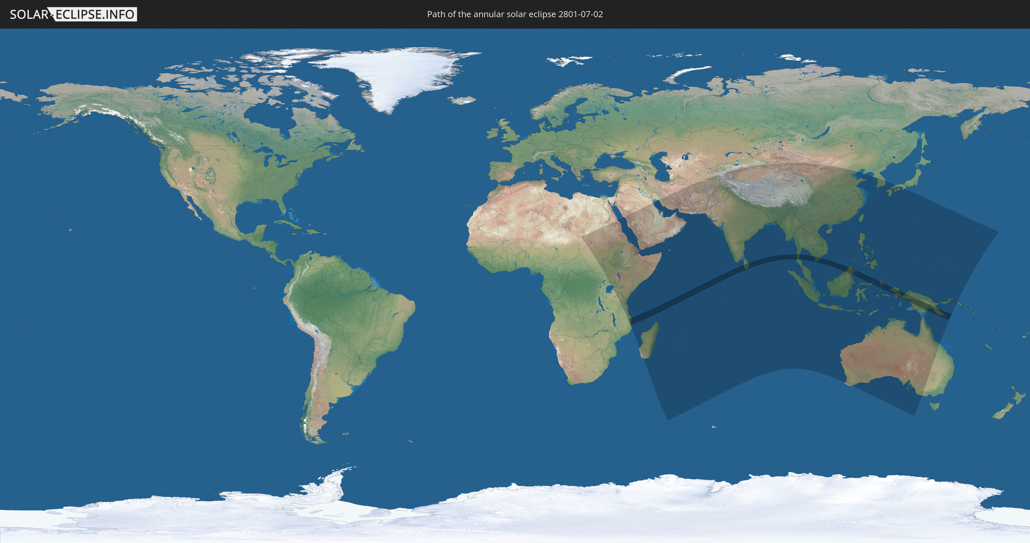
Die Sonnenfinsternis am 07/02/2801 kann man in 68 Ländern als partielle Sonnenfinsternis beobachten.
Der Finsternispfad verläuft durch 14 Länder. Nur in diesen Ländern ist sie als annular Sonnenfinsternis zu sehen.
In den folgenden Ländern ist die Sonnenfinsternis annular zu sehen
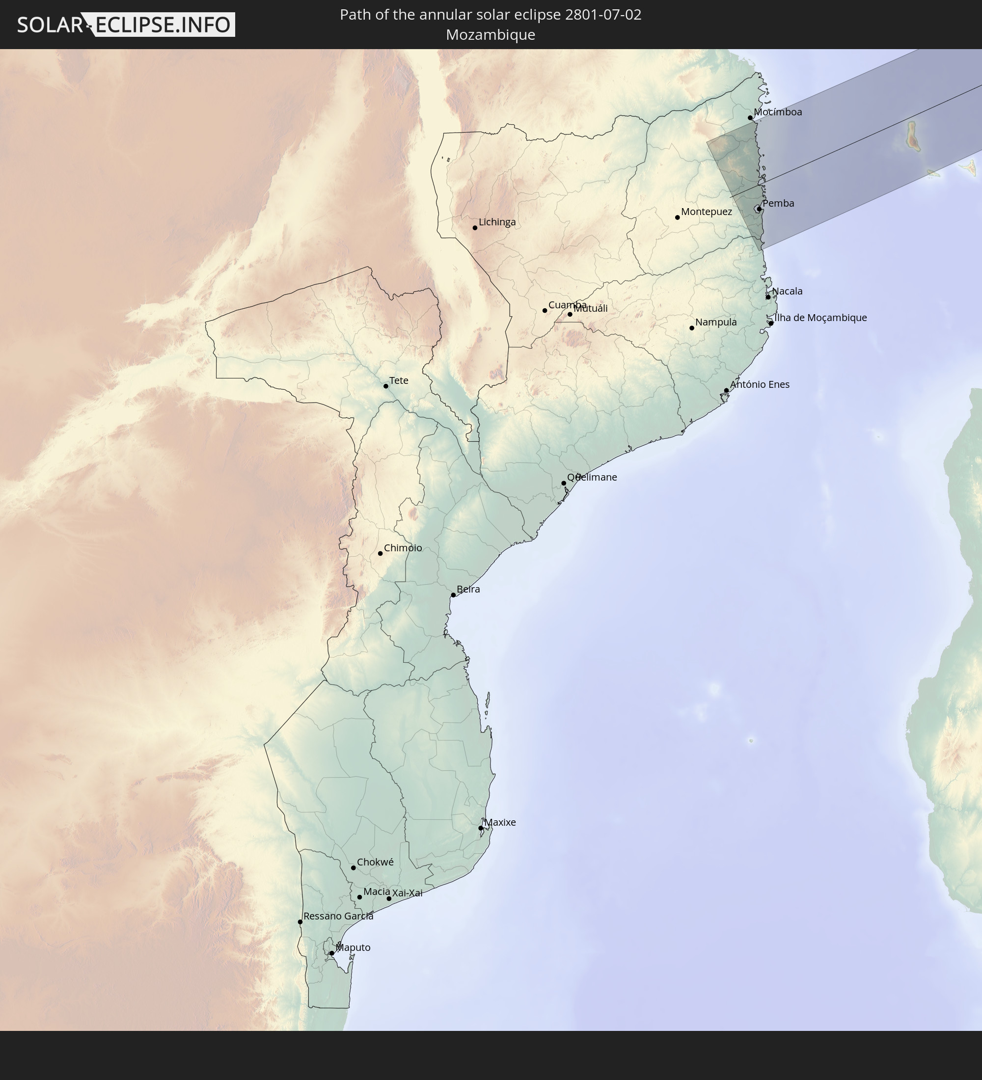 Mozambique
 Comoros
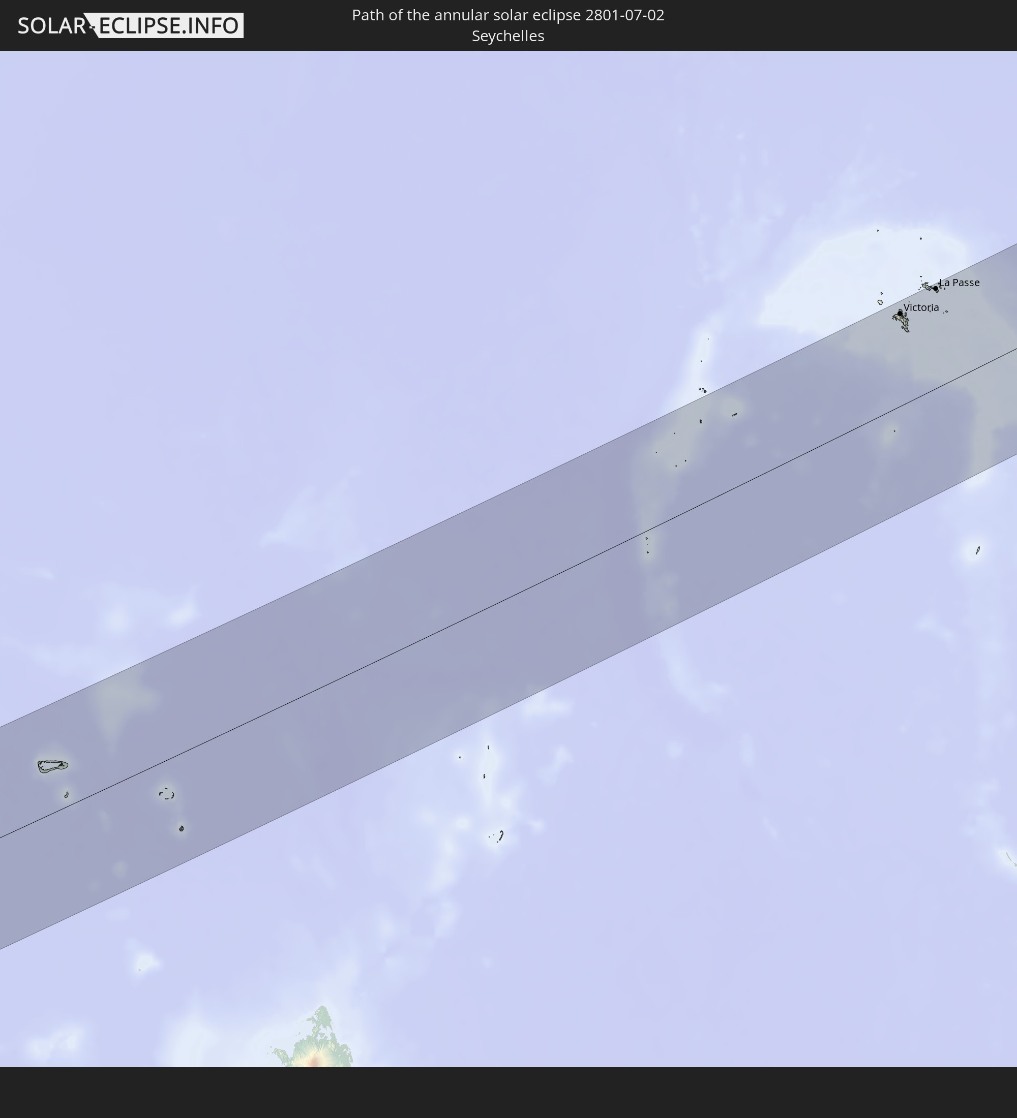 Seychelles
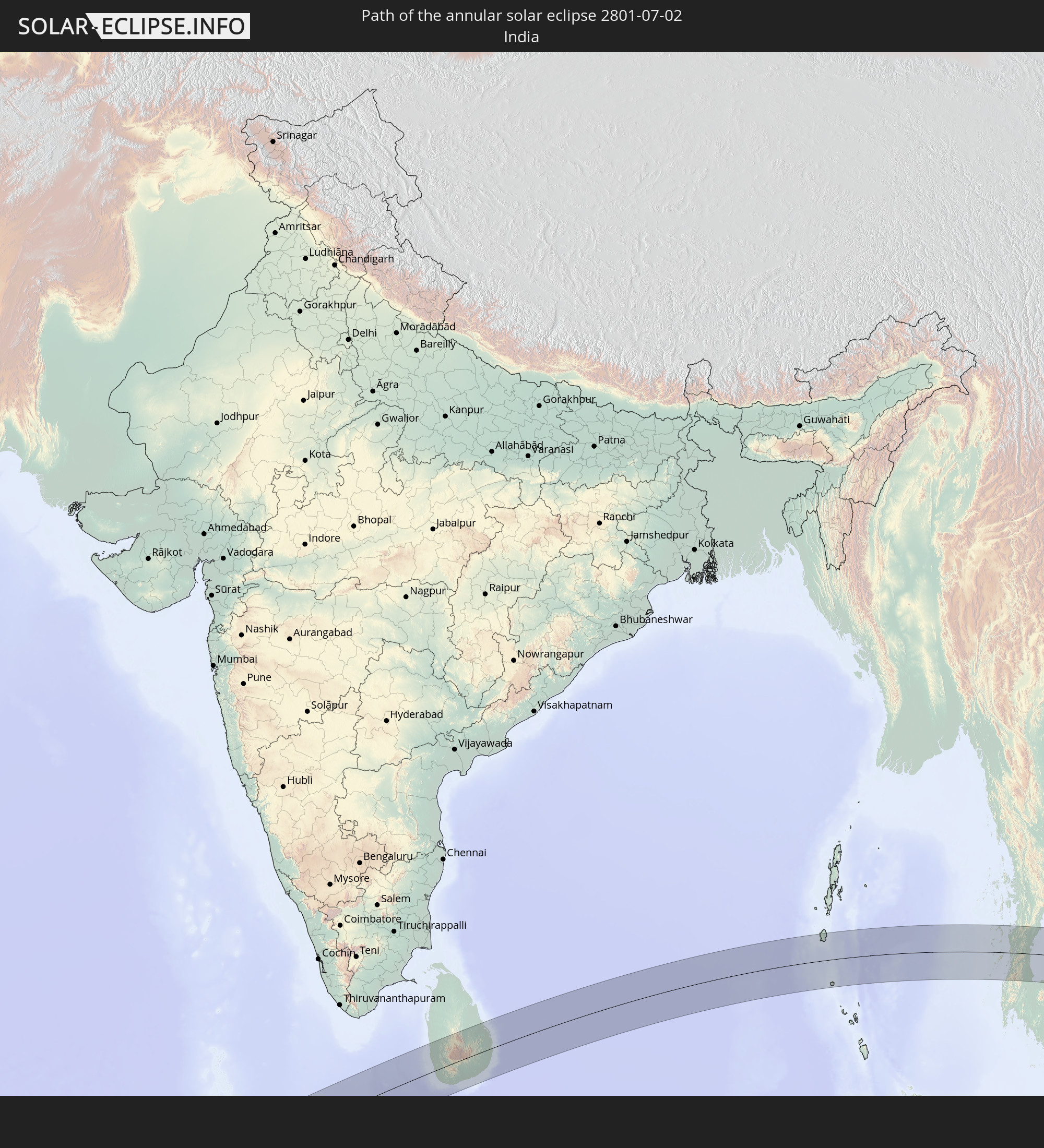 India
India
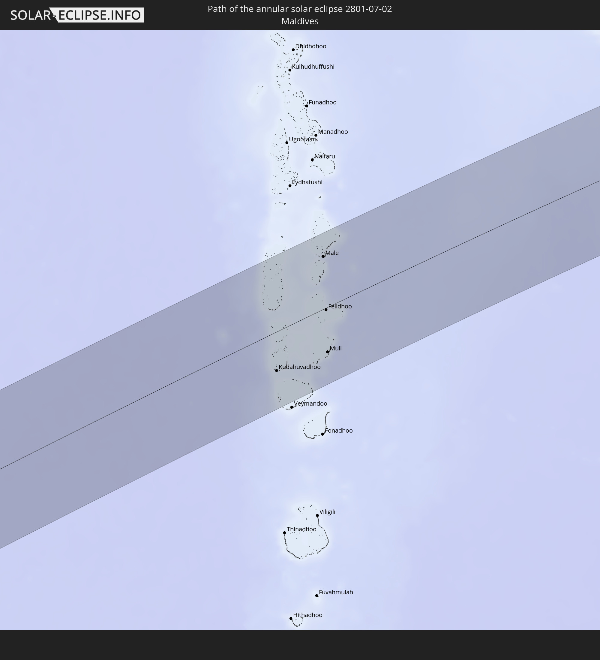 Maldives
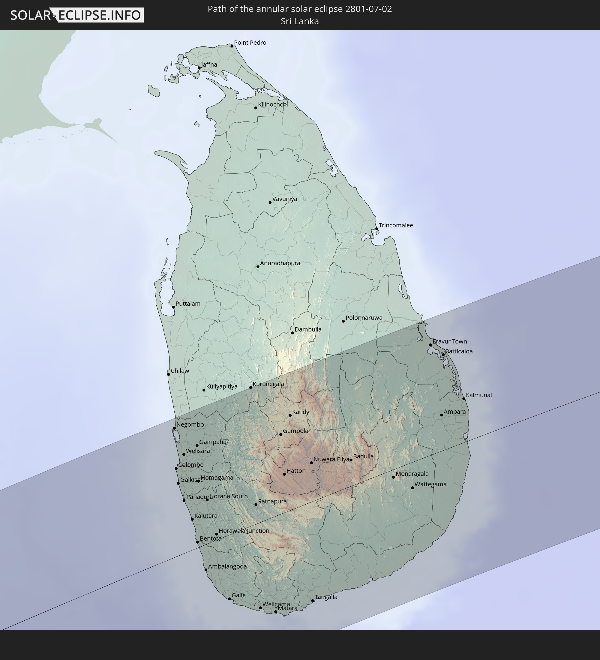 Sri Lanka
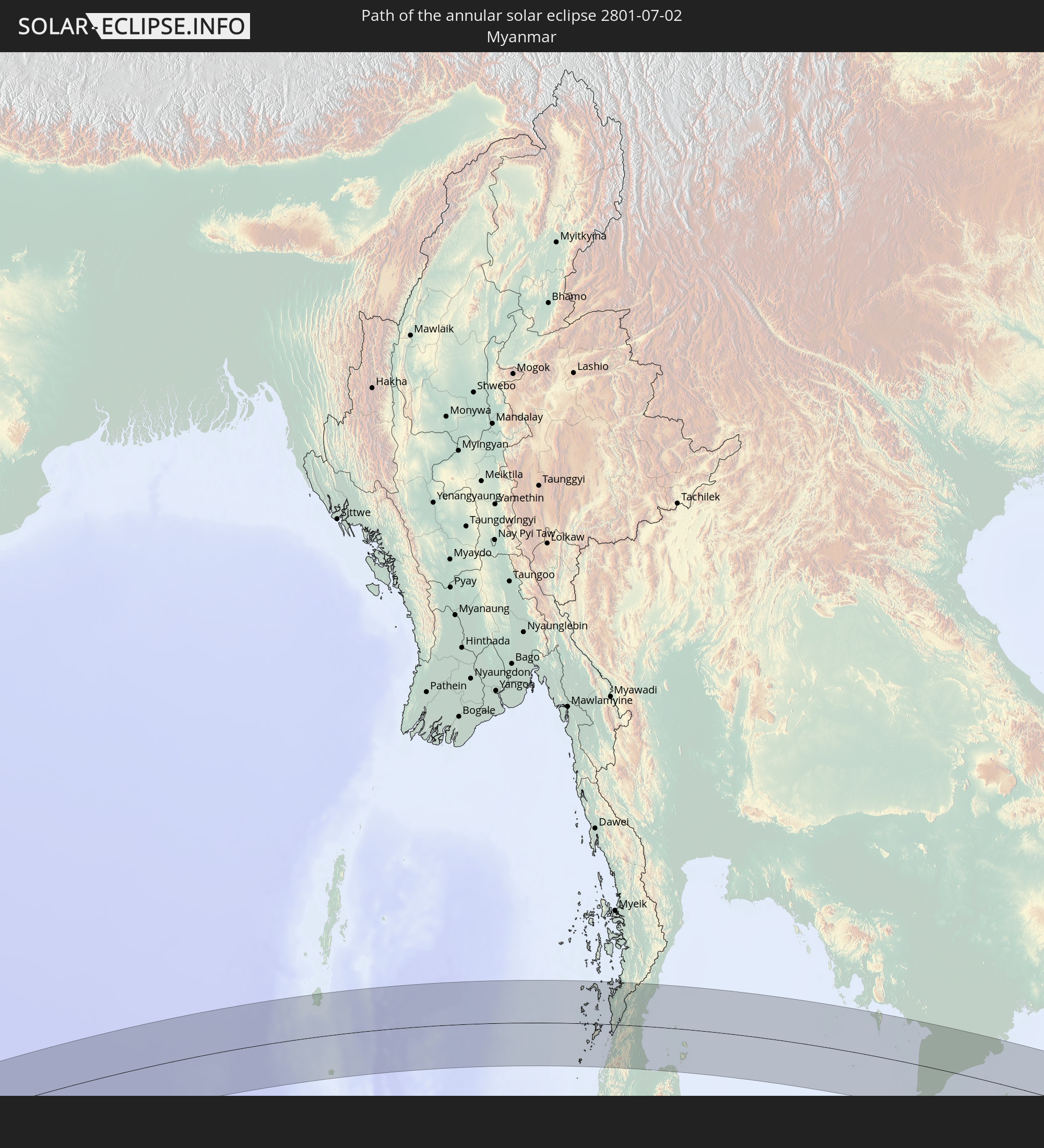 Myanmar
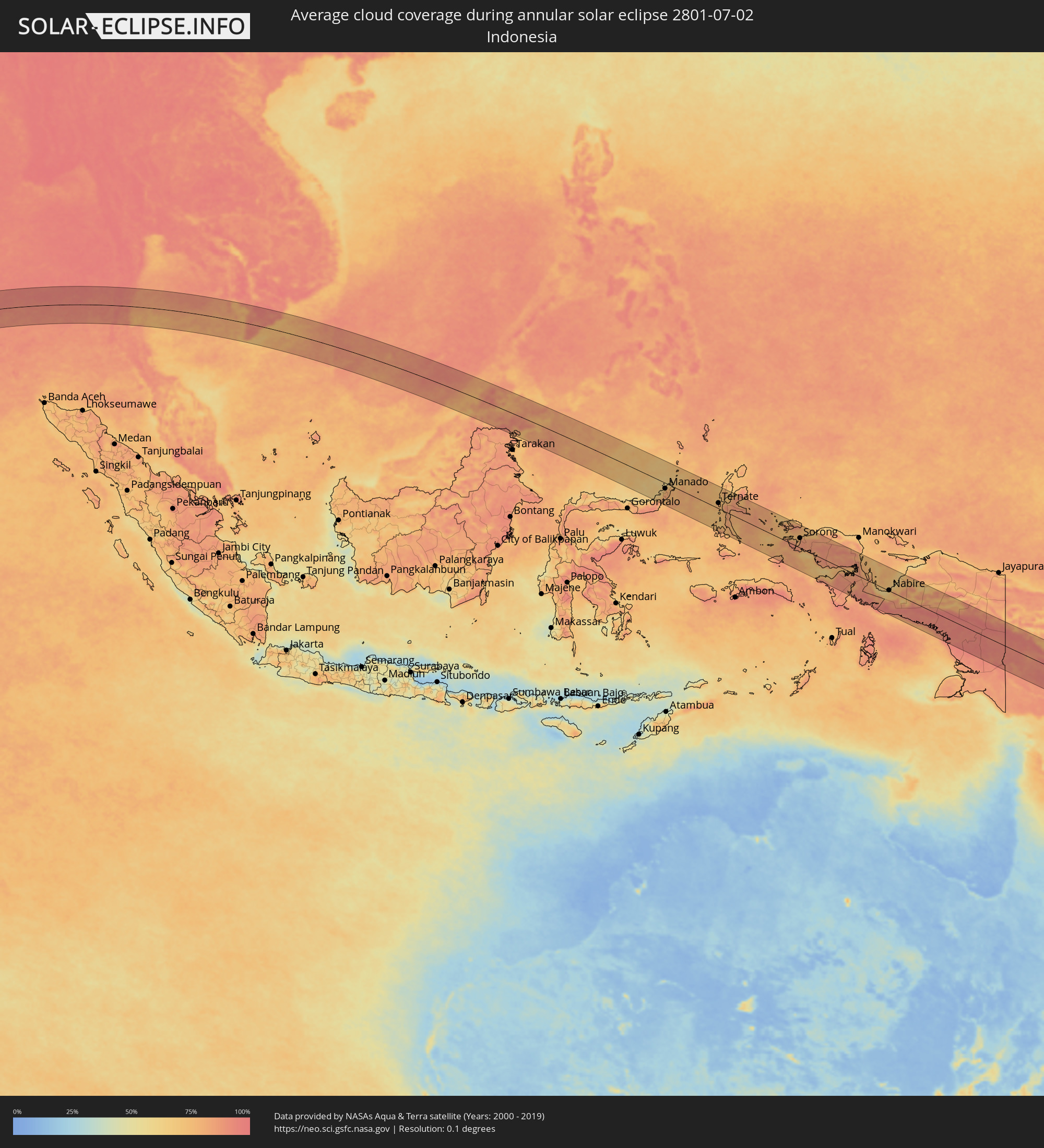
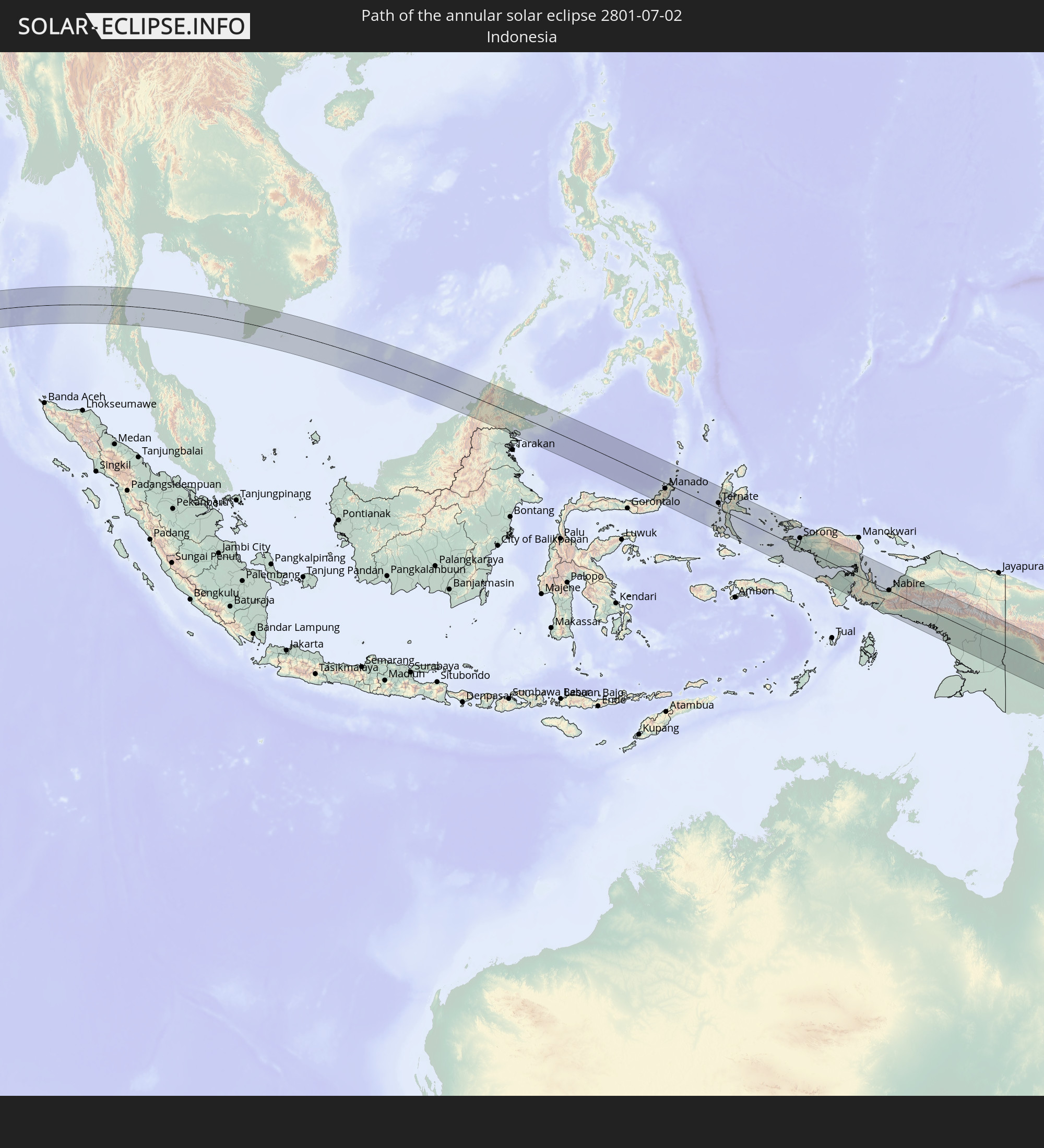 Indonesia
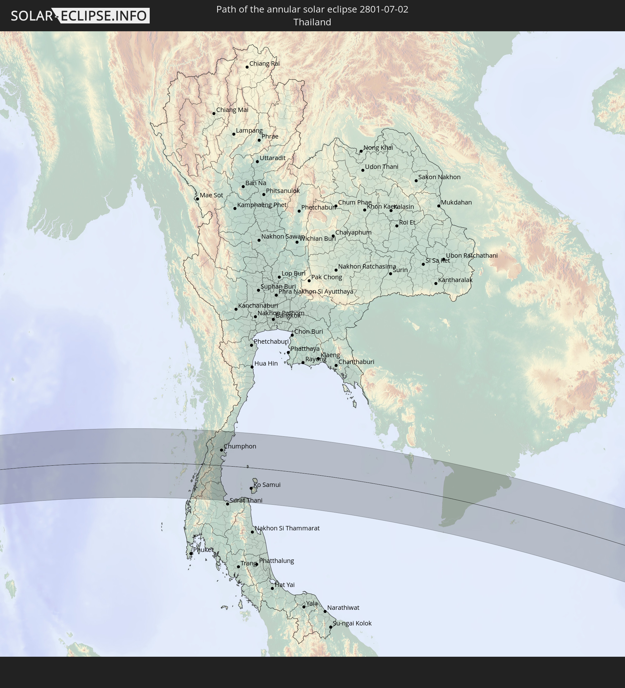 Thailand
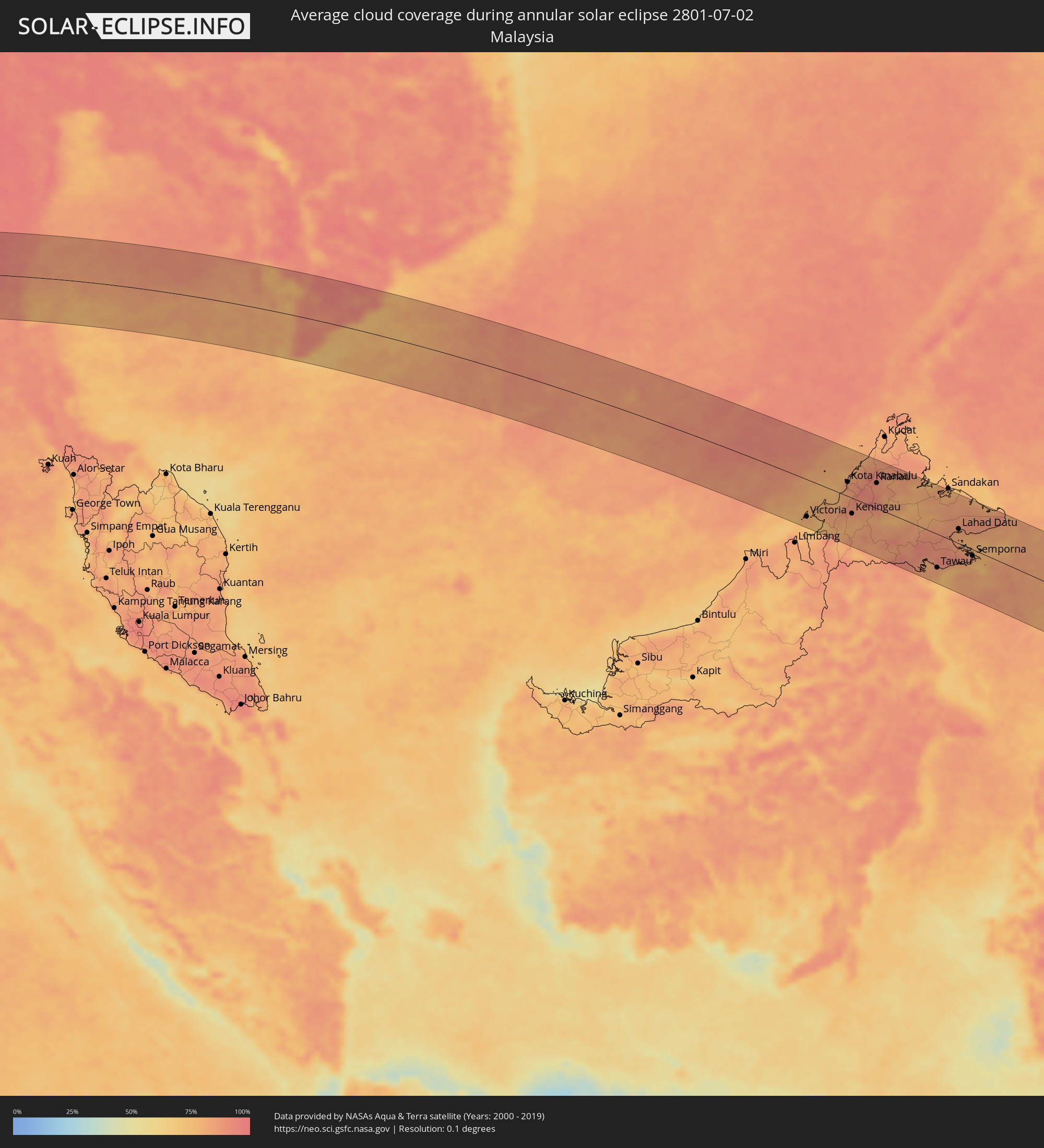
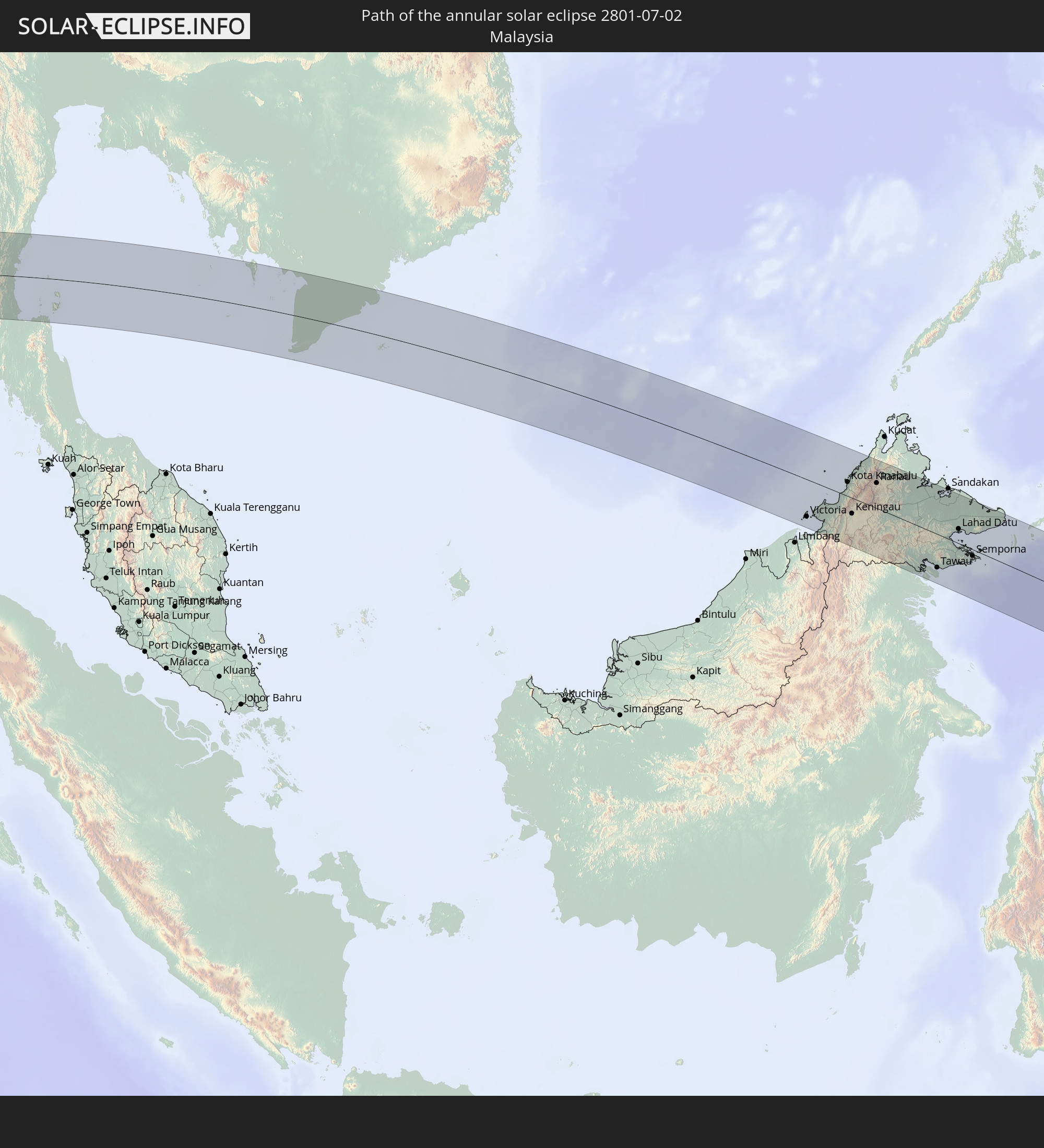 Malaysia
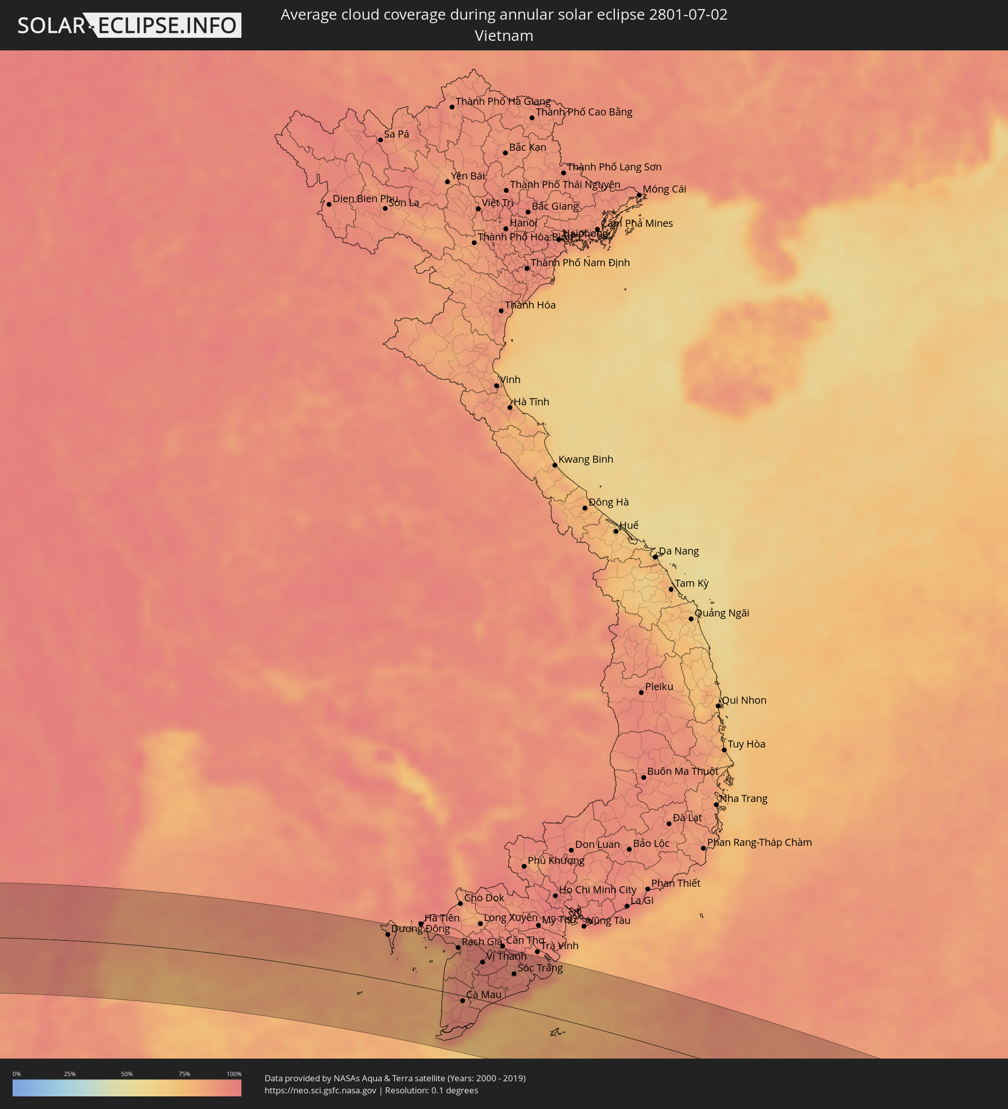
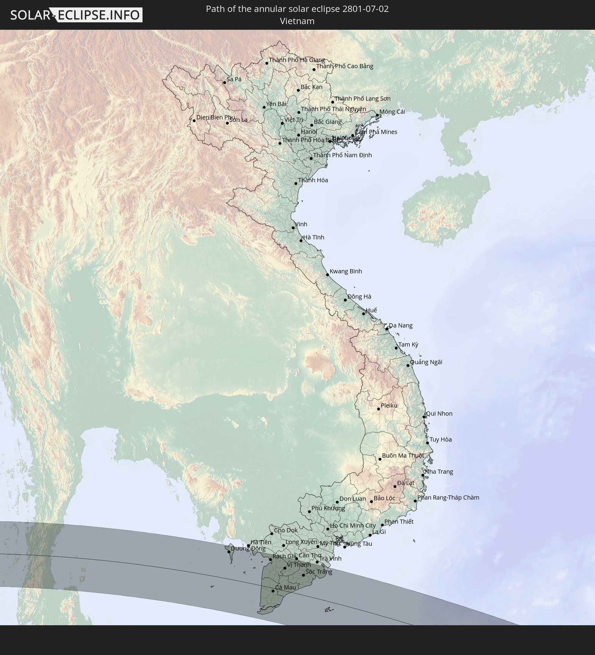 Vietnam
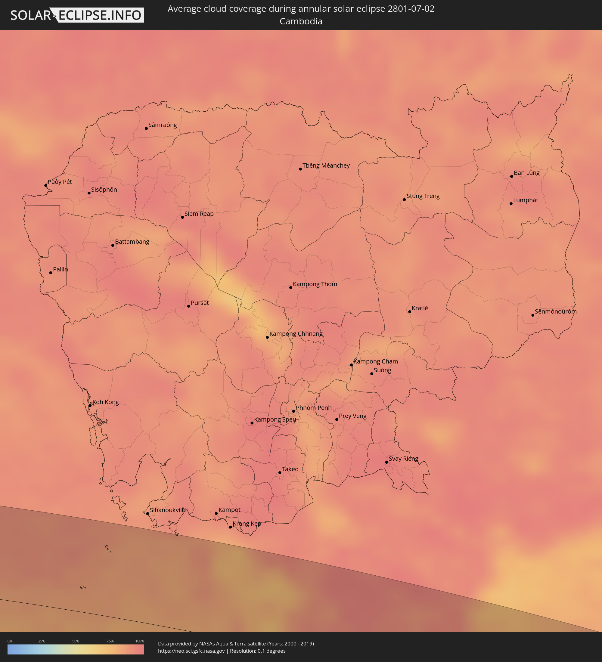
 Cambodia
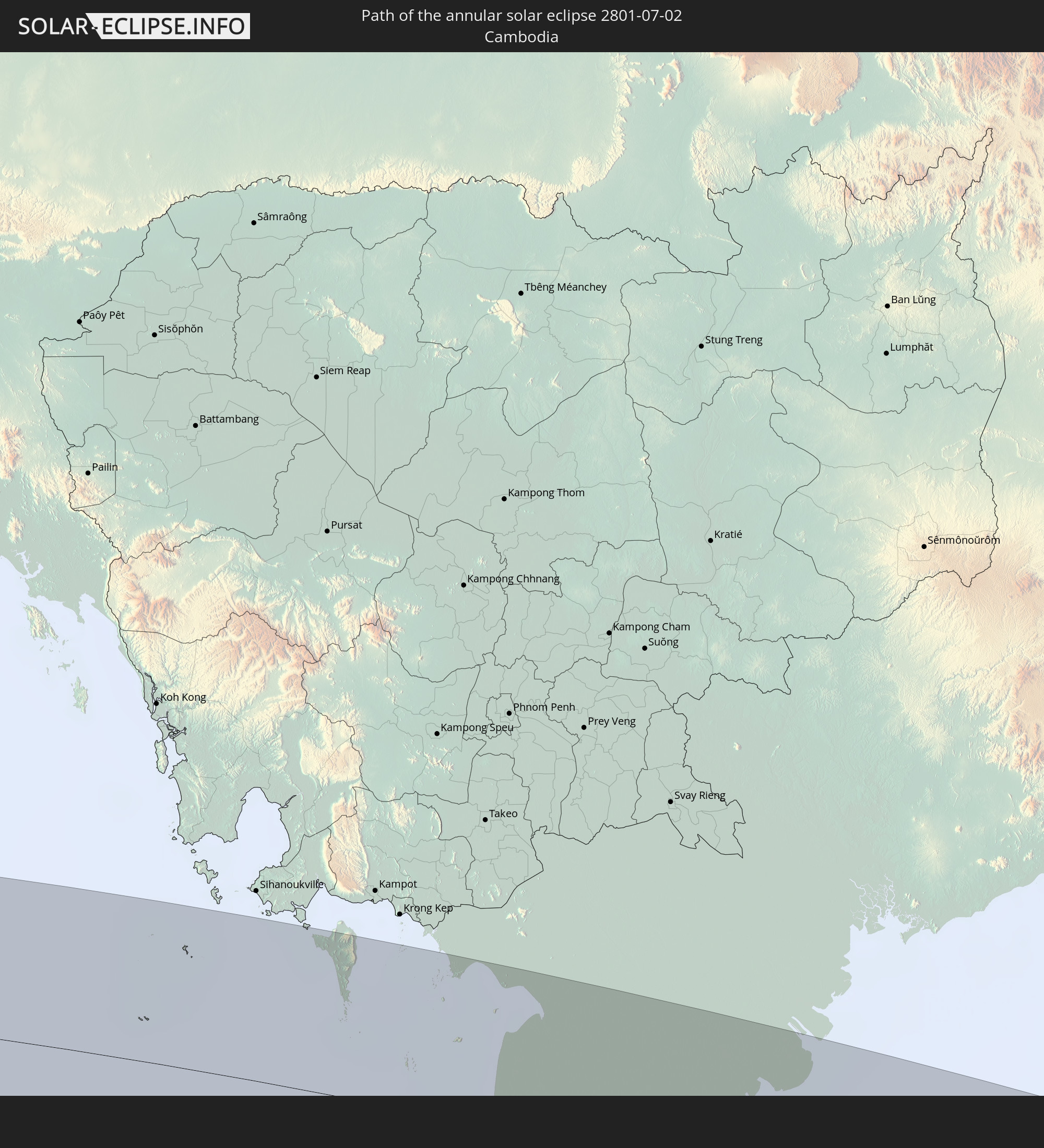
 Philippines
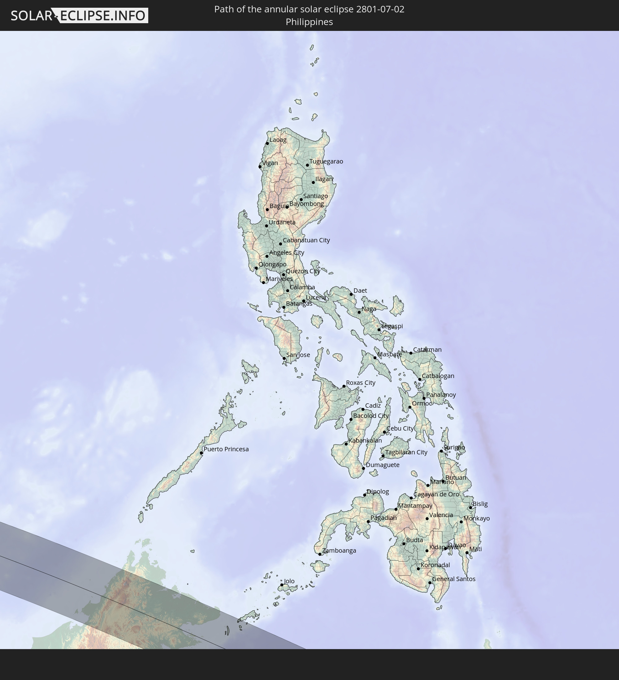
 Papua New Guinea
In den folgenden Ländern ist die Sonnenfinsternis partiell zu sehen
 United States Minor Outlying Islands
 Chad
Chad
 Sudan
Sudan
 Egypt
Egypt
 Tanzania
 Uganda
 Mozambique
 Ethiopia
 Kenya
Kenya
 Saudi Arabia
 Eritrea
 French Southern and Antarctic Lands
 Somalia
 Djibouti
 Yemen
Yemen
 Madagascar
 Comoros
 Iran
Iran
 Mayotte
 Seychelles
 Kuwait
 Bahrain
 Qatar
Qatar
 United Arab Emirates
 Oman
Oman
 Turkmenistan
 Réunion
 Uzbekistan
 Mauritius
 Afghanistan
 Pakistan
 Tajikistan
 India
India
 Kyrgyzstan
 British Indian Ocean Territory
 Maldives
 China
China
 Sri Lanka
 Nepal
Nepal
 Mongolia
 Bangladesh
 Bhutan
 Myanmar
 Indonesia
 Cocos Islands
 Thailand
 Malaysia
 Laos
Laos
 Vietnam
 Cambodia
 Singapore
 Christmas Island
 Australia
 Macau
Macau
 Hong Kong
 Brunei
 Taiwan
 Philippines
 Japan
Japan
 East Timor
 North Korea
 South Korea
 Palau
Palau
 Federated States of Micronesia
 Papua New Guinea
 Guam
Guam
 Northern Mariana Islands
 Marshall Islands
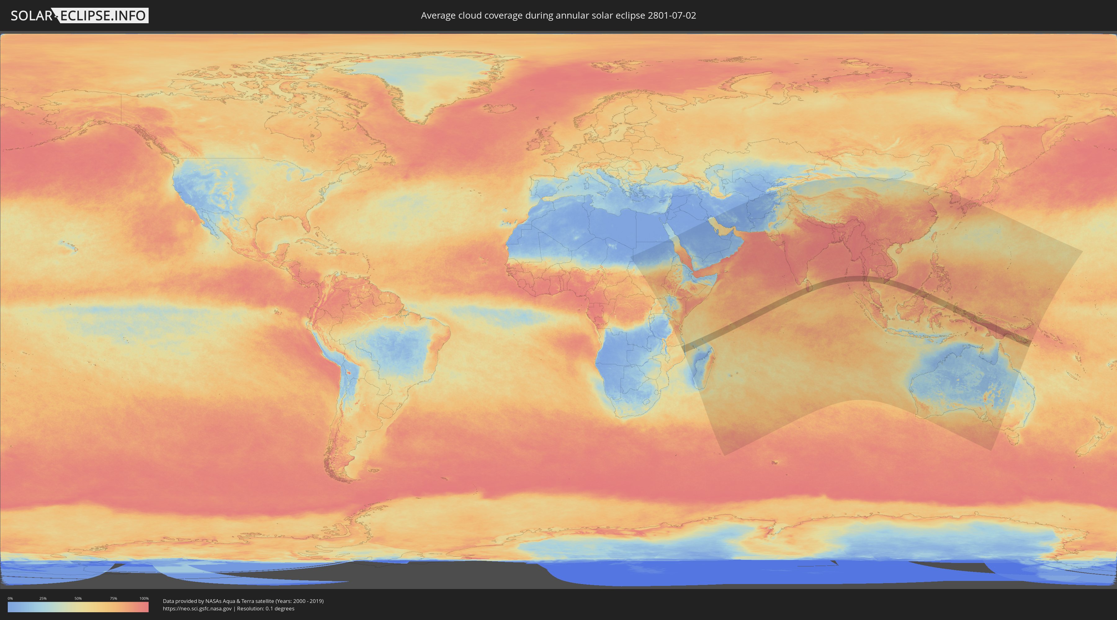
How will be the weather during the annular solar eclipse on 07/02/2801?
Where is the best place to see the annular solar eclipse of 07/02/2801?
The following maps show the average cloud coverage for the day of the annular solar eclipse.
With the help of these maps, it is possible to find the place along the eclipse path, which has the best
chance of a cloudless sky.
Nevertheless, you should consider local circumstances and inform about the weather of your chosen
observation site.
The data is provided by NASAs satellites
AQUA and TERRA.
The cloud maps are averaged over a period of 19 years (2000 - 2019).
Detailed country maps
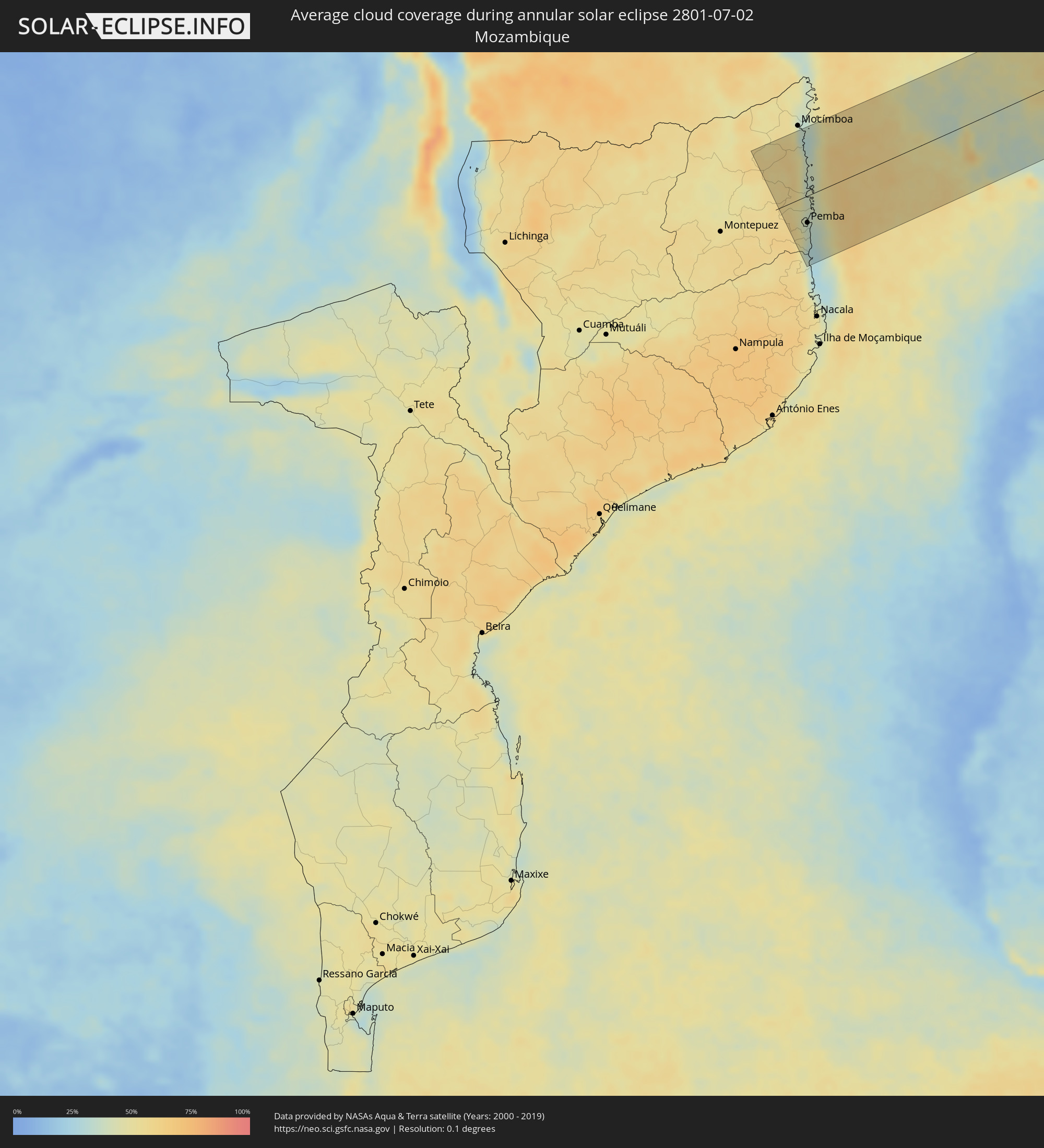 Mozambique
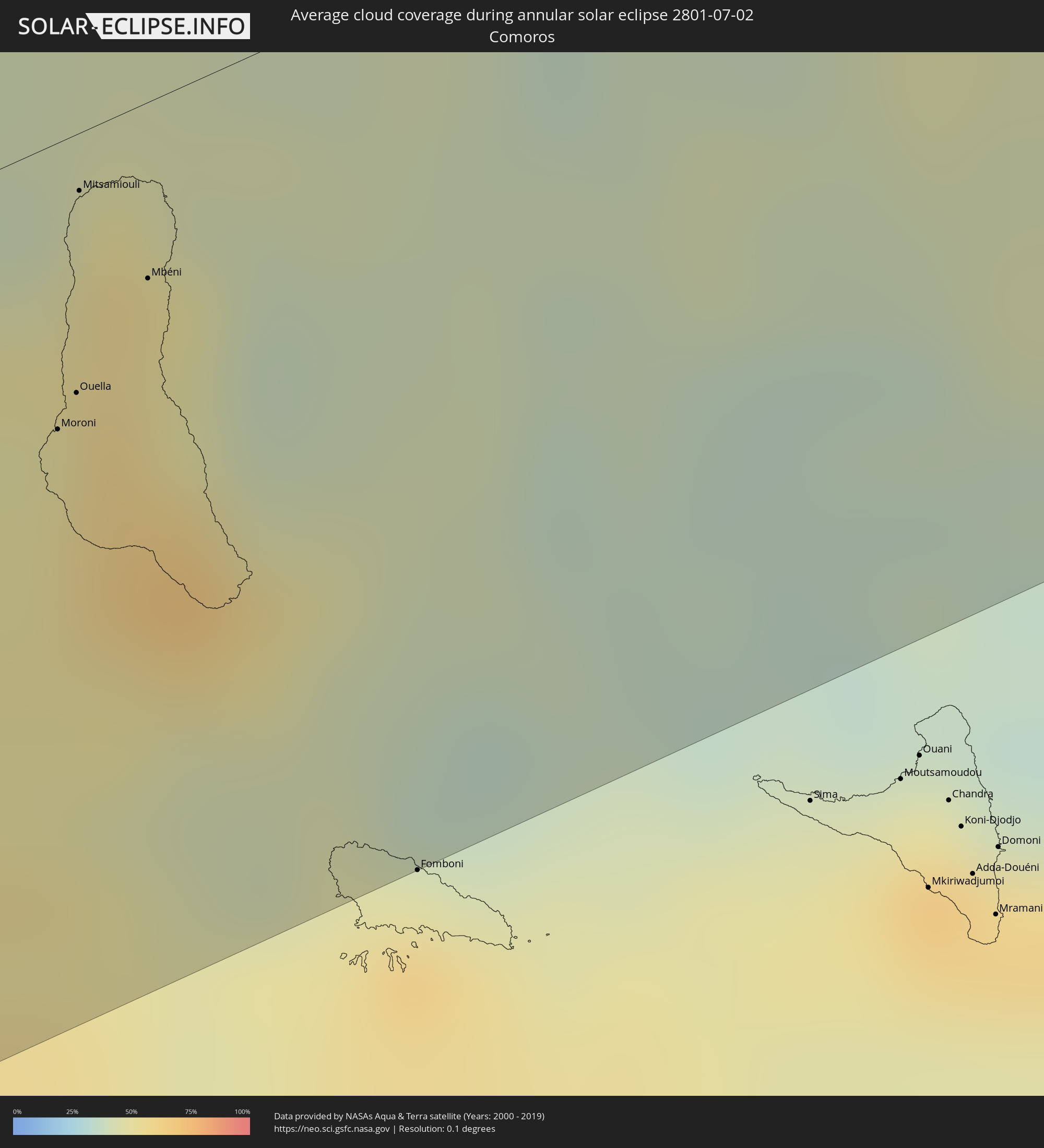 Comoros
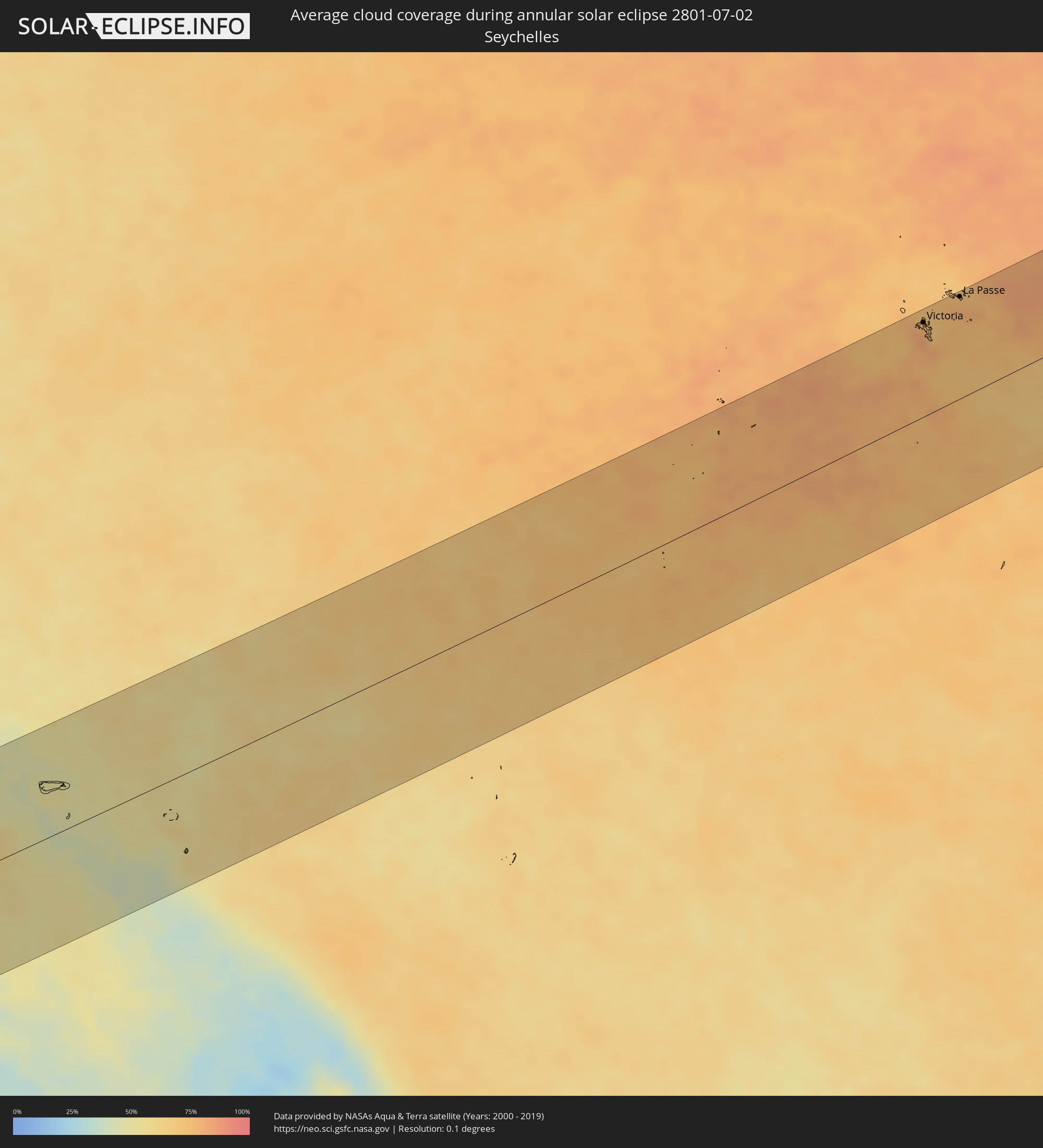 Seychelles
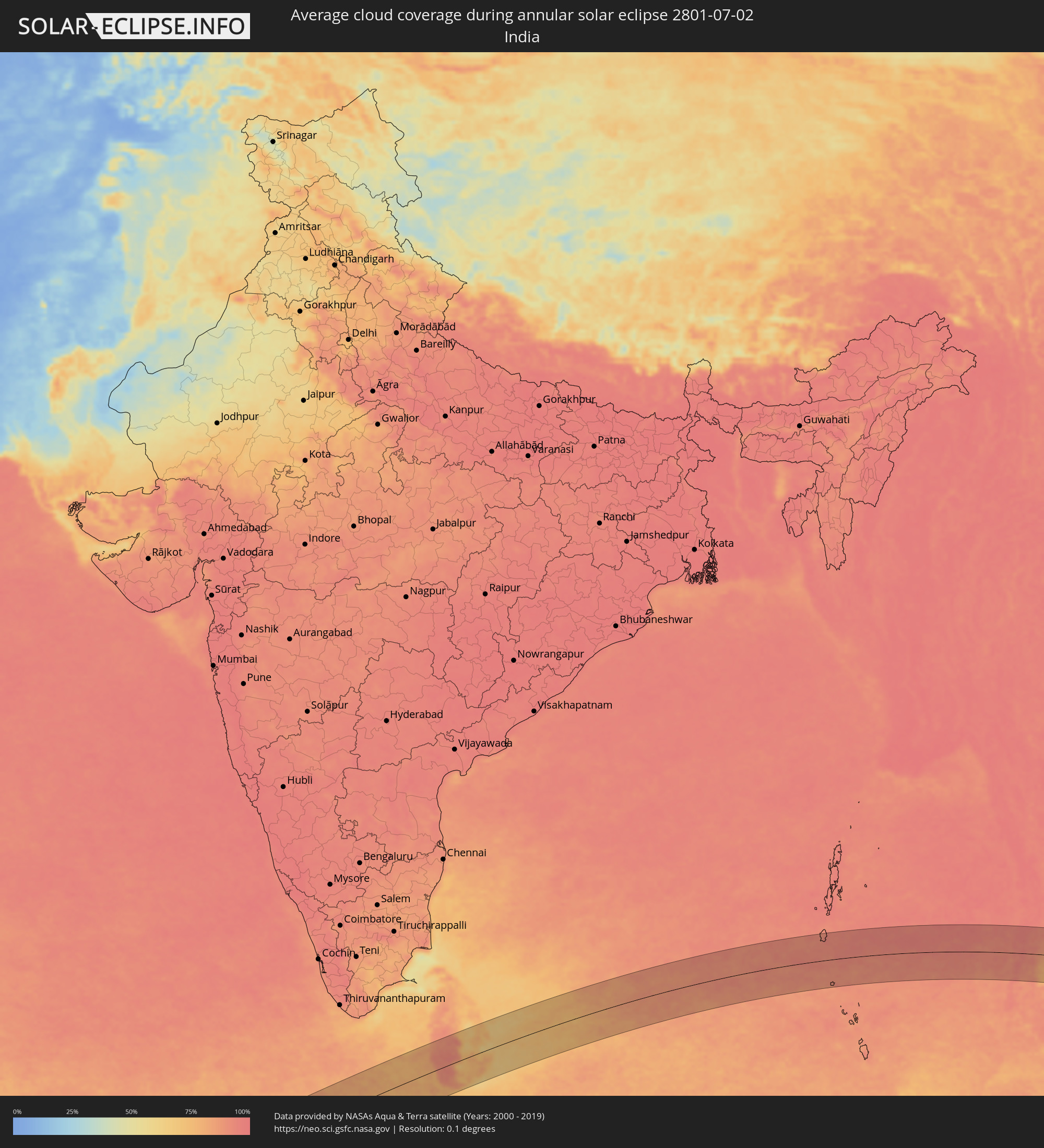 India
India
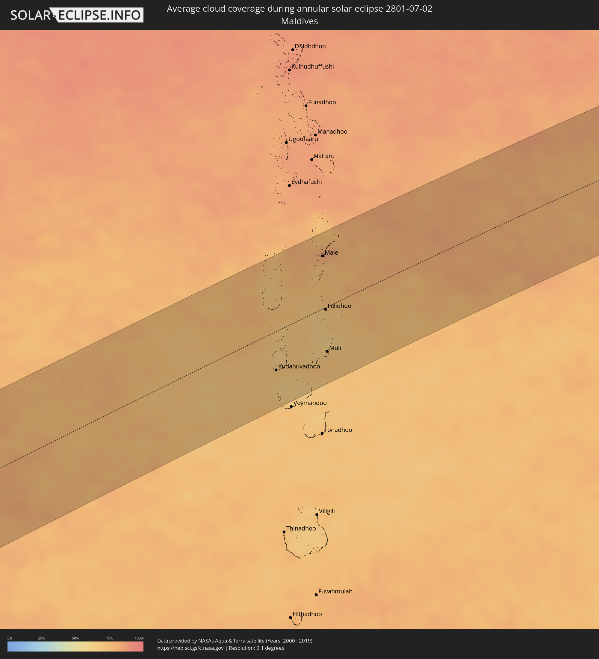 Maldives
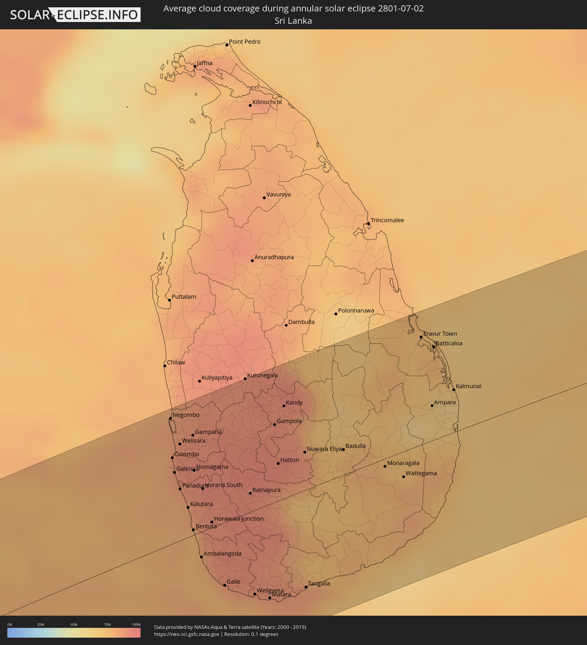 Sri Lanka
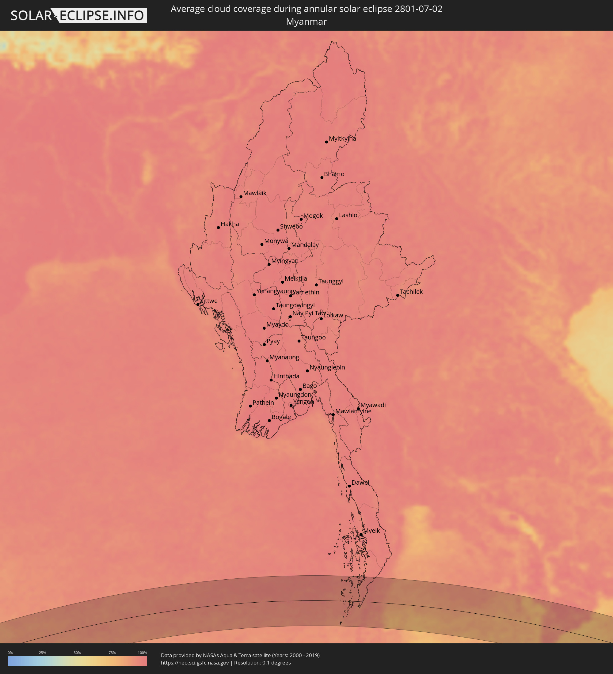 Myanmar
 Indonesia
 Thailand
 Malaysia
 Vietnam
 Cambodia
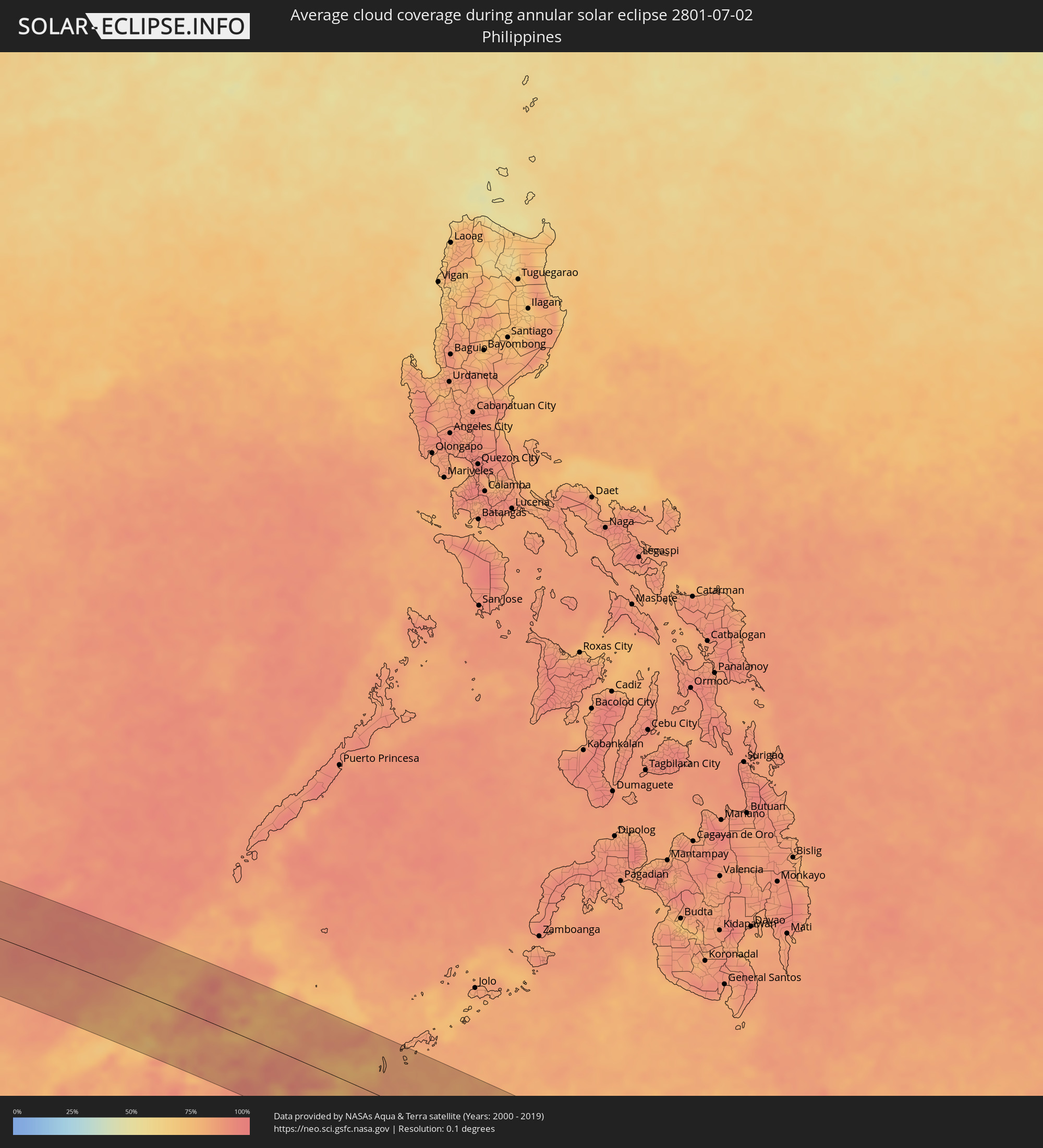 Philippines
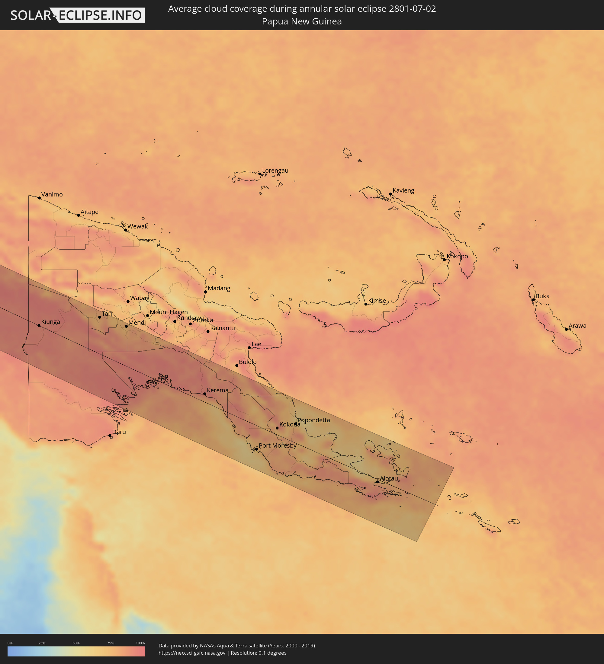 Papua New Guinea
Cities inside the path of the eclipse
The following table shows all locations with a population of more than 5,000 inside the eclipse path. Cities which have more than 100,000 inhabitants are marked bold. A click at the locations opens a detailed map.
| City | Type | Eclipse duration | Local time of max. eclipse | Distance to central line | Ø Cloud coverage |
|
Pemba, Cabo Delgado
|
annular | - | 05:48:05 UTC+02:00 | 47 km | 40% |
|
Moroni, Grande Comore
|
annular | - | 06:48:18 UTC+03:00 | 39 km | 60% |
|
Ouella, Grande Comore
|
annular | - | 06:48:18 UTC+03:00 | 35 km | 60% |
|
Mitsamiouli, Grande Comore
|
annular | - | 06:48:18 UTC+03:00 | 8 km | 56% |
|
Mbéni, Grande Comore
|
annular | - | 06:48:19 UTC+03:00 | 24 km | 48% |
|
Port Glaud, Port Glaud
|
annular | - | 07:54:28 UTC+04:00 | 95 km | 78% |
|
Bel Ombre, Bel Ombre
|
annular | - | 07:54:29 UTC+04:00 | 100 km | 83% |
|
Beau Vallon, Beau Vallon
|
annular | - | 07:54:30 UTC+04:00 | 99 km | 83% |
|
Victoria, English River
|
annular | - | 07:54:31 UTC+04:00 | 98 km | 74% |
|
Anse Boileau, Anse Boileau
|
annular | - | 07:54:30 UTC+04:00 | 86 km | 80% |
|
Takamaka, Takamaka
|
annular | - | 07:54:30 UTC+04:00 | 81 km | 77% |
|
Cascade, Cascade
|
annular | - | 07:54:32 UTC+04:00 | 91 km | 80% |
|
Anse Royale, Anse Royale
|
annular | - | 07:54:31 UTC+04:00 | 83 km | 80% |
|
La Passe, Inner Islands
|
annular | - | 07:54:53 UTC+04:00 | 106 km | 78% |
|
Kudahuvadhoo, Dhaalu Atholhu
|
annular | - | 09:22:01 UTC+05:00 | 52 km | 72% |
|
Male, Kaafu Atoll
|
annular | - | 09:24:35 UTC+05:00 | 69 km | 78% |
|
Felidhoo, Vaavu Atholhu
|
annular | - | 09:24:03 UTC+05:00 | 3 km | 67% |
|
Muli, Meemu Atholhu
|
annular | - | 09:23:38 UTC+05:00 | 60 km | 71% |
|
Negombo, Western
|
annular | - | 10:13:07 UTC+05:30 | 91 km | 83% |
|
Colombo, Western
|
annular | - | 10:12:53 UTC+05:30 | 62 km | 81% |
|
Moratuwa, Western
|
annular | - | 10:12:50 UTC+05:30 | 44 km | 83% |
|
Ja Ela, Western
|
annular | - | 10:13:09 UTC+05:30 | 75 km | 87% |
|
Kelaniya, Western
|
annular | - | 10:13:07 UTC+05:30 | 61 km | 88% |
|
Kalutara, Western
|
annular | - | 10:12:53 UTC+05:30 | 21 km | 82% |
|
Bentota, Southern
|
annular | - | 10:12:51 UTC+05:30 | 4 km | 77% |
|
Homagama, Western
|
annular | - | 10:13:15 UTC+05:30 | 46 km | 89% |
|
Galle, Southern
|
annular | - | 10:13:08 UTC+05:30 | 46 km | 76% |
|
Kurunegala, North Western
|
annular | - | 10:14:53 UTC+05:30 | 98 km | 90% |
|
Ratnapura, Sabaragamuwa
|
annular | - | 10:14:15 UTC+05:30 | 13 km | 91% |
|
Matara, Southern
|
annular | - | 10:13:59 UTC+05:30 | 68 km | 78% |
|
Gampola, Central
|
annular | - | 10:15:11 UTC+05:30 | 56 km | 91% |
|
Kandy, Central
|
annular | - | 10:15:30 UTC+05:30 | 67 km | 90% |
|
Nuwara Eliya, Central
|
annular | - | 10:15:38 UTC+05:30 | 27 km | 86% |
|
Badulla, Uva
|
annular | - | 10:16:28 UTC+05:30 | 18 km | 78% |
|
Eravur Town, Eastern Province
|
annular | - | 10:18:51 UTC+05:30 | 78 km | 74% |
|
Batticaloa, Eastern Province
|
annular | - | 10:19:03 UTC+05:30 | 68 km | 76% |
|
Kalmunai, Eastern Province
|
annular | - | 10:19:13 UTC+05:30 | 31 km | 62% |
|
Ranong, Ranong
|
annular | - | 12:55:06 UTC+07:00 | 20 km | 93% |
|
Ban Nam Yuen, Chumphon
|
annular | - | 12:56:04 UTC+07:00 | 29 km | 90% |
|
Lang Suan, Chumphon
|
annular | - | 12:56:56 UTC+07:00 | 20 km | 90% |
|
Chumphon, Chumphon
|
annular | - | 12:57:16 UTC+07:00 | 42 km | 93% |
|
Chaiya, Surat Thani
|
annular | - | 12:57:30 UTC+07:00 | 81 km | 91% |
|
Don Sak, Surat Thani
|
annular | - | 12:59:33 UTC+07:00 | 85 km | 87% |
|
Ko Samui, Surat Thani
|
annular | - | 13:00:30 UTC+07:00 | 58 km | 78% |
|
Ko Pha Ngan, Nakhon Si Thammarat
|
annular | - | 13:00:50 UTC+07:00 | 33 km | 79% |
|
Dương Đông, Kiến Giang
|
annular | - | 13:16:01 UTC+07:00 | 78 km | 85% |
|
Rạch Giá, Kiến Giang
|
annular | - | 13:20:15 UTC+07:00 | 80 km | 88% |
|
Cà Mau, Cà Mau
|
annular | - | 13:20:58 UTC+07:00 | 9 km | 92% |
|
Vị Thanh, Hau Giang
|
annular | - | 13:21:47 UTC+07:00 | 65 km | 95% |
|
Thành phố Bạc Liêu, Bạc Liêu
|
annular | - | 13:22:59 UTC+07:00 | 18 km | 92% |
|
Sóc Trăng, Sóc Trăng
|
annular | - | 13:23:41 UTC+07:00 | 57 km | 94% |
|
Victoria, Labuan
|
annular | - | 14:55:13 UTC+08:00 | 78 km | 78% |
|
Bandar Labuan, Sabah
|
annular | - | 14:55:16 UTC+08:00 | 75 km | 79% |
|
Beaufort, Sabah
|
annular | - | 14:56:25 UTC+08:00 | 49 km | 81% |
|
Papar, Sabah
|
annular | - | 14:56:35 UTC+08:00 | 1 km | 77% |
|
Kinarut, Sabah
|
annular | - | 14:56:48 UTC+08:00 | 13 km | 81% |
|
Putatan, Sabah
|
annular | - | 14:56:45 UTC+08:00 | 24 km | 85% |
|
Kota Kinabalu, Sabah
|
annular | - | 14:56:44 UTC+08:00 | 29 km | 87% |
|
Donggongon, Sabah
|
annular | - | 14:56:52 UTC+08:00 | 23 km | 85% |
|
Keningau, Sabah
|
annular | - | 14:57:27 UTC+08:00 | 33 km | 81% |
|
Kota Belud, Sabah
|
annular | - | 14:57:19 UTC+08:00 | 83 km | 83% |
|
Ranau, Sabah
|
annular | - | 14:58:11 UTC+08:00 | 52 km | 87% |
|
Tawau, Sabah
|
annular | - | 15:02:19 UTC+08:00 | 69 km | 81% |
|
Lahad Datu, Sabah
|
annular | - | 15:02:42 UTC+08:00 | 30 km | 81% |
|
Semporna, Sabah
|
annular | - | 07:03:44 UTC+00:00 | 13 km | 82% |
|
Sitangkai, Autonomous Region in Muslim Mindanao
|
annular | - | 15:05:16 UTC+08:00 | 40 km | 81% |
|
Bongao, Autonomous Region in Muslim Mindanao
|
annular | - | 15:05:46 UTC+08:00 | 95 km | 81% |
|
Sanga-Sanga, Autonomous Region in Muslim Mindanao
|
annular | - | 15:05:46 UTC+08:00 | 100 km | 81% |
|
Tampakan, Autonomous Region in Muslim Mindanao
|
annular | - | 15:05:54 UTC+08:00 | 85 km | 81% |
|
Tomohon, North Sulawesi
|
annular | - | 15:17:24 UTC+08:00 | 45 km | 76% |
|
Manado, North Sulawesi
|
annular | - | 15:17:22 UTC+08:00 | 27 km | 70% |
|
Tondano, North Sulawesi
|
annular | - | 15:17:34 UTC+08:00 | 41 km | 79% |
|
Laikit, Laikit II (Dimembe), North Sulawesi
|
annular | - | 15:17:33 UTC+08:00 | 20 km | 77% |
|
Bitung, North Sulawesi
|
annular | - | 15:17:54 UTC+08:00 | 13 km | 75% |
|
Ternate, North Maluku
|
annular | - | 16:21:28 UTC+09:00 | 26 km | 75% |
|
Sofifi, North Maluku
|
annular | - | 16:21:44 UTC+09:00 | 29 km | 81% |
|
Sorong, West Papua
|
annular | - | 16:27:00 UTC+09:00 | 46 km | 86% |
|
Nabire, Papua
|
annular | - | 16:31:54 UTC+09:00 | 2 km | 69% |
|
Kiunga, Western Province
|
annular | - | 17:36:13 UTC+10:00 | 0 km | 91% |
|
Tari, Hela
|
annular | - | 17:36:52 UTC+10:00 | 99 km | 77% |
|
Mendi, Southern Highlands
|
annular | - | 17:37:11 UTC+10:00 | 108 km | 77% |
|
Ialibu, Southern Highlands
|
annular | - | 17:37:20 UTC+10:00 | 110 km | 82% |
|
Kerema, Gulf
|
annular | - | 17:38:05 UTC+10:00 | 22 km | 77% |
|
Port Moresby, National Capital
|
annular | - | 17:38:30 UTC+10:00 | 65 km | 70% |
|
Kokoda, Northern Province
|
annular | - | 17:38:35 UTC+10:00 | 18 km | 77% |
|
Popondetta, Northern Province
|
annular | - | 17:38:40 UTC+10:00 | 51 km | 81% |
|
Alotau, Milne Bay
|
annular | - | 17:38:57 UTC+10:00 | 7 km | 88% |