Total solar eclipse of 02/08/2855
| Day of week: | Monday |
| Maximum duration of eclipse: | 04m00s |
| Maximum width of eclipse path: | 191 km |
| Saros cycle: | 154 |
| Coverage: | 100% |
| Magnitude: | 1.0448 |
| Gamma: | 0.6288 |
Wo kann man die Sonnenfinsternis vom 02/08/2855 sehen?
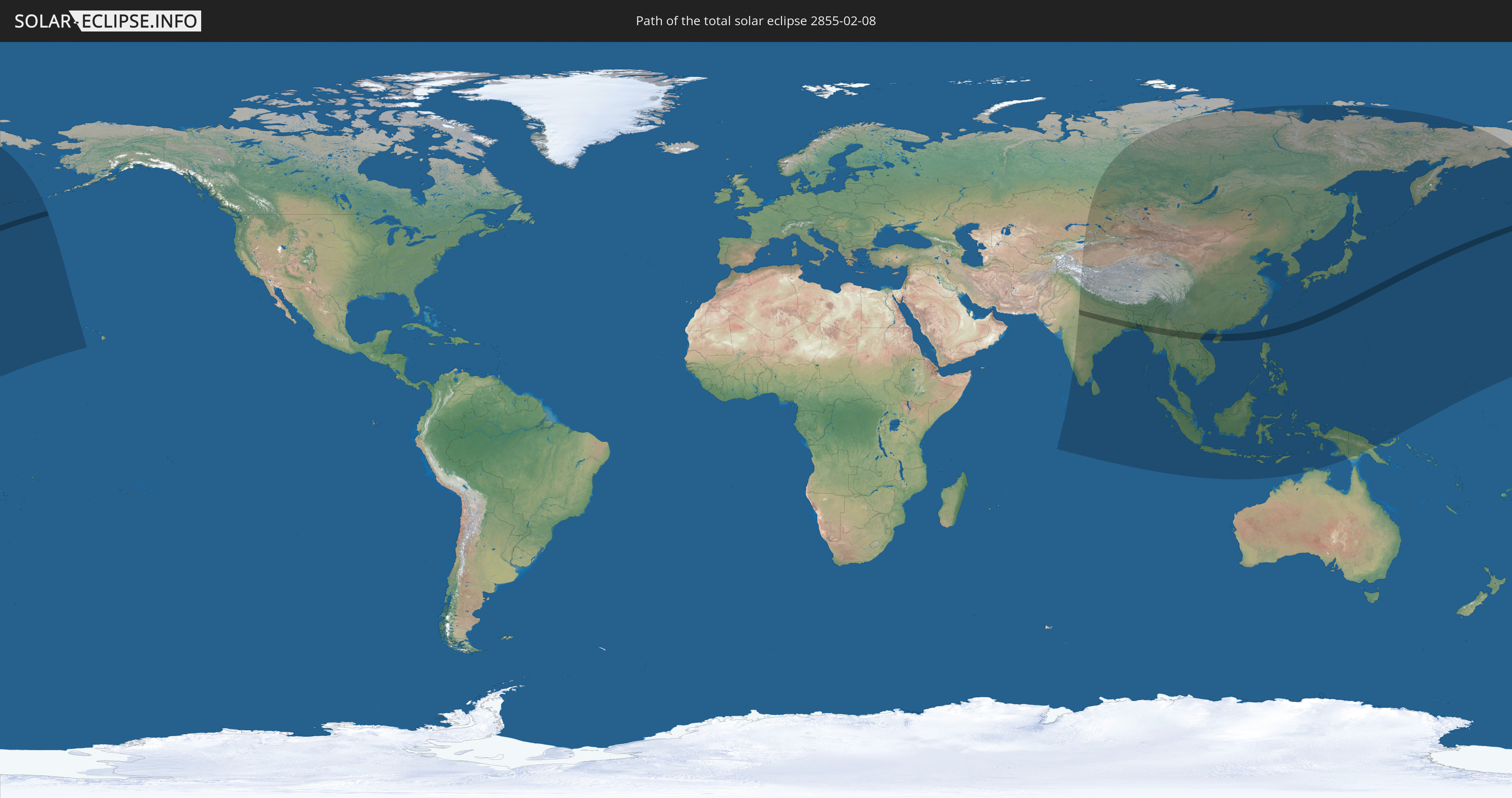
Die Sonnenfinsternis am 02/08/2855 kann man in 41 Ländern als partielle Sonnenfinsternis beobachten.
Der Finsternispfad verläuft durch 9 Länder. Nur in diesen Ländern ist sie als total Sonnenfinsternis zu sehen.
In den folgenden Ländern ist die Sonnenfinsternis total zu sehen
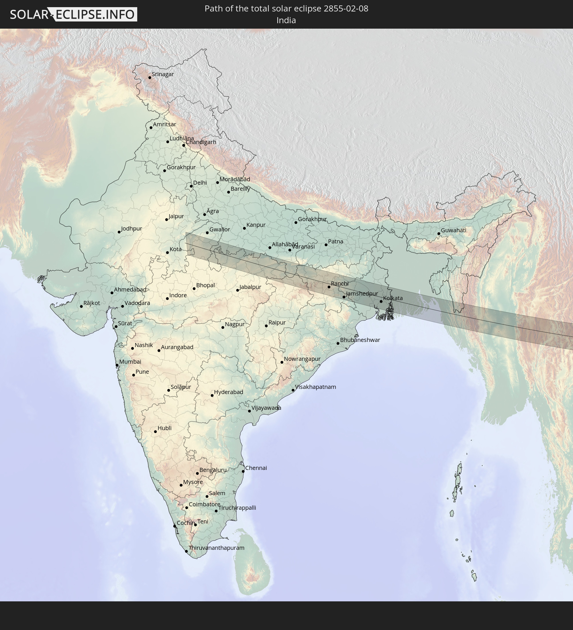 India
India
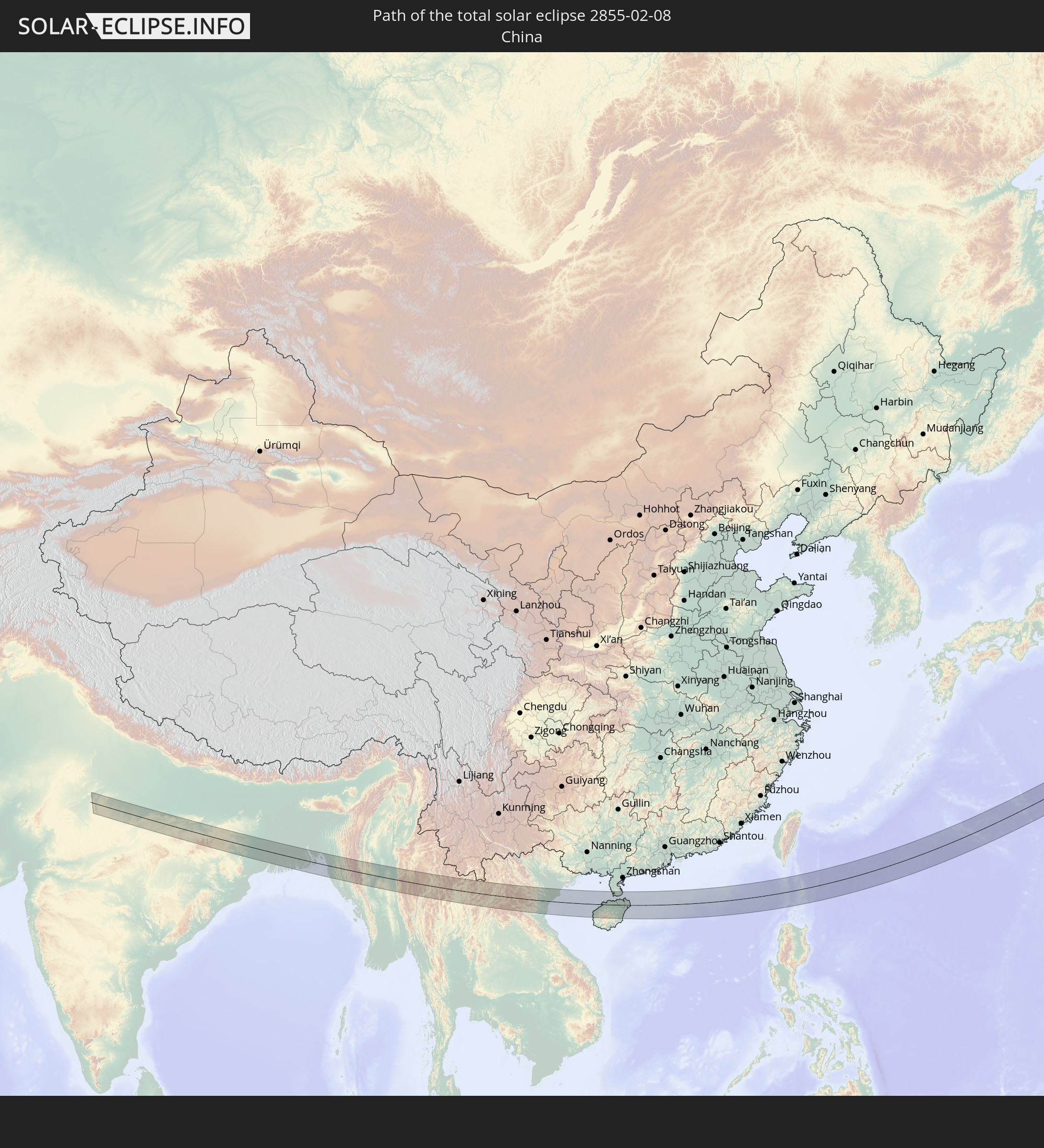 China
China
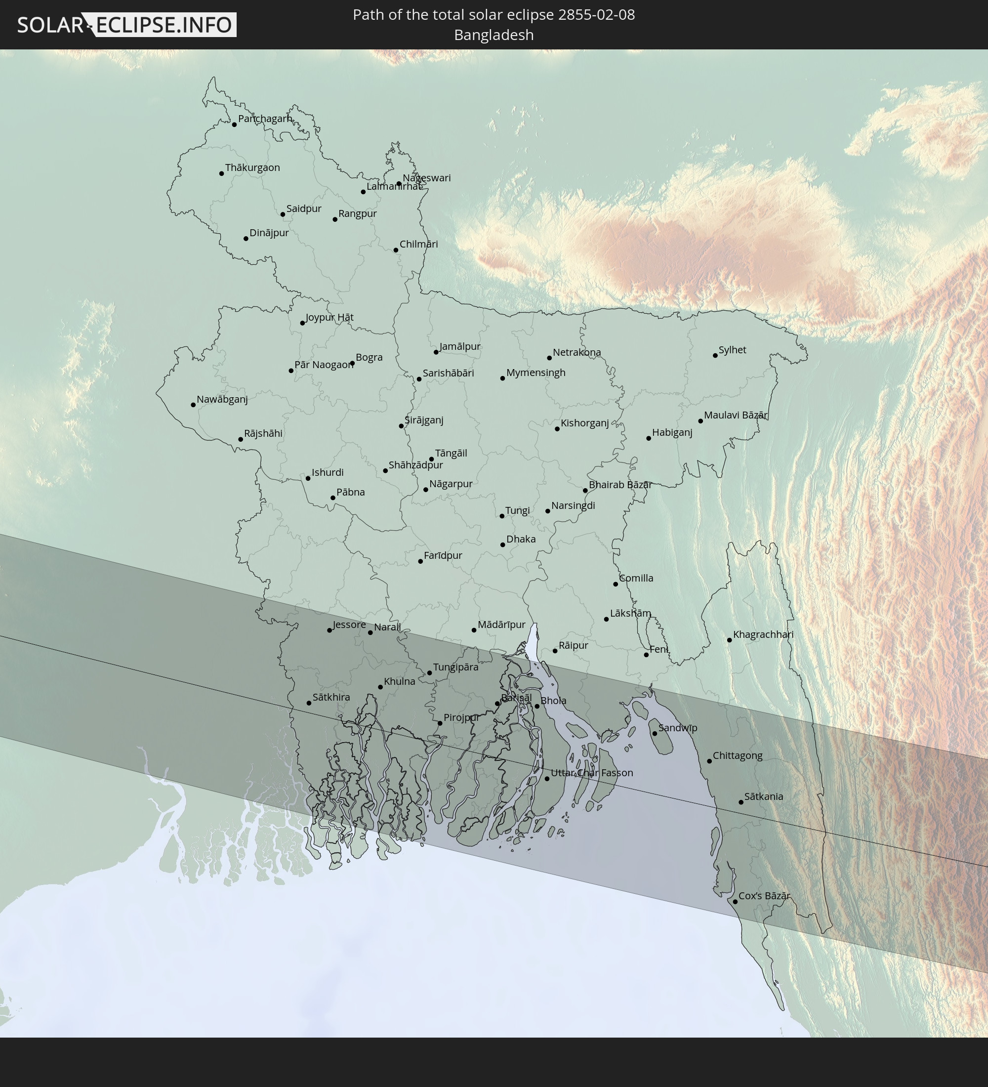 Bangladesh
 Myanmar
 Thailand
 Laos
Laos
 Vietnam
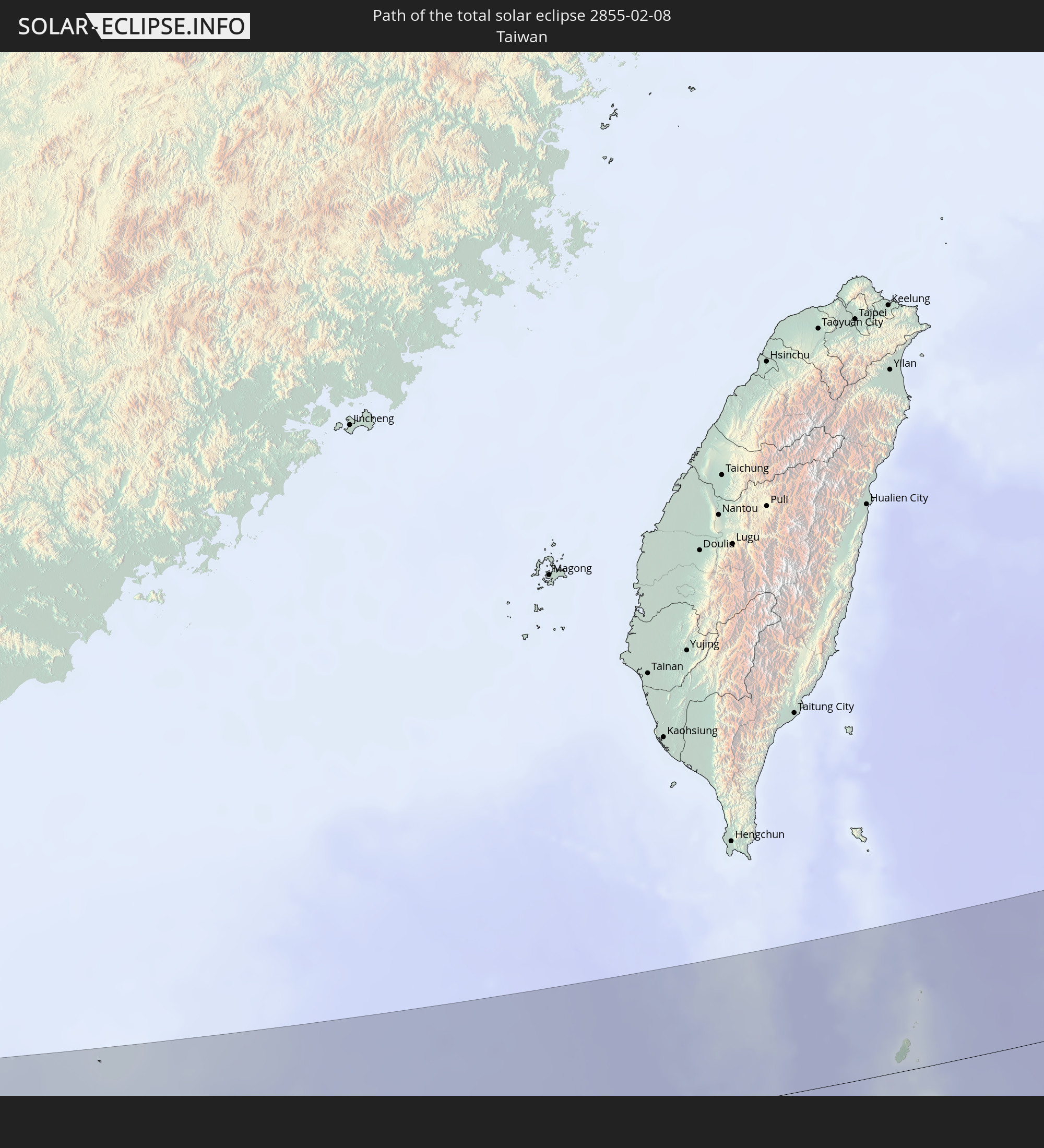 Taiwan
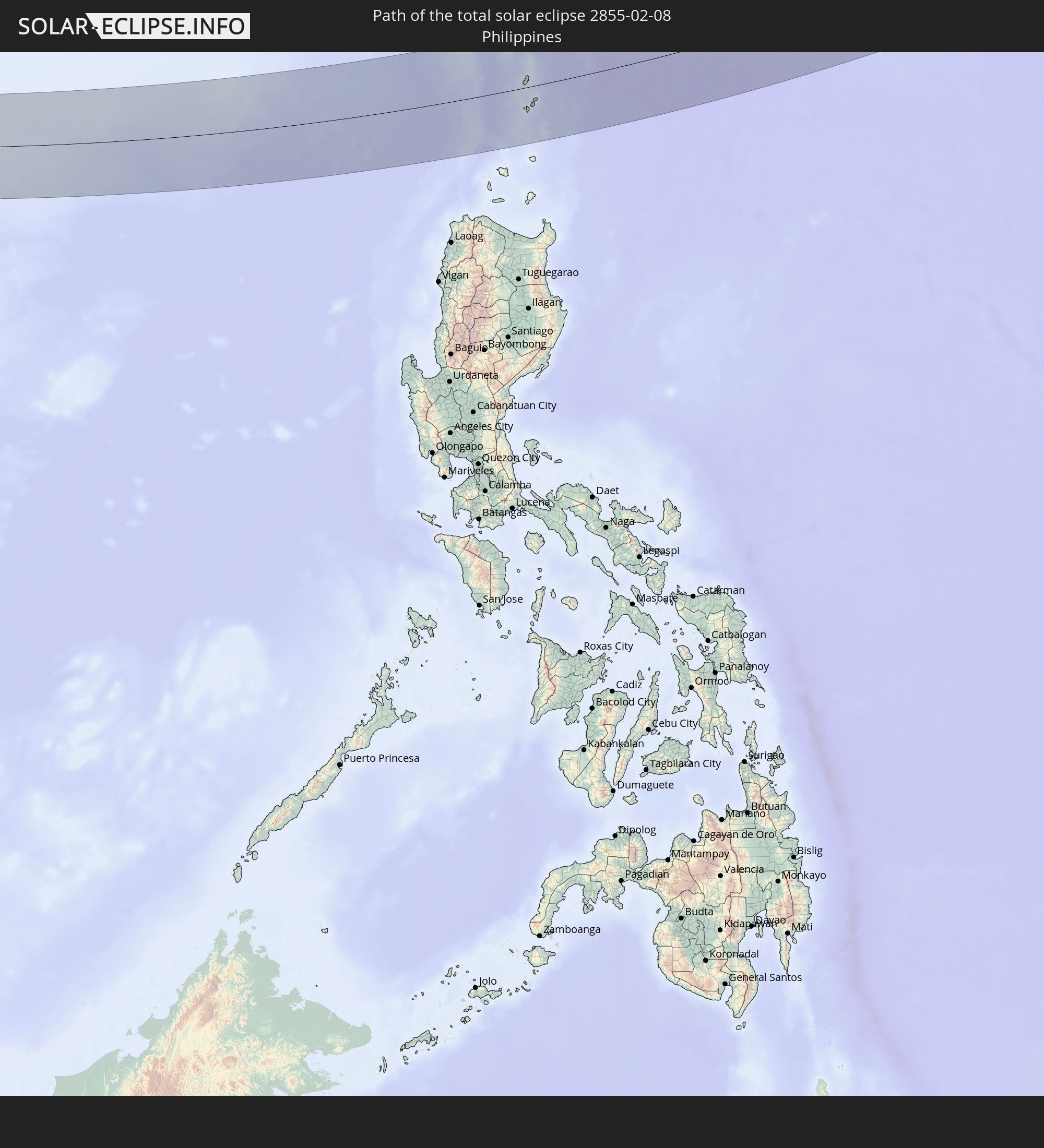 Philippines
In den folgenden Ländern ist die Sonnenfinsternis partiell zu sehen
 Russia
 United States
 United States Minor Outlying Islands
 Kazakhstan
 Pakistan
 India
India
 Kyrgyzstan
 British Indian Ocean Territory
 Maldives
 China
China
 Sri Lanka
 Nepal
Nepal
 Mongolia
 Bangladesh
 Bhutan
 Myanmar
 Indonesia
 Cocos Islands
 Thailand
 Malaysia
 Laos
Laos
 Vietnam
 Cambodia
 Singapore
 Christmas Island
 Australia
 Macau
Macau
 Hong Kong
 Brunei
 Taiwan
 Philippines
 Japan
Japan
 East Timor
 North Korea
 South Korea
 Palau
Palau
 Federated States of Micronesia
 Papua New Guinea
 Guam
Guam
 Northern Mariana Islands
 Marshall Islands
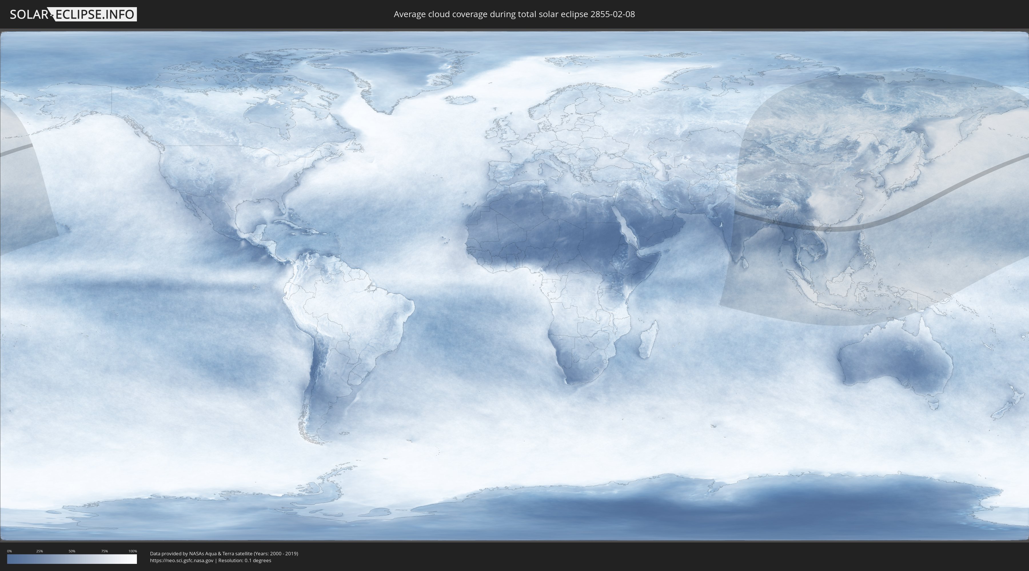
How will be the weather during the total solar eclipse on 02/08/2855?
Where is the best place to see the total solar eclipse of 02/08/2855?
The following maps show the average cloud coverage for the day of the total solar eclipse.
With the help of these maps, it is possible to find the place along the eclipse path, which has the best
chance of a cloudless sky.
Nevertheless, you should consider local circumstances and inform about the weather of your chosen
observation site.
The data is provided by NASAs satellites
AQUA and TERRA.
The cloud maps are averaged over a period of 19 years (2000 - 2019).

Detailed country maps
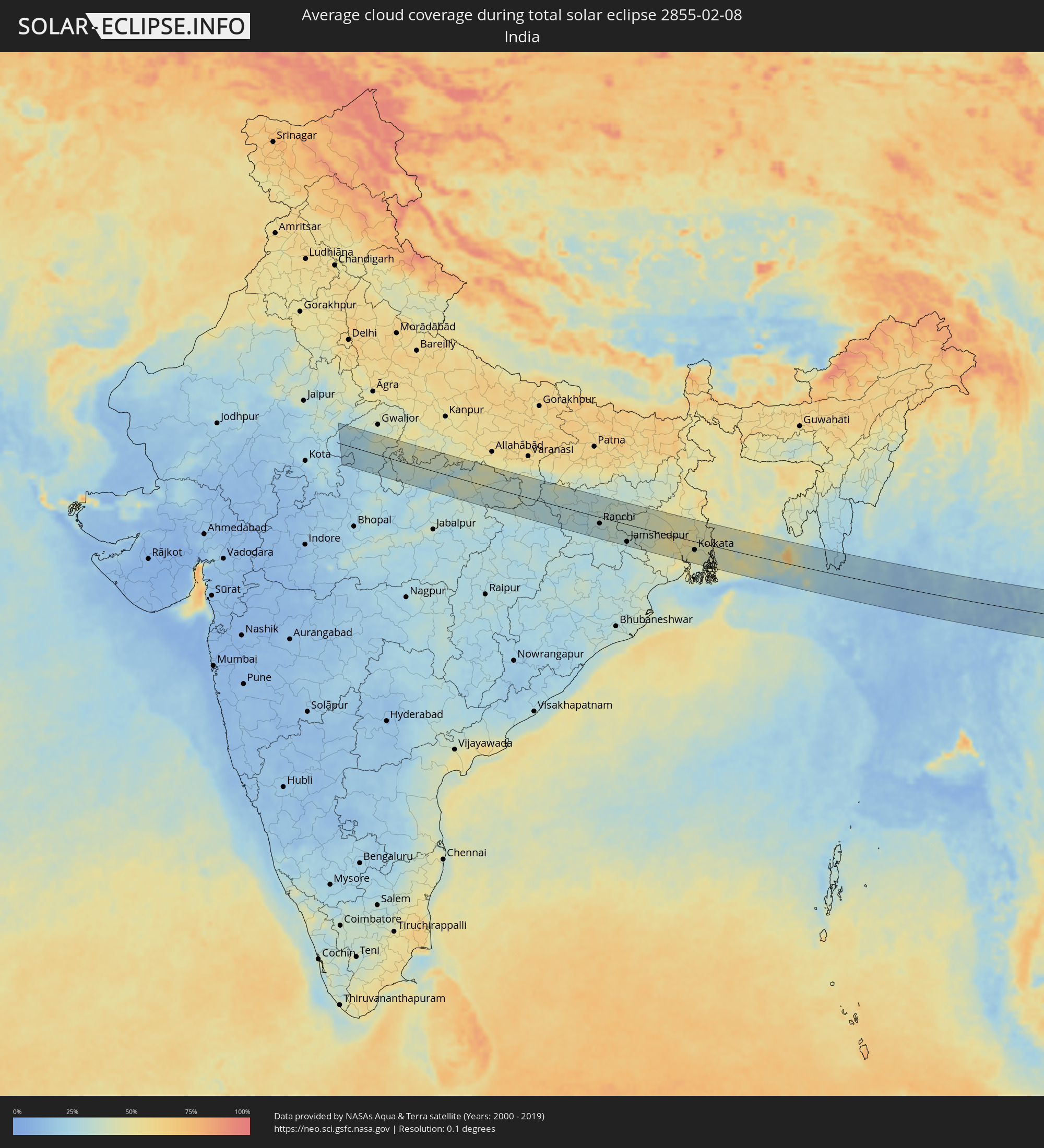 India
India
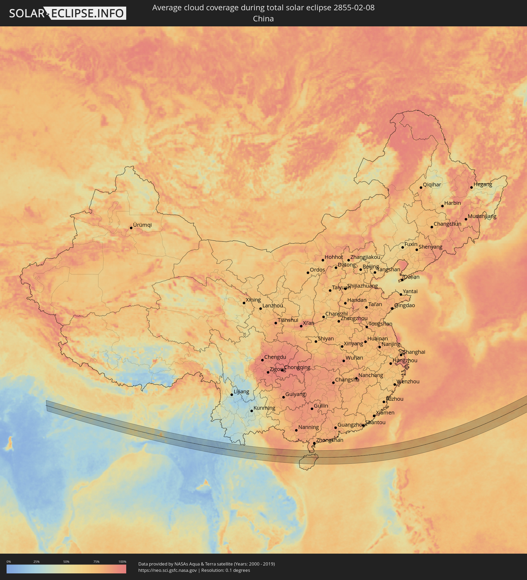 China
China
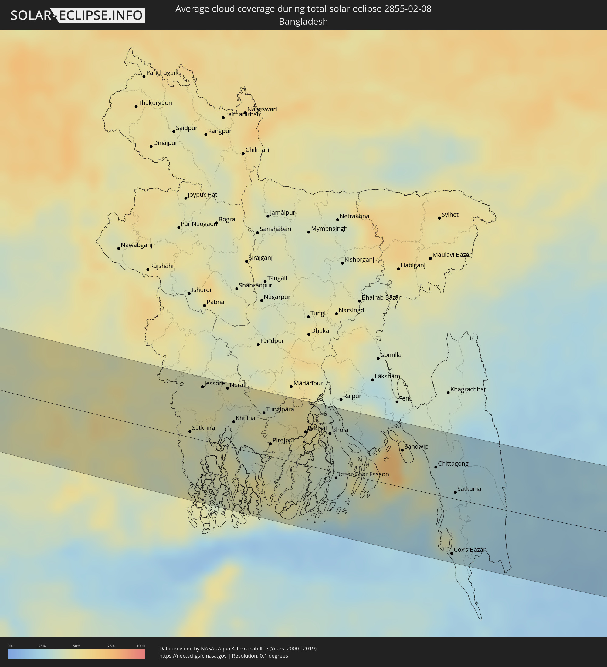 Bangladesh
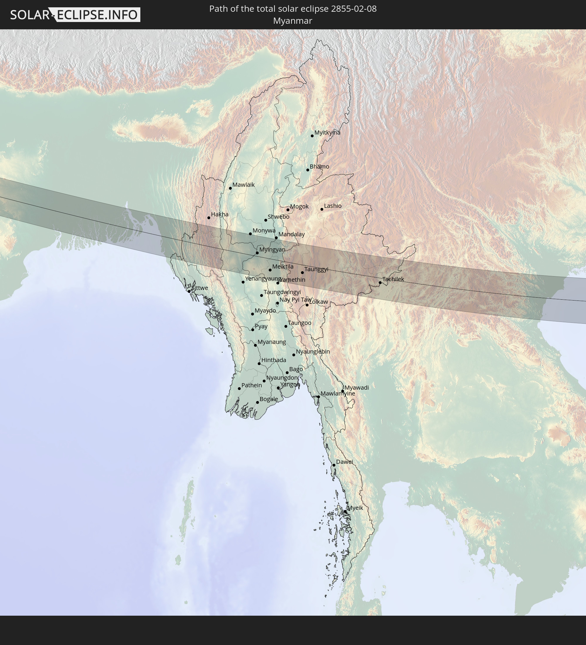
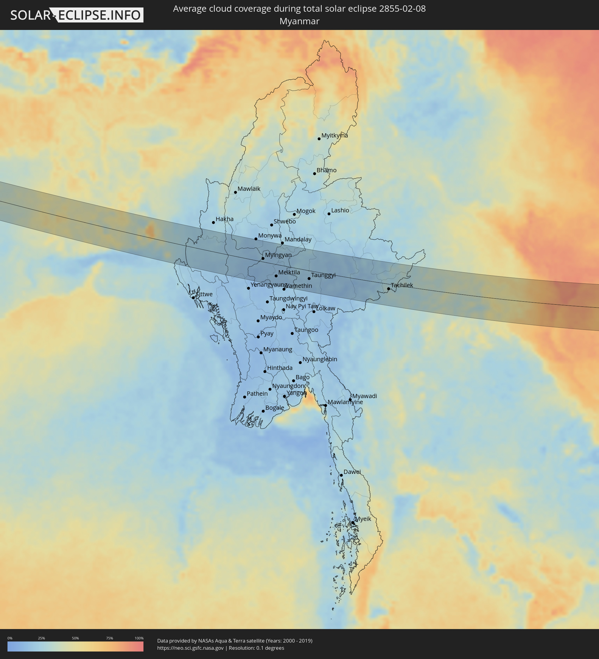 Myanmar
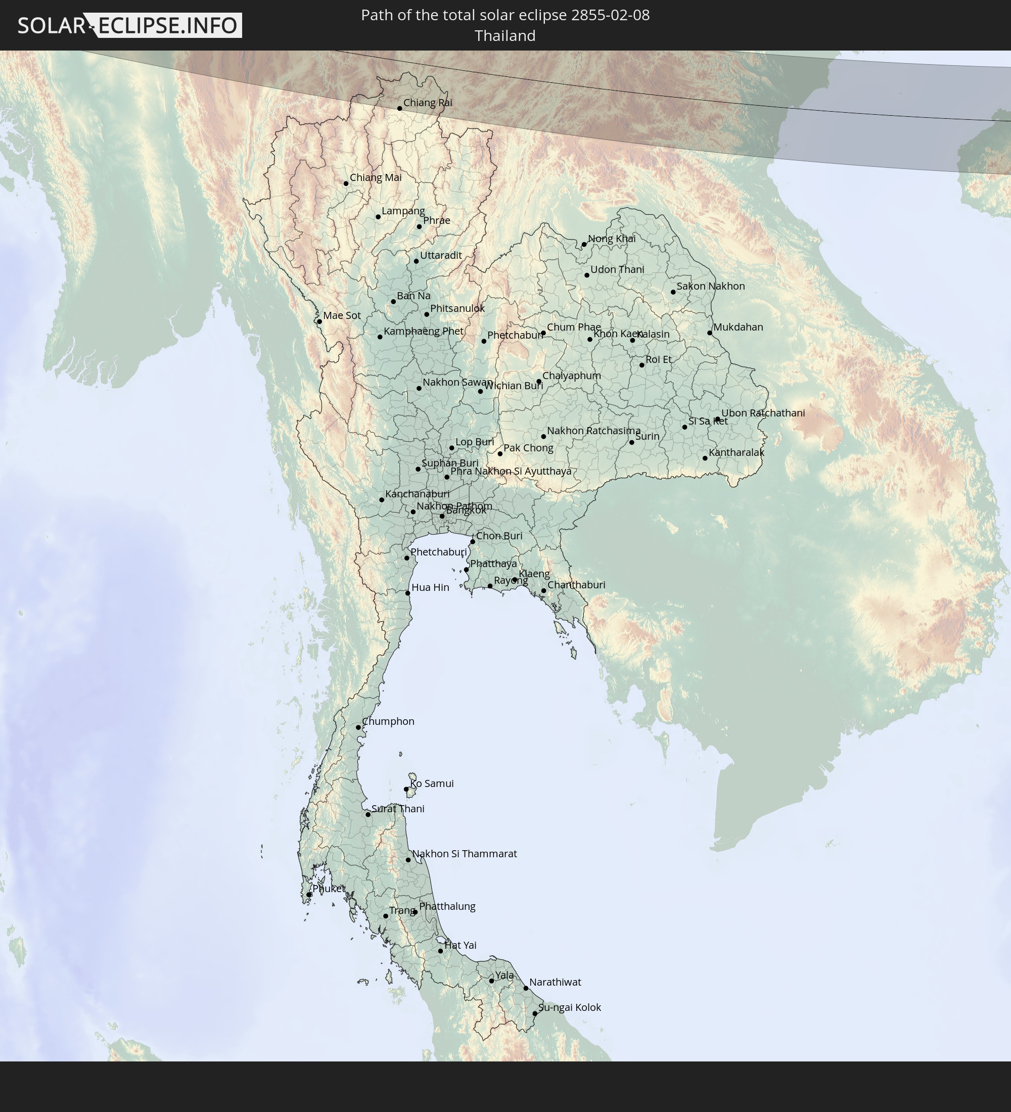
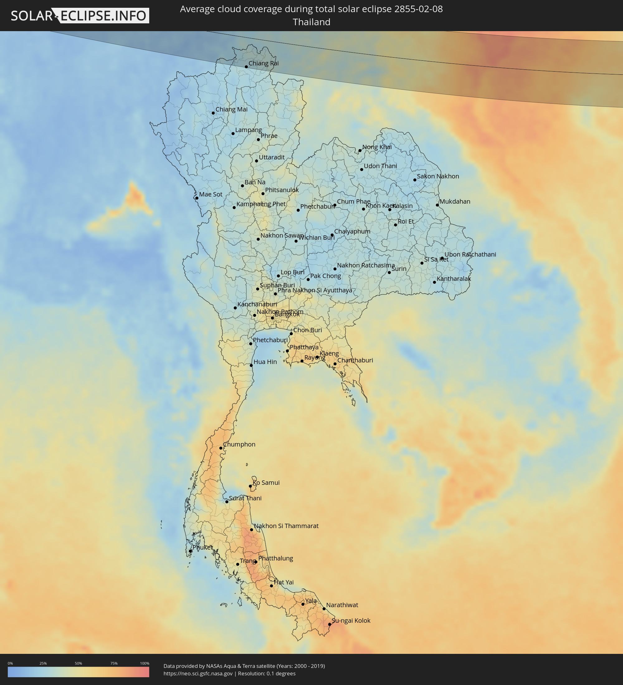 Thailand
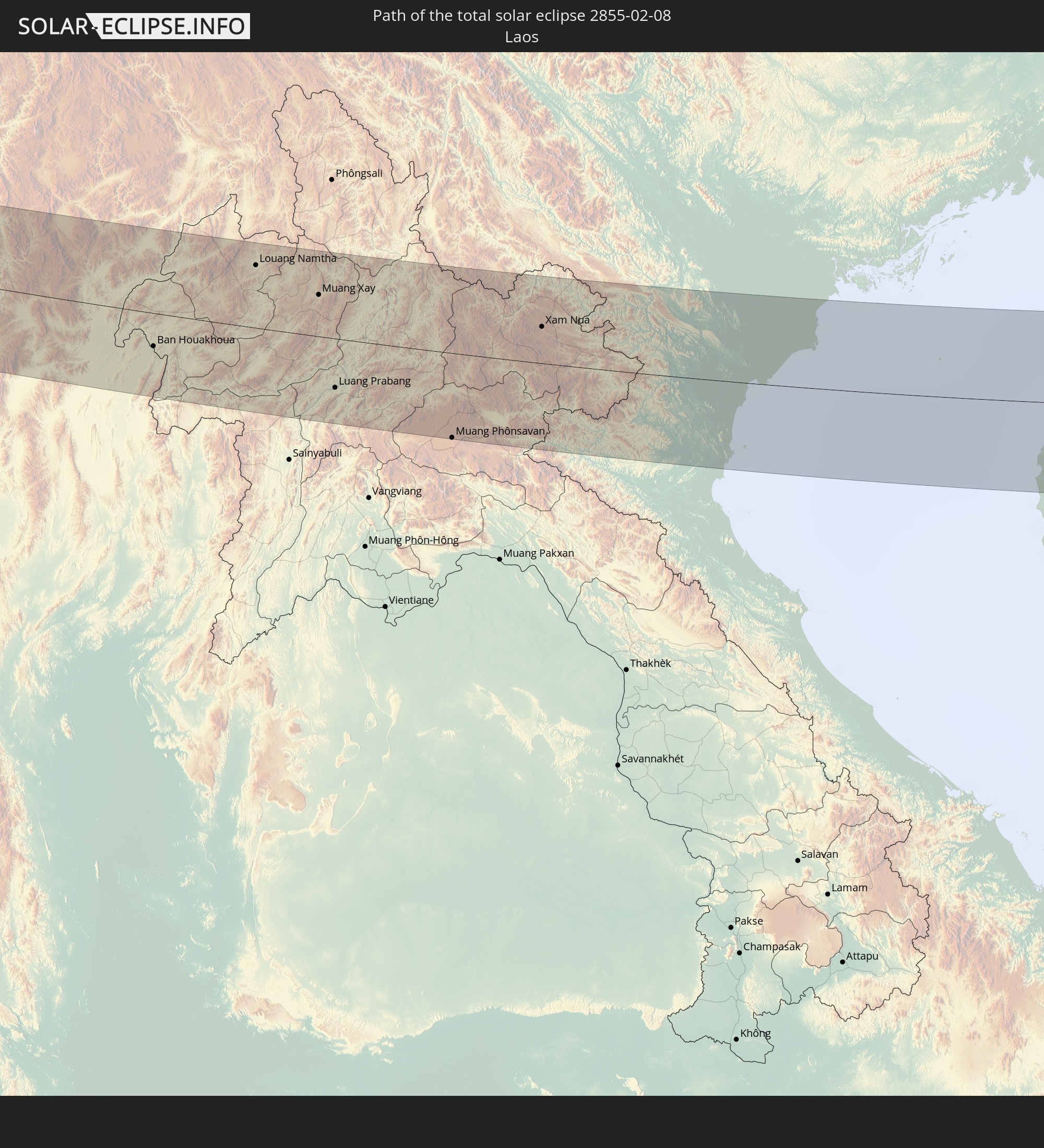
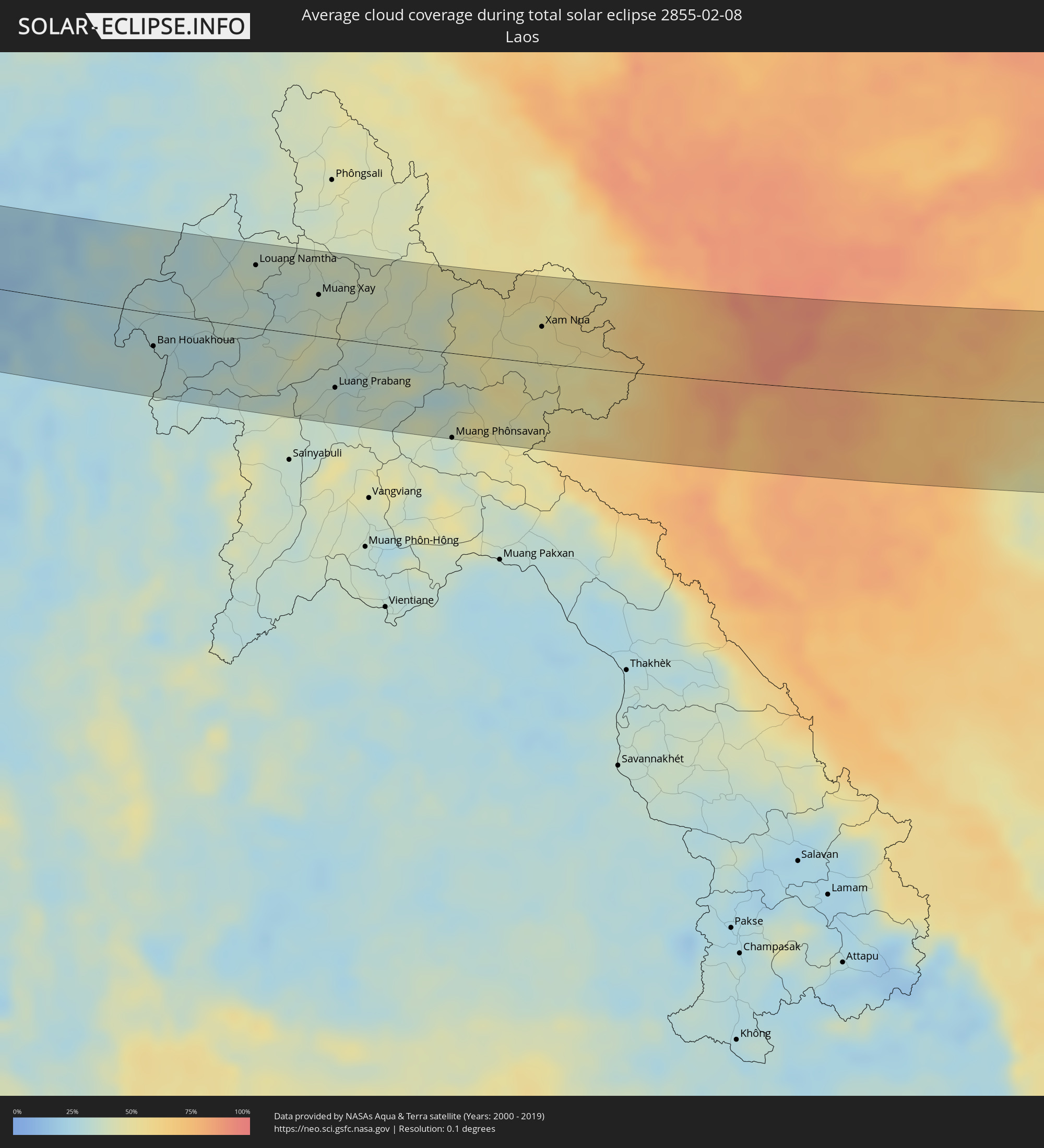 Laos
Laos
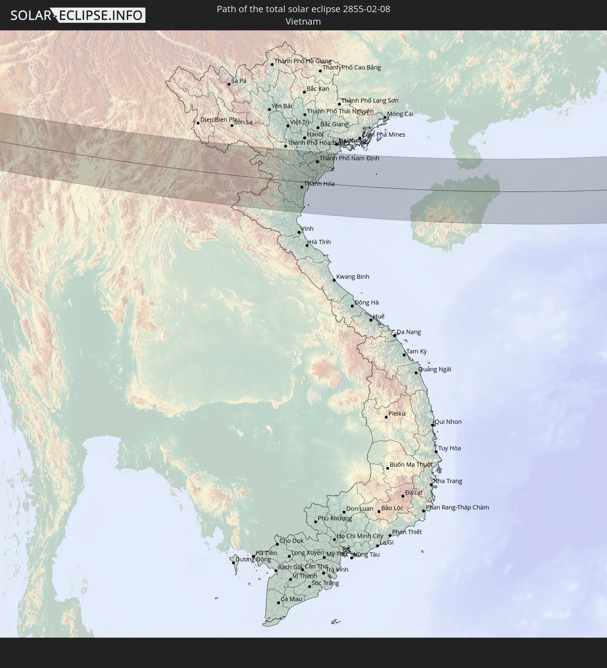
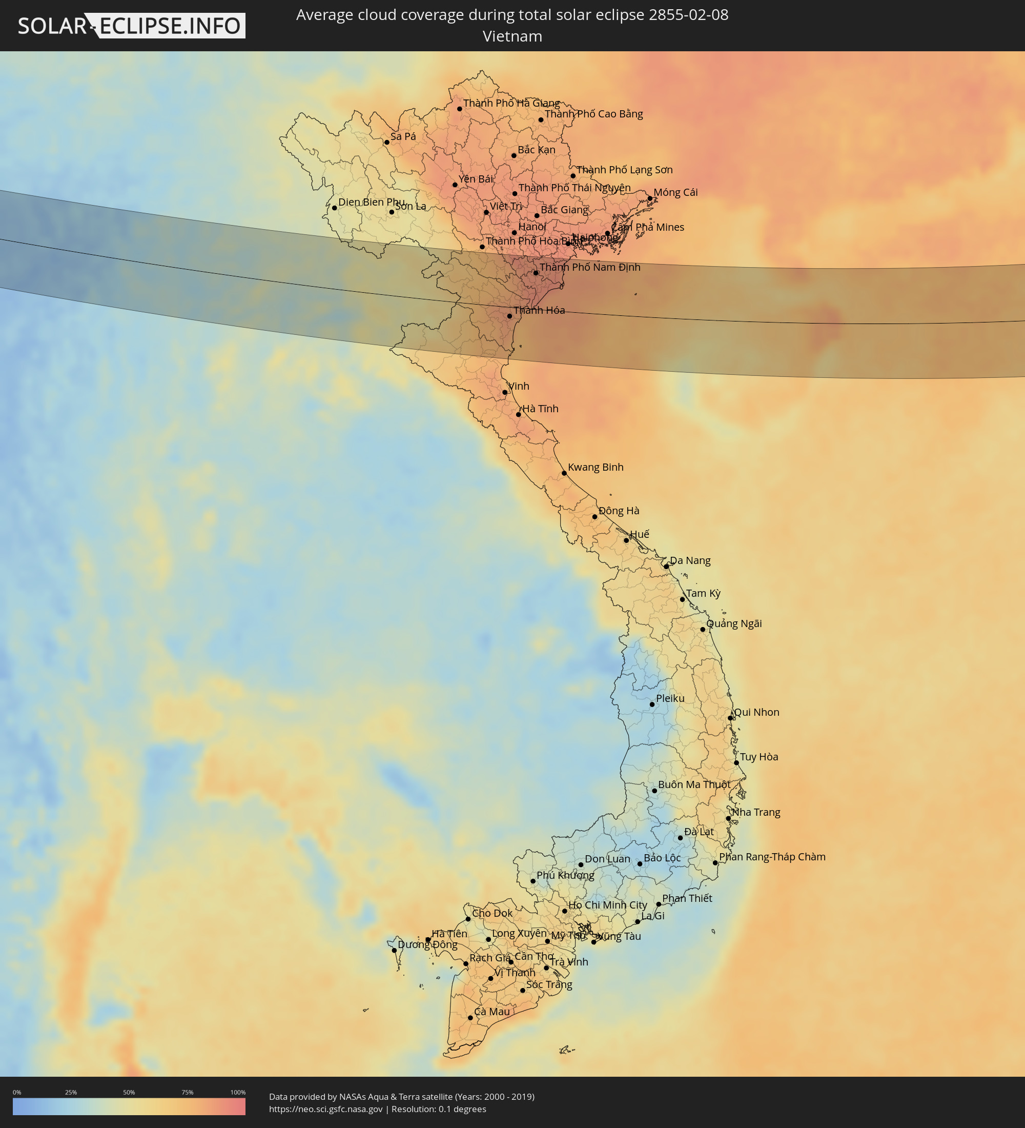 Vietnam
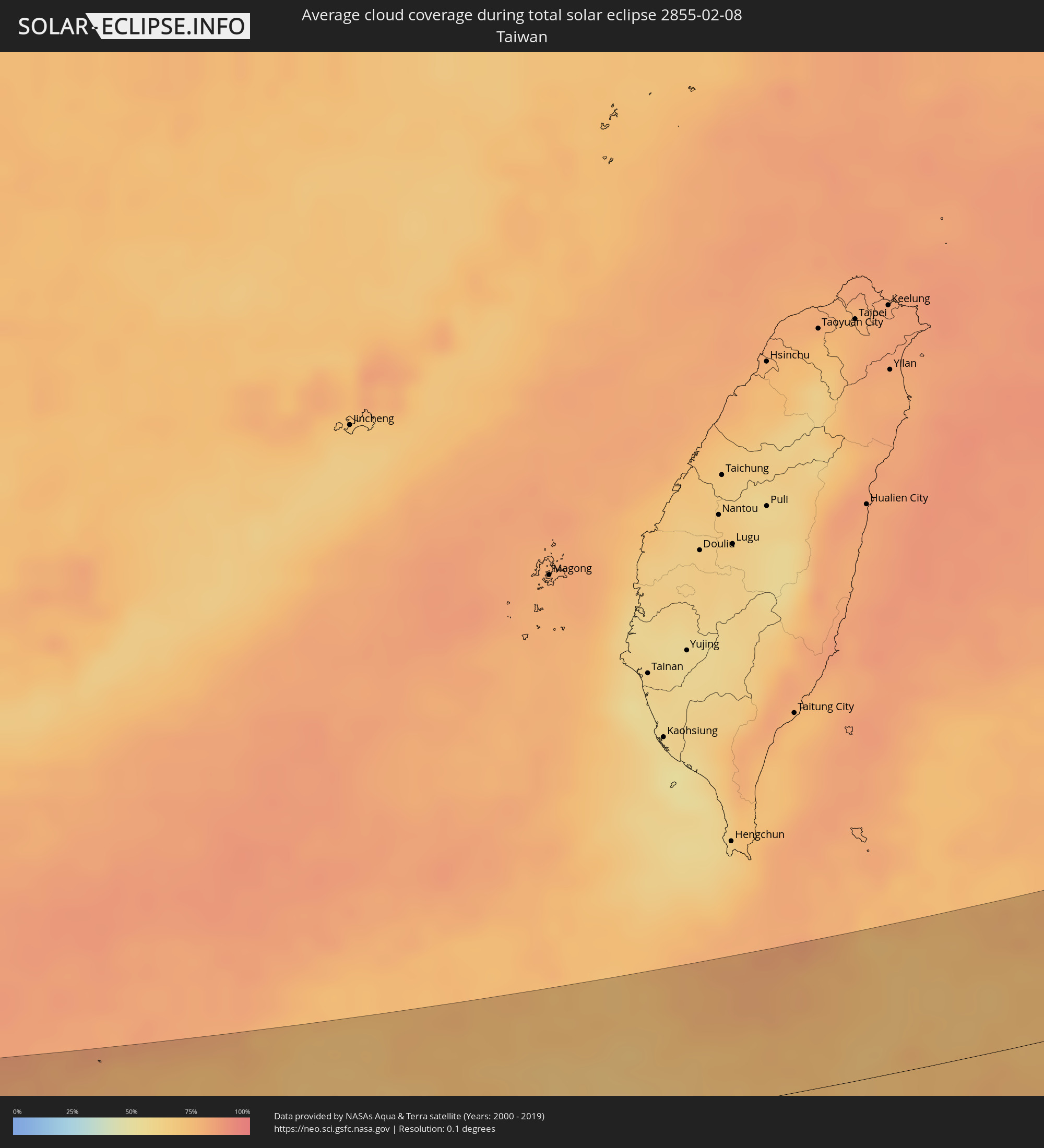 Taiwan
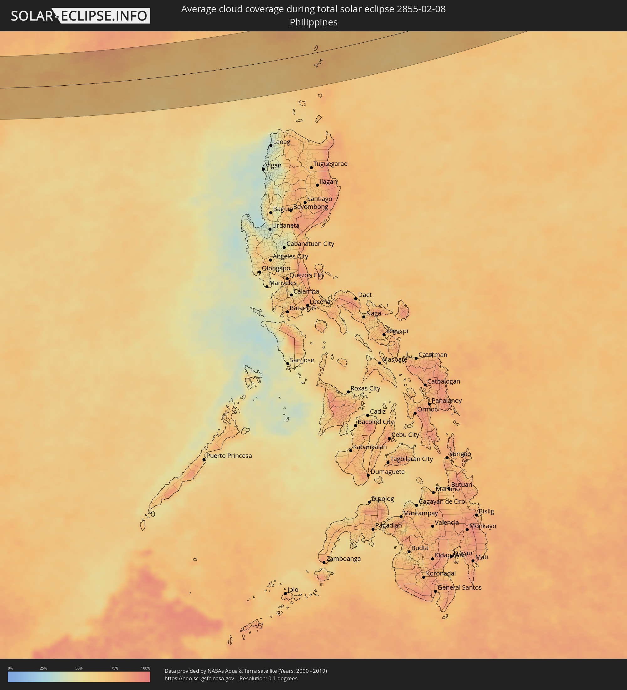 Philippines
Cities inside the path of the eclipse
The following table shows all locations with a population of more than 5,000 inside the eclipse path. Cities which have more than 100,000 inhabitants are marked bold. A click at the locations opens a detailed map.
| City | Type | Eclipse duration | Local time of max. eclipse | Distance to central line | Ø Cloud coverage |
|
Shivpuri, Madhya Pradesh
|
total | - | 07:04:43 UTC+05:30 | 8 km | 23% |
|
Jhānsi, Uttar Pradesh
|
total | - | 07:05:03 UTC+05:30 | 22 km | 33% |
|
Satna, Madhya Pradesh
|
total | - | 07:04:59 UTC+05:30 | 9 km | 41% |
|
Rewa, Madhya Pradesh
|
total | - | 07:05:09 UTC+05:30 | 1 km | 40% |
|
Singrauli, Madhya Pradesh
|
total | - | 07:05:26 UTC+05:30 | 2 km | 37% |
|
Ranchi, Jharkhand
|
total | - | 07:05:59 UTC+05:30 | 20 km | 30% |
|
Hazārībāg, Jharkhand
|
total | - | 07:06:40 UTC+05:30 | 51 km | 33% |
|
Bokāro, Jharkhand
|
total | - | 07:06:49 UTC+05:30 | 45 km | 34% |
|
Jamshedpur, Jharkhand
|
total | - | 07:05:58 UTC+05:30 | 56 km | 31% |
|
Dhanbād, Jharkhand
|
total | - | 07:07:09 UTC+05:30 | 59 km | 35% |
|
Kulti, West Bengal
|
total | - | 07:07:20 UTC+05:30 | 61 km | 39% |
|
Āsansol, West Bengal
|
total | - | 07:07:22 UTC+05:30 | 60 km | 42% |
|
Bānkura, West Bengal
|
total | - | 07:06:58 UTC+05:30 | 13 km | 41% |
|
Durgapur, West Bengal
|
total | - | 07:07:25 UTC+05:30 | 50 km | 43% |
|
Medinīpur, West Bengal
|
total | - | 07:06:19 UTC+05:30 | 68 km | 41% |
|
Barddhamān, West Bengal
|
total | - | 07:07:32 UTC+05:30 | 36 km | 45% |
|
Nangi, West Bengal
|
total | - | 07:07:01 UTC+05:30 | 36 km | 48% |
|
Kolkata, West Bengal
|
total | - | 07:07:11 UTC+05:30 | 27 km | 45% |
|
Bhātpāra, West Bengal
|
total | - | 07:07:31 UTC+05:30 | 7 km | 48% |
|
Shāntipur, West Bengal
|
total | - | 07:07:56 UTC+05:30 | 49 km | 47% |
|
Bārāsat, West Bengal
|
total | - | 07:06:55 UTC+05:30 | 61 km | 41% |
|
Bārāsat, West Bengal
|
total | - | 07:07:26 UTC+05:30 | 7 km | 42% |
|
Krishnanagar, West Bengal
|
total | - | 07:08:08 UTC+05:30 | 67 km | 45% |
|
Hābra, West Bengal
|
total | - | 07:07:41 UTC+05:30 | 11 km | 45% |
|
Gosāba, West Bengal
|
total | - | 07:07:06 UTC+05:30 | 59 km | 40% |
|
Sātkhira, Khulna
|
total | - | 07:37:51 UTC+06:00 | 6 km | 42% |
|
Jhingergācha, Khulna
|
total | - | 07:38:16 UTC+06:00 | 50 km | 46% |
|
Jessore, Khulna
|
total | - | 07:38:26 UTC+06:00 | 60 km | 43% |
|
Bhātpāra Abhaynagar, Khulna
|
total | - | 07:38:26 UTC+06:00 | 48 km | 46% |
|
Narail, Khulna
|
total | - | 07:38:38 UTC+06:00 | 65 km | 47% |
|
Phultala, Khulna
|
total | - | 07:38:11 UTC+06:00 | 18 km | 41% |
|
Khulna, Khulna
|
total | - | 07:38:20 UTC+06:00 | 29 km | 40% |
|
Kālia, Khulna
|
total | - | 07:38:37 UTC+06:00 | 56 km | 40% |
|
Sarankhola, Khulna
|
total | - | 07:38:00 UTC+06:00 | 20 km | 51% |
|
Tungipāra, Dhaka
|
total | - | 07:38:41 UTC+06:00 | 47 km | 48% |
|
Pirojpur, Barisāl
|
total | - | 07:38:25 UTC+06:00 | 14 km | 46% |
|
Gaurnadi, Barisāl
|
total | - | 07:39:01 UTC+06:00 | 63 km | 50% |
|
Nālchiti, Barisāl
|
total | - | 07:38:42 UTC+06:00 | 27 km | 45% |
|
Barisāl, Barisāl
|
total | - | 07:38:51 UTC+06:00 | 37 km | 49% |
|
Mehendiganj, Barisāl
|
total | - | 07:39:06 UTC+06:00 | 53 km | 49% |
|
Bhola, Barisāl
|
total | - | 07:39:04 UTC+06:00 | 41 km | 40% |
|
Uttar Char Fasson, Khulna
|
total | - | 07:38:39 UTC+06:00 | 7 km | 31% |
|
Burhānuddin, Barisāl
|
total | - | 07:38:56 UTC+06:00 | 22 km | 36% |
|
Lālmohan, Barisāl
|
total | - | 07:38:47 UTC+06:00 | 6 km | 33% |
|
Sandwīp, Chittagong
|
total | - | 07:39:34 UTC+06:00 | 41 km | 45% |
|
Fatikchari, Chittagong
|
total | - | 07:40:02 UTC+06:00 | 68 km | 35% |
|
Chittagong, Chittagong
|
total | - | 07:39:43 UTC+06:00 | 31 km | 35% |
|
Patiya, Chittagong
|
total | - | 07:39:48 UTC+06:00 | 30 km | 30% |
|
Cox’s Bāzār, Chittagong
|
total | - | 07:38:58 UTC+06:00 | 63 km | 28% |
|
Sātkania, Chittagong
|
total | - | 07:39:38 UTC+06:00 | 7 km | 29% |
|
Chauk, Magway
|
total | - | 08:11:05 UTC+06:30 | 61 km | 13% |
|
Pakokku, Magway
|
total | - | 08:11:48 UTC+06:30 | 9 km | 15% |
|
Myingyan, Mandalay
|
total | - | 08:12:15 UTC+06:30 | 11 km | 17% |
|
Meiktila, Mandalay
|
total | - | 08:12:09 UTC+06:30 | 43 km | 15% |
|
Sagaing, Sagain
|
total | - | 08:13:18 UTC+06:30 | 69 km | 22% |
|
Kyaukse, Mandalay
|
total | - | 08:13:12 UTC+06:30 | 42 km | 20% |
|
Taunggyi, Shan
|
total | - | 08:13:22 UTC+06:30 | 30 km | 17% |
|
Chiang Rai, Chiang Rai
|
total | - | 08:45:52 UTC+07:00 | 79 km | 27% |
|
Mae Chan, Chiang Rai
|
total | - | 08:46:08 UTC+07:00 | 52 km | 27% |
|
Mae Sai, Chiang Rai
|
total | - | 08:46:27 UTC+07:00 | 20 km | 32% |
|
Tachilek, Shan
|
total | - | 08:46:28 UTC+07:00 | 18 km | 32% |
|
Chiang Saen, Chiang Rai
|
total | - | 08:46:33 UTC+07:00 | 34 km | 31% |
|
Chiang Khong, Chiang Rai
|
total | - | 08:46:58 UTC+07:00 | 31 km | 31% |
|
Ban Houayxay, Bokeo Province
|
total | - | 08:46:59 UTC+07:00 | 29 km | 31% |
|
Ban Houakhoua, Bokeo Province
|
total | - | 08:47:01 UTC+07:00 | 32 km | 31% |
|
Louang Namtha, Loungnamtha
|
total | - | 08:49:01 UTC+07:00 | 60 km | 35% |
|
Muang Xay, Oudômxai
|
total | - | 08:49:33 UTC+07:00 | 40 km | 38% |
|
Luang Prabang, Louangphabang
|
total | - | 08:48:57 UTC+07:00 | 47 km | 35% |
|
Muang Phônsavan, Xiangkhoang
|
total | - | 08:50:04 UTC+07:00 | 81 km | 34% |
|
Xam Nua, Houaphan
|
total | - | 08:52:18 UTC+07:00 | 35 km | 49% |
|
Thanh Hóa, Thanh Hóa
|
total | - | 08:54:23 UTC+07:00 | 16 km | 82% |
|
Bỉm Sơn, Thanh Hóa
|
total | - | 08:54:49 UTC+07:00 | 16 km | 84% |
|
Thành Phố Phủ Lý, Hà Nam
|
total | - | 08:55:23 UTC+07:00 | 68 km | 84% |
|
Thành Phố Ninh Bình, Ninh Bình
|
total | - | 08:55:12 UTC+07:00 | 37 km | 88% |
|
Hưng Yên, Hưng Yên
|
total | - | 08:55:44 UTC+07:00 | 81 km | 87% |
|
Thành Phố Nam Định, Nam Định
|
total | - | 08:55:43 UTC+07:00 | 58 km | 88% |
|
Thành Phố Thái Bình, Thái Bình
|
total | - | 08:56:00 UTC+07:00 | 61 km | 87% |
|
Lincheng, Hainan
|
total | - | 10:01:20 UTC+08:00 | 20 km | 68% |
|
Jinjiang, Hainan
|
total | - | 10:01:45 UTC+08:00 | 1 km | 68% |
|
Xucheng, Guangdong
|
total | - | 10:02:40 UTC+08:00 | 69 km | 63% |
|
Xiuying, Hainan
|
total | - | 10:02:34 UTC+08:00 | 32 km | 73% |
|
Haikou, Hainan
|
total | - | 10:02:42 UTC+08:00 | 37 km | 73% |
|
Qiongshan, Hainan
|
total | - | 10:02:41 UTC+08:00 | 33 km | 76% |
|
Basco, Cagayan Valley
|
total | - | 10:28:51 UTC+08:00 | 24 km | 77% |