Totale Sonnenfinsternis vom 19.05.-0035
| Wochentag: | Dienstag |
| Maximale Dauer der Verfinsterung: | 05m46s |
| Maximale Breite des Finsternispfades: | 225 km |
| Saroszyklus: | 66 |
| Bedeckungsgrad: | 100% |
| Magnitude: | 1.0672 |
| Gamma: | 0.2106 |
Wo kann man die Sonnenfinsternis vom 19.05.-0035 sehen?
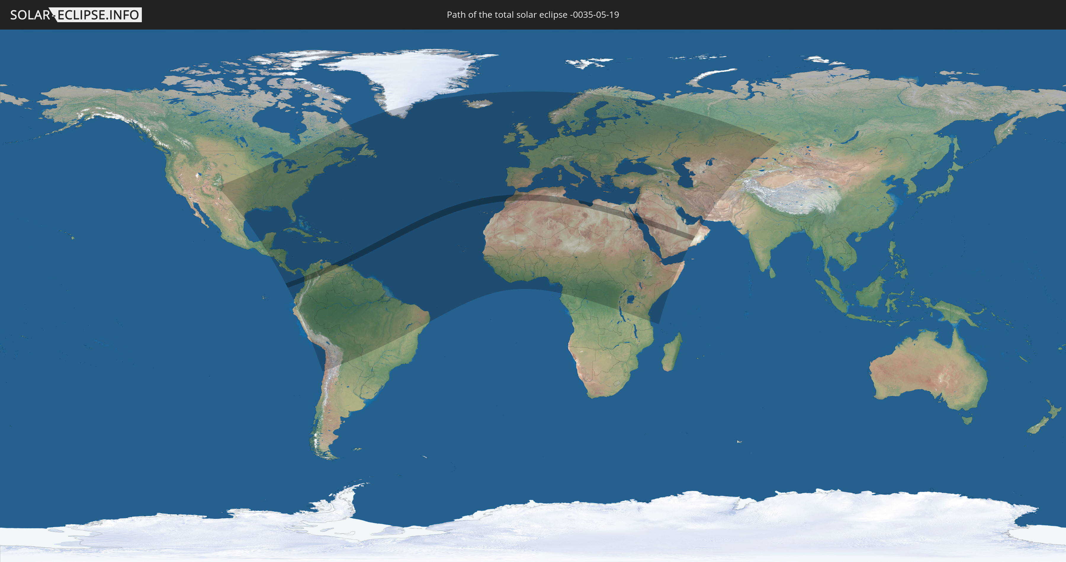
Die Sonnenfinsternis am 19.05.-0035 kann man in 165 Ländern als partielle Sonnenfinsternis beobachten.
Der Finsternispfad verläuft durch 14 Länder. Nur in diesen Ländern ist sie als totale Sonnenfinsternis zu sehen.
In den folgenden Ländern ist die Sonnenfinsternis total zu sehen
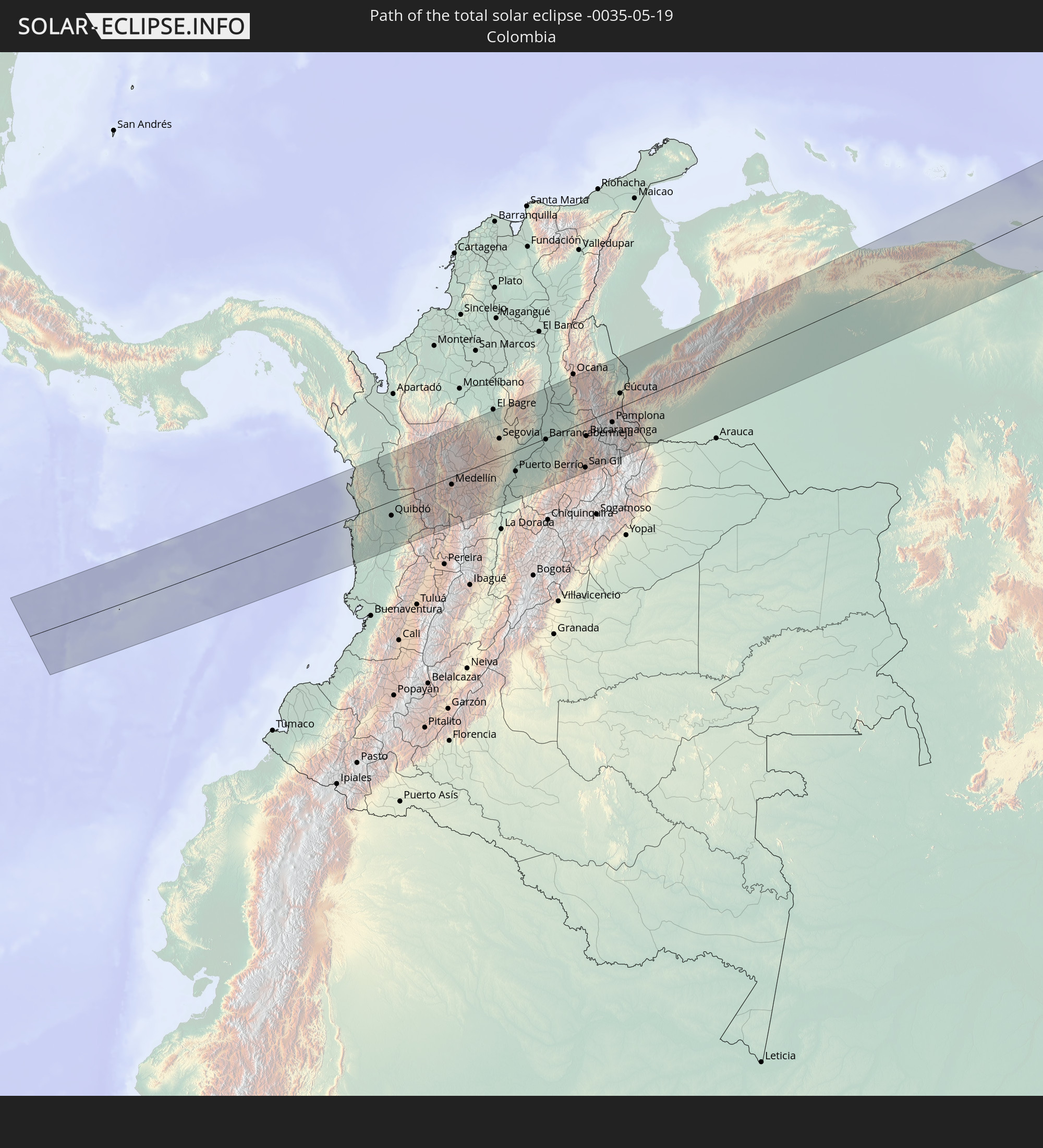 Kolumbien
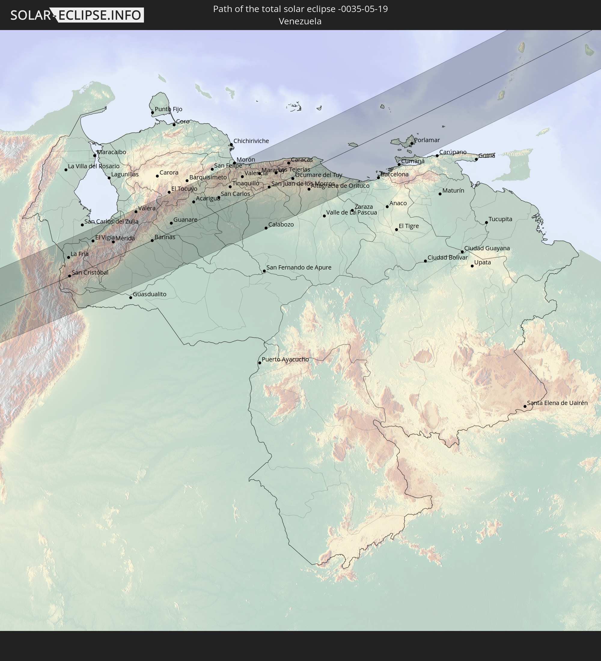 Venezuela
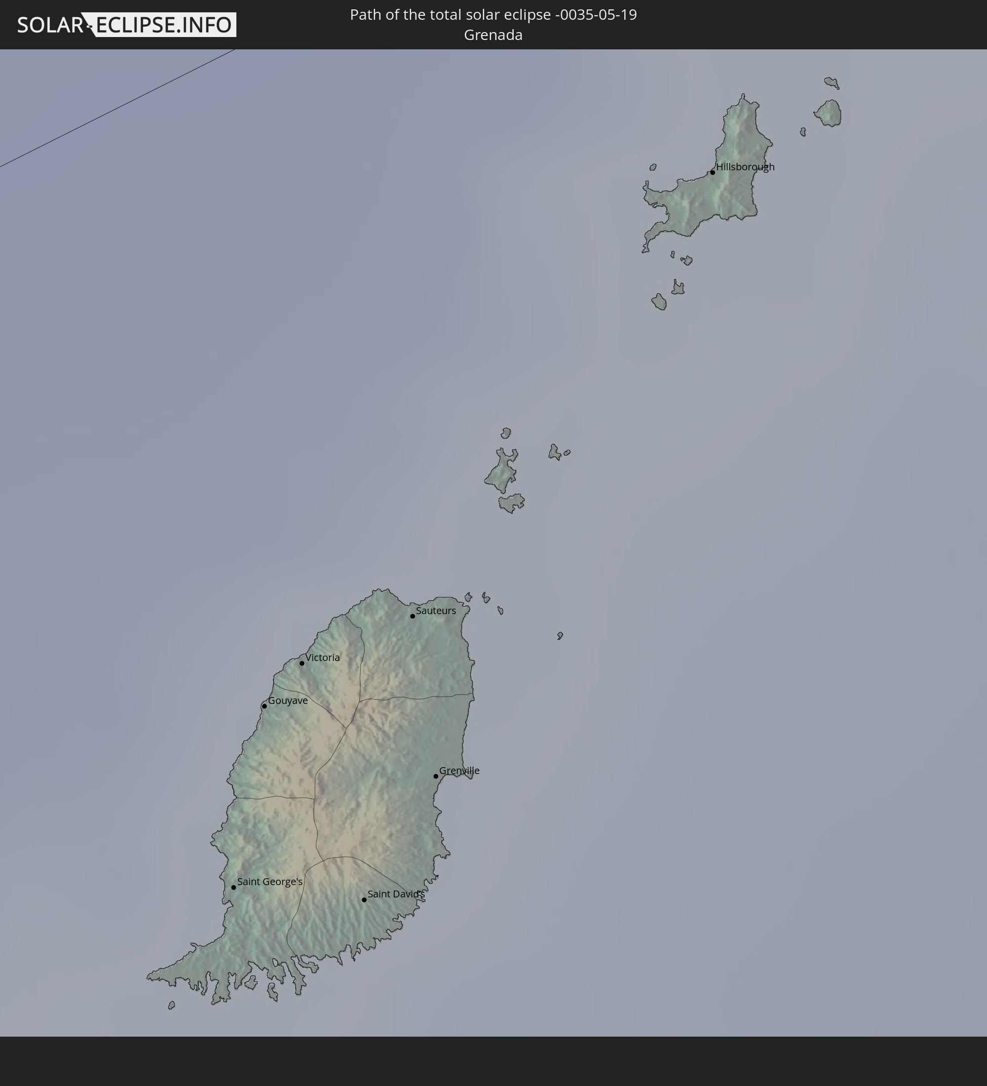 Grenada
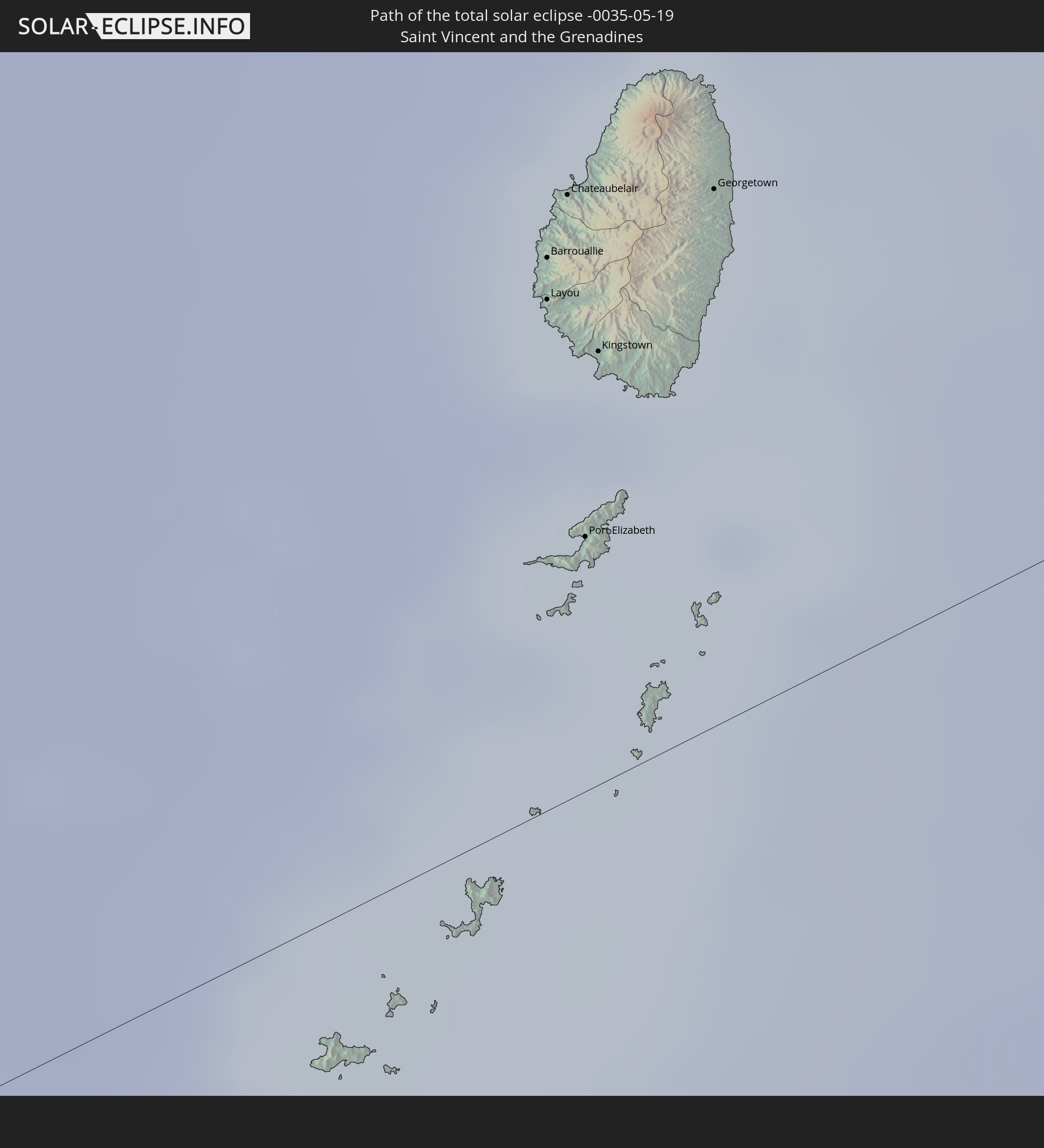 St. Vincent und die Grenadinen
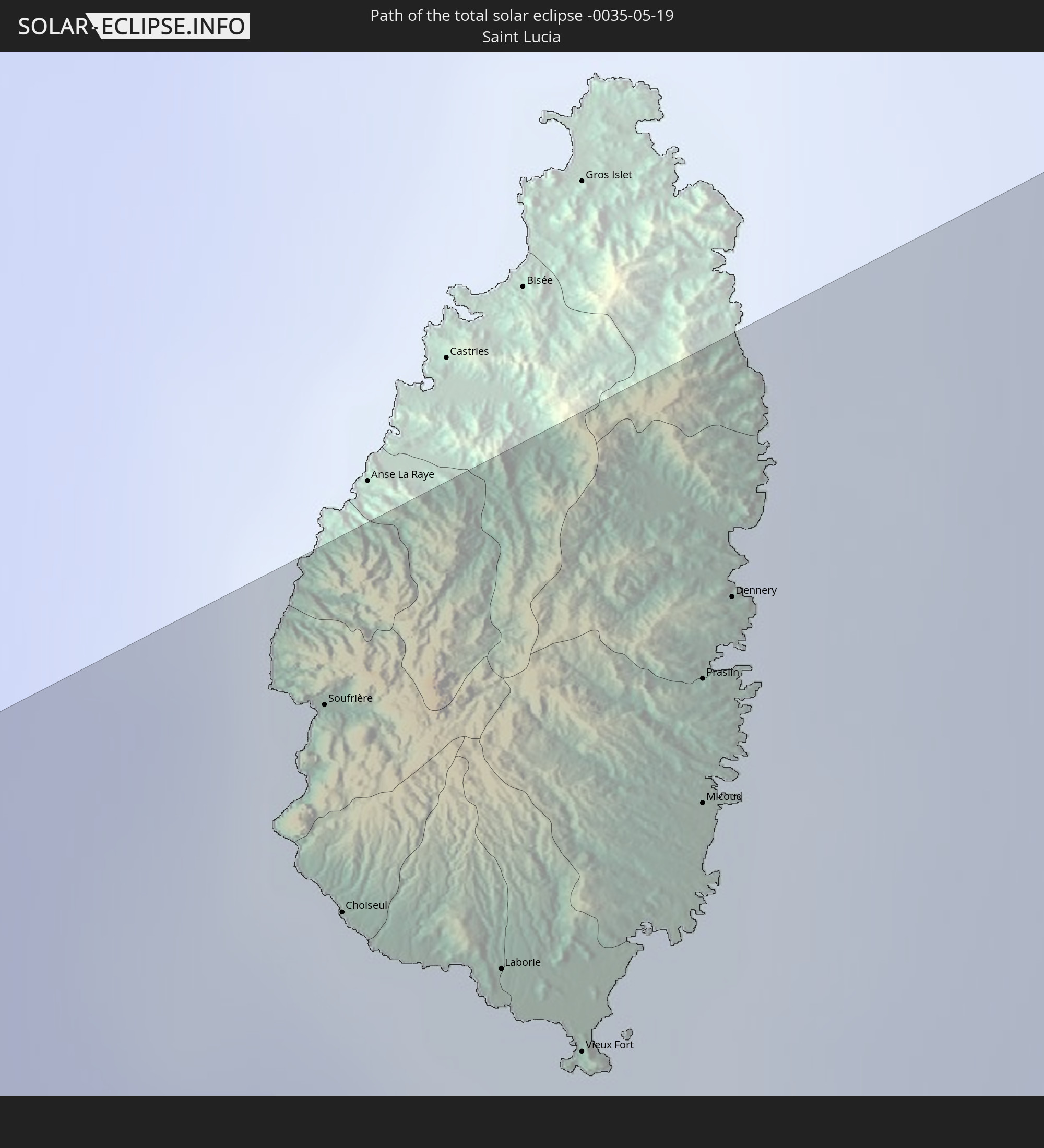 St. Lucia
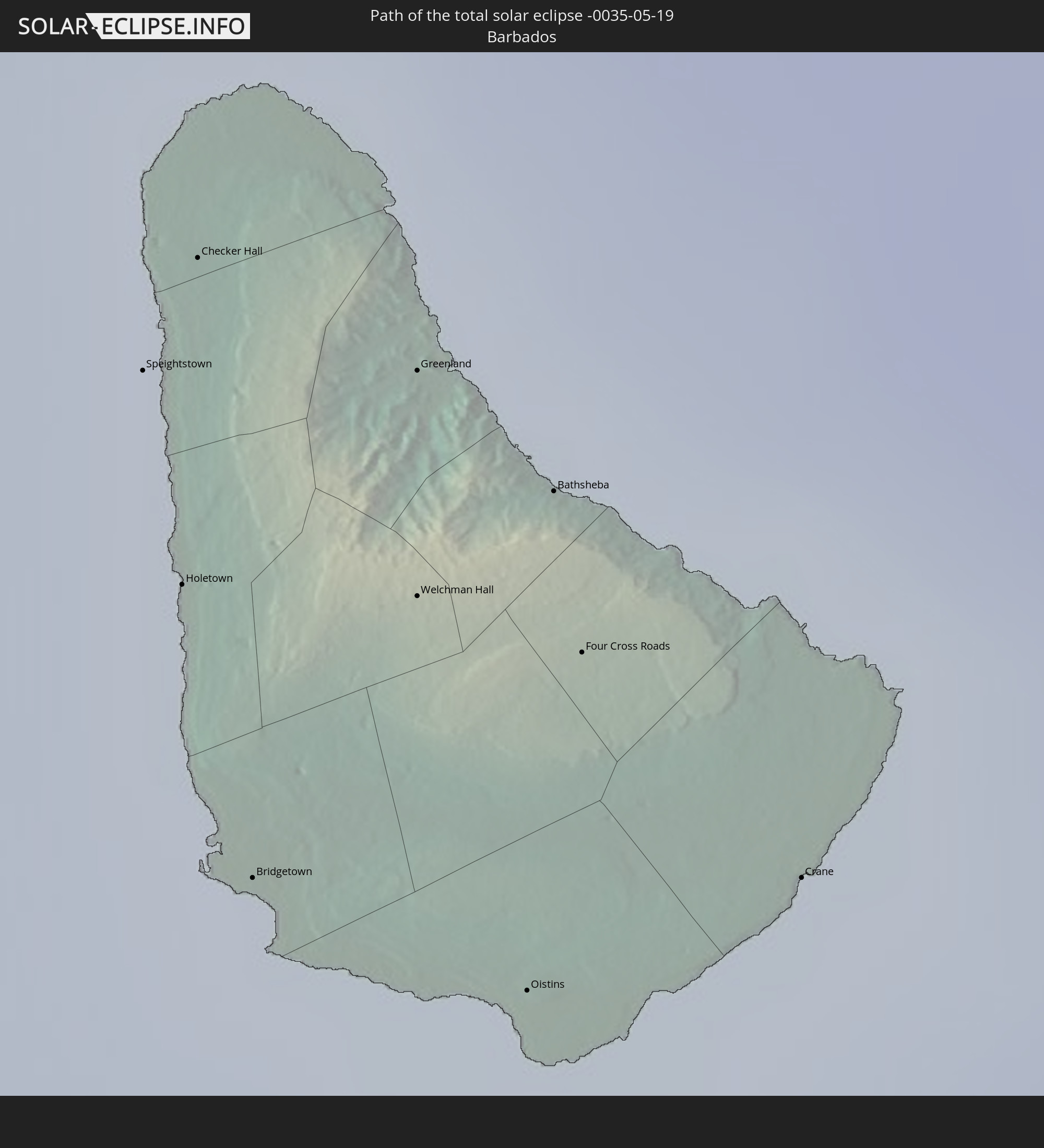 Barbados
 Portugal
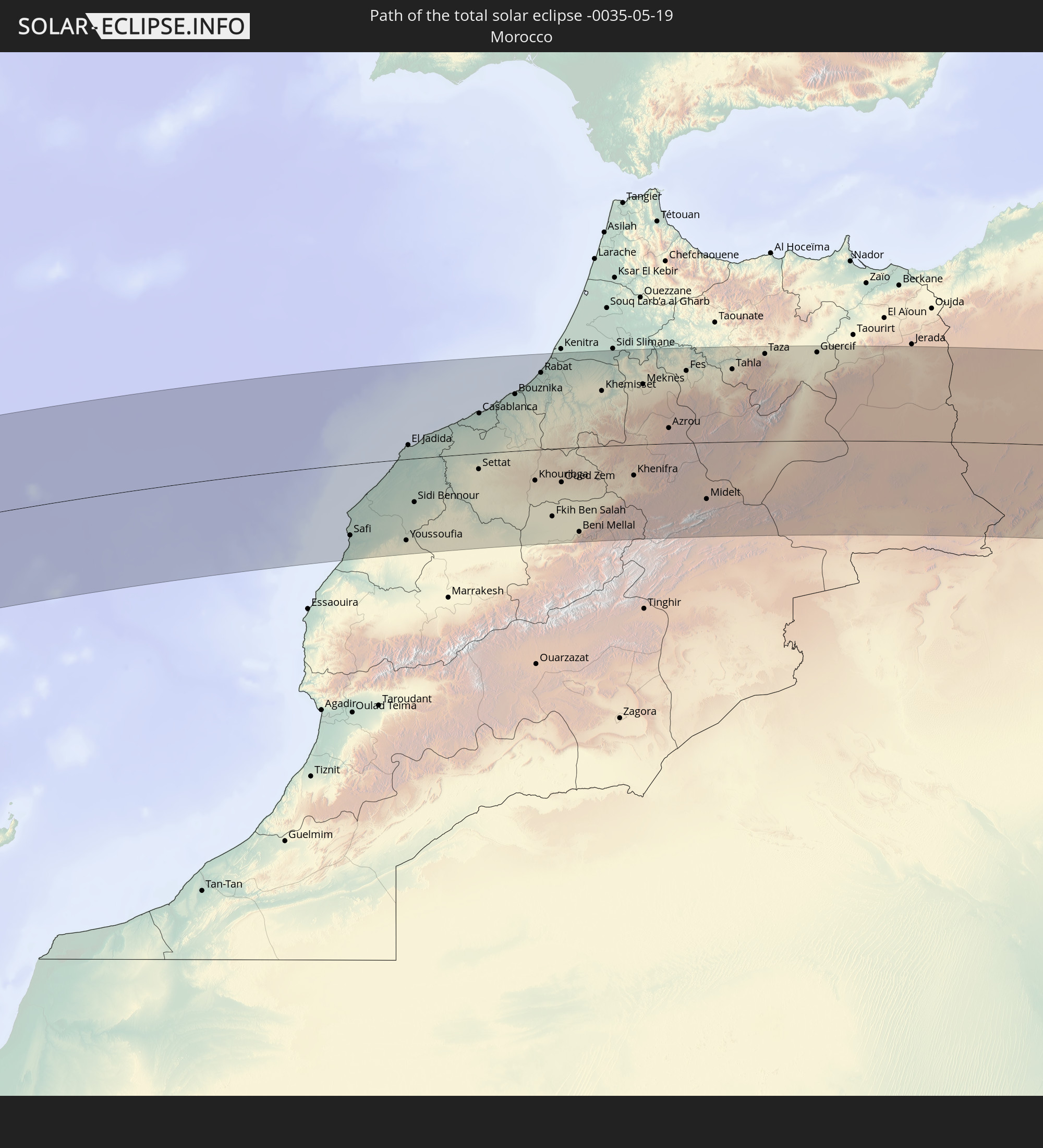 Marokko
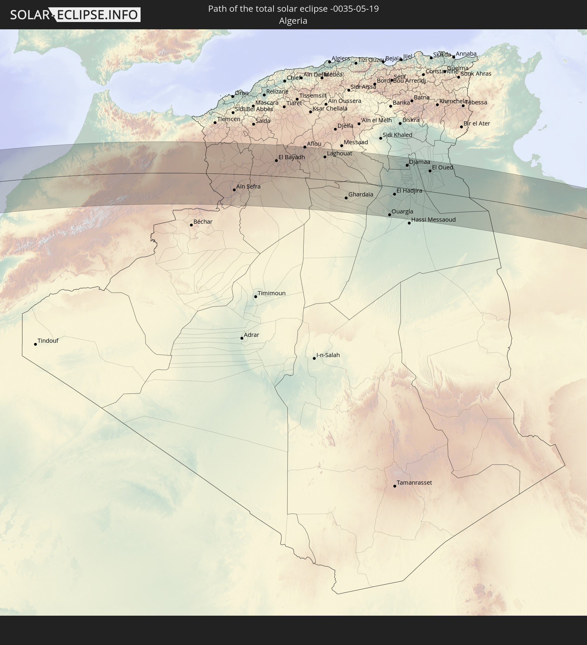 Algerien
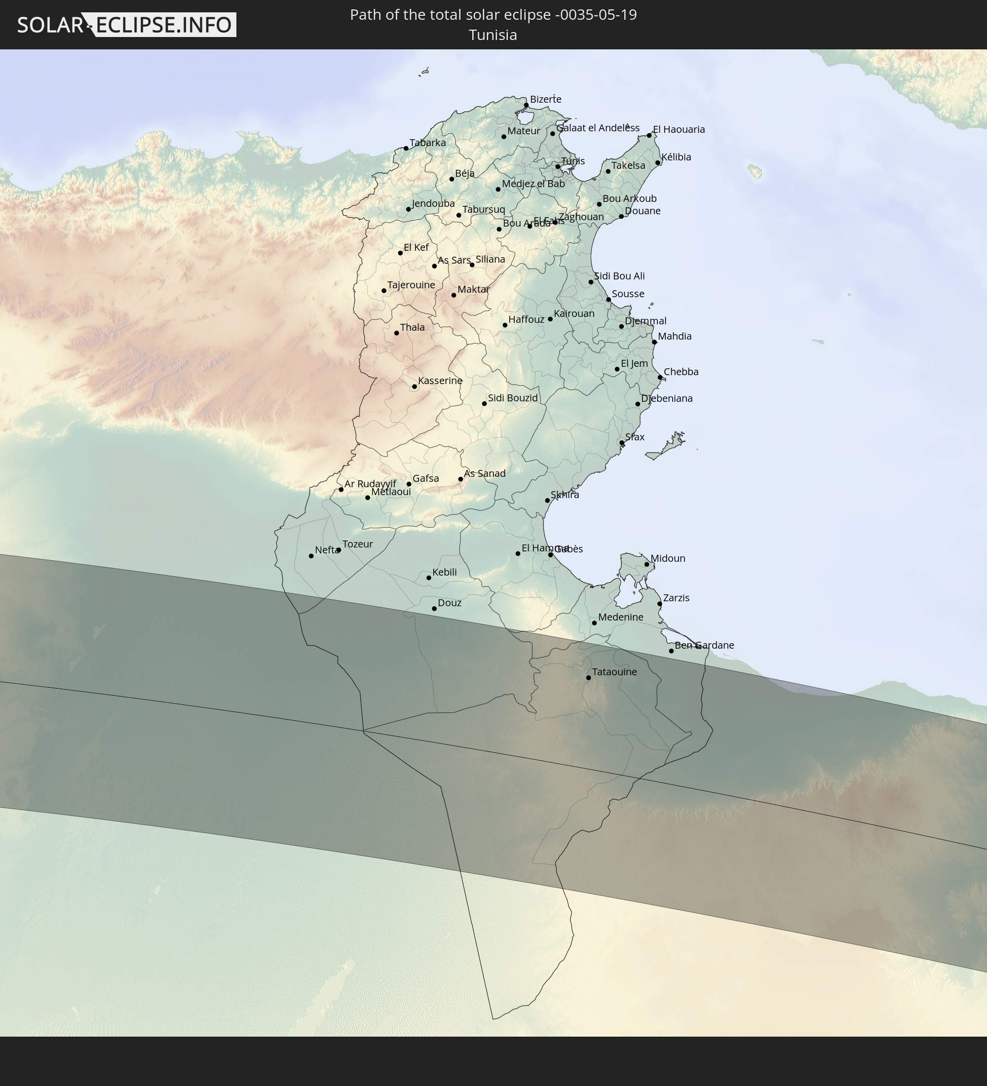 Tunesien
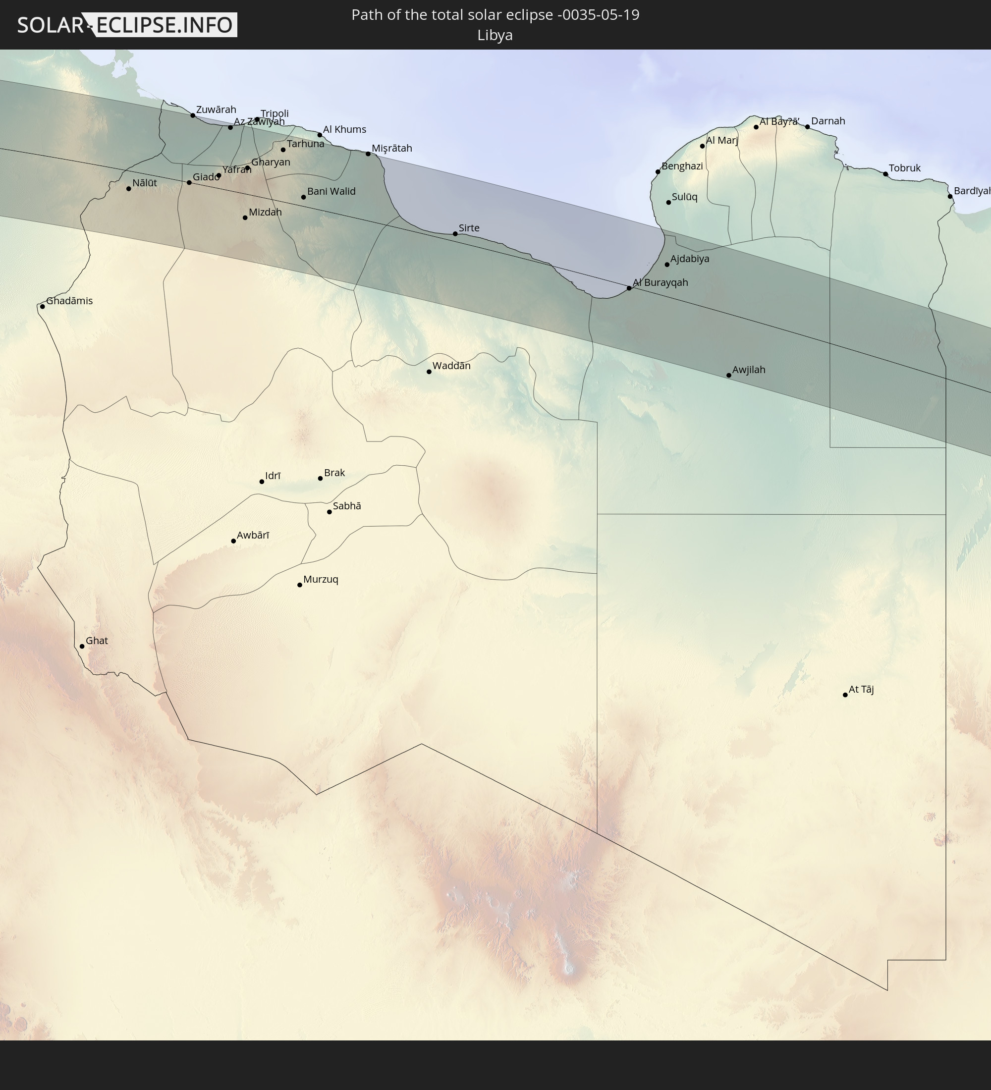 Libyen
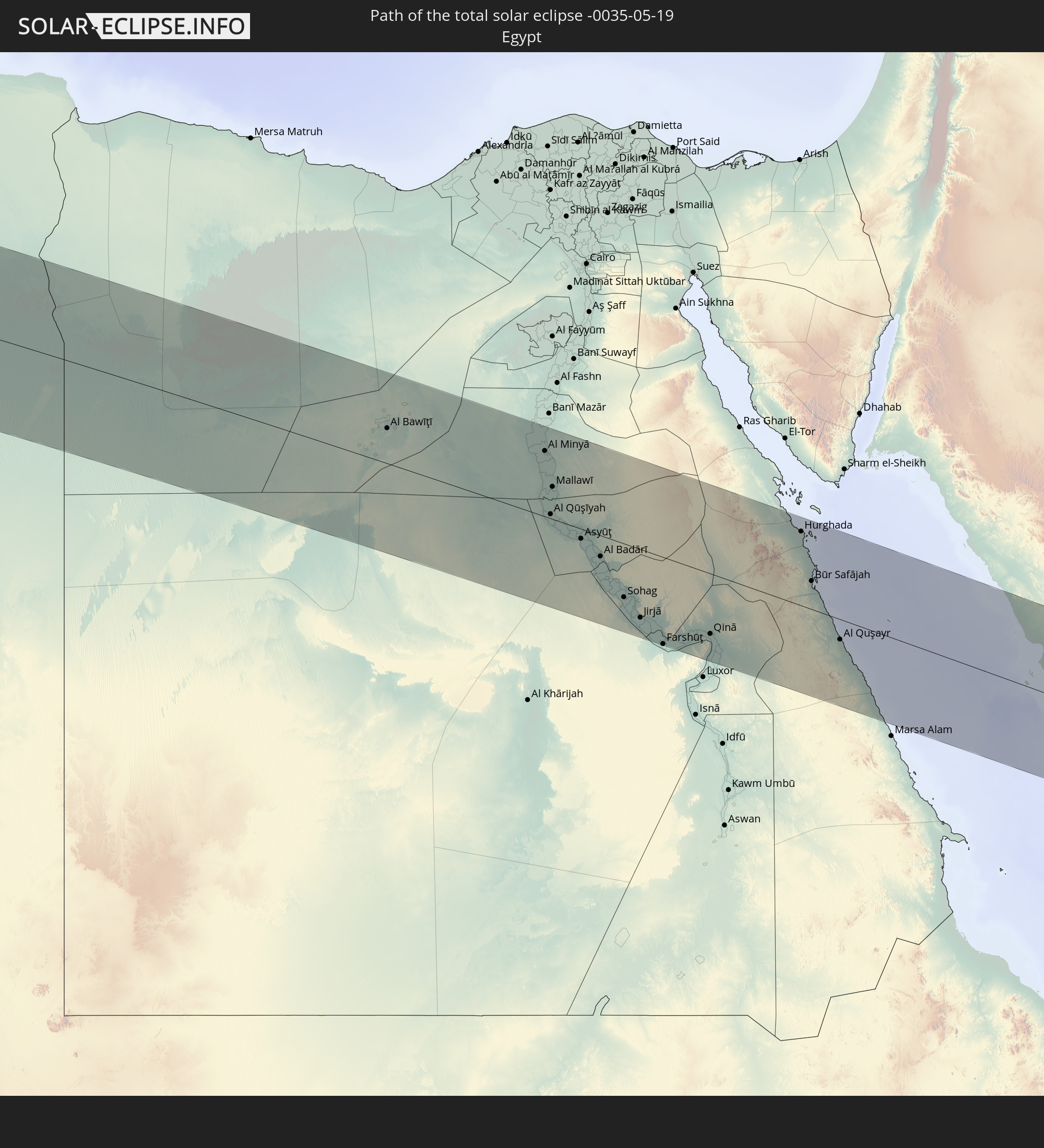 Ägypten
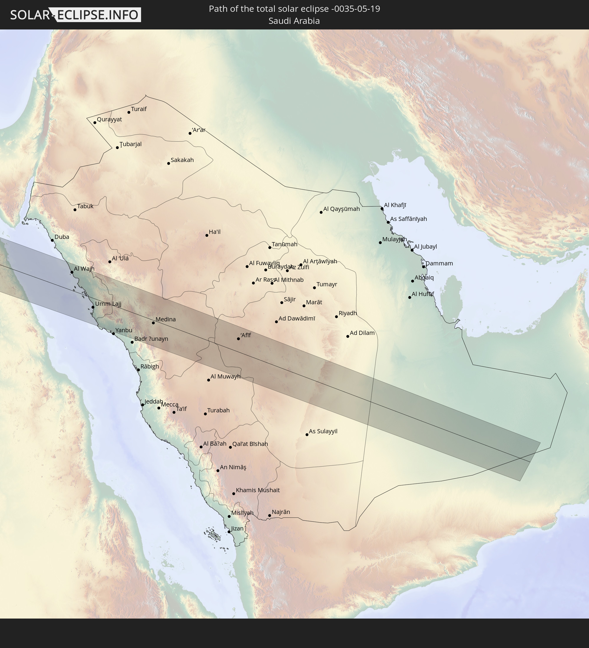 Saudi-Arabien
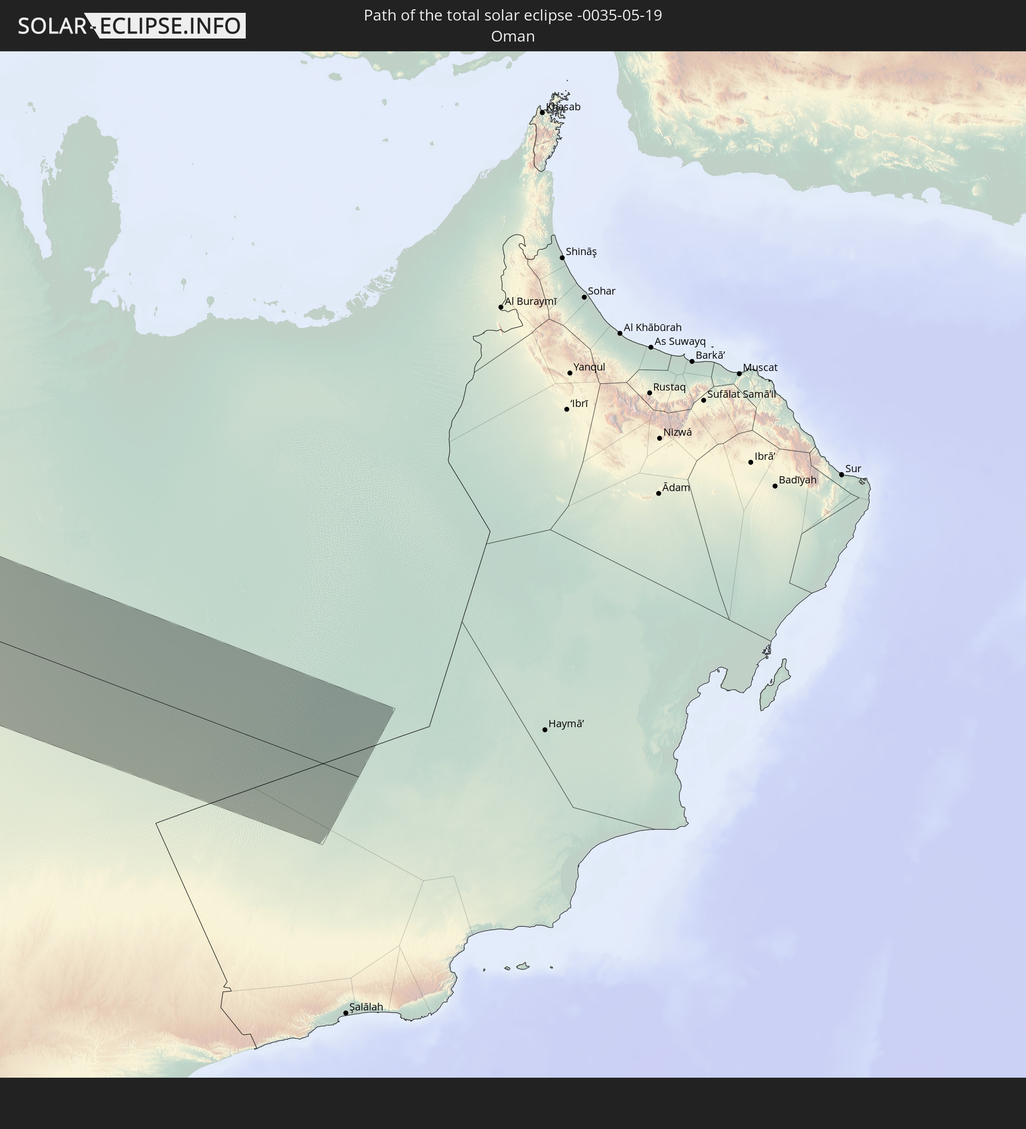 Oman
Oman
In den folgenden Ländern ist die Sonnenfinsternis partiell zu sehen
 Russland
 Vereinigte Staaten
 United States Minor Outlying Islands
 Kanada
 Mexiko
 Chile
Chile
 Grönland
 Guatemala
 Ecuador
 El Salvador
 Honduras
 Belize
 Nicaragua
 Costa Rica
 Kuba
Kuba
 Panama
 Kolumbien
 Kaimaninseln
 Peru
Peru
 Bahamas
 Jamaika
 Haiti
Haiti
 Brasilien
 Argentinien
 Venezuela
 Turks- und Caicosinseln
 Dominikanische Republik
 Aruba
Aruba
 Bolivien
 Puerto Rico
 Amerikanische Jungferninseln
 Bermuda
 Britische Jungferninseln
 Anguilla
 Saint-Martin
 Saint-Barthélemy
 St. Kitts und Nevis
 Paraguay
 Antigua und Barbuda
 Montserrat
 Trinidad und Tobago
 Guadeloupe
 Grenada
 Dominica
 St. Vincent und die Grenadinen
 Guyana
 Martinique
 St. Lucia
 Barbados
 Suriname
 Saint-Pierre und Miquelon
 Französisch-Guayana
 Portugal
 Kap Verde
 Island
 Spanien
 Senegal
 Mauretanien
 Gambia
 Guinea-Bissau
 Guinea
 Sierra Leone
 Marokko
 Mali
Mali
 Liberia
 Irland
 Algerien
 Vereinigtes Königreich
 Elfenbeinküste
 Färöer
 Burkina Faso
 Gibraltar
 Frankreich
 Isle of Man
 Ghana
Ghana
 Guernsey
 Jersey
 Togo
Togo
 Niger
Niger
 Benin
Benin
 Andorra
 Belgien
 Nigeria
 Niederlande
 Norwegen
 Äquatorialguinea
 Luxemburg
 Deutschland
 Schweiz
 São Tomé und Príncipe
 Italien
 Monaco
 Tunesien
 Dänemark
 Kamerun
 Gabun
Gabun
 Libyen
 Liechtenstein
 Österreich
 Schweden
 Republik Kongo
 Tschechien
 Demokratische Republik Kongo
 San Marino
 Vatikanstadt
 Slowenien
 Tschad
 Kroatien
 Polen
Polen
 Malta
Malta
 Zentralafrikanische Republik
 Bosnien und Herzegowina
 Ungarn
 Slowakei
 Montenegro
 Serbien
 Albanien
 Åland Islands
 Griechenland
 Rumänien
 Mazedonien
 Finnland
 Litauen
 Lettland
 Estland
 Sudan
Sudan
 Ukraine
 Bulgarien
 Weißrussland
 Ägypten
 Türkei
 Moldawien
 Ruanda
 Burundi
 Tansania
 Uganda
 Republik Zypern
 Äthiopien
 Kenia
Kenia
 Staat Palästina
 Israel
 Saudi-Arabien
 Jordanien
 Libanon
 Syrien
 Eritrea
 Irak
Irak
 Georgien
 Somalia
 Dschibuti
 Jemen
Jemen
 Armenien
 Iran
Iran
 Aserbaidschan
 Kasachstan
 Kuwait
 Bahrain
 Katar
Katar
 Vereinigte Arabische Emirate
 Oman
Oman
 Turkmenistan
 Usbekistan
 Afghanistan
 Tadschikistan
 Kirgisistan
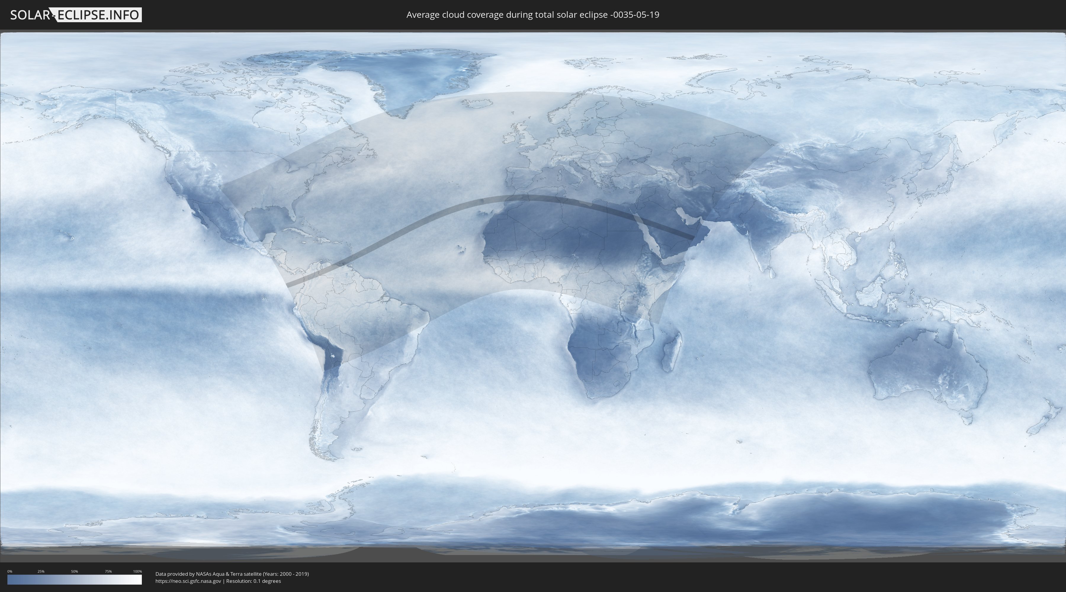
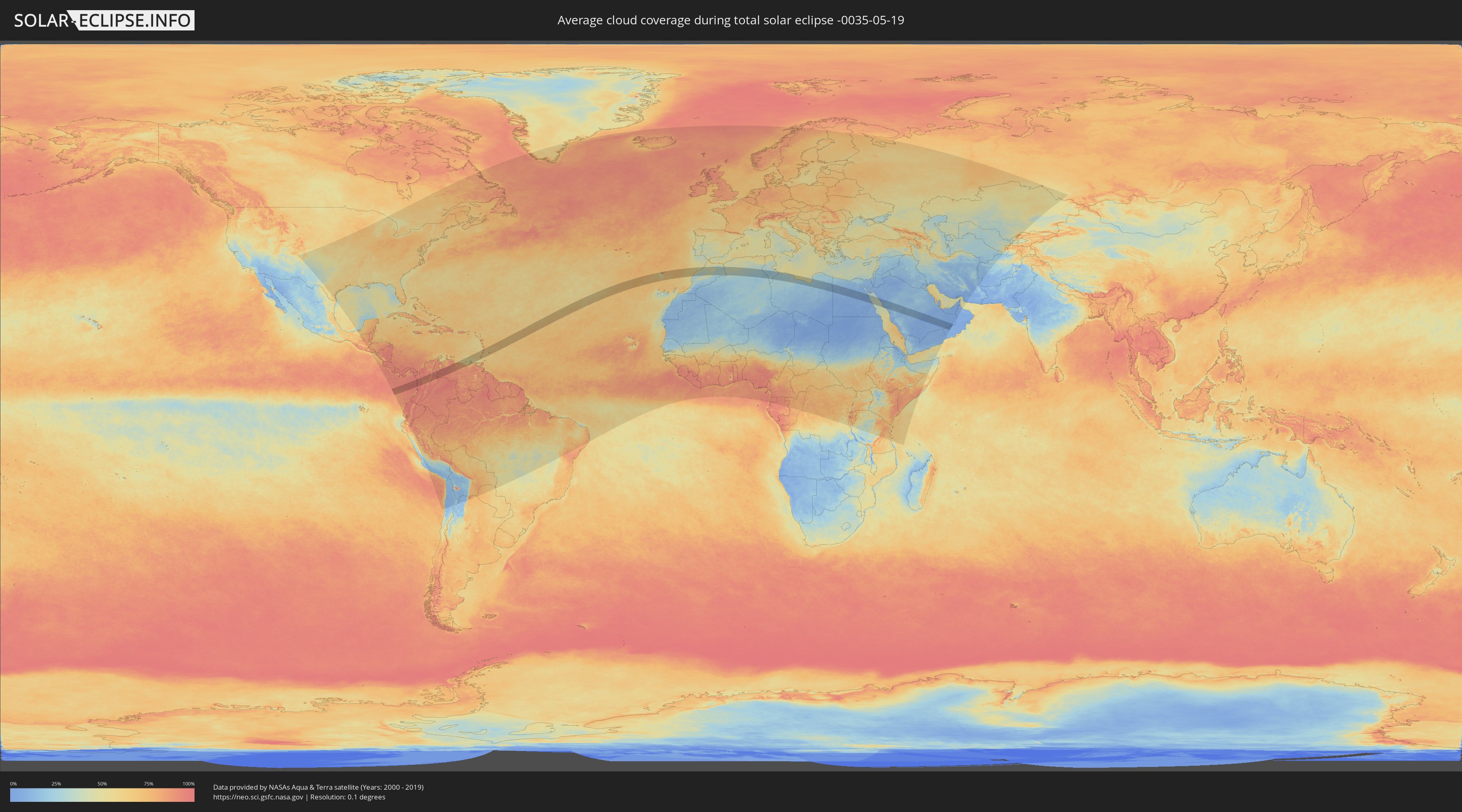
Wie wird das Wetter während der totalen Sonnenfinsternis am 19.05.-0035?
Wo ist der beste Ort, um die totale Sonnenfinsternis vom 19.05.-0035 zu beobachten?
Die folgenden Karten zeigen die durchschnittliche Bewölkung für den Tag, an dem die totale Sonnenfinsternis
stattfindet. Mit Hilfe der Karten lässt sich der Ort entlang des Finsternispfades eingrenzen,
der die besten Aussichen auf einen klaren wolkenfreien Himmel bietet.
Trotzdem muss man immer lokale Gegenenheiten beachten und sollte sich genau über das Wetter an seinem
gewählten Beobachtungsort informieren.
Die Daten stammen von den beiden NASA-Satelliten
AQUA und TERRA
und wurden über einen Zeitraum von 19 Jahren (2000 - 2019) gemittelt.
Detaillierte Länderkarten
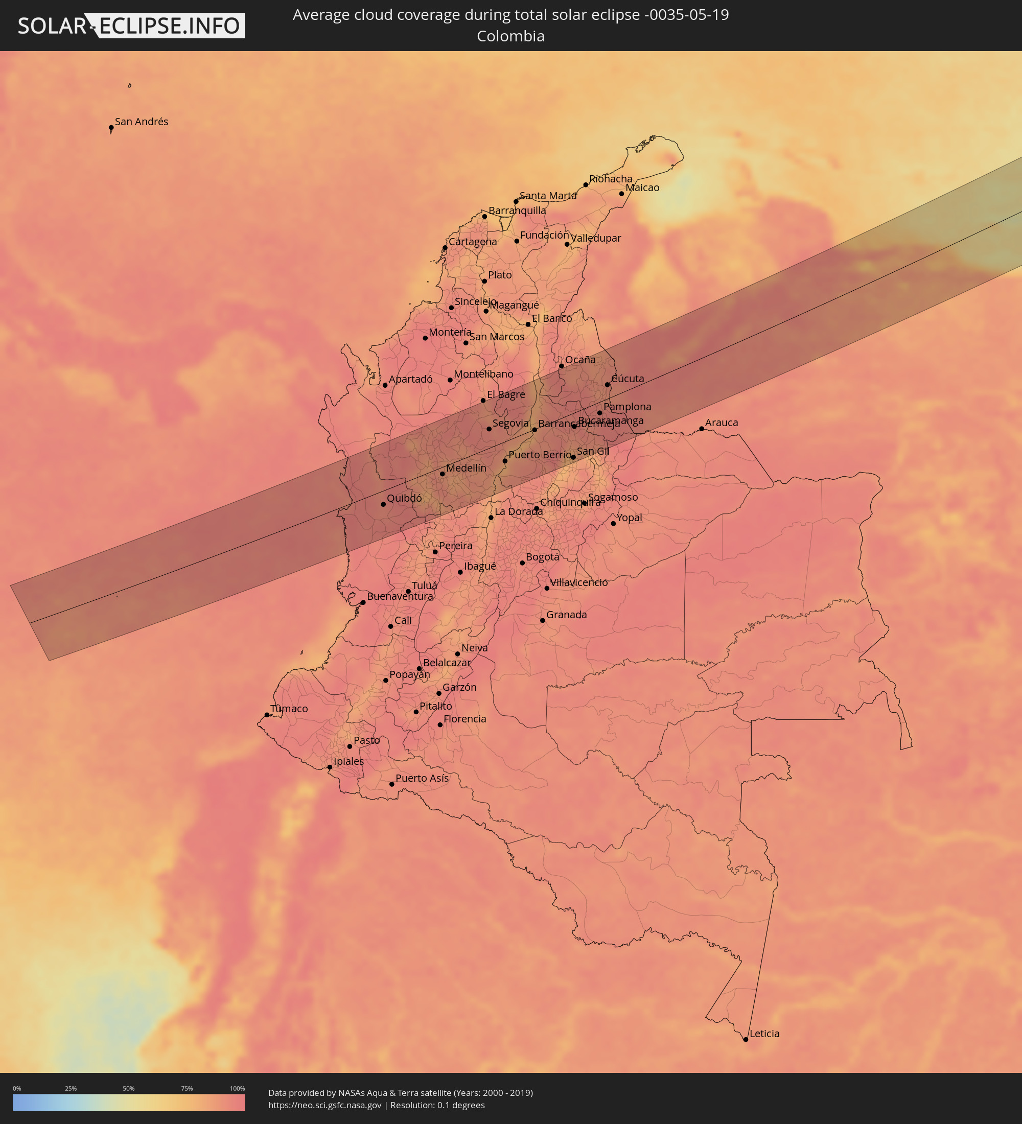 Kolumbien
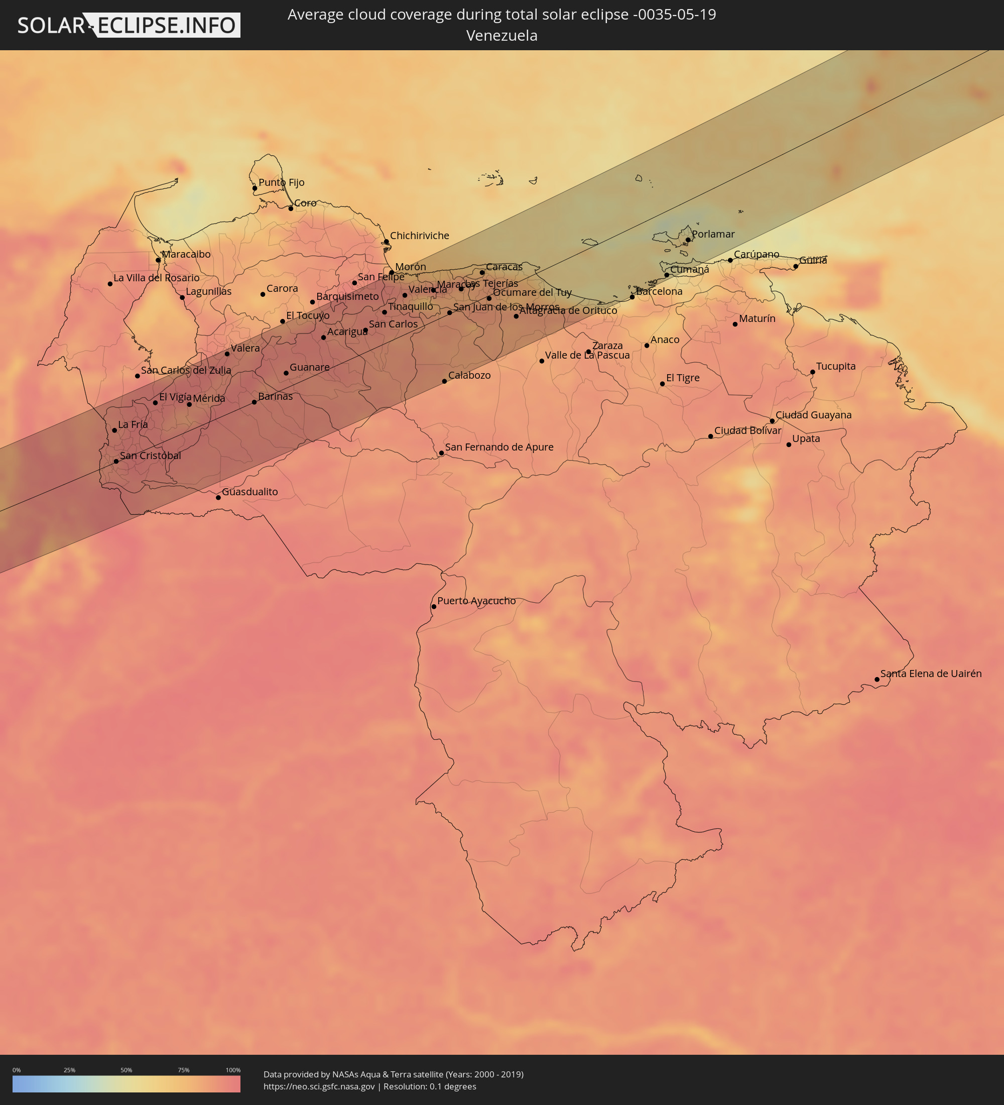 Venezuela
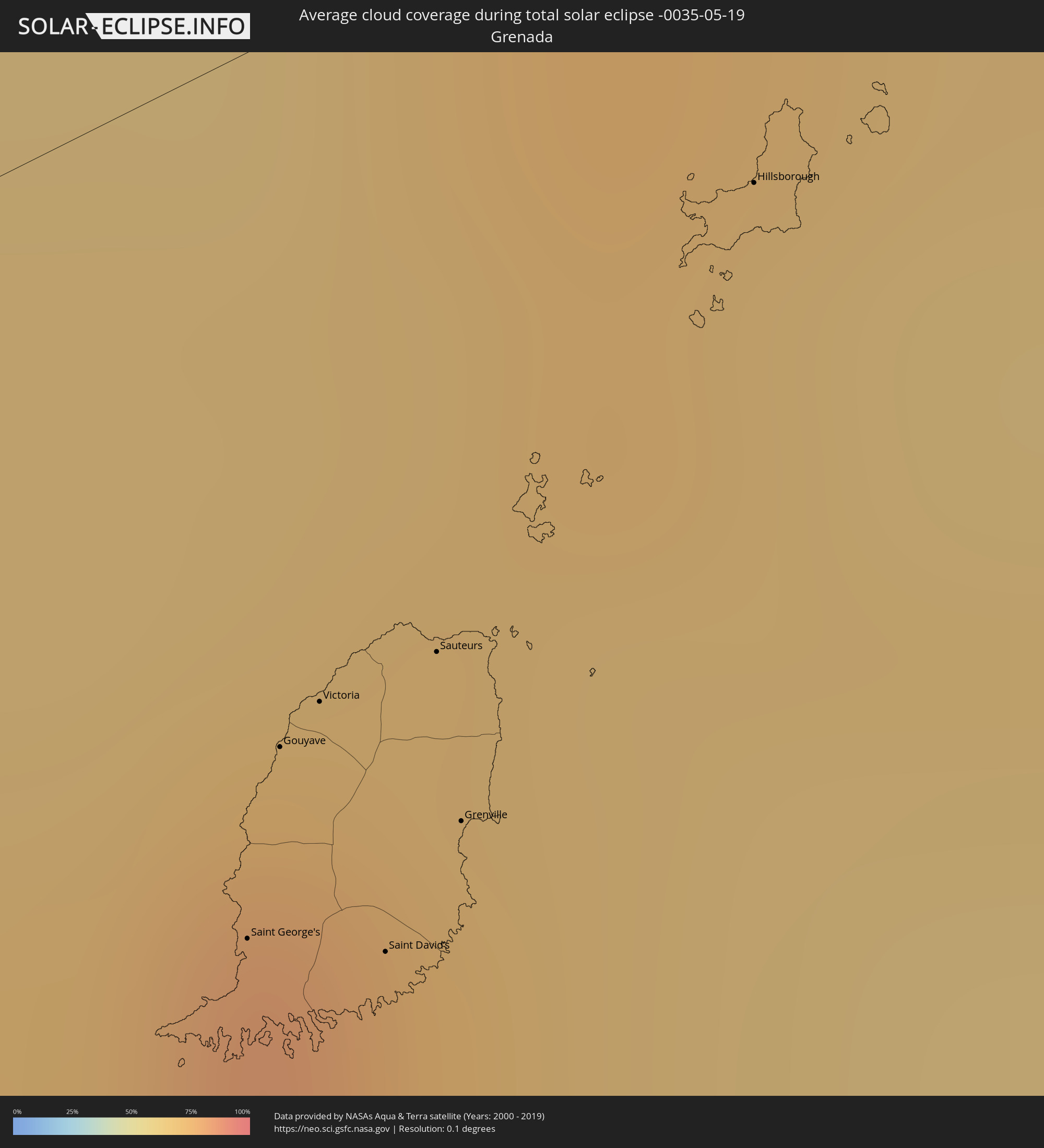 Grenada
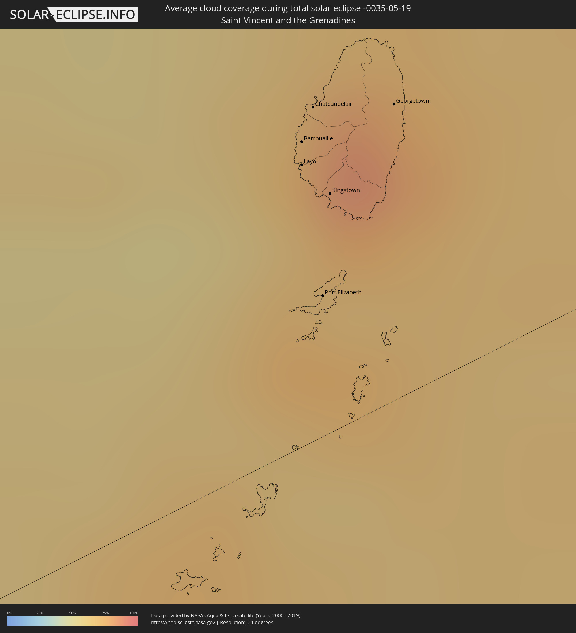 St. Vincent und die Grenadinen
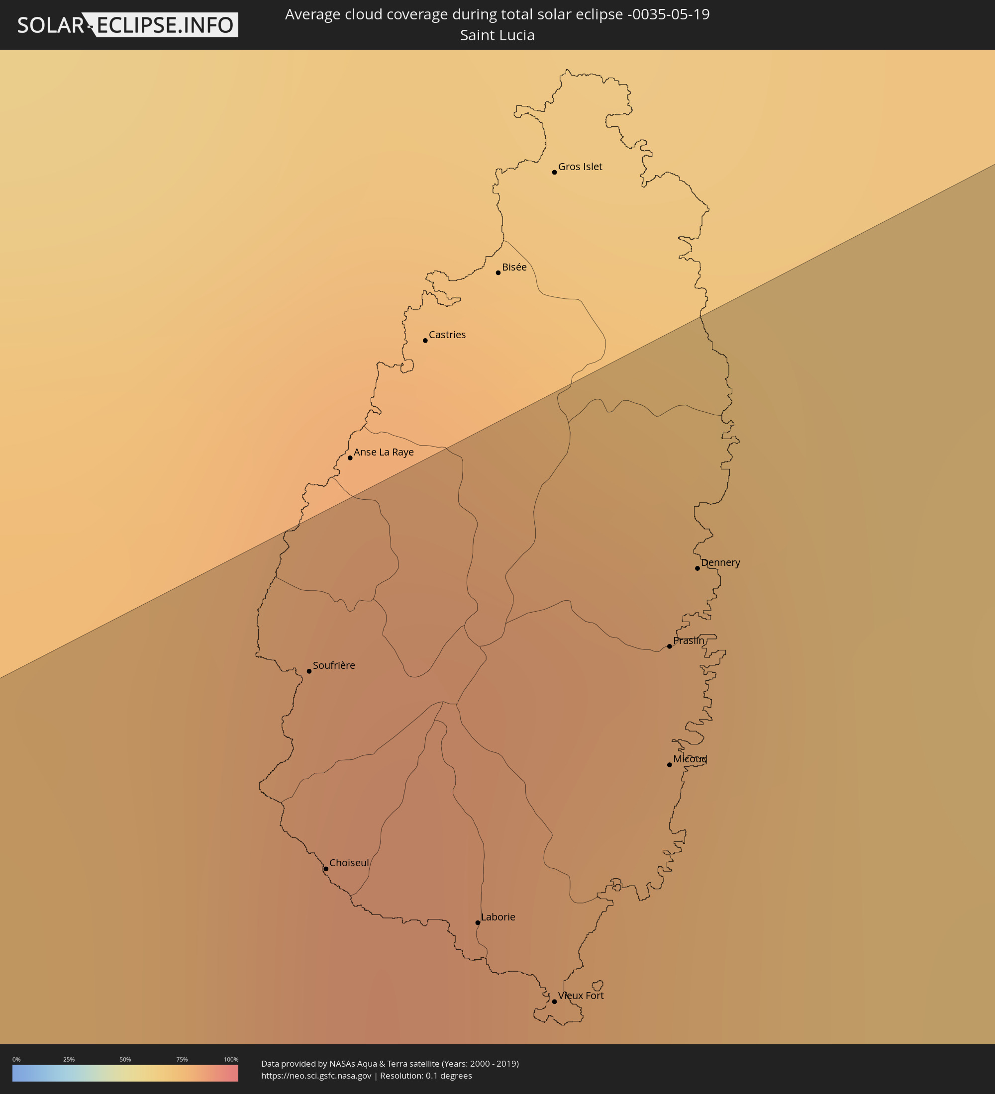 St. Lucia
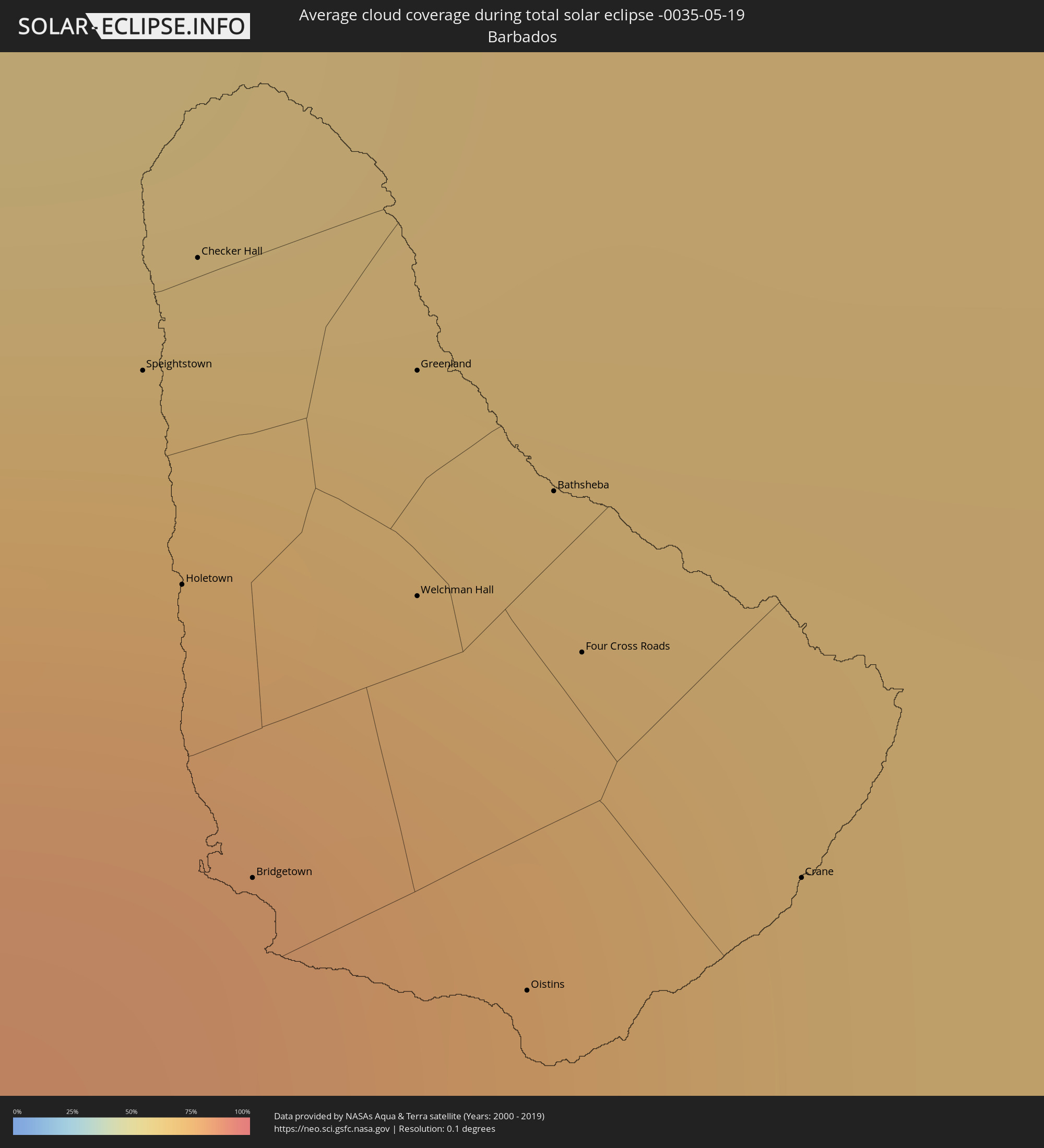 Barbados
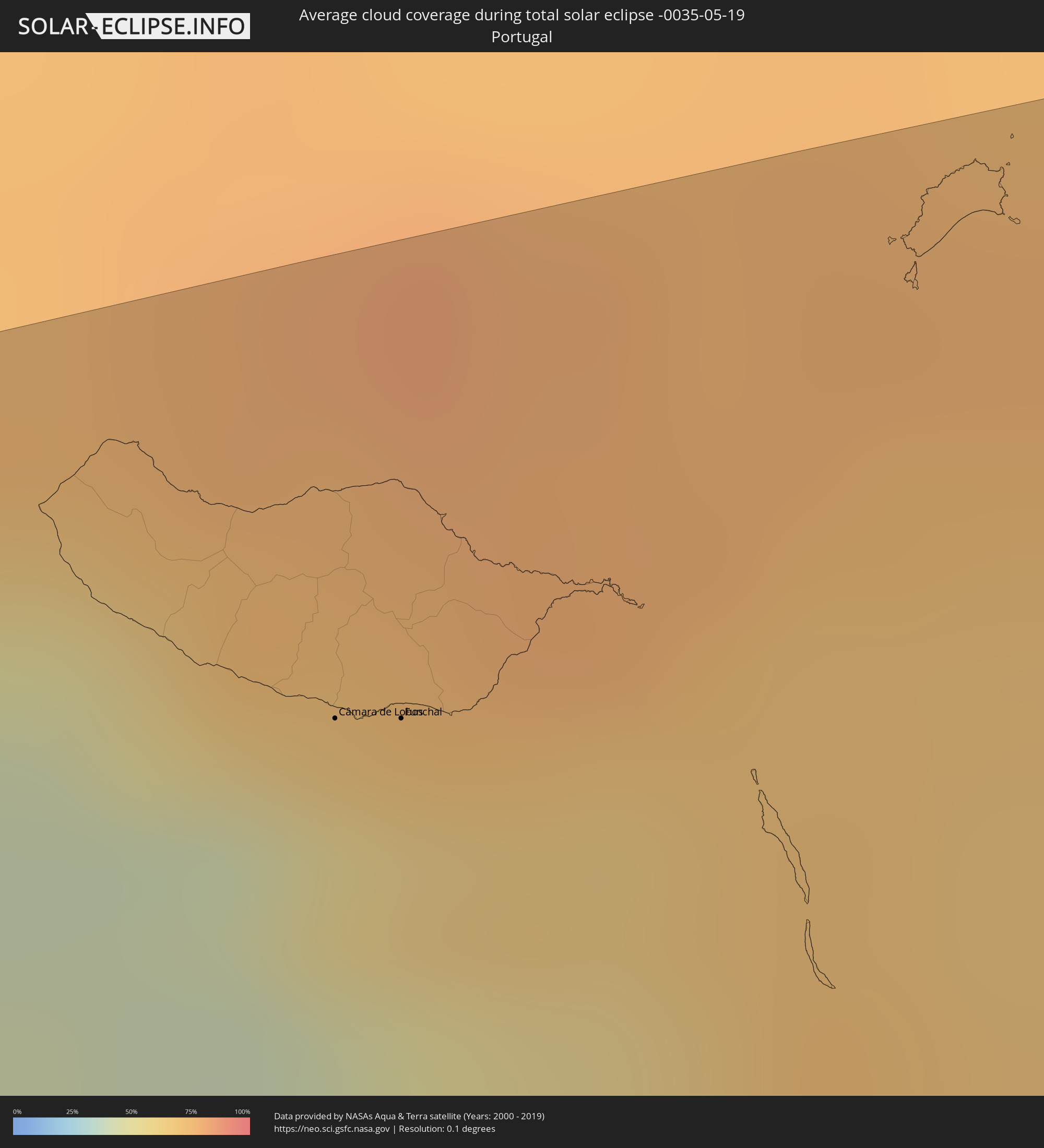 Portugal
 Marokko
 Algerien
 Tunesien
 Libyen
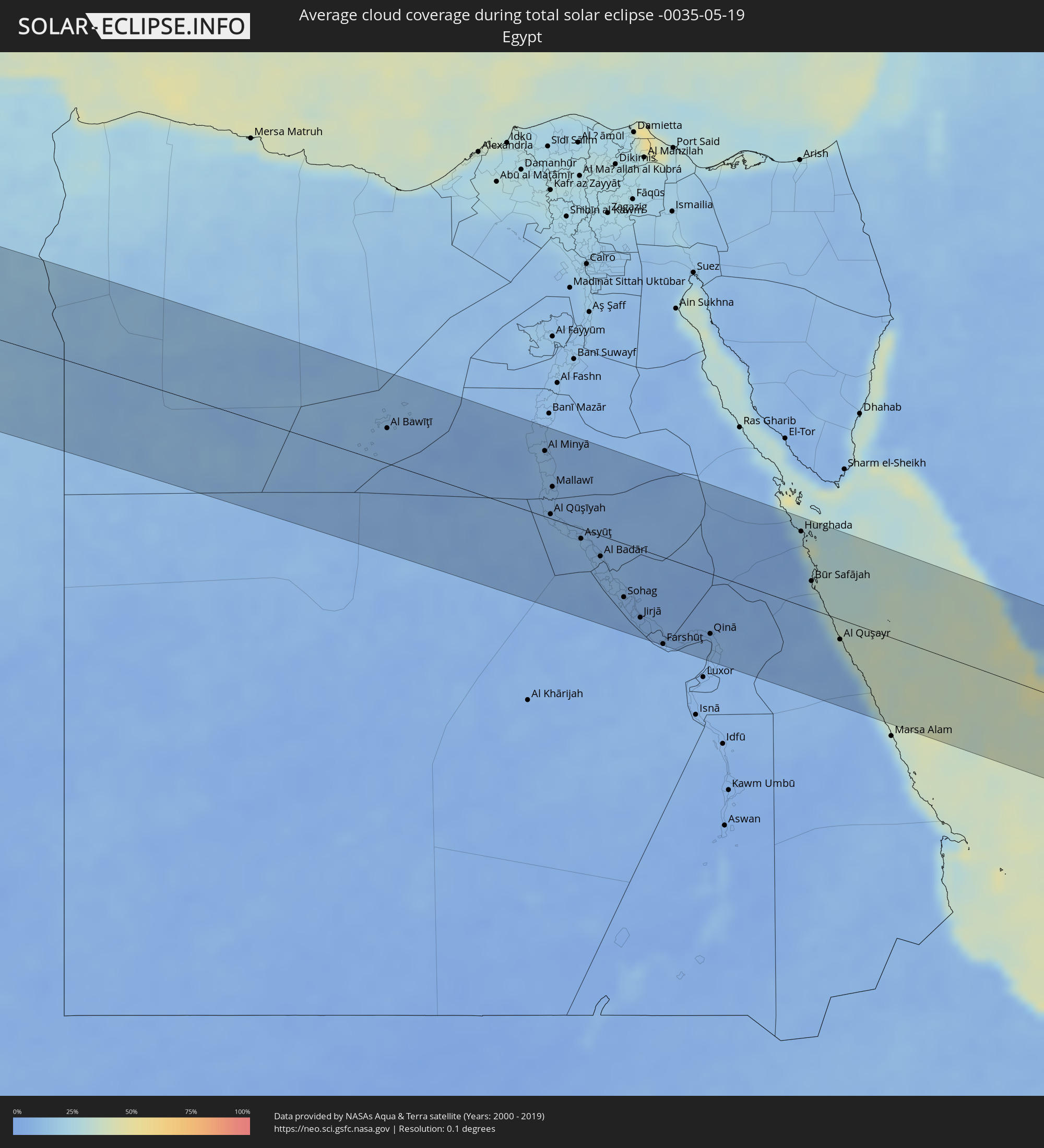 Ägypten
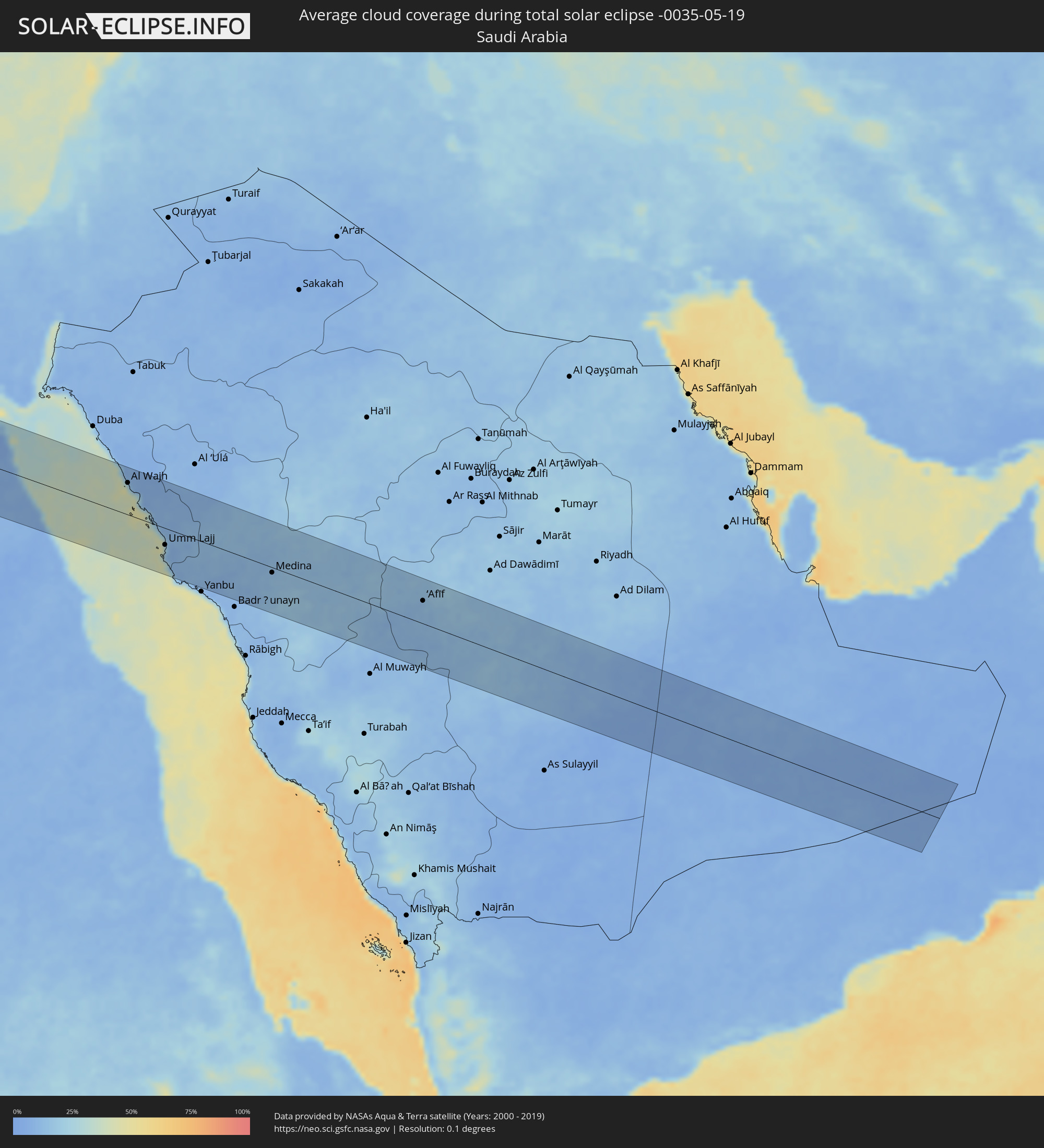 Saudi-Arabien
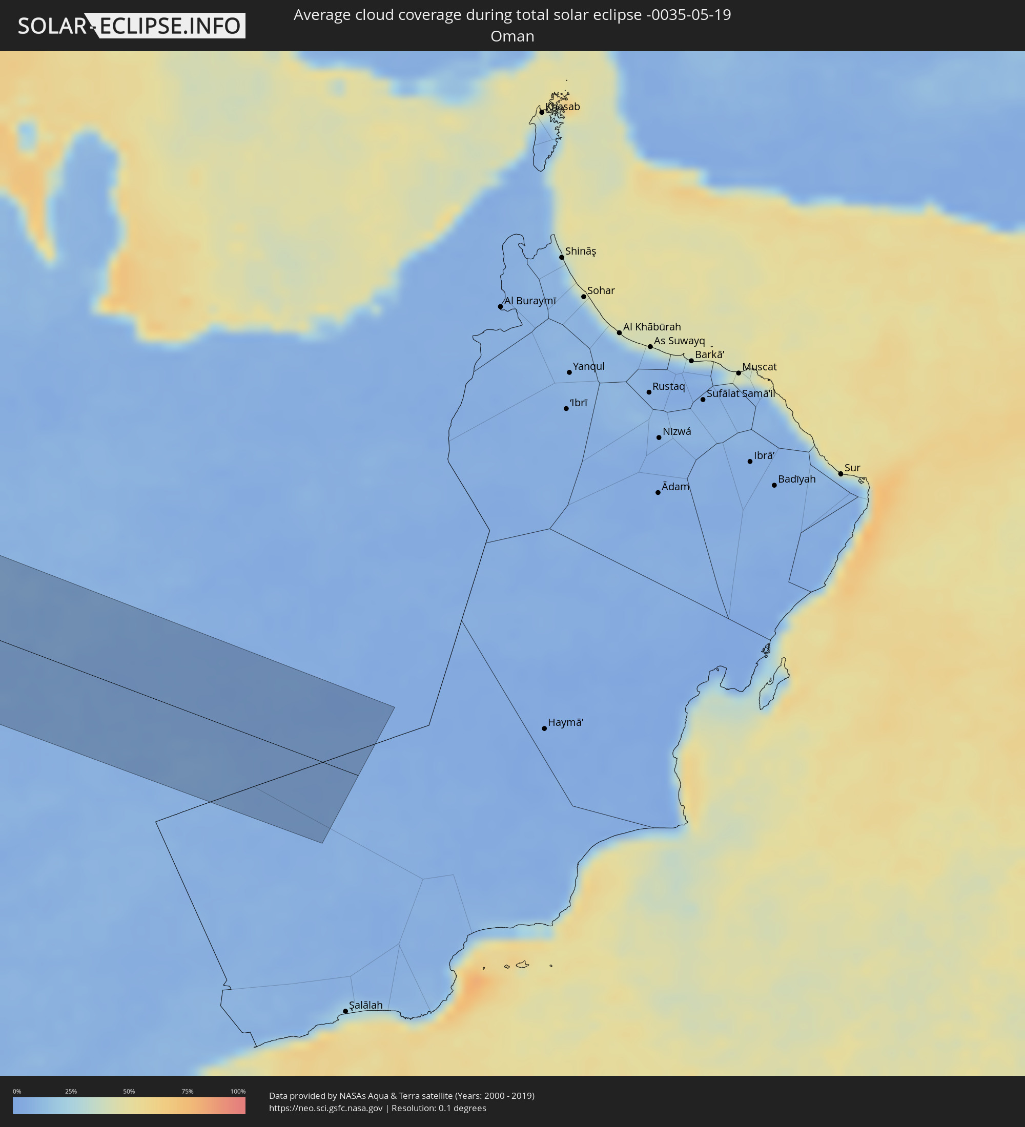 Oman
Oman
Orte im Finsternispfad
Die nachfolgene Tabelle zeigt Städte und Orte mit mehr als 5.000 Einwohnern, die sich im Finsternispfad befinden. Städte mit mehr als 100.000 Einwohnern sind dick gekennzeichnet. Mit einem Klick auf den Ort öffnet sich eine Detailkarte die die Lage des jeweiligen Ortes zusammen mit dem Verlauf der zentralen Finsternis präsentiert.
| Ort | Typ | Dauer der Verfinsterung | Ortszeit bei maximaler Verfinsterung | Entfernung zur Zentrallinie | Ø Bewölkung |
|
Quibdó, Chocó
|
total | - | 06:24:58 UTC-04:56 | 27 km | 92% |
|
Caldas, Antioquia
|
total | - | 06:25:15 UTC-04:56 | 28 km | 92% |
|
Medellín, Antioquia
|
total | - | 06:25:22 UTC-04:56 | 15 km | 87% |
|
Aguadas, Caldas
|
total | - | 06:24:55 UTC-04:56 | 85 km | 90% |
|
La Ceja, Antioquia
|
total | - | 06:25:13 UTC-04:56 | 43 km | 86% |
|
Yarumal, Antioquia
|
total | - | 06:25:53 UTC-04:56 | 53 km | 91% |
|
Rionegro, Antioquia
|
total | - | 06:25:18 UTC-04:56 | 32 km | 82% |
|
Segovia, Antioquia
|
total | - | 06:26:00 UTC-04:56 | 35 km | 94% |
|
Puerto Boyacá, Boyacá
|
total | - | 06:25:12 UTC-04:56 | 84 km | 82% |
|
Puerto Berrío, Antioquia
|
total | - | 06:25:35 UTC-04:56 | 38 km | 78% |
|
Barrancabermeja, Santander
|
total | - | 06:26:03 UTC-04:56 | 2 km | 81% |
|
San Gil, Santander
|
total | - | 06:25:44 UTC-04:56 | 85 km | 81% |
|
Bucaramanga, Santander
|
total | - | 06:26:09 UTC-04:56 | 27 km | 90% |
|
Piedecuesta, Santander
|
total | - | 06:26:04 UTC-04:56 | 45 km | 90% |
|
Pamplona, Norte de Santander
|
total | - | 06:26:24 UTC-04:56 | 22 km | 94% |
|
Cúcuta, Norte de Santander
|
total | - | 06:26:49 UTC-04:56 | 25 km | 91% |
|
San Cristóbal, Táchira
|
total | - | 06:55:22 UTC-04:27 | 1 km | 92% |
|
Mérida, Mérida
|
total | - | 06:56:11 UTC-04:27 | 37 km | 87% |
|
Mucumpiz, Mérida
|
total | - | 06:56:03 UTC-04:27 | 19 km | 94% |
|
Barinas, Barinas
|
total | - | 06:56:24 UTC-04:27 | 2 km | 92% |
|
Acarigua, Portuguesa
|
total | - | 06:57:26 UTC-04:27 | 48 km | 94% |
|
Puerto Cabello, Carabobo
|
total | - | 06:58:34 UTC-04:27 | 88 km | 86% |
|
Valencia, Carabobo
|
total | - | 06:58:17 UTC-04:27 | 56 km | 84% |
|
Guacara, Carabobo
|
total | - | 06:58:23 UTC-04:27 | 56 km | 80% |
|
Maracay, Aragua
|
total | - | 06:58:29 UTC-04:27 | 44 km | 76% |
|
Los Teques, Miranda
|
total | - | 06:58:46 UTC-04:27 | 30 km | 81% |
|
Cúa, Miranda
|
total | - | 06:58:38 UTC-04:27 | 4 km | 84% |
|
Caracas, Capital
|
total | - | 06:58:57 UTC-04:27 | 36 km | 80% |
|
Santa Teresa, Miranda
|
total | - | 06:58:47 UTC-04:27 | 1 km | 82% |
|
Guatire, Miranda
|
total | - | 06:59:03 UTC-04:27 | 20 km | 80% |
|
Puerto La Cruz, Anzoátegui
|
total | - | 06:59:33 UTC-04:27 | 97 km | 79% |
|
Cumaná, Sucre
|
total | - | 06:59:57 UTC-04:27 | 93 km | 63% |
|
Saint George's, Saint George
|
total | - | 07:24:20 UTC-04:06 | 50 km | 77% |
|
Gouyave, Saint John
|
total | - | 07:24:27 UTC-04:06 | 40 km | 81% |
|
Victoria, Saint Mark
|
total | - | 07:24:29 UTC-04:06 | 39 km | 81% |
|
Saint David’s, Saint David
|
total | - | 07:24:22 UTC-04:06 | 54 km | 69% |
|
Sauteurs, Saint Patrick
|
total | - | 07:24:33 UTC-04:06 | 39 km | 72% |
|
Grenville, Saint Andrew
|
total | - | 07:24:28 UTC-04:06 | 49 km | 70% |
|
Hillsborough, Carriacou and Petite Martinique
|
total | - | 07:24:56 UTC-04:06 | 22 km | 70% |
|
Layou, Saint Andrew
|
total | - | 07:25:48 UTC-04:06 | 40 km | 65% |
|
Barrouallie, Saint Patrick
|
total | - | 07:25:50 UTC-04:06 | 44 km | 65% |
|
Chateaubelair, Saint David
|
total | - | 07:25:54 UTC-04:06 | 48 km | 71% |
|
Port Elizabeth, Grenadines
|
total | - | 07:25:37 UTC-04:06 | 20 km | 73% |
|
Kingstown Park, Saint George
|
total | - | 07:25:46 UTC-04:06 | 35 km | 76% |
|
Kingstown, Saint George
|
total | - | 07:25:47 UTC-04:06 | 34 km | 76% |
|
Georgetown, Charlotte
|
total | - | 07:25:58 UTC-04:06 | 43 km | 78% |
|
Soufrière, Soufrière
|
total | - | 07:26:38 UTC-04:06 | 95 km | 75% |
|
Choiseul, Choiseul Quarter
|
total | - | 07:26:33 UTC-04:06 | 87 km | 76% |
|
Laborie, Laborie Quarter
|
total | - | 07:26:33 UTC-04:06 | 81 km | 76% |
|
Vieux Fort, Vieux-Fort
|
total | - | 07:26:32 UTC-04:06 | 76 km | 68% |
|
Micoud, Micoud Quarter
|
total | - | 07:26:41 UTC-04:06 | 84 km | 73% |
|
Praslin, Praslin
|
total | - | 07:26:44 UTC-04:06 | 89 km | 78% |
|
Dennery, Dennery Quarter
|
total | - | 07:26:47 UTC-04:06 | 91 km | 78% |
|
Speightstown, Saint Peter
|
total | - | 07:34:25 UTC-03:58 | 34 km | 76% |
|
Holetown, Saint James
|
total | - | 07:34:21 UTC-03:58 | 41 km | 81% |
|
Checker Hall, Saint Lucy
|
total | - | 07:34:28 UTC-03:58 | 32 km | 73% |
|
Bridgetown, Saint Michael
|
total | - | 07:34:17 UTC-03:58 | 51 km | 70% |
|
Greenland, Saint Andrew
|
total | - | 07:34:28 UTC-03:58 | 38 km | 73% |
|
Welchman Hall, Saint Thomas
|
total | - | 07:34:24 UTC-03:58 | 45 km | 81% |
|
Oistins, Christ Church
|
total | - | 07:34:18 UTC-03:58 | 58 km | 70% |
|
Bathsheba, Saint Joseph
|
total | - | 07:34:28 UTC-03:58 | 44 km | 76% |
|
Four Cross Roads, Saint John
|
total | - | 07:34:25 UTC-03:58 | 49 km | 76% |
|
Crane, Saint Philip
|
total | - | 07:34:23 UTC-03:58 | 59 km | 70% |
|
Ribeira Brava, Madeira
|
total | - | 13:09:03 UTC+00:00 | 74 km | 61% |
|
São Vicente, Madeira
|
total | - | 12:32:27 UTC-00:36 | 89 km | 74% |
|
Câmara de Lobos, Madeira
|
total | - | 13:09:17 UTC+00:00 | 70 km | 56% |
|
Nossa Senhora do Monte, Madeira
|
total | - | 12:32:43 UTC-00:36 | 72 km | 72% |
|
Funchal, Madeira
|
total | - | 13:09:26 UTC+00:00 | 69 km | 61% |
|
Santana, Madeira
|
total | - | 12:32:50 UTC-00:36 | 86 km | 75% |
|
Caniço, Madeira
|
total | - | 12:32:49 UTC-00:36 | 68 km | 61% |
|
Camacha, Madeira
|
total | - | 12:32:51 UTC-00:36 | 72 km | 72% |
|
Santa Cruz, Madeira
|
total | - | 12:32:57 UTC-00:36 | 72 km | 72% |
|
Machico, Madeira
|
total | - | 12:33:03 UTC-00:36 | 73 km | 72% |
|
Camacha, Madeira
|
total | - | 12:34:16 UTC-00:36 | 107 km | 76% |
|
Safi, Doukkala-Abda
|
total | - | 12:57:24 UTC-00:30 | 83 km | 39% |
|
El Jadida, Doukkala-Abda
|
total | - | 12:59:12 UTC-00:30 | 16 km | 47% |
|
Settat, Chaouia-Ouardigha
|
total | - | 13:01:15 UTC-00:30 | 18 km | 38% |
|
Casablanca, Grand Casablanca
|
total | - | 13:01:16 UTC-00:30 | 47 km | 42% |
|
Berrechid, Chaouia-Ouardigha
|
total | - | 13:01:19 UTC-00:30 | 11 km | 42% |
|
Mohammedia, Grand Casablanca
|
total | - | 13:01:47 UTC-00:30 | 56 km | 43% |
|
Khouribga, Chaouia-Ouardigha
|
total | - | 13:02:53 UTC-00:30 | 36 km | 37% |
|
Rabat, Rabat-Salé-Zemmour-Zaër
|
total | - | 13:03:01 UTC-00:30 | 89 km | 41% |
|
Fkih Ben Salah, Tadla-Azilal
|
total | - | 13:03:23 UTC-00:30 | 80 km | 37% |
|
Oued Zem, Chaouia-Ouardigha
|
total | - | 13:03:39 UTC-00:30 | 40 km | 37% |
|
Beni Mellal, Tadla-Azilal
|
total | - | 13:04:11 UTC-00:30 | 99 km | 39% |
|
Khemisset, Rabat-Salé-Zemmour-Zaër
|
total | - | 13:04:44 UTC-00:30 | 65 km | 41% |
|
Sidi Qacem, Gharb-Chrarda-Beni Hssen
|
total | - | 13:05:29 UTC-00:30 | 107 km | 43% |
|
Meknès, Meknès-Tafilalet
|
total | - | 13:05:53 UTC-00:30 | 70 km | 39% |
|
Fes, Fès-Boulemane
|
total | - | 13:07:03 UTC-00:30 | 84 km | 40% |
|
Taza, Taza-Al Hoceima-Taounate
|
total | - | 13:09:10 UTC-00:30 | 102 km | 39% |
|
Aïn Sefra, Naama
|
total | - | 13:56:31 UTC+00:09 | 57 km | 38% |
|
El Abiodh Sidi Cheikh, El Bayadh
|
total | - | 13:58:47 UTC+00:09 | 36 km | 33% |
|
El Bayadh, El Bayadh
|
total | - | 13:59:24 UTC+00:09 | 54 km | 42% |
|
Aflou, Laghouat
|
total | - | 14:01:19 UTC+00:09 | 109 km | 43% |
|
Laghouat, Laghouat
|
total | - | 14:02:55 UTC+00:09 | 79 km | 36% |
|
Metlili Chaamba, Ghardaia
|
total | - | 14:05:11 UTC+00:09 | 84 km | 28% |
|
Ghardaïa, Ghardaia
|
total | - | 14:05:09 UTC+00:09 | 59 km | 29% |
|
Berriane, Ghardaia
|
total | - | 14:05:09 UTC+00:09 | 21 km | 29% |
|
Ouargla, Ouargla
|
total | - | 14:08:33 UTC+00:09 | 102 km | 24% |
|
El Hadjira, Ouargla
|
total | - | 14:08:30 UTC+00:09 | 26 km | 26% |
|
Djamaa, Ouargla
|
total | - | 14:08:47 UTC+00:09 | 81 km | 32% |
|
Touggourt, Ouargla
|
total | - | 14:09:10 UTC+00:09 | 34 km | 31% |
|
Tebesbest, Ouargla
|
total | - | 14:09:13 UTC+00:09 | 36 km | 31% |
|
Reguiba, El Oued
|
total | - | 14:10:00 UTC+00:09 | 93 km | 30% |
|
El Oued, El Oued
|
total | - | 14:10:25 UTC+00:09 | 72 km | 28% |
|
Debila, El Oued
|
total | - | 14:10:28 UTC+00:09 | 91 km | 27% |
|
Tataouine, Tataouine
|
total | - | 14:16:36 UTC+00:09 | 78 km | 27% |
|
Nālūt, Sha‘bīyat Nālūt
|
total | - | 15:01:37 UTC+00:52 | 30 km | 25% |
|
Zuwārah, An Nuqāţ al Khams
|
total | - | 15:02:27 UTC+00:52 | 106 km | 32% |
|
Zintan, Jabal al Gharbi District
|
total | - | 15:03:30 UTC+00:52 | 0 km | 26% |
|
Şabrātah, Az Zāwiyah
|
total | - | 15:03:10 UTC+00:52 | 99 km | 34% |
|
Yafran, Jabal al Gharbi District
|
total | - | 15:03:48 UTC+00:52 | 20 km | 29% |
|
Şurmān, Az Zāwiyah
|
total | - | 15:03:19 UTC+00:52 | 96 km | 37% |
|
Az Zāwīyah, Az Zāwiyah
|
total | - | 15:03:32 UTC+00:52 | 99 km | 39% |
|
Mizdah, Jabal al Gharbi District
|
total | - | 15:04:57 UTC+00:52 | 39 km | 26% |
|
Gharyan, Jabal al Gharbi District
|
total | - | 15:04:26 UTC+00:52 | 41 km | 31% |
|
Tarhuna, Al Marqab
|
total | - | 15:05:05 UTC+00:52 | 82 km | 30% |
|
Bani Walid, Mişrātah
|
total | - | 15:06:09 UTC+00:52 | 14 km | 28% |
|
Zliten, Mişrātah
|
total | - | 15:06:21 UTC+00:52 | 104 km | 38% |
|
Mişrātah, Mişrātah
|
total | - | 15:07:08 UTC+00:52 | 105 km | 40% |
|
Sirte, Surt
|
total | - | 15:10:05 UTC+00:52 | 11 km | 29% |
|
Az Zuwaytīnah, Sha‘bīyat al Wāḩāt
|
total | - | 15:14:30 UTC+00:52 | 69 km | 39% |
|
Ajdabiya, Sha‘bīyat al Wāḩāt
|
total | - | 15:14:47 UTC+00:52 | 50 km | 26% |
|
Samālūţ, Minya
|
total | - | 16:33:14 UTC+02:00 | 93 km | 10% |
|
Al Minyā, Minya
|
total | - | 16:33:26 UTC+02:00 | 73 km | 11% |
|
Al Qūşīyah, Asyut
|
total | - | 16:34:04 UTC+02:00 | 5 km | 9% |
|
Abū Qurqāş, Minya
|
total | - | 16:33:39 UTC+02:00 | 57 km | 10% |
|
Mallawī, Minya
|
total | - | 16:33:50 UTC+02:00 | 36 km | 10% |
|
Manfalūţ, Asyut
|
total | - | 16:34:17 UTC+02:00 | 4 km | 9% |
|
Asyūţ, Asyut
|
total | - | 16:34:31 UTC+02:00 | 11 km | 9% |
|
Abū Tīj, Asyut
|
total | - | 16:34:43 UTC+02:00 | 21 km | 9% |
|
Ţahţā, Sohag
|
total | - | 16:35:04 UTC+02:00 | 44 km | 10% |
|
Sohag, Sohag
|
total | - | 16:35:21 UTC+02:00 | 60 km | 8% |
|
Al Manshāh, Sohag
|
total | - | 16:35:29 UTC+02:00 | 65 km | 7% |
|
Jirjā, Sohag
|
total | - | 16:35:39 UTC+02:00 | 77 km | 6% |
|
Dishnā, Qena
|
total | - | 16:36:10 UTC+02:00 | 80 km | 8% |
|
Qinā, Qena
|
total | - | 16:36:16 UTC+02:00 | 68 km | 7% |
|
Kousa, Qena
|
total | - | 16:36:30 UTC+02:00 | 93 km | 8% |
|
Hurghada, Red Sea
|
total | - | 16:35:54 UTC+02:00 | 83 km | 17% |
|
Al Wajh, Tabuk
|
total | - | 17:44:47 UTC+03:06 | 66 km | 28% |
|
Umm Lajj, Tabuk
|
total | - | 17:46:06 UTC+03:06 | 35 km | 20% |
|
Sulţānah, Al Madīnah al Munawwarah
|
total | - | 17:47:14 UTC+03:06 | 9 km | 13% |
|
Medina, Al Madīnah al Munawwarah
|
total | - | 17:47:16 UTC+03:06 | 11 km | 13% |
|
‘Afīf, Ar Riyāḑ
|
total | - | 17:48:23 UTC+03:06 | 48 km | 12% |