Totale Sonnenfinsternis vom 18.05.-0081
| Wochentag: | Samstag |
| Maximale Dauer der Verfinsterung: | 04m52s |
| Maximale Breite des Finsternispfades: | 253 km |
| Saroszyklus: | 75 |
| Bedeckungsgrad: | 100% |
| Magnitude: | 1.0674 |
| Gamma: | 0.4964 |
Wo kann man die Sonnenfinsternis vom 18.05.-0081 sehen?
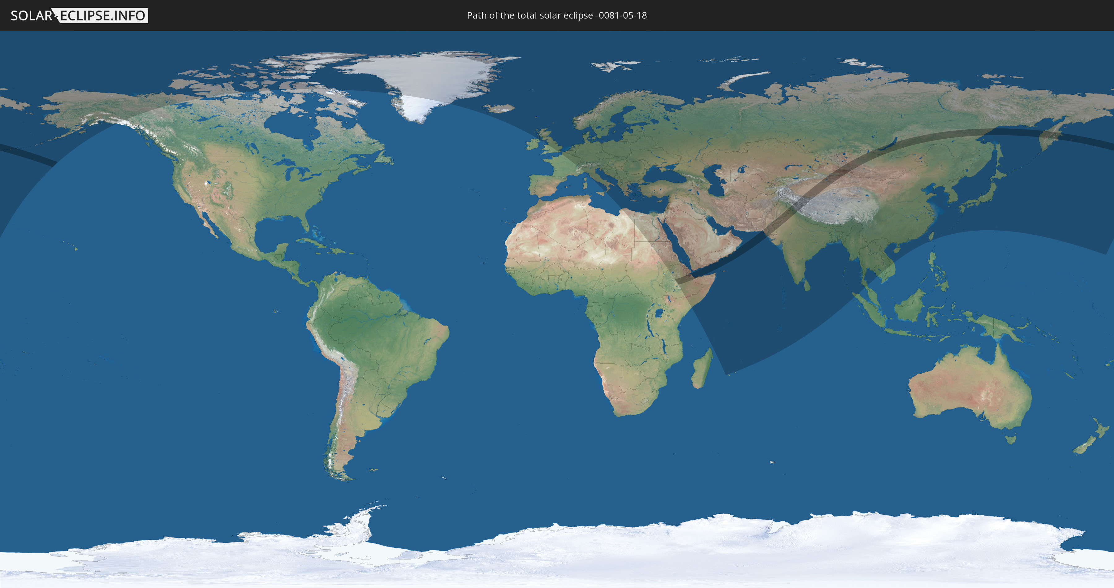
Die Sonnenfinsternis am 18.05.-0081 kann man in 104 Ländern als partielle Sonnenfinsternis beobachten.
Der Finsternispfad verläuft durch 11 Länder. Nur in diesen Ländern ist sie als totale Sonnenfinsternis zu sehen.
In den folgenden Ländern ist die Sonnenfinsternis total zu sehen
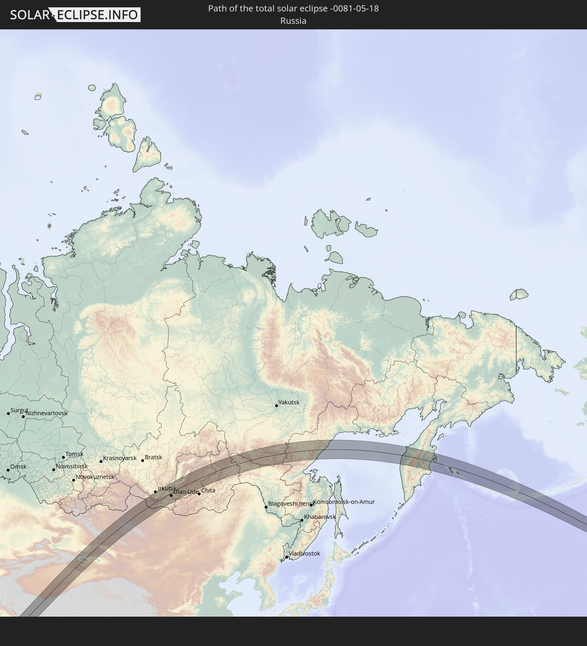 Russland
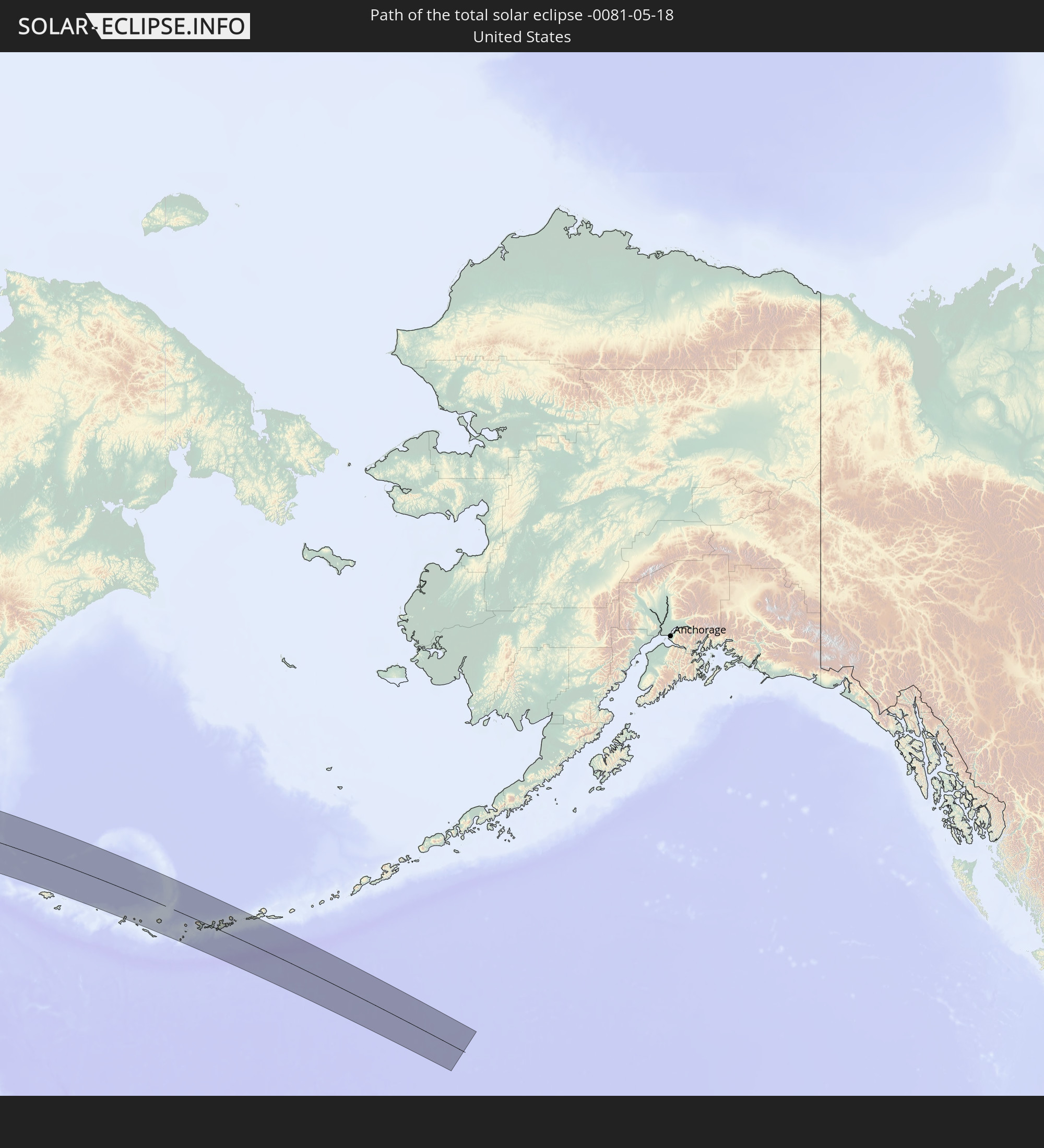 Vereinigte Staaten
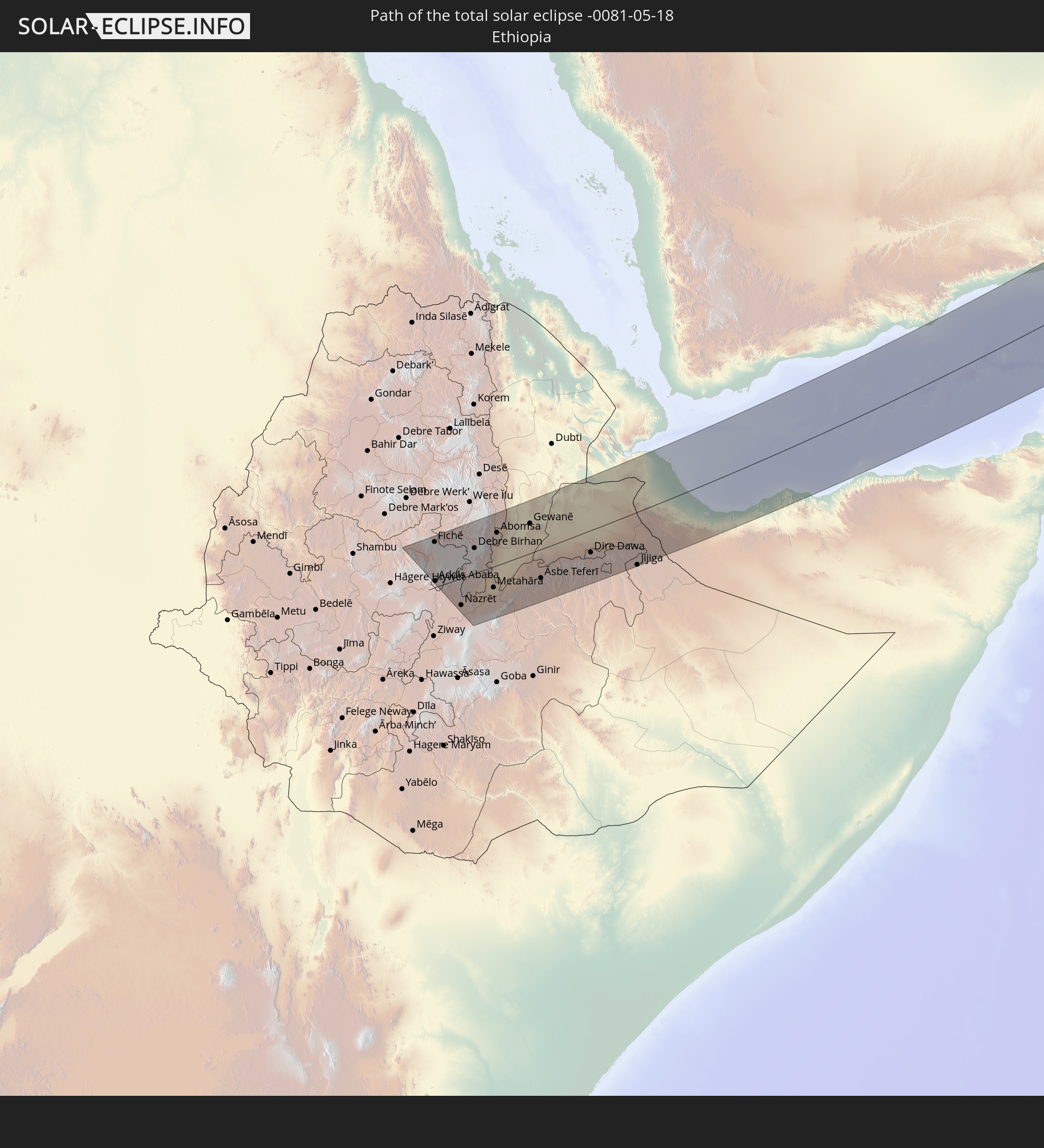 Äthiopien
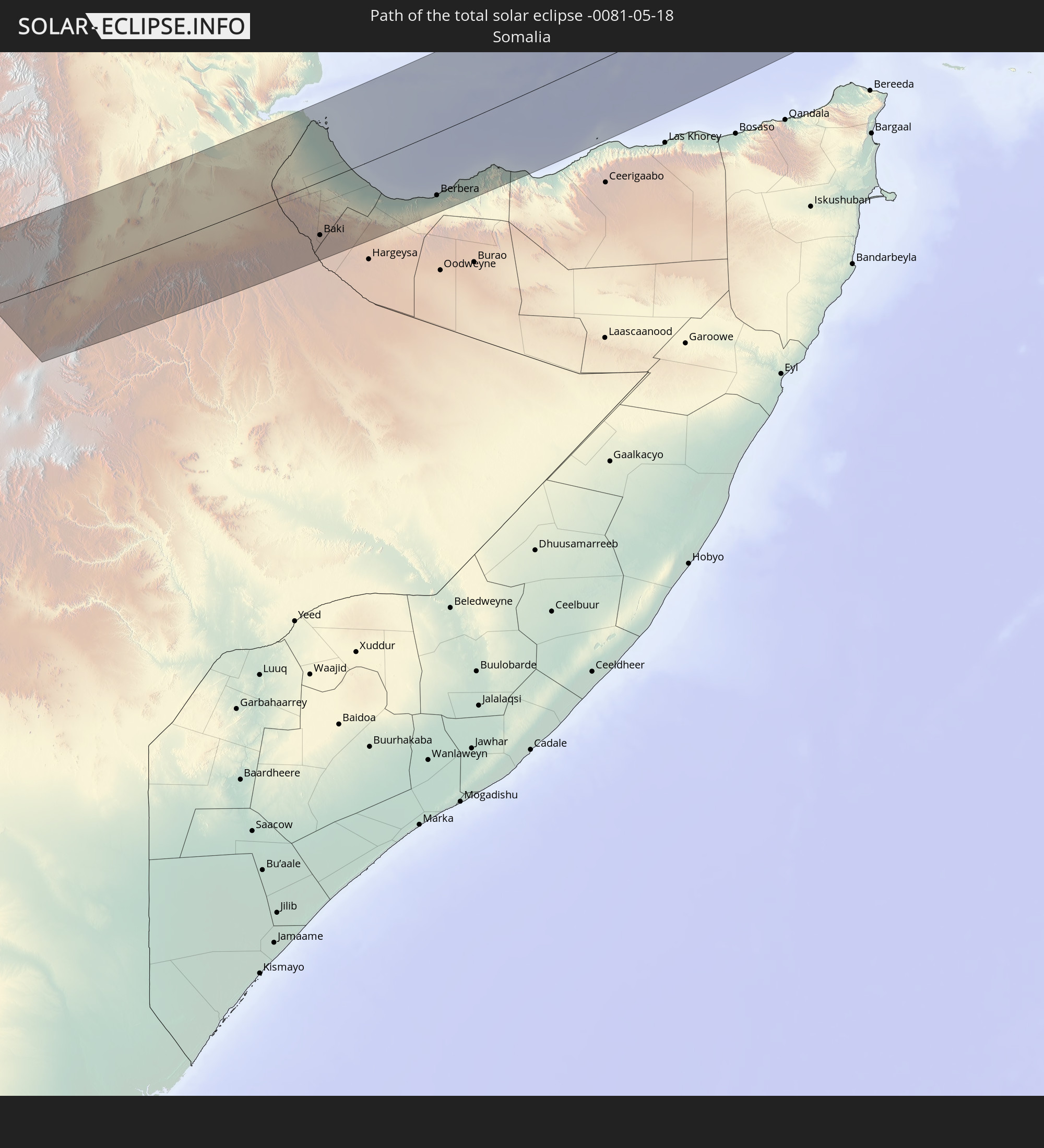 Somalia
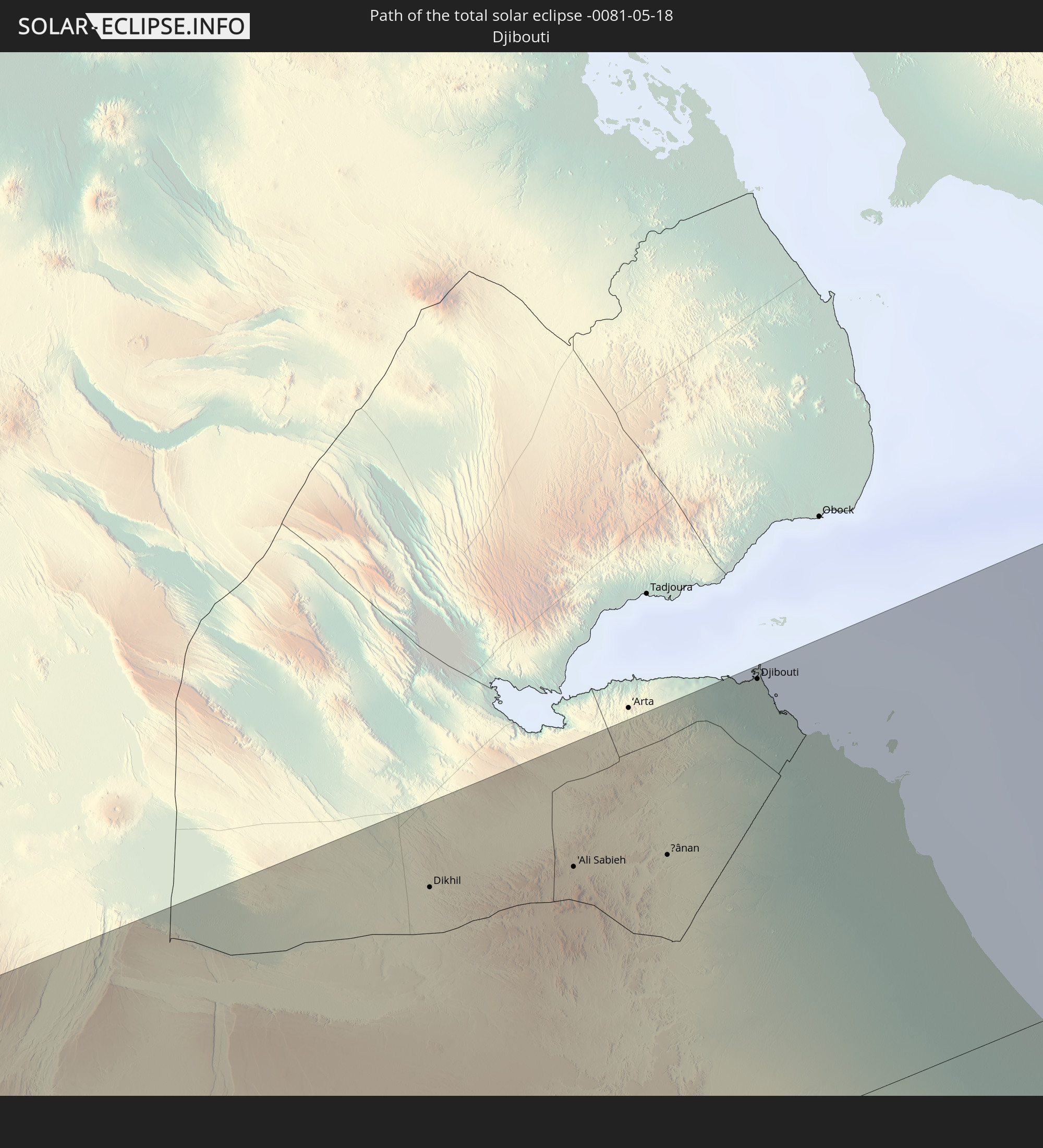 Dschibuti
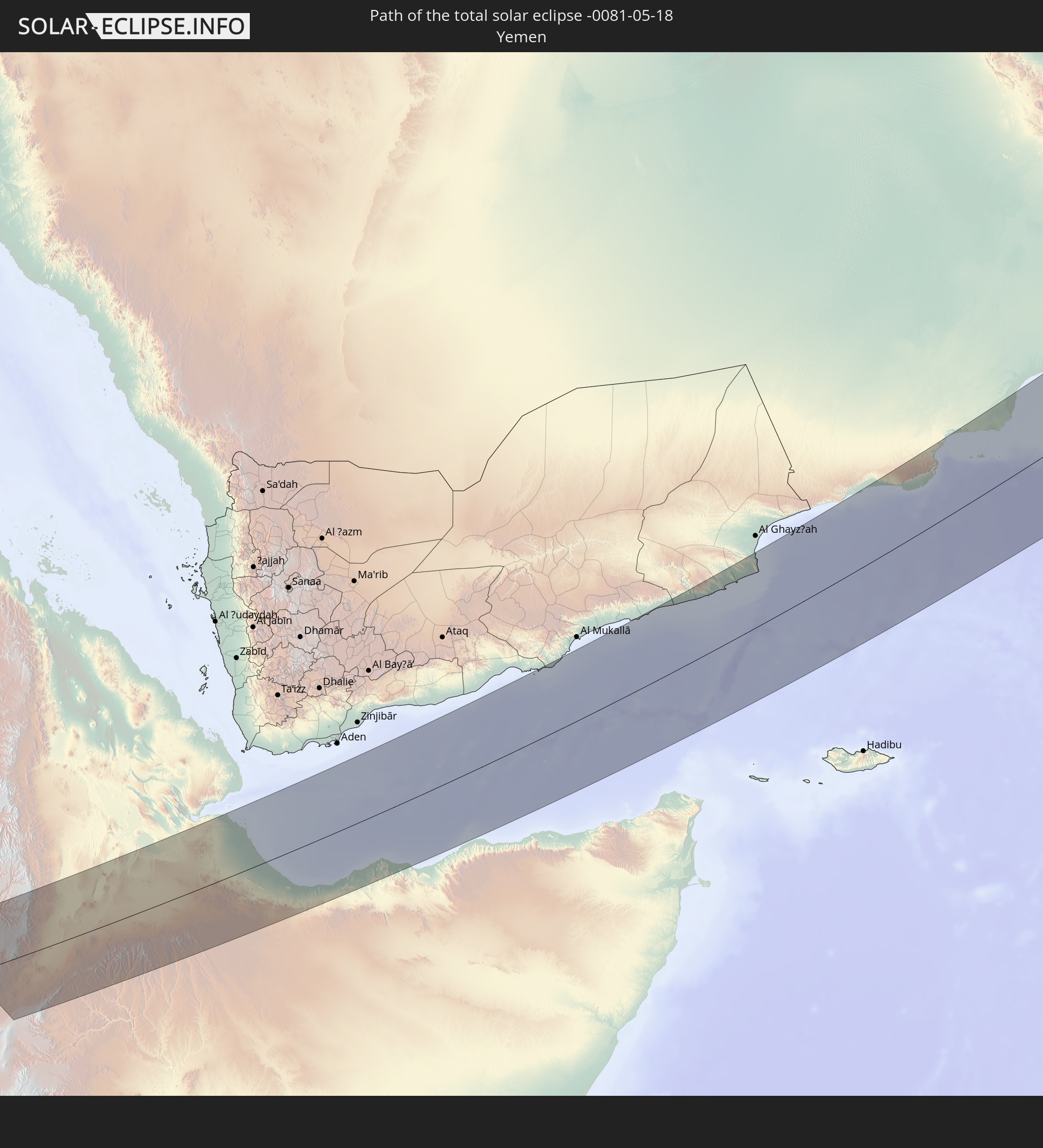 Jemen
Jemen
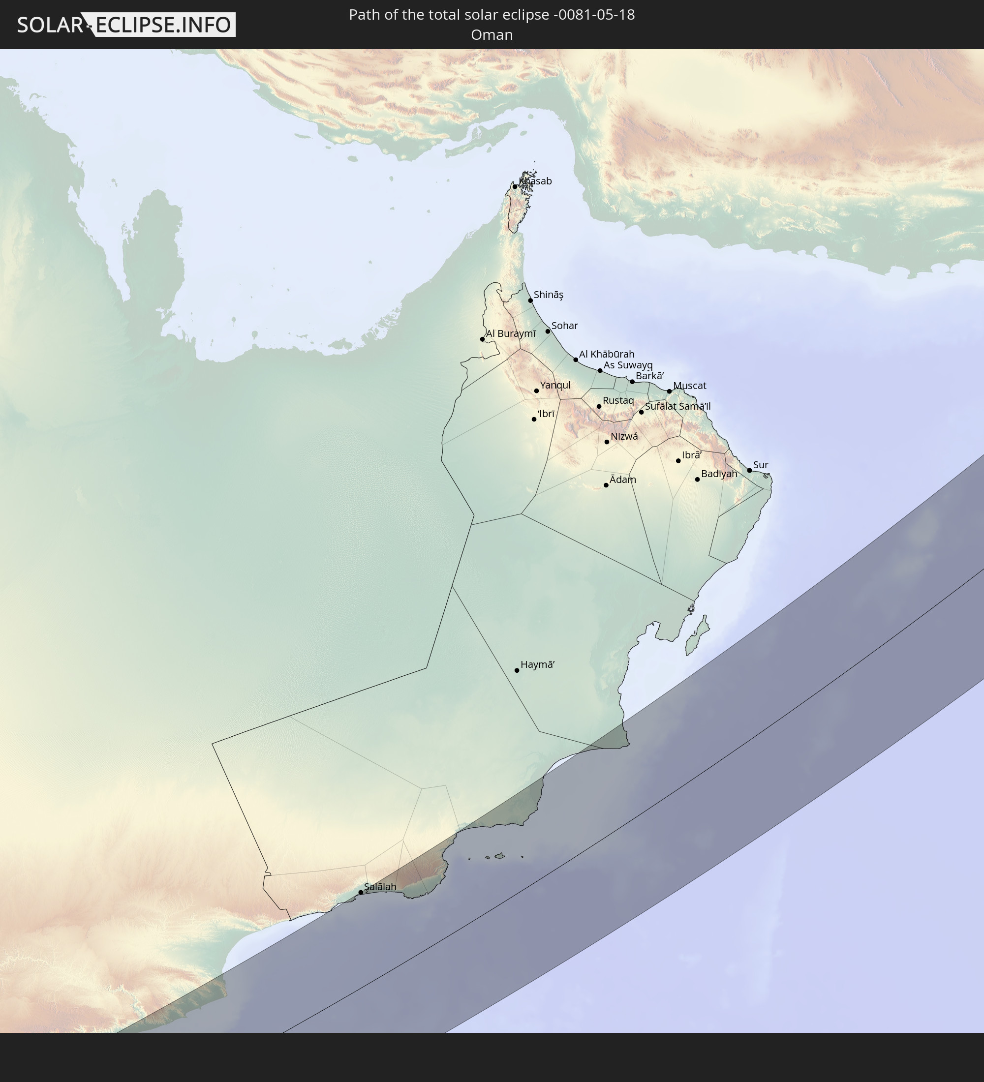 Oman
Oman
 Pakistan
 Indien
 Volksrepublik China
 Mongolei
In den folgenden Ländern ist die Sonnenfinsternis partiell zu sehen
 Russland
 Vereinigte Staaten
 United States Minor Outlying Islands
 Kanada
 Grönland
 Island
 Spitzbergen
 Vereinigtes Königreich
 Färöer
 Frankreich
 Isle of Man
 Belgien
 Niederlande
 Norwegen
 Luxemburg
 Deutschland
 Schweiz
 Italien
 Dänemark
 Libyen
 Liechtenstein
 Österreich
 Schweden
 Tschechien
 San Marino
 Vatikanstadt
 Slowenien
 Kroatien
 Polen
Polen
 Bosnien und Herzegowina
 Ungarn
 Slowakei
 Montenegro
 Serbien
 Albanien
 Åland Islands
 Griechenland
 Rumänien
 Mazedonien
 Finnland
 Litauen
 Lettland
 Estland
 Sudan
Sudan
 Ukraine
 Bulgarien
 Weißrussland
 Ägypten
 Türkei
 Moldawien
 Republik Zypern
 Äthiopien
 Kenia
Kenia
 Staat Palästina
 Israel
 Saudi-Arabien
 Jordanien
 Libanon
 Syrien
 Eritrea
 Irak
Irak
 Georgien
 Französische Süd- und Antarktisgebiete
 Somalia
 Dschibuti
 Jemen
Jemen
 Armenien
 Iran
Iran
 Aserbaidschan
 Seychellen
 Kasachstan
 Kuwait
 Bahrain
 Katar
Katar
 Vereinigte Arabische Emirate
 Oman
Oman
 Turkmenistan
 Usbekistan
 Mauritius
 Afghanistan
 Pakistan
 Tadschikistan
 Indien
 Kirgisistan
 Britisches Territorium im Indischen Ozean
 Malediven
 Volksrepublik China
 Sri Lanka
 Nepal
Nepal
 Mongolei
 Bangladesch
 Bhutan
 Myanmar
 Indonesien
 Thailand
 Laos
Laos
 Vietnam
 Kambodscha
 Macau
Macau
 Hongkong
 Taiwan
 Japan
Japan
 Nordkorea
 Südkorea
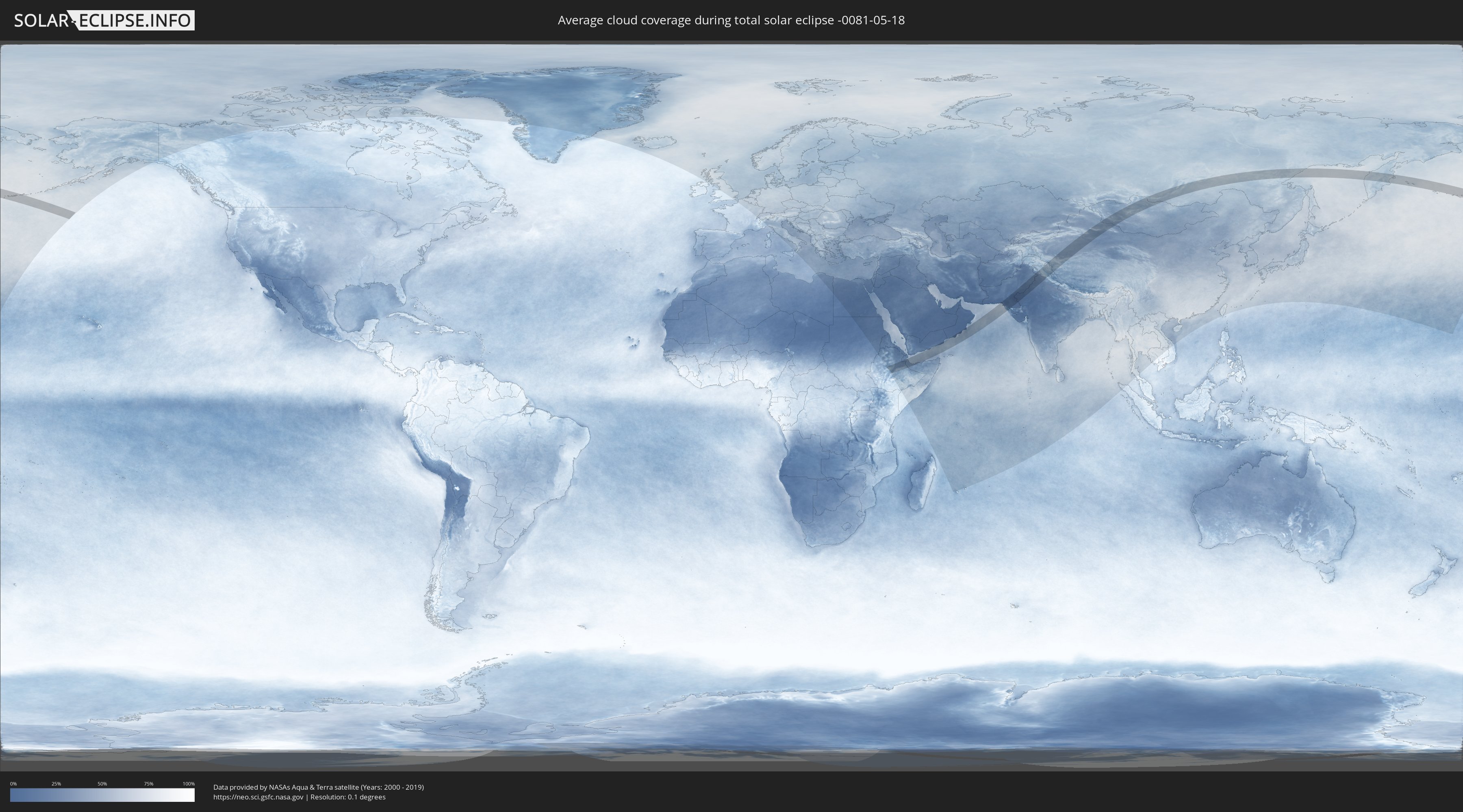
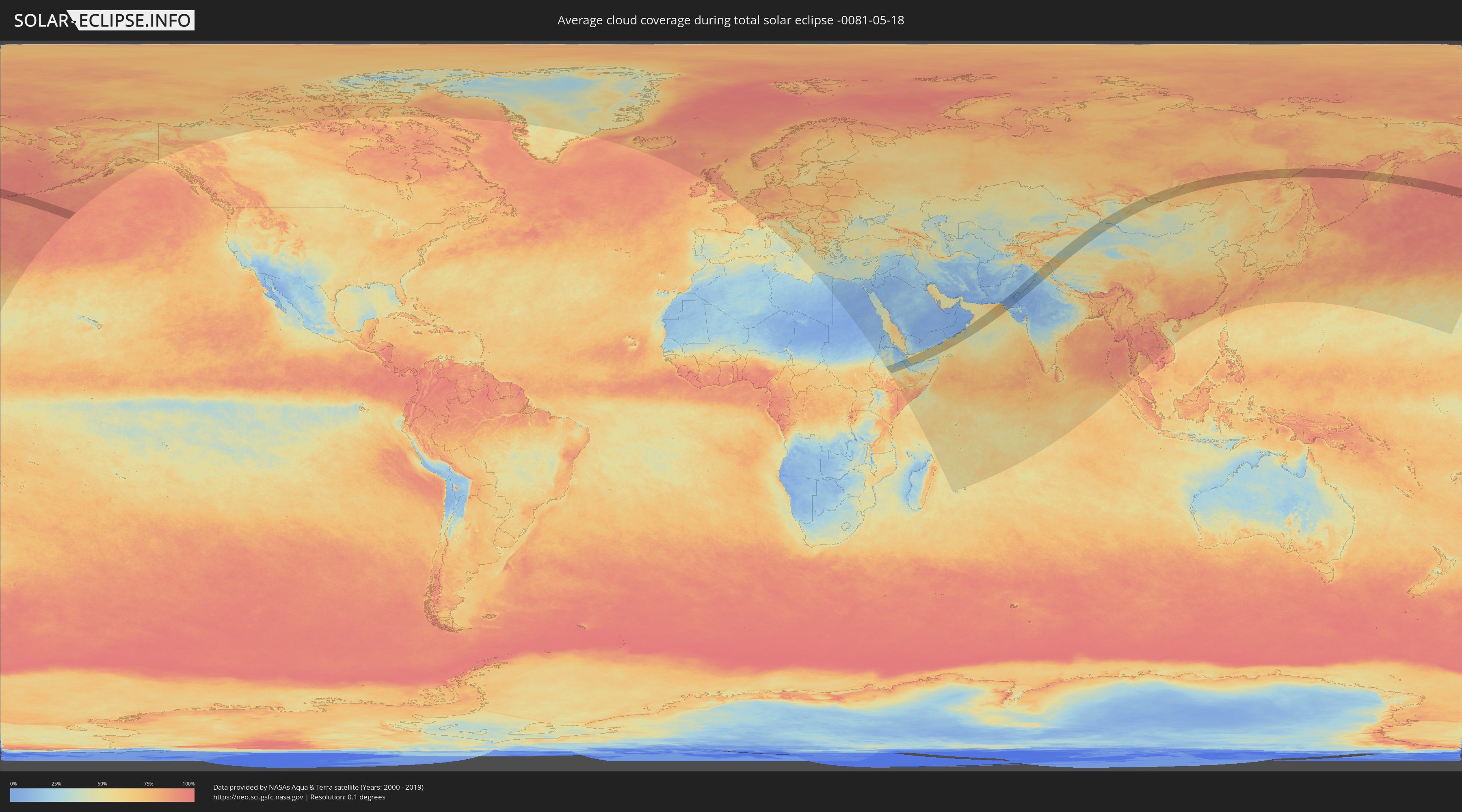
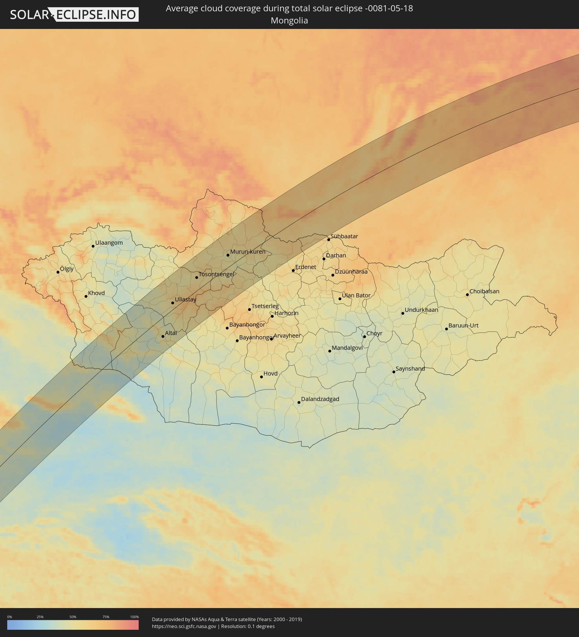
Wie wird das Wetter während der totalen Sonnenfinsternis am 18.05.-0081?
Wo ist der beste Ort, um die totale Sonnenfinsternis vom 18.05.-0081 zu beobachten?
Die folgenden Karten zeigen die durchschnittliche Bewölkung für den Tag, an dem die totale Sonnenfinsternis
stattfindet. Mit Hilfe der Karten lässt sich der Ort entlang des Finsternispfades eingrenzen,
der die besten Aussichen auf einen klaren wolkenfreien Himmel bietet.
Trotzdem muss man immer lokale Gegenenheiten beachten und sollte sich genau über das Wetter an seinem
gewählten Beobachtungsort informieren.
Die Daten stammen von den beiden NASA-Satelliten
AQUA und TERRA
und wurden über einen Zeitraum von 19 Jahren (2000 - 2019) gemittelt.
Detaillierte Länderkarten
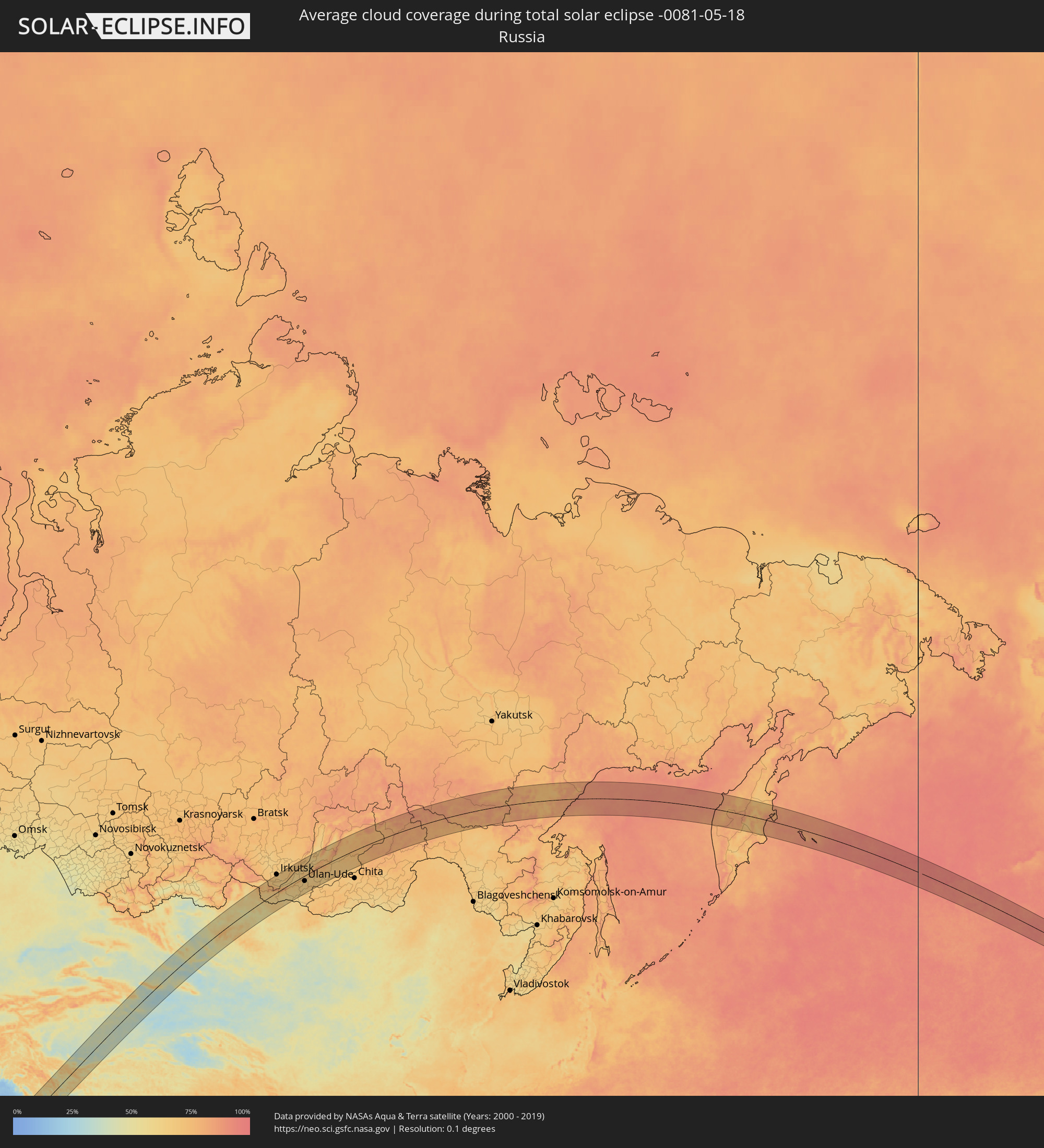 Russland
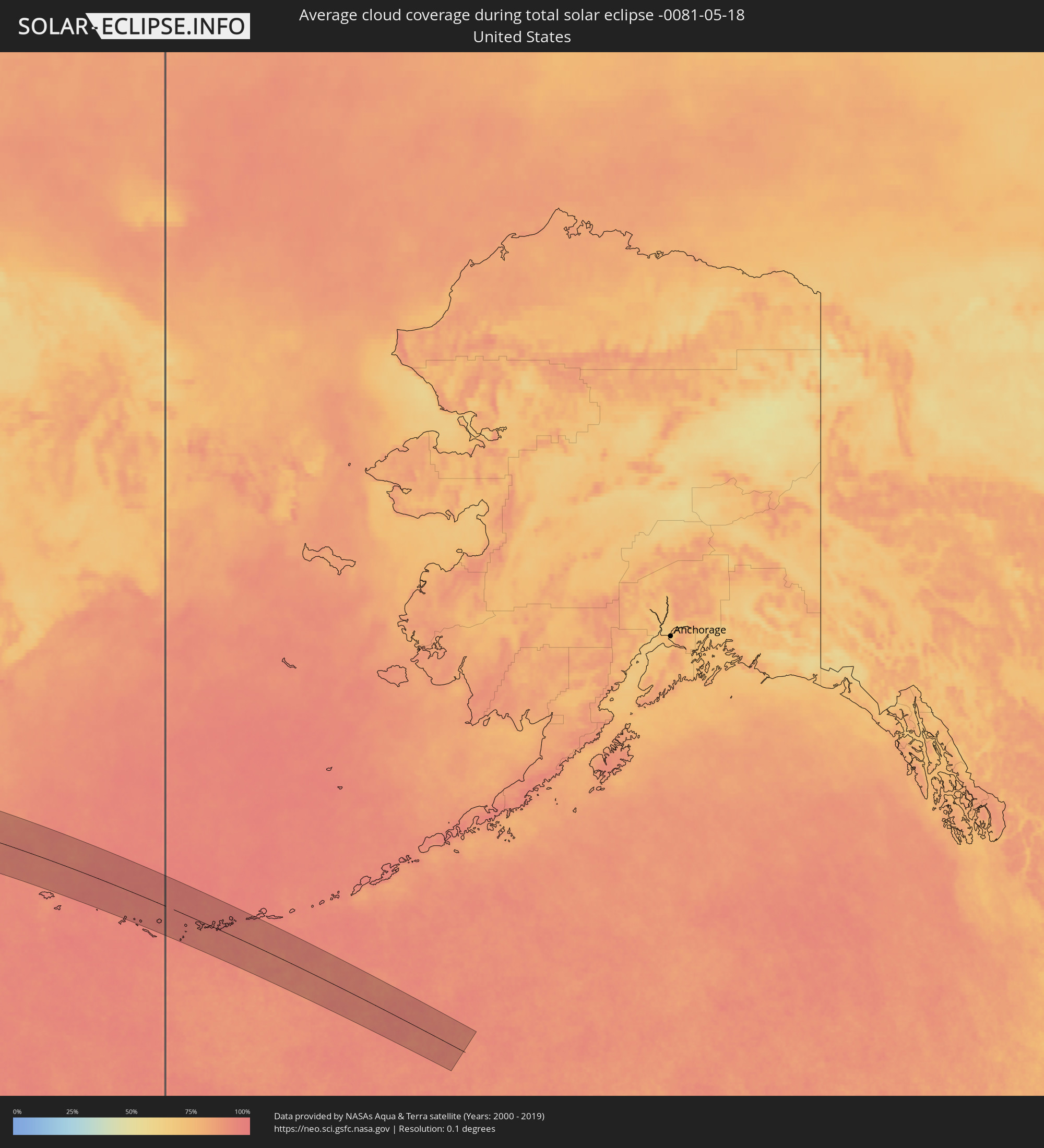 Vereinigte Staaten
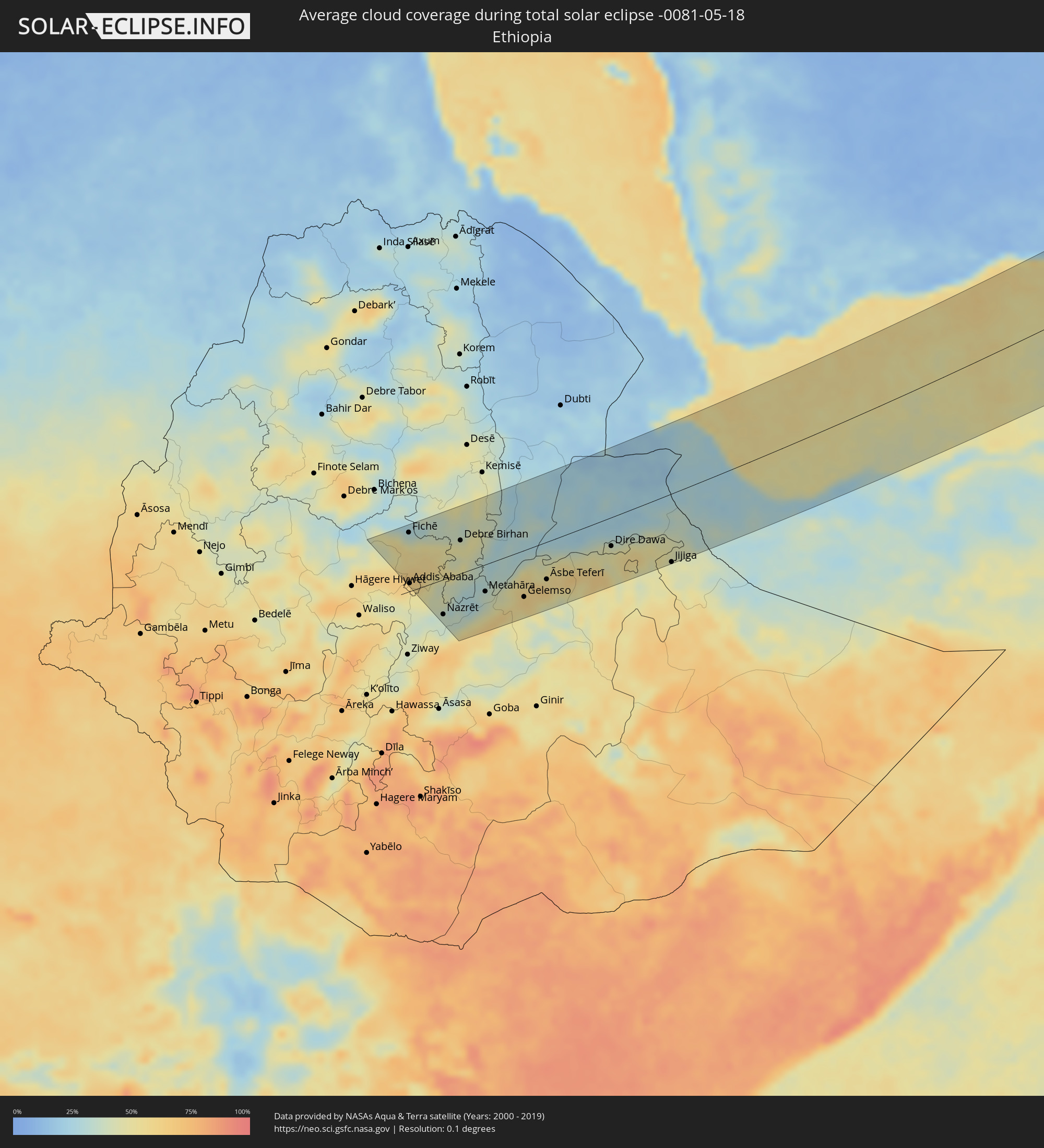 Äthiopien
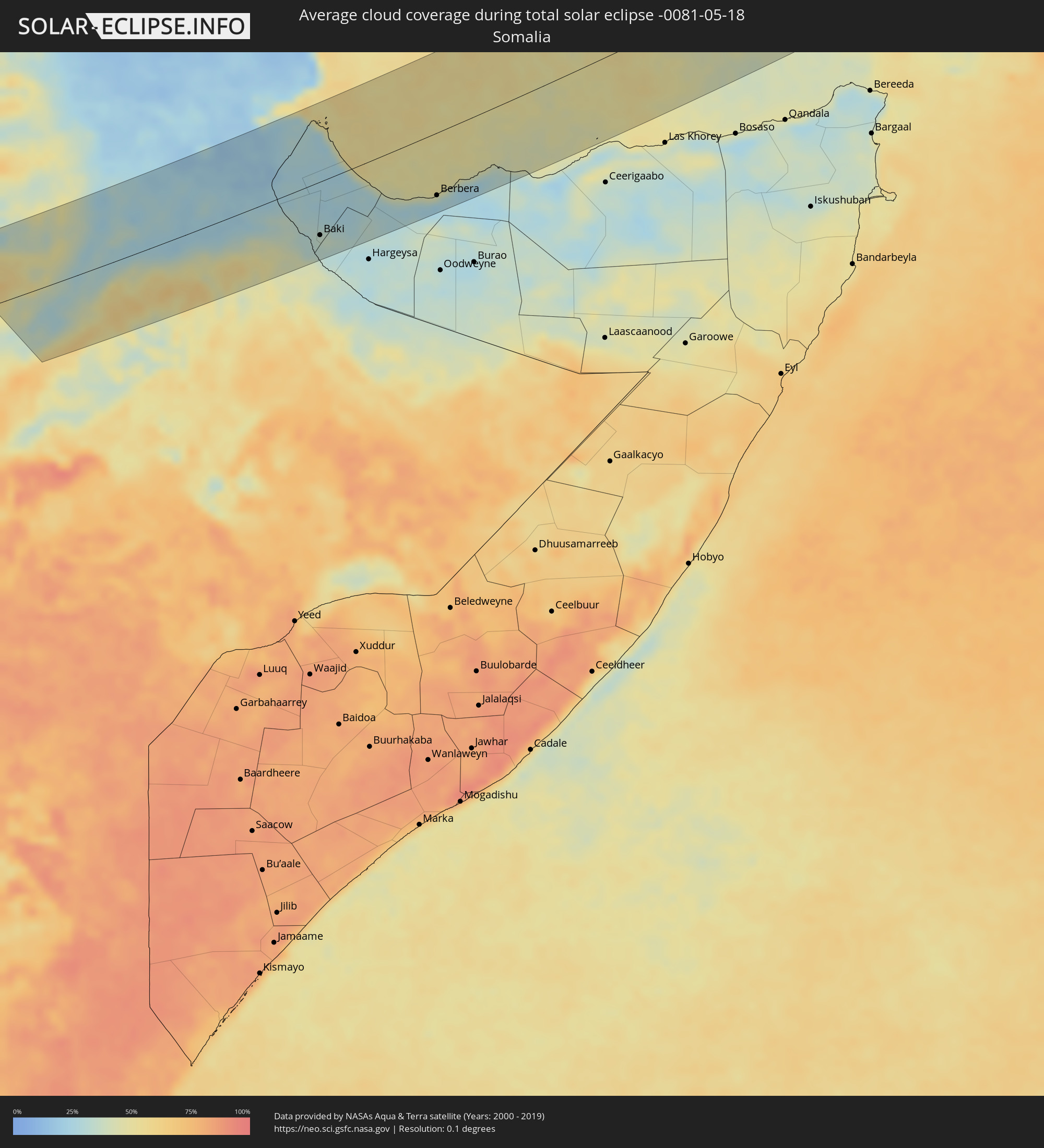 Somalia
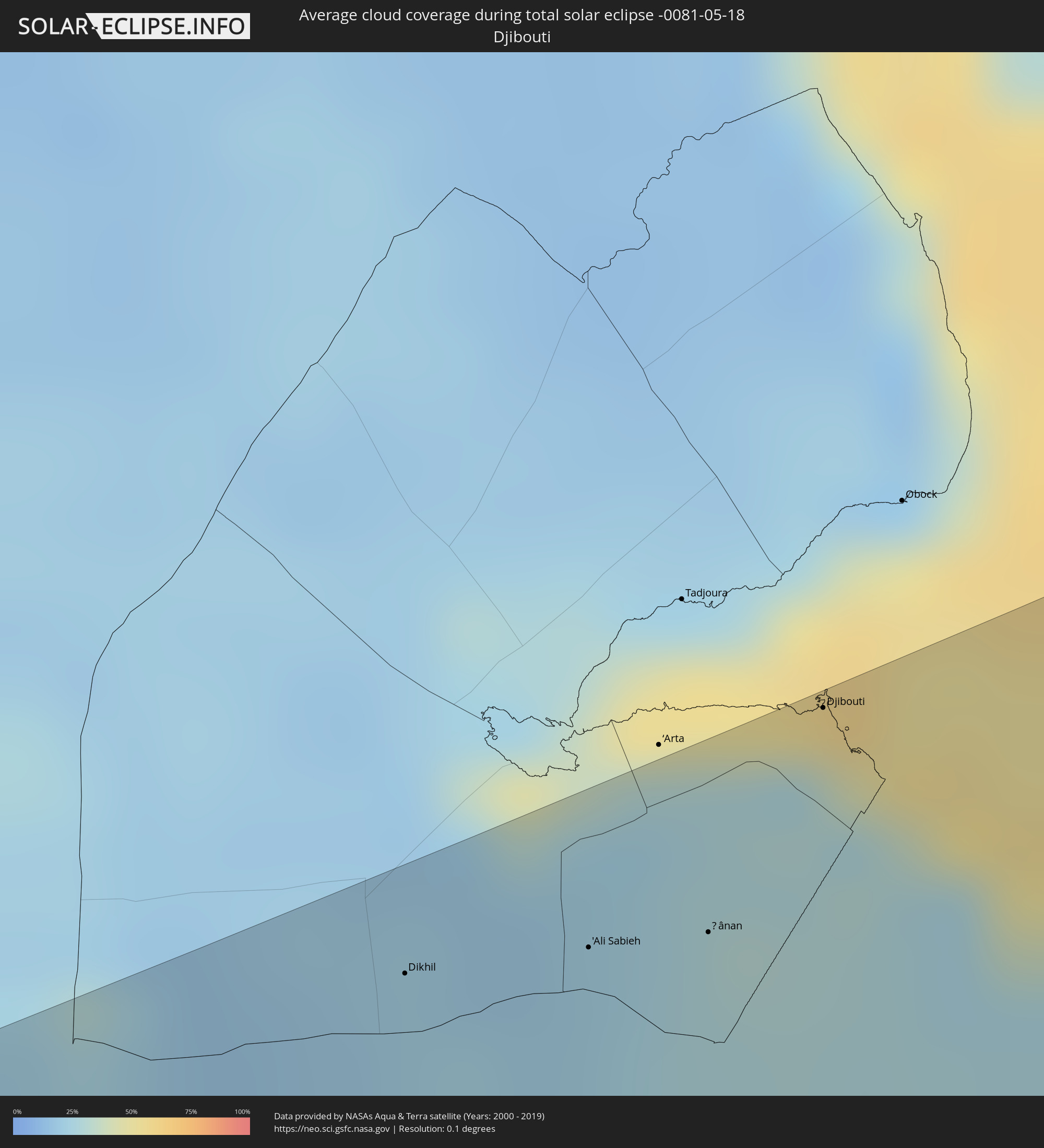 Dschibuti
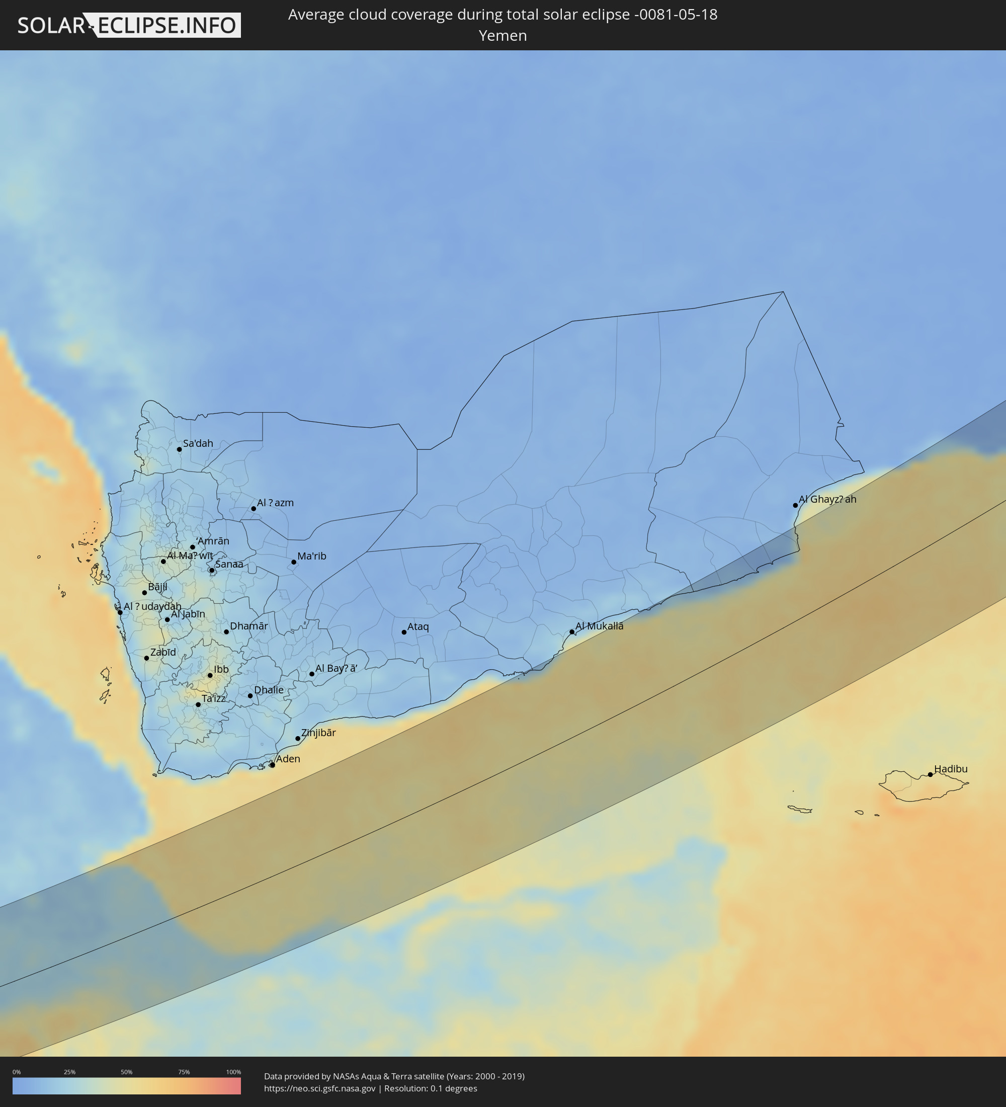 Jemen
Jemen
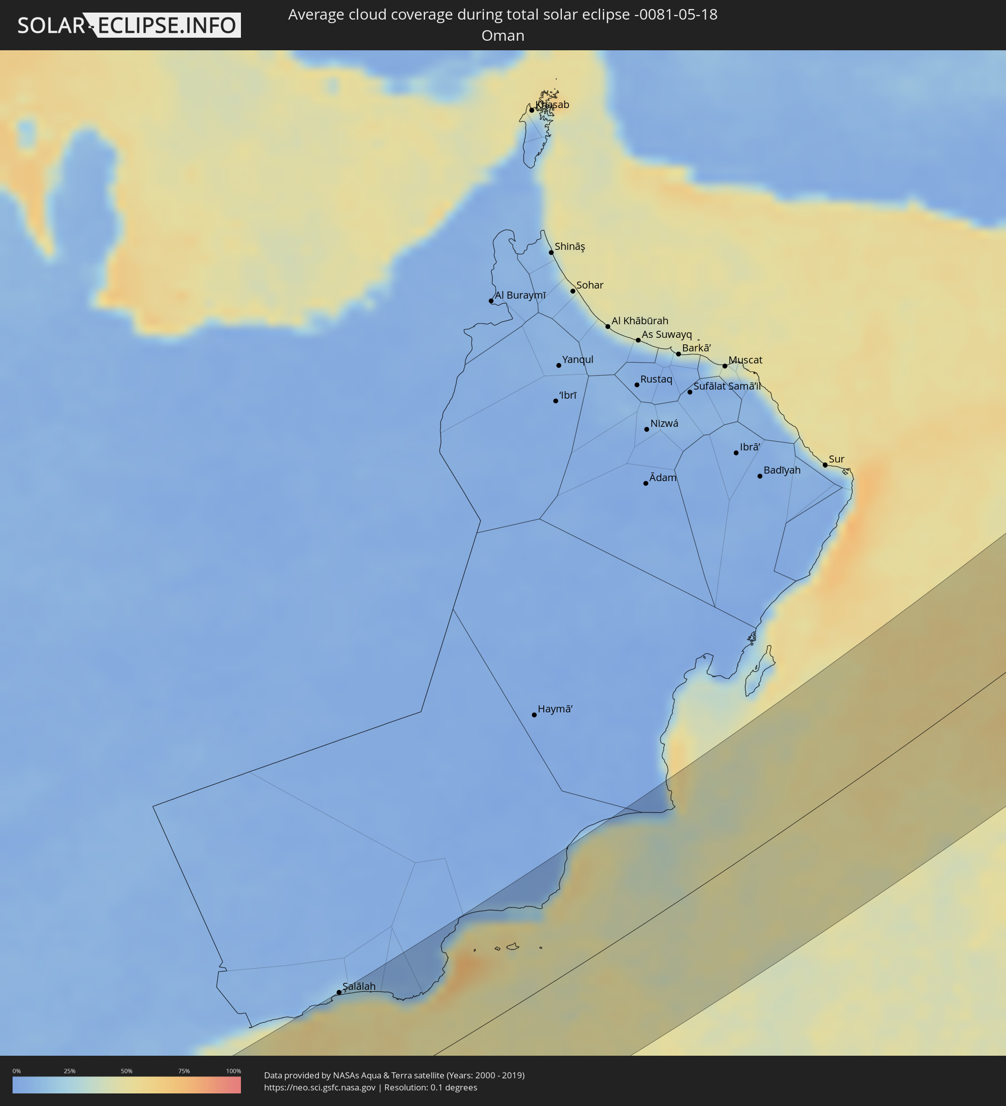 Oman
Oman
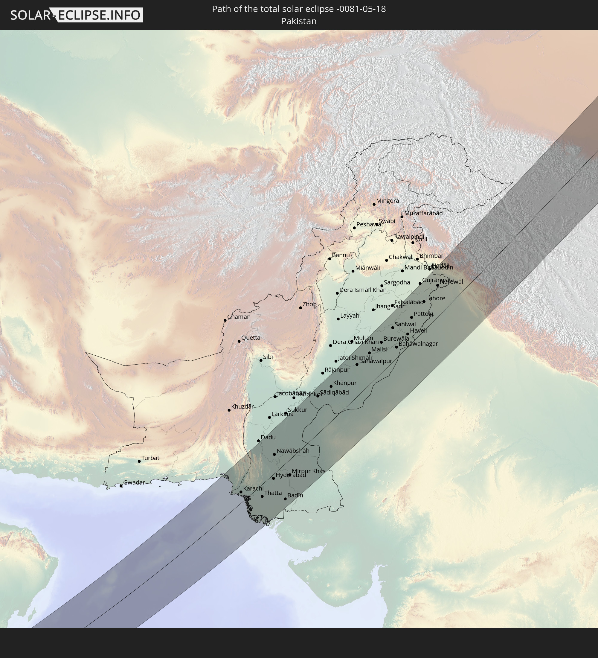
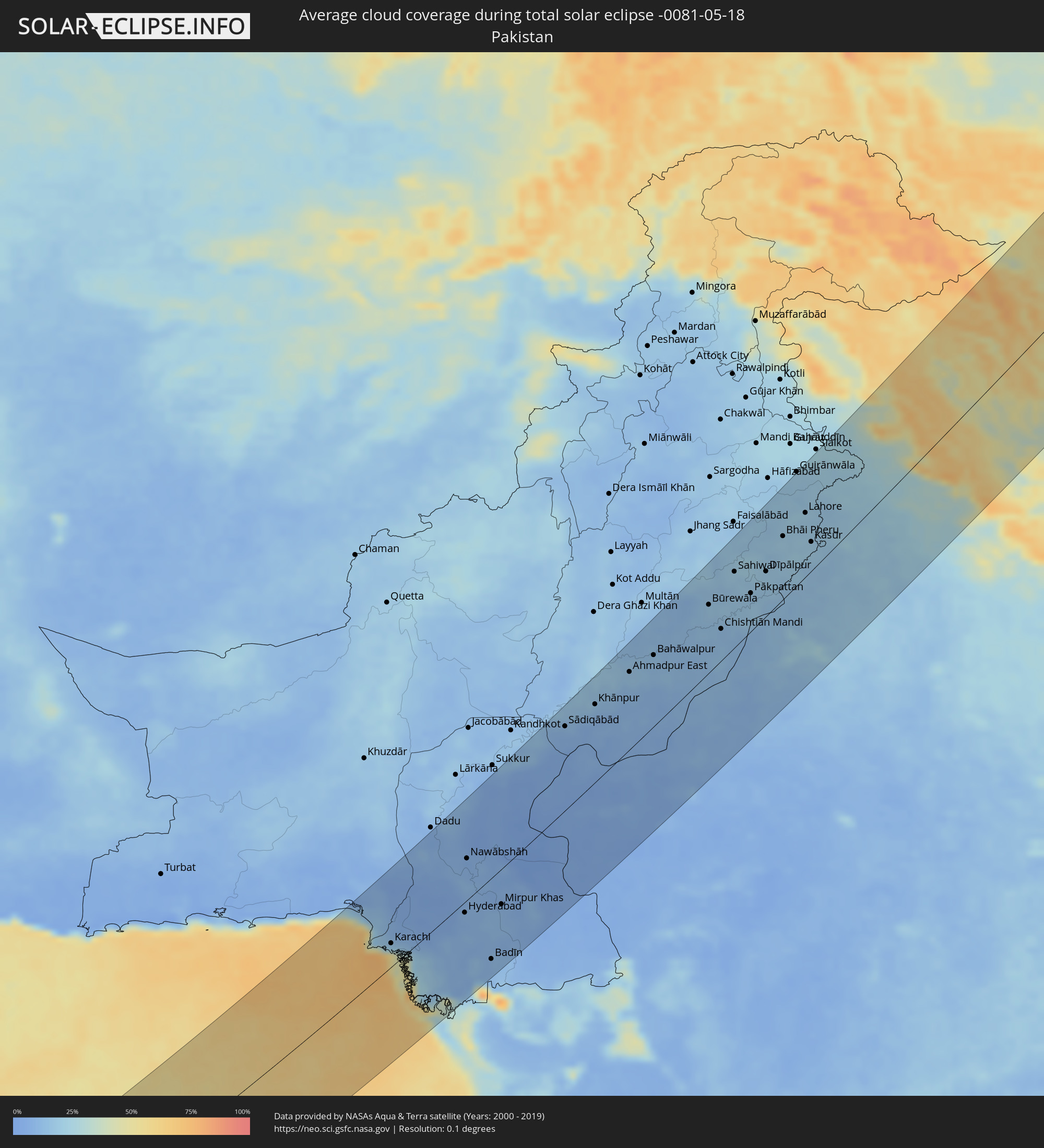 Pakistan
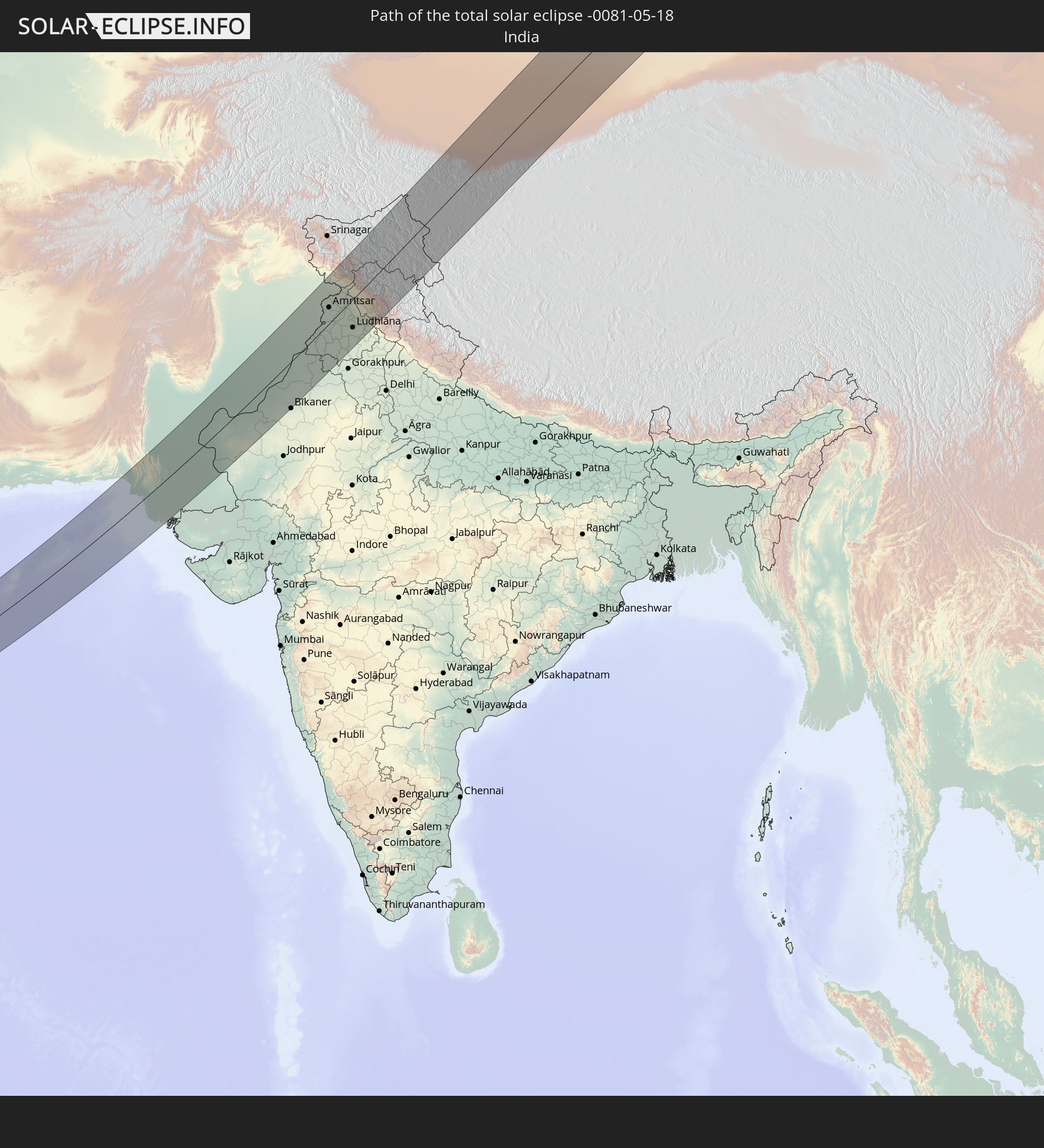
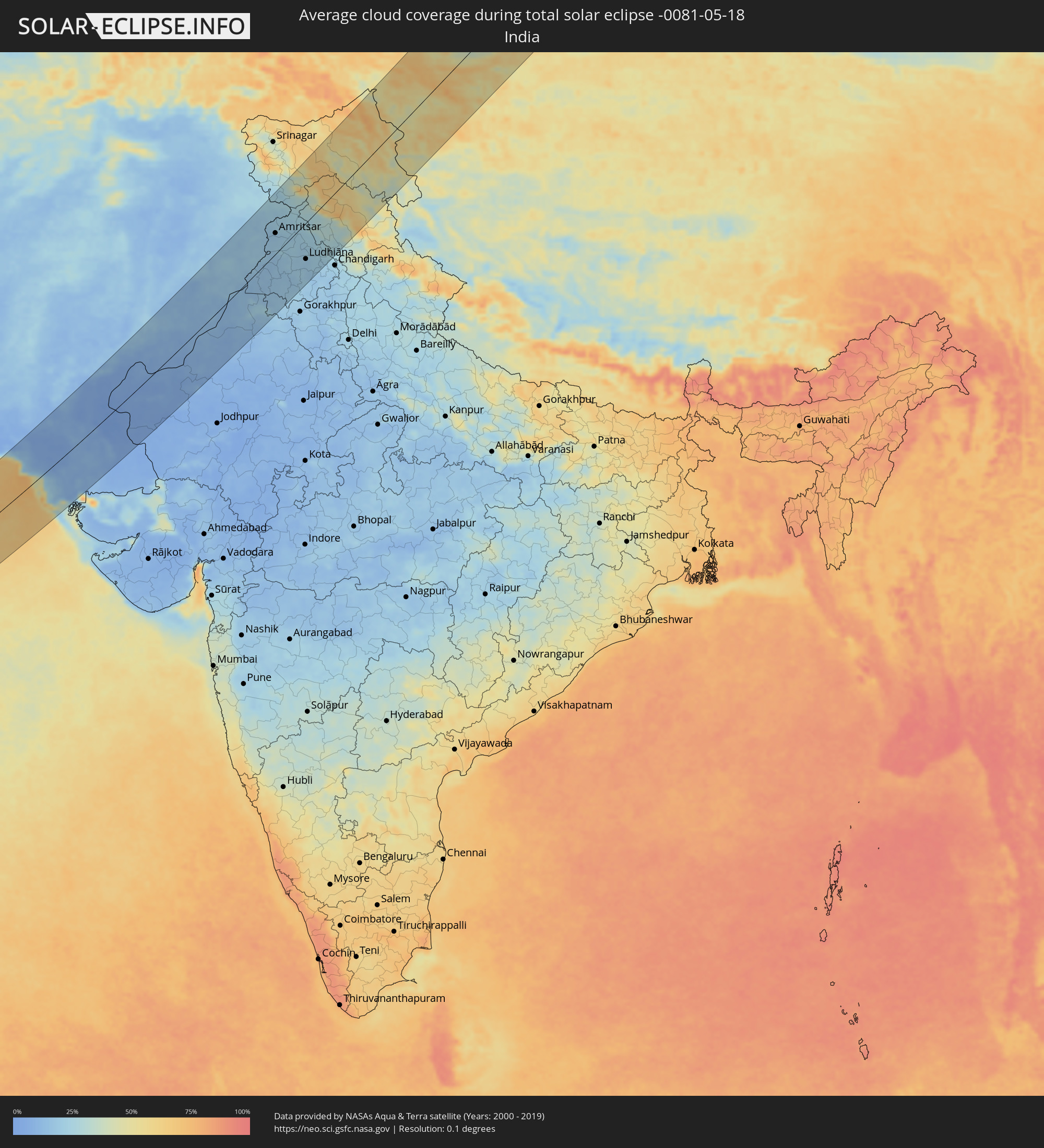 Indien
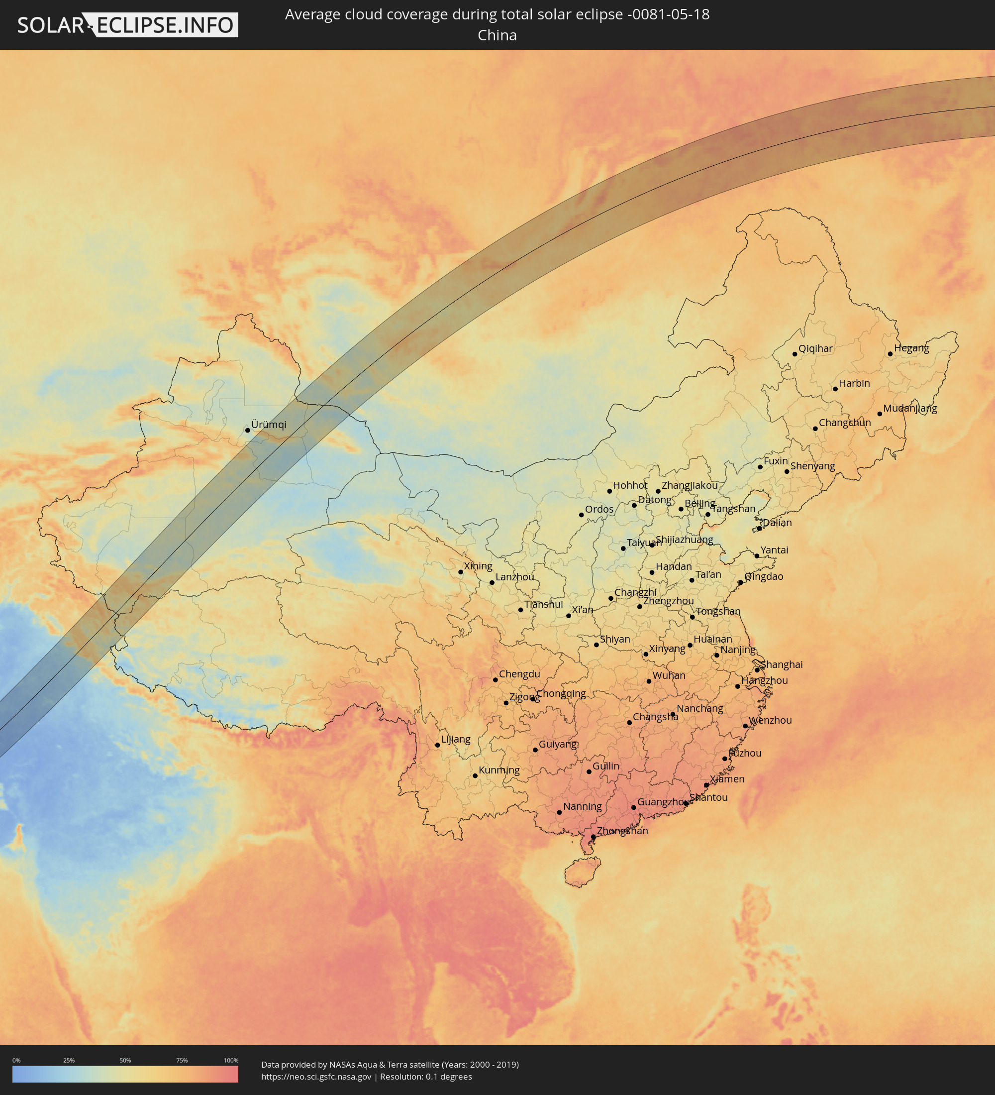 Volksrepublik China
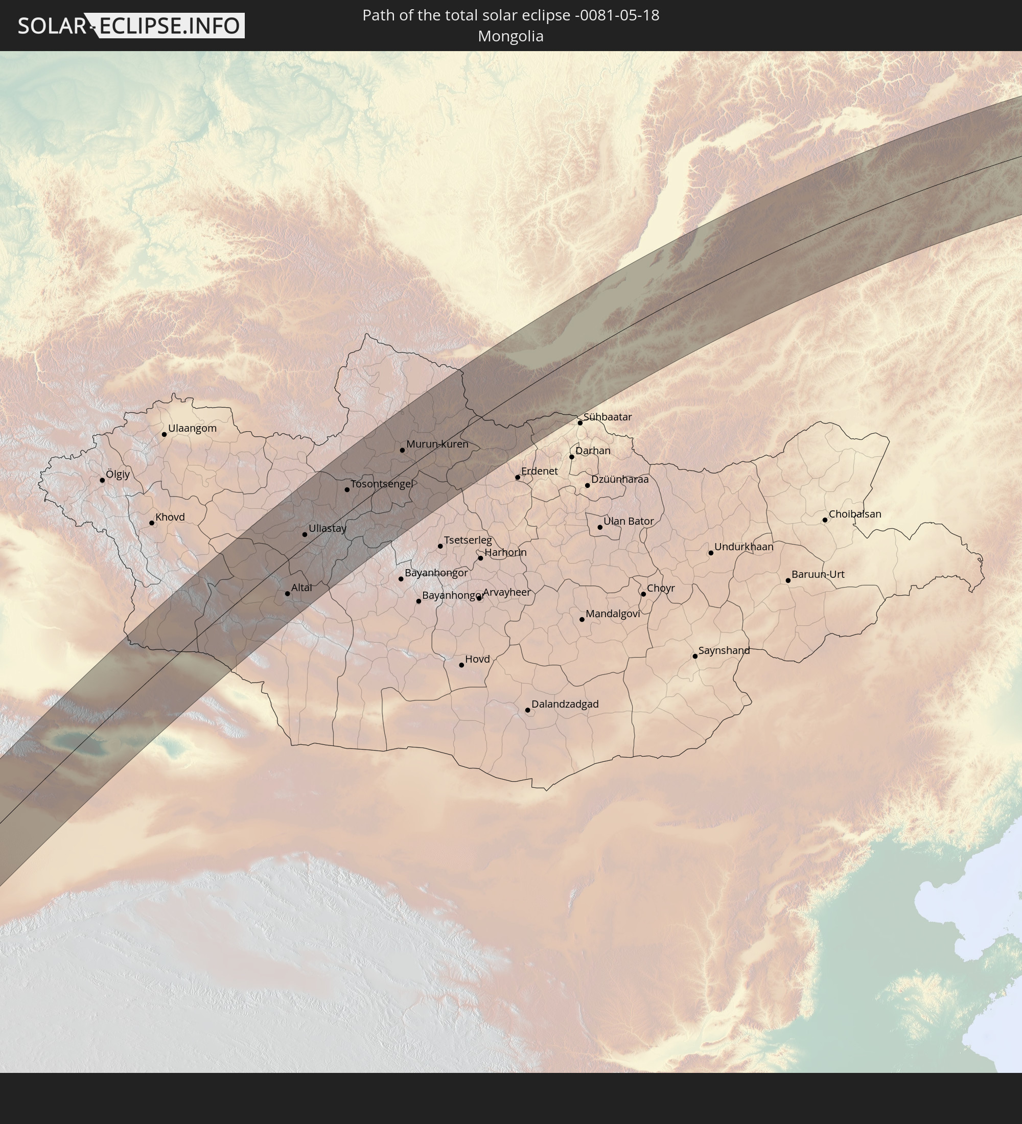
 Mongolei
Orte im Finsternispfad
Die nachfolgene Tabelle zeigt Städte und Orte mit mehr als 5.000 Einwohnern, die sich im Finsternispfad befinden. Städte mit mehr als 100.000 Einwohnern sind dick gekennzeichnet. Mit einem Klick auf den Ort öffnet sich eine Detailkarte die die Lage des jeweiligen Ortes zusammen mit dem Verlauf der zentralen Finsternis präsentiert.
| Ort | Typ | Dauer der Verfinsterung | Ortszeit bei maximaler Verfinsterung | Entfernung zur Zentrallinie | Ø Bewölkung |
|
Gebre Guracha, Oromiya
|
total | - | 05:34:16 UTC+02:27 | 107 km | 49% |
|
Fichē, Oromiya
|
total | - | 05:34:10 UTC+02:27 | 95 km | 39% |
|
Addis Ababa, Addis Ababa
|
total | - | 05:33:26 UTC+02:27 | 13 km | 60% |
|
Bishoftu, Oromiya
|
total | - | 05:33:06 UTC+02:27 | 24 km | 48% |
|
Sendafa, Oromiya
|
total | - | 05:33:28 UTC+02:27 | 16 km | 59% |
|
Mojo, Oromiya
|
total | - | 05:32:54 UTC+02:27 | 47 km | 34% |
|
Nazrēt, Oromiya
|
total | - | 05:32:49 UTC+02:27 | 56 km | 36% |
|
Wenjī, Oromiya
|
total | - | 05:32:43 UTC+02:27 | 67 km | 37% |
|
Sirre, Oromiya
|
total | - | 05:32:32 UTC+02:27 | 88 km | 52% |
|
Debre Birhan, Amhara
|
total | - | 05:33:49 UTC+02:27 | 53 km | 48% |
|
Debre Sīna, Amhara
|
total | - | 05:33:55 UTC+02:27 | 62 km | 48% |
|
Metahāra, Oromiya
|
total | - | 05:32:57 UTC+02:27 | 43 km | 36% |
|
Abomsa, Amhara
|
total | - | 05:33:59 UTC+02:27 | 68 km | 40% |
|
Āwash, Āfar
|
total | - | 05:32:57 UTC+02:27 | 44 km | 44% |
|
Gelemso, Oromiya
|
total | - | 05:32:42 UTC+02:27 | 74 km | 59% |
|
Gewanē, Āfar
|
total | - | 05:33:59 UTC+02:27 | 62 km | 30% |
|
Bedēsa, Oromiya
|
total | - | 05:32:42 UTC+02:27 | 76 km | 57% |
|
Āsbe Teferī, Oromiya
|
total | - | 05:32:51 UTC+02:27 | 60 km | 56% |
|
Hīrna, Oromiya
|
total | - | 05:32:55 UTC+02:27 | 55 km | 57% |
|
Deder, Oromiya
|
total | - | 05:32:55 UTC+02:27 | 58 km | 58% |
|
Dire Dawa, Dire Dawa
|
total | - | 05:33:05 UTC+02:27 | 46 km | 46% |
|
Harar, Harari
|
total | - | 05:32:45 UTC+02:27 | 85 km | 55% |
|
Dikhil, Dikhil
|
total | - | 05:34:31 UTC+02:27 | 91 km | 22% |
|
'Ali Sabieh, Ali Sabieh
|
total | - | 05:34:29 UTC+02:27 | 82 km | 22% |
|
Jijiga, Somali
|
total | - | 05:32:37 UTC+02:27 | 108 km | 43% |
|
Ḏânan, Ali Sabieh
|
total | - | 05:34:28 UTC+02:27 | 76 km | 27% |
|
Djibouti, Djibouti
|
total | - | 05:34:51 UTC+02:27 | 109 km | 29% |
|
Baki, Awdal
|
total | - | 05:33:02 UTC+02:27 | 76 km | 35% |
|
Berbera, Woqooyi Galbeed
|
total | - | 05:33:17 UTC+02:27 | 88 km | 24% |
|
Şalālah, Z̧ufār
|
total | - | 06:54:43 UTC+03:41 | 122 km | 45% |
|
Karachi, Sindh
|
total | - | 07:57:58 UTC+04:28 | 32 km | 22% |
|
Hyderabad, Sindh
|
total | - | 07:59:33 UTC+04:28 | 14 km | 9% |
|
Nawābshāh, Sindh
|
total | - | 08:01:03 UTC+04:28 | 54 km | 8% |
|
Tando Ādam, Sindh
|
total | - | 08:00:22 UTC+04:28 | 2 km | 8% |
|
Tando Allāhyār, Sindh
|
total | - | 07:59:53 UTC+04:28 | 31 km | 9% |
|
Mirpur Khas, Sindh
|
total | - | 08:00:10 UTC+04:28 | 46 km | 11% |
|
Sādiqābād, Punjab
|
total | - | 08:05:47 UTC+04:28 | 106 km | 9% |
|
Khānpur, Punjab
|
total | - | 08:06:45 UTC+04:28 | 97 km | 10% |
|
Ahmadpur East, Punjab
|
total | - | 08:08:04 UTC+04:28 | 96 km | 15% |
|
Bahāwalpur, Punjab
|
total | - | 08:08:51 UTC+04:28 | 87 km | 13% |
|
Būrewāla, Punjab
|
total | - | 08:10:59 UTC+04:28 | 82 km | 17% |
|
Chishtiān Mandi, Punjab
|
total | - | 08:10:29 UTC+04:28 | 38 km | 12% |
|
Sahiwal, Punjab
|
total | - | 08:12:15 UTC+04:28 | 91 km | 20% |
|
Bahāwalnagar, Punjab
|
total | - | 08:11:09 UTC+04:28 | 28 km | 18% |
|
Pākpattan, Punjab
|
total | - | 08:11:53 UTC+04:28 | 46 km | 16% |
|
Bahāwalnagar, Punjab
|
total | - | 08:12:17 UTC+04:28 | 62 km | 17% |
|
Jarānwāla, Punjab
|
total | - | 08:13:45 UTC+04:28 | 120 km | 17% |
|
Okāra, Punjab
|
total | - | 08:12:48 UTC+04:28 | 78 km | 21% |
|
Gangānagar, Rajasthan
|
total | - | 09:04:29 UTC+05:21 | 21 km | 14% |
|
Sheikhupura, Punjab
|
total | - | 08:14:54 UTC+04:28 | 113 km | 18% |
|
Abohar, Punjab
|
total | - | 09:05:10 UTC+05:21 | 25 km | 14% |
|
Kamoke, Punjab
|
total | - | 08:15:35 UTC+04:28 | 116 km | 19% |
|
Murīdke, Punjab
|
total | - | 08:15:18 UTC+04:28 | 100 km | 17% |
|
Hanumāngarh, Rajasthan
|
total | - | 09:04:14 UTC+05:21 | 78 km | 23% |
|
Lahore, Punjab
|
total | - | 08:14:54 UTC+04:28 | 75 km | 19% |
|
Kasūr, Punjab
|
total | - | 08:14:11 UTC+04:28 | 34 km | 20% |
|
Muktsar, Punjab
|
total | - | 09:06:02 UTC+05:21 | 21 km | 15% |
|
Ferozepore, Punjab
|
total | - | 09:06:57 UTC+05:21 | 8 km | 17% |
|
Kotkapura, Punjab
|
total | - | 09:06:30 UTC+05:21 | 34 km | 17% |
|
Jammu, Kashmir
|
total | - | 09:10:31 UTC+05:21 | 131 km | 22% |
|
Amritsar, Punjab
|
total | - | 09:08:28 UTC+05:21 | 45 km | 18% |
|
Bhatinda, Punjab
|
total | - | 09:05:54 UTC+05:21 | 70 km | 17% |
|
Sirsa, Haryana
|
total | - | 09:04:44 UTC+05:21 | 130 km | 17% |
|
Udhampur, Kashmir
|
total | - | 09:11:06 UTC+05:21 | 128 km | 26% |
|
Moga, Punjab
|
total | - | 09:07:13 UTC+05:21 | 38 km | 20% |
|
Batāla, Punjab
|
total | - | 09:09:06 UTC+05:21 | 37 km | 22% |
|
Kapūrthala, Punjab
|
total | - | 09:08:27 UTC+05:21 | 9 km | 22% |
|
Mānsa, Punjab
|
total | - | 09:05:54 UTC+05:21 | 119 km | 20% |
|
Barnāla, Punjab
|
total | - | 09:06:44 UTC+05:21 | 99 km | 18% |
|
Jalandhar, Punjab
|
total | - | 09:08:32 UTC+05:21 | 26 km | 21% |
|
Pathānkot, Punjab
|
total | - | 09:10:21 UTC+05:21 | 43 km | 28% |
|
Phagwāra, Punjab
|
total | - | 09:08:31 UTC+05:21 | 47 km | 20% |
|
Sangrūr, Punjab
|
total | - | 09:06:46 UTC+05:21 | 129 km | 18% |
|
Ludhiāna, Punjab
|
total | - | 09:08:00 UTC+05:21 | 77 km | 18% |
|
Māler Kotla, Punjab
|
total | - | 09:07:19 UTC+05:21 | 109 km | 18% |
|
Khanna, Punjab
|
total | - | 09:07:57 UTC+05:21 | 118 km | 20% |
|
Hotan, Xinjiang Uyghur Autonomous Region
|
total | - | 12:02:24 UTC+08:00 | 128 km | 48% |
|
Korla, Xinjiang Uyghur Autonomous Region
|
total | - | 12:17:57 UTC+08:00 | 99 km | 43% |
|
Sishilichengzi, Xinjiang Uyghur Autonomous Region
|
total | - | 12:18:41 UTC+08:00 | 95 km | 45% |
|
Turpan, Xinjiang Uyghur Autonomous Region
|
total | - | 12:23:46 UTC+08:00 | 18 km | 35% |
|
Altai, Govĭ-Altay
|
total | - | 10:45:16 UTC+06:06 | 69 km | 46% |
|
Uliastay, Dzabkhan
|
total | - | 10:47:59 UTC+06:06 | 22 km | 54% |
|
Tosontsengel, Dzabkhan
|
total | - | 10:51:17 UTC+06:06 | 45 km | 53% |
|
Murun-kuren, Hövsgöl
|
total | - | 11:55:51 UTC+07:07 | 42 km | 47% |
|
Zakamensk, Respublika Buryatiya
|
total | - | 11:50:30 UTC+06:57 | 18 km | 61% |
|
Slyudyanka, Irkutsk
|
total | - | 11:52:22 UTC+06:57 | 86 km | 69% |
|
Shelekhov, Irkutsk
|
total | - | 11:53:25 UTC+06:57 | 123 km | 67% |
|
Baykal’sk, Irkutsk
|
total | - | 11:52:48 UTC+06:57 | 56 km | 73% |
|
Markova, Irkutsk
|
total | - | 11:53:33 UTC+06:57 | 119 km | 67% |
|
Petropavlovka, Respublika Buryatiya
|
total | - | 11:53:33 UTC+06:57 | 73 km | 59% |
|
Gusinoozyorsk, Respublika Buryatiya
|
total | - | 11:55:48 UTC+06:57 | 51 km | 64% |
|
Kabansk, Respublika Buryatiya
|
total | - | 11:56:40 UTC+06:57 | 17 km | 66% |
|
Ivolginsk, Respublika Buryatiya
|
total | - | 11:57:16 UTC+06:57 | 34 km | 63% |
|
Sokol, Respublika Buryatiya
|
total | - | 11:57:31 UTC+06:57 | 34 km | 61% |
|
Zarechnyy, Respublika Buryatiya
|
total | - | 11:57:40 UTC+06:57 | 32 km | 62% |
|
Ulan-Ude, Respublika Buryatiya
|
total | - | 11:57:46 UTC+06:57 | 37 km | 62% |
|
Turuntayevo, Respublika Buryatiya
|
total | - | 11:58:07 UTC+06:57 | 2 km | 66% |
|
Onokhoy, Respublika Buryatiya
|
total | - | 11:58:28 UTC+06:57 | 43 km | 63% |
|
Ust’-Barguzin, Respublika Buryatiya
|
total | - | 12:00:51 UTC+06:57 | 70 km | 64% |
|
Barguzin, Respublika Buryatiya
|
total | - | 12:01:46 UTC+06:57 | 72 km | 66% |
|
Khorinsk, Respublika Buryatiya
|
total | - | 12:00:58 UTC+06:57 | 75 km | 64% |
|
Kizhinga, Respublika Buryatiya
|
total | - | 12:00:56 UTC+06:57 | 111 km | 64% |
|
Kurumkan, Respublika Buryatiya
|
total | - | 12:03:04 UTC+06:57 | 121 km | 64% |
|
Neryungri, Sakha
|
total | - | 14:02:46 UTC+08:38 | 45 km | 78% |
|
Tynda, Amur
|
total | - | 14:03:01 UTC+08:38 | 120 km | 75% |
|
Chul’man, Sakha
|
total | - | 14:03:03 UTC+08:38 | 60 km | 80% |
|
Klyuchi, Kamtsjatka
|
total | - | 16:28:19 UTC+10:34 | 10 km | 78% |