Hybride Sonnenfinsternis vom 17.05.-0100
| Wochentag: | Donnerstag |
| Maximale Dauer der Verfinsterung: | 01m44s |
| Maximale Breite des Finsternispfades: | 59 km |
| Saroszyklus: | 65 |
| Bedeckungsgrad: | 100% |
| Magnitude: | 1.017 |
| Gamma: | -0.1912 |
Wo kann man die Sonnenfinsternis vom 17.05.-0100 sehen?
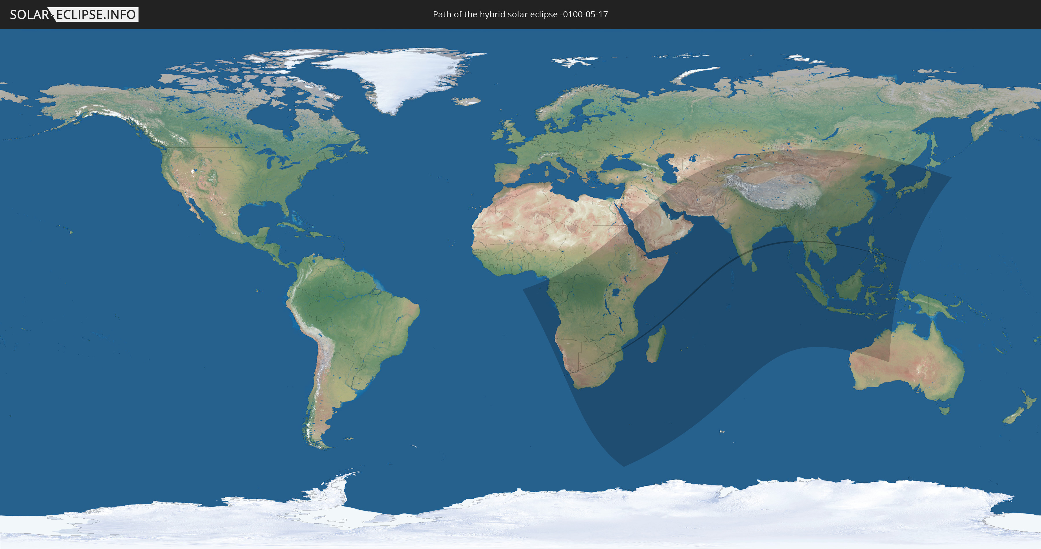
Die Sonnenfinsternis am 17.05.-0100 kann man in 82 Ländern als partielle Sonnenfinsternis beobachten.
Der Finsternispfad verläuft durch 10 Länder. Nur in diesen Ländern ist sie als hybride Sonnenfinsternis zu sehen.
In den folgenden Ländern ist die Sonnenfinsternis hybrid zu sehen
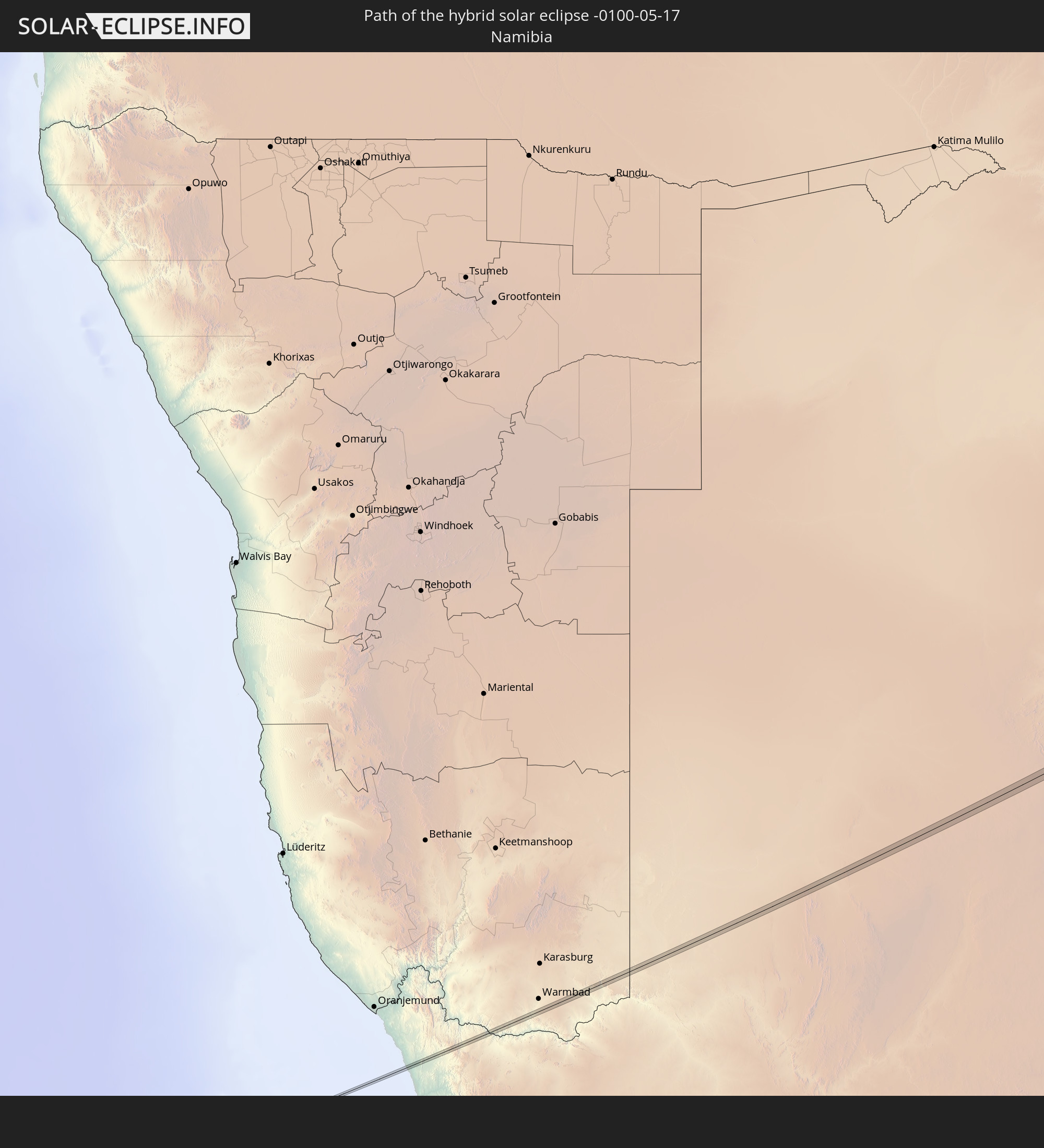 Namibia
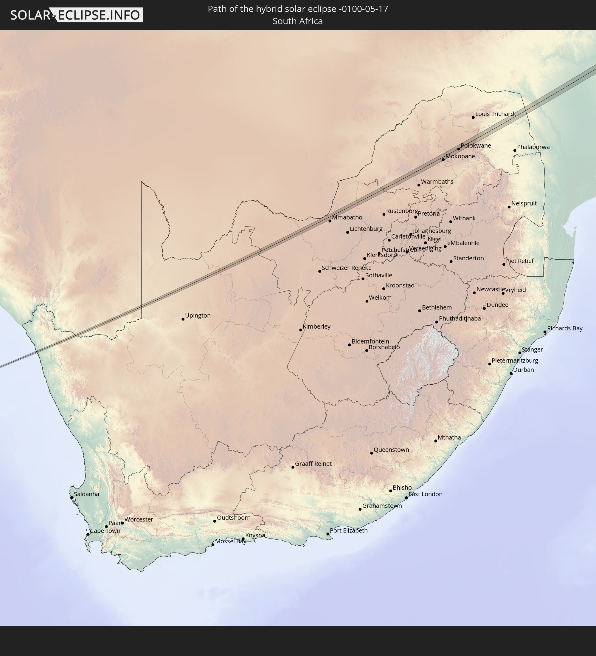 Südafrika
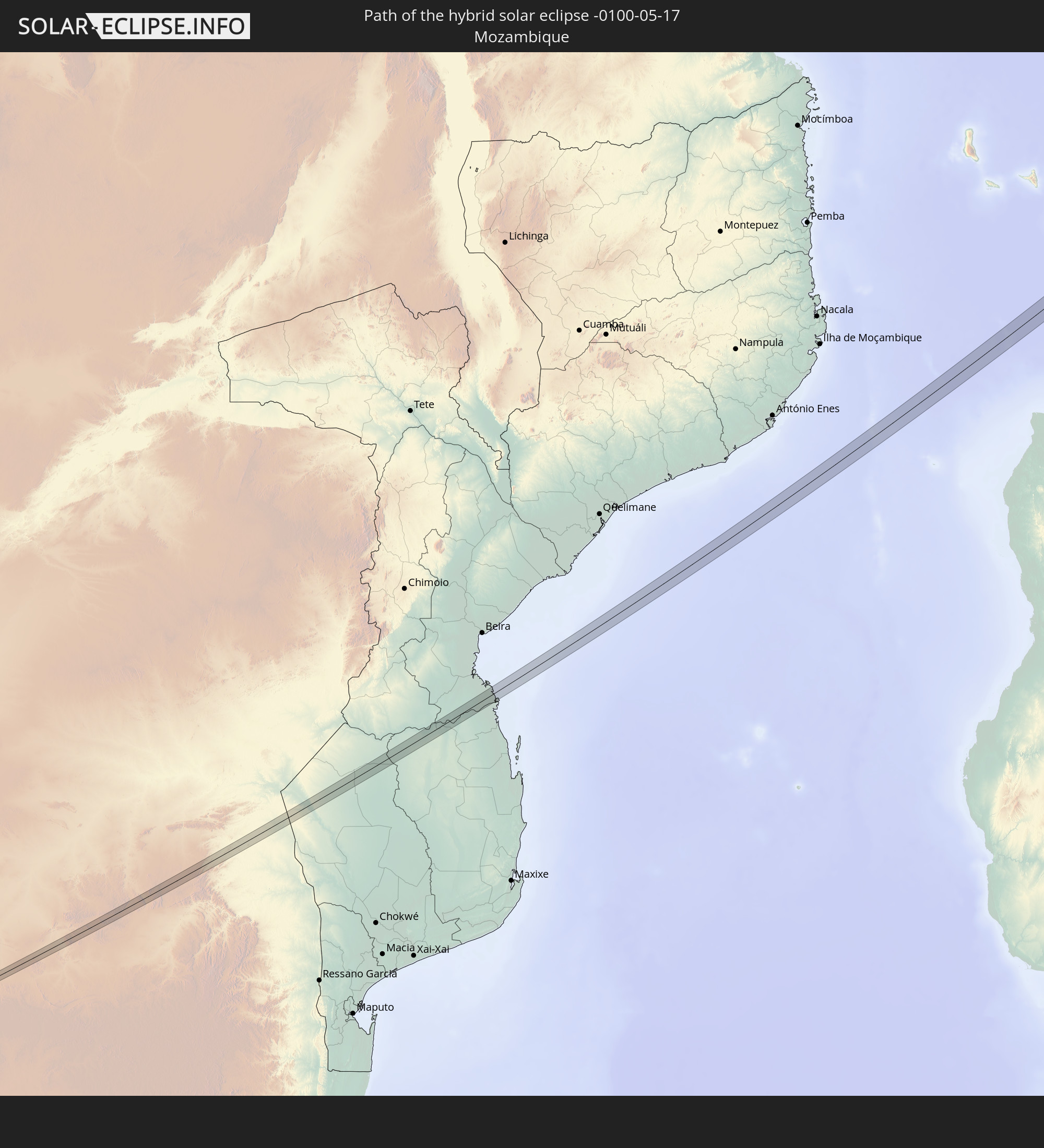 Mosambik
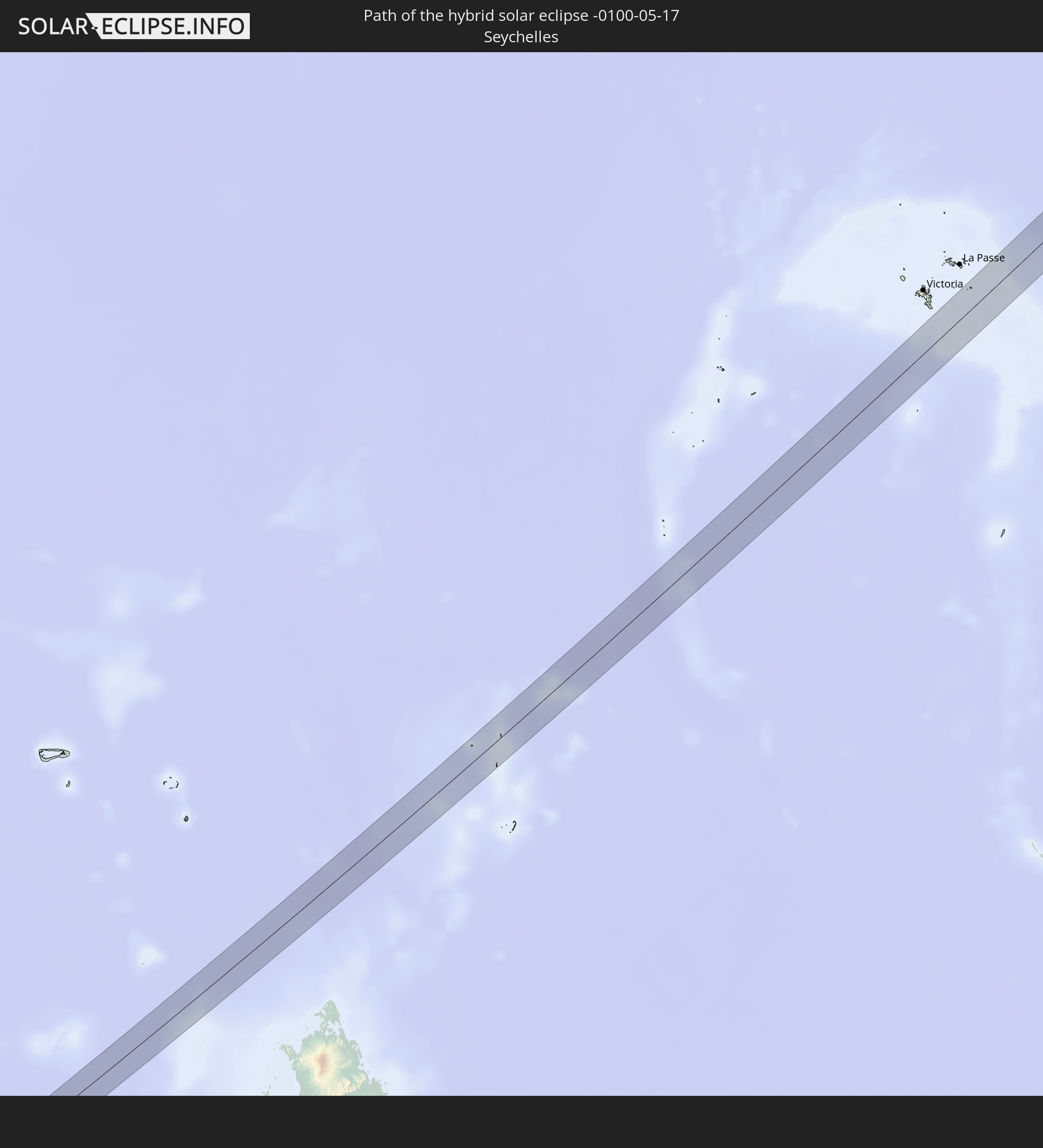 Seychellen
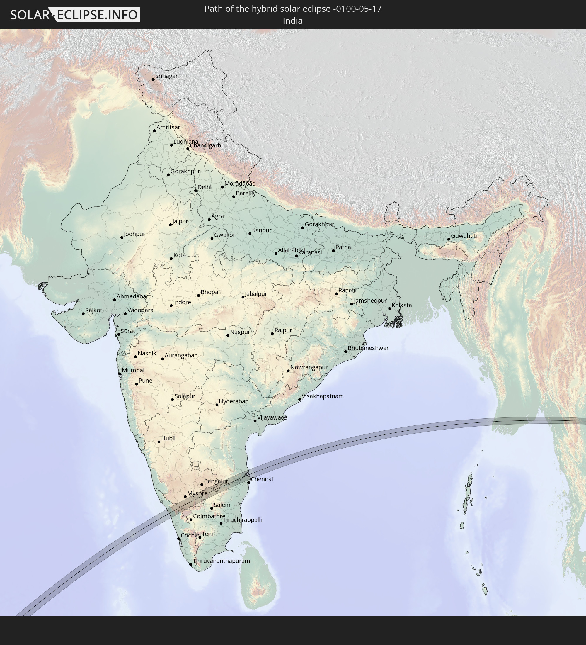 Indien
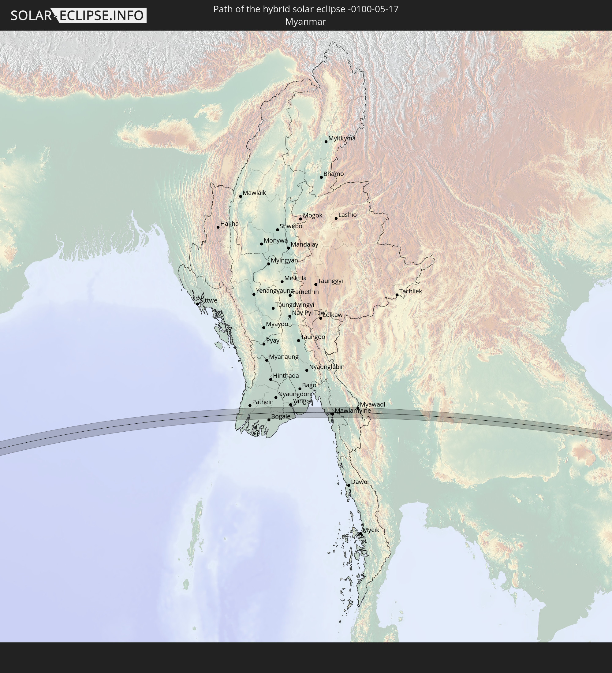 Myanmar
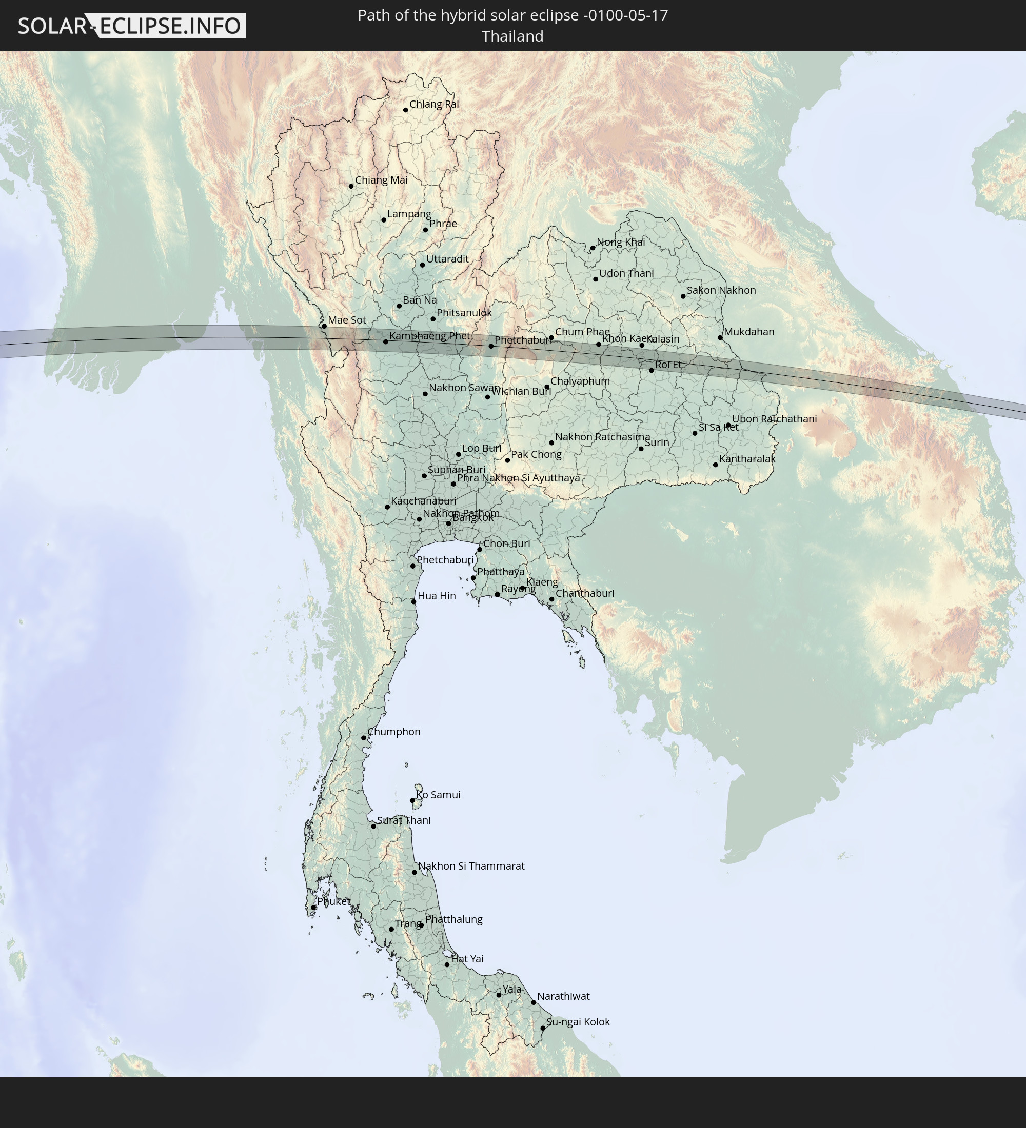 Thailand
 Laos
Laos
 Vietnam
 Philippinen
In den folgenden Ländern ist die Sonnenfinsternis partiell zu sehen
 Russland
 Äquatorialguinea
 São Tomé und Príncipe
 Kamerun
 Gabun
Gabun
 Republik Kongo
 Angola
 Namibia
 Demokratische Republik Kongo
 Tschad
 Zentralafrikanische Republik
 Südafrika
 Botswana
 Sudan
Sudan
 Sambia
 Simbabwe
 Lesotho
 Ruanda
 Burundi
 Tansania
 Uganda
 Mosambik
 Swasiland
 Malawi
 Äthiopien
 Kenia
Kenia
 Saudi-Arabien
 Eritrea
 Irak
Irak
 Französische Süd- und Antarktisgebiete
 Somalia
 Dschibuti
 Jemen
Jemen
 Madagaskar
 Komoren
 Iran
Iran
 Mayotte
 Seychellen
 Kasachstan
 Kuwait
 Bahrain
 Katar
Katar
 Vereinigte Arabische Emirate
 Oman
Oman
 Turkmenistan
 Réunion
 Usbekistan
 Mauritius
 Afghanistan
 Pakistan
 Tadschikistan
 Indien
 Kirgisistan
 Britisches Territorium im Indischen Ozean
 Malediven
 Volksrepublik China
 Sri Lanka
 Nepal
Nepal
 Mongolei
 Bangladesch
 Bhutan
 Myanmar
 Indonesien
 Kokosinseln
 Thailand
 Malaysia
 Laos
Laos
 Vietnam
 Kambodscha
 Singapur
 Weihnachtsinsel
 Australien
 Macau
Macau
 Hongkong
 Brunei
 Taiwan
 Philippinen
 Japan
Japan
 Osttimor
 Nordkorea
 Südkorea
 Palau
Palau
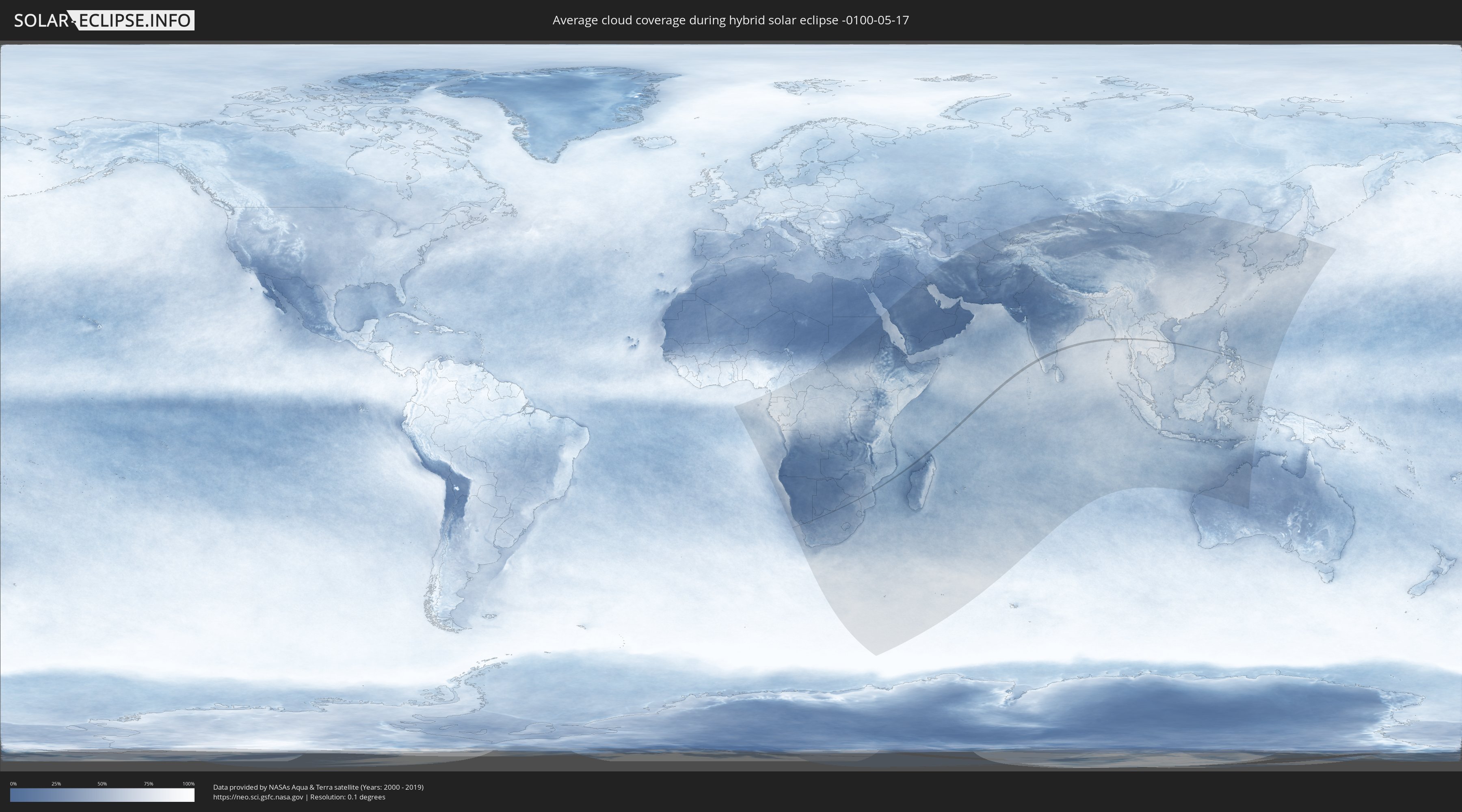
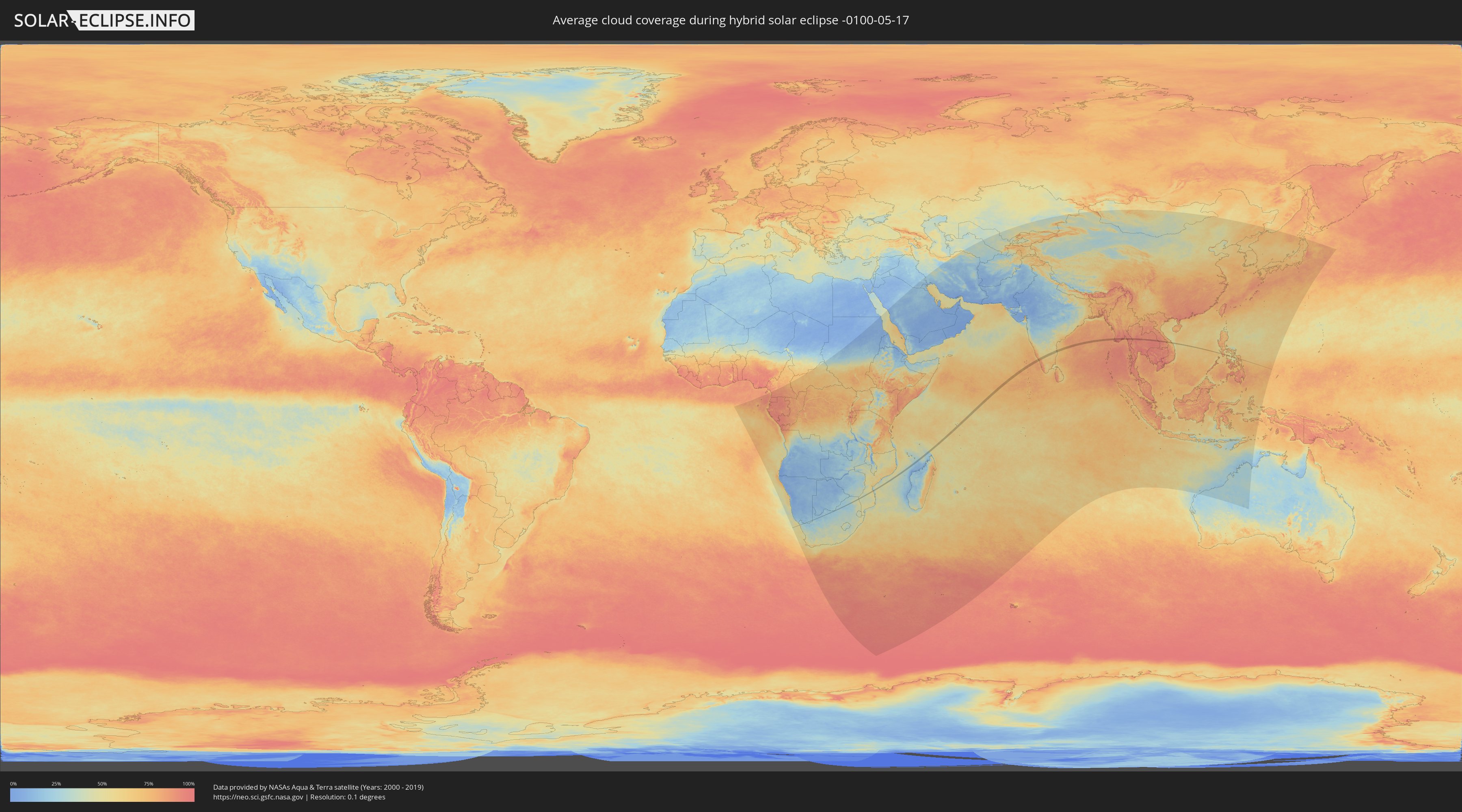
Wie wird das Wetter während der hybriden Sonnenfinsternis am 17.05.-0100?
Wo ist der beste Ort, um die hybride Sonnenfinsternis vom 17.05.-0100 zu beobachten?
Die folgenden Karten zeigen die durchschnittliche Bewölkung für den Tag, an dem die hybride Sonnenfinsternis
stattfindet. Mit Hilfe der Karten lässt sich der Ort entlang des Finsternispfades eingrenzen,
der die besten Aussichen auf einen klaren wolkenfreien Himmel bietet.
Trotzdem muss man immer lokale Gegenenheiten beachten und sollte sich genau über das Wetter an seinem
gewählten Beobachtungsort informieren.
Die Daten stammen von den beiden NASA-Satelliten
AQUA und TERRA
und wurden über einen Zeitraum von 19 Jahren (2000 - 2019) gemittelt.
Detaillierte Länderkarten
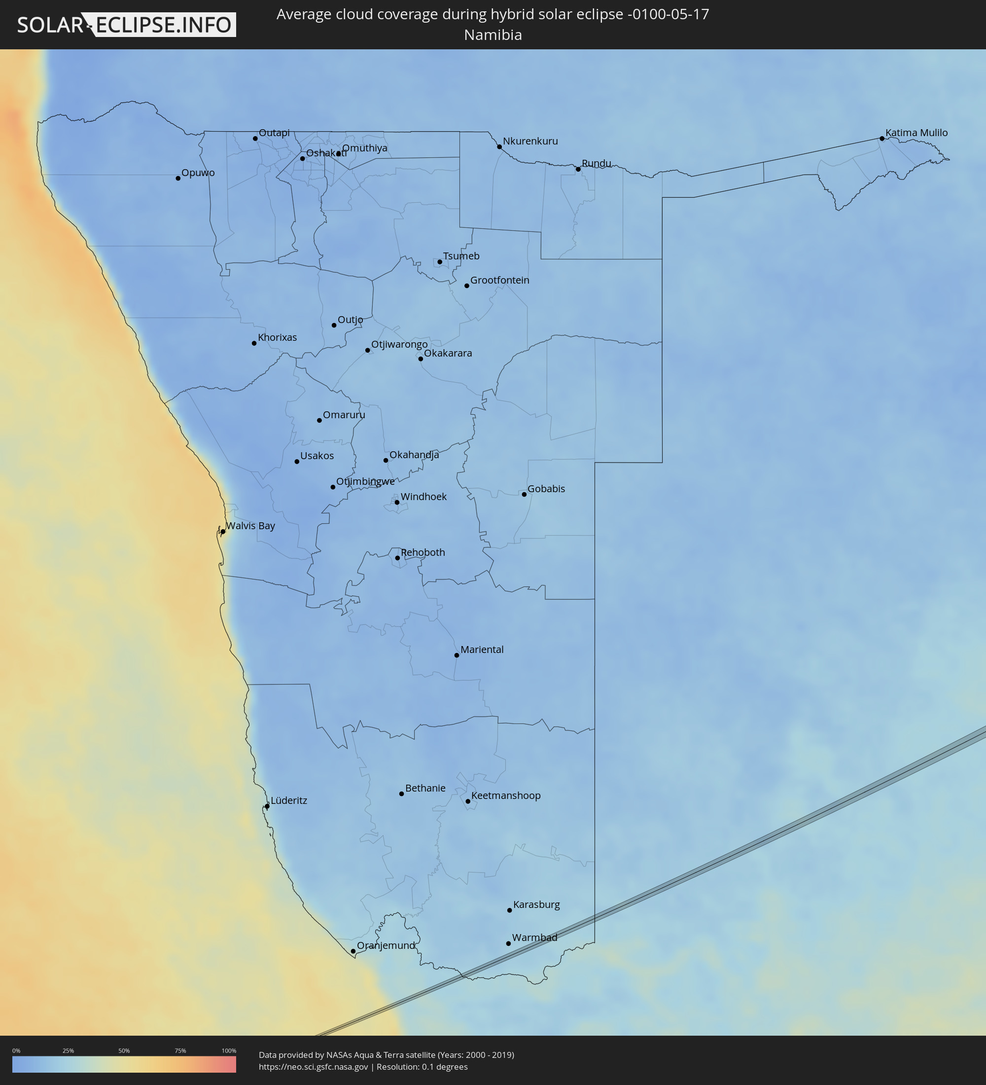 Namibia
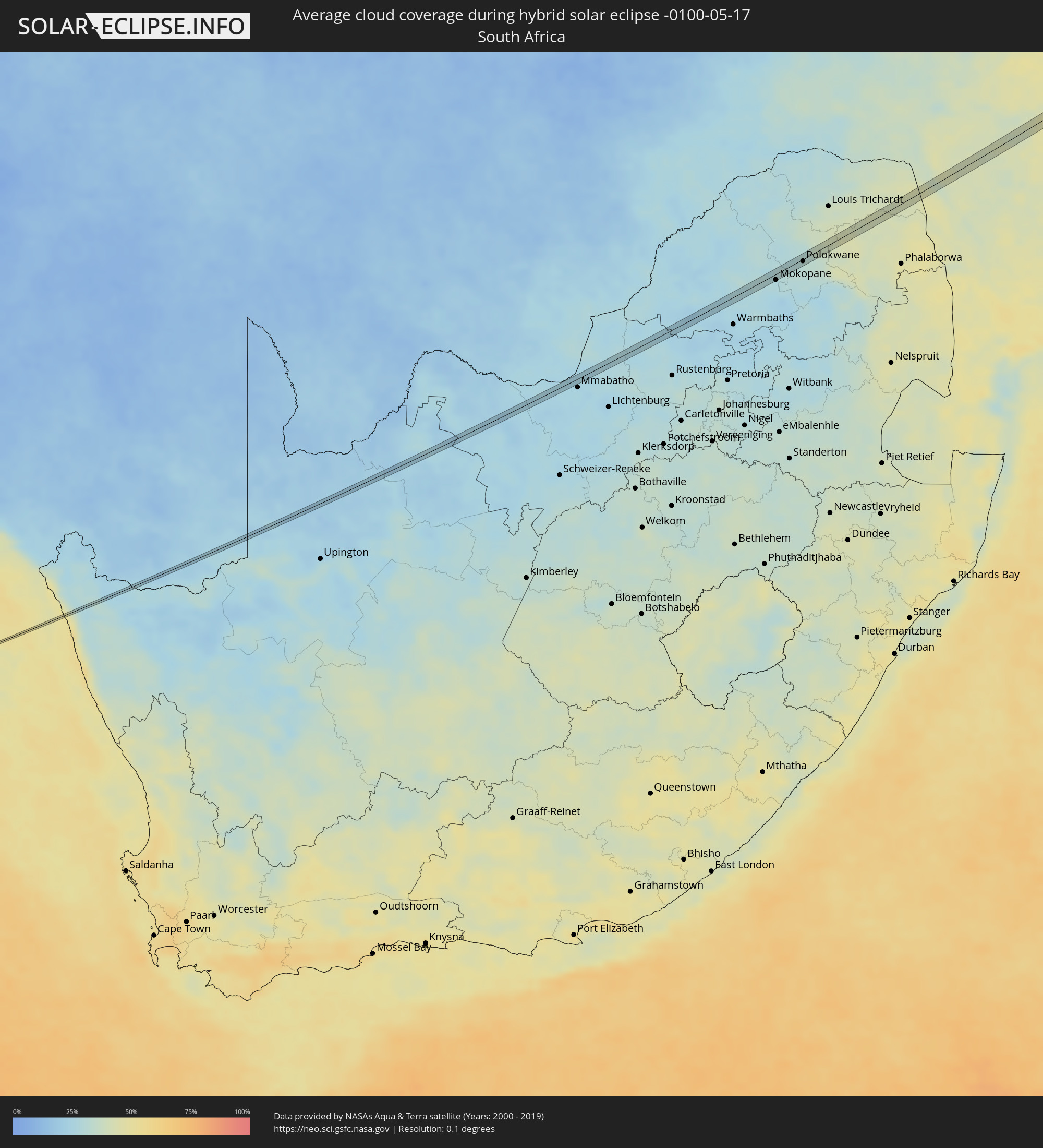 Südafrika
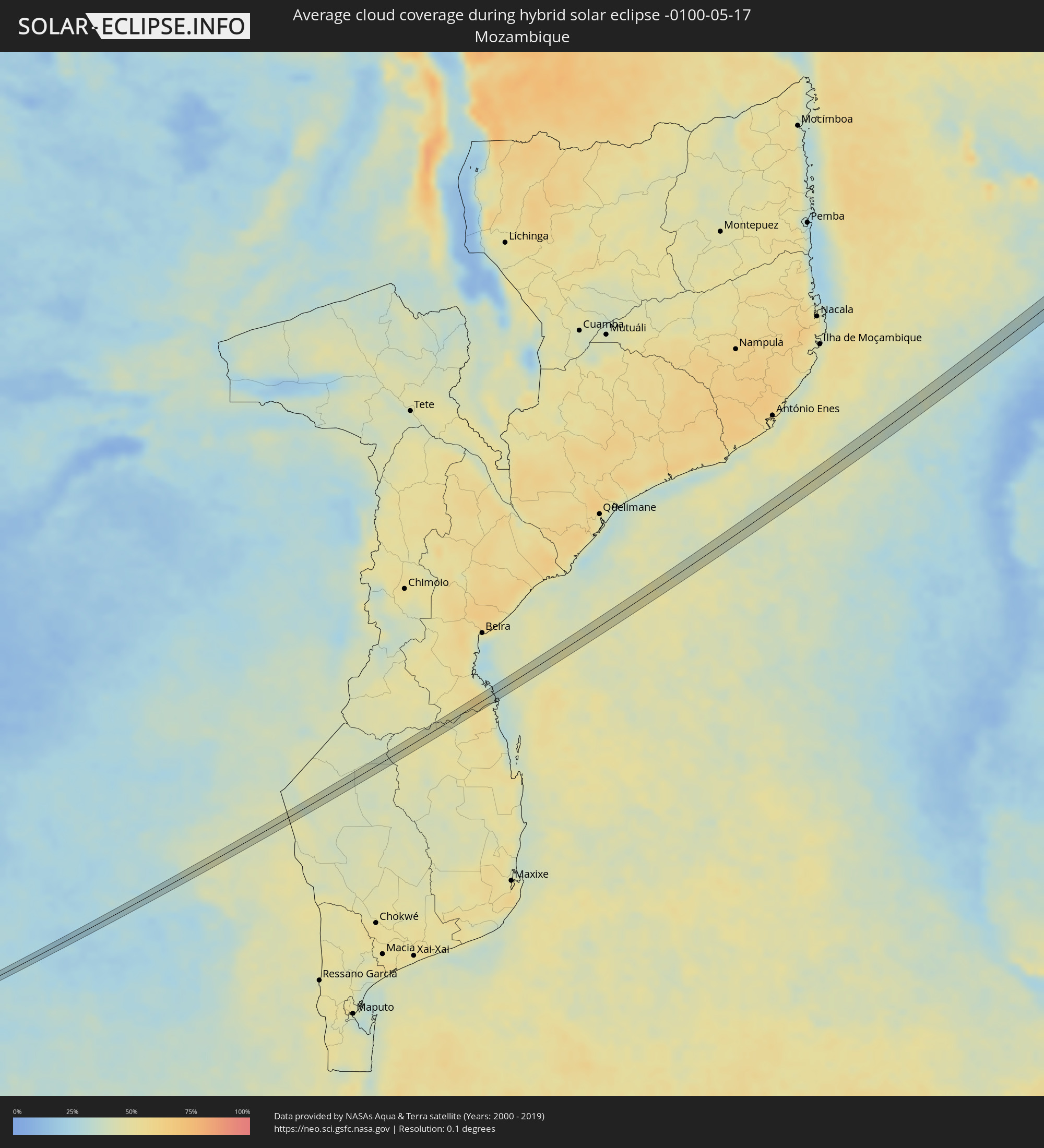 Mosambik
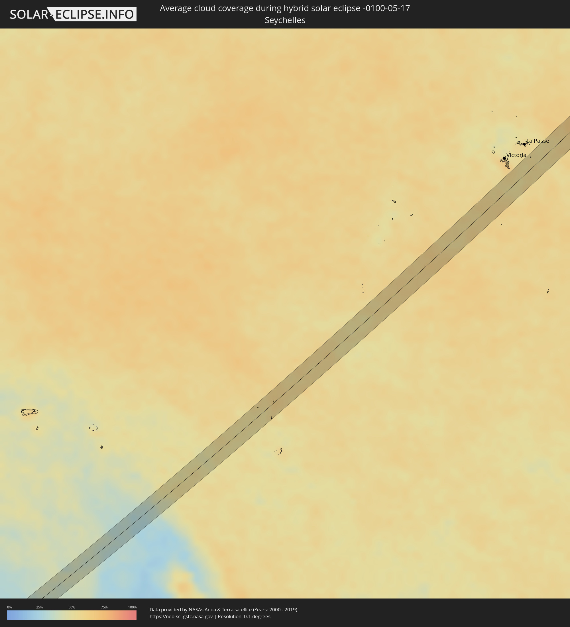 Seychellen
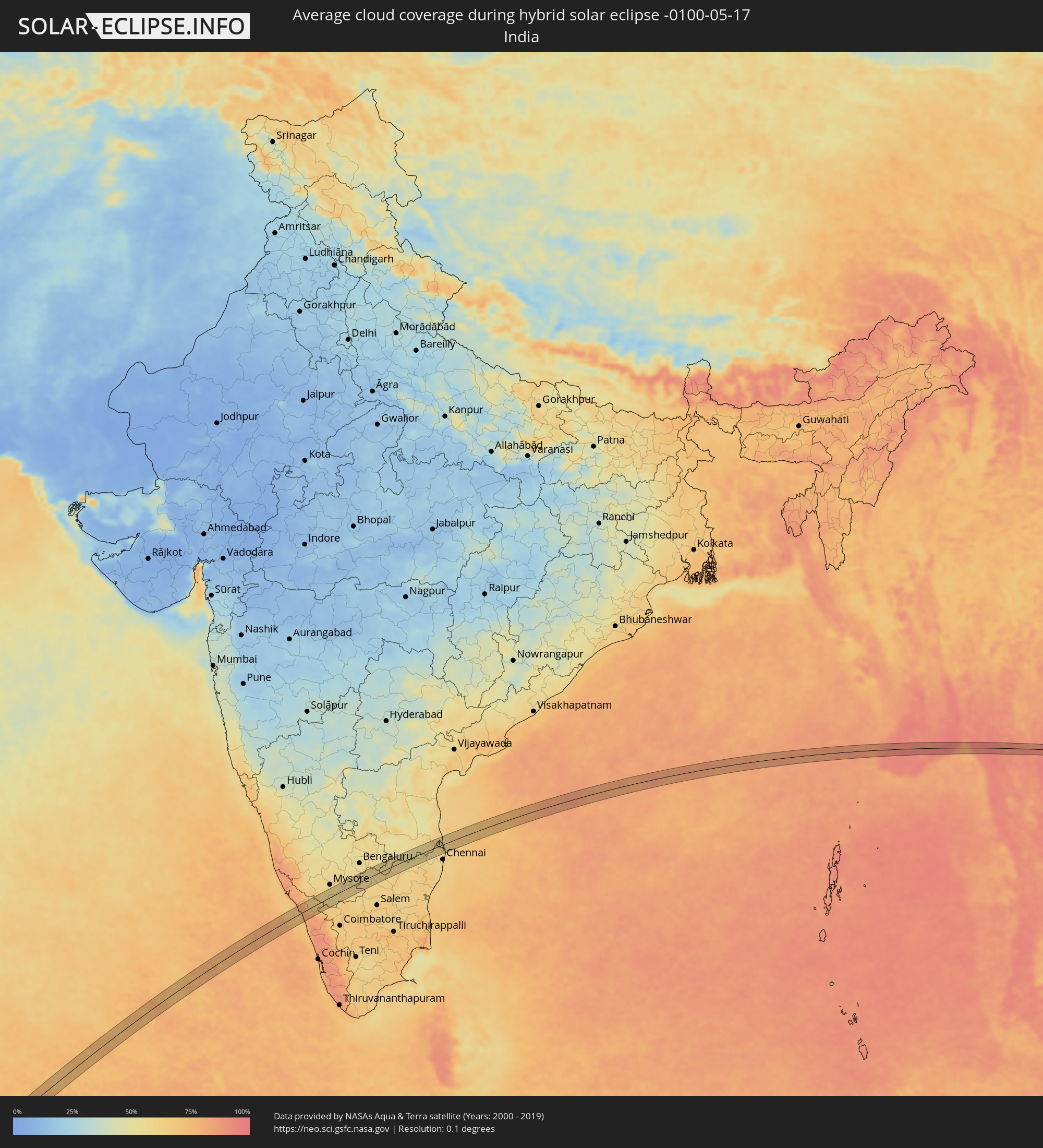 Indien
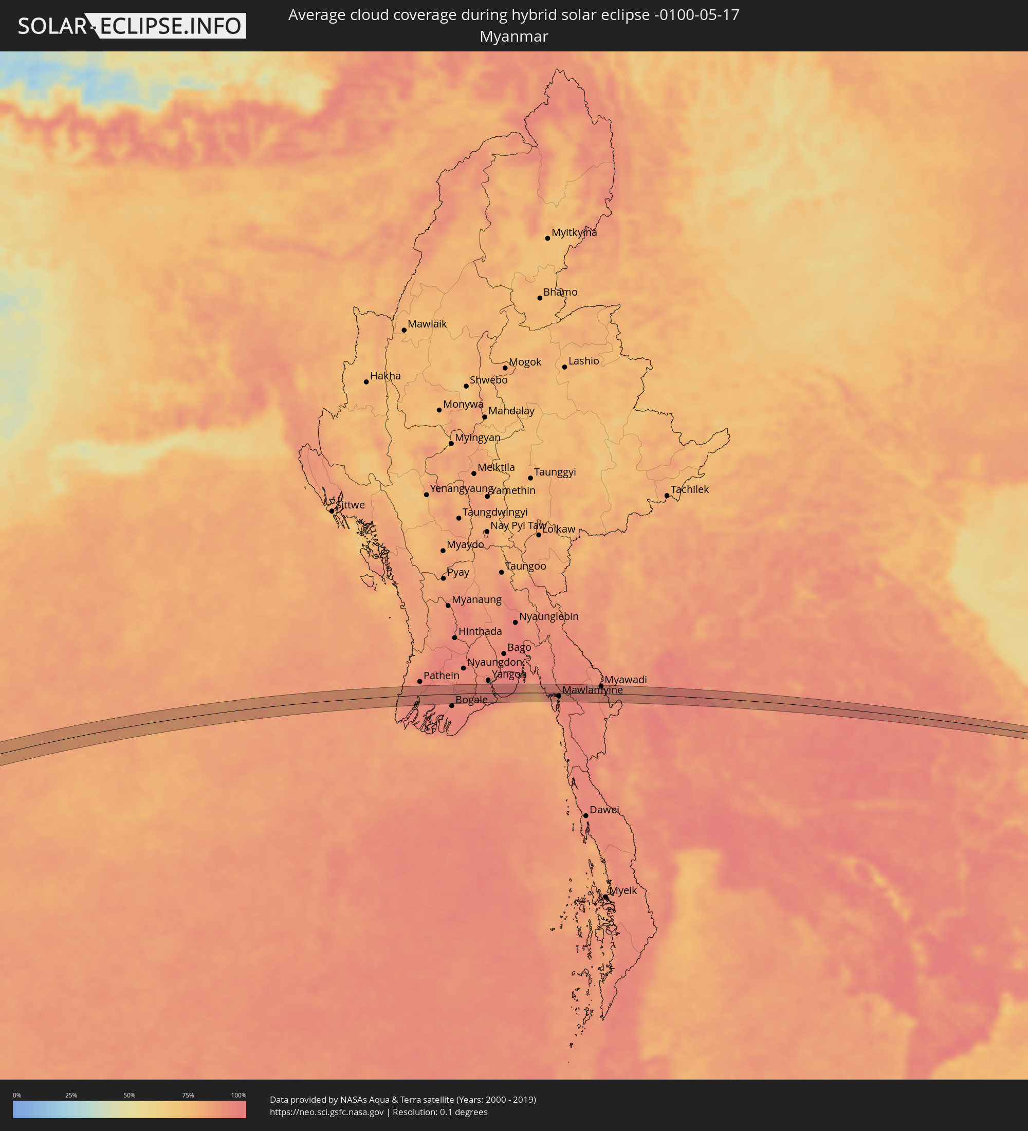 Myanmar
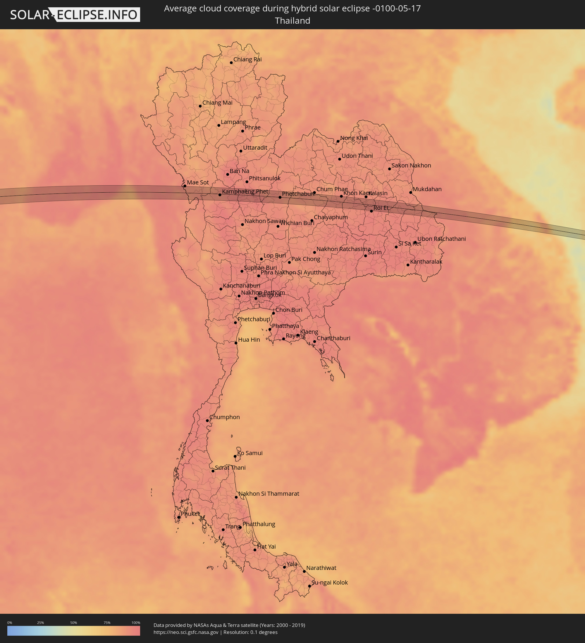 Thailand
 Laos
Laos
 Vietnam
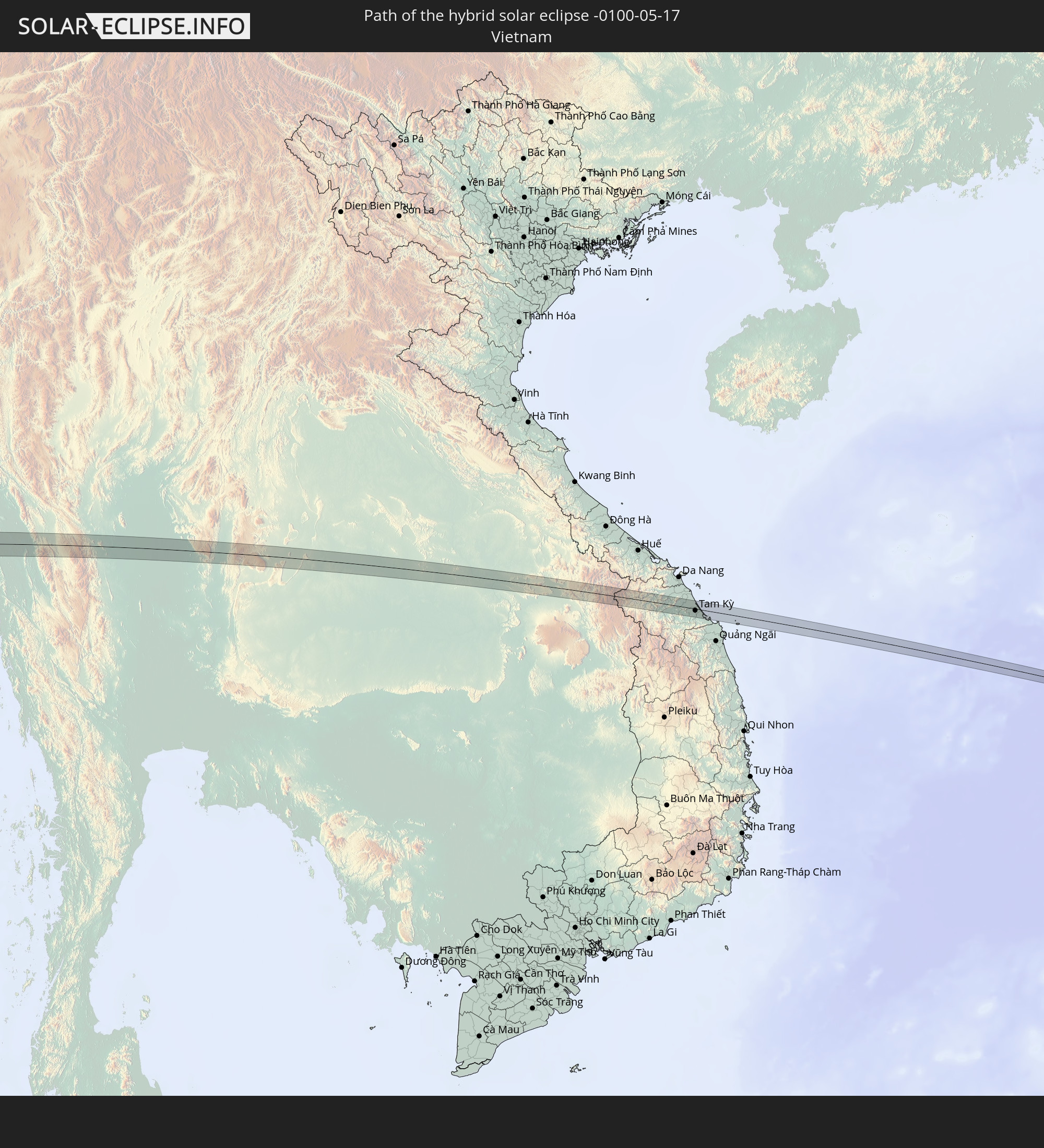
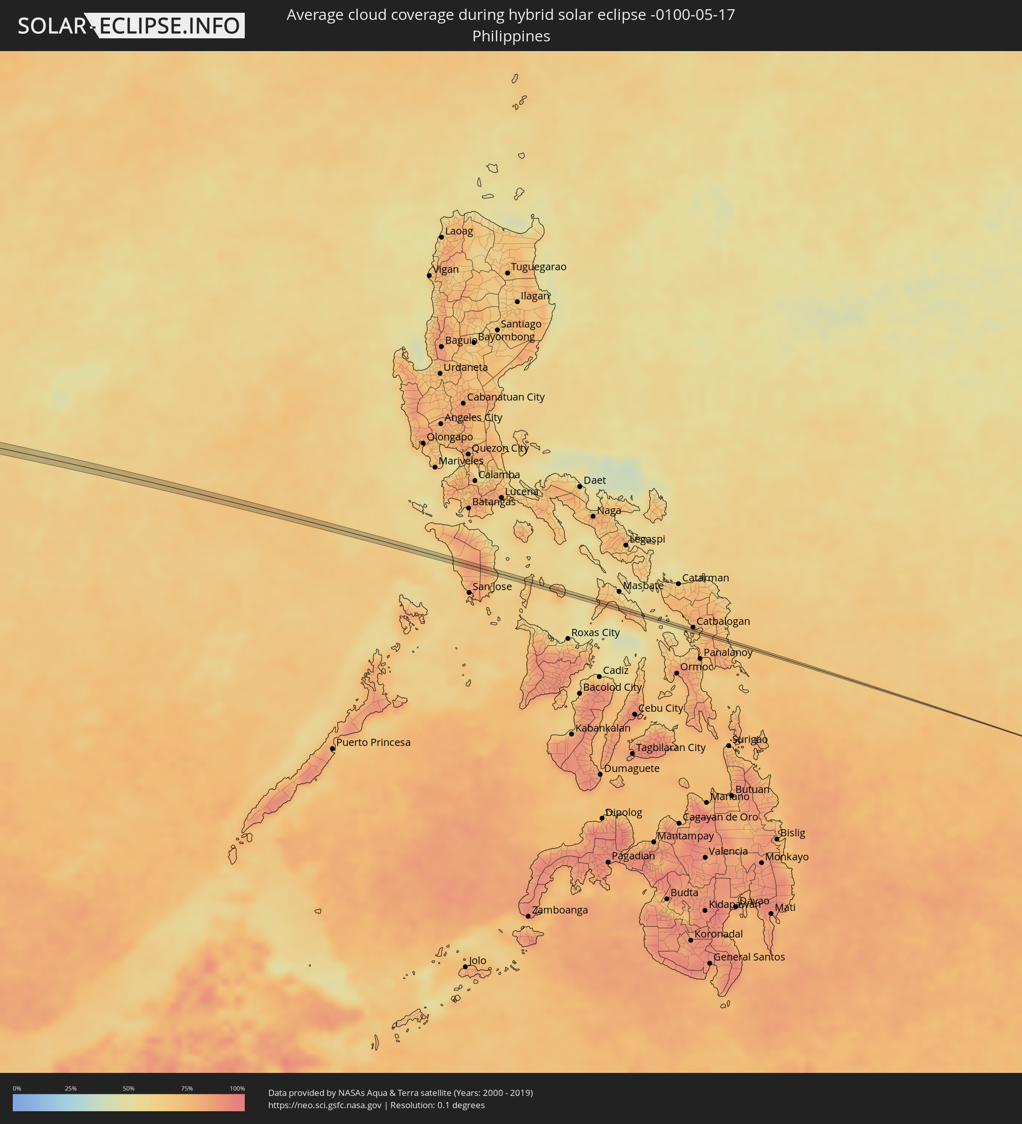 Philippinen
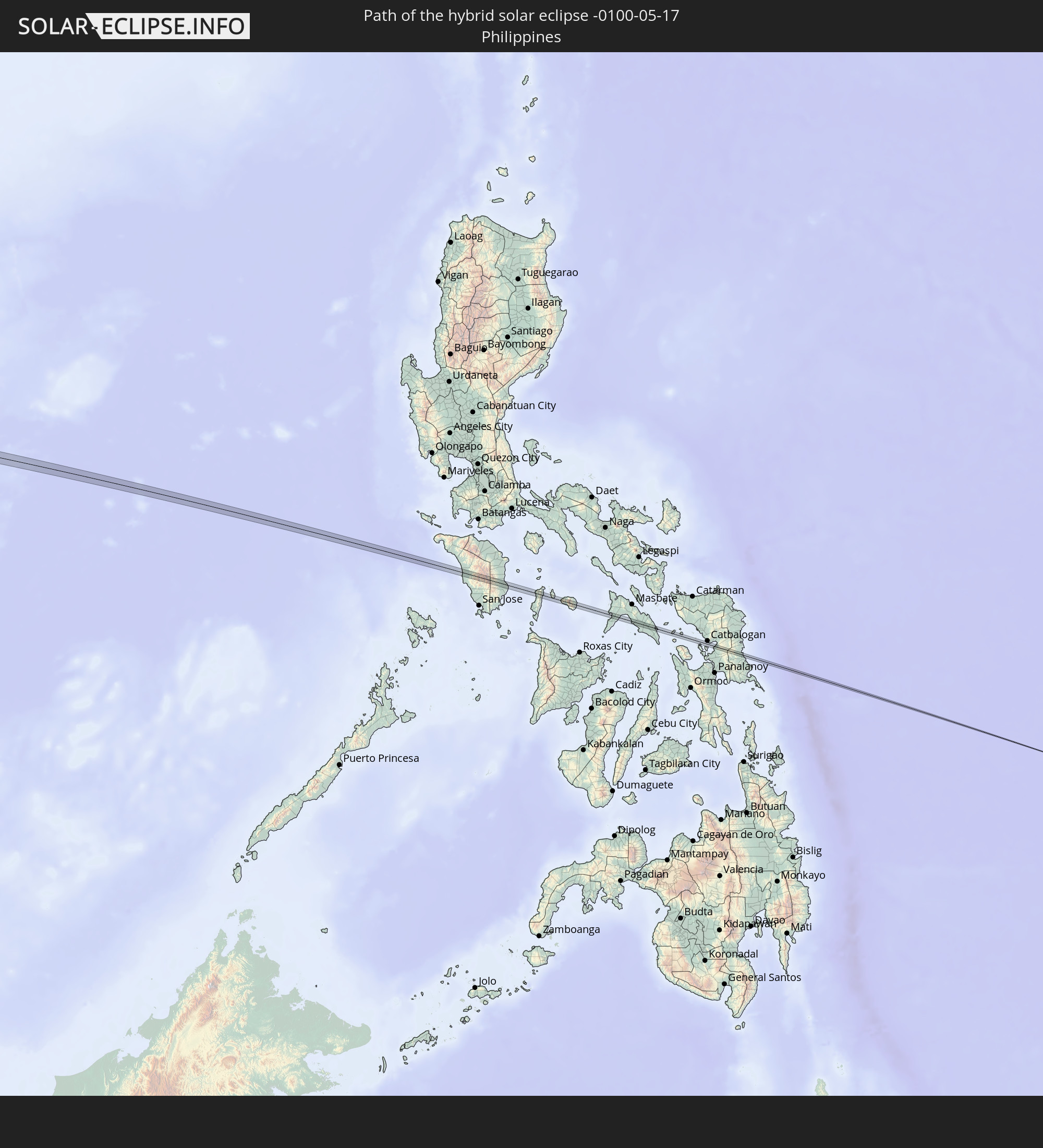
Orte im Finsternispfad
Die nachfolgene Tabelle zeigt Städte und Orte mit mehr als 5.000 Einwohnern, die sich im Finsternispfad befinden. Städte mit mehr als 100.000 Einwohnern sind dick gekennzeichnet. Mit einem Klick auf den Ort öffnet sich eine Detailkarte die die Lage des jeweiligen Ortes zusammen mit dem Verlauf der zentralen Finsternis präsentiert.
| Ort | Typ | Dauer der Verfinsterung | Ortszeit bei maximaler Verfinsterung | Entfernung zur Zentrallinie | Ø Bewölkung |
|
Zeerust, North-West
|
total | - | 07:09:03 UTC+01:30 | 2 km | 26% |
|
Mokopane, Limpopo
|
total | - | 07:10:27 UTC+01:30 | 9 km | 27% |
|
Polokwane, Limpopo
|
total | - | 07:10:44 UTC+01:30 | 3 km | 31% |
|
Giyani, Limpopo
|
total | - | 07:11:30 UTC+01:30 | 7 km | 41% |
|
Badagara, Kerala
|
total | - | 13:04:23 UTC+05:21 | 26 km | 67% |
|
Iringal, Kerala
|
total | - | 13:04:25 UTC+05:21 | 20 km | 67% |
|
Naduvannūr, Kerala
|
total | - | 13:04:45 UTC+05:21 | 5 km | 81% |
|
Kozhikode, Kerala
|
total | - | 13:04:21 UTC+05:21 | 19 km | 69% |
|
Ferokh, Kerala
|
total | - | 13:04:25 UTC+05:21 | 28 km | 69% |
|
Mavoor, Kerala
|
total | - | 13:04:46 UTC+05:21 | 24 km | 78% |
|
Kalpetta, Kerala
|
total | - | 13:05:48 UTC+05:21 | 1 km | 74% |
|
Nanjangūd, Karnataka
|
total | - | 13:08:18 UTC+05:21 | 20 km | 58% |
|
Gundlupet, Karnataka
|
total | - | 13:07:49 UTC+05:21 | 11 km | 61% |
|
Chamrajnagar, Karnataka
|
total | - | 13:08:42 UTC+05:21 | 13 km | 61% |
|
Malavalli, Karnataka
|
total | - | 13:09:47 UTC+05:21 | 27 km | 60% |
|
Kollegāl, Karnataka
|
total | - | 13:09:33 UTC+05:21 | 2 km | 60% |
|
Kānkānhalli, Karnataka
|
total | - | 13:11:02 UTC+05:21 | 26 km | 56% |
|
Anekal, Karnataka
|
total | - | 13:12:03 UTC+05:21 | 29 km | 56% |
|
Hosūr, Tamil Nadu
|
total | - | 13:12:28 UTC+05:21 | 25 km | 55% |
|
Krishnagiri, Tamil Nadu
|
total | - | 13:13:11 UTC+05:21 | 15 km | 58% |
|
Robertsonpet, Karnataka
|
total | - | 13:14:02 UTC+05:21 | 26 km | 57% |
|
Vaniyambadi, Tamil Nadu
|
total | - | 13:14:34 UTC+05:21 | 18 km | 61% |
|
Ambur, Tamil Nadu
|
total | - | 13:15:00 UTC+05:21 | 11 km | 61% |
|
Peranāmpattu, Tamil Nadu
|
total | - | 13:15:13 UTC+05:21 | 4 km | 59% |
|
Gudiyatham, Tamil Nadu
|
total | - | 13:15:40 UTC+05:21 | 2 km | 58% |
|
Pallikondai, Tamil Nadu
|
total | - | 13:15:48 UTC+05:21 | 9 km | 58% |
|
Vellore, Tamil Nadu
|
total | - | 13:16:20 UTC+05:21 | 17 km | 57% |
|
Rāmāpuram, Andhra Pradesh
|
total | - | 13:16:45 UTC+05:21 | 0 km | 55% |
|
Arcot, Tamil Nadu
|
total | - | 13:16:50 UTC+05:21 | 26 km | 58% |
|
Walajapet, Tamil Nadu
|
total | - | 13:17:00 UTC+05:21 | 26 km | 62% |
|
Sholinghur, Tamil Nadu
|
total | - | 13:17:26 UTC+05:21 | 9 km | 56% |
|
Puttūr, Andhra Pradesh
|
total | - | 13:18:15 UTC+05:21 | 18 km | 53% |
|
Nagari, Andhra Pradesh
|
total | - | 13:18:11 UTC+05:21 | 5 km | 53% |
|
Arakkonam, Tamil Nadu
|
total | - | 13:18:04 UTC+05:21 | 23 km | 57% |
|
Tiruvallur, Tamil Nadu
|
total | - | 13:18:49 UTC+05:21 | 27 km | 57% |
|
Sūlūru, Andhra Pradesh
|
total | - | 13:19:53 UTC+05:21 | 25 km | 63% |
|
Ponneri, Tamil Nadu
|
total | - | 13:19:53 UTC+05:21 | 19 km | 57% |
|
Mīnjūr, Tamil Nadu
|
total | - | 13:19:58 UTC+05:21 | 28 km | 56% |
|
Wakema, Ayeyarwady
|
total | - | 15:03:08 UTC+06:24 | 8 km | 92% |
|
Mawlamyinegyunn, Ayeyarwady
|
total | - | 15:03:11 UTC+06:24 | 17 km | 93% |
|
Maubin, Ayeyarwady
|
total | - | 15:04:07 UTC+06:24 | 21 km | 94% |
|
Kyaiklat, Ayeyarwady
|
total | - | 15:04:08 UTC+06:24 | 11 km | 91% |
|
Twante, Yangon
|
total | - | 15:04:39 UTC+06:24 | 18 km | 92% |
|
Kanbe, Yangon
|
total | - | 15:04:47 UTC+06:24 | 17 km | 93% |
|
Martaban, Mon
|
total | - | 15:07:45 UTC+06:24 | 4 km | 92% |
|
Mawlamyine, Mon
|
total | - | 15:07:46 UTC+06:24 | 8 km | 92% |
|
Myawadi, Kayin
|
total | - | 15:09:25 UTC+06:24 | 16 km | 91% |
|
Mae Sot, Tak
|
total | - | 15:26:49 UTC+06:42 | 19 km | 91% |
|
Kamphaeng Phet, Kamphaeng Phet
|
total | - | 15:28:24 UTC+06:42 | 4 km | 91% |
|
Lan Krabue, Kamphaeng Phet
|
total | - | 15:29:00 UTC+06:42 | 11 km | 94% |
|
Bang Krathum, Phitsanulok
|
total | - | 15:29:45 UTC+06:42 | 11 km | 94% |
|
Phichit, Phichit
|
total | - | 15:29:48 UTC+06:42 | 4 km | 94% |
|
Wang Sai Phun, Phichit
|
total | - | 15:30:05 UTC+06:42 | 9 km | 96% |
|
Phetchabun, Phetchabun
|
total | - | 15:31:07 UTC+06:42 | 1 km | 91% |
|
Kaset Sombun, Chaiyaphum
|
total | - | 15:32:20 UTC+06:42 | 11 km | 86% |
|
Phu Khiao, Chaiyaphum
|
total | - | 15:32:38 UTC+06:42 | 2 km | 89% |
|
Khon Kaen, Khon Kaen
|
total | - | 15:33:43 UTC+06:42 | 16 km | 92% |
|
Kosum Phisai, Maha Sarakham
|
total | - | 15:34:02 UTC+06:42 | 4 km | 92% |
|
Maha Sarakham, Maha Sarakham
|
total | - | 15:34:22 UTC+06:42 | 8 km | 92% |
|
Yang Talat, Kalasin
|
total | - | 15:34:30 UTC+06:42 | 16 km | 92% |
|
Kamalasai, Kalasin
|
total | - | 15:34:47 UTC+06:42 | 12 km | 94% |
|
Pho Chai, Roi Et
|
total | - | 15:35:04 UTC+06:42 | 13 km | 95% |
|
Waeng, Roi Et
|
total | - | 15:35:22 UTC+06:42 | 12 km | 94% |
|
Tam Kỳ, Quảng Nam
|
total | - | 16:05:41 UTC+07:06 | 3 km | 73% |
|
Cataingan, Bicol
|
total | - | 17:10:32 UTC+08:00 | 1 km | 65% |