Totale Sonnenfinsternis vom 19.08.-0114
| Wochentag: | Dienstag |
| Maximale Dauer der Verfinsterung: | 05m36s |
| Maximale Breite des Finsternispfades: | 216 km |
| Saroszyklus: | 72 |
| Bedeckungsgrad: | 100% |
| Magnitude: | 1.0658 |
| Gamma: | -0.1203 |
Wo kann man die Sonnenfinsternis vom 19.08.-0114 sehen?
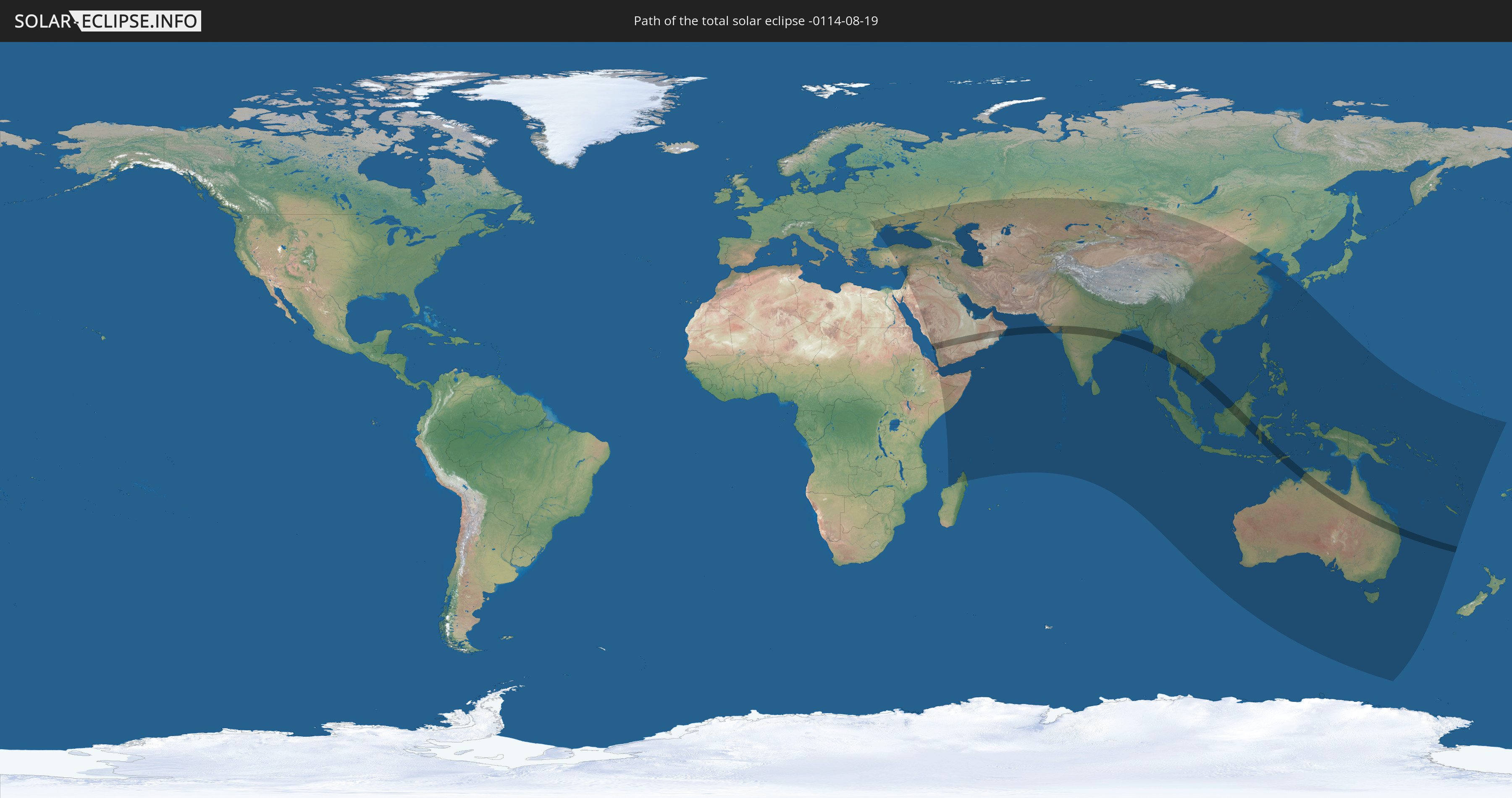
Die Sonnenfinsternis am 19.08.-0114 kann man in 74 Ländern als partielle Sonnenfinsternis beobachten.
Der Finsternispfad verläuft durch 12 Länder. Nur in diesen Ländern ist sie als totale Sonnenfinsternis zu sehen.
In den folgenden Ländern ist die Sonnenfinsternis total zu sehen
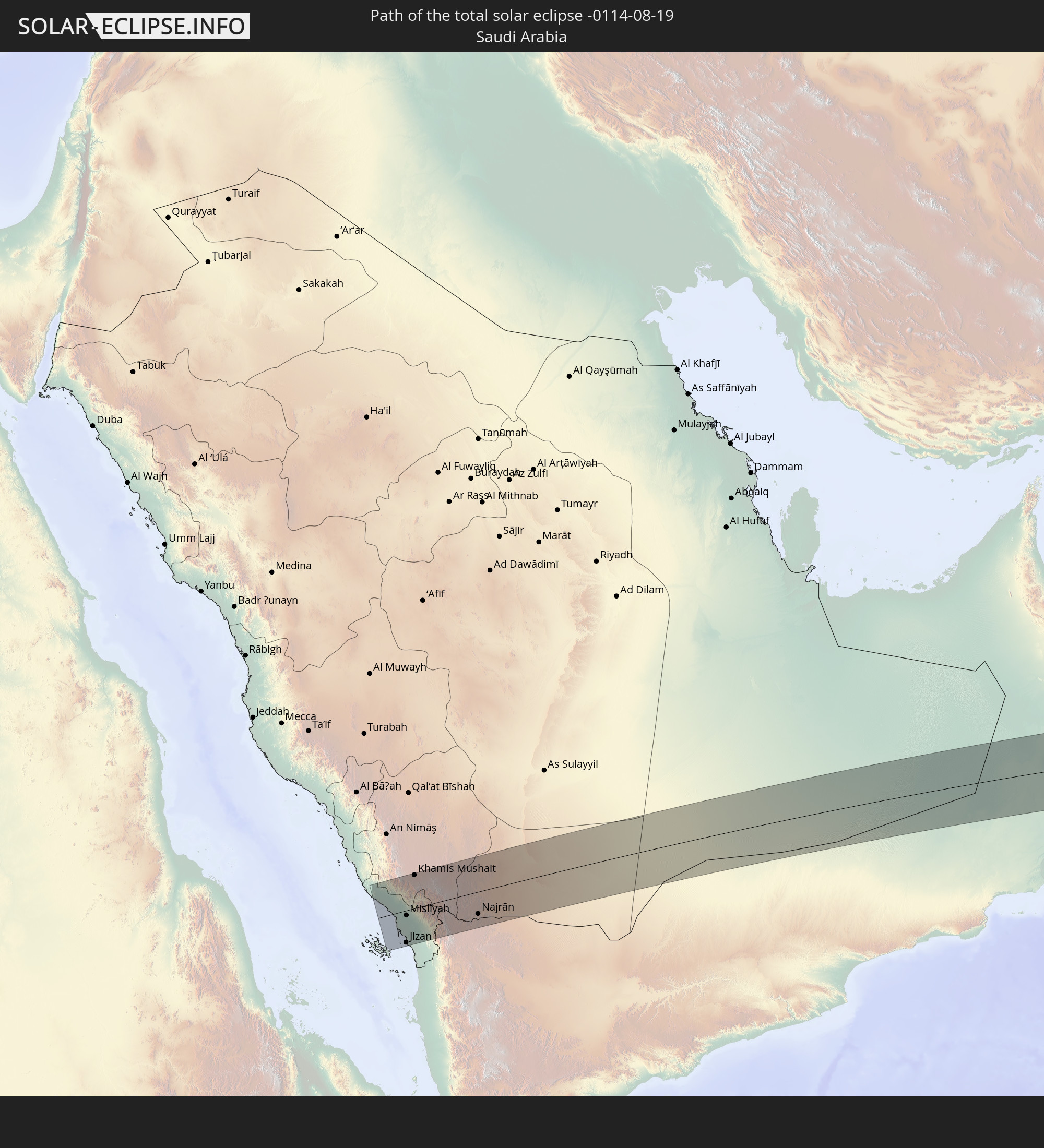 Saudi-Arabien
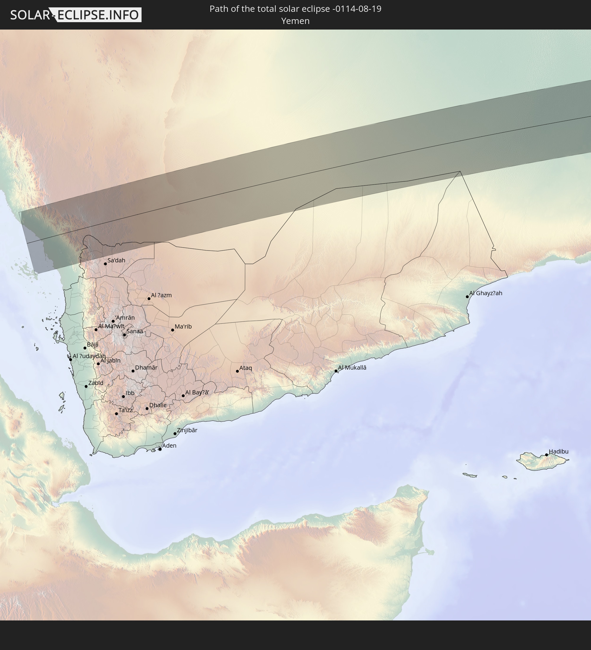 Jemen
Jemen
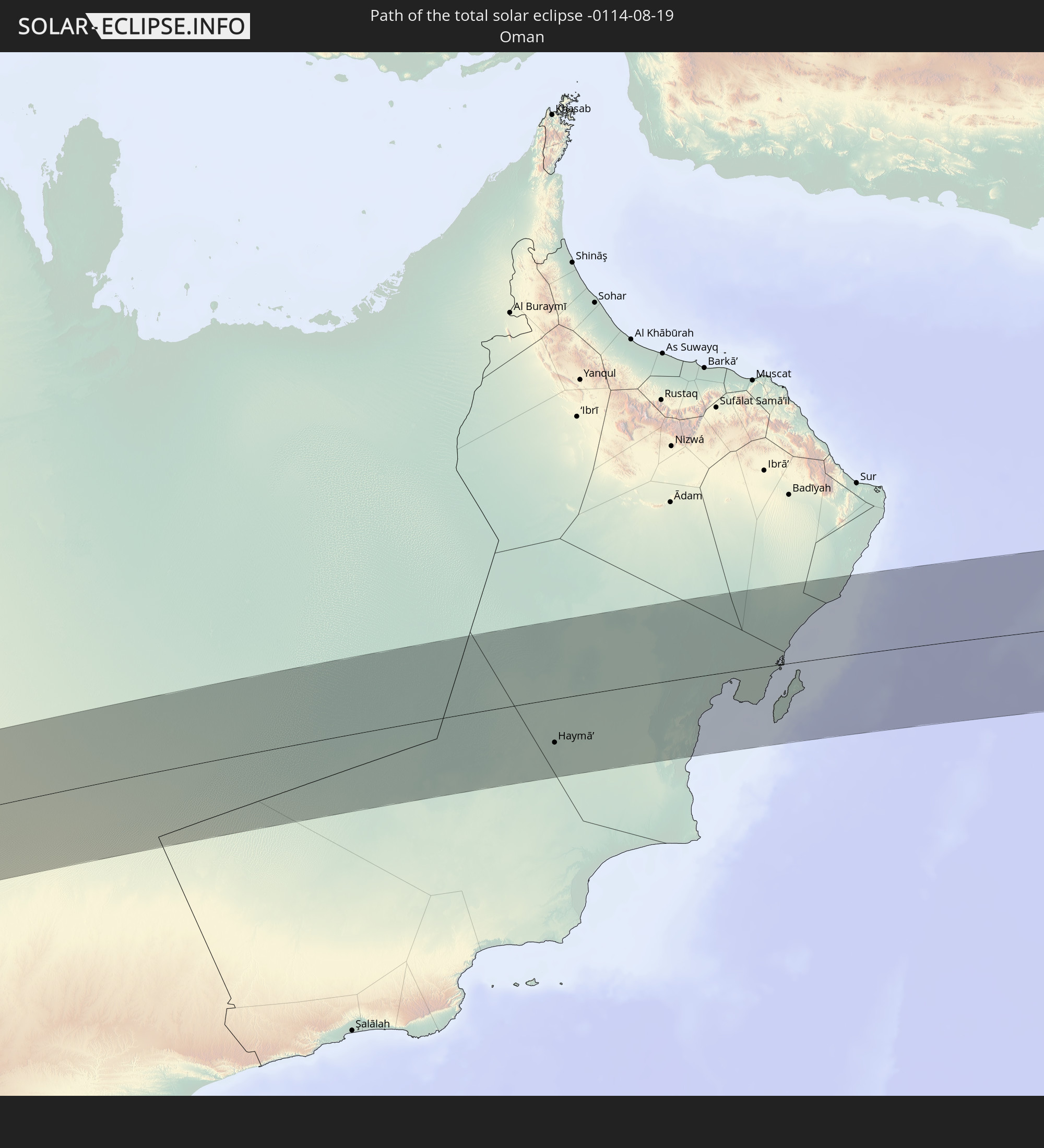 Oman
Oman
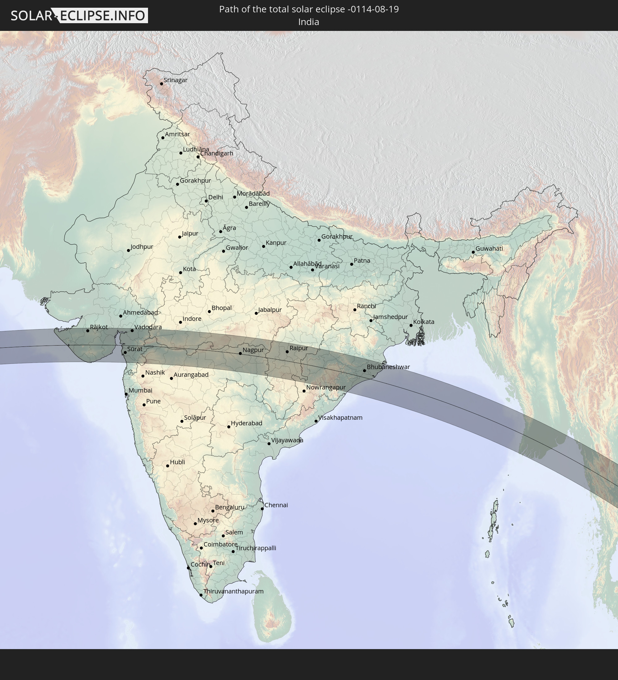 Indien
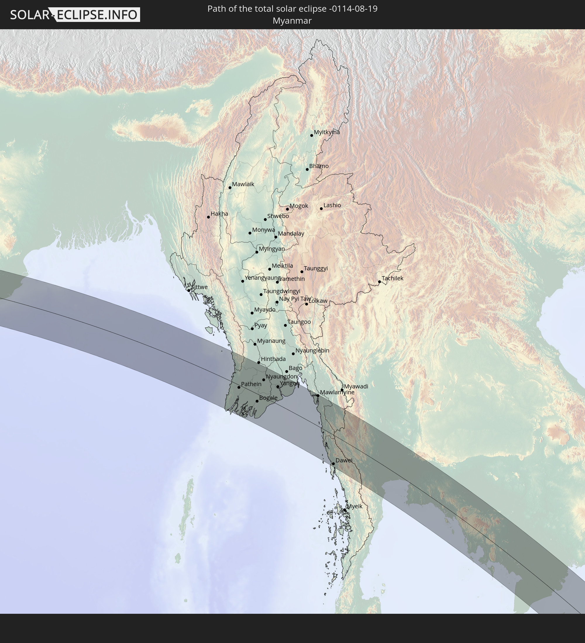 Myanmar
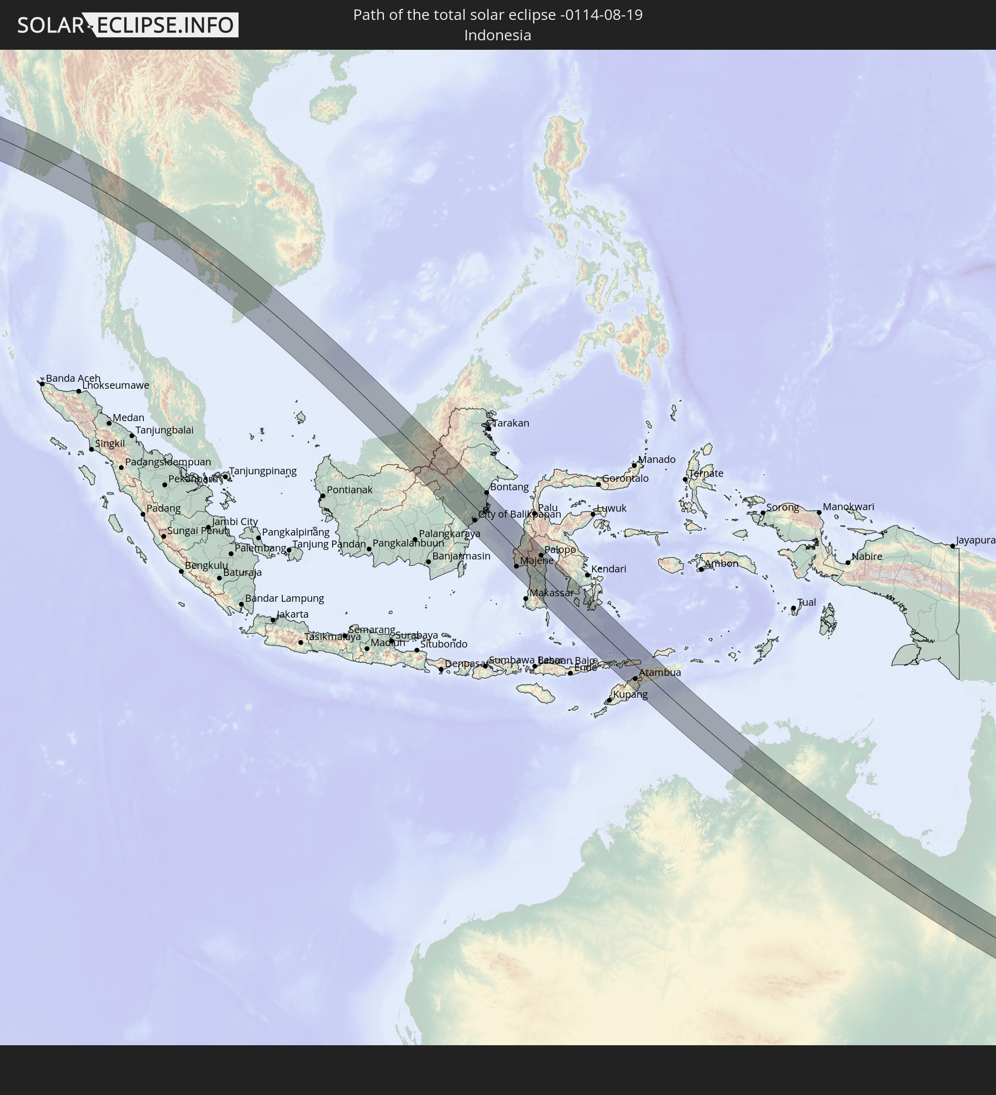 Indonesien
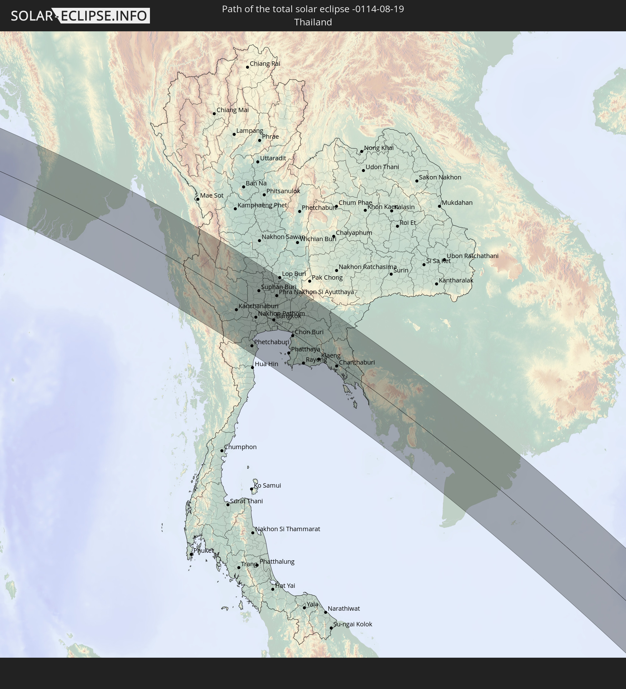 Thailand
 Malaysia
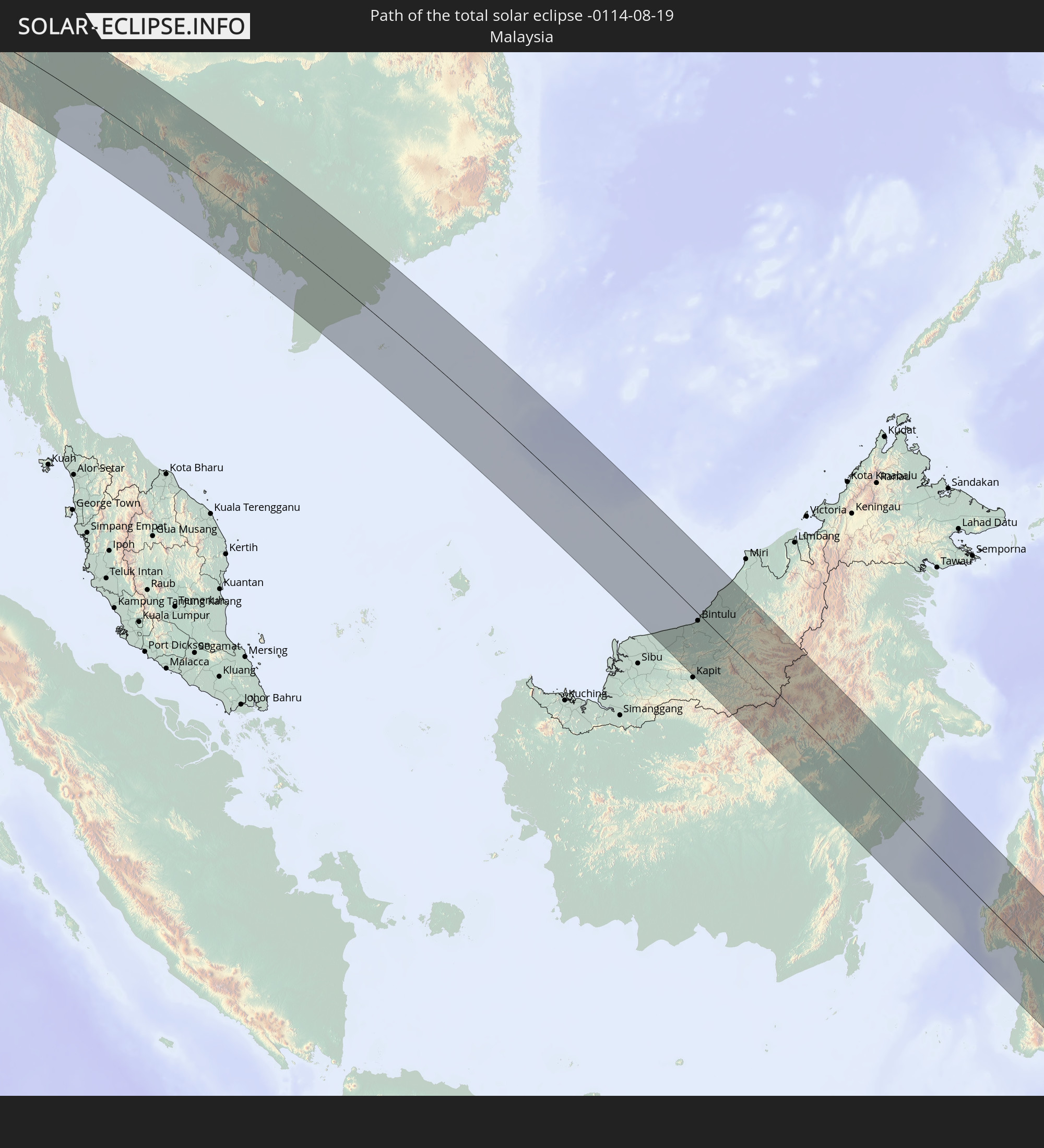
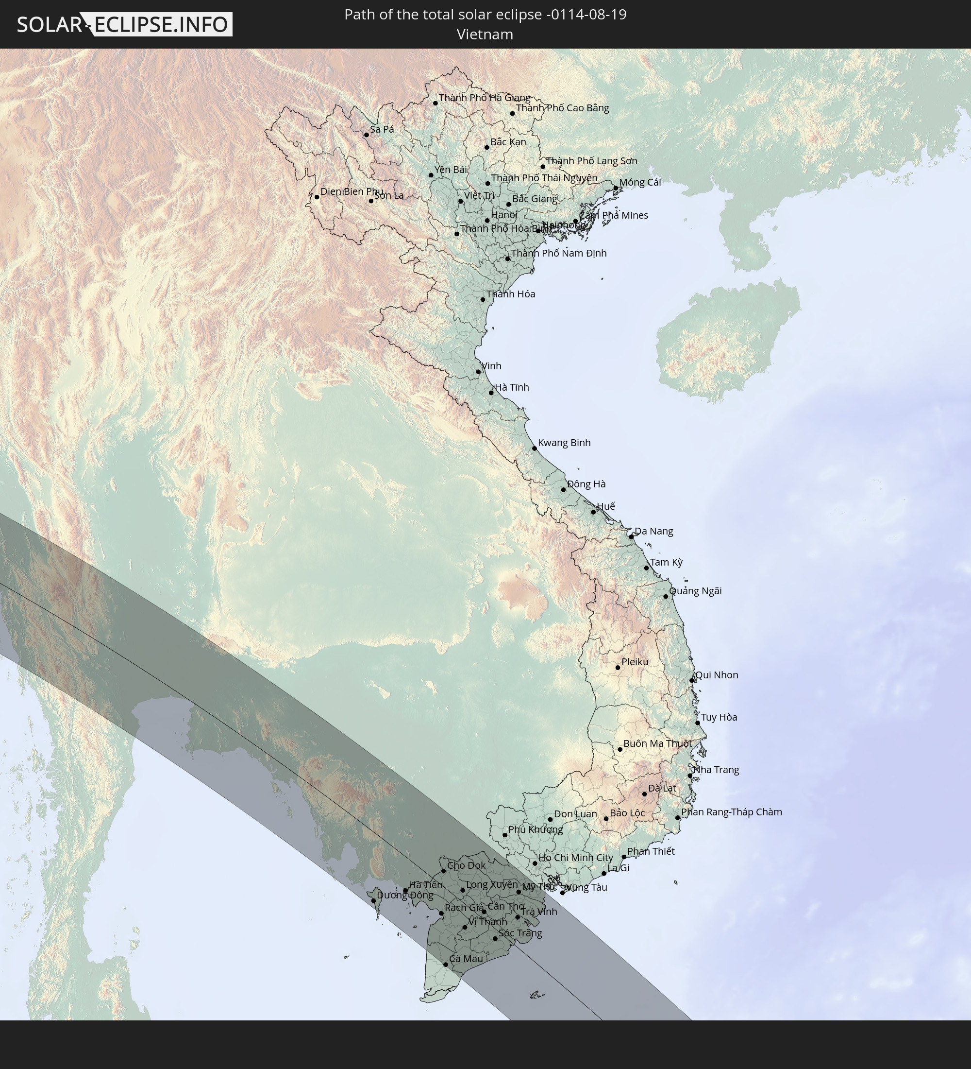 Vietnam
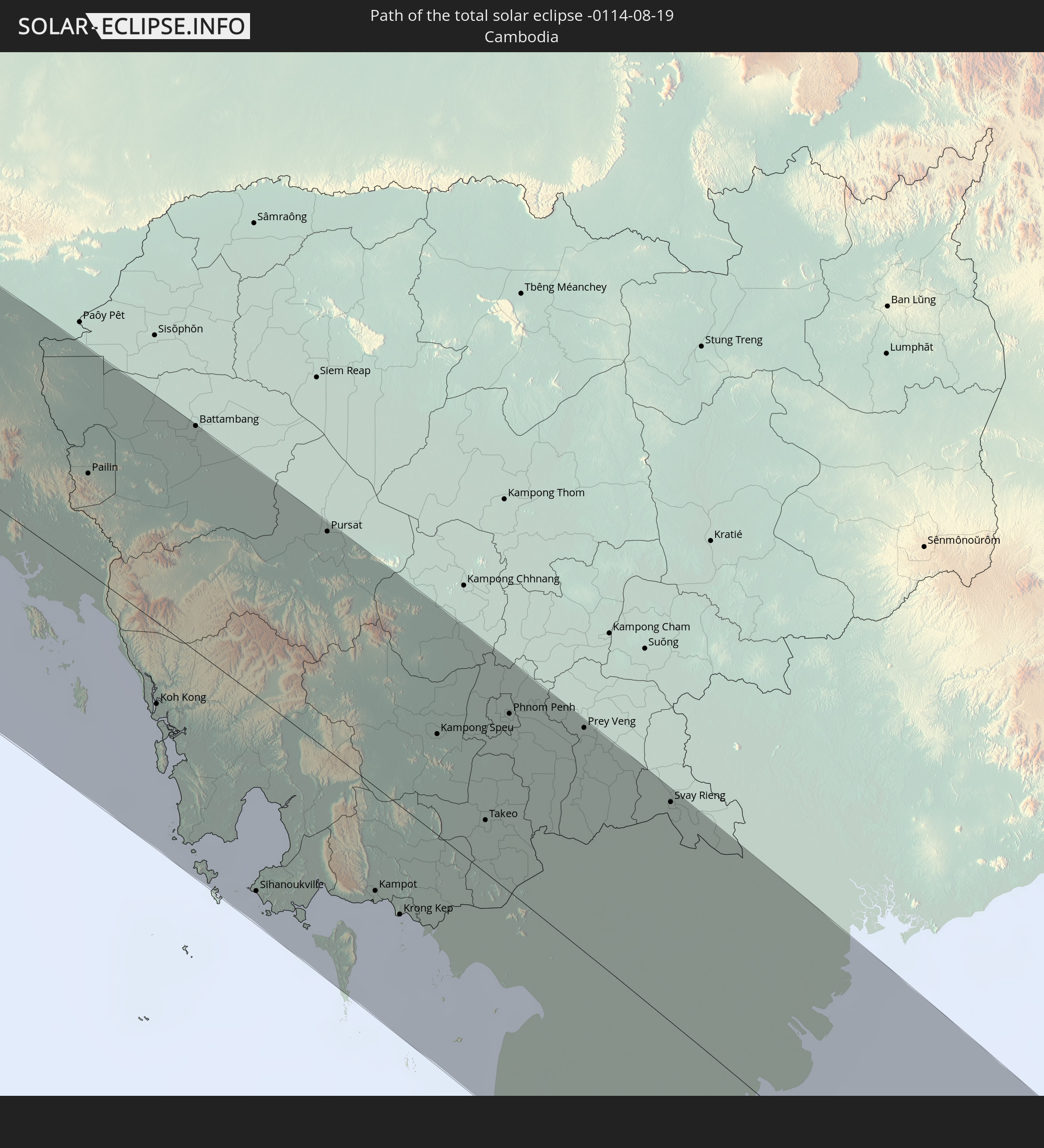 Kambodscha
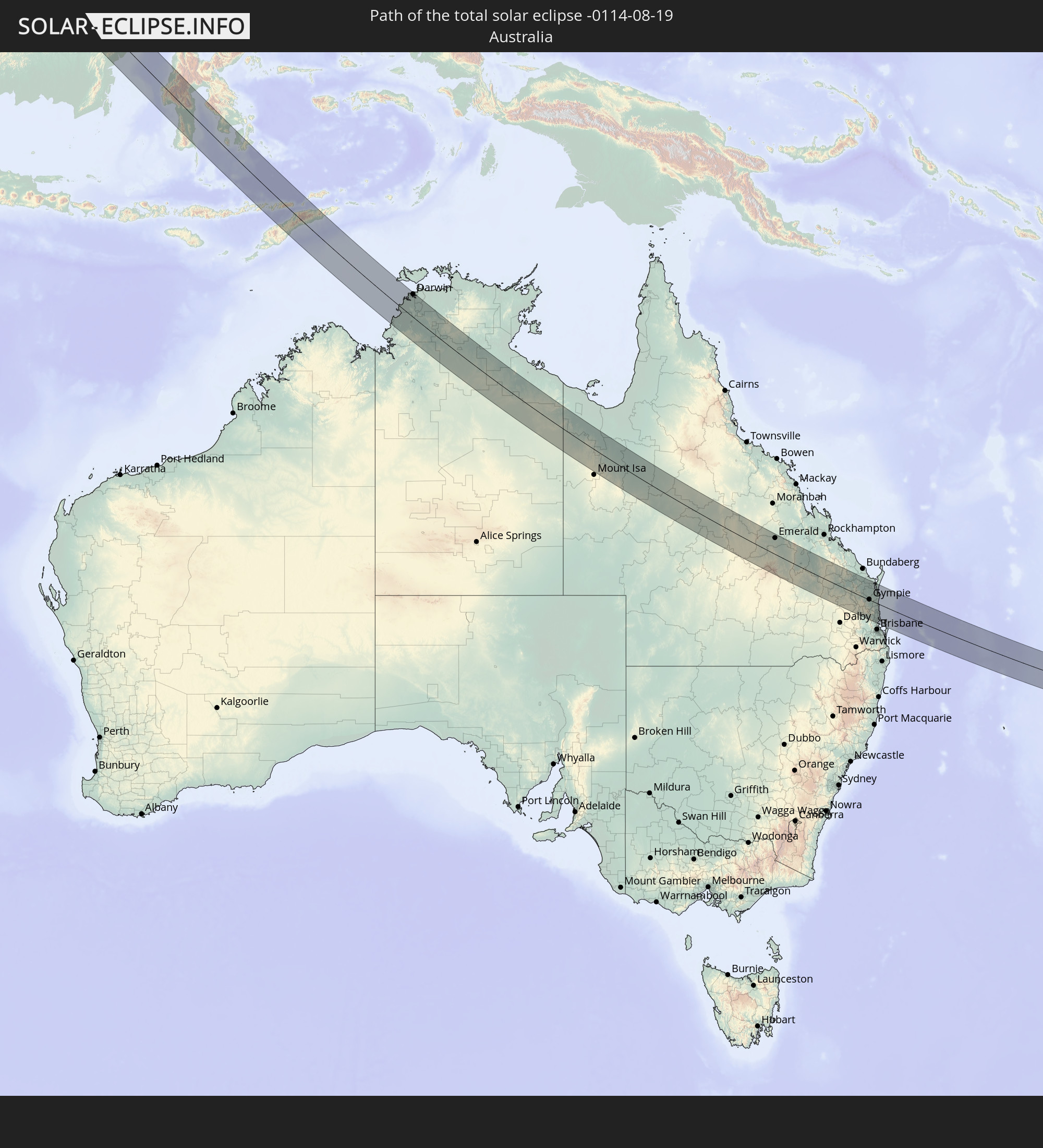 Australien
 Osttimor
In den folgenden Ländern ist die Sonnenfinsternis partiell zu sehen
 Russland
 Kiribati
 Rumänien
 Ukraine
 Türkei
 Moldawien
 Äthiopien
 Saudi-Arabien
 Jordanien
 Libanon
 Syrien
 Eritrea
 Irak
Irak
 Georgien
 Französische Süd- und Antarktisgebiete
 Somalia
 Dschibuti
 Jemen
Jemen
 Madagaskar
 Armenien
 Iran
Iran
 Aserbaidschan
 Seychellen
 Kasachstan
 Kuwait
 Bahrain
 Katar
Katar
 Vereinigte Arabische Emirate
 Oman
Oman
 Turkmenistan
 Usbekistan
 Mauritius
 Afghanistan
 Pakistan
 Tadschikistan
 Indien
 Kirgisistan
 Britisches Territorium im Indischen Ozean
 Malediven
 Volksrepublik China
 Sri Lanka
 Nepal
Nepal
 Mongolei
 Bangladesch
 Bhutan
 Myanmar
 Indonesien
 Kokosinseln
 Thailand
 Malaysia
 Laos
Laos
 Vietnam
 Kambodscha
 Singapur
 Weihnachtsinsel
 Australien
 Macau
Macau
 Hongkong
 Brunei
 Taiwan
 Philippinen
 Japan
Japan
 Osttimor
 Südkorea
 Palau
Palau
 Föderierte Staaten von Mikronesien
 Papua-Neuguinea
 Guam
Guam
 Nördliche Marianen
 Salomonen
 Neukaledonien
 Vanuatu
 Nauru
Nauru
 Tuvalu
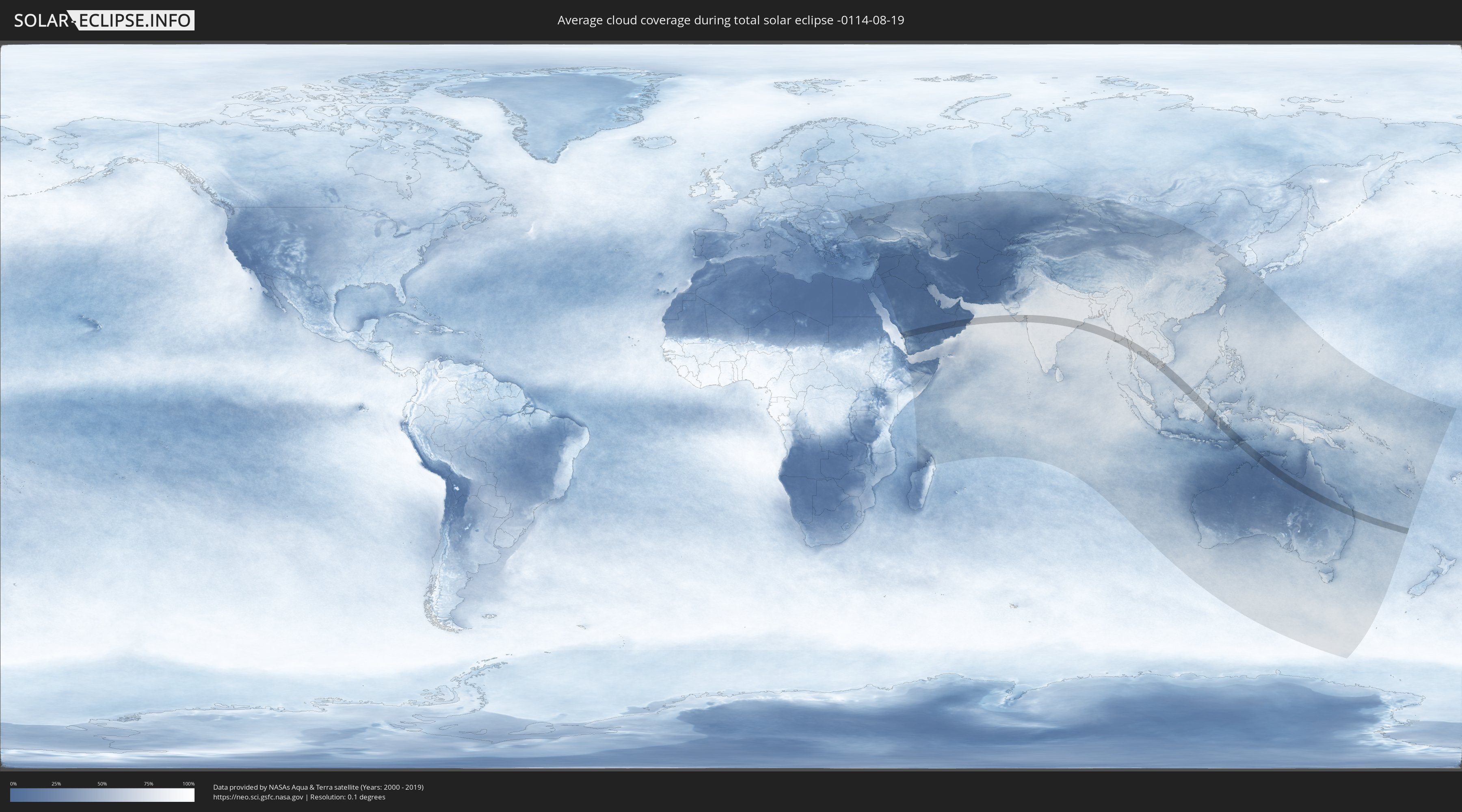
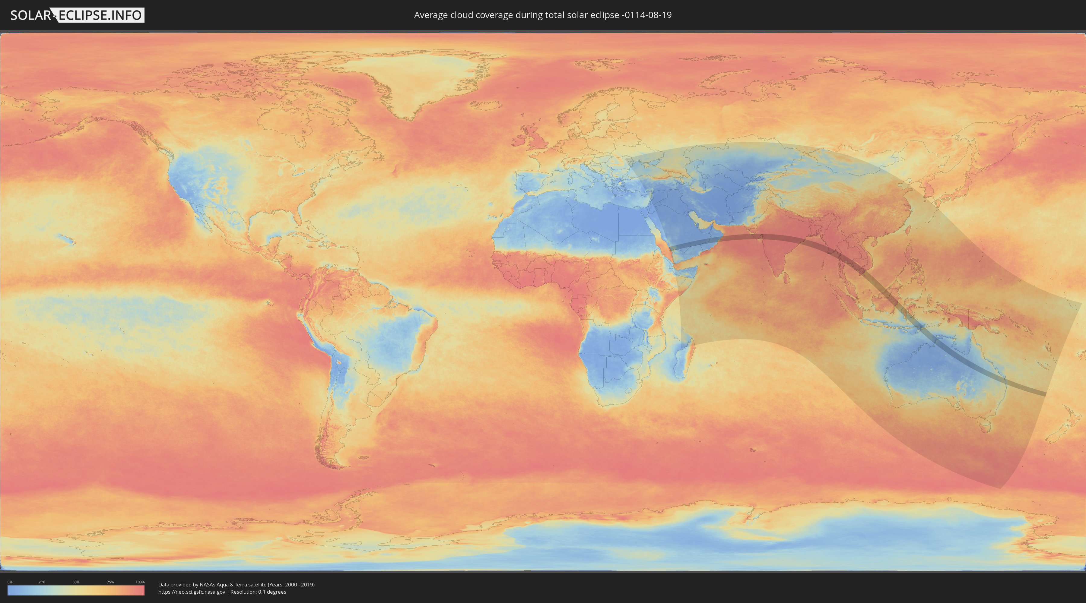
Wie wird das Wetter während der totalen Sonnenfinsternis am 19.08.-0114?
Wo ist der beste Ort, um die totale Sonnenfinsternis vom 19.08.-0114 zu beobachten?
Die folgenden Karten zeigen die durchschnittliche Bewölkung für den Tag, an dem die totale Sonnenfinsternis
stattfindet. Mit Hilfe der Karten lässt sich der Ort entlang des Finsternispfades eingrenzen,
der die besten Aussichen auf einen klaren wolkenfreien Himmel bietet.
Trotzdem muss man immer lokale Gegenenheiten beachten und sollte sich genau über das Wetter an seinem
gewählten Beobachtungsort informieren.
Die Daten stammen von den beiden NASA-Satelliten
AQUA und TERRA
und wurden über einen Zeitraum von 19 Jahren (2000 - 2019) gemittelt.
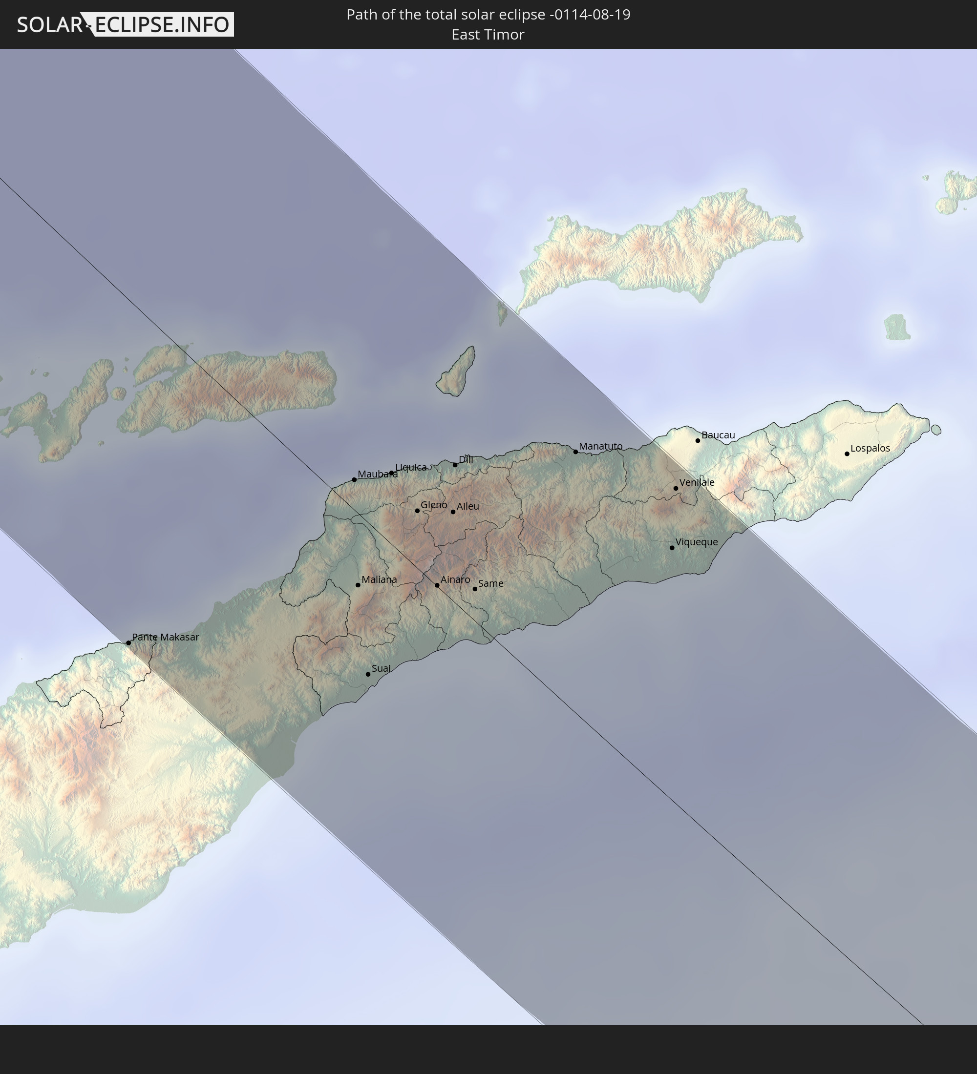
Detaillierte Länderkarten
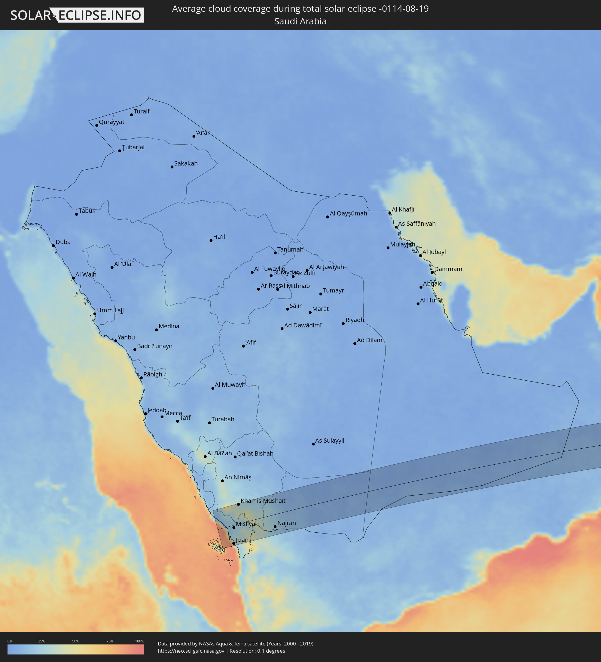 Saudi-Arabien
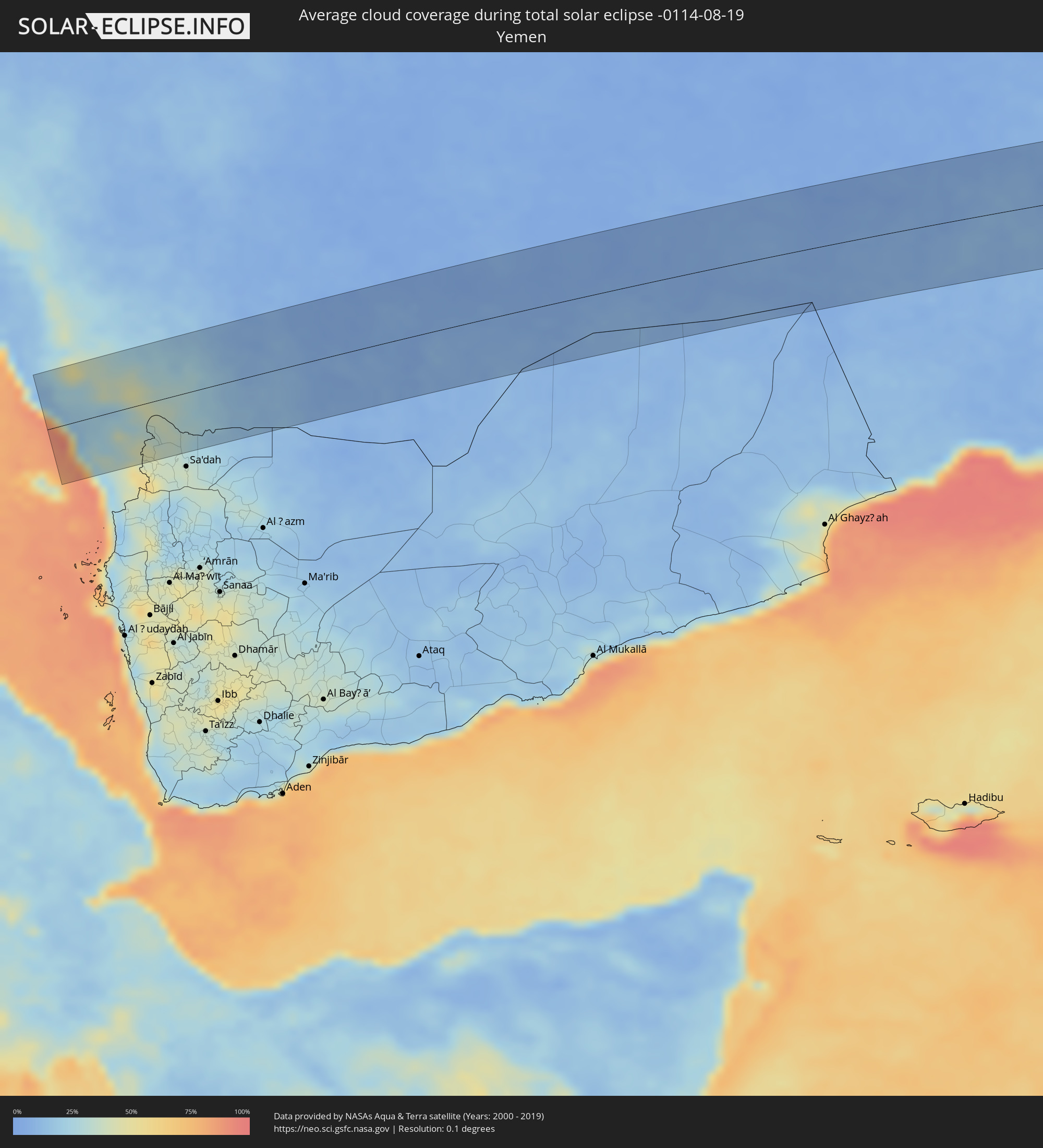 Jemen
Jemen
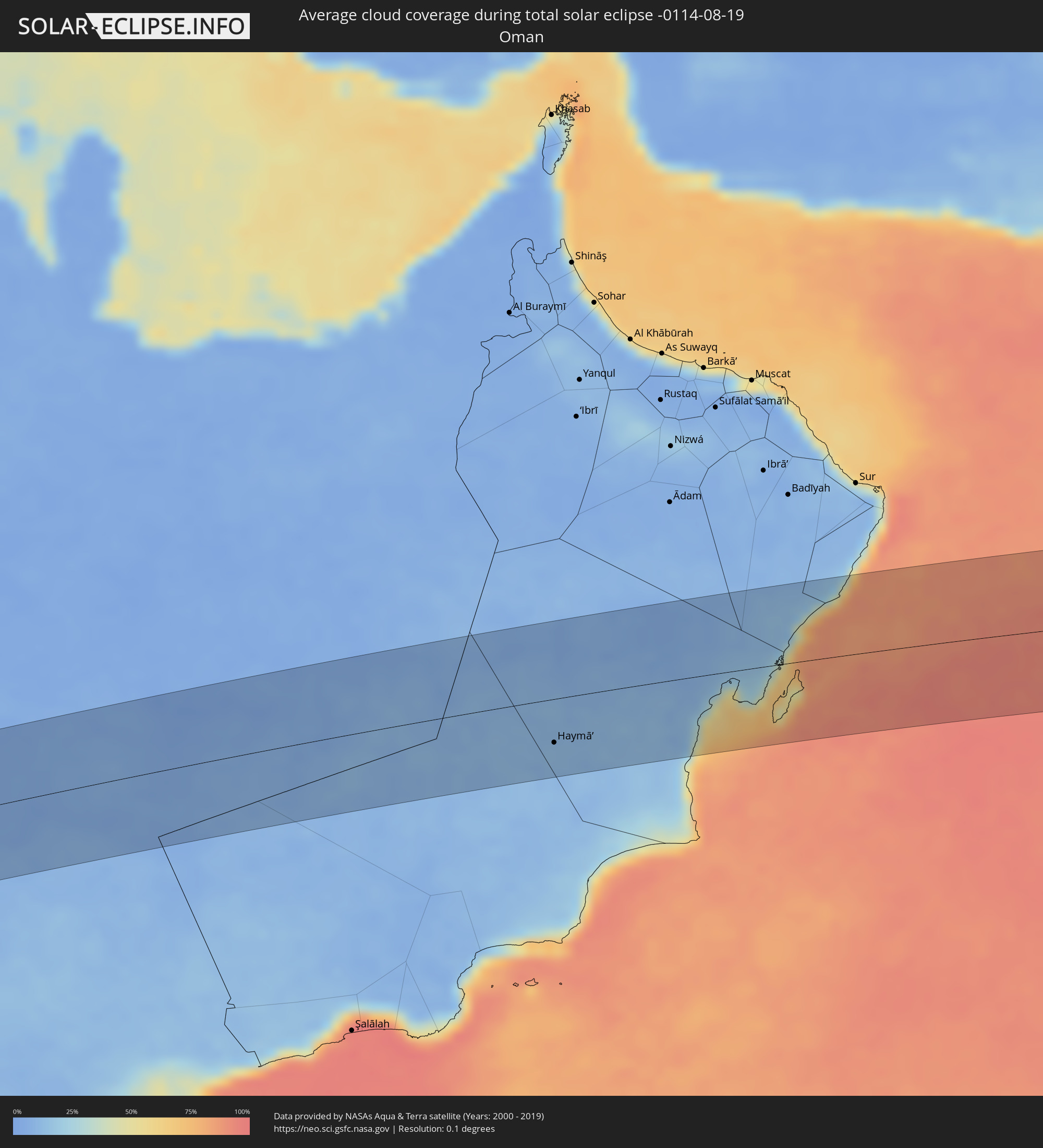 Oman
Oman
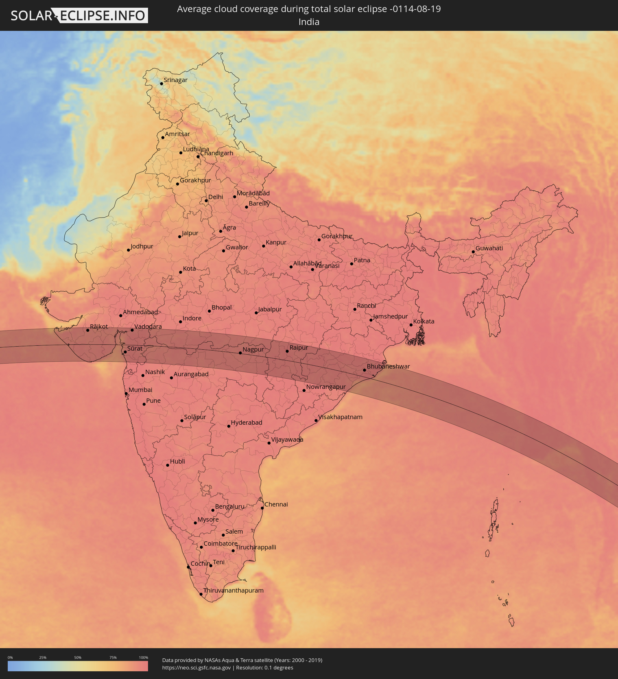 Indien
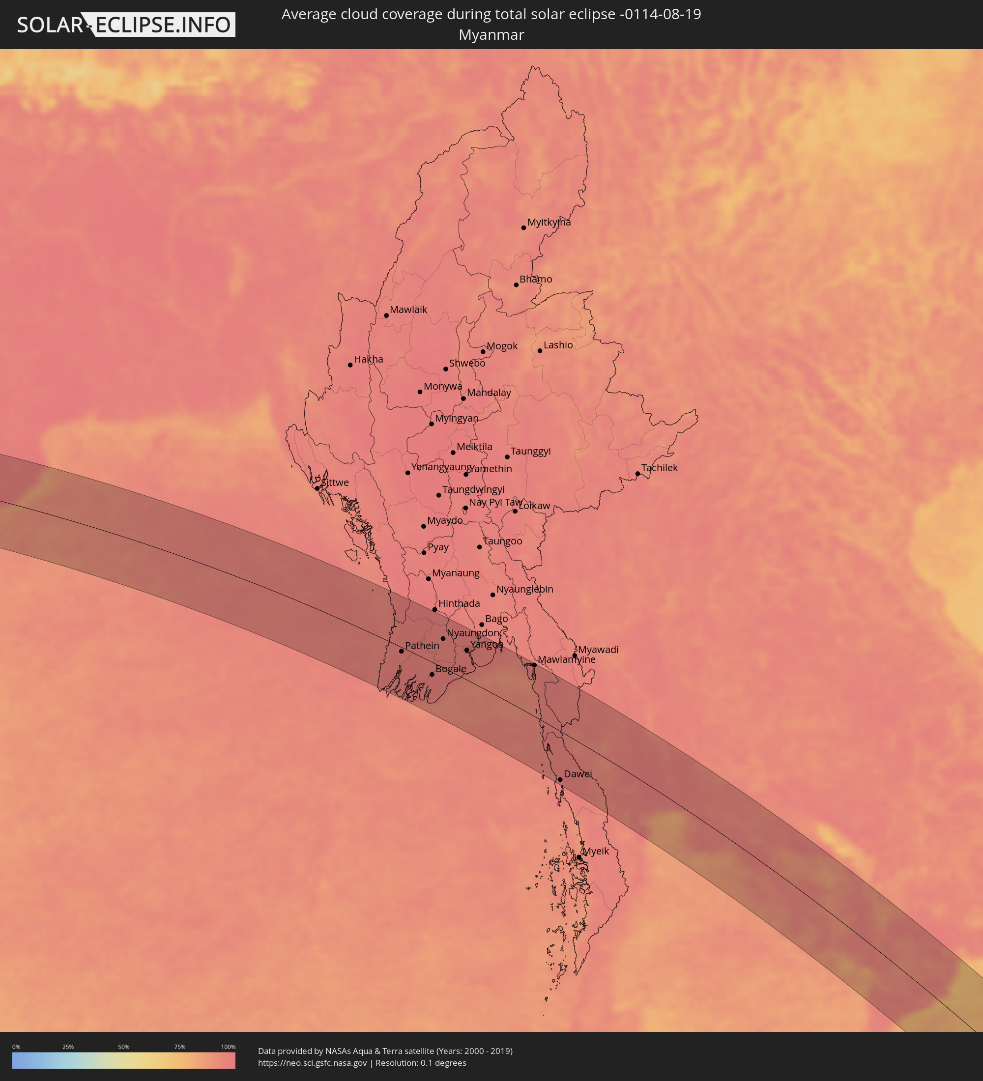 Myanmar
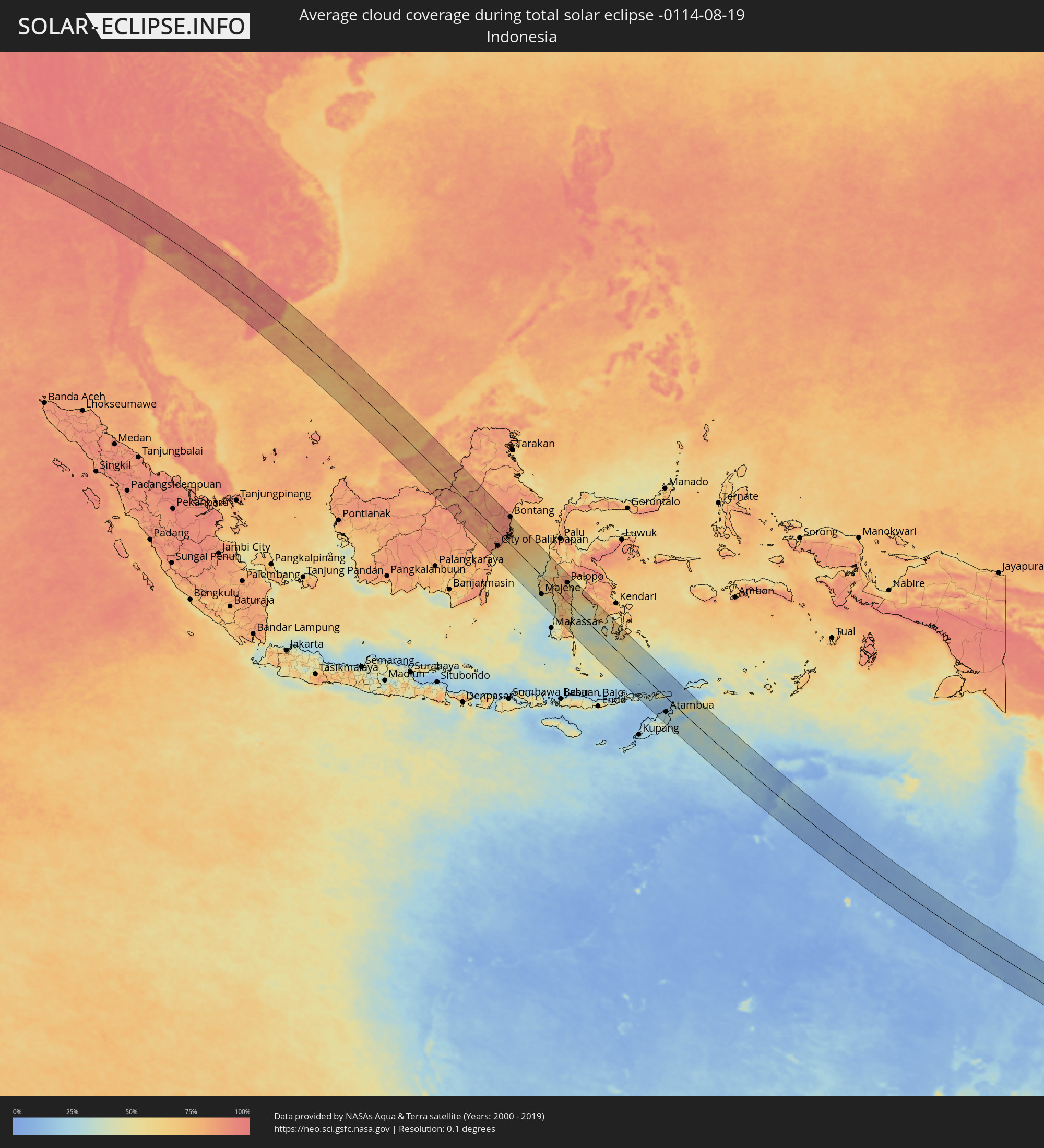 Indonesien
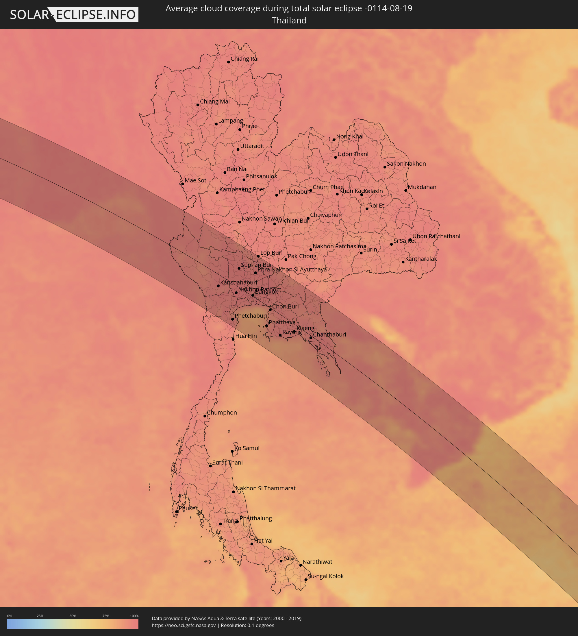 Thailand
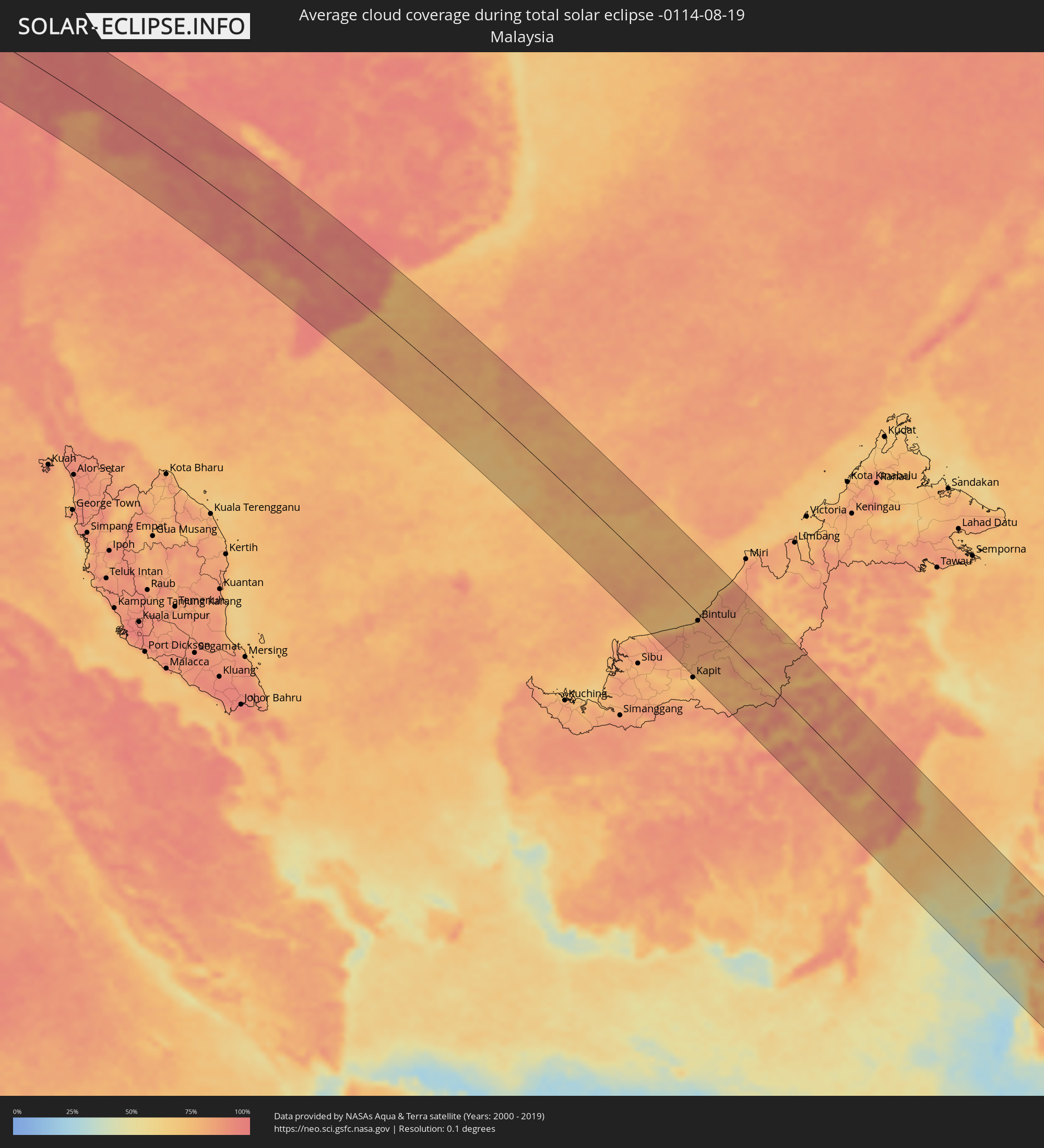 Malaysia
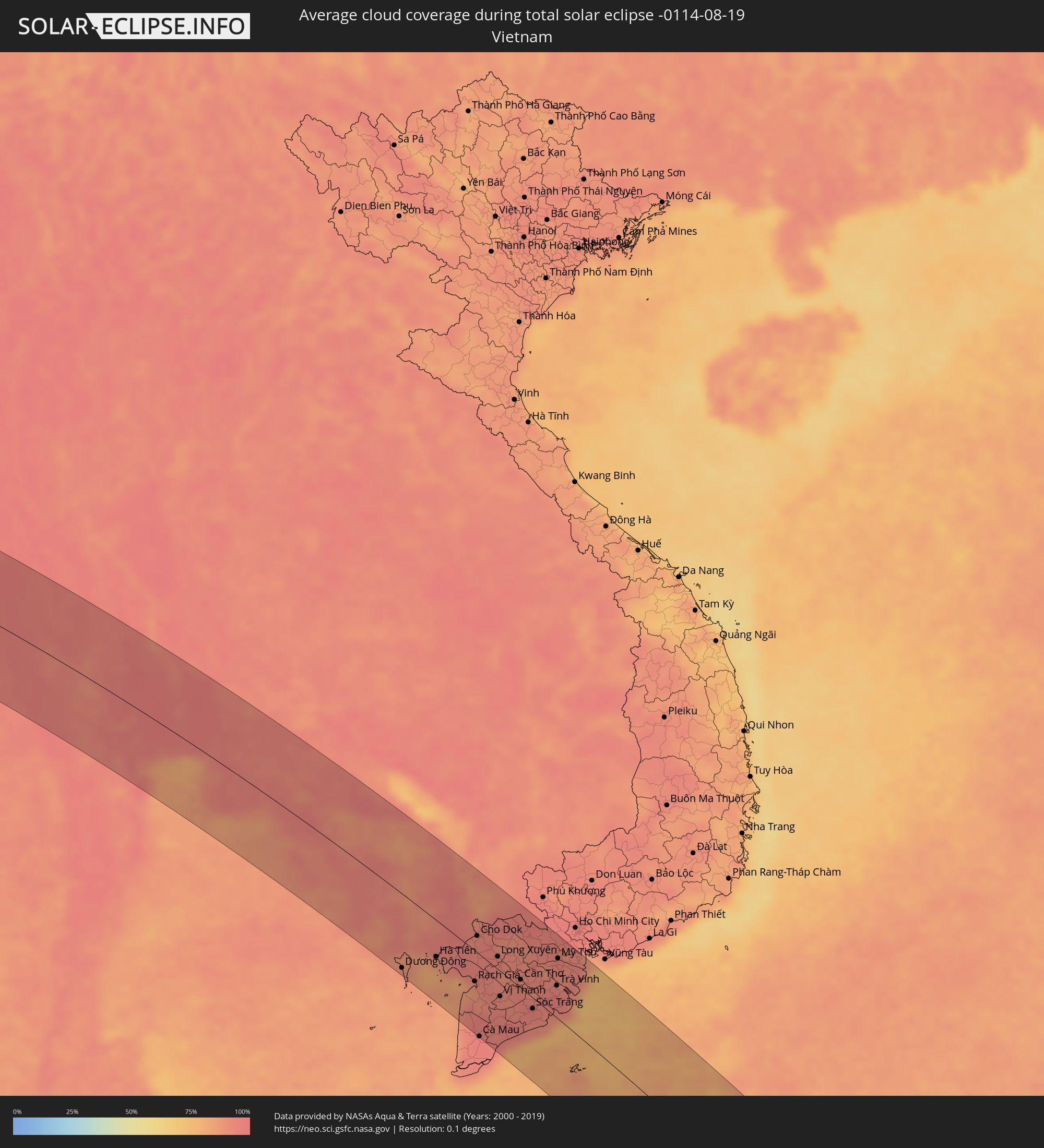 Vietnam
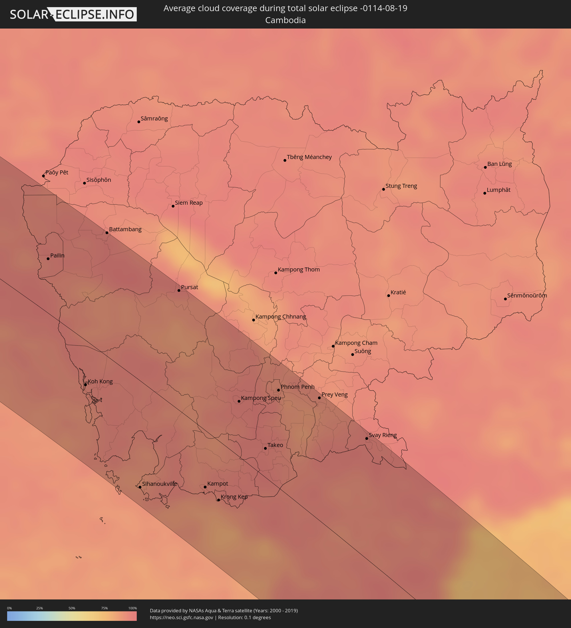 Kambodscha
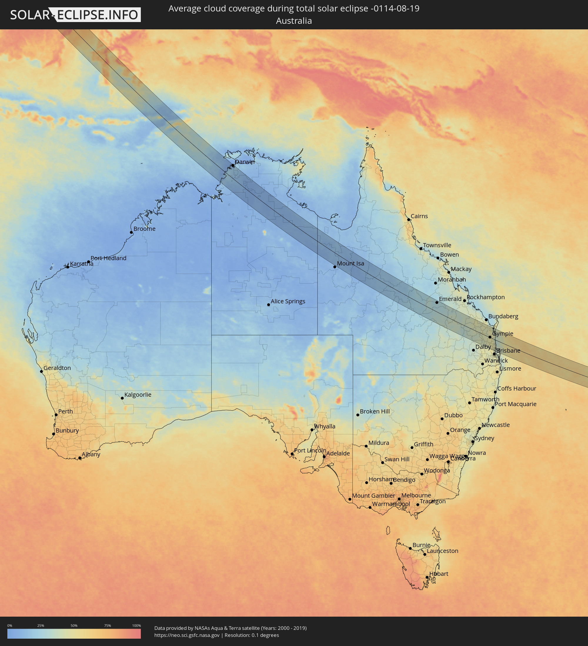 Australien
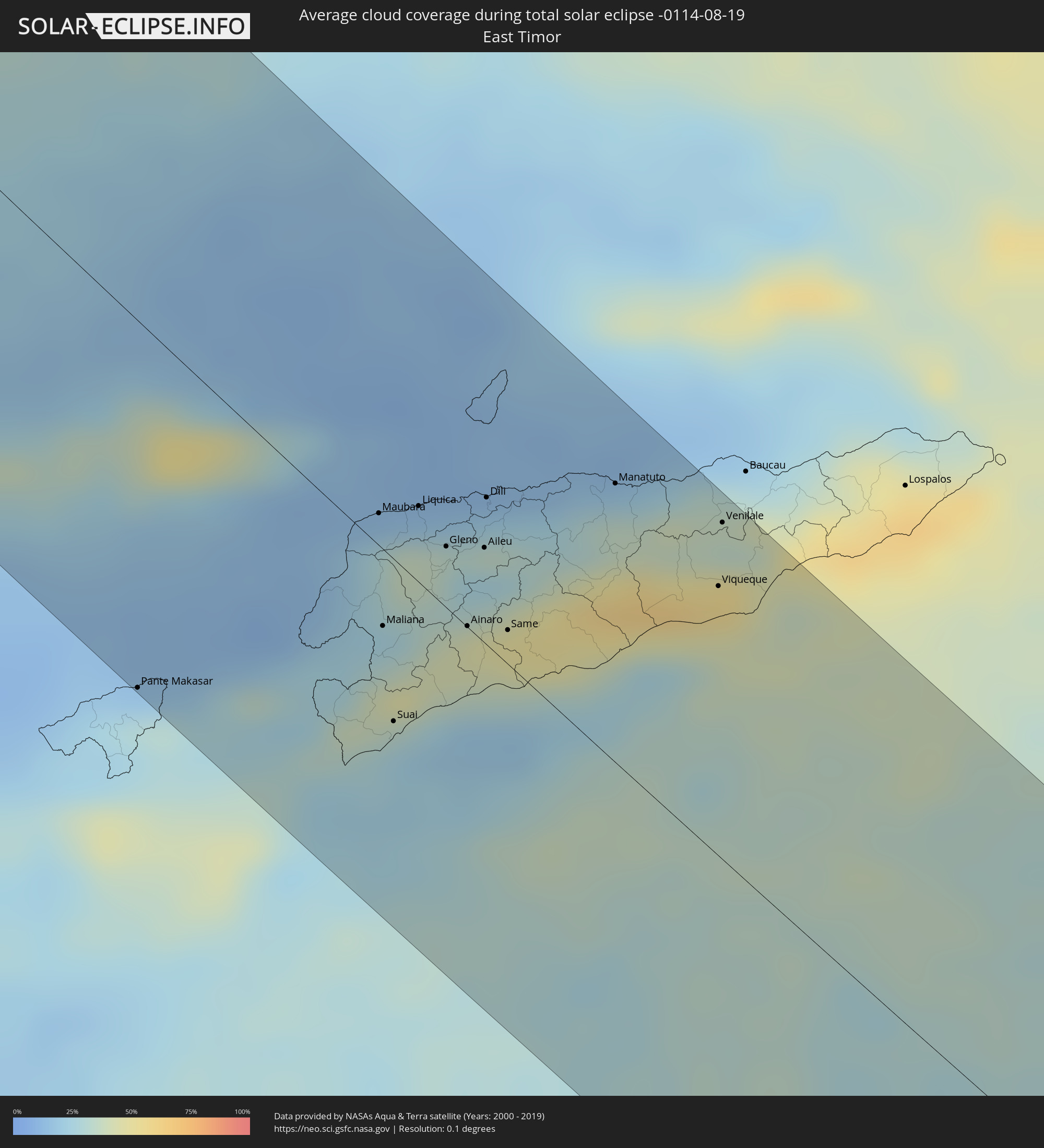 Osttimor
Orte im Finsternispfad
Die nachfolgene Tabelle zeigt Städte und Orte mit mehr als 5.000 Einwohnern, die sich im Finsternispfad befinden. Städte mit mehr als 100.000 Einwohnern sind dick gekennzeichnet. Mit einem Klick auf den Ort öffnet sich eine Detailkarte die die Lage des jeweiligen Ortes zusammen mit dem Verlauf der zentralen Finsternis präsentiert.
| Ort | Typ | Dauer der Verfinsterung | Ortszeit bei maximaler Verfinsterung | Entfernung zur Zentrallinie | Ø Bewölkung |
|
Ad Darb, Jizan
|
total | - | 06:03:06 UTC+03:06 | 25 km | 20% |
|
Abha, 'Asir
|
total | - | 06:03:07 UTC+03:06 | 72 km | 37% |
|
Jizan, Jizan
|
total | - | 06:03:08 UTC+03:06 | 73 km | 48% |
|
Mislīyah, Jizan
|
total | - | 06:03:07 UTC+03:06 | 11 km | 23% |
|
Şabyā, Jizan
|
total | - | 06:03:07 UTC+03:06 | 47 km | 27% |
|
Khamis Mushait, 'Asir
|
total | - | 06:03:07 UTC+03:06 | 74 km | 35% |
|
Abū ‘Arīsh, Jizan
|
total | - | 06:03:08 UTC+03:06 | 72 km | 31% |
|
Najrān, Najran
|
total | - | 06:03:11 UTC+03:06 | 50 km | 19% |
|
Haymā’, Al Wusţá
|
total | - | 06:40:50 UTC+03:41 | 48 km | 12% |
|
Jūnāgadh, Gujarat
|
total | - | 08:31:48 UTC+05:21 | 9 km | 96% |
|
Rājkot, Gujarat
|
total | - | 08:32:00 UTC+05:21 | 77 km | 93% |
|
Bhāvnagar, Gujarat
|
total | - | 08:33:39 UTC+05:21 | 21 km | 93% |
|
Sūrat, Gujarat
|
total | - | 08:34:37 UTC+05:21 | 42 km | 93% |
|
Bilimora, Gujarat
|
total | - | 08:34:54 UTC+05:21 | 89 km | 96% |
|
Vadodara, Gujarat
|
total | - | 08:34:45 UTC+05:21 | 82 km | 96% |
|
Dhūlia, Maharashtra
|
total | - | 08:37:09 UTC+05:21 | 67 km | 95% |
|
Jalgaon, Maharashtra
|
total | - | 08:38:10 UTC+05:21 | 50 km | 96% |
|
Burhānpur, Madhya Pradesh
|
total | - | 08:38:56 UTC+05:21 | 11 km | 97% |
|
Punāsa, Madhya Pradesh
|
total | - | 08:38:49 UTC+05:21 | 93 km | 95% |
|
Akola, Maharashtra
|
total | - | 08:40:15 UTC+05:21 | 71 km | 94% |
|
Amrāvati, Maharashtra
|
total | - | 08:41:13 UTC+05:21 | 38 km | 95% |
|
Nagpur, Maharashtra
|
total | - | 08:43:05 UTC+05:21 | 1 km | 95% |
|
Durg, Chhattisgarh
|
total | - | 08:46:25 UTC+05:21 | 39 km | 96% |
|
Bhilai, Chhattisgarh
|
total | - | 08:46:39 UTC+05:21 | 43 km | 97% |
|
Raipur, Chhattisgarh
|
total | - | 08:46:58 UTC+05:21 | 50 km | 97% |
|
Brahmapur, Odisha
|
total | - | 08:53:36 UTC+05:21 | 94 km | 94% |
|
Bhubaneshwar, Odisha
|
total | - | 08:54:42 UTC+05:21 | 36 km | 98% |
|
Cuttack, Odisha
|
total | - | 08:54:38 UTC+05:21 | 58 km | 95% |
|
Pathein, Ayeyarwady
|
total | - | 10:19:29 UTC+06:24 | 9 km | 95% |
|
Wakema, Ayeyarwady
|
total | - | 10:20:41 UTC+06:24 | 6 km | 96% |
|
Mawlamyinegyunn, Ayeyarwady
|
total | - | 10:21:09 UTC+06:24 | 25 km | 97% |
|
Bogale, Ayeyarwady
|
total | - | 10:21:33 UTC+06:24 | 27 km | 97% |
|
Nyaungdon, Ayeyarwady
|
total | - | 10:21:04 UTC+06:24 | 60 km | 97% |
|
Maubin, Ayeyarwady
|
total | - | 10:21:31 UTC+06:24 | 29 km | 96% |
|
Pyapon, Ayeyarwady
|
total | - | 10:22:10 UTC+06:24 | 14 km | 97% |
|
Kyaiklat, Ayeyarwady
|
total | - | 10:22:03 UTC+06:24 | 4 km | 97% |
|
Twante, Yangon
|
total | - | 10:22:08 UTC+06:24 | 40 km | 96% |
|
Kanbe, Yangon
|
total | - | 10:22:17 UTC+06:24 | 44 km | 98% |
|
Yangon, Yangon
|
total | - | 10:22:29 UTC+06:24 | 61 km | 97% |
|
Syriam, Yangon
|
total | - | 10:22:43 UTC+06:24 | 62 km | 97% |
|
Thongwa, Yangon
|
total | - | 10:23:20 UTC+06:24 | 75 km | 97% |
|
Kayan, Yangon
|
total | - | 10:23:12 UTC+06:24 | 91 km | 96% |
|
Kyaikkami, Mon
|
total | - | 10:26:31 UTC+06:24 | 60 km | 94% |
|
Martaban, Mon
|
total | - | 10:25:59 UTC+06:24 | 107 km | 96% |
|
Mawlamyine, Mon
|
total | - | 10:26:04 UTC+06:24 | 104 km | 96% |
|
Mudon, Mon
|
total | - | 10:26:36 UTC+06:24 | 86 km | 96% |
|
Dawei, Tanintharyi
|
total | - | 10:30:51 UTC+06:24 | 99 km | 94% |
|
Kanchanaburi, Kanchanaburi
|
total | - | 10:51:16 UTC+06:42 | 30 km | 94% |
|
Ratchaburi, Ratchaburi
|
total | - | 10:52:36 UTC+06:42 | 58 km | 97% |
|
Ban Pong, Ratchaburi
|
total | - | 10:52:18 UTC+06:42 | 29 km | 95% |
|
Nakhon Pathom, Nakhon Pathom
|
total | - | 10:52:40 UTC+06:42 | 19 km | 97% |
|
Krathum Baen, Samut Sakhon
|
total | - | 10:53:24 UTC+06:42 | 21 km | 96% |
|
Pak Kret, Nonthaburi
|
total | - | 10:53:31 UTC+06:42 | 17 km | 96% |
|
Bangkok, Bangkok
|
total | - | 10:53:47 UTC+06:42 | 2 km | 97% |
|
Phra Nakhon Si Ayutthaya, Phra Nakhon Si Ayutthaya
|
total | - | 10:53:00 UTC+06:42 | 62 km | 96% |
|
Samut Prakan, Samut Prakan
|
total | - | 10:54:15 UTC+06:42 | 7 km | 94% |
|
Khlong Luang, Pathum Thani
|
total | - | 10:53:36 UTC+06:42 | 40 km | 96% |
|
Ban Lam Luk Ka, Pathum Thani
|
total | - | 10:54:02 UTC+06:42 | 39 km | 97% |
|
Phatthaya, Chon Buri
|
total | - | 10:55:58 UTC+06:42 | 51 km | 92% |
|
Sattahip, Chon Buri
|
total | - | 10:56:27 UTC+06:42 | 75 km | 88% |
|
Saraburi, Sara Buri
|
total | - | 10:53:27 UTC+06:42 | 99 km | 97% |
|
Si Racha, Chon Buri
|
total | - | 10:55:41 UTC+06:42 | 26 km | 89% |
|
Chon Buri, Chon Buri
|
total | - | 10:55:29 UTC+06:42 | 5 km | 94% |
|
Rayong, Rayong
|
total | - | 10:57:14 UTC+06:42 | 52 km | 93% |
|
Klaeng, Rayong
|
total | - | 10:57:56 UTC+06:42 | 18 km | 95% |
|
Chanthaburi, Chanthaburi
|
total | - | 10:59:14 UTC+06:42 | 6 km | 96% |
|
Pailin, Pailin
|
total | - | 10:59:57 UTC+06:42 | 48 km | 94% |
|
Koh Kong, Koh Kong
|
total | - | 11:02:55 UTC+06:42 | 39 km | 91% |
|
Smach Mean Chey, Koh Kong
|
total | - | 11:03:09 UTC+06:42 | 42 km | 88% |
|
Battambang, Battambang
|
total | - | 11:00:49 UTC+06:42 | 108 km | 96% |
|
Sihanoukville, Preah Sihanouk
|
total | - | 11:05:54 UTC+06:42 | 93 km | 89% |
|
Pursat, Pursat
|
total | - | 11:03:23 UTC+06:42 | 104 km | 89% |
|
Dương Đông, Kiến Giang
|
total | - | 11:32:10 UTC+07:06 | 99 km | 88% |
|
Kampot, Kampot
|
total | - | 11:07:22 UTC+06:42 | 49 km | 89% |
|
Krong Kep, Kep
|
total | - | 11:07:54 UTC+06:42 | 51 km | 84% |
|
Hà Tiên, Kiến Giang
|
total | - | 11:33:03 UTC+07:06 | 48 km | 87% |
|
Kampong Speu, Kampong Speu
|
total | - | 11:06:37 UTC+06:42 | 48 km | 95% |
|
Phumĭ Véal Srê, Takeo
|
total | - | 11:08:01 UTC+06:42 | 23 km | 96% |
|
Takeo, Takeo
|
total | - | 11:08:01 UTC+06:42 | 25 km | 96% |
|
Phnom Penh, Phnom Penh
|
total | - | 11:07:17 UTC+06:42 | 84 km | 94% |
|
Ta Khmau, Kandal
|
total | - | 11:07:30 UTC+06:42 | 79 km | 89% |
|
Rạch Giá, Kiến Giang
|
total | - | 11:35:03 UTC+07:06 | 40 km | 90% |
|
Cho Dok, An Giang
|
total | - | 11:33:53 UTC+07:06 | 22 km | 94% |
|
Cà Mau, Cà Mau
|
total | - | 11:36:44 UTC+07:06 | 108 km | 96% |
|
Prey Veng, Prey Veng
|
total | - | 11:08:19 UTC+06:42 | 105 km | 86% |
|
Long Xuyên, An Giang
|
total | - | 11:35:09 UTC+07:06 | 17 km | 93% |
|
Vị Thanh, Hau Giang
|
total | - | 11:36:19 UTC+07:06 | 33 km | 93% |
|
Cao Lãnh, Đồng Tháp
|
total | - | 11:35:27 UTC+07:06 | 37 km | 92% |
|
Thành phố Bạc Liêu, Bạc Liêu
|
total | - | 11:37:48 UTC+07:06 | 57 km | 93% |
|
Sadek, Đồng Tháp
|
total | - | 11:36:02 UTC+07:06 | 30 km | 91% |
|
Cần Thơ, Cần Thơ
|
total | - | 11:36:34 UTC+07:06 | 11 km | 94% |
|
Svay Rieng, Svay Rieng
|
total | - | 11:10:04 UTC+06:42 | 102 km | 95% |
|
Sóc Trăng, Sóc Trăng
|
total | - | 11:37:46 UTC+07:06 | 14 km | 95% |
|
Vĩnh Long, Vĩnh Long
|
total | - | 11:36:34 UTC+07:06 | 42 km | 93% |
|
Ấp Tân Ngãi, Bến Tre
|
total | - | 11:37:17 UTC+07:06 | 62 km | 93% |
|
Trà Vinh, Trà Vinh
|
total | - | 11:37:56 UTC+07:06 | 42 km | 97% |
|
Mỹ Tho, Tiền Giang
|
total | - | 11:37:13 UTC+07:06 | 78 km | 94% |
|
Bến Tre, Bến Tre
|
total | - | 11:37:28 UTC+07:06 | 69 km | 92% |
|
Tân An, Long An
|
total | - | 11:37:01 UTC+07:06 | 97 km | 96% |
|
Bintulu, Sarawak
|
total | - | 12:19:35 UTC+07:21 | 12 km | 80% |
|
Balikpapan, East Kalimantan
|
total | - | 13:11:21 UTC+07:57 | 59 km | 70% |
|
City of Balikpapan, East Kalimantan
|
total | - | 13:11:26 UTC+07:57 | 52 km | 80% |
|
Loa Janan, East Kalimantan
|
total | - | 13:10:36 UTC+07:57 | 15 km | 93% |
|
Samarinda, East Kalimantan
|
total | - | 13:10:31 UTC+07:57 | 27 km | 91% |
|
Bontang, East Kalimantan
|
total | - | 13:10:00 UTC+07:57 | 102 km | 80% |
|
Mamuju, West Sulawesi
|
total | - | 13:17:31 UTC+07:57 | 7 km | 69% |
|
Majene, West Sulawesi
|
total | - | 13:19:09 UTC+07:57 | 67 km | 47% |
|
Polewali, West Sulawesi
|
total | - | 13:19:36 UTC+07:57 | 29 km | 61% |
|
Parepare, South Sulawesi
|
total | - | 13:21:04 UTC+07:57 | 53 km | 51% |
|
Rantepao, South Sulawesi
|
total | - | 13:19:45 UTC+07:57 | 51 km | 73% |
|
Sengkang, South Sulawesi
|
total | - | 13:21:56 UTC+07:57 | 30 km | 63% |
|
Palopo, South Sulawesi
|
total | - | 13:20:17 UTC+07:57 | 72 km | 64% |
|
Sinjai, South Sulawesi
|
total | - | 13:23:58 UTC+07:57 | 91 km | 53% |
|
Watampone, South Sulawesi
|
total | - | 13:23:07 UTC+07:57 | 39 km | 64% |
|
Katabu, Southeast Sulawesi
|
total | - | 13:27:18 UTC+07:57 | 100 km | 71% |
|
Pante Makasar, Oecusse
|
total | - | 14:01:23 UTC+08:22 | 101 km | 28% |
|
Atambua, East Nusa Tenggara
|
total | - | 13:37:14 UTC+07:57 | 55 km | 29% |
|
Maubara, Liquiçá
|
total | - | 14:01:42 UTC+08:22 | 9 km | 26% |
|
Maliana, Bobonaro
|
total | - | 14:02:16 UTC+08:22 | 21 km | 30% |
|
Suai, Cova Lima
|
total | - | 14:02:47 UTC+08:22 | 45 km | 23% |
|
Liquica, Liquiçá
|
total | - | 14:01:52 UTC+08:22 | 21 km | 35% |
|
Gleno, Ermera District
|
total | - | 14:02:12 UTC+08:22 | 17 km | 35% |
|
Ainaro, Ainaro
|
total | - | 14:02:41 UTC+08:22 | 1 km | 43% |
|
Aileu, Aileu
|
total | - | 14:02:23 UTC+08:22 | 26 km | 26% |
|
Dili, Díli
|
total | - | 14:02:09 UTC+08:22 | 41 km | 34% |
|
Same, Manufahi
|
total | - | 14:02:53 UTC+08:22 | 9 km | 43% |
|
Manatuto, Manatuto
|
total | - | 14:02:42 UTC+08:22 | 77 km | 34% |
|
Viqueque, Viqueque
|
total | - | 14:03:41 UTC+08:22 | 75 km | 44% |
|
Venilale, Baucau
|
total | - | 14:03:24 UTC+08:22 | 94 km | 35% |
|
Darwin, Northern Territory
|
total | - | 15:21:45 UTC+09:30 | 92 km | 13% |
|
Katherine, Northern Territory
|
total | - | 15:25:37 UTC+09:30 | 15 km | 5% |
|
Emerald, Queensland
|
total | - | 16:14:52 UTC+10:00 | 70 km | 28% |
|
Kingaroy, Queensland
|
total | - | 16:17:31 UTC+10:00 | 69 km | 42% |
|
Gympie, Queensland
|
total | - | 16:17:43 UTC+10:00 | 1 km | 47% |
|
Maryborough, Queensland
|
total | - | 16:17:34 UTC+10:00 | 69 km | 48% |
|
Morayfield, Queensland
|
total | - | 16:18:03 UTC+10:00 | 80 km | 46% |
|
Caboolture, Queensland
|
total | - | 16:18:02 UTC+10:00 | 78 km | 41% |
|
Burpengary, Queensland
|
total | - | 16:18:04 UTC+10:00 | 85 km | 44% |
|
Nambour, Queensland
|
total | - | 16:17:56 UTC+10:00 | 31 km | 44% |
|
Tewantin, Queensland
|
total | - | 16:17:54 UTC+10:00 | 4 km | 39% |
|
Buderim, Queensland
|
total | - | 16:17:59 UTC+10:00 | 33 km | 41% |
|
Noosaville, Queensland
|
total | - | 16:17:55 UTC+10:00 | 4 km | 34% |
|
Coolum Beach, Queensland
|
total | - | 16:17:57 UTC+10:00 | 16 km | 36% |
|
Little Mountain, Queensland
|
total | - | 16:18:01 UTC+10:00 | 42 km | 42% |
|
Scarborough, Queensland
|
total | - | 16:18:07 UTC+10:00 | 83 km | 36% |
|
Mooloolaba, Queensland
|
total | - | 16:18:00 UTC+10:00 | 30 km | 41% |
|
Caloundra, Queensland
|
total | - | 16:18:02 UTC+10:00 | 42 km | 42% |
|
Bongaree, Queensland
|
total | - | 16:18:07 UTC+10:00 | 69 km | 35% |