Totale Sonnenfinsternis vom 15.05.-0249
| Wochentag: | Donnerstag |
| Maximale Dauer der Verfinsterung: | 05m56s |
| Maximale Breite des Finsternispfades: | 295 km |
| Saroszyklus: | 53 |
| Bedeckungsgrad: | 100% |
| Magnitude: | 1.0695 |
| Gamma: | -0.6518 |
Wo kann man die Sonnenfinsternis vom 15.05.-0249 sehen?
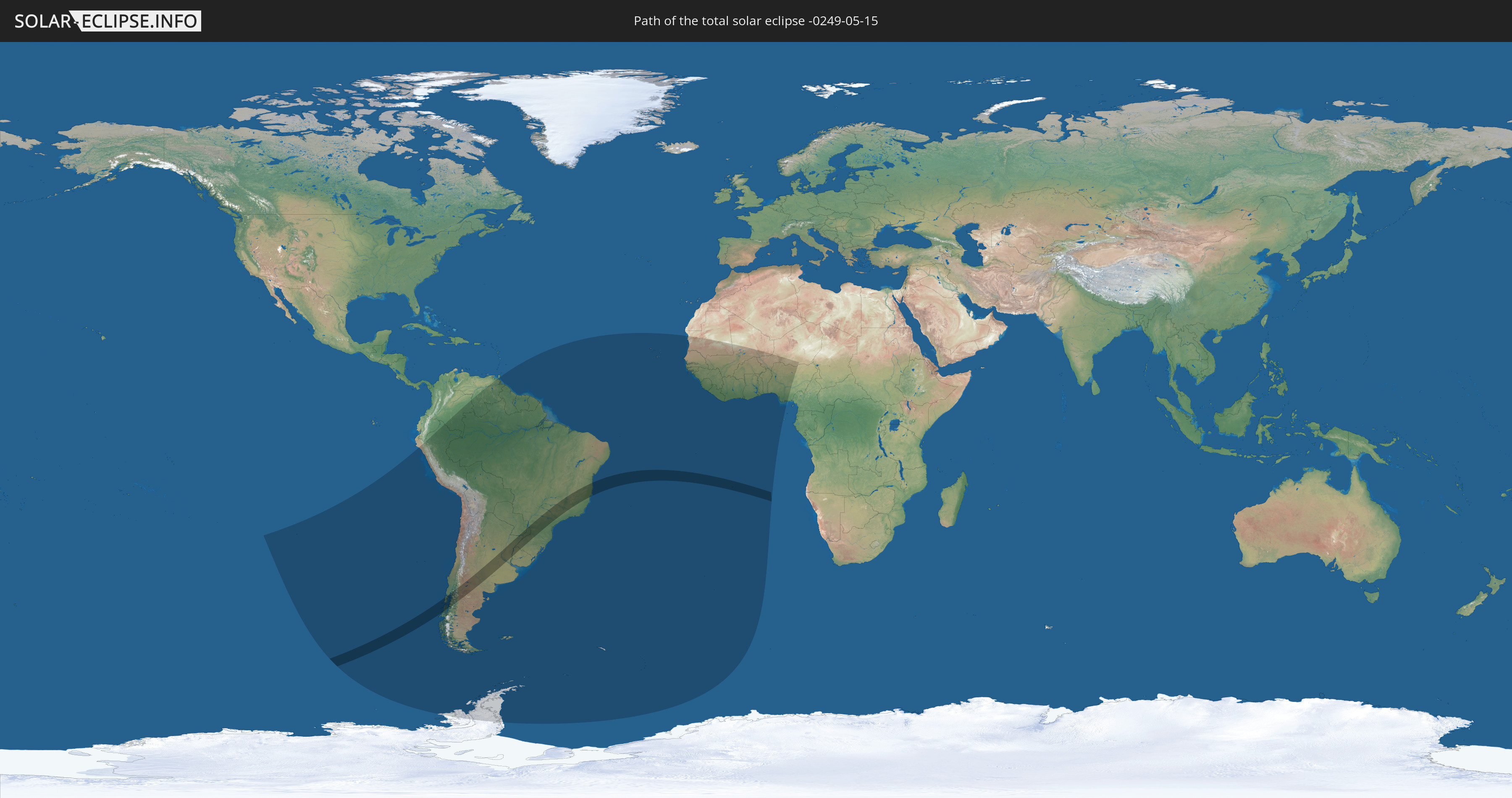
Die Sonnenfinsternis am 15.05.-0249 kann man in 34 Ländern als partielle Sonnenfinsternis beobachten.
Der Finsternispfad verläuft durch 6 Länder. Nur in diesen Ländern ist sie als totale Sonnenfinsternis zu sehen.
In den folgenden Ländern ist die Sonnenfinsternis total zu sehen
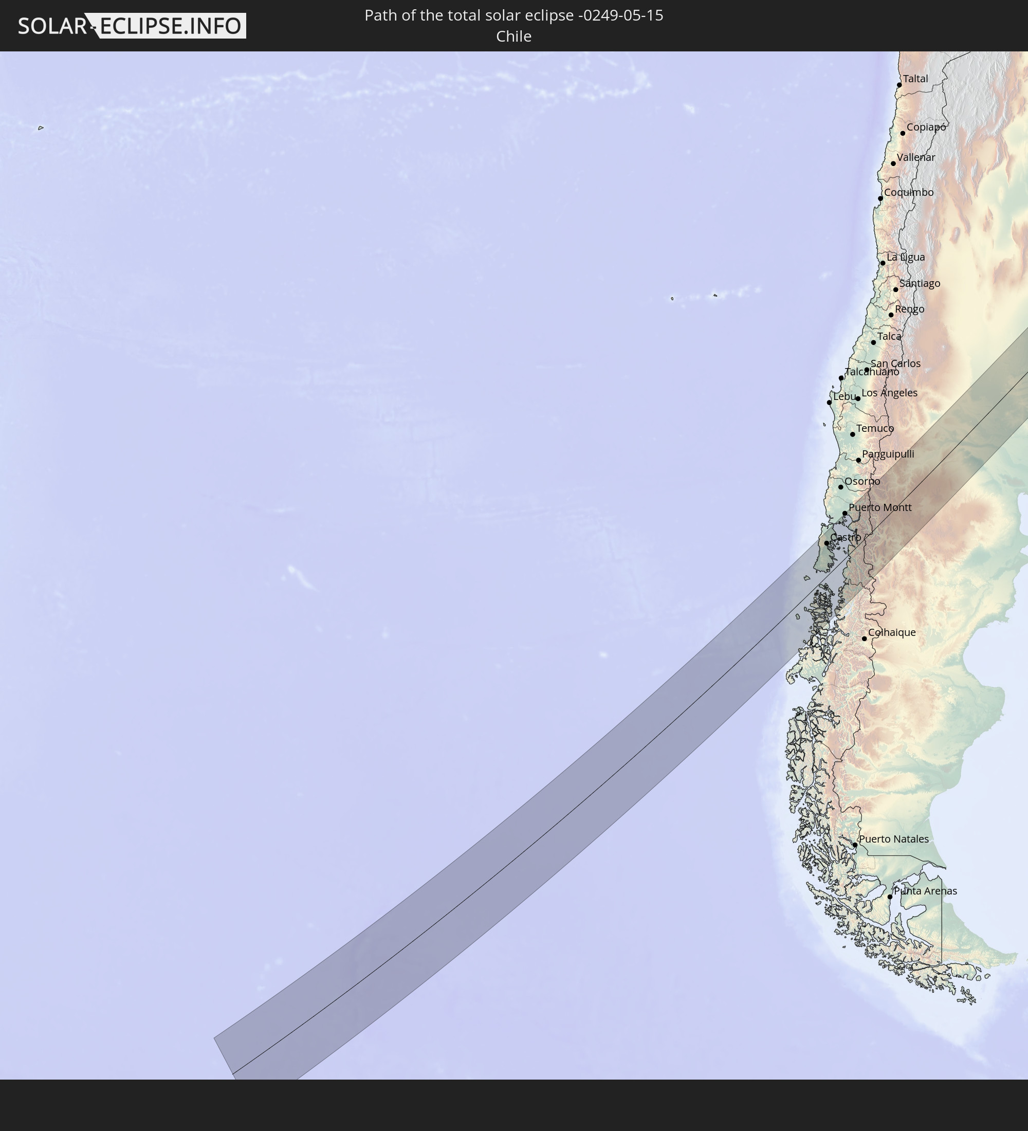 Chile
Chile
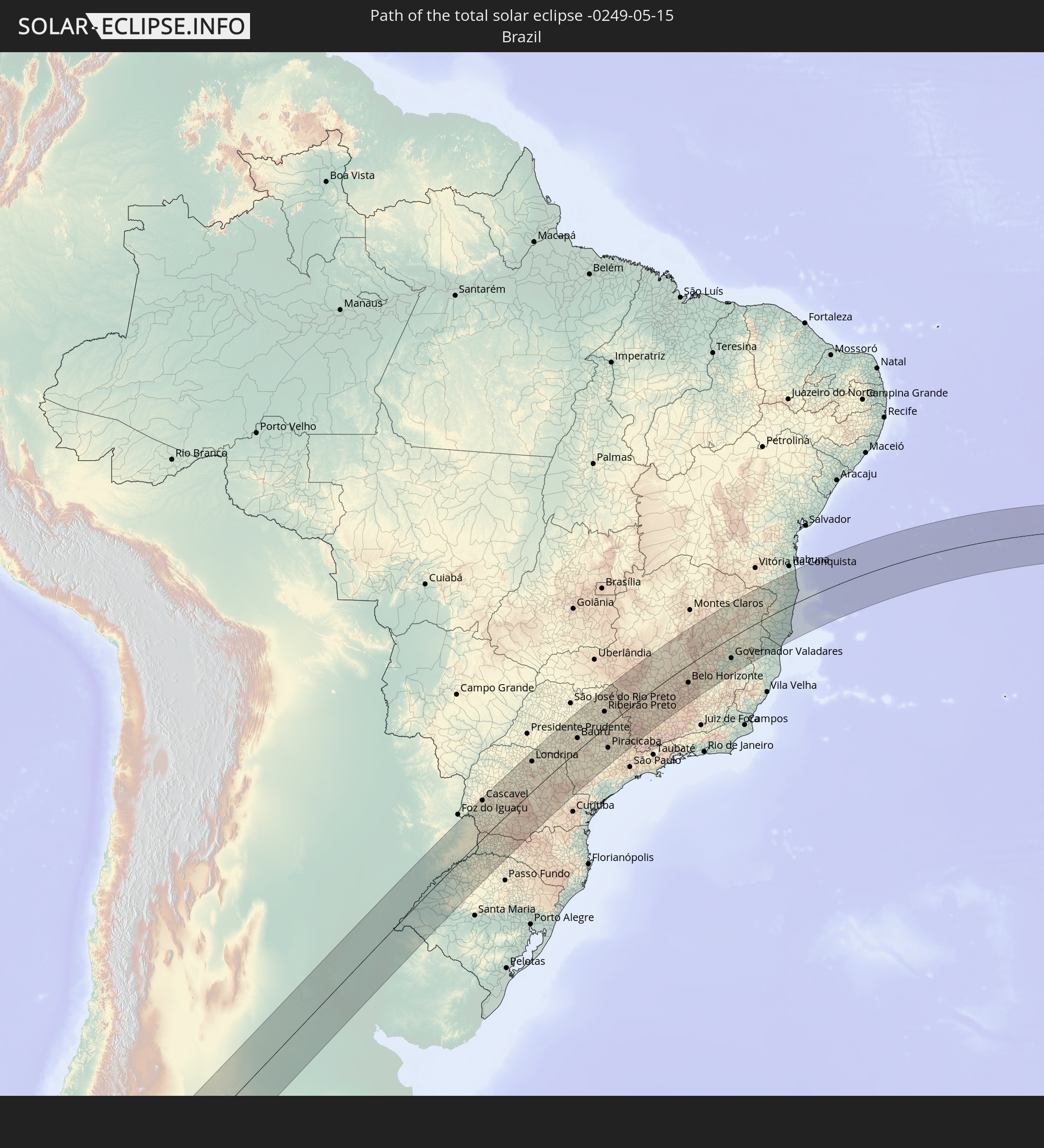 Brasilien
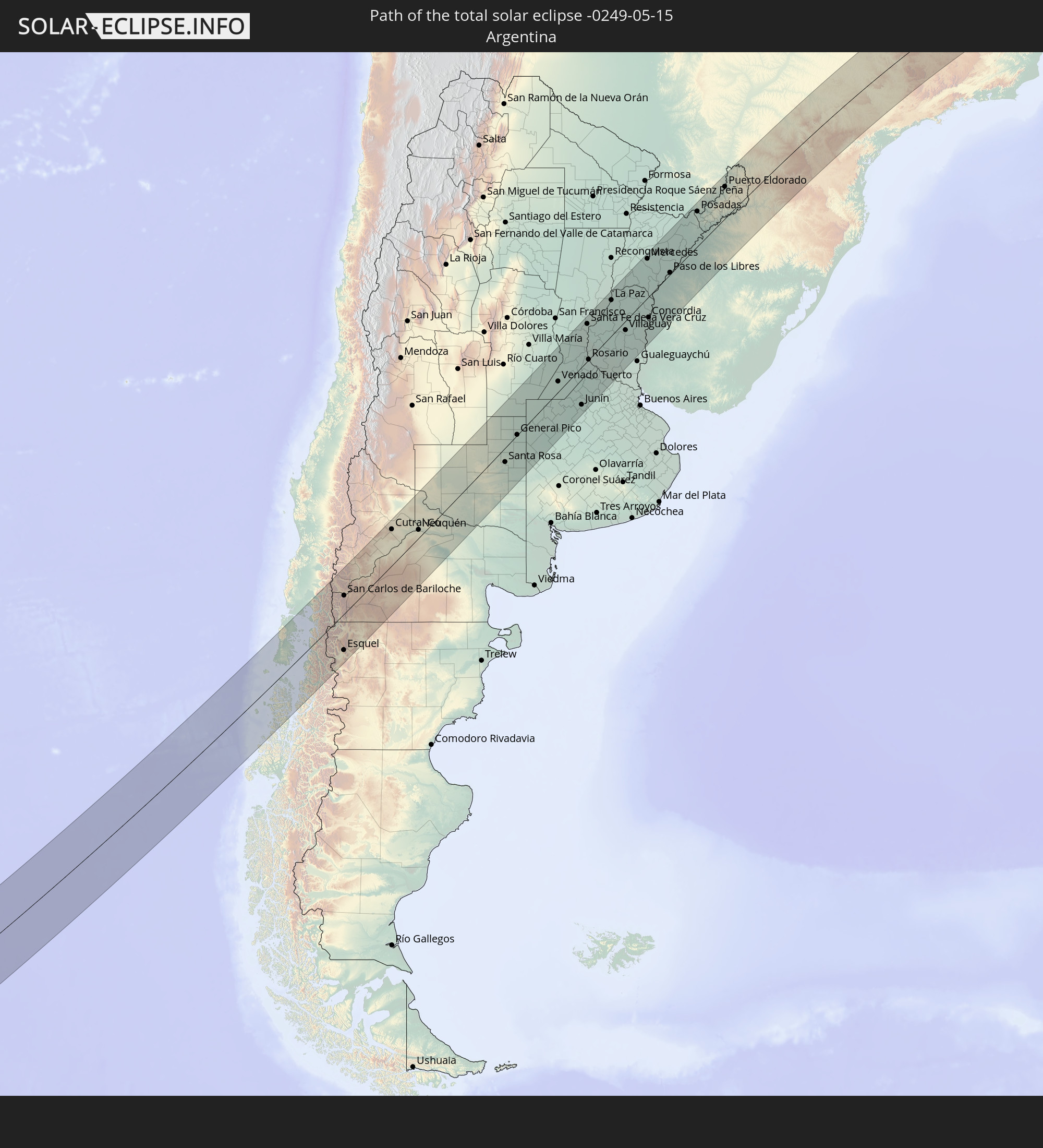 Argentinien
 Paraguay
 Uruguay
 St. Helena
In den folgenden Ländern ist die Sonnenfinsternis partiell zu sehen
 Antarktika
 Chile
Chile
 Kolumbien
 Peru
Peru
 Brasilien
 Argentinien
 Venezuela
 Bolivien
 Paraguay
 Trinidad und Tobago
 Falklandinseln
 Guyana
 Uruguay
 Suriname
 Französisch-Guayana
 Südgeorgien und die Südlichen Sandwichinseln
 Kap Verde
 Senegal
 Mauretanien
 Gambia
 Guinea-Bissau
 Guinea
 St. Helena
 Sierra Leone
 Mali
Mali
 Liberia
 Elfenbeinküste
 Burkina Faso
 Ghana
Ghana
 Togo
Togo
 Niger
Niger
 Benin
Benin
 Nigeria
 Äquatorialguinea
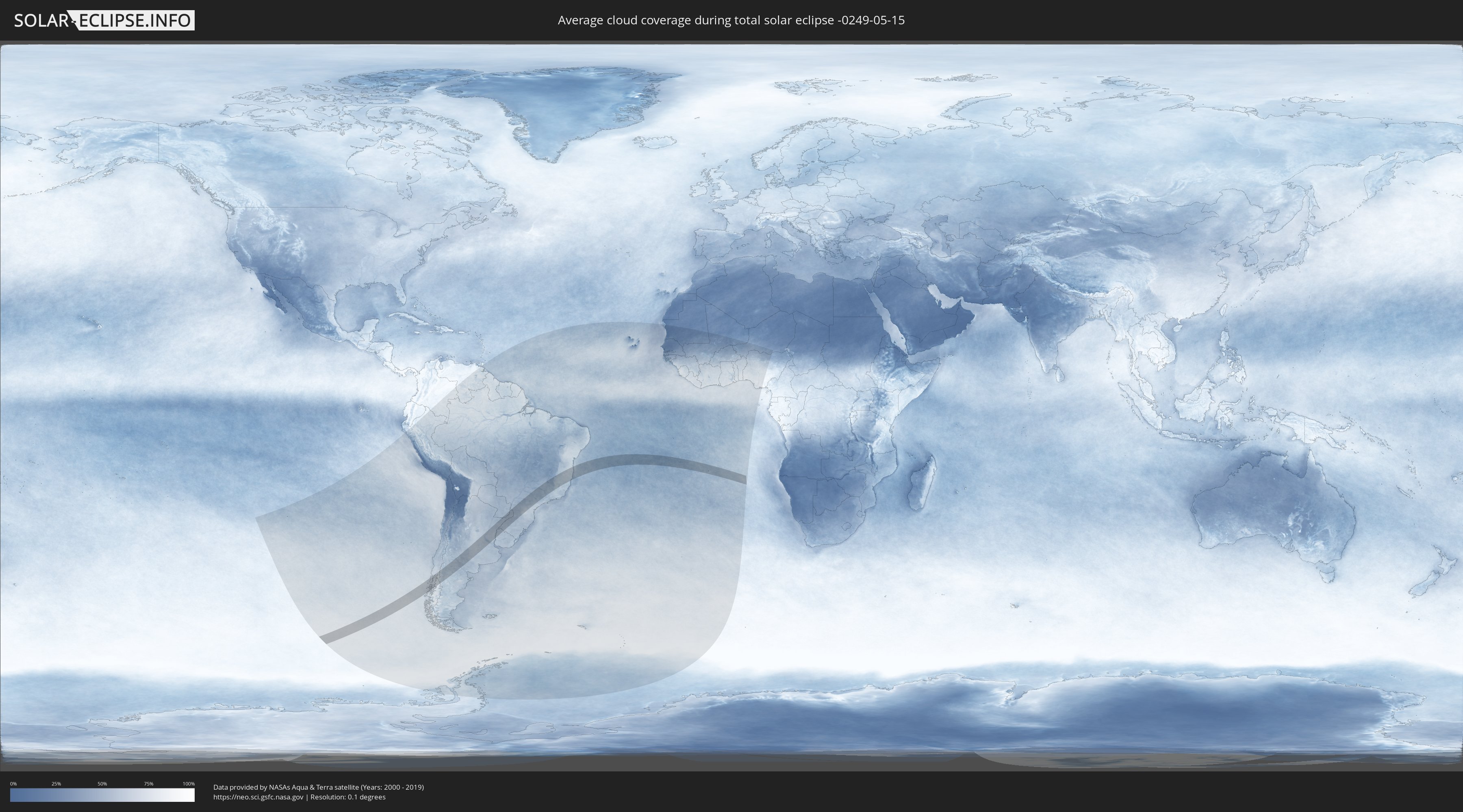
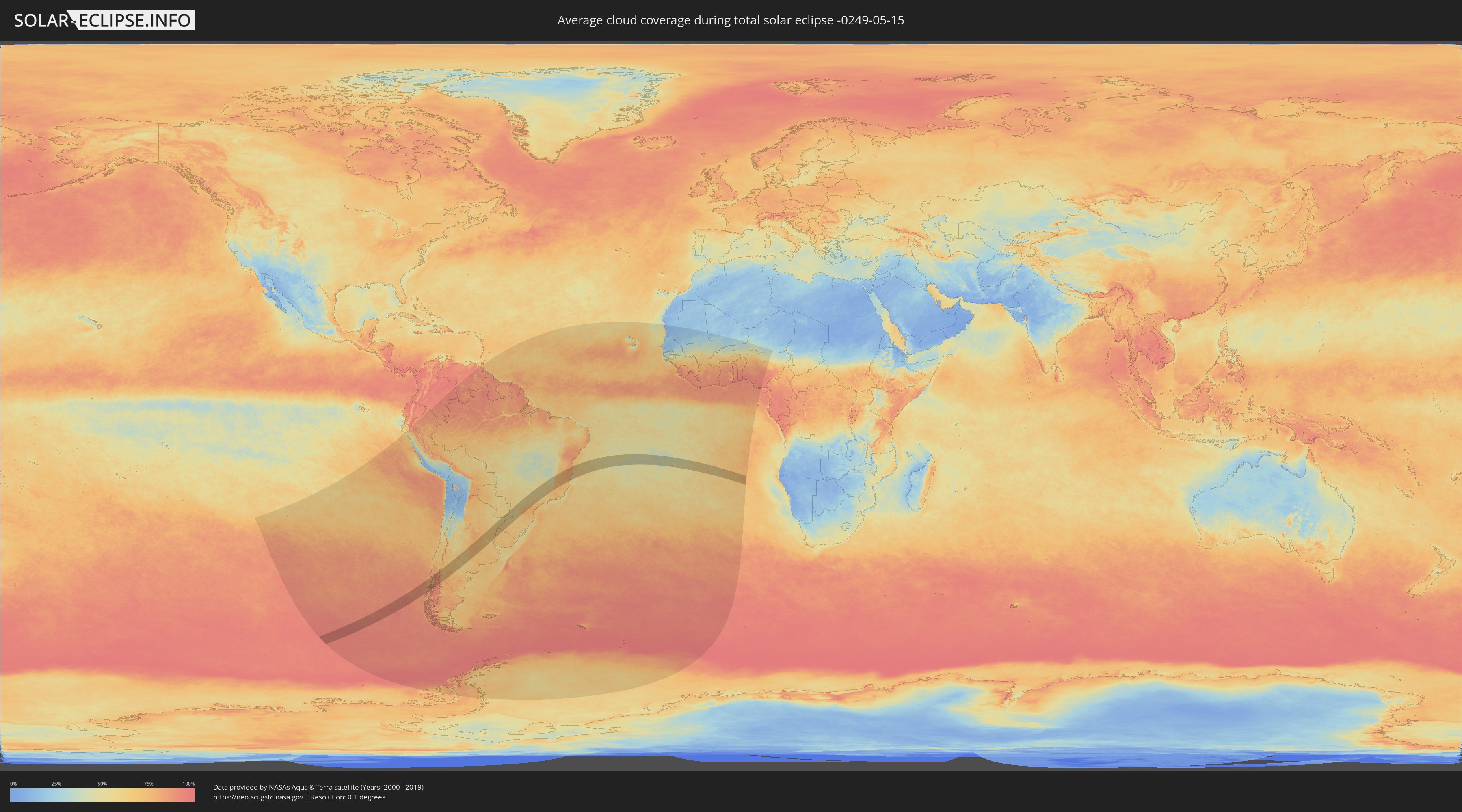
Wie wird das Wetter während der totalen Sonnenfinsternis am 15.05.-0249?
Wo ist der beste Ort, um die totale Sonnenfinsternis vom 15.05.-0249 zu beobachten?
Die folgenden Karten zeigen die durchschnittliche Bewölkung für den Tag, an dem die totale Sonnenfinsternis
stattfindet. Mit Hilfe der Karten lässt sich der Ort entlang des Finsternispfades eingrenzen,
der die besten Aussichen auf einen klaren wolkenfreien Himmel bietet.
Trotzdem muss man immer lokale Gegenenheiten beachten und sollte sich genau über das Wetter an seinem
gewählten Beobachtungsort informieren.
Die Daten stammen von den beiden NASA-Satelliten
AQUA und TERRA
und wurden über einen Zeitraum von 19 Jahren (2000 - 2019) gemittelt.
Detaillierte Länderkarten
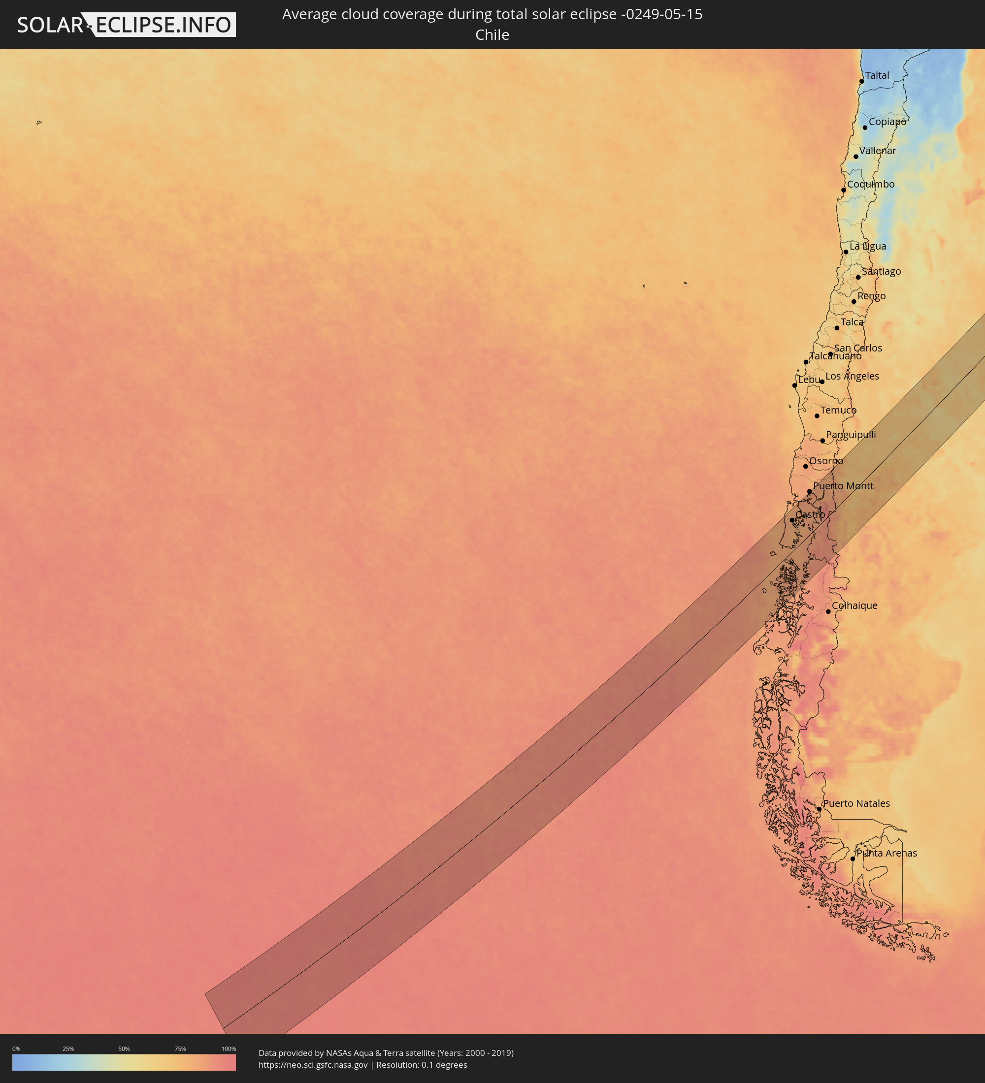 Chile
Chile
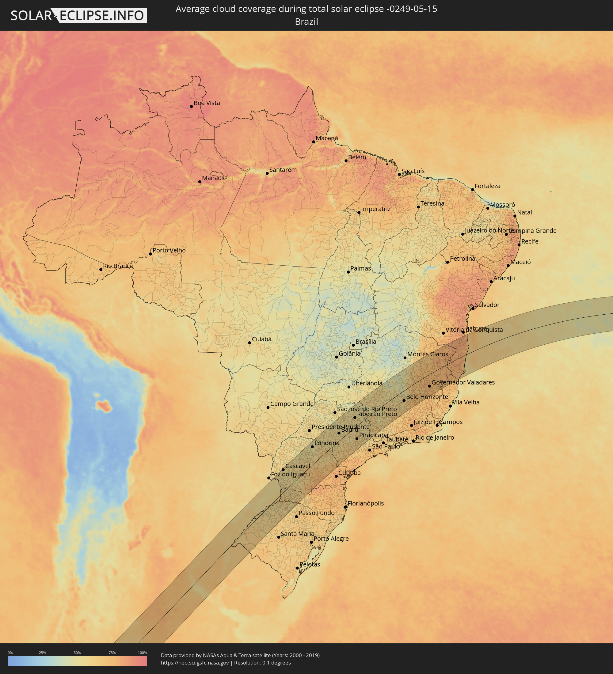 Brasilien
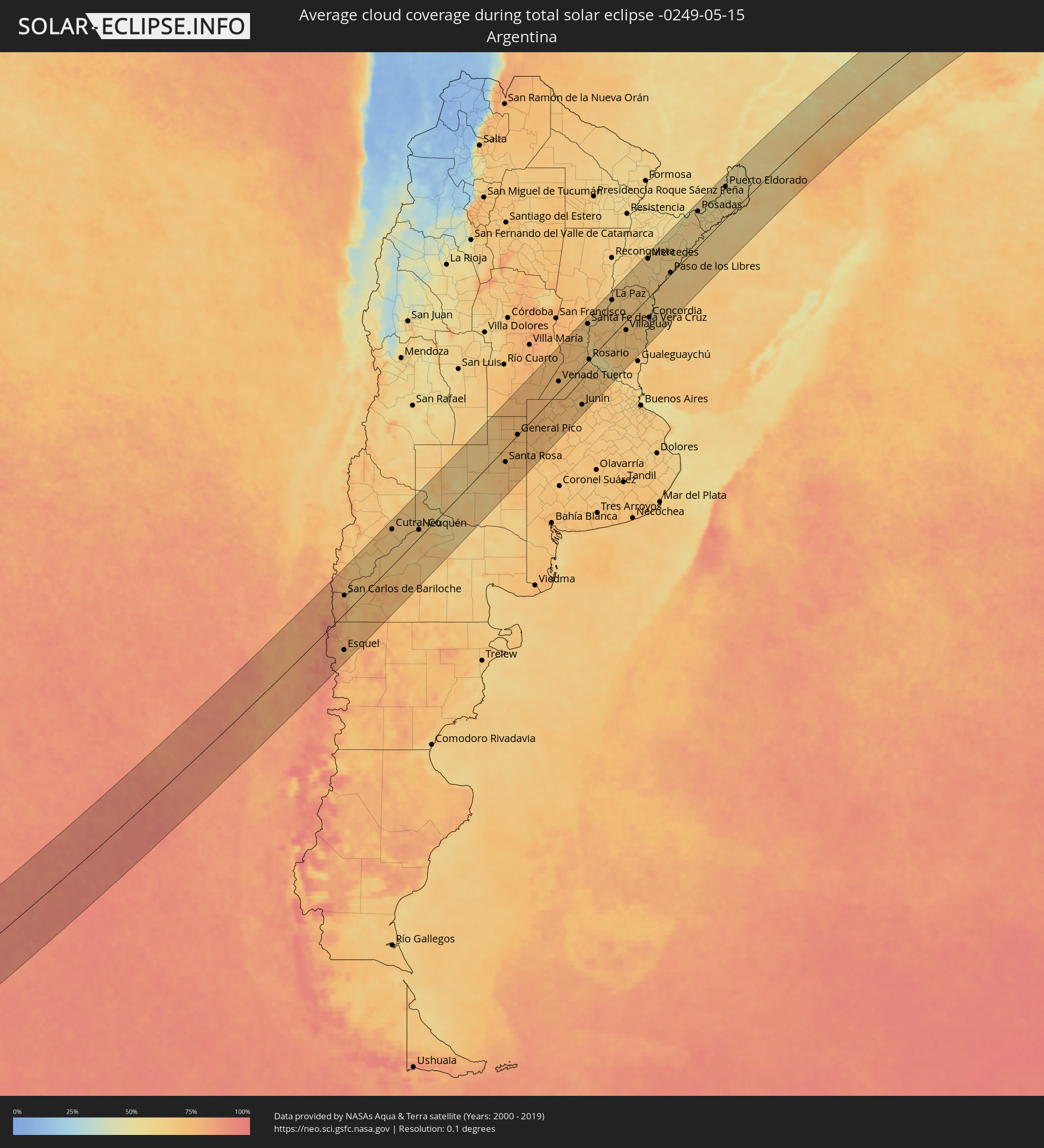 Argentinien
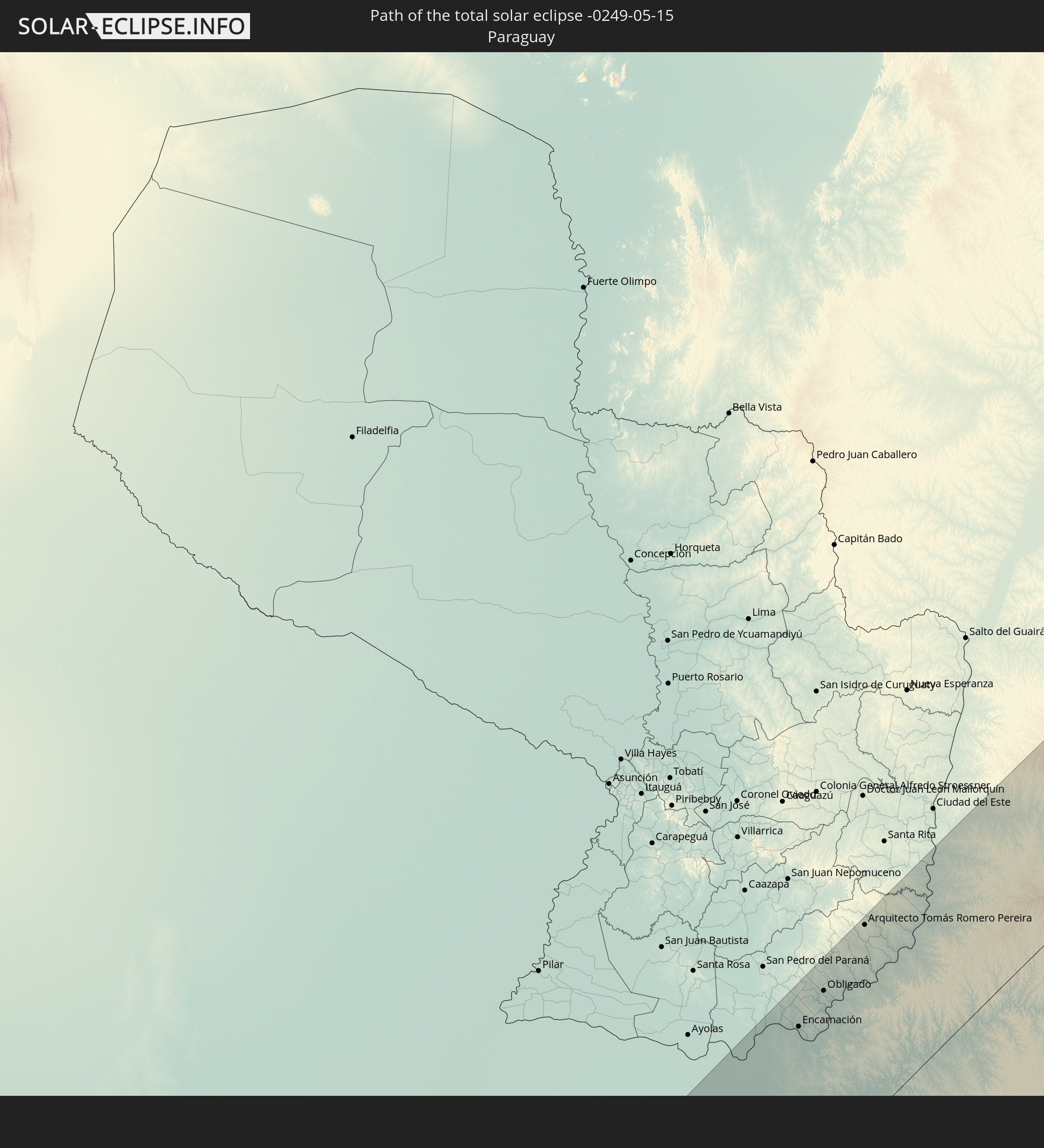
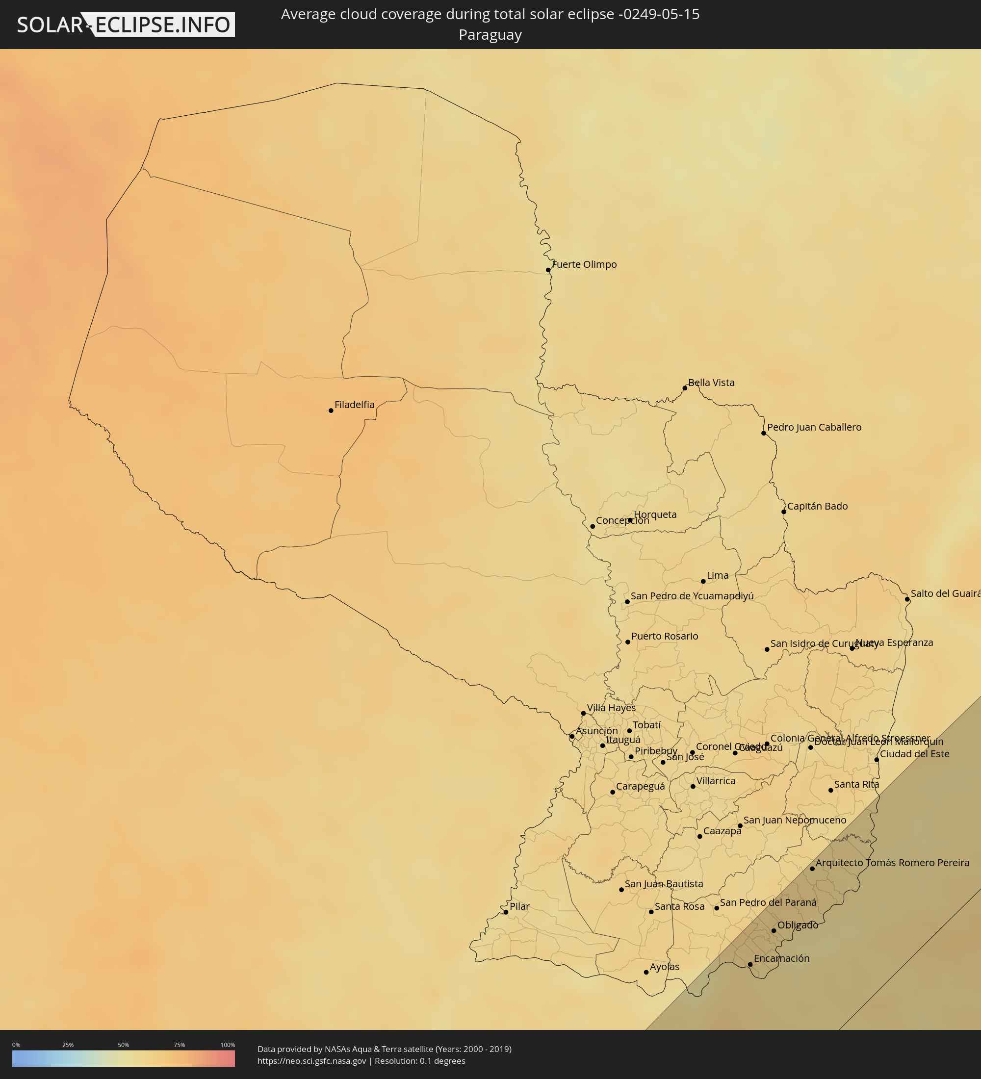 Paraguay
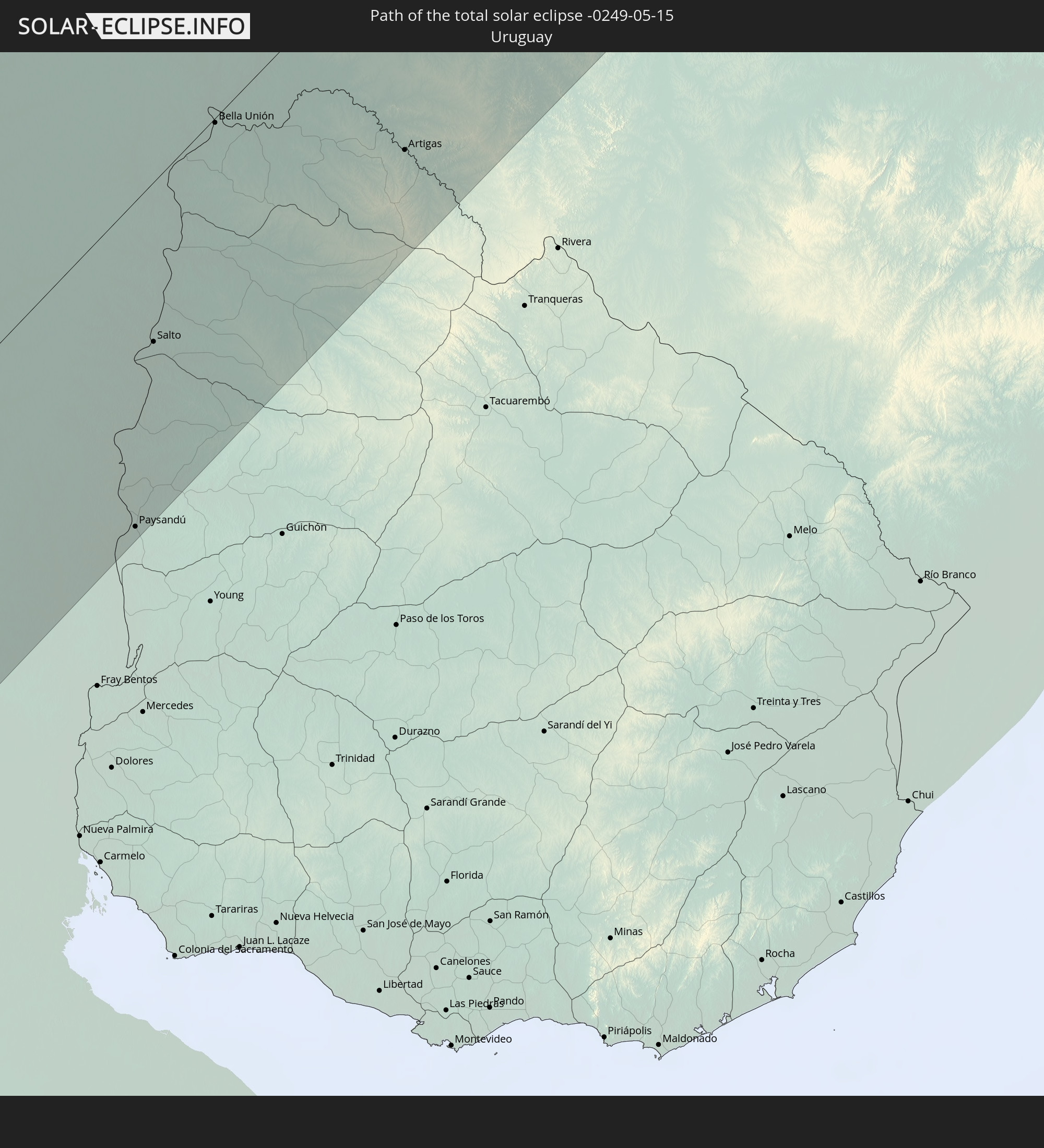
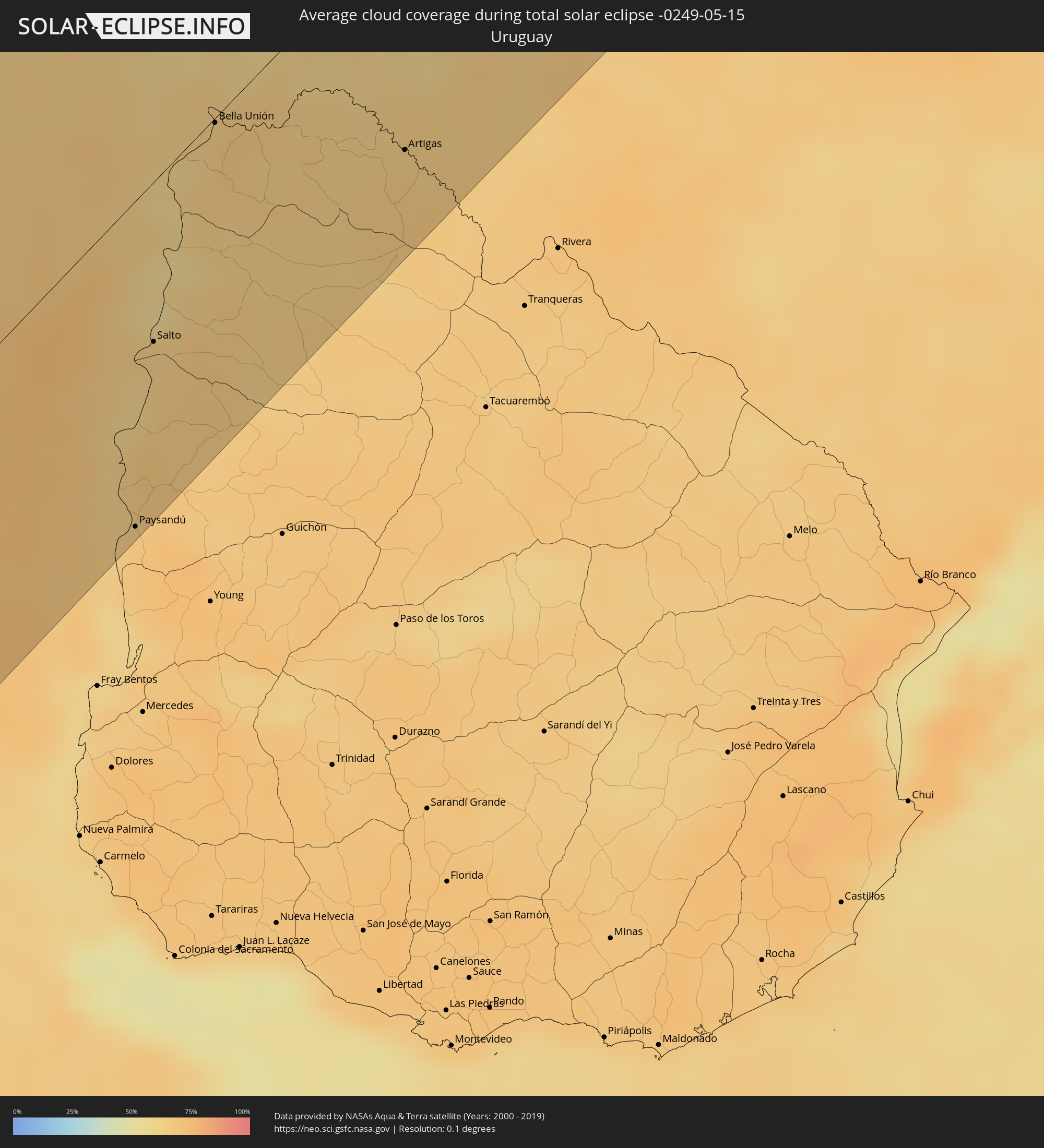 Uruguay
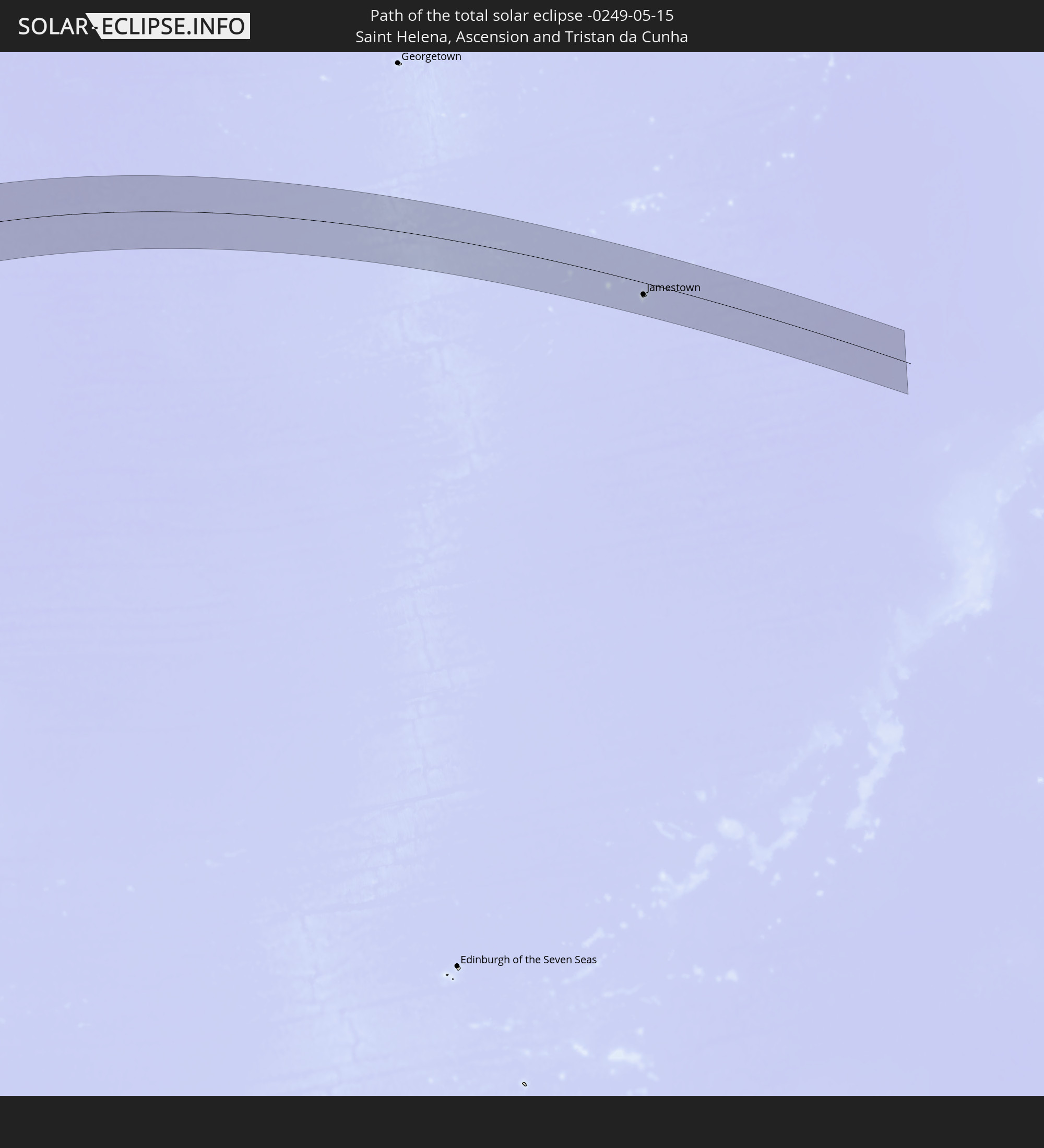
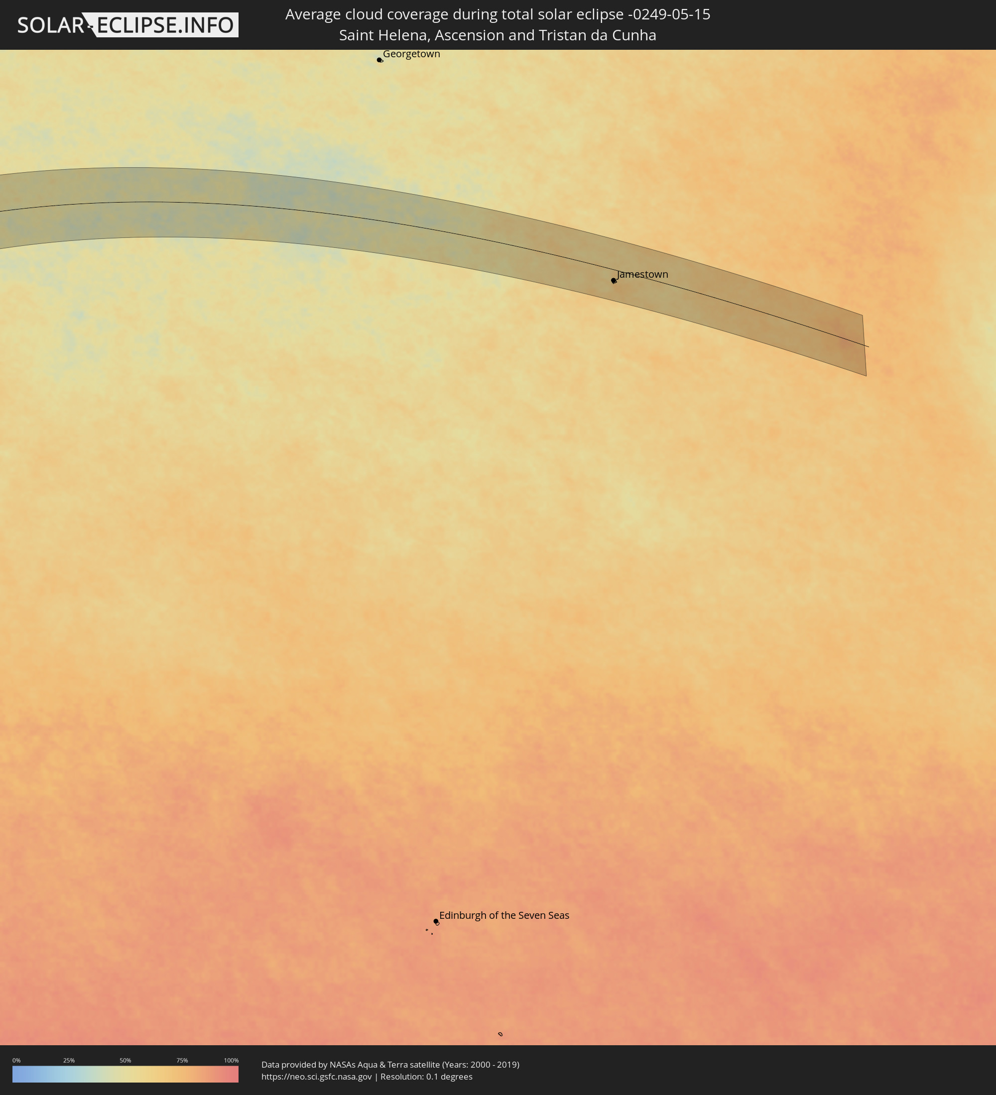 St. Helena
Orte im Finsternispfad
Die nachfolgene Tabelle zeigt Städte und Orte mit mehr als 5.000 Einwohnern, die sich im Finsternispfad befinden. Städte mit mehr als 100.000 Einwohnern sind dick gekennzeichnet. Mit einem Klick auf den Ort öffnet sich eine Detailkarte die die Lage des jeweiligen Ortes zusammen mit dem Verlauf der zentralen Finsternis präsentiert.
| Ort | Typ | Dauer der Verfinsterung | Ortszeit bei maximaler Verfinsterung | Entfernung zur Zentrallinie | Ø Bewölkung |
|
Chonchi, Los Lagos
|
total | - | 10:05:04 UTC-04:42 | 73 km | 80% |
|
Castro, Los Lagos
|
total | - | 10:05:05 UTC-04:42 | 85 km | 80% |
|
Puerto Quellón, Los Lagos
|
total | - | 10:05:15 UTC-04:42 | 24 km | 79% |
|
Calbuco, Los Lagos
|
total | - | 10:05:50 UTC-04:42 | 103 km | 83% |
|
Puerto Montt, Los Lagos
|
total | - | 10:06:04 UTC-04:42 | 117 km | 85% |
|
Esquel, Chubut Province
|
total | - | 10:33:51 UTC-04:16 | 91 km | 79% |
|
San Carlos de Bariloche, Río Negro Province
|
total | - | 10:34:01 UTC-04:16 | 47 km | 71% |
|
Cutral-Có, Neuquén Province
|
total | - | 10:37:04 UTC-04:16 | 95 km | 68% |
|
Neuquén, Neuquén Province
|
total | - | 10:38:38 UTC-04:16 | 21 km | 70% |
|
Allen, Río Negro Province
|
total | - | 10:38:56 UTC-04:16 | 5 km | 67% |
|
General Roca, Río Negro Province
|
total | - | 10:39:15 UTC-04:16 | 15 km | 69% |
|
Villa Regina, Río Negro Province
|
total | - | 10:39:56 UTC-04:16 | 52 km | 64% |
|
Santa Rosa, La Pampa Province
|
total | - | 10:44:56 UTC-04:16 | 38 km | 70% |
|
General Pico, La Pampa Province
|
total | - | 10:46:14 UTC-04:16 | 1 km | 76% |
|
Venado Tuerto, Santa Fe Province
|
total | - | 10:50:15 UTC-04:16 | 29 km | 71% |
|
Lincoln, Buenos Aires
|
total | - | 10:50:15 UTC-04:16 | 86 km | 71% |
|
Cañada de Gómez, Santa Fe Province
|
total | - | 10:51:52 UTC-04:16 | 61 km | 72% |
|
Casilda, Santa Fe Province
|
total | - | 10:52:05 UTC-04:16 | 29 km | 70% |
|
Junín, Buenos Aires
|
total | - | 10:51:24 UTC-04:16 | 104 km | 73% |
|
Capitán Bermúdez, Santa Fe Province
|
total | - | 10:53:00 UTC-04:16 | 15 km | 63% |
|
Santa Fe de la Vera Cruz, Santa Fe Province
|
total | - | 10:53:57 UTC-04:16 | 105 km | 66% |
|
Rosario, Santa Fe Province
|
total | - | 10:53:03 UTC-04:16 | 0 km | 60% |
|
Pergamino, Buenos Aires
|
total | - | 10:52:29 UTC-04:16 | 76 km | 69% |
|
Paraná, Entre Ríos Province
|
total | - | 10:54:11 UTC-04:16 | 86 km | 69% |
|
Villa Constitución, Santa Fe Province
|
total | - | 10:53:22 UTC-04:16 | 42 km | 62% |
|
San Nicolás de los Arroyos, Buenos Aires
|
total | - | 10:53:29 UTC-04:16 | 58 km | 62% |
|
Gualeguay, Entre Ríos Province
|
total | - | 10:55:12 UTC-04:16 | 105 km | 66% |
|
Villaguay, Entre Ríos Province
|
total | - | 10:56:43 UTC-04:16 | 27 km | 68% |
|
Concepción del Uruguay, Entre Ríos Province
|
total | - | 10:57:37 UTC-04:16 | 128 km | 64% |
|
Paysandú, Paysandú
|
total | - | 11:30:00 UTC-03:44 | 127 km | 66% |
|
Mercedes, Corrientes Province
|
total | - | 11:00:50 UTC-04:16 | 114 km | 63% |
|
Curuzú Cuatiá, Corrientes Province
|
total | - | 11:00:18 UTC-04:16 | 66 km | 62% |
|
Concordia, Entre Ríos Province
|
total | - | 10:58:56 UTC-04:16 | 60 km | 62% |
|
Chajarí, Entre Ríos Province
|
total | - | 10:59:34 UTC-04:16 | 13 km | 62% |
|
Salto, Salto
|
total | - | 11:30:59 UTC-03:44 | 63 km | 62% |
|
Bella Unión, Artigas
|
total | - | 11:32:40 UTC-03:44 | 2 km | 65% |
|
Uruguaiana, Rio Grande do Sul
|
total | - | 12:12:29 UTC-03:06 | 2 km | 62% |
|
Paso de los Libres, Corrientes Province
|
total | - | 11:02:12 UTC-04:16 | 5 km | 61% |
|
Artigas, Artigas
|
total | - | 11:34:40 UTC-03:44 | 91 km | 65% |
|
Gobernador Ingeniero Valentín Virasoro, Corrientes Province
|
total | - | 11:05:54 UTC-04:16 | 61 km | 63% |
|
Posadas, Misiones Province
|
total | - | 11:06:54 UTC-04:16 | 105 km | 59% |
|
Encarnación, Itapúa
|
total | - | 11:33:08 UTC-03:50 | 106 km | 59% |
|
Hohenau, Itapúa
|
total | - | 11:33:38 UTC-03:50 | 117 km | 61% |
|
Obligado, Itapúa
|
total | - | 11:33:55 UTC-03:50 | 113 km | 59% |
|
Arquitecto Tomás Romero Pereira, Itapúa
|
total | - | 11:35:18 UTC-03:50 | 130 km | 60% |
|
Oberá, Misiones Province
|
total | - | 11:08:19 UTC-04:16 | 41 km | 57% |
|
Puerto Eldorado, Misiones Province
|
total | - | 11:36:31 UTC-03:50 | 97 km | 54% |
|
San Vicente, Misiones Province
|
total | - | 11:11:18 UTC-04:16 | 41 km | 57% |
|
Cascavel, Paraná
|
total | - | 12:25:00 UTC-03:06 | 127 km | 56% |
|
Chapecó, Santa Catarina
|
total | - | 12:24:13 UTC-03:06 | 102 km | 64% |
|
Guarapuava, Paraná
|
total | - | 12:28:42 UTC-03:06 | 46 km | 63% |
|
Londrina, Paraná
|
total | - | 12:32:02 UTC-03:06 | 104 km | 54% |
|
Ponta Grossa, Paraná
|
total | - | 12:31:55 UTC-03:06 | 111 km | 72% |
|
Marília, São Paulo
|
total | - | 12:36:12 UTC-03:06 | 113 km | 58% |
|
Bauru, São Paulo
|
total | - | 12:38:03 UTC-03:06 | 45 km | 56% |
|
Jaú, São Paulo
|
total | - | 12:39:13 UTC-03:06 | 13 km | 57% |
|
Araraquara, São Paulo
|
total | - | 12:40:47 UTC-03:06 | 31 km | 56% |
|
Itapetininga, São Paulo
|
total | - | 12:38:35 UTC-03:06 | 130 km | 67% |
|
São Carlos, São Paulo
|
total | - | 12:41:08 UTC-03:06 | 7 km | 54% |
|
Ribeirão Preto, São Paulo
|
total | - | 12:42:30 UTC-03:06 | 60 km | 59% |
|
Piracicaba, São Paulo
|
total | - | 12:40:42 UTC-03:06 | 83 km | 63% |
|
Rio Claro, São Paulo
|
total | - | 12:41:20 UTC-03:06 | 62 km | 62% |
|
Santa Bárbara d'Oeste, São Paulo
|
total | - | 12:41:12 UTC-03:06 | 101 km | 61% |
|
Limeira, São Paulo
|
total | - | 12:41:29 UTC-03:06 | 86 km | 63% |
|
Franca, São Paulo
|
total | - | 12:44:21 UTC-03:06 | 90 km | 55% |
|
Sumaré, São Paulo
|
total | - | 12:41:26 UTC-03:06 | 117 km | 60% |
|
Indaiatuba, São Paulo
|
total | - | 12:41:12 UTC-03:06 | 143 km | 63% |
|
Campinas, São Paulo
|
total | - | 12:41:48 UTC-03:06 | 137 km | 58% |
|
Mogi-Gaucu, São Paulo
|
total | - | 12:42:48 UTC-03:06 | 99 km | 57% |
|
Poços de Caldas, Minas Gerais
|
total | - | 12:44:31 UTC-03:06 | 74 km | 61% |
|
Varginha, Minas Gerais
|
total | - | 12:47:29 UTC-03:06 | 125 km | 63% |
|
Divinópolis, Minas Gerais
|
total | - | 12:50:47 UTC-03:06 | 33 km | 61% |
|
Sete Lagoas, Minas Gerais
|
total | - | 12:53:18 UTC-03:06 | 10 km | 55% |
|
Betim, Minas Gerais
|
total | - | 12:52:41 UTC-03:06 | 59 km | 59% |
|
Ribeirão das Neves, Minas Gerais
|
total | - | 12:53:14 UTC-03:06 | 47 km | 59% |
|
Ibirité, Minas Gerais
|
total | - | 12:52:55 UTC-03:06 | 72 km | 60% |
|
Belo Horizonte, Minas Gerais
|
total | - | 12:53:22 UTC-03:06 | 70 km | 60% |
|
Santa Luzia, Minas Gerais
|
total | - | 12:53:47 UTC-03:06 | 62 km | 61% |
|
Ipatinga, Minas Gerais
|
total | - | 12:57:20 UTC-03:06 | 110 km | 62% |
|
Governador Valadares, Minas Gerais
|
total | - | 12:59:39 UTC-03:06 | 85 km | 74% |
|
Porto Seguro, Bahia
|
total | - | 13:42:32 UTC-02:34 | 2 km | 67% |
|
Jamestown, Saint Helena
|
total | - | 16:54:38 UTC-00:16 | 43 km | 71% |