Total solar eclipse of 05/15/-0249
| Day of week: | Thursday |
| Maximum duration of eclipse: | 05m56s |
| Maximum width of eclipse path: | 295 km |
| Saros cycle: | 53 |
| Coverage: | 100% |
| Magnitude: | 1.0695 |
| Gamma: | -0.6518 |
Wo kann man die Sonnenfinsternis vom 05/15/-0249 sehen?
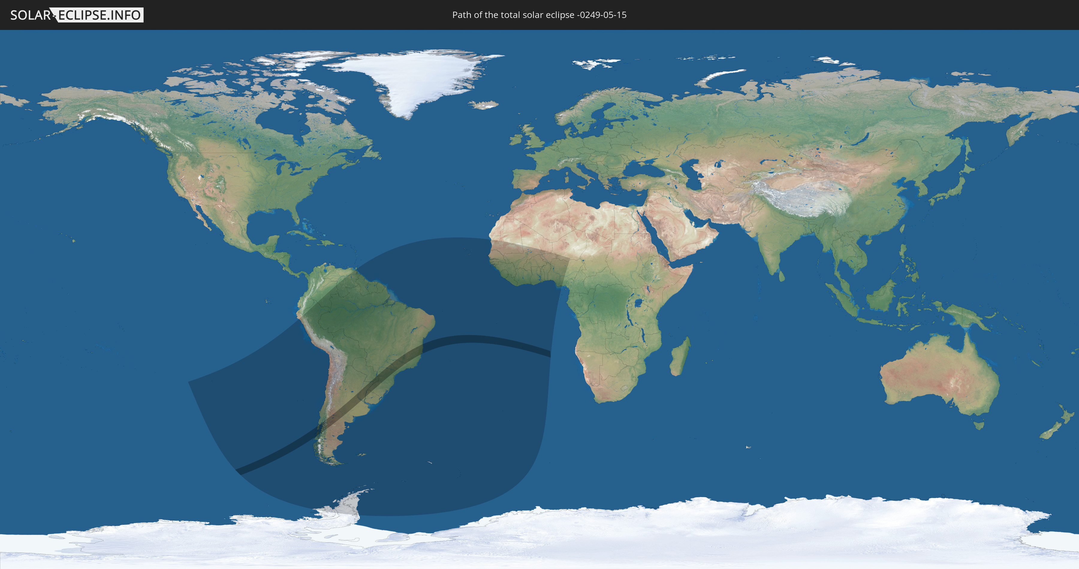
Die Sonnenfinsternis am 05/15/-0249 kann man in 34 Ländern als partielle Sonnenfinsternis beobachten.
Der Finsternispfad verläuft durch 6 Länder. Nur in diesen Ländern ist sie als total Sonnenfinsternis zu sehen.
In den folgenden Ländern ist die Sonnenfinsternis total zu sehen
 Chile
Chile
 Brazil
 Argentina
 Paraguay
 Uruguay
 Saint Helena, Ascension and Tristan da Cunha
In den folgenden Ländern ist die Sonnenfinsternis partiell zu sehen
 Antarctica
 Chile
Chile
 Colombia
 Peru
Peru
 Brazil
 Argentina
 Venezuela
 Bolivia
 Paraguay
 Trinidad and Tobago
 Falkland Islands
 Guyana
 Uruguay
 Suriname
 French Guiana
 South Georgia and the South Sandwich Islands
 Cabo Verde
 Senegal
 Mauritania
 The Gambia
 Guinea-Bissau
 Guinea
 Saint Helena, Ascension and Tristan da Cunha
 Sierra Leone
 Mali
Mali
 Liberia
 Ivory Coast
 Burkina Faso
 Ghana
Ghana
 Togo
Togo
 Niger
Niger
 Benin
Benin
 Nigeria
 Equatorial Guinea
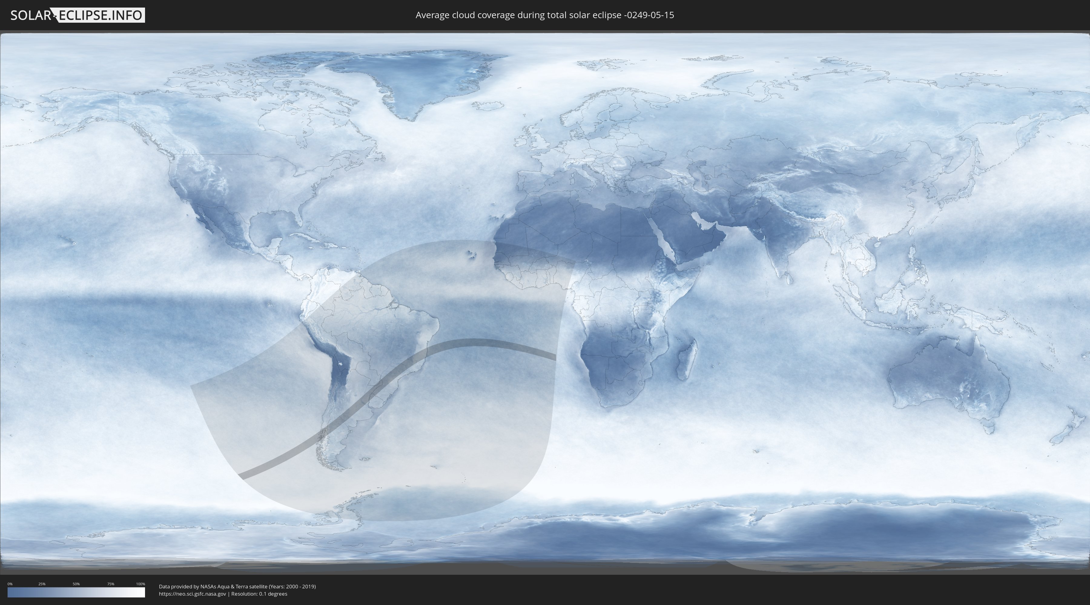
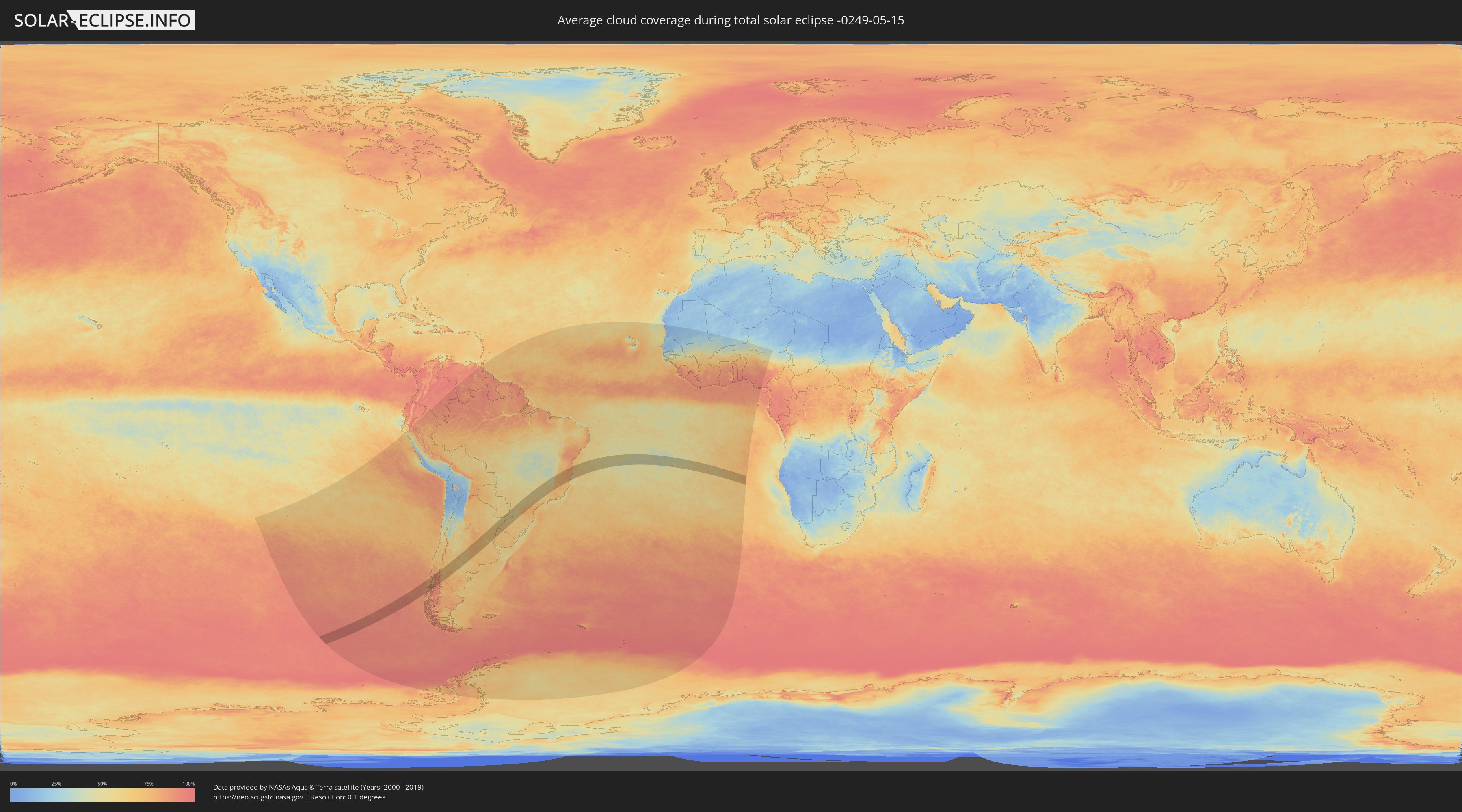
How will be the weather during the total solar eclipse on 05/15/-0249?
Where is the best place to see the total solar eclipse of 05/15/-0249?
The following maps show the average cloud coverage for the day of the total solar eclipse.
With the help of these maps, it is possible to find the place along the eclipse path, which has the best
chance of a cloudless sky.
Nevertheless, you should consider local circumstances and inform about the weather of your chosen
observation site.
The data is provided by NASAs satellites
AQUA and TERRA.
The cloud maps are averaged over a period of 19 years (2000 - 2019).
Detailed country maps
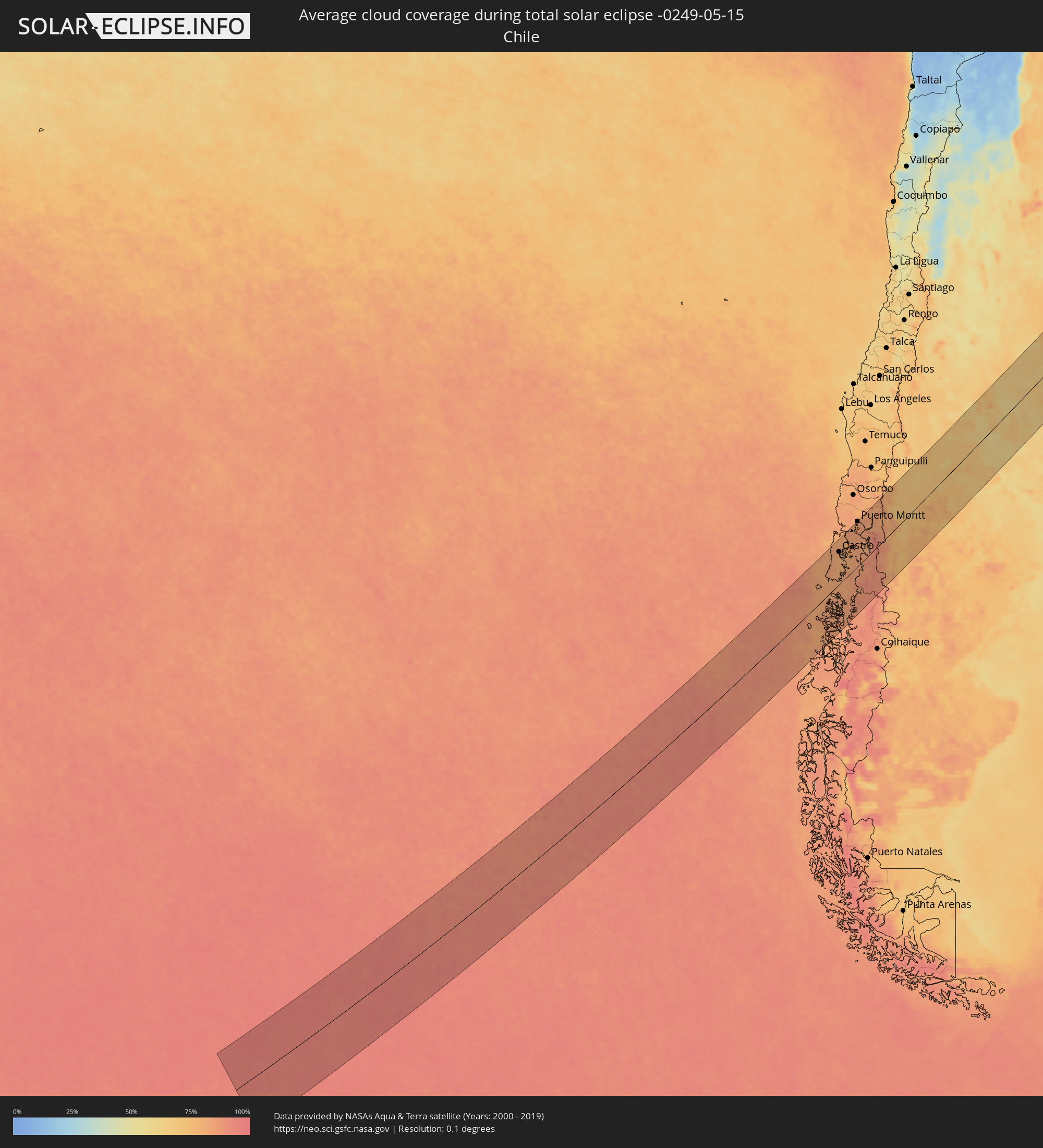 Chile
Chile
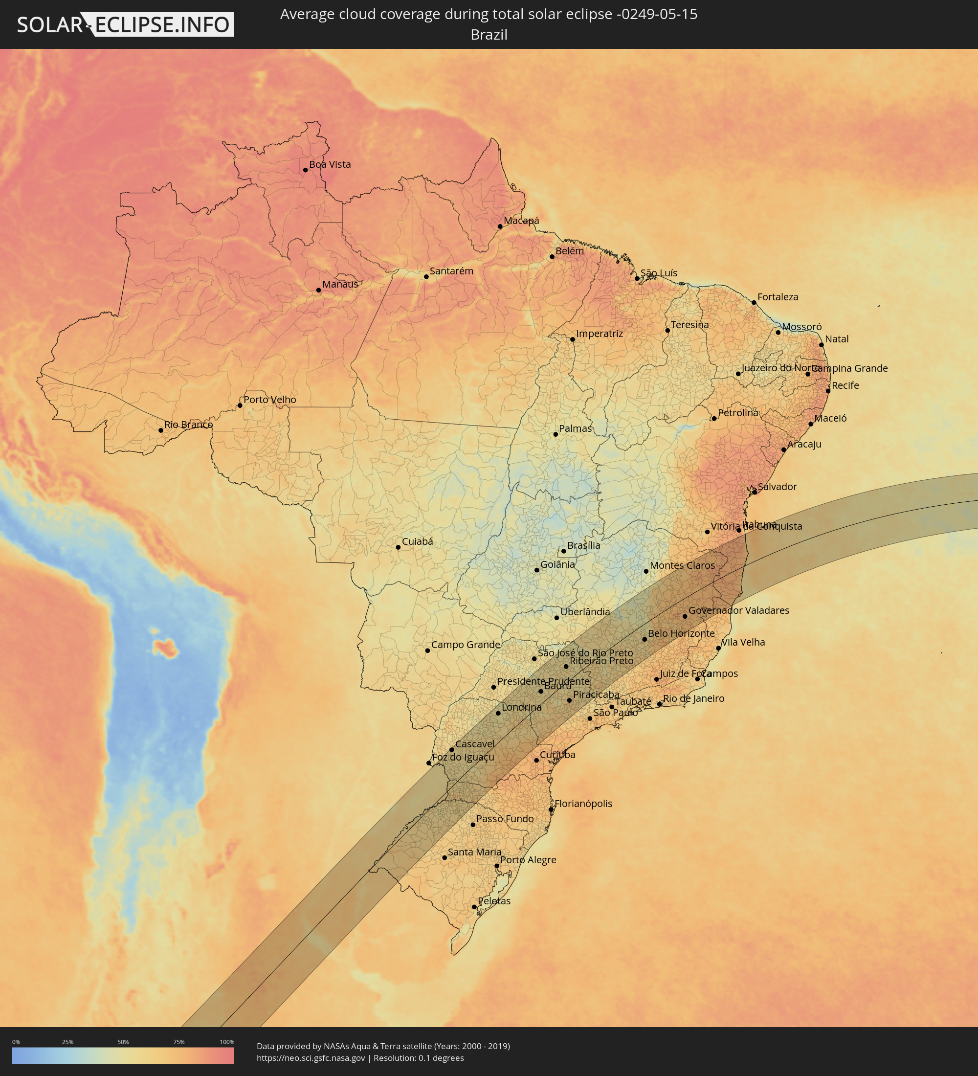 Brazil
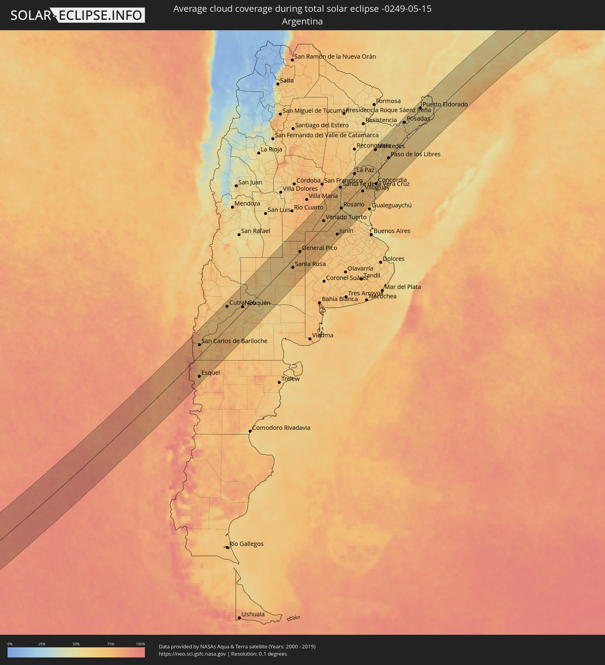 Argentina
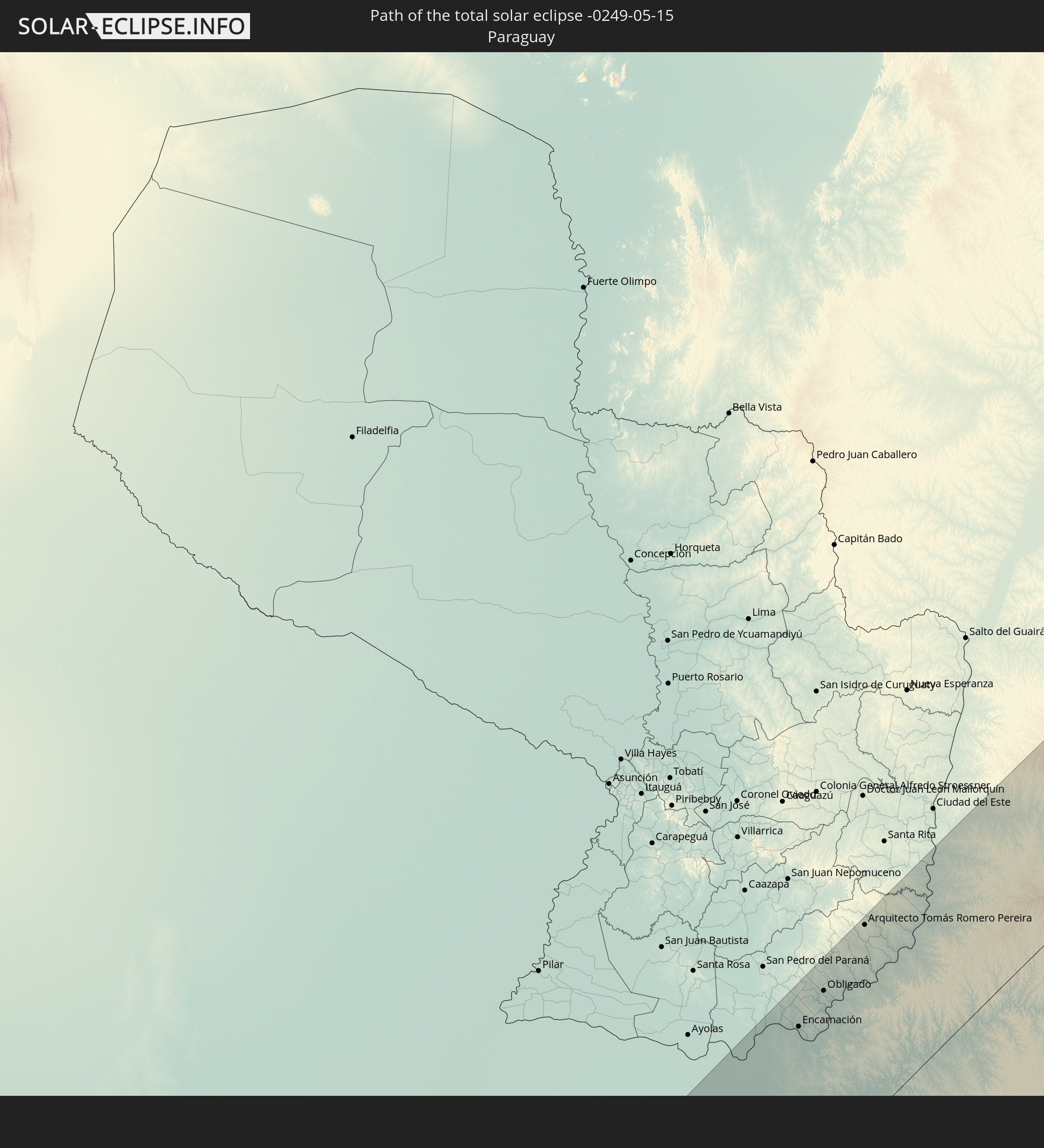
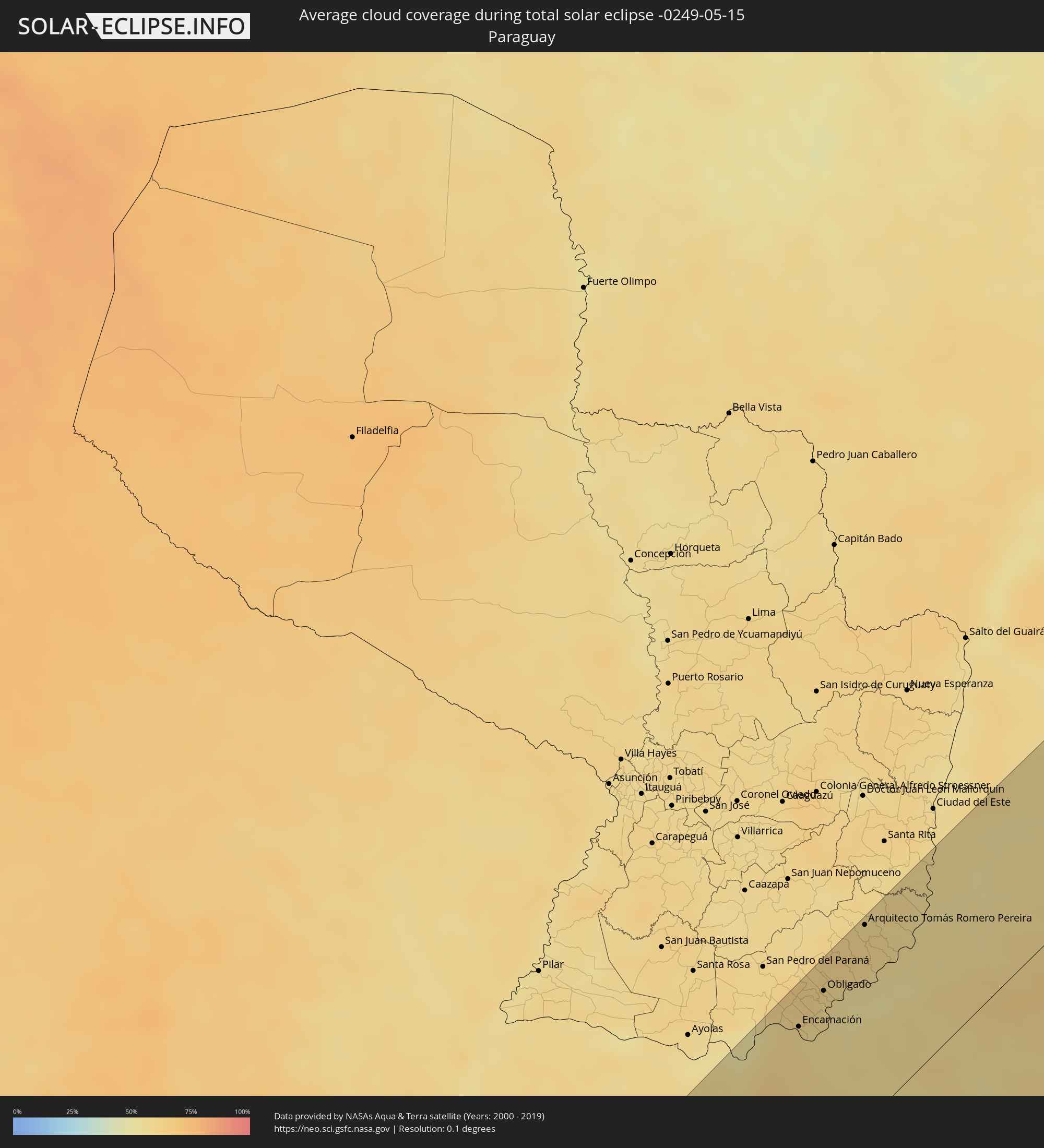 Paraguay
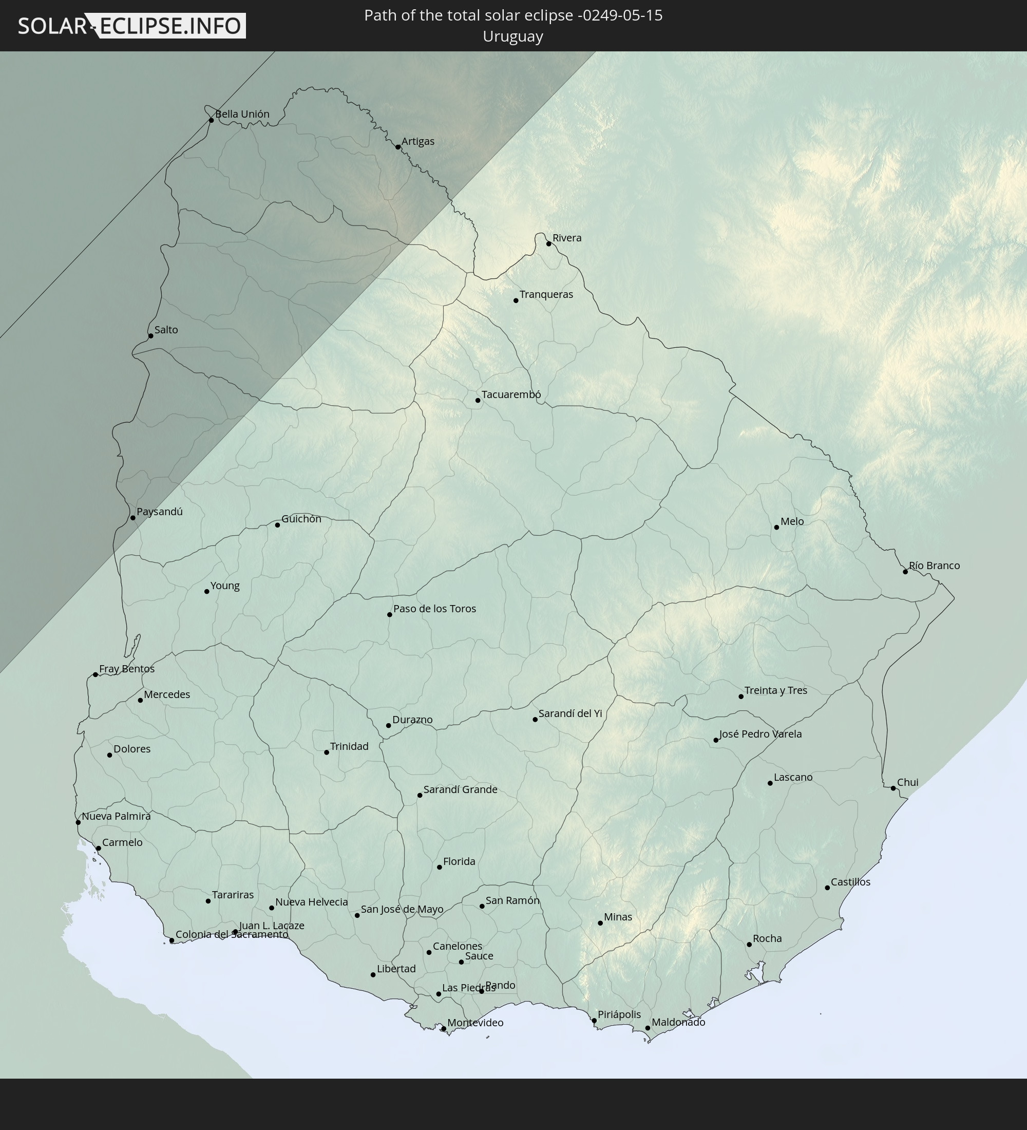
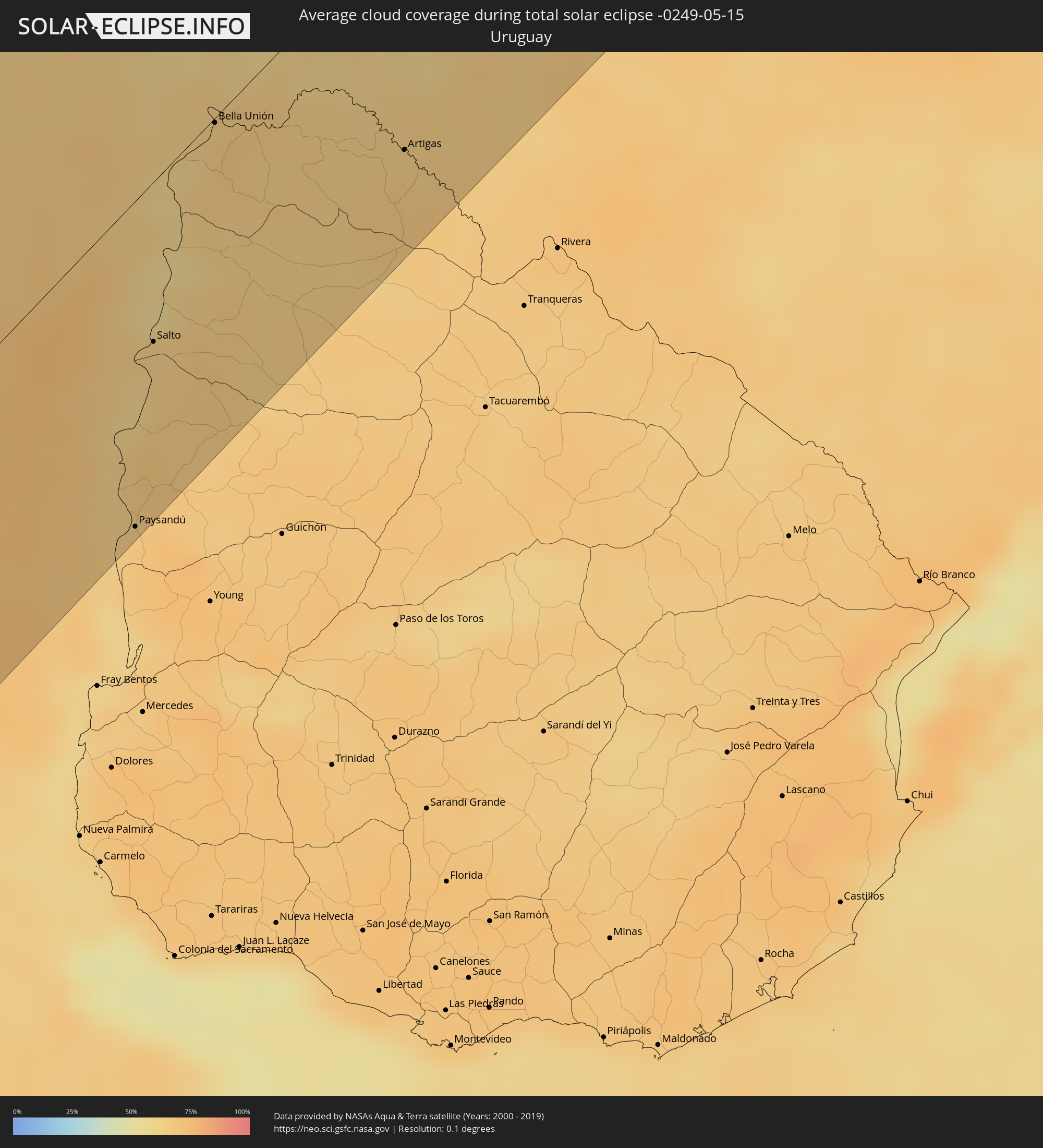 Uruguay
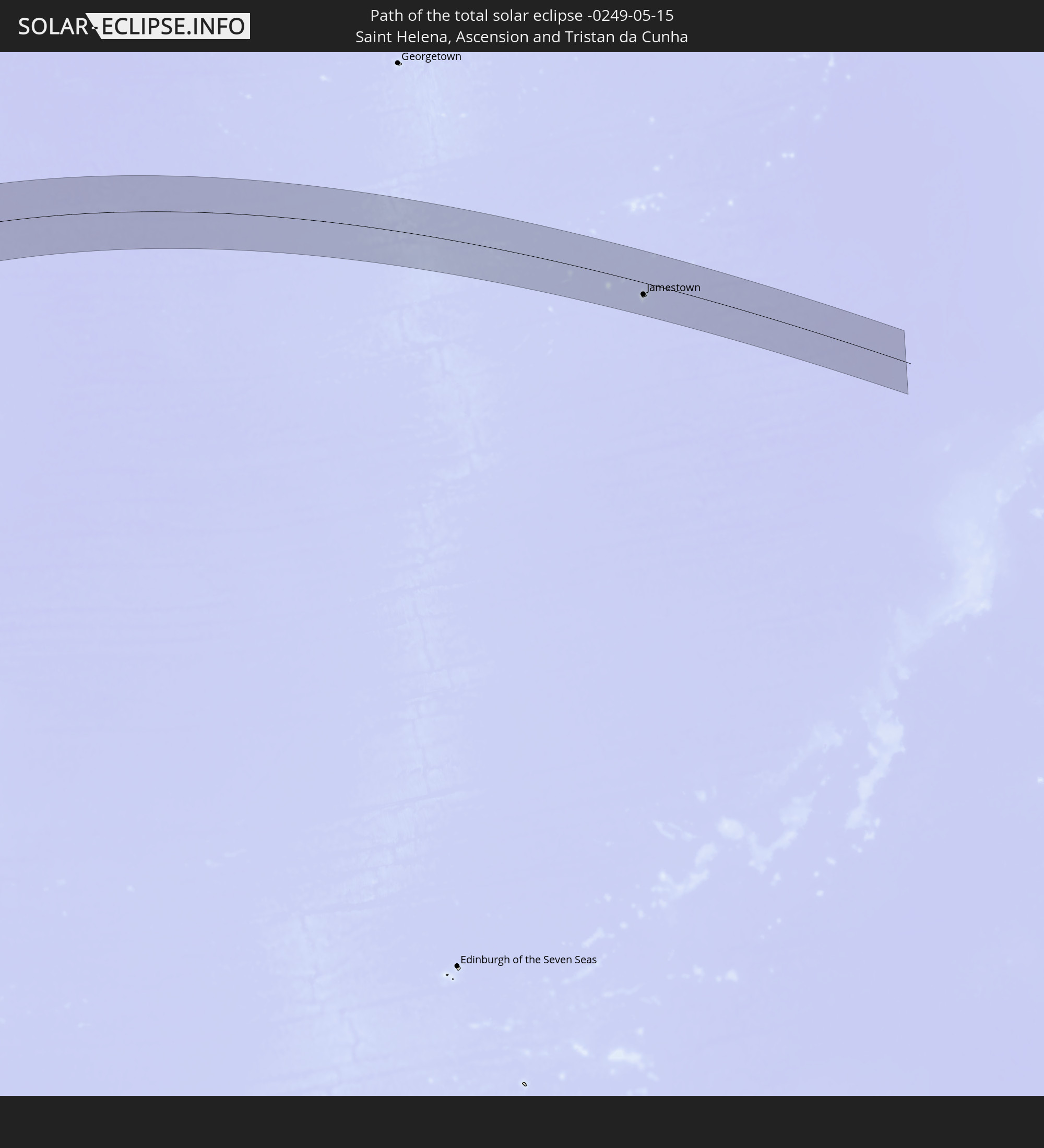
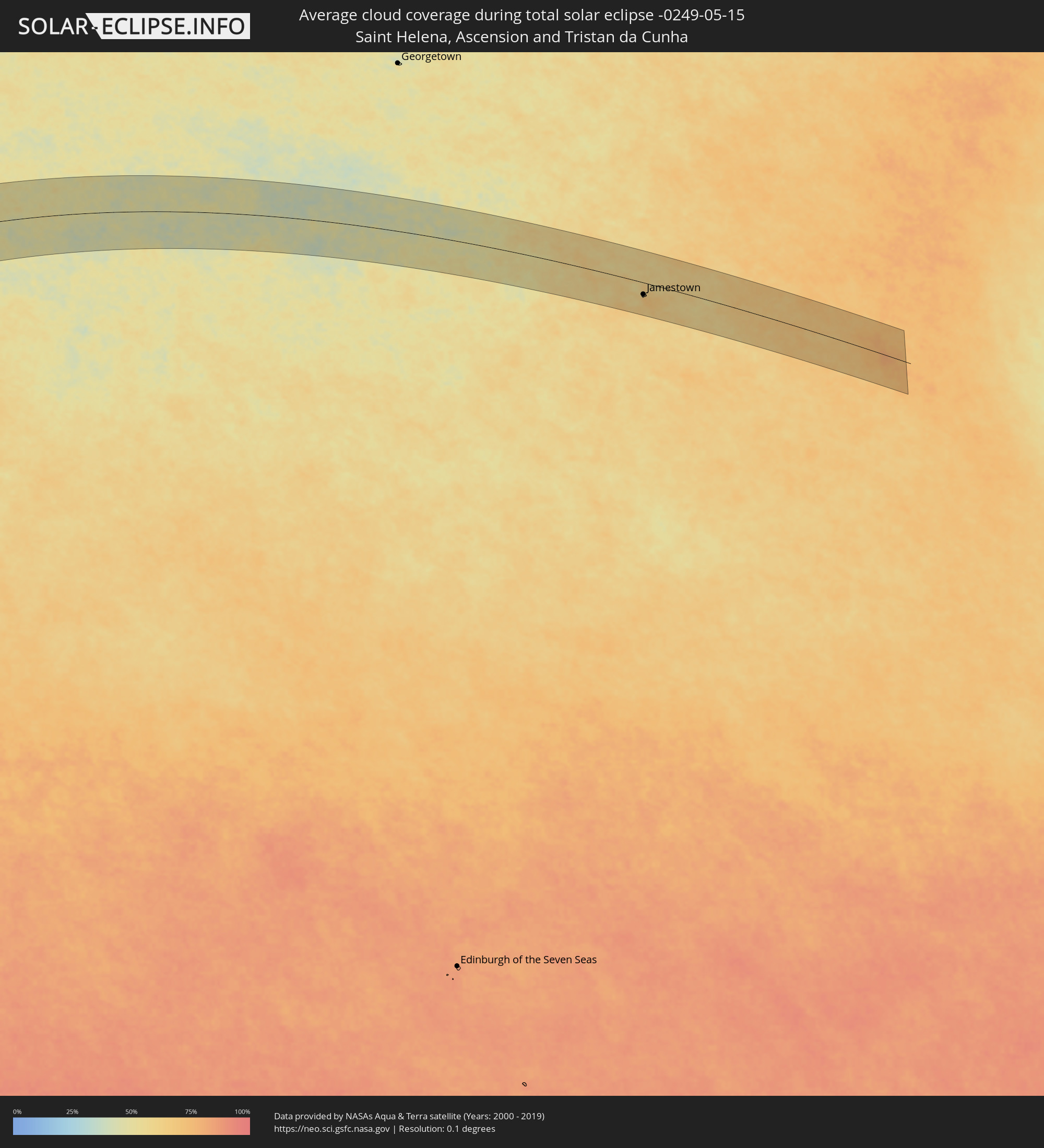 Saint Helena, Ascension and Tristan da Cunha
Cities inside the path of the eclipse
The following table shows all locations with a population of more than 5,000 inside the eclipse path. Cities which have more than 100,000 inhabitants are marked bold. A click at the locations opens a detailed map.
| City | Type | Eclipse duration | Local time of max. eclipse | Distance to central line | Ø Cloud coverage |
|
Chonchi, Los Lagos
|
total | - | 10:05:04 UTC-04:42 | 73 km | 80% |
|
Castro, Los Lagos
|
total | - | 10:05:05 UTC-04:42 | 85 km | 80% |
|
Puerto Quellón, Los Lagos
|
total | - | 10:05:15 UTC-04:42 | 24 km | 79% |
|
Calbuco, Los Lagos
|
total | - | 10:05:50 UTC-04:42 | 103 km | 83% |
|
Puerto Montt, Los Lagos
|
total | - | 10:06:04 UTC-04:42 | 117 km | 85% |
|
Esquel, Chubut Province
|
total | - | 10:33:51 UTC-04:16 | 91 km | 79% |
|
San Carlos de Bariloche, Río Negro Province
|
total | - | 10:34:01 UTC-04:16 | 47 km | 71% |
|
Cutral-Có, Neuquén Province
|
total | - | 10:37:04 UTC-04:16 | 95 km | 68% |
|
Neuquén, Neuquén Province
|
total | - | 10:38:38 UTC-04:16 | 21 km | 70% |
|
Allen, Río Negro Province
|
total | - | 10:38:56 UTC-04:16 | 5 km | 67% |
|
General Roca, Río Negro Province
|
total | - | 10:39:15 UTC-04:16 | 15 km | 69% |
|
Villa Regina, Río Negro Province
|
total | - | 10:39:56 UTC-04:16 | 52 km | 64% |
|
Santa Rosa, La Pampa Province
|
total | - | 10:44:56 UTC-04:16 | 38 km | 70% |
|
General Pico, La Pampa Province
|
total | - | 10:46:14 UTC-04:16 | 1 km | 76% |
|
Venado Tuerto, Santa Fe Province
|
total | - | 10:50:15 UTC-04:16 | 29 km | 71% |
|
Lincoln, Buenos Aires
|
total | - | 10:50:15 UTC-04:16 | 86 km | 71% |
|
Cañada de Gómez, Santa Fe Province
|
total | - | 10:51:52 UTC-04:16 | 61 km | 72% |
|
Casilda, Santa Fe Province
|
total | - | 10:52:05 UTC-04:16 | 29 km | 70% |
|
Junín, Buenos Aires
|
total | - | 10:51:24 UTC-04:16 | 104 km | 73% |
|
Capitán Bermúdez, Santa Fe Province
|
total | - | 10:53:00 UTC-04:16 | 15 km | 63% |
|
Santa Fe de la Vera Cruz, Santa Fe Province
|
total | - | 10:53:57 UTC-04:16 | 105 km | 66% |
|
Rosario, Santa Fe Province
|
total | - | 10:53:03 UTC-04:16 | 0 km | 60% |
|
Pergamino, Buenos Aires
|
total | - | 10:52:29 UTC-04:16 | 76 km | 69% |
|
Paraná, Entre Ríos Province
|
total | - | 10:54:11 UTC-04:16 | 86 km | 69% |
|
Villa Constitución, Santa Fe Province
|
total | - | 10:53:22 UTC-04:16 | 42 km | 62% |
|
San Nicolás de los Arroyos, Buenos Aires
|
total | - | 10:53:29 UTC-04:16 | 58 km | 62% |
|
Gualeguay, Entre Ríos Province
|
total | - | 10:55:12 UTC-04:16 | 105 km | 66% |
|
Villaguay, Entre Ríos Province
|
total | - | 10:56:43 UTC-04:16 | 27 km | 68% |
|
Concepción del Uruguay, Entre Ríos Province
|
total | - | 10:57:37 UTC-04:16 | 128 km | 64% |
|
Paysandú, Paysandú
|
total | - | 11:30:00 UTC-03:44 | 127 km | 66% |
|
Mercedes, Corrientes Province
|
total | - | 11:00:50 UTC-04:16 | 114 km | 63% |
|
Curuzú Cuatiá, Corrientes Province
|
total | - | 11:00:18 UTC-04:16 | 66 km | 62% |
|
Concordia, Entre Ríos Province
|
total | - | 10:58:56 UTC-04:16 | 60 km | 62% |
|
Chajarí, Entre Ríos Province
|
total | - | 10:59:34 UTC-04:16 | 13 km | 62% |
|
Salto, Salto
|
total | - | 11:30:59 UTC-03:44 | 63 km | 62% |
|
Bella Unión, Artigas
|
total | - | 11:32:40 UTC-03:44 | 2 km | 65% |
|
Uruguaiana, Rio Grande do Sul
|
total | - | 12:12:29 UTC-03:06 | 2 km | 62% |
|
Paso de los Libres, Corrientes Province
|
total | - | 11:02:12 UTC-04:16 | 5 km | 61% |
|
Artigas, Artigas
|
total | - | 11:34:40 UTC-03:44 | 91 km | 65% |
|
Gobernador Ingeniero Valentín Virasoro, Corrientes Province
|
total | - | 11:05:54 UTC-04:16 | 61 km | 63% |
|
Posadas, Misiones Province
|
total | - | 11:06:54 UTC-04:16 | 105 km | 59% |
|
Encarnación, Itapúa
|
total | - | 11:33:08 UTC-03:50 | 106 km | 59% |
|
Hohenau, Itapúa
|
total | - | 11:33:38 UTC-03:50 | 117 km | 61% |
|
Obligado, Itapúa
|
total | - | 11:33:55 UTC-03:50 | 113 km | 59% |
|
Arquitecto Tomás Romero Pereira, Itapúa
|
total | - | 11:35:18 UTC-03:50 | 130 km | 60% |
|
Oberá, Misiones Province
|
total | - | 11:08:19 UTC-04:16 | 41 km | 57% |
|
Puerto Eldorado, Misiones Province
|
total | - | 11:36:31 UTC-03:50 | 97 km | 54% |
|
San Vicente, Misiones Province
|
total | - | 11:11:18 UTC-04:16 | 41 km | 57% |
|
Cascavel, Paraná
|
total | - | 12:25:00 UTC-03:06 | 127 km | 56% |
|
Chapecó, Santa Catarina
|
total | - | 12:24:13 UTC-03:06 | 102 km | 64% |
|
Guarapuava, Paraná
|
total | - | 12:28:42 UTC-03:06 | 46 km | 63% |
|
Londrina, Paraná
|
total | - | 12:32:02 UTC-03:06 | 104 km | 54% |
|
Ponta Grossa, Paraná
|
total | - | 12:31:55 UTC-03:06 | 111 km | 72% |
|
Marília, São Paulo
|
total | - | 12:36:12 UTC-03:06 | 113 km | 58% |
|
Bauru, São Paulo
|
total | - | 12:38:03 UTC-03:06 | 45 km | 56% |
|
Jaú, São Paulo
|
total | - | 12:39:13 UTC-03:06 | 13 km | 57% |
|
Araraquara, São Paulo
|
total | - | 12:40:47 UTC-03:06 | 31 km | 56% |
|
Itapetininga, São Paulo
|
total | - | 12:38:35 UTC-03:06 | 130 km | 67% |
|
São Carlos, São Paulo
|
total | - | 12:41:08 UTC-03:06 | 7 km | 54% |
|
Ribeirão Preto, São Paulo
|
total | - | 12:42:30 UTC-03:06 | 60 km | 59% |
|
Piracicaba, São Paulo
|
total | - | 12:40:42 UTC-03:06 | 83 km | 63% |
|
Rio Claro, São Paulo
|
total | - | 12:41:20 UTC-03:06 | 62 km | 62% |
|
Santa Bárbara d'Oeste, São Paulo
|
total | - | 12:41:12 UTC-03:06 | 101 km | 61% |
|
Limeira, São Paulo
|
total | - | 12:41:29 UTC-03:06 | 86 km | 63% |
|
Franca, São Paulo
|
total | - | 12:44:21 UTC-03:06 | 90 km | 55% |
|
Sumaré, São Paulo
|
total | - | 12:41:26 UTC-03:06 | 117 km | 60% |
|
Indaiatuba, São Paulo
|
total | - | 12:41:12 UTC-03:06 | 143 km | 63% |
|
Campinas, São Paulo
|
total | - | 12:41:48 UTC-03:06 | 137 km | 58% |
|
Mogi-Gaucu, São Paulo
|
total | - | 12:42:48 UTC-03:06 | 99 km | 57% |
|
Poços de Caldas, Minas Gerais
|
total | - | 12:44:31 UTC-03:06 | 74 km | 61% |
|
Varginha, Minas Gerais
|
total | - | 12:47:29 UTC-03:06 | 125 km | 63% |
|
Divinópolis, Minas Gerais
|
total | - | 12:50:47 UTC-03:06 | 33 km | 61% |
|
Sete Lagoas, Minas Gerais
|
total | - | 12:53:18 UTC-03:06 | 10 km | 55% |
|
Betim, Minas Gerais
|
total | - | 12:52:41 UTC-03:06 | 59 km | 59% |
|
Ribeirão das Neves, Minas Gerais
|
total | - | 12:53:14 UTC-03:06 | 47 km | 59% |
|
Ibirité, Minas Gerais
|
total | - | 12:52:55 UTC-03:06 | 72 km | 60% |
|
Belo Horizonte, Minas Gerais
|
total | - | 12:53:22 UTC-03:06 | 70 km | 60% |
|
Santa Luzia, Minas Gerais
|
total | - | 12:53:47 UTC-03:06 | 62 km | 61% |
|
Ipatinga, Minas Gerais
|
total | - | 12:57:20 UTC-03:06 | 110 km | 62% |
|
Governador Valadares, Minas Gerais
|
total | - | 12:59:39 UTC-03:06 | 85 km | 74% |
|
Porto Seguro, Bahia
|
total | - | 13:42:32 UTC-02:34 | 2 km | 67% |
|
Jamestown, Saint Helena
|
total | - | 16:54:38 UTC-00:16 | 43 km | 71% |