Totale Sonnenfinsternis vom 15.08.-0309
| Wochentag: | Montag |
| Maximale Dauer der Verfinsterung: | 05m00s |
| Maximale Breite des Finsternispfades: | 212 km |
| Saroszyklus: | 69 |
| Bedeckungsgrad: | 100% |
| Magnitude: | 1.0609 |
| Gamma: | 0.3394 |
Wo kann man die Sonnenfinsternis vom 15.08.-0309 sehen?
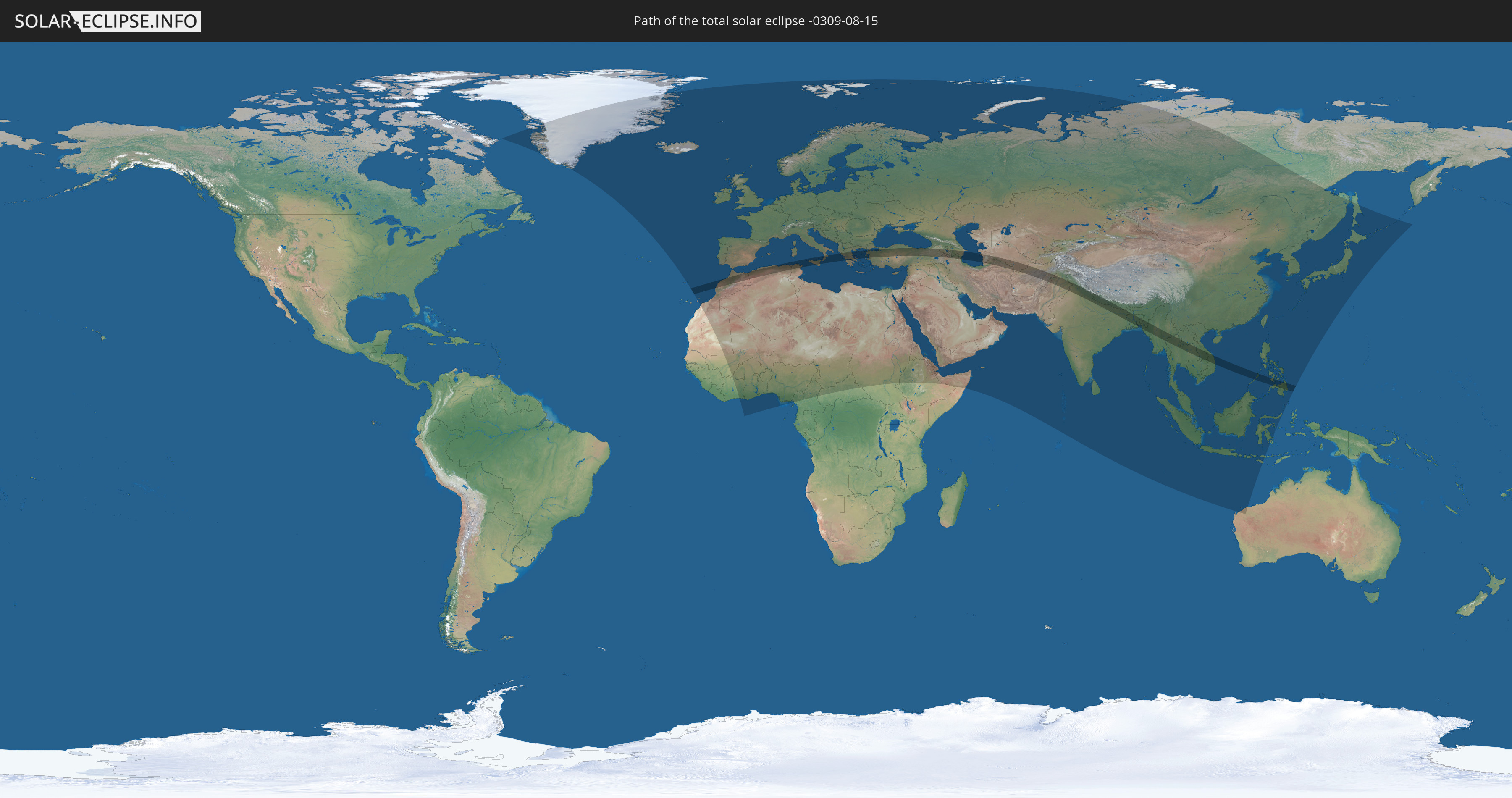
Die Sonnenfinsternis am 15.08.-0309 kann man in 127 Ländern als partielle Sonnenfinsternis beobachten.
Der Finsternispfad verläuft durch 22 Länder. Nur in diesen Ländern ist sie als totale Sonnenfinsternis zu sehen.
In den folgenden Ländern ist die Sonnenfinsternis total zu sehen
 Marokko
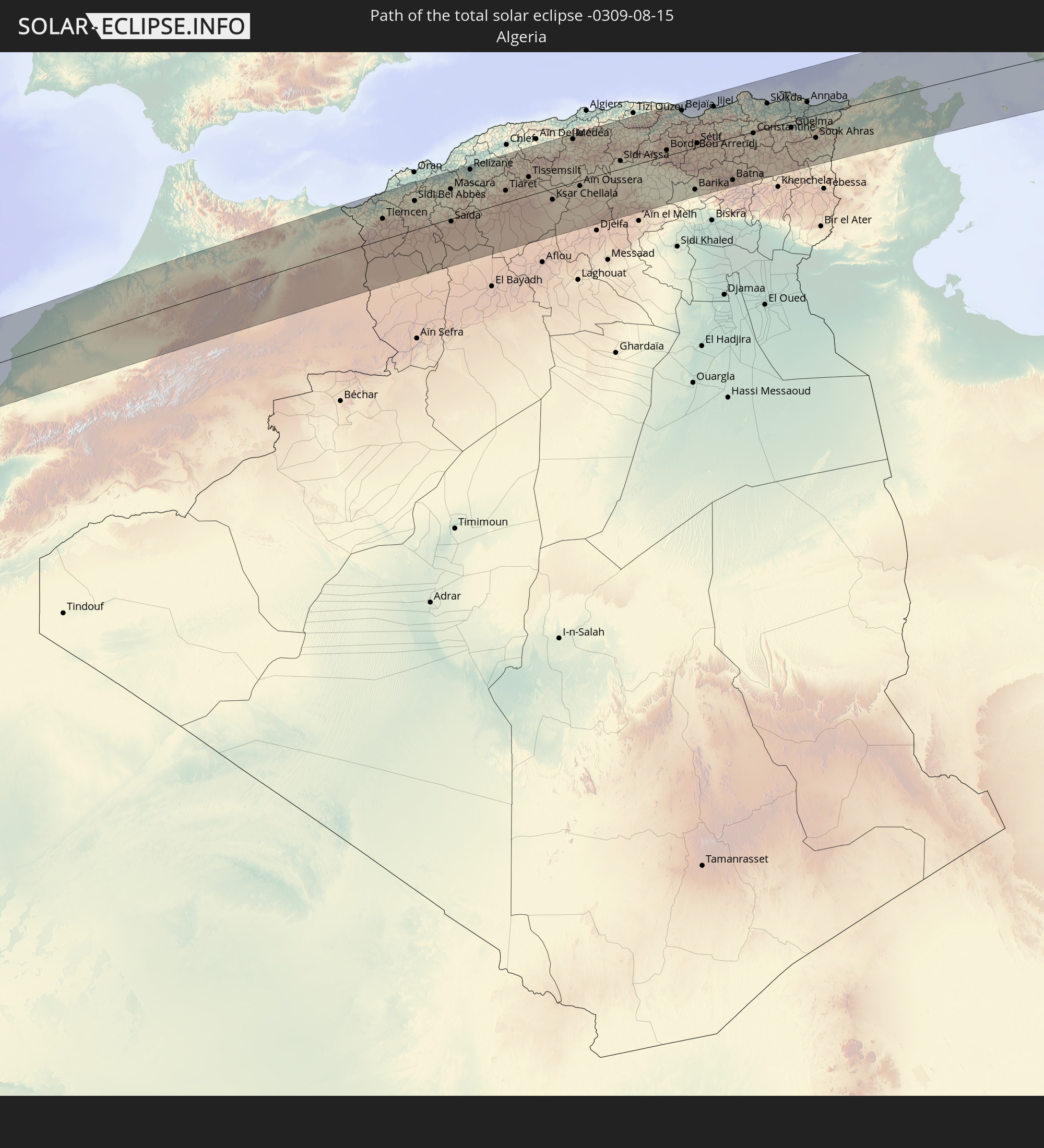 Algerien
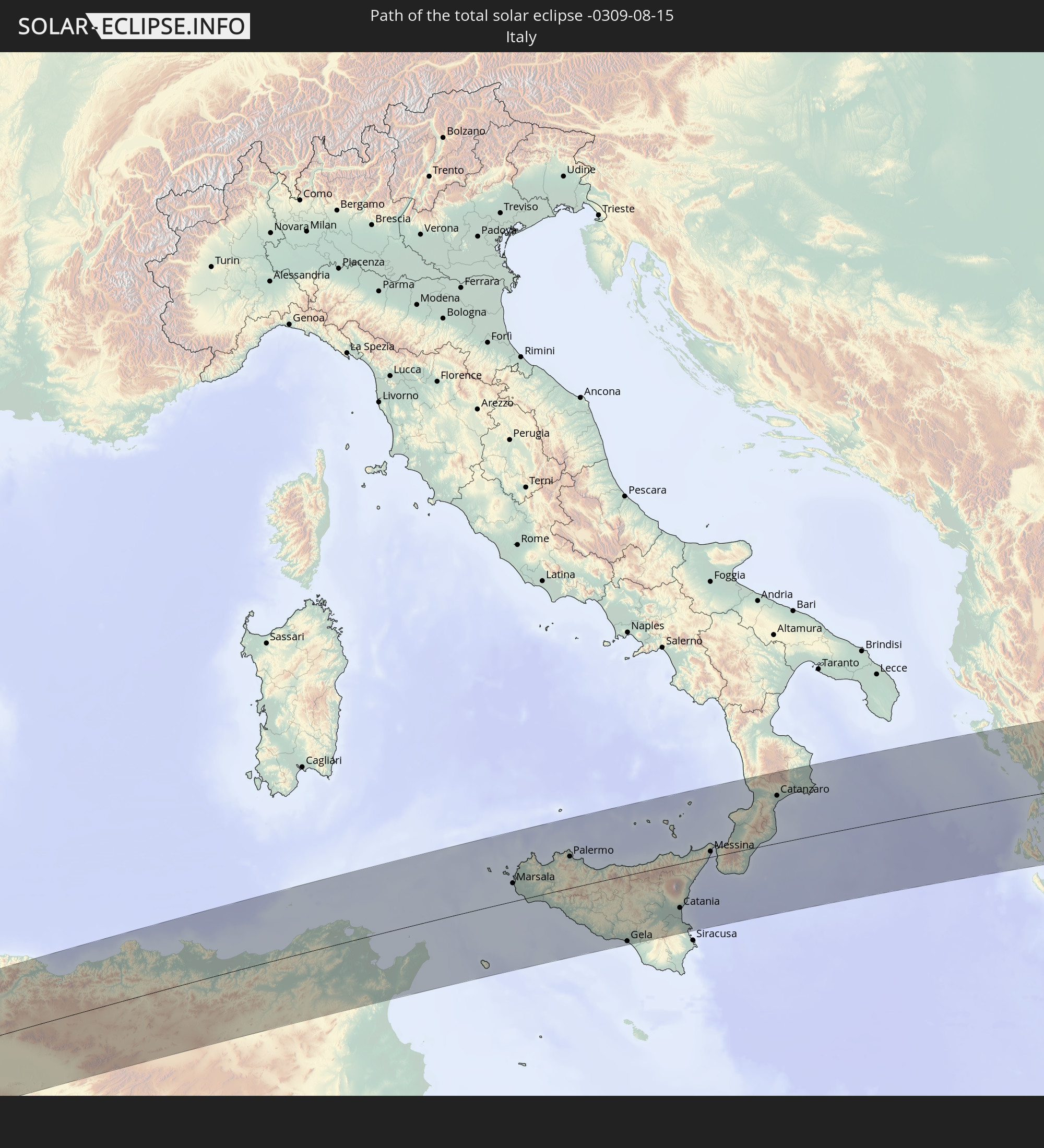 Italien
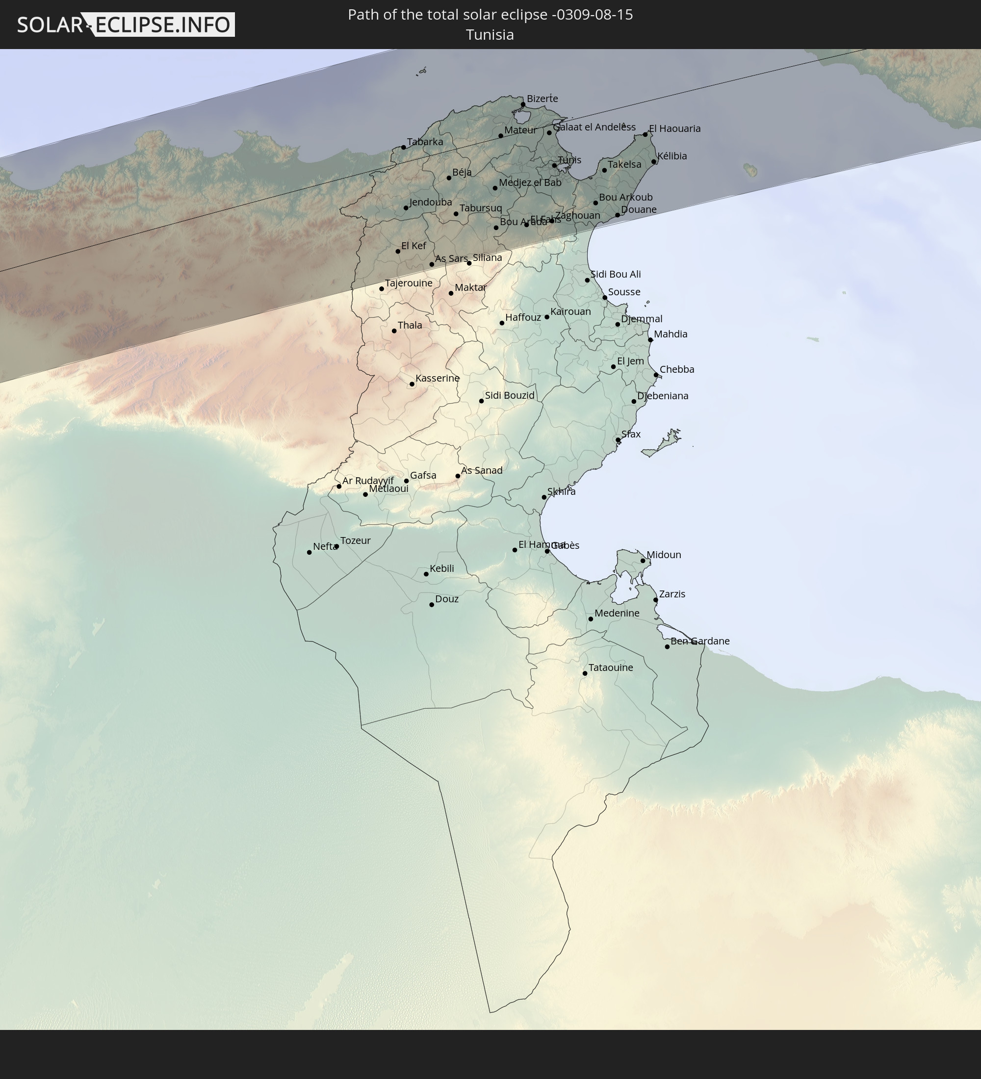 Tunesien
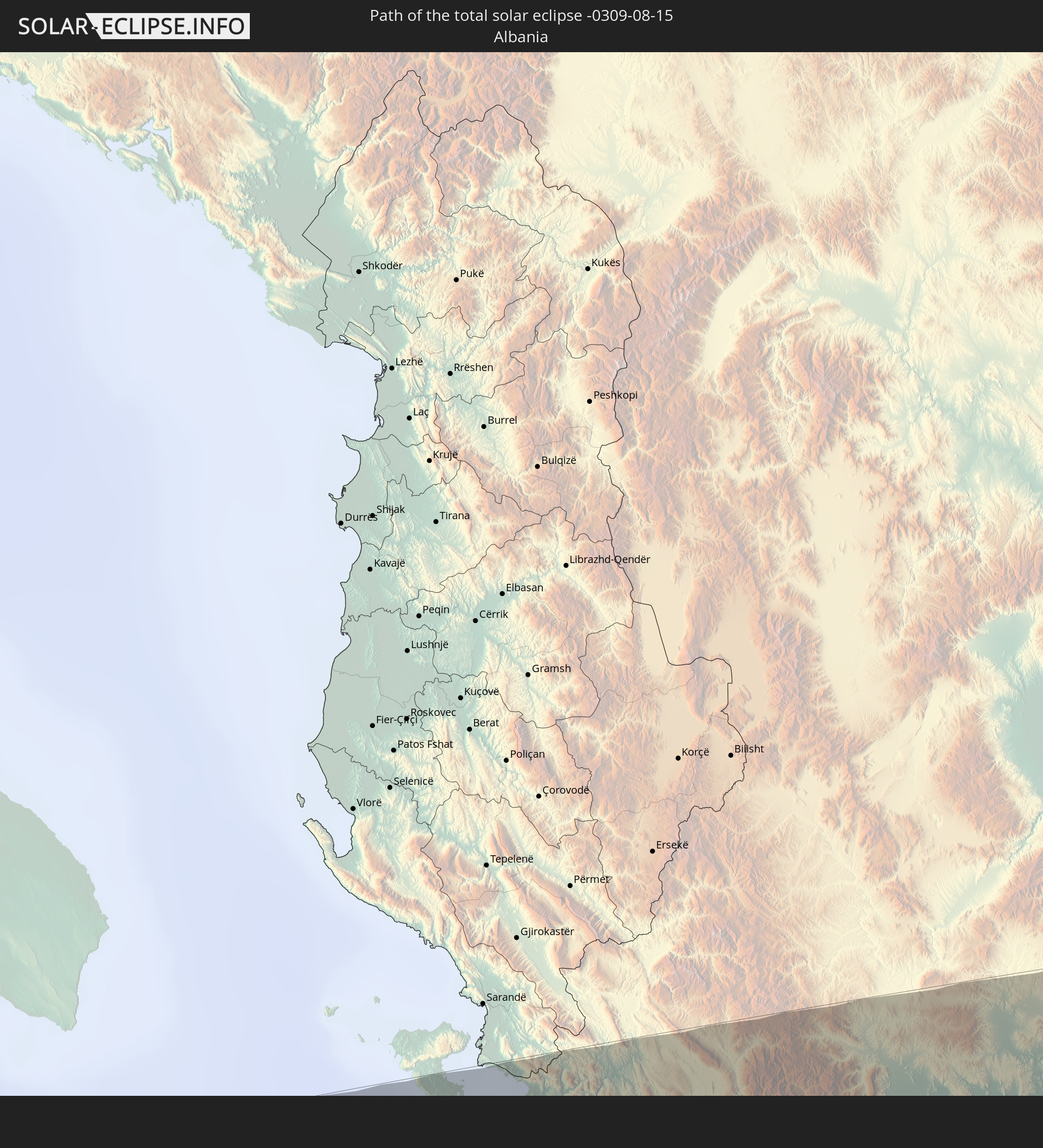 Albanien
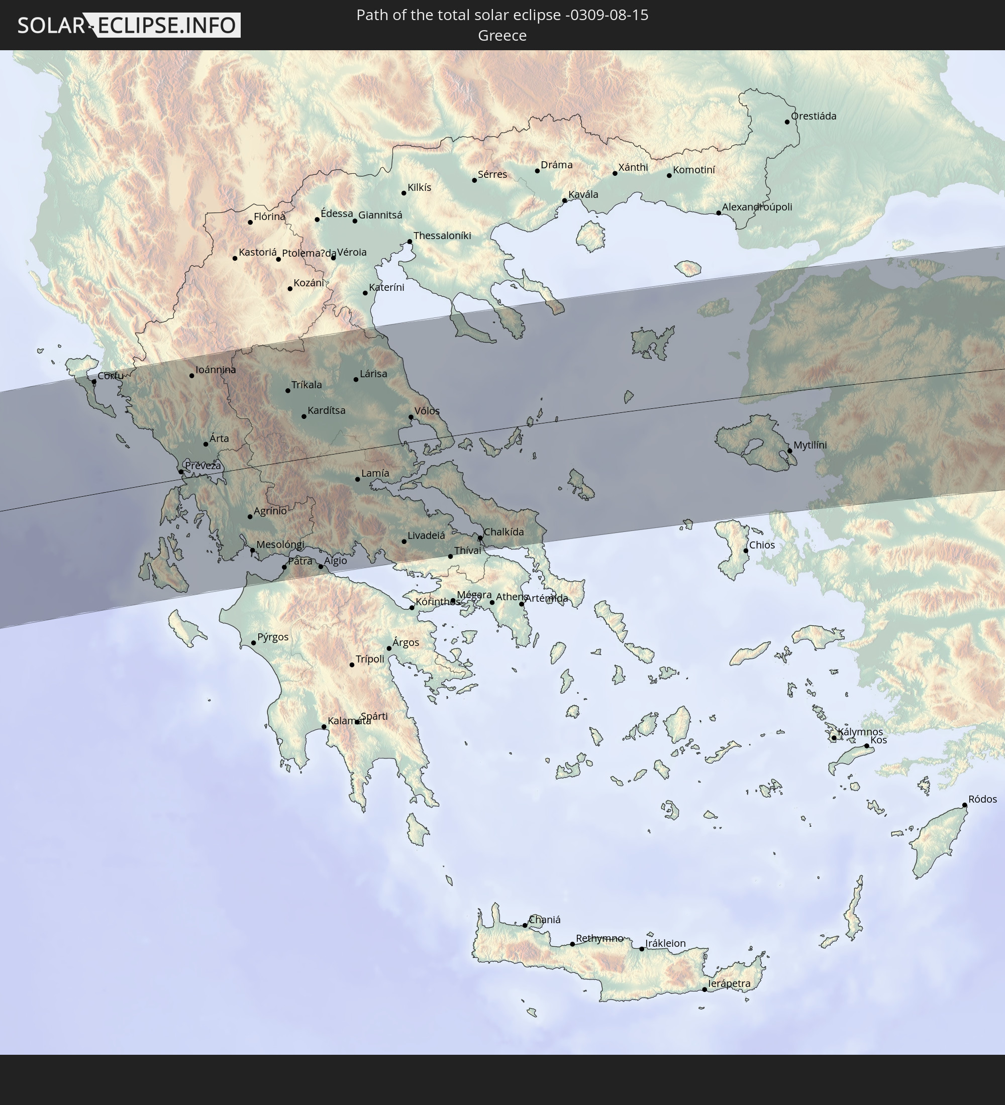 Griechenland
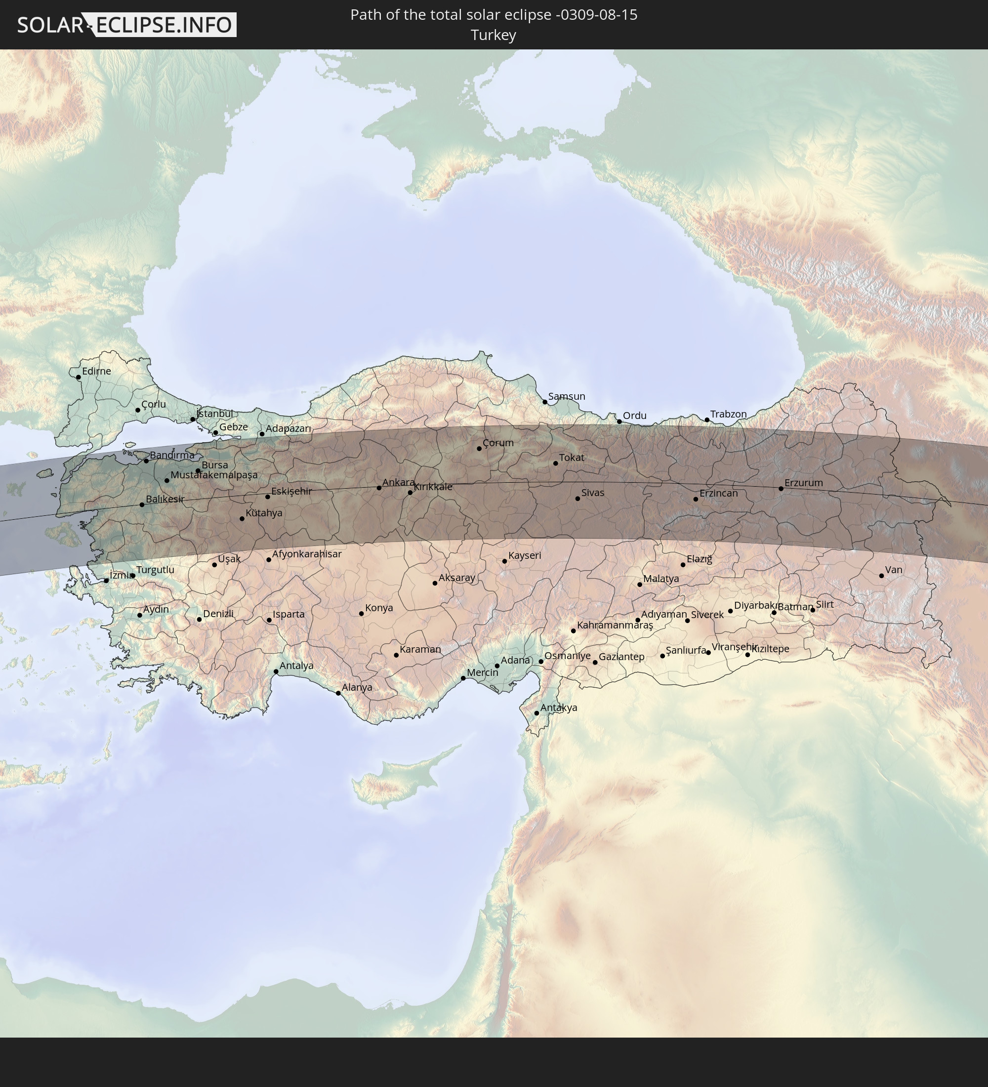 Türkei
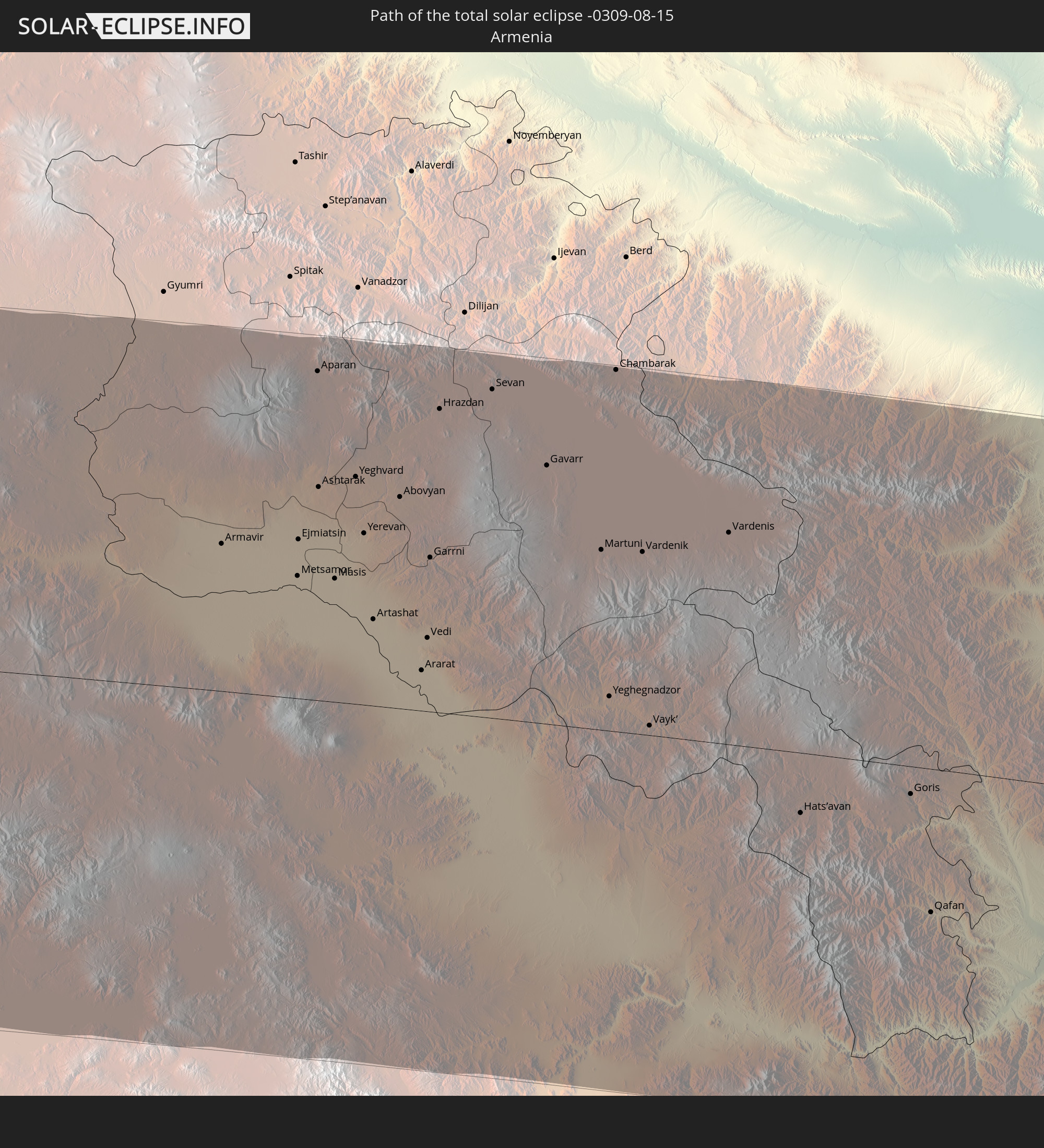 Armenien
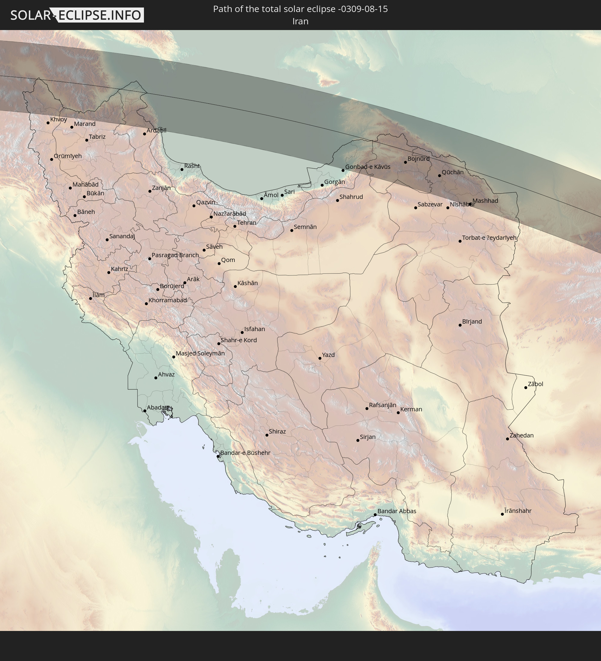 Iran
Iran
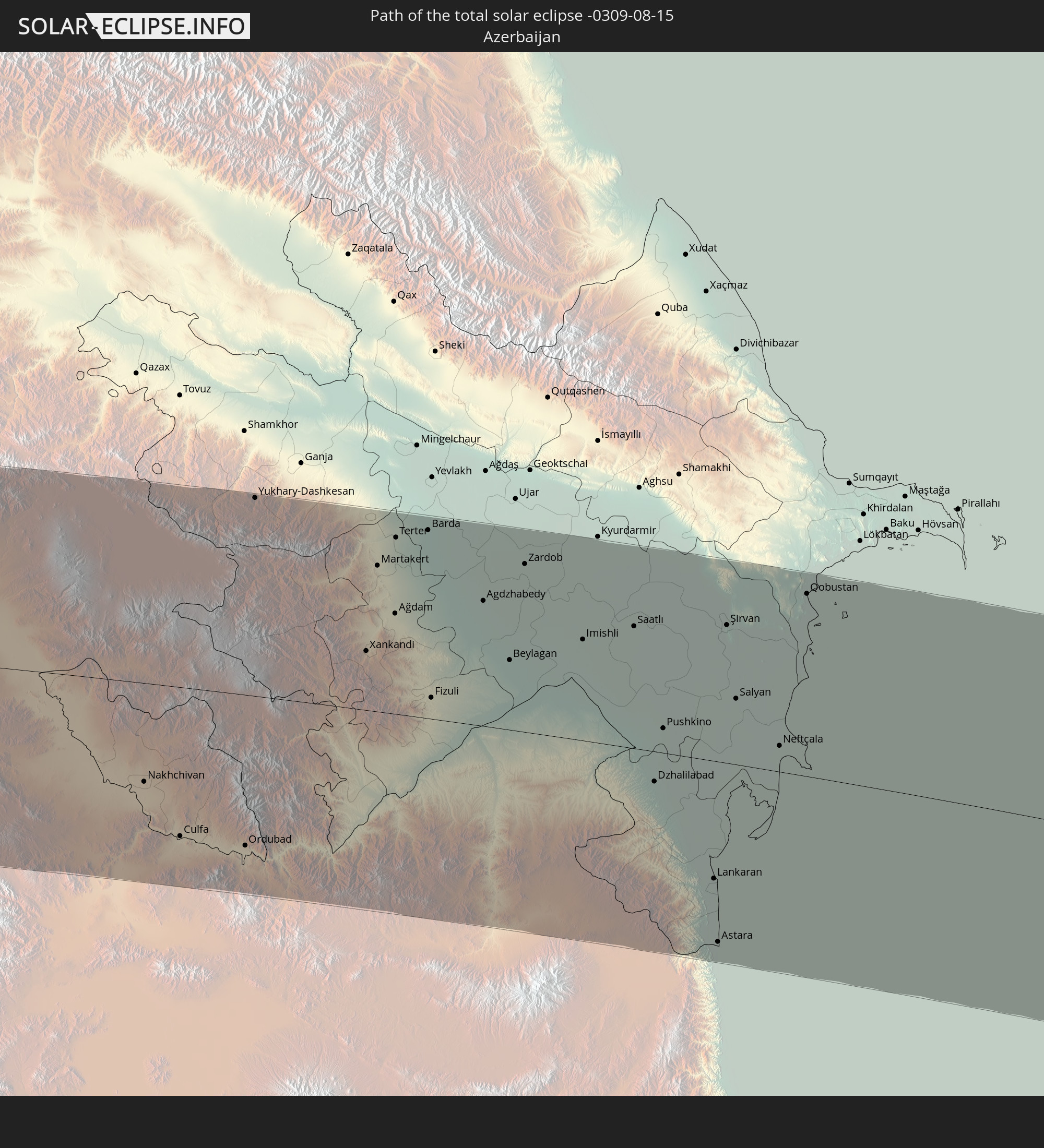 Aserbaidschan
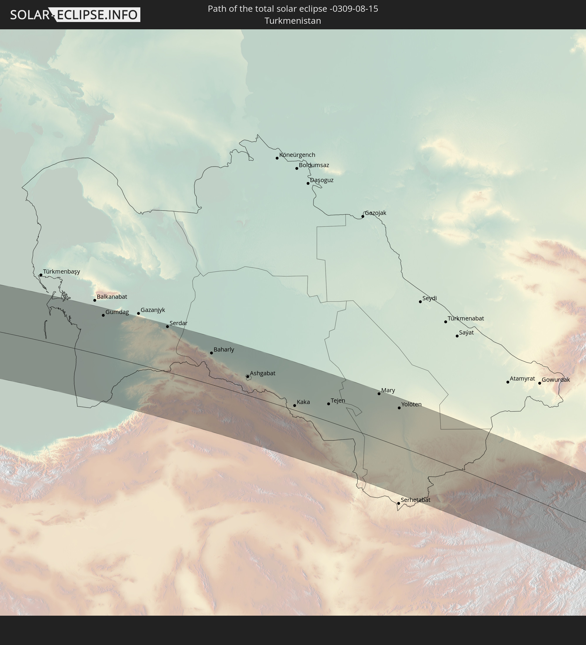 Turkmenistan
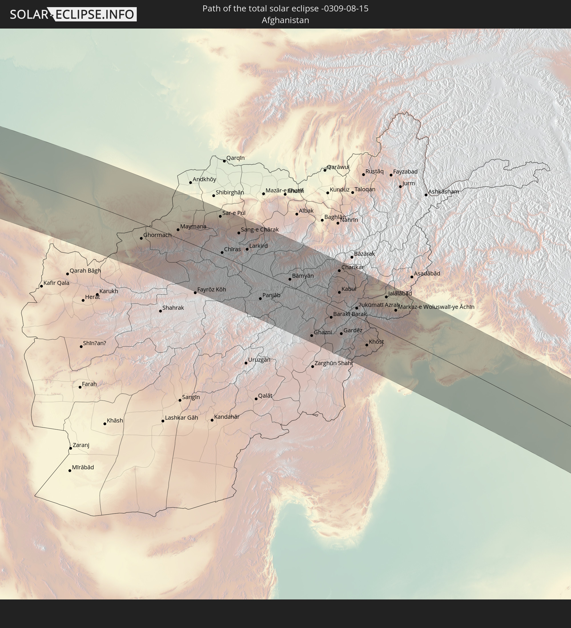 Afghanistan
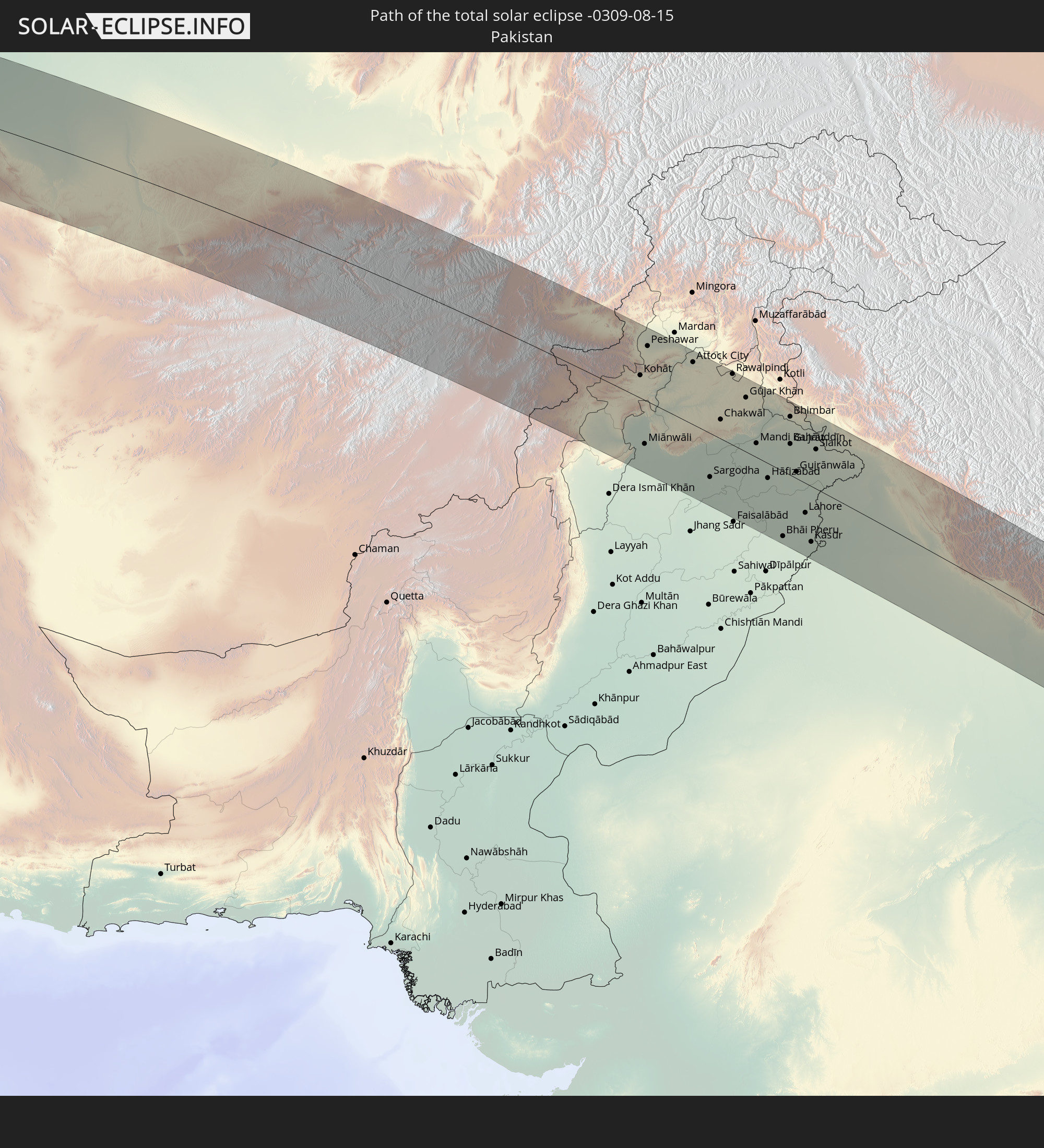 Pakistan
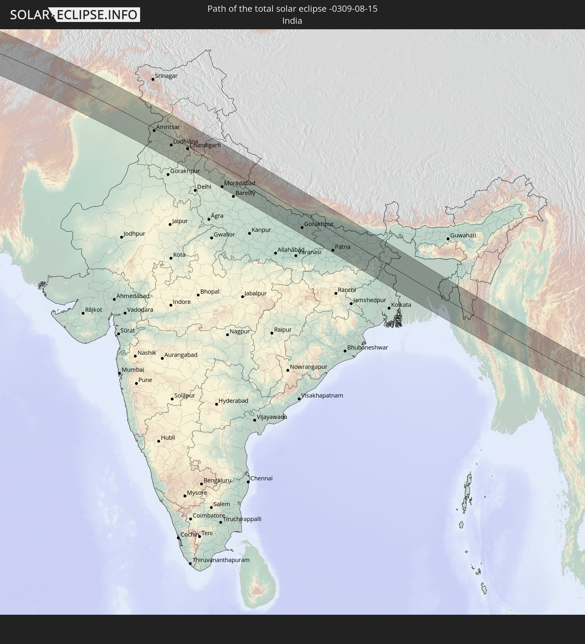 Indien
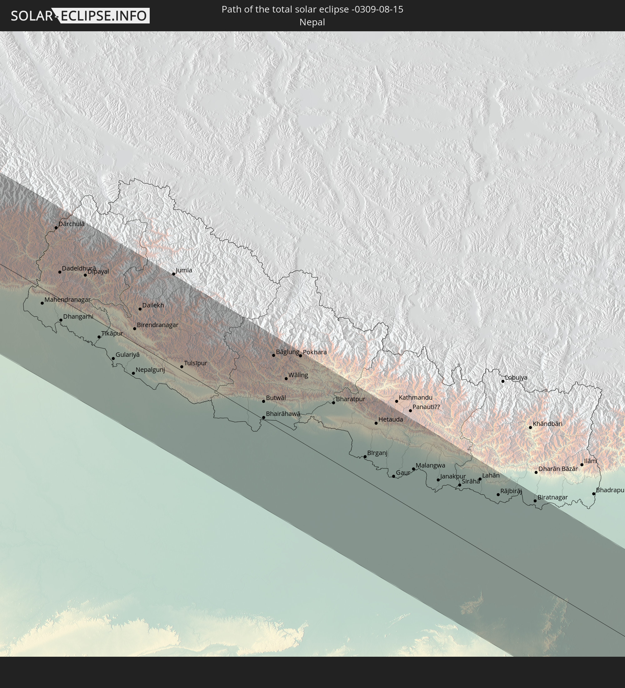 Nepal
Nepal
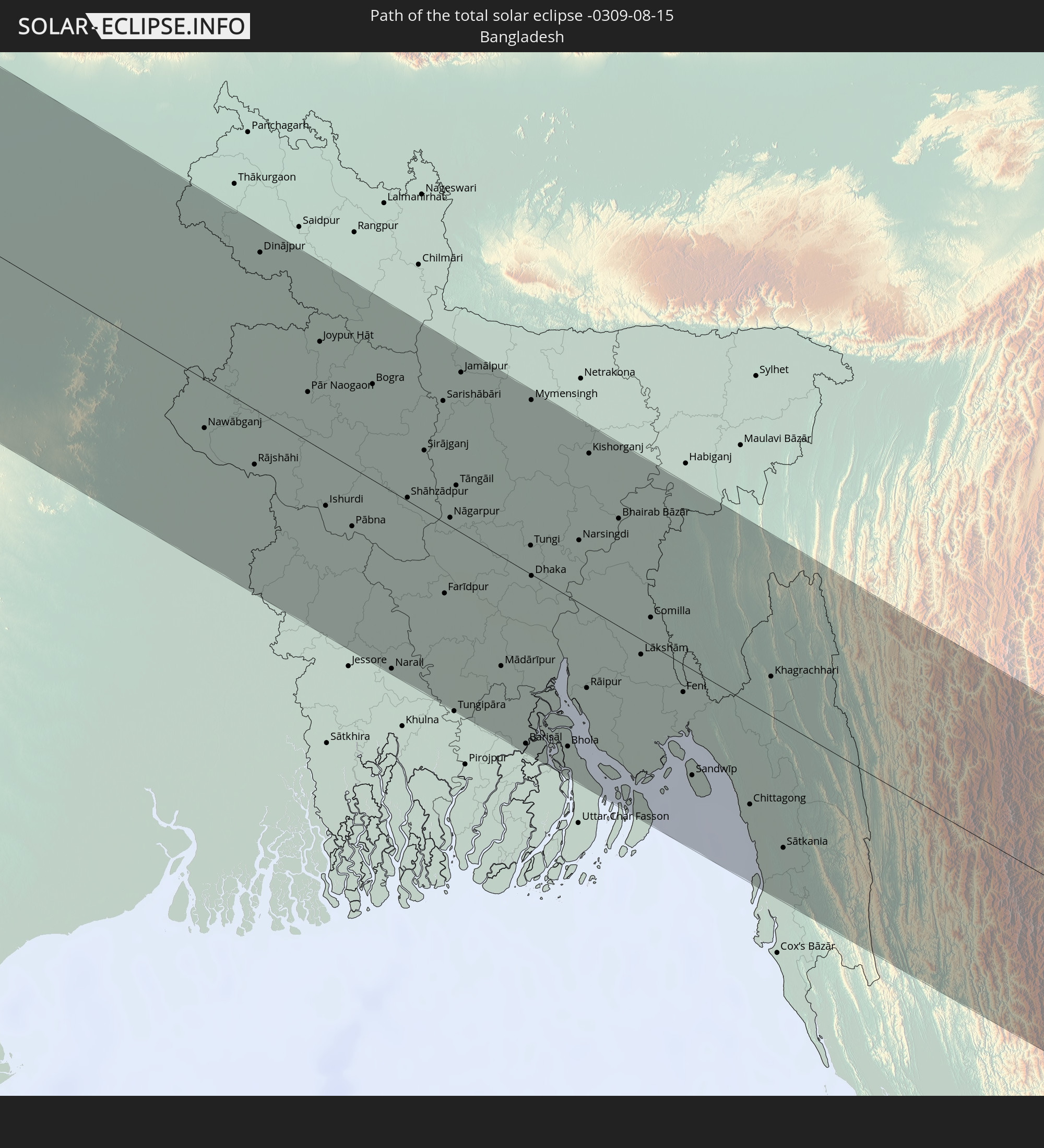 Bangladesch
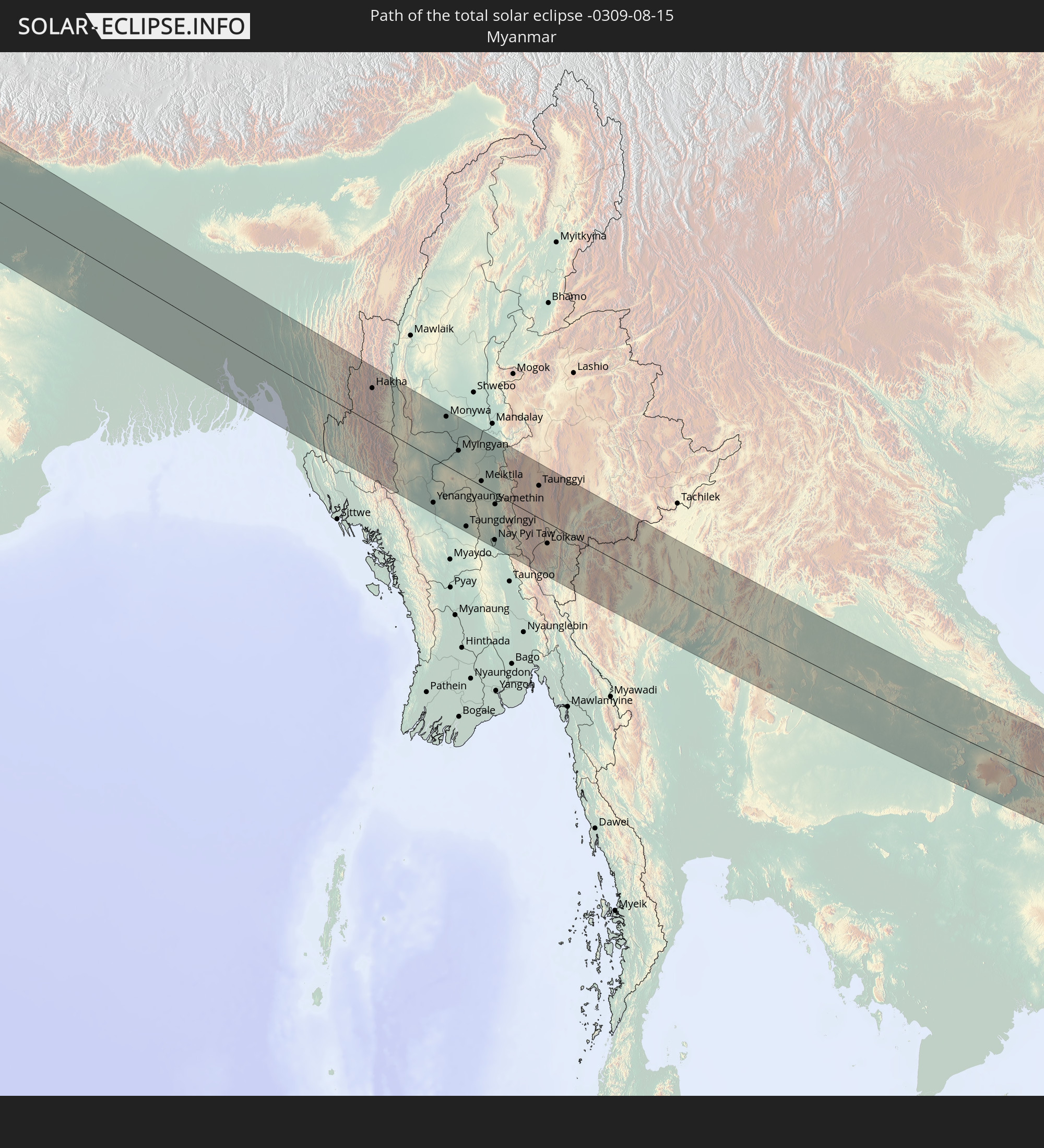 Myanmar
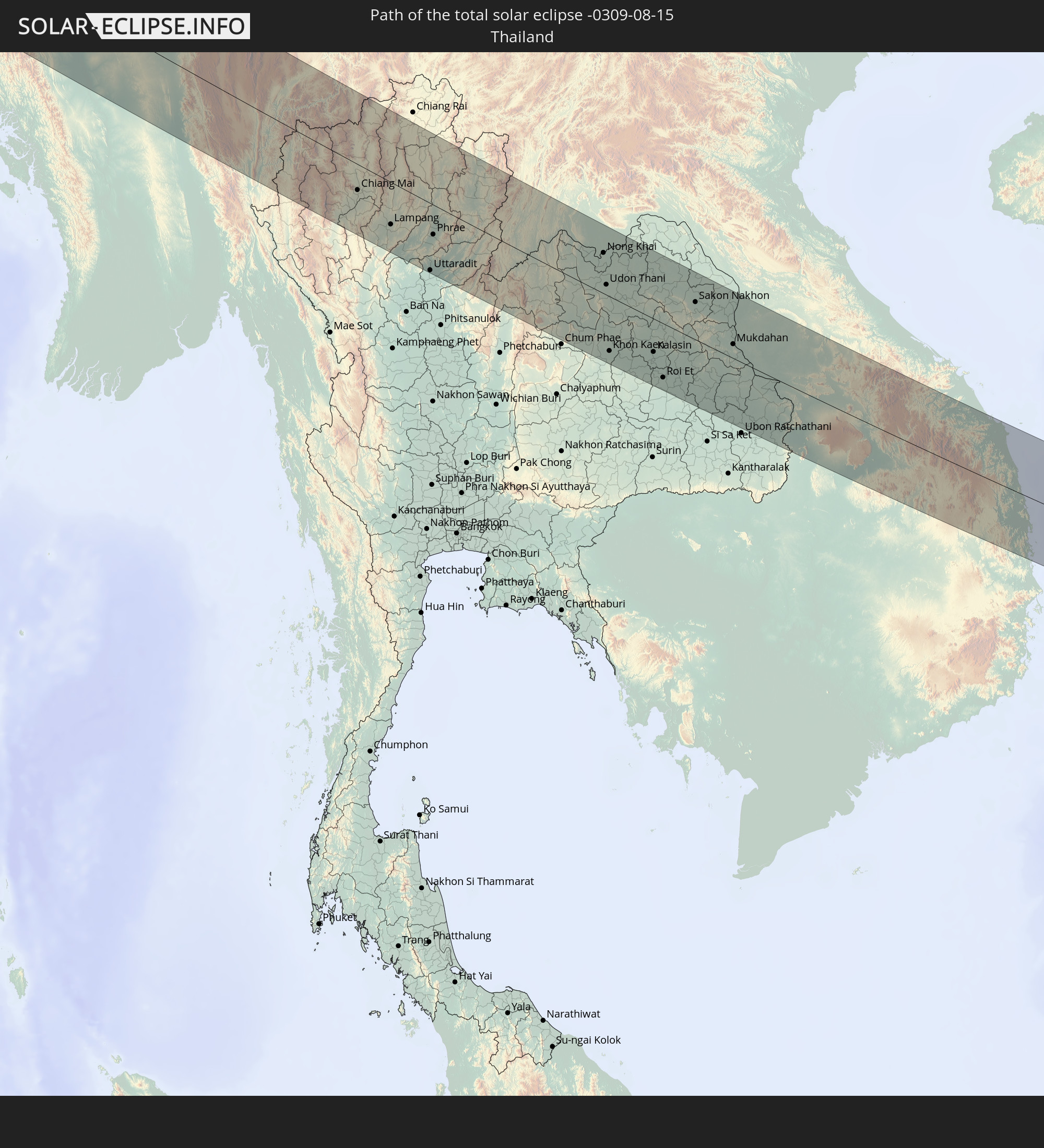 Thailand
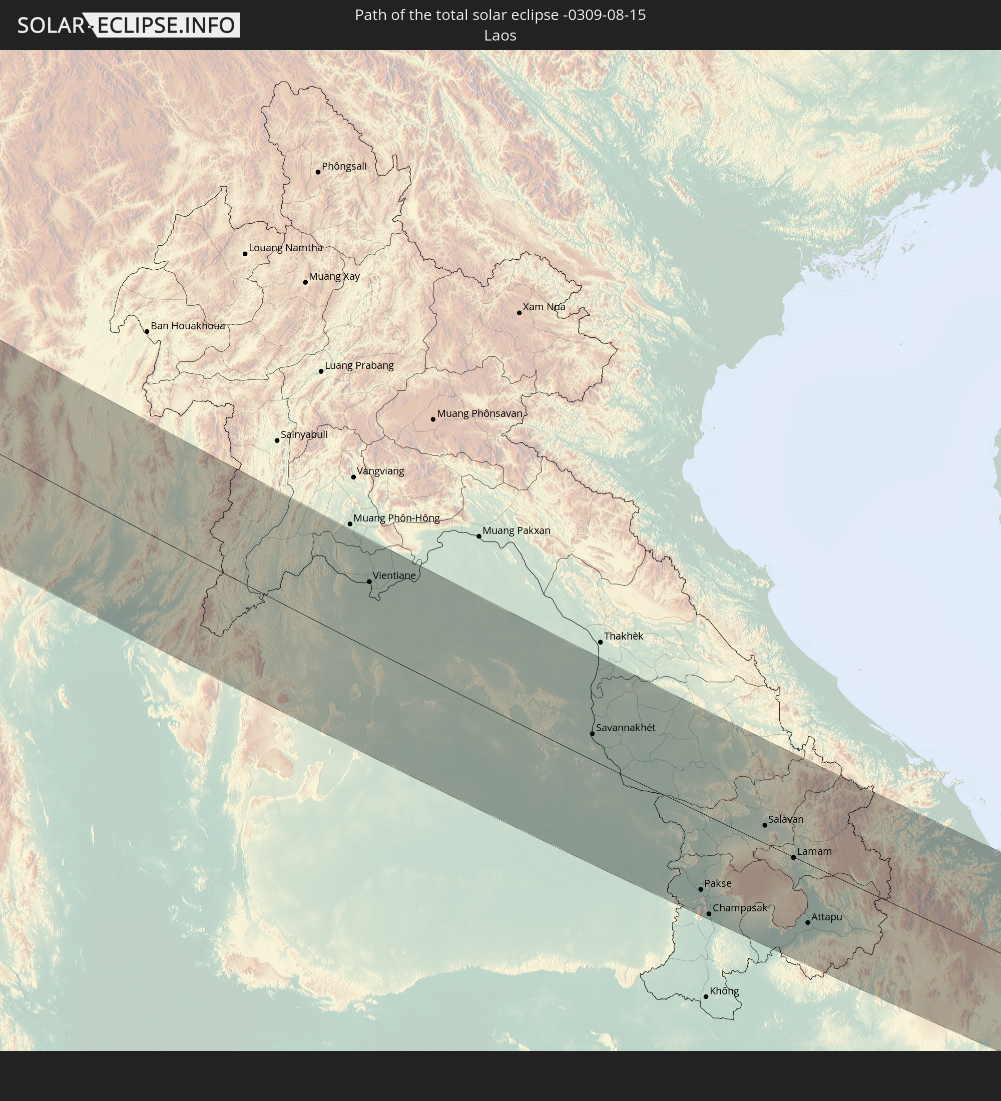 Laos
Laos
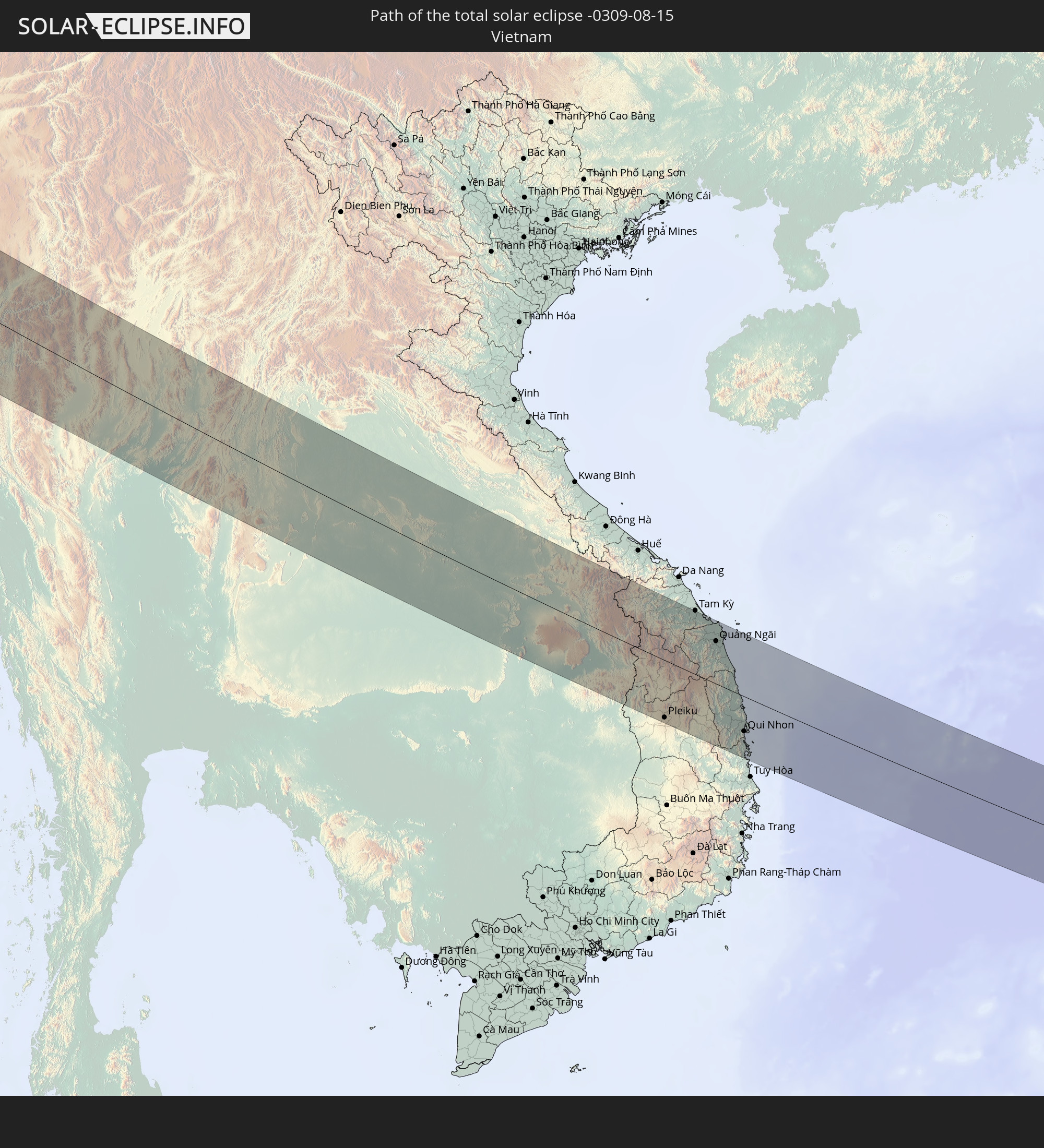 Vietnam
 Kambodscha
 Philippinen
In den folgenden Ländern ist die Sonnenfinsternis partiell zu sehen
 Russland
 Grönland
 Portugal
 Island
 Spanien
 Mauretanien
 Marokko
 Mali
Mali
 Irland
 Spitzbergen
 Algerien
 Vereinigtes Königreich
 Elfenbeinküste
 Färöer
 Burkina Faso
 Gibraltar
 Frankreich
 Isle of Man
 Ghana
Ghana
 Guernsey
 Jersey
 Togo
Togo
 Niger
Niger
 Benin
Benin
 Andorra
 Belgien
 Nigeria
 Niederlande
 Norwegen
 Luxemburg
 Deutschland
 Schweiz
 Italien
 Monaco
 Tunesien
 Dänemark
 Kamerun
 Libyen
 Liechtenstein
 Österreich
 Schweden
 Tschechien
 San Marino
 Vatikanstadt
 Slowenien
 Tschad
 Kroatien
 Polen
Polen
 Malta
Malta
 Zentralafrikanische Republik
 Bosnien und Herzegowina
 Ungarn
 Slowakei
 Montenegro
 Serbien
 Albanien
 Åland Islands
 Griechenland
 Rumänien
 Mazedonien
 Finnland
 Litauen
 Lettland
 Estland
 Sudan
Sudan
 Ukraine
 Bulgarien
 Weißrussland
 Ägypten
 Türkei
 Moldawien
 Republik Zypern
 Äthiopien
 Staat Palästina
 Israel
 Saudi-Arabien
 Jordanien
 Libanon
 Syrien
 Eritrea
 Irak
Irak
 Georgien
 Somalia
 Dschibuti
 Jemen
Jemen
 Armenien
 Iran
Iran
 Aserbaidschan
 Kasachstan
 Kuwait
 Bahrain
 Katar
Katar
 Vereinigte Arabische Emirate
 Oman
Oman
 Turkmenistan
 Usbekistan
 Afghanistan
 Pakistan
 Tadschikistan
 Indien
 Kirgisistan
 Malediven
 Volksrepublik China
 Sri Lanka
 Nepal
Nepal
 Mongolei
 Bangladesch
 Bhutan
 Myanmar
 Indonesien
 Kokosinseln
 Thailand
 Malaysia
 Laos
Laos
 Vietnam
 Kambodscha
 Singapur
 Weihnachtsinsel
 Australien
 Macau
Macau
 Hongkong
 Brunei
 Taiwan
 Philippinen
 Japan
Japan
 Nordkorea
 Südkorea
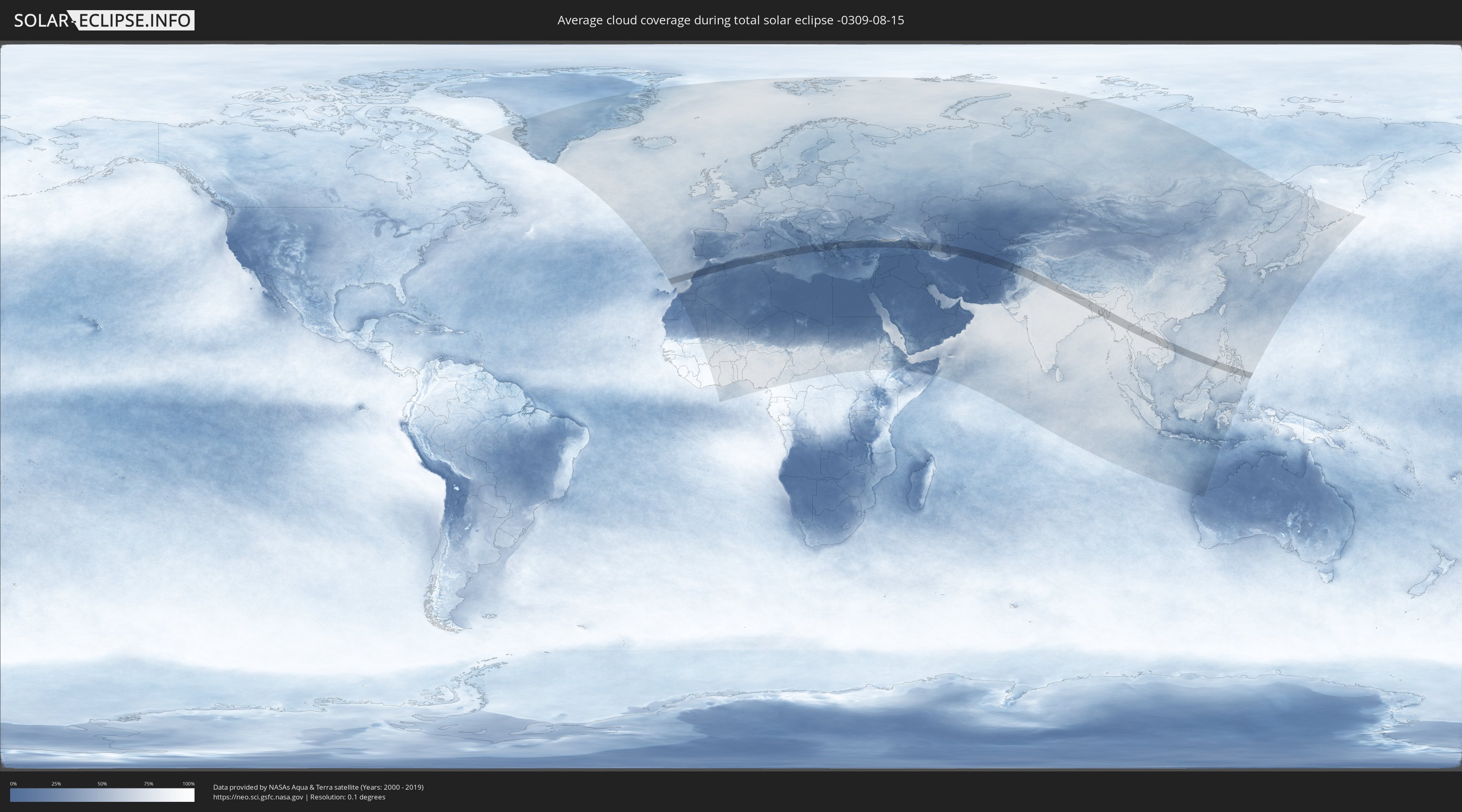
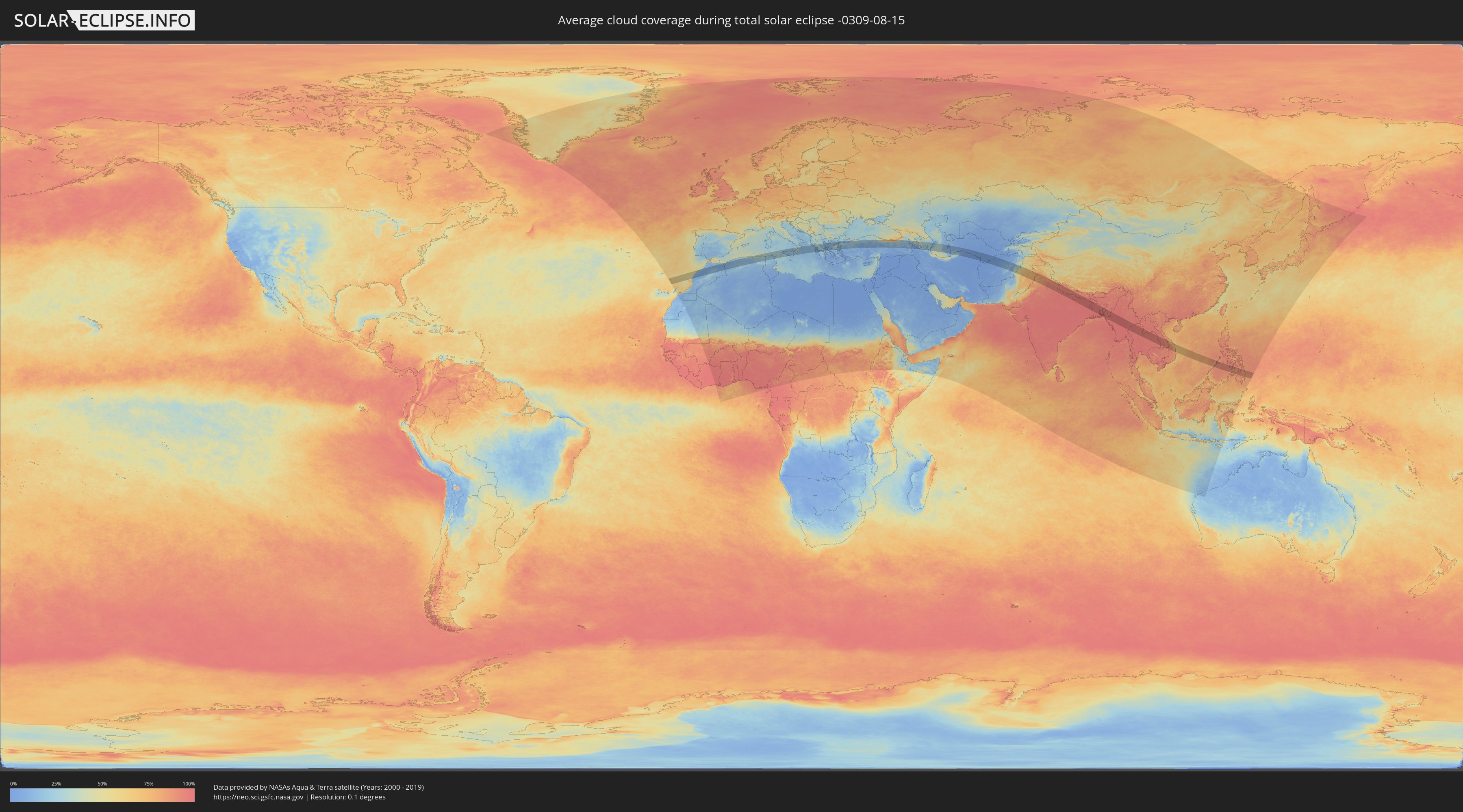
Wie wird das Wetter während der totalen Sonnenfinsternis am 15.08.-0309?
Wo ist der beste Ort, um die totale Sonnenfinsternis vom 15.08.-0309 zu beobachten?
Die folgenden Karten zeigen die durchschnittliche Bewölkung für den Tag, an dem die totale Sonnenfinsternis
stattfindet. Mit Hilfe der Karten lässt sich der Ort entlang des Finsternispfades eingrenzen,
der die besten Aussichen auf einen klaren wolkenfreien Himmel bietet.
Trotzdem muss man immer lokale Gegenenheiten beachten und sollte sich genau über das Wetter an seinem
gewählten Beobachtungsort informieren.
Die Daten stammen von den beiden NASA-Satelliten
AQUA und TERRA
und wurden über einen Zeitraum von 19 Jahren (2000 - 2019) gemittelt.
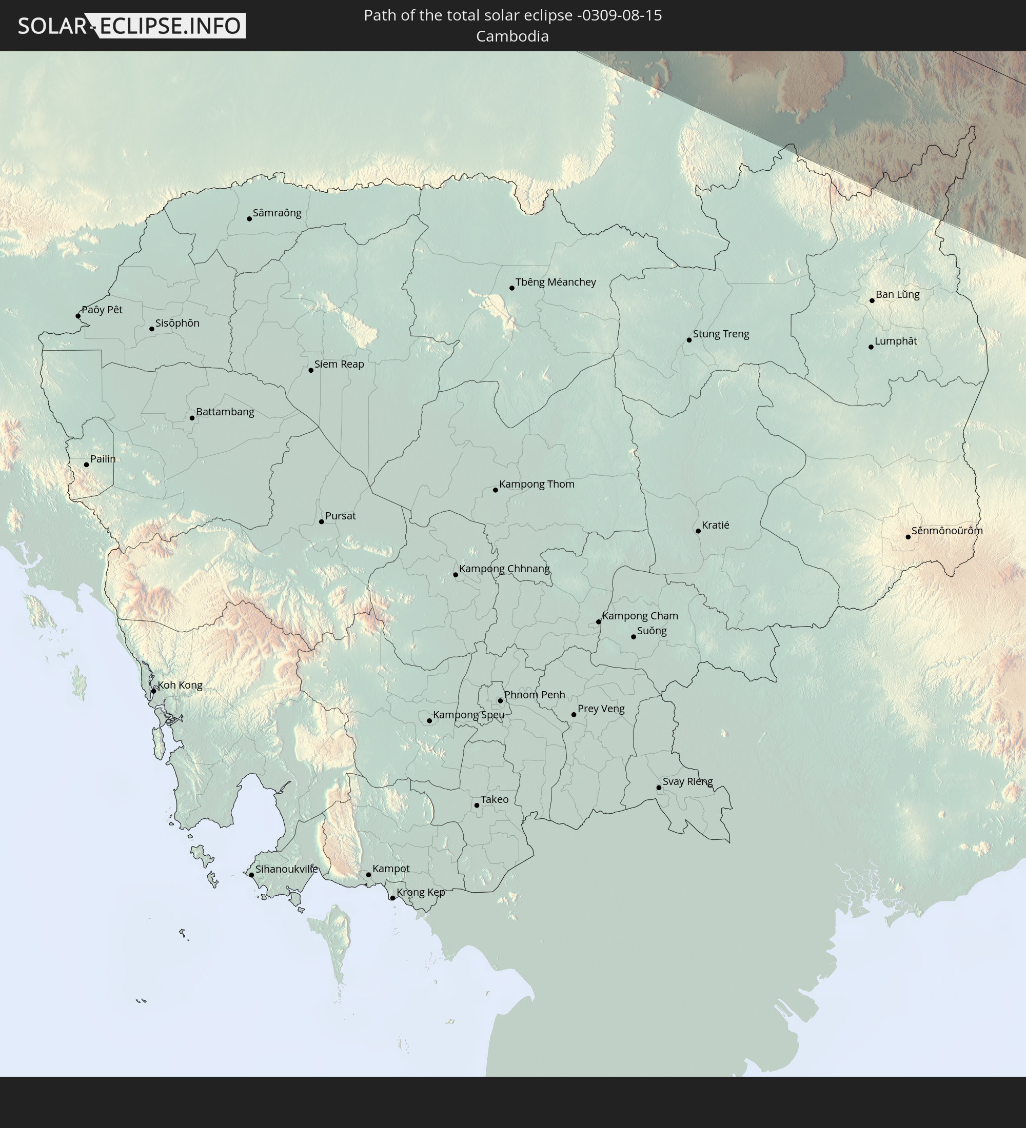
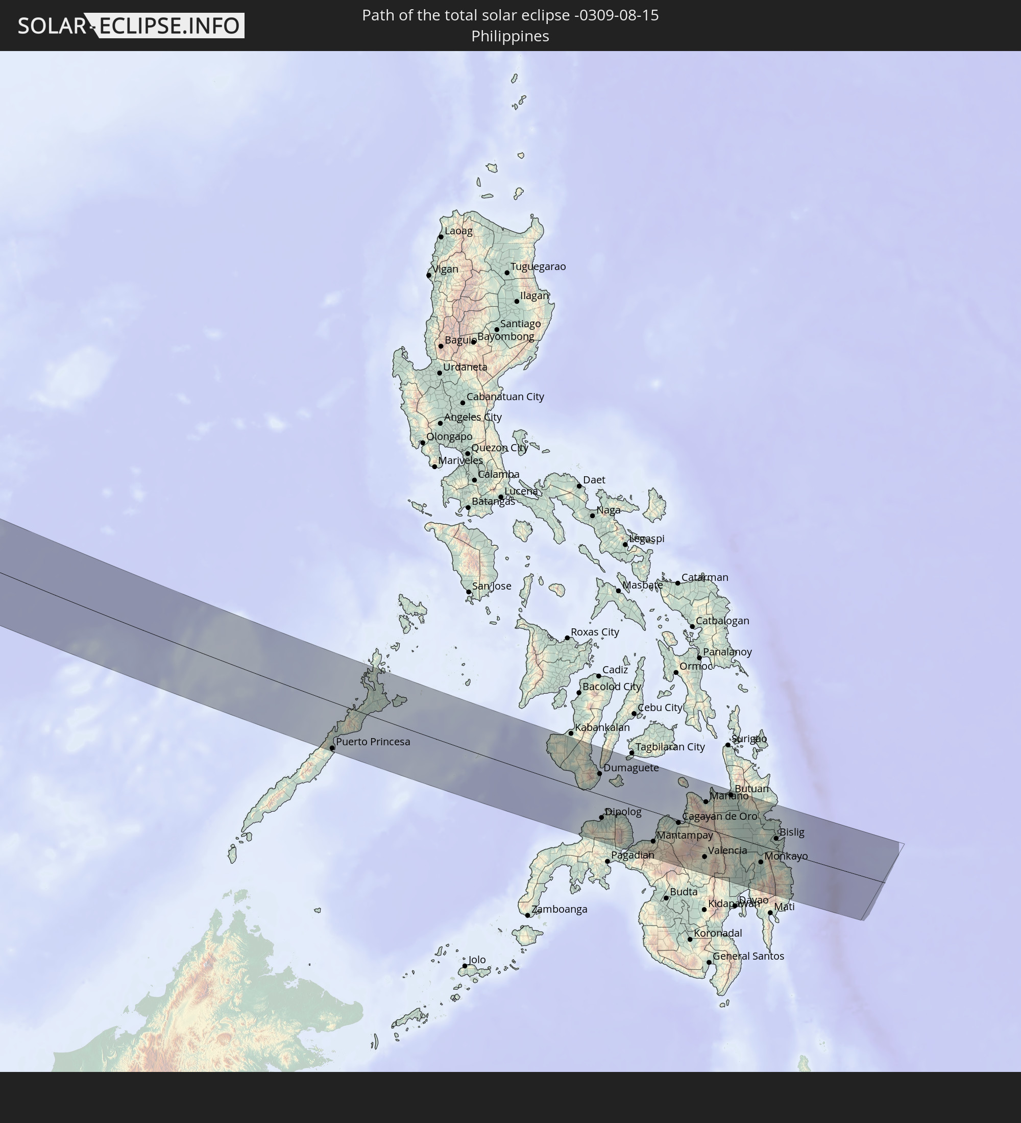
Detaillierte Länderkarten
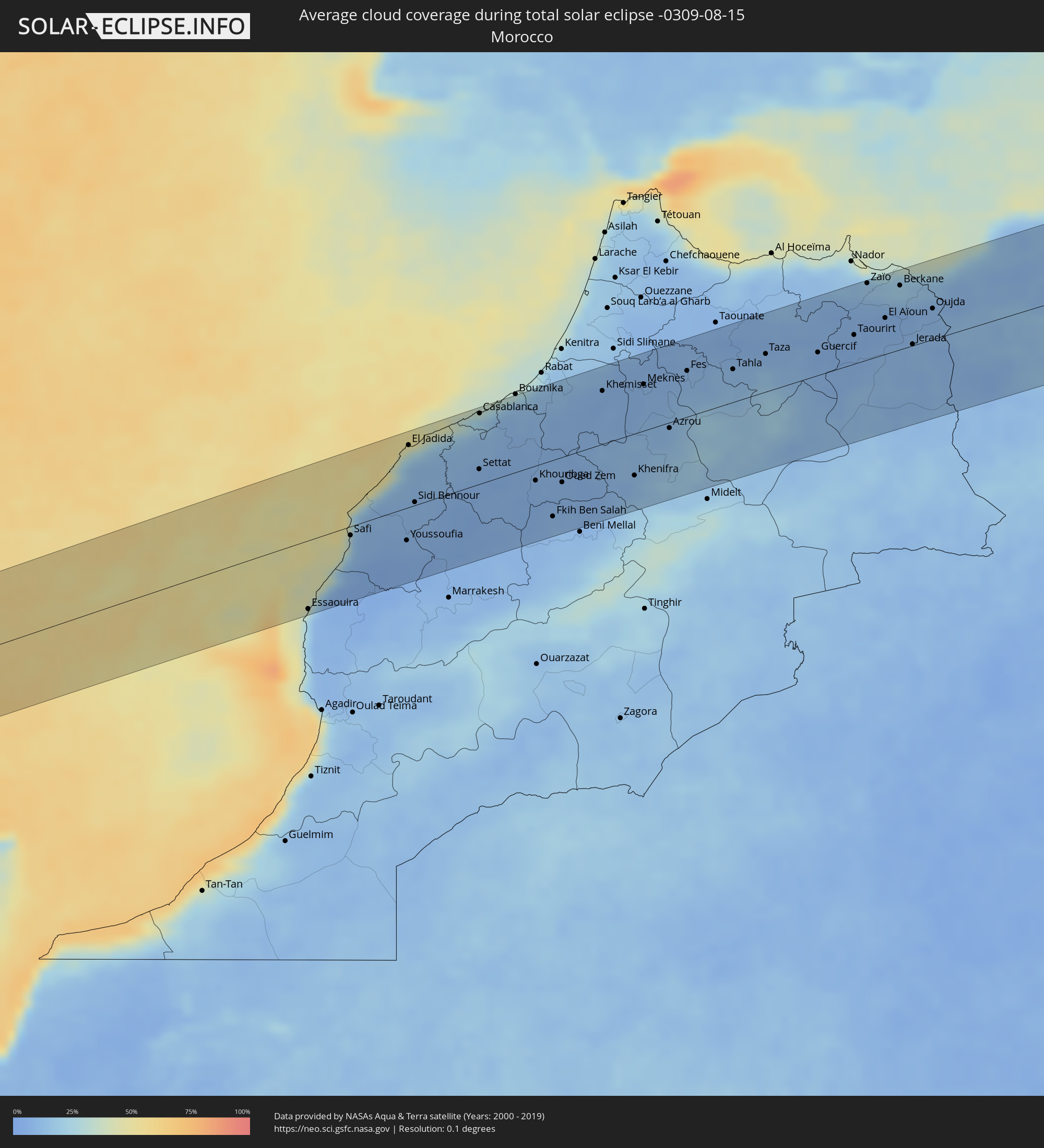 Marokko
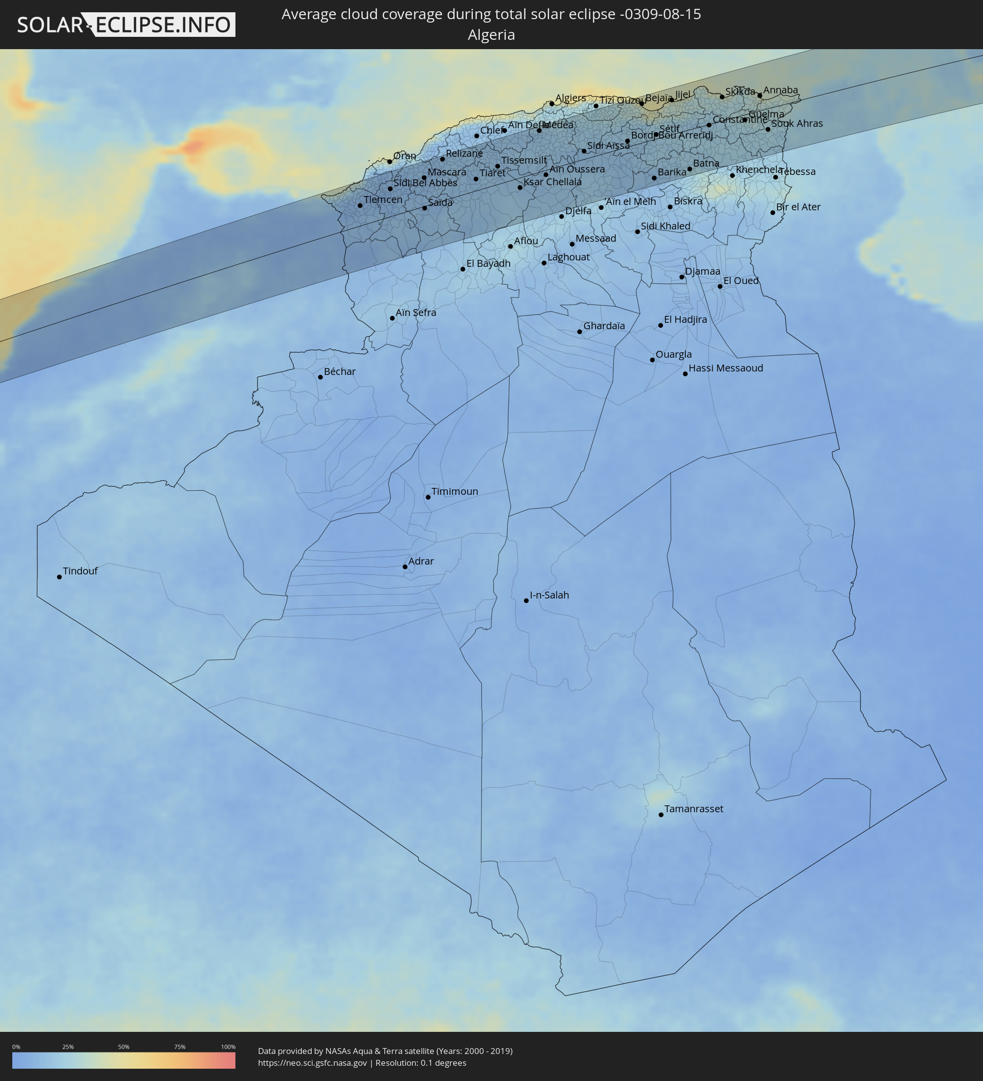 Algerien
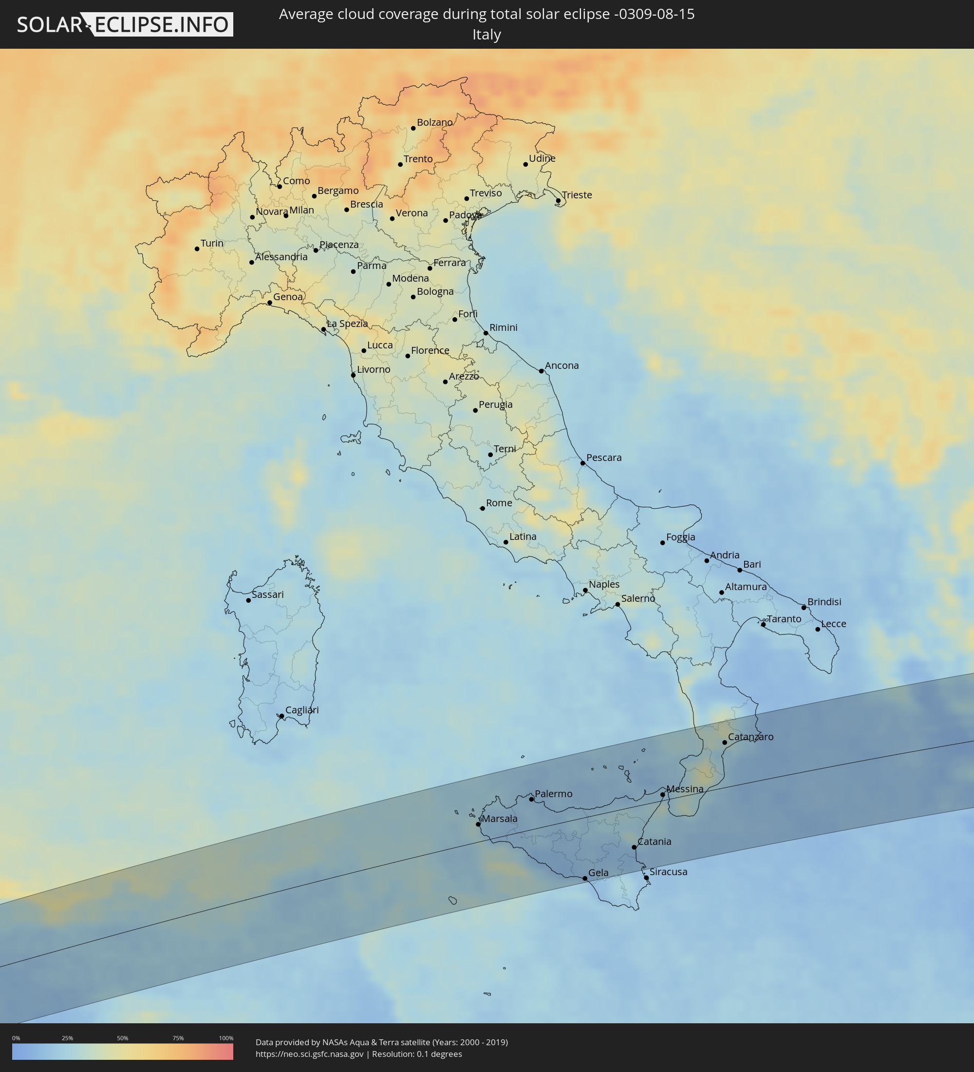 Italien
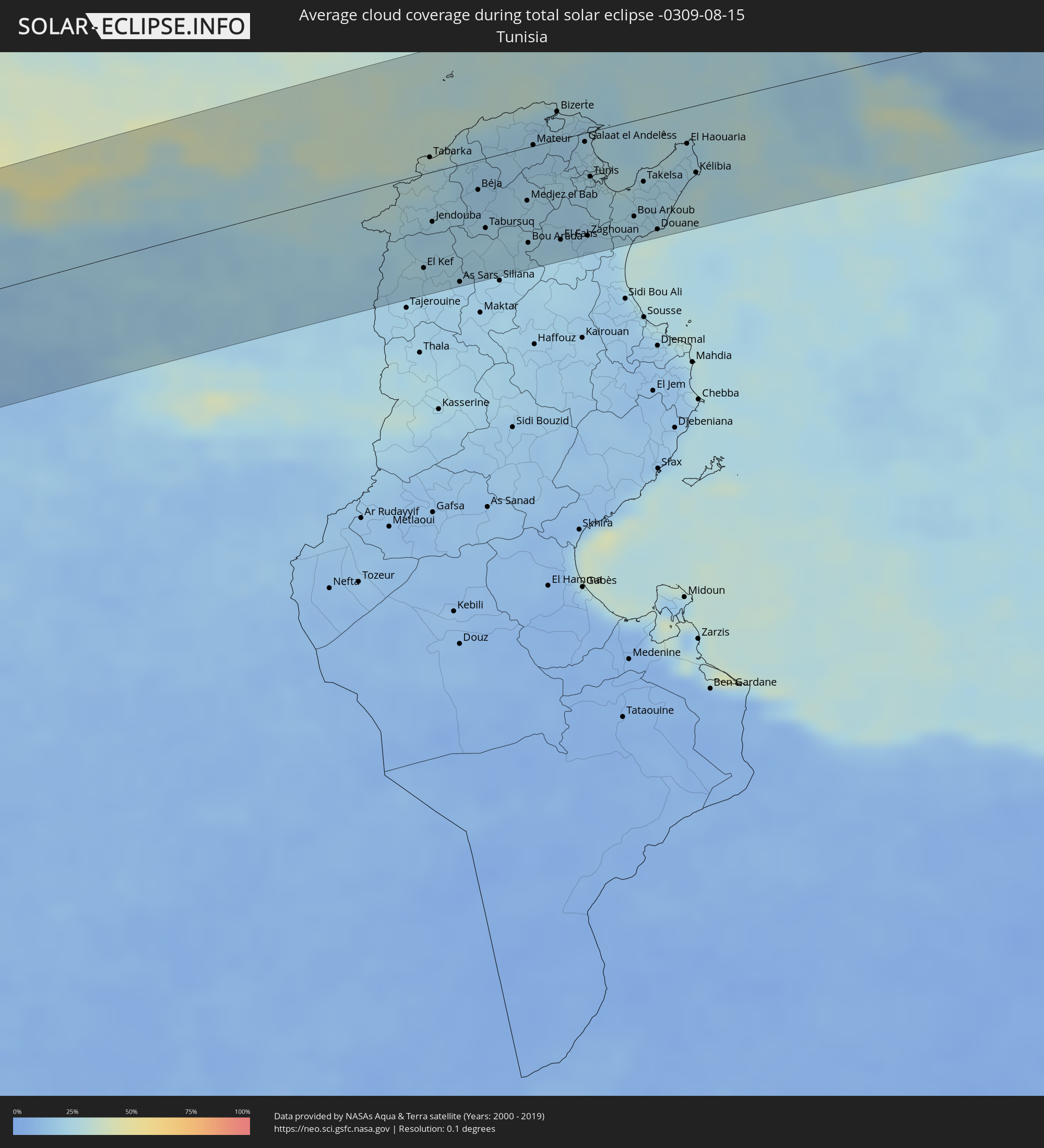 Tunesien
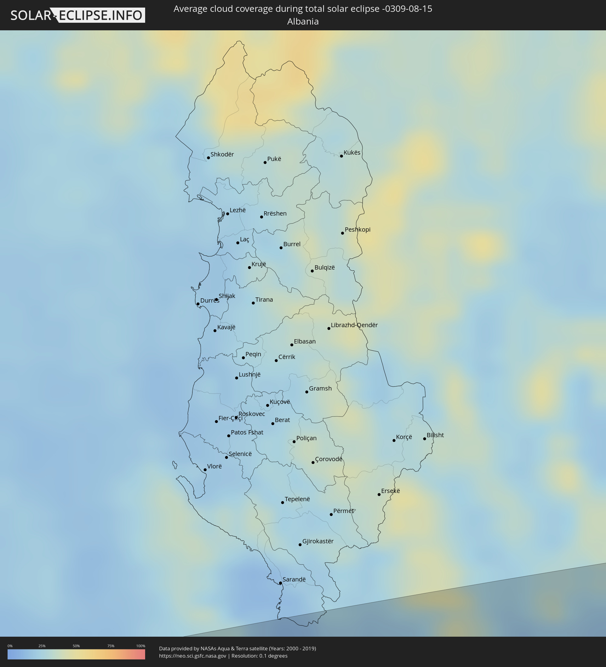 Albanien
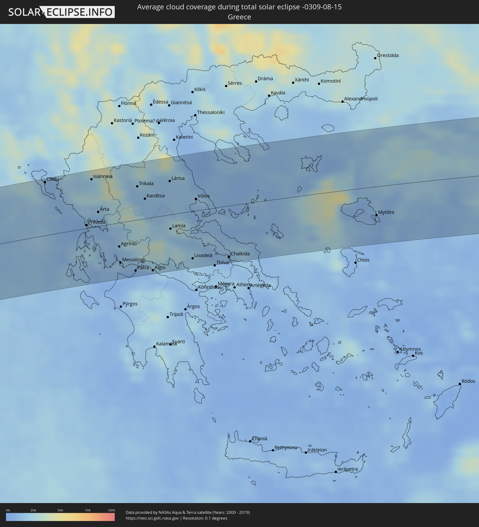 Griechenland
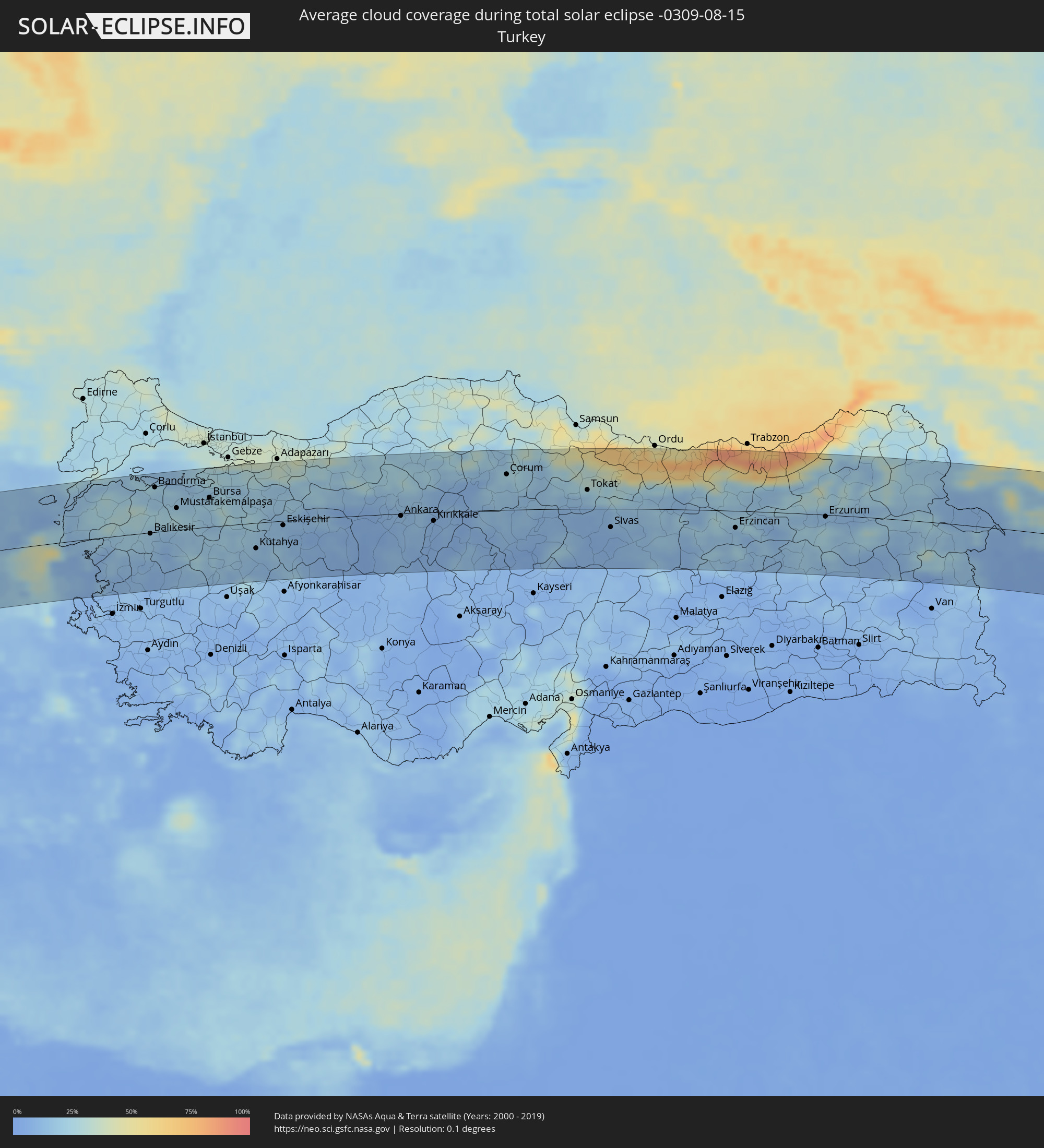 Türkei
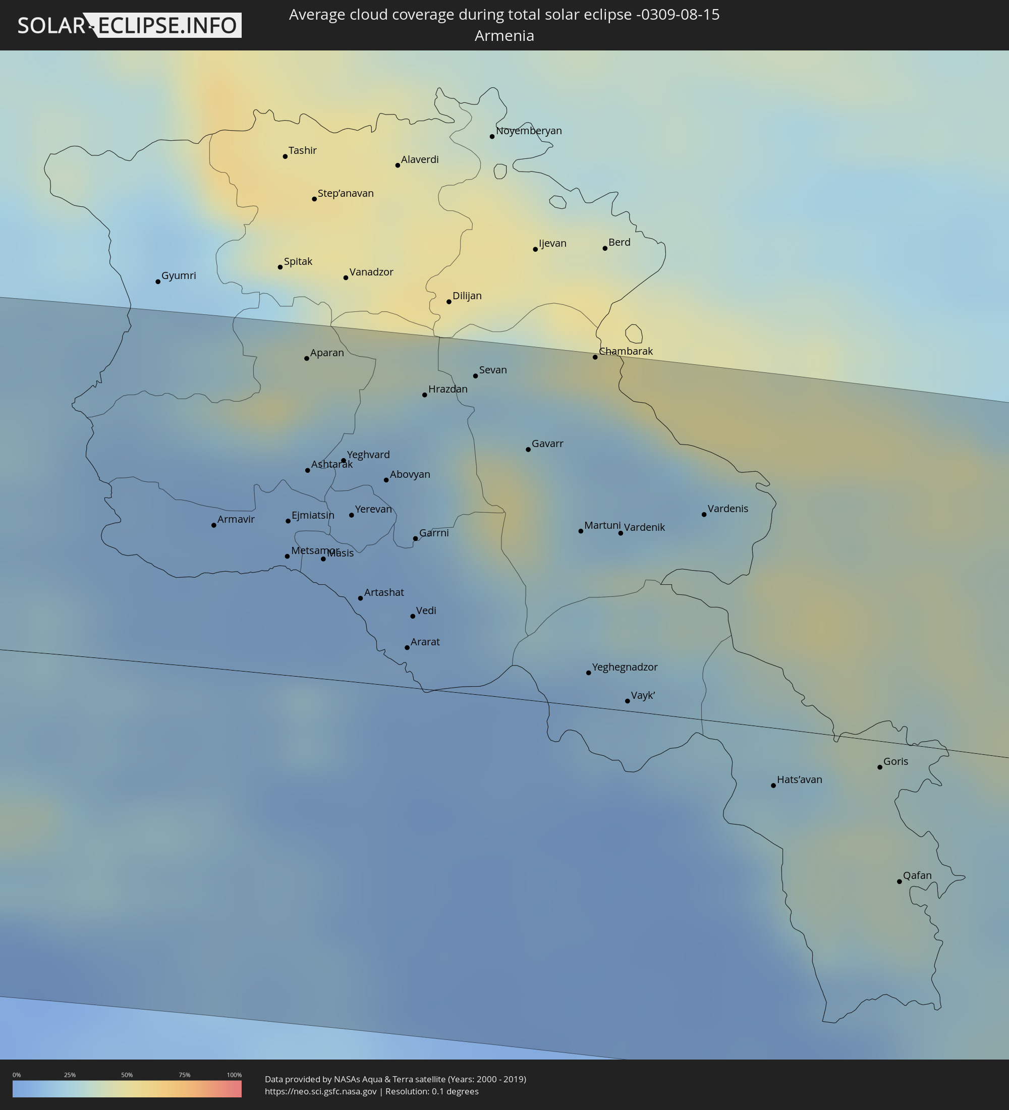 Armenien
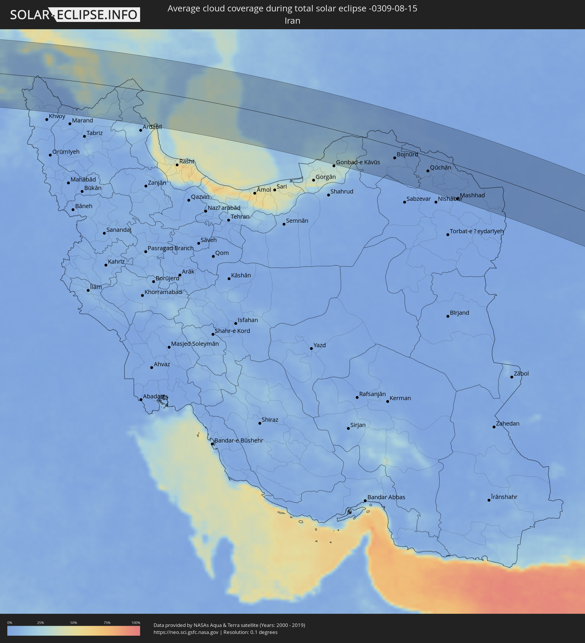 Iran
Iran
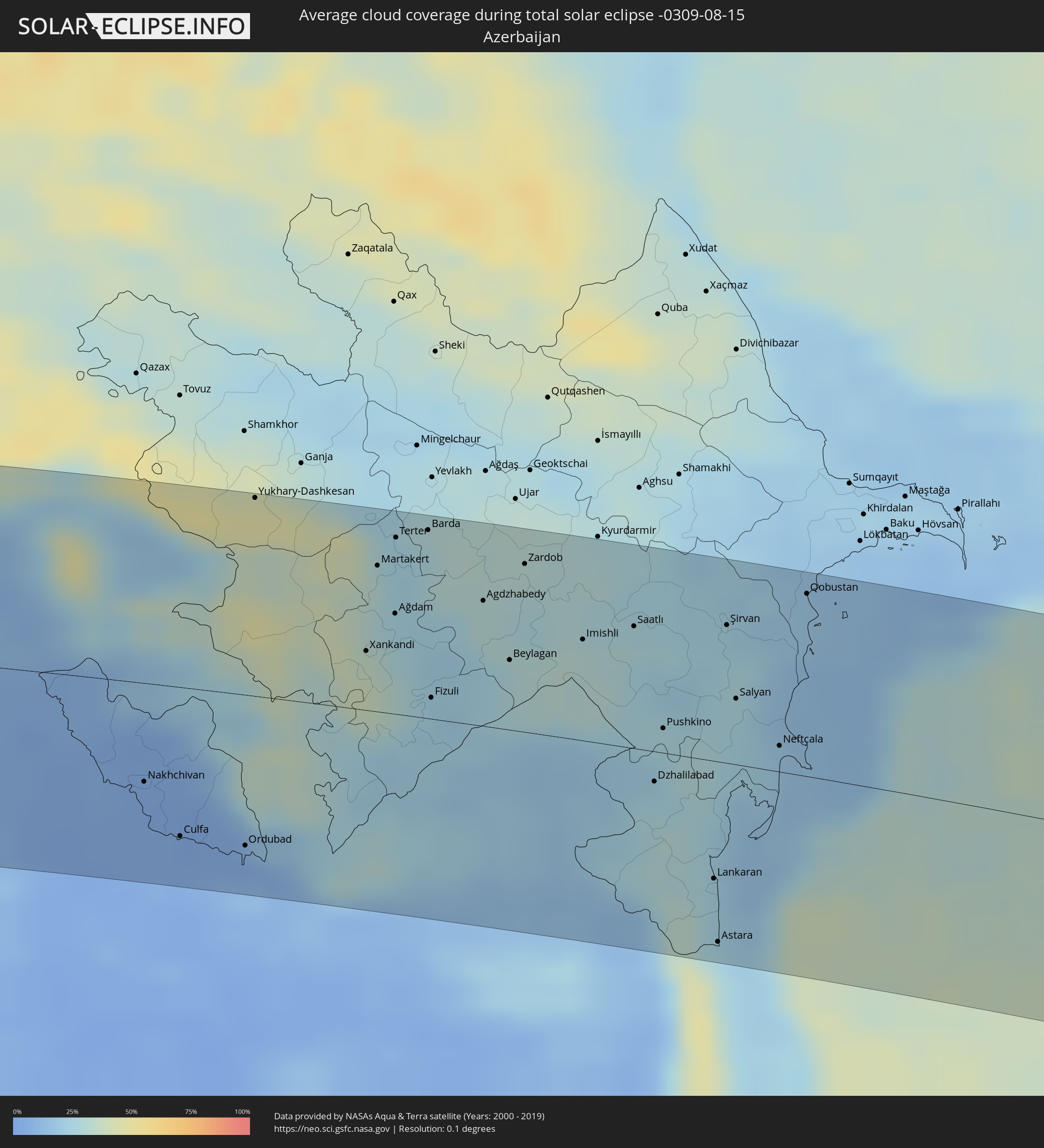 Aserbaidschan
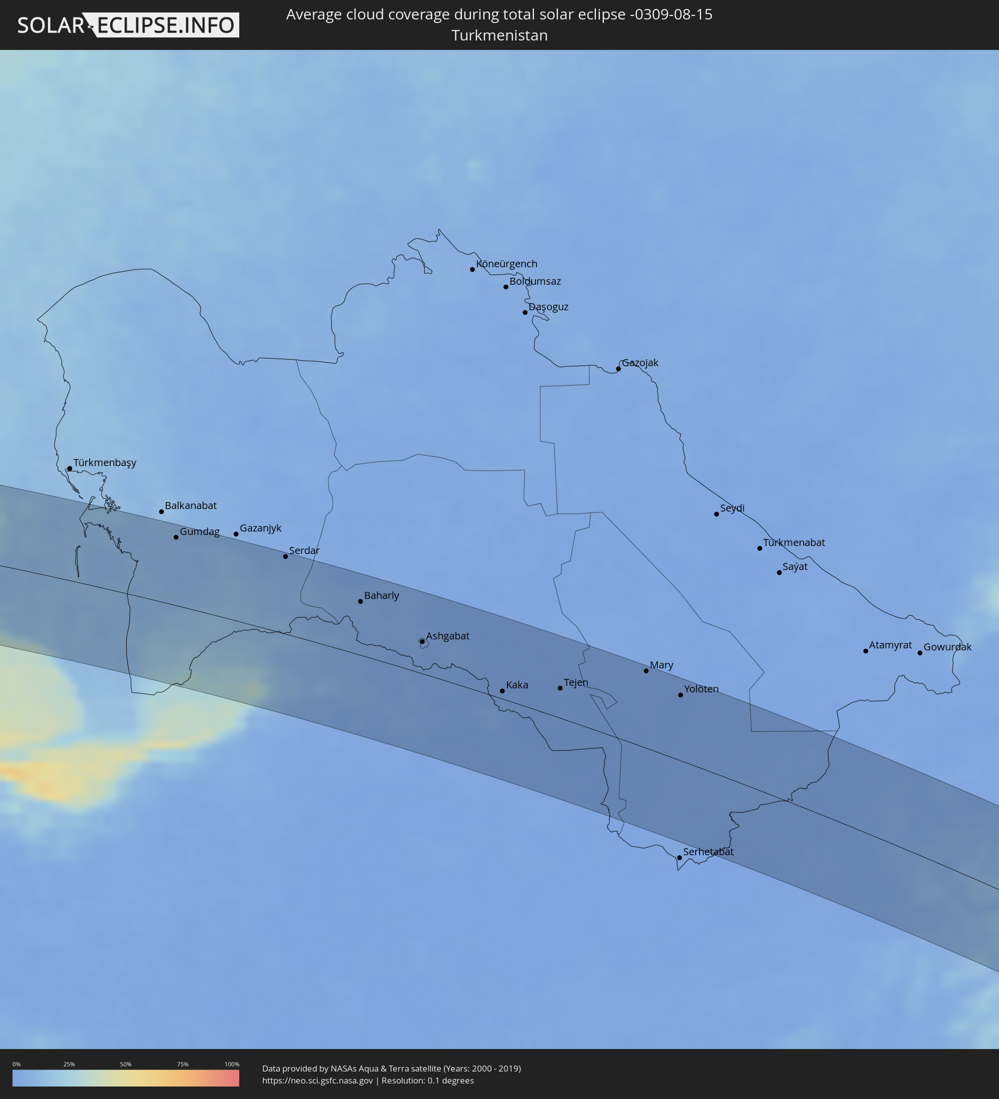 Turkmenistan
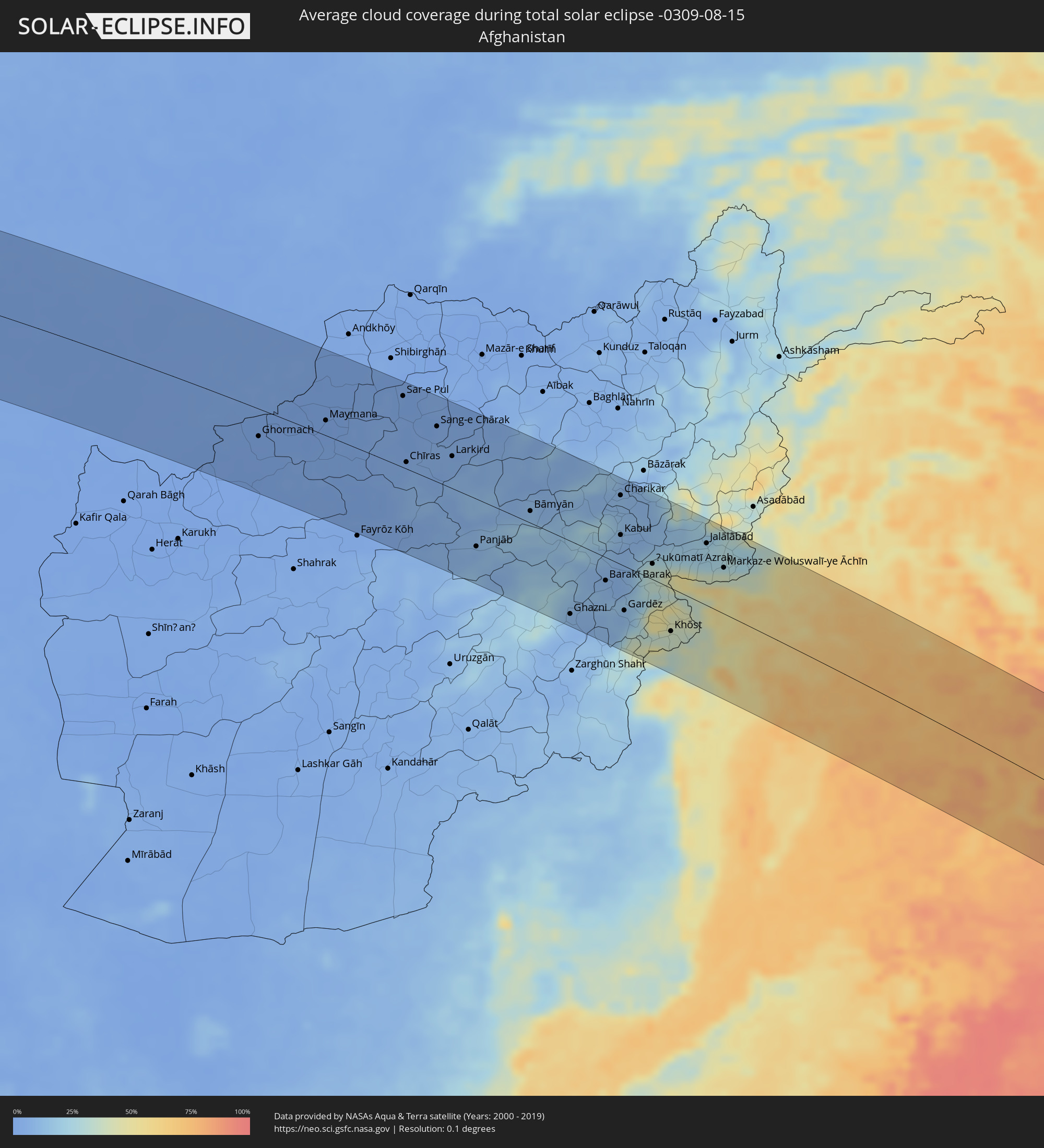 Afghanistan
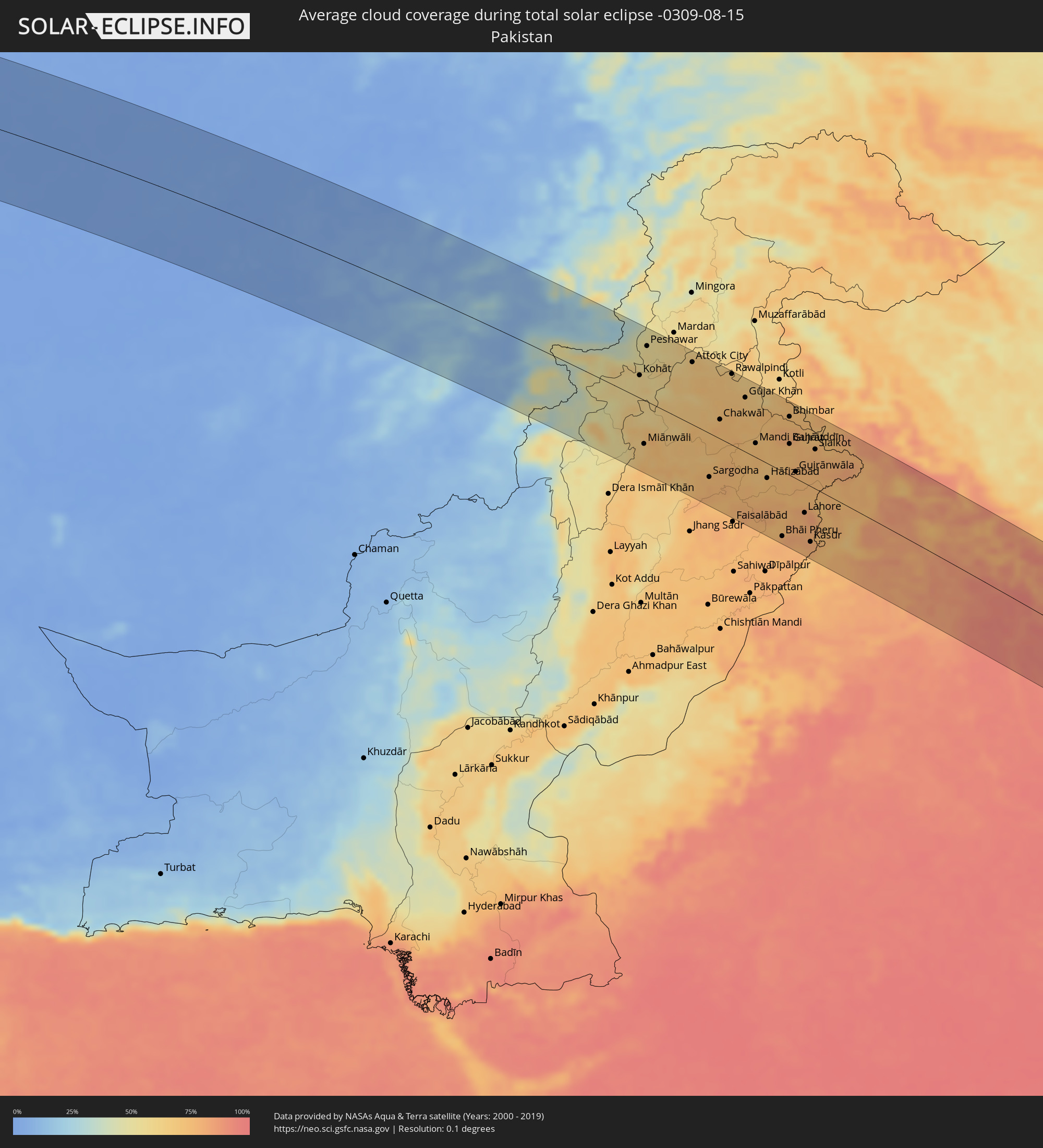 Pakistan
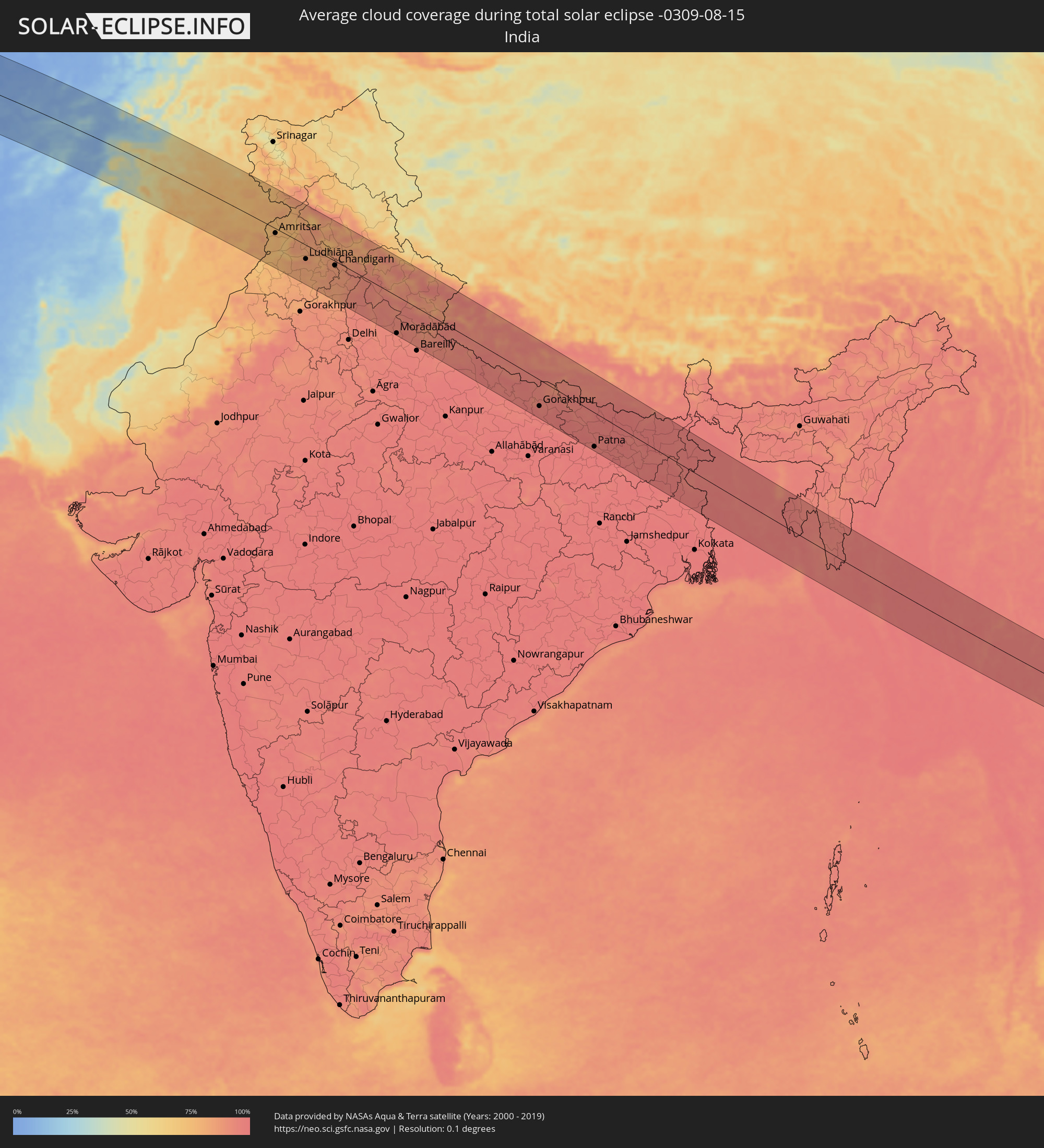 Indien
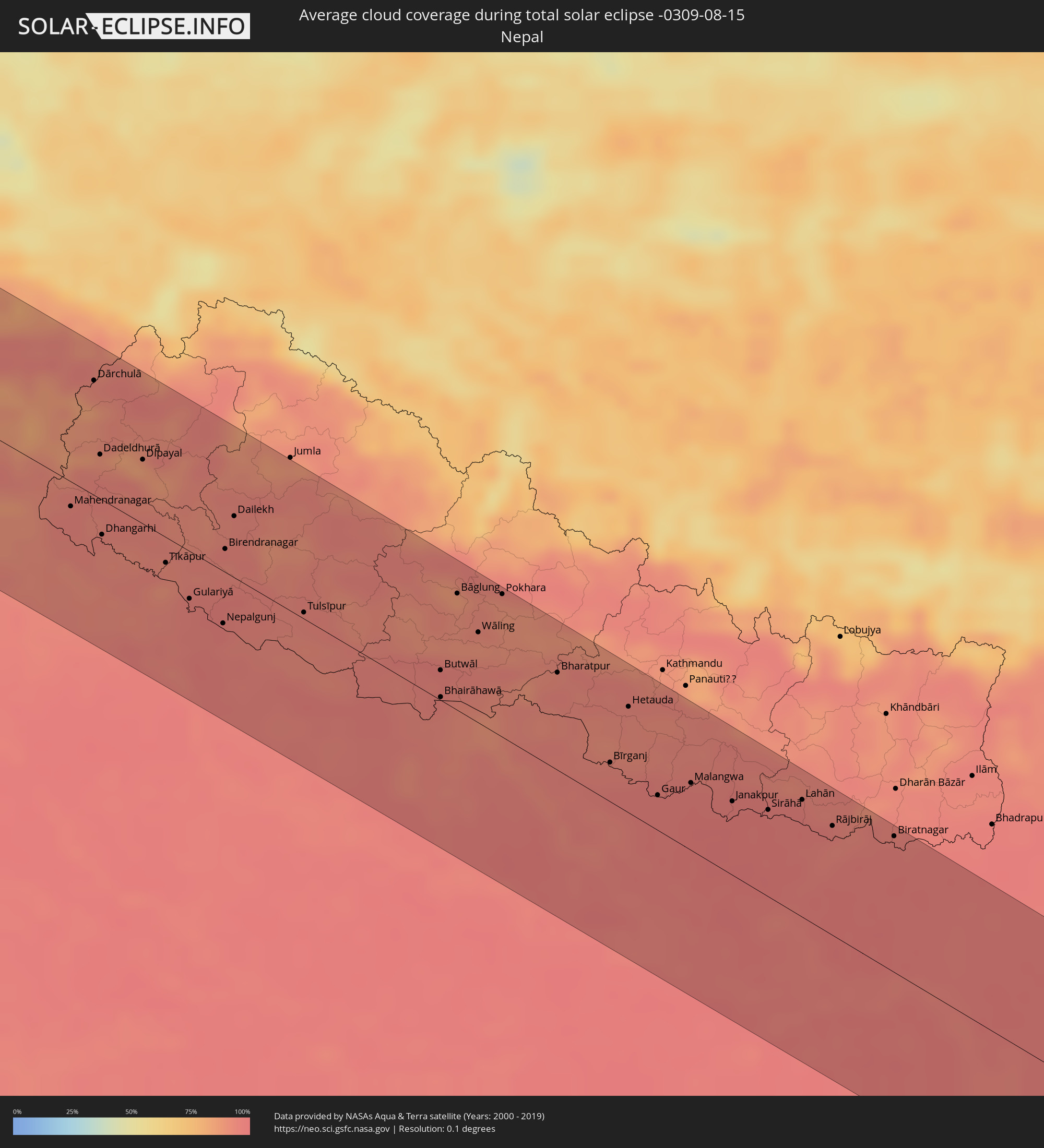 Nepal
Nepal
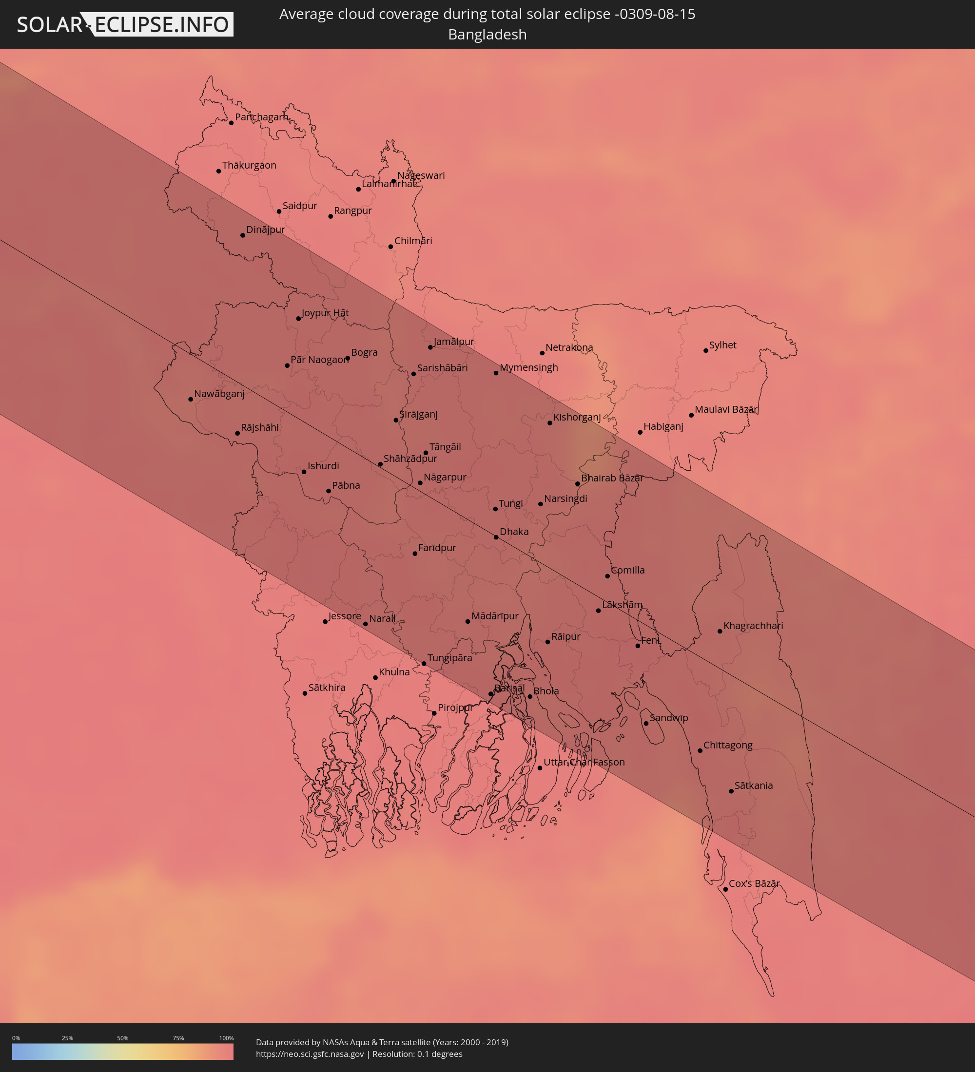 Bangladesch
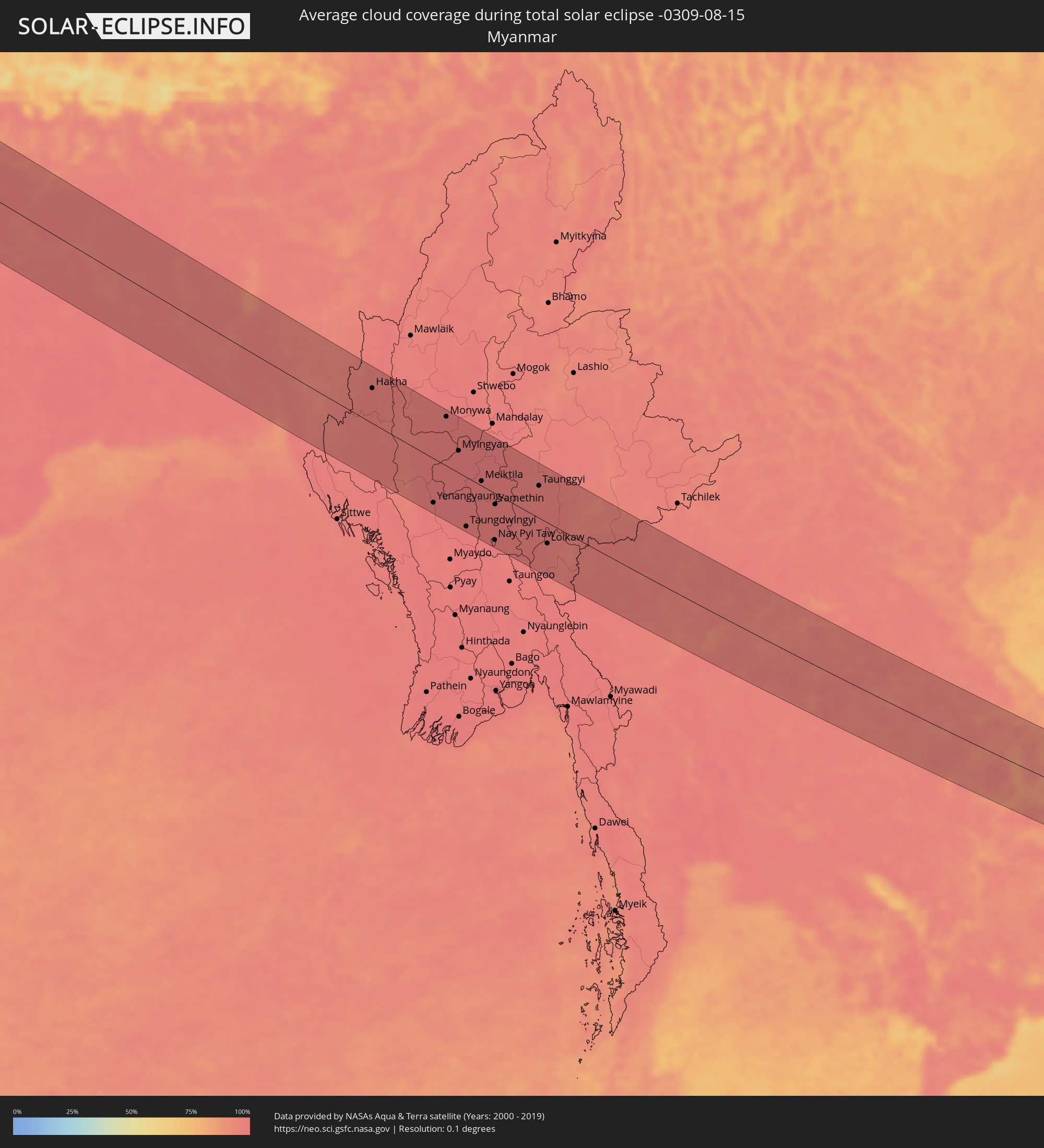 Myanmar
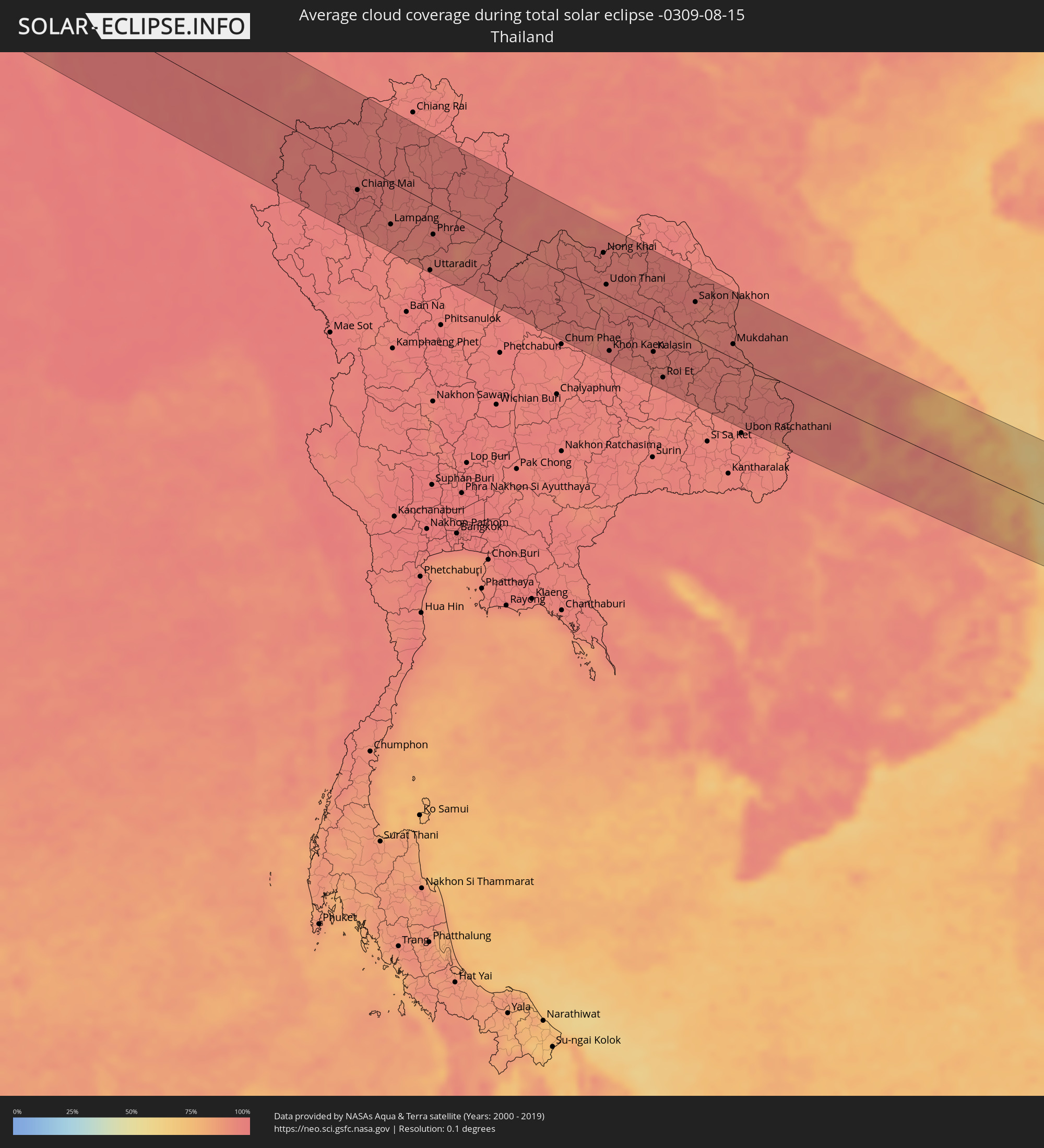 Thailand
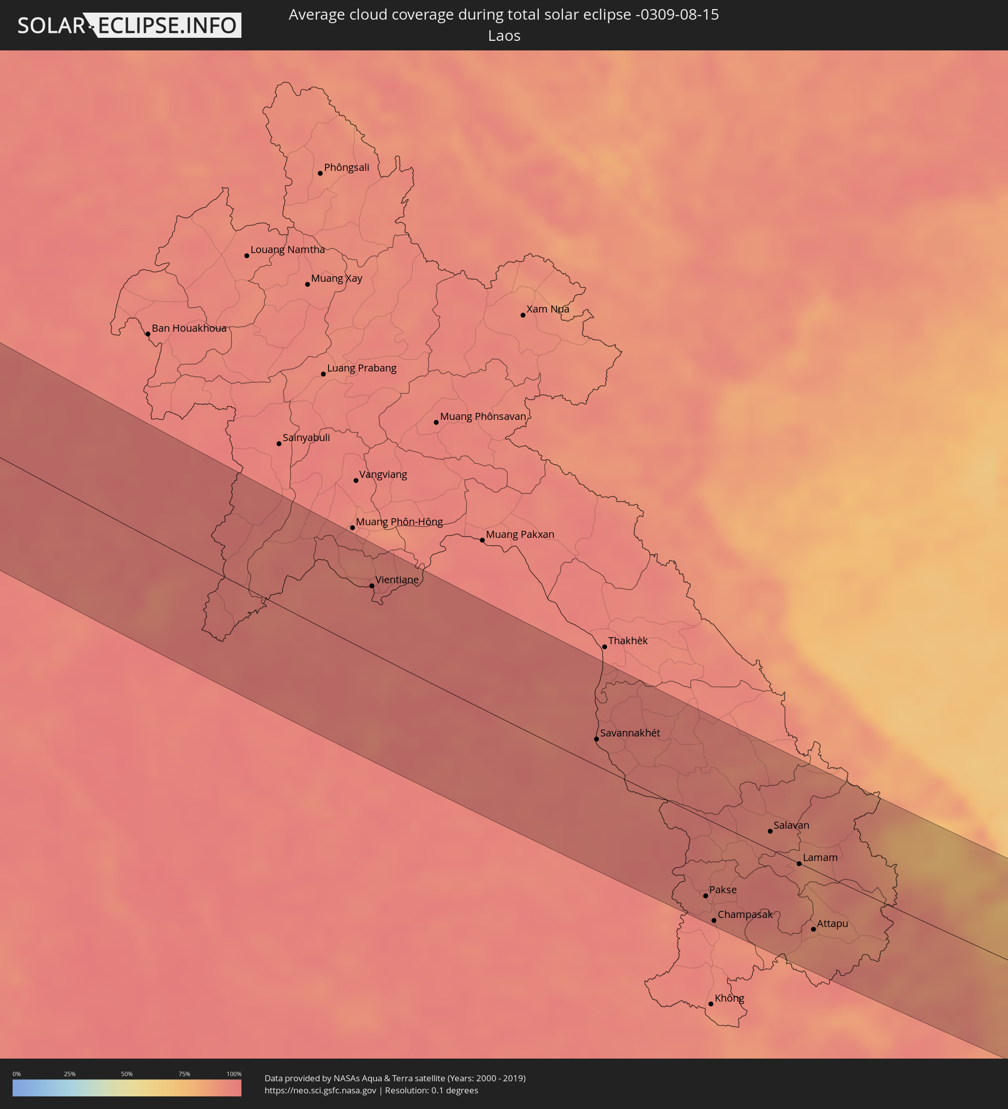 Laos
Laos
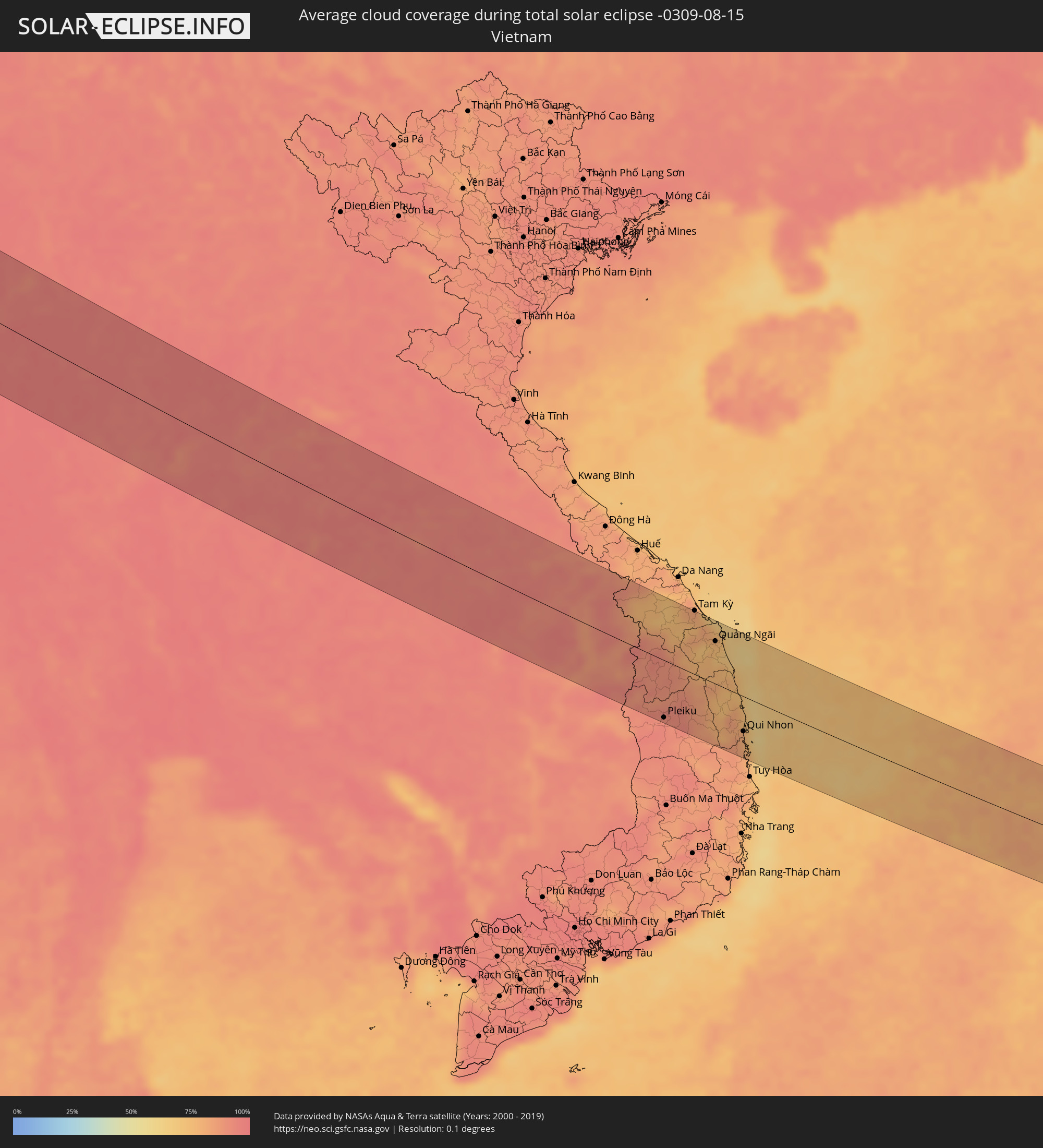 Vietnam
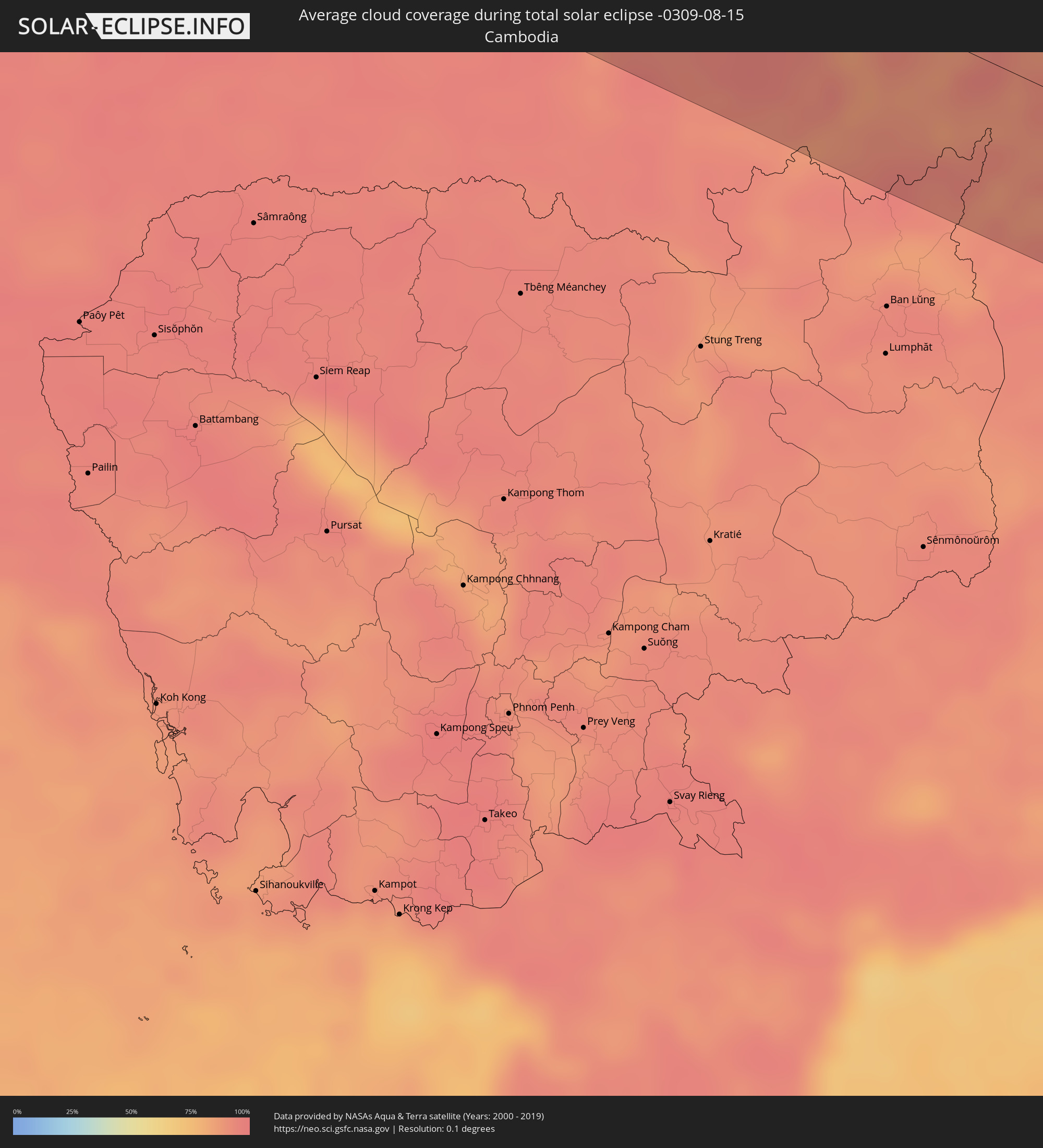 Kambodscha
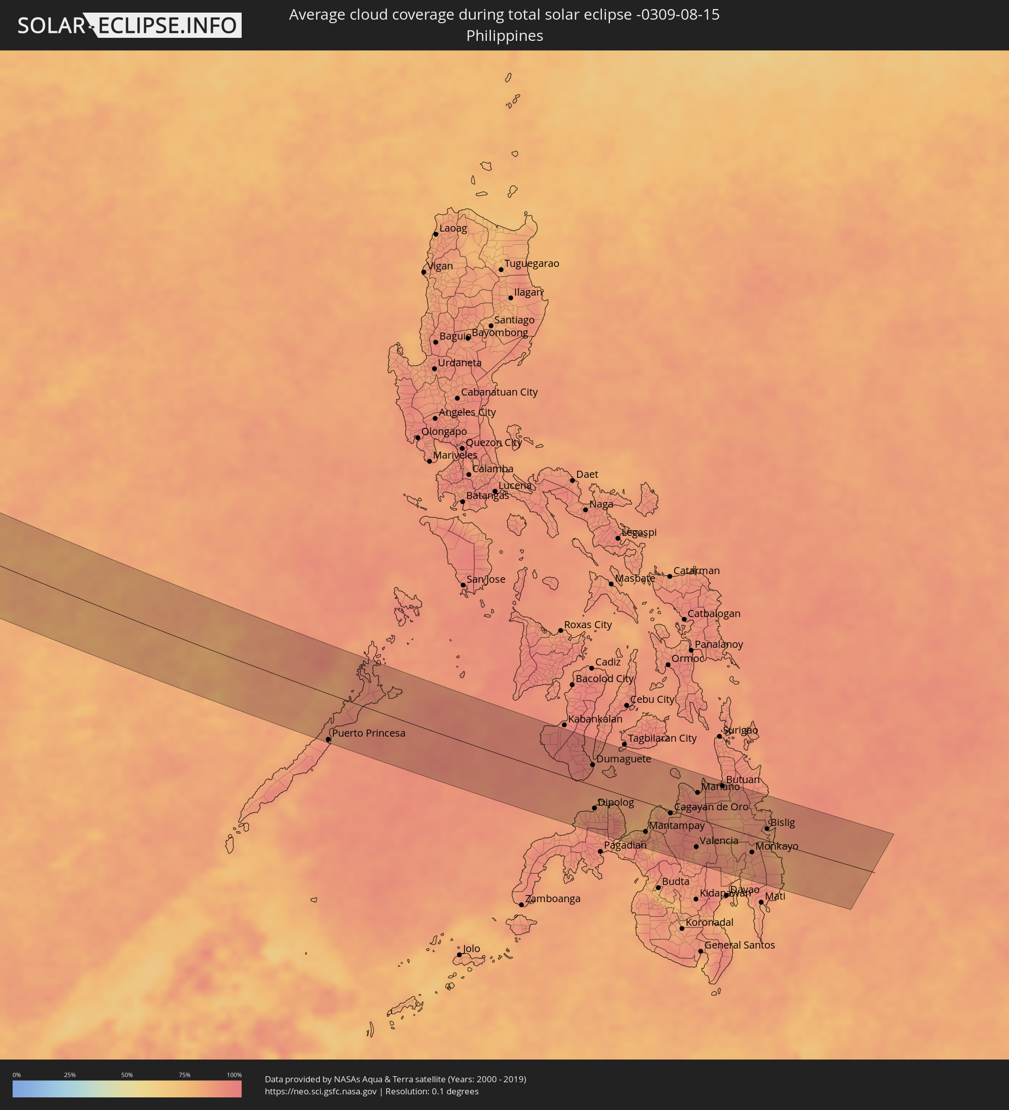 Philippinen
Orte im Finsternispfad
Die nachfolgene Tabelle zeigt Städte und Orte mit mehr als 5.000 Einwohnern, die sich im Finsternispfad befinden. Städte mit mehr als 100.000 Einwohnern sind dick gekennzeichnet. Mit einem Klick auf den Ort öffnet sich eine Detailkarte die die Lage des jeweiligen Ortes zusammen mit dem Verlauf der zentralen Finsternis präsentiert.
| Ort | Typ | Dauer der Verfinsterung | Ortszeit bei maximaler Verfinsterung | Entfernung zur Zentrallinie | Ø Bewölkung |
|
Safi, Doukkala-Abda
|
total | - | 05:54:11 UTC-00:30 | 10 km | 14% |
|
El Jadida, Doukkala-Abda
|
total | - | 05:54:56 UTC-00:30 | 69 km | 33% |
|
Settat, Chaouia-Ouardigha
|
total | - | 05:54:42 UTC-00:30 | 17 km | 7% |
|
Casablanca, Grand Casablanca
|
total | - | 05:55:11 UTC-00:30 | 79 km | 19% |
|
Mohammedia, Grand Casablanca
|
total | - | 05:55:16 UTC-00:30 | 82 km | 18% |
|
Khouribga, Chaouia-Ouardigha
|
total | - | 05:54:36 UTC-00:30 | 17 km | 7% |
|
Meknès, Meknès-Tafilalet
|
total | - | 05:55:30 UTC-00:30 | 52 km | 9% |
|
Fes, Fès-Boulemane
|
total | - | 05:55:39 UTC-00:30 | 51 km | 10% |
|
Taza, Taza-Al Hoceima-Taounate
|
total | - | 05:55:53 UTC-00:30 | 42 km | 10% |
|
Oujda, Oriental
|
total | - | 05:56:34 UTC-00:30 | 34 km | 9% |
|
Sidi Bel Abbès, Sidi Bel Abbès
|
total | - | 06:36:56 UTC+00:09 | 54 km | 10% |
|
Tiaret, Tiaret
|
total | - | 06:37:32 UTC+00:09 | 22 km | 14% |
|
Bordj Bou Arreridj, Bordj Bou Arréridj
|
total | - | 06:39:16 UTC+00:09 | 10 km | 15% |
|
Bejaïa, Béjaïa
|
total | - | 06:40:02 UTC+00:09 | 76 km | 41% |
|
Sétif, Sétif
|
total | - | 06:39:38 UTC+00:09 | 7 km | 20% |
|
Batna, Batna
|
total | - | 06:39:21 UTC+00:09 | 79 km | 26% |
|
Constantine, Constantine
|
total | - | 06:40:17 UTC+00:09 | 3 km | 20% |
|
Skikda, Skikda
|
total | - | 06:40:54 UTC+00:09 | 45 km | 29% |
|
Annaba, Annaba
|
total | - | 06:41:19 UTC+00:09 | 28 km | 33% |
|
Souk Ahras, Souk Ahras
|
total | - | 06:40:50 UTC+00:09 | 42 km | 25% |
|
El Kef, Kef
|
total | - | 06:41:06 UTC+00:09 | 71 km | 22% |
|
Jendouba, Jundūbah
|
total | - | 06:41:26 UTC+00:09 | 38 km | 21% |
|
Béja, Bājah
|
total | - | 06:41:51 UTC+00:09 | 23 km | 19% |
|
Menzel Bourguiba, Banzart
|
total | - | 06:42:35 UTC+00:09 | 10 km | 21% |
|
Bizerte, Banzart
|
total | - | 06:42:45 UTC+00:09 | 21 km | 24% |
|
La Mohammedia, Tūnis
|
total | - | 06:42:20 UTC+00:09 | 49 km | 22% |
|
Tunis, Tūnis
|
total | - | 06:42:29 UTC+00:09 | 34 km | 23% |
|
Al Marsá, Tūnis
|
total | - | 06:42:37 UTC+00:09 | 31 km | 28% |
|
Hammam-Lif, Tūnis
|
total | - | 06:42:29 UTC+00:09 | 48 km | 24% |
|
Douane, Nābul
|
total | - | 06:42:28 UTC+00:09 | 87 km | 30% |
|
Marsala, Sicily
|
total | - | 07:35:25 UTC+01:00 | 24 km | 29% |
|
Trapani, Sicily
|
total | - | 07:35:41 UTC+01:00 | 46 km | 21% |
|
Palermo, Sicily
|
total | - | 07:36:19 UTC+01:00 | 43 km | 20% |
|
Bagheria, Sicily
|
total | - | 07:36:23 UTC+01:00 | 33 km | 15% |
|
Caltanissetta, Sicily
|
total | - | 07:36:13 UTC+01:00 | 41 km | 14% |
|
Gela, Sicily
|
total | - | 07:35:57 UTC+01:00 | 90 km | 21% |
|
Catania, Sicily
|
total | - | 07:36:56 UTC+01:00 | 60 km | 13% |
|
Messina, Sicily
|
total | - | 07:37:57 UTC+01:00 | 7 km | 34% |
|
Lamezia Terme, Calabria
|
total | - | 07:39:15 UTC+01:00 | 78 km | 31% |
|
Catanzaro, Calabria
|
total | - | 07:39:24 UTC+01:00 | 64 km | 21% |
|
Ioánnina, Epirus
|
total | - | 08:18:40 UTC+01:34 | 82 km | 20% |
|
Agrínio, West Greece
|
total | - | 08:18:16 UTC+01:34 | 41 km | 10% |
|
Pátra, West Greece
|
total | - | 08:18:15 UTC+01:34 | 87 km | 8% |
|
Tríkala, Thessaly
|
total | - | 08:19:27 UTC+01:34 | 57 km | 13% |
|
Kardítsa, Thessaly
|
total | - | 08:19:26 UTC+01:34 | 34 km | 12% |
|
Lárisa, Thessaly
|
total | - | 08:20:10 UTC+01:34 | 57 km | 13% |
|
Lamía, Central Greece
|
total | - | 08:19:32 UTC+01:34 | 24 km | 18% |
|
Vólos, Thessaly
|
total | - | 08:20:27 UTC+01:34 | 20 km | 14% |
|
Chalkída, Central Greece
|
total | - | 08:20:22 UTC+01:34 | 87 km | 10% |
|
Mytilíni, North Aegean
|
total | - | 08:24:13 UTC+01:34 | 49 km | 8% |
|
Balıkesir, Balıkesir
|
total | - | 08:48:18 UTC+01:56 | 2 km | 17% |
|
Bursa, Bursa
|
total | - | 08:50:10 UTC+01:56 | 49 km | 24% |
|
İnegol, Bursa
|
total | - | 08:50:40 UTC+01:56 | 33 km | 22% |
|
Kütahya, Kütahya
|
total | - | 08:50:47 UTC+01:56 | 43 km | 14% |
|
Eskişehir, Eskişehir
|
total | - | 08:51:45 UTC+01:56 | 8 km | 13% |
|
Ankara, Ankara
|
total | - | 08:55:02 UTC+01:56 | 4 km | 11% |
|
Kırıkkale, Kırıkkale
|
total | - | 08:55:54 UTC+01:56 | 15 km | 8% |
|
Çorum, Çorum
|
total | - | 08:58:26 UTC+01:56 | 60 km | 17% |
|
Sivas, Sivas
|
total | - | 09:01:08 UTC+01:56 | 31 km | 9% |
|
Erzurum, Erzurum
|
total | - | 09:08:11 UTC+01:56 | 3 km | 23% |
|
Armavir, Armavir Province
|
total | - | 10:14:08 UTC+02:58 | 42 km | 10% |
|
Ejmiatsin, Armavir Province
|
total | - | 10:14:35 UTC+02:58 | 45 km | 10% |
|
Masis, Ararat Province
|
total | - | 10:14:47 UTC+02:58 | 35 km | 9% |
|
Yerevan, Yerevan
|
total | - | 10:14:59 UTC+02:58 | 49 km | 11% |
|
Artashat, Ararat Province
|
total | - | 10:15:00 UTC+02:58 | 25 km | 10% |
|
Ararat, Ararat Province
|
total | - | 10:15:16 UTC+02:58 | 11 km | 9% |
|
Hrazdan, Kotayk Province
|
total | - | 10:15:29 UTC+02:58 | 86 km | 24% |
|
Gavarr, Gegharkunik Province
|
total | - | 10:16:06 UTC+02:58 | 73 km | 31% |
|
Nakhchivan, Nakhichevan
|
total | - | 10:37:53 UTC+03:19 | 51 km | 5% |
|
Goris, Syunik Province
|
total | - | 10:18:14 UTC+02:58 | 8 km | 33% |
|
Qafan, Syunik Province
|
total | - | 10:18:20 UTC+02:58 | 41 km | 34% |
|
Xankandi, Xankǝndi
|
total | - | 10:40:25 UTC+03:19 | 30 km | 34% |
|
Ağdam, Ağdam
|
total | - | 10:40:45 UTC+03:19 | 51 km | 26% |
|
Barda, Bǝrdǝ
|
total | - | 10:41:09 UTC+03:19 | 96 km | 28% |
|
Agdzhabedy, Ağcabǝdi
|
total | - | 10:41:45 UTC+03:19 | 64 km | 30% |
|
Pārsābād, Ardabīl
|
total | - | 10:48:56 UTC+03:25 | 25 km | 27% |
|
Saatlı, Saatlı
|
total | - | 10:43:27 UTC+03:19 | 62 km | 27% |
|
Dzhalilabad, Jalilabad
|
total | - | 10:43:43 UTC+03:19 | 15 km | 24% |
|
Lankaran, Lənkəran
|
total | - | 10:44:26 UTC+03:19 | 61 km | 22% |
|
Āstārā, Gīlān
|
total | - | 10:50:50 UTC+03:25 | 96 km | 26% |
|
Şirvan, Shirvan
|
total | - | 10:44:31 UTC+03:19 | 71 km | 24% |
|
Salyan, Salyan
|
total | - | 10:44:38 UTC+03:19 | 34 km | 26% |
|
Gumdag, Balkan
|
total | - | 11:29:53 UTC+03:53 | 88 km | 10% |
|
Kalāleh, Golestān
|
total | - | 11:04:42 UTC+03:25 | 90 km | 28% |
|
Bojnūrd, Khorāsān-e Shomālī
|
total | - | 11:08:32 UTC+03:25 | 36 km | 5% |
|
Baharly, Ahal
|
total | - | 11:36:01 UTC+03:53 | 69 km | 4% |
|
Esfarāyen, Khorāsān-e Shomālī
|
total | - | 11:09:08 UTC+03:25 | 74 km | 2% |
|
Shīrvān, Khorāsān-e Shomālī
|
total | - | 11:09:50 UTC+03:25 | 30 km | 3% |
|
Abadan, Ahal
|
total | - | 11:37:49 UTC+03:53 | 47 km | 4% |
|
Ashgabat, Ahal
|
total | - | 11:38:16 UTC+03:53 | 41 km | 2% |
|
Qūchān, Razavi Khorasan
|
total | - | 11:11:15 UTC+03:25 | 46 km | 2% |
|
Annau, Ahal
|
total | - | 11:38:34 UTC+03:53 | 38 km | 2% |
|
Chenārān, Razavi Khorasan
|
total | - | 11:12:51 UTC+03:25 | 78 km | 1% |
|
Mashhad, Razavi Khorasan
|
total | - | 11:14:03 UTC+03:25 | 101 km | 1% |
|
Kaka, Ahal
|
total | - | 11:41:13 UTC+03:53 | 10 km | 1% |
|
Tejen, Ahal
|
total | - | 11:43:04 UTC+03:53 | 38 km | 1% |
|
Sarakhs, Razavi Khorasan
|
total | - | 11:17:17 UTC+03:25 | 31 km | 1% |
|
Mary, Mary
|
total | - | 11:45:40 UTC+03:53 | 99 km | 1% |
|
Murgab
|
total | - | 11:46:02 UTC+03:53 | 93 km | 2% |
|
Yolöten, Mary
|
total | - | 11:47:00 UTC+03:53 | 84 km | 0% |
|
Maymana, Faryab
|
total | - | 11:59:47 UTC+04:00 | 19 km | 0% |
|
Sar-e Pul, Sar-e Pol
|
total | - | 12:01:53 UTC+04:00 | 88 km | 1% |
|
Bāmyān, Bamyan
|
total | - | 12:07:19 UTC+04:00 | 15 km | 13% |
|
Ghazni, Ghazni
|
total | - | 12:10:02 UTC+04:00 | 91 km | 10% |
|
Paghmān, Kabul
|
total | - | 12:09:54 UTC+04:00 | 34 km | 16% |
|
Charikar, Parwan
|
total | - | 12:09:51 UTC+04:00 | 85 km | 10% |
|
Kabul, Kabul
|
total | - | 12:10:26 UTC+04:00 | 36 km | 8% |
|
Gardēz, Paktia
|
total | - | 12:11:40 UTC+04:00 | 55 km | 9% |
|
Khōst, Khowst
|
total | - | 12:13:25 UTC+04:00 | 54 km | 36% |
|
Jalālābād, Nangarhar
|
total | - | 12:13:09 UTC+04:00 | 77 km | 23% |
|
Peshawar, Khyber Pakhtunkhwa
|
total | - | 12:44:08 UTC+04:28 | 81 km | 55% |
|
Sargodha, Punjab
|
total | - | 12:48:52 UTC+04:28 | 64 km | 74% |
|
Rawalpindi, Punjab
|
total | - | 12:47:36 UTC+04:28 | 103 km | 67% |
|
Sheikhupura, Punjab
|
total | - | 12:51:58 UTC+04:28 | 44 km | 75% |
|
Bhimbar, Azad Kashmir
|
total | - | 12:50:25 UTC+04:28 | 85 km | 74% |
|
Gujrāt, Punjab
|
total | - | 12:50:58 UTC+04:28 | 45 km | 74% |
|
Gujrānwāla, Punjab
|
total | - | 12:51:45 UTC+04:28 | 10 km | 76% |
|
Lahore, Punjab
|
total | - | 12:52:55 UTC+04:28 | 43 km | 77% |
|
Kasūr, Punjab
|
total | - | 12:53:44 UTC+04:28 | 81 km | 78% |
|
Sialkot, Punjab
|
total | - | 12:51:57 UTC+04:28 | 58 km | 77% |
|
Jammu, Kashmir
|
total | - | 13:45:13 UTC+05:21 | 96 km | 73% |
|
Amritsar, Punjab
|
total | - | 13:46:49 UTC+05:21 | 13 km | 77% |
|
Jalandhar, Punjab
|
total | - | 13:48:35 UTC+05:21 | 10 km | 84% |
|
Ludhiāna, Punjab
|
total | - | 13:49:42 UTC+05:21 | 38 km | 86% |
|
Chandigarh, Chandigarh
|
total | - | 13:51:43 UTC+05:21 | 11 km | 85% |
|
Sahāranpur, Uttar Pradesh
|
total | - | 13:54:16 UTC+05:21 | 51 km | 94% |
|
Dehra Dūn, Uttarakhand
|
total | - | 13:54:38 UTC+05:21 | 7 km | 93% |
|
Morādābād, Uttar Pradesh
|
total | - | 13:58:14 UTC+05:21 | 101 km | 94% |
|
Mahendranagar, Far Western
|
total | - | 14:20:57 UTC+05:41 | 18 km | 95% |
|
Dhangarhi, Far Western
|
total | - | 14:21:44 UTC+05:41 | 25 km | 93% |
|
Nepalgunj, Mid Western
|
total | - | 14:24:29 UTC+05:41 | 37 km | 97% |
|
Gorakhpur, Uttar Pradesh
|
total | - | 14:09:16 UTC+05:21 | 72 km | 94% |
|
Butwāl, Western Region
|
total | - | 14:28:02 UTC+05:41 | 21 km | 94% |
|
Pokhara, Western Region
|
total | - | 14:27:58 UTC+05:41 | 102 km | 91% |
|
Bharatpur, Central Region
|
total | - | 14:29:36 UTC+05:41 | 70 km | 93% |
|
Bīrganj, Central Region
|
total | - | 14:31:21 UTC+05:41 | 28 km | 95% |
|
Hetauda, Central Region
|
total | - | 14:30:55 UTC+05:41 | 76 km | 93% |
|
Patna, Bihar
|
total | - | 14:13:52 UTC+05:21 | 94 km | 97% |
|
Janakpur, Central Region
|
total | - | 14:33:21 UTC+05:41 | 53 km | 97% |
|
Biratnagar, Eastern Region
|
total | - | 14:35:45 UTC+05:41 | 98 km | 97% |
|
Rājshāhi, Rājshāhi
|
total | - | 14:52:54 UTC+05:53 | 31 km | 97% |
|
Dinājpur, Rangpur Division
|
total | - | 14:51:00 UTC+05:53 | 90 km | 97% |
|
Bogra, Rājshāhi
|
total | - | 14:53:11 UTC+05:53 | 54 km | 97% |
|
Nāgarpur, Dhaka
|
total | - | 14:55:04 UTC+05:53 | 5 km | 97% |
|
Tungi, Dhaka
|
total | - | 14:56:00 UTC+05:53 | 16 km | 97% |
|
Mymensingh, Dhaka
|
total | - | 14:54:40 UTC+05:53 | 99 km | 97% |
|
Dhaka, Dhaka
|
total | - | 14:56:17 UTC+05:53 | 1 km | 96% |
|
Narsingdi, Dhaka
|
total | - | 14:56:21 UTC+05:53 | 36 km | 95% |
|
Comilla, Chittagong
|
total | - | 14:57:38 UTC+05:53 | 16 km | 97% |
|
Chittagong, Chittagong
|
total | - | 15:00:07 UTC+05:53 | 58 km | 95% |
|
Chauk, Magway
|
total | - | 15:37:01 UTC+06:24 | 43 km | 98% |
|
Yenangyaung, Magway
|
total | - | 15:37:42 UTC+06:24 | 82 km | 98% |
|
Pakokku, Magway
|
total | - | 15:36:40 UTC+06:24 | 13 km | 97% |
|
Monywa, Sagain
|
total | - | 15:35:35 UTC+06:24 | 91 km | 97% |
|
Myingyan, Mandalay
|
total | - | 15:36:47 UTC+06:24 | 41 km | 98% |
|
Taungdwingyi, Magway
|
total | - | 15:39:03 UTC+06:24 | 92 km | 98% |
|
Meiktila, Mandalay
|
total | - | 15:38:06 UTC+06:24 | 9 km | 98% |
|
Nay Pyi Taw, Nay Pyi Taw
|
total | - | 15:40:00 UTC+06:24 | 87 km | 98% |
|
Pyinmana, Nay Pyi Taw
|
total | - | 15:40:05 UTC+06:24 | 84 km | 98% |
|
Taunggyi, Shan
|
total | - | 15:39:23 UTC+06:24 | 60 km | 97% |
|
Chiang Mai, Chiang Mai
|
total | - | 16:01:11 UTC+06:42 | 36 km | 97% |
|
Lamphun, Lamphun
|
total | - | 16:01:30 UTC+06:42 | 56 km | 98% |
|
Lampang, Lampang
|
total | - | 16:02:17 UTC+06:42 | 60 km | 96% |
|
Uttaradit, Uttaradit
|
total | - | 16:03:39 UTC+06:42 | 96 km | 98% |
|
Vientiane, Vientiane
|
total | - | 16:05:03 UTC+06:42 | 60 km | 96% |
|
Nong Khai, Nong Khai
|
total | - | 16:05:15 UTC+06:42 | 59 km | 94% |
|
Udon Thani, Changwat Udon Thani
|
total | - | 16:05:53 UTC+06:42 | 15 km | 94% |
|
Khon Kaen, Khon Kaen
|
total | - | 16:07:09 UTC+06:42 | 79 km | 96% |
|
Maha Sarakham, Maha Sarakham
|
total | - | 16:07:47 UTC+06:42 | 83 km | 95% |
|
Kalasin, Kalasin
|
total | - | 16:07:36 UTC+06:42 | 48 km | 94% |
|
Sakon Nakhon, Sakon Nakhon
|
total | - | 16:07:05 UTC+06:42 | 55 km | 96% |
|
Savannakhét, Savannahkhét
|
total | - | 16:08:12 UTC+06:42 | 24 km | 93% |
|
Pakse, Champasak
|
total | - | 16:10:32 UTC+06:42 | 72 km | 94% |
|
Champasak, Champasak
|
total | - | 16:10:51 UTC+06:42 | 91 km | 92% |
|
Salavan, Salavan
|
total | - | 16:10:09 UTC+06:42 | 17 km | 93% |
|
Lamam, Xékong
|
total | - | 16:10:39 UTC+06:42 | 1 km | 88% |
|
Attapu, Attapu
|
total | - | 16:11:26 UTC+06:42 | 56 km | 89% |
|
Pleiku, Gia Lai
|
total | - | 16:37:31 UTC+07:06 | 86 km | 93% |
|
Kon Tum, Kon Tum
|
total | - | 16:37:06 UTC+07:06 | 48 km | 88% |
|
Quảng Ngãi, Quảng Ngãi
|
total | - | 16:36:34 UTC+07:06 | 64 km | 73% |
|
Sông Cầu, Phú Yên
|
total | - | 16:38:37 UTC+07:06 | 86 km | 83% |
|
Qui Nhon, Bình Định
|
total | - | 16:38:16 UTC+07:06 | 53 km | 80% |
|
Puerto Princesa, Mimaropa
|
total | - | 17:37:41 UTC+08:00 | 82 km | 88% |
|
Dumaguete, Central Visayas
|
total | - | 17:38:00 UTC+08:00 | 36 km | 89% |
|
Dipolog, Zamboanga Peninsula
|
total | - | 17:38:36 UTC+08:00 | 41 km | 85% |
|
Ozamiz City, Northern Mindanao
|
total | - | 17:38:53 UTC+08:00 | 68 km | 80% |
|
Mantampay, Northern Mindanao
|
total | - | 17:38:50 UTC+08:00 | 53 km | 85% |
|
Marawi City, Autonomous Region in Muslim Mindanao
|
total | - | 17:38:57 UTC+08:00 | 68 km | 82% |
|
Iligan City, Soccsksargen
|
total | - | 17:38:45 UTC+08:00 | 38 km | 87% |
|
Cagayan de Oro, Northern Mindanao
|
total | - | 17:38:32 UTC+08:00 | 5 km | 87% |
|
Butuan, Caraga
|
total | - | 17:38:03 UTC+08:00 | 74 km | 90% |
|
Tagum, Davao
|
total | - | 17:39:11 UTC+08:00 | 77 km | 79% |