Total solar eclipse of 08/15/-0309
| Day of week: | Monday |
| Maximum duration of eclipse: | 05m00s |
| Maximum width of eclipse path: | 212 km |
| Saros cycle: | 69 |
| Coverage: | 100% |
| Magnitude: | 1.0609 |
| Gamma: | 0.3394 |
Wo kann man die Sonnenfinsternis vom 08/15/-0309 sehen?
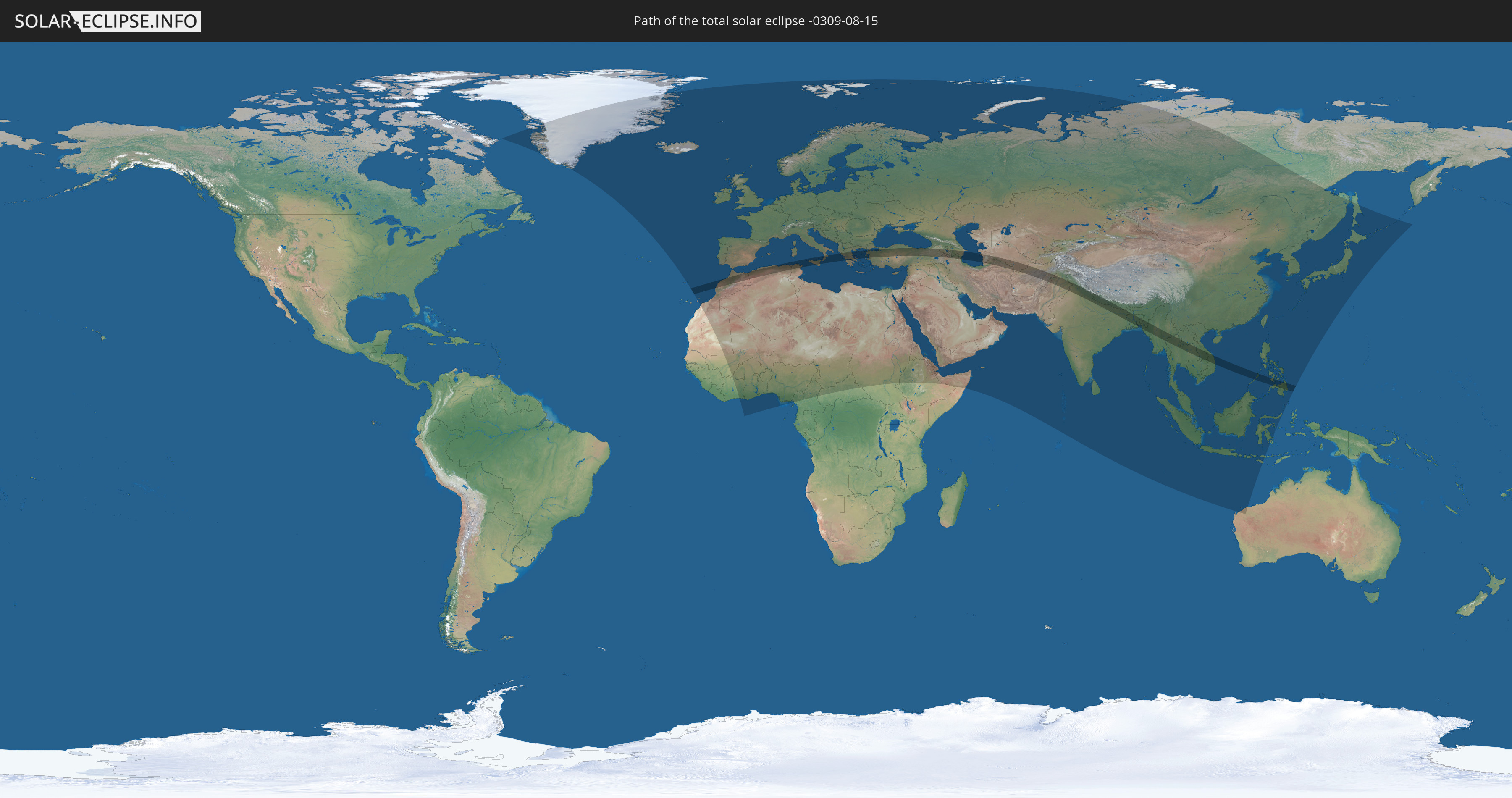
Die Sonnenfinsternis am 08/15/-0309 kann man in 127 Ländern als partielle Sonnenfinsternis beobachten.
Der Finsternispfad verläuft durch 22 Länder. Nur in diesen Ländern ist sie als total Sonnenfinsternis zu sehen.
In den folgenden Ländern ist die Sonnenfinsternis total zu sehen
 Morocco
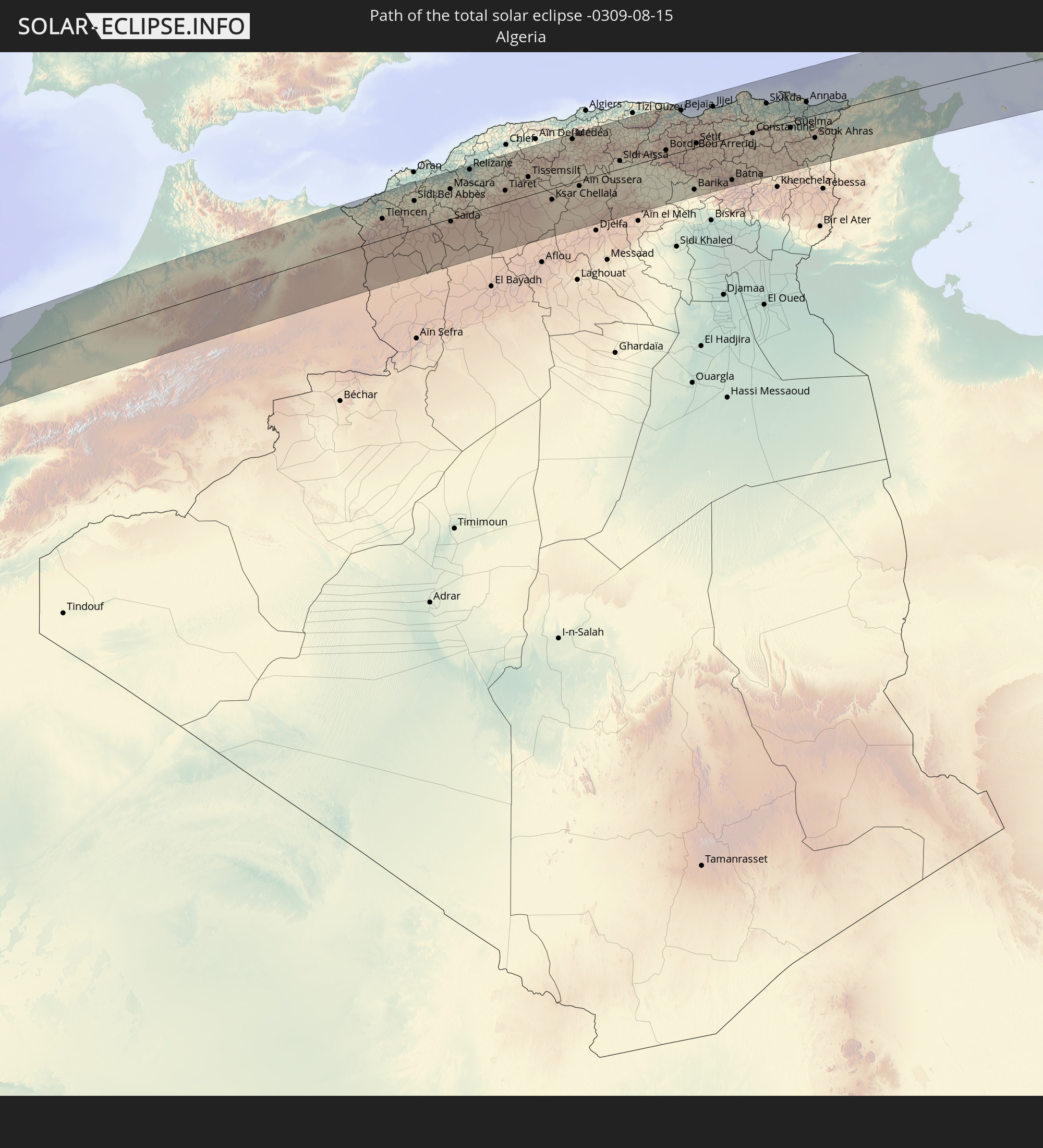 Algeria
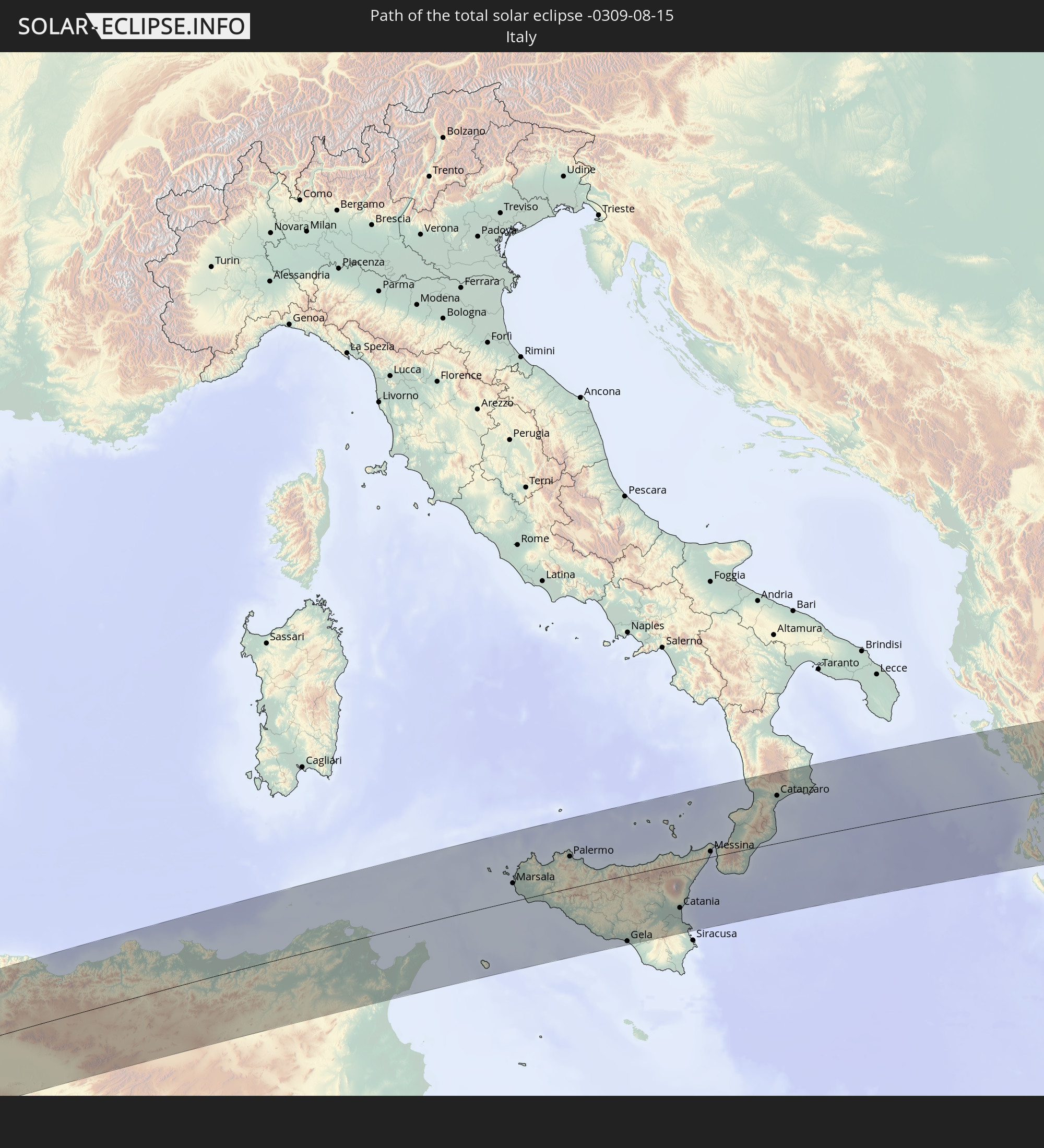 Italy
Italy
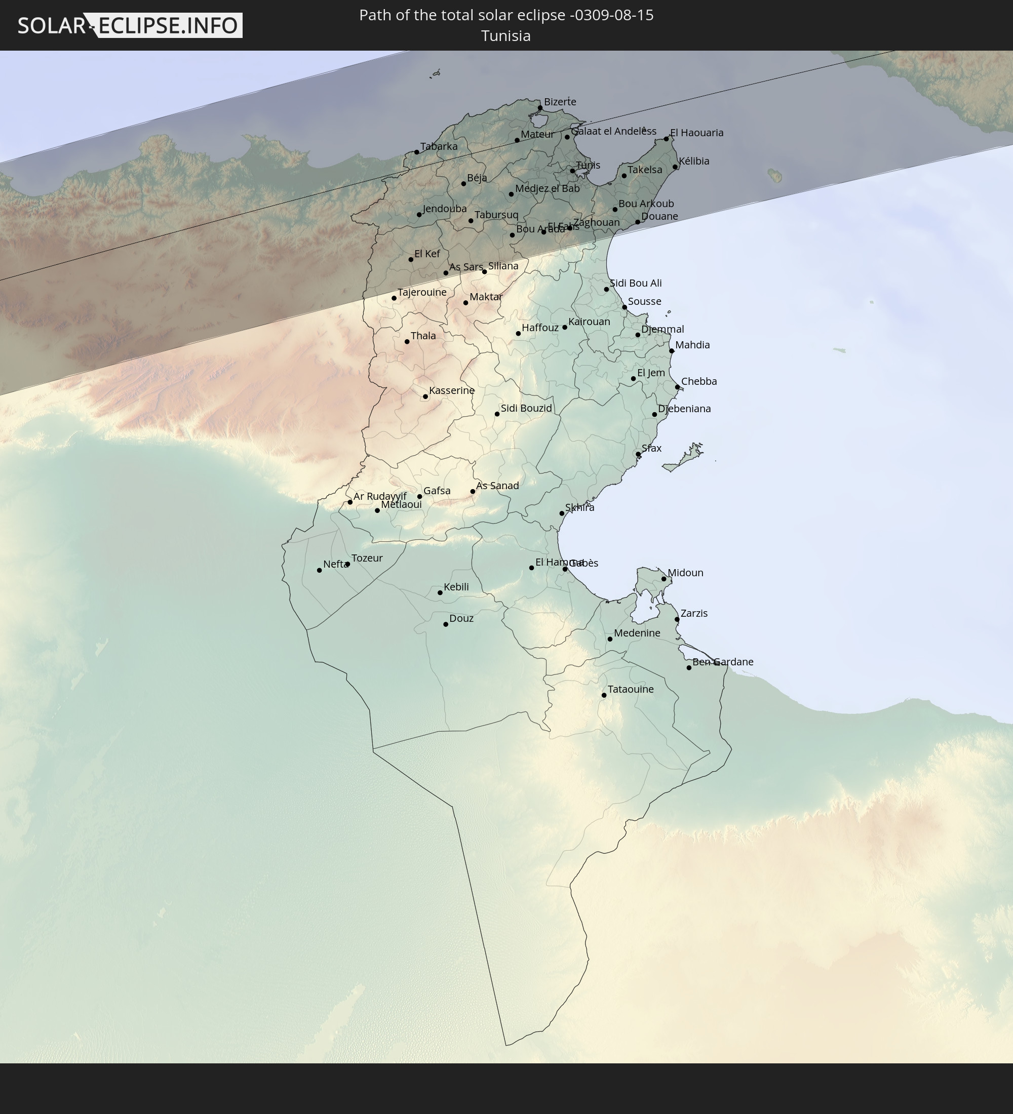 Tunisia
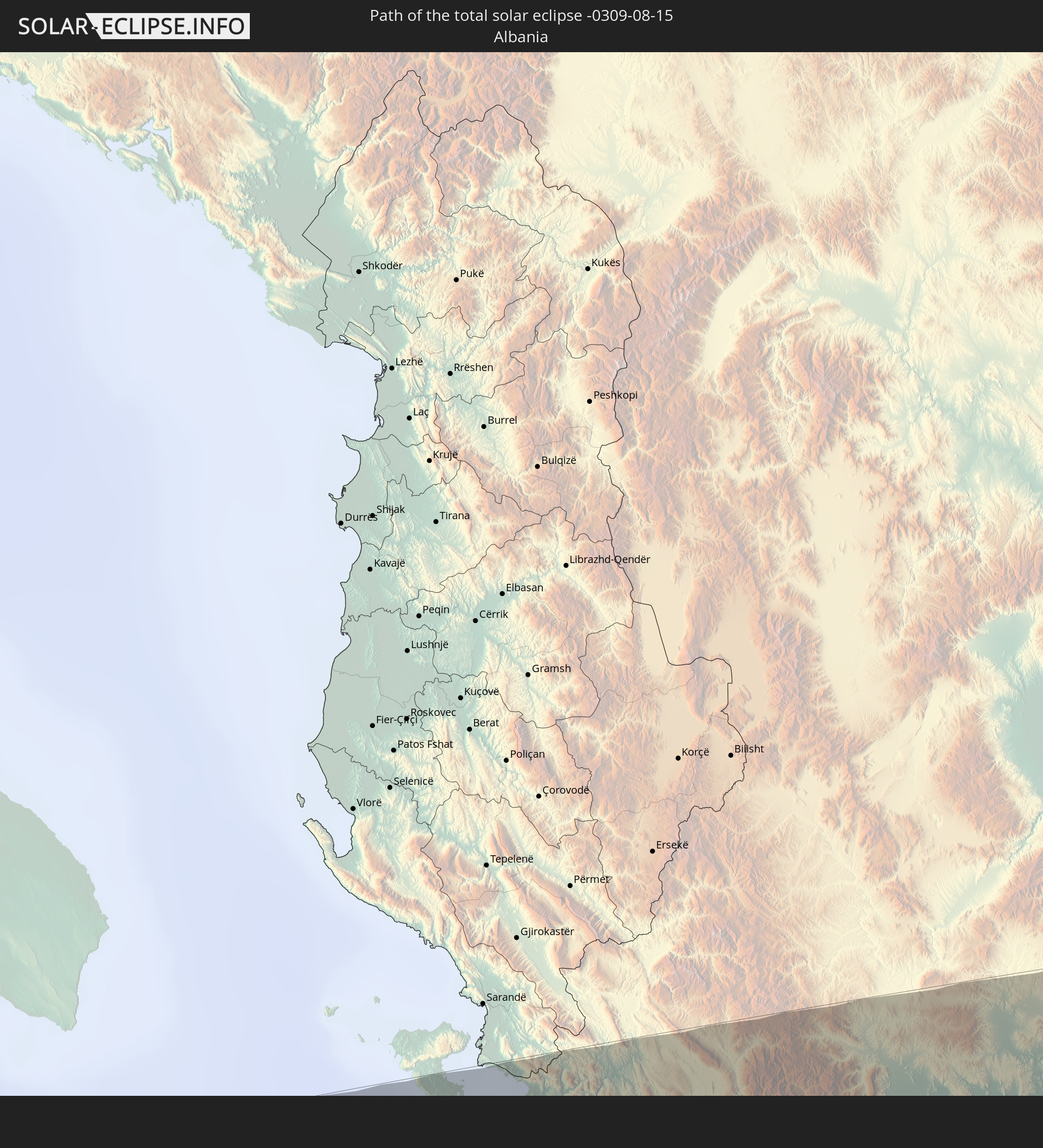 Albania
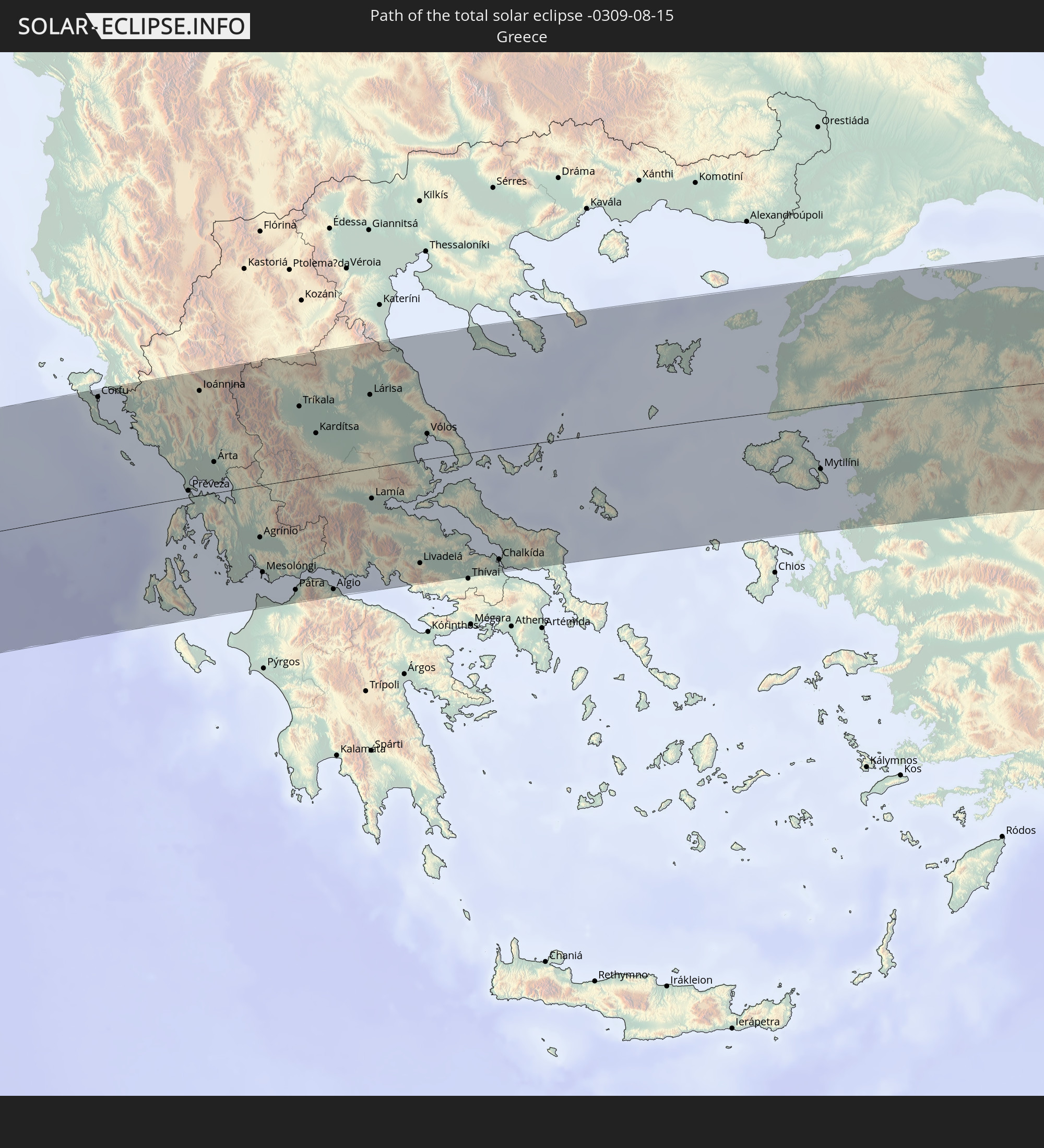 Greece
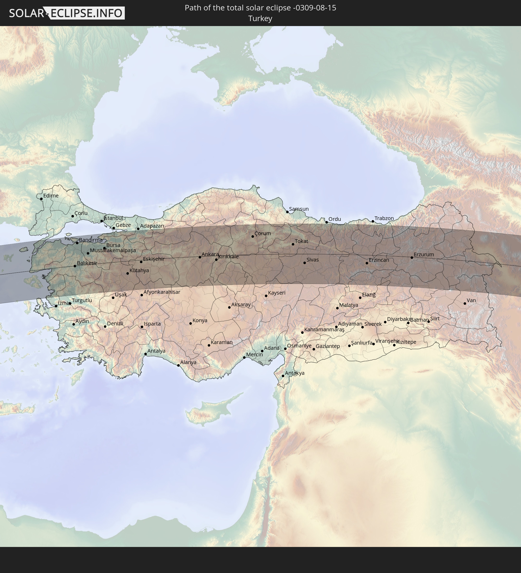 Turkey
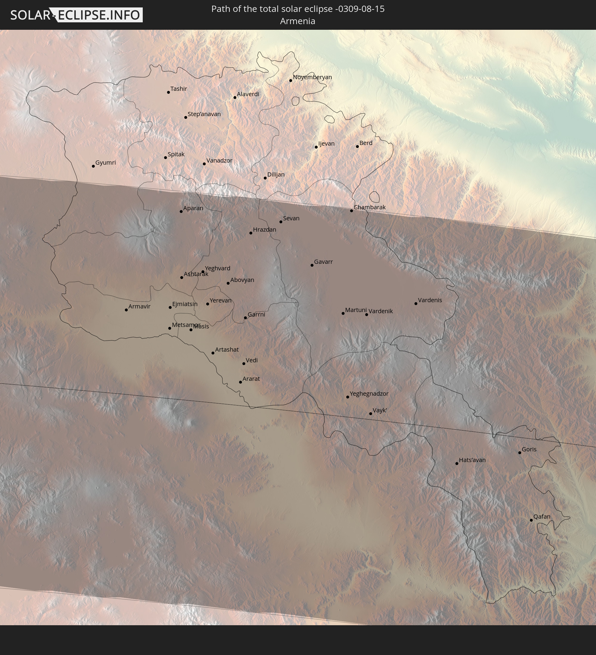 Armenia
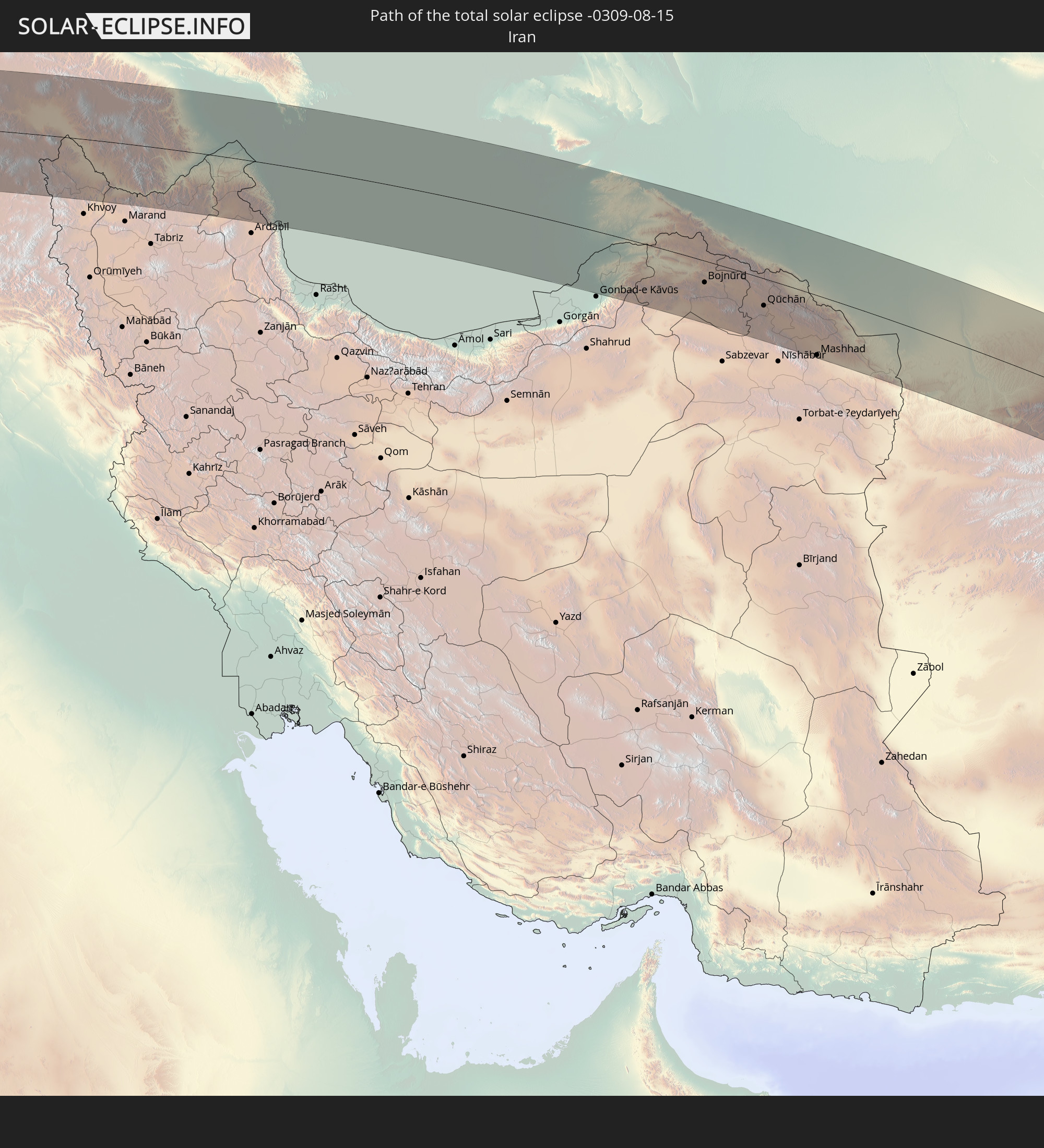 Iran
Iran
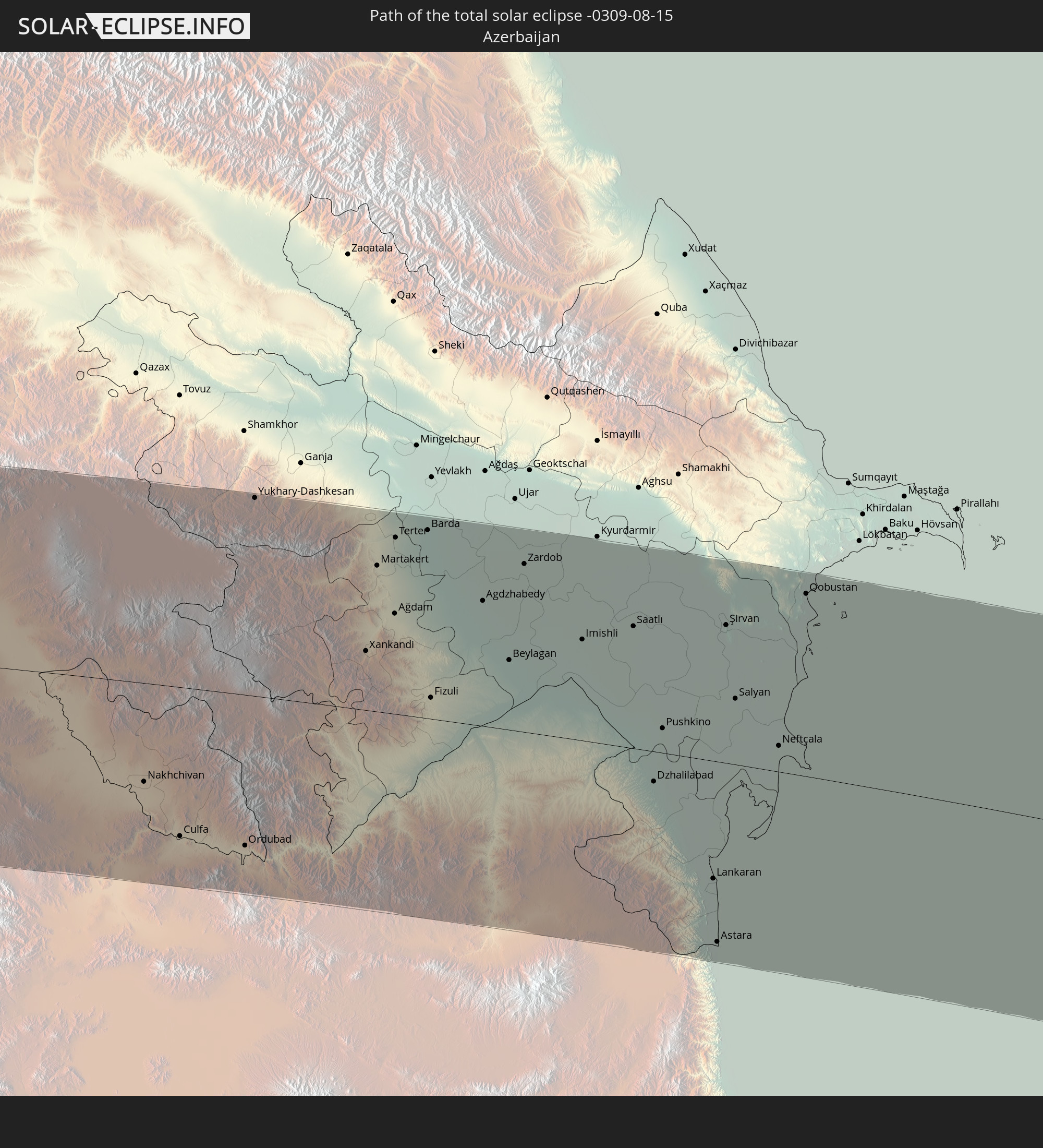 Azerbaijan
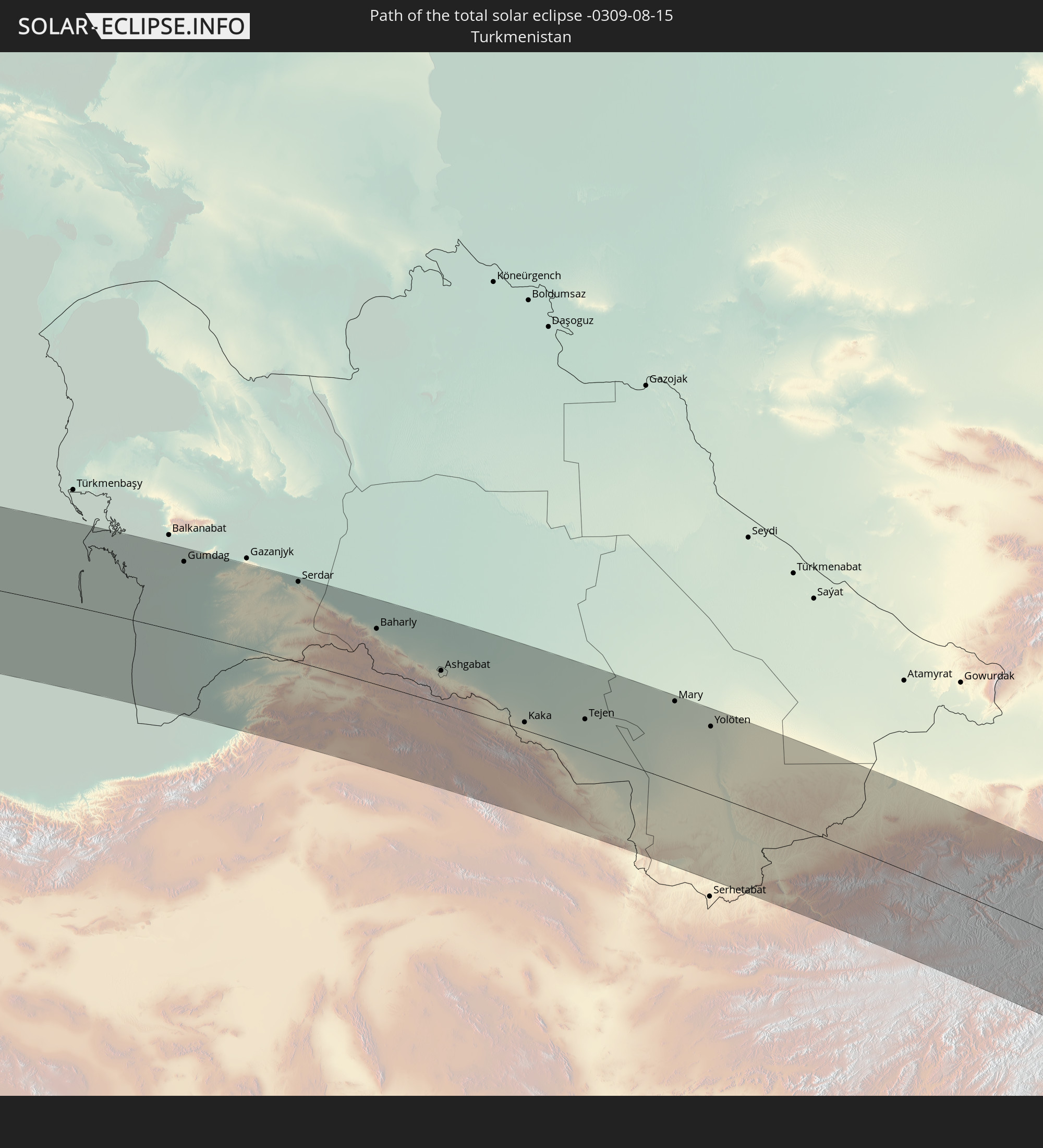 Turkmenistan
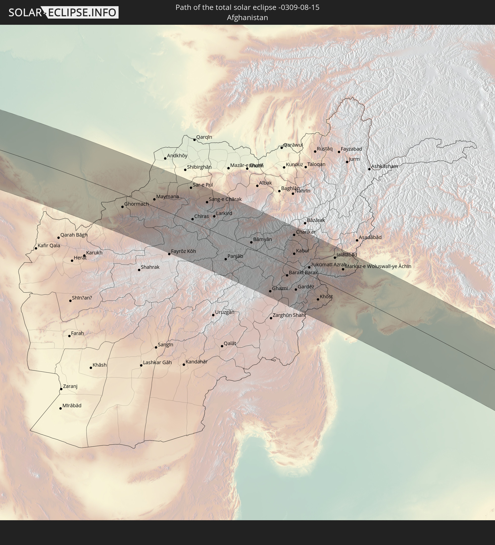 Afghanistan
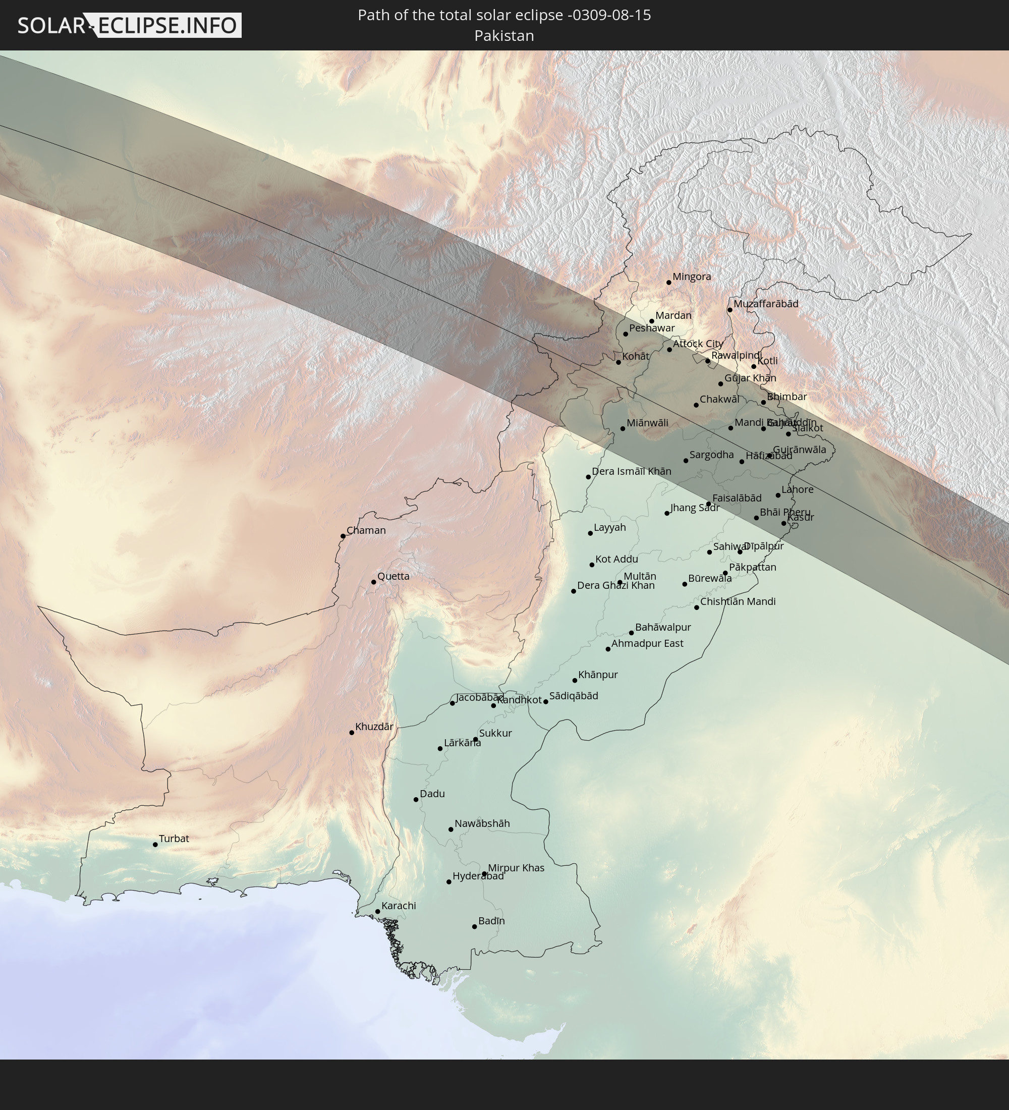 Pakistan
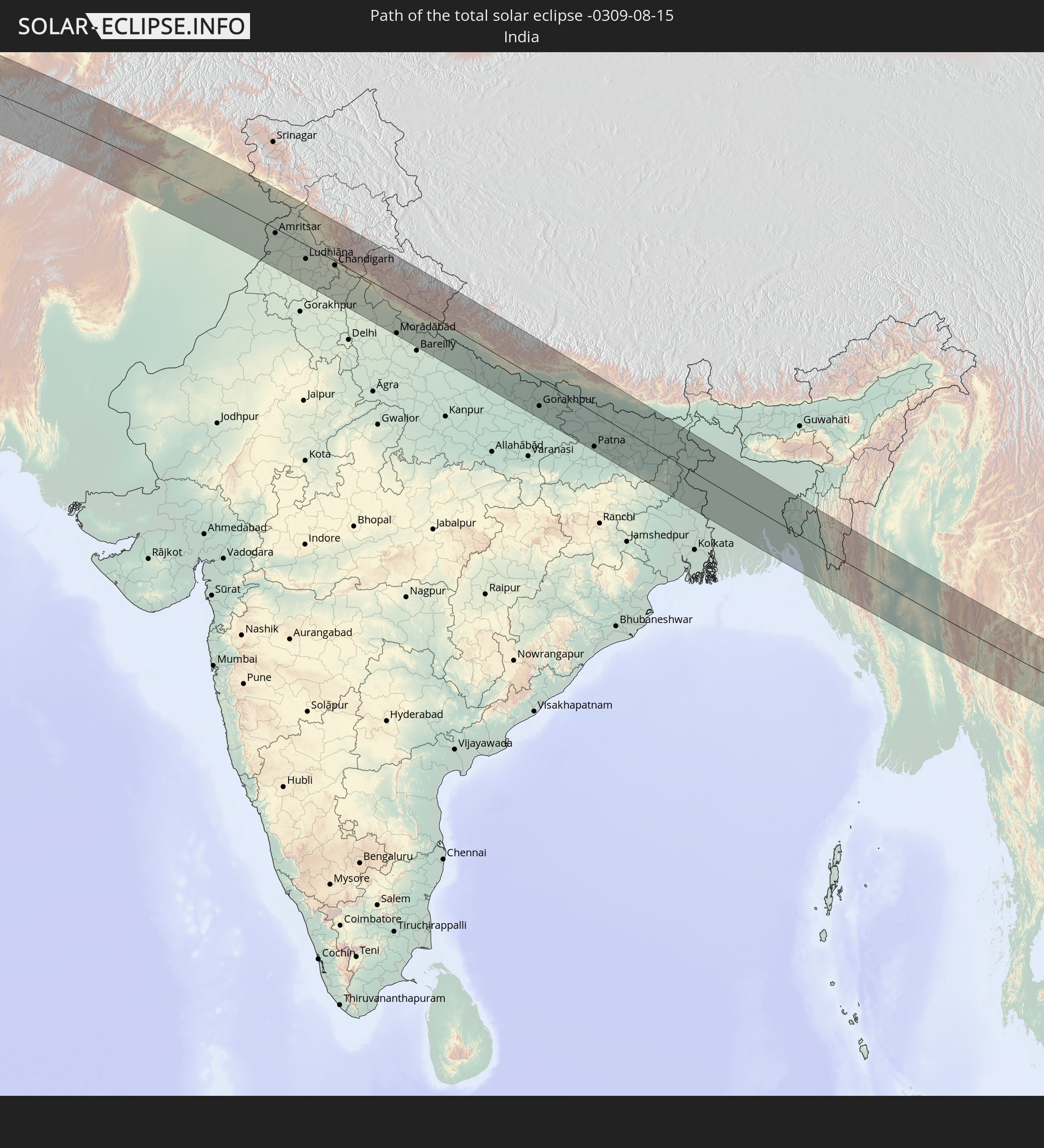 India
India
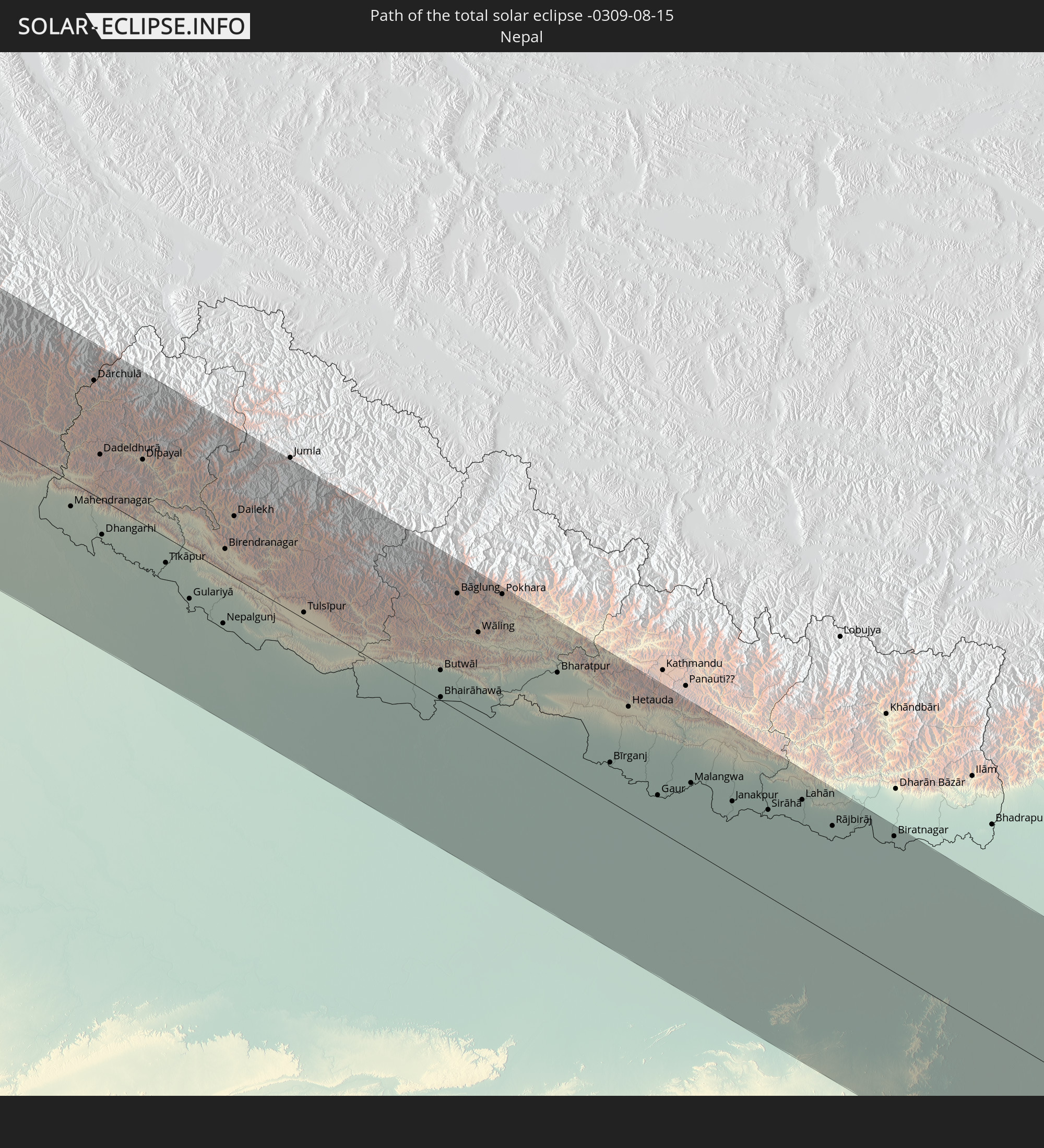 Nepal
Nepal
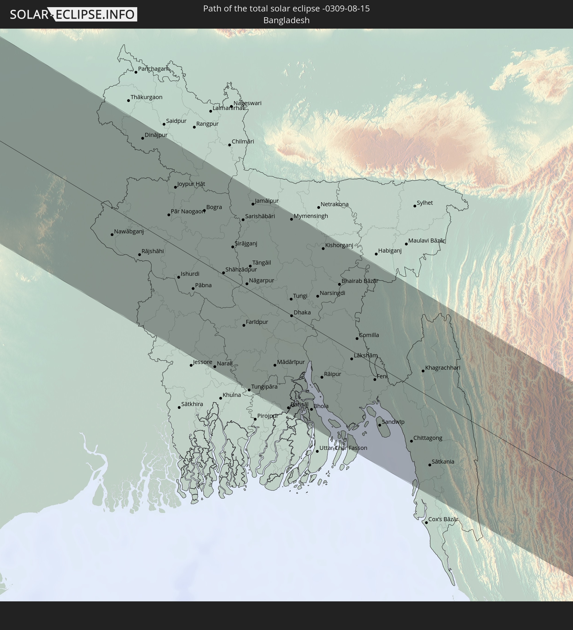 Bangladesh
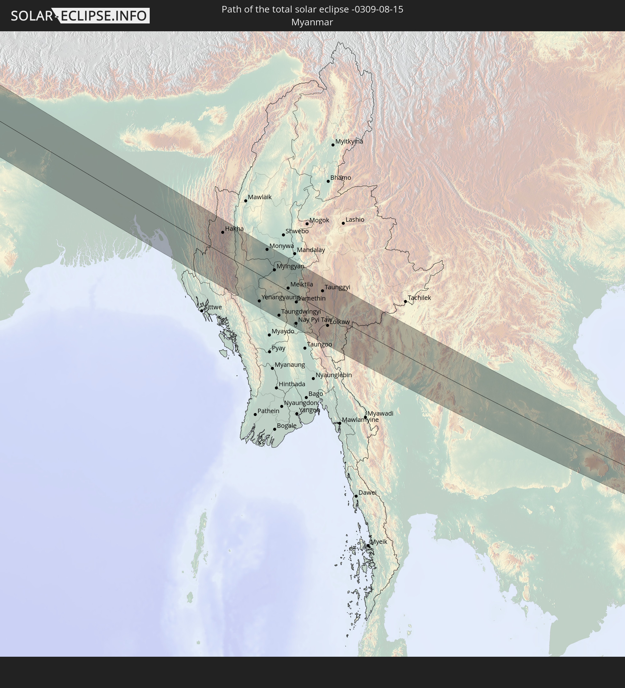 Myanmar
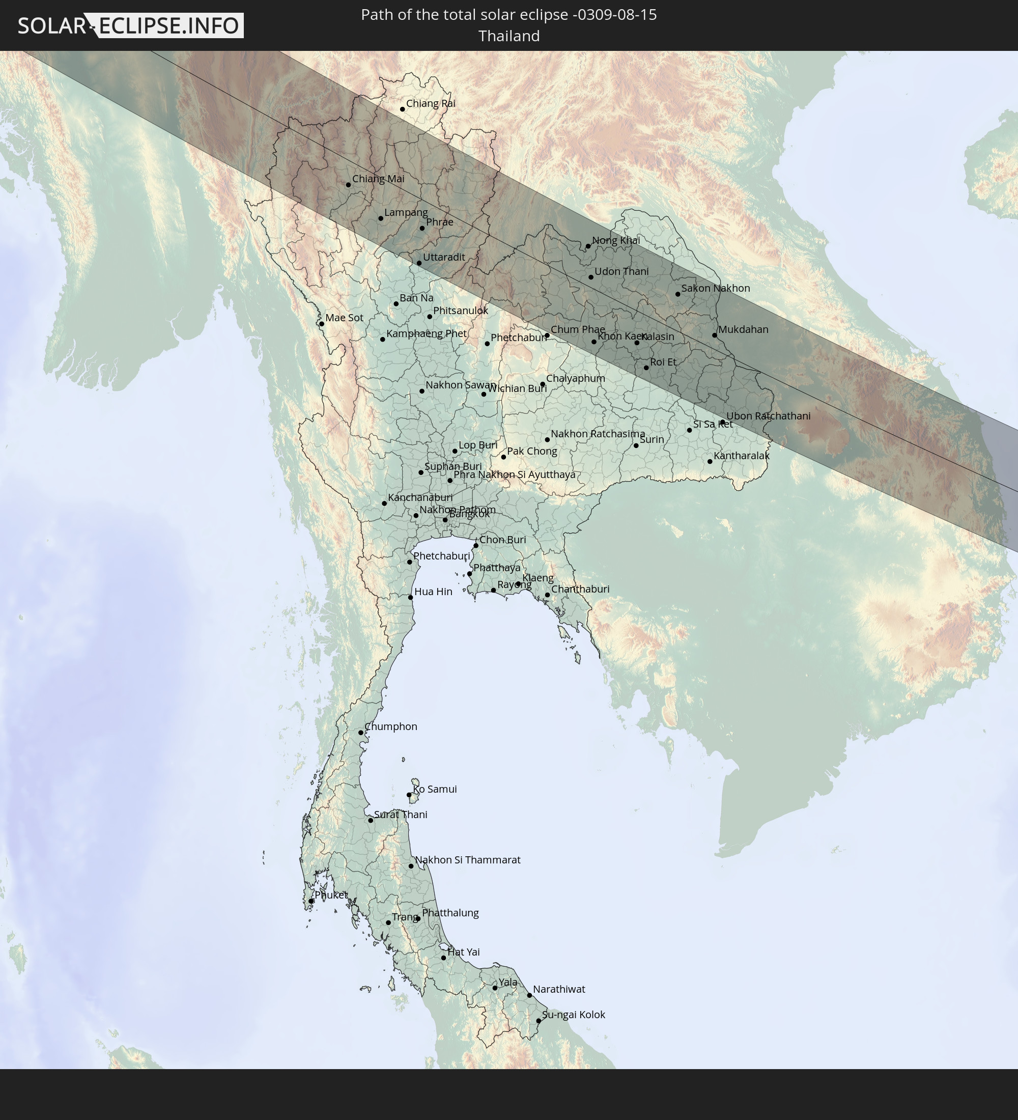 Thailand
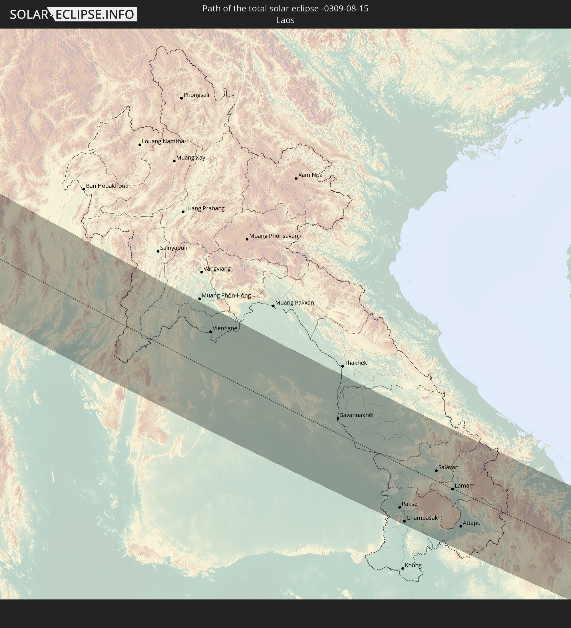 Laos
Laos
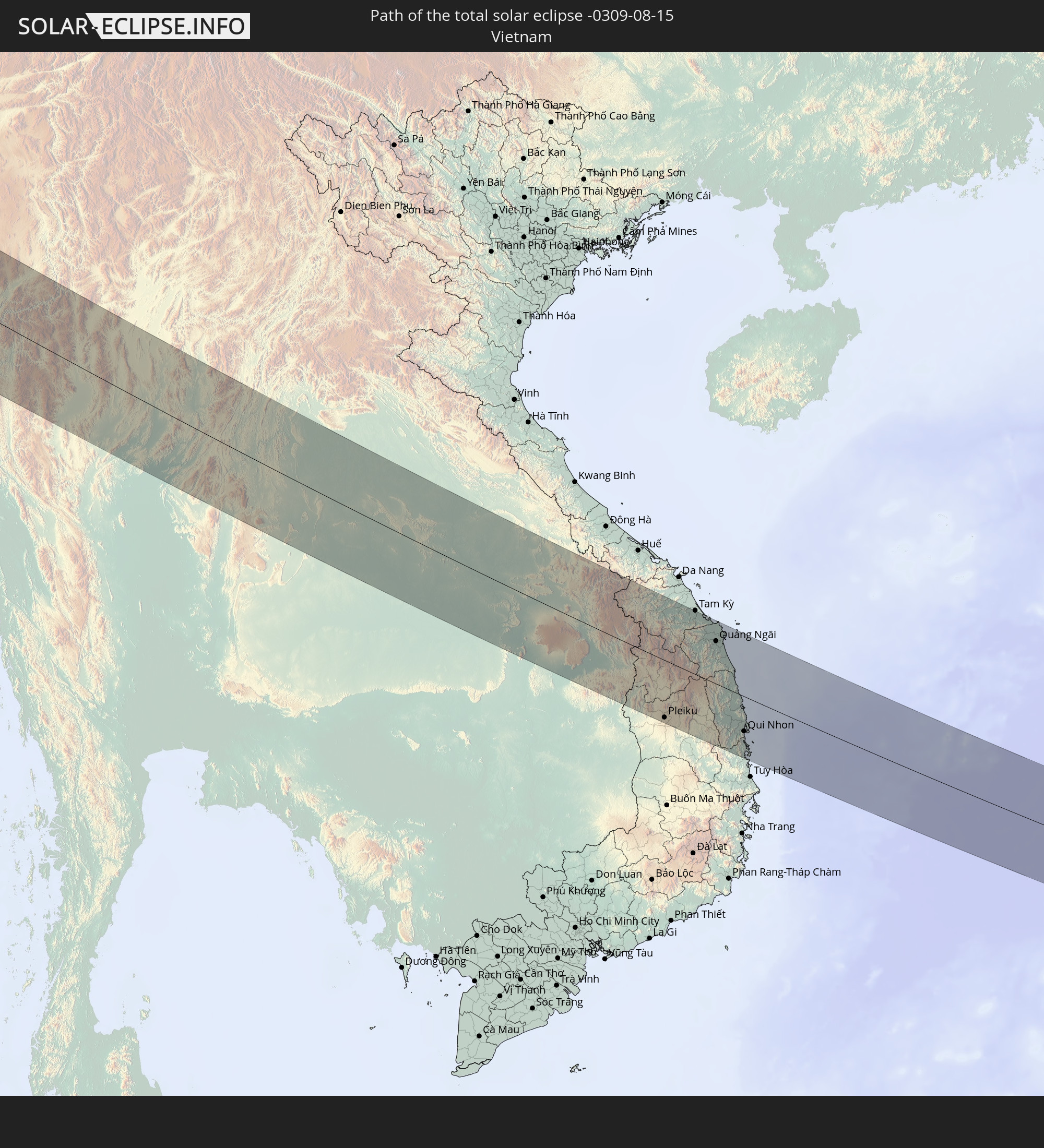 Vietnam
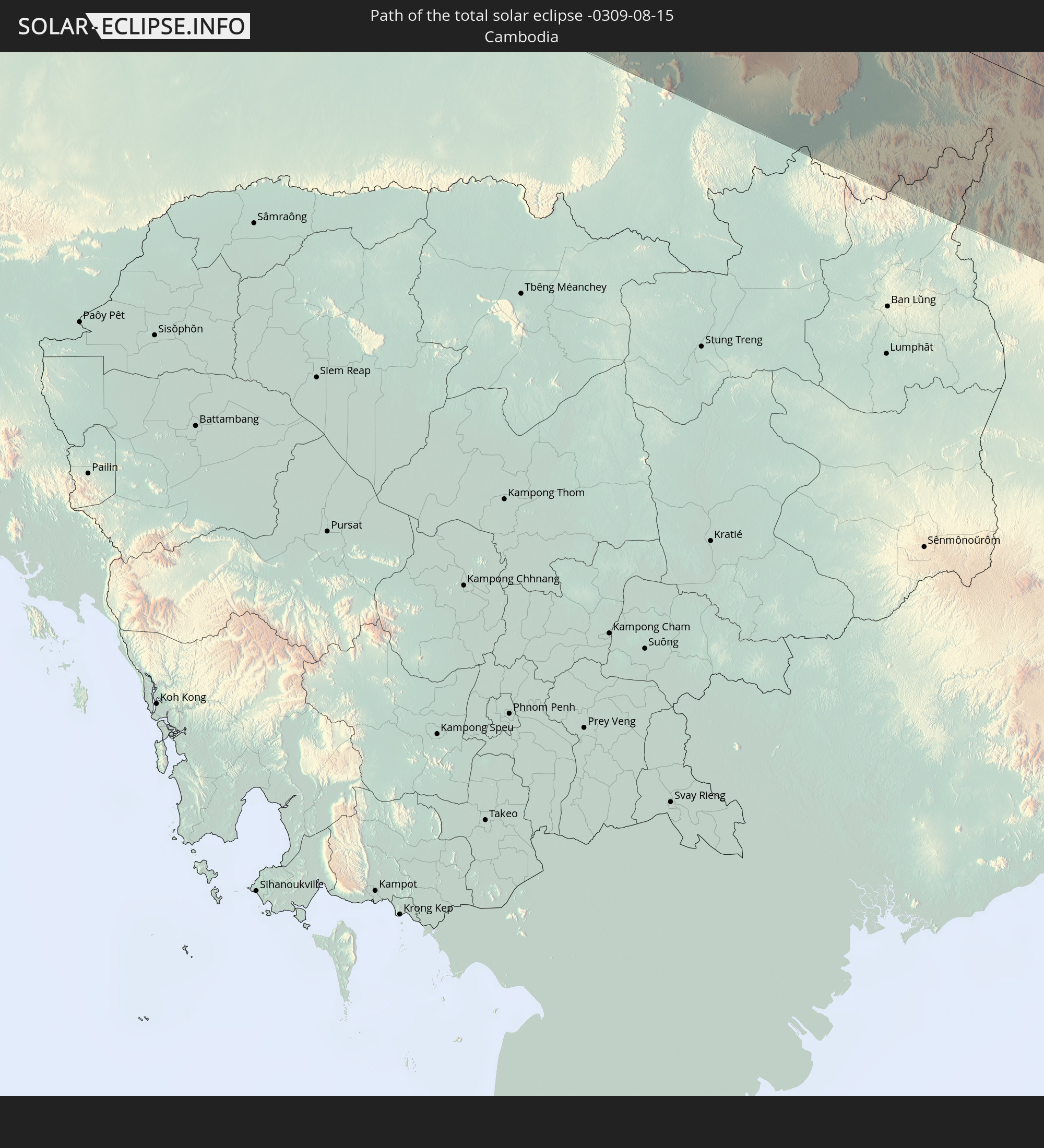 Cambodia
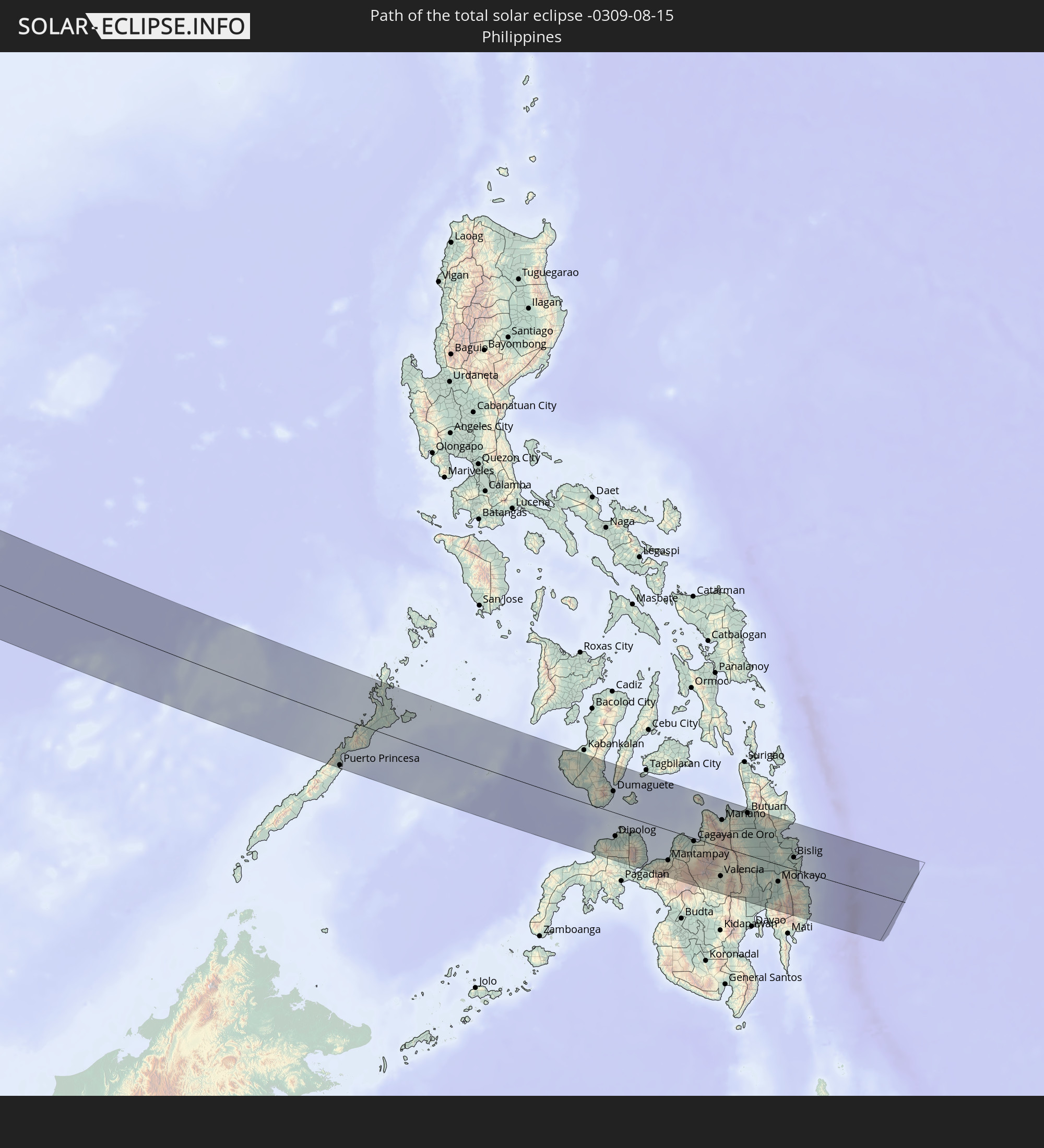 Philippines
In den folgenden Ländern ist die Sonnenfinsternis partiell zu sehen
 Russia
 Greenland
 Portugal
 Iceland
 Spain
Spain
 Mauritania
 Morocco
 Mali
Mali
 Republic of Ireland
 Svalbard and Jan Mayen
 Algeria
 United Kingdom
 Ivory Coast
 Faroe Islands
 Burkina Faso
 Gibraltar
 France
 Isle of Man
 Ghana
Ghana
 Guernsey
 Jersey
 Togo
Togo
 Niger
Niger
 Benin
Benin
 Andorra
 Belgium
 Nigeria
 Netherlands
 Norway
 Luxembourg
 Germany
 Switzerland
 Italy
Italy
 Monaco
 Tunisia
 Denmark
 Cameroon
 Libya
Libya
 Liechtenstein
 Austria
 Sweden
 Czechia
 San Marino
 Vatican City
 Slovenia
 Chad
Chad
 Croatia
 Poland
 Malta
Malta
 Central African Republic
 Bosnia and Herzegovina
 Hungary
 Slovakia
 Montenegro
 Serbia
 Albania
 Åland Islands
 Greece
 Romania
 Republic of Macedonia
 Finland
 Lithuania
 Latvia
 Estonia
 Sudan
Sudan
 Ukraine
 Bulgaria
 Belarus
 Egypt
Egypt
 Turkey
 Moldova
 Cyprus
 Ethiopia
 State of Palestine
 Israel
 Saudi Arabia
 Jordan
 Lebanon
 Syria
Syria
 Eritrea
 Iraq
Iraq
 Georgia
 Somalia
 Djibouti
 Yemen
Yemen
 Armenia
 Iran
Iran
 Azerbaijan
 Kazakhstan
 Kuwait
 Bahrain
 Qatar
Qatar
 United Arab Emirates
 Oman
Oman
 Turkmenistan
 Uzbekistan
 Afghanistan
 Pakistan
 Tajikistan
 India
India
 Kyrgyzstan
 Maldives
 China
China
 Sri Lanka
 Nepal
Nepal
 Mongolia
 Bangladesh
 Bhutan
 Myanmar
 Indonesia
 Cocos Islands
 Thailand
 Malaysia
 Laos
Laos
 Vietnam
 Cambodia
 Singapore
 Christmas Island
 Australia
 Macau
Macau
 Hong Kong
 Brunei
 Taiwan
 Philippines
 Japan
Japan
 North Korea
 South Korea
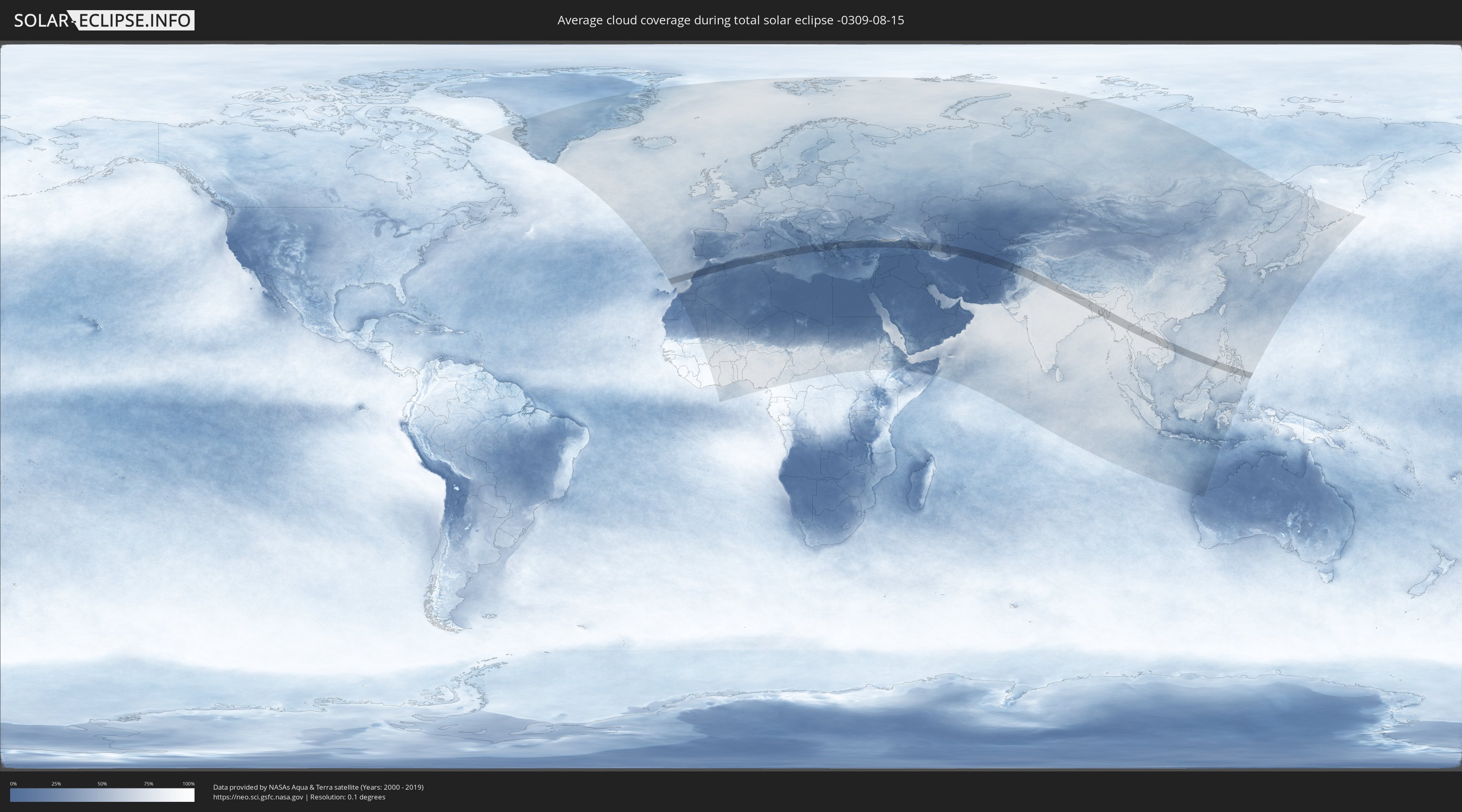
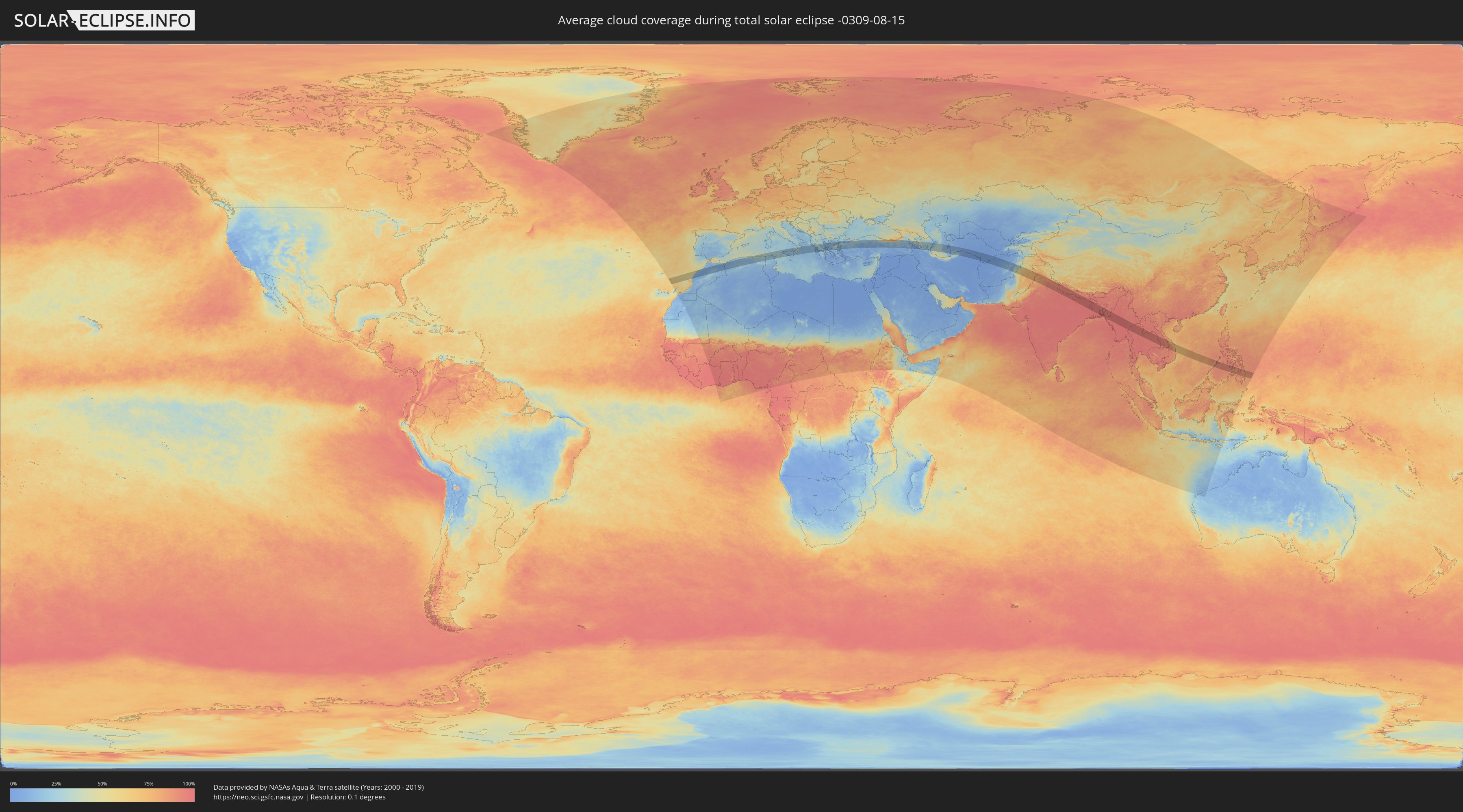
How will be the weather during the total solar eclipse on 08/15/-0309?
Where is the best place to see the total solar eclipse of 08/15/-0309?
The following maps show the average cloud coverage for the day of the total solar eclipse.
With the help of these maps, it is possible to find the place along the eclipse path, which has the best
chance of a cloudless sky.
Nevertheless, you should consider local circumstances and inform about the weather of your chosen
observation site.
The data is provided by NASAs satellites
AQUA and TERRA.
The cloud maps are averaged over a period of 19 years (2000 - 2019).
Detailed country maps
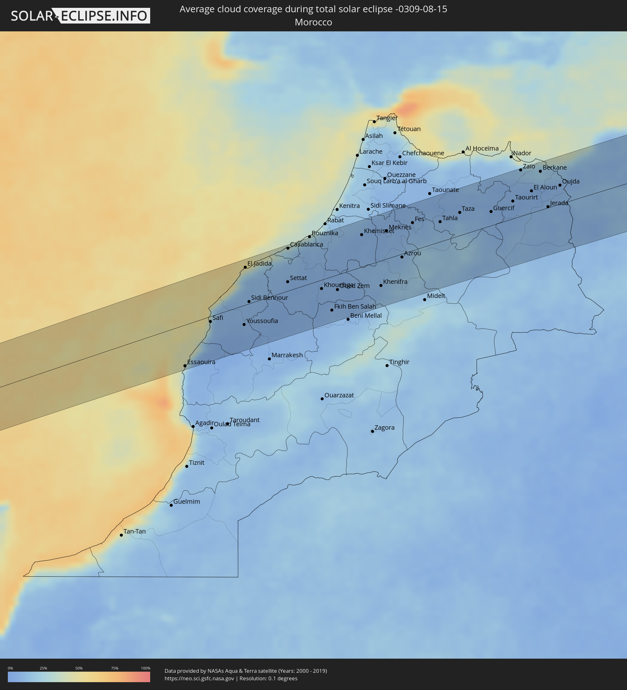 Morocco
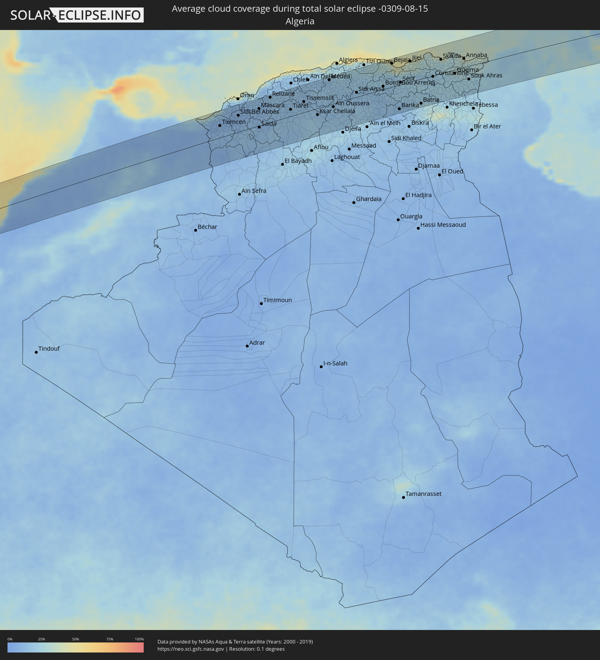 Algeria
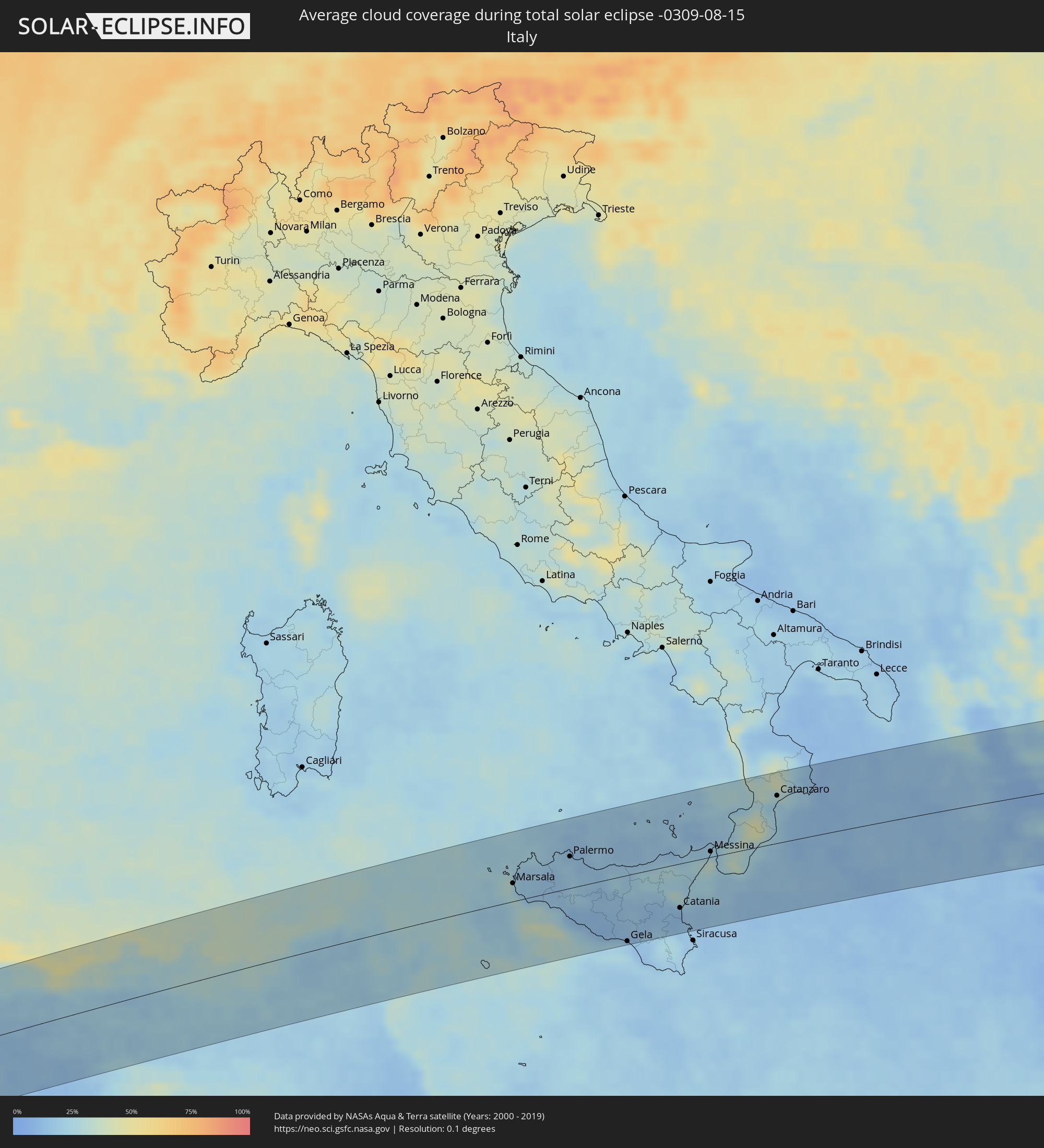 Italy
Italy
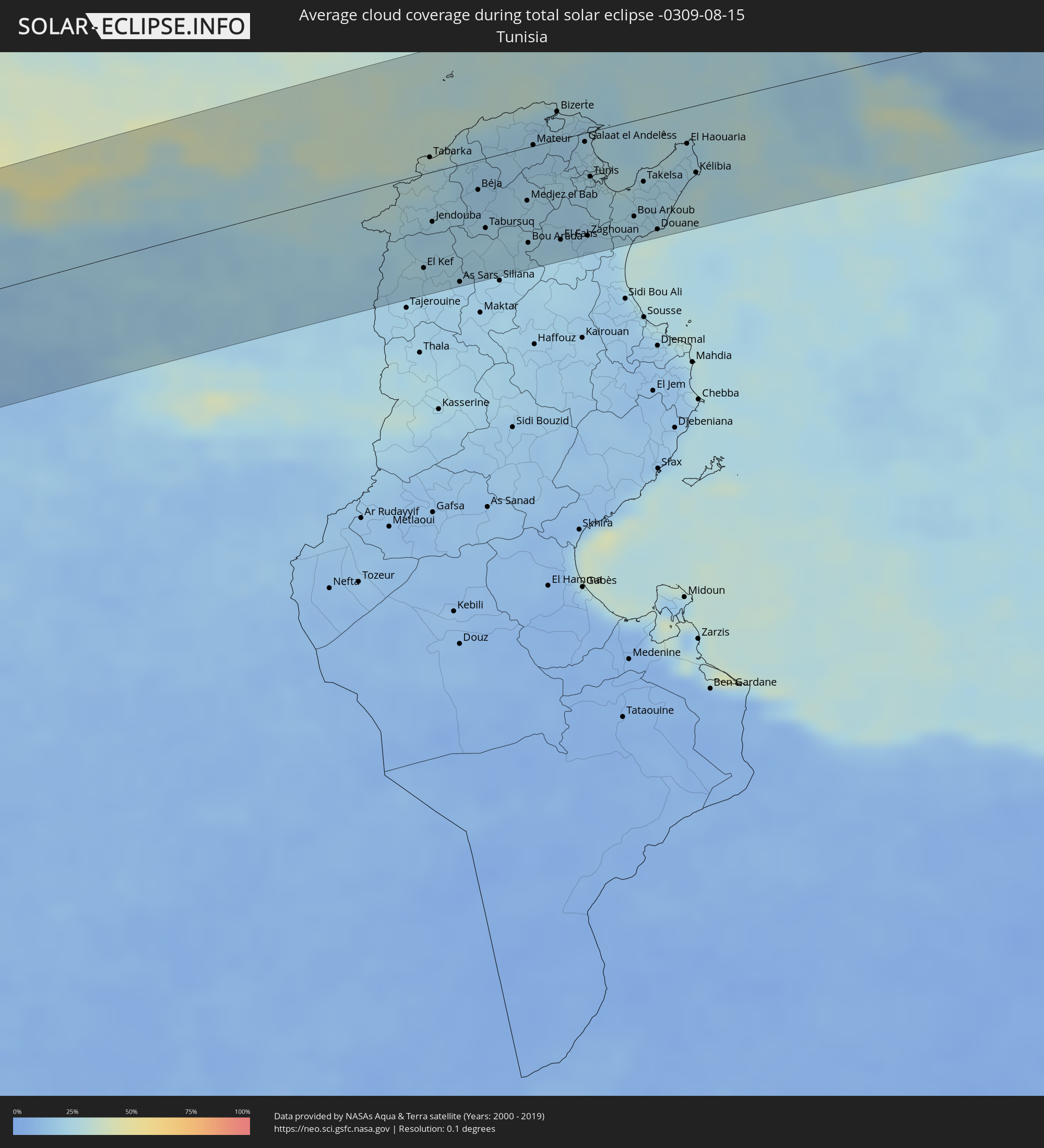 Tunisia
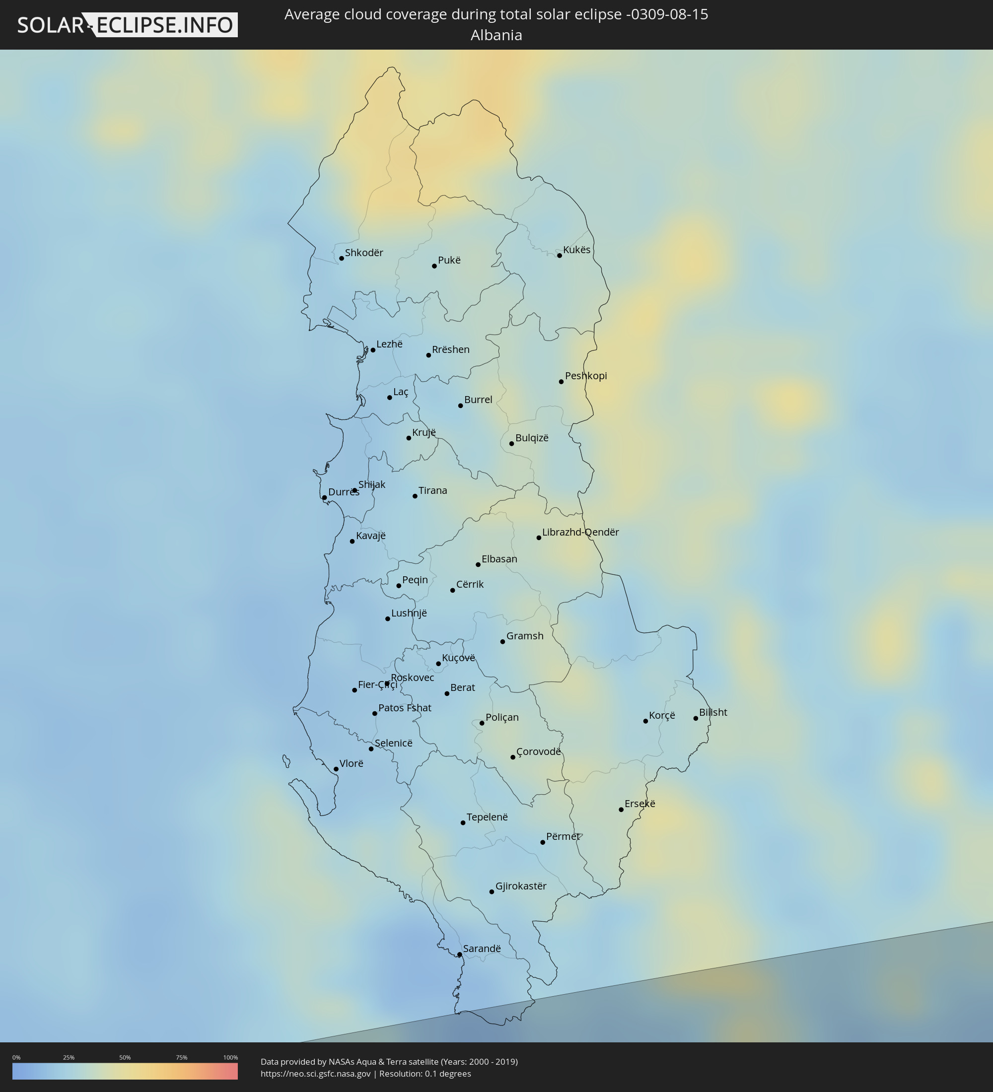 Albania
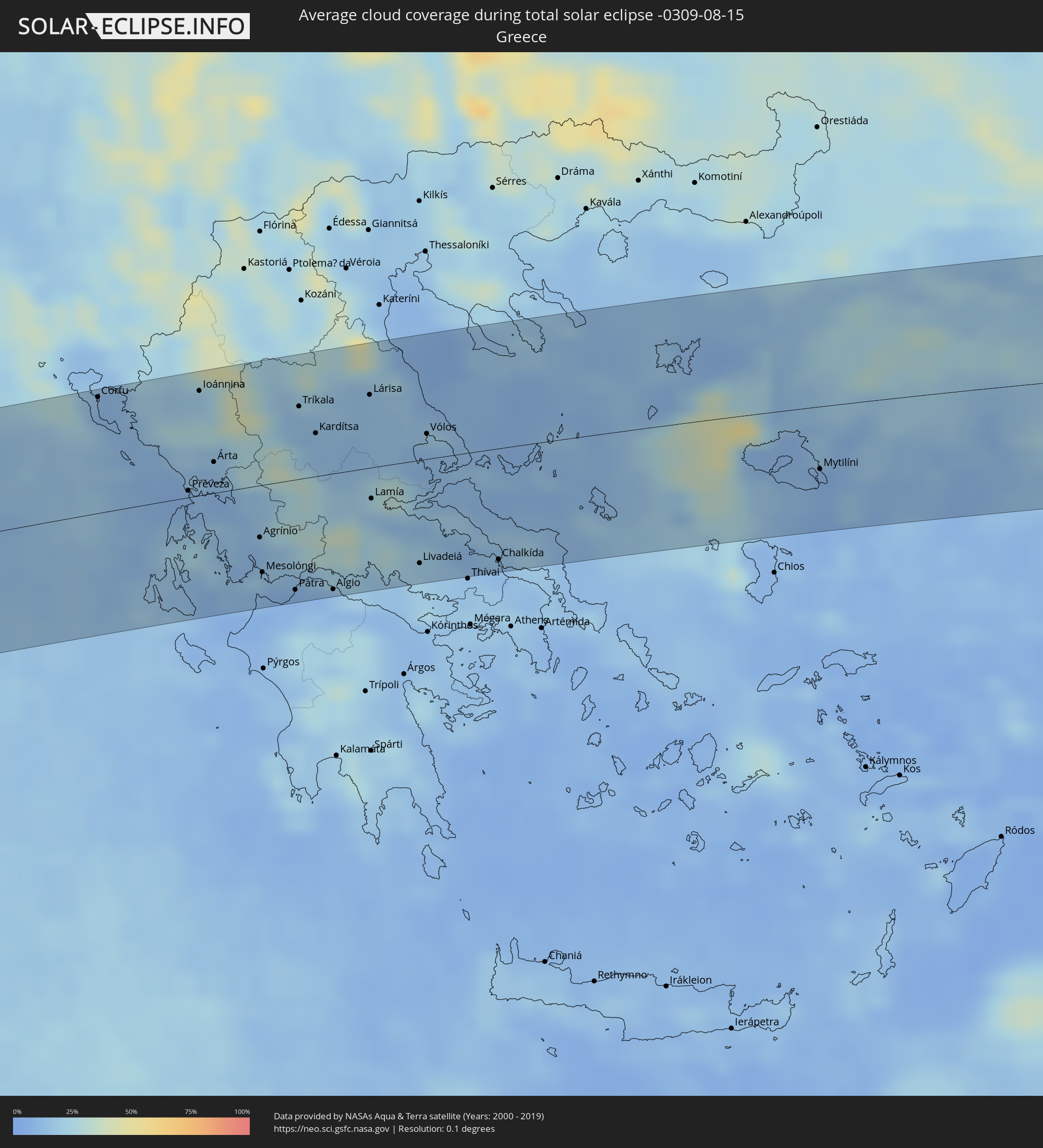 Greece
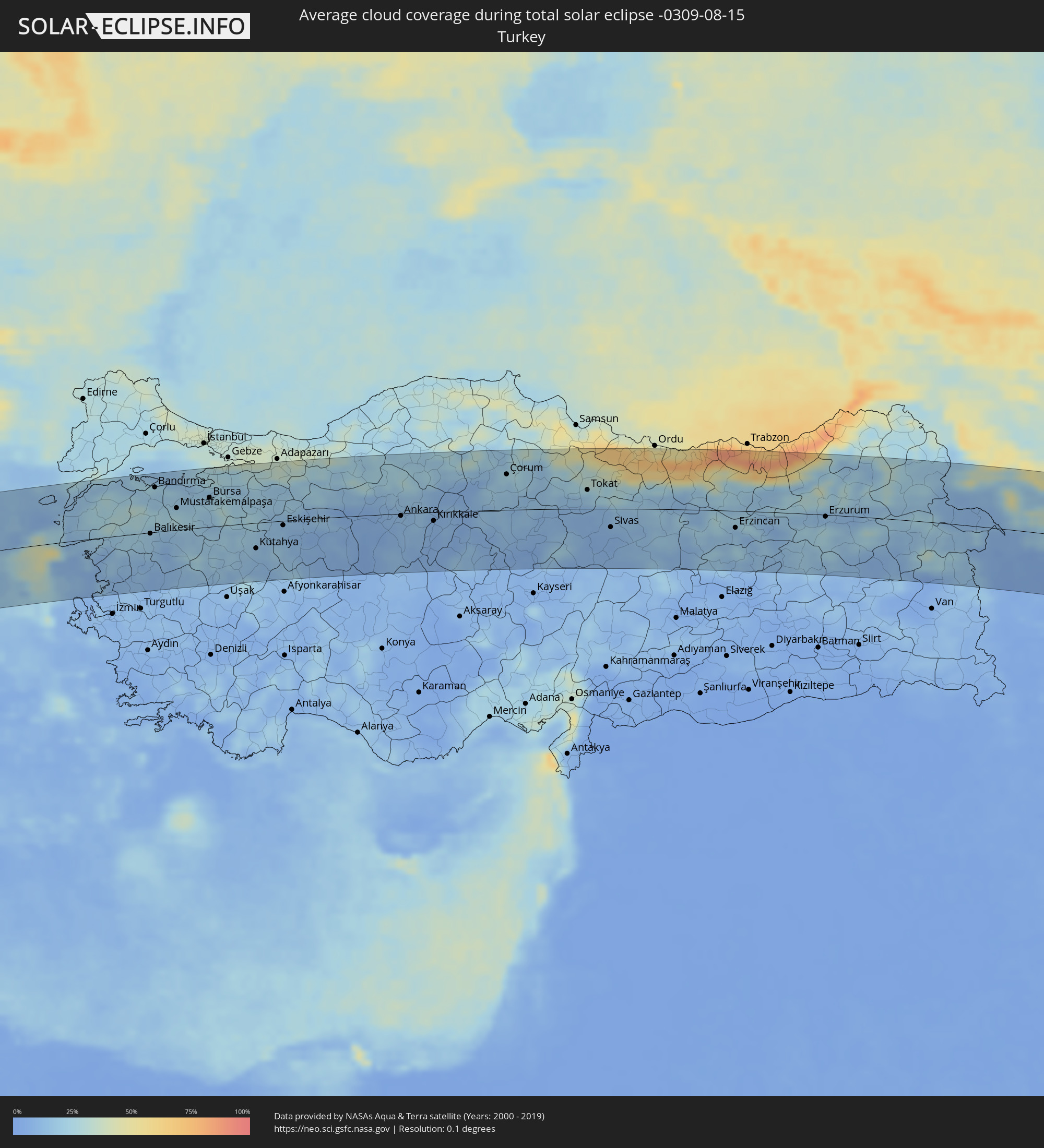 Turkey
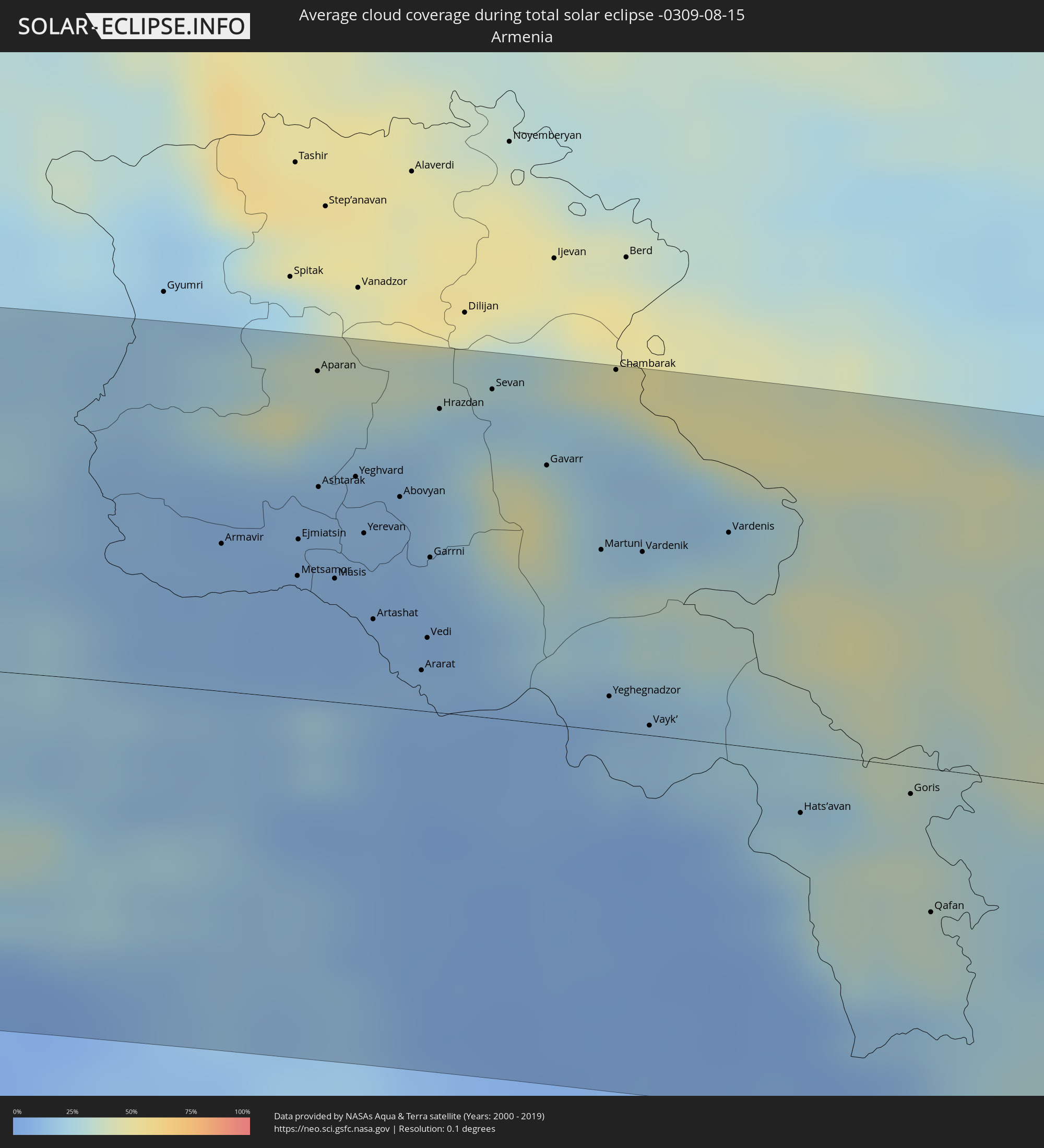 Armenia
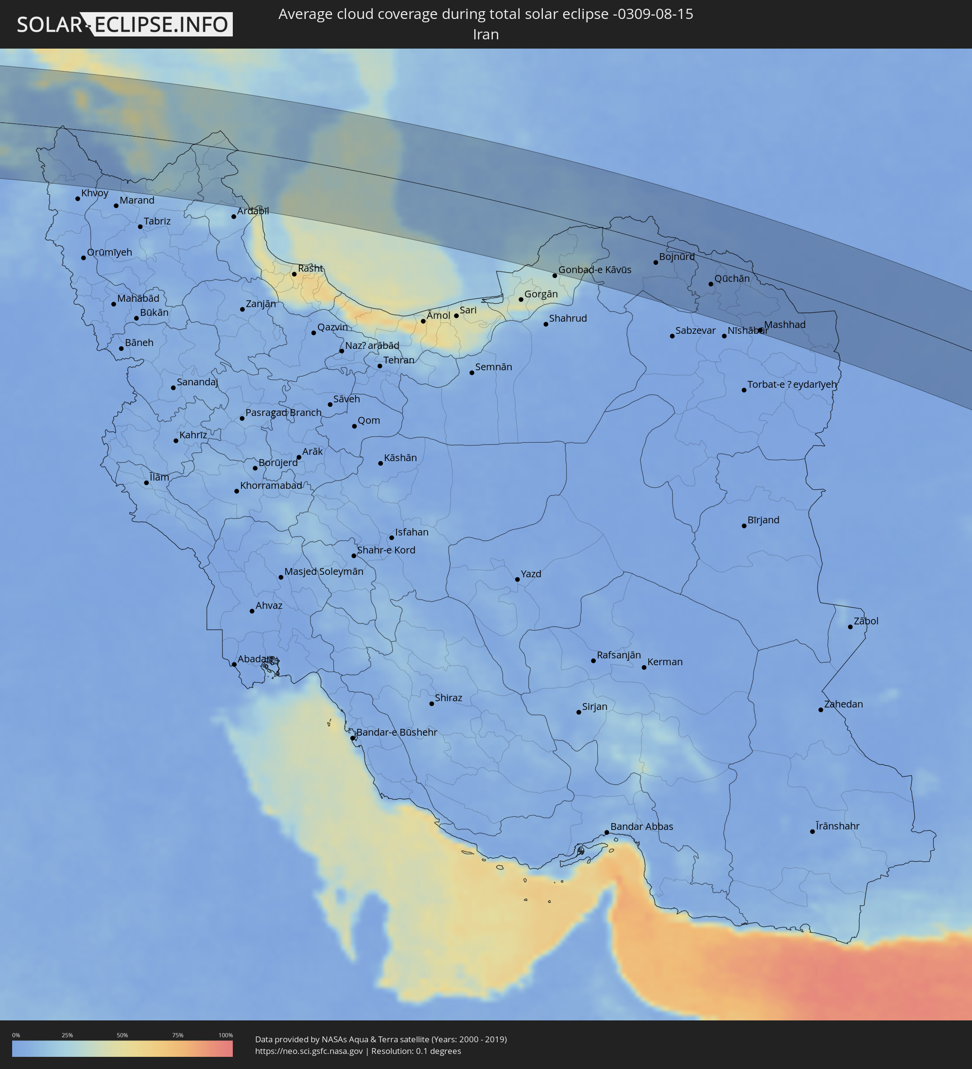 Iran
Iran
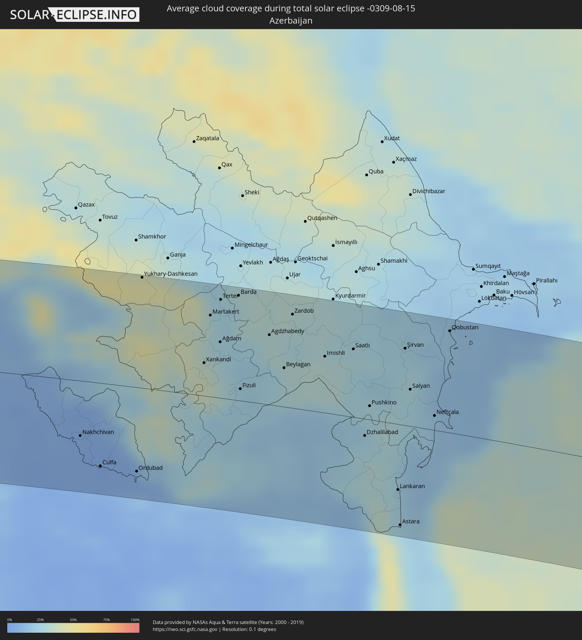 Azerbaijan
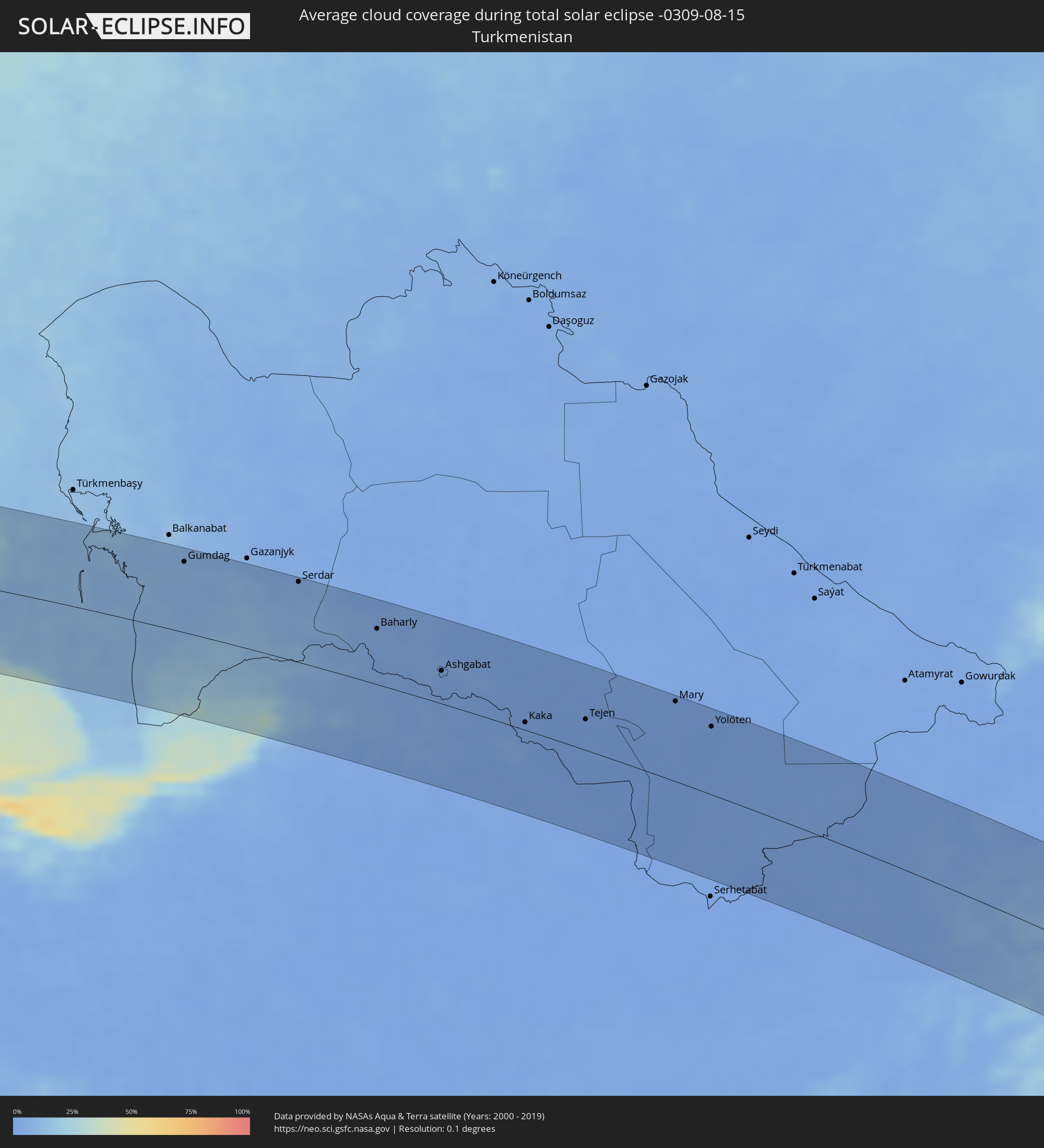 Turkmenistan
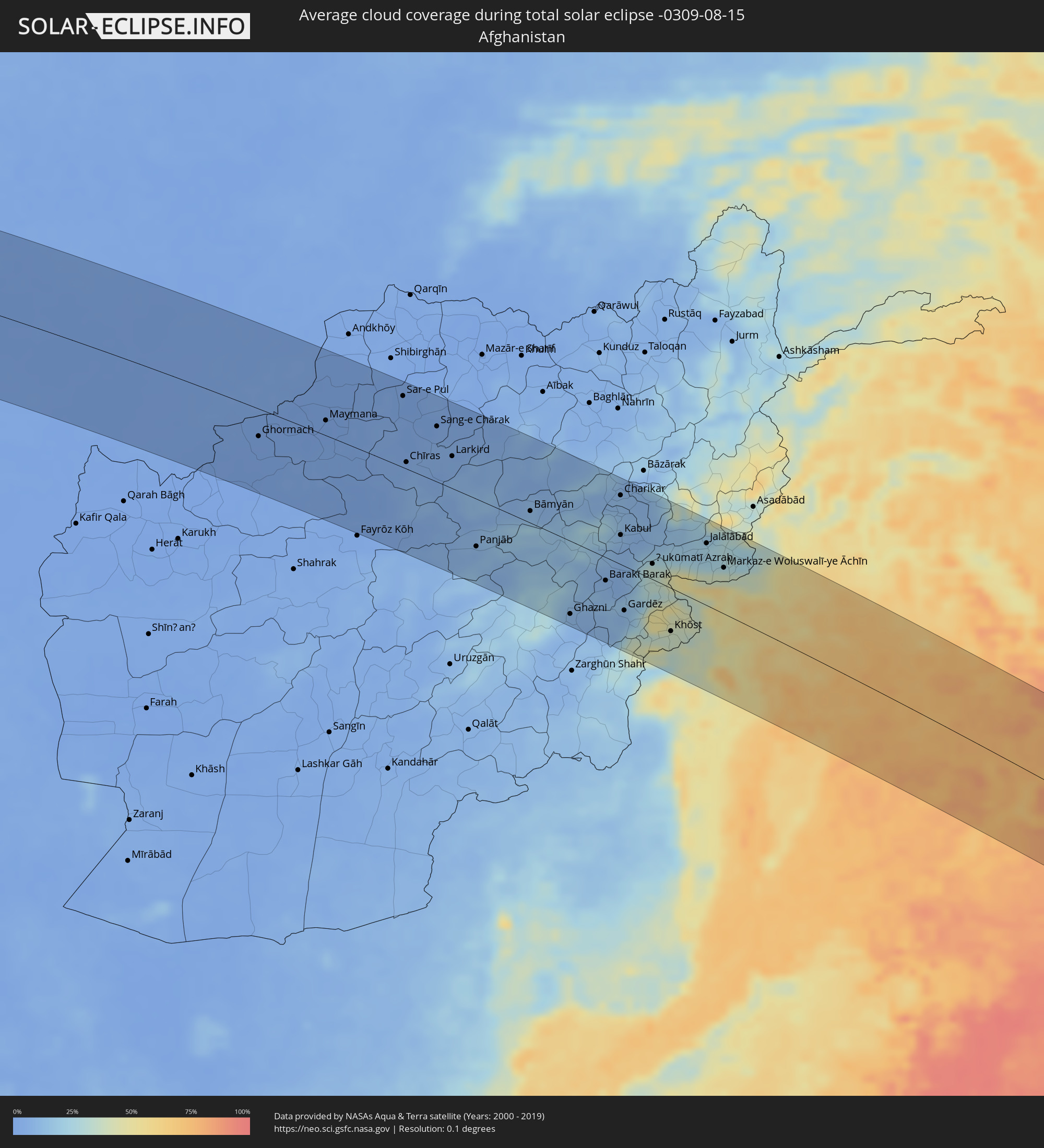 Afghanistan
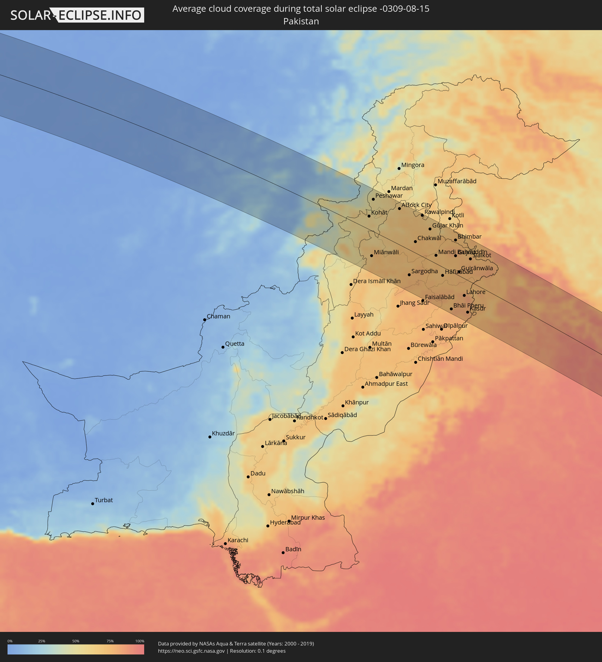 Pakistan
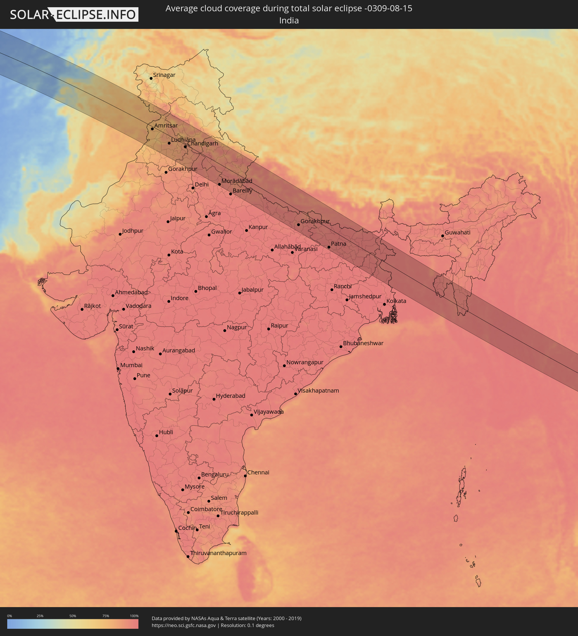 India
India
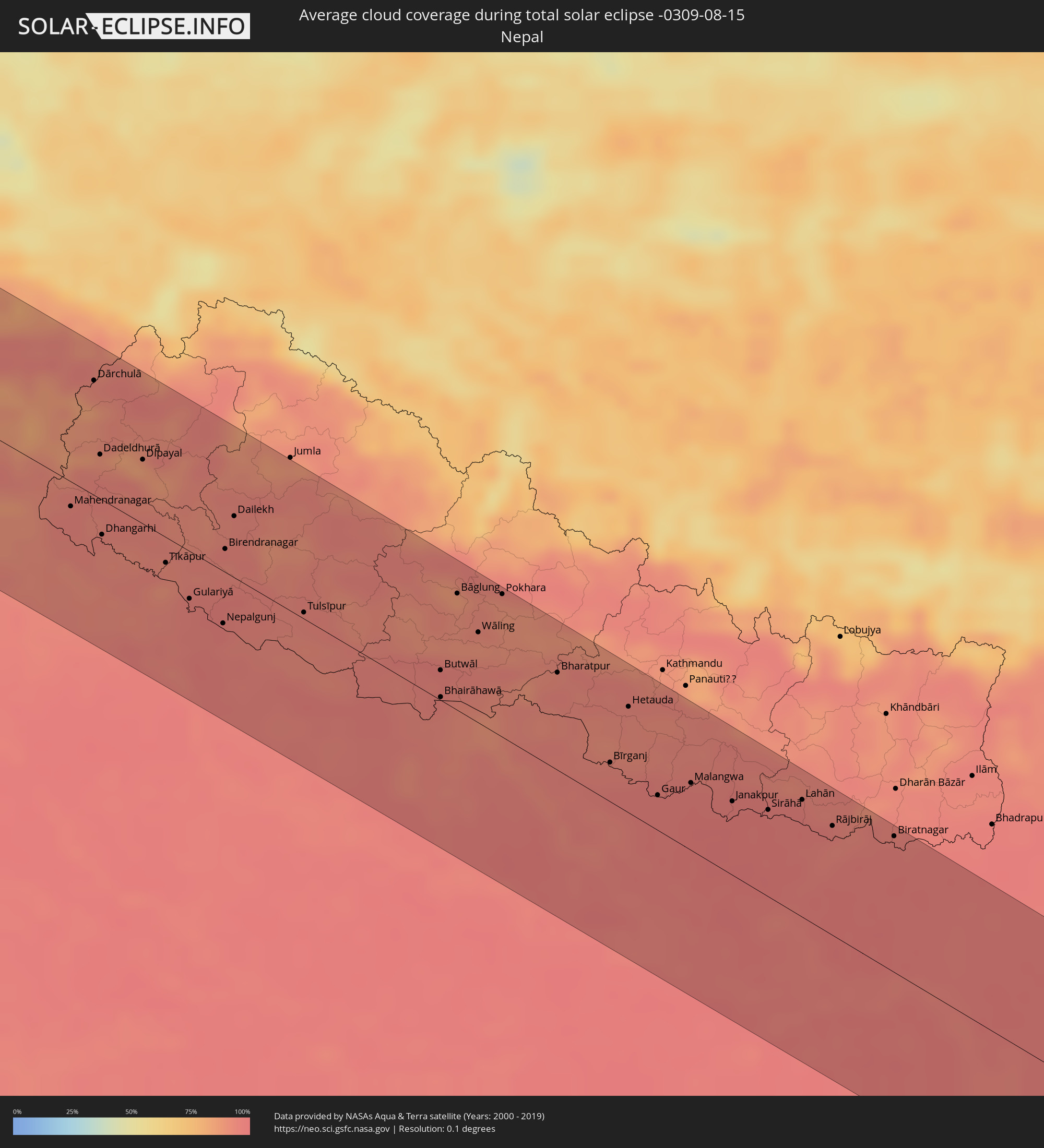 Nepal
Nepal
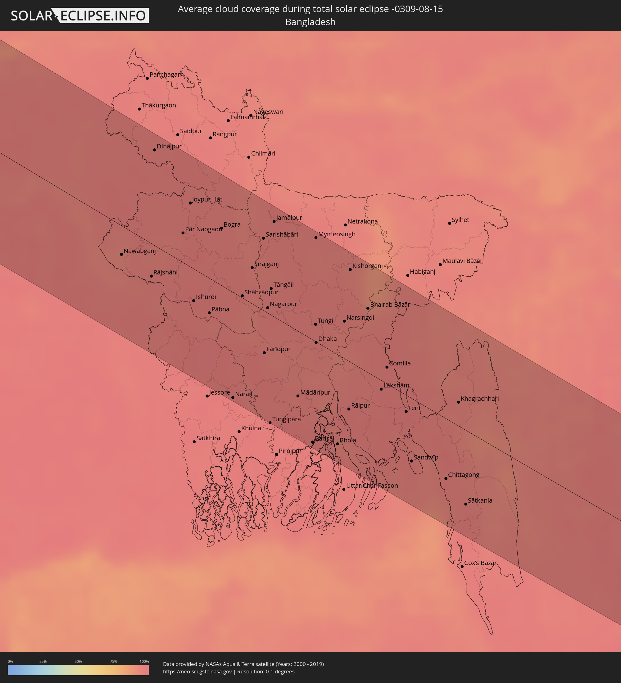 Bangladesh
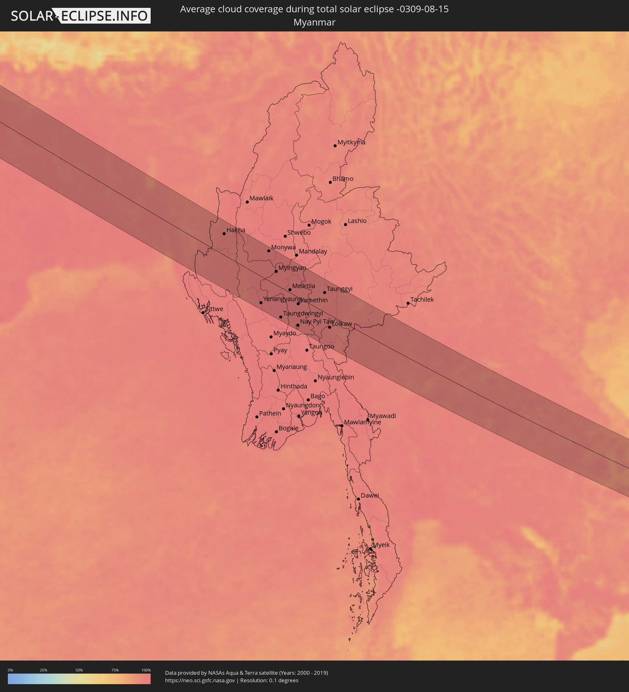 Myanmar
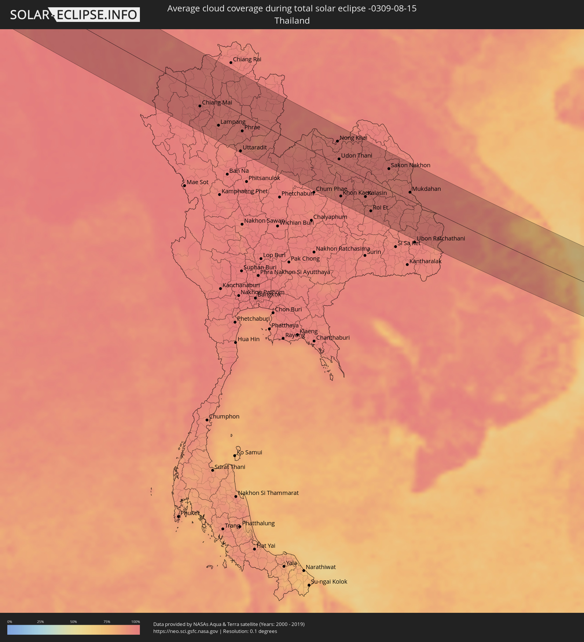 Thailand
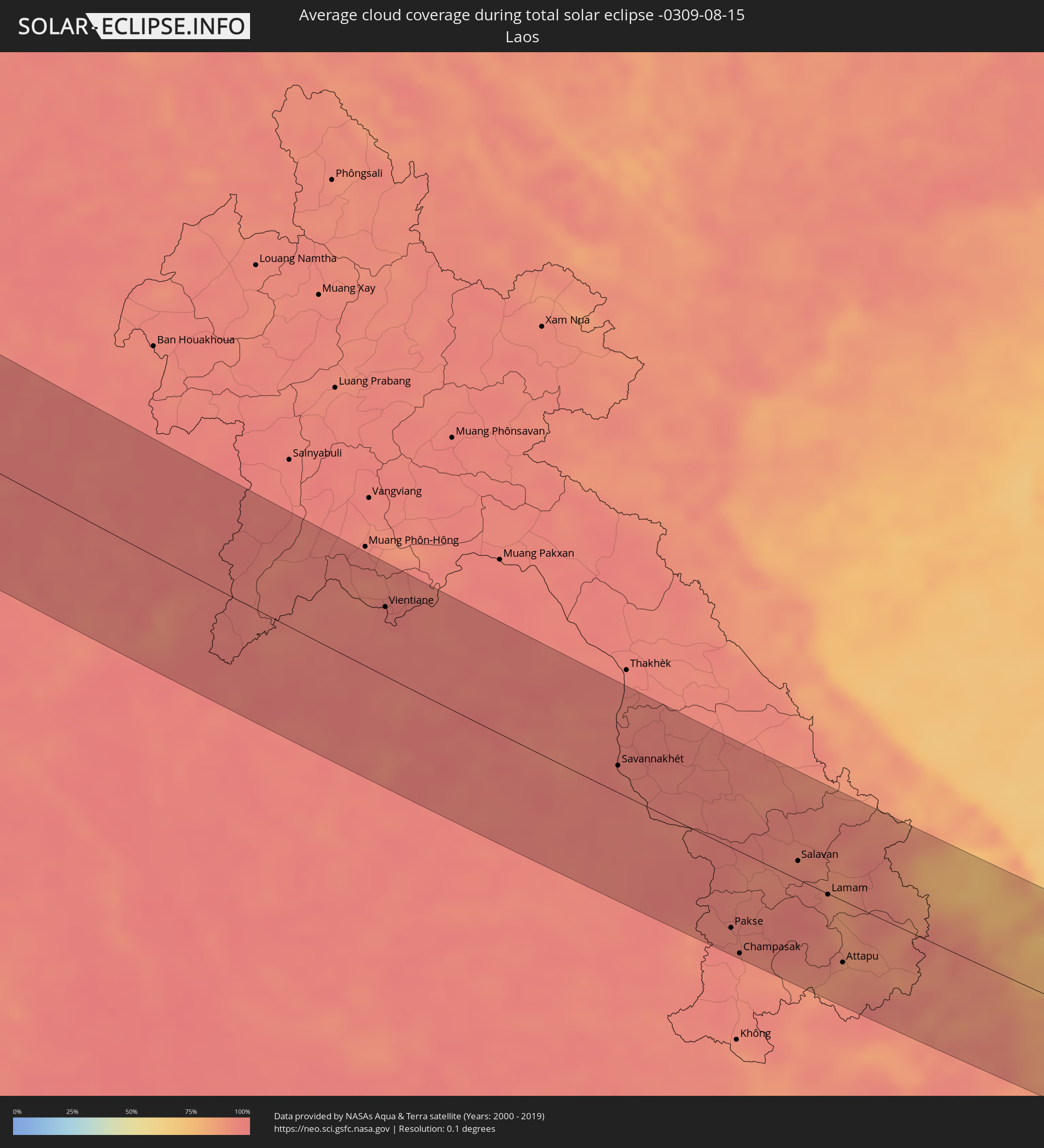 Laos
Laos
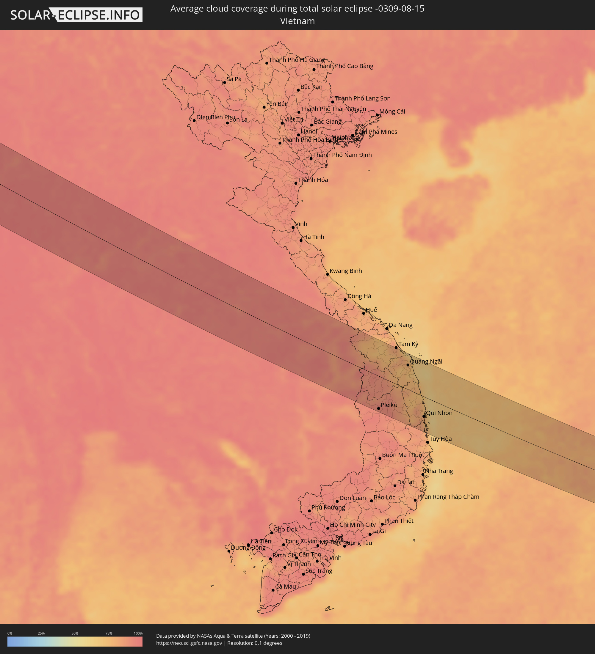 Vietnam
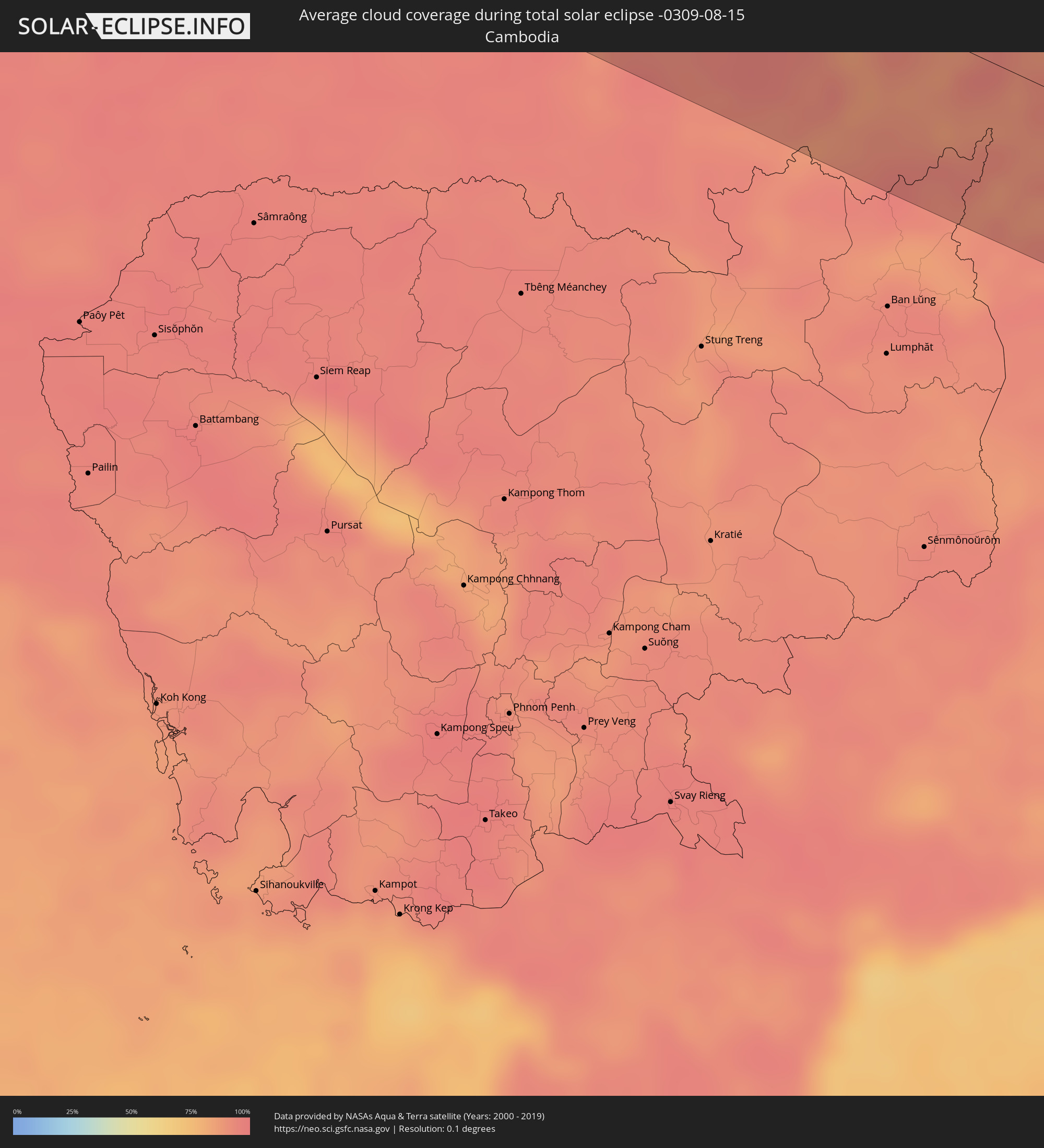 Cambodia
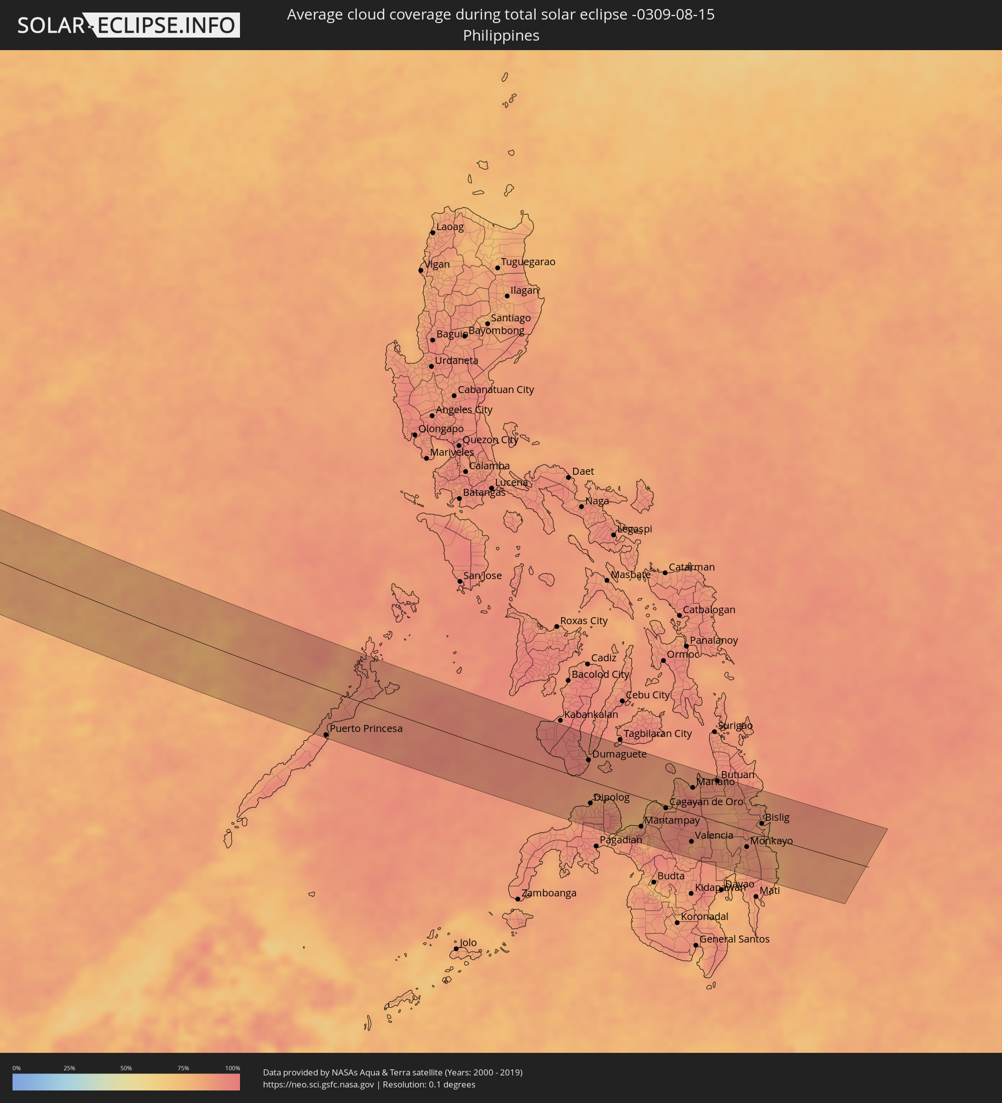 Philippines
Cities inside the path of the eclipse
The following table shows all locations with a population of more than 5,000 inside the eclipse path. Cities which have more than 100,000 inhabitants are marked bold. A click at the locations opens a detailed map.
| City | Type | Eclipse duration | Local time of max. eclipse | Distance to central line | Ø Cloud coverage |
|
Safi, Doukkala-Abda
|
total | - | 05:54:11 UTC-00:30 | 10 km | 14% |
|
El Jadida, Doukkala-Abda
|
total | - | 05:54:56 UTC-00:30 | 69 km | 33% |
|
Settat, Chaouia-Ouardigha
|
total | - | 05:54:42 UTC-00:30 | 17 km | 7% |
|
Casablanca, Grand Casablanca
|
total | - | 05:55:11 UTC-00:30 | 79 km | 19% |
|
Mohammedia, Grand Casablanca
|
total | - | 05:55:16 UTC-00:30 | 82 km | 18% |
|
Khouribga, Chaouia-Ouardigha
|
total | - | 05:54:36 UTC-00:30 | 17 km | 7% |
|
Meknès, Meknès-Tafilalet
|
total | - | 05:55:30 UTC-00:30 | 52 km | 9% |
|
Fes, Fès-Boulemane
|
total | - | 05:55:39 UTC-00:30 | 51 km | 10% |
|
Taza, Taza-Al Hoceima-Taounate
|
total | - | 05:55:53 UTC-00:30 | 42 km | 10% |
|
Oujda, Oriental
|
total | - | 05:56:34 UTC-00:30 | 34 km | 9% |
|
Sidi Bel Abbès, Sidi Bel Abbès
|
total | - | 06:36:56 UTC+00:09 | 54 km | 10% |
|
Tiaret, Tiaret
|
total | - | 06:37:32 UTC+00:09 | 22 km | 14% |
|
Bordj Bou Arreridj, Bordj Bou Arréridj
|
total | - | 06:39:16 UTC+00:09 | 10 km | 15% |
|
Bejaïa, Béjaïa
|
total | - | 06:40:02 UTC+00:09 | 76 km | 41% |
|
Sétif, Sétif
|
total | - | 06:39:38 UTC+00:09 | 7 km | 20% |
|
Batna, Batna
|
total | - | 06:39:21 UTC+00:09 | 79 km | 26% |
|
Constantine, Constantine
|
total | - | 06:40:17 UTC+00:09 | 3 km | 20% |
|
Skikda, Skikda
|
total | - | 06:40:54 UTC+00:09 | 45 km | 29% |
|
Annaba, Annaba
|
total | - | 06:41:19 UTC+00:09 | 28 km | 33% |
|
Souk Ahras, Souk Ahras
|
total | - | 06:40:50 UTC+00:09 | 42 km | 25% |
|
El Kef, Kef
|
total | - | 06:41:06 UTC+00:09 | 71 km | 22% |
|
Jendouba, Jundūbah
|
total | - | 06:41:26 UTC+00:09 | 38 km | 21% |
|
Béja, Bājah
|
total | - | 06:41:51 UTC+00:09 | 23 km | 19% |
|
Menzel Bourguiba, Banzart
|
total | - | 06:42:35 UTC+00:09 | 10 km | 21% |
|
Bizerte, Banzart
|
total | - | 06:42:45 UTC+00:09 | 21 km | 24% |
|
La Mohammedia, Tūnis
|
total | - | 06:42:20 UTC+00:09 | 49 km | 22% |
|
Tunis, Tūnis
|
total | - | 06:42:29 UTC+00:09 | 34 km | 23% |
|
Al Marsá, Tūnis
|
total | - | 06:42:37 UTC+00:09 | 31 km | 28% |
|
Hammam-Lif, Tūnis
|
total | - | 06:42:29 UTC+00:09 | 48 km | 24% |
|
Douane, Nābul
|
total | - | 06:42:28 UTC+00:09 | 87 km | 30% |
|
Marsala, Sicily
|
total | - | 07:35:25 UTC+01:00 | 24 km | 29% |
|
Trapani, Sicily
|
total | - | 07:35:41 UTC+01:00 | 46 km | 21% |
|
Palermo, Sicily
|
total | - | 07:36:19 UTC+01:00 | 43 km | 20% |
|
Bagheria, Sicily
|
total | - | 07:36:23 UTC+01:00 | 33 km | 15% |
|
Caltanissetta, Sicily
|
total | - | 07:36:13 UTC+01:00 | 41 km | 14% |
|
Gela, Sicily
|
total | - | 07:35:57 UTC+01:00 | 90 km | 21% |
|
Catania, Sicily
|
total | - | 07:36:56 UTC+01:00 | 60 km | 13% |
|
Messina, Sicily
|
total | - | 07:37:57 UTC+01:00 | 7 km | 34% |
|
Lamezia Terme, Calabria
|
total | - | 07:39:15 UTC+01:00 | 78 km | 31% |
|
Catanzaro, Calabria
|
total | - | 07:39:24 UTC+01:00 | 64 km | 21% |
|
Ioánnina, Epirus
|
total | - | 08:18:40 UTC+01:34 | 82 km | 20% |
|
Agrínio, West Greece
|
total | - | 08:18:16 UTC+01:34 | 41 km | 10% |
|
Pátra, West Greece
|
total | - | 08:18:15 UTC+01:34 | 87 km | 8% |
|
Tríkala, Thessaly
|
total | - | 08:19:27 UTC+01:34 | 57 km | 13% |
|
Kardítsa, Thessaly
|
total | - | 08:19:26 UTC+01:34 | 34 km | 12% |
|
Lárisa, Thessaly
|
total | - | 08:20:10 UTC+01:34 | 57 km | 13% |
|
Lamía, Central Greece
|
total | - | 08:19:32 UTC+01:34 | 24 km | 18% |
|
Vólos, Thessaly
|
total | - | 08:20:27 UTC+01:34 | 20 km | 14% |
|
Chalkída, Central Greece
|
total | - | 08:20:22 UTC+01:34 | 87 km | 10% |
|
Mytilíni, North Aegean
|
total | - | 08:24:13 UTC+01:34 | 49 km | 8% |
|
Balıkesir, Balıkesir
|
total | - | 08:48:18 UTC+01:56 | 2 km | 17% |
|
Bursa, Bursa
|
total | - | 08:50:10 UTC+01:56 | 49 km | 24% |
|
İnegol, Bursa
|
total | - | 08:50:40 UTC+01:56 | 33 km | 22% |
|
Kütahya, Kütahya
|
total | - | 08:50:47 UTC+01:56 | 43 km | 14% |
|
Eskişehir, Eskişehir
|
total | - | 08:51:45 UTC+01:56 | 8 km | 13% |
|
Ankara, Ankara
|
total | - | 08:55:02 UTC+01:56 | 4 km | 11% |
|
Kırıkkale, Kırıkkale
|
total | - | 08:55:54 UTC+01:56 | 15 km | 8% |
|
Çorum, Çorum
|
total | - | 08:58:26 UTC+01:56 | 60 km | 17% |
|
Sivas, Sivas
|
total | - | 09:01:08 UTC+01:56 | 31 km | 9% |
|
Erzurum, Erzurum
|
total | - | 09:08:11 UTC+01:56 | 3 km | 23% |
|
Armavir, Armavir Province
|
total | - | 10:14:08 UTC+02:58 | 42 km | 10% |
|
Ejmiatsin, Armavir Province
|
total | - | 10:14:35 UTC+02:58 | 45 km | 10% |
|
Masis, Ararat Province
|
total | - | 10:14:47 UTC+02:58 | 35 km | 9% |
|
Yerevan, Yerevan
|
total | - | 10:14:59 UTC+02:58 | 49 km | 11% |
|
Artashat, Ararat Province
|
total | - | 10:15:00 UTC+02:58 | 25 km | 10% |
|
Ararat, Ararat Province
|
total | - | 10:15:16 UTC+02:58 | 11 km | 9% |
|
Hrazdan, Kotayk Province
|
total | - | 10:15:29 UTC+02:58 | 86 km | 24% |
|
Gavarr, Gegharkunik Province
|
total | - | 10:16:06 UTC+02:58 | 73 km | 31% |
|
Nakhchivan, Nakhichevan
|
total | - | 10:37:53 UTC+03:19 | 51 km | 5% |
|
Goris, Syunik Province
|
total | - | 10:18:14 UTC+02:58 | 8 km | 33% |
|
Qafan, Syunik Province
|
total | - | 10:18:20 UTC+02:58 | 41 km | 34% |
|
Xankandi, Xankǝndi
|
total | - | 10:40:25 UTC+03:19 | 30 km | 34% |
|
Ağdam, Ağdam
|
total | - | 10:40:45 UTC+03:19 | 51 km | 26% |
|
Barda, Bǝrdǝ
|
total | - | 10:41:09 UTC+03:19 | 96 km | 28% |
|
Agdzhabedy, Ağcabǝdi
|
total | - | 10:41:45 UTC+03:19 | 64 km | 30% |
|
Pārsābād, Ardabīl
|
total | - | 10:48:56 UTC+03:25 | 25 km | 27% |
|
Saatlı, Saatlı
|
total | - | 10:43:27 UTC+03:19 | 62 km | 27% |
|
Dzhalilabad, Jalilabad
|
total | - | 10:43:43 UTC+03:19 | 15 km | 24% |
|
Lankaran, Lənkəran
|
total | - | 10:44:26 UTC+03:19 | 61 km | 22% |
|
Āstārā, Gīlān
|
total | - | 10:50:50 UTC+03:25 | 96 km | 26% |
|
Şirvan, Shirvan
|
total | - | 10:44:31 UTC+03:19 | 71 km | 24% |
|
Salyan, Salyan
|
total | - | 10:44:38 UTC+03:19 | 34 km | 26% |
|
Gumdag, Balkan
|
total | - | 11:29:53 UTC+03:53 | 88 km | 10% |
|
Kalāleh, Golestān
|
total | - | 11:04:42 UTC+03:25 | 90 km | 28% |
|
Bojnūrd, Khorāsān-e Shomālī
|
total | - | 11:08:32 UTC+03:25 | 36 km | 5% |
|
Baharly, Ahal
|
total | - | 11:36:01 UTC+03:53 | 69 km | 4% |
|
Esfarāyen, Khorāsān-e Shomālī
|
total | - | 11:09:08 UTC+03:25 | 74 km | 2% |
|
Shīrvān, Khorāsān-e Shomālī
|
total | - | 11:09:50 UTC+03:25 | 30 km | 3% |
|
Abadan, Ahal
|
total | - | 11:37:49 UTC+03:53 | 47 km | 4% |
|
Ashgabat, Ahal
|
total | - | 11:38:16 UTC+03:53 | 41 km | 2% |
|
Qūchān, Razavi Khorasan
|
total | - | 11:11:15 UTC+03:25 | 46 km | 2% |
|
Annau, Ahal
|
total | - | 11:38:34 UTC+03:53 | 38 km | 2% |
|
Chenārān, Razavi Khorasan
|
total | - | 11:12:51 UTC+03:25 | 78 km | 1% |
|
Mashhad, Razavi Khorasan
|
total | - | 11:14:03 UTC+03:25 | 101 km | 1% |
|
Kaka, Ahal
|
total | - | 11:41:13 UTC+03:53 | 10 km | 1% |
|
Tejen, Ahal
|
total | - | 11:43:04 UTC+03:53 | 38 km | 1% |
|
Sarakhs, Razavi Khorasan
|
total | - | 11:17:17 UTC+03:25 | 31 km | 1% |
|
Mary, Mary
|
total | - | 11:45:40 UTC+03:53 | 99 km | 1% |
|
Murgab
|
total | - | 11:46:02 UTC+03:53 | 93 km | 2% |
|
Yolöten, Mary
|
total | - | 11:47:00 UTC+03:53 | 84 km | 0% |
|
Maymana, Faryab
|
total | - | 11:59:47 UTC+04:00 | 19 km | 0% |
|
Sar-e Pul, Sar-e Pol
|
total | - | 12:01:53 UTC+04:00 | 88 km | 1% |
|
Bāmyān, Bamyan
|
total | - | 12:07:19 UTC+04:00 | 15 km | 13% |
|
Ghazni, Ghazni
|
total | - | 12:10:02 UTC+04:00 | 91 km | 10% |
|
Paghmān, Kabul
|
total | - | 12:09:54 UTC+04:00 | 34 km | 16% |
|
Charikar, Parwan
|
total | - | 12:09:51 UTC+04:00 | 85 km | 10% |
|
Kabul, Kabul
|
total | - | 12:10:26 UTC+04:00 | 36 km | 8% |
|
Gardēz, Paktia
|
total | - | 12:11:40 UTC+04:00 | 55 km | 9% |
|
Khōst, Khowst
|
total | - | 12:13:25 UTC+04:00 | 54 km | 36% |
|
Jalālābād, Nangarhar
|
total | - | 12:13:09 UTC+04:00 | 77 km | 23% |
|
Peshawar, Khyber Pakhtunkhwa
|
total | - | 12:44:08 UTC+04:28 | 81 km | 55% |
|
Sargodha, Punjab
|
total | - | 12:48:52 UTC+04:28 | 64 km | 74% |
|
Rawalpindi, Punjab
|
total | - | 12:47:36 UTC+04:28 | 103 km | 67% |
|
Sheikhupura, Punjab
|
total | - | 12:51:58 UTC+04:28 | 44 km | 75% |
|
Bhimbar, Azad Kashmir
|
total | - | 12:50:25 UTC+04:28 | 85 km | 74% |
|
Gujrāt, Punjab
|
total | - | 12:50:58 UTC+04:28 | 45 km | 74% |
|
Gujrānwāla, Punjab
|
total | - | 12:51:45 UTC+04:28 | 10 km | 76% |
|
Lahore, Punjab
|
total | - | 12:52:55 UTC+04:28 | 43 km | 77% |
|
Kasūr, Punjab
|
total | - | 12:53:44 UTC+04:28 | 81 km | 78% |
|
Sialkot, Punjab
|
total | - | 12:51:57 UTC+04:28 | 58 km | 77% |
|
Jammu, Kashmir
|
total | - | 13:45:13 UTC+05:21 | 96 km | 73% |
|
Amritsar, Punjab
|
total | - | 13:46:49 UTC+05:21 | 13 km | 77% |
|
Jalandhar, Punjab
|
total | - | 13:48:35 UTC+05:21 | 10 km | 84% |
|
Ludhiāna, Punjab
|
total | - | 13:49:42 UTC+05:21 | 38 km | 86% |
|
Chandigarh, Chandigarh
|
total | - | 13:51:43 UTC+05:21 | 11 km | 85% |
|
Sahāranpur, Uttar Pradesh
|
total | - | 13:54:16 UTC+05:21 | 51 km | 94% |
|
Dehra Dūn, Uttarakhand
|
total | - | 13:54:38 UTC+05:21 | 7 km | 93% |
|
Morādābād, Uttar Pradesh
|
total | - | 13:58:14 UTC+05:21 | 101 km | 94% |
|
Mahendranagar, Far Western
|
total | - | 14:20:57 UTC+05:41 | 18 km | 95% |
|
Dhangarhi, Far Western
|
total | - | 14:21:44 UTC+05:41 | 25 km | 93% |
|
Nepalgunj, Mid Western
|
total | - | 14:24:29 UTC+05:41 | 37 km | 97% |
|
Gorakhpur, Uttar Pradesh
|
total | - | 14:09:16 UTC+05:21 | 72 km | 94% |
|
Butwāl, Western Region
|
total | - | 14:28:02 UTC+05:41 | 21 km | 94% |
|
Pokhara, Western Region
|
total | - | 14:27:58 UTC+05:41 | 102 km | 91% |
|
Bharatpur, Central Region
|
total | - | 14:29:36 UTC+05:41 | 70 km | 93% |
|
Bīrganj, Central Region
|
total | - | 14:31:21 UTC+05:41 | 28 km | 95% |
|
Hetauda, Central Region
|
total | - | 14:30:55 UTC+05:41 | 76 km | 93% |
|
Patna, Bihar
|
total | - | 14:13:52 UTC+05:21 | 94 km | 97% |
|
Janakpur, Central Region
|
total | - | 14:33:21 UTC+05:41 | 53 km | 97% |
|
Biratnagar, Eastern Region
|
total | - | 14:35:45 UTC+05:41 | 98 km | 97% |
|
Rājshāhi, Rājshāhi
|
total | - | 14:52:54 UTC+05:53 | 31 km | 97% |
|
Dinājpur, Rangpur Division
|
total | - | 14:51:00 UTC+05:53 | 90 km | 97% |
|
Bogra, Rājshāhi
|
total | - | 14:53:11 UTC+05:53 | 54 km | 97% |
|
Nāgarpur, Dhaka
|
total | - | 14:55:04 UTC+05:53 | 5 km | 97% |
|
Tungi, Dhaka
|
total | - | 14:56:00 UTC+05:53 | 16 km | 97% |
|
Mymensingh, Dhaka
|
total | - | 14:54:40 UTC+05:53 | 99 km | 97% |
|
Dhaka, Dhaka
|
total | - | 14:56:17 UTC+05:53 | 1 km | 96% |
|
Narsingdi, Dhaka
|
total | - | 14:56:21 UTC+05:53 | 36 km | 95% |
|
Comilla, Chittagong
|
total | - | 14:57:38 UTC+05:53 | 16 km | 97% |
|
Chittagong, Chittagong
|
total | - | 15:00:07 UTC+05:53 | 58 km | 95% |
|
Chauk, Magway
|
total | - | 15:37:01 UTC+06:24 | 43 km | 98% |
|
Yenangyaung, Magway
|
total | - | 15:37:42 UTC+06:24 | 82 km | 98% |
|
Pakokku, Magway
|
total | - | 15:36:40 UTC+06:24 | 13 km | 97% |
|
Monywa, Sagain
|
total | - | 15:35:35 UTC+06:24 | 91 km | 97% |
|
Myingyan, Mandalay
|
total | - | 15:36:47 UTC+06:24 | 41 km | 98% |
|
Taungdwingyi, Magway
|
total | - | 15:39:03 UTC+06:24 | 92 km | 98% |
|
Meiktila, Mandalay
|
total | - | 15:38:06 UTC+06:24 | 9 km | 98% |
|
Nay Pyi Taw, Nay Pyi Taw
|
total | - | 15:40:00 UTC+06:24 | 87 km | 98% |
|
Pyinmana, Nay Pyi Taw
|
total | - | 15:40:05 UTC+06:24 | 84 km | 98% |
|
Taunggyi, Shan
|
total | - | 15:39:23 UTC+06:24 | 60 km | 97% |
|
Chiang Mai, Chiang Mai
|
total | - | 16:01:11 UTC+06:42 | 36 km | 97% |
|
Lamphun, Lamphun
|
total | - | 16:01:30 UTC+06:42 | 56 km | 98% |
|
Lampang, Lampang
|
total | - | 16:02:17 UTC+06:42 | 60 km | 96% |
|
Uttaradit, Uttaradit
|
total | - | 16:03:39 UTC+06:42 | 96 km | 98% |
|
Vientiane, Vientiane
|
total | - | 16:05:03 UTC+06:42 | 60 km | 96% |
|
Nong Khai, Nong Khai
|
total | - | 16:05:15 UTC+06:42 | 59 km | 94% |
|
Udon Thani, Changwat Udon Thani
|
total | - | 16:05:53 UTC+06:42 | 15 km | 94% |
|
Khon Kaen, Khon Kaen
|
total | - | 16:07:09 UTC+06:42 | 79 km | 96% |
|
Maha Sarakham, Maha Sarakham
|
total | - | 16:07:47 UTC+06:42 | 83 km | 95% |
|
Kalasin, Kalasin
|
total | - | 16:07:36 UTC+06:42 | 48 km | 94% |
|
Sakon Nakhon, Sakon Nakhon
|
total | - | 16:07:05 UTC+06:42 | 55 km | 96% |
|
Savannakhét, Savannahkhét
|
total | - | 16:08:12 UTC+06:42 | 24 km | 93% |
|
Pakse, Champasak
|
total | - | 16:10:32 UTC+06:42 | 72 km | 94% |
|
Champasak, Champasak
|
total | - | 16:10:51 UTC+06:42 | 91 km | 92% |
|
Salavan, Salavan
|
total | - | 16:10:09 UTC+06:42 | 17 km | 93% |
|
Lamam, Xékong
|
total | - | 16:10:39 UTC+06:42 | 1 km | 88% |
|
Attapu, Attapu
|
total | - | 16:11:26 UTC+06:42 | 56 km | 89% |
|
Pleiku, Gia Lai
|
total | - | 16:37:31 UTC+07:06 | 86 km | 93% |
|
Kon Tum, Kon Tum
|
total | - | 16:37:06 UTC+07:06 | 48 km | 88% |
|
Quảng Ngãi, Quảng Ngãi
|
total | - | 16:36:34 UTC+07:06 | 64 km | 73% |
|
Sông Cầu, Phú Yên
|
total | - | 16:38:37 UTC+07:06 | 86 km | 83% |
|
Qui Nhon, Bình Định
|
total | - | 16:38:16 UTC+07:06 | 53 km | 80% |
|
Puerto Princesa, Mimaropa
|
total | - | 17:37:41 UTC+08:00 | 82 km | 88% |
|
Dumaguete, Central Visayas
|
total | - | 17:38:00 UTC+08:00 | 36 km | 89% |
|
Dipolog, Zamboanga Peninsula
|
total | - | 17:38:36 UTC+08:00 | 41 km | 85% |
|
Ozamiz City, Northern Mindanao
|
total | - | 17:38:53 UTC+08:00 | 68 km | 80% |
|
Mantampay, Northern Mindanao
|
total | - | 17:38:50 UTC+08:00 | 53 km | 85% |
|
Marawi City, Autonomous Region in Muslim Mindanao
|
total | - | 17:38:57 UTC+08:00 | 68 km | 82% |
|
Iligan City, Soccsksargen
|
total | - | 17:38:45 UTC+08:00 | 38 km | 87% |
|
Cagayan de Oro, Northern Mindanao
|
total | - | 17:38:32 UTC+08:00 | 5 km | 87% |
|
Butuan, Caraga
|
total | - | 17:38:03 UTC+08:00 | 74 km | 90% |
|
Tagum, Davao
|
total | - | 17:39:11 UTC+08:00 | 77 km | 79% |