Totale Sonnenfinsternis vom 30.04.-0443
| Wochentag: | Montag |
| Maximale Dauer der Verfinsterung: | 07m01s |
| Maximale Breite des Finsternispfades: | 264 km |
| Saroszyklus: | 60 |
| Bedeckungsgrad: | 100% |
| Magnitude: | 1.0774 |
| Gamma: | -0.3188 |
Wo kann man die Sonnenfinsternis vom 30.04.-0443 sehen?
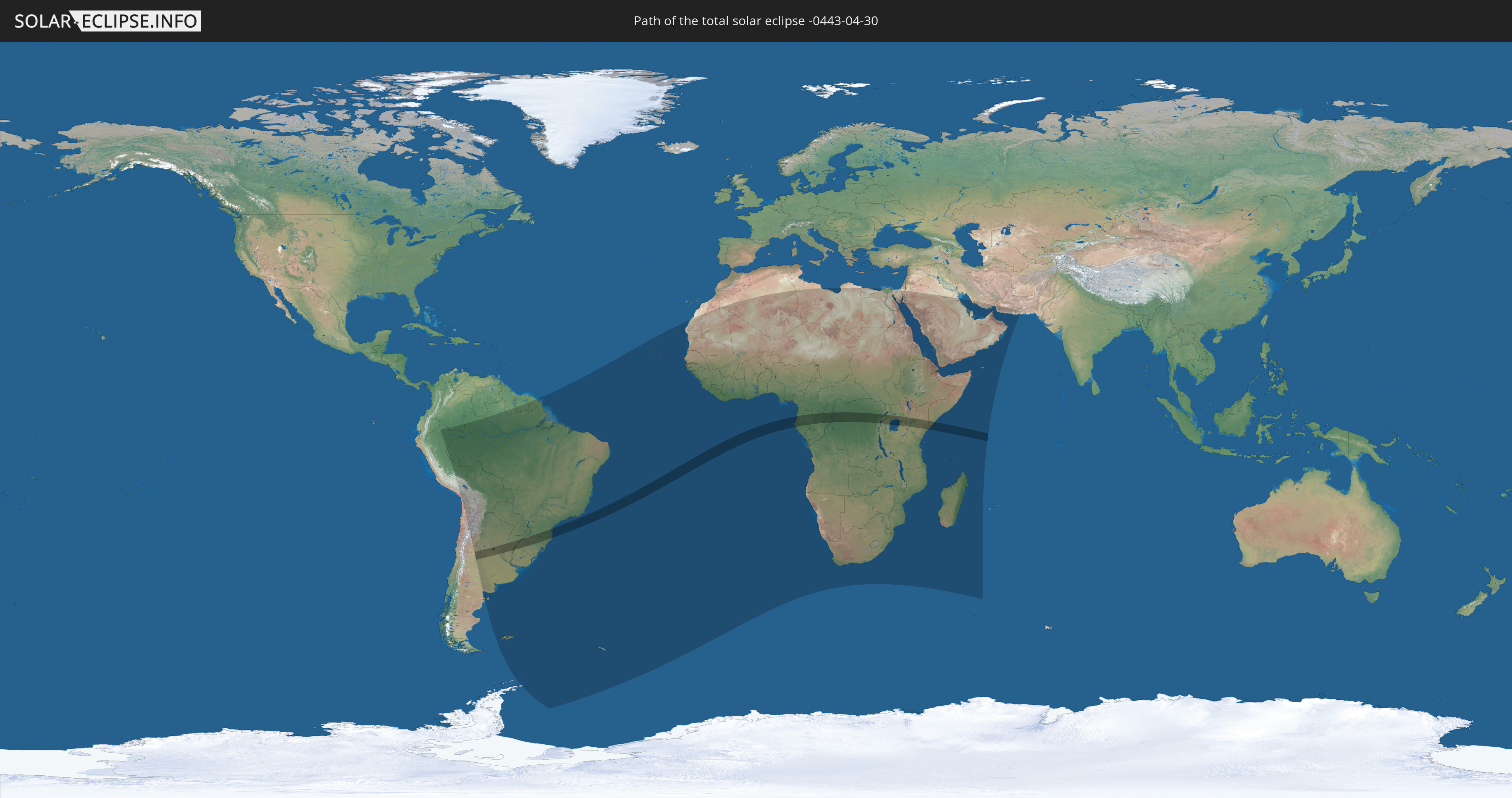
Die Sonnenfinsternis am 30.04.-0443 kann man in 80 Ländern als partielle Sonnenfinsternis beobachten.
Der Finsternispfad verläuft durch 13 Länder. Nur in diesen Ländern ist sie als totale Sonnenfinsternis zu sehen.
In den folgenden Ländern ist die Sonnenfinsternis total zu sehen
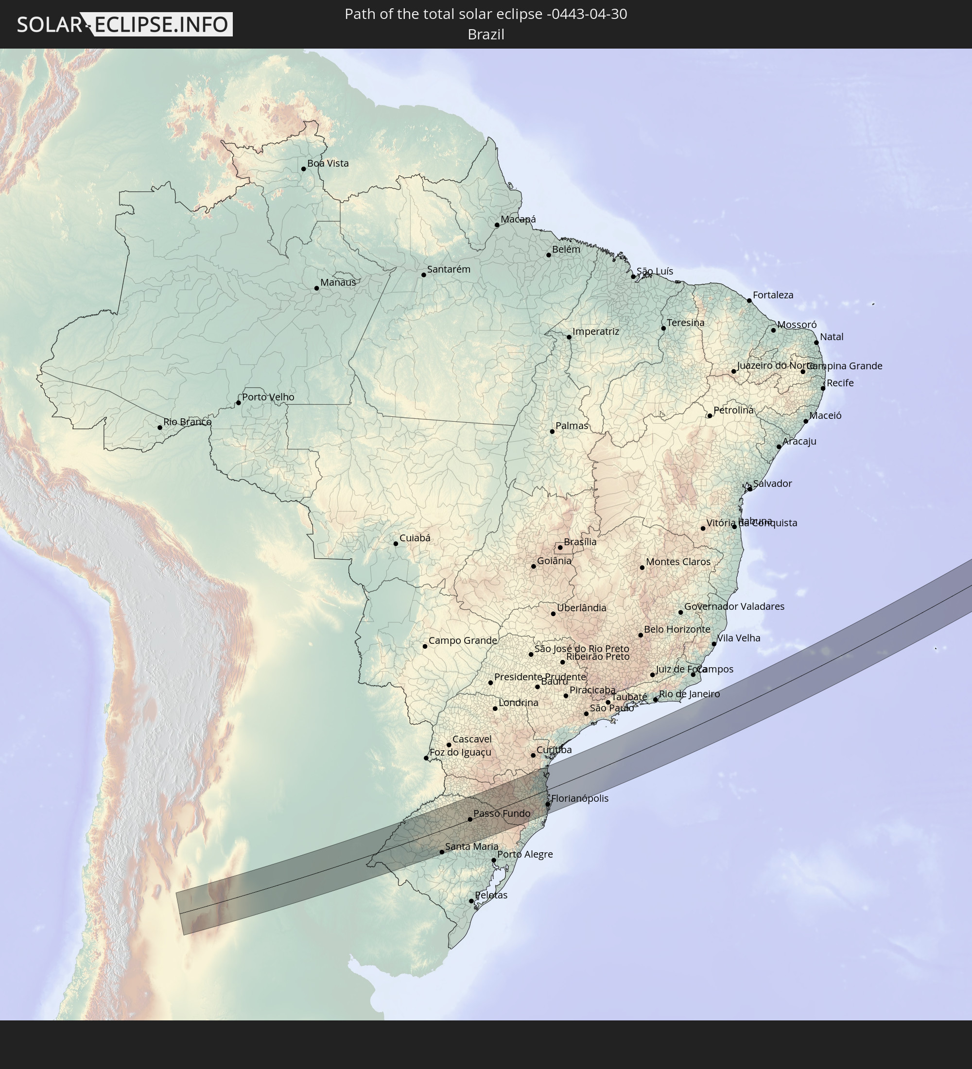 Brasilien
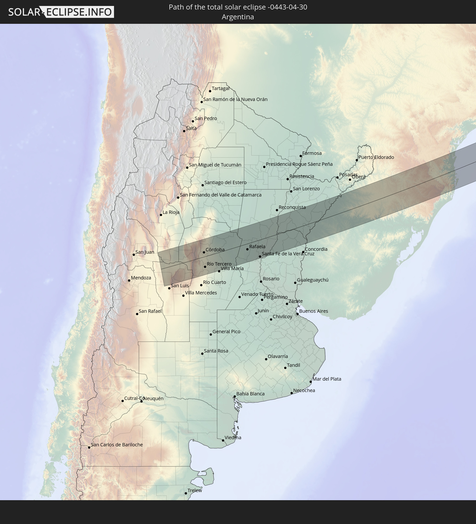 Argentinien
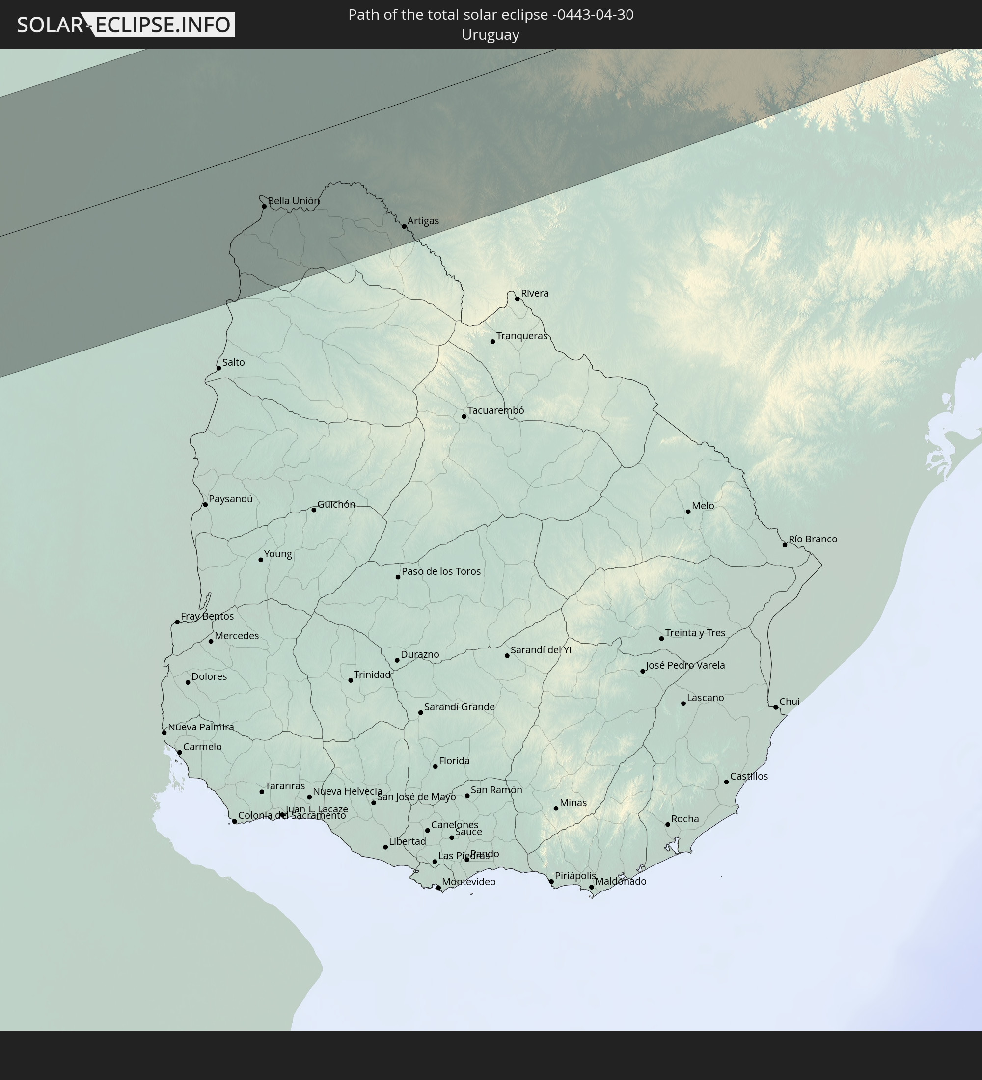 Uruguay
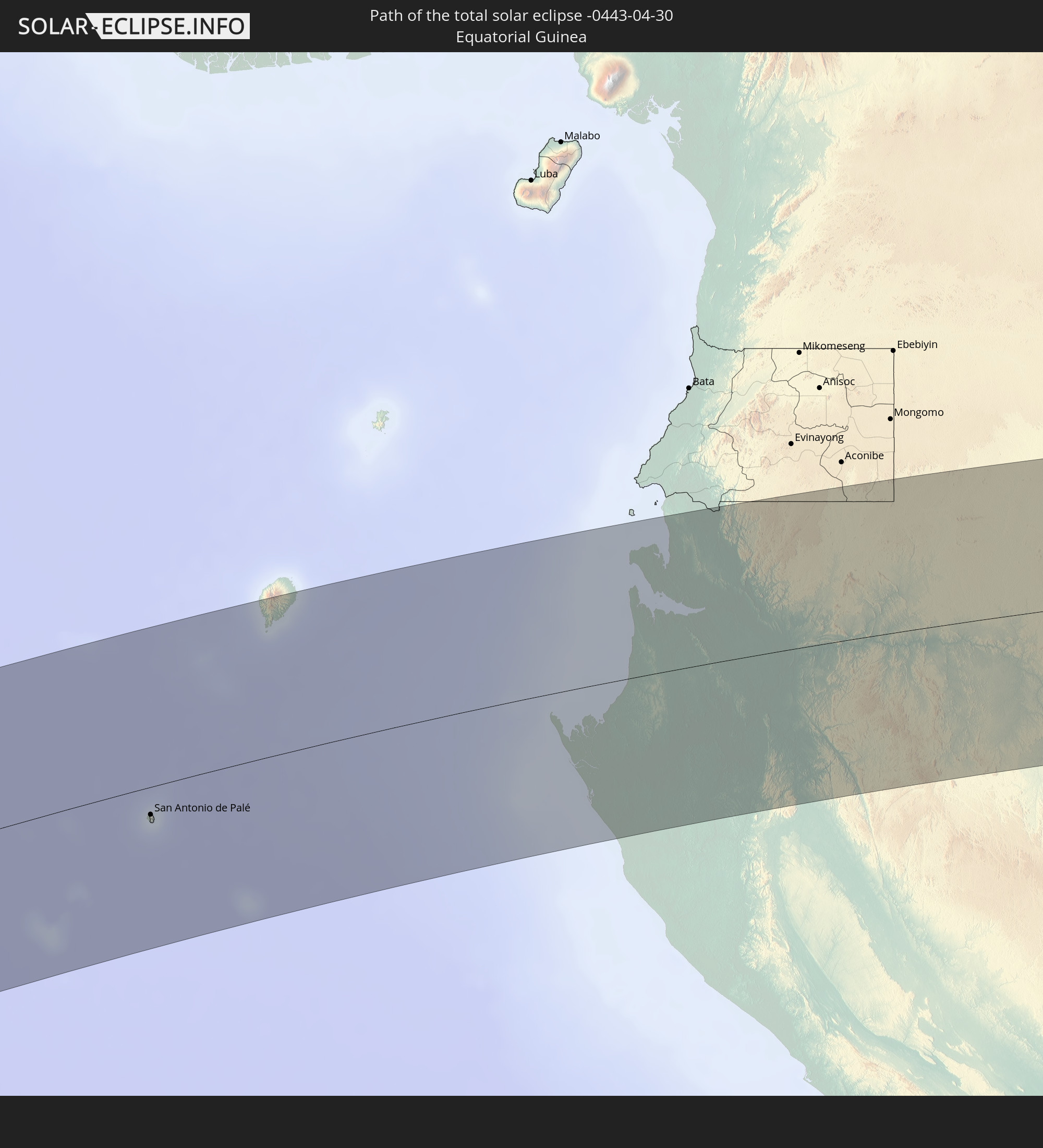 Äquatorialguinea
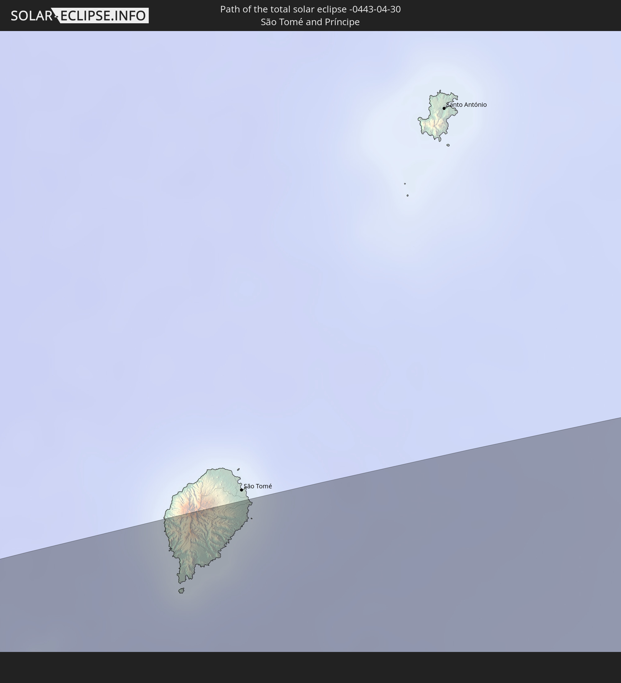 São Tomé und Príncipe
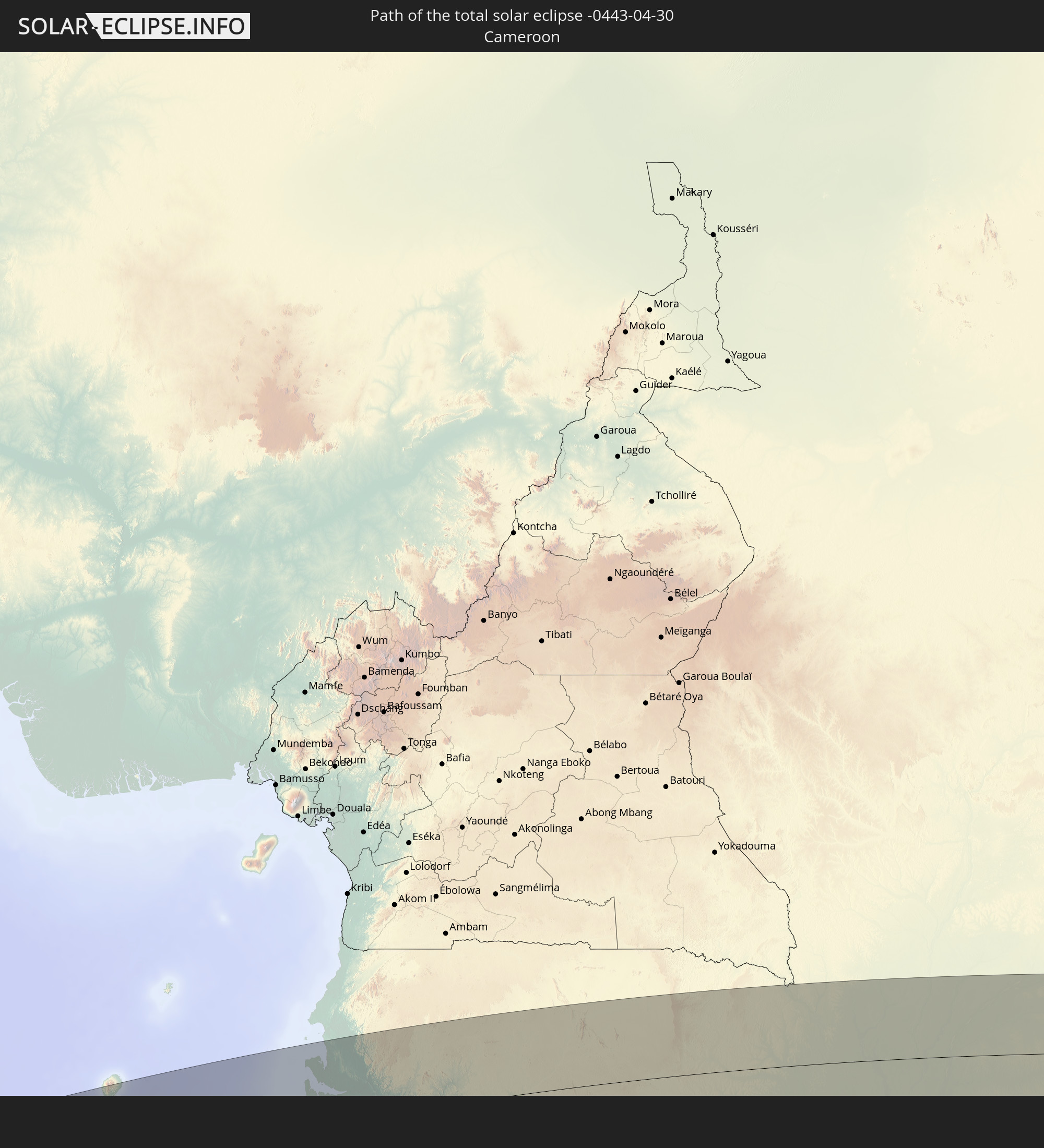 Kamerun
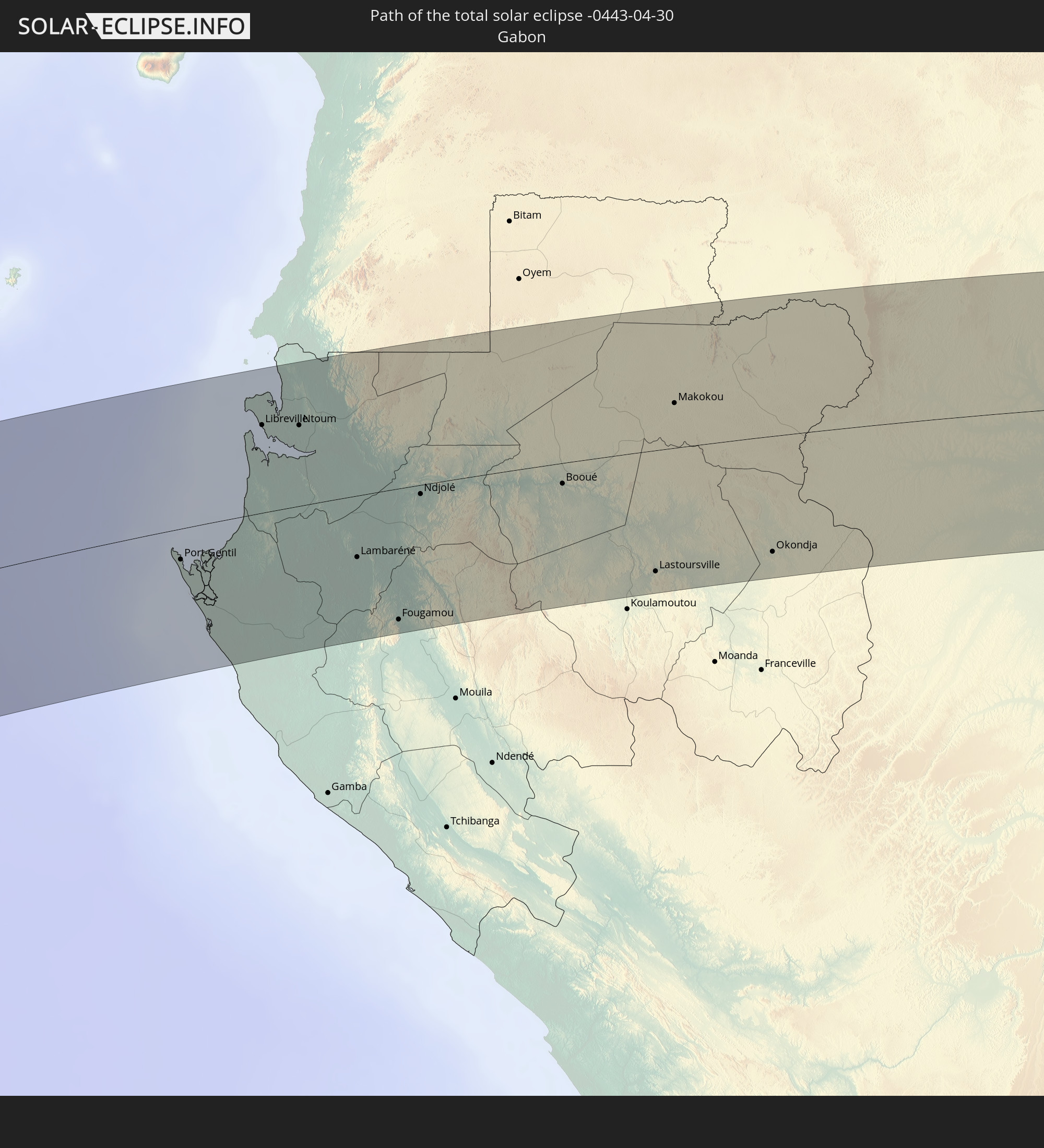 Gabun
Gabun
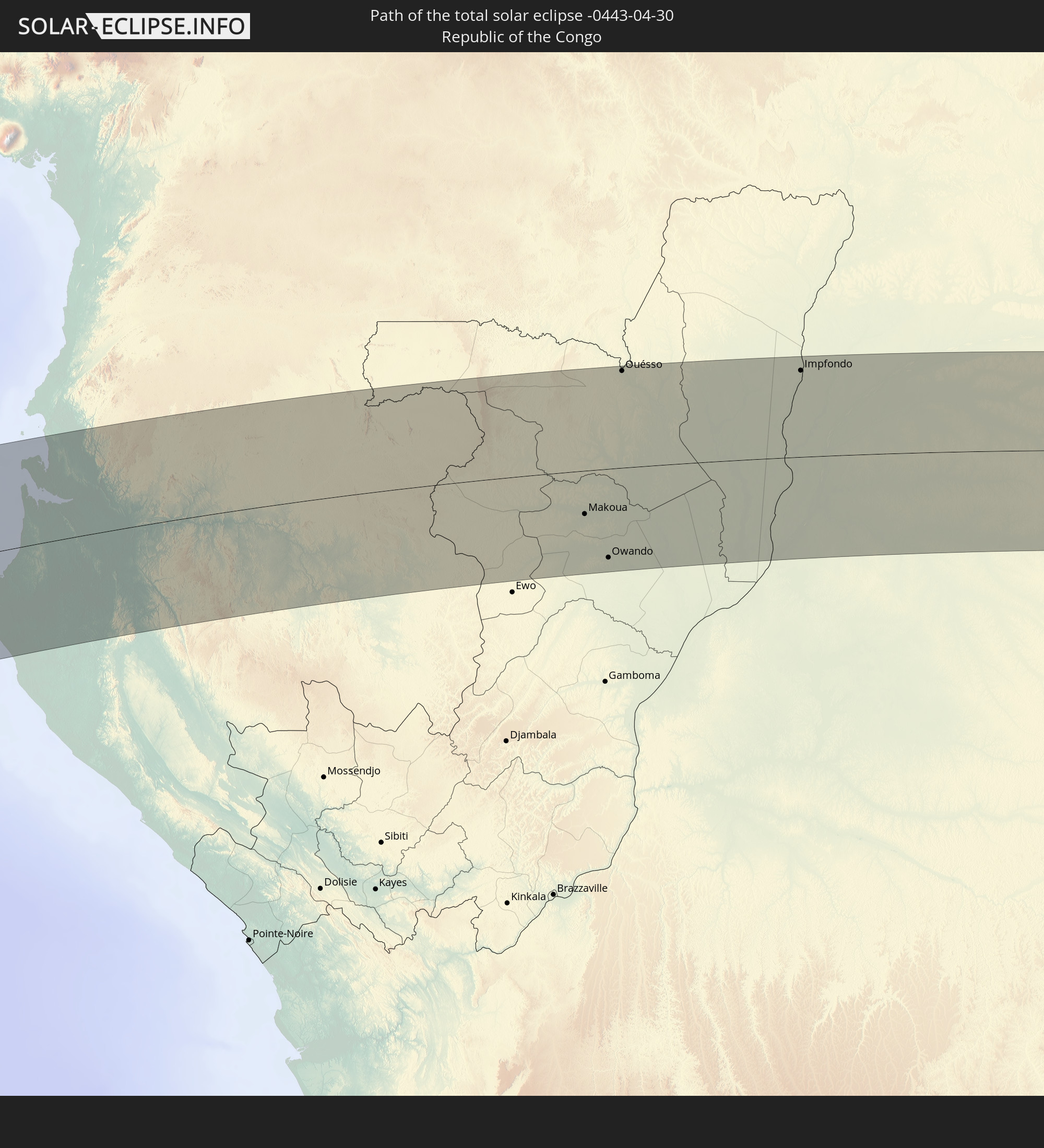 Republik Kongo
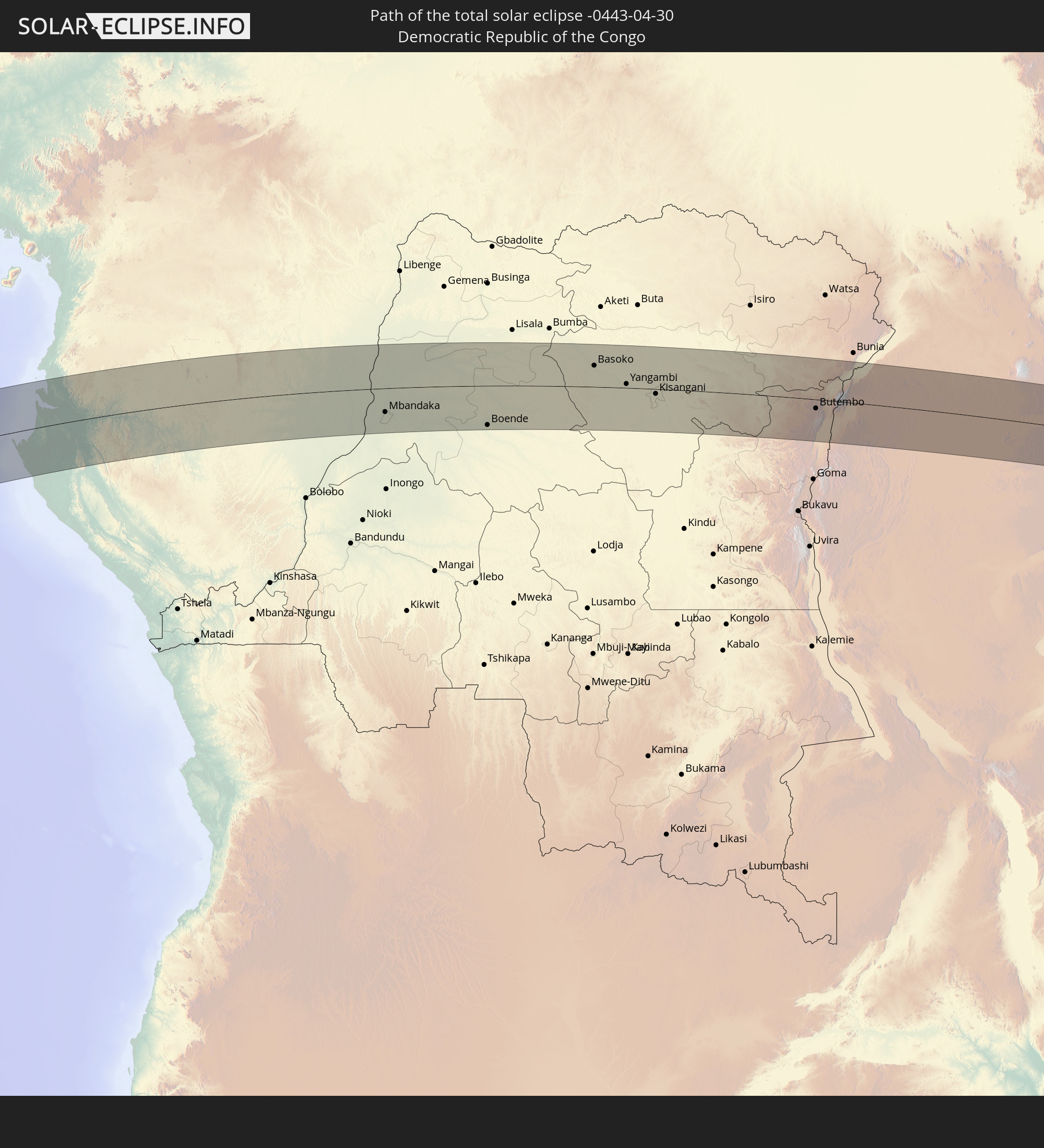 Demokratische Republik Kongo
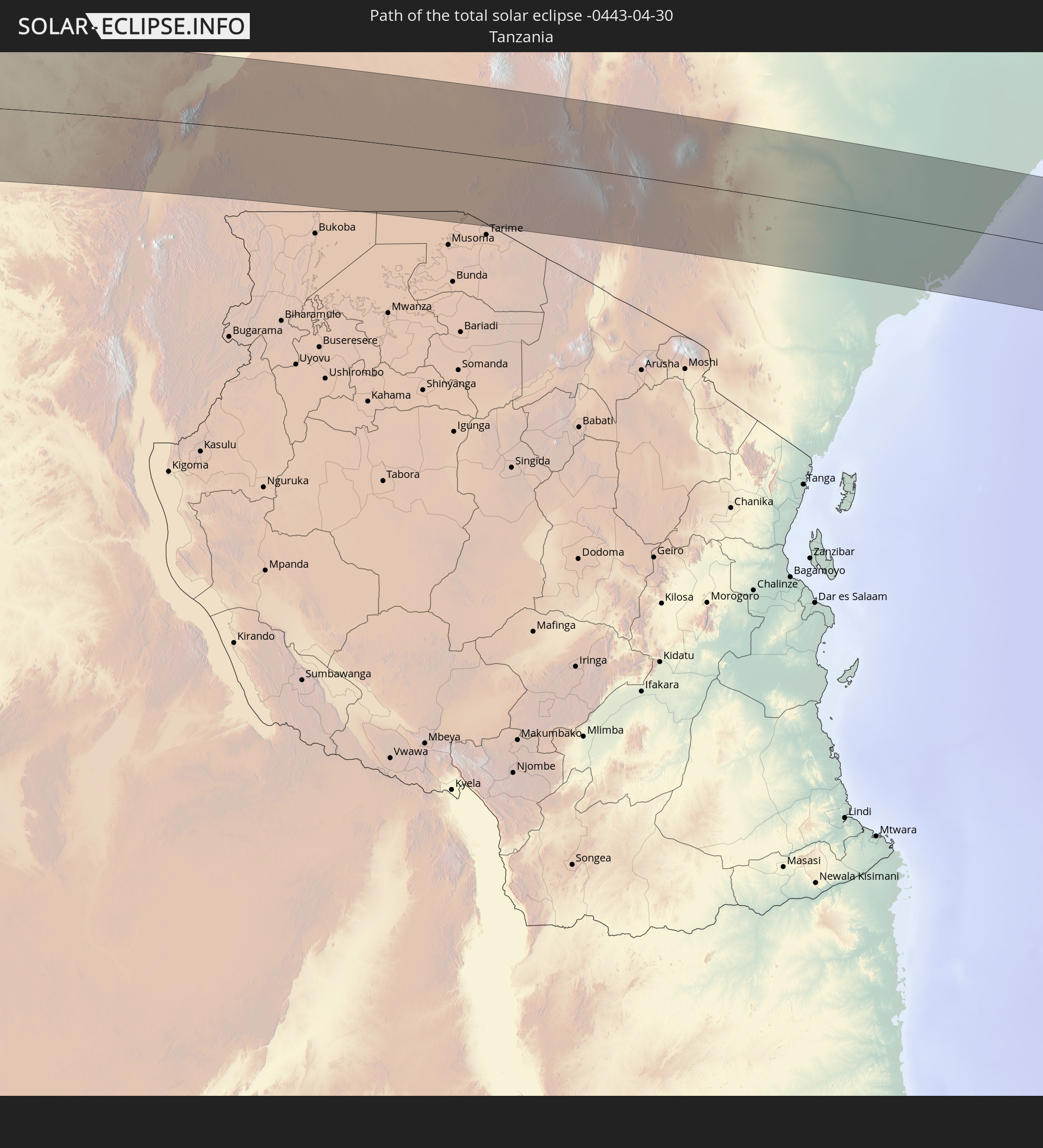 Tansania
 Uganda
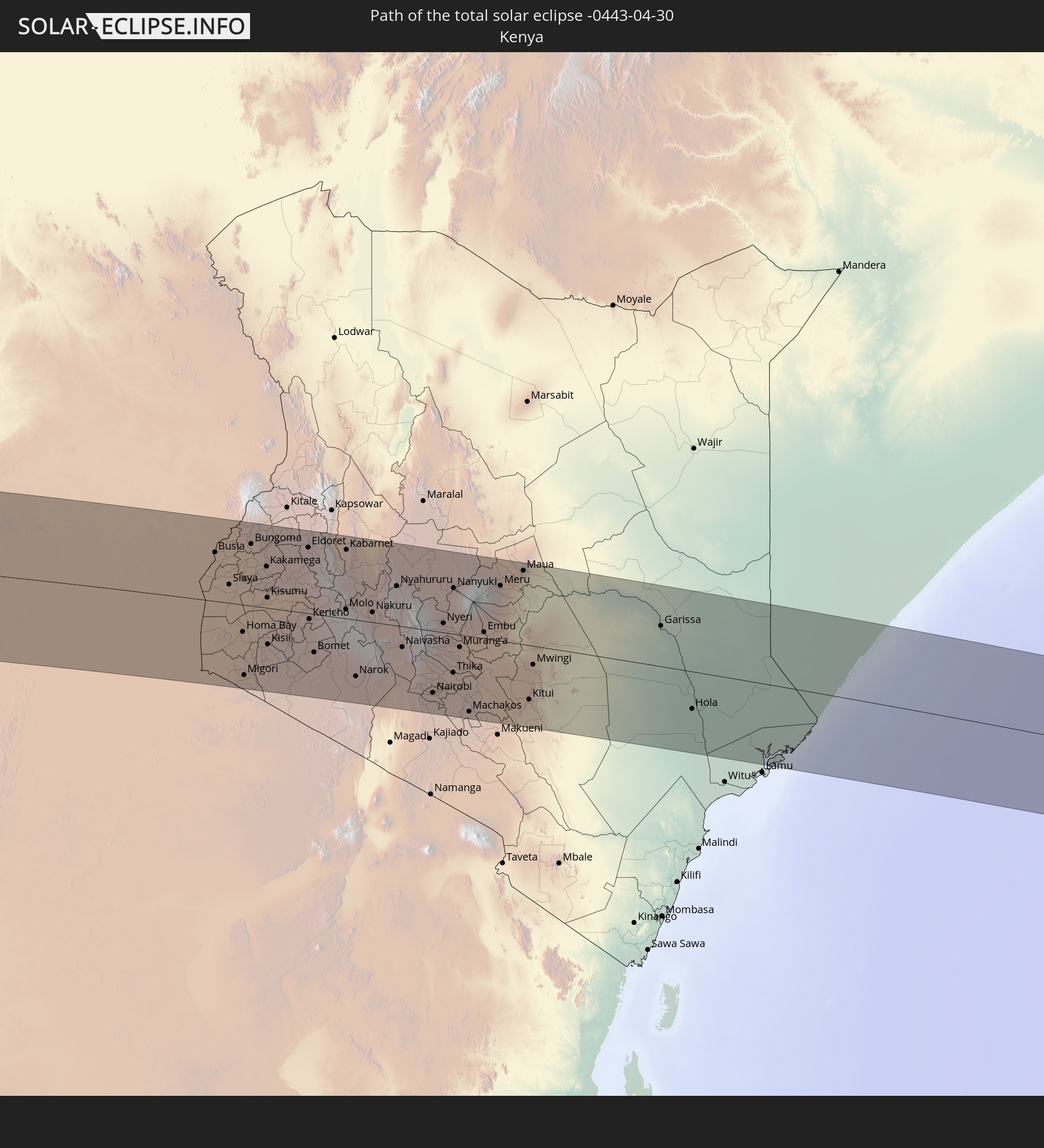 Kenia
Kenia
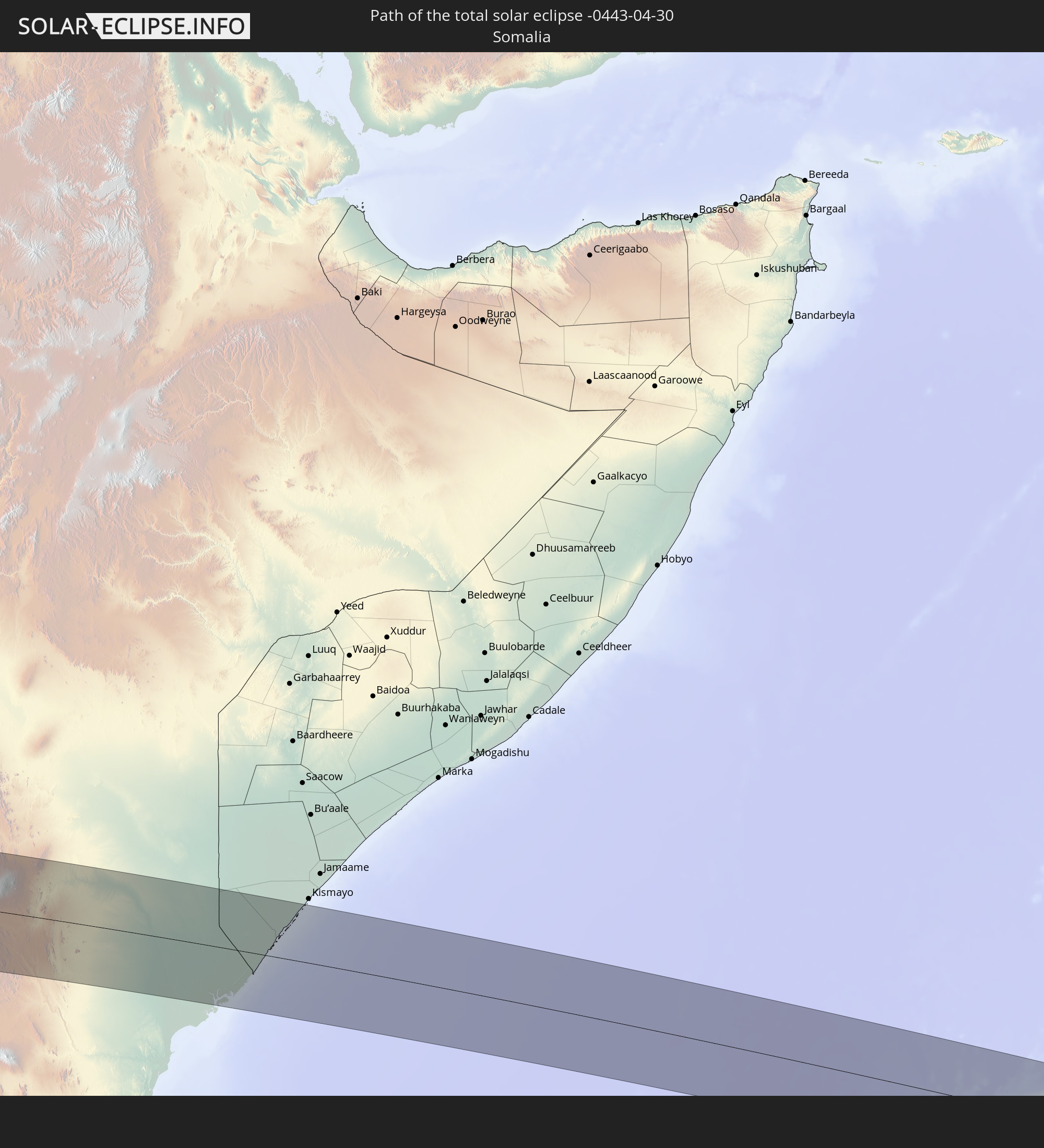 Somalia
In den folgenden Ländern ist die Sonnenfinsternis partiell zu sehen
 Antarktika
 Chile
Chile
 Kolumbien
 Peru
Peru
 Brasilien
 Argentinien
 Bolivien
 Paraguay
 Falklandinseln
 Guyana
 Uruguay
 Suriname
 Französisch-Guayana
 Südgeorgien und die Südlichen Sandwichinseln
 Kap Verde
 Senegal
 Mauretanien
 Gambia
 Guinea-Bissau
 Guinea
 St. Helena
 Sierra Leone
 Mali
Mali
 Liberia
 Algerien
 Elfenbeinküste
 Burkina Faso
 Ghana
Ghana
 Togo
Togo
 Niger
Niger
 Benin
Benin
 Nigeria
 Äquatorialguinea
 São Tomé und Príncipe
 Tunesien
 Kamerun
 Gabun
Gabun
 Libyen
 Republik Kongo
 Angola
 Namibia
 Demokratische Republik Kongo
 Tschad
 Zentralafrikanische Republik
 Südafrika
 Botswana
 Sudan
Sudan
 Sambia
 Ägypten
 Simbabwe
 Lesotho
 Ruanda
 Burundi
 Tansania
 Uganda
 Mosambik
 Swasiland
 Malawi
 Äthiopien
 Kenia
Kenia
 Israel
 Saudi-Arabien
 Jordanien
 Eritrea
 Irak
Irak
 Französische Süd- und Antarktisgebiete
 Somalia
 Dschibuti
 Jemen
Jemen
 Madagaskar
 Komoren
 Iran
Iran
 Mayotte
 Seychellen
 Kuwait
 Bahrain
 Katar
Katar
 Vereinigte Arabische Emirate
 Oman
Oman
 Pakistan
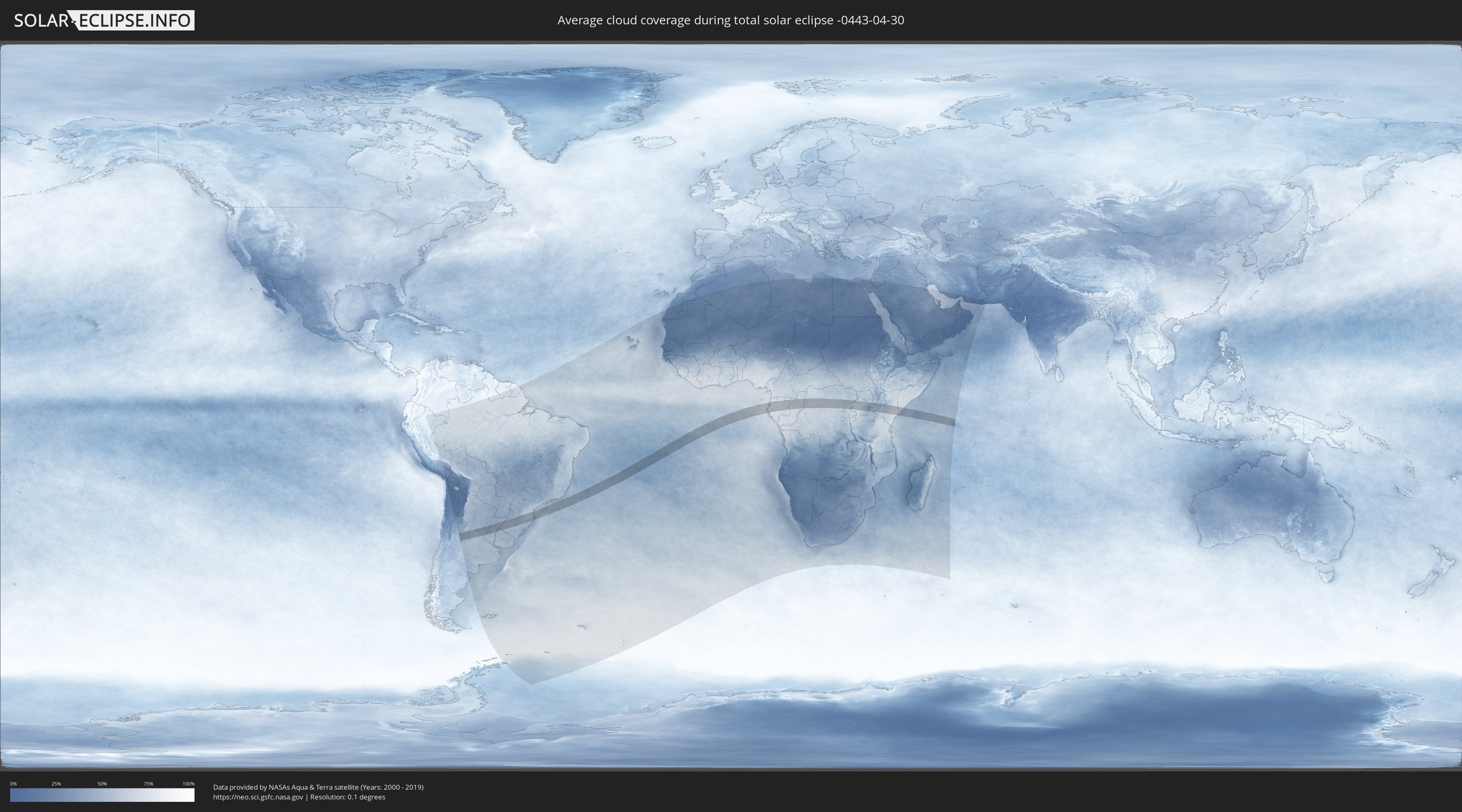
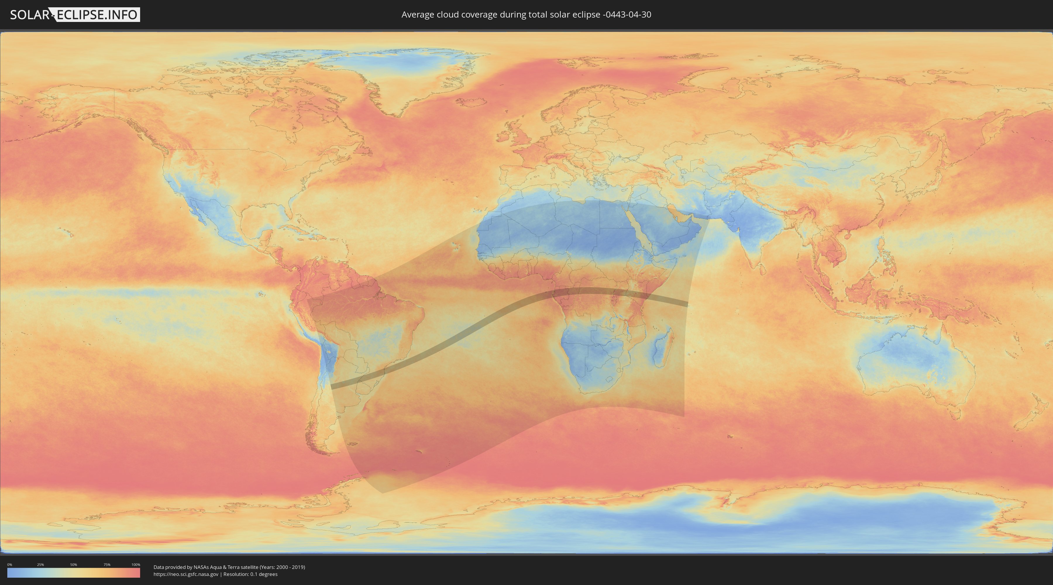
Wie wird das Wetter während der totalen Sonnenfinsternis am 30.04.-0443?
Wo ist der beste Ort, um die totale Sonnenfinsternis vom 30.04.-0443 zu beobachten?
Die folgenden Karten zeigen die durchschnittliche Bewölkung für den Tag, an dem die totale Sonnenfinsternis
stattfindet. Mit Hilfe der Karten lässt sich der Ort entlang des Finsternispfades eingrenzen,
der die besten Aussichen auf einen klaren wolkenfreien Himmel bietet.
Trotzdem muss man immer lokale Gegenenheiten beachten und sollte sich genau über das Wetter an seinem
gewählten Beobachtungsort informieren.
Die Daten stammen von den beiden NASA-Satelliten
AQUA und TERRA
und wurden über einen Zeitraum von 19 Jahren (2000 - 2019) gemittelt.
Detaillierte Länderkarten
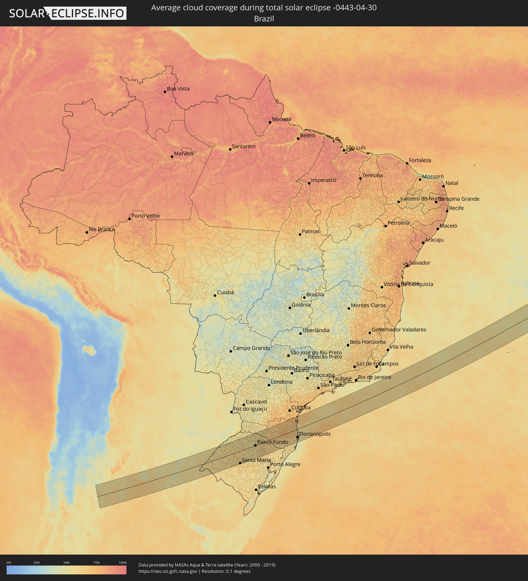 Brasilien
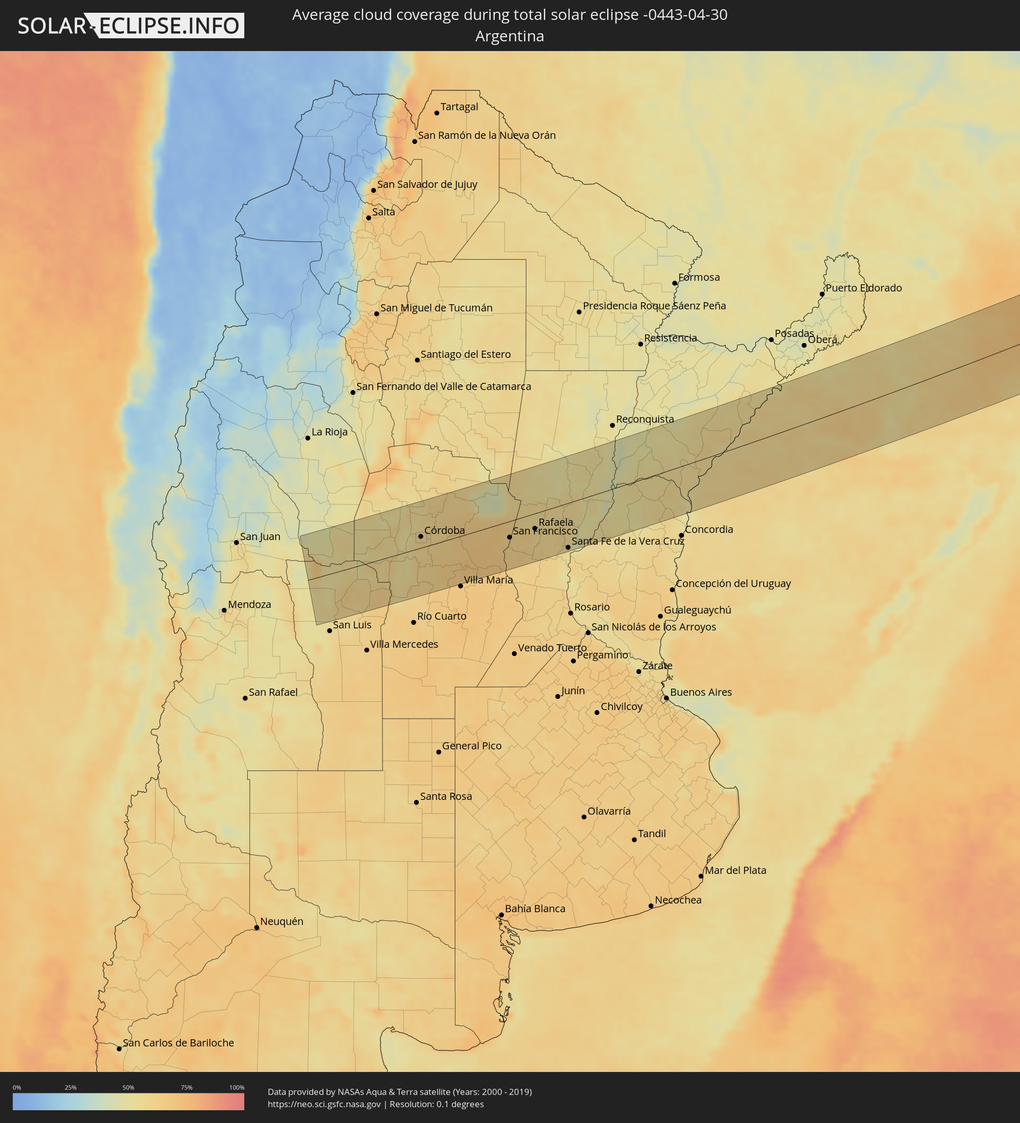 Argentinien
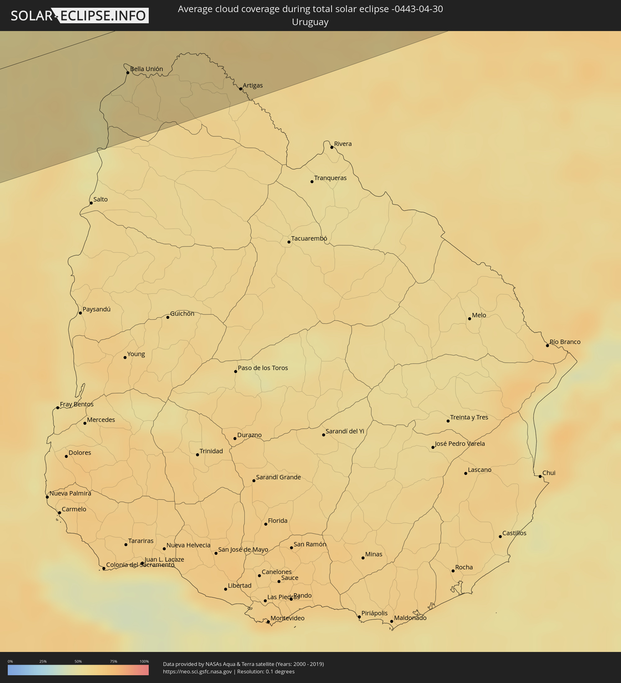 Uruguay
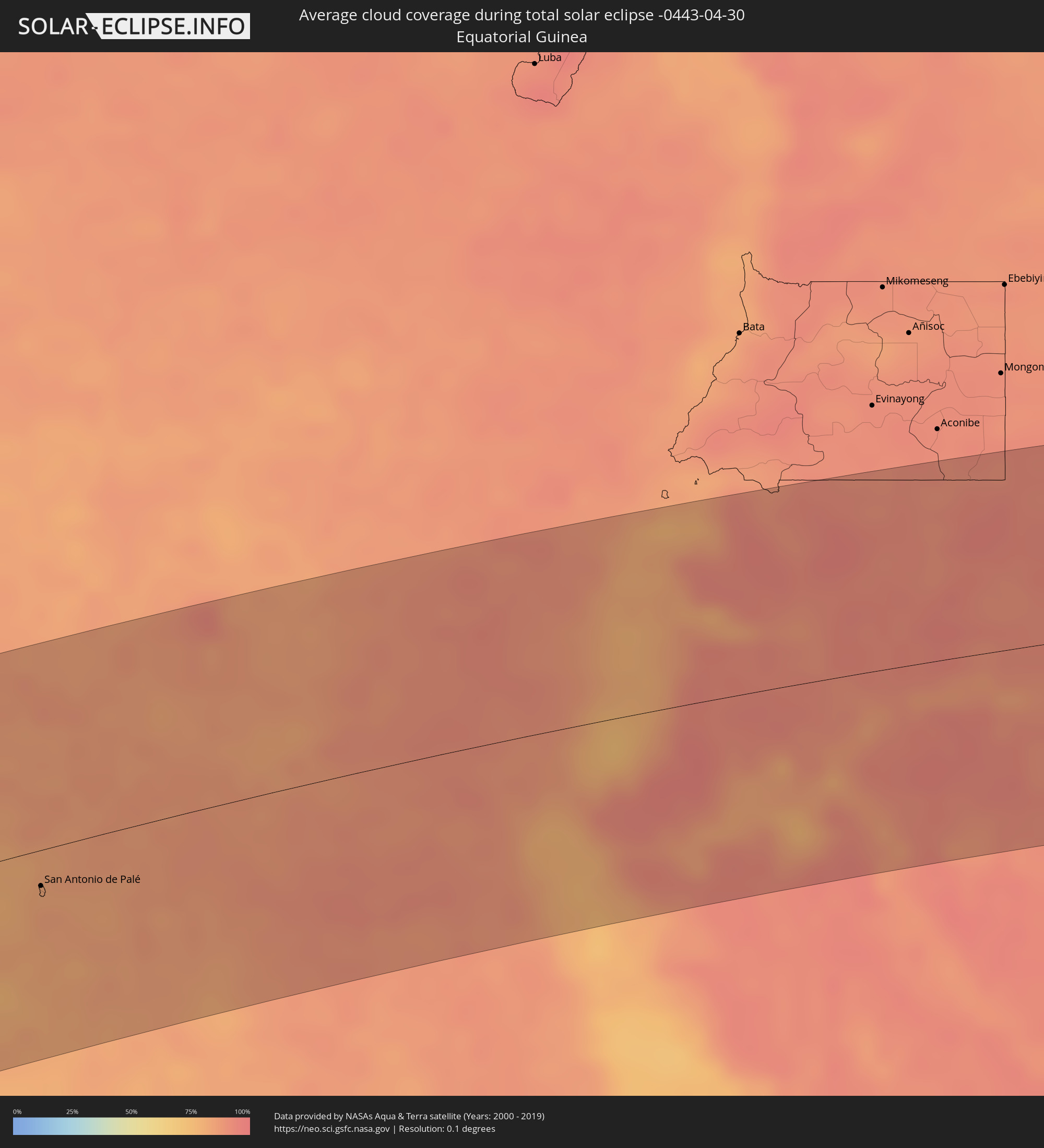 Äquatorialguinea
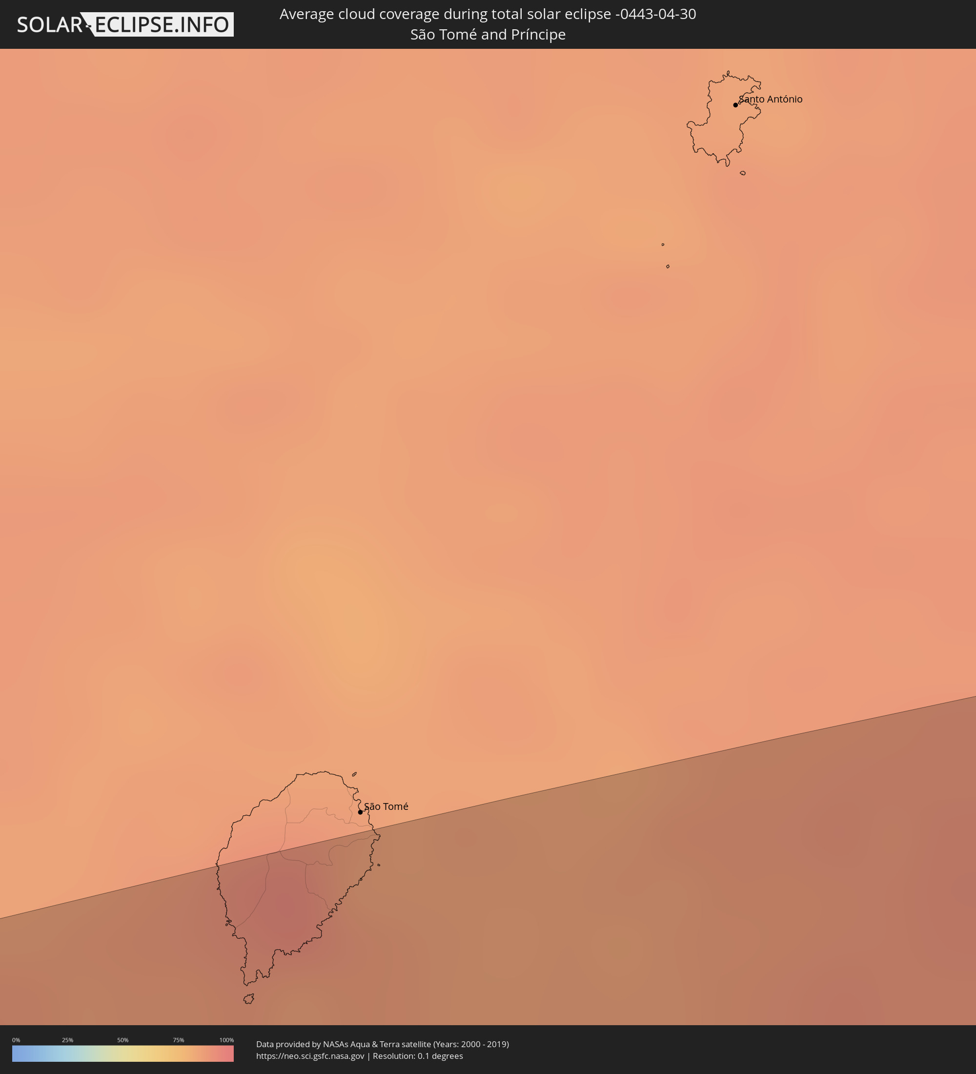 São Tomé und Príncipe
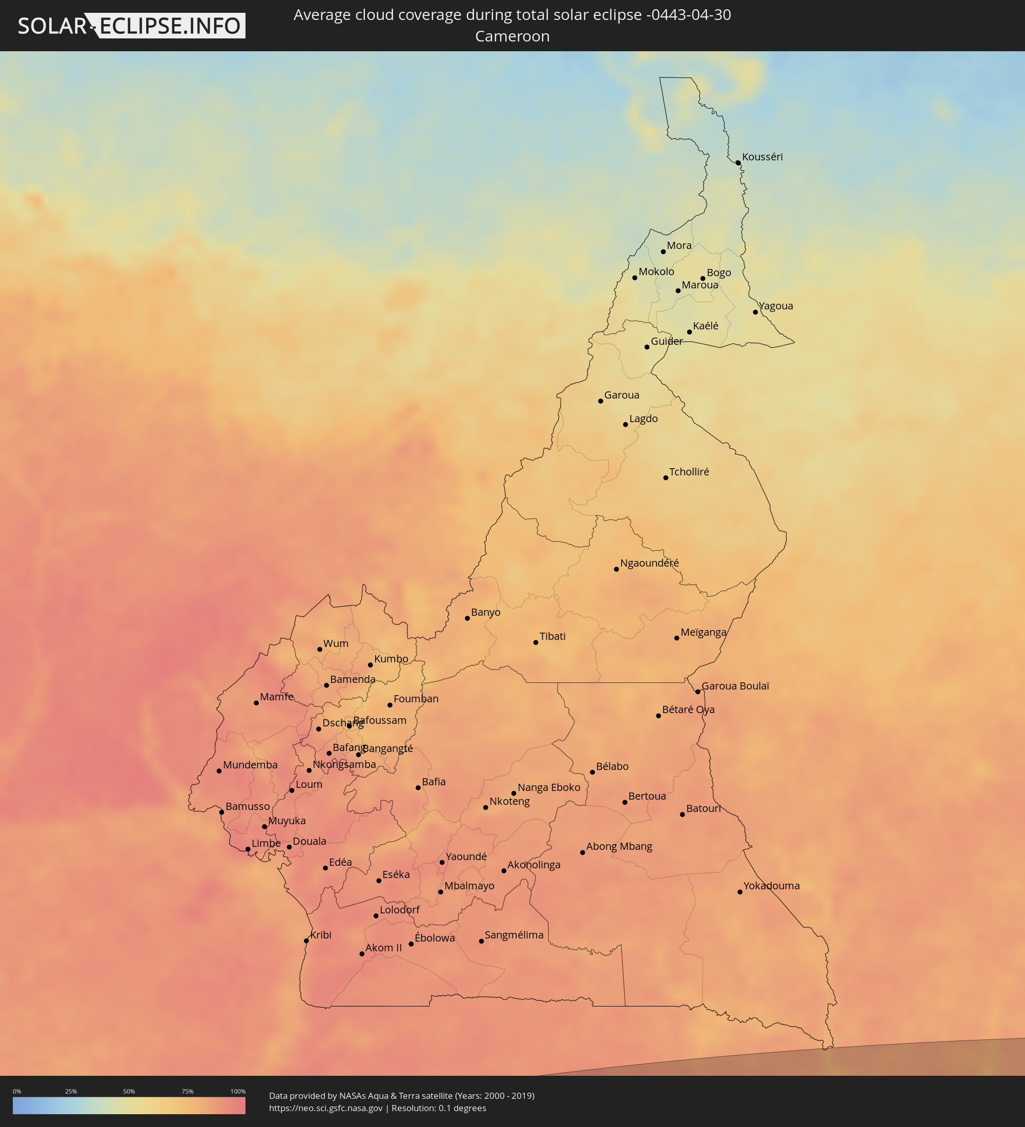 Kamerun
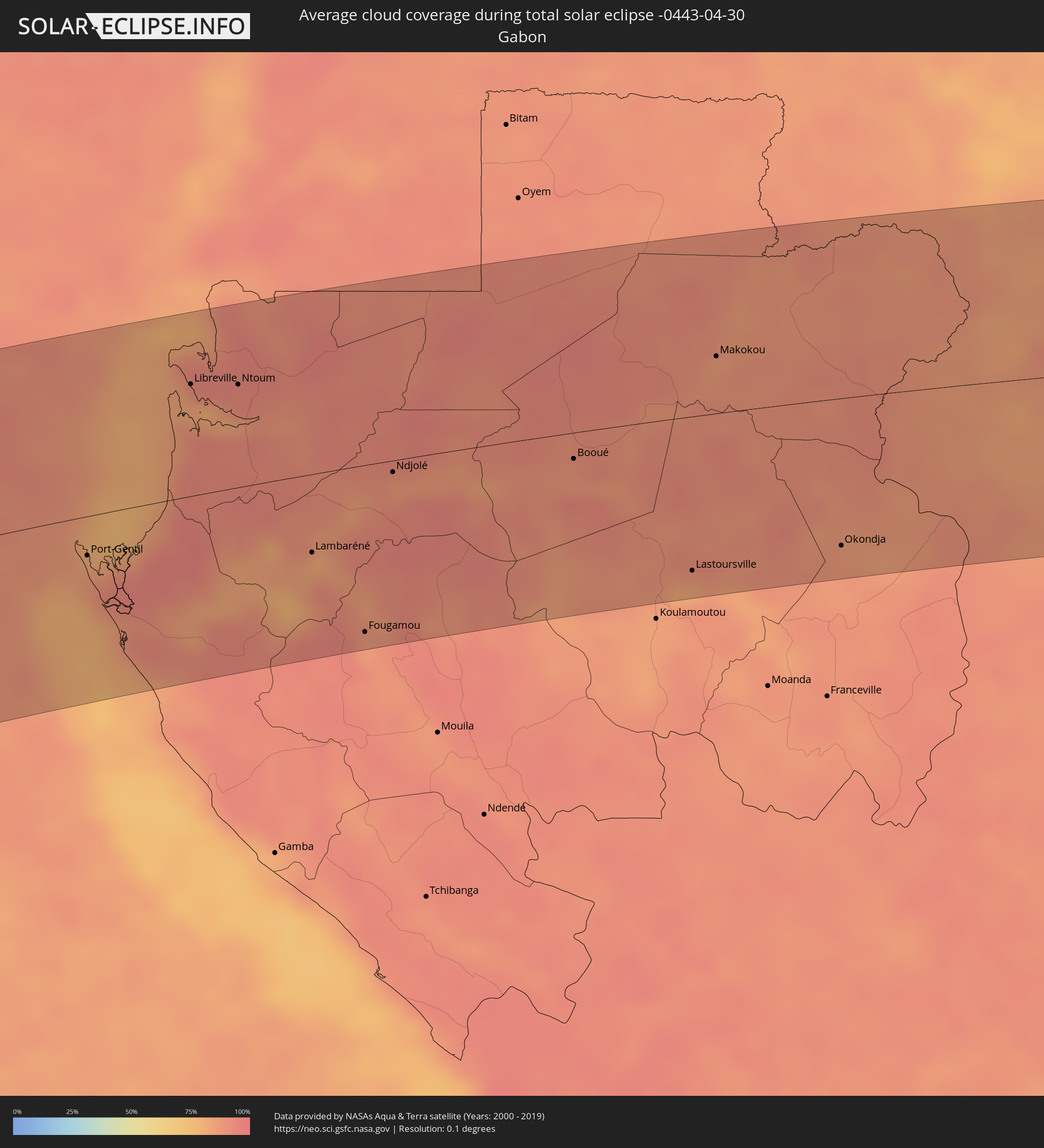 Gabun
Gabun
 Republik Kongo
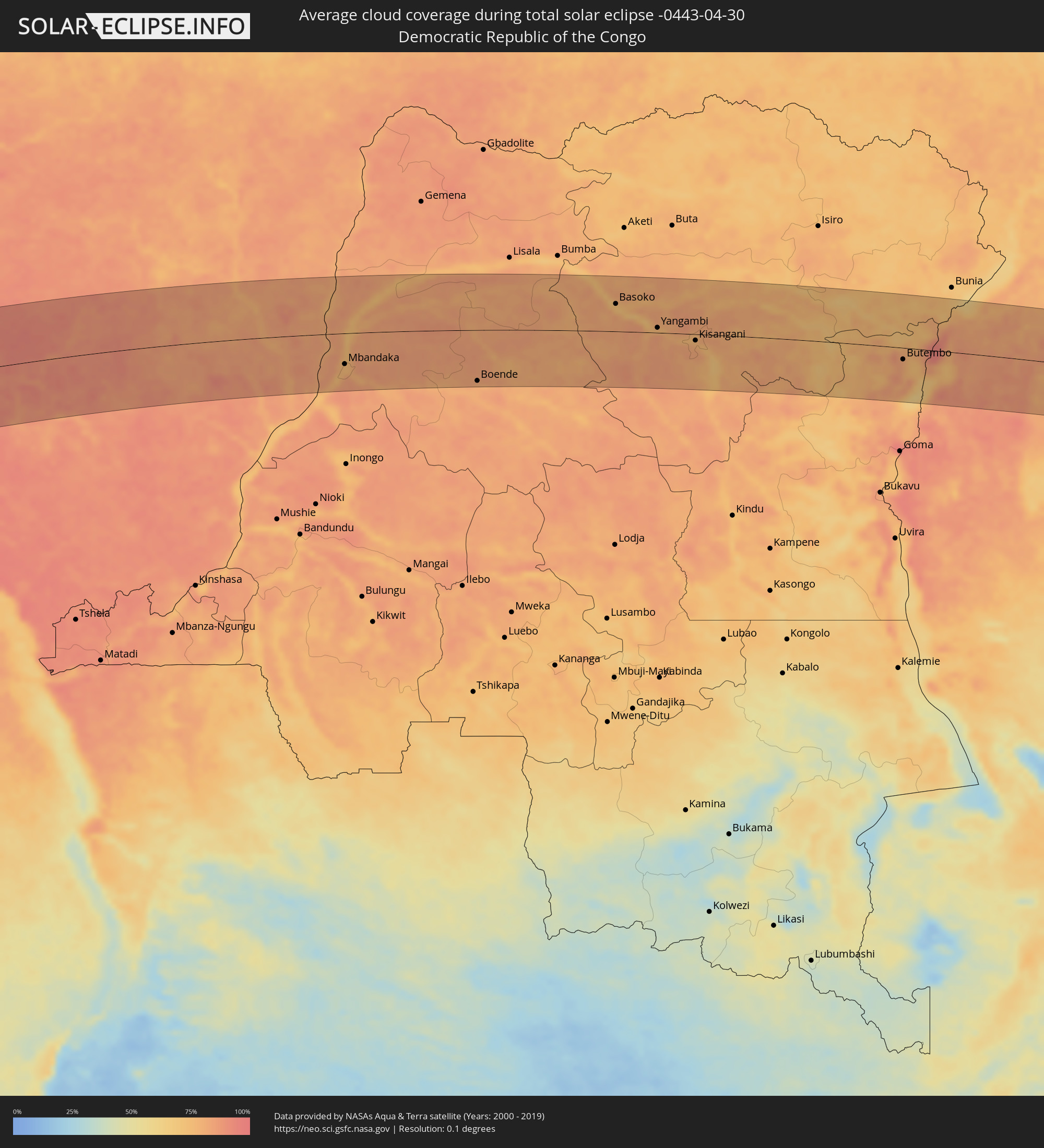 Demokratische Republik Kongo
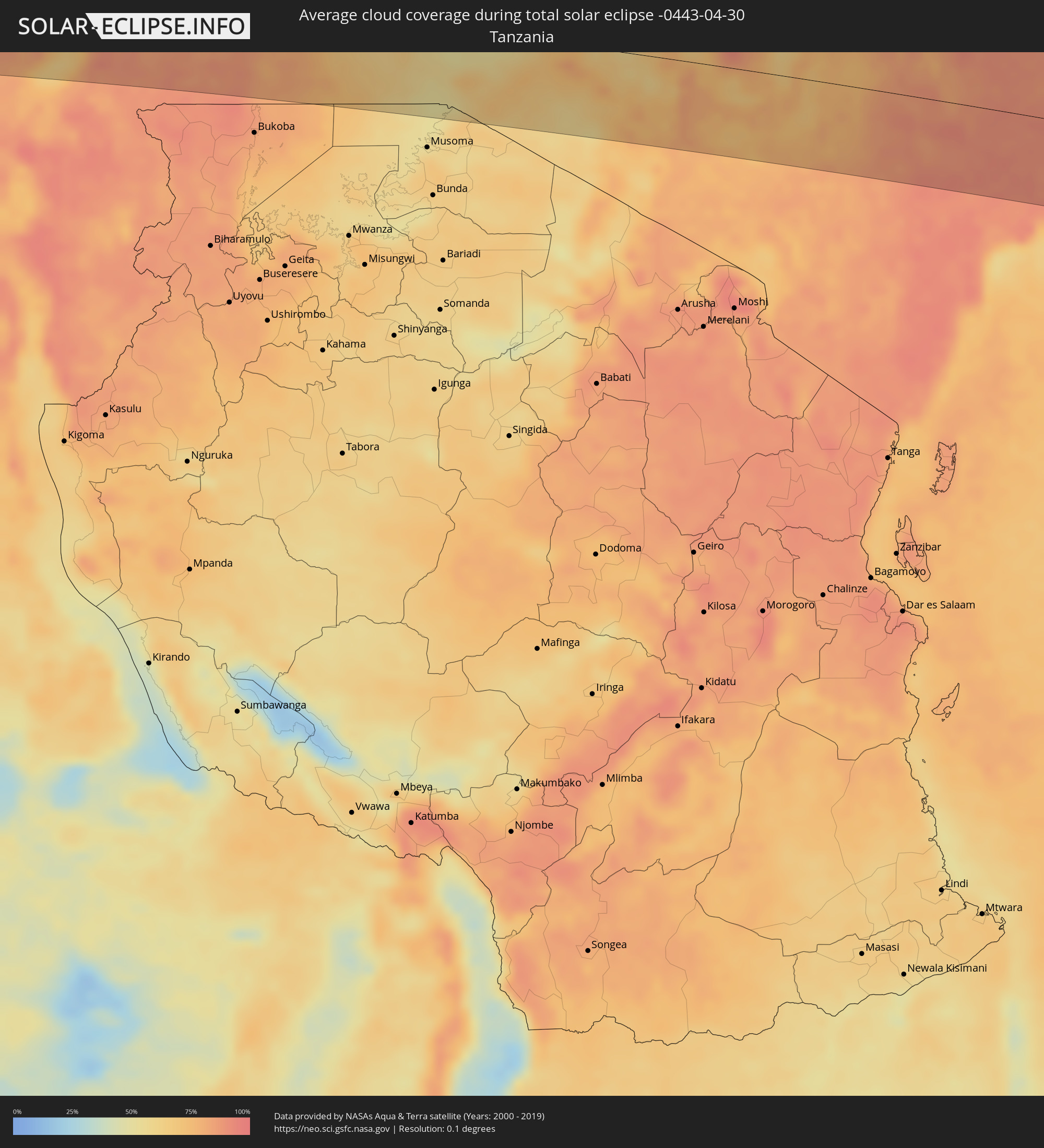 Tansania
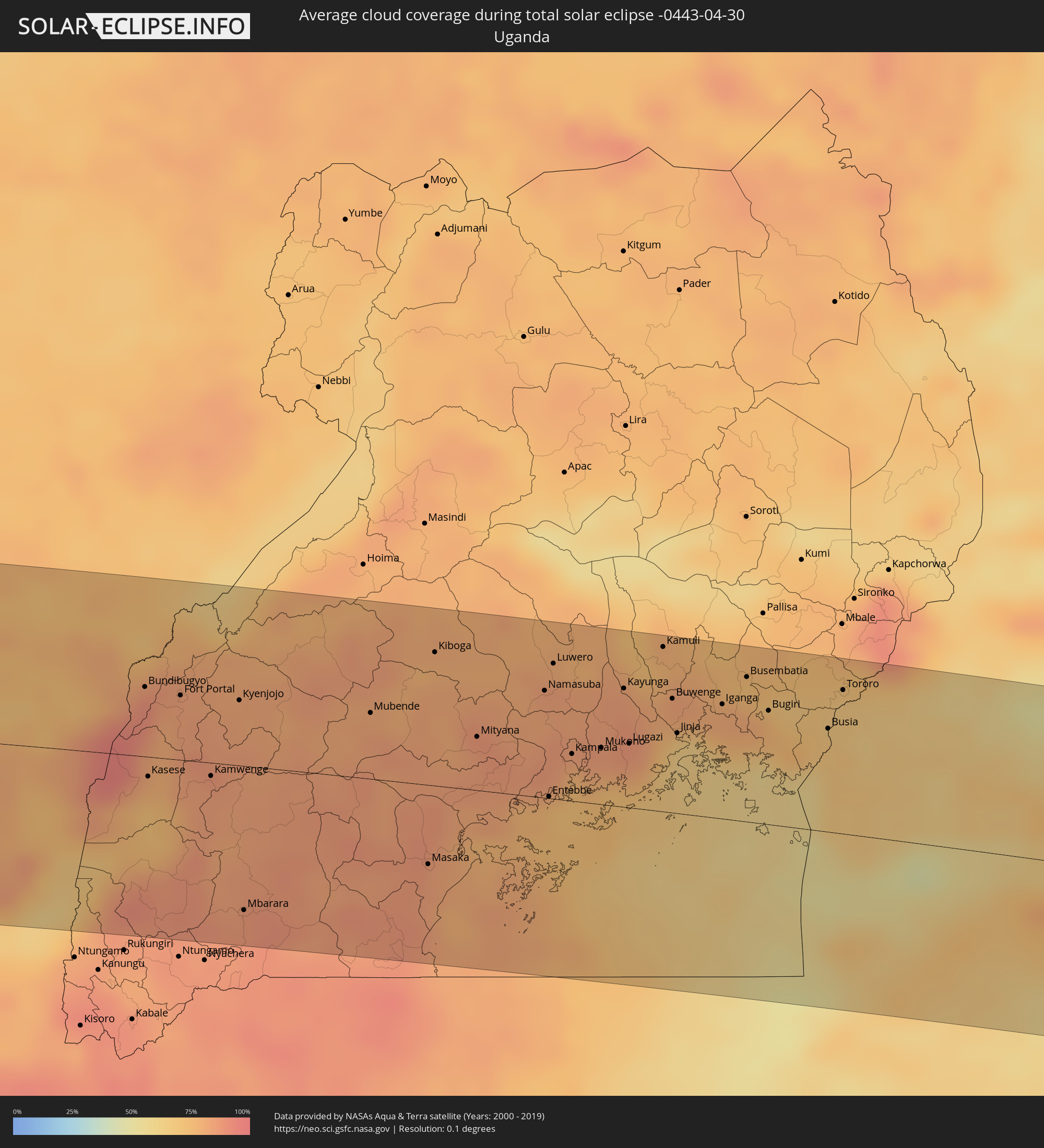 Uganda
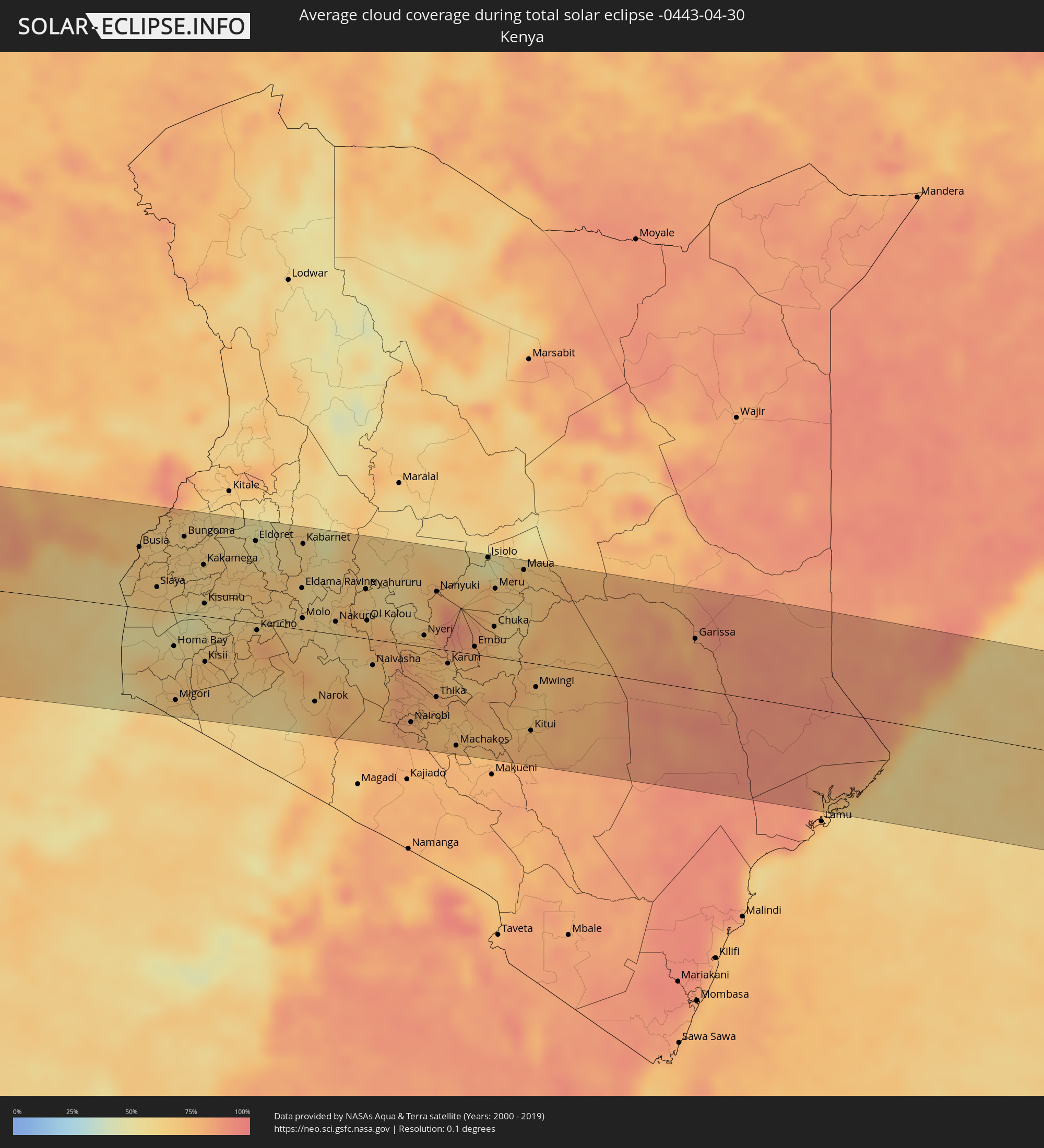 Kenia
Kenia
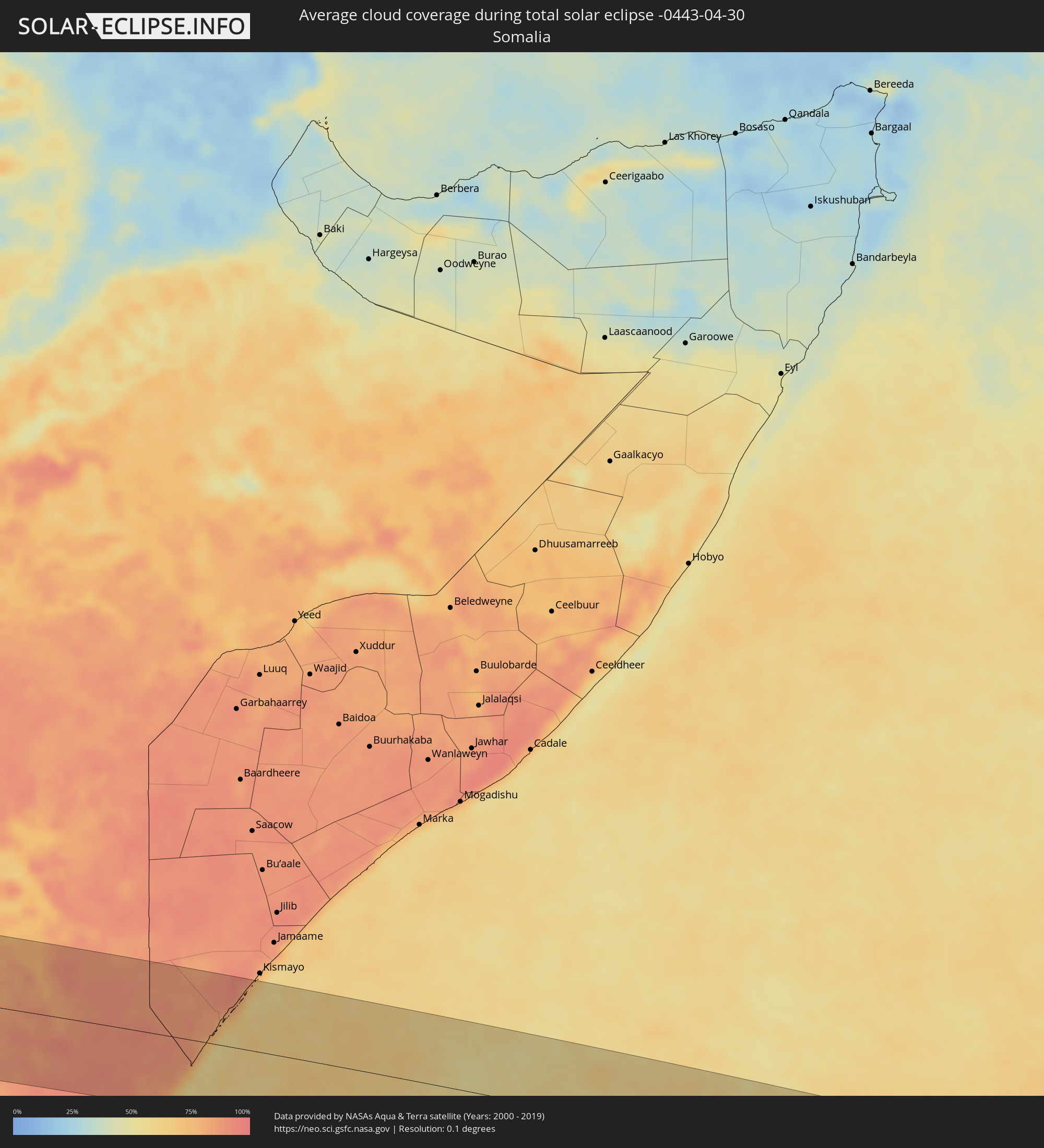 Somalia
Orte im Finsternispfad
Die nachfolgene Tabelle zeigt Städte und Orte mit mehr als 5.000 Einwohnern, die sich im Finsternispfad befinden. Städte mit mehr als 100.000 Einwohnern sind dick gekennzeichnet. Mit einem Klick auf den Ort öffnet sich eine Detailkarte die die Lage des jeweiligen Ortes zusammen mit dem Verlauf der zentralen Finsternis präsentiert.
| Ort | Typ | Dauer der Verfinsterung | Ortszeit bei maximaler Verfinsterung | Entfernung zur Zentrallinie | Ø Bewölkung |
|
Villa Dolores, Cordoba Province
|
total | - | 06:39:12 UTC-04:16 | 7 km | 59% |
|
Villa Carlos Paz, Cordoba Province
|
total | - | 06:39:07 UTC-04:16 | 31 km | 52% |
|
Cosquín, Cordoba Province
|
total | - | 06:39:03 UTC-04:16 | 49 km | 51% |
|
Alta Gracia, Cordoba Province
|
total | - | 06:39:12 UTC-04:16 | 4 km | 55% |
|
La Calera, Cordoba Province
|
total | - | 06:39:06 UTC-04:16 | 35 km | 57% |
|
Córdoba, Cordoba Province
|
total | - | 06:39:09 UTC-04:16 | 23 km | 63% |
|
Río Tercero, Cordoba Province
|
total | - | 06:39:27 UTC-04:16 | 60 km | 61% |
|
Jesús María, Cordoba Province
|
total | - | 06:39:01 UTC-04:16 | 67 km | 55% |
|
Arroyito, Cordoba Province
|
total | - | 06:39:22 UTC-04:16 | 8 km | 64% |
|
San Francisco, Cordoba Province
|
total | - | 06:39:34 UTC-04:16 | 35 km | 62% |
|
Sunchales, Santa Fe Province
|
total | - | 06:39:31 UTC-04:16 | 2 km | 56% |
|
Rafaela, Santa Fe Province
|
total | - | 06:39:39 UTC-04:16 | 33 km | 58% |
|
Esperanza, Santa Fe Province
|
total | - | 06:39:51 UTC-04:16 | 70 km | 60% |
|
Santa Fe de la Vera Cruz, Santa Fe Province
|
total | - | 06:39:58 UTC-04:16 | 96 km | 56% |
|
San Justo, Santa Fe Province
|
total | - | 06:39:43 UTC-04:16 | 10 km | 57% |
|
La Paz, Entre Ríos Province
|
total | - | 06:39:58 UTC-04:16 | 33 km | 50% |
|
Esquina, Corrientes Province
|
total | - | 06:39:46 UTC-04:16 | 41 km | 47% |
|
Mercedes, Corrientes Province
|
total | - | 06:40:00 UTC-04:16 | 85 km | 52% |
|
Curuzú Cuatiá, Corrientes Province
|
total | - | 06:40:10 UTC-04:16 | 21 km | 53% |
|
Chajarí, Entre Ríos Province
|
total | - | 06:40:29 UTC-04:16 | 83 km | 51% |
|
Monte Caseros, Corrientes Province
|
total | - | 06:40:27 UTC-04:16 | 41 km | 54% |
|
Bella Unión, Artigas
|
total | - | 07:12:25 UTC-03:44 | 43 km | 54% |
|
Uruguaiana, Rio Grande do Sul
|
total | - | 07:50:50 UTC-03:06 | 5 km | 58% |
|
Paso de los Libres, Corrientes Province
|
total | - | 06:40:30 UTC-04:16 | 1 km | 57% |
|
Artigas, Artigas
|
total | - | 07:12:53 UTC-03:44 | 93 km | 56% |
|
Santo Tomé, Corrientes Province
|
total | - | 06:40:37 UTC-04:16 | 89 km | 56% |
|
São Borja, Rio Grande do Sul
|
total | - | 07:50:59 UTC-03:06 | 76 km | 57% |
|
Alegrete, Rio Grande do Sul
|
total | - | 07:51:21 UTC-03:06 | 49 km | 58% |
|
Santo Ângelo, Rio Grande do Sul
|
total | - | 07:51:41 UTC-03:06 | 57 km | 53% |
|
Ijuí, Rio Grande do Sul
|
total | - | 07:51:52 UTC-03:06 | 36 km | 58% |
|
Santa Maria, Rio Grande do Sul
|
total | - | 07:52:13 UTC-03:06 | 103 km | 65% |
|
Cruz Alta, Rio Grande do Sul
|
total | - | 07:52:04 UTC-03:06 | 1 km | 60% |
|
Carazinho, Rio Grande do Sul
|
total | - | 07:52:24 UTC-03:06 | 9 km | 55% |
|
Passo Fundo, Rio Grande do Sul
|
total | - | 07:52:36 UTC-03:06 | 2 km | 55% |
|
Erechim, Rio Grande do Sul
|
total | - | 07:52:33 UTC-03:06 | 59 km | 57% |
|
Concórdia, Santa Catarina
|
total | - | 07:52:37 UTC-03:06 | 92 km | 58% |
|
Caçador, Santa Catarina
|
total | - | 07:53:08 UTC-03:06 | 105 km | 64% |
|
Vacaria, Rio Grande do Sul
|
total | - | 07:53:27 UTC-03:06 | 79 km | 64% |
|
Lages, Santa Catarina
|
total | - | 07:53:42 UTC-03:06 | 28 km | 67% |
|
Rio do Sul, Santa Catarina
|
total | - | 07:54:02 UTC-03:06 | 10 km | 73% |
|
São Bento do Sul, Santa Catarina
|
total | - | 07:54:06 UTC-03:06 | 100 km | 69% |
|
Jaraguá do Sul, Santa Catarina
|
total | - | 07:54:19 UTC-03:06 | 64 km | 69% |
|
Blumenau, Santa Catarina
|
total | - | 07:54:22 UTC-03:06 | 19 km | 67% |
|
Brusque, Santa Catarina
|
total | - | 07:54:29 UTC-03:06 | 5 km | 66% |
|
Joinville, Santa Catarina
|
total | - | 07:54:27 UTC-03:06 | 75 km | 69% |
|
Itajaí, Santa Catarina
|
total | - | 07:54:38 UTC-03:06 | 6 km | 66% |
|
Biguaçu, Santa Catarina
|
total | - | 07:54:42 UTC-03:06 | 55 km | 61% |
|
Florianópolis, Santa Catarina
|
total | - | 07:54:47 UTC-03:06 | 70 km | 52% |
|
San Antonio de Palé, Annobón Province
|
total | - | 13:21:05 UTC+00:13 | 23 km | 84% |
|
Port-Gentil, Ogooué-Maritime
|
total | - | 13:30:00 UTC+00:13 | 28 km | 86% |
|
Libreville, Estuaire
|
total | - | 13:32:43 UTC+00:13 | 79 km | 90% |
|
Ntoum, Estuaire
|
total | - | 13:33:29 UTC+00:13 | 73 km | 93% |
|
Lambaréné, Moyen-Ogooué
|
total | - | 13:33:41 UTC+00:13 | 56 km | 84% |
|
Fougamou, Ngouni
|
total | - | 13:34:03 UTC+00:13 | 119 km | 87% |
|
Ndjolé, Moyen-Ogooué
|
total | - | 13:35:26 UTC+00:13 | 8 km | 90% |
|
Booué, Ogooué-Ivindo
|
total | - | 13:38:19 UTC+00:13 | 19 km | 88% |
|
Lastoursville, Ogooué-Lolo
|
total | - | 13:39:30 UTC+00:13 | 110 km | 82% |
|
Makokou, Ogooué-Ivindo
|
total | - | 13:41:01 UTC+00:13 | 41 km | 86% |
|
Okondja, Haut-Ogooué
|
total | - | 13:41:52 UTC+00:13 | 106 km | 88% |
|
Makoua, Cuvette
|
total | - | 13:46:43 UTC+00:13 | 54 km | 90% |
|
Owando, Cuvette
|
total | - | 13:46:55 UTC+00:13 | 111 km | 89% |
|
Ouésso, Sangha
|
total | - | 13:48:46 UTC+00:13 | 121 km | 78% |
|
Impfondo, Likouala
|
total | - | 13:52:48 UTC+00:13 | 108 km | 80% |
|
Mbandaka, Équateur
|
total | - | 13:52:09 UTC+00:13 | 68 km | 82% |
|
Boende, Équateur
|
total | - | 13:56:53 UTC+00:13 | 112 km | 80% |
|
Basoko, Orientale
|
total | - | 15:59:12 UTC+02:10 | 61 km | 74% |
|
Yangambi, Orientale
|
total | - | 16:00:15 UTC+02:10 | 11 km | 77% |
|
Kisangani, Orientale
|
total | - | 16:01:16 UTC+02:10 | 14 km | 78% |
|
Butembo, Nord Kivu
|
total | - | 16:06:47 UTC+02:10 | 25 km | 79% |
|
Beni, Nord Kivu
|
total | - | 16:07:11 UTC+02:10 | 15 km | 73% |
|
Bundibugyo, Western Region
|
total | - | 16:24:56 UTC+02:27 | 45 km | 91% |
|
Kasese, Western Region
|
total | - | 16:24:43 UTC+02:27 | 13 km | 78% |
|
Fort Portal, Western Region
|
total | - | 16:25:10 UTC+02:27 | 42 km | 83% |
|
Kamwenge, Western Region
|
total | - | 16:25:10 UTC+02:27 | 9 km | 85% |
|
Kyenjojo, Western Region
|
total | - | 16:25:34 UTC+02:27 | 43 km | 83% |
|
Mbarara, Western Region
|
total | - | 16:25:01 UTC+02:27 | 94 km | 87% |
|
Mubende, Central Region
|
total | - | 16:26:26 UTC+02:27 | 43 km | 82% |
|
Masaka, Central Region
|
total | - | 16:26:25 UTC+02:27 | 52 km | 85% |
|
Mityana, Central Region
|
total | - | 16:27:05 UTC+02:27 | 35 km | 83% |
|
Namasuba, Central Region
|
total | - | 16:27:38 UTC+02:27 | 70 km | 83% |
|
Entebbe, Central Region
|
total | - | 16:27:23 UTC+02:27 | 1 km | 76% |
|
Wakiso, Central Region
|
total | - | 16:27:33 UTC+02:27 | 39 km | 85% |
|
Luwero, Central Region
|
total | - | 16:27:45 UTC+02:27 | 88 km | 84% |
|
Kampala, Central Region
|
total | - | 16:27:39 UTC+02:27 | 31 km | 77% |
|
Kireka, Central Region
|
total | - | 16:27:44 UTC+02:27 | 35 km | 77% |
|
Mukono, Central Region
|
total | - | 16:27:51 UTC+02:27 | 37 km | 85% |
|
Kayunga, Central Region
|
total | - | 16:28:08 UTC+02:27 | 77 km | 84% |
|
Lugazi, Central Region
|
total | - | 16:28:02 UTC+02:27 | 42 km | 86% |
|
Jinja, Eastern Region
|
total | - | 16:28:21 UTC+02:27 | 52 km | 63% |
|
Iganga, Eastern Region
|
total | - | 16:28:42 UTC+02:27 | 75 km | 81% |
|
Bugiri, Eastern Region
|
total | - | 16:28:57 UTC+02:27 | 74 km | 79% |
|
Busia, Eastern Region
|
total | - | 16:29:16 UTC+02:27 | 67 km | 69% |
|
Busia, Busia
|
total | - | 16:29:17 UTC+02:27 | 67 km | 69% |
|
Tororo, Eastern Region
|
total | - | 16:29:27 UTC+02:27 | 94 km | 67% |
|
Lugulu, Busia
|
total | - | 16:29:27 UTC+02:27 | 62 km | 65% |
|
Homa Bay, Homa Bay
|
total | - | 16:29:12 UTC+02:27 | 37 km | 58% |
|
Migori, Migori
|
total | - | 16:28:58 UTC+02:27 | 96 km | 61% |
|
Mumias, Kakamega
|
total | - | 16:29:36 UTC+02:27 | 58 km | 65% |
|
Bungoma, Bungoma
|
total | - | 16:29:46 UTC+02:27 | 85 km | 64% |
|
Kakamega, Kakamega
|
total | - | 16:29:50 UTC+02:27 | 57 km | 63% |
|
Kisumu, Kisumu
|
total | - | 16:29:41 UTC+02:27 | 14 km | 53% |
|
Eldoret, Uasin Gishu
|
total | - | 16:30:25 UTC+02:27 | 90 km | 55% |
|
Kericho, Kericho
|
total | - | 16:30:03 UTC+02:27 | 8 km | 79% |
|
Narok, Narok
|
total | - | 16:30:17 UTC+02:27 | 77 km | 73% |
|
Nakuru, Nakuru
|
total | - | 16:30:48 UTC+02:27 | 14 km | 60% |
|
Nyahururu, Laikipia
|
total | - | 16:31:12 UTC+02:27 | 54 km | 64% |
|
Ol Kalou, Nyandarua
|
total | - | 16:31:05 UTC+02:27 | 20 km | 70% |
|
Naivasha, Nakuru
|
total | - | 16:30:57 UTC+02:27 | 28 km | 65% |
|
Nairobi, Nairobi Area
|
total | - | 16:31:02 UTC+02:27 | 85 km | 81% |
|
Nyeri, Nyeri
|
total | - | 16:31:31 UTC+02:27 | 13 km | 72% |
|
Thika, Nairobi Area
|
total | - | 16:31:21 UTC+02:27 | 53 km | 74% |
|
Nanyuki, Laikipia
|
total | - | 16:31:48 UTC+02:27 | 63 km | 79% |
|
Embu, Embu
|
total | - | 16:31:53 UTC+02:27 | 9 km | 79% |
|
Isiolo, Isiolo
|
total | - | 16:32:20 UTC+02:27 | 108 km | 52% |
|
Meru, Meru
|
total | - | 16:32:17 UTC+02:27 | 76 km | 68% |
|
Garissa, Garissa
|
total | - | 16:33:35 UTC+02:27 | 55 km | 79% |