Totale Sonnenfinsternis vom 01.08.-0476
| Wochentag: | Donnerstag |
| Maximale Dauer der Verfinsterung: | 05m53s |
| Maximale Breite des Finsternispfades: | 207 km |
| Saroszyklus: | 57 |
| Bedeckungsgrad: | 100% |
| Magnitude: | 1.0627 |
| Gamma: | -0.0907 |
Wo kann man die Sonnenfinsternis vom 01.08.-0476 sehen?
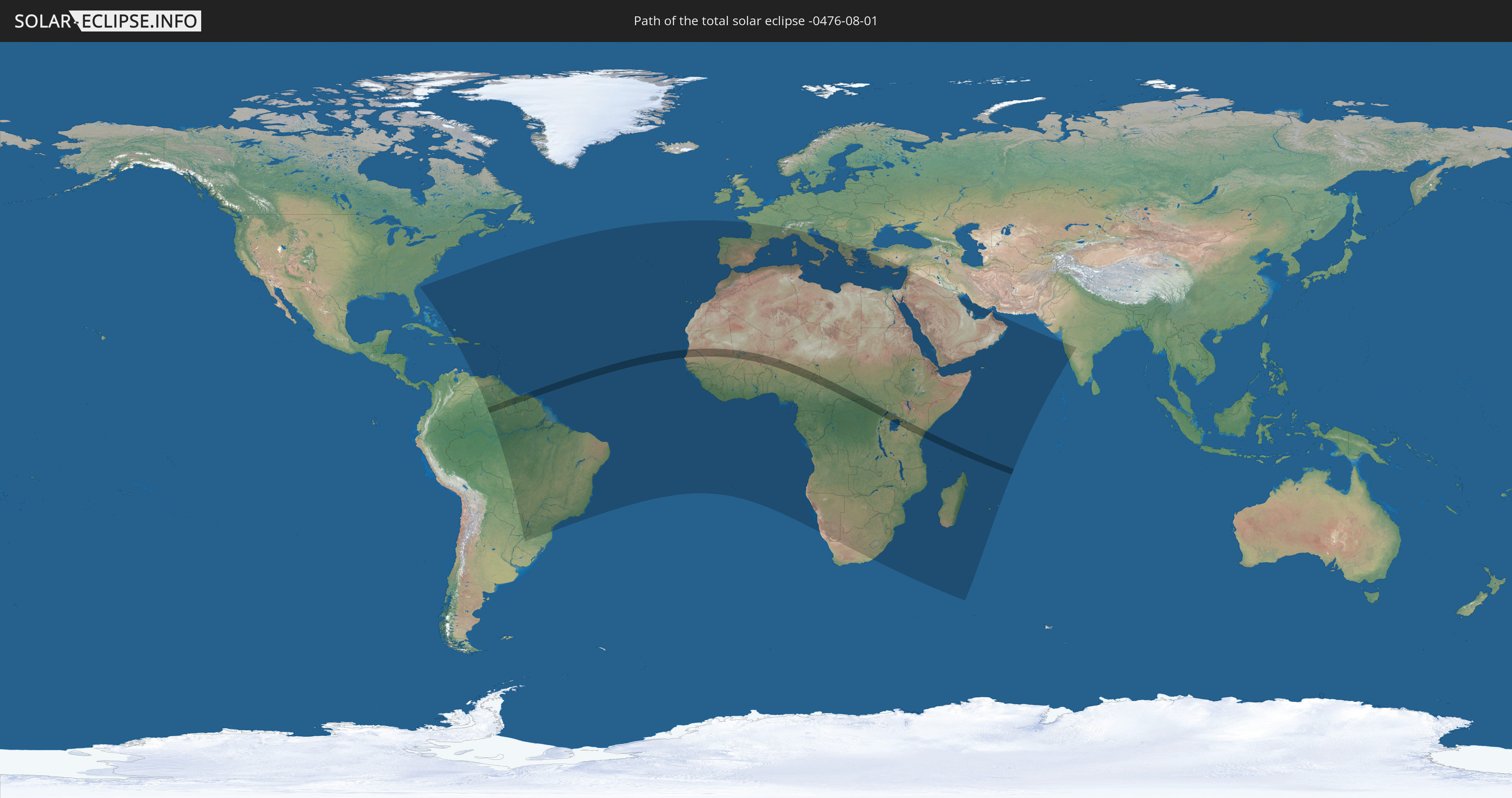
Die Sonnenfinsternis am 01.08.-0476 kann man in 120 Ländern als partielle Sonnenfinsternis beobachten.
Der Finsternispfad verläuft durch 20 Länder. Nur in diesen Ländern ist sie als totale Sonnenfinsternis zu sehen.
In den folgenden Ländern ist die Sonnenfinsternis total zu sehen
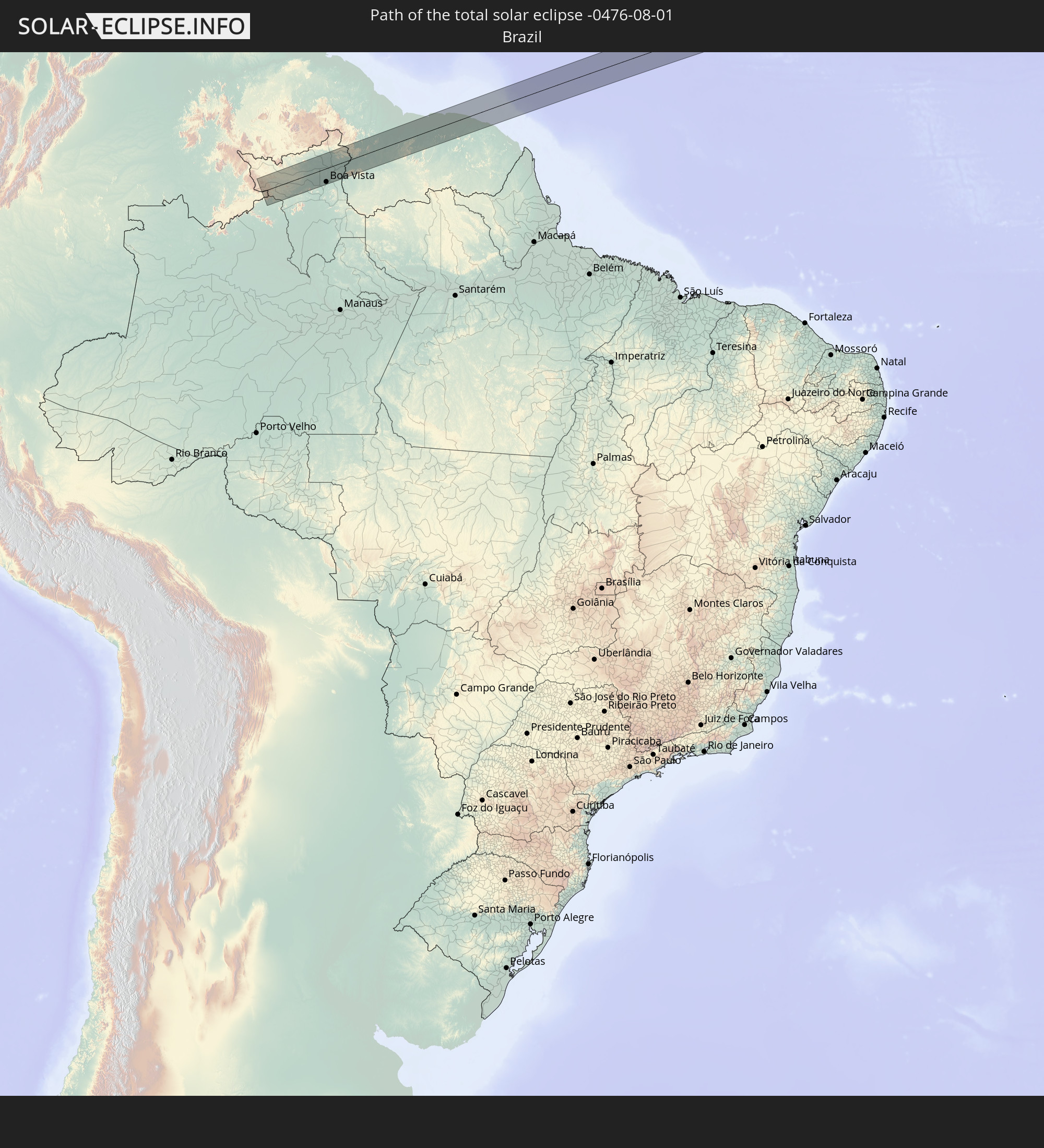 Brasilien
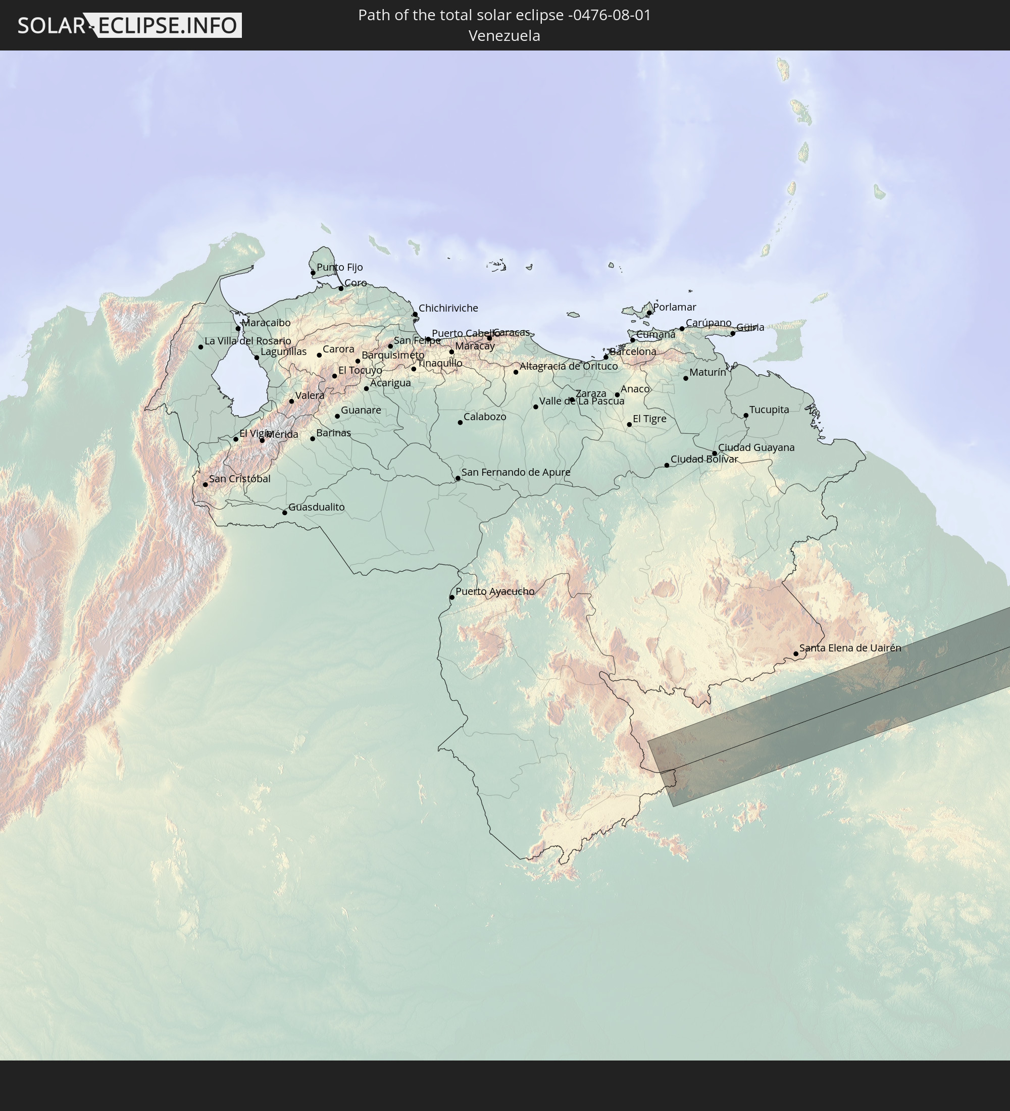 Venezuela
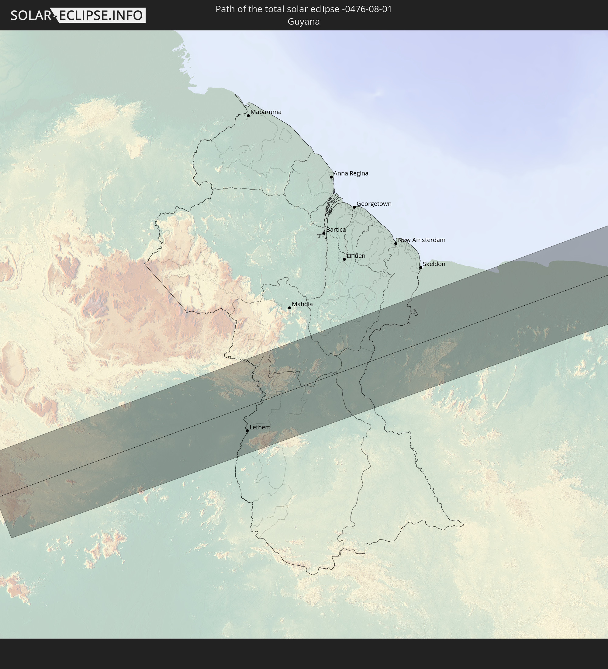 Guyana
 Suriname
 Französisch-Guayana
 Kap Verde
 Senegal
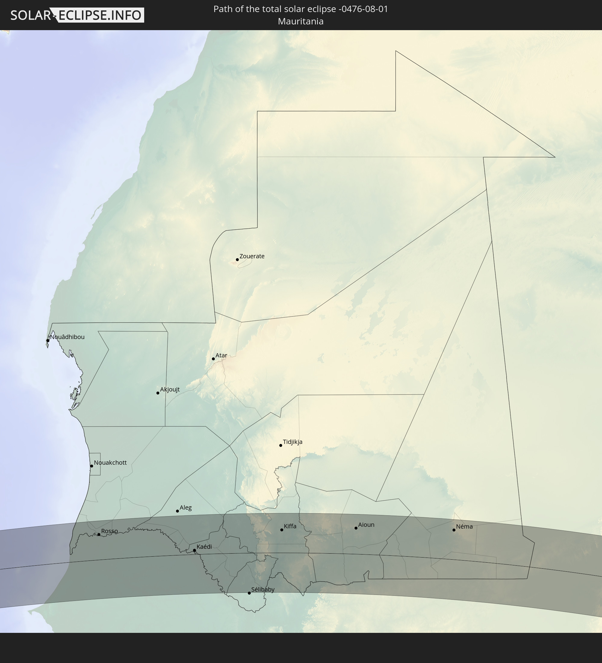 Mauretanien
 Mali
Mali
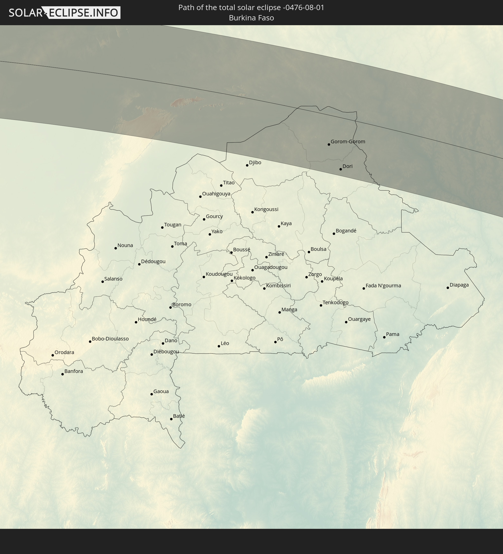 Burkina Faso
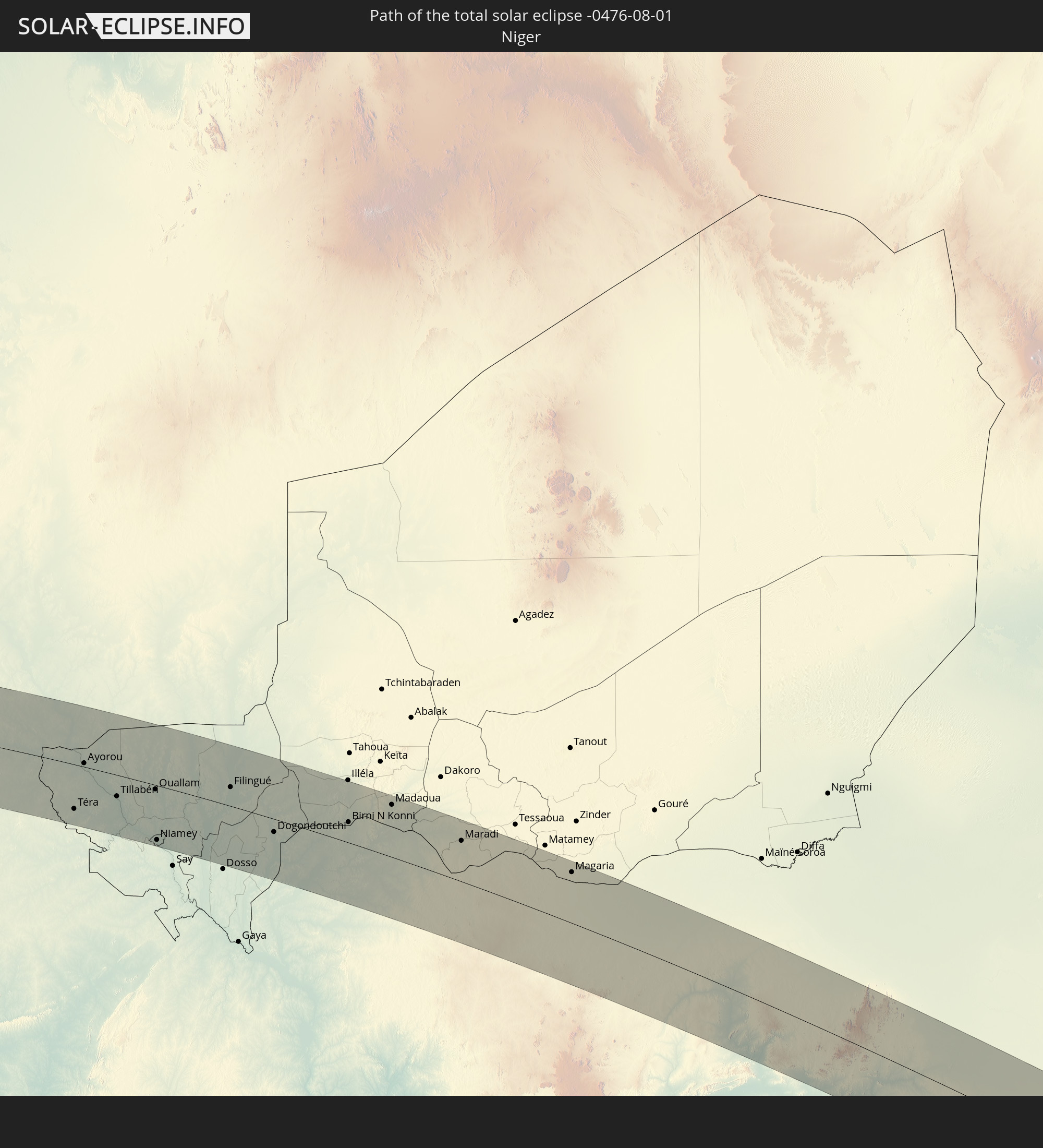 Niger
Niger
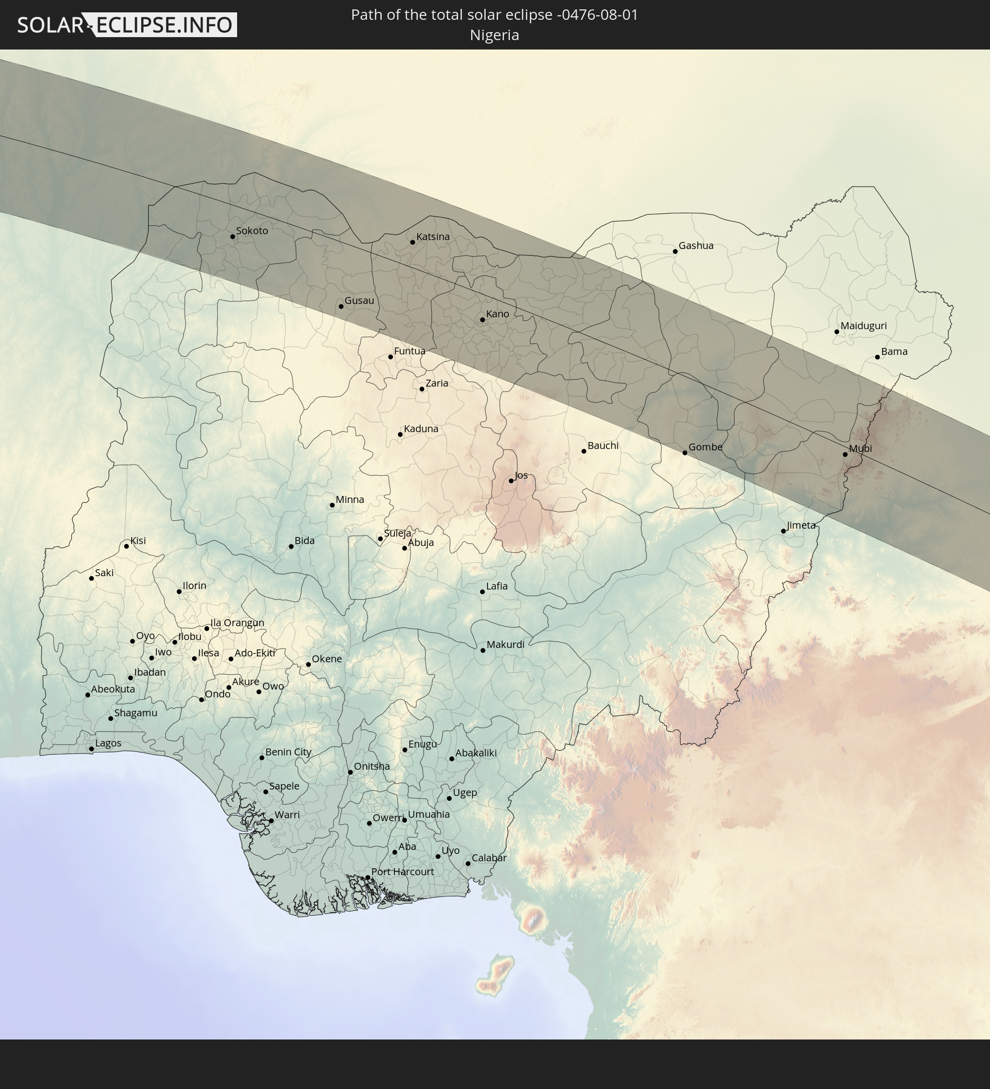 Nigeria
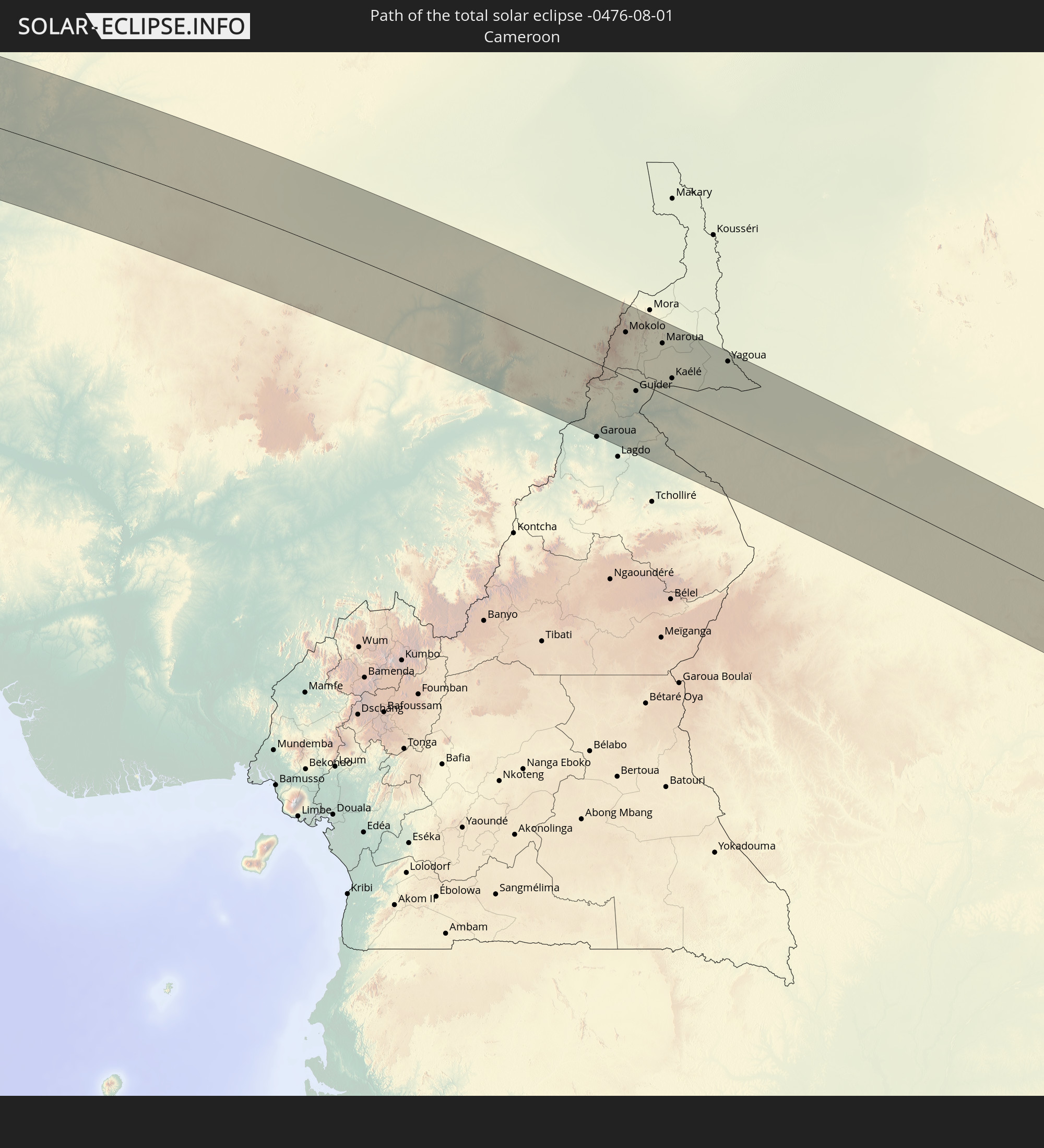 Kamerun
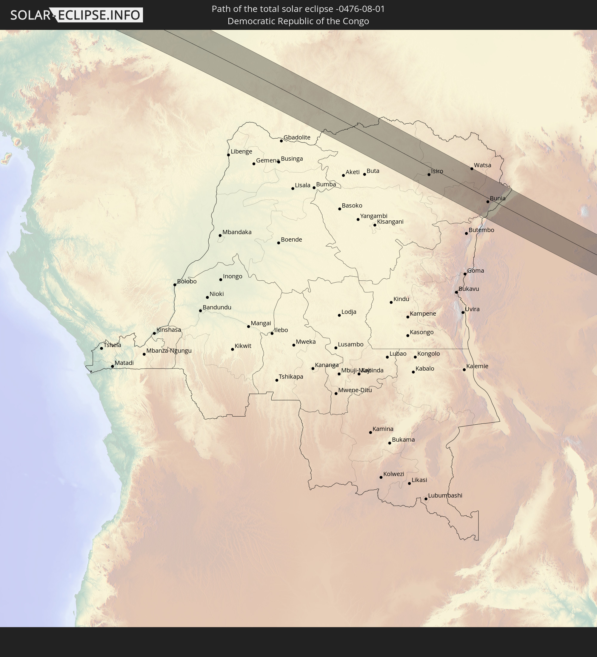 Demokratische Republik Kongo
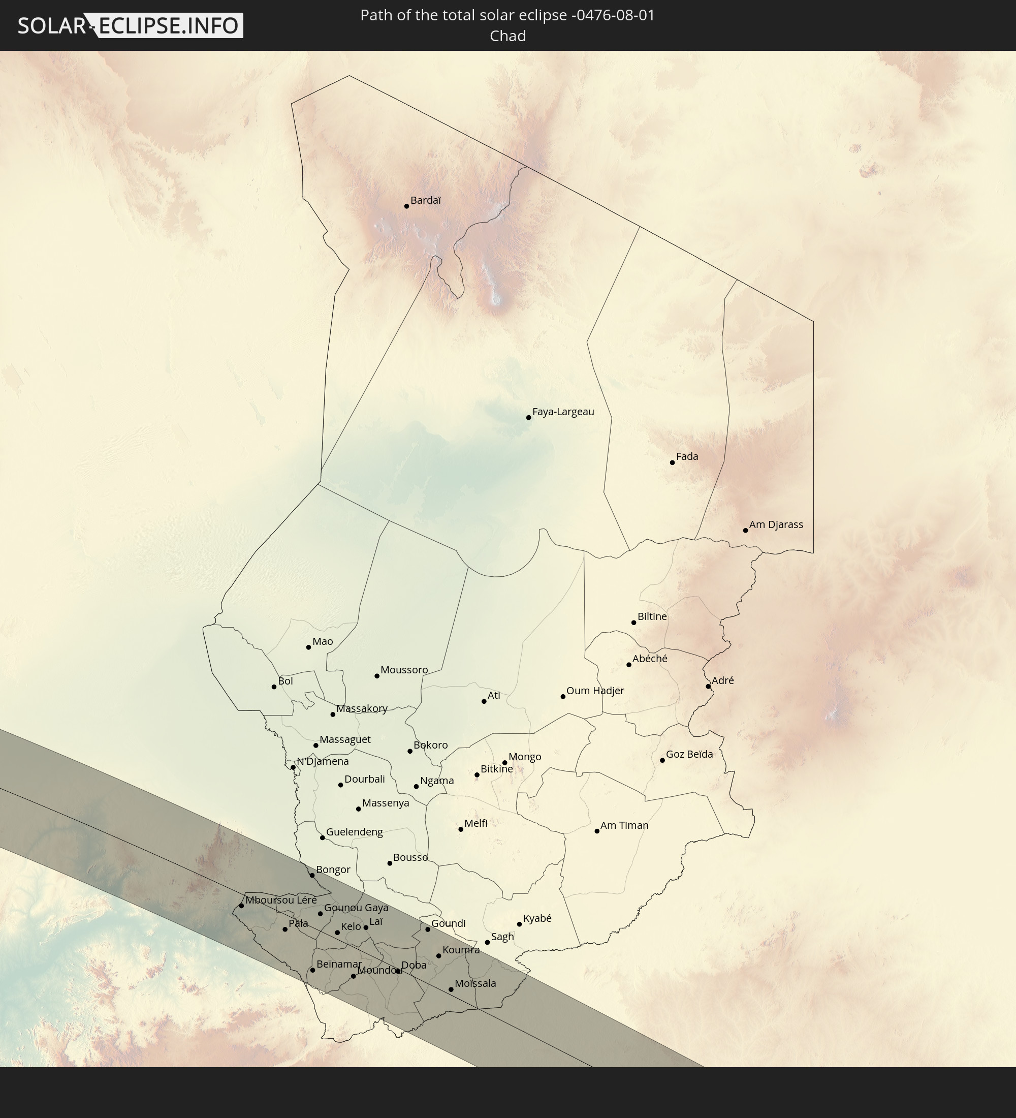 Tschad
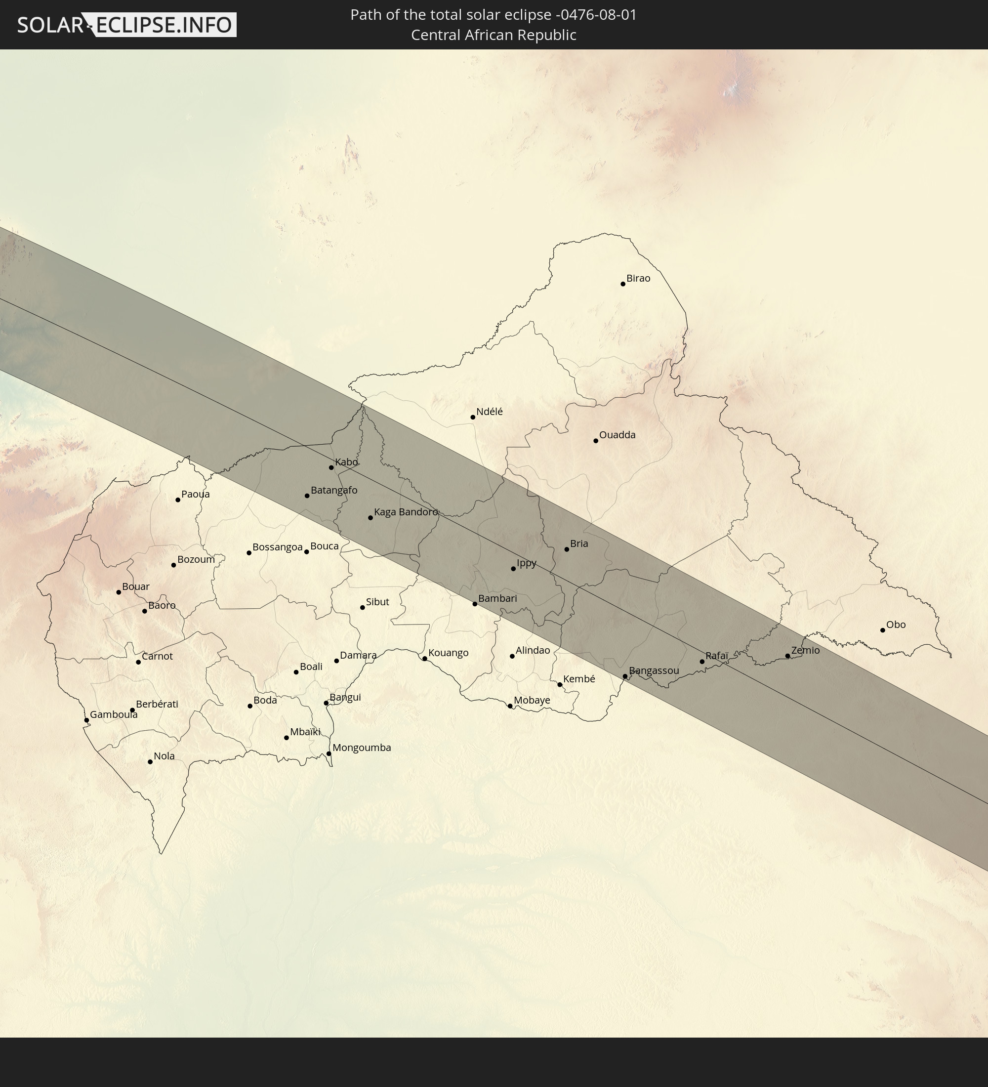 Zentralafrikanische Republik
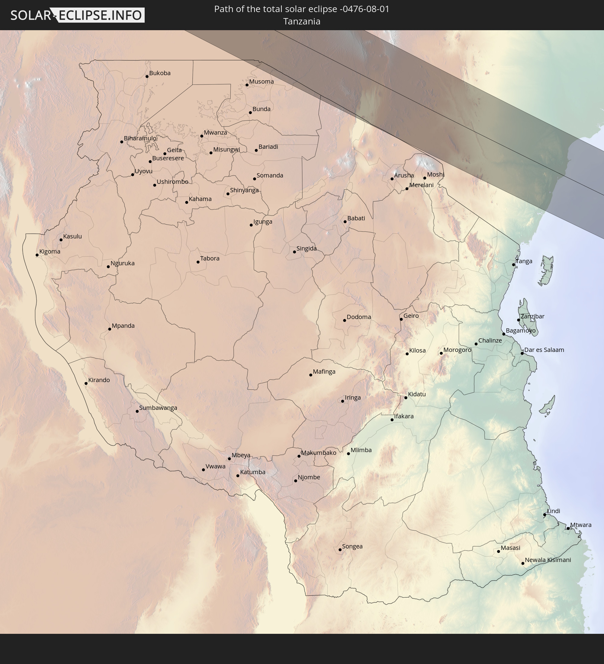 Tansania
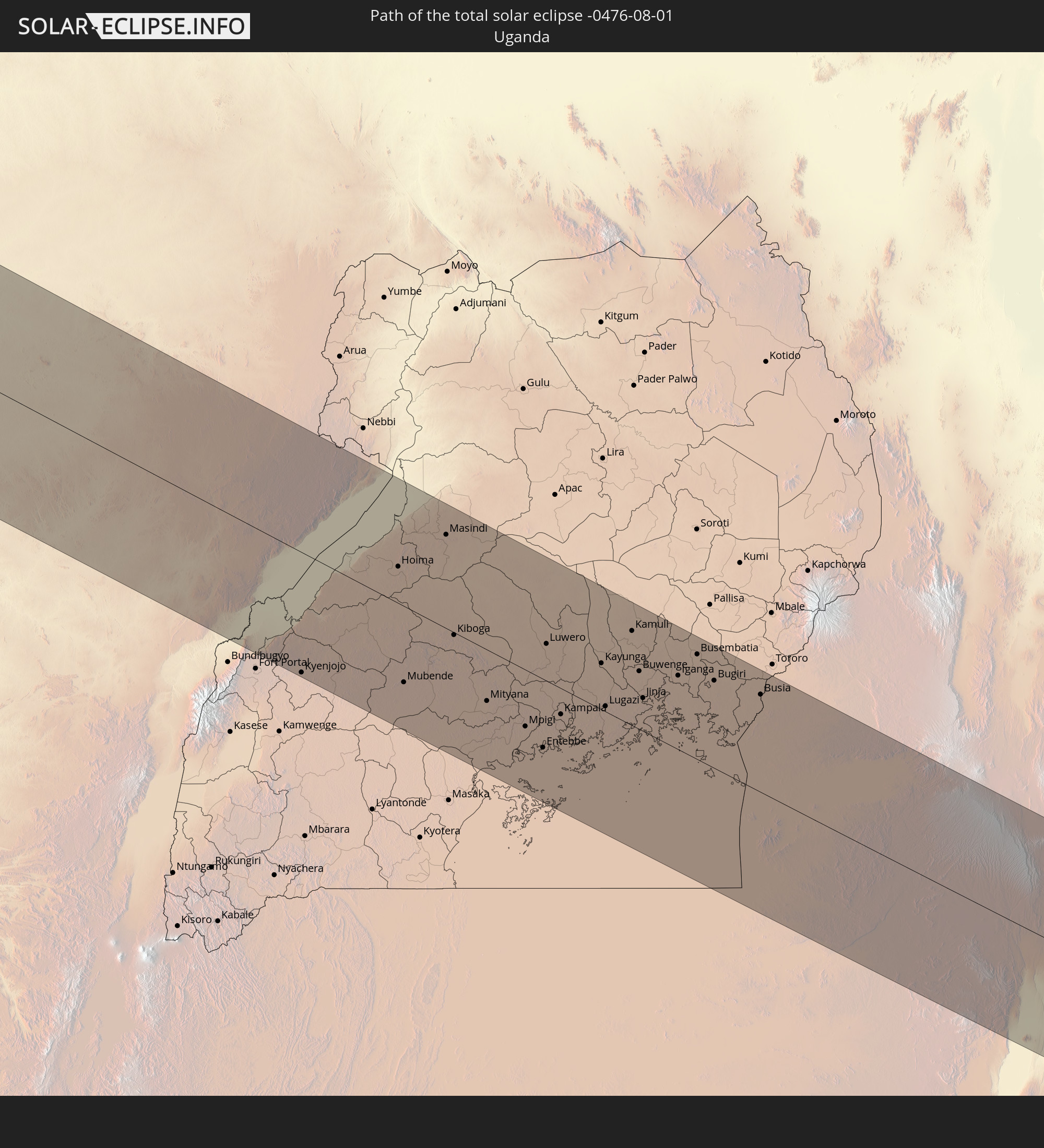 Uganda
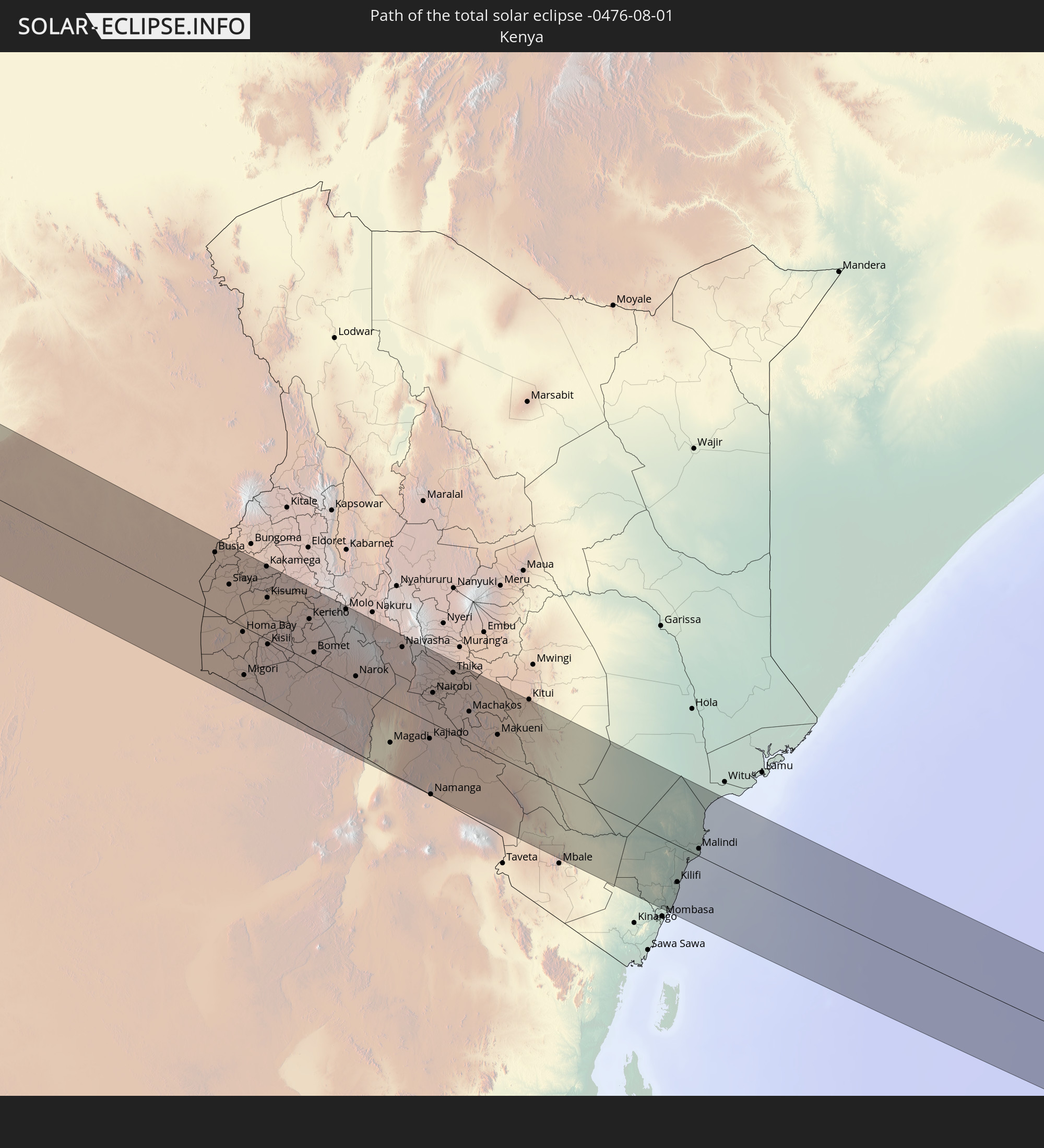 Kenia
Kenia
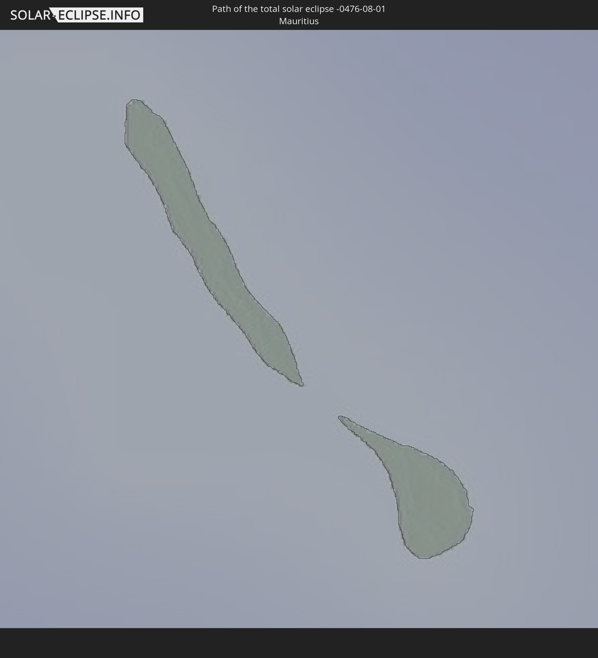 Mauritius
In den folgenden Ländern ist die Sonnenfinsternis partiell zu sehen
 Bahamas
 Haiti
Haiti
 Brasilien
 Argentinien
 Venezuela
 Turks- und Caicosinseln
 Dominikanische Republik
 Puerto Rico
 Amerikanische Jungferninseln
 Bermuda
 Britische Jungferninseln
 Anguilla
 Saint-Martin
 Saint-Barthélemy
 St. Kitts und Nevis
 Paraguay
 Antigua und Barbuda
 Montserrat
 Trinidad und Tobago
 Guadeloupe
 Grenada
 Dominica
 St. Vincent und die Grenadinen
 Guyana
 Martinique
 St. Lucia
 Barbados
 Suriname
 Französisch-Guayana
 Portugal
 Kap Verde
 Spanien
 Senegal
 Mauretanien
 Gambia
 Guinea-Bissau
 Guinea
 St. Helena
 Sierra Leone
 Marokko
 Mali
Mali
 Liberia
 Algerien
 Elfenbeinküste
 Burkina Faso
 Gibraltar
 Frankreich
 Ghana
Ghana
 Togo
Togo
 Niger
Niger
 Benin
Benin
 Andorra
 Nigeria
 Äquatorialguinea
 São Tomé und Príncipe
 Italien
 Monaco
 Tunesien
 Kamerun
 Gabun
Gabun
 Libyen
 Republik Kongo
 Angola
 Namibia
 Demokratische Republik Kongo
 San Marino
 Vatikanstadt
 Tschad
 Kroatien
 Malta
Malta
 Zentralafrikanische Republik
 Bosnien und Herzegowina
 Südafrika
 Montenegro
 Albanien
 Griechenland
 Botswana
 Mazedonien
 Sudan
Sudan
 Sambia
 Bulgarien
 Ägypten
 Simbabwe
 Türkei
 Lesotho
 Ruanda
 Burundi
 Tansania
 Uganda
 Mosambik
 Swasiland
 Republik Zypern
 Malawi
 Äthiopien
 Kenia
Kenia
 Staat Palästina
 Israel
 Saudi-Arabien
 Jordanien
 Libanon
 Syrien
 Eritrea
 Irak
Irak
 Französische Süd- und Antarktisgebiete
 Somalia
 Dschibuti
 Jemen
Jemen
 Madagaskar
 Komoren
 Iran
Iran
 Mayotte
 Seychellen
 Kuwait
 Bahrain
 Katar
Katar
 Vereinigte Arabische Emirate
 Oman
Oman
 Réunion
 Mauritius
 Indien
Wie wird das Wetter während der totalen Sonnenfinsternis am 01.08.-0476?
Wo ist der beste Ort, um die totale Sonnenfinsternis vom 01.08.-0476 zu beobachten?
Die folgenden Karten zeigen die durchschnittliche Bewölkung für den Tag, an dem die totale Sonnenfinsternis
stattfindet. Mit Hilfe der Karten lässt sich der Ort entlang des Finsternispfades eingrenzen,
der die besten Aussichen auf einen klaren wolkenfreien Himmel bietet.
Trotzdem muss man immer lokale Gegenenheiten beachten und sollte sich genau über das Wetter an seinem
gewählten Beobachtungsort informieren.
Die Daten stammen von den beiden NASA-Satelliten
AQUA und TERRA
und wurden über einen Zeitraum von 19 Jahren (2000 - 2019) gemittelt.
Detaillierte Länderkarten
 Brasilien
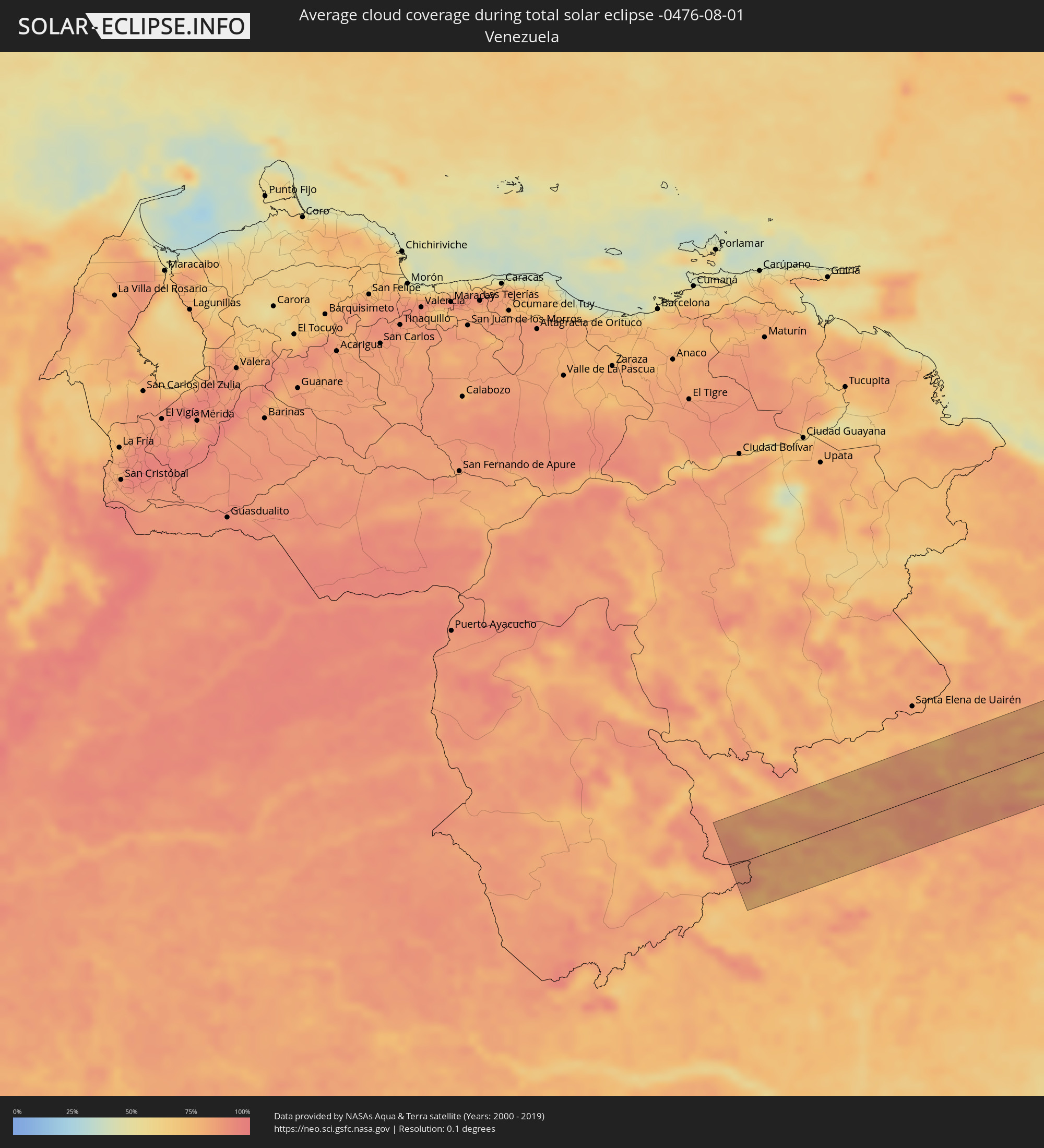 Venezuela
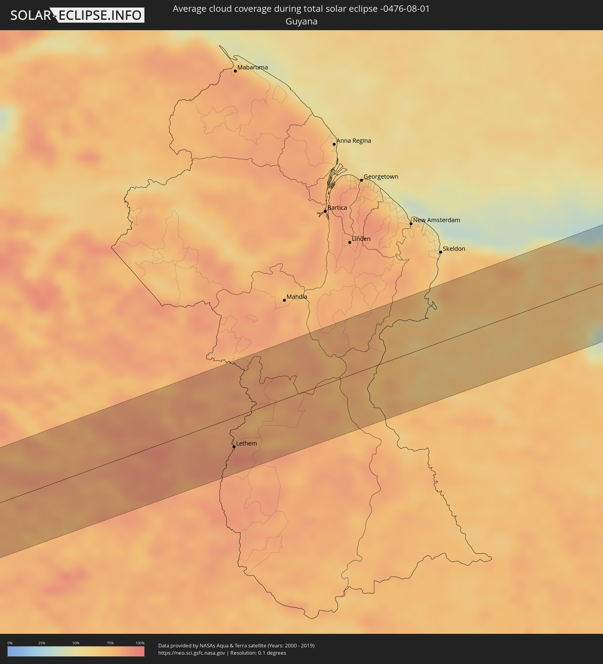 Guyana
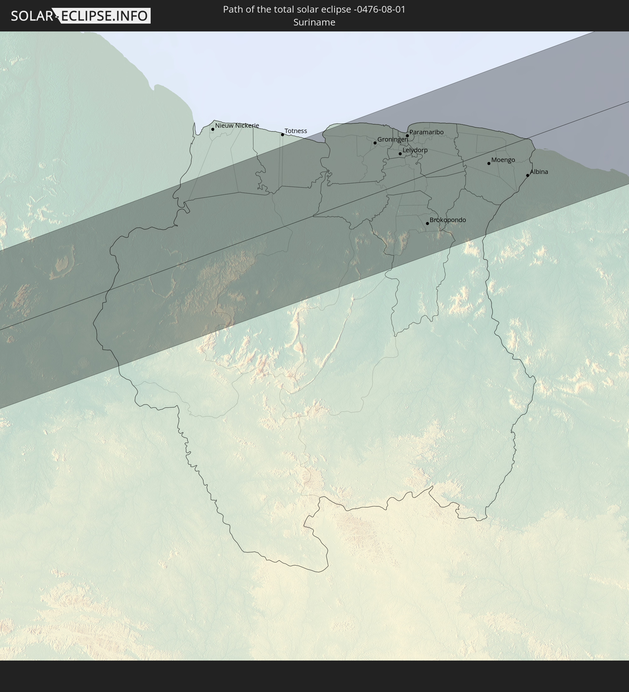
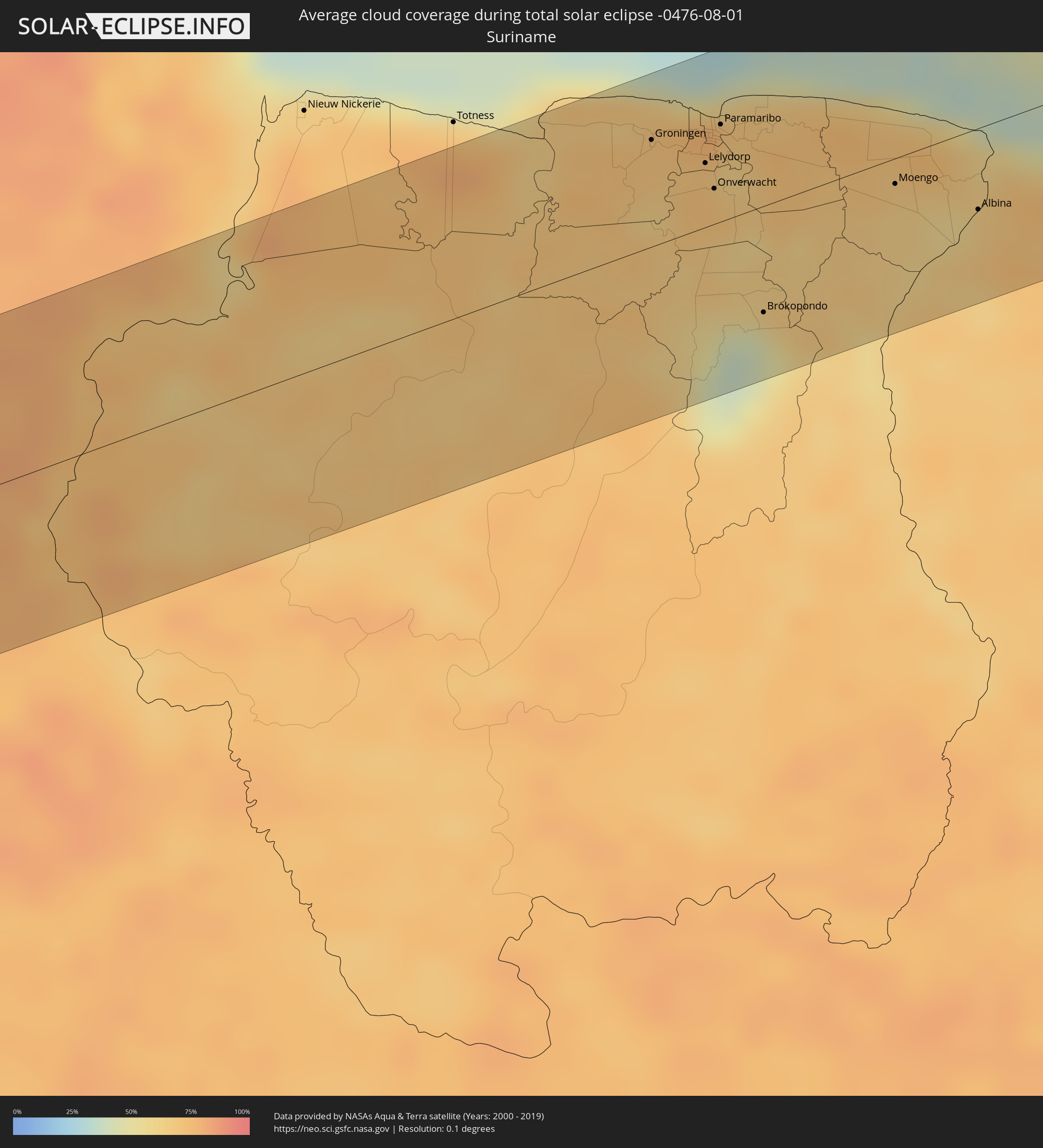 Suriname
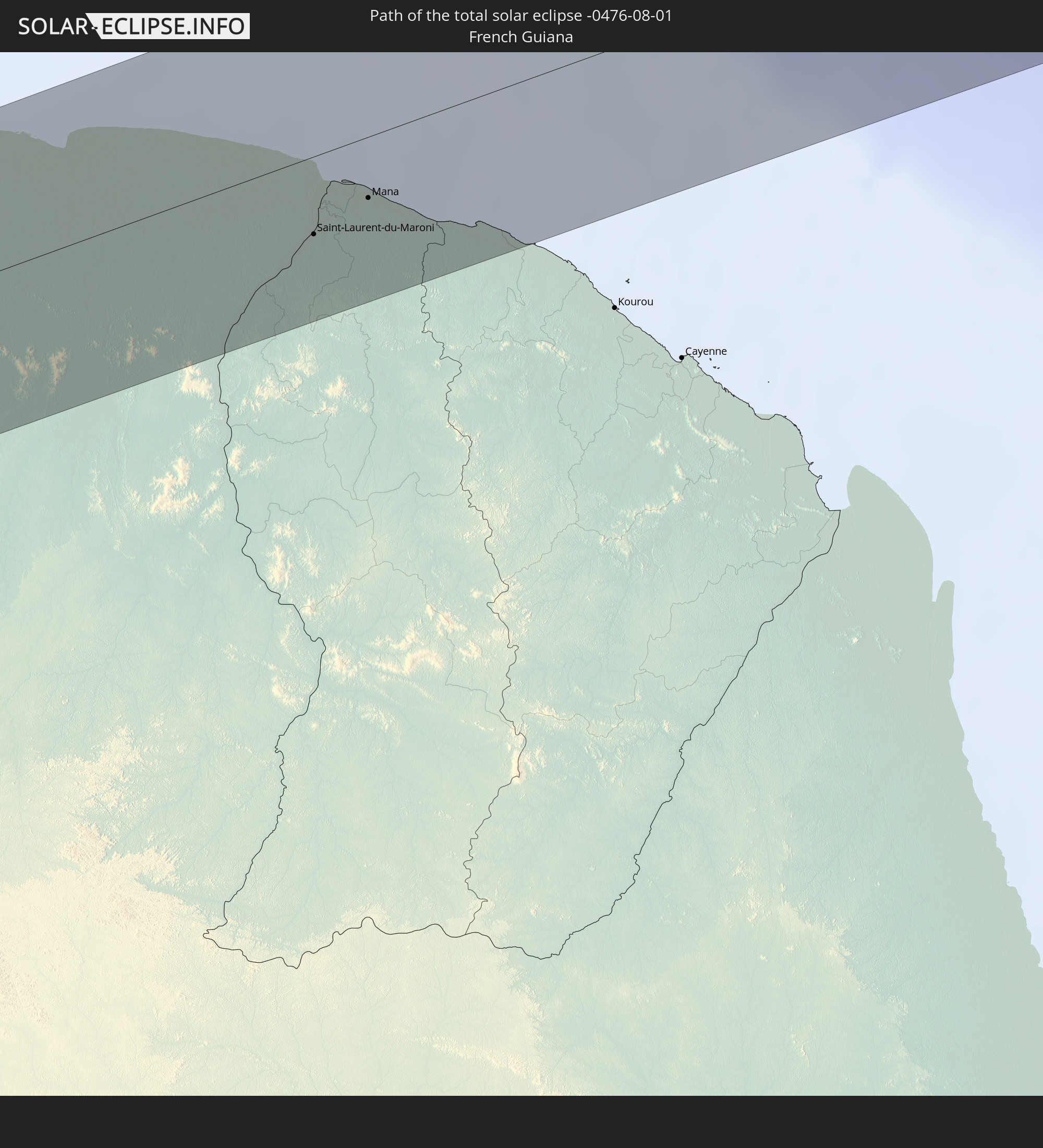
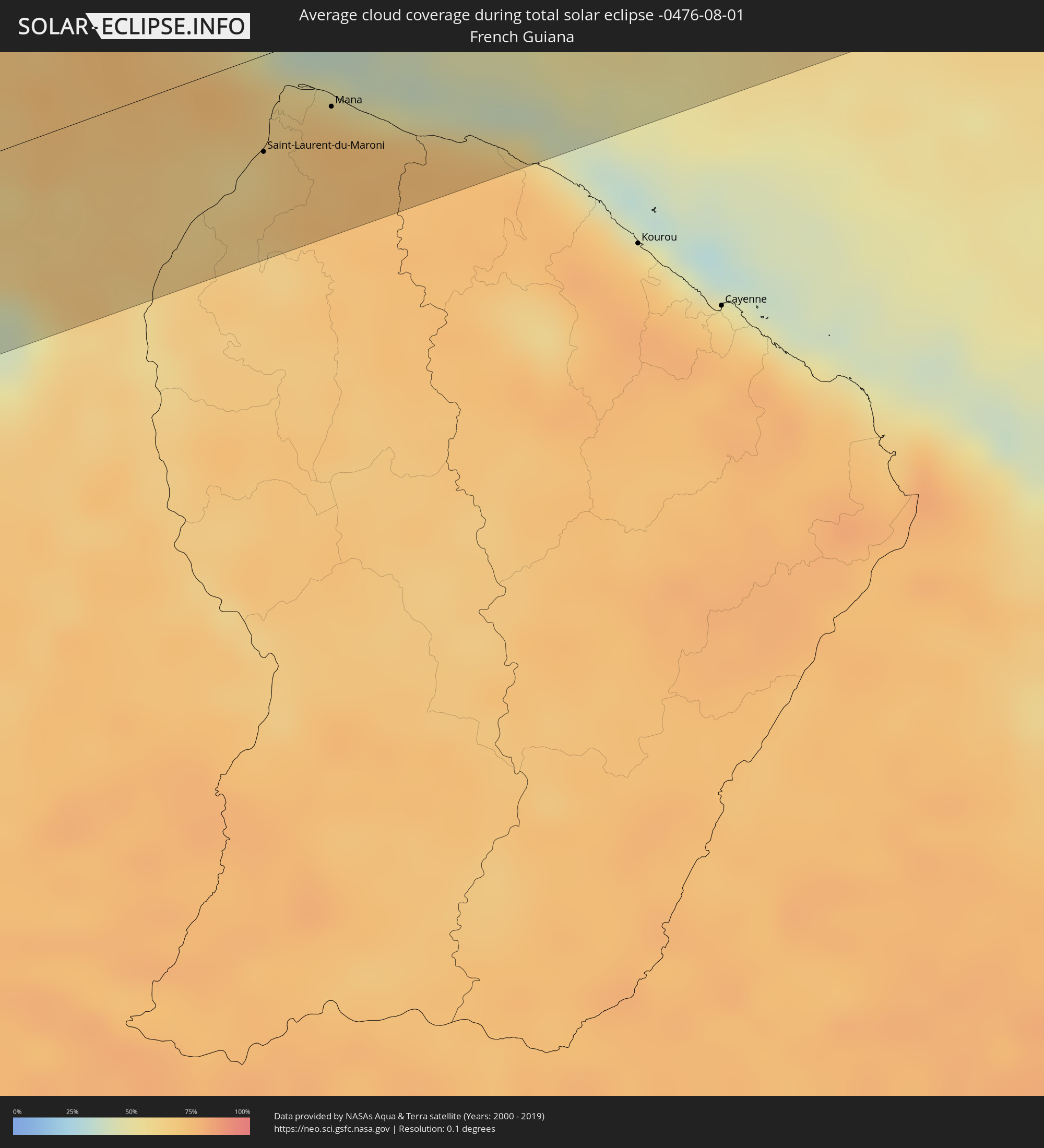 Französisch-Guayana
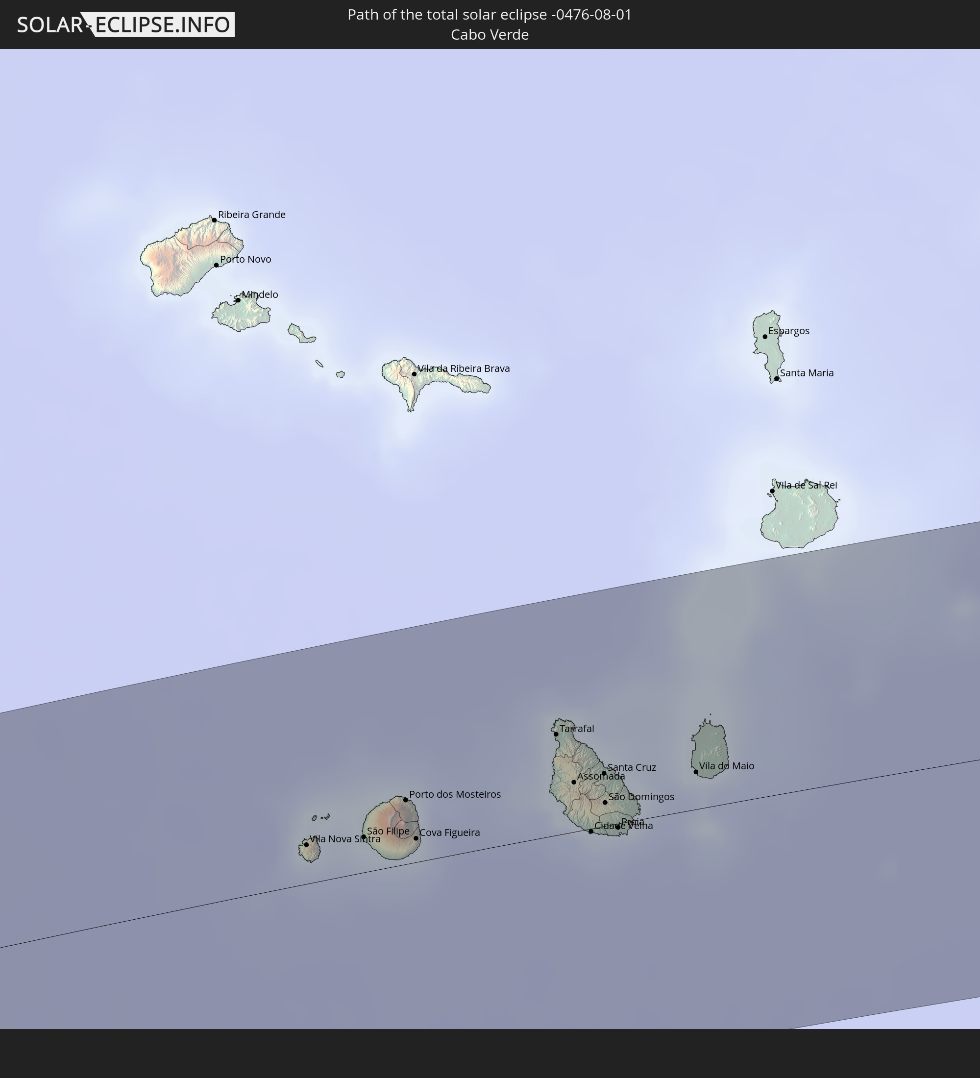
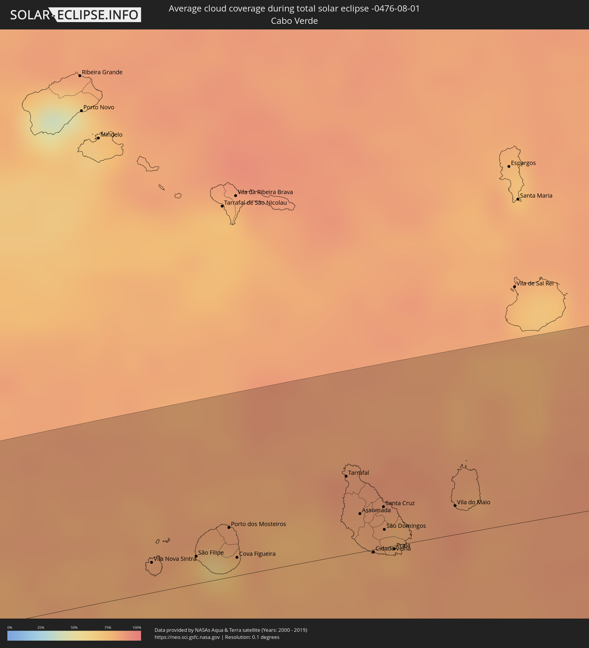 Kap Verde
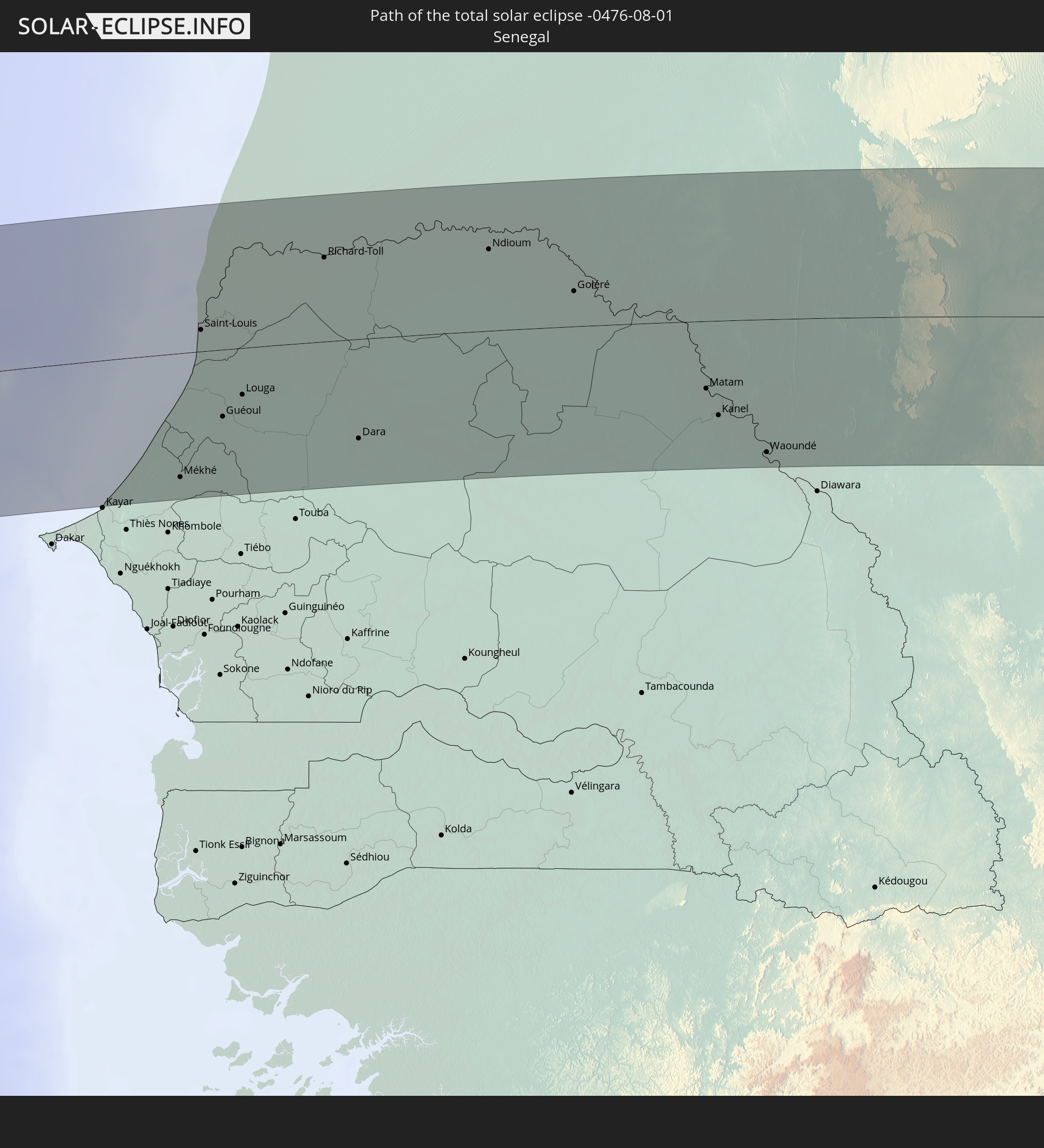
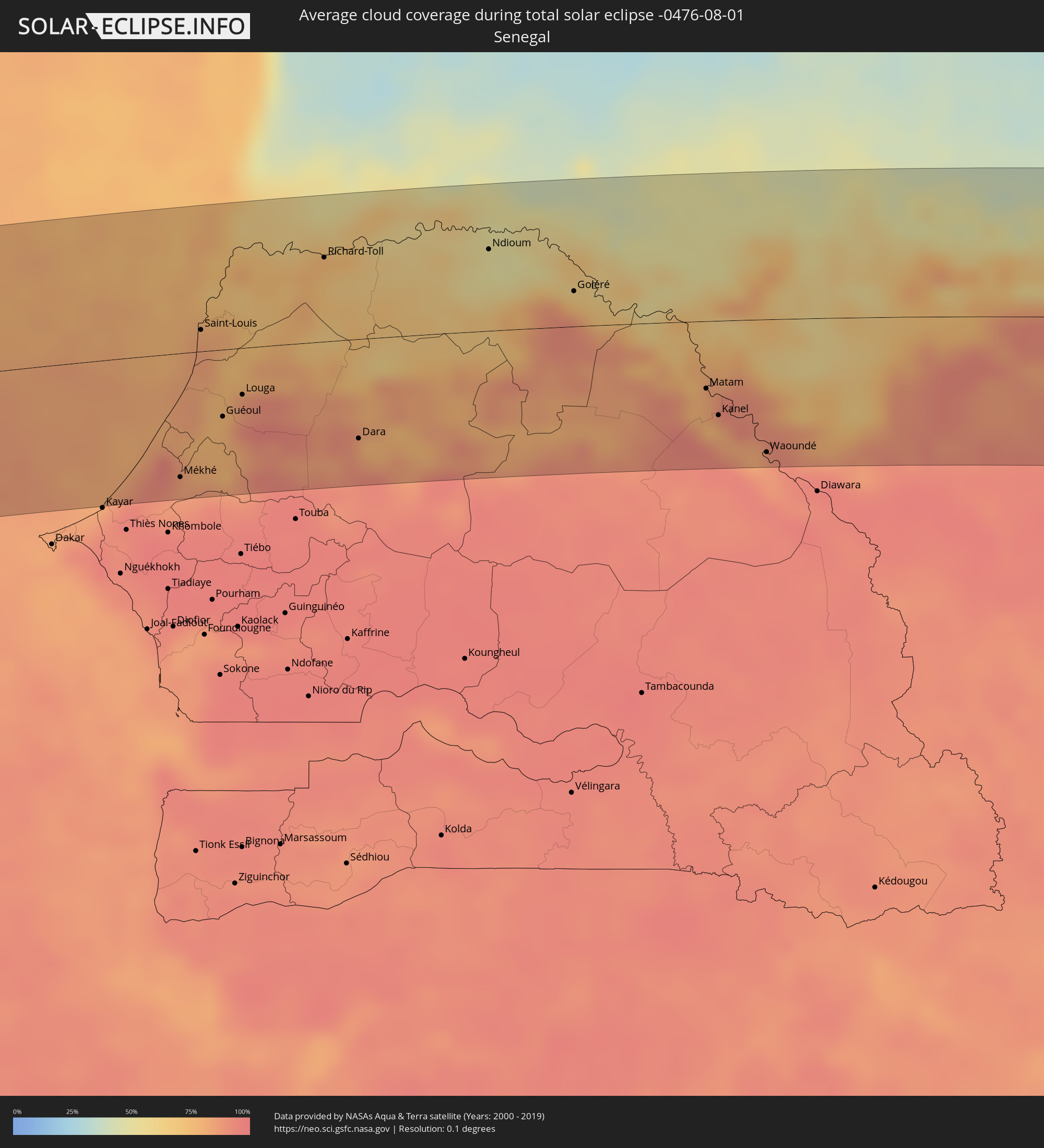 Senegal
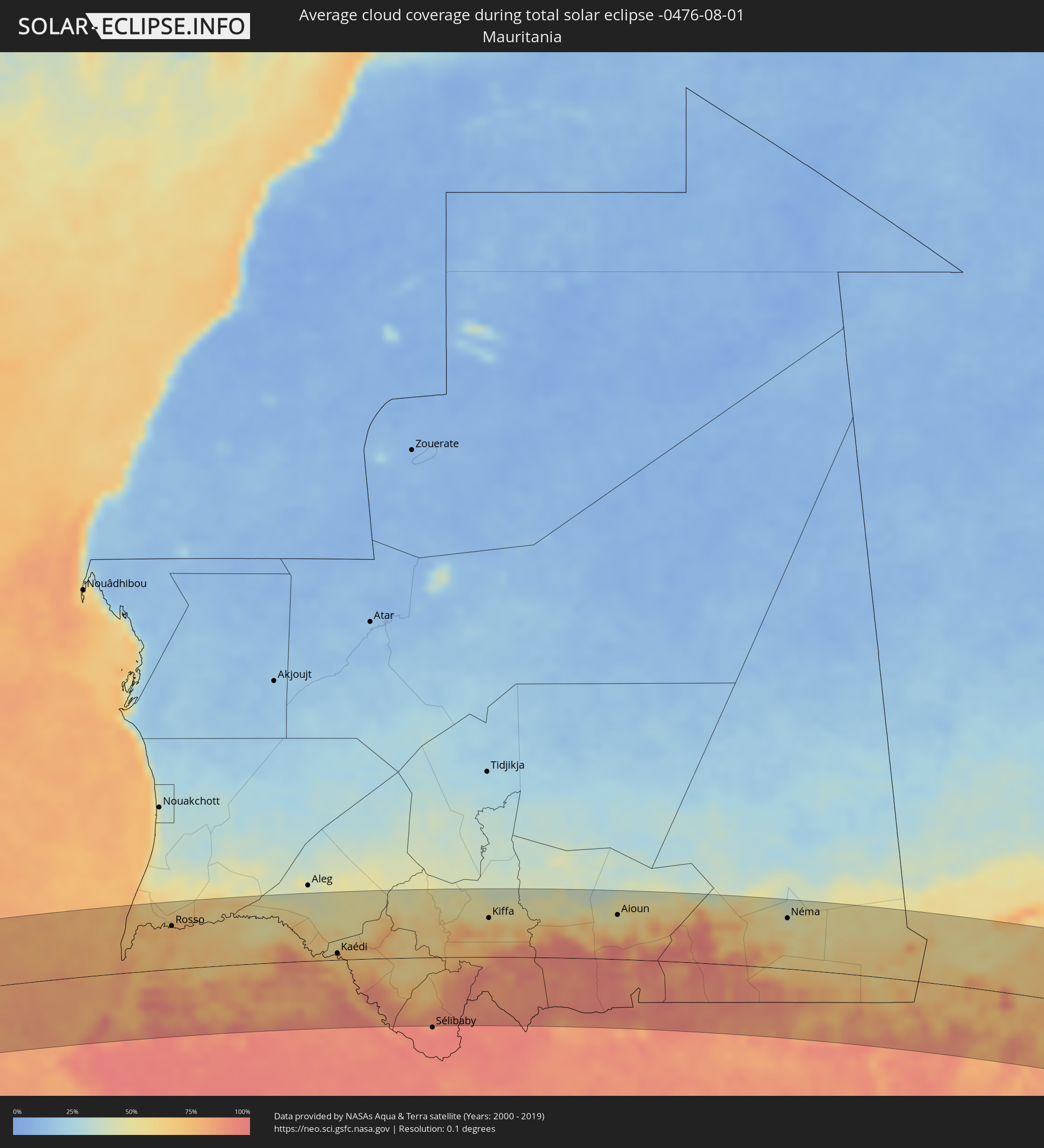 Mauretanien
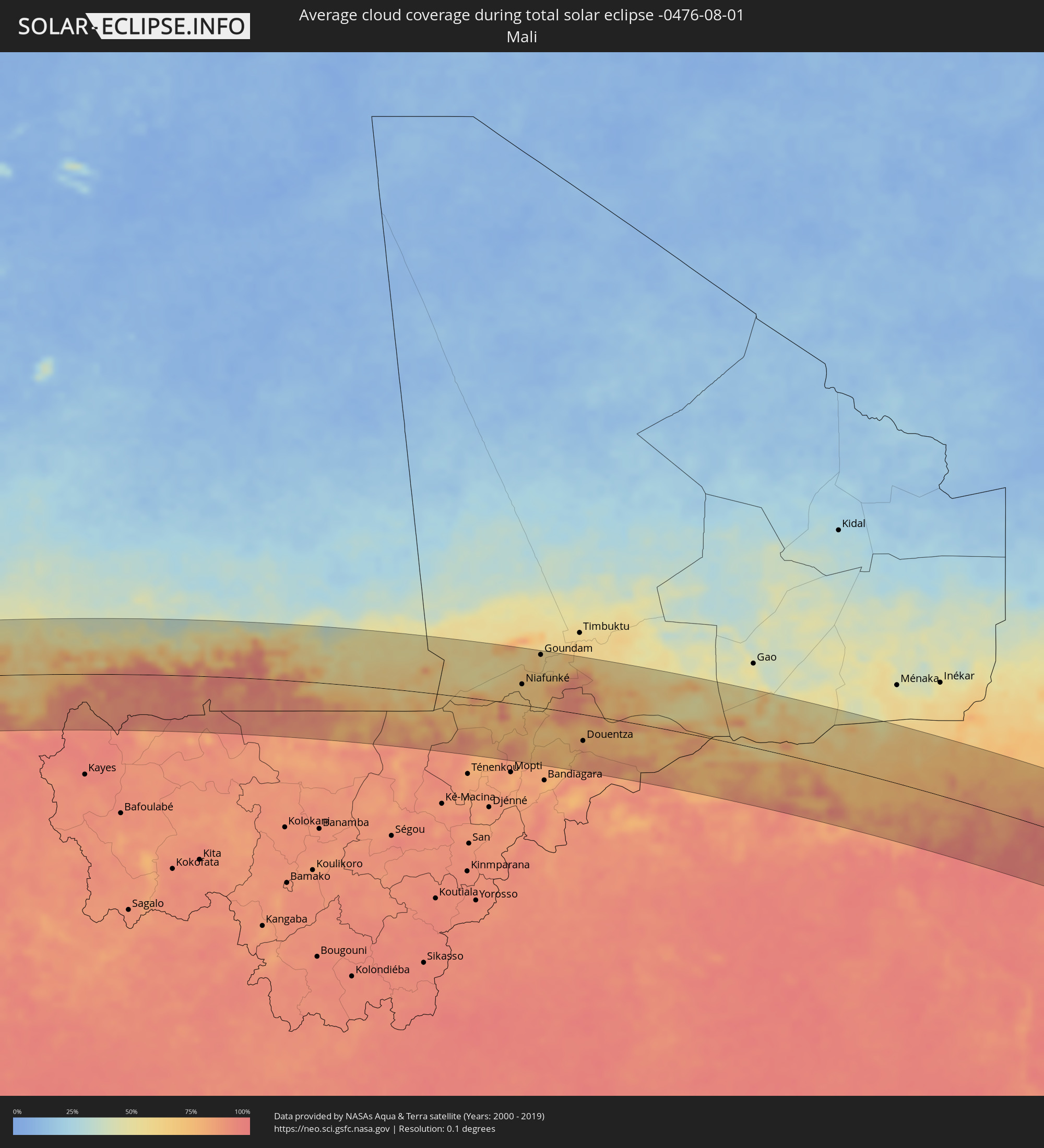 Mali
Mali
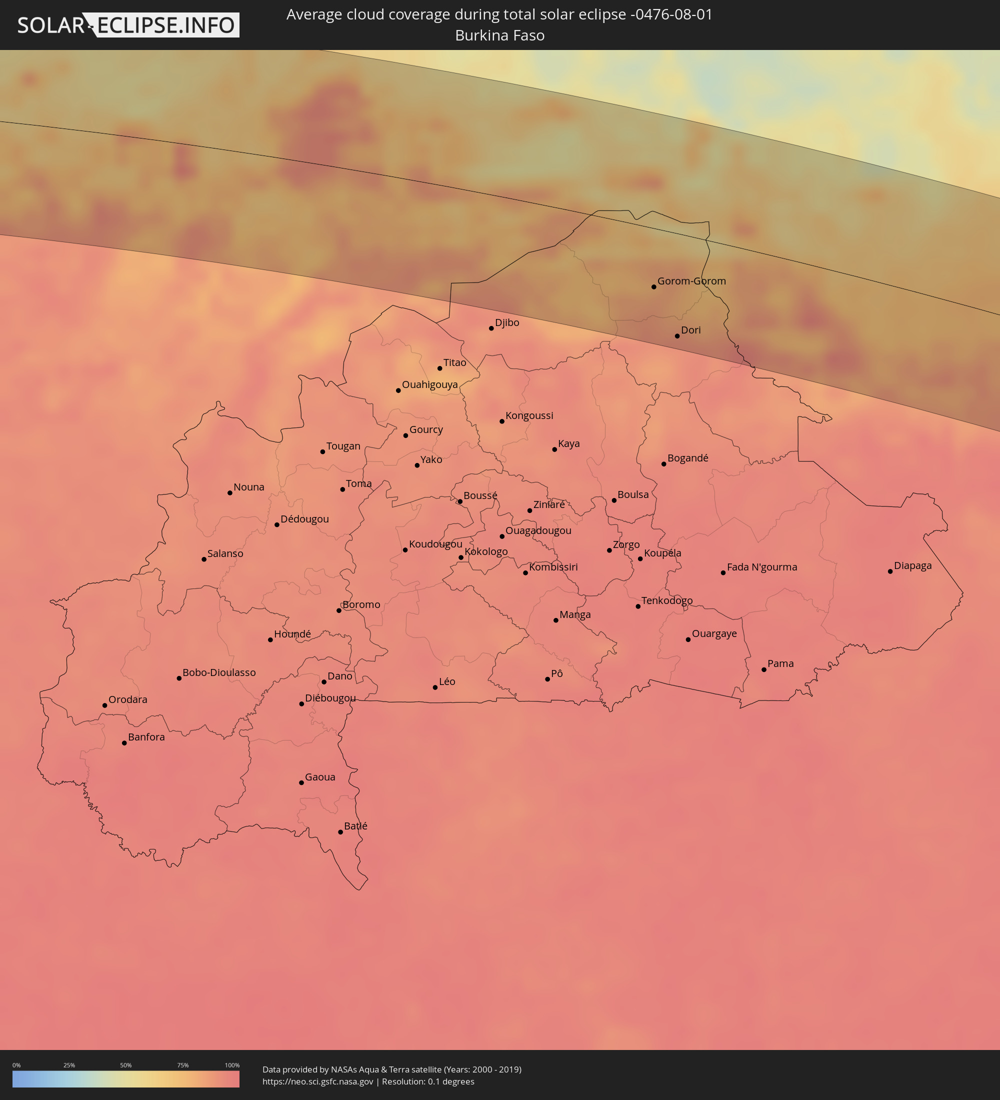 Burkina Faso
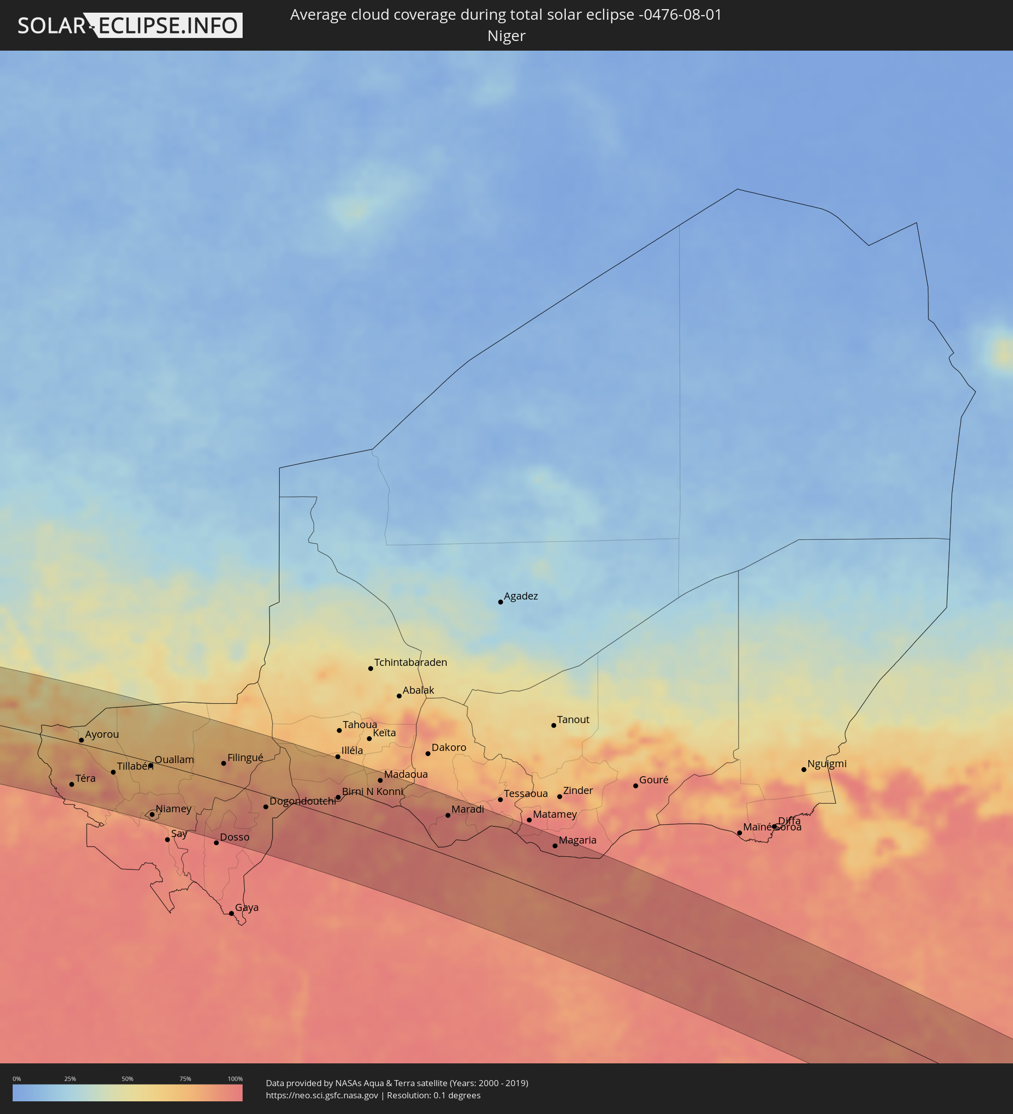 Niger
Niger
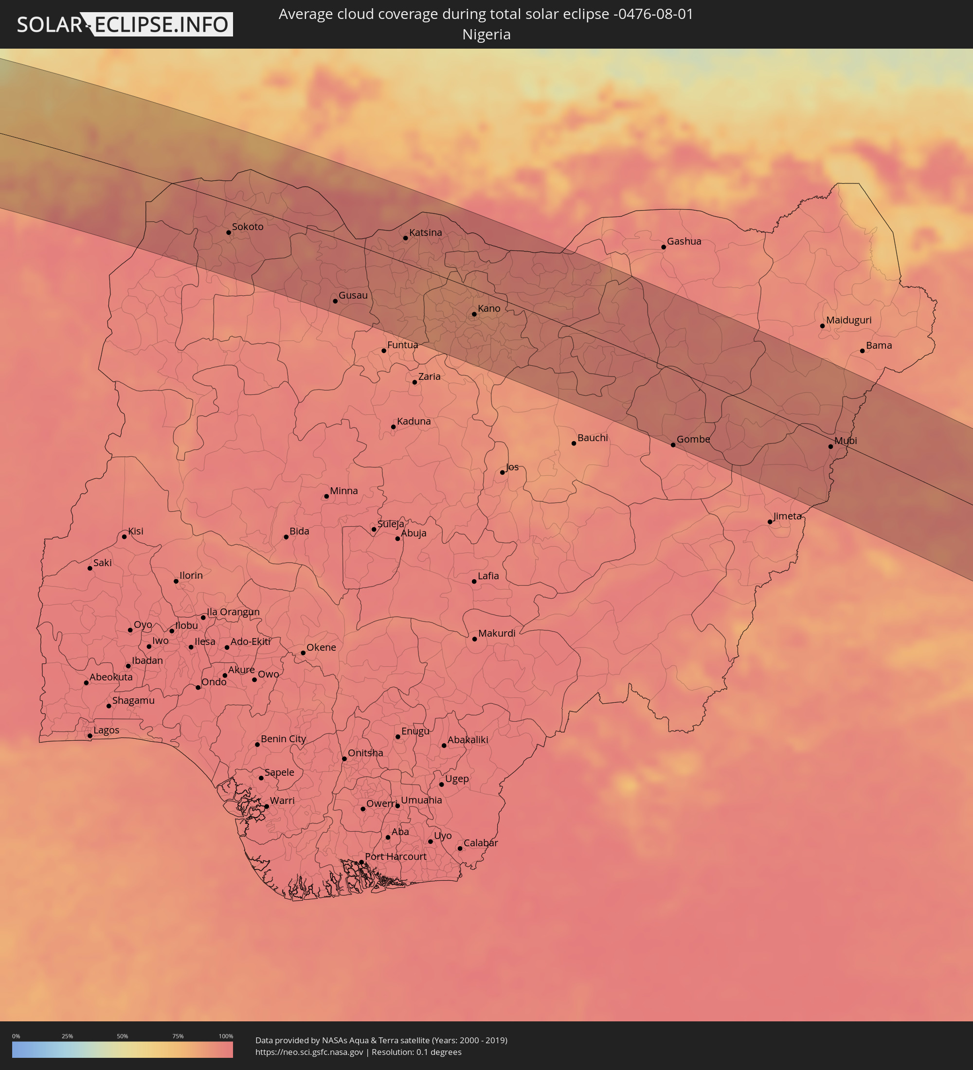 Nigeria
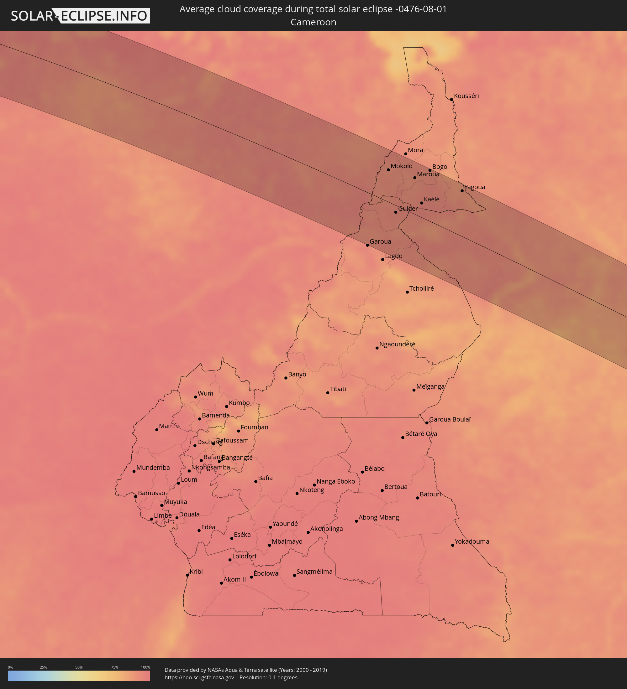 Kamerun
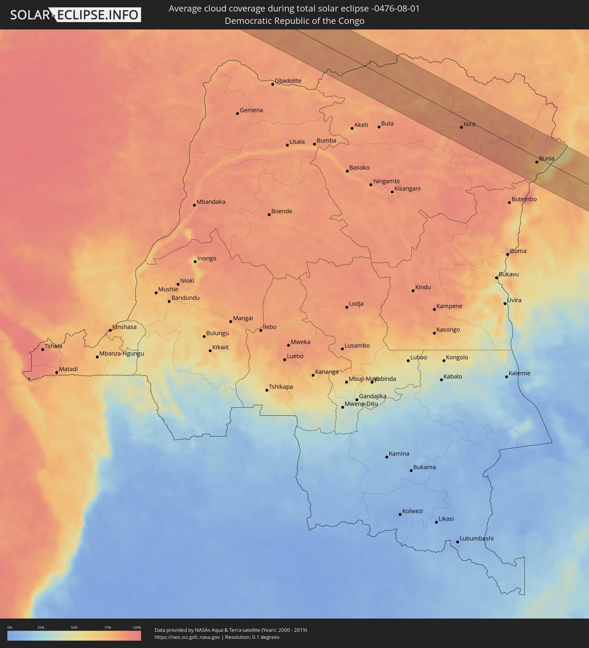 Demokratische Republik Kongo
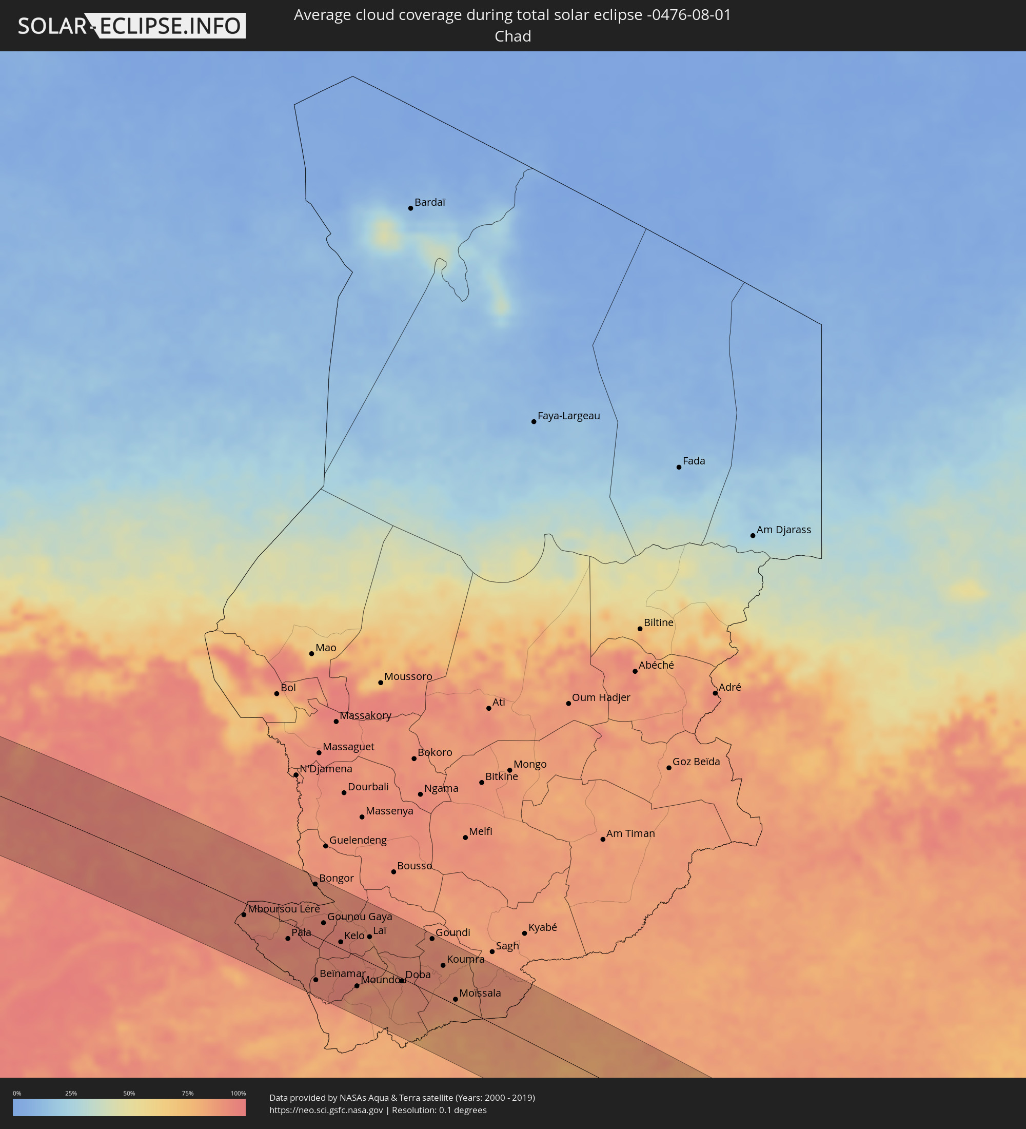 Tschad
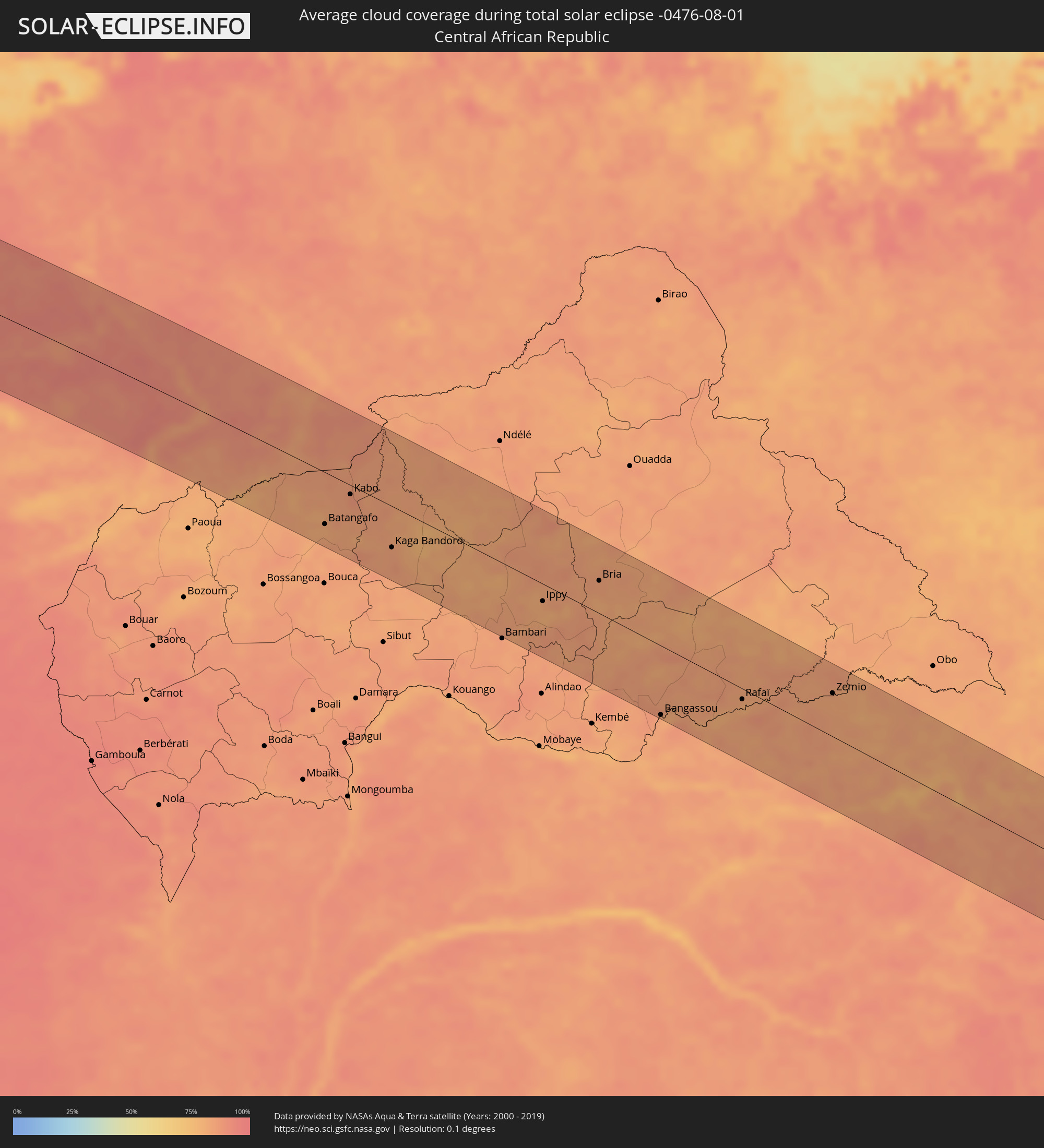 Zentralafrikanische Republik
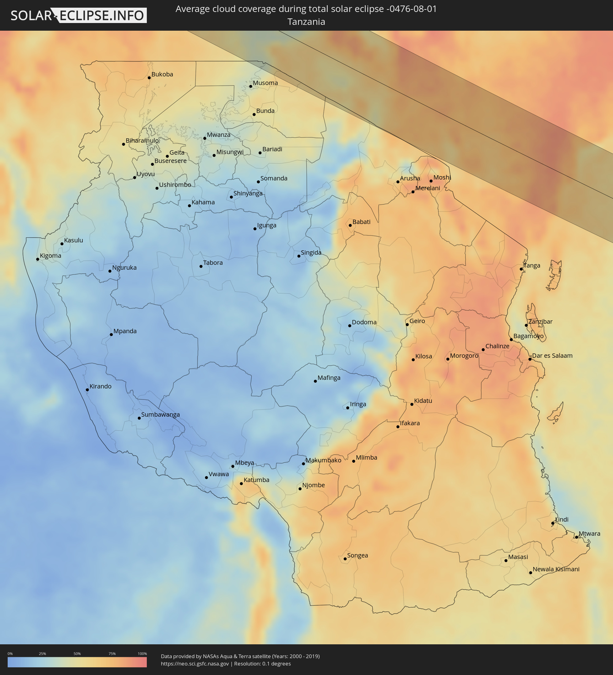 Tansania
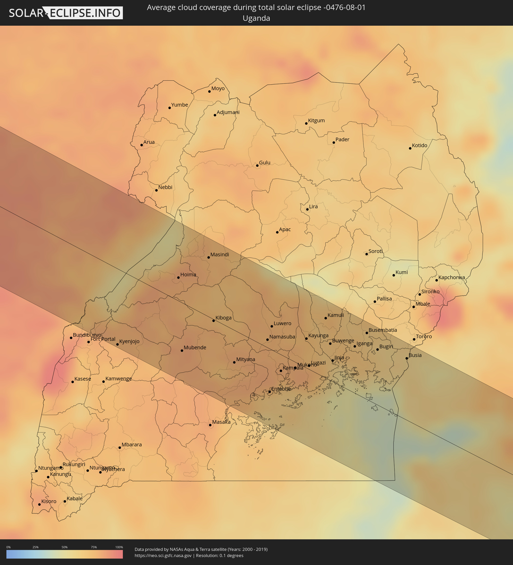 Uganda
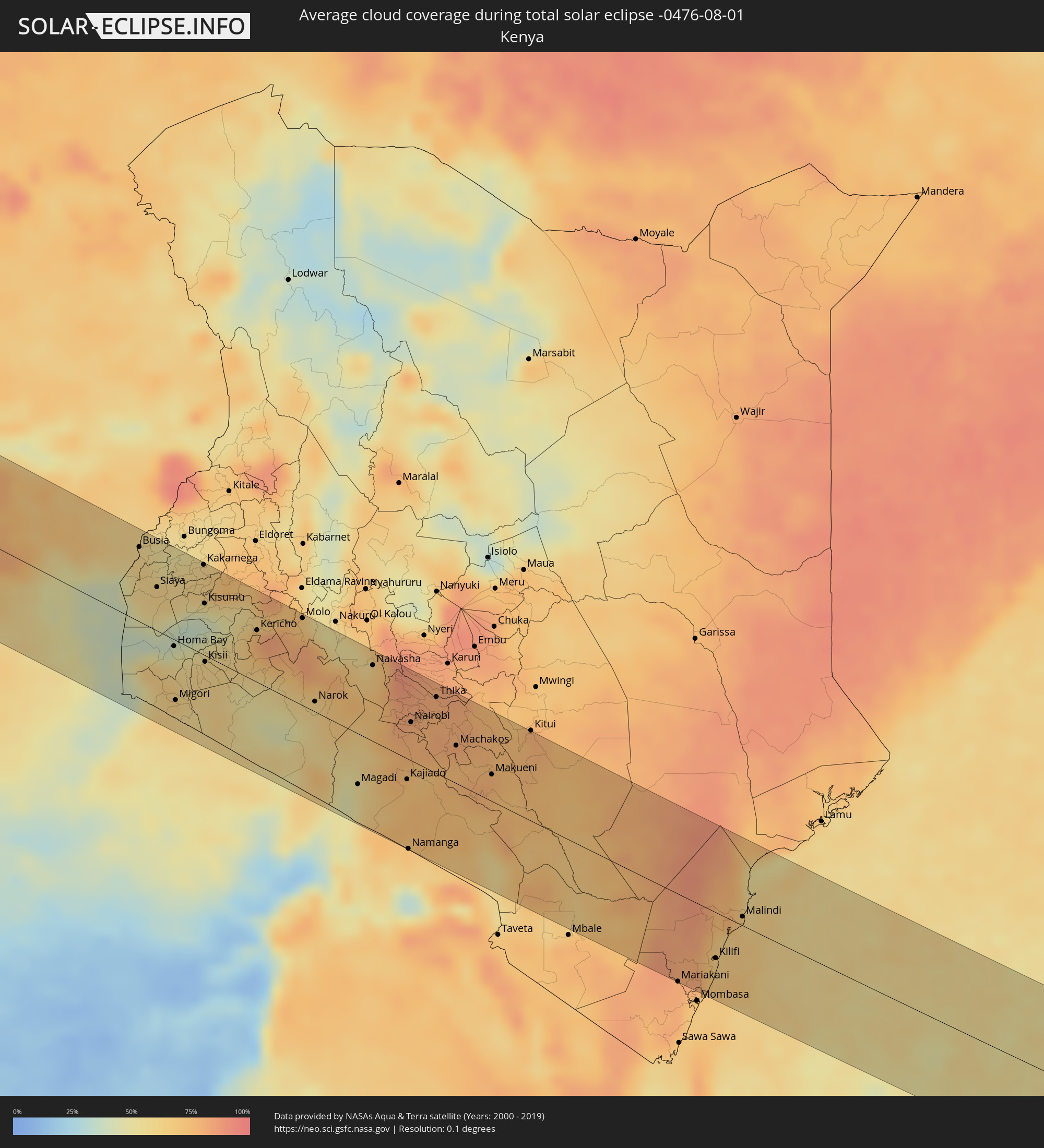 Kenia
Kenia
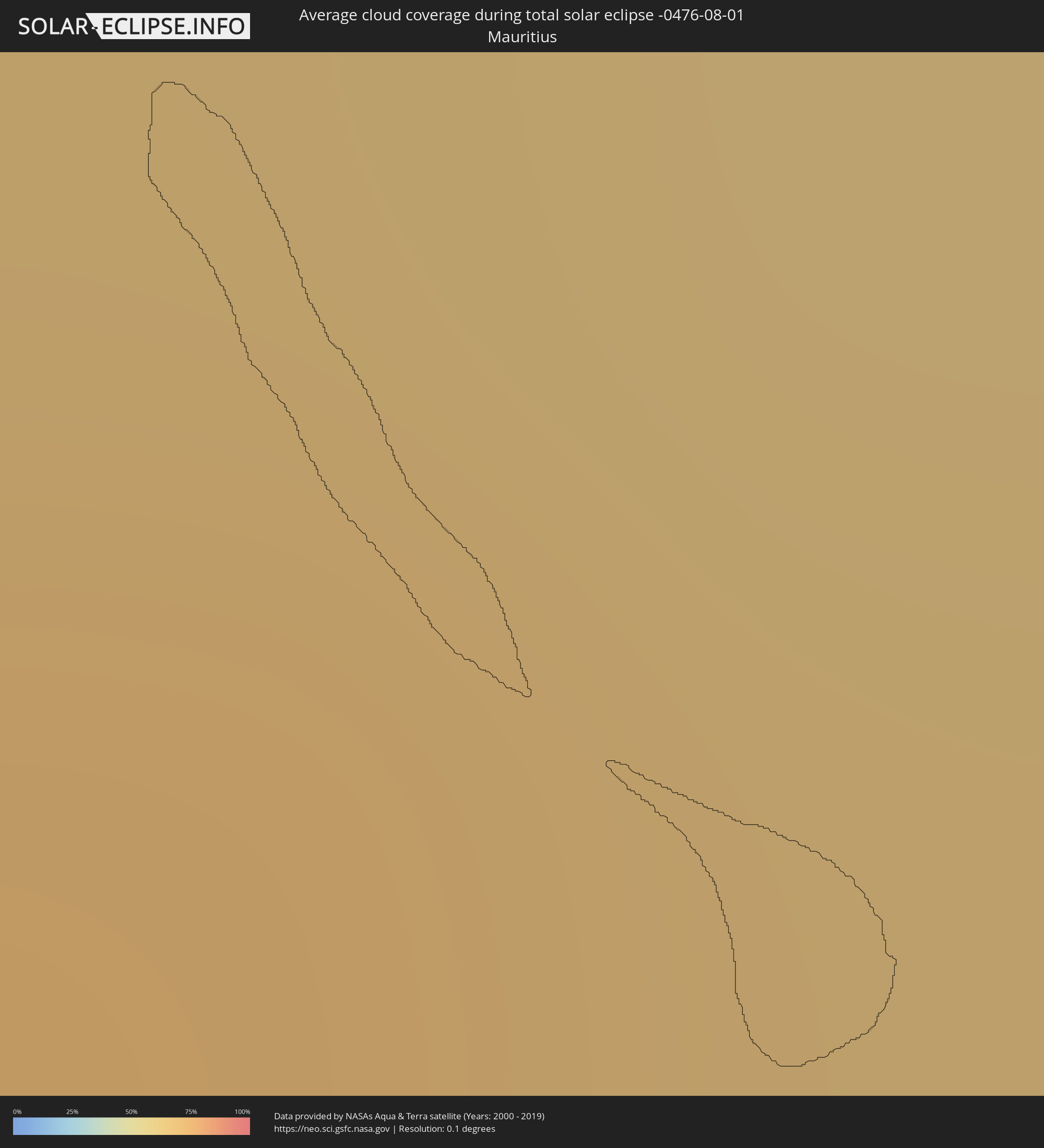 Mauritius
Orte im Finsternispfad
Die nachfolgene Tabelle zeigt Städte und Orte mit mehr als 5.000 Einwohnern, die sich im Finsternispfad befinden. Städte mit mehr als 100.000 Einwohnern sind dick gekennzeichnet. Mit einem Klick auf den Ort öffnet sich eine Detailkarte die die Lage des jeweiligen Ortes zusammen mit dem Verlauf der zentralen Finsternis präsentiert.
| Ort | Typ | Dauer der Verfinsterung | Ortszeit bei maximaler Verfinsterung | Entfernung zur Zentrallinie | Ø Bewölkung |
|
Boa Vista, Roraima
|
total | - | 06:11:27 UTC-04:02 | 66 km | 83% |
|
Lethem, Upper Takutu-Upper Essequibo
|
total | - | 06:21:36 UTC-03:52 | 40 km | 85% |
|
Groningen, Saramacca
|
total | - | 06:34:46 UTC-03:40 | 48 km | 70% |
|
Lelydorp, Wanica
|
total | - | 06:34:48 UTC-03:40 | 29 km | 69% |
|
Onverwacht, Para
|
total | - | 06:34:47 UTC-03:40 | 16 km | 71% |
|
Paramaribo, Paramaribo
|
total | - | 06:34:51 UTC-03:40 | 44 km | 76% |
|
Nieuw Amsterdam, Commewijne
|
total | - | 06:34:53 UTC-03:40 | 43 km | 70% |
|
Brokopondo, Brokopondo
|
total | - | 06:34:44 UTC-03:40 | 48 km | 60% |
|
Moengo, Marowijne
|
total | - | 06:35:00 UTC-03:40 | 12 km | 67% |
|
Albina, Marowijne
|
total | - | 06:35:05 UTC-03:40 | 37 km | 59% |
|
Saint-Laurent-du-Maroni, Guyane
|
total | - | 06:46:26 UTC-03:29 | 37 km | 66% |
|
Mana, Guyane
|
total | - | 06:46:32 UTC-03:29 | 29 km | 62% |
|
Vila Nova Sintra, Brava
|
total | - | 09:15:31 UTC-01:34 | 16 km | 81% |
|
São Filipe, São Filipe
|
total | - | 09:15:58 UTC-01:34 | 14 km | 79% |
|
Cova Figueira, Santa Catarina do Fogo
|
total | - | 09:16:21 UTC-01:34 | 10 km | 74% |
|
Tarrafal, Tarrafal
|
total | - | 09:17:33 UTC-01:34 | 41 km | 85% |
|
Assomada, Santa Catarina
|
total | - | 09:17:38 UTC-01:34 | 20 km | 79% |
|
Picos, São Salvador do Mundo
|
total | - | 09:17:43 UTC-01:34 | 17 km | 82% |
|
Cidade Velha, Ribeira Grande de Santiago
|
total | - | 09:17:42 UTC-01:34 | 1 km | 83% |
|
Calheta, São Miguel
|
total | - | 09:17:50 UTC-01:34 | 28 km | 83% |
|
Santa Cruz, Santa Cruz
|
total | - | 09:17:52 UTC-01:34 | 21 km | 82% |
|
São Domingos, São Domingos
|
total | - | 09:17:51 UTC-01:34 | 9 km | 79% |
|
Praia, Praia
|
total | - | 09:17:55 UTC-01:34 | 2 km | 83% |
|
Vila do Maio, Maio
|
total | - | 09:18:35 UTC-01:34 | 15 km | 87% |
|
Mékhé, Thiès
|
total | - | 10:51:27 UTC-00:16 | 85 km | 88% |
|
Saint-Louis, Saint-Louis
|
total | - | 10:51:53 UTC-00:16 | 15 km | 83% |
|
Guéoul, Louga
|
total | - | 10:52:10 UTC-00:16 | 46 km | 76% |
|
Louga, Louga
|
total | - | 10:52:30 UTC-00:16 | 32 km | 90% |
|
Rosso, Trarza
|
total | - | 10:53:39 UTC-00:16 | 64 km | 76% |
|
Rosso, Saint-Louis
|
total | - | 10:53:39 UTC-00:16 | 53 km | 75% |
|
Richard-Toll, Saint-Louis
|
total | - | 10:53:54 UTC-00:16 | 57 km | 74% |
|
Dara, Louga
|
total | - | 10:54:22 UTC-00:16 | 68 km | 90% |
|
Ndibène Dahra, Louga
|
total | - | 10:54:22 UTC-00:16 | 70 km | 90% |
|
Tékane, Trarza
|
total | - | 10:54:31 UTC-00:16 | 68 km | 73% |
|
Ndioum, Saint-Louis
|
total | - | 10:56:34 UTC-00:16 | 56 km | 50% |
|
Kaédi, Gorgol
|
total | - | 10:59:32 UTC-00:16 | 10 km | 66% |
|
Ouro Sogui, Matam
|
total | - | 11:00:01 UTC-00:16 | 52 km | 88% |
|
Matam, Matam
|
total | - | 11:00:12 UTC-00:16 | 46 km | 78% |
|
Kanel, Matam
|
total | - | 11:00:25 UTC-00:16 | 65 km | 90% |
|
Kiffa, Assaba
|
total | - | 11:05:10 UTC-00:16 | 58 km | 66% |
|
Aioun, Hodh El Gharbi
|
total | - | 11:10:06 UTC-00:16 | 66 km | 48% |
|
Néma, Hodh ech Chargui
|
total | - | 11:16:49 UTC-00:16 | 75 km | 48% |
|
Niafunké, Tombouctou
|
total | - | 11:26:40 UTC-00:16 | 37 km | 66% |
|
Goundam, Tombouctou
|
total | - | 11:27:22 UTC-00:16 | 95 km | 67% |
|
Douentza, Mopti
|
total | - | 11:30:15 UTC-00:16 | 48 km | 85% |
|
Gorom-Gorom, Sahel
|
total | - | 11:38:50 UTC-00:16 | 53 km | 85% |
|
Dori, Sahel
|
total | - | 11:39:43 UTC-00:16 | 93 km | 90% |
|
Téra, Tillabéri
|
total | - | 12:11:51 UTC+00:13 | 76 km | 89% |
|
Ayorou, Tillabéri
|
total | - | 12:11:49 UTC+00:13 | 6 km | 82% |
|
Tillabéri, Tillabéri
|
total | - | 12:13:49 UTC+00:13 | 36 km | 81% |
|
Niamey, Niamey
|
total | - | 12:16:20 UTC+00:13 | 93 km | 87% |
|
Filingué, Tillabéri
|
total | - | 12:19:13 UTC+00:13 | 32 km | 79% |
|
Dogondoutchi, Dosso
|
total | - | 12:21:56 UTC+00:13 | 22 km | 89% |
|
Sokoto, Sokoto
|
total | - | 12:25:59 UTC+00:13 | 43 km | 92% |
|
Birni N Konni, Tahoua
|
total | - | 12:25:20 UTC+00:13 | 34 km | 90% |
|
Madaoua, Tahoua
|
total | - | 12:27:06 UTC+00:13 | 88 km | 89% |
|
Gusau, Zamfara
|
total | - | 12:30:56 UTC+00:13 | 87 km | 93% |
|
Tibiri, Maradi
|
total | - | 12:30:39 UTC+00:13 | 73 km | 96% |
|
Maradi, Maradi
|
total | - | 12:30:52 UTC+00:13 | 68 km | 94% |
|
Katsina, Katsina
|
total | - | 12:32:46 UTC+00:13 | 33 km | 91% |
|
Malumfashi, Katsina
|
total | - | 12:34:01 UTC+00:13 | 91 km | 89% |
|
Aguié, Maradi
|
total | - | 12:32:44 UTC+00:13 | 94 km | 88% |
|
Kano, Kano
|
total | - | 12:36:18 UTC+00:13 | 35 km | 89% |
|
Magaria, Zinder
|
total | - | 12:36:20 UTC+00:13 | 84 km | 96% |
|
Hadejia, Jigawa
|
total | - | 12:39:56 UTC+00:13 | 73 km | 94% |
|
Azare, Bauchi
|
total | - | 12:41:09 UTC+00:13 | 1 km | 94% |
|
Potiskum, Yobe
|
total | - | 12:43:27 UTC+00:13 | 41 km | 93% |
|
Gombe, Gombe
|
total | - | 12:45:12 UTC+00:13 | 101 km | 94% |
|
Daura, Yobe
|
total | - | 12:44:28 UTC+00:13 | 38 km | 92% |
|
Biu, Borno
|
total | - | 12:47:30 UTC+00:13 | 24 km | 92% |
|
Mubi, Adamawa
|
total | - | 12:50:34 UTC+00:13 | 11 km | 95% |
|
Pitoa, North
|
total | - | 12:52:07 UTC+00:13 | 89 km | 90% |
|
Mokolo, Far North
|
total | - | 12:51:21 UTC+00:13 | 62 km | 91% |
|
Guider, North
|
total | - | 12:52:36 UTC+00:13 | 14 km | 92% |
|
Mboursou Léré, Mayo-Kebbi Ouest
|
total | - | 13:39:54 UTC+01:00 | 21 km | 92% |
|
Maroua, Far North
|
total | - | 12:52:45 UTC+00:13 | 70 km | 90% |
|
Mindif, Far North
|
total | - | 12:53:15 UTC+00:13 | 56 km | 92% |
|
Kaélé, Far North
|
total | - | 12:53:37 UTC+00:13 | 28 km | 94% |
|
Bogo, Far North
|
total | - | 12:53:18 UTC+00:13 | 98 km | 91% |
|
Pala, Mayo-Kebbi Ouest
|
total | - | 13:42:08 UTC+01:00 | 26 km | 94% |
|
Yagoua, Far North
|
total | - | 12:55:12 UTC+00:13 | 87 km | 92% |
|
Bongor, Mayo-Kebbi Est
|
total | - | 13:42:12 UTC+01:00 | 88 km | 86% |
|
Kelo, Tandjilé
|
total | - | 13:44:17 UTC+01:00 | 11 km | 93% |
|
Moundou, Logone Occidental
|
total | - | 13:45:44 UTC+01:00 | 50 km | 86% |
|
Béré, Tandjilé
|
total | - | 13:45:04 UTC+01:00 | 29 km | 90% |
|
Laï, Tandjilé
|
total | - | 13:45:19 UTC+01:00 | 43 km | 86% |
|
Benoy, Logone Occidental
|
total | - | 13:45:49 UTC+01:00 | 3 km | 92% |
|
Bébédja, Logone Oriental
|
total | - | 13:46:43 UTC+01:00 | 16 km | 90% |
|
Doba, Logone Oriental
|
total | - | 13:47:22 UTC+01:00 | 5 km | 90% |
|
Koumra, Mandoul
|
total | - | 13:48:38 UTC+01:00 | 56 km | 86% |
|
Moïssala, Mandoul
|
total | - | 13:49:43 UTC+01:00 | 9 km | 82% |
|
Batangafo, Ouham
|
total | - | 13:05:21 UTC+00:13 | 69 km | 81% |
|
Kabo, Ouham
|
total | - | 13:05:38 UTC+00:13 | 12 km | 88% |
|
Kaga Bandoro, Nana-Grébizi
|
total | - | 13:07:34 UTC+00:13 | 55 km | 84% |
|
Ippy, Ouaka
|
total | - | 13:12:22 UTC+00:13 | 23 km | 81% |
|
Bria, Haute-Kotto
|
total | - | 13:13:31 UTC+00:13 | 43 km | 84% |
|
Bangassou, Mbomou
|
total | - | 13:16:53 UTC+00:13 | 92 km | 82% |
|
Rafaï, Mbomou
|
total | - | 13:18:37 UTC+00:13 | 14 km | 81% |
|
Zemio, Haut-Mbomou
|
total | - | 13:20:35 UTC+00:13 | 57 km | 81% |
|
Isiro, Orientale
|
total | - | 15:23:19 UTC+02:10 | 35 km | 87% |
|
Wamba, Orientale
|
total | - | 15:24:25 UTC+02:10 | 77 km | 89% |
|
Watsa, Orientale
|
total | - | 15:25:48 UTC+02:10 | 91 km | 86% |
|
Bunia, Orientale
|
total | - | 15:28:01 UTC+02:10 | 17 km | 74% |
|
Hoima, Western Region
|
total | - | 15:46:27 UTC+02:27 | 27 km | 79% |
|
Masindi, Western Region
|
total | - | 15:46:42 UTC+02:27 | 70 km | 76% |
|
Mityana, Central Region
|
total | - | 15:48:04 UTC+02:27 | 38 km | 76% |
|
Namasuba, Central Region
|
total | - | 15:48:20 UTC+02:27 | 9 km | 79% |
|
Entebbe, Central Region
|
total | - | 15:48:50 UTC+02:27 | 51 km | 67% |
|
Luwero, Central Region
|
total | - | 15:48:16 UTC+02:27 | 28 km | 77% |
|
Kampala, Central Region
|
total | - | 15:48:48 UTC+02:27 | 19 km | 74% |
|
Mukono, Central Region
|
total | - | 15:48:59 UTC+02:27 | 7 km | 80% |
|
Lugazi, Central Region
|
total | - | 15:49:09 UTC+02:27 | 4 km | 79% |
|
Jinja, Eastern Region
|
total | - | 15:49:25 UTC+02:27 | 25 km | 62% |
|
Iganga, Eastern Region
|
total | - | 15:49:35 UTC+02:27 | 55 km | 70% |
|
Busia, Eastern Region
|
total | - | 15:50:23 UTC+02:27 | 73 km | 60% |
|
Busia, Busia
|
total | - | 15:50:24 UTC+02:27 | 73 km | 60% |
|
Lugulu, Busia
|
total | - | 15:50:40 UTC+02:27 | 77 km | 55% |
|
Homa Bay, Homa Bay
|
total | - | 15:51:30 UTC+02:27 | 7 km | 48% |
|
Sirari, Mara
|
total | - | 15:52:02 UTC+02:27 | 78 km | 62% |
|
Mumias, Kakamega
|
total | - | 15:50:54 UTC+02:27 | 80 km | 56% |
|
Kakamega, Kakamega
|
total | - | 15:51:13 UTC+02:27 | 89 km | 60% |
|
Kisumu, Kisumu
|
total | - | 15:51:31 UTC+02:27 | 51 km | 44% |
|
Naivasha, Nakuru
|
total | - | 15:53:36 UTC+02:27 | 75 km | 63% |
|
Nairobi, Nairobi Area
|
total | - | 15:54:21 UTC+02:27 | 38 km | 80% |
|
Thika, Nairobi Area
|
total | - | 15:54:25 UTC+02:27 | 75 km | 81% |
|
Voi, Taita Taveta
|
total | - | 15:57:10 UTC+02:27 | 86 km | 76% |
|
Kilifi, Kilifi
|
total | - | 15:58:19 UTC+02:27 | 45 km | 72% |
|
Malindi, Kilifi
|
total | - | 15:58:18 UTC+02:27 | 9 km | 67% |