Totale Sonnenfinsternis vom 23.11.-0519
| Wochentag: | Montag |
| Maximale Dauer der Verfinsterung: | 03m44s |
| Maximale Breite des Finsternispfades: | 160 km |
| Saroszyklus: | 63 |
| Bedeckungsgrad: | 100% |
| Magnitude: | 1.0393 |
| Gamma: | 0.5724 |
Wo kann man die Sonnenfinsternis vom 23.11.-0519 sehen?
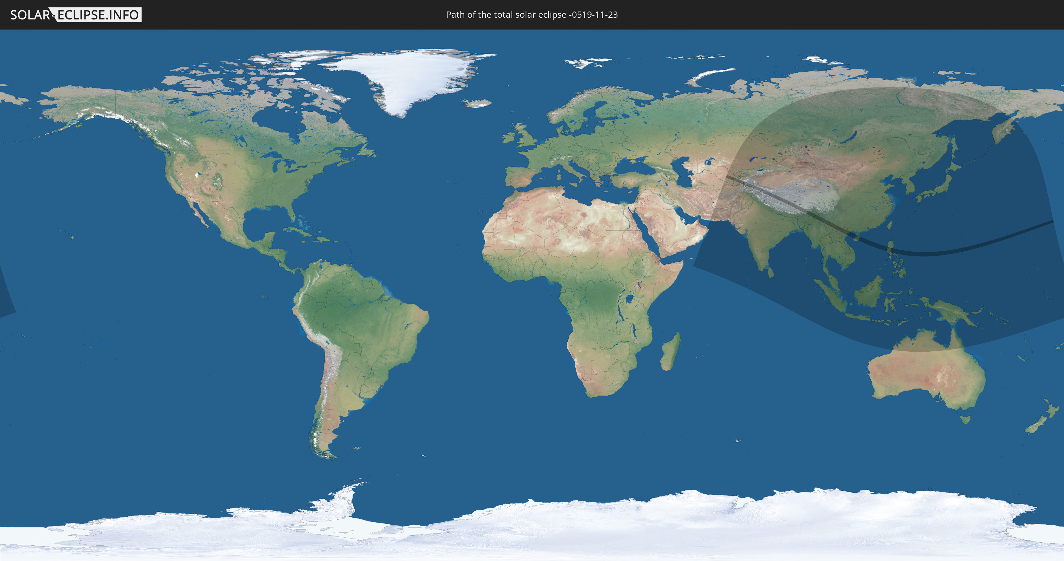
Die Sonnenfinsternis am 23.11.-0519 kann man in 48 Ländern als partielle Sonnenfinsternis beobachten.
Der Finsternispfad verläuft durch 10 Länder. Nur in diesen Ländern ist sie als totale Sonnenfinsternis zu sehen.
In den folgenden Ländern ist die Sonnenfinsternis total zu sehen
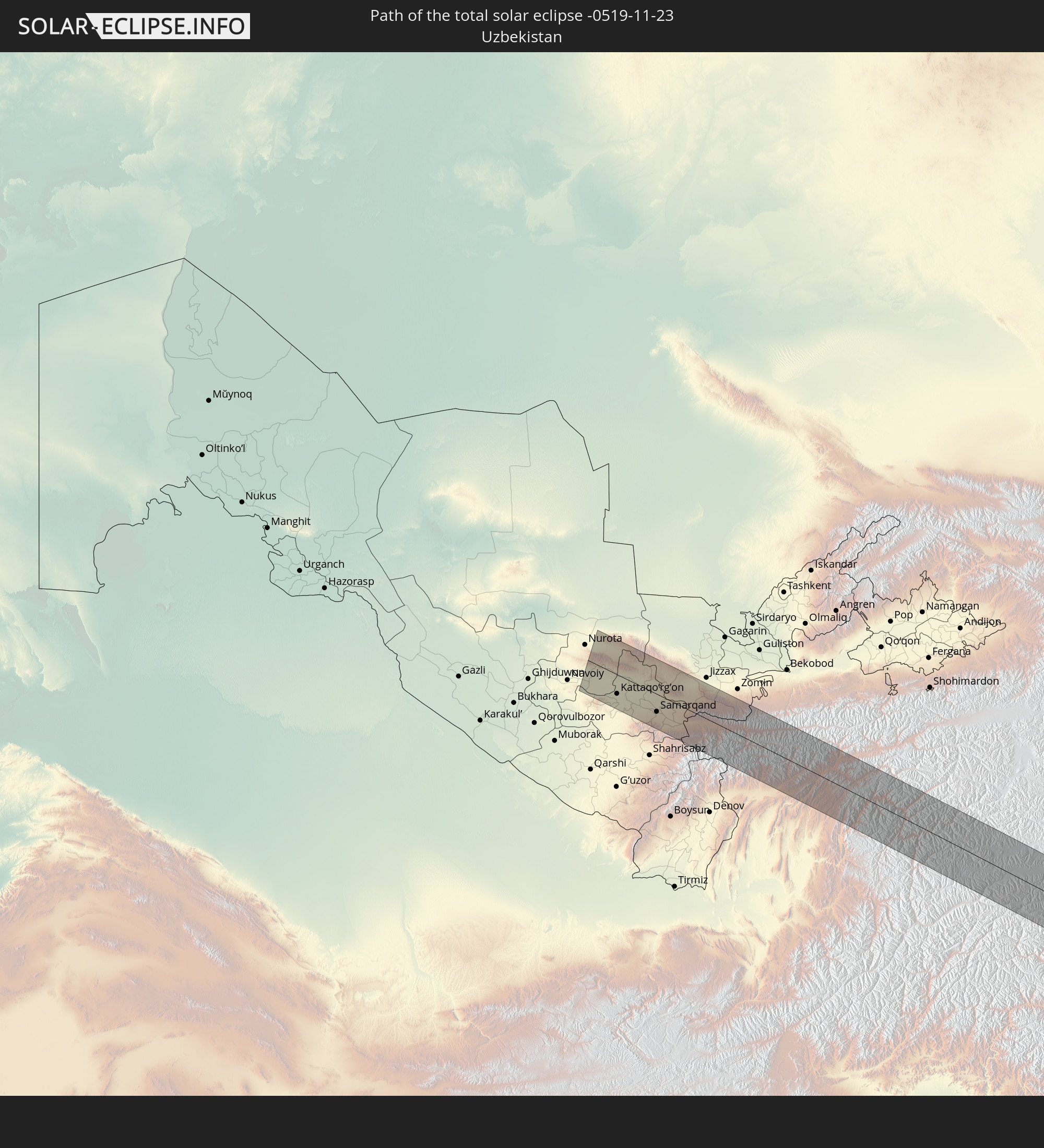 Usbekistan
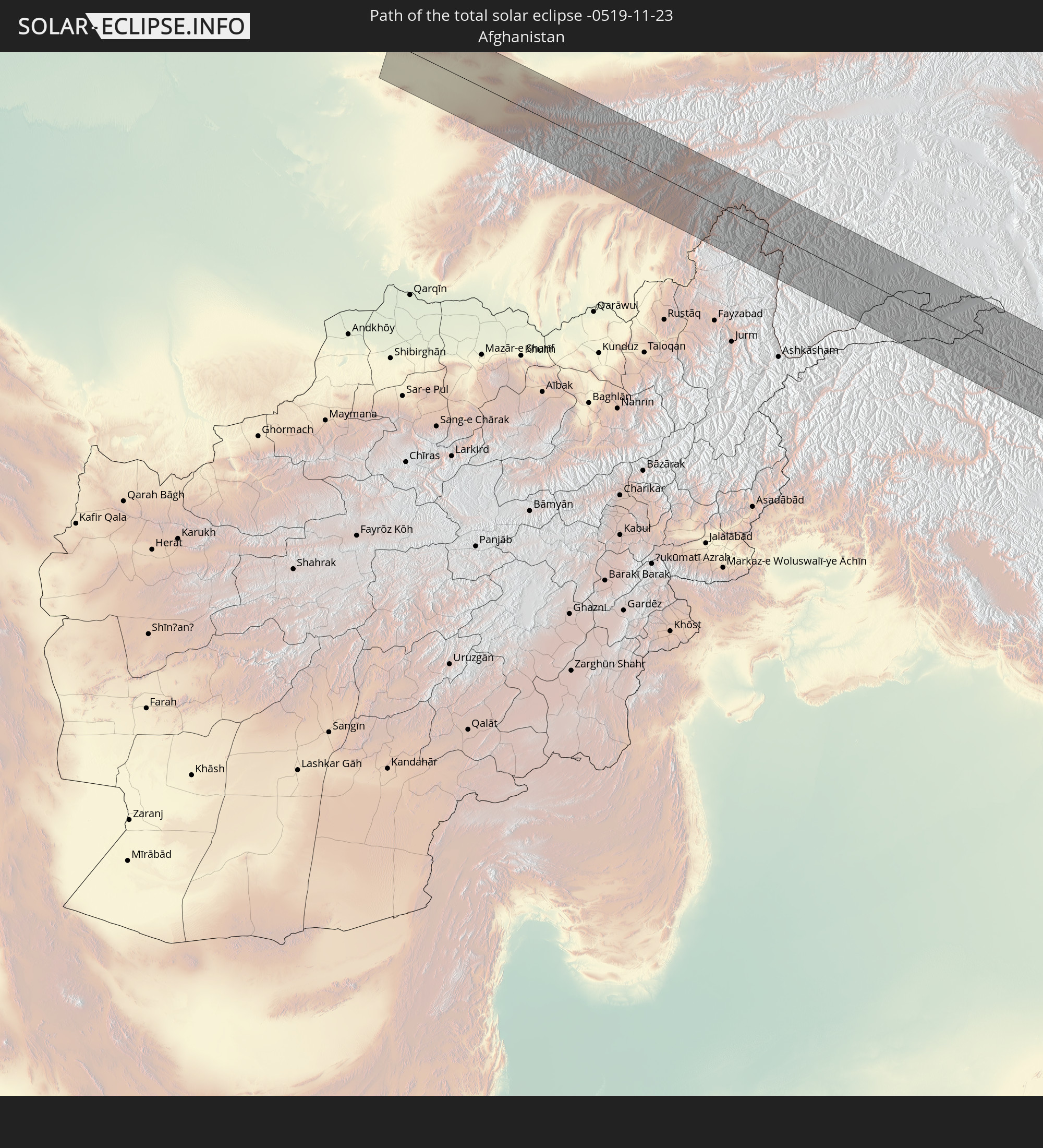 Afghanistan
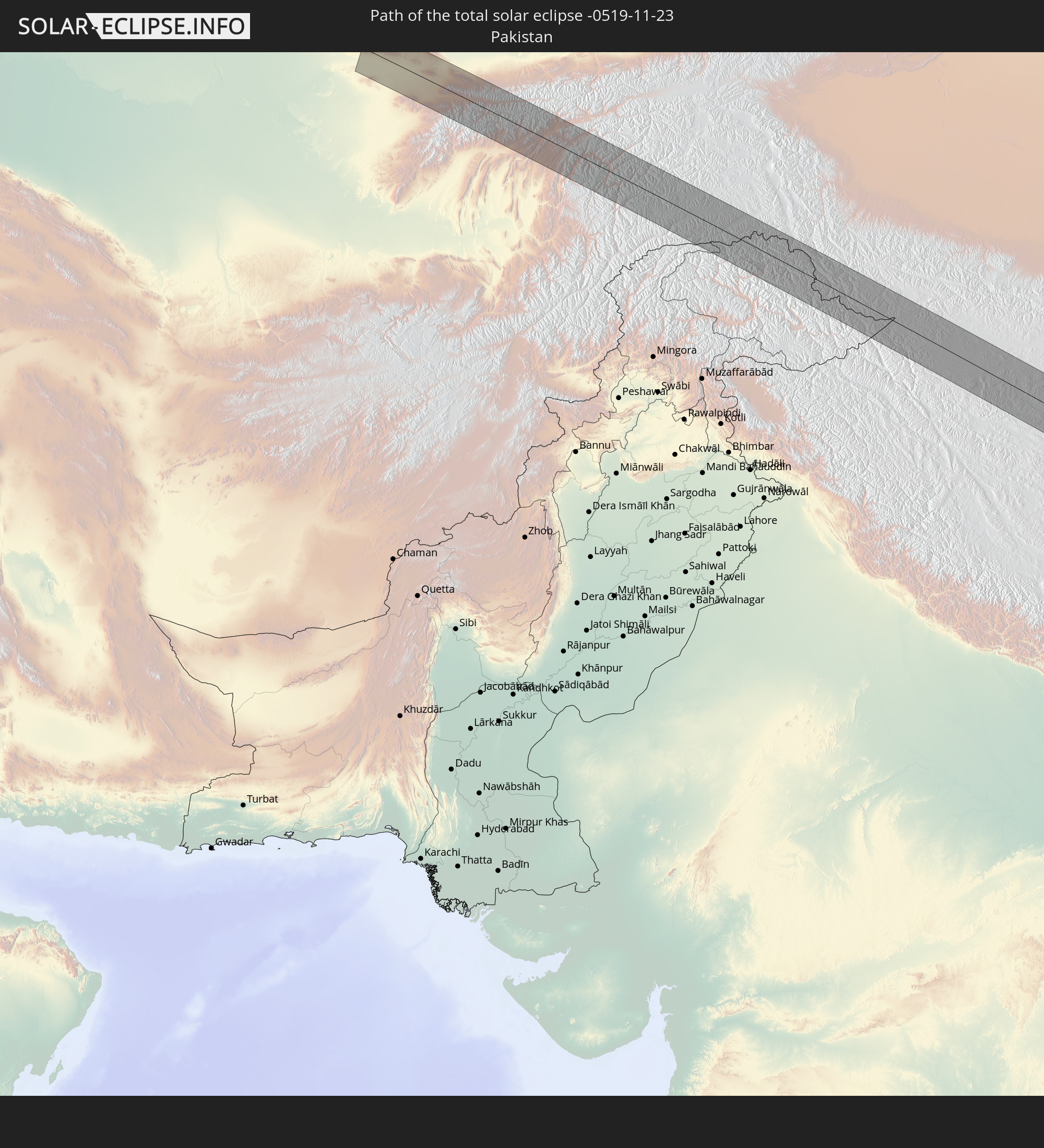 Pakistan
 Tadschikistan
 Indien
 Volksrepublik China
 Myanmar
 Vietnam
 Philippinen
 Nördliche Marianen
In den folgenden Ländern ist die Sonnenfinsternis partiell zu sehen
 Russland
 United States Minor Outlying Islands
 Kiribati
 Iran
Iran
 Kasachstan
 Oman
Oman
 Turkmenistan
 Usbekistan
 Afghanistan
 Pakistan
 Tadschikistan
 Indien
 Kirgisistan
 Malediven
 Volksrepublik China
 Sri Lanka
 Nepal
Nepal
 Mongolei
 Bangladesch
 Bhutan
 Myanmar
 Indonesien
 Thailand
 Malaysia
 Laos
Laos
 Vietnam
 Kambodscha
 Singapur
 Weihnachtsinsel
 Australien
 Macau
Macau
 Hongkong
 Brunei
 Taiwan
 Philippinen
 Japan
Japan
 Osttimor
 Nordkorea
 Südkorea
 Palau
Palau
 Föderierte Staaten von Mikronesien
 Papua-Neuguinea
 Guam
Guam
 Nördliche Marianen
 Salomonen
 Marshallinseln
 Nauru
Nauru
 Tuvalu
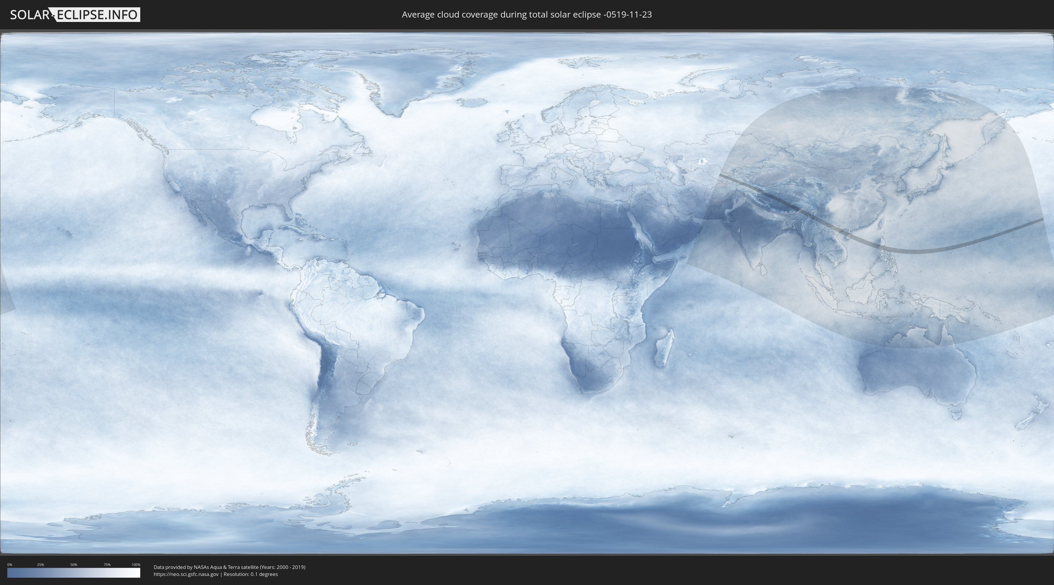
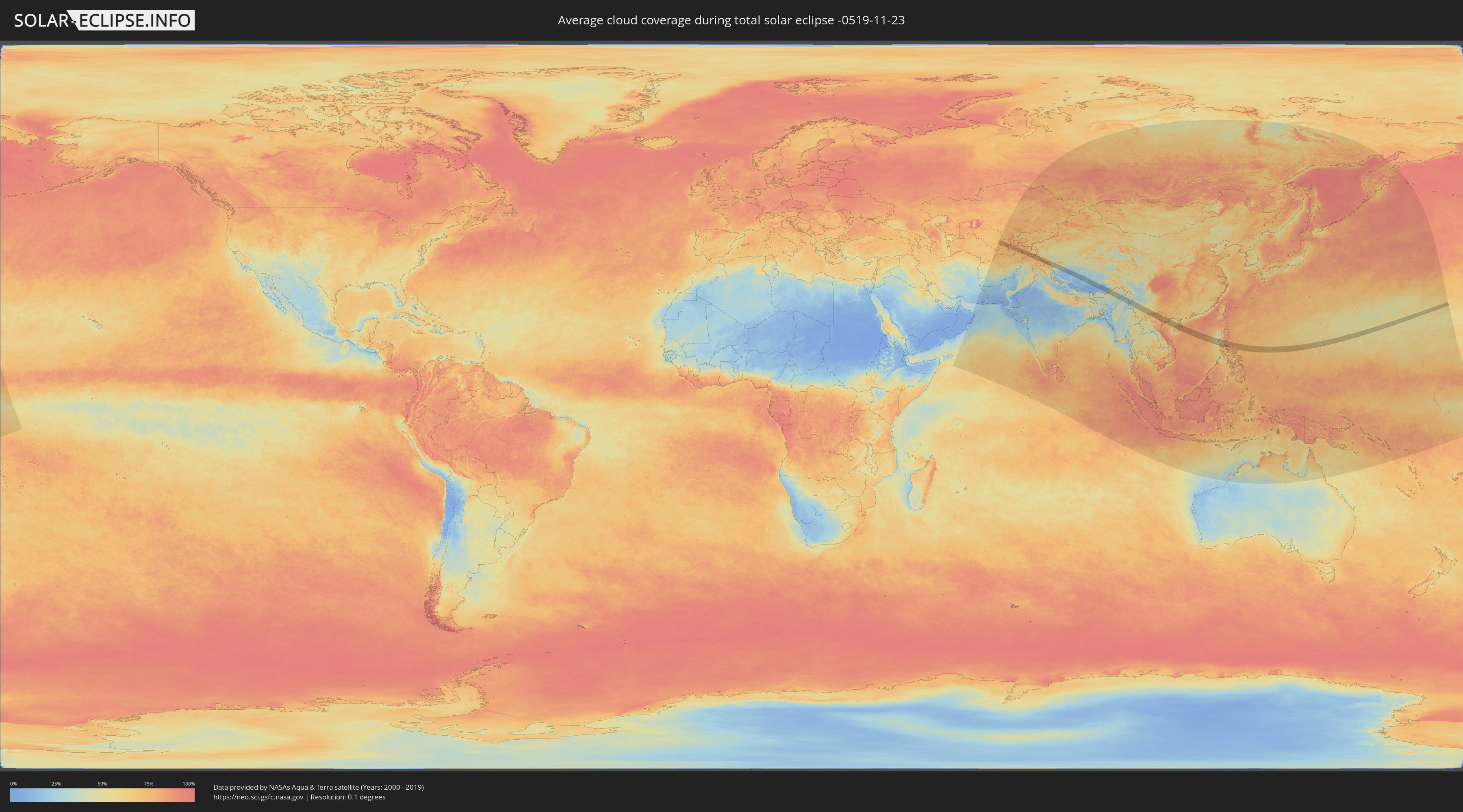
Wie wird das Wetter während der totalen Sonnenfinsternis am 23.11.-0519?
Wo ist der beste Ort, um die totale Sonnenfinsternis vom 23.11.-0519 zu beobachten?
Die folgenden Karten zeigen die durchschnittliche Bewölkung für den Tag, an dem die totale Sonnenfinsternis
stattfindet. Mit Hilfe der Karten lässt sich der Ort entlang des Finsternispfades eingrenzen,
der die besten Aussichen auf einen klaren wolkenfreien Himmel bietet.
Trotzdem muss man immer lokale Gegenenheiten beachten und sollte sich genau über das Wetter an seinem
gewählten Beobachtungsort informieren.
Die Daten stammen von den beiden NASA-Satelliten
AQUA und TERRA
und wurden über einen Zeitraum von 19 Jahren (2000 - 2019) gemittelt.
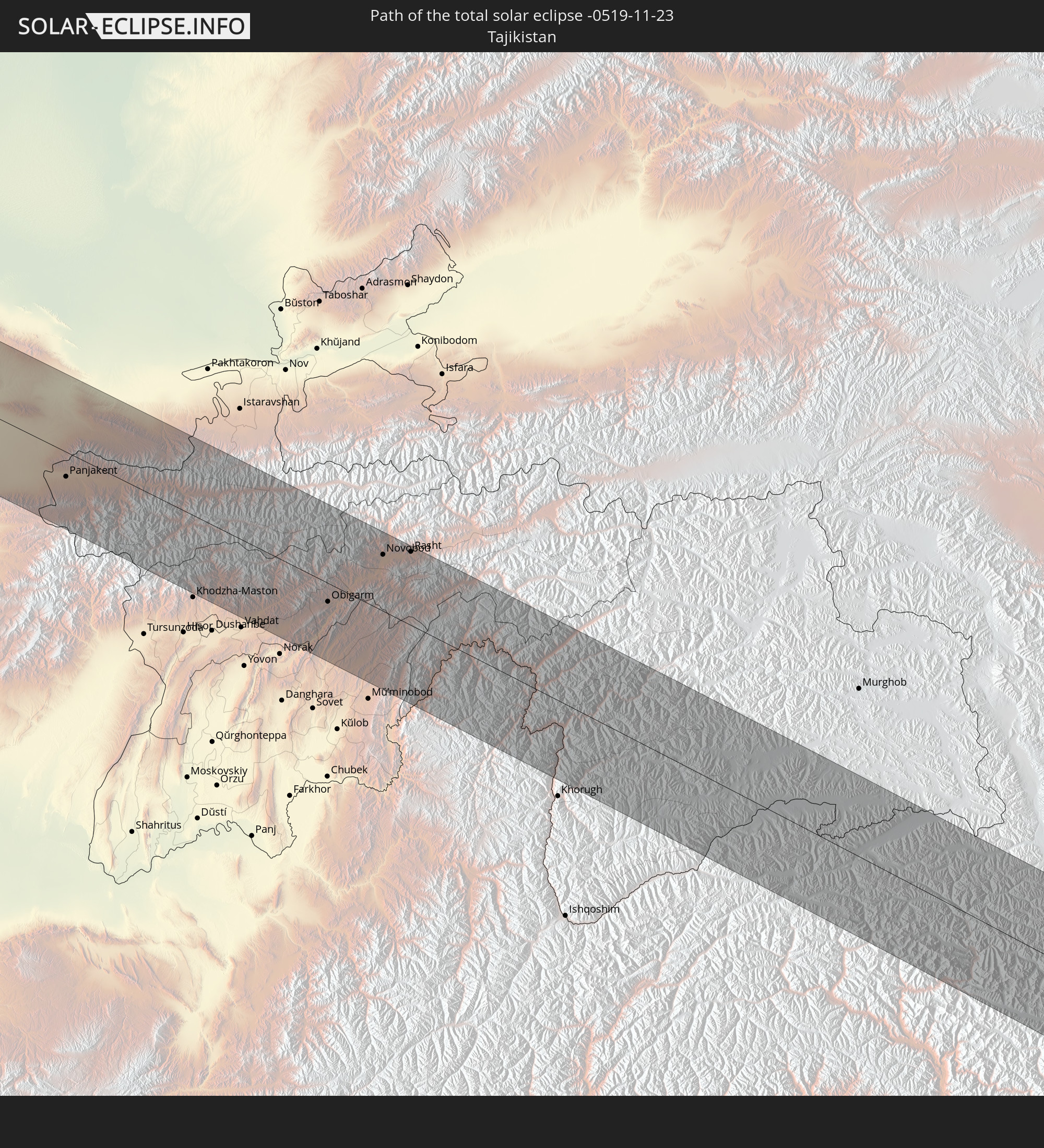
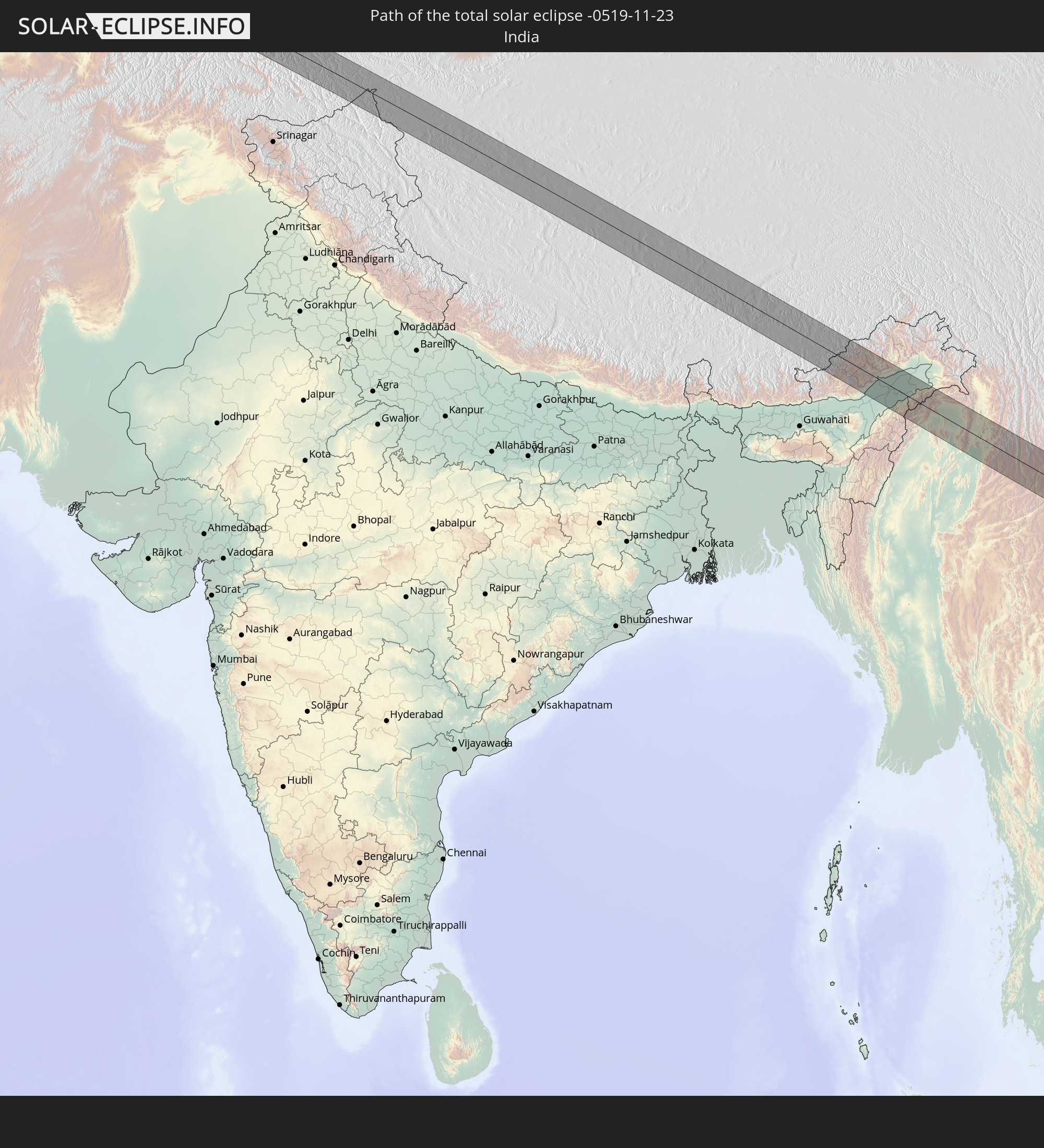
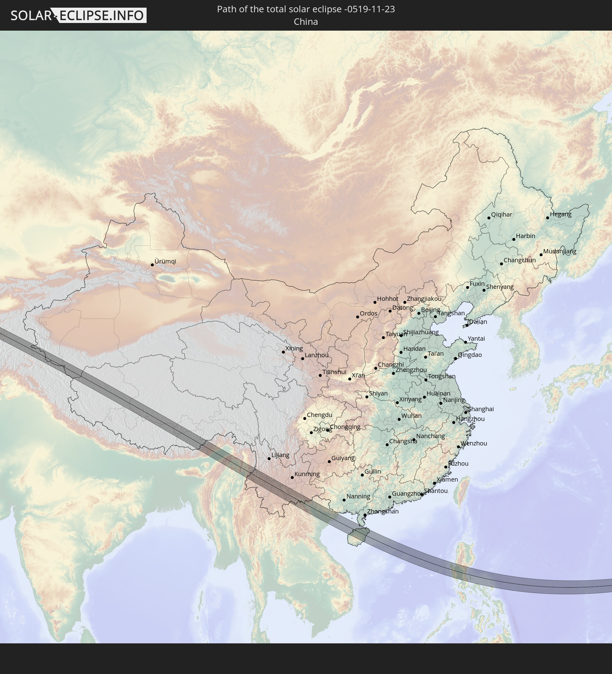
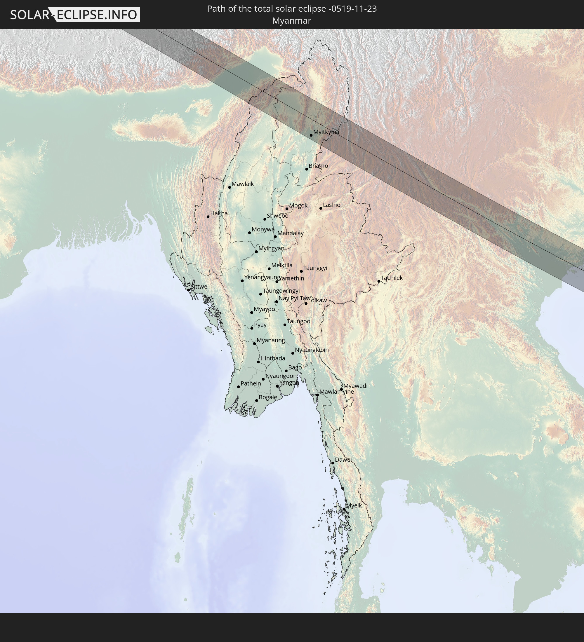
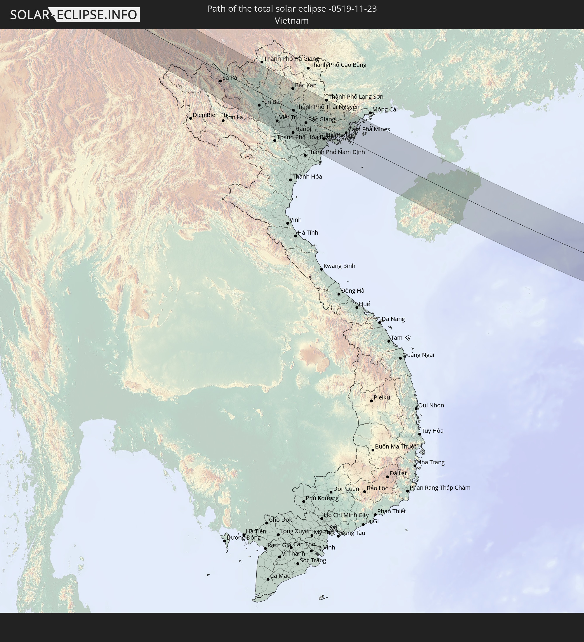
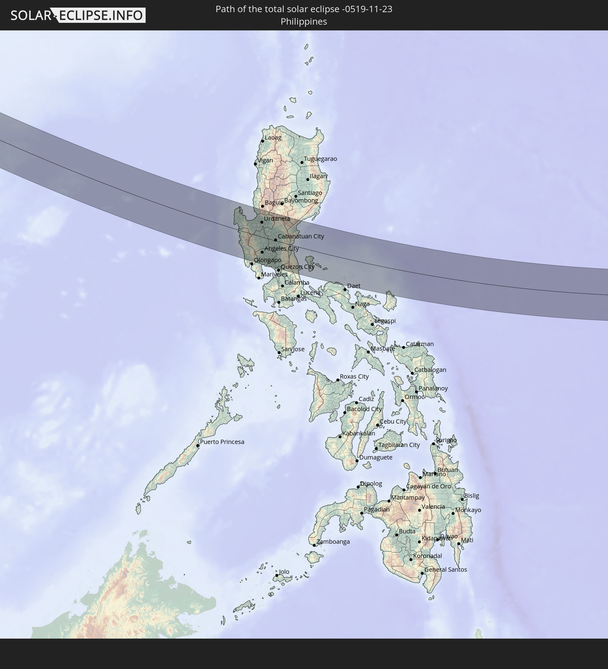
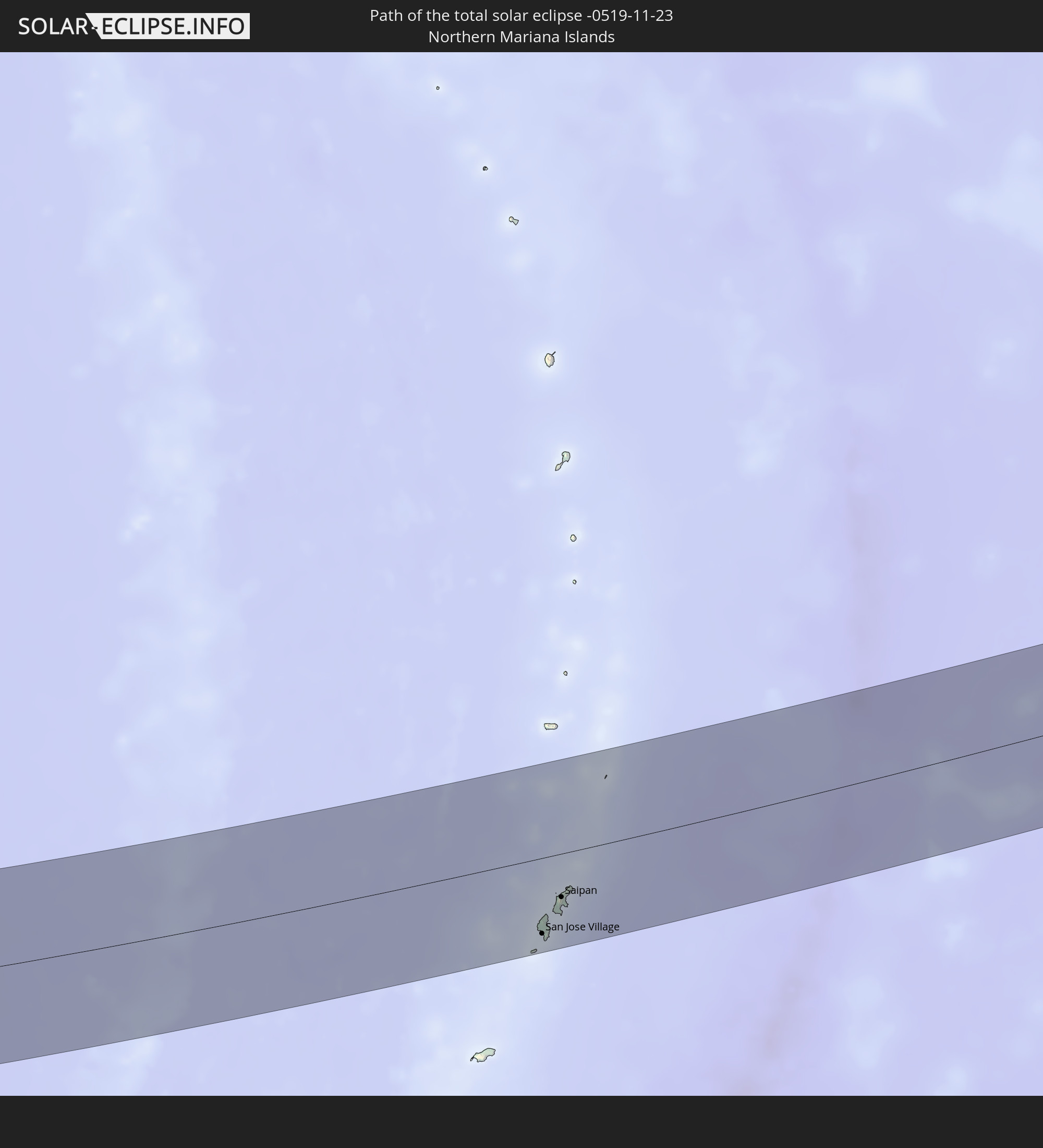
Detaillierte Länderkarten
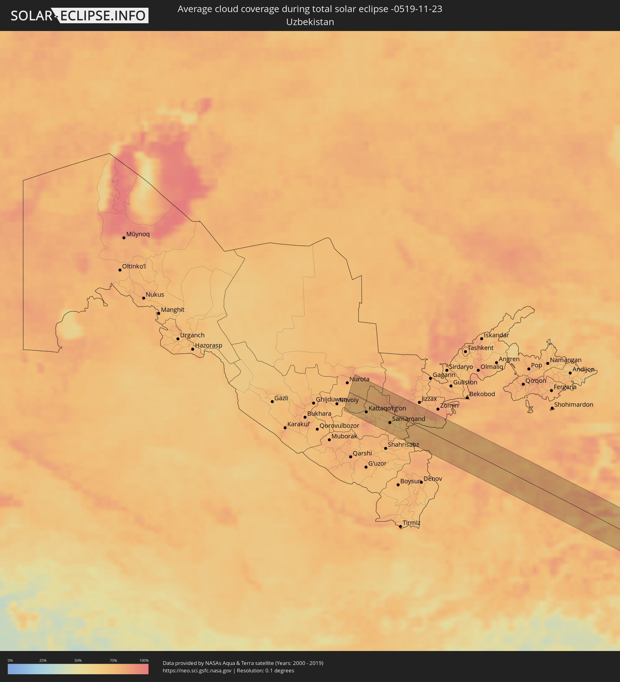 Usbekistan
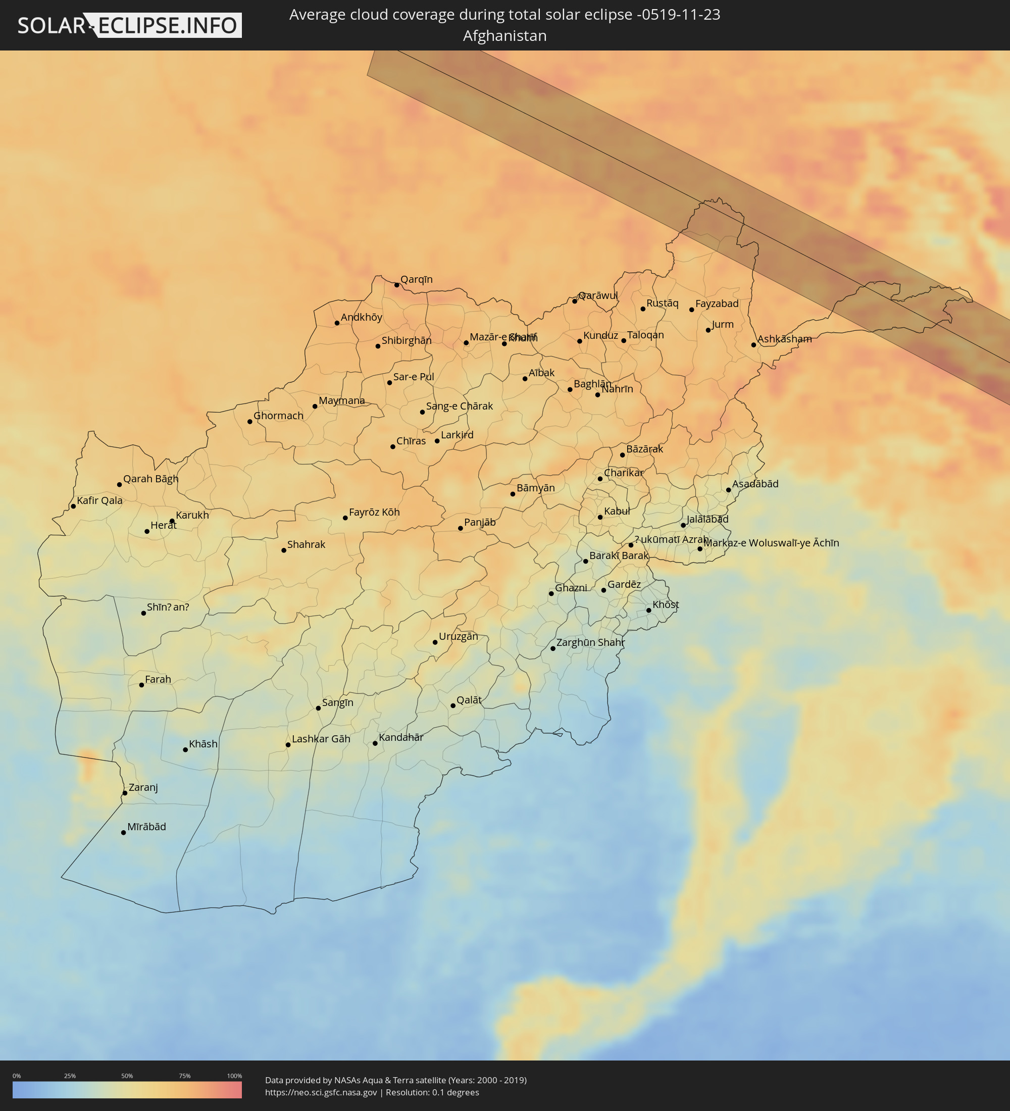 Afghanistan
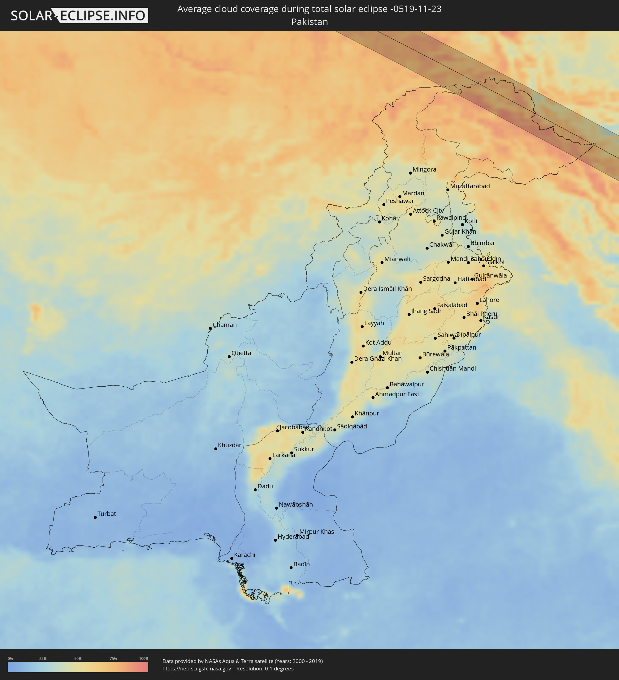 Pakistan
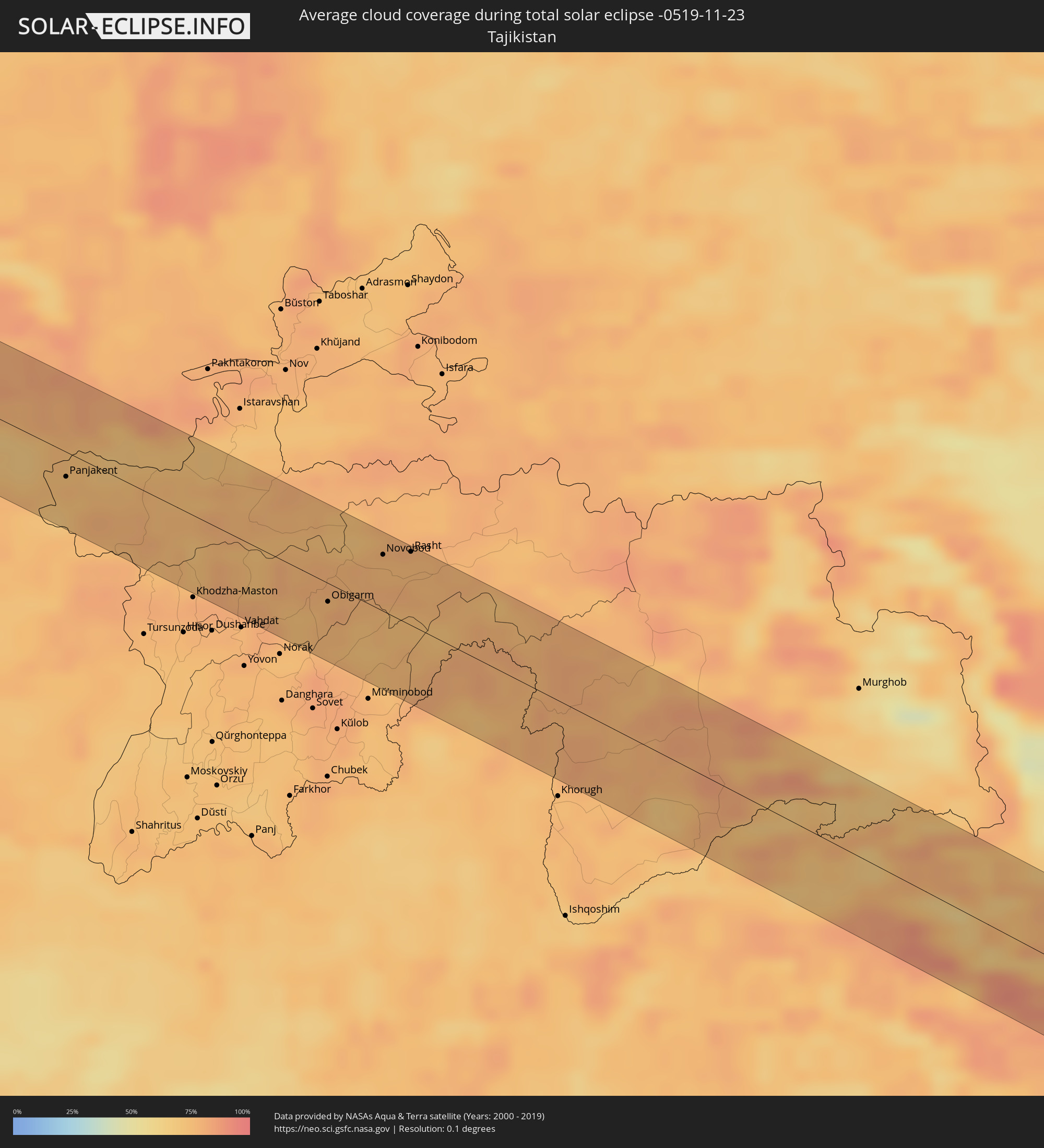 Tadschikistan
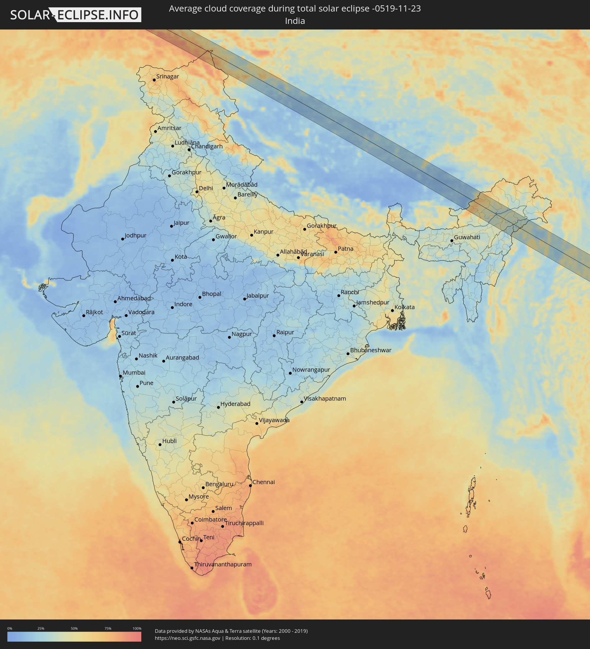 Indien
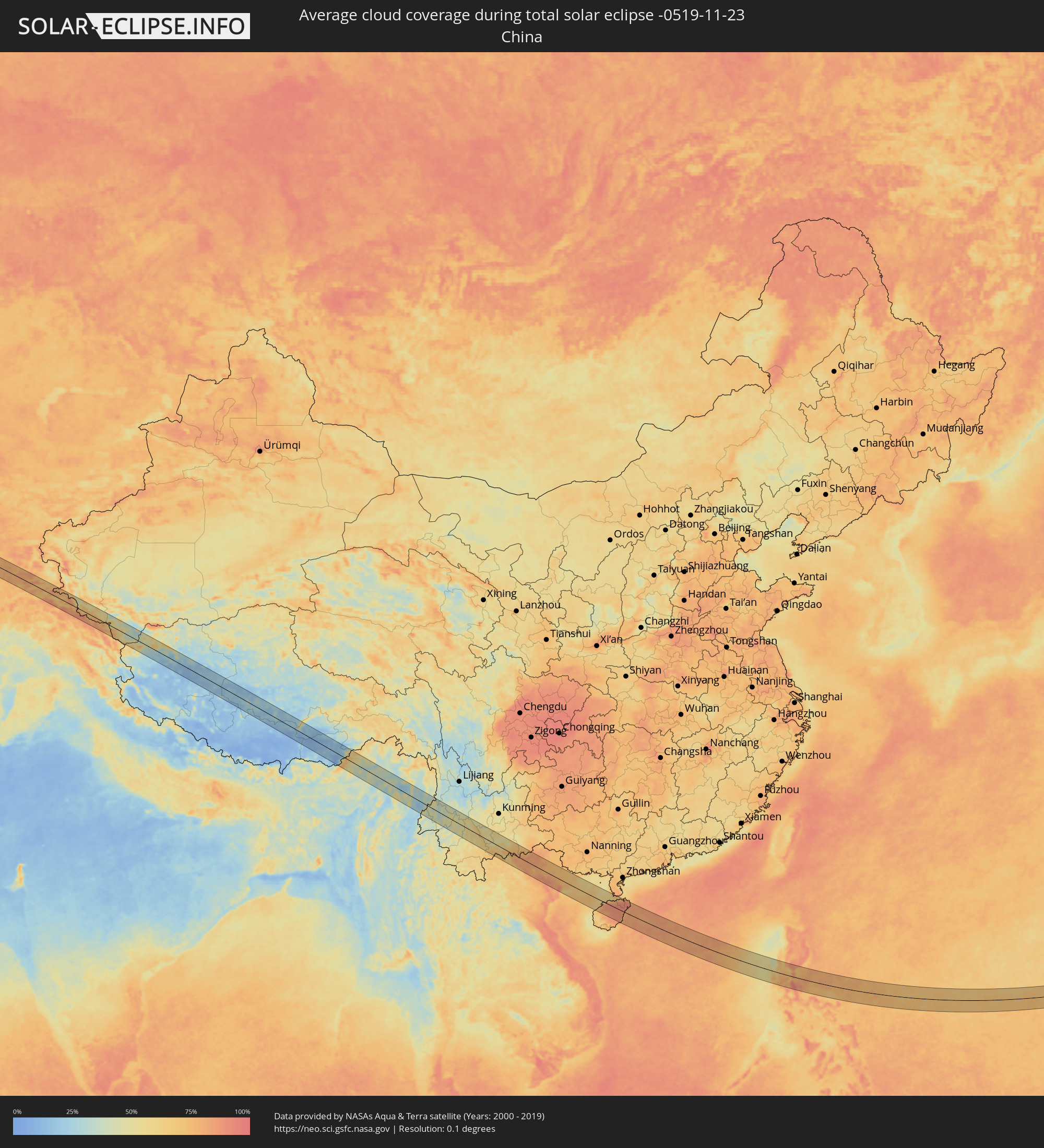 Volksrepublik China
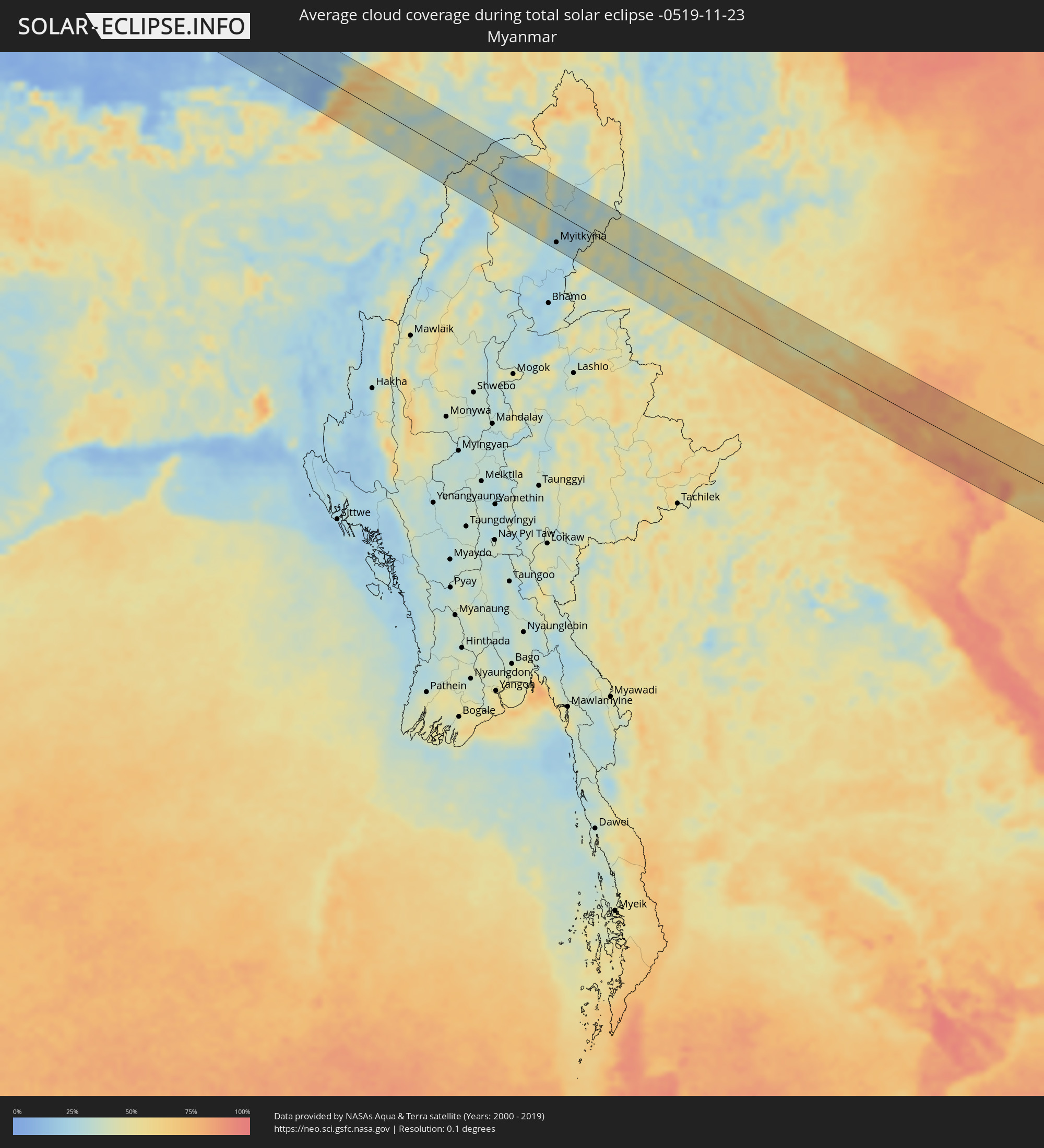 Myanmar
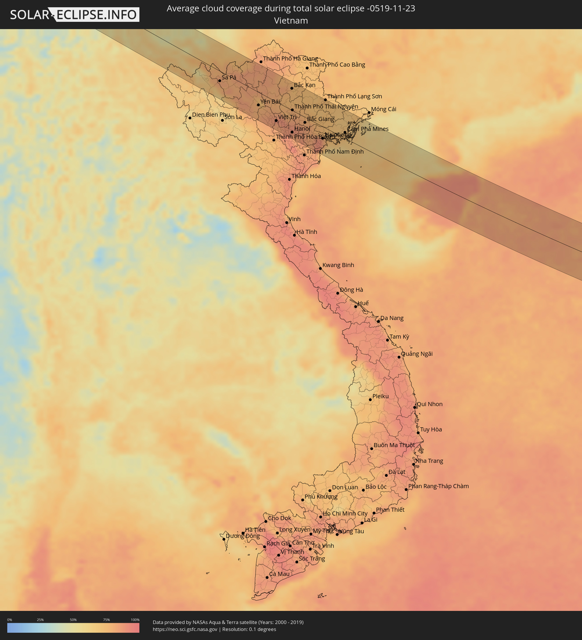 Vietnam
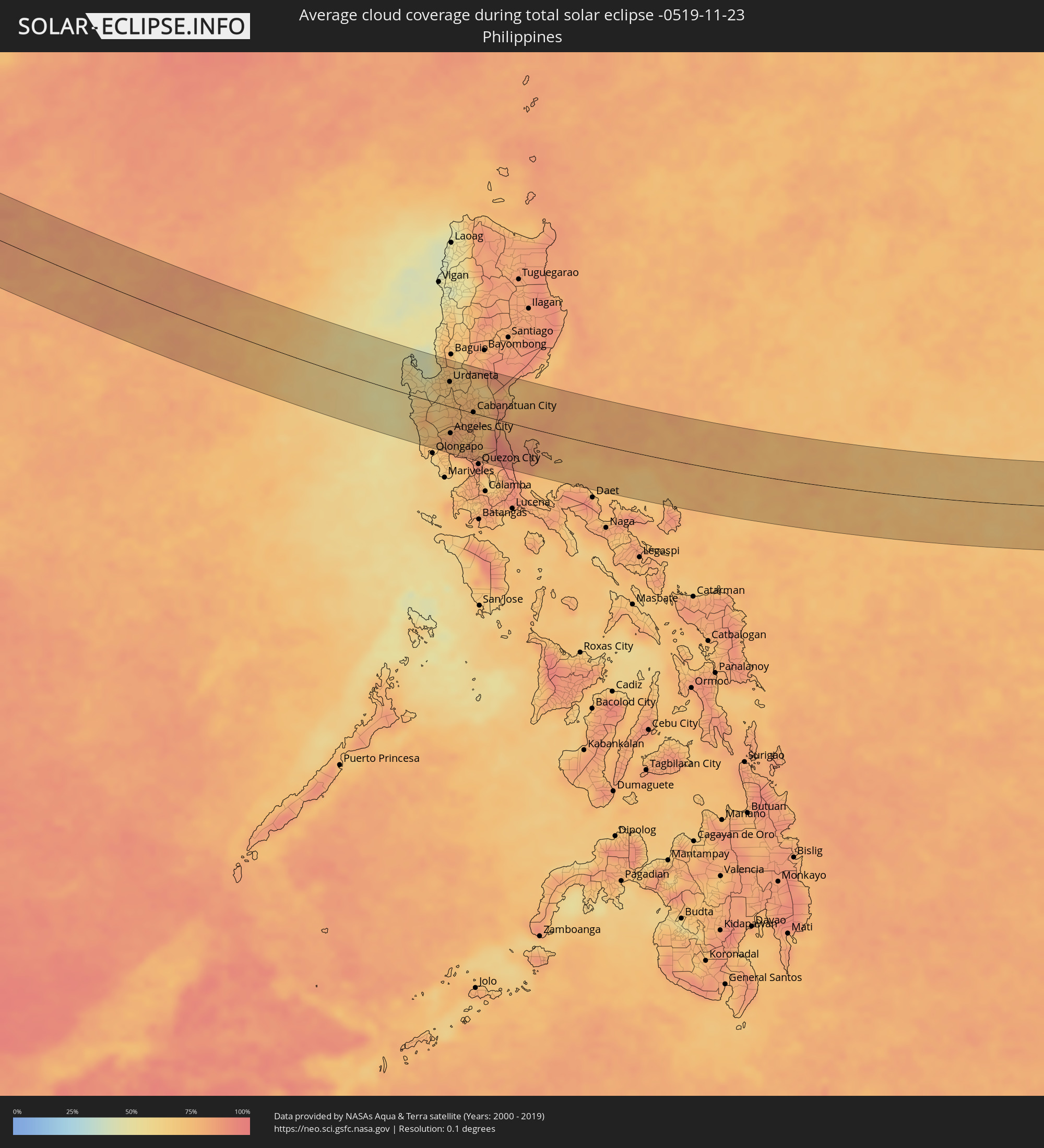 Philippinen
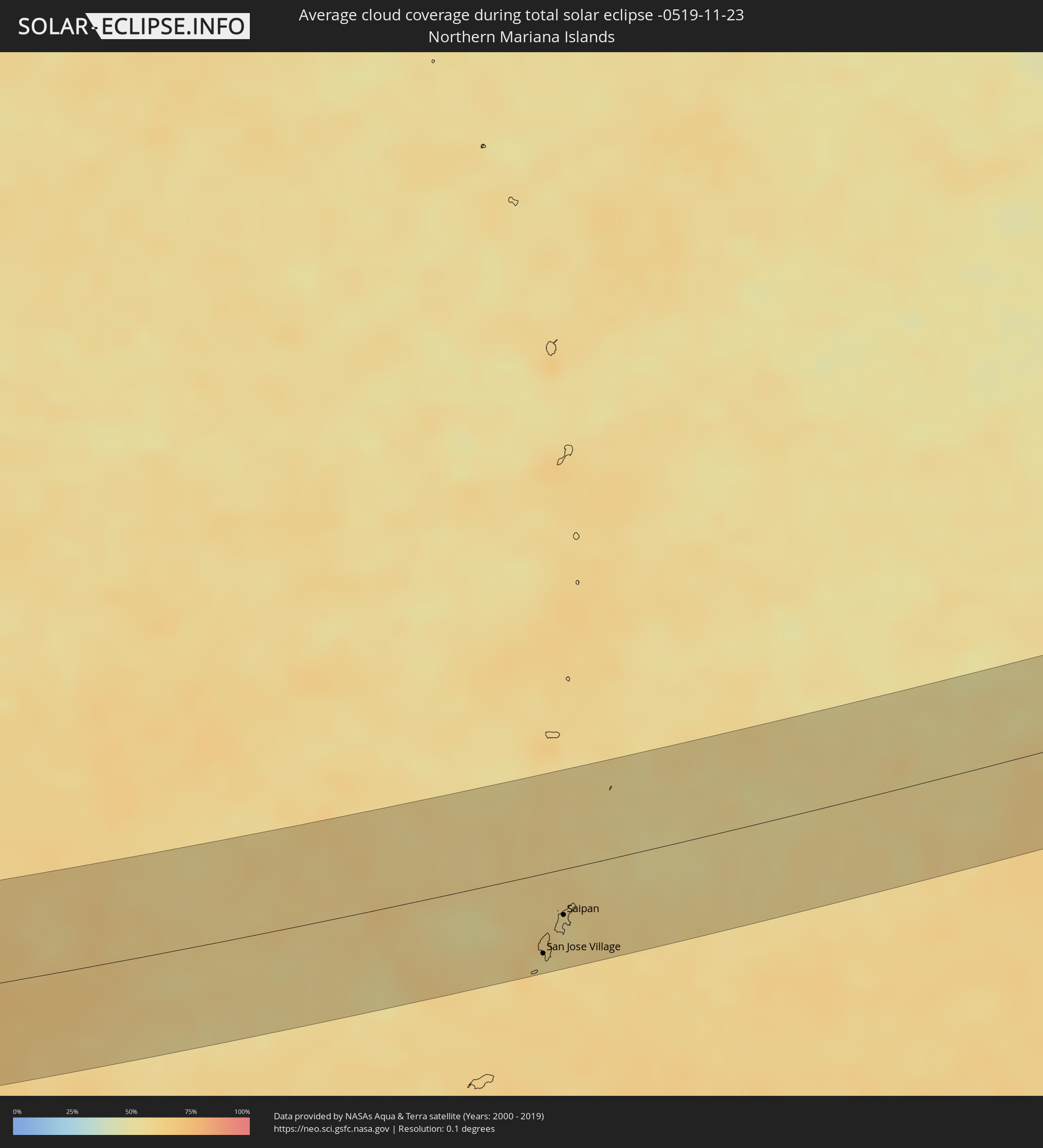 Nördliche Marianen
Orte im Finsternispfad
Die nachfolgene Tabelle zeigt Städte und Orte mit mehr als 5.000 Einwohnern, die sich im Finsternispfad befinden. Städte mit mehr als 100.000 Einwohnern sind dick gekennzeichnet. Mit einem Klick auf den Ort öffnet sich eine Detailkarte die die Lage des jeweiligen Ortes zusammen mit dem Verlauf der zentralen Finsternis präsentiert.
| Ort | Typ | Dauer der Verfinsterung | Ortszeit bei maximaler Verfinsterung | Entfernung zur Zentrallinie | Ø Bewölkung |
|
Oqtosh, Samarqand
|
total | - | 07:05:00 UTC+04:27 | 38 km | 76% |
|
Yangirabot, Navoiy
|
total | - | 07:05:06 UTC+04:27 | 26 km | 71% |
|
Payshanba, Samarqand
|
total | - | 07:05:10 UTC+04:27 | 16 km | 72% |
|
Kattaqo’rg’on, Samarqand
|
total | - | 07:05:06 UTC+04:27 | 26 km | 77% |
|
Ishtixon, Samarqand
|
total | - | 07:05:13 UTC+04:27 | 11 km | 72% |
|
Juma, Samarqand
|
total | - | 07:05:05 UTC+04:27 | 29 km | 72% |
|
Charxin, Samarqand
|
total | - | 07:05:06 UTC+04:27 | 27 km | 75% |
|
Chelak, Samarqand
|
total | - | 07:05:18 UTC+04:27 | 1 km | 71% |
|
Daxbet, Samarqand
|
total | - | 07:05:12 UTC+04:27 | 15 km | 70% |
|
Samarqand, Samarqand
|
total | - | 07:05:08 UTC+04:27 | 24 km | 74% |
|
Jomboy, Samarqand
|
total | - | 07:05:13 UTC+04:27 | 15 km | 69% |
|
Urgut, Samarqand
|
total | - | 07:05:02 UTC+04:27 | 38 km | 77% |
|
Bulung’ur, Samarqand
|
total | - | 07:05:19 UTC+04:27 | 1 km | 71% |
|
Panjakent, Viloyati Sughd
|
total | - | 07:12:33 UTC+04:35 | 15 km | 76% |
|
Obigarm
|
total | - | 07:12:45 UTC+04:35 | 11 km | 79% |
|
Roghun
|
total | - | 07:12:52 UTC+04:35 | 1 km | 77% |
|
Novobod
|
total | - | 07:13:10 UTC+04:35 | 35 km | 76% |
|
Rasht
|
total | - | 07:13:16 UTC+04:35 | 46 km | 76% |
|
Dêqên, Tibet Autonomous Region
|
total | - | 10:49:44 UTC+08:00 | 59 km | 18% |
|
Lhasa, Tibet Autonomous Region
|
total | - | 10:50:09 UTC+08:00 | 47 km | 13% |
|
Ziro, Arunachal Pradesh
|
total | - | 08:14:38 UTC+05:21 | 16 km | 43% |
|
North Lakhimpur, Assam
|
total | - | 08:14:59 UTC+05:21 | 38 km | 40% |
|
Amguri, Assam
|
total | - | 08:15:34 UTC+05:21 | 57 km | 40% |
|
Dhemāji, Assam
|
total | - | 08:15:43 UTC+05:21 | 10 km | 42% |
|
Sibsāgar, Assam
|
total | - | 08:15:45 UTC+05:21 | 36 km | 41% |
|
Nāzirā, Assam
|
total | - | 08:15:53 UTC+05:21 | 37 km | 40% |
|
Dibrugarh, Assam
|
total | - | 08:16:12 UTC+05:21 | 26 km | 37% |
|
Morānha, Assam
|
total | - | 08:16:11 UTC+05:21 | 2 km | 36% |
|
Sonāri, Assam
|
total | - | 08:16:19 UTC+05:21 | 13 km | 29% |
|
Mon, Nagaland
|
total | - | 08:16:21 UTC+05:21 | 39 km | 33% |
|
Chābua, Assam
|
total | - | 08:16:36 UTC+05:21 | 39 km | 39% |
|
Duliāgaon, Assam
|
total | - | 08:16:48 UTC+05:21 | 35 km | 38% |
|
Nāmrup, Assam
|
total | - | 08:16:48 UTC+05:21 | 19 km | 35% |
|
Nahorkatiya, Assam
|
total | - | 08:16:50 UTC+05:21 | 29 km | 38% |
|
Tinsukia, Assam
|
total | - | 08:16:53 UTC+05:21 | 49 km | 40% |
|
Mākum, Assam
|
total | - | 08:17:00 UTC+05:21 | 53 km | 40% |
|
Khonsa, Arunachal Pradesh
|
total | - | 08:17:09 UTC+05:21 | 14 km | 42% |
|
Digboi, Assam
|
total | - | 08:17:16 UTC+05:21 | 53 km | 36% |
|
Margherita, Arunachal Pradesh
|
total | - | 08:17:20 UTC+05:21 | 45 km | 35% |
|
Myitkyina, Kachin
|
total | - | 09:23:38 UTC+06:24 | 52 km | 32% |
|
Gejiu, Yunnan
|
total | - | 11:09:38 UTC+08:00 | 40 km | 56% |
|
Lai Châu, Lai Châu
|
total | - | 10:17:06 UTC+07:06 | 38 km | 67% |
|
Sa Pá, Lào Cai
|
total | - | 10:17:55 UTC+07:06 | 25 km | 77% |
|
Lào Cai, Lào Cai
|
total | - | 10:18:09 UTC+07:06 | 4 km | 79% |
|
Yên Bái, Yên Bái
|
total | - | 10:20:20 UTC+07:06 | 32 km | 79% |
|
Thành Phố Tuyên Quang, Tuyên Quang
|
total | - | 10:20:57 UTC+07:06 | 8 km | 80% |
|
Việt Trì, Phú Thọ
|
total | - | 10:21:30 UTC+07:06 | 48 km | 84% |
|
Sơn Tây, Ha Nội
|
total | - | 10:21:47 UTC+07:06 | 60 km | 83% |
|
Vĩnh Yên, Vĩnh Phúc
|
total | - | 10:21:57 UTC+07:06 | 39 km | 89% |
|
Hà Đông, Ha Nội
|
total | - | 10:22:27 UTC+07:06 | 64 km | 86% |
|
Bắc Kạn, Bắc Kạn
|
total | - | 10:22:14 UTC+07:06 | 54 km | 75% |
|
Hanoi, Ha Nội
|
total | - | 10:22:34 UTC+07:06 | 55 km | 86% |
|
Thành Phố Thái Nguyên, Thái Nguyên
|
total | - | 10:22:25 UTC+07:06 | 1 km | 78% |
|
Bắc Ninh, Bắc Ninh
|
total | - | 10:23:02 UTC+07:06 | 28 km | 85% |
|
Bắc Giang, Bắc Giang
|
total | - | 10:23:17 UTC+07:06 | 14 km | 80% |
|
Thành Phố Hải Dương, Hải Dương
|
total | - | 10:23:41 UTC+07:06 | 40 km | 82% |
|
Haiphong, Hải Phòng
|
total | - | 10:24:30 UTC+07:06 | 30 km | 82% |
|
Thành Phố Lạng Sơn, Lạng Sơn
|
total | - | 10:24:22 UTC+07:06 | 71 km | 74% |
|
Thành Phố Uông Bí, Quảng Ninh
|
total | - | 10:24:39 UTC+07:06 | 9 km | 75% |
|
Cát Bà, Hải Phòng
|
total | - | 10:25:23 UTC+07:06 | 26 km | 60% |
|
Thành Phố Hạ Long, Quảng Ninh
|
total | - | 10:25:22 UTC+07:06 | 3 km | 73% |
|
Cẩm Phả Mines, Quảng Ninh
|
total | - | 10:25:52 UTC+07:06 | 15 km | 71% |
|
Lincheng, Hainan
|
total | - | 11:25:18 UTC+08:00 | 18 km | 87% |
|
Jinjiang, Hainan
|
total | - | 11:26:10 UTC+08:00 | 15 km | 89% |
|
Xiuying, Hainan
|
total | - | 11:26:46 UTC+08:00 | 55 km | 86% |
|
Haikou, Hainan
|
total | - | 11:26:52 UTC+08:00 | 62 km | 86% |
|
Qiongshan, Hainan
|
total | - | 11:26:55 UTC+08:00 | 58 km | 86% |
|
Wanning, Hainan
|
total | - | 11:27:31 UTC+08:00 | 61 km | 85% |
|
Santa Cruz, Central Luzon
|
total | - | 11:55:30 UTC+08:00 | 0 km | 54% |
|
Masinloc, Central Luzon
|
total | - | 11:55:46 UTC+08:00 | 23 km | 69% |
|
Iba, Central Luzon
|
total | - | 11:55:59 UTC+08:00 | 45 km | 60% |
|
Agoo, Ilocos
|
total | - | 11:55:51 UTC+08:00 | 40 km | 47% |
|
Lingayen, Ilocos
|
total | - | 11:56:17 UTC+08:00 | 37 km | 56% |
|
Mangaldan, Ilocos
|
total | - | 11:56:45 UTC+08:00 | 47 km | 67% |
|
Camiling, Central Luzon
|
total | - | 11:57:02 UTC+08:00 | 7 km | 67% |
|
Dinalupihan, Central Luzon
|
total | - | 11:57:40 UTC+08:00 | 79 km | 74% |
|
Urdaneta, Ilocos
|
total | - | 11:57:19 UTC+08:00 | 42 km | 70% |
|
Paniqui, Central Luzon
|
total | - | 11:57:32 UTC+08:00 | 10 km | 74% |
|
Angeles City, Central Luzon
|
total | - | 11:57:53 UTC+08:00 | 46 km | 81% |
|
Capas, Central Luzon
|
total | - | 11:57:47 UTC+08:00 | 26 km | 80% |
|
Tarlac City, Central Luzon
|
total | - | 11:57:43 UTC+08:00 | 10 km | 77% |
|
San Fernando, Central Luzon
|
total | - | 11:58:17 UTC+08:00 | 56 km | 75% |
|
Guimba, Central Luzon
|
total | - | 11:58:06 UTC+08:00 | 14 km | 76% |
|
Arayat, Central Luzon
|
total | - | 11:58:26 UTC+08:00 | 40 km | 74% |
|
Malolos, Central Luzon
|
total | - | 11:58:45 UTC+08:00 | 72 km | 79% |
|
Baliuag, Central Luzon
|
total | - | 11:58:57 UTC+08:00 | 57 km | 82% |
|
Muñoz, Central Luzon
|
total | - | 11:58:28 UTC+08:00 | 24 km | 76% |
|
Gapan, Central Luzon
|
total | - | 11:58:51 UTC+08:00 | 18 km | 80% |
|
Cabanatuan City, Central Luzon
|
total | - | 11:58:48 UTC+08:00 | 2 km | 80% |
|
San Miguel, Central Luzon
|
total | - | 11:59:03 UTC+08:00 | 35 km | 78% |
|
San Jose del Monte, Central Luzon
|
total | - | 11:59:28 UTC+08:00 | 68 km | 86% |
|
Bongabon, Central Luzon
|
total | - | 11:59:14 UTC+08:00 | 22 km | 72% |
|
Rodriguez, Calabarzon
|
total | - | 11:59:58 UTC+08:00 | 70 km | 82% |
|
San Jose Village, Tinian
|
total | - | 15:03:25 UTC+10:00 | 55 km | 61% |
|
Saipan, Saipan
|
total | - | 15:03:31 UTC+10:00 | 31 km | 58% |