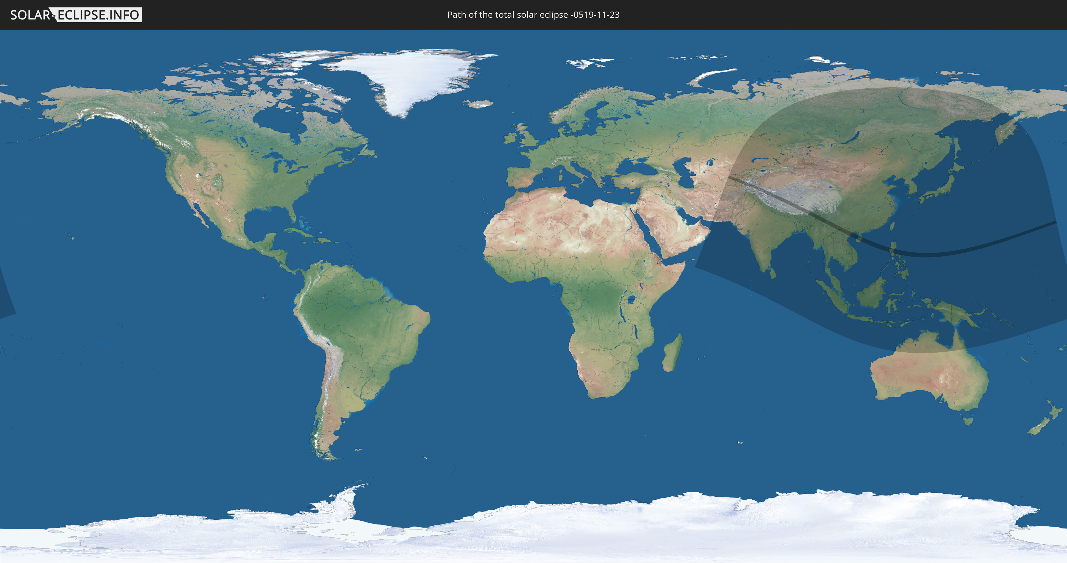
Total solar eclipse of 11/23/-0519
| Day of week: | Monday |
| Maximum duration of eclipse: | 03m44s |
| Maximum width of eclipse path: | 160 km |
| Saros cycle: | 63 |
| Coverage: | 100% |
| Magnitude: | 1.0393 |
| Gamma: | 0.5724 |
Wo kann man die Sonnenfinsternis vom 11/23/-0519 sehen?
Die Sonnenfinsternis am 11/23/-0519 kann man in 48 Ländern als partielle Sonnenfinsternis beobachten.
Der Finsternispfad verläuft durch 10 Länder. Nur in diesen Ländern ist sie als total Sonnenfinsternis zu sehen.
In den folgenden Ländern ist die Sonnenfinsternis total zu sehen
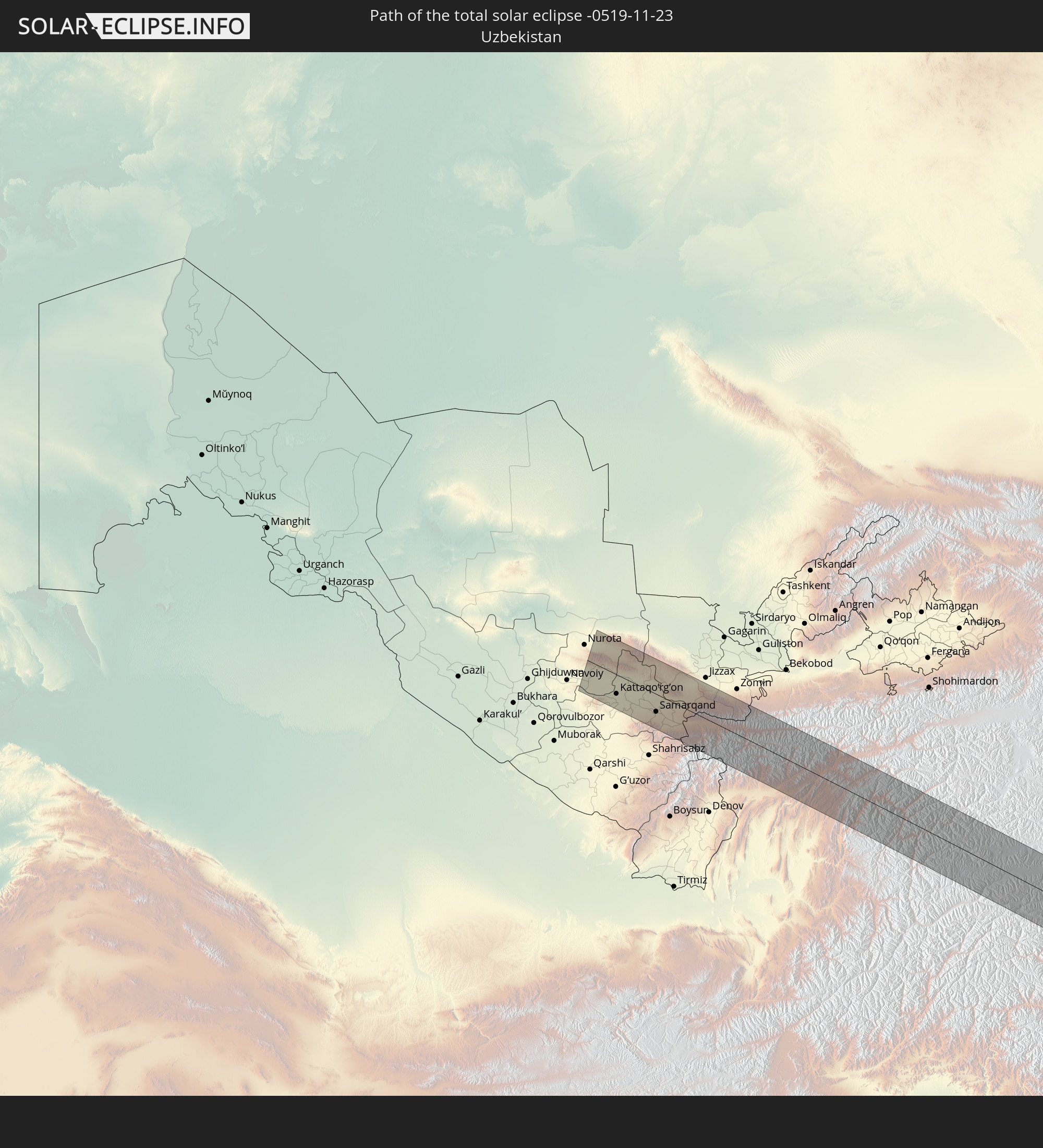 Uzbekistan
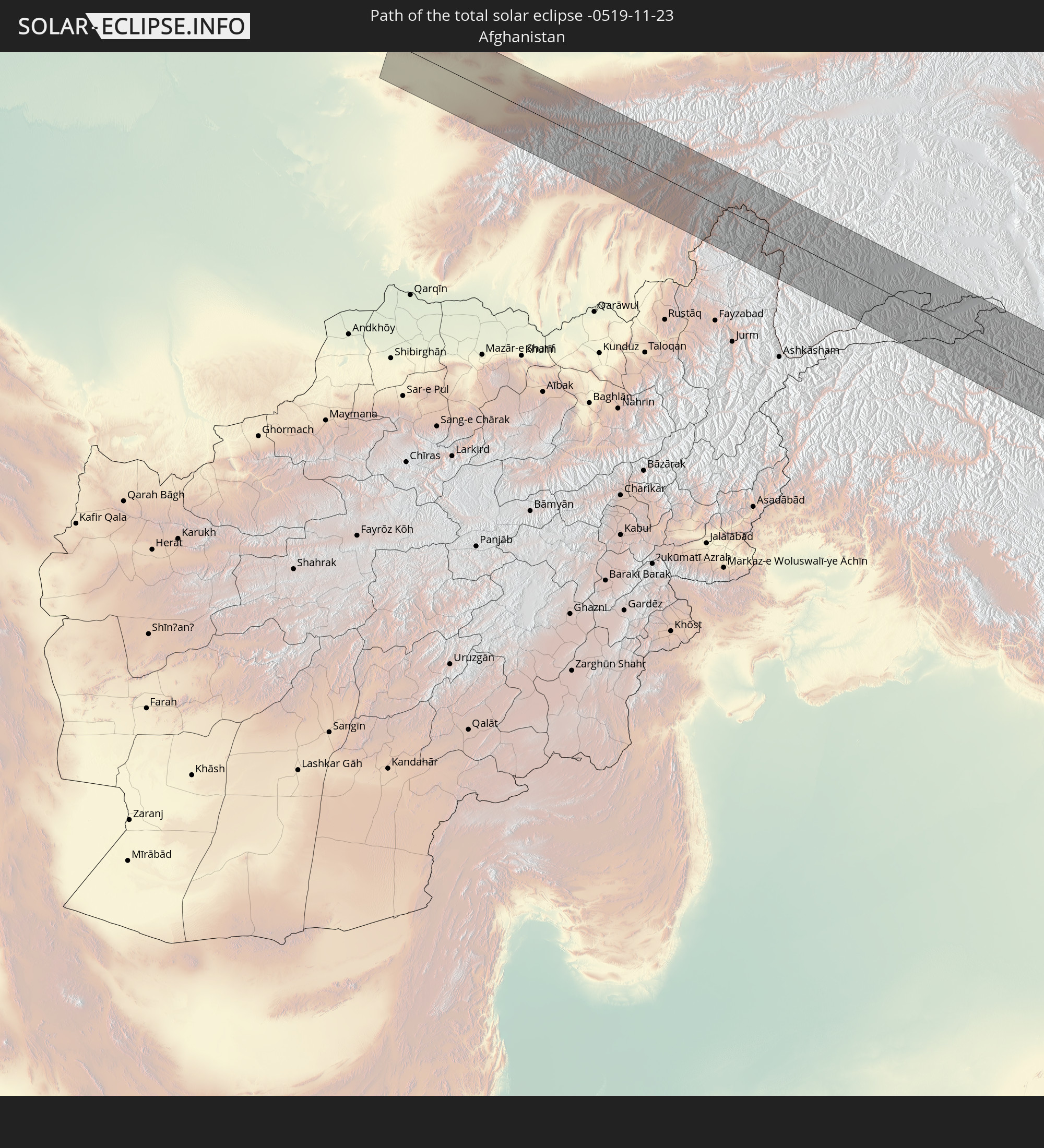 Afghanistan
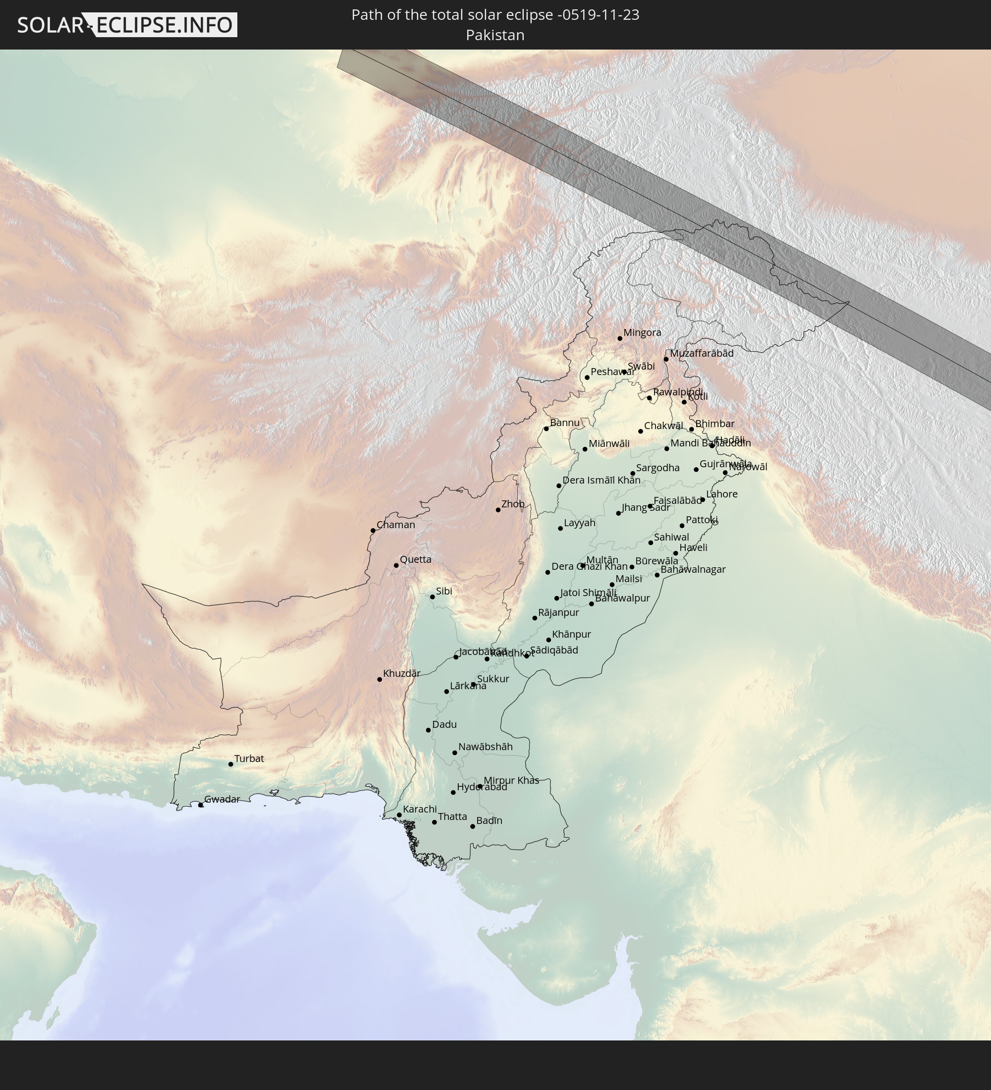 Pakistan
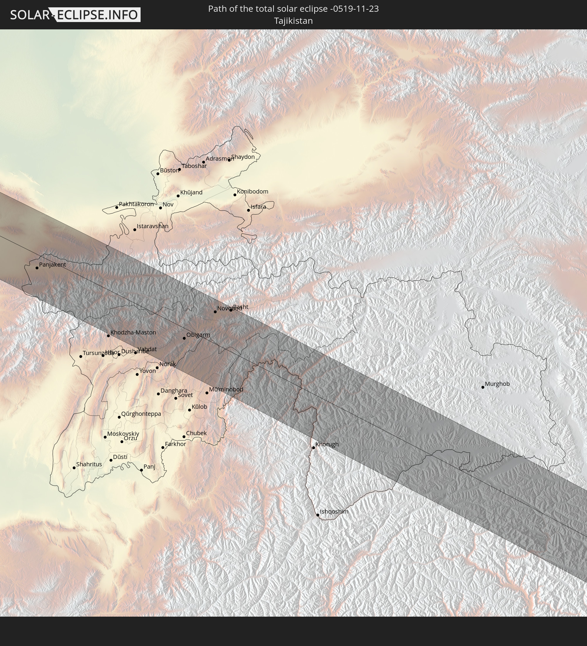 Tajikistan
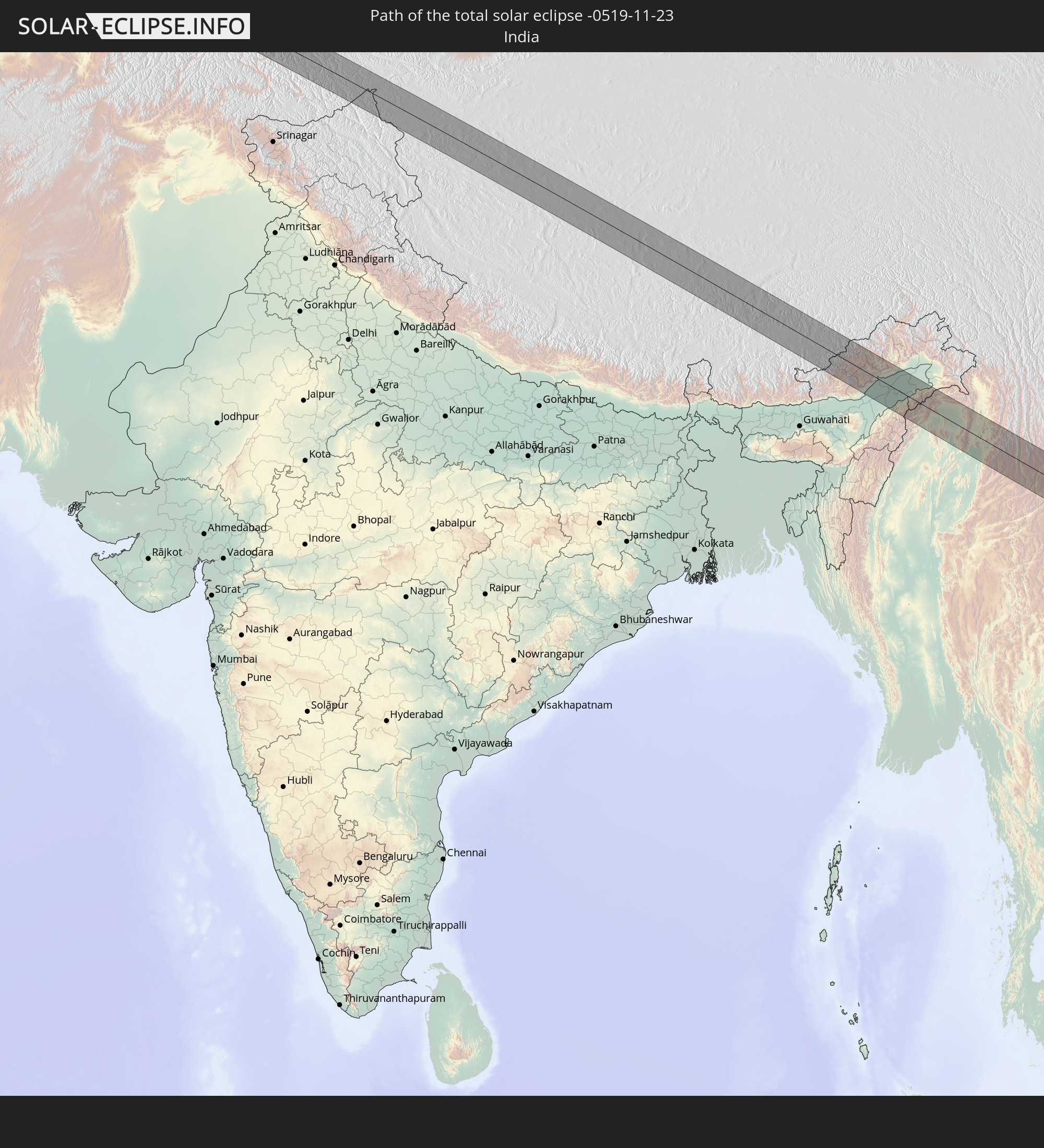 India
India
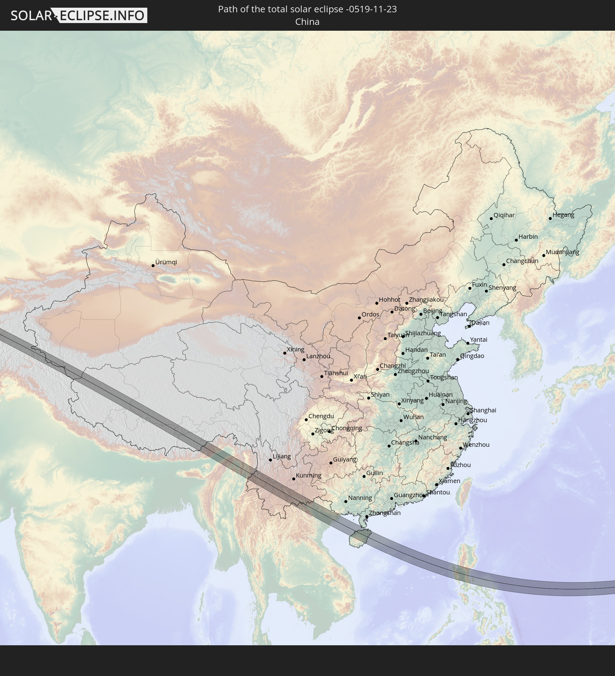 China
China
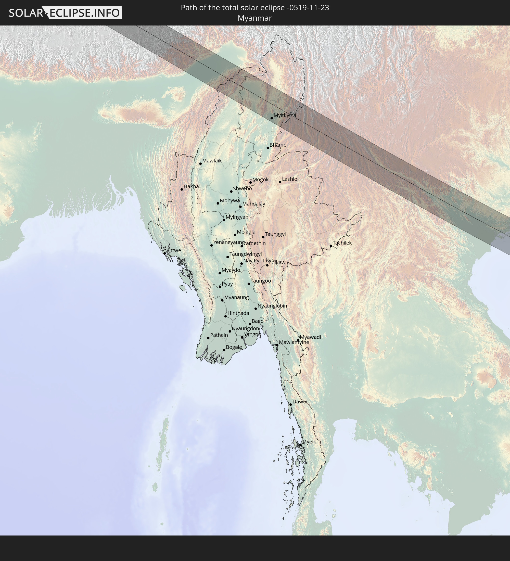 Myanmar
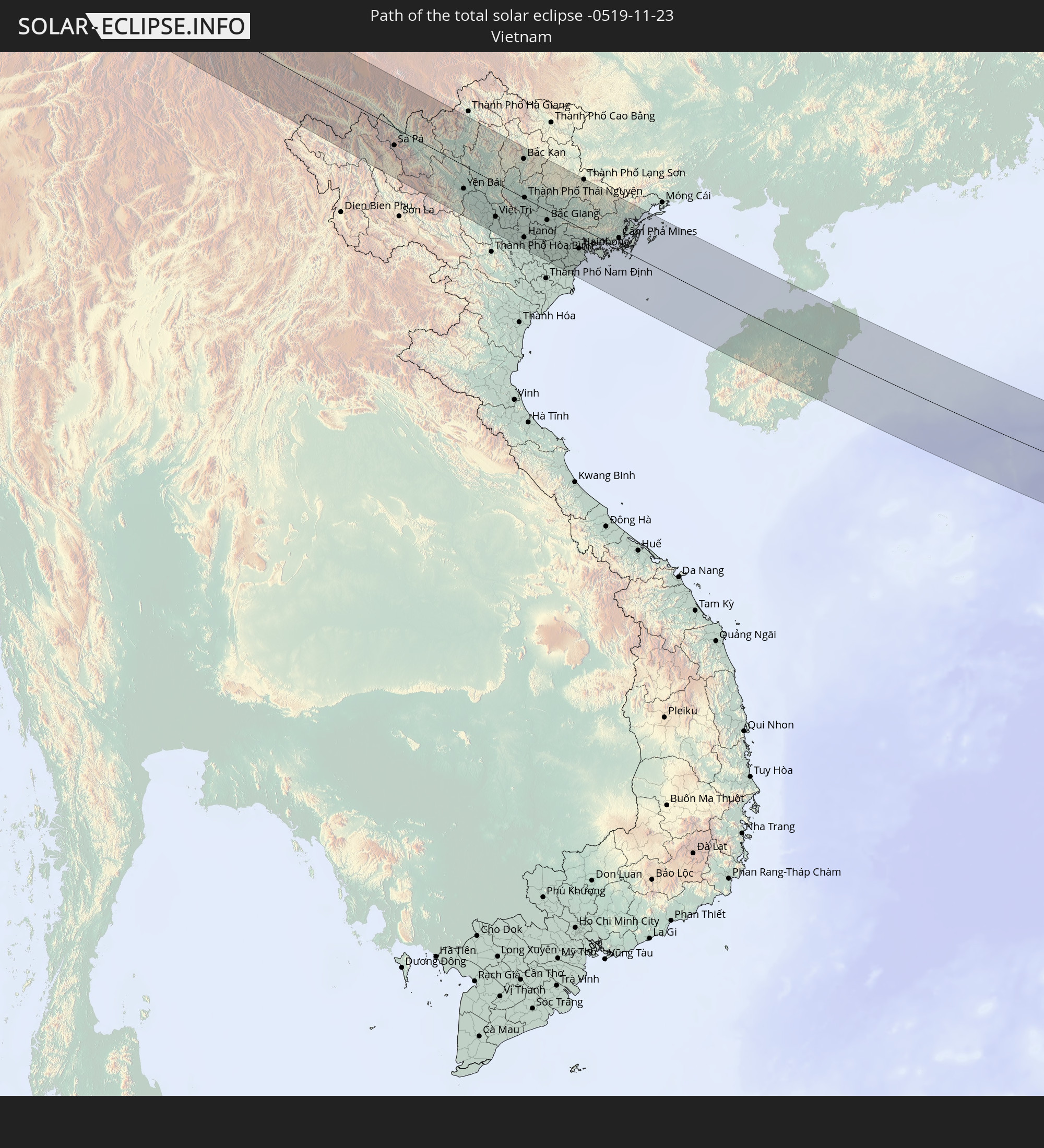 Vietnam
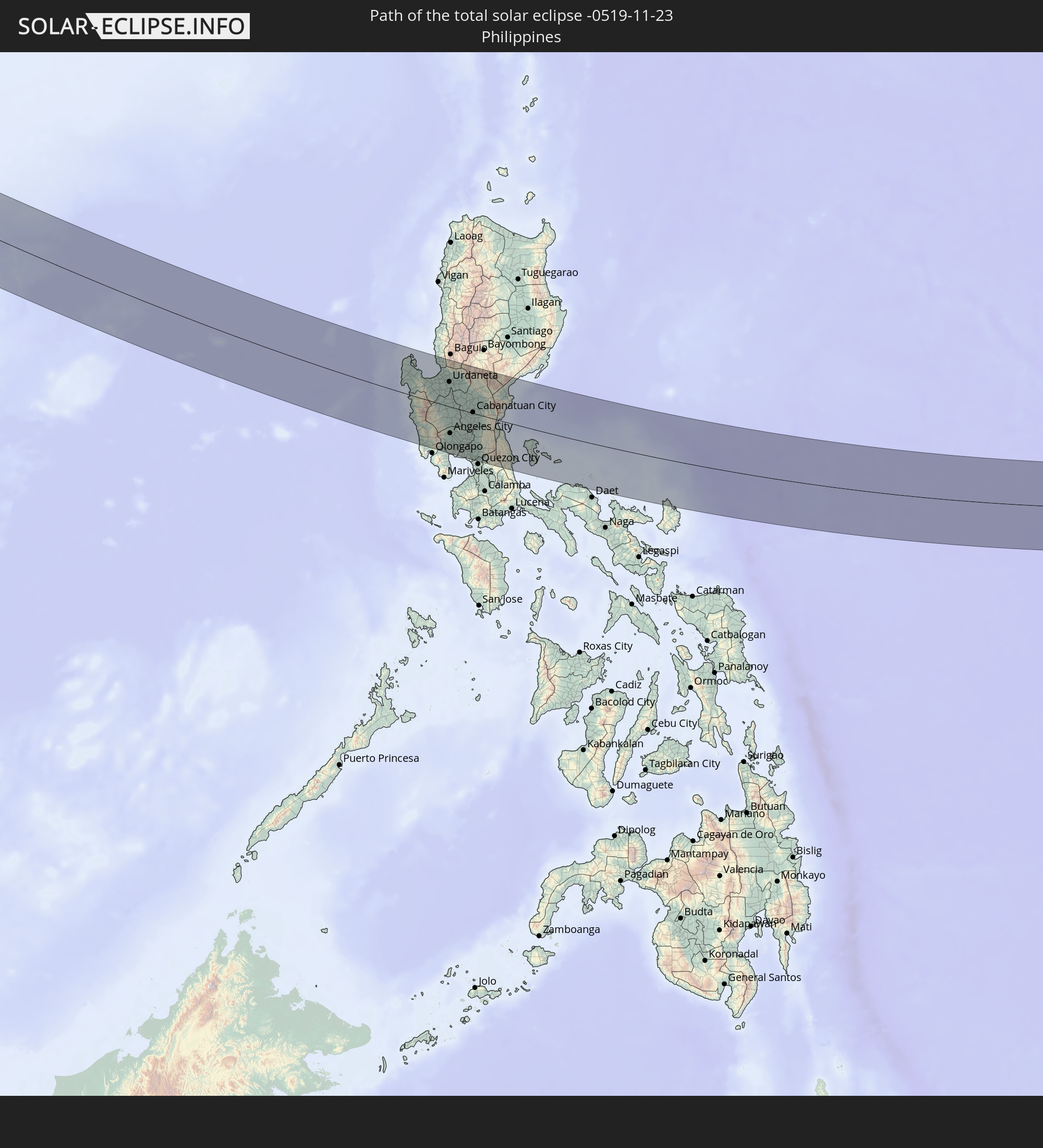 Philippines
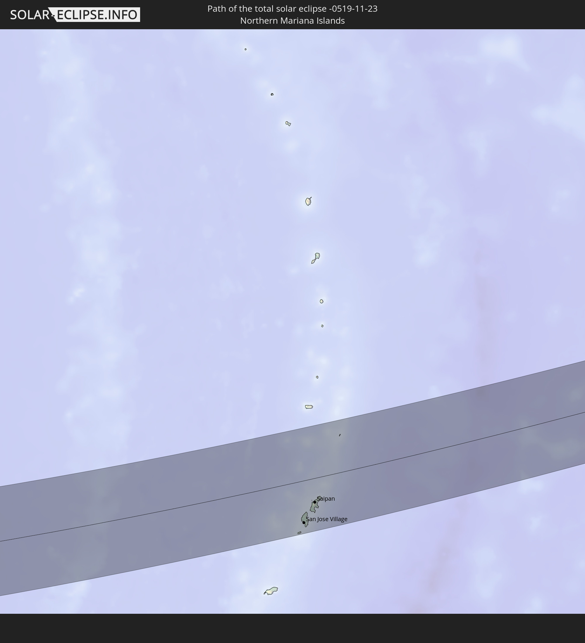 Northern Mariana Islands
In den folgenden Ländern ist die Sonnenfinsternis partiell zu sehen
 Russia
 United States Minor Outlying Islands
 Kiribati
 Iran
Iran
 Kazakhstan
 Oman
Oman
 Turkmenistan
 Uzbekistan
 Afghanistan
 Pakistan
 Tajikistan
 India
India
 Kyrgyzstan
 Maldives
 China
China
 Sri Lanka
 Nepal
Nepal
 Mongolia
 Bangladesh
 Bhutan
 Myanmar
 Indonesia
 Thailand
 Malaysia
 Laos
Laos
 Vietnam
 Cambodia
 Singapore
 Christmas Island
 Australia
 Macau
Macau
 Hong Kong
 Brunei
 Taiwan
 Philippines
 Japan
Japan
 East Timor
 North Korea
 South Korea
 Palau
Palau
 Federated States of Micronesia
 Papua New Guinea
 Guam
Guam
 Northern Mariana Islands
 Solomon Islands
 Marshall Islands
 Nauru
Nauru
 Tuvalu
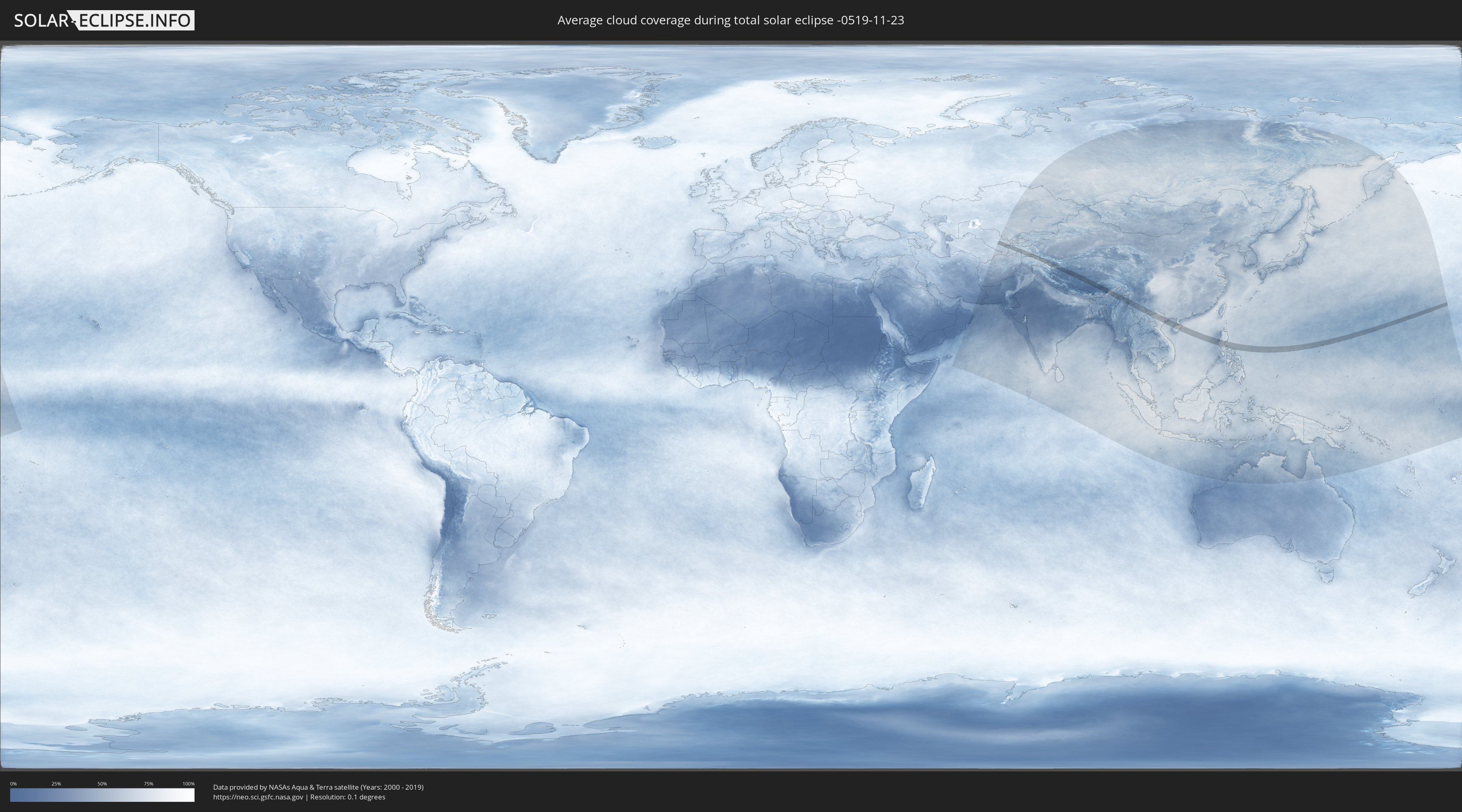
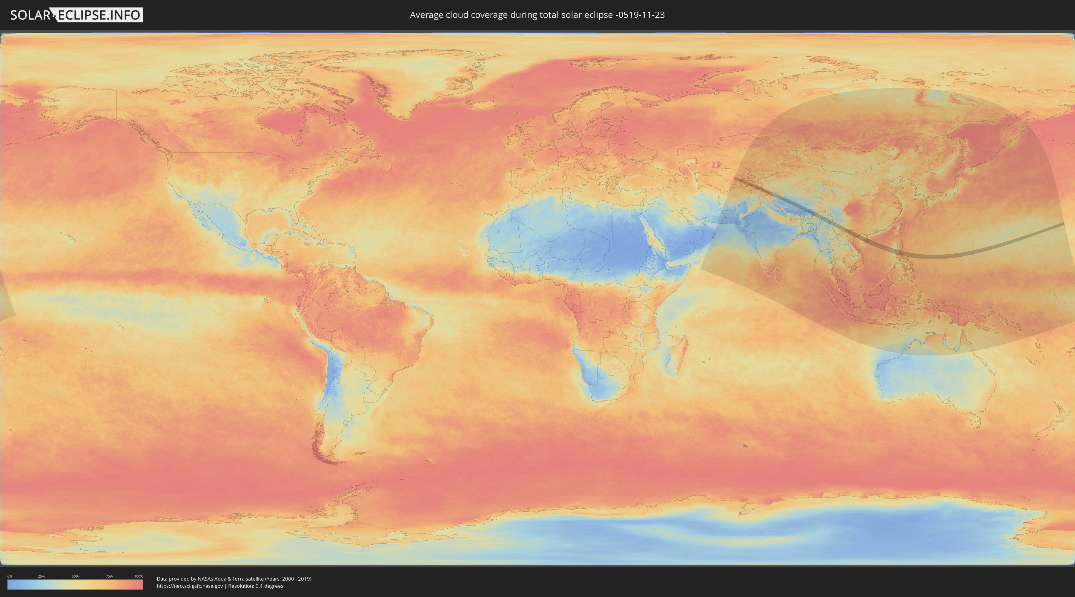
How will be the weather during the total solar eclipse on 11/23/-0519?
Where is the best place to see the total solar eclipse of 11/23/-0519?
The following maps show the average cloud coverage for the day of the total solar eclipse.
With the help of these maps, it is possible to find the place along the eclipse path, which has the best
chance of a cloudless sky.
Nevertheless, you should consider local circumstances and inform about the weather of your chosen
observation site.
The data is provided by NASAs satellites
AQUA and TERRA.
The cloud maps are averaged over a period of 19 years (2000 - 2019).
Detailed country maps
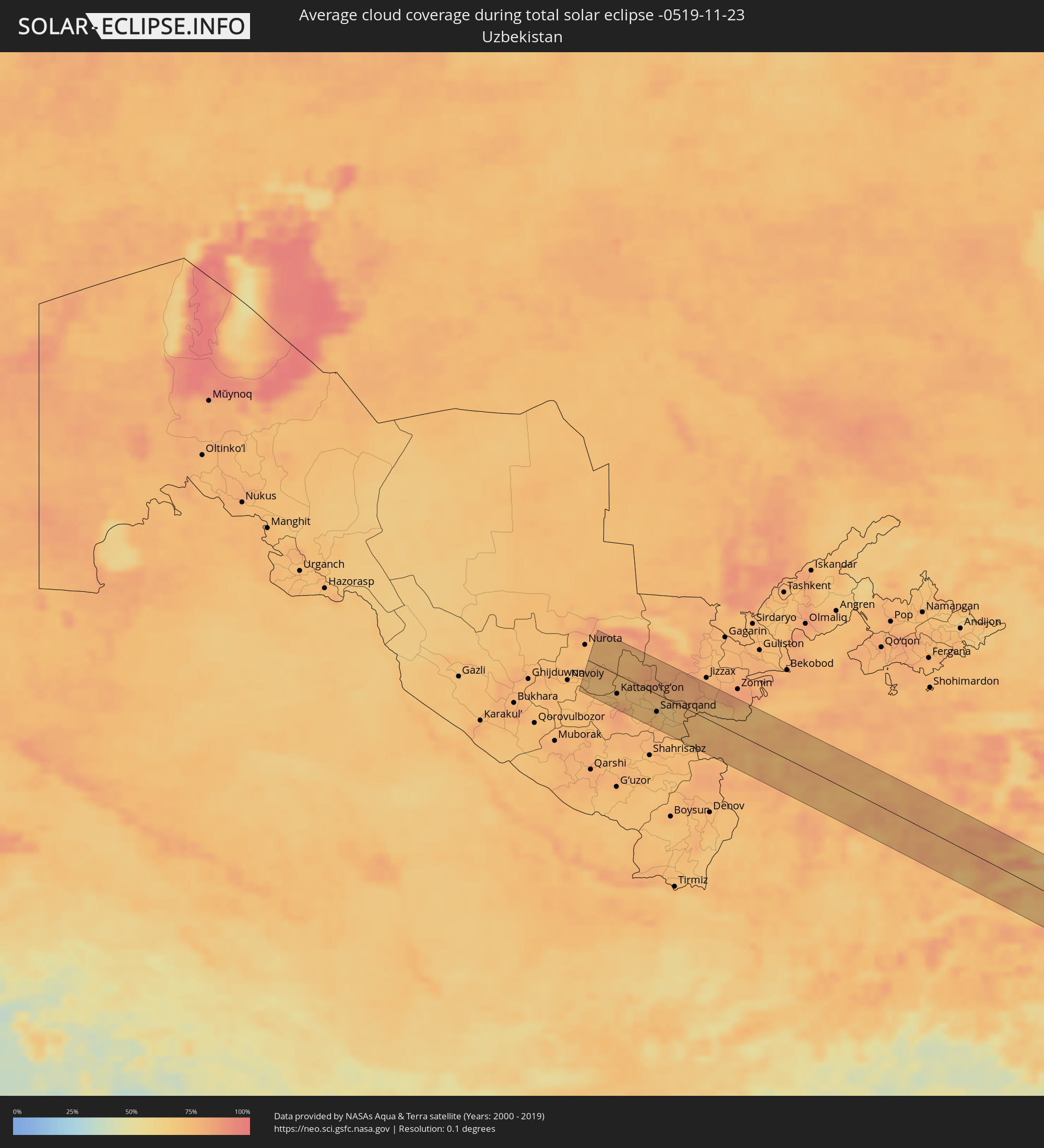 Uzbekistan
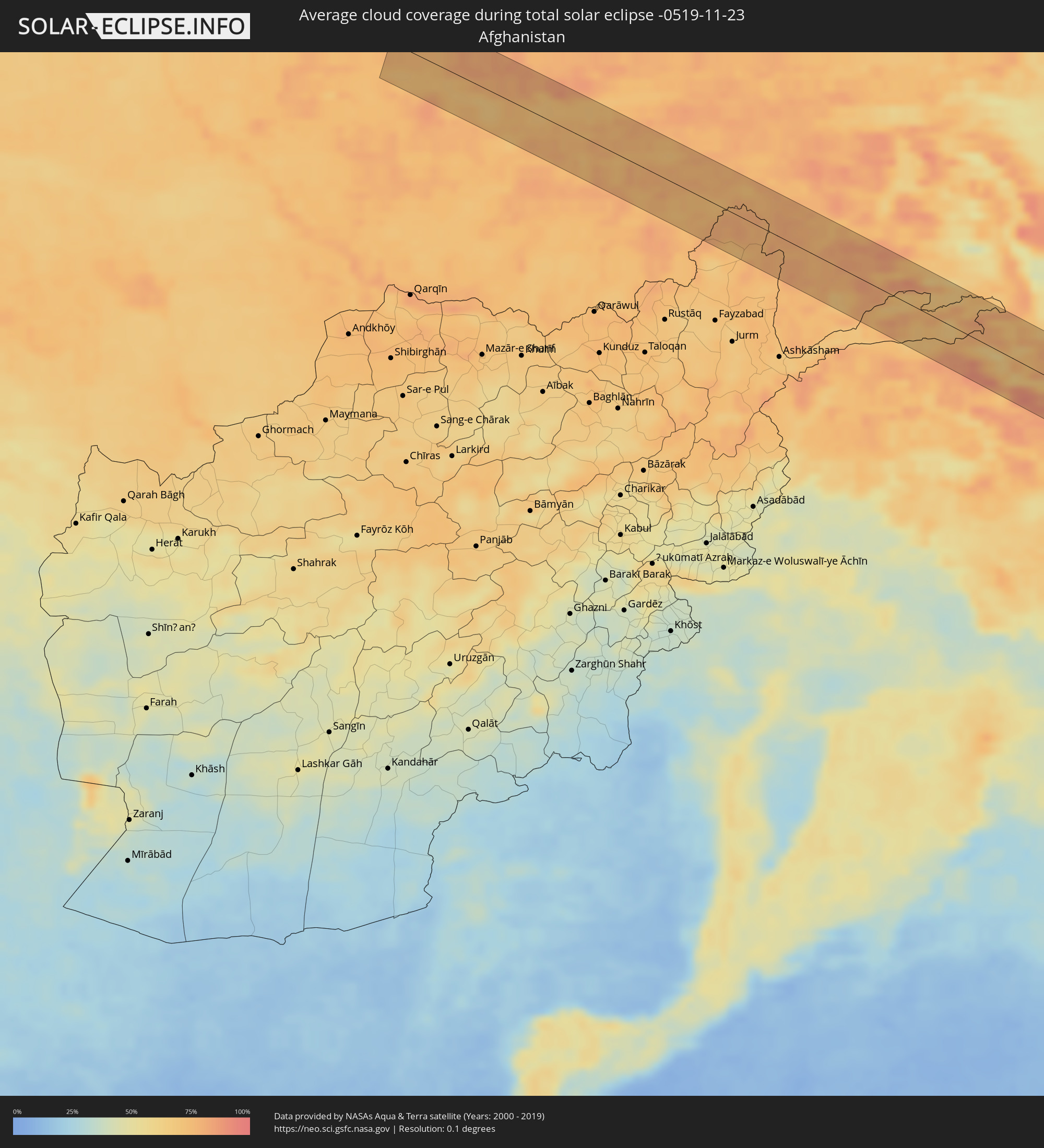 Afghanistan
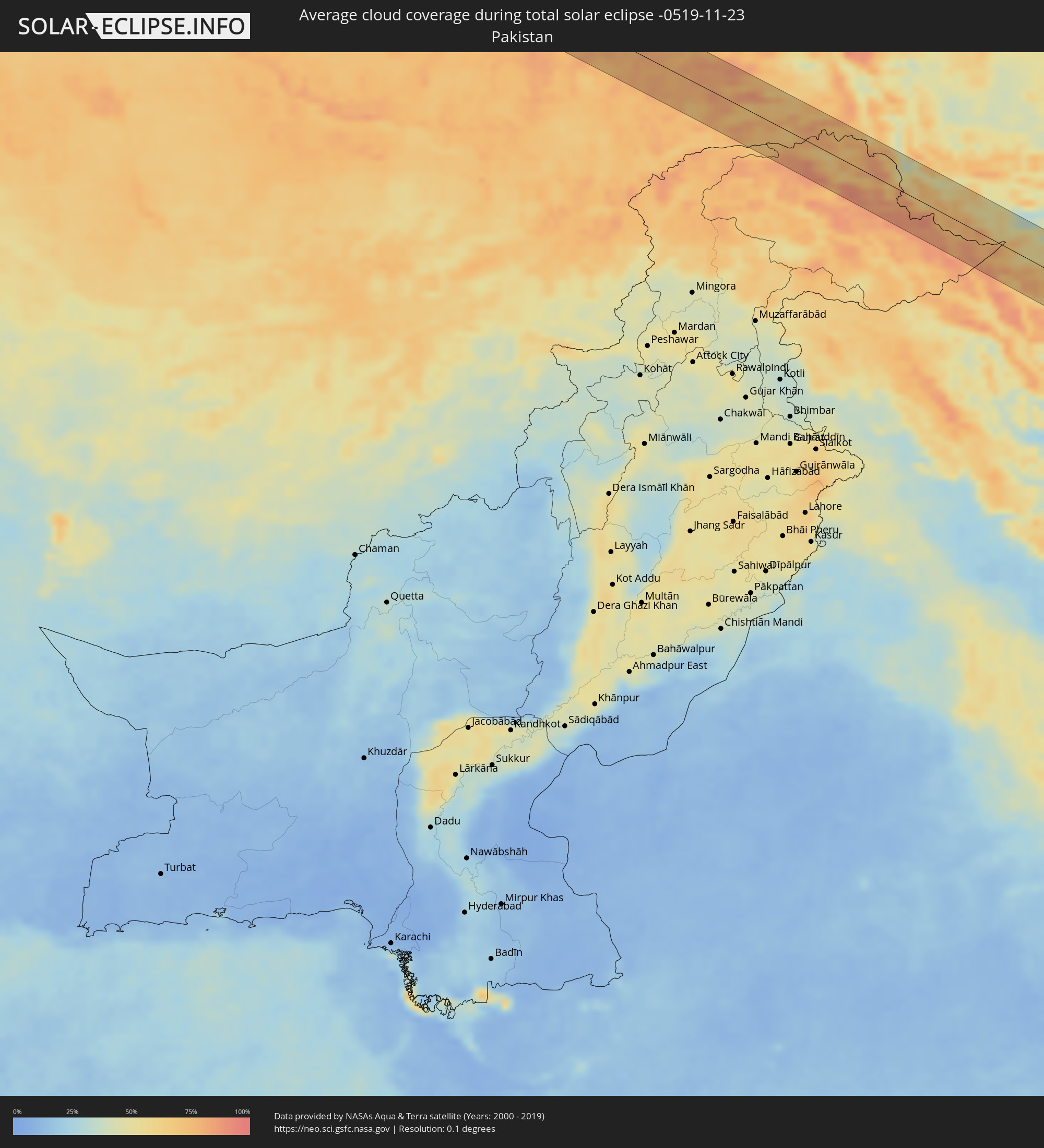 Pakistan
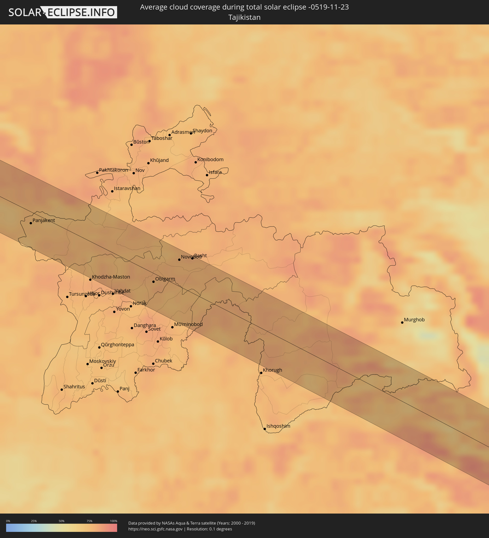 Tajikistan
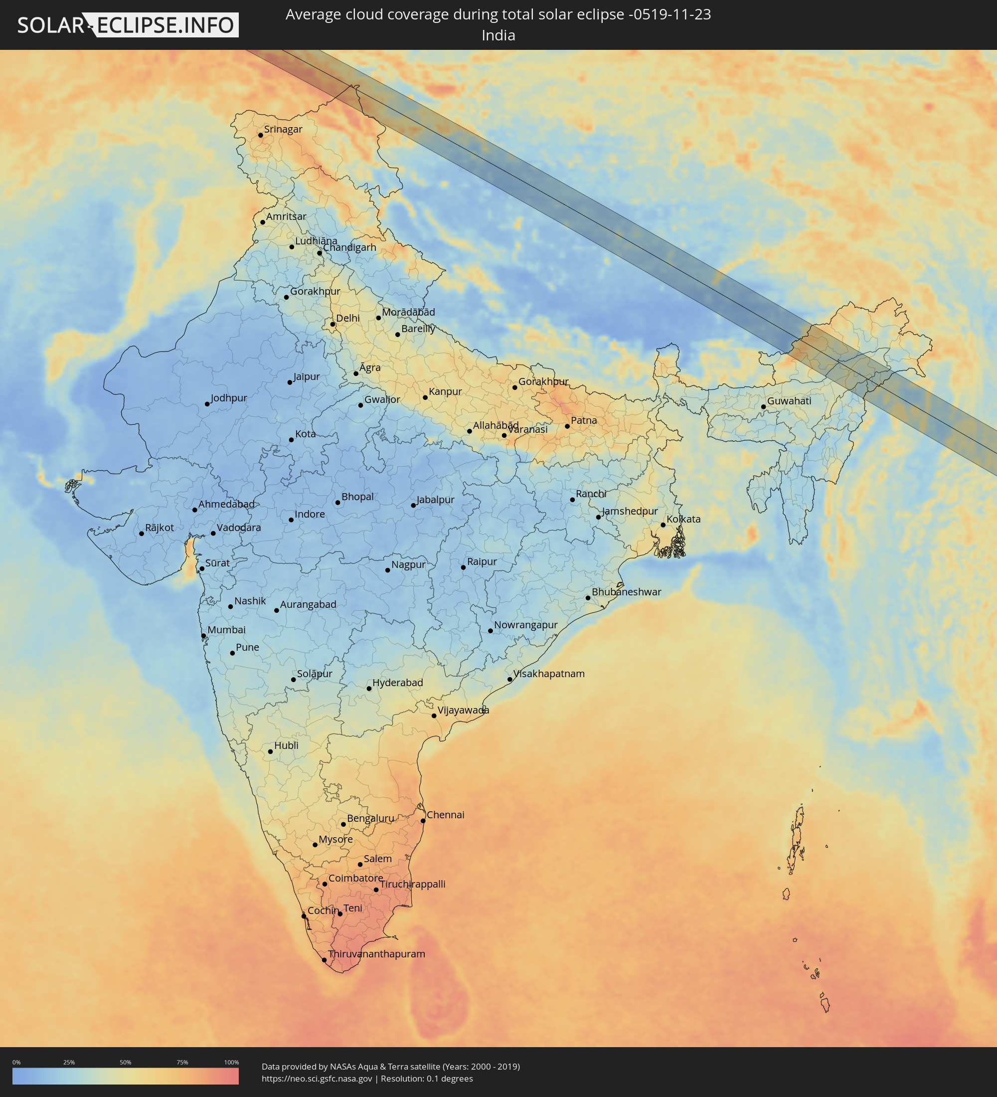 India
India
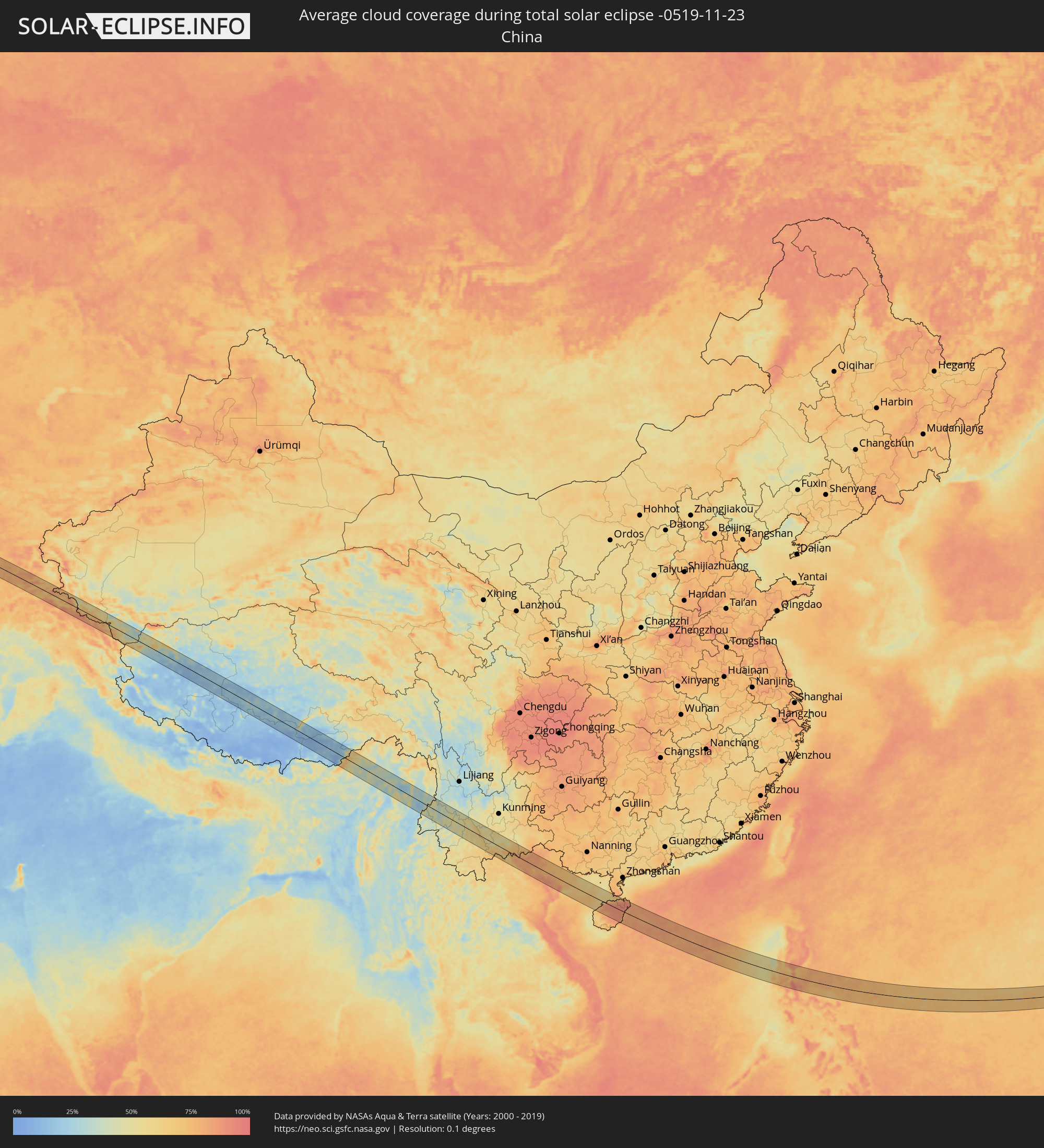 China
China
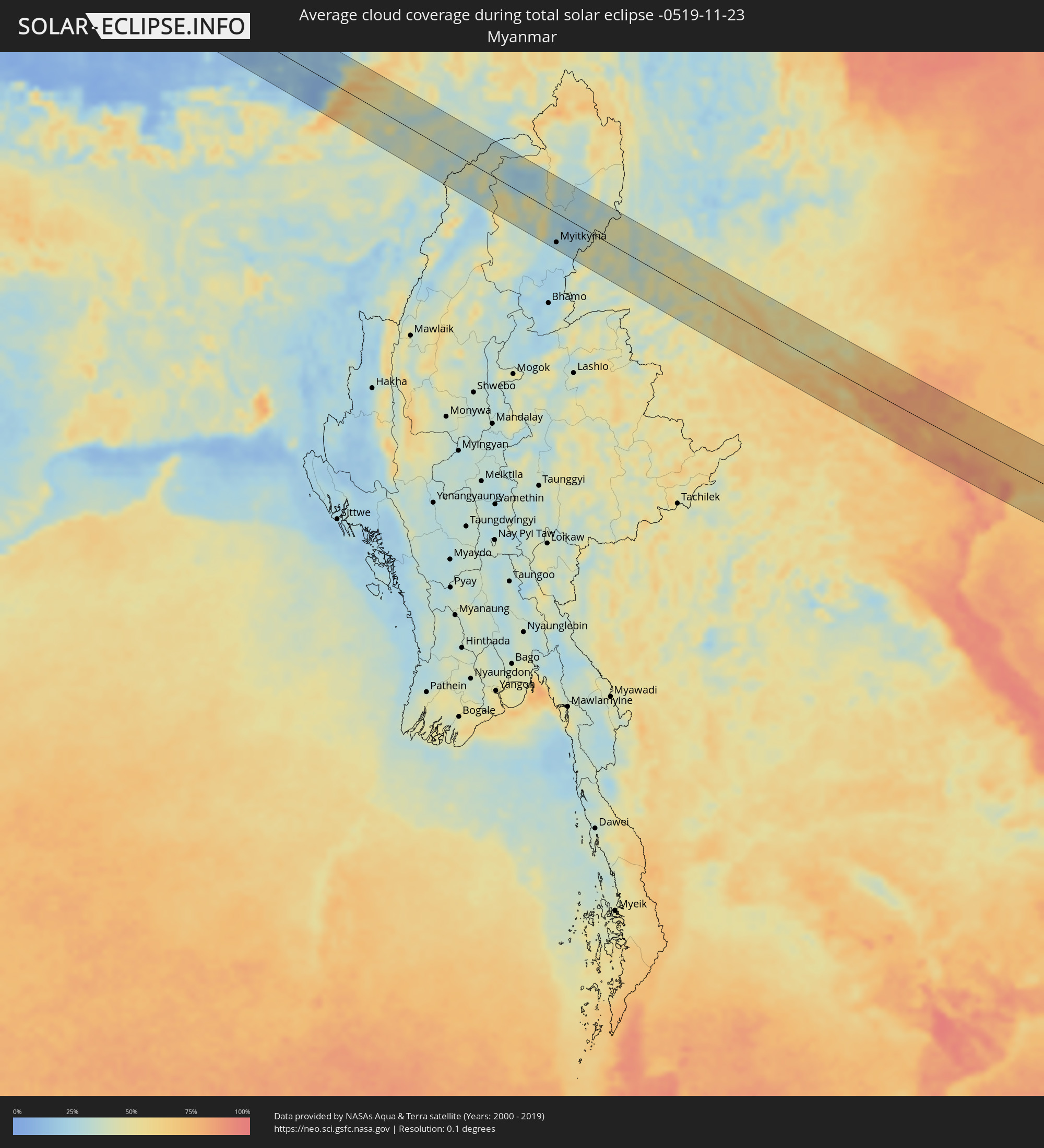 Myanmar
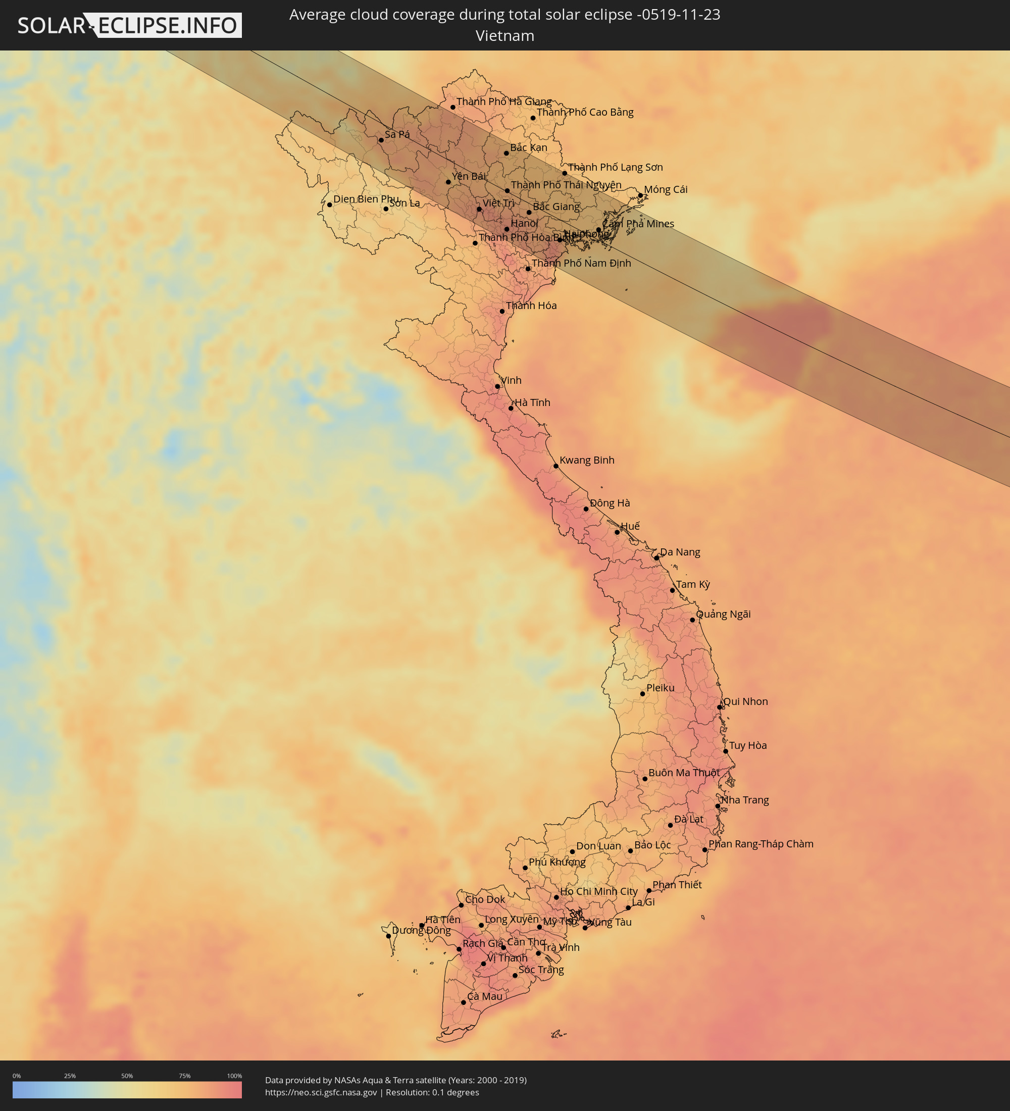 Vietnam
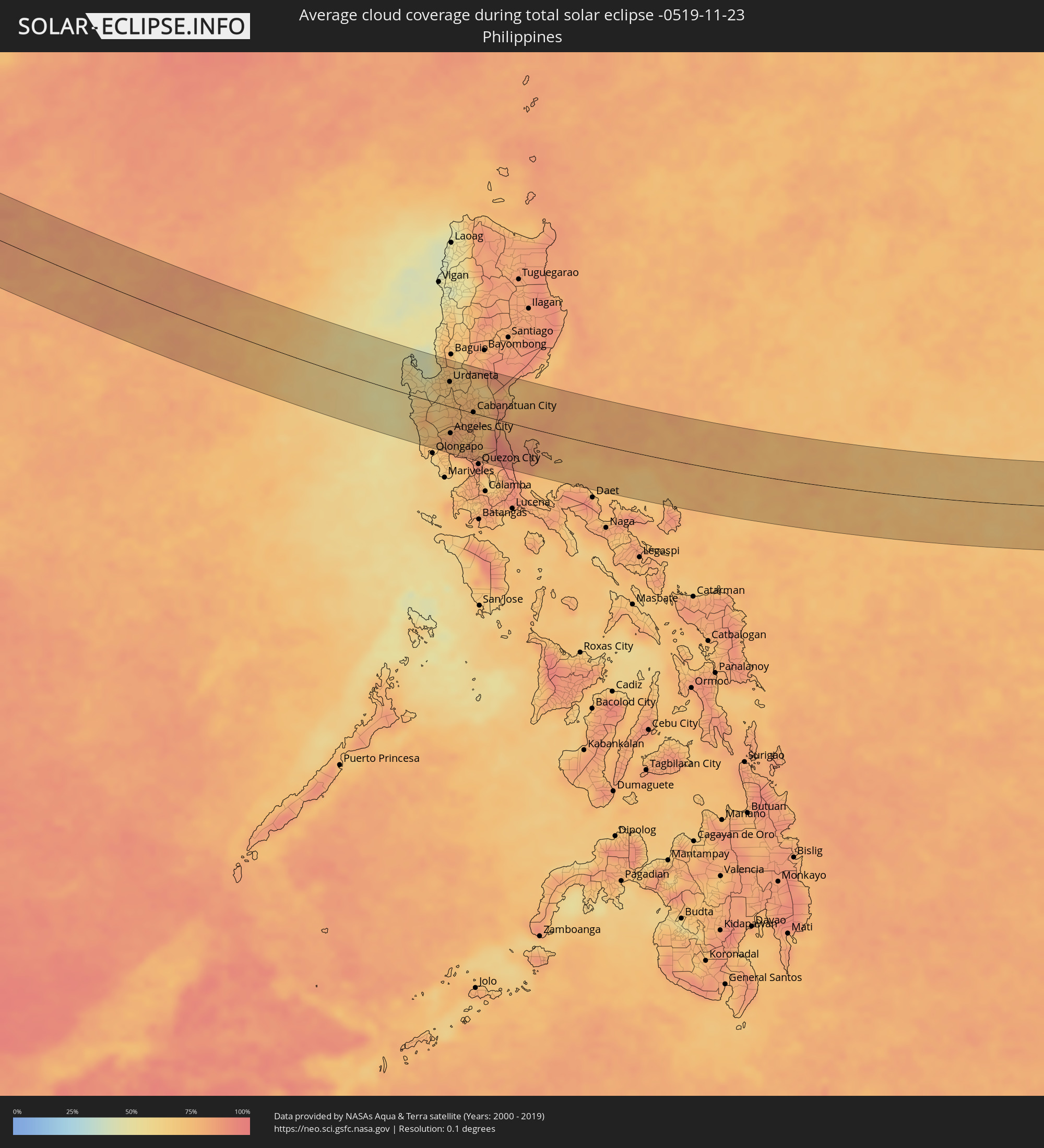 Philippines
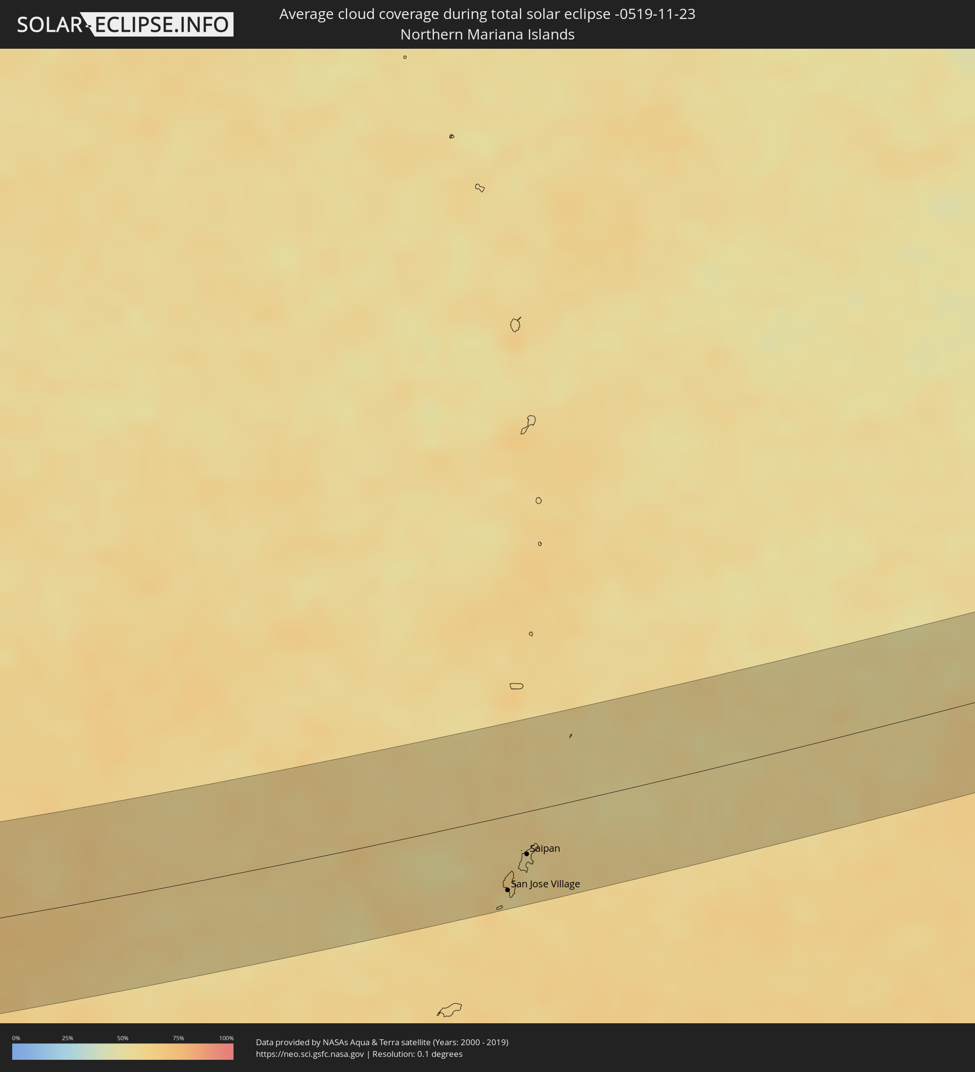 Northern Mariana Islands
Cities inside the path of the eclipse
The following table shows all locations with a population of more than 5,000 inside the eclipse path. Cities which have more than 100,000 inhabitants are marked bold. A click at the locations opens a detailed map.
| City | Type | Eclipse duration | Local time of max. eclipse | Distance to central line | Ø Cloud coverage |
|
Oqtosh, Samarqand
|
total | - | 07:05:00 UTC+04:27 | 38 km | 76% |
|
Yangirabot, Navoiy
|
total | - | 07:05:06 UTC+04:27 | 26 km | 71% |
|
Payshanba, Samarqand
|
total | - | 07:05:10 UTC+04:27 | 16 km | 72% |
|
Kattaqo’rg’on, Samarqand
|
total | - | 07:05:06 UTC+04:27 | 26 km | 77% |
|
Ishtixon, Samarqand
|
total | - | 07:05:13 UTC+04:27 | 11 km | 72% |
|
Juma, Samarqand
|
total | - | 07:05:05 UTC+04:27 | 29 km | 72% |
|
Charxin, Samarqand
|
total | - | 07:05:06 UTC+04:27 | 27 km | 75% |
|
Chelak, Samarqand
|
total | - | 07:05:18 UTC+04:27 | 1 km | 71% |
|
Daxbet, Samarqand
|
total | - | 07:05:12 UTC+04:27 | 15 km | 70% |
|
Samarqand, Samarqand
|
total | - | 07:05:08 UTC+04:27 | 24 km | 74% |
|
Jomboy, Samarqand
|
total | - | 07:05:13 UTC+04:27 | 15 km | 69% |
|
Urgut, Samarqand
|
total | - | 07:05:02 UTC+04:27 | 38 km | 77% |
|
Bulung’ur, Samarqand
|
total | - | 07:05:19 UTC+04:27 | 1 km | 71% |
|
Panjakent, Viloyati Sughd
|
total | - | 07:12:33 UTC+04:35 | 15 km | 76% |
|
Obigarm
|
total | - | 07:12:45 UTC+04:35 | 11 km | 79% |
|
Roghun
|
total | - | 07:12:52 UTC+04:35 | 1 km | 77% |
|
Novobod
|
total | - | 07:13:10 UTC+04:35 | 35 km | 76% |
|
Rasht
|
total | - | 07:13:16 UTC+04:35 | 46 km | 76% |
|
Dêqên, Tibet Autonomous Region
|
total | - | 10:49:44 UTC+08:00 | 59 km | 18% |
|
Lhasa, Tibet Autonomous Region
|
total | - | 10:50:09 UTC+08:00 | 47 km | 13% |
|
Ziro, Arunachal Pradesh
|
total | - | 08:14:38 UTC+05:21 | 16 km | 43% |
|
North Lakhimpur, Assam
|
total | - | 08:14:59 UTC+05:21 | 38 km | 40% |
|
Amguri, Assam
|
total | - | 08:15:34 UTC+05:21 | 57 km | 40% |
|
Dhemāji, Assam
|
total | - | 08:15:43 UTC+05:21 | 10 km | 42% |
|
Sibsāgar, Assam
|
total | - | 08:15:45 UTC+05:21 | 36 km | 41% |
|
Nāzirā, Assam
|
total | - | 08:15:53 UTC+05:21 | 37 km | 40% |
|
Dibrugarh, Assam
|
total | - | 08:16:12 UTC+05:21 | 26 km | 37% |
|
Morānha, Assam
|
total | - | 08:16:11 UTC+05:21 | 2 km | 36% |
|
Sonāri, Assam
|
total | - | 08:16:19 UTC+05:21 | 13 km | 29% |
|
Mon, Nagaland
|
total | - | 08:16:21 UTC+05:21 | 39 km | 33% |
|
Chābua, Assam
|
total | - | 08:16:36 UTC+05:21 | 39 km | 39% |
|
Duliāgaon, Assam
|
total | - | 08:16:48 UTC+05:21 | 35 km | 38% |
|
Nāmrup, Assam
|
total | - | 08:16:48 UTC+05:21 | 19 km | 35% |
|
Nahorkatiya, Assam
|
total | - | 08:16:50 UTC+05:21 | 29 km | 38% |
|
Tinsukia, Assam
|
total | - | 08:16:53 UTC+05:21 | 49 km | 40% |
|
Mākum, Assam
|
total | - | 08:17:00 UTC+05:21 | 53 km | 40% |
|
Khonsa, Arunachal Pradesh
|
total | - | 08:17:09 UTC+05:21 | 14 km | 42% |
|
Digboi, Assam
|
total | - | 08:17:16 UTC+05:21 | 53 km | 36% |
|
Margherita, Arunachal Pradesh
|
total | - | 08:17:20 UTC+05:21 | 45 km | 35% |
|
Myitkyina, Kachin
|
total | - | 09:23:38 UTC+06:24 | 52 km | 32% |
|
Gejiu, Yunnan
|
total | - | 11:09:38 UTC+08:00 | 40 km | 56% |
|
Lai Châu, Lai Châu
|
total | - | 10:17:06 UTC+07:06 | 38 km | 67% |
|
Sa Pá, Lào Cai
|
total | - | 10:17:55 UTC+07:06 | 25 km | 77% |
|
Lào Cai, Lào Cai
|
total | - | 10:18:09 UTC+07:06 | 4 km | 79% |
|
Yên Bái, Yên Bái
|
total | - | 10:20:20 UTC+07:06 | 32 km | 79% |
|
Thành Phố Tuyên Quang, Tuyên Quang
|
total | - | 10:20:57 UTC+07:06 | 8 km | 80% |
|
Việt Trì, Phú Thọ
|
total | - | 10:21:30 UTC+07:06 | 48 km | 84% |
|
Sơn Tây, Ha Nội
|
total | - | 10:21:47 UTC+07:06 | 60 km | 83% |
|
Vĩnh Yên, Vĩnh Phúc
|
total | - | 10:21:57 UTC+07:06 | 39 km | 89% |
|
Hà Đông, Ha Nội
|
total | - | 10:22:27 UTC+07:06 | 64 km | 86% |
|
Bắc Kạn, Bắc Kạn
|
total | - | 10:22:14 UTC+07:06 | 54 km | 75% |
|
Hanoi, Ha Nội
|
total | - | 10:22:34 UTC+07:06 | 55 km | 86% |
|
Thành Phố Thái Nguyên, Thái Nguyên
|
total | - | 10:22:25 UTC+07:06 | 1 km | 78% |
|
Bắc Ninh, Bắc Ninh
|
total | - | 10:23:02 UTC+07:06 | 28 km | 85% |
|
Bắc Giang, Bắc Giang
|
total | - | 10:23:17 UTC+07:06 | 14 km | 80% |
|
Thành Phố Hải Dương, Hải Dương
|
total | - | 10:23:41 UTC+07:06 | 40 km | 82% |
|
Haiphong, Hải Phòng
|
total | - | 10:24:30 UTC+07:06 | 30 km | 82% |
|
Thành Phố Lạng Sơn, Lạng Sơn
|
total | - | 10:24:22 UTC+07:06 | 71 km | 74% |
|
Thành Phố Uông Bí, Quảng Ninh
|
total | - | 10:24:39 UTC+07:06 | 9 km | 75% |
|
Cát Bà, Hải Phòng
|
total | - | 10:25:23 UTC+07:06 | 26 km | 60% |
|
Thành Phố Hạ Long, Quảng Ninh
|
total | - | 10:25:22 UTC+07:06 | 3 km | 73% |
|
Cẩm Phả Mines, Quảng Ninh
|
total | - | 10:25:52 UTC+07:06 | 15 km | 71% |
|
Lincheng, Hainan
|
total | - | 11:25:18 UTC+08:00 | 18 km | 87% |
|
Jinjiang, Hainan
|
total | - | 11:26:10 UTC+08:00 | 15 km | 89% |
|
Xiuying, Hainan
|
total | - | 11:26:46 UTC+08:00 | 55 km | 86% |
|
Haikou, Hainan
|
total | - | 11:26:52 UTC+08:00 | 62 km | 86% |
|
Qiongshan, Hainan
|
total | - | 11:26:55 UTC+08:00 | 58 km | 86% |
|
Wanning, Hainan
|
total | - | 11:27:31 UTC+08:00 | 61 km | 85% |
|
Santa Cruz, Central Luzon
|
total | - | 11:55:30 UTC+08:00 | 0 km | 54% |
|
Masinloc, Central Luzon
|
total | - | 11:55:46 UTC+08:00 | 23 km | 69% |
|
Iba, Central Luzon
|
total | - | 11:55:59 UTC+08:00 | 45 km | 60% |
|
Agoo, Ilocos
|
total | - | 11:55:51 UTC+08:00 | 40 km | 47% |
|
Lingayen, Ilocos
|
total | - | 11:56:17 UTC+08:00 | 37 km | 56% |
|
Mangaldan, Ilocos
|
total | - | 11:56:45 UTC+08:00 | 47 km | 67% |
|
Camiling, Central Luzon
|
total | - | 11:57:02 UTC+08:00 | 7 km | 67% |
|
Dinalupihan, Central Luzon
|
total | - | 11:57:40 UTC+08:00 | 79 km | 74% |
|
Urdaneta, Ilocos
|
total | - | 11:57:19 UTC+08:00 | 42 km | 70% |
|
Paniqui, Central Luzon
|
total | - | 11:57:32 UTC+08:00 | 10 km | 74% |
|
Angeles City, Central Luzon
|
total | - | 11:57:53 UTC+08:00 | 46 km | 81% |
|
Capas, Central Luzon
|
total | - | 11:57:47 UTC+08:00 | 26 km | 80% |
|
Tarlac City, Central Luzon
|
total | - | 11:57:43 UTC+08:00 | 10 km | 77% |
|
San Fernando, Central Luzon
|
total | - | 11:58:17 UTC+08:00 | 56 km | 75% |
|
Guimba, Central Luzon
|
total | - | 11:58:06 UTC+08:00 | 14 km | 76% |
|
Arayat, Central Luzon
|
total | - | 11:58:26 UTC+08:00 | 40 km | 74% |
|
Malolos, Central Luzon
|
total | - | 11:58:45 UTC+08:00 | 72 km | 79% |
|
Baliuag, Central Luzon
|
total | - | 11:58:57 UTC+08:00 | 57 km | 82% |
|
Muñoz, Central Luzon
|
total | - | 11:58:28 UTC+08:00 | 24 km | 76% |
|
Gapan, Central Luzon
|
total | - | 11:58:51 UTC+08:00 | 18 km | 80% |
|
Cabanatuan City, Central Luzon
|
total | - | 11:58:48 UTC+08:00 | 2 km | 80% |
|
San Miguel, Central Luzon
|
total | - | 11:59:03 UTC+08:00 | 35 km | 78% |
|
San Jose del Monte, Central Luzon
|
total | - | 11:59:28 UTC+08:00 | 68 km | 86% |
|
Bongabon, Central Luzon
|
total | - | 11:59:14 UTC+08:00 | 22 km | 72% |
|
Rodriguez, Calabarzon
|
total | - | 11:59:58 UTC+08:00 | 70 km | 82% |
|
San Jose Village, Tinian
|
total | - | 15:03:25 UTC+10:00 | 55 km | 61% |
|
Saipan, Saipan
|
total | - | 15:03:31 UTC+10:00 | 31 km | 58% |