Totale Sonnenfinsternis vom 24.02.-0570
| Wochentag: | Montag |
| Maximale Dauer der Verfinsterung: | 03m04s |
| Maximale Breite des Finsternispfades: | 106 km |
| Saroszyklus: | 50 |
| Bedeckungsgrad: | 100% |
| Magnitude: | 1.0313 |
| Gamma: | 0.0115 |
Wo kann man die Sonnenfinsternis vom 24.02.-0570 sehen?
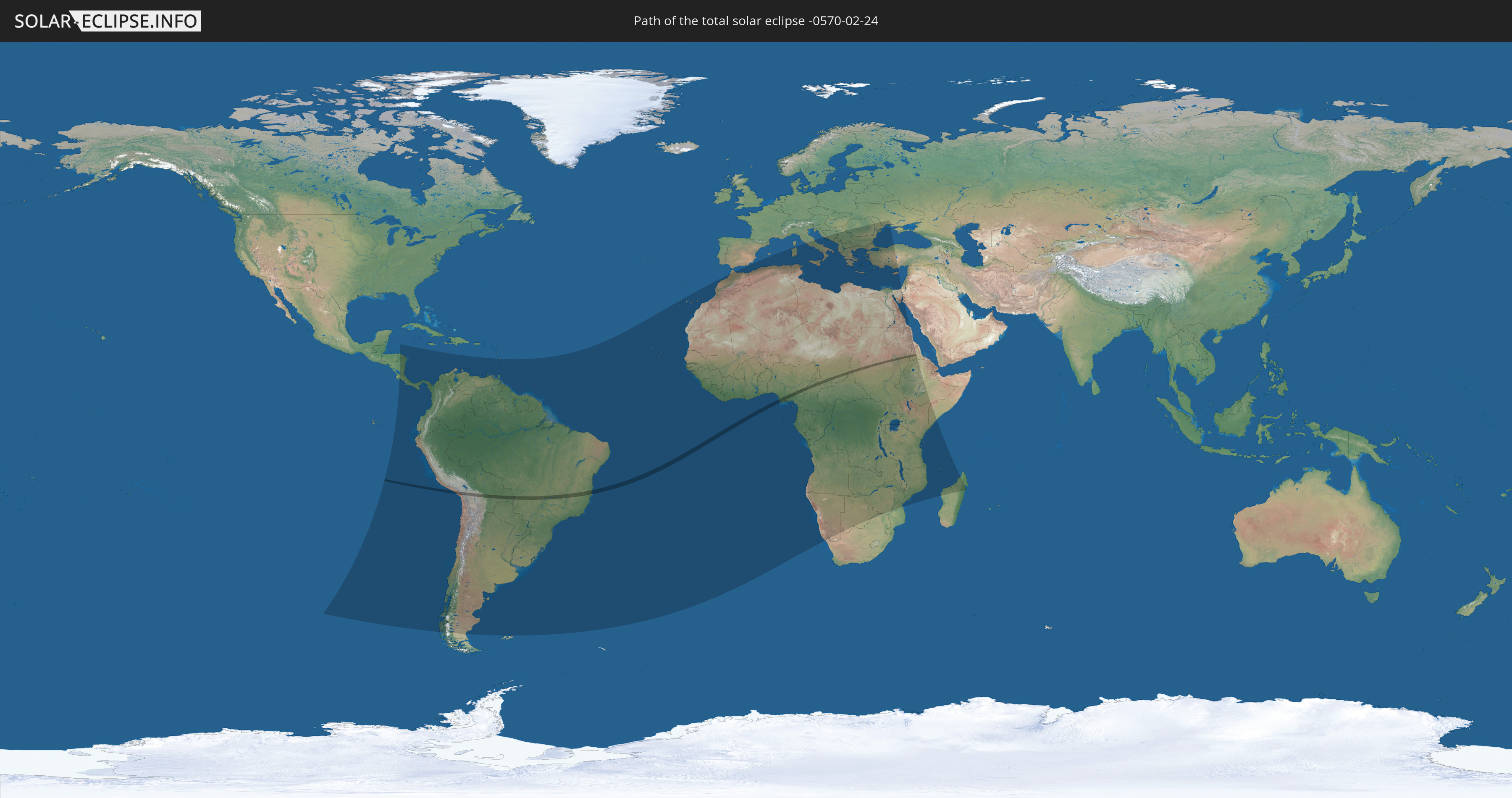
Die Sonnenfinsternis am 24.02.-0570 kann man in 98 Ländern als partielle Sonnenfinsternis beobachten.
Der Finsternispfad verläuft durch 9 Länder. Nur in diesen Ländern ist sie als totale Sonnenfinsternis zu sehen.
In den folgenden Ländern ist die Sonnenfinsternis total zu sehen
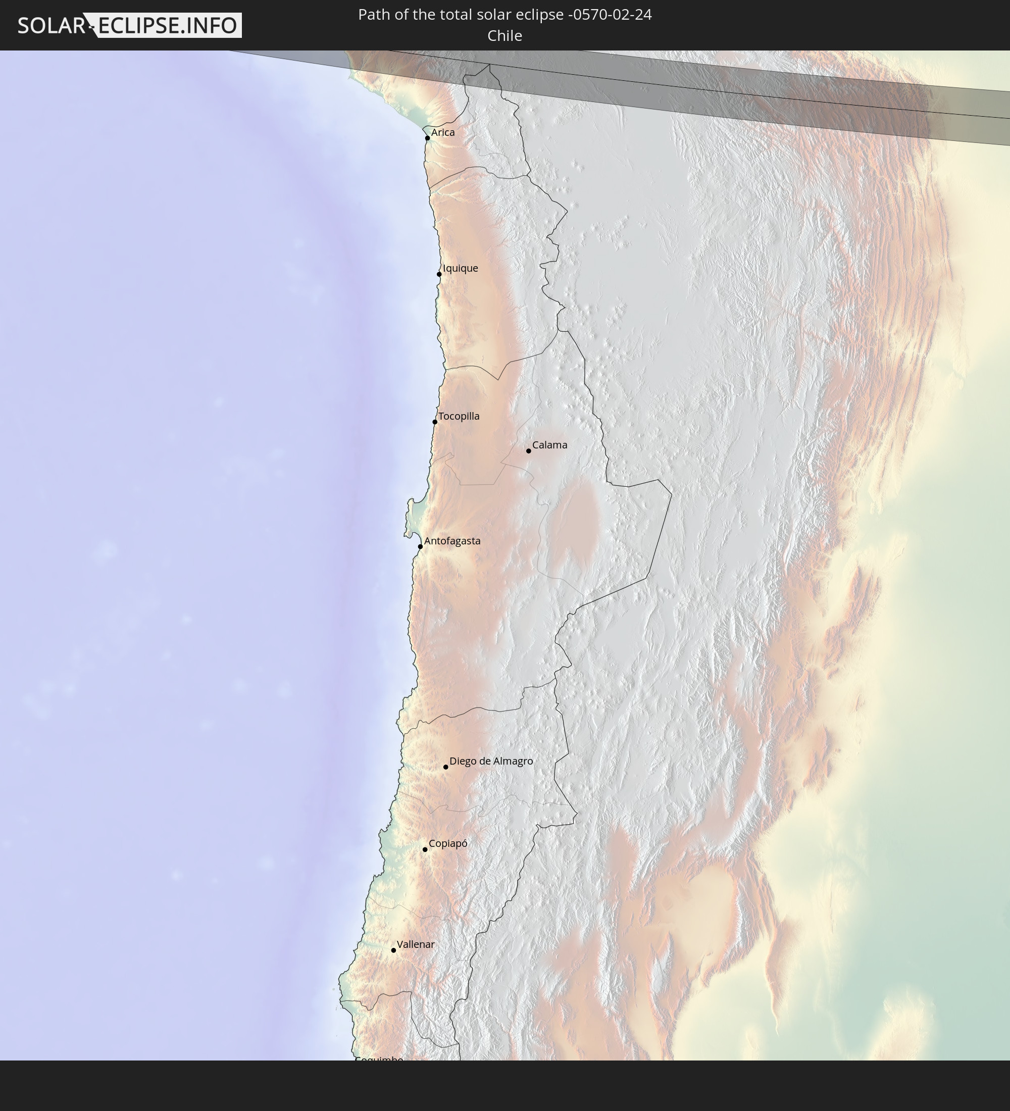 Chile
Chile
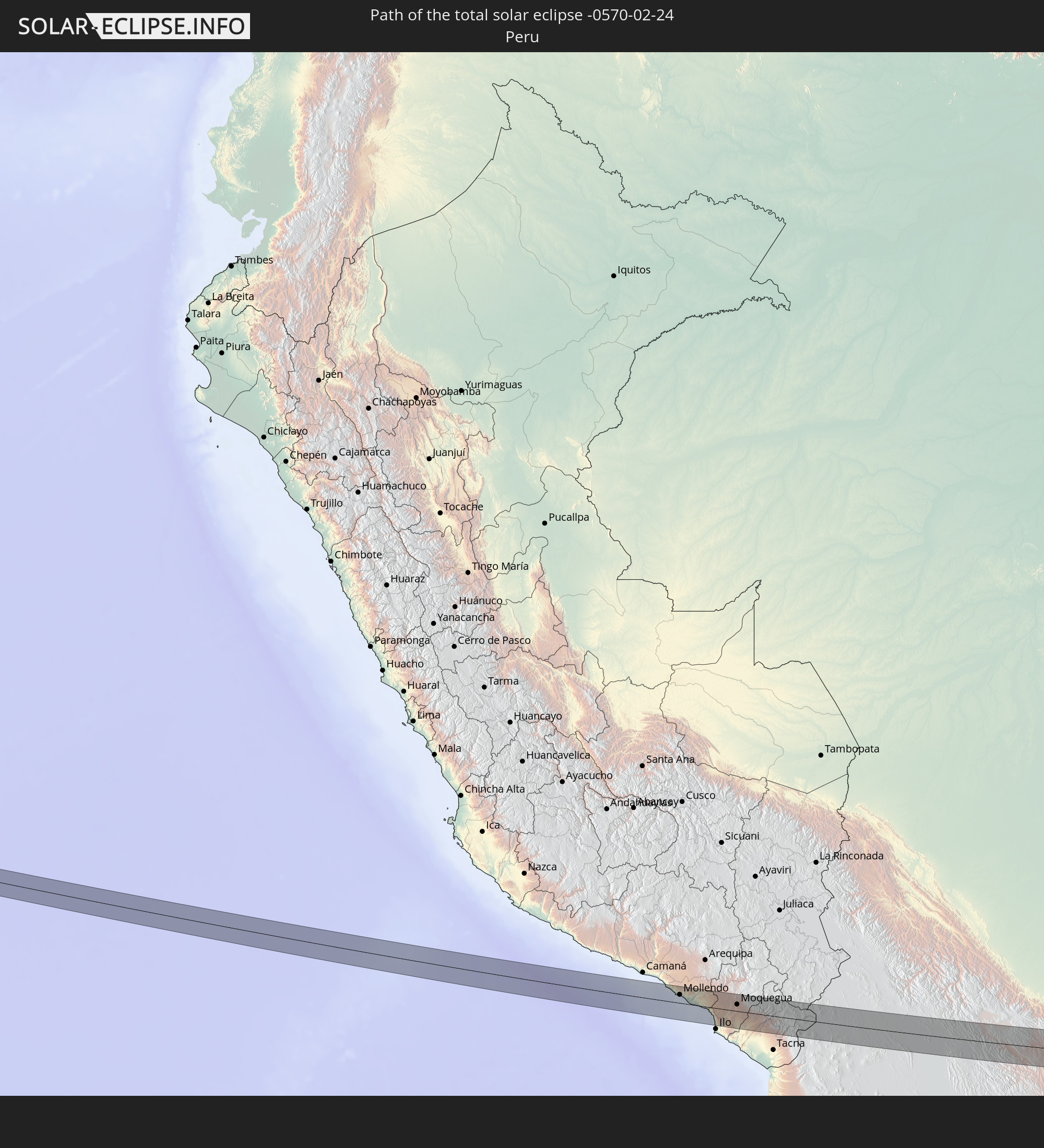 Peru
Peru
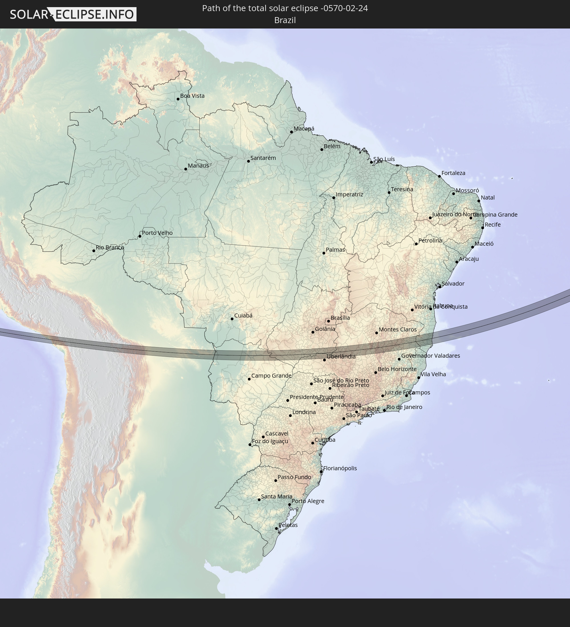 Brasilien
 Bolivien
 Nigeria
 Kamerun
 Tschad
 Sudan
Sudan
 Eritrea
In den folgenden Ländern ist die Sonnenfinsternis partiell zu sehen
 Chile
Chile
 Ecuador
 Honduras
 Nicaragua
 Costa Rica
 Panama
 Kolumbien
 Peru
Peru
 Brasilien
 Argentinien
 Venezuela
 Aruba
Aruba
 Bolivien
 Paraguay
 Trinidad und Tobago
 Grenada
 St. Vincent und die Grenadinen
 Falklandinseln
 Guyana
 Martinique
 St. Lucia
 Barbados
 Uruguay
 Suriname
 Französisch-Guayana
 Kap Verde
 Spanien
 Senegal
 Mauretanien
 Gambia
 Guinea-Bissau
 Guinea
 St. Helena
 Sierra Leone
 Marokko
 Mali
Mali
 Liberia
 Algerien
 Elfenbeinküste
 Burkina Faso
 Ghana
Ghana
 Togo
Togo
 Niger
Niger
 Benin
Benin
 Nigeria
 Äquatorialguinea
 São Tomé und Príncipe
 Italien
 Tunesien
 Kamerun
 Gabun
Gabun
 Libyen
 Republik Kongo
 Angola
 Namibia
 Demokratische Republik Kongo
 Vatikanstadt
 Tschad
 Kroatien
 Malta
Malta
 Zentralafrikanische Republik
 Bosnien und Herzegowina
 Südafrika
 Montenegro
 Serbien
 Albanien
 Griechenland
 Botswana
 Rumänien
 Mazedonien
 Sudan
Sudan
 Sambia
 Ukraine
 Bulgarien
 Ägypten
 Simbabwe
 Türkei
 Moldawien
 Ruanda
 Burundi
 Tansania
 Uganda
 Mosambik
 Republik Zypern
 Malawi
 Äthiopien
 Kenia
Kenia
 Staat Palästina
 Israel
 Saudi-Arabien
 Jordanien
 Eritrea
 Französische Süd- und Antarktisgebiete
 Somalia
 Madagaskar
 Komoren
 Mayotte
 Seychellen
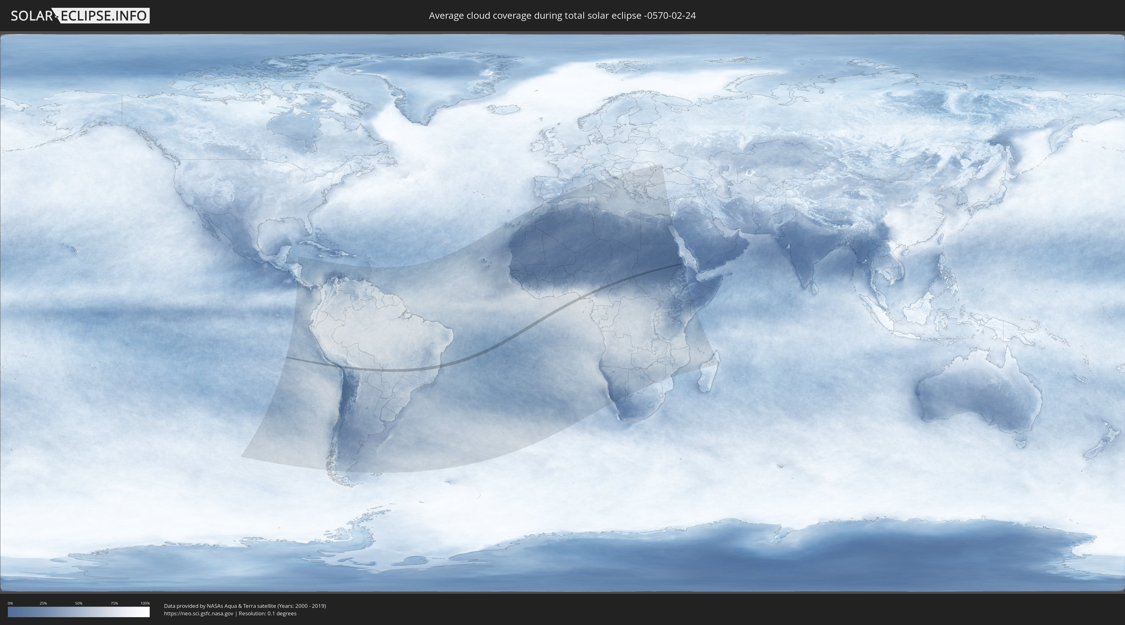
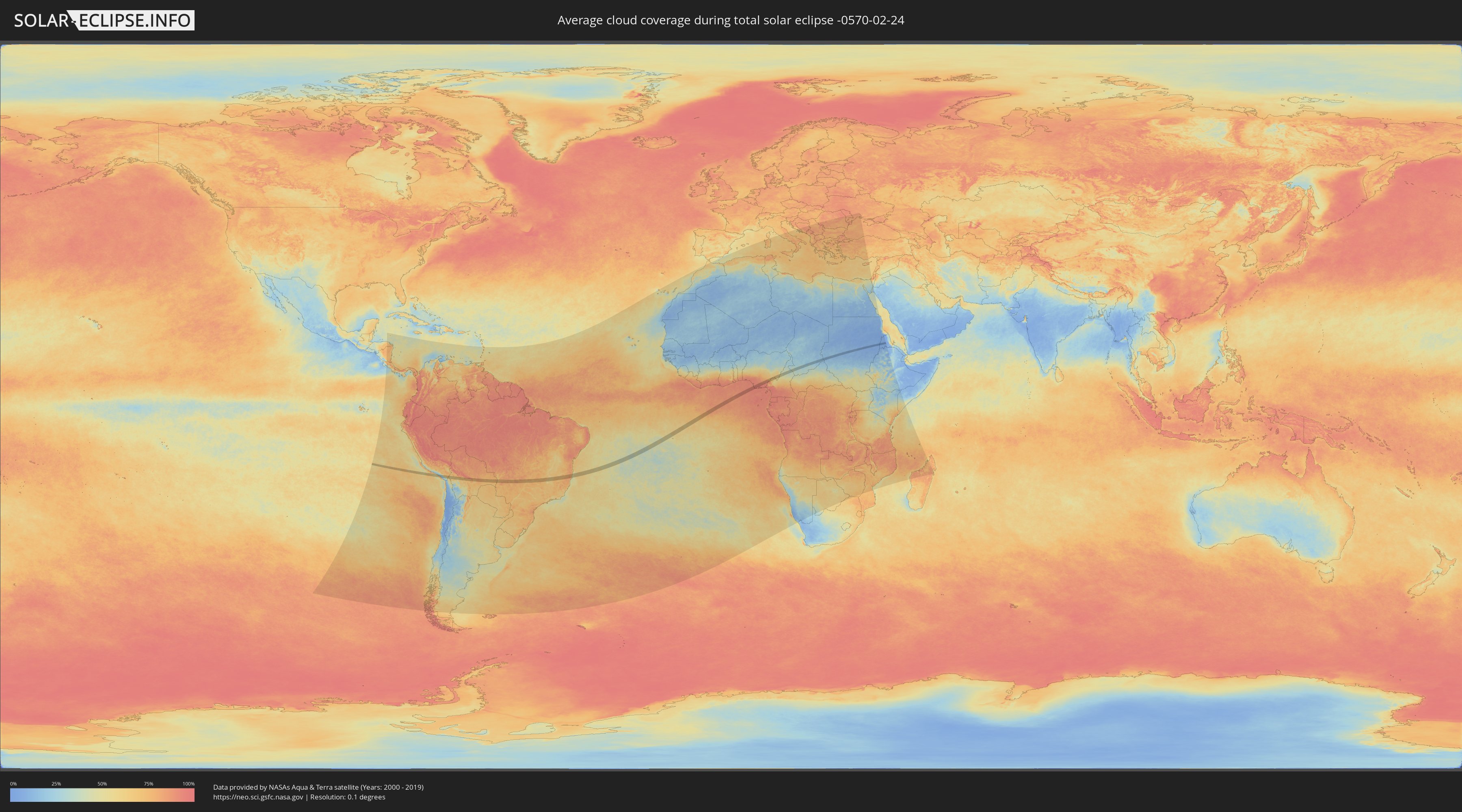
Wie wird das Wetter während der totalen Sonnenfinsternis am 24.02.-0570?
Wo ist der beste Ort, um die totale Sonnenfinsternis vom 24.02.-0570 zu beobachten?
Die folgenden Karten zeigen die durchschnittliche Bewölkung für den Tag, an dem die totale Sonnenfinsternis
stattfindet. Mit Hilfe der Karten lässt sich der Ort entlang des Finsternispfades eingrenzen,
der die besten Aussichen auf einen klaren wolkenfreien Himmel bietet.
Trotzdem muss man immer lokale Gegenenheiten beachten und sollte sich genau über das Wetter an seinem
gewählten Beobachtungsort informieren.
Die Daten stammen von den beiden NASA-Satelliten
AQUA und TERRA
und wurden über einen Zeitraum von 19 Jahren (2000 - 2019) gemittelt.
Detaillierte Länderkarten
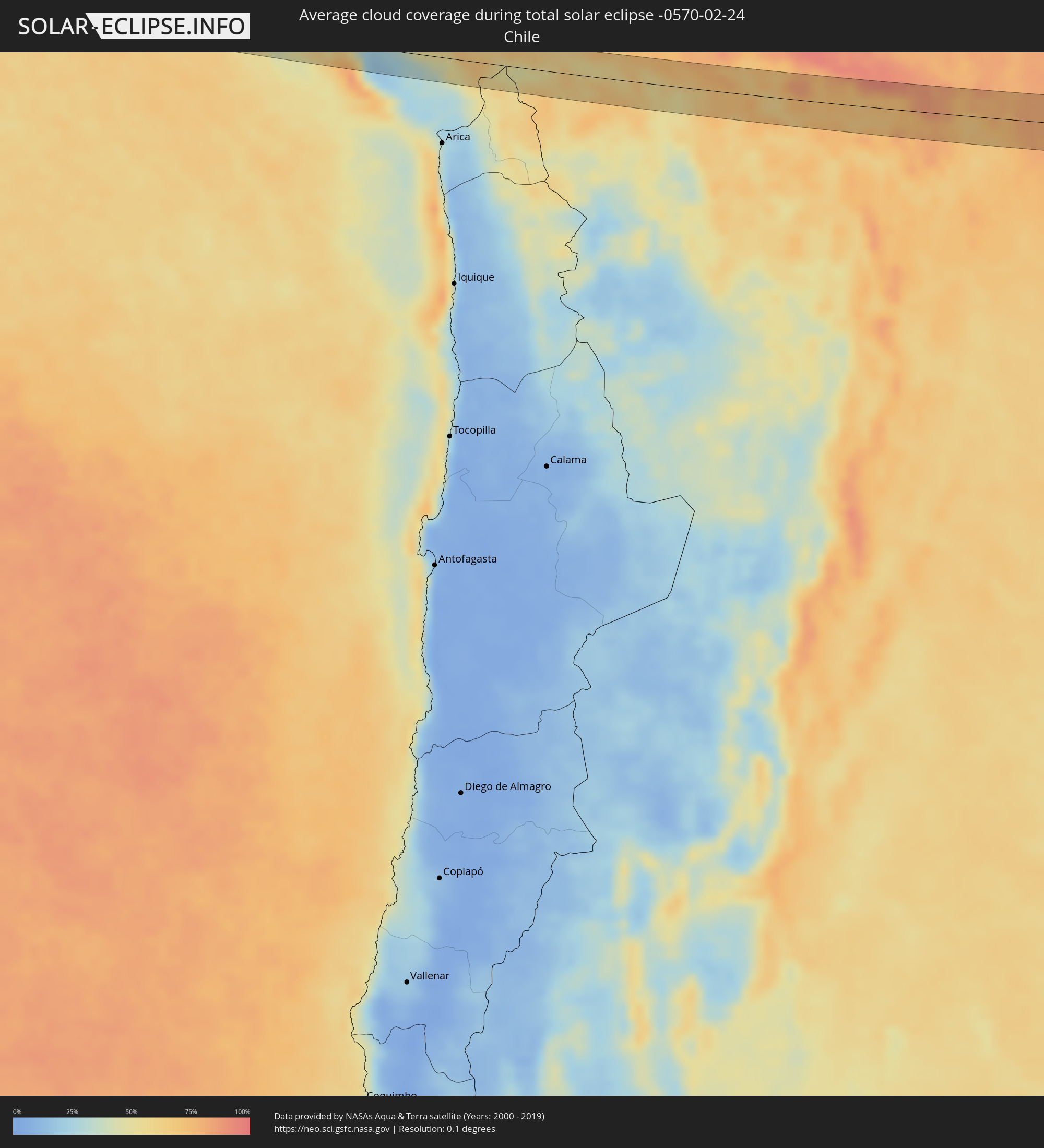 Chile
Chile
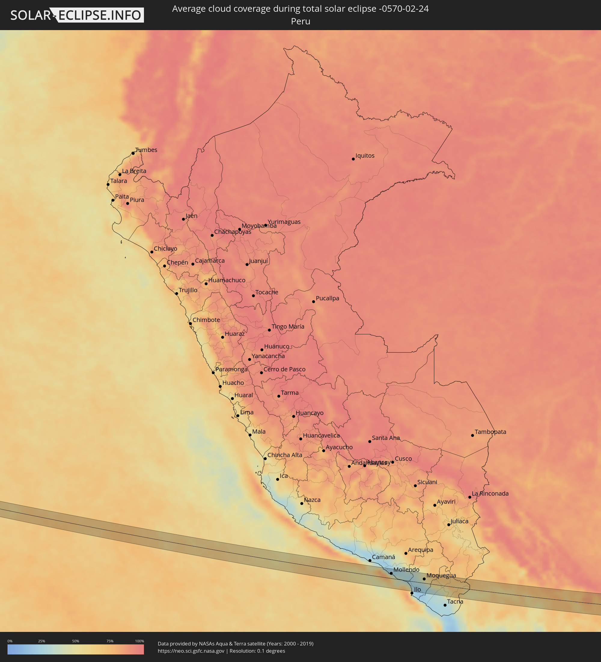 Peru
Peru
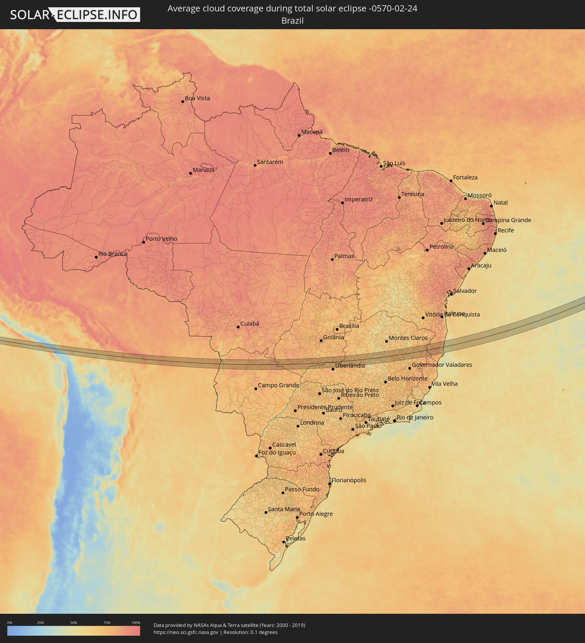 Brasilien
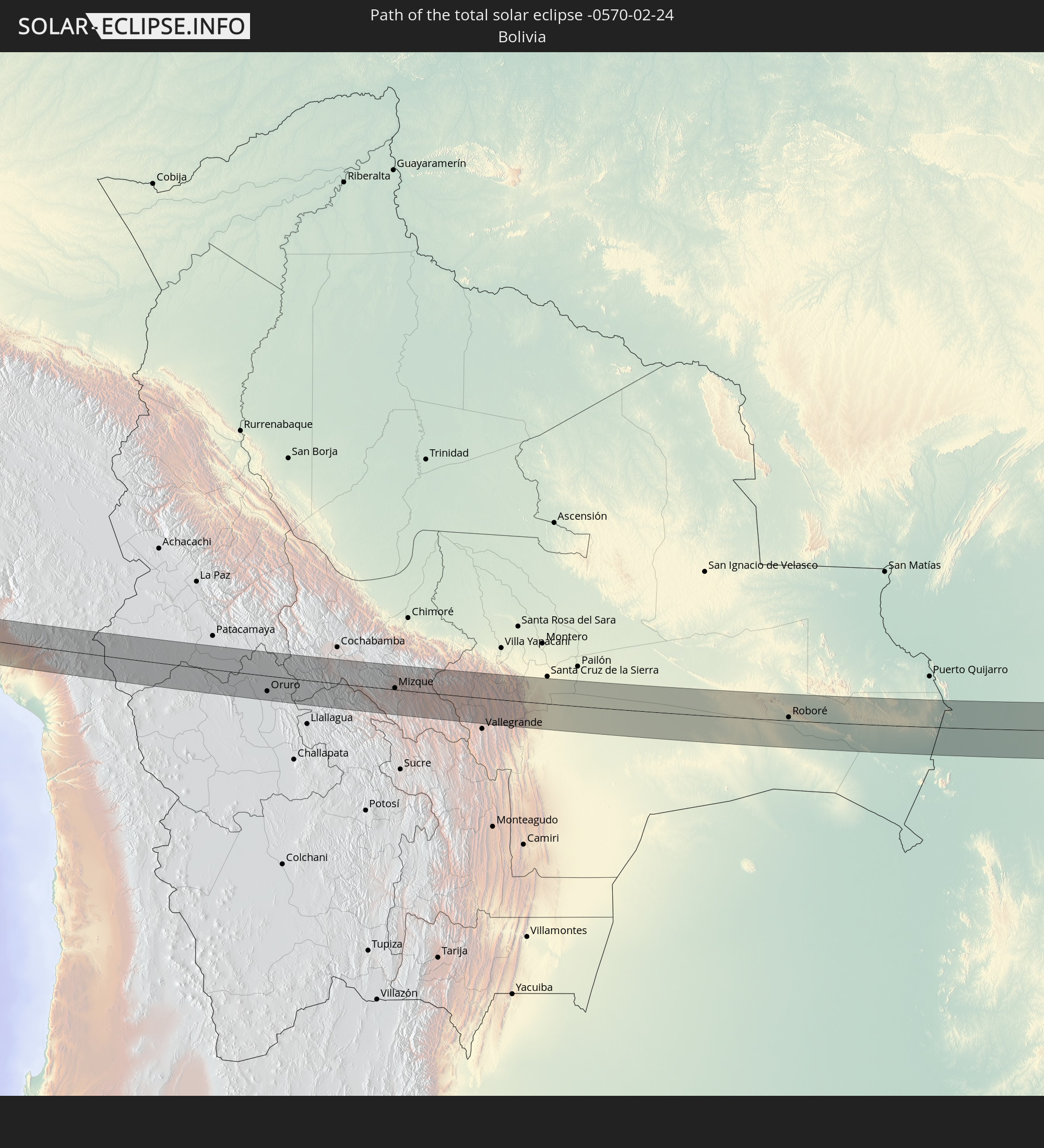
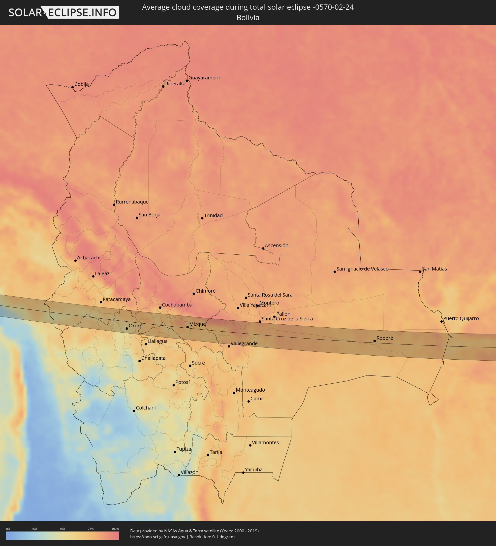 Bolivien
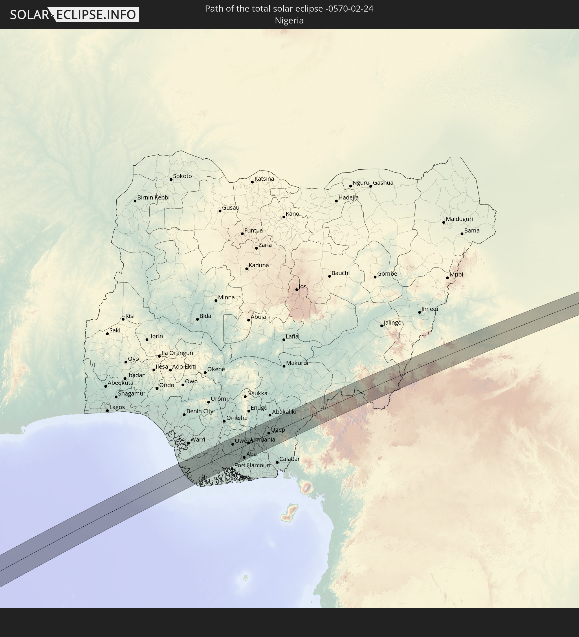
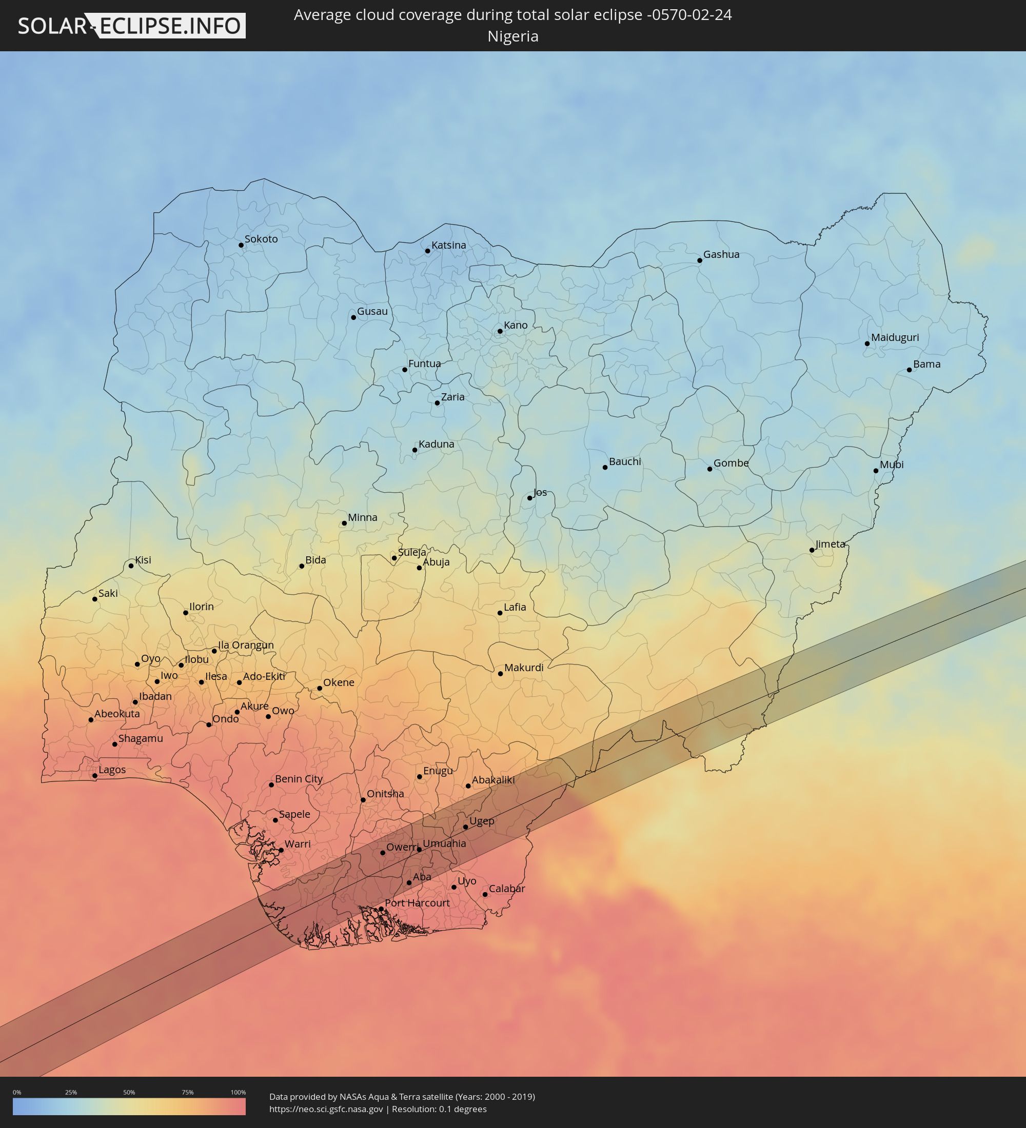 Nigeria
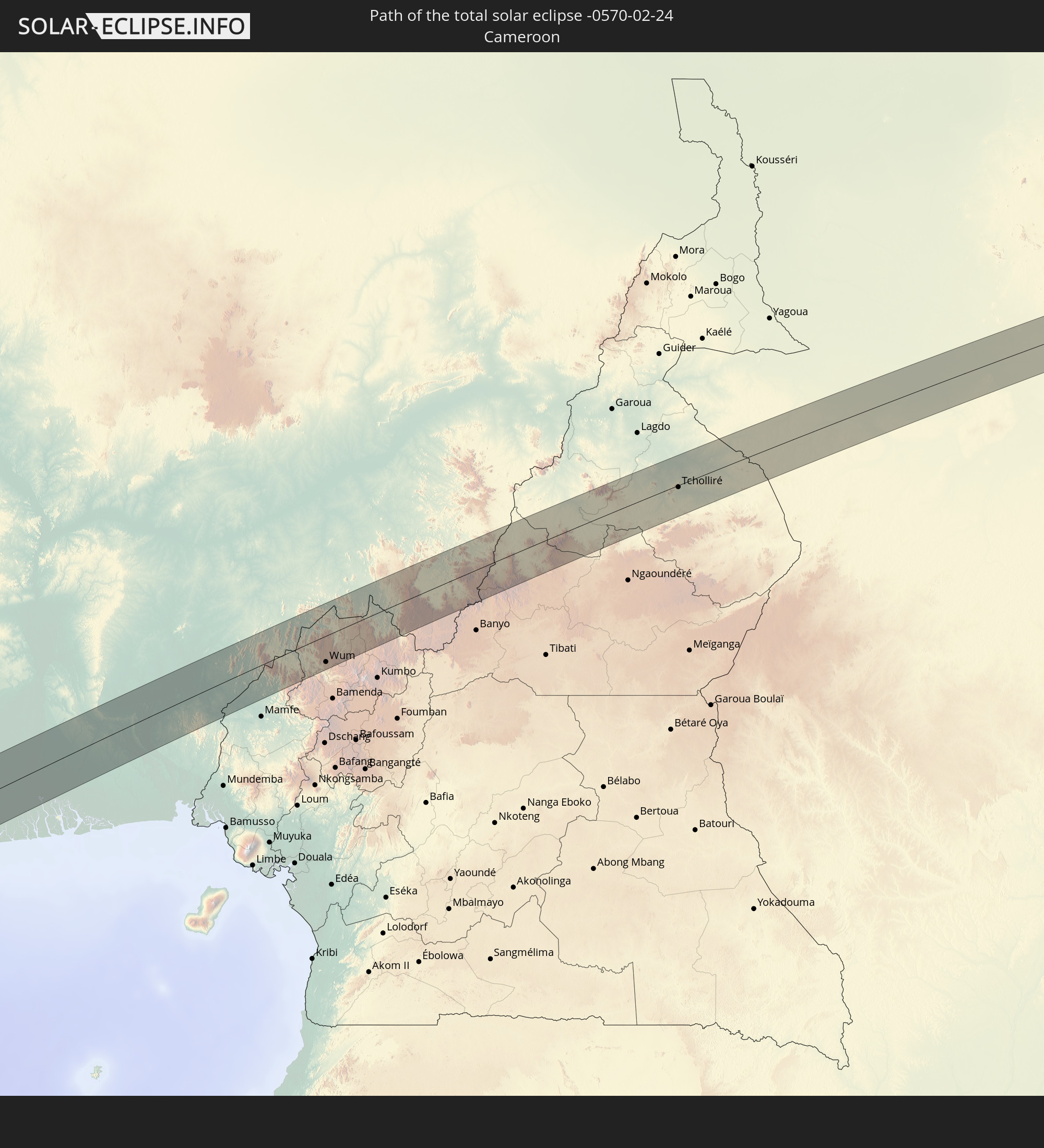
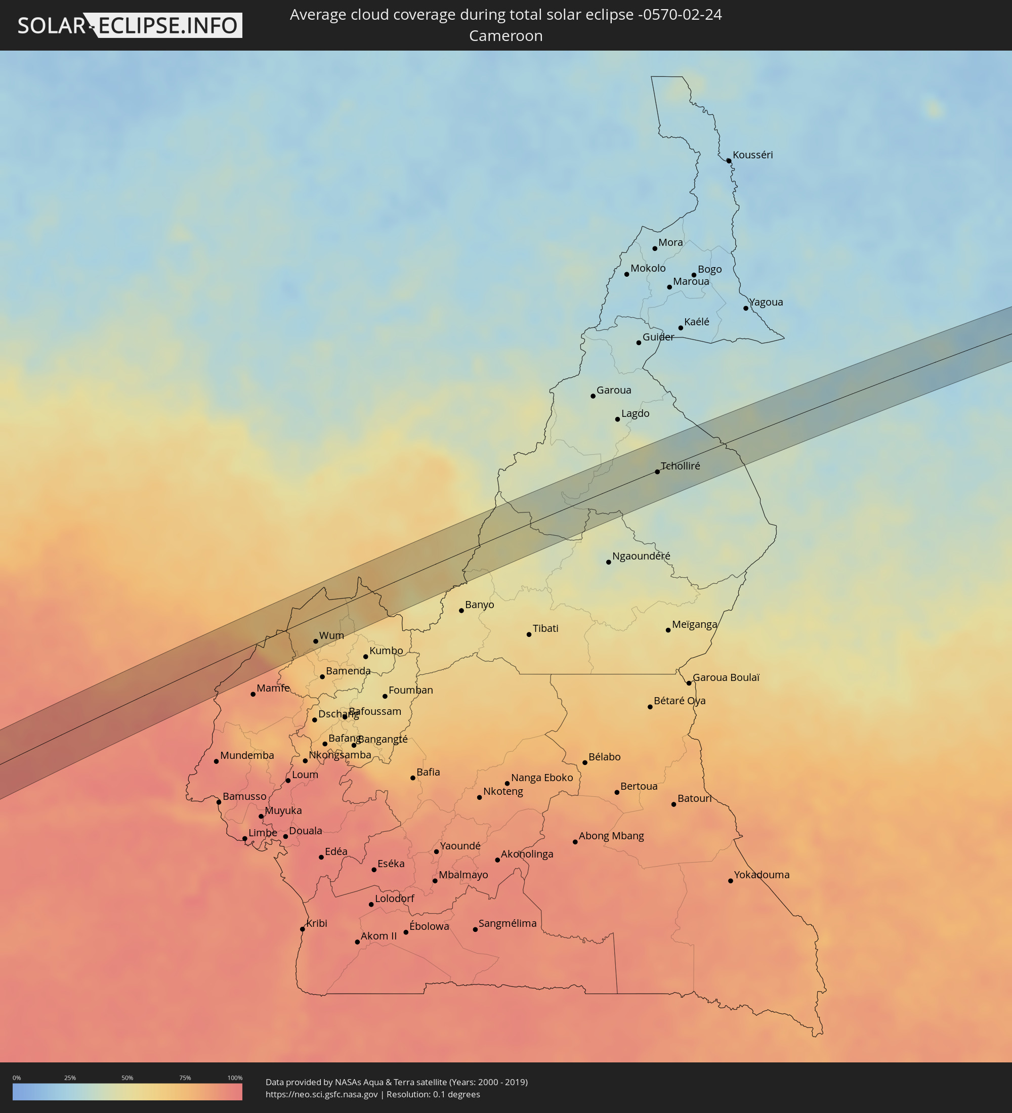 Kamerun
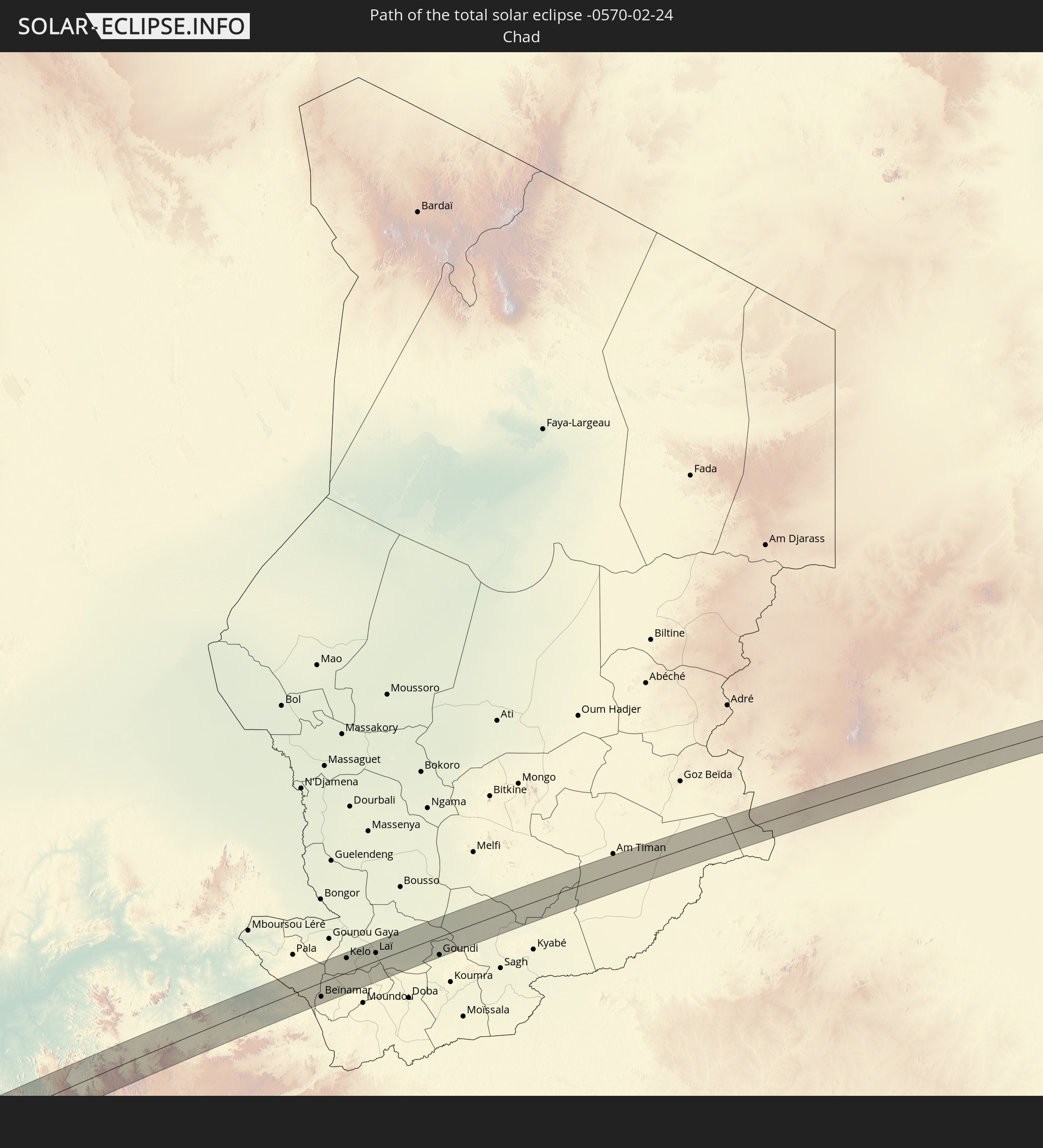
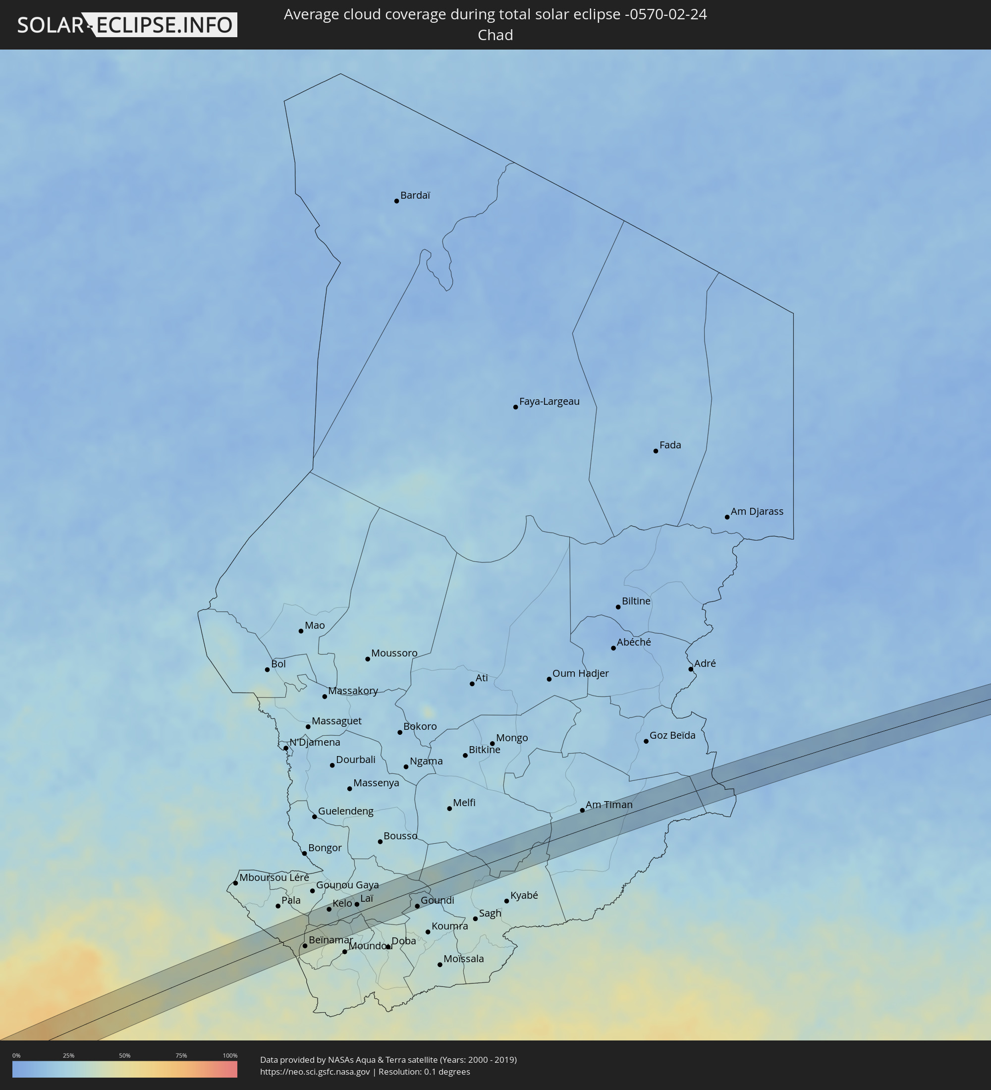 Tschad
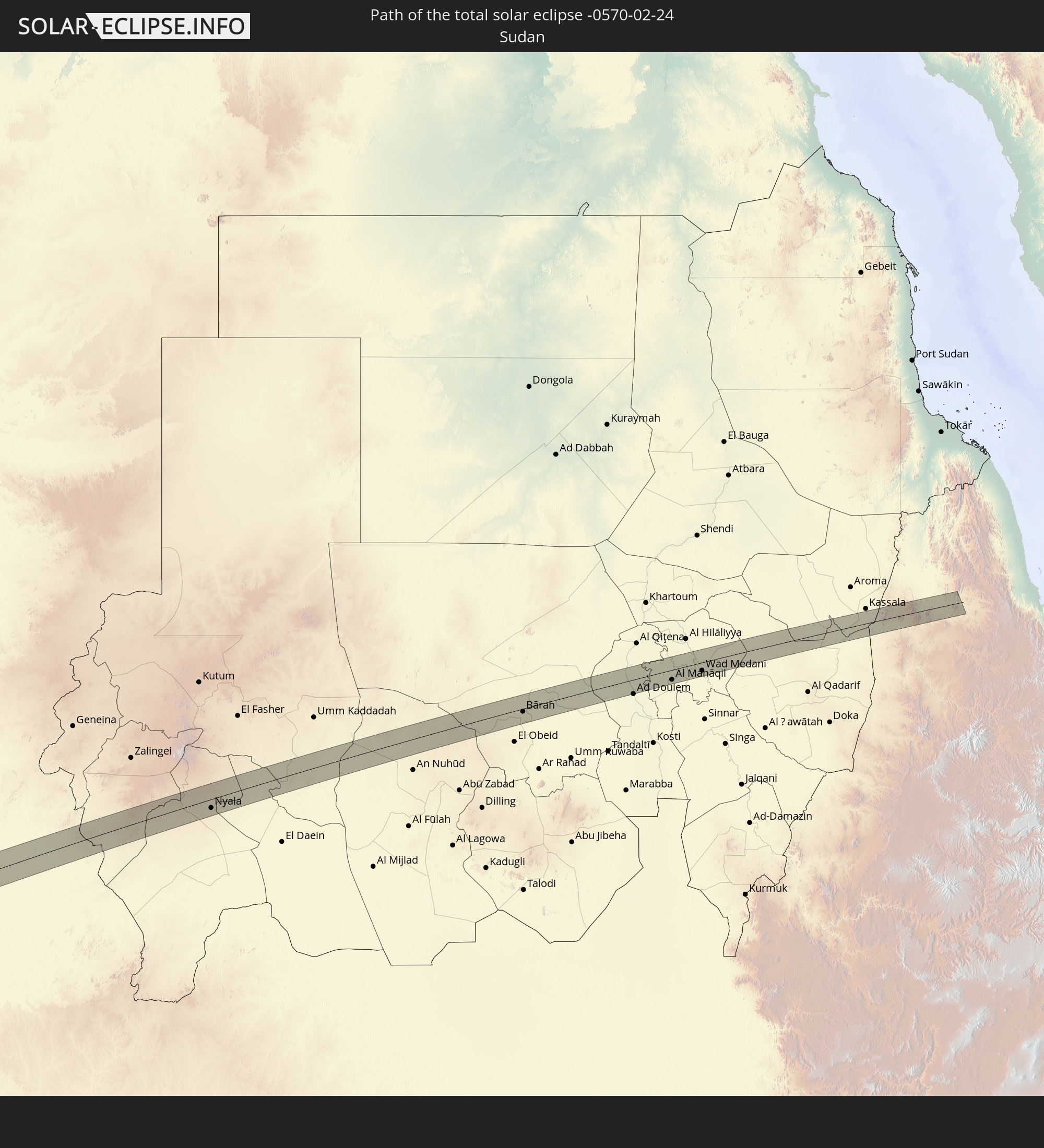
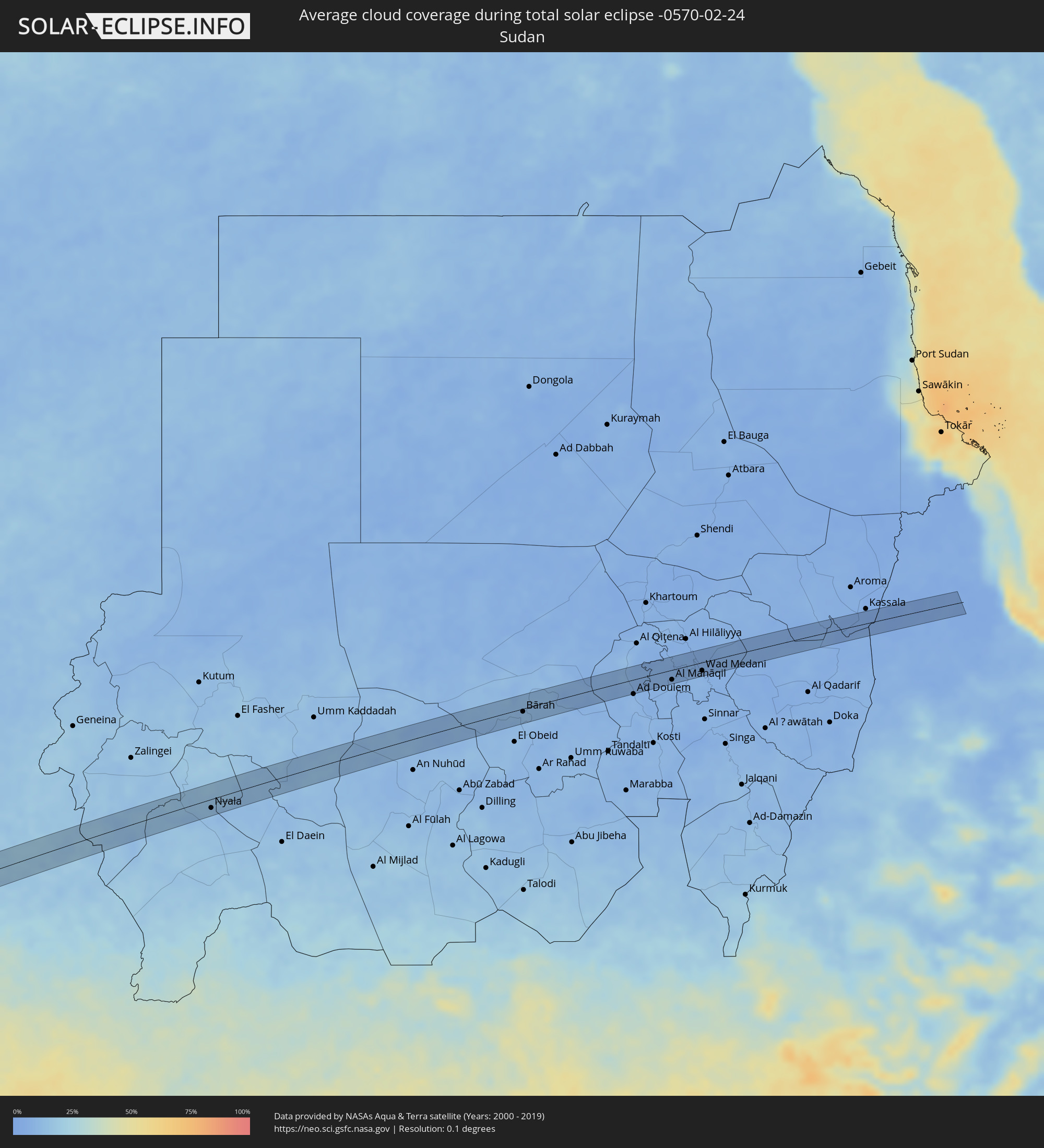 Sudan
Sudan
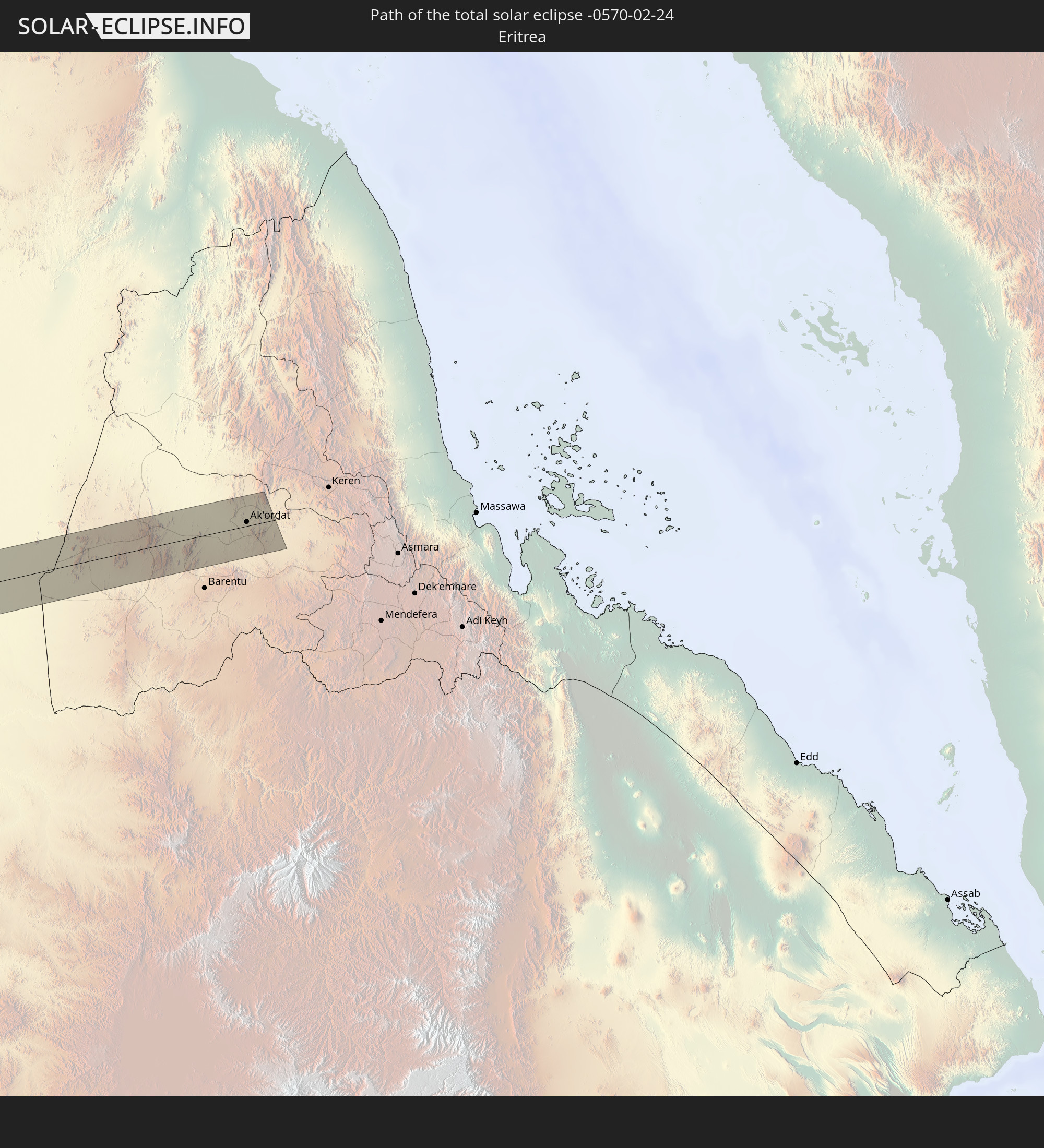
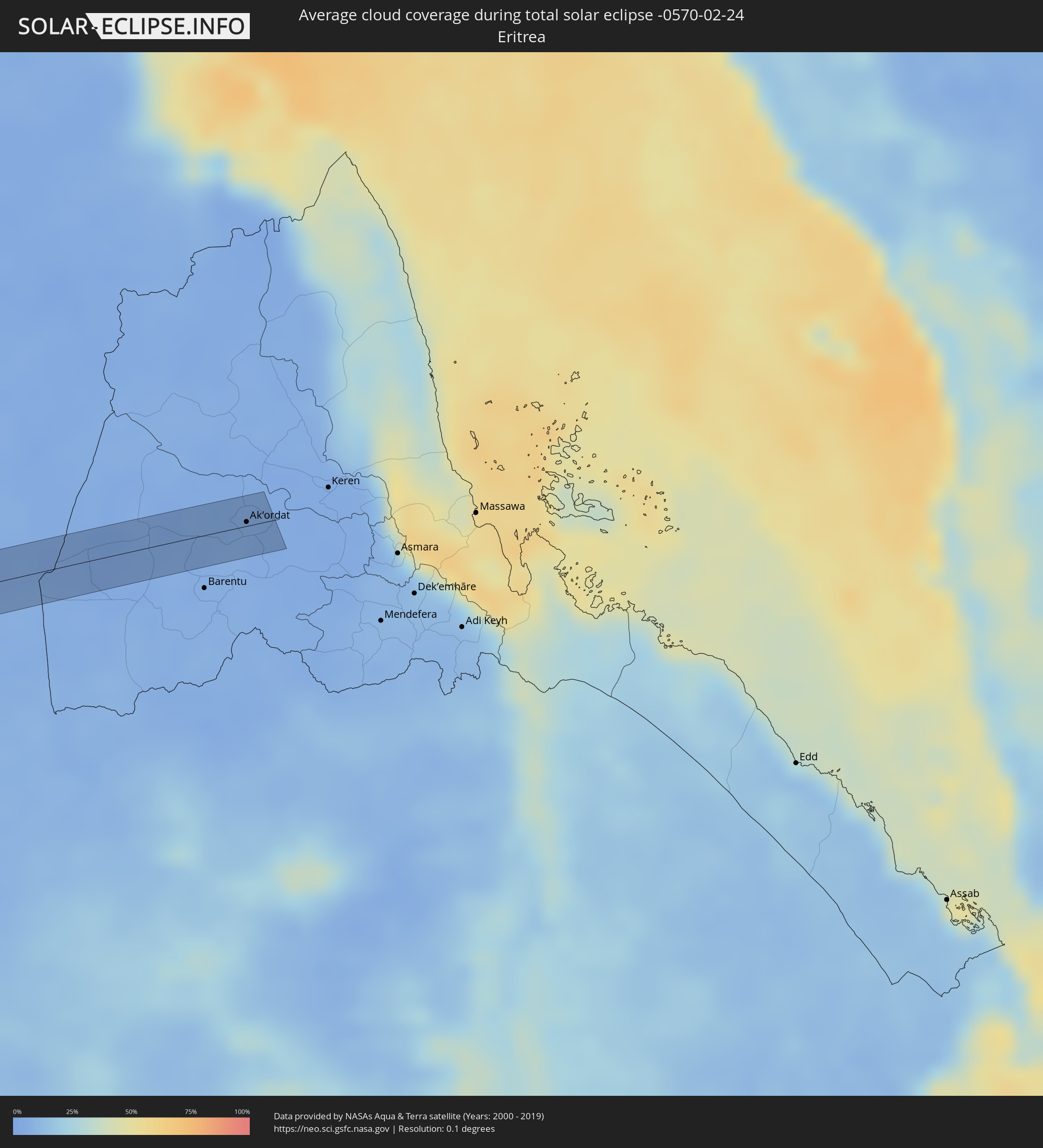 Eritrea
Orte im Finsternispfad
Die nachfolgene Tabelle zeigt Städte und Orte mit mehr als 5.000 Einwohnern, die sich im Finsternispfad befinden. Städte mit mehr als 100.000 Einwohnern sind dick gekennzeichnet. Mit einem Klick auf den Ort öffnet sich eine Detailkarte die die Lage des jeweiligen Ortes zusammen mit dem Verlauf der zentralen Finsternis präsentiert.
| Ort | Typ | Dauer der Verfinsterung | Ortszeit bei maximaler Verfinsterung | Entfernung zur Zentrallinie | Ø Bewölkung |
|
Mollendo, Arequipa
|
total | - | 06:55:15 UTC-05:08 | 16 km | 48% |
|
Punta de Bombón, Arequipa
|
total | - | 06:55:24 UTC-05:08 | 3 km | 40% |
|
Cocachacra, Arequipa
|
total | - | 06:55:25 UTC-05:08 | 13 km | 43% |
|
Moquegua, Moquegua
|
total | - | 06:55:56 UTC-05:08 | 13 km | 39% |
|
Torata, Moquegua
|
total | - | 06:55:58 UTC-05:08 | 28 km | 56% |
|
Ilabaya, Tacna
|
total | - | 06:56:15 UTC-05:08 | 5 km | 42% |
|
Oruro, Oruro
|
total | - | 07:34:48 UTC-04:32 | 23 km | 53% |
|
Capinota, Cochabamba
|
total | - | 07:35:30 UTC-04:32 | 18 km | 67% |
|
Tarata, Cochabamba
|
total | - | 07:35:41 UTC-04:32 | 32 km | 69% |
|
Cliza, Cochabamba
|
total | - | 07:35:46 UTC-04:32 | 35 km | 66% |
|
Mizque, Cochabamba
|
total | - | 07:36:20 UTC-04:32 | 2 km | 70% |
|
Aiquile, Cochabamba
|
total | - | 07:36:31 UTC-04:32 | 25 km | 75% |
|
Santiago del Torno, Santa Cruz
|
total | - | 07:38:12 UTC-04:32 | 16 km | 70% |
|
Roboré, Santa Cruz
|
total | - | 07:42:13 UTC-04:32 | 5 km | 71% |
|
Coxim, Mato Grosso do Sul
|
total | - | 08:43:03 UTC-03:38 | 2 km | 74% |
|
Quirinópolis, Goiás
|
total | - | 09:21:59 UTC-03:06 | 0 km | 75% |
|
Capinópolis, Minas Gerais
|
total | - | 09:23:30 UTC-03:06 | 31 km | 73% |
|
Goiatuba, Goiás
|
total | - | 09:24:00 UTC-03:06 | 43 km | 77% |
|
Itumbiara, Goiás
|
total | - | 09:24:11 UTC-03:06 | 4 km | 68% |
|
Tupaciguara, Minas Gerais
|
total | - | 09:25:05 UTC-03:06 | 26 km | 73% |
|
Araguari, Minas Gerais
|
total | - | 09:26:02 UTC-03:06 | 36 km | 71% |
|
Catalão, Goiás
|
total | - | 09:26:35 UTC-03:06 | 16 km | 76% |
|
Coromandel, Minas Gerais
|
total | - | 09:27:57 UTC-03:06 | 25 km | 74% |
|
Vazante, Minas Gerais
|
total | - | 09:28:38 UTC-03:06 | 26 km | 70% |
|
Patos de Minas, Minas Gerais
|
total | - | 09:29:15 UTC-03:06 | 43 km | 73% |
|
Presidente Olegário, Minas Gerais
|
total | - | 09:29:29 UTC-03:06 | 26 km | 74% |
|
João Pinheiro, Minas Gerais
|
total | - | 09:30:10 UTC-03:06 | 46 km | 71% |
|
Várzea da Palma, Minas Gerais
|
total | - | 09:33:11 UTC-03:06 | 45 km | 65% |
|
Corinto, Minas Gerais
|
total | - | 09:33:30 UTC-03:06 | 45 km | 61% |
|
Diamantina, Minas Gerais
|
total | - | 09:35:21 UTC-03:06 | 42 km | 71% |
|
Itamarandiba, Minas Gerais
|
total | - | 09:37:07 UTC-03:06 | 10 km | 75% |
|
Capelinha, Minas Gerais
|
total | - | 09:37:57 UTC-03:06 | 3 km | 74% |
|
Itambacuri, Minas Gerais
|
total | - | 09:39:39 UTC-03:06 | 49 km | 72% |
|
Teófilo Otoni, Minas Gerais
|
total | - | 09:40:08 UTC-03:06 | 33 km | 71% |
|
Carlos Chagas, Minas Gerais
|
total | - | 09:41:54 UTC-03:06 | 29 km | 76% |
|
Itanhém, Bahia
|
total | - | 10:15:40 UTC-02:34 | 21 km | 73% |
|
Medeiros Neto, Bahia
|
total | - | 10:15:49 UTC-02:34 | 4 km | 77% |
|
Itamaraju, Bahia
|
total | - | 10:17:39 UTC-02:34 | 19 km | 78% |
|
Prado, Bahia
|
total | - | 10:18:13 UTC-02:34 | 21 km | 55% |
|
Bomadi, Delta
|
total | - | 15:22:03 UTC+00:13 | 41 km | 90% |
|
Amassoma, Bayelsa
|
total | - | 15:22:07 UTC+00:13 | 13 km | 93% |
|
Patani, Delta
|
total | - | 15:22:27 UTC+00:13 | 35 km | 90% |
|
Yenagoa, Bayelsa
|
total | - | 15:22:17 UTC+00:13 | 1 km | 94% |
|
Ahoada, Rivers
|
total | - | 15:22:54 UTC+00:13 | 2 km | 93% |
|
Omoku, Rivers
|
total | - | 15:23:09 UTC+00:13 | 24 km | 92% |
|
Degema Hulk, Rivers
|
total | - | 15:22:44 UTC+00:13 | 39 km | 93% |
|
Elele, Rivers
|
total | - | 15:23:08 UTC+00:13 | 8 km | 93% |
|
Owerri, Imo
|
total | - | 15:23:45 UTC+00:13 | 20 km | 92% |
|
Orodo, Imo
|
total | - | 15:23:52 UTC+00:13 | 33 km | 92% |
|
Iho, Imo
|
total | - | 15:23:55 UTC+00:13 | 26 km | 91% |
|
Okigwe, Imo
|
total | - | 15:24:27 UTC+00:13 | 39 km | 88% |
|
Aba, Abia
|
total | - | 15:23:49 UTC+00:13 | 34 km | 92% |
|
Umuahia, Abia
|
total | - | 15:24:21 UTC+00:13 | 2 km | 90% |
|
Bende, Abia
|
total | - | 15:24:33 UTC+00:13 | 1 km | 91% |
|
Ake-Eze, Enugu
|
total | - | 15:24:55 UTC+00:13 | 33 km | 86% |
|
Ohafia-Ifigh, Abia
|
total | - | 15:24:49 UTC+00:13 | 4 km | 90% |
|
Amaigbo, Abia
|
total | - | 15:25:00 UTC+00:13 | 12 km | 87% |
|
Arochukwu, Abia
|
total | - | 15:24:44 UTC+00:13 | 32 km | 91% |
|
Afikpo, Ebonyi
|
total | - | 15:25:12 UTC+00:13 | 18 km | 87% |
|
Ugep, Cross River
|
total | - | 15:25:18 UTC+00:13 | 3 km | 89% |
|
Obubra, Cross River
|
total | - | 15:25:50 UTC+00:13 | 18 km | 85% |
|
Ikom, Cross River
|
total | - | 15:26:10 UTC+00:13 | 11 km | 85% |
|
Obudu, Cross River
|
total | - | 15:27:16 UTC+00:13 | 39 km | 71% |
|
Wum, North-West
|
total | - | 15:28:02 UTC+00:13 | 31 km | 63% |
|
Baissa, Taraba
|
total | - | 15:29:17 UTC+00:13 | 30 km | 68% |
|
Kontcha, Adamaoua
|
total | - | 15:31:26 UTC+00:13 | 35 km | 48% |
|
Tcholliré, North
|
total | - | 15:33:30 UTC+00:13 | 2 km | 38% |
|
Rey Bouba, North
|
total | - | 15:33:41 UTC+00:13 | 25 km | 39% |
|
Beïnamar, Logone Occidental
|
total | - | 16:21:18 UTC+01:00 | 24 km | 38% |
|
Kelo, Tandjilé
|
total | - | 16:22:02 UTC+01:00 | 25 km | 30% |
|
Béré, Tandjilé
|
total | - | 16:22:18 UTC+01:00 | 12 km | 29% |
|
Laï, Tandjilé
|
total | - | 16:22:28 UTC+01:00 | 14 km | 31% |
|
Benoy, Logone Occidental
|
total | - | 16:22:14 UTC+01:00 | 30 km | 31% |
|
Goundi, Mandoul
|
total | - | 16:23:14 UTC+01:00 | 31 km | 30% |
|
Nyala, Southern Darfur
|
total | - | 17:38:37 UTC+02:10 | 16 km | 12% |
|
Bārah, North Kordofan
|
total | - | 17:40:48 UTC+02:10 | 6 km | 12% |
|
Al Kiremit al ‘Arakiyyīn, Al Jazīrah
|
total | - | 17:41:22 UTC+02:10 | 6 km | 7% |
|
Al Manāqil, Al Jazīrah
|
total | - | 17:41:21 UTC+02:10 | 18 km | 7% |
|
Al Masallamiyya, Al Jazīrah
|
total | - | 17:41:28 UTC+02:10 | 8 km | 6% |
|
Wad Medani, Al Jazīrah
|
total | - | 17:41:27 UTC+02:10 | 15 km | 7% |
|
Ak’ordat, Gash-Barka
|
total | - | 17:58:58 UTC+02:27 | 13 km | 3% |