Totale Sonnenfinsternis vom 18.05.-0602
| Wochentag: | Mittwoch |
| Maximale Dauer der Verfinsterung: | 05m52s |
| Maximale Breite des Finsternispfades: | 279 km |
| Saroszyklus: | 57 |
| Bedeckungsgrad: | 100% |
| Magnitude: | 1.0797 |
| Gamma: | 0.3953 |
Wo kann man die Sonnenfinsternis vom 18.05.-0602 sehen?
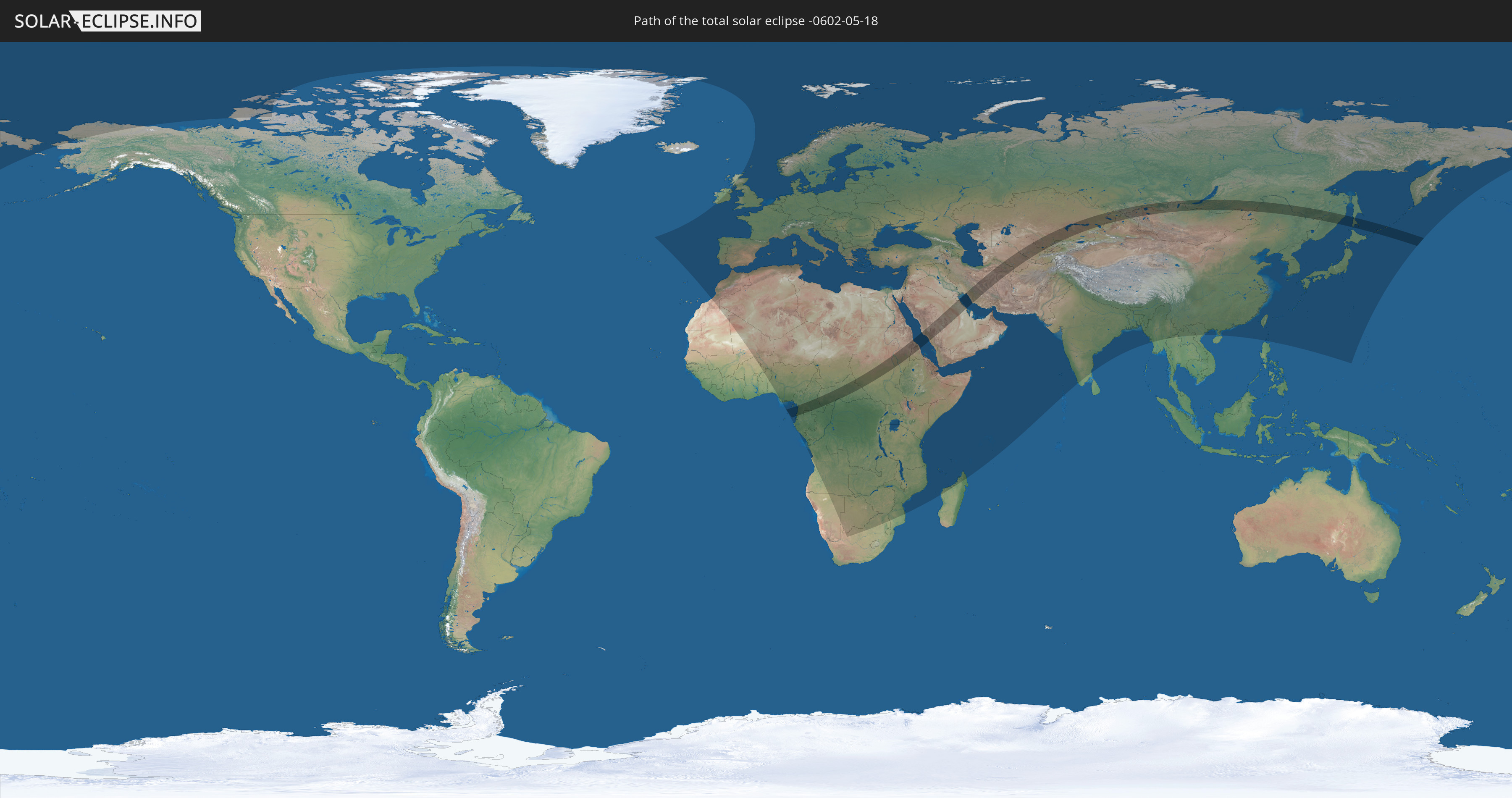
Die Sonnenfinsternis am 18.05.-0602 kann man in 137 Ländern als partielle Sonnenfinsternis beobachten.
Der Finsternispfad verläuft durch 18 Länder. Nur in diesen Ländern ist sie als totale Sonnenfinsternis zu sehen.
In den folgenden Ländern ist die Sonnenfinsternis total zu sehen
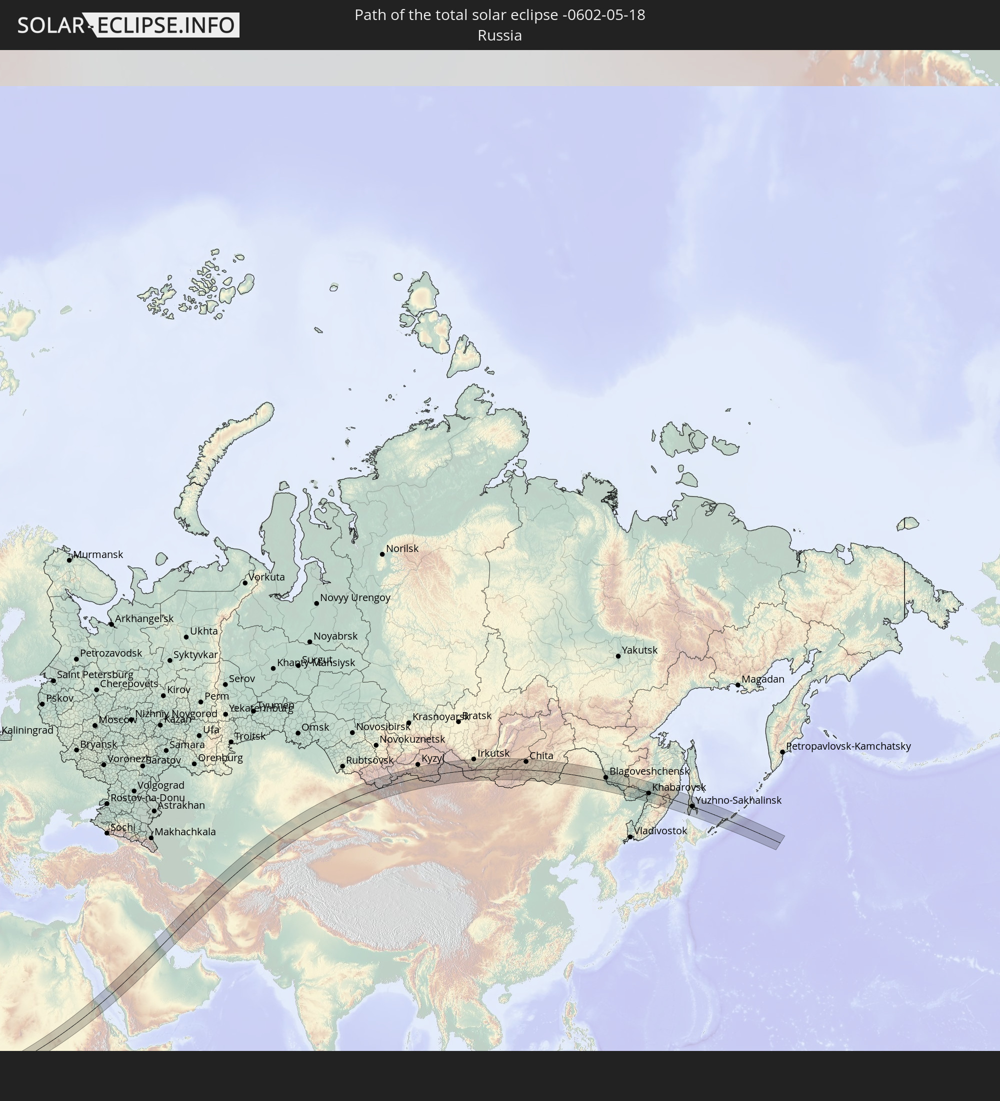 Russland
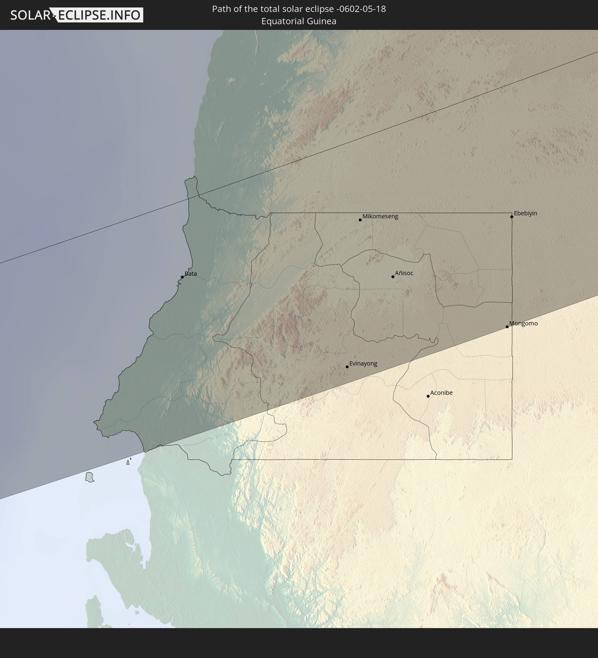 Äquatorialguinea
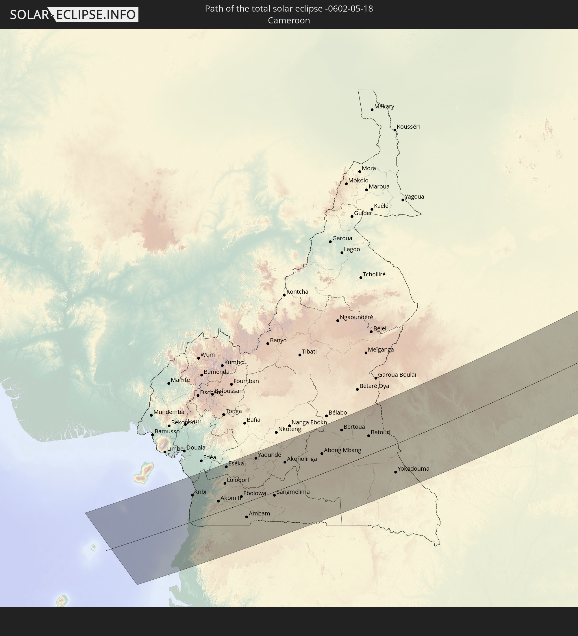 Kamerun
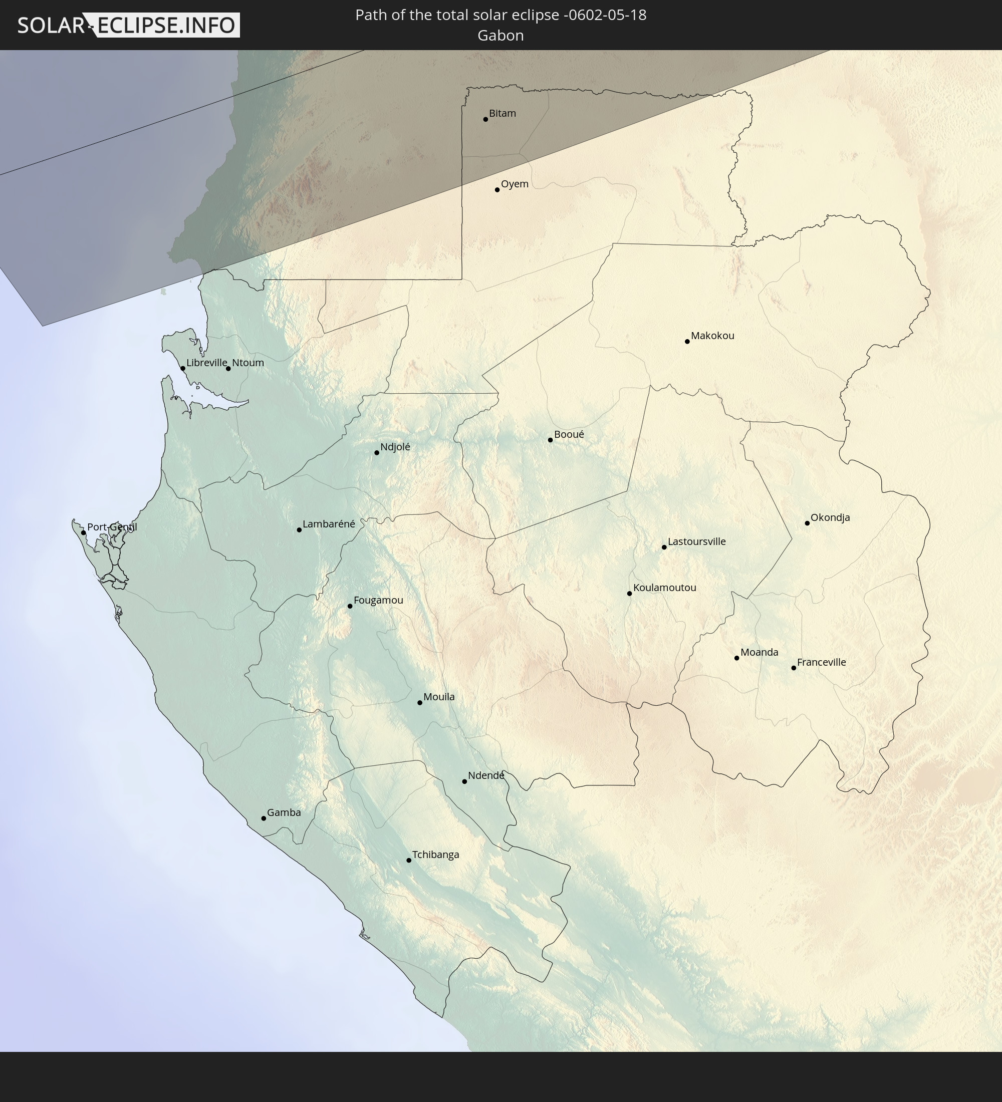 Gabun
Gabun
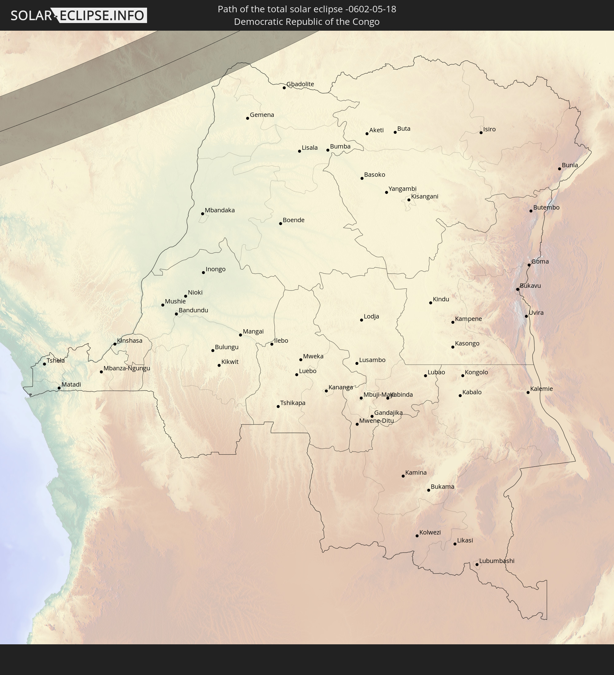 Demokratische Republik Kongo
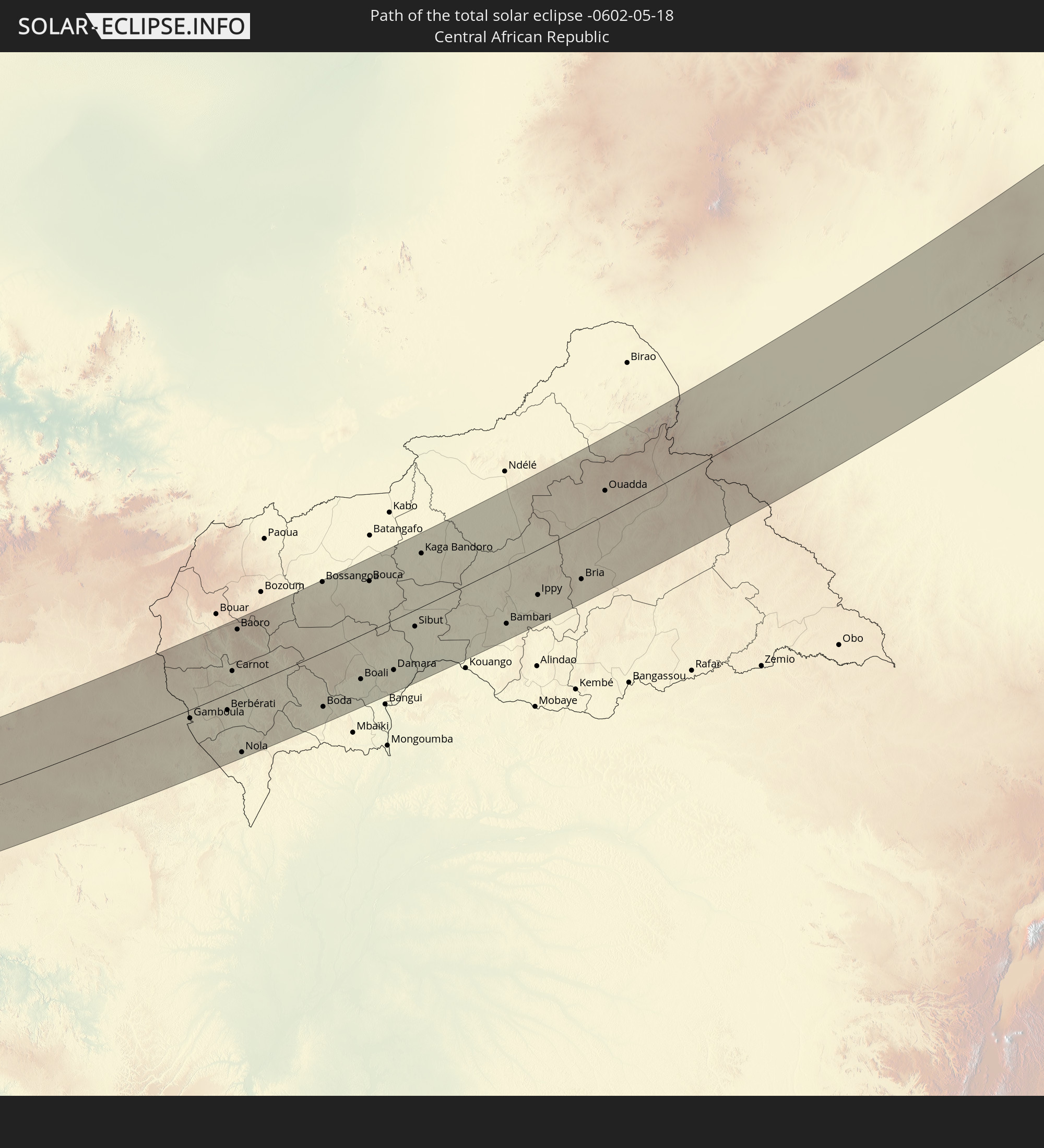 Zentralafrikanische Republik
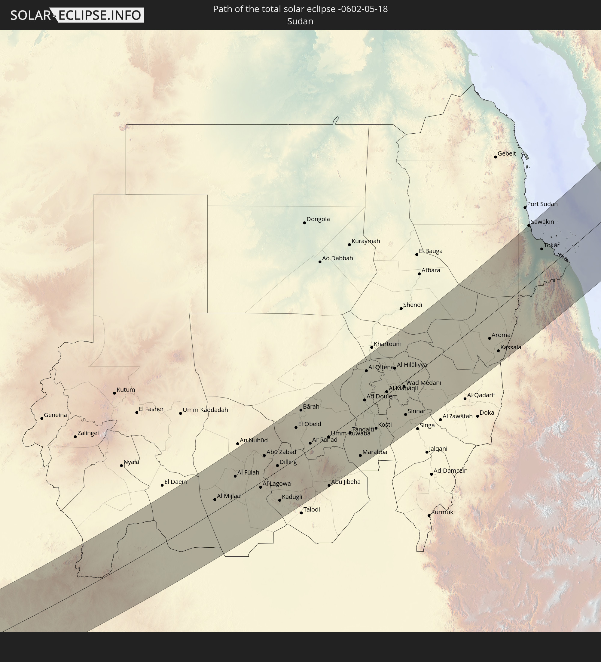 Sudan
Sudan
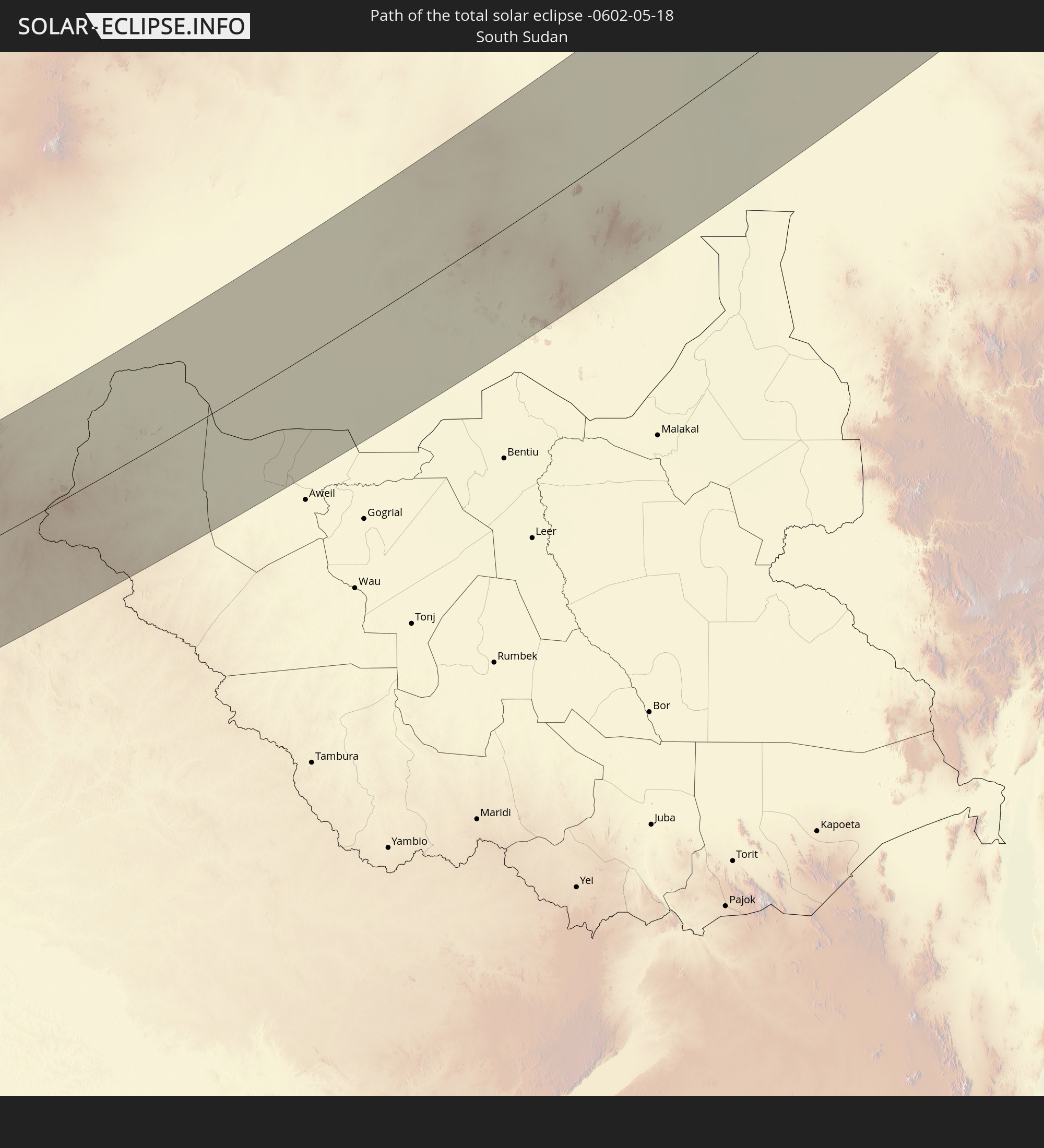 Südsudan
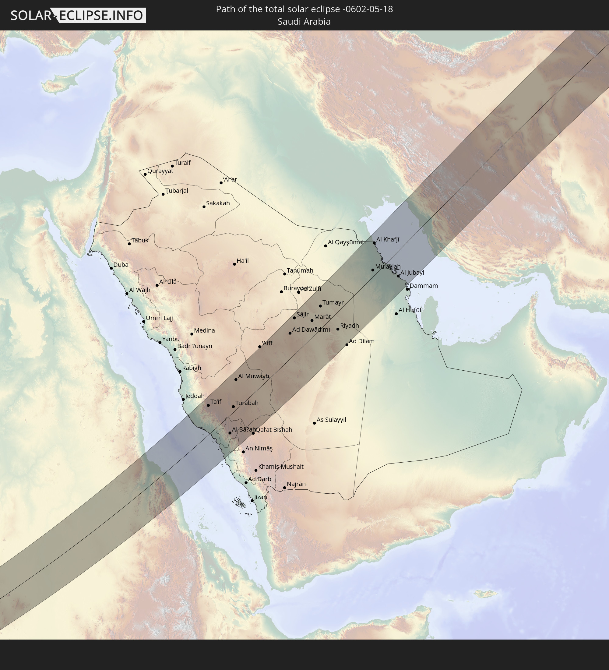 Saudi-Arabien
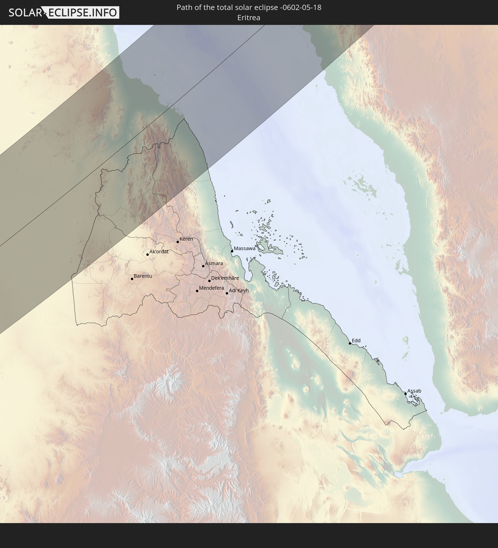 Eritrea
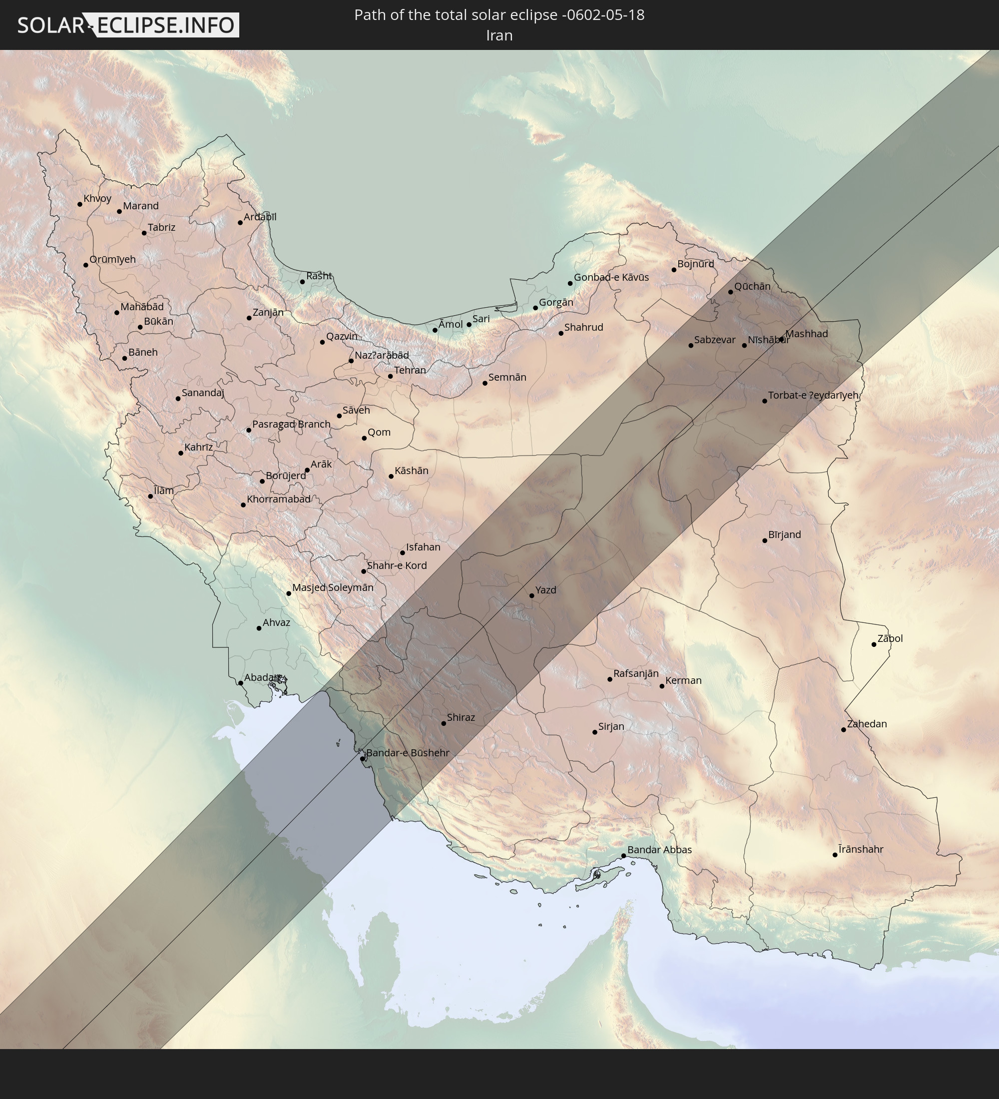 Iran
Iran
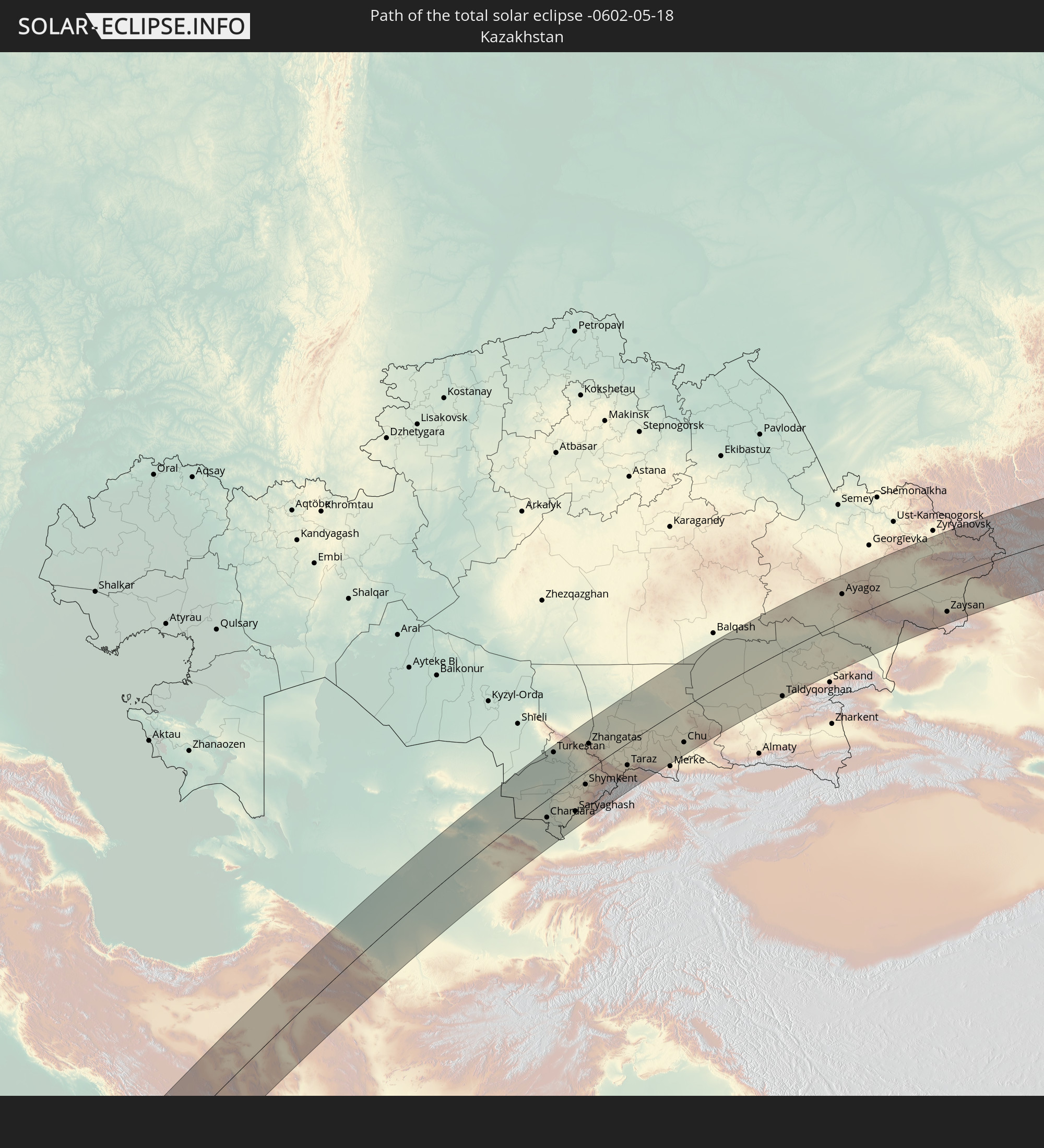 Kasachstan
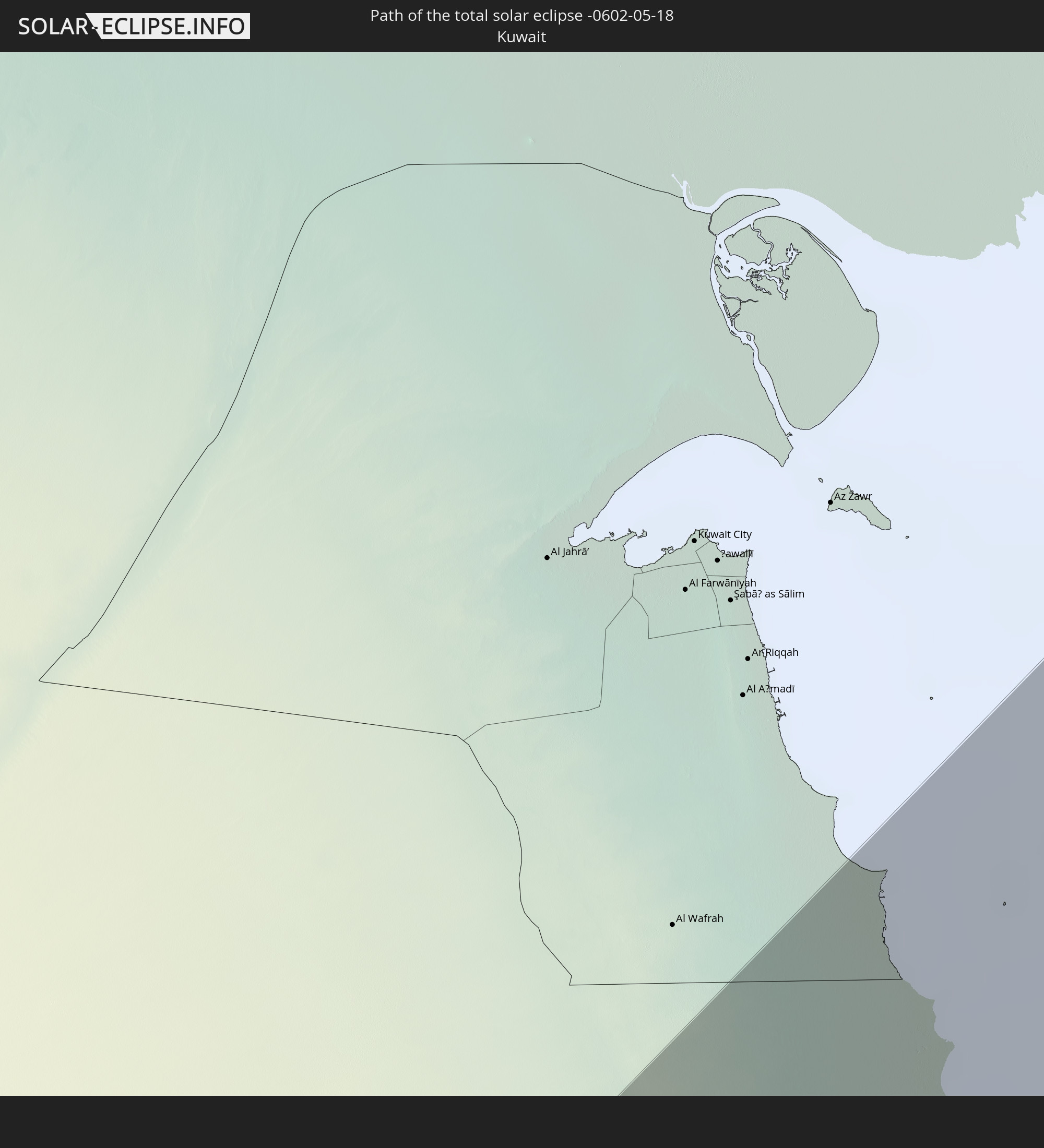 Kuwait
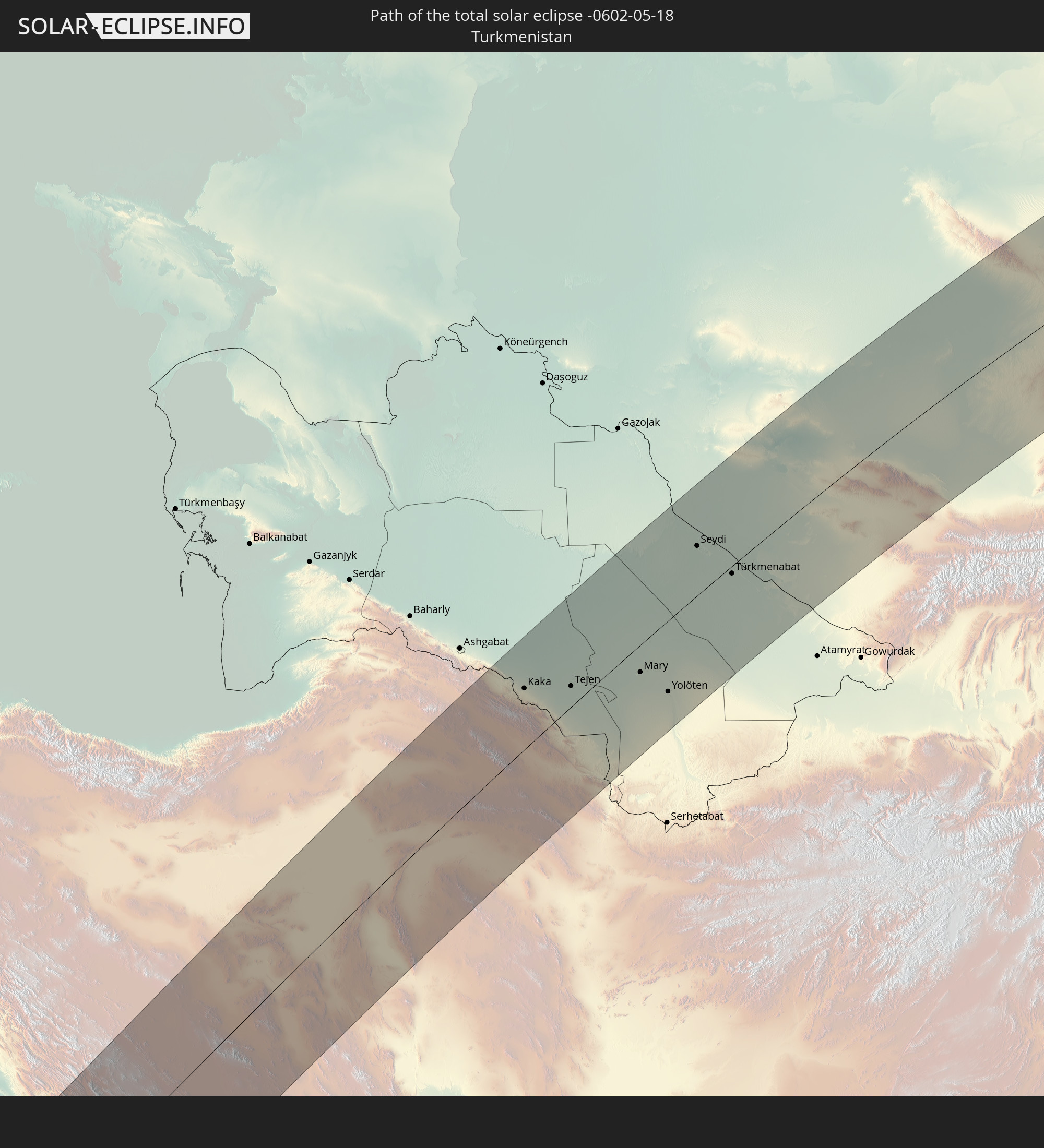 Turkmenistan
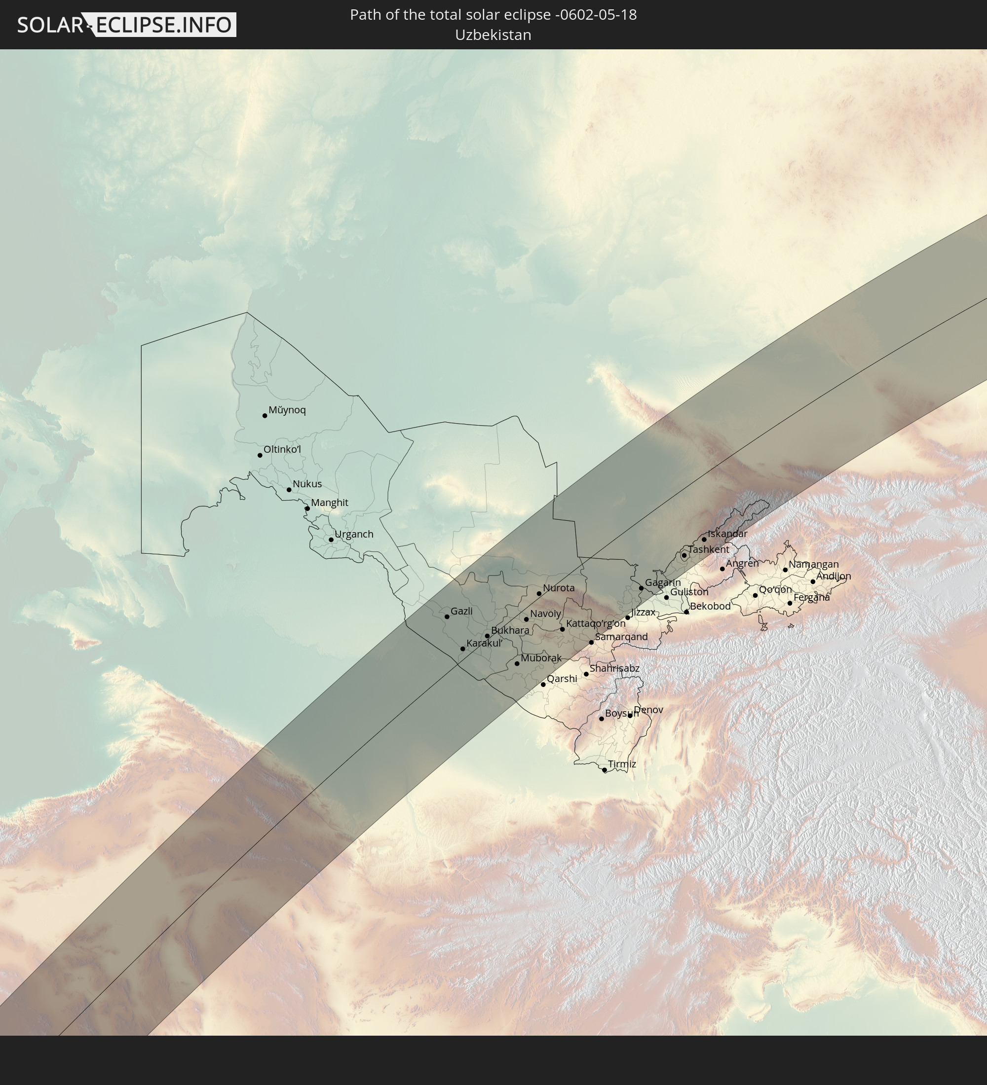 Usbekistan
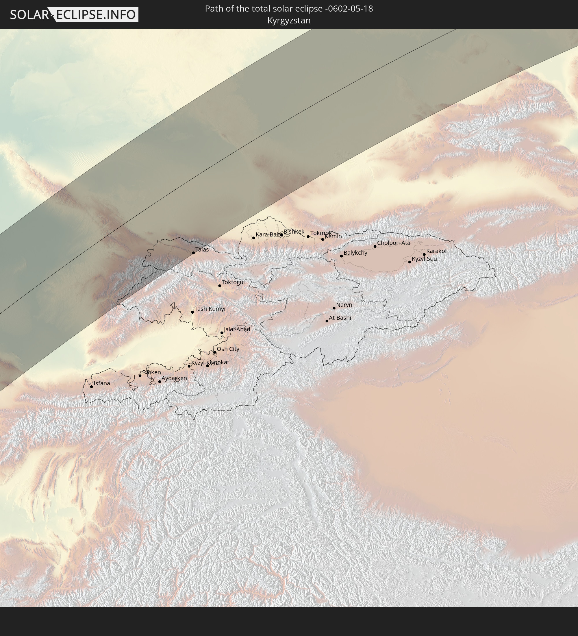 Kirgisistan
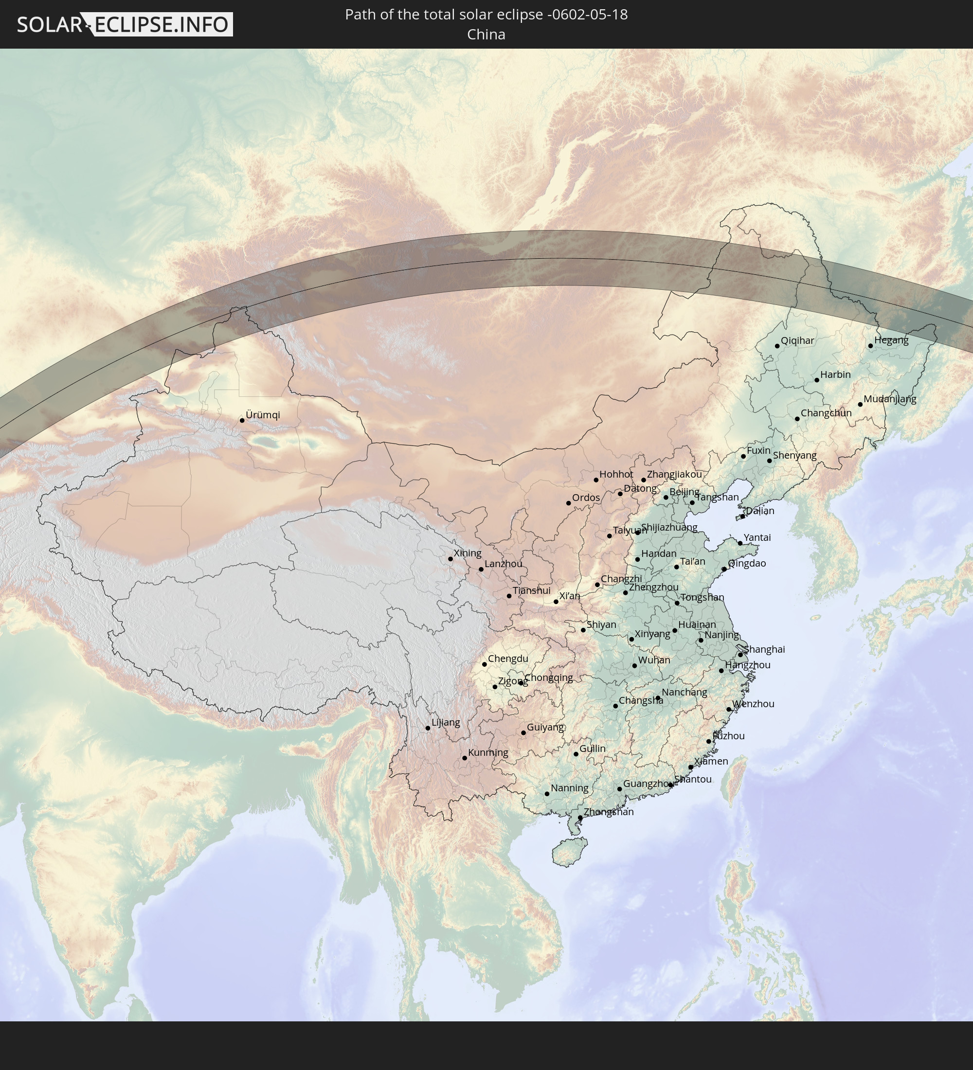 Volksrepublik China
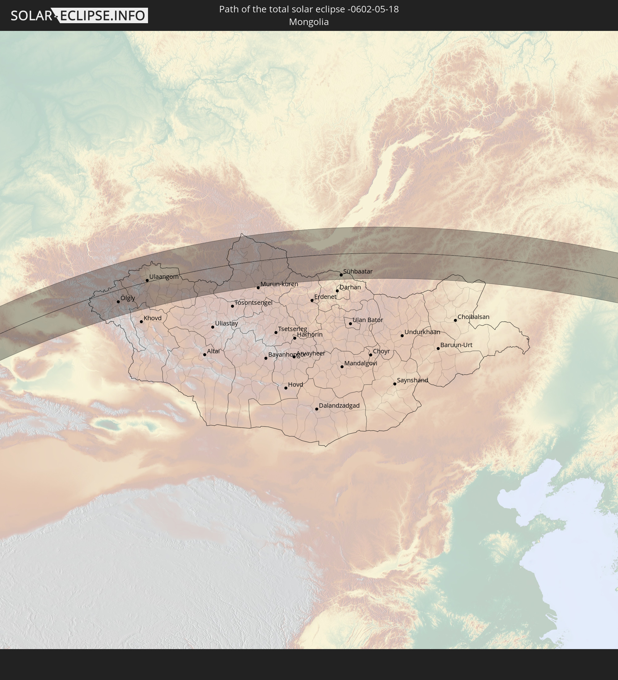 Mongolei
In den folgenden Ländern ist die Sonnenfinsternis partiell zu sehen
 Russland
 Vereinigte Staaten
 Kanada
 Grönland
 Portugal
 Spanien
 Mauretanien
 Marokko
 Mali
Mali
 Irland
 Spitzbergen
 Algerien
 Vereinigtes Königreich
 Burkina Faso
 Gibraltar
 Frankreich
 Isle of Man
 Guernsey
 Jersey
 Niger
Niger
 Benin
Benin
 Andorra
 Belgien
 Nigeria
 Niederlande
 Norwegen
 Äquatorialguinea
 Luxemburg
 Deutschland
 Schweiz
 Italien
 Monaco
 Tunesien
 Dänemark
 Kamerun
 Gabun
Gabun
 Libyen
 Liechtenstein
 Österreich
 Schweden
 Republik Kongo
 Angola
 Namibia
 Tschechien
 Demokratische Republik Kongo
 San Marino
 Vatikanstadt
 Slowenien
 Tschad
 Kroatien
 Polen
Polen
 Malta
Malta
 Zentralafrikanische Republik
 Bosnien und Herzegowina
 Ungarn
 Südafrika
 Slowakei
 Montenegro
 Serbien
 Albanien
 Åland Islands
 Griechenland
 Botswana
 Rumänien
 Mazedonien
 Finnland
 Litauen
 Lettland
 Estland
 Sudan
Sudan
 Sambia
 Ukraine
 Bulgarien
 Weißrussland
 Ägypten
 Simbabwe
 Türkei
 Moldawien
 Ruanda
 Burundi
 Tansania
 Uganda
 Mosambik
 Republik Zypern
 Malawi
 Äthiopien
 Kenia
Kenia
 Staat Palästina
 Israel
 Saudi-Arabien
 Jordanien
 Libanon
 Syrien
 Eritrea
 Irak
Irak
 Georgien
 Französische Süd- und Antarktisgebiete
 Somalia
 Dschibuti
 Jemen
Jemen
 Madagaskar
 Komoren
 Armenien
 Iran
Iran
 Aserbaidschan
 Mayotte
 Seychellen
 Kasachstan
 Kuwait
 Bahrain
 Katar
Katar
 Vereinigte Arabische Emirate
 Oman
Oman
 Turkmenistan
 Usbekistan
 Afghanistan
 Pakistan
 Tadschikistan
 Indien
 Kirgisistan
 Malediven
 Volksrepublik China
 Nepal
Nepal
 Mongolei
 Bangladesch
 Bhutan
 Myanmar
 Thailand
 Laos
Laos
 Vietnam
 Macau
Macau
 Hongkong
 Taiwan
 Philippinen
 Japan
Japan
 Nordkorea
 Südkorea
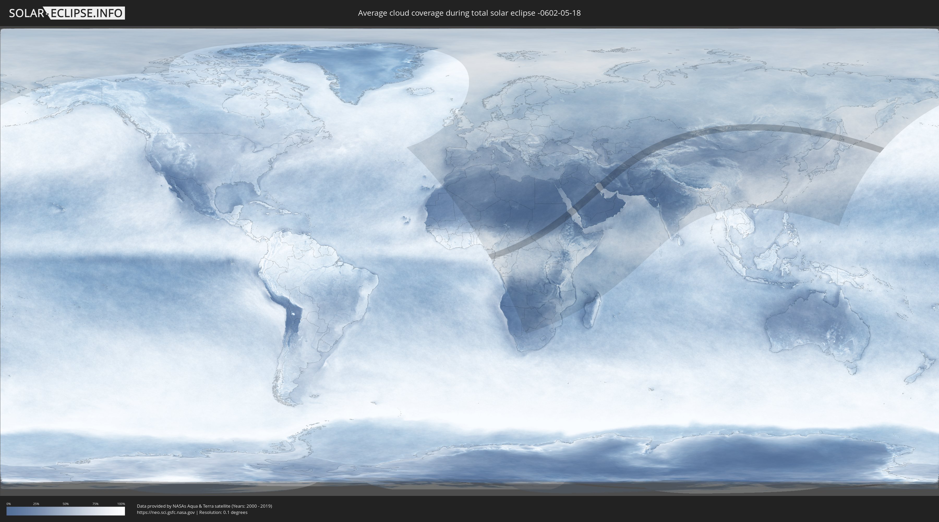
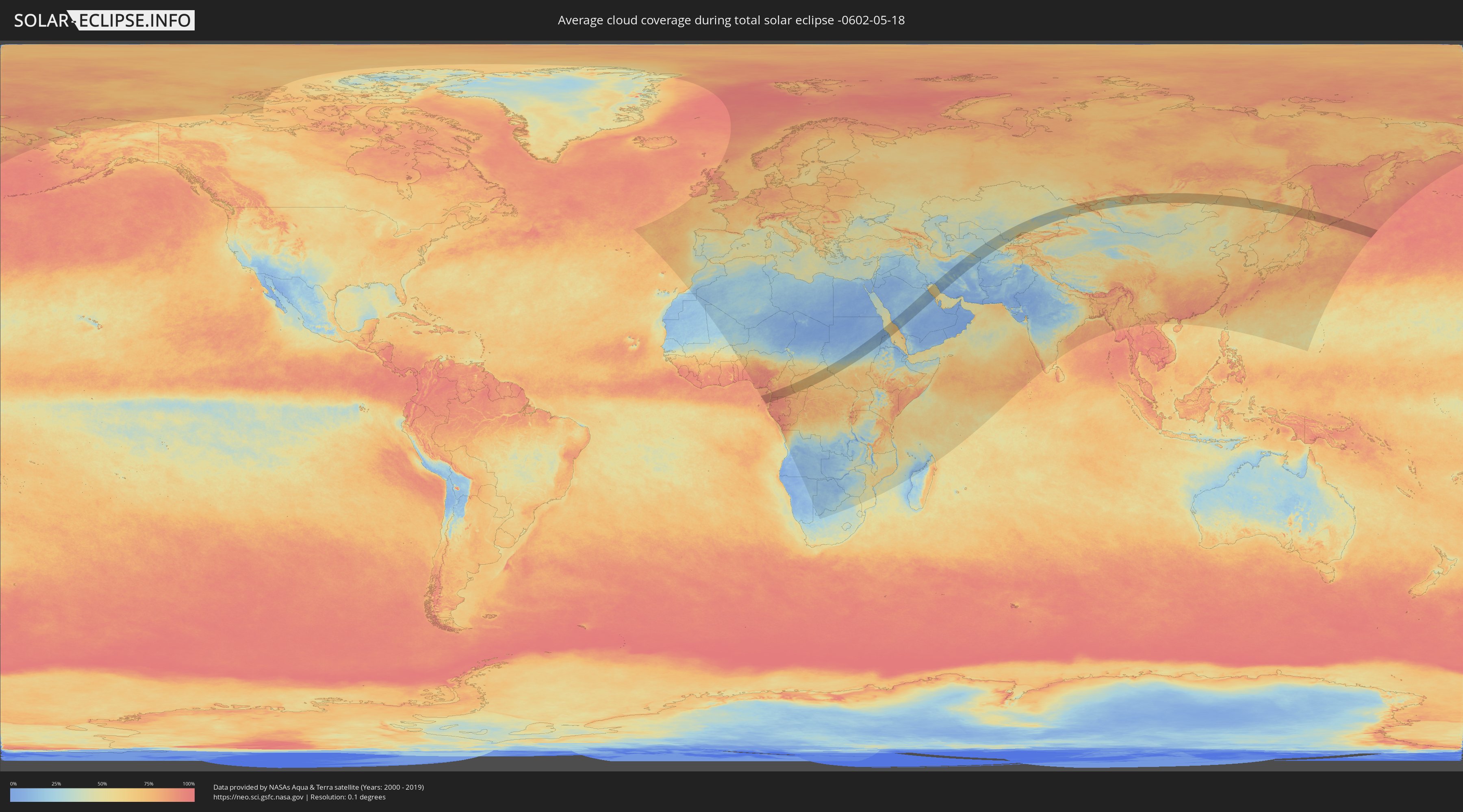
Wie wird das Wetter während der totalen Sonnenfinsternis am 18.05.-0602?
Wo ist der beste Ort, um die totale Sonnenfinsternis vom 18.05.-0602 zu beobachten?
Die folgenden Karten zeigen die durchschnittliche Bewölkung für den Tag, an dem die totale Sonnenfinsternis
stattfindet. Mit Hilfe der Karten lässt sich der Ort entlang des Finsternispfades eingrenzen,
der die besten Aussichen auf einen klaren wolkenfreien Himmel bietet.
Trotzdem muss man immer lokale Gegenenheiten beachten und sollte sich genau über das Wetter an seinem
gewählten Beobachtungsort informieren.
Die Daten stammen von den beiden NASA-Satelliten
AQUA und TERRA
und wurden über einen Zeitraum von 19 Jahren (2000 - 2019) gemittelt.
Detaillierte Länderkarten
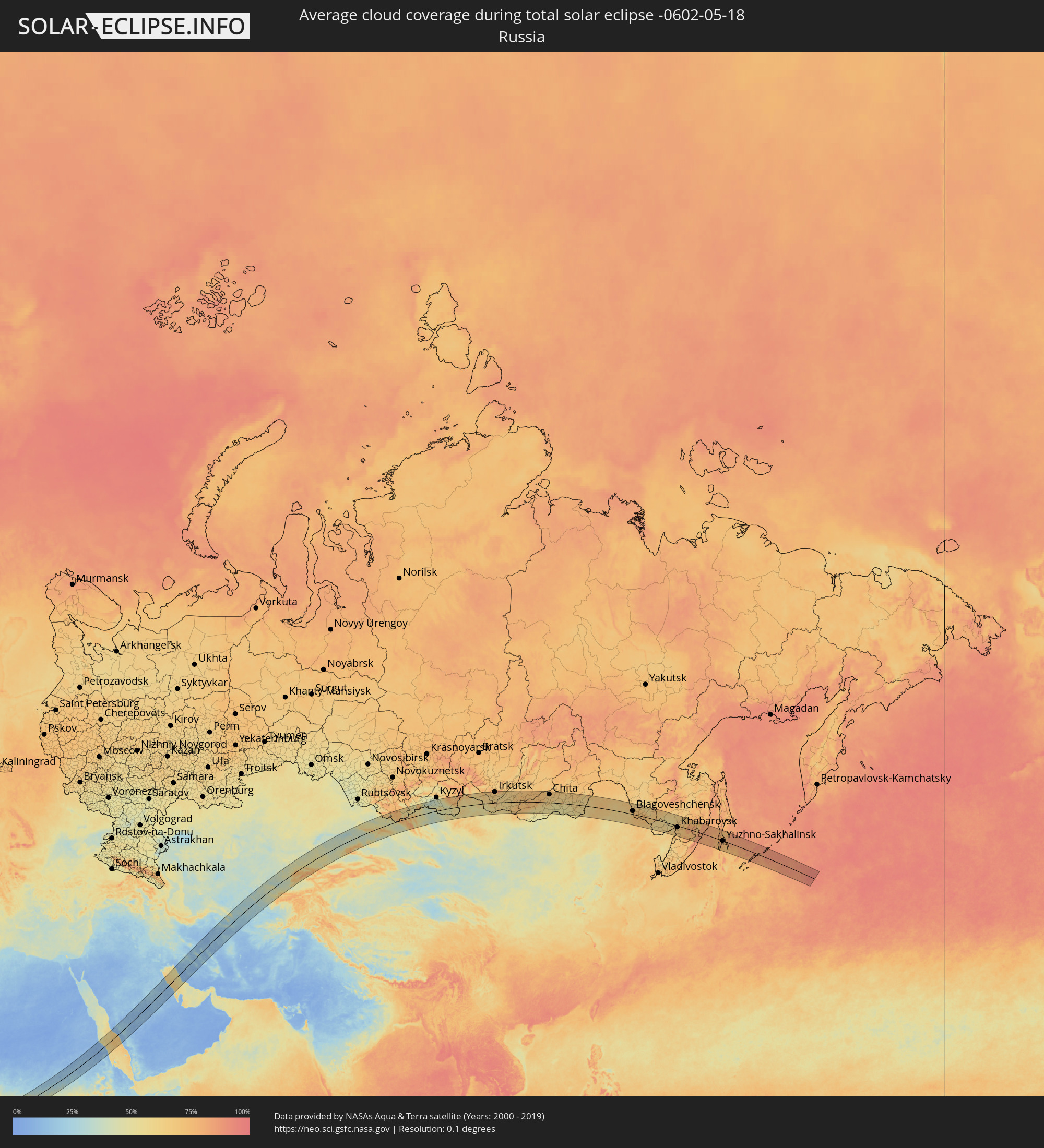 Russland
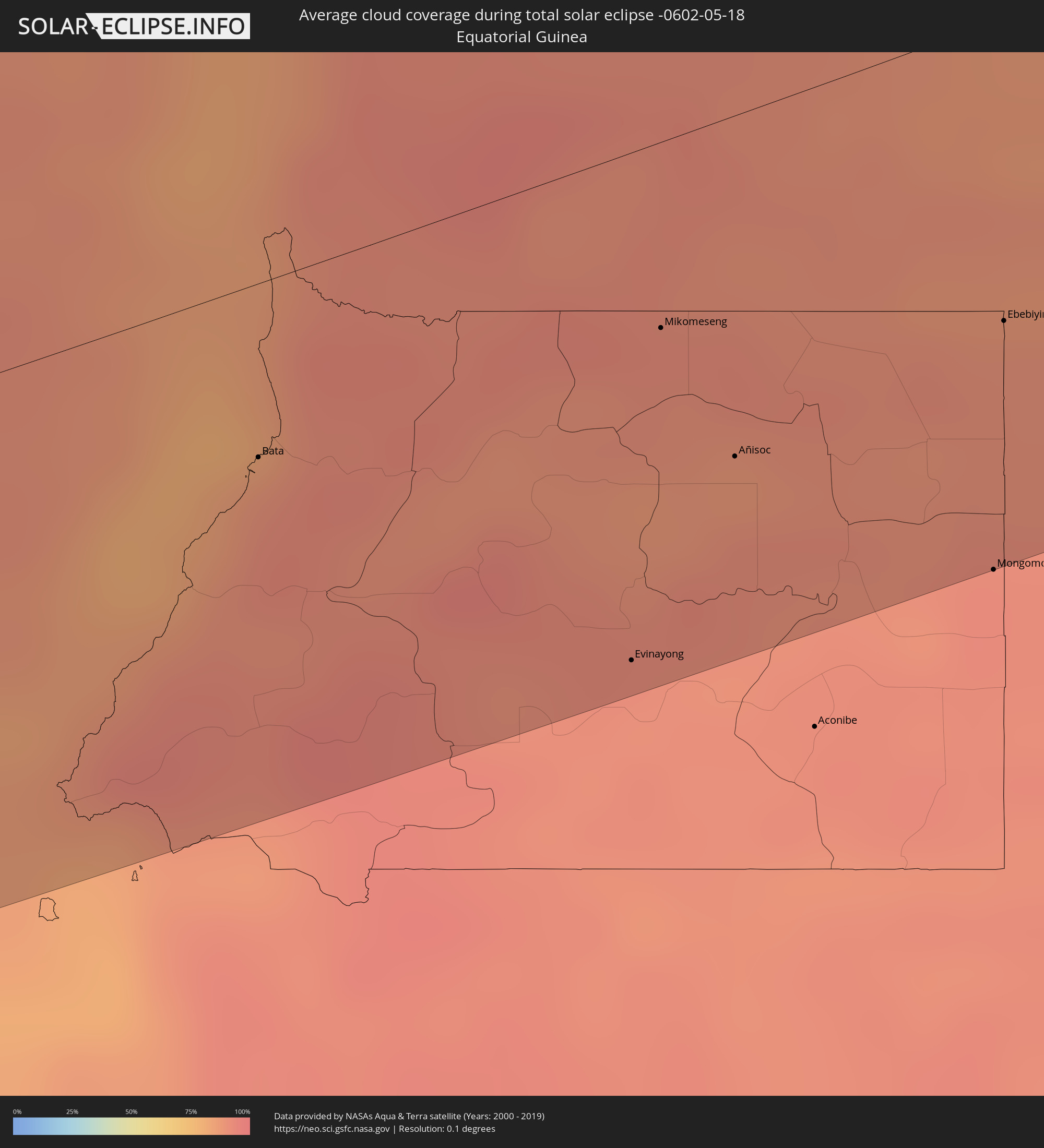 Äquatorialguinea
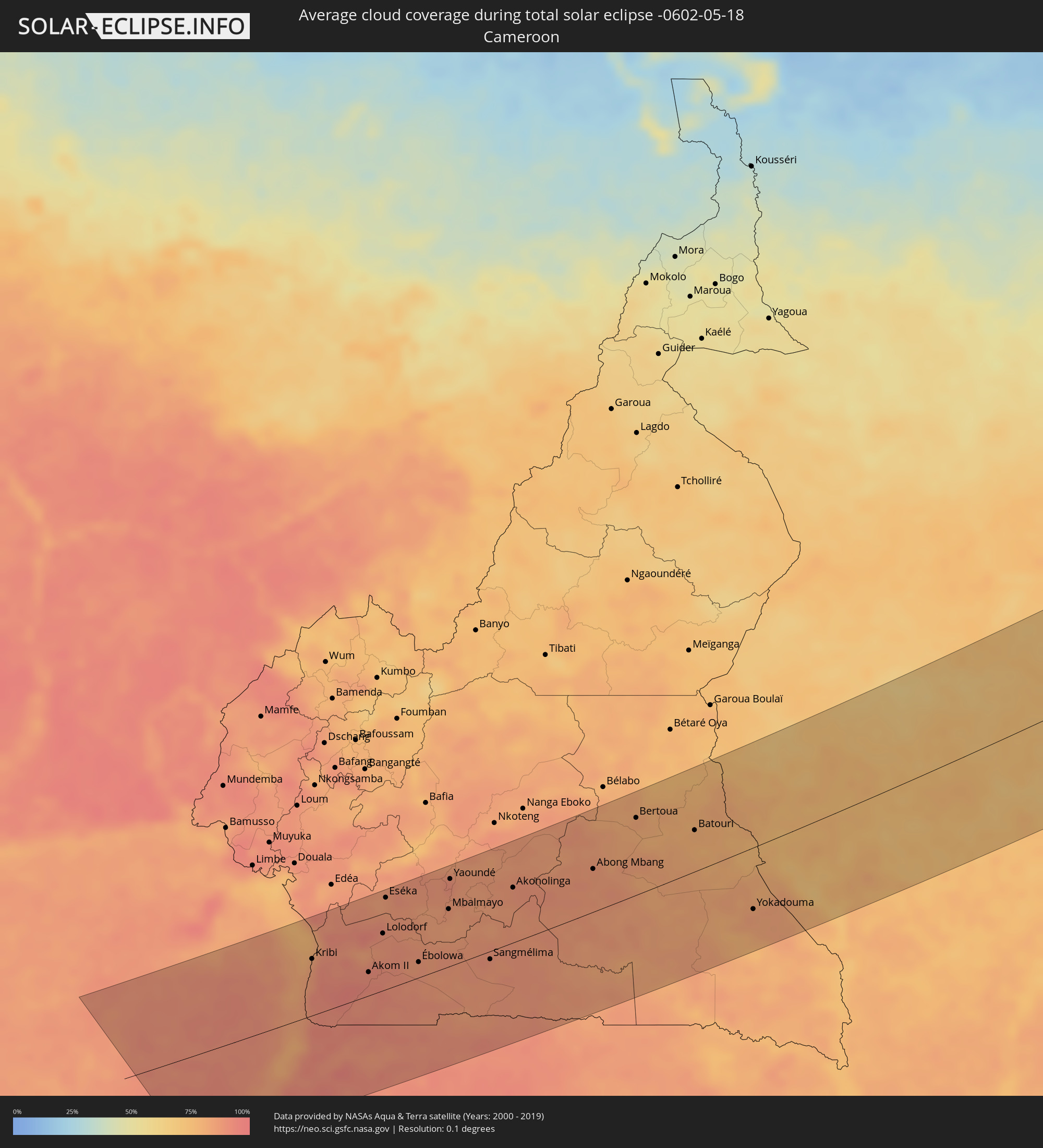 Kamerun
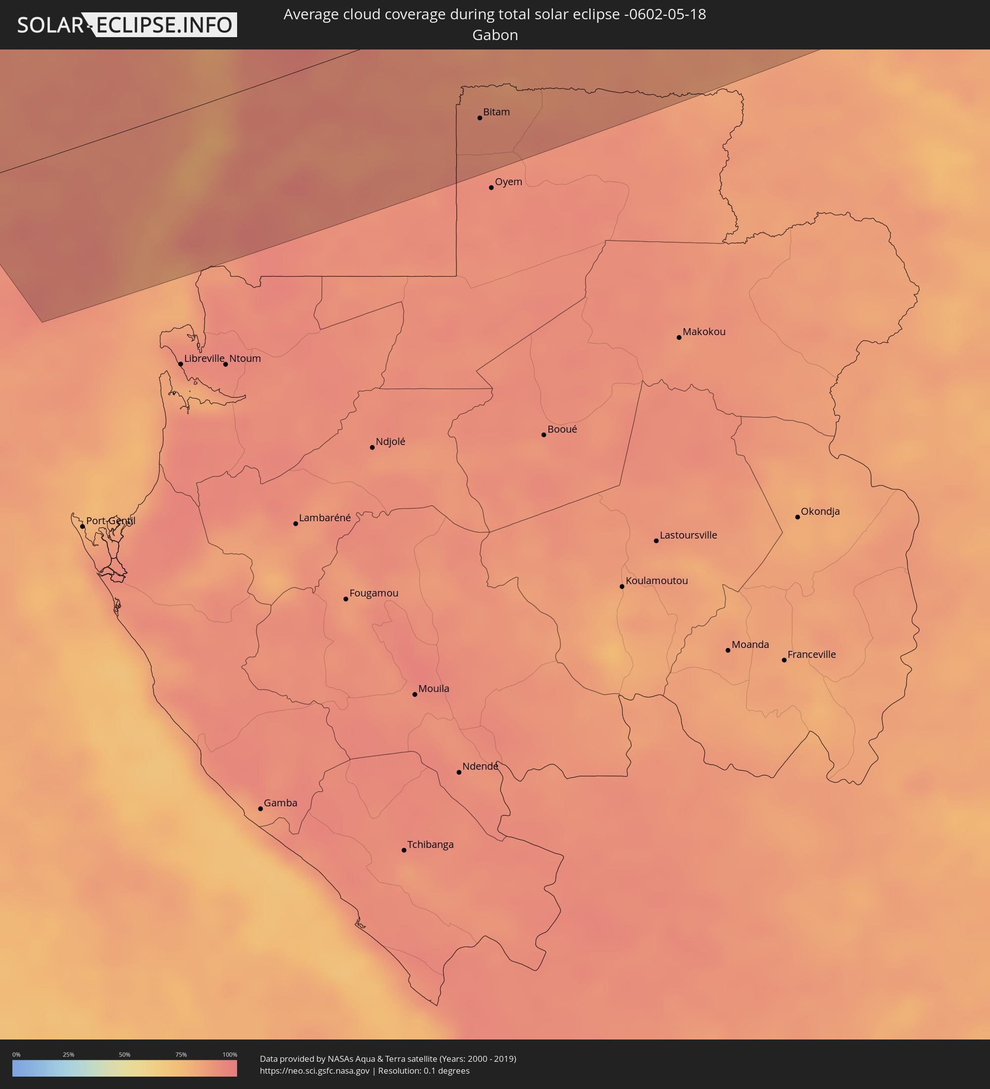 Gabun
Gabun
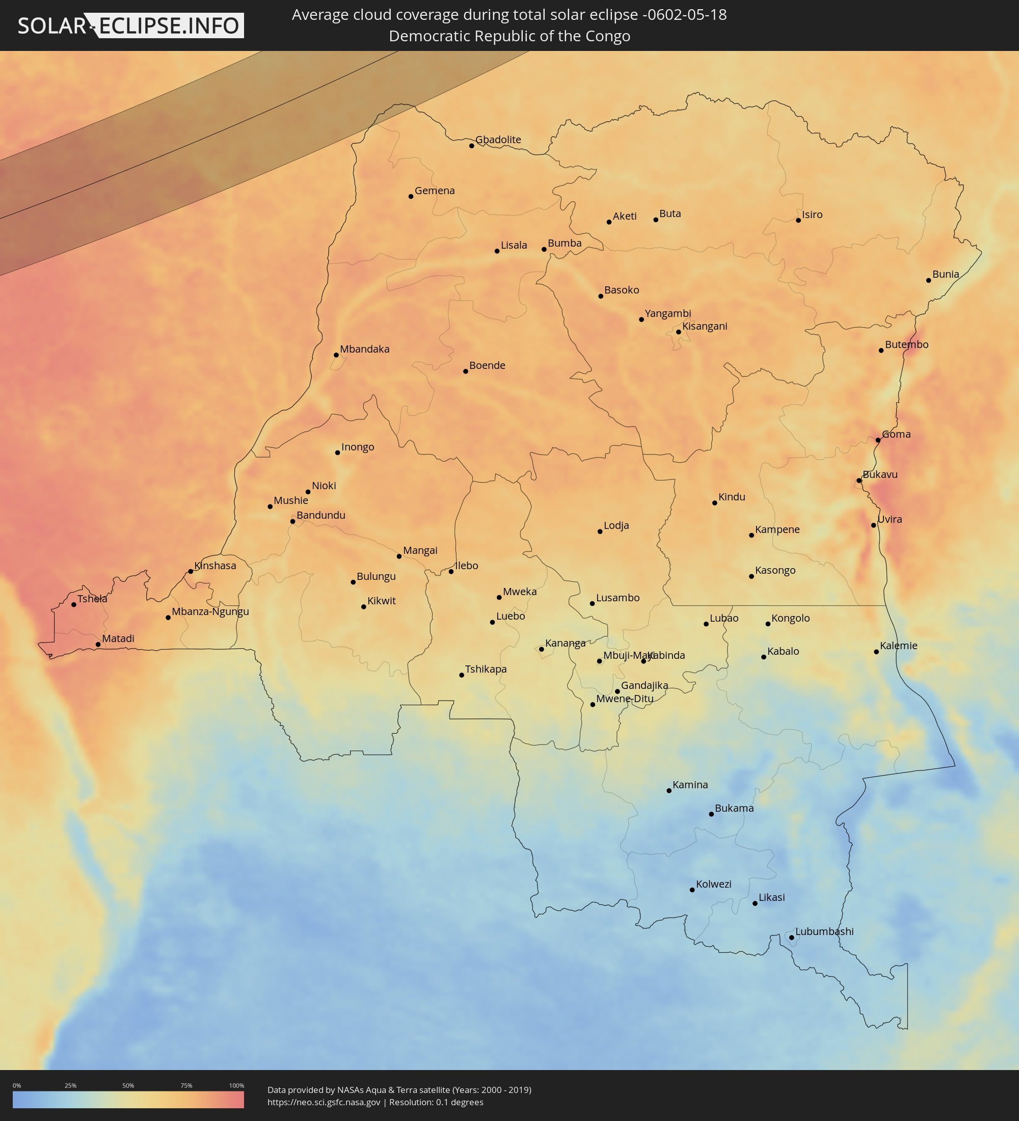 Demokratische Republik Kongo
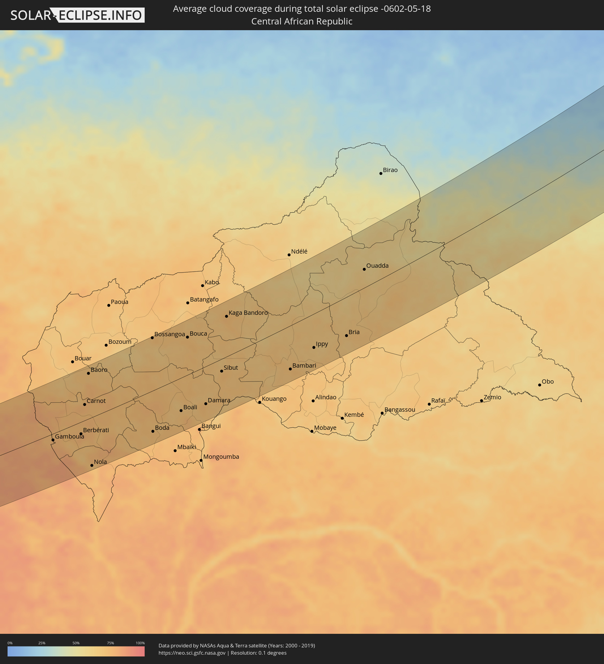 Zentralafrikanische Republik
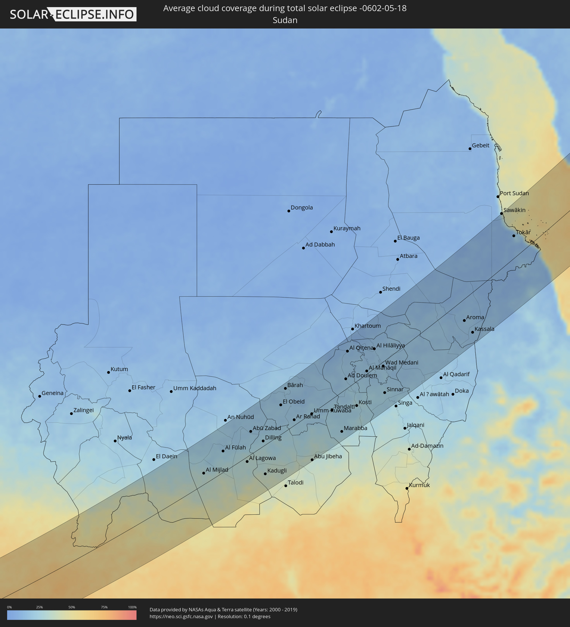 Sudan
Sudan
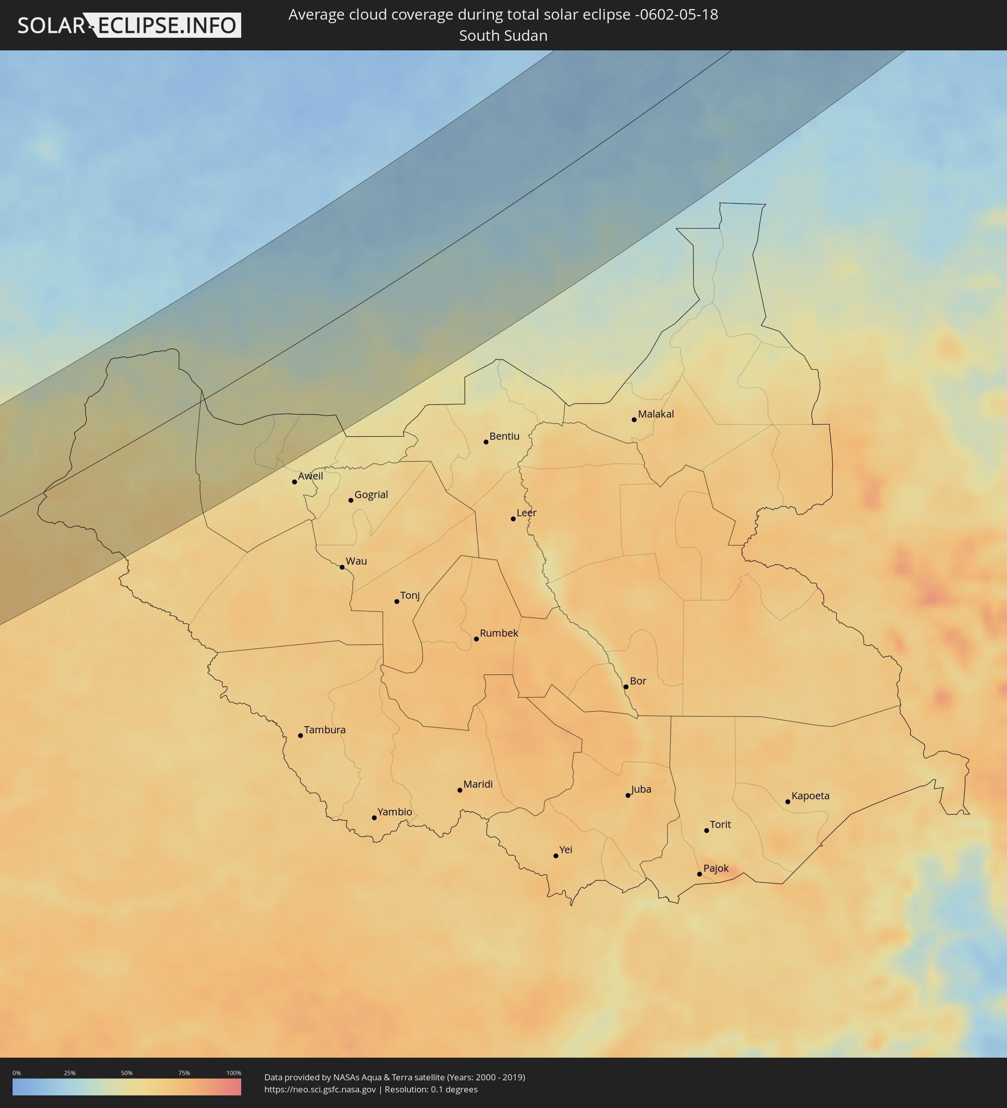 Südsudan
 Saudi-Arabien
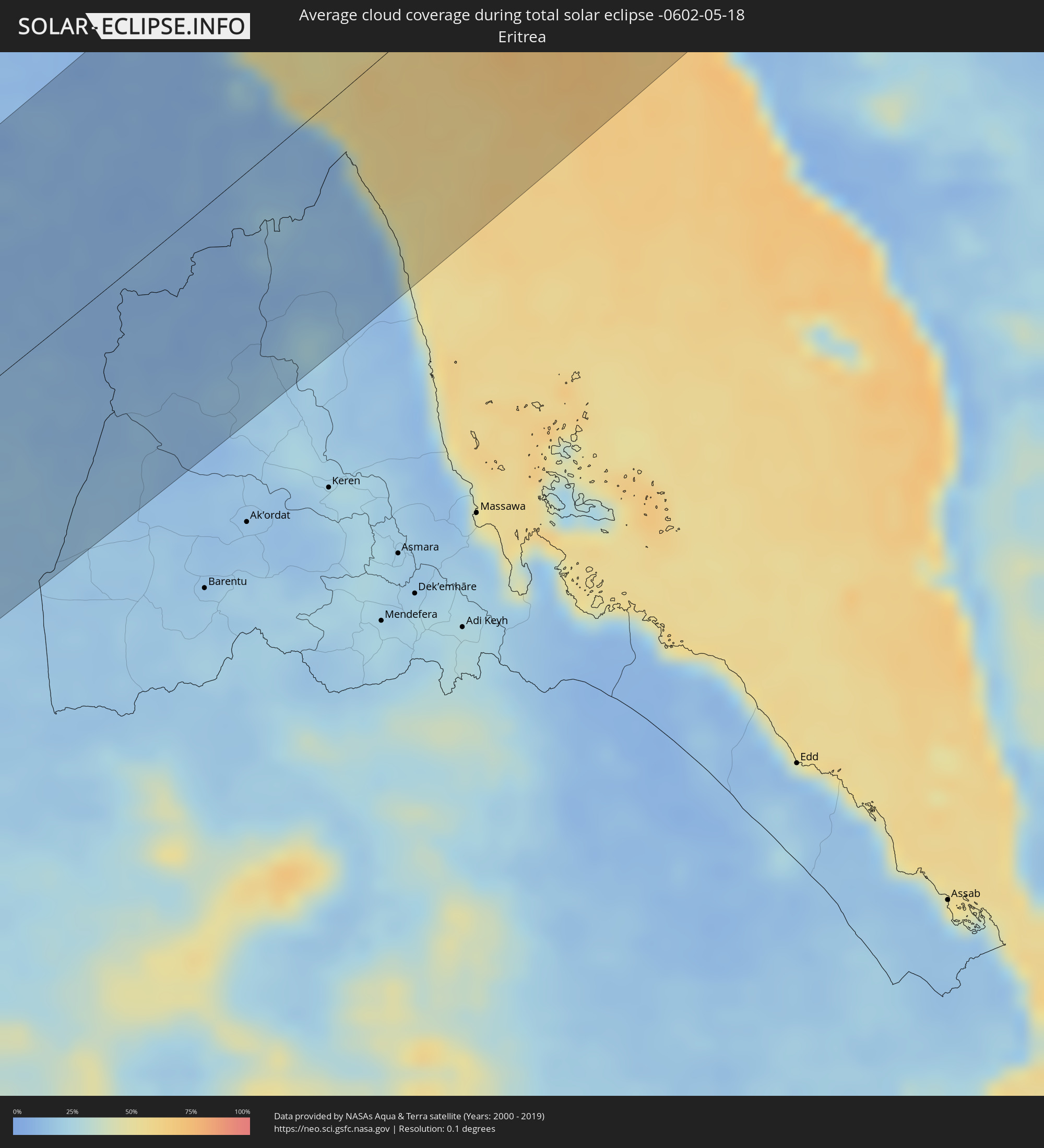 Eritrea
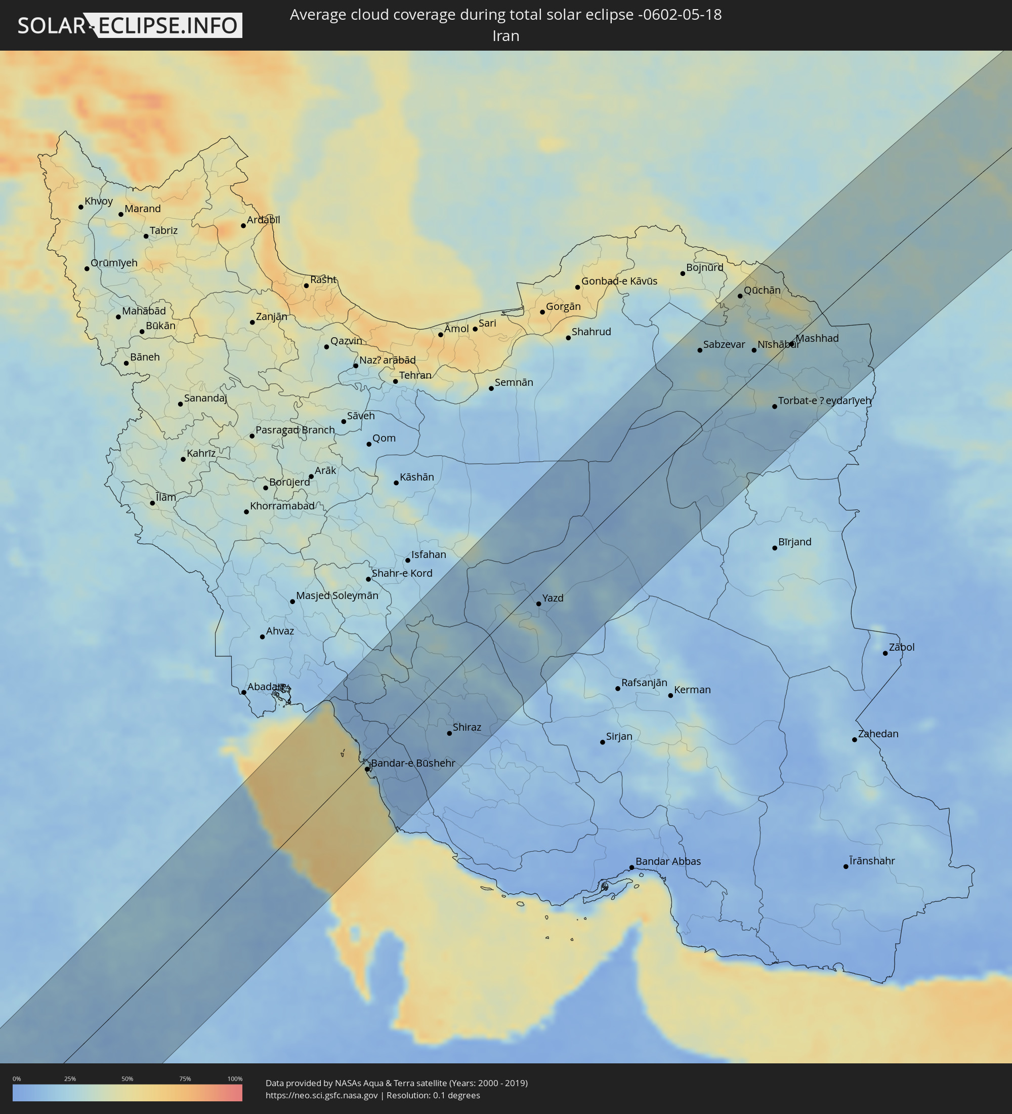 Iran
Iran
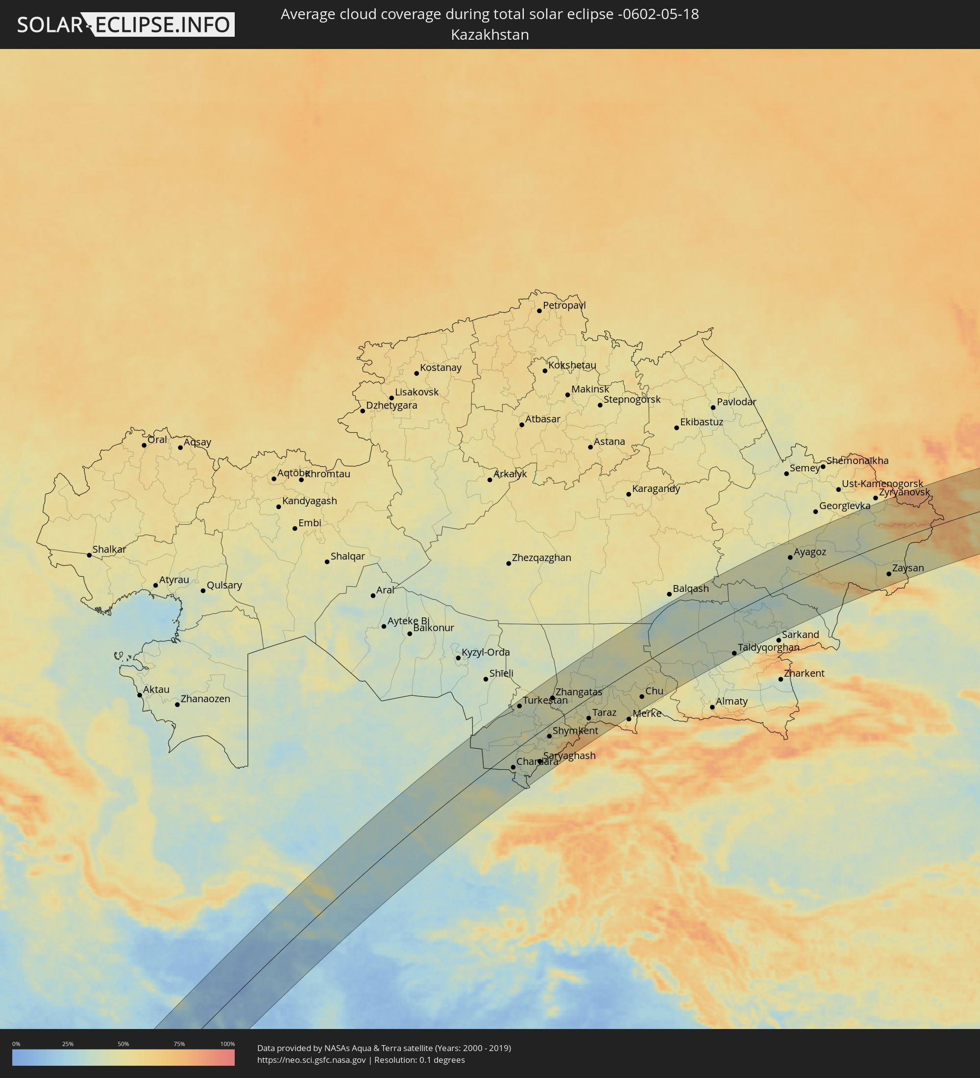 Kasachstan
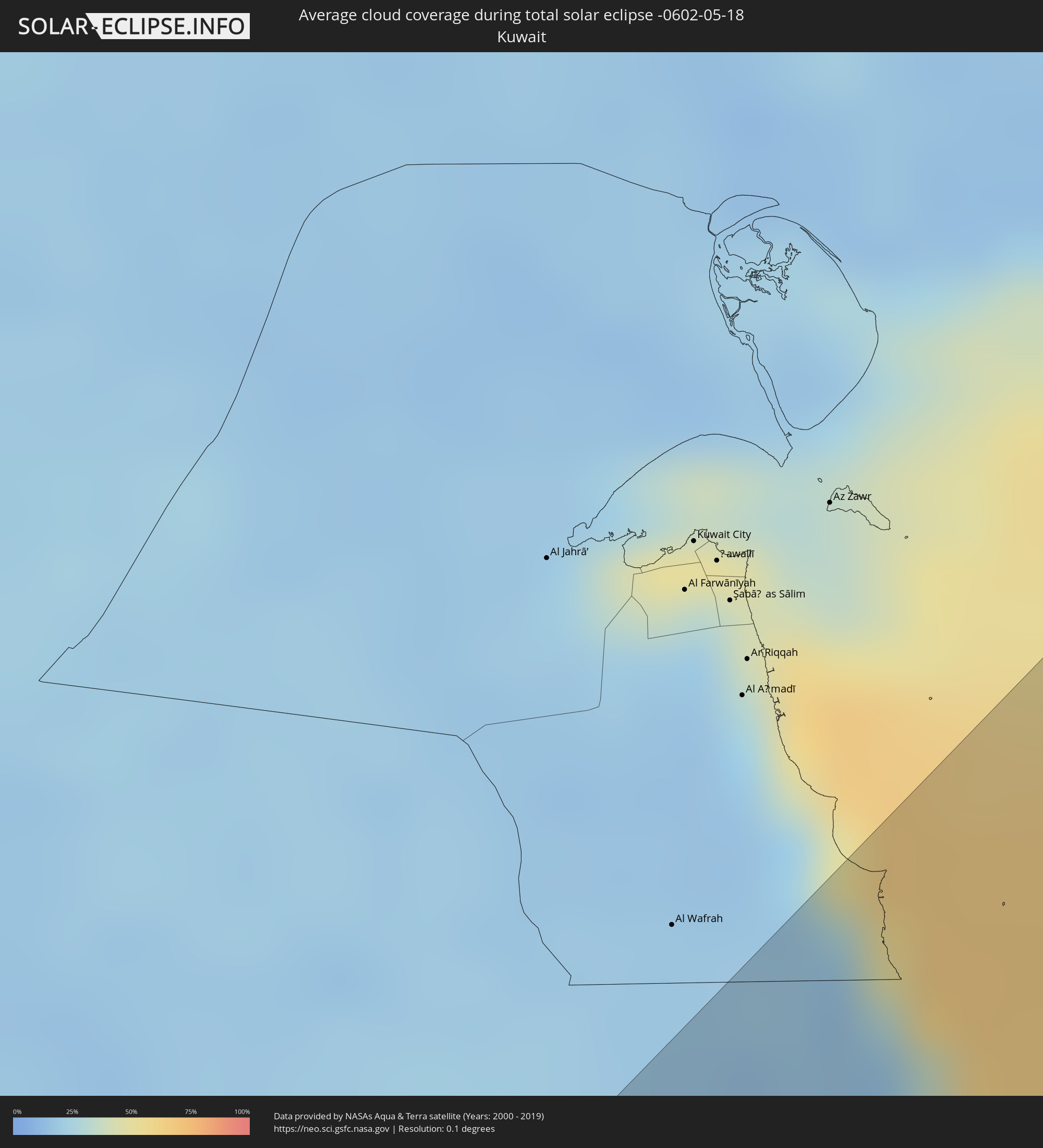 Kuwait
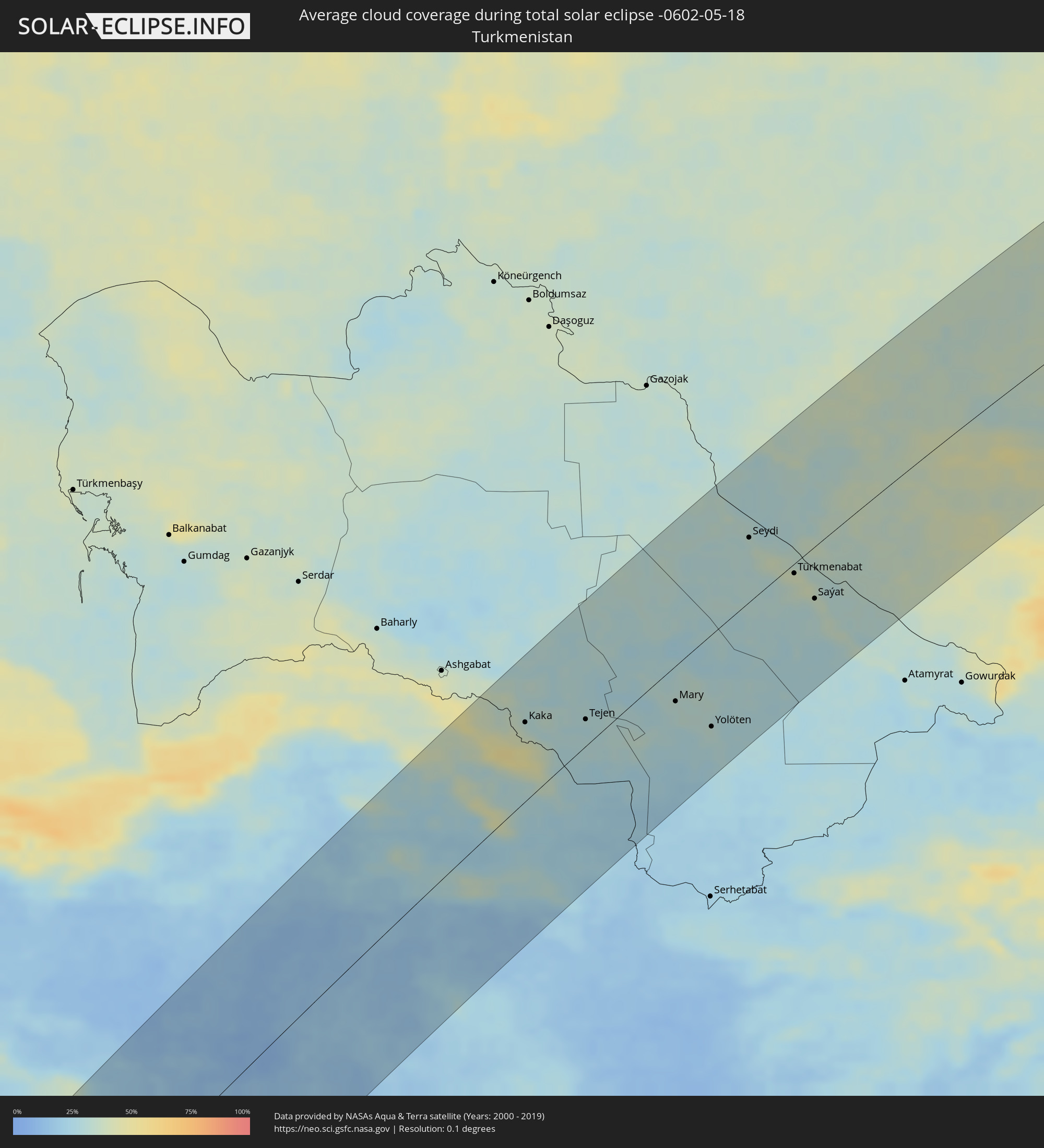 Turkmenistan
 Usbekistan
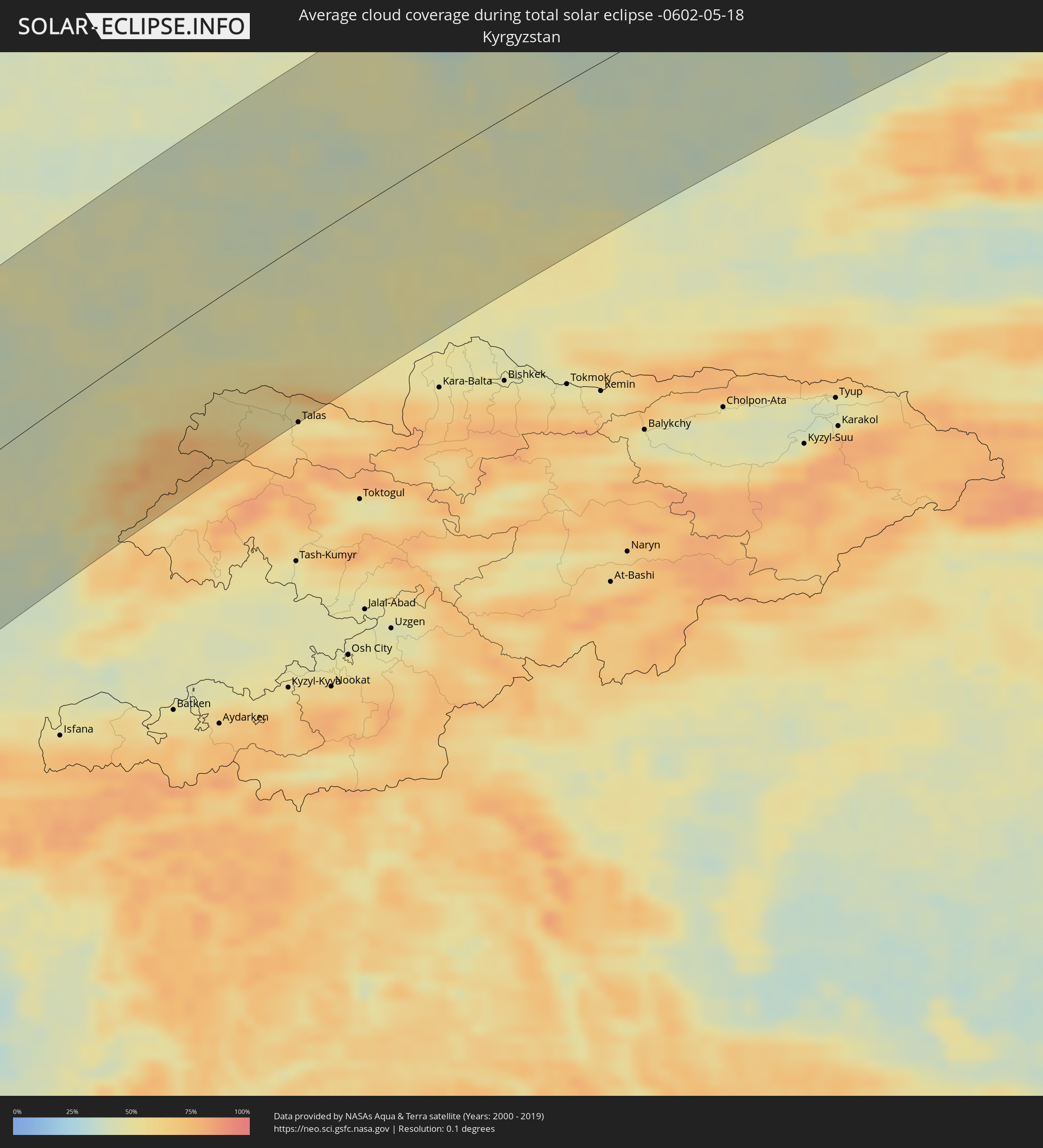 Kirgisistan
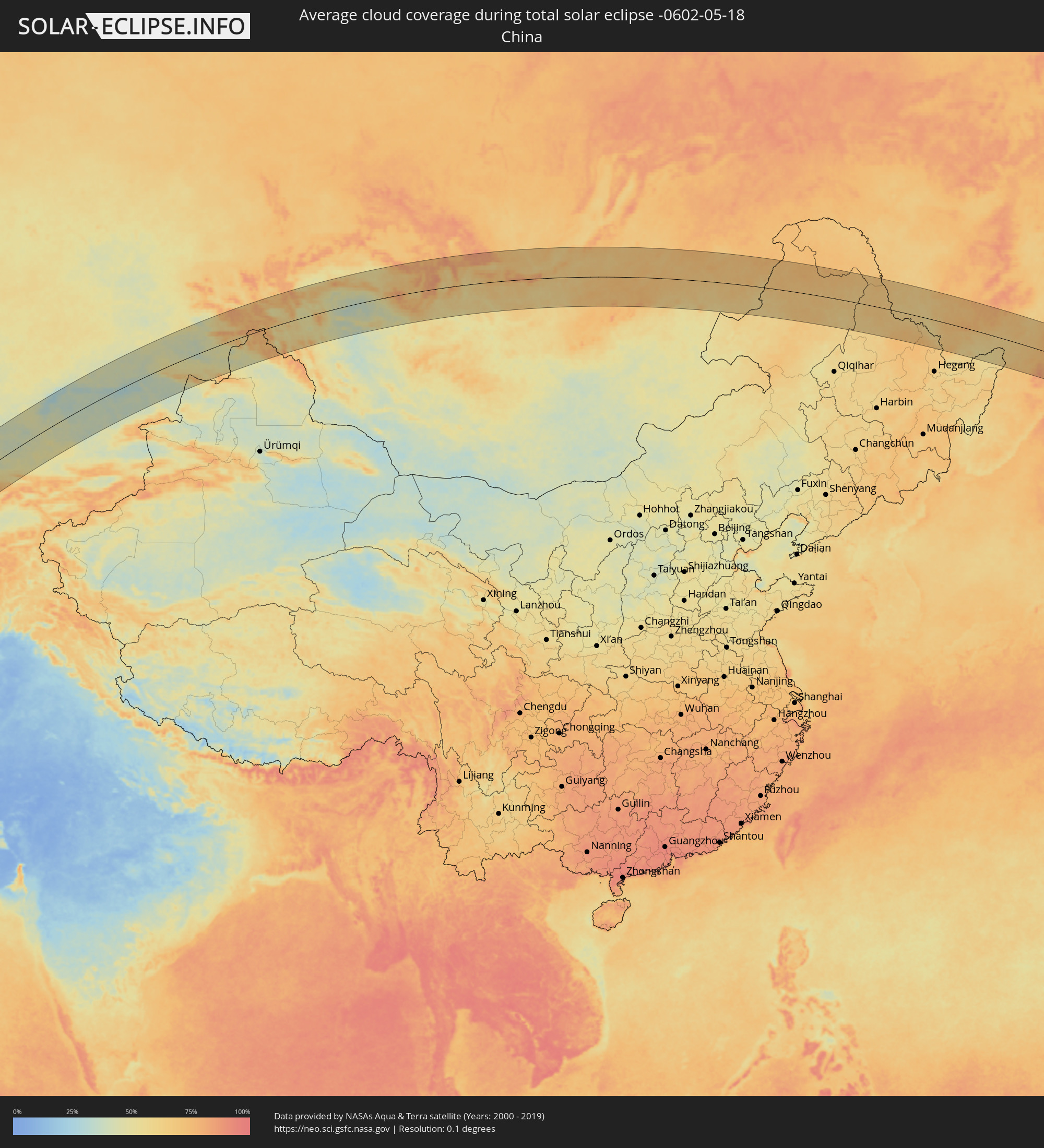 Volksrepublik China
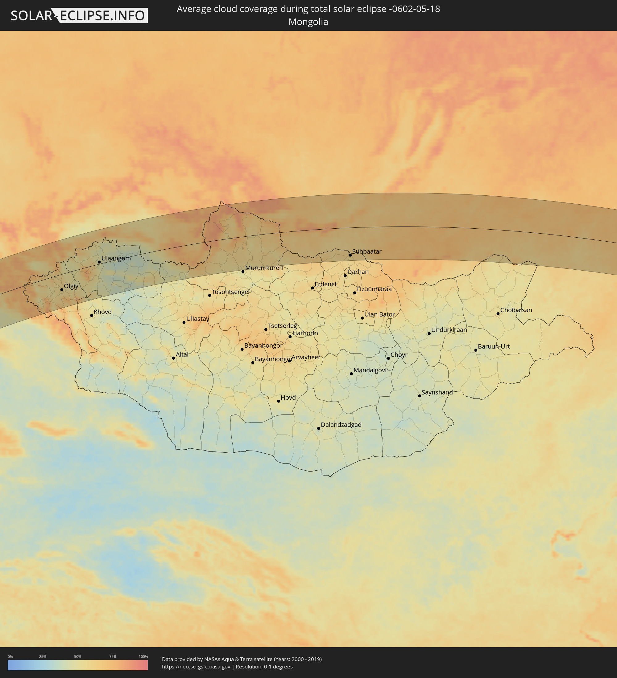 Mongolei
Orte im Finsternispfad
Die nachfolgene Tabelle zeigt Städte und Orte mit mehr als 5.000 Einwohnern, die sich im Finsternispfad befinden. Städte mit mehr als 100.000 Einwohnern sind dick gekennzeichnet. Mit einem Klick auf den Ort öffnet sich eine Detailkarte die die Lage des jeweiligen Ortes zusammen mit dem Verlauf der zentralen Finsternis präsentiert.
| Ort | Typ | Dauer der Verfinsterung | Ortszeit bei maximaler Verfinsterung | Entfernung zur Zentrallinie | Ø Bewölkung |
|
Bata, Litoral
|
total | - | 05:32:22 UTC+00:13 | 39 km | 88% |
|
Kribi, South
|
total | - | 05:33:15 UTC+00:13 | 69 km | 85% |
|
Evinayong, Centro Sur
|
total | - | 05:31:51 UTC+00:13 | 112 km | 90% |
|
Akom II, South
|
total | - | 05:32:59 UTC+00:13 | 29 km | 91% |
|
Mikomeseng, Kié-Ntem
|
total | - | 05:32:26 UTC+00:13 | 41 km | 91% |
|
Lolodorf, South
|
total | - | 05:33:21 UTC+00:13 | 69 km | 89% |
|
Eséka, Centre
|
total | - | 05:33:43 UTC+00:13 | 112 km | 86% |
|
Añisoc, Wele-Nzas
|
total | - | 05:32:10 UTC+00:13 | 75 km | 87% |
|
Ébolowa, South
|
total | - | 05:32:59 UTC+00:13 | 19 km | 88% |
|
Ambam, South
|
total | - | 05:32:31 UTC+00:13 | 40 km | 88% |
|
Ebebiyin, Kié-Ntem
|
total | - | 05:32:18 UTC+00:13 | 67 km | 89% |
|
Mbalmayo, Centre
|
total | - | 05:33:28 UTC+00:13 | 70 km | 86% |
|
Bitam, Woleu-Ntem
|
total | - | 05:32:13 UTC+00:13 | 81 km | 90% |
|
Yaoundé, Centre
|
total | - | 05:33:47 UTC+00:13 | 106 km | 91% |
|
Sangmélima, South
|
total | - | 05:32:52 UTC+00:13 | 10 km | 87% |
|
Akonolinga, Centre
|
total | - | 05:33:35 UTC+00:13 | 67 km | 88% |
|
Abong Mbang, East
|
total | - | 05:33:39 UTC+00:13 | 52 km | 86% |
|
Doumé, East
|
total | - | 05:33:51 UTC+00:13 | 67 km | 81% |
|
Dimako, East
|
total | - | 05:33:59 UTC+00:13 | 77 km | 81% |
|
Bertoua, East
|
total | - | 05:34:09 UTC+00:13 | 93 km | 83% |
|
Batouri, East
|
total | - | 05:33:57 UTC+00:13 | 50 km | 79% |
|
Yokadouma, East
|
total | - | 05:33:02 UTC+00:13 | 74 km | 83% |
|
Gamboula, Mambéré-Kadéï
|
total | - | 05:33:35 UTC+00:13 | 16 km | 77% |
|
Berbérati, Mambéré-Kadéï
|
total | - | 05:33:41 UTC+00:13 | 29 km | 78% |
|
Carnot, Mambéré-Kadéï
|
total | - | 05:34:20 UTC+00:13 | 37 km | 75% |
|
Baoro, Nana-Mambéré
|
total | - | 05:35:03 UTC+00:13 | 107 km | 72% |
|
Nola, Sangha-Mbaéré
|
total | - | 05:32:58 UTC+00:13 | 115 km | 73% |
|
Bossangoa, Ouham
|
total | - | 05:35:52 UTC+00:13 | 124 km | 73% |
|
Boda, Lobaye
|
total | - | 05:33:40 UTC+00:13 | 97 km | 72% |
|
Boali, Ombella-M'Poko
|
total | - | 05:34:08 UTC+00:13 | 78 km | 72% |
|
Bouca, Ouham
|
total | - | 05:35:53 UTC+00:13 | 88 km | 73% |
|
Damara, Ombella-M'Poko
|
total | - | 05:34:18 UTC+00:13 | 88 km | 72% |
|
Sibut, Kémo
|
total | - | 05:35:05 UTC+00:13 | 29 km | 75% |
|
Kaga Bandoro, Nana-Grébizi
|
total | - | 05:36:26 UTC+00:13 | 93 km | 74% |
|
Bambari, Ouaka
|
total | - | 05:35:13 UTC+00:13 | 101 km | 74% |
|
Ippy, Ouaka
|
total | - | 05:35:48 UTC+00:13 | 78 km | 66% |
|
Bria, Haute-Kotto
|
total | - | 05:36:10 UTC+00:13 | 89 km | 66% |
|
Ouadda, Haute-Kotto
|
total | - | 05:37:57 UTC+00:13 | 41 km | 62% |
|
Dilling, Southern Kordofan
|
total | - | 07:41:22 UTC+02:10 | 14 km | 26% |
|
Kadugli, Southern Kordofan
|
total | - | 07:40:00 UTC+02:10 | 86 km | 37% |
|
El Obeid, North Kordofan
|
total | - | 07:43:10 UTC+02:10 | 85 km | 18% |
|
Ar Rahad, North Kordofan
|
total | - | 07:42:41 UTC+02:10 | 15 km | 22% |
|
Umm Ruwaba, North Kordofan
|
total | - | 07:43:12 UTC+02:10 | 3 km | 21% |
|
Tandaltī, White Nile
|
total | - | 07:43:39 UTC+02:10 | 33 km | 21% |
|
Ad Douiem, White Nile
|
total | - | 07:45:16 UTC+02:10 | 28 km | 19% |
|
Kosti, White Nile
|
total | - | 07:44:13 UTC+02:10 | 70 km | 25% |
|
Al Manāqil, Al Jazīrah
|
total | - | 07:45:58 UTC+02:10 | 7 km | 17% |
|
Al Hasaheisa, Al Jazīrah
|
total | - | 07:46:52 UTC+02:10 | 33 km | 18% |
|
Wad Medani, Al Jazīrah
|
total | - | 07:46:28 UTC+02:10 | 13 km | 20% |
|
Sinnar, Sinnār
|
total | - | 07:45:16 UTC+02:10 | 91 km | 23% |
|
Maiurno, Sinnār
|
total | - | 07:45:05 UTC+02:10 | 111 km | 21% |
|
As Sūkī, Sinnār
|
total | - | 07:45:03 UTC+02:10 | 134 km | 22% |
|
Kassala, Kassala
|
total | - | 07:49:42 UTC+02:10 | 109 km | 14% |
|
Sawākin, Red Sea
|
total | - | 07:56:09 UTC+02:10 | 142 km | 14% |
|
Ash Shafā, Makkah
|
total | - | 08:58:27 UTC+03:06 | 100 km | 17% |
|
Ta’if, Makkah
|
total | - | 08:58:53 UTC+03:06 | 109 km | 23% |
|
Al Mindak, Al Bahah
|
total | - | 08:57:42 UTC+03:06 | 44 km | 21% |
|
Al Bāḩah, Al Bahah
|
total | - | 08:57:36 UTC+03:06 | 69 km | 19% |
|
Turabah, Makkah
|
total | - | 08:59:49 UTC+03:06 | 19 km | 19% |
|
Ad Dawādimī, Ar Riyāḑ
|
total | - | 09:08:13 UTC+03:06 | 88 km | 15% |
|
Sājir, Ar Riyāḑ
|
total | - | 09:09:38 UTC+03:06 | 127 km | 16% |
|
Marāt, Ar Riyāḑ
|
total | - | 09:10:19 UTC+03:06 | 57 km | 17% |
|
Tumayr, Ar Riyāḑ
|
total | - | 09:11:53 UTC+03:06 | 78 km | 21% |
|
Riyadh, Ar Riyāḑ
|
total | - | 09:10:56 UTC+03:06 | 63 km | 15% |
|
Al Khafjī, Eastern Province
|
total | - | 09:19:50 UTC+03:06 | 107 km | 32% |
|
Al Jubayl, Eastern Province
|
total | - | 09:18:32 UTC+03:06 | 87 km | 31% |
|
Umm as Sāhik, Eastern Province
|
total | - | 09:18:10 UTC+03:06 | 133 km | 17% |
|
Al Awjām, Eastern Province
|
total | - | 09:18:02 UTC+03:06 | 142 km | 15% |
|
Şafwá, Eastern Province
|
total | - | 09:18:13 UTC+03:06 | 136 km | 24% |
|
Raḩīmah, Eastern Province
|
total | - | 09:18:27 UTC+03:06 | 139 km | 56% |
|
Dogonbadan, Kohgīlūyeh va Būyer Aḩmad
|
total | - | 09:45:02 UTC+03:25 | 95 km | 15% |
|
Bandar-e Būshehr, Bushehr
|
total | - | 09:42:29 UTC+03:25 | 16 km | 39% |
|
Borāzjān, Bushehr
|
total | - | 09:43:31 UTC+03:25 | 19 km | 12% |
|
Nūrābād, Fars
|
total | - | 09:45:28 UTC+03:25 | 27 km | 15% |
|
Yasuj, Kohgīlūyeh va Būyer Aḩmad
|
total | - | 09:46:35 UTC+03:25 | 65 km | 22% |
|
Kāzerūn, Fars
|
total | - | 09:44:43 UTC+03:25 | 21 km | 13% |
|
Shiraz, Fars
|
total | - | 09:45:49 UTC+03:25 | 82 km | 15% |
|
Akbarābād, Fars
|
total | - | 09:45:28 UTC+03:25 | 128 km | 15% |
|
Ardakān, Yazd
|
total | - | 09:52:48 UTC+03:25 | 29 km | 16% |
|
Yazd, Yazd
|
total | - | 09:52:30 UTC+03:25 | 27 km | 17% |
|
Sabzevar, Razavi Khorasan
|
total | - | 10:04:54 UTC+03:25 | 102 km | 23% |
|
Kāshmar, Razavi Khorasan
|
total | - | 10:04:20 UTC+03:25 | 25 km | 19% |
|
Qūchān, Razavi Khorasan
|
total | - | 10:07:38 UTC+03:25 | 123 km | 36% |
|
Nīshābūr, Razavi Khorasan
|
total | - | 10:06:31 UTC+03:25 | 33 km | 24% |
|
Torbat-e Ḩeydarīyeh, Razavi Khorasan
|
total | - | 10:05:31 UTC+03:25 | 69 km | 20% |
|
Mashhad, Razavi Khorasan
|
total | - | 10:07:50 UTC+03:25 | 5 km | 27% |
|
Kaka, Ahal
|
total | - | 10:37:28 UTC+03:53 | 76 km | 37% |
|
Tejen, Ahal
|
total | - | 10:38:51 UTC+03:53 | 26 km | 27% |
|
Mary, Mary
|
total | - | 10:41:12 UTC+03:53 | 35 km | 31% |
|
Murgab
|
total | - | 10:41:16 UTC+03:53 | 51 km | 32% |
|
Bayramaly, Mary
|
total | - | 10:41:46 UTC+03:53 | 52 km | 32% |
|
Yolöten, Mary
|
total | - | 10:41:32 UTC+03:53 | 90 km | 31% |
|
Seydi, Mary
|
total | - | 10:45:54 UTC+03:53 | 62 km | 31% |
|
Türkmenabat, Lebap
|
total | - | 10:46:17 UTC+03:53 | 9 km | 40% |
|
Farap, Lebap
|
total | - | 10:46:29 UTC+03:53 | 3 km | 39% |
|
Saýat, Lebap
|
total | - | 10:46:18 UTC+03:53 | 51 km | 35% |
|
Bukhara, Bukhara
|
total | - | 11:23:02 UTC+04:27 | 4 km | 38% |
|
Shofirkon, Bukhara
|
total | - | 11:23:40 UTC+04:27 | 30 km | 37% |
|
Ghijduwon, Bukhara
|
total | - | 11:23:55 UTC+04:27 | 18 km | 39% |
|
Muborak, Qashqadaryo
|
total | - | 11:23:23 UTC+04:27 | 80 km | 36% |
|
Navoiy, Navoiy
|
total | - | 11:24:59 UTC+04:27 | 20 km | 39% |
|
Koson, Qashqadaryo
|
total | - | 11:23:44 UTC+04:27 | 123 km | 39% |
|
Nurota, Navoiy
|
total | - | 11:26:10 UTC+04:27 | 5 km | 42% |
|
Oqtosh, Samarqand
|
total | - | 11:25:36 UTC+04:27 | 64 km | 40% |
|
Kattaqo’rg’on, Samarqand
|
total | - | 11:26:06 UTC+04:27 | 83 km | 40% |
|
Chardara, Ongtüstik Qazaqstan
|
total | - | 11:24:44 UTC+04:21 | 51 km | 39% |
|
Gagarin, Jizzax
|
total | - | 11:30:16 UTC+04:27 | 114 km | 37% |
|
Turkestan, Ongtüstik Qazaqstan
|
total | - | 11:27:52 UTC+04:21 | 118 km | 42% |
|
Kentau, Ongtüstik Qazaqstan
|
total | - | 11:28:32 UTC+04:21 | 126 km | 43% |
|
Sirdaryo, Sirdaryo
|
total | - | 11:31:18 UTC+04:27 | 122 km | 39% |
|
Arys, Ongtüstik Qazaqstan
|
total | - | 11:27:37 UTC+04:21 | 13 km | 40% |
|
Yangiyŭl, Toshkent
|
total | - | 11:32:18 UTC+04:27 | 117 km | 39% |
|
Saryaghash, Ongtüstik Qazaqstan
|
total | - | 11:26:56 UTC+04:21 | 92 km | 40% |
|
Tashkent, Toshkent Shahri
|
total | - | 11:32:46 UTC+04:27 | 112 km | 42% |
|
Salor, Toshkent
|
total | - | 11:33:11 UTC+04:27 | 110 km | 43% |
|
Chirchiq, Toshkent
|
total | - | 11:33:38 UTC+04:27 | 111 km | 43% |
|
Shymkent, Ongtüstik Qazaqstan
|
total | - | 11:28:43 UTC+04:21 | 36 km | 46% |
|
Parkent, Toshkent
|
total | - | 11:33:33 UTC+04:27 | 131 km | 45% |
|
Zhangatas, Zhambyl
|
total | - | 11:30:29 UTC+04:21 | 73 km | 44% |
|
Belyye Vody, Ongtüstik Qazaqstan
|
total | - | 11:29:14 UTC+04:21 | 36 km | 47% |
|
Lenger, Ongtüstik Qazaqstan
|
total | - | 11:29:01 UTC+04:21 | 61 km | 50% |
|
Vannovka, Ongtüstik Qazaqstan
|
total | - | 11:30:12 UTC+04:21 | 50 km | 51% |
|
Karatau, Zhambyl
|
total | - | 11:31:10 UTC+04:21 | 4 km | 46% |
|
Taraz, Zhambyl
|
total | - | 11:32:16 UTC+04:21 | 63 km | 53% |
|
Chu, Zhambyl
|
total | - | 11:36:54 UTC+04:21 | 101 km | 48% |
|
Taldyqorghan, Almaty Oblysy
|
total | - | 11:44:53 UTC+04:21 | 130 km | 44% |
|
Ush-Tyube, Almaty Oblysy
|
total | - | 11:45:12 UTC+04:21 | 107 km | 38% |
|
Ayagoz, East Kazakhstan
|
total | - | 11:50:50 UTC+04:21 | 81 km | 41% |
|
Ölgiy, Bayan-Ölgiy
|
total | - | 13:49:29 UTC+06:06 | 63 km | 57% |
|
Ulaangom, Uvs
|
total | - | 13:52:20 UTC+06:06 | 6 km | 46% |
|
Shelekhov, Irkutsk
|
total | - | 14:56:02 UTC+06:57 | 118 km | 67% |
|
Irkutsk, Irkutsk
|
total | - | 14:56:11 UTC+06:57 | 126 km | 65% |
|
Sühbaatar, Selenge
|
total | - | 15:09:40 UTC+07:07 | 111 km | 58% |
|
Gusinoozyorsk, Respublika Buryatiya
|
total | - | 14:58:54 UTC+06:57 | 6 km | 64% |
|
Ulan-Ude, Respublika Buryatiya
|
total | - | 14:59:37 UTC+06:57 | 64 km | 62% |
|
Petrovsk-Zabaykal’skiy, Transbaikal Territory
|
total | - | 16:43:00 UTC+08:38 | 1 km | 67% |
|
Chita, Transbaikal Territory
|
total | - | 16:46:24 UTC+08:38 | 94 km | 70% |
|
Borzya, Transbaikal Territory
|
total | - | 16:50:02 UTC+08:38 | 74 km | 61% |
|
Krasnokamensk, Transbaikal Territory
|
total | - | 16:51:22 UTC+08:38 | 94 km | 60% |
|
Genhe, Inner Mongolia
|
total | - | 16:14:04 UTC+08:00 | 14 km | 68% |
|
Oroqen Zizhiqi, Inner Mongolia
|
total | - | 16:15:32 UTC+08:00 | 16 km | 65% |
|
Jagdaqi, Inner Mongolia
|
total | - | 16:15:54 UTC+08:00 | 4 km | 65% |
|
Nenjiang, Heilongjiang
|
total | - | 16:17:39 UTC+08:00 | 117 km | 62% |
|
Heihe, Heilongjiang
|
total | - | 16:17:44 UTC+08:00 | 33 km | 65% |
|
Blagoveshchensk, Amur
|
total | - | 16:56:41 UTC+08:38 | 38 km | 66% |
|
Belogorsk, Amur
|
total | - | 16:56:28 UTC+08:38 | 121 km | 63% |
|
Raychikhinsk, Amur
|
total | - | 16:57:58 UTC+08:38 | 14 km | 61% |
|
Birobidzhan, Jewish Autonomous Oblast
|
total | - | 17:08:47 UTC+08:47 | 29 km | 60% |
|
Fuyuan, Heilongjiang
|
total | - | 16:22:07 UTC+08:00 | 48 km | 58% |
|
Khabarovsk, Khabarovsk Krai
|
total | - | 17:09:44 UTC+08:47 | 19 km | 62% |
|
Kholmsk, Sakhalin
|
total | - | 18:39:47 UTC+10:14 | 8 km | 78% |
|
Yuzhno-Sakhalinsk, Sakhalin
|
total | - | 18:39:56 UTC+10:14 | 1 km | 76% |
|
Korsakov, Sakhalin
|
total | - | 18:40:15 UTC+10:14 | 33 km | 74% |