Total solar eclipse of 05/18/-0602
| Day of week: | Wednesday |
| Maximum duration of eclipse: | 05m52s |
| Maximum width of eclipse path: | 279 km |
| Saros cycle: | 57 |
| Coverage: | 100% |
| Magnitude: | 1.0797 |
| Gamma: | 0.3953 |
Wo kann man die Sonnenfinsternis vom 05/18/-0602 sehen?
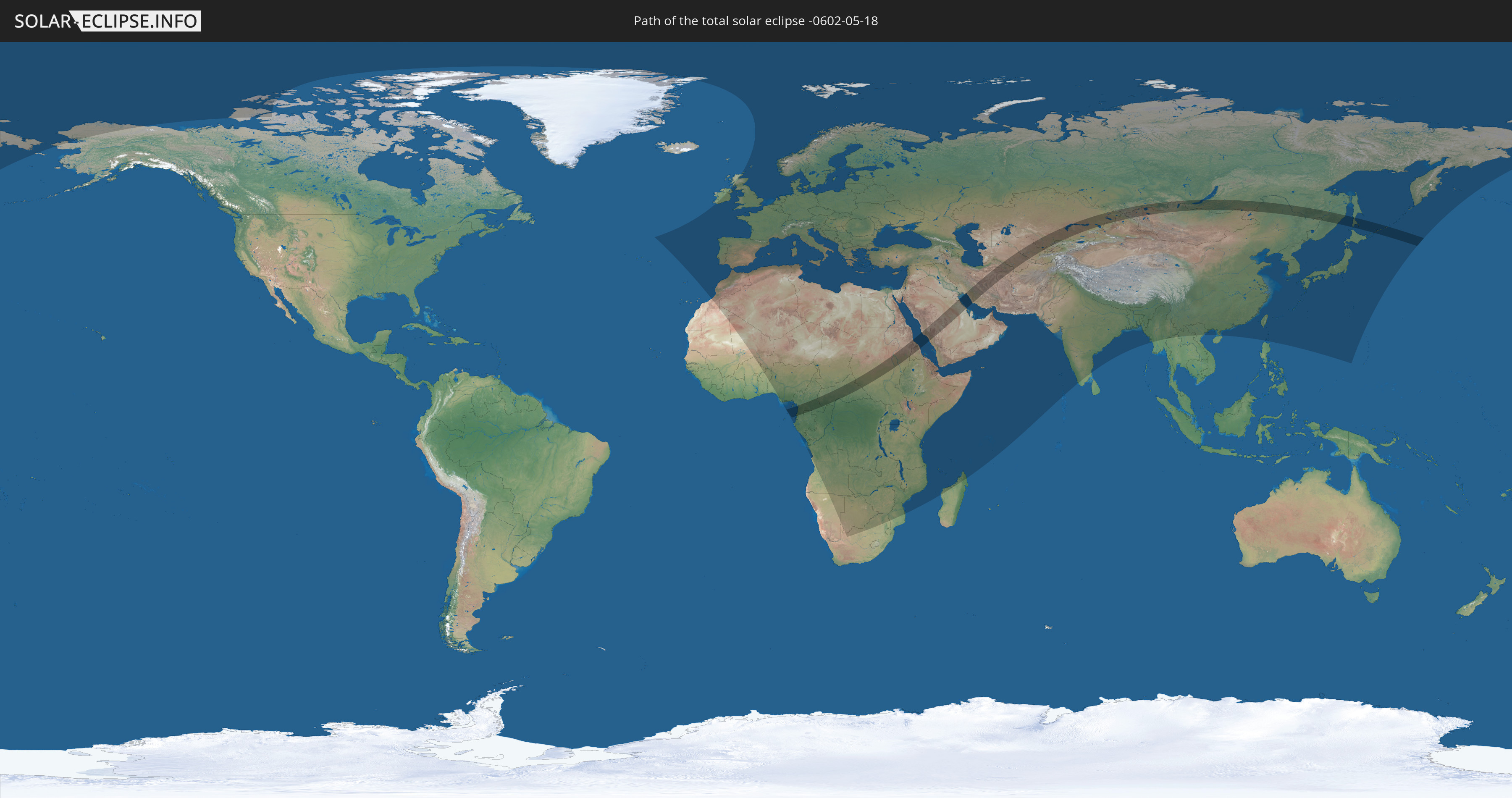
Die Sonnenfinsternis am 05/18/-0602 kann man in 137 Ländern als partielle Sonnenfinsternis beobachten.
Der Finsternispfad verläuft durch 18 Länder. Nur in diesen Ländern ist sie als total Sonnenfinsternis zu sehen.
In den folgenden Ländern ist die Sonnenfinsternis total zu sehen
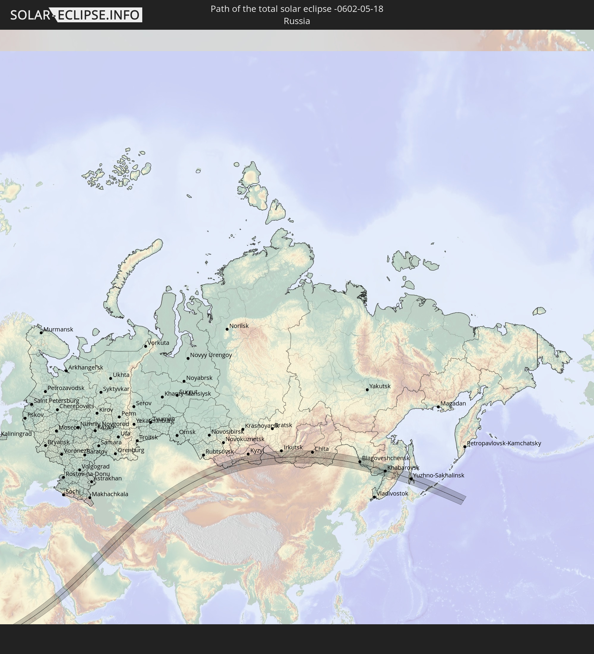 Russia
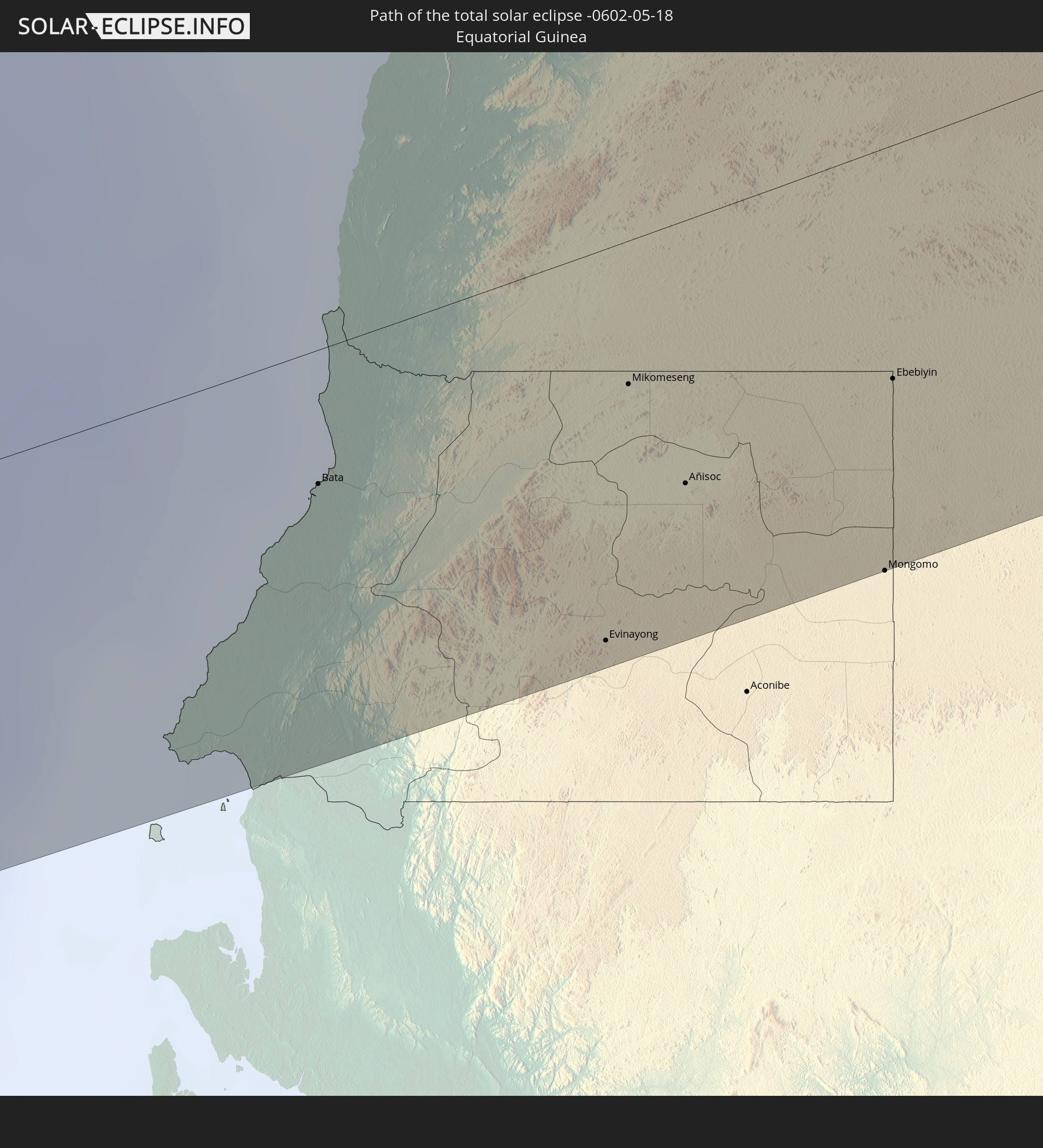 Equatorial Guinea
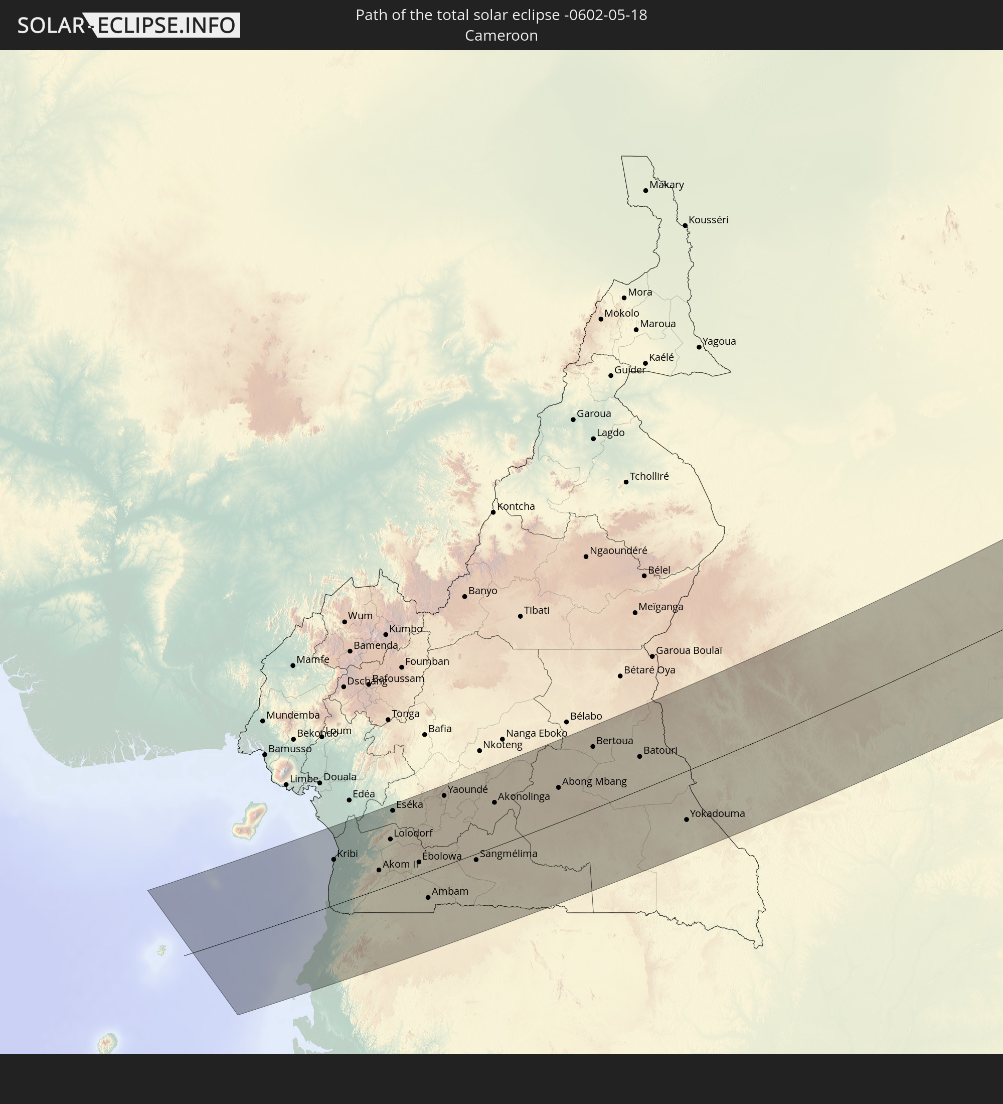 Cameroon
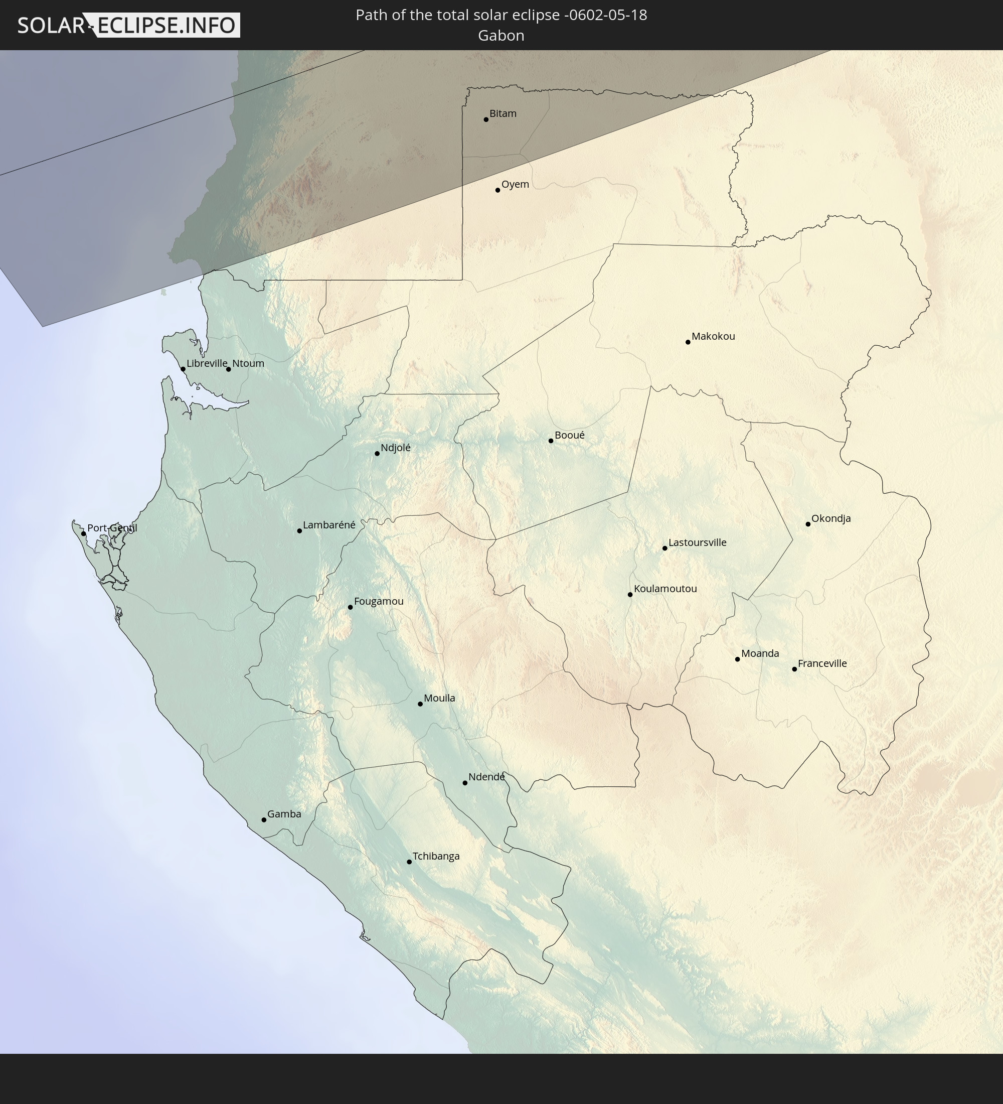 Gabon
Gabon
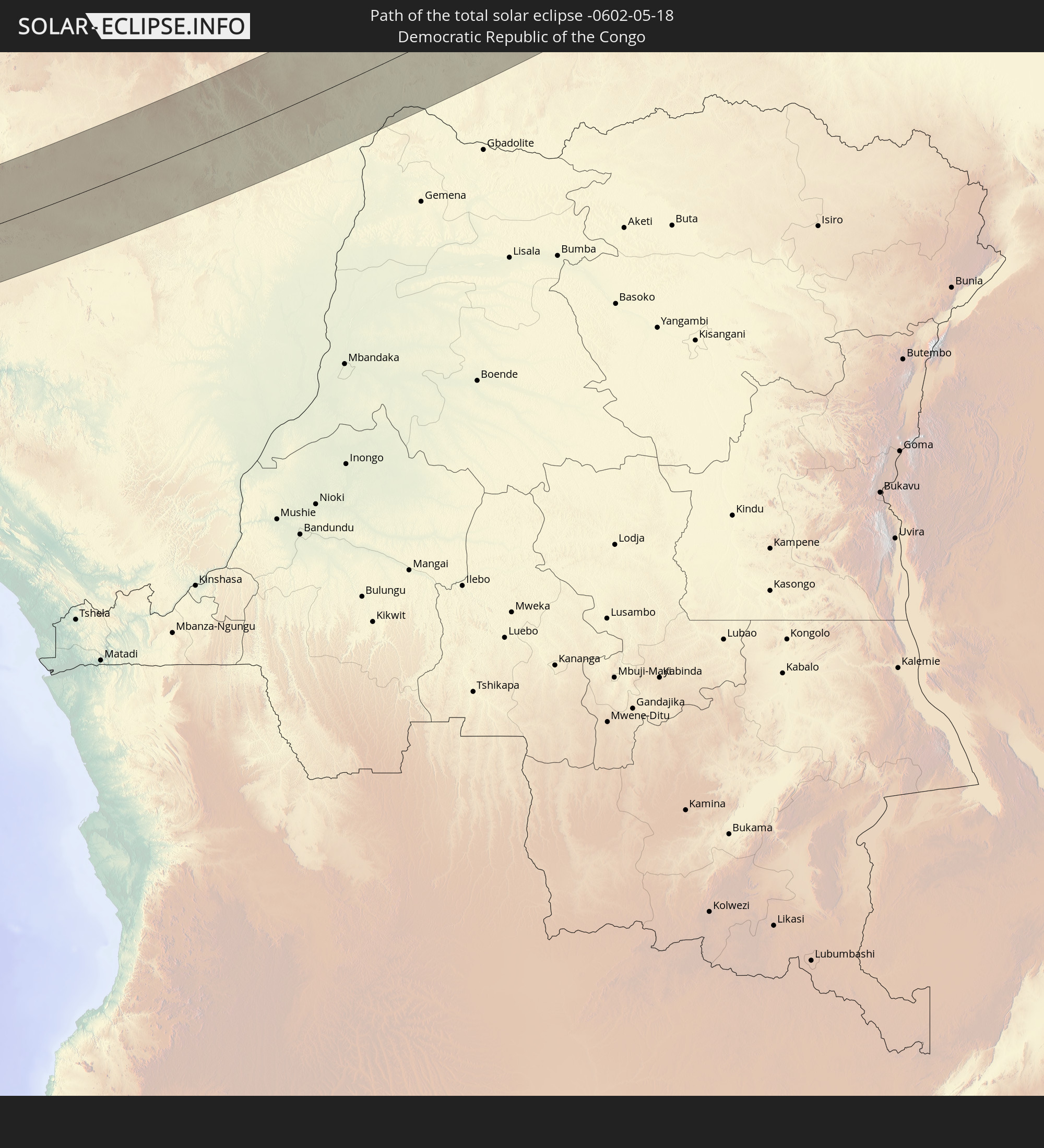 Democratic Republic of the Congo
 Central African Republic
 Sudan
Sudan
 South Sudan
 Saudi Arabia
 Eritrea
 Iran
Iran
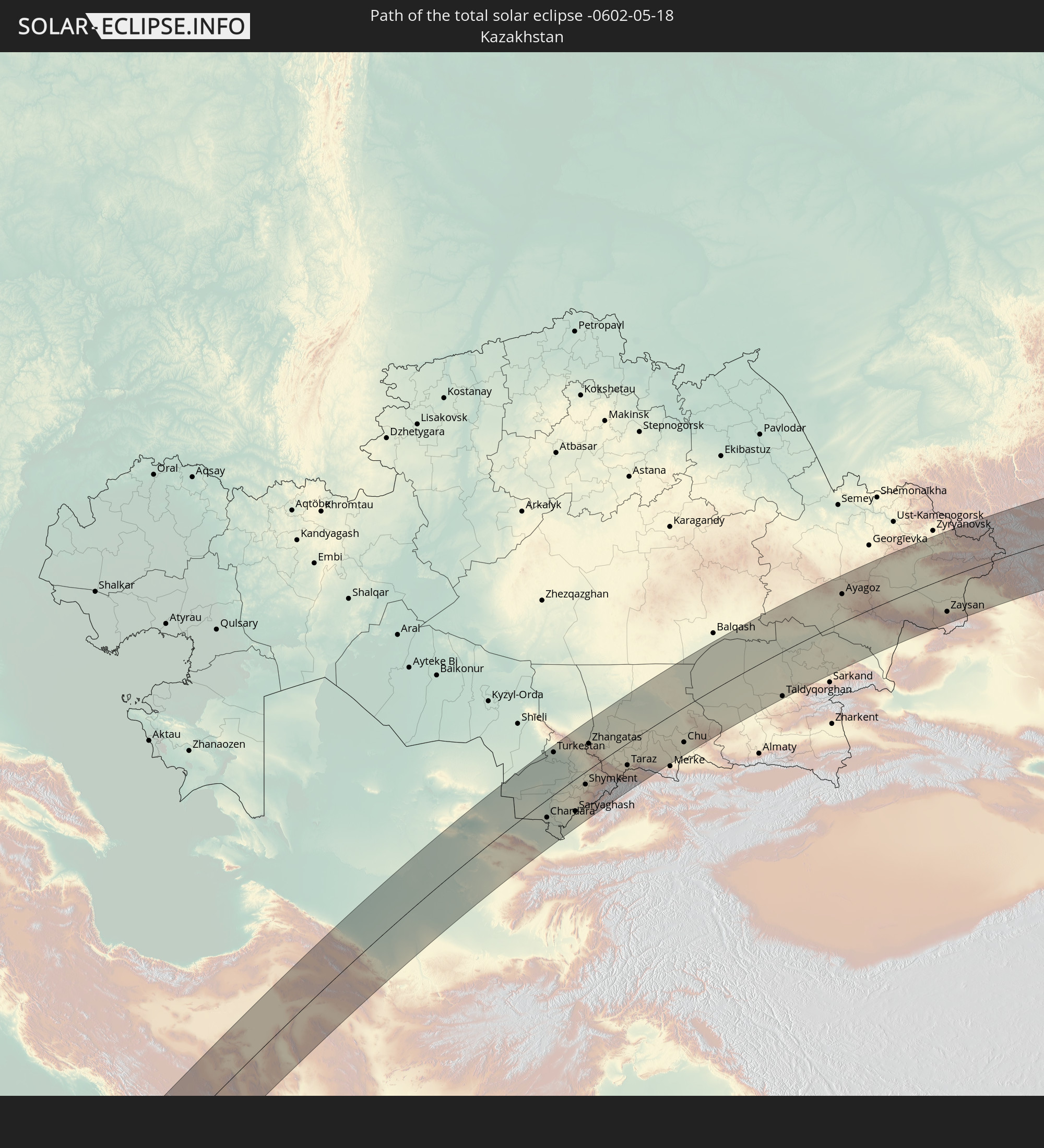 Kazakhstan
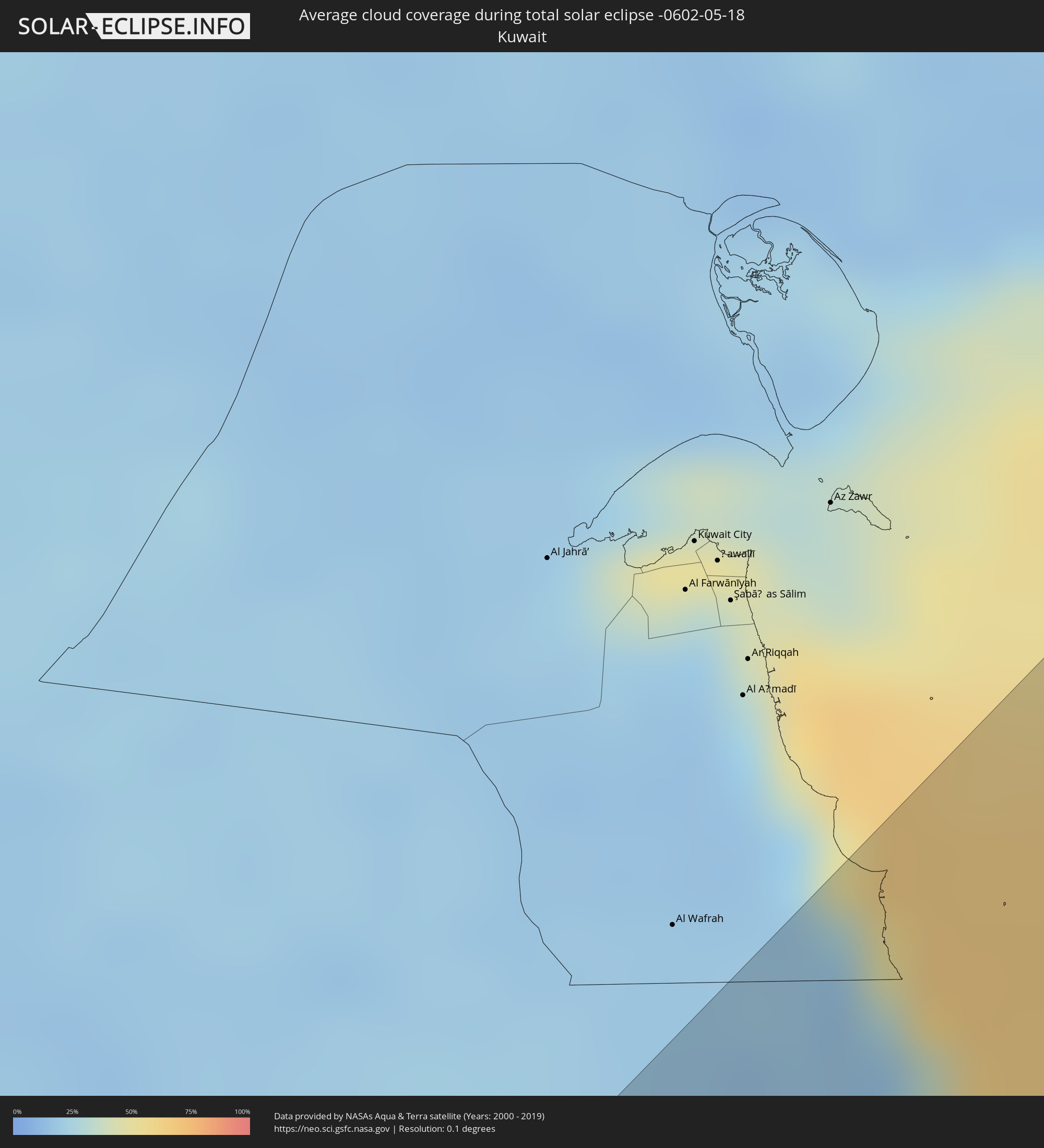
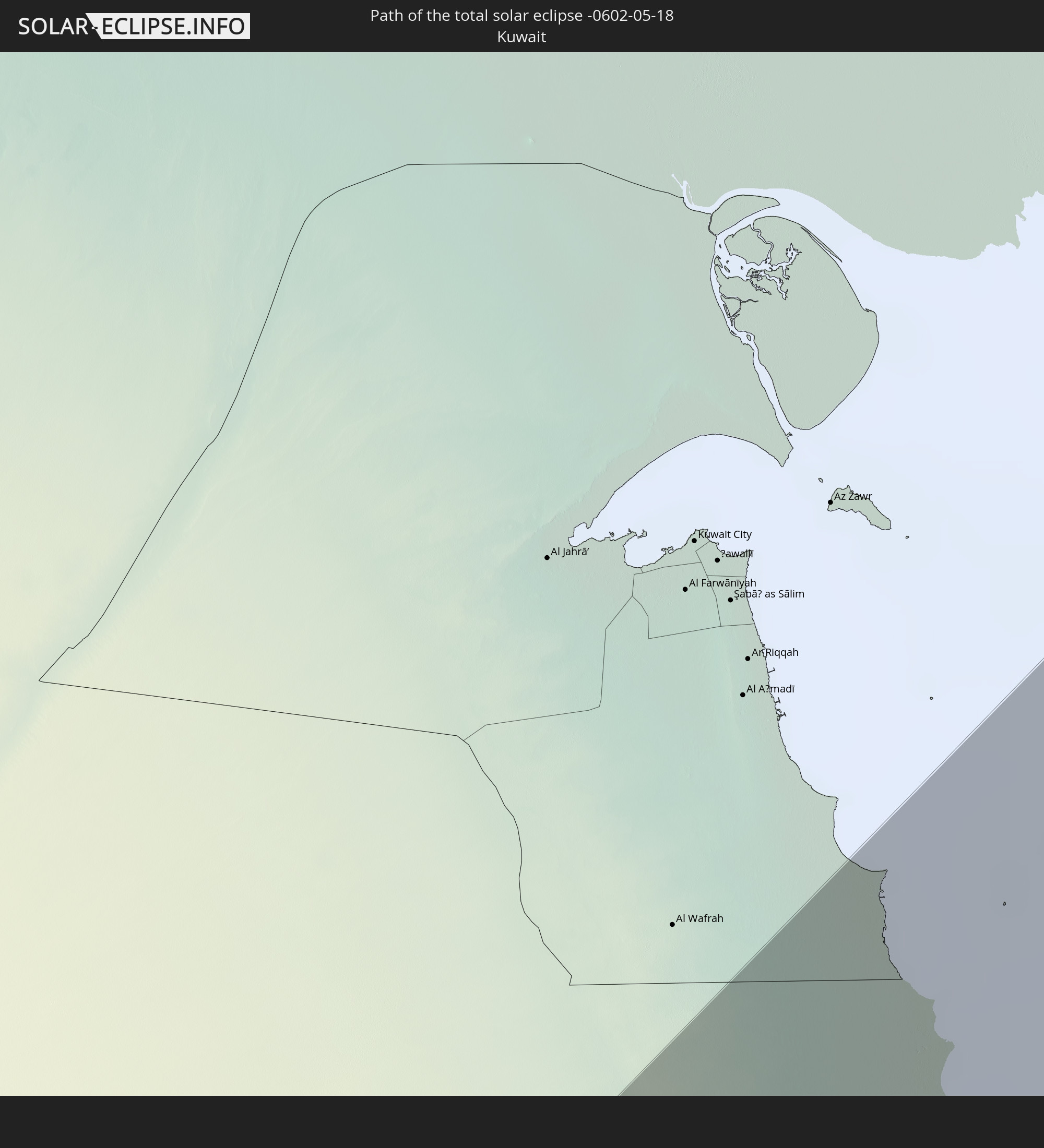 Kuwait
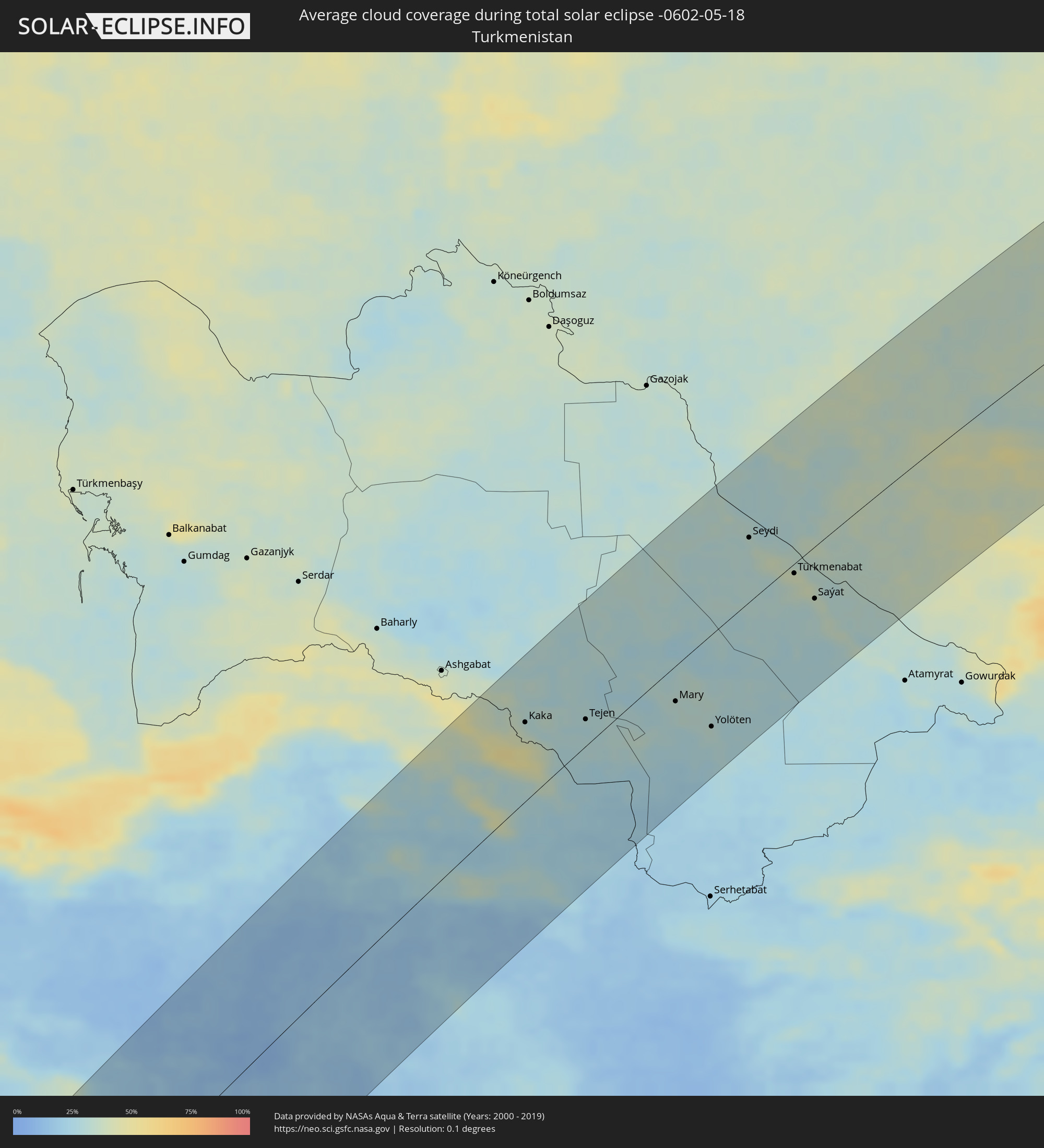
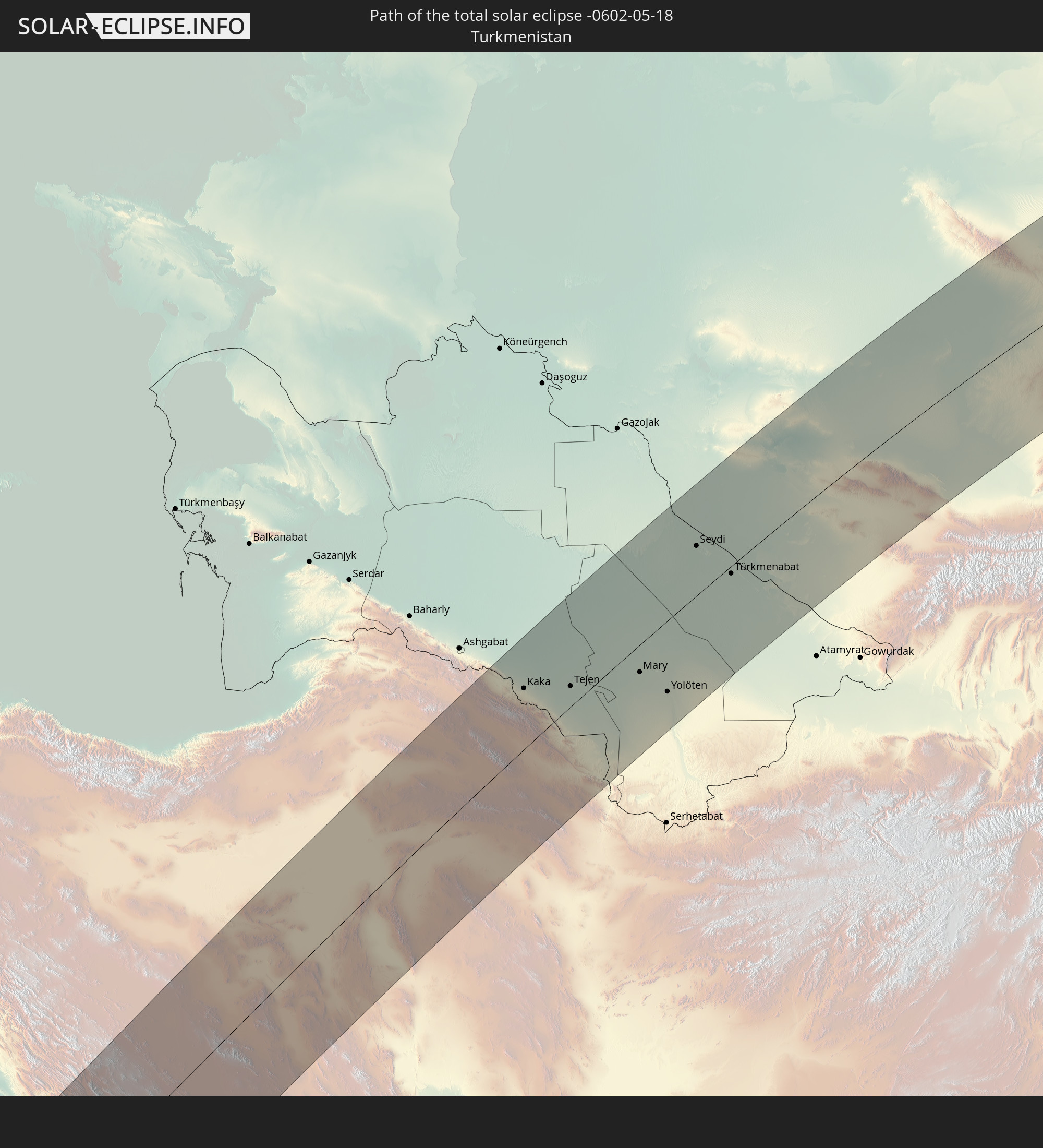 Turkmenistan
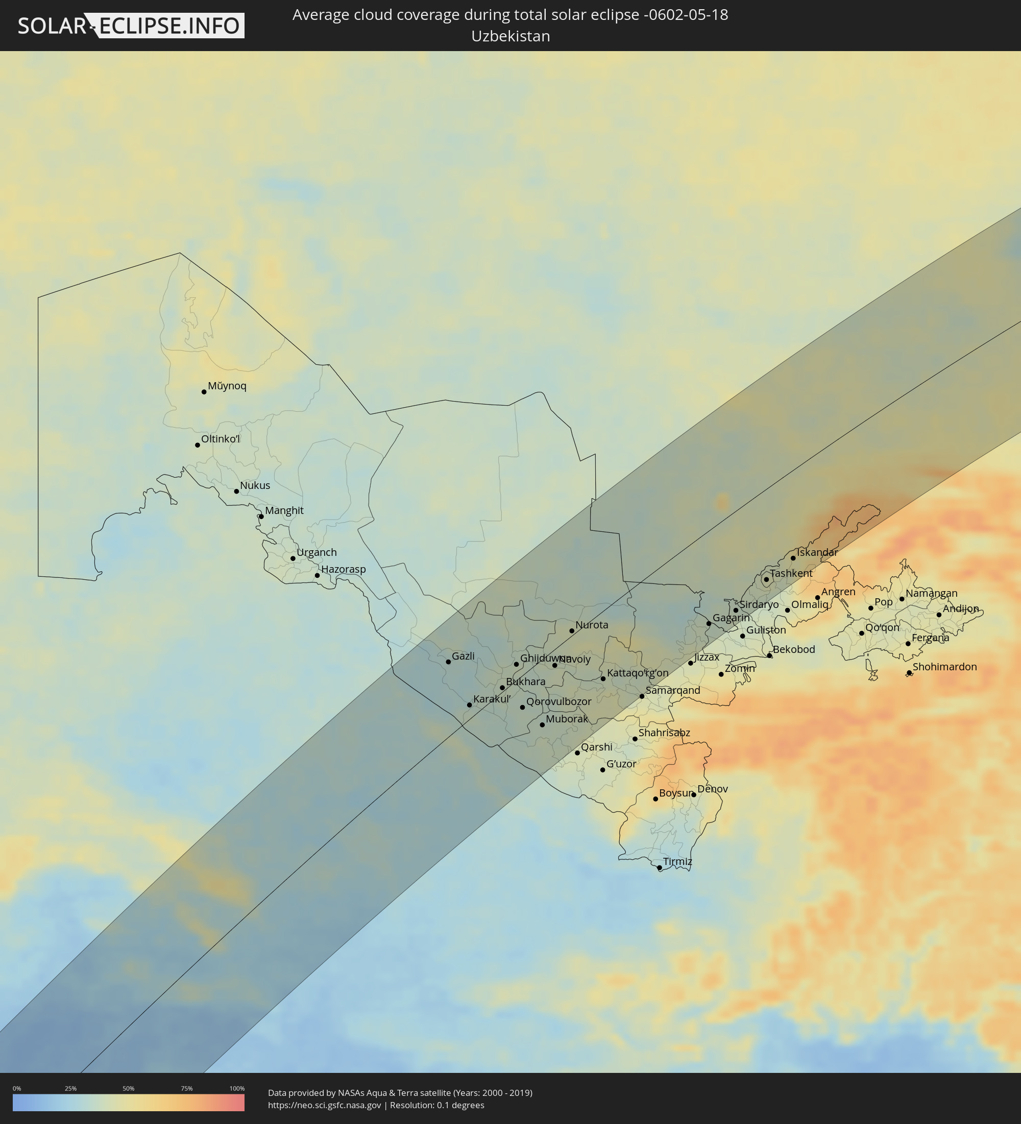
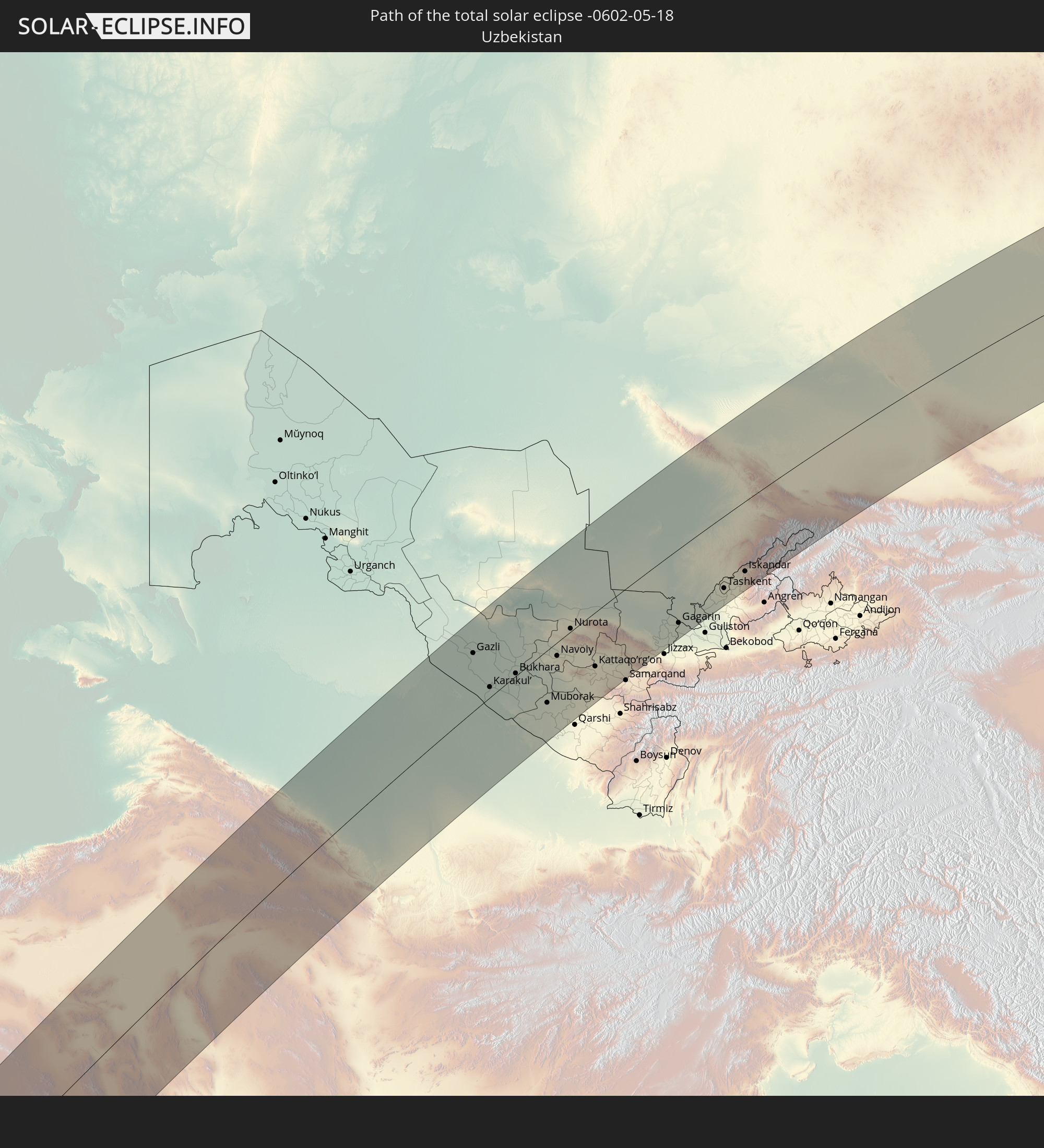 Uzbekistan
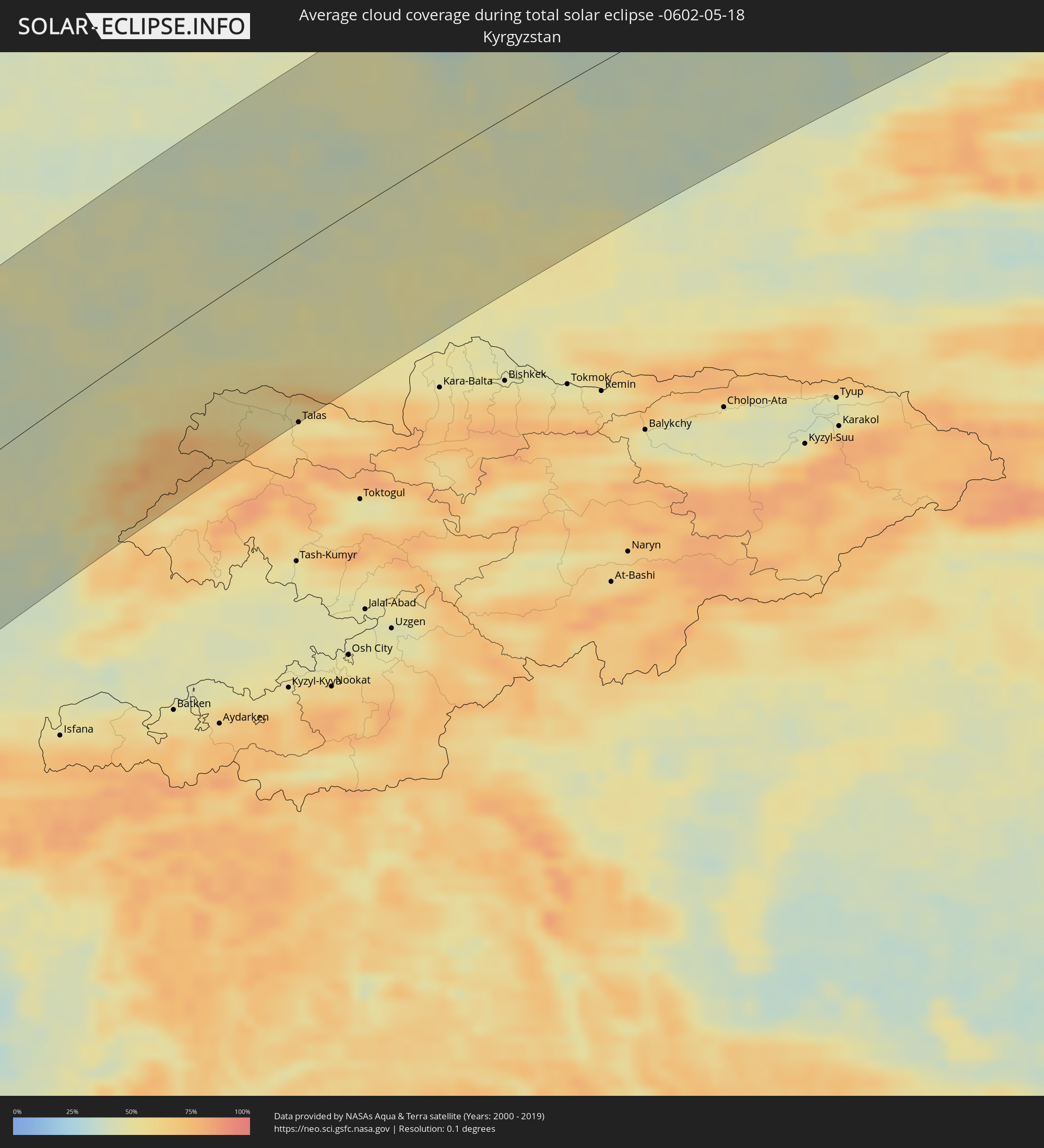
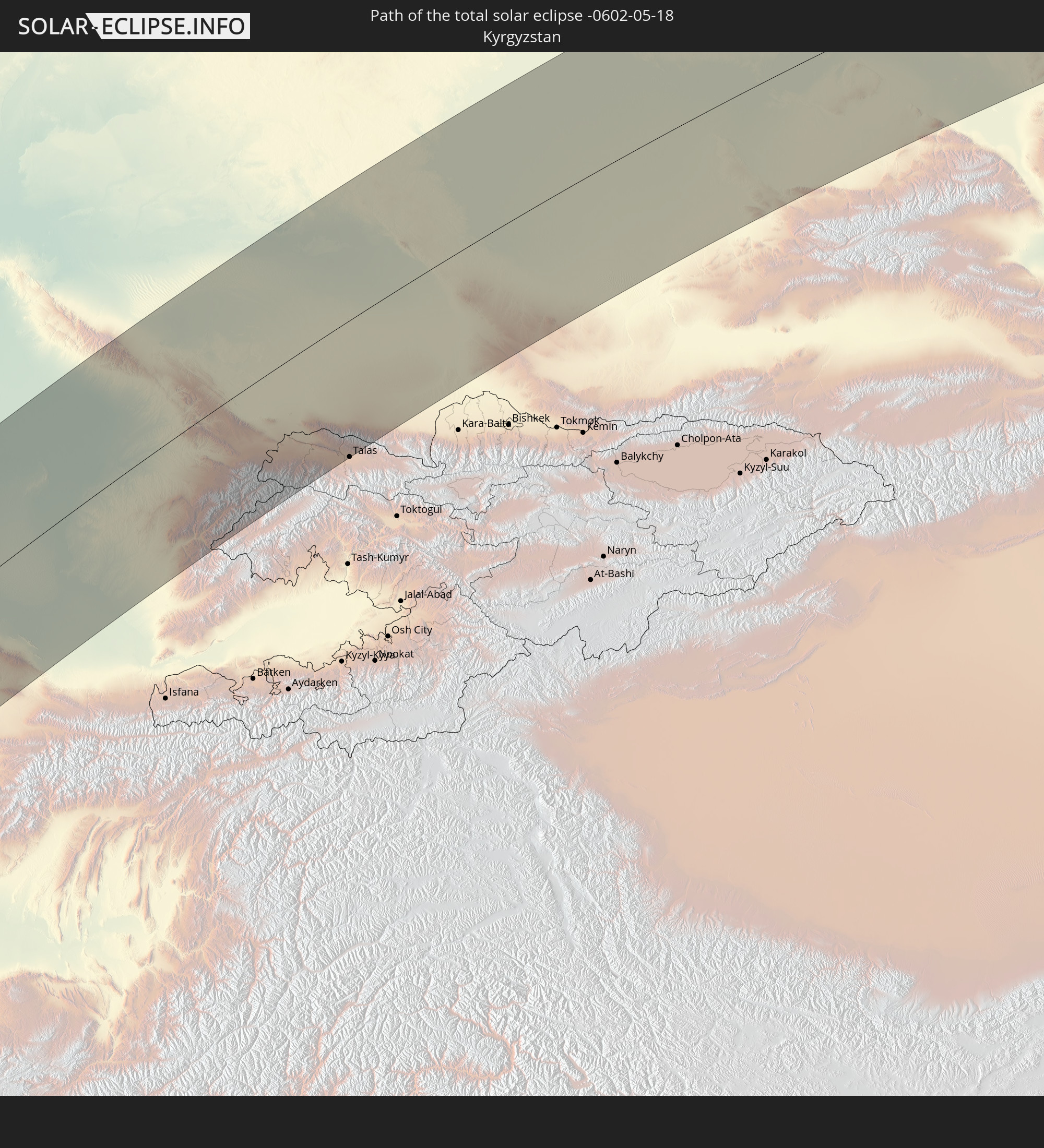 Kyrgyzstan
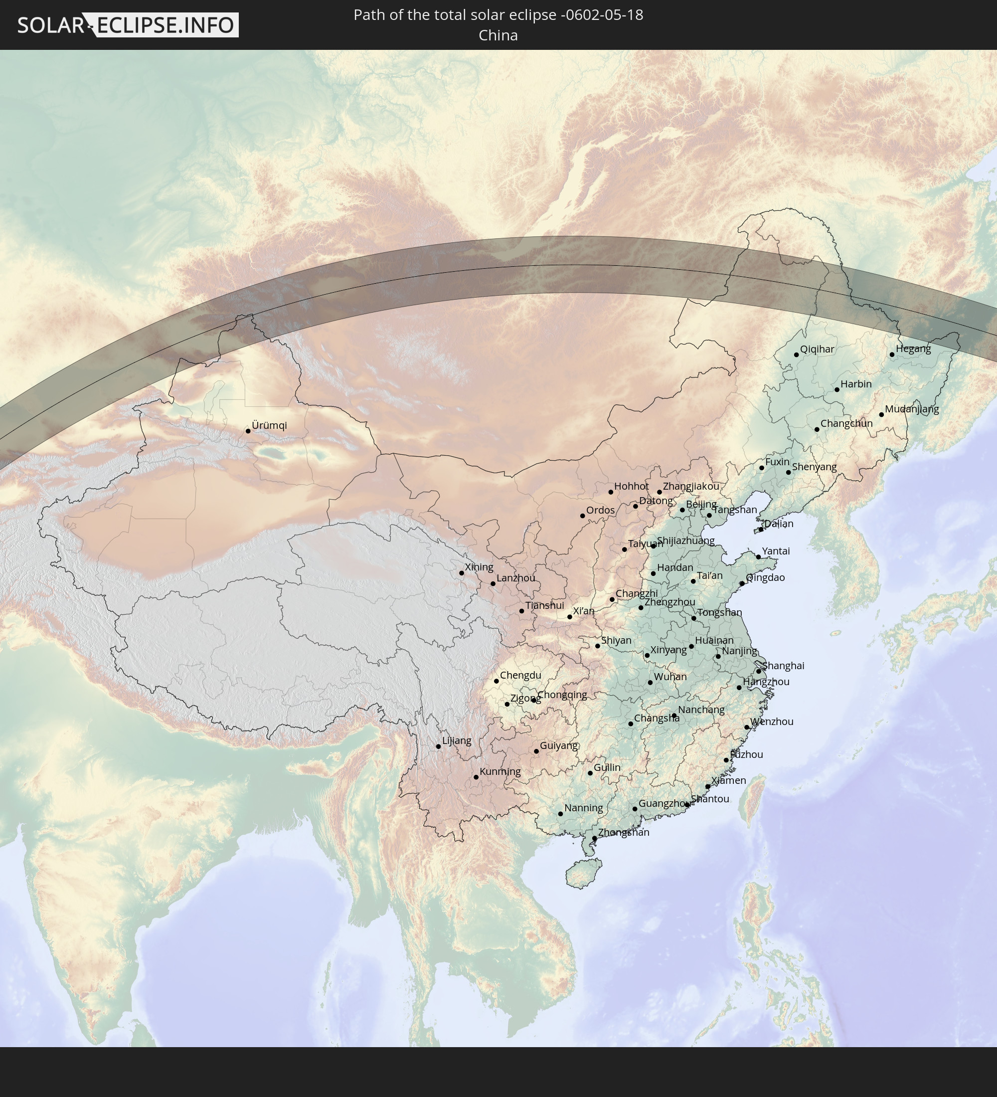 China
China
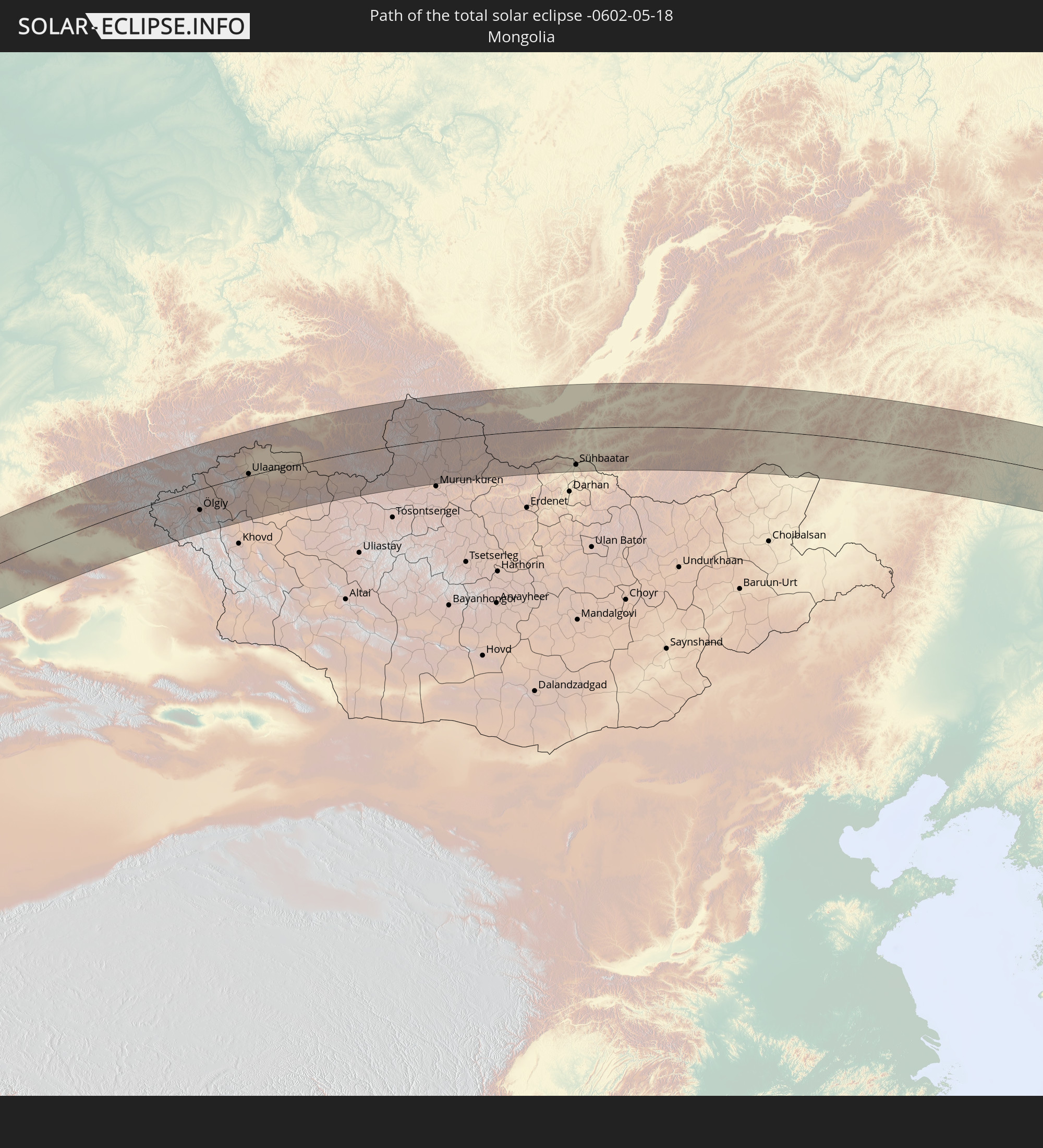 Mongolia
In den folgenden Ländern ist die Sonnenfinsternis partiell zu sehen
 Russia
 United States
 Canada
 Greenland
 Portugal
 Spain
Spain
 Mauritania
 Morocco
 Mali
Mali
 Republic of Ireland
 Svalbard and Jan Mayen
 Algeria
 United Kingdom
 Burkina Faso
 Gibraltar
 France
 Isle of Man
 Guernsey
 Jersey
 Niger
Niger
 Benin
Benin
 Andorra
 Belgium
 Nigeria
 Netherlands
 Norway
 Equatorial Guinea
 Luxembourg
 Germany
 Switzerland
 Italy
Italy
 Monaco
 Tunisia
 Denmark
 Cameroon
 Gabon
Gabon
 Libya
Libya
 Liechtenstein
 Austria
 Sweden
 Republic of the Congo
 Angola
 Namibia
 Czechia
 Democratic Republic of the Congo
 San Marino
 Vatican City
 Slovenia
 Chad
Chad
 Croatia
 Poland
 Malta
Malta
 Central African Republic
 Bosnia and Herzegovina
 Hungary
 South Africa
 Slovakia
 Montenegro
 Serbia
 Albania
 Åland Islands
 Greece
 Botswana
 Romania
 Republic of Macedonia
 Finland
 Lithuania
 Latvia
 Estonia
 Sudan
Sudan
 Zambia
 Ukraine
 Bulgaria
 Belarus
 Egypt
Egypt
 Zimbabwe
 Turkey
 Moldova
 Rwanda
 Burundi
 Tanzania
 Uganda
 Mozambique
 Cyprus
 Malawi
 Ethiopia
 Kenya
Kenya
 State of Palestine
 Israel
 Saudi Arabia
 Jordan
 Lebanon
 Syria
Syria
 Eritrea
 Iraq
Iraq
 Georgia
 French Southern and Antarctic Lands
 Somalia
 Djibouti
 Yemen
Yemen
 Madagascar
 Comoros
 Armenia
 Iran
Iran
 Azerbaijan
 Mayotte
 Seychelles
 Kazakhstan
 Kuwait
 Bahrain
 Qatar
Qatar
 United Arab Emirates
 Oman
Oman
 Turkmenistan
 Uzbekistan
 Afghanistan
 Pakistan
 Tajikistan
 India
India
 Kyrgyzstan
 Maldives
 China
China
 Nepal
Nepal
 Mongolia
 Bangladesh
 Bhutan
 Myanmar
 Thailand
 Laos
Laos
 Vietnam
 Macau
Macau
 Hong Kong
 Taiwan
 Philippines
 Japan
Japan
 North Korea
 South Korea
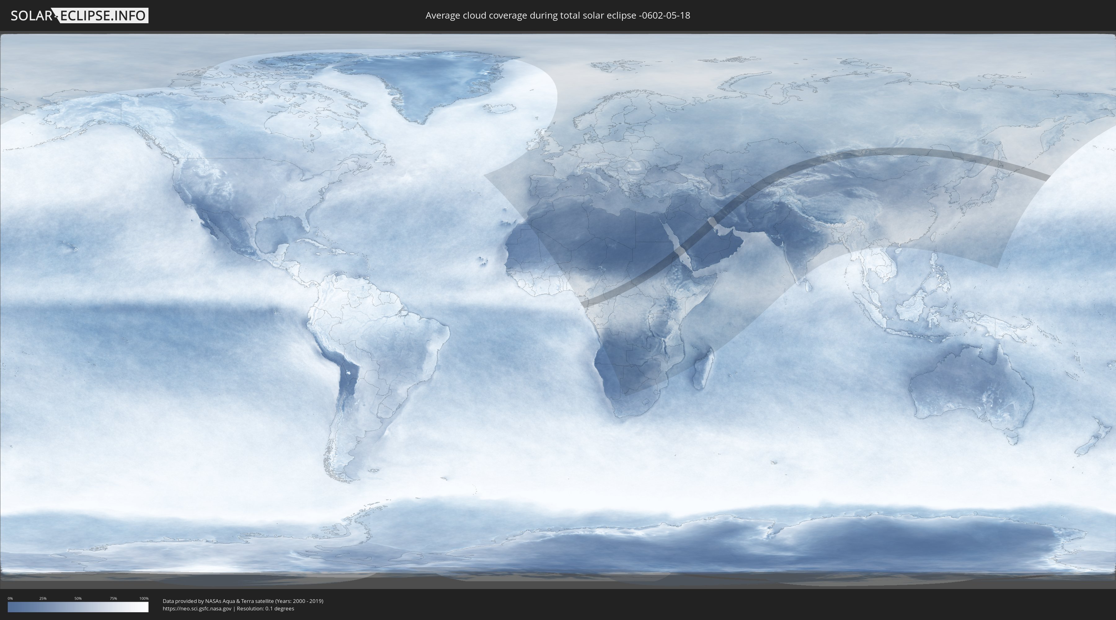
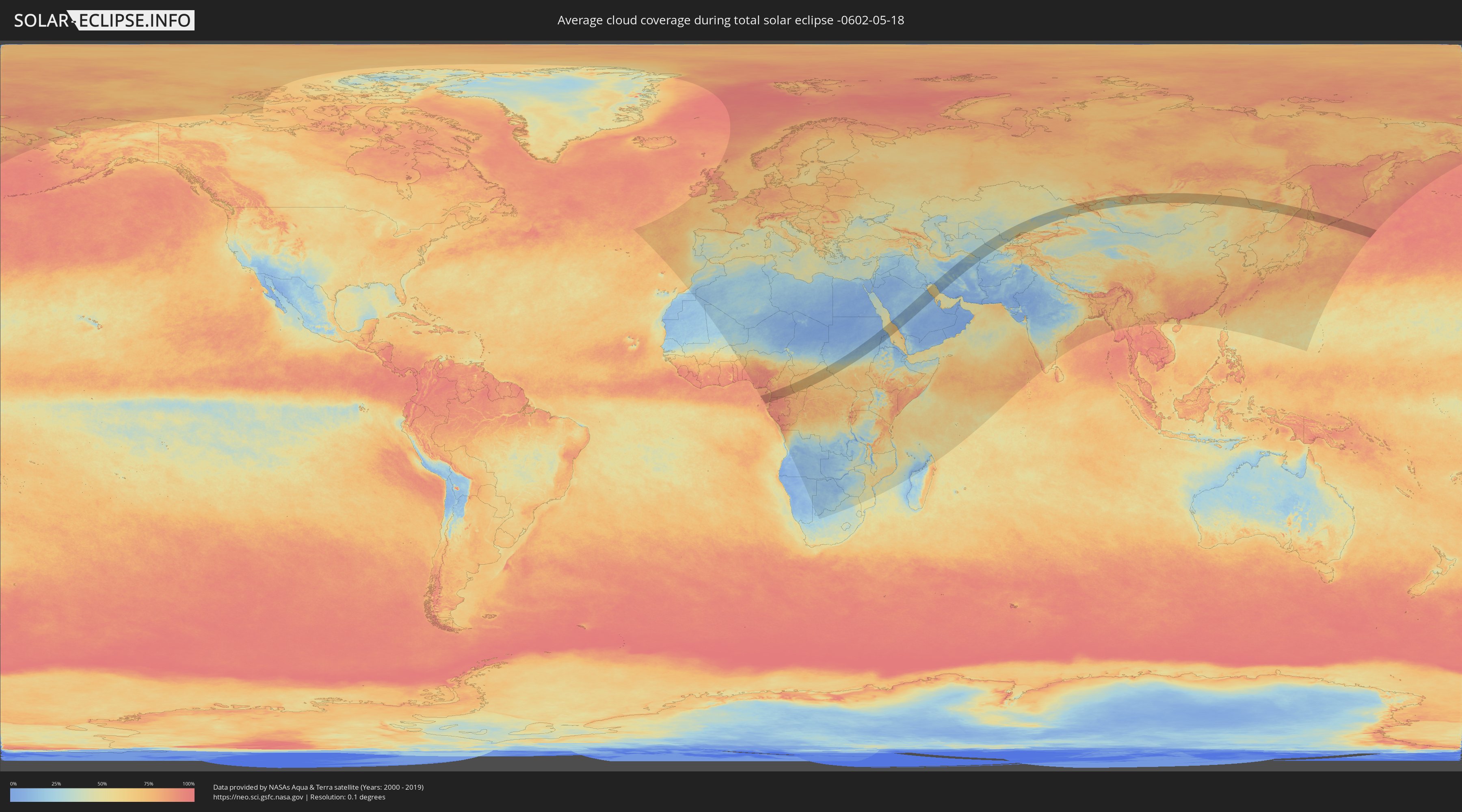
How will be the weather during the total solar eclipse on 05/18/-0602?
Where is the best place to see the total solar eclipse of 05/18/-0602?
The following maps show the average cloud coverage for the day of the total solar eclipse.
With the help of these maps, it is possible to find the place along the eclipse path, which has the best
chance of a cloudless sky.
Nevertheless, you should consider local circumstances and inform about the weather of your chosen
observation site.
The data is provided by NASAs satellites
AQUA and TERRA.
The cloud maps are averaged over a period of 19 years (2000 - 2019).
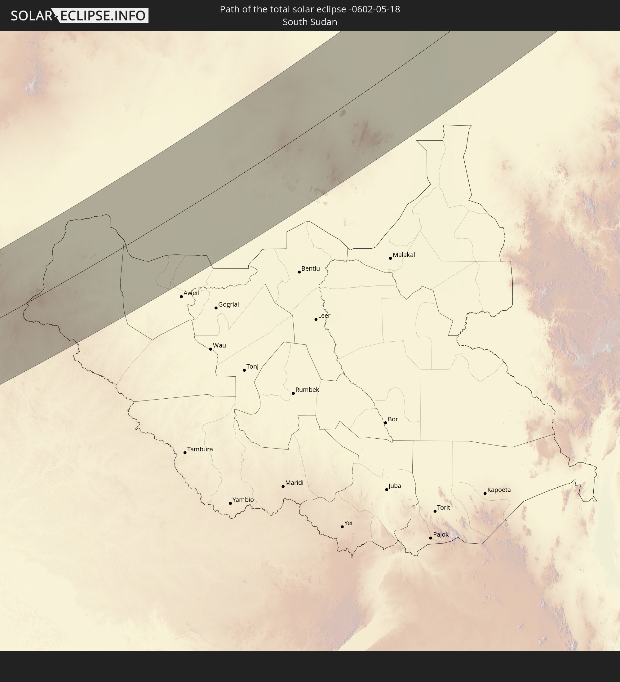
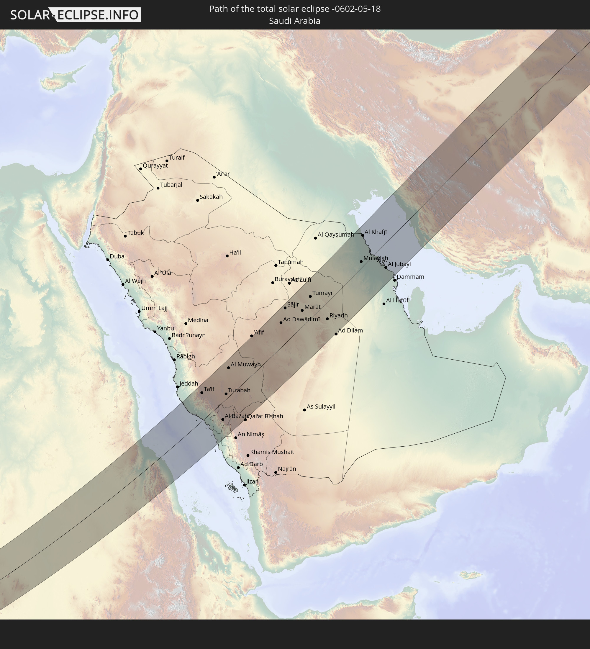
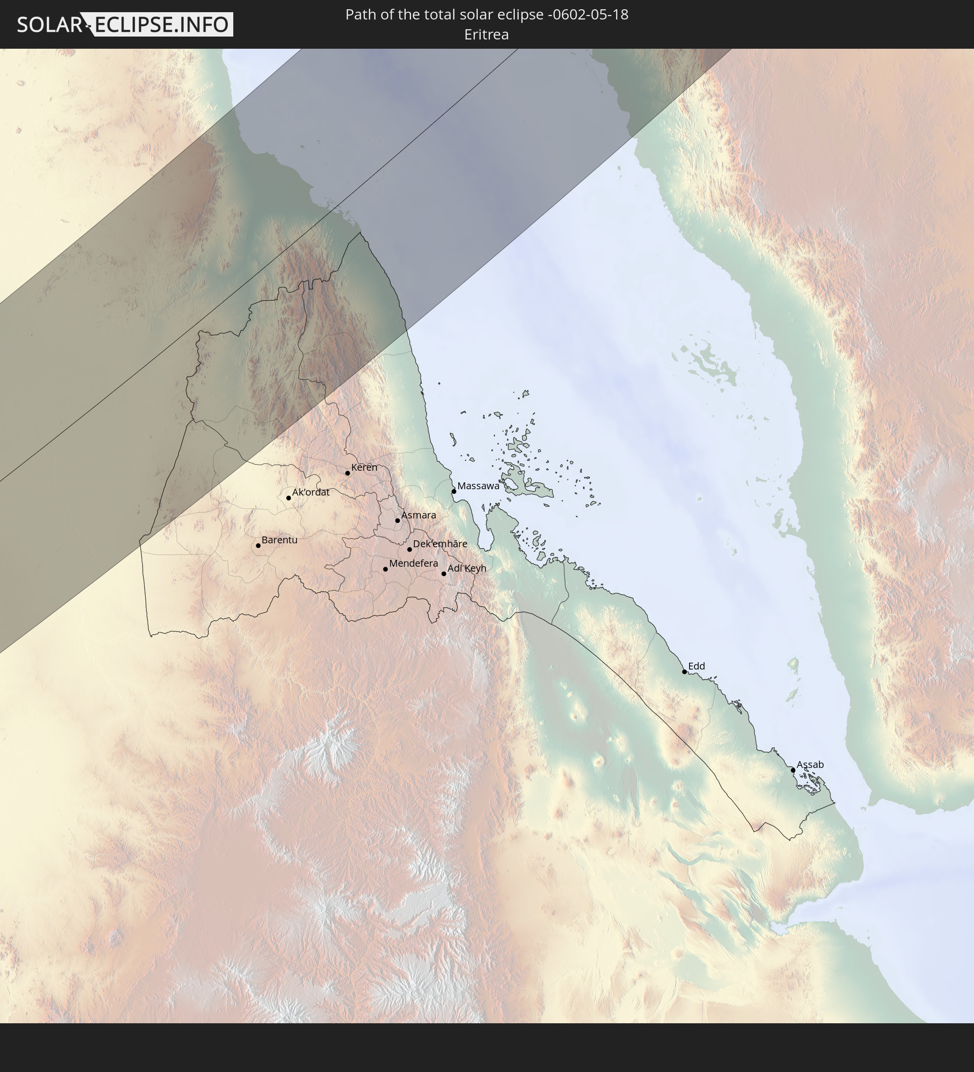
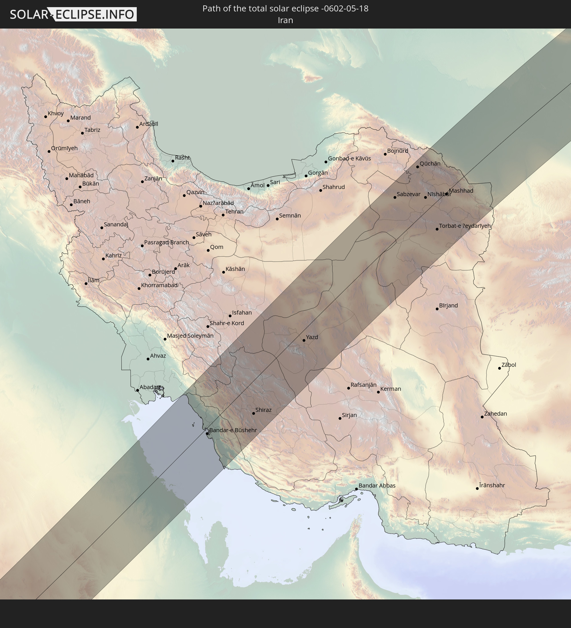
Detailed country maps
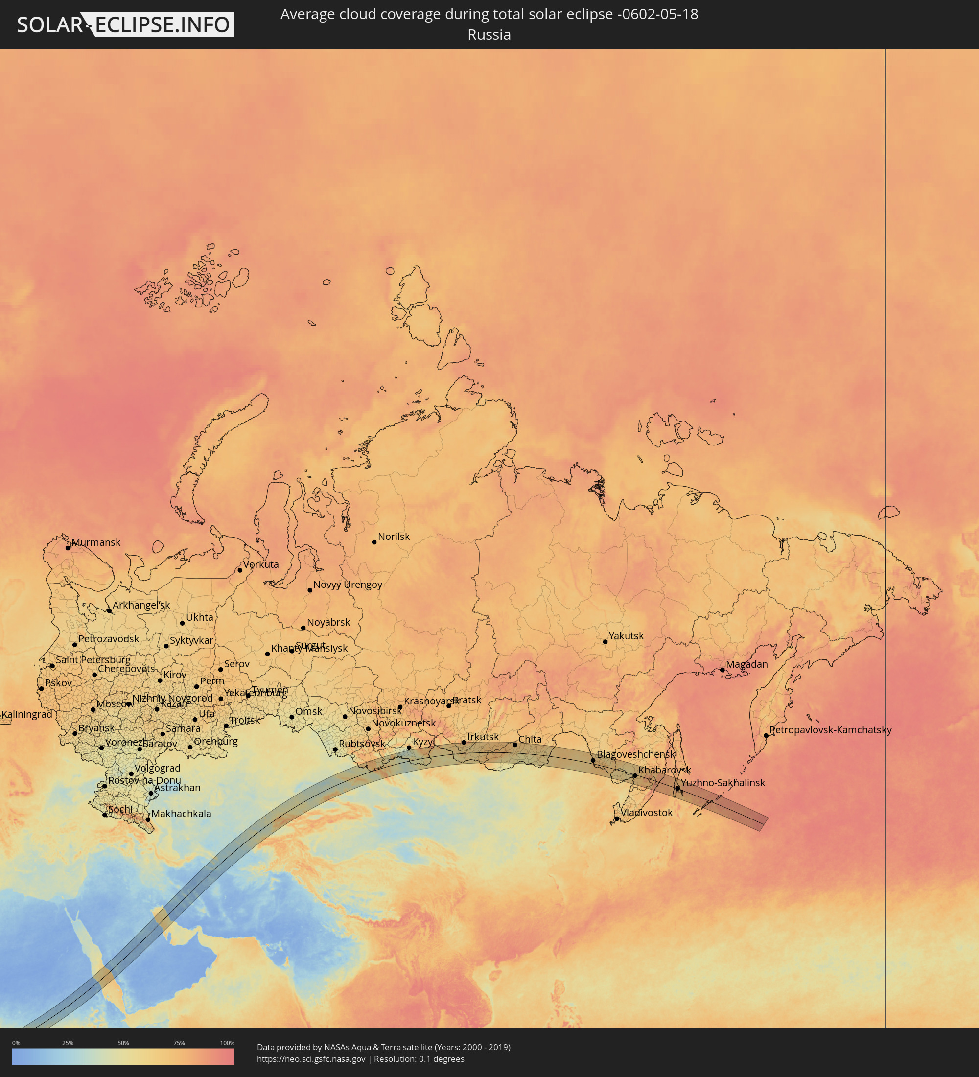 Russia
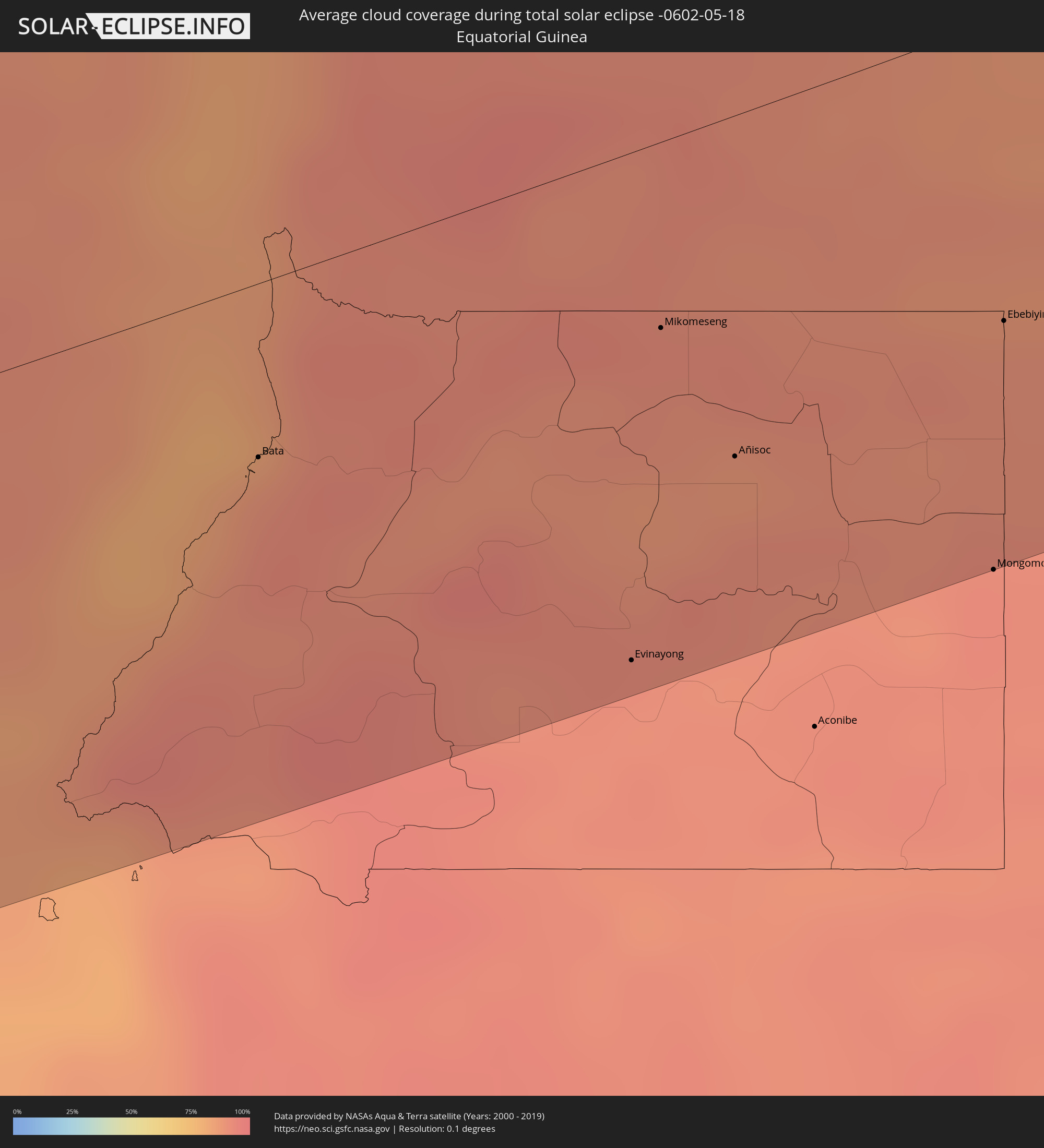 Equatorial Guinea
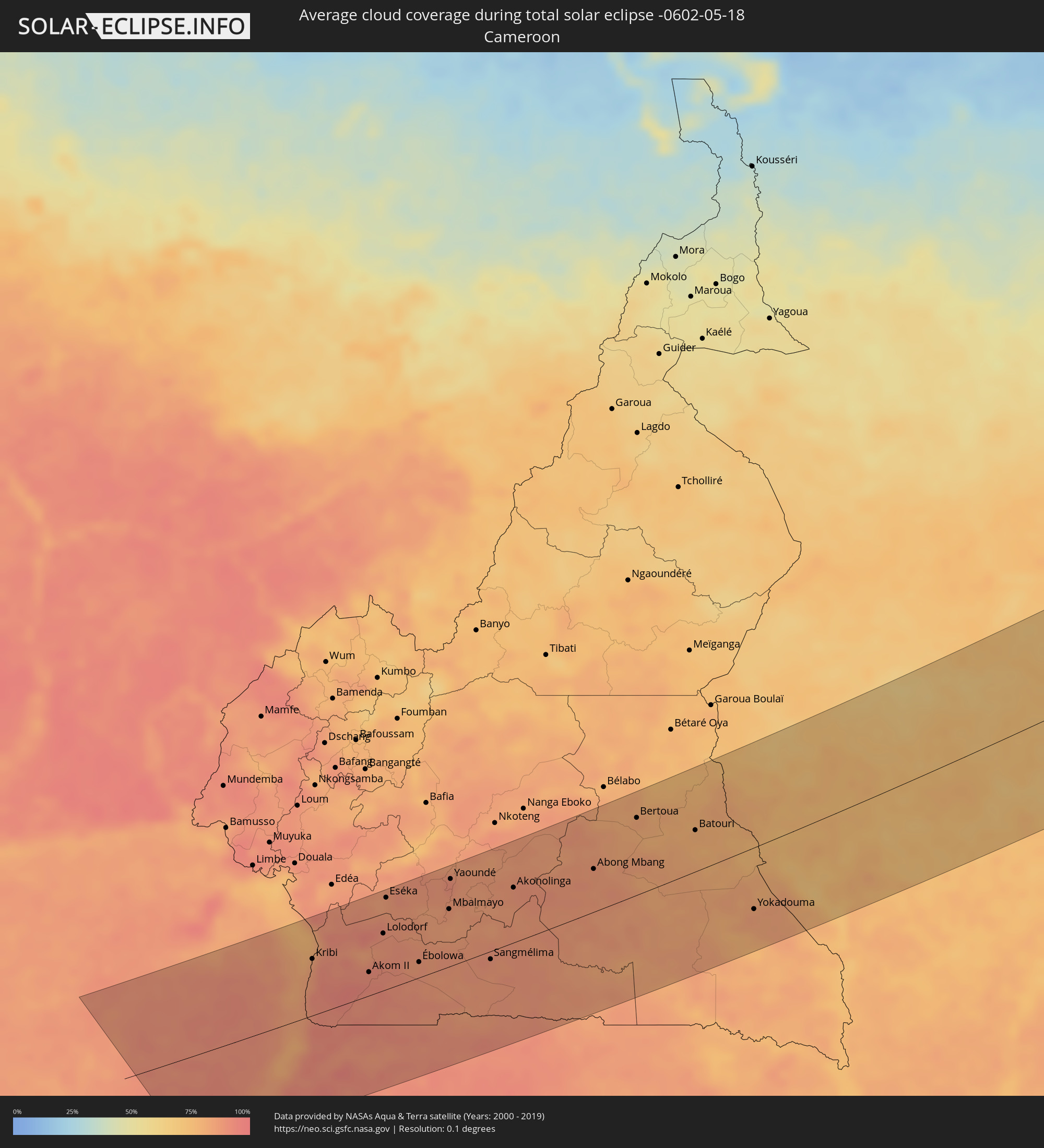 Cameroon
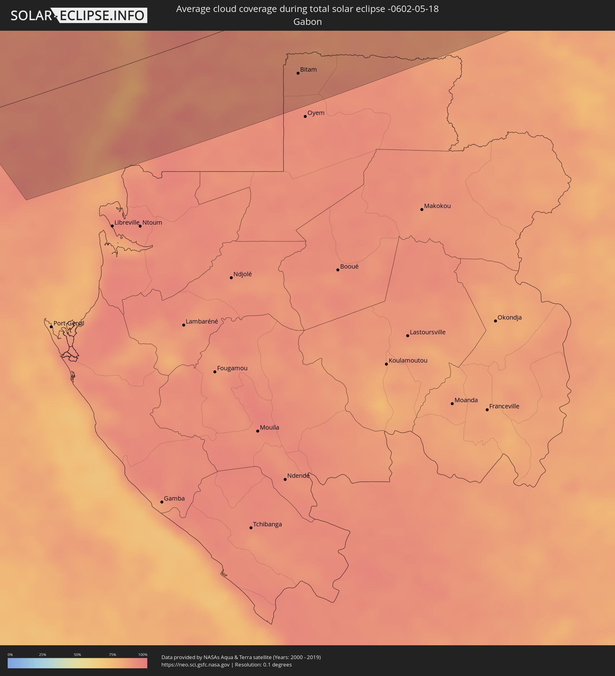 Gabon
Gabon
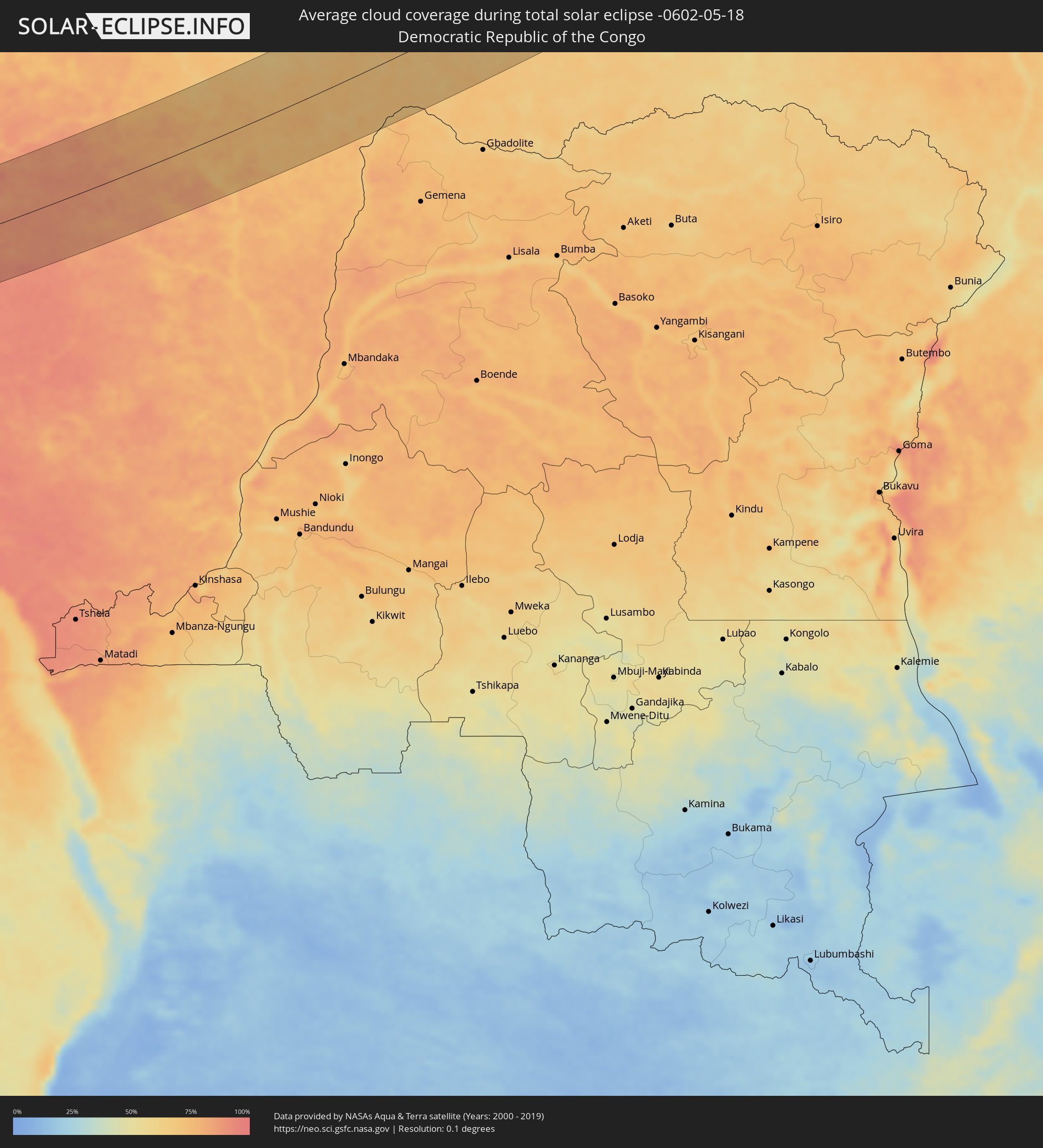 Democratic Republic of the Congo
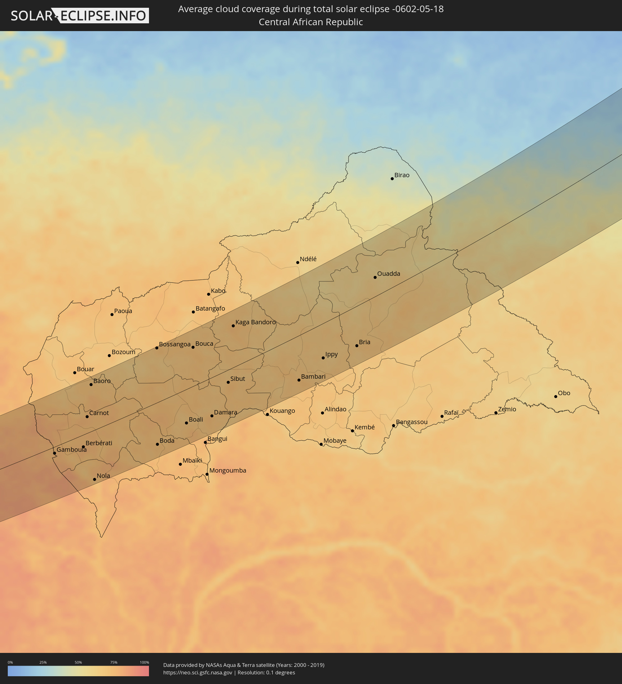 Central African Republic
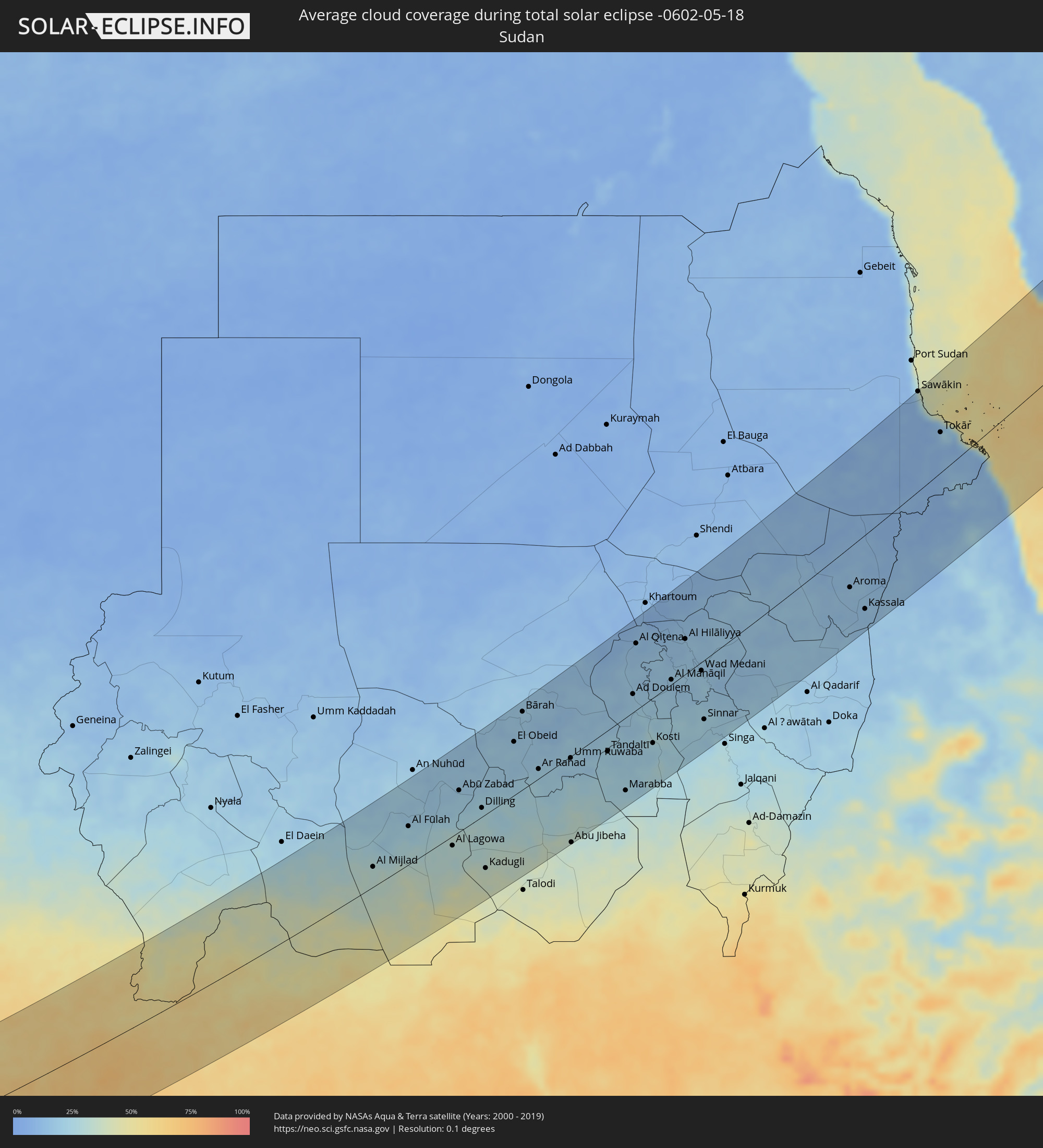 Sudan
Sudan
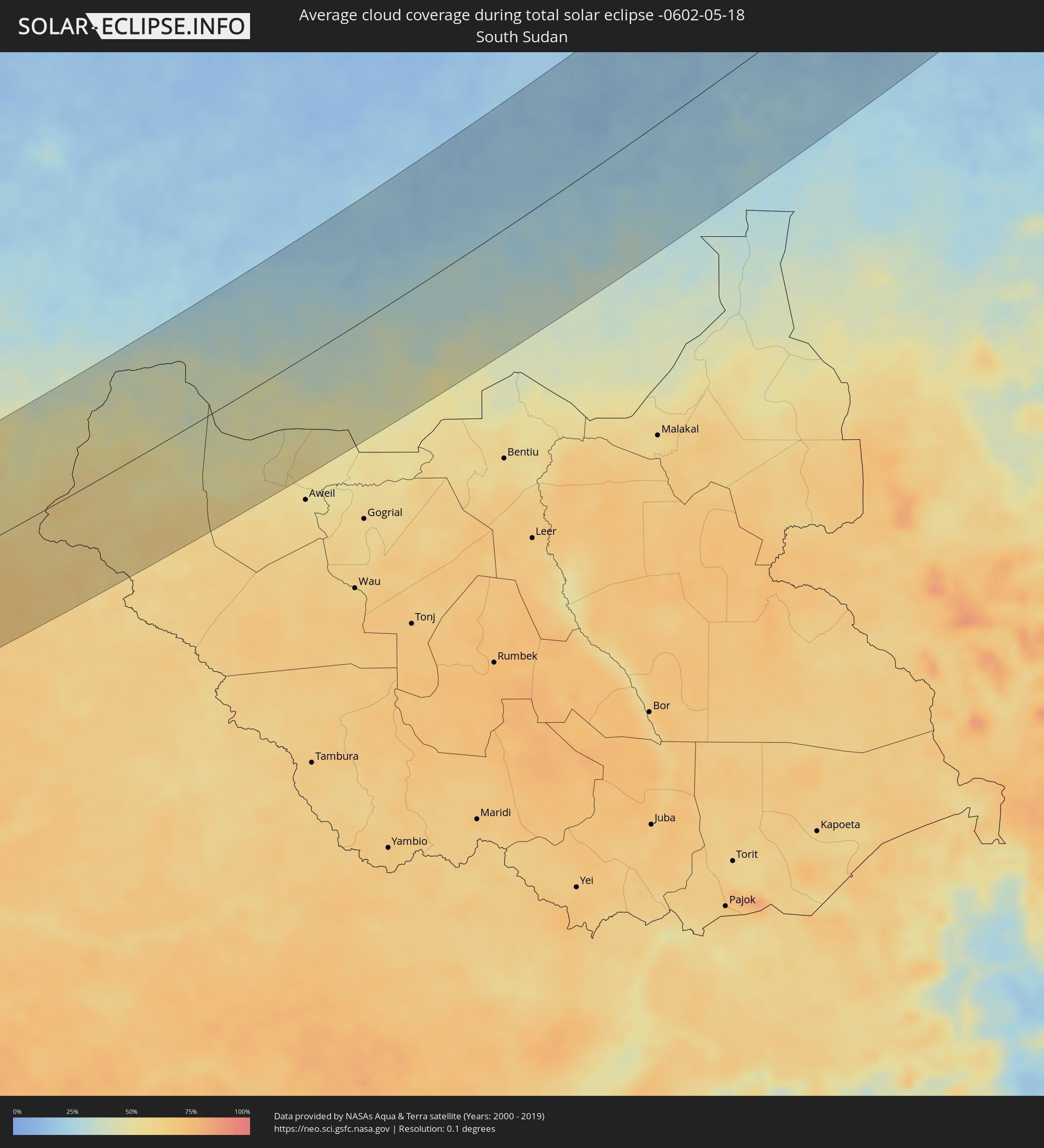 South Sudan
 Saudi Arabia
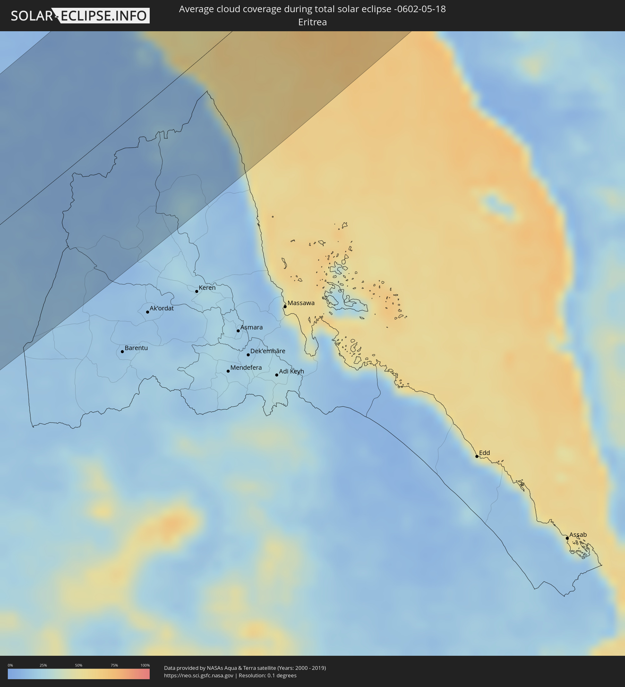 Eritrea
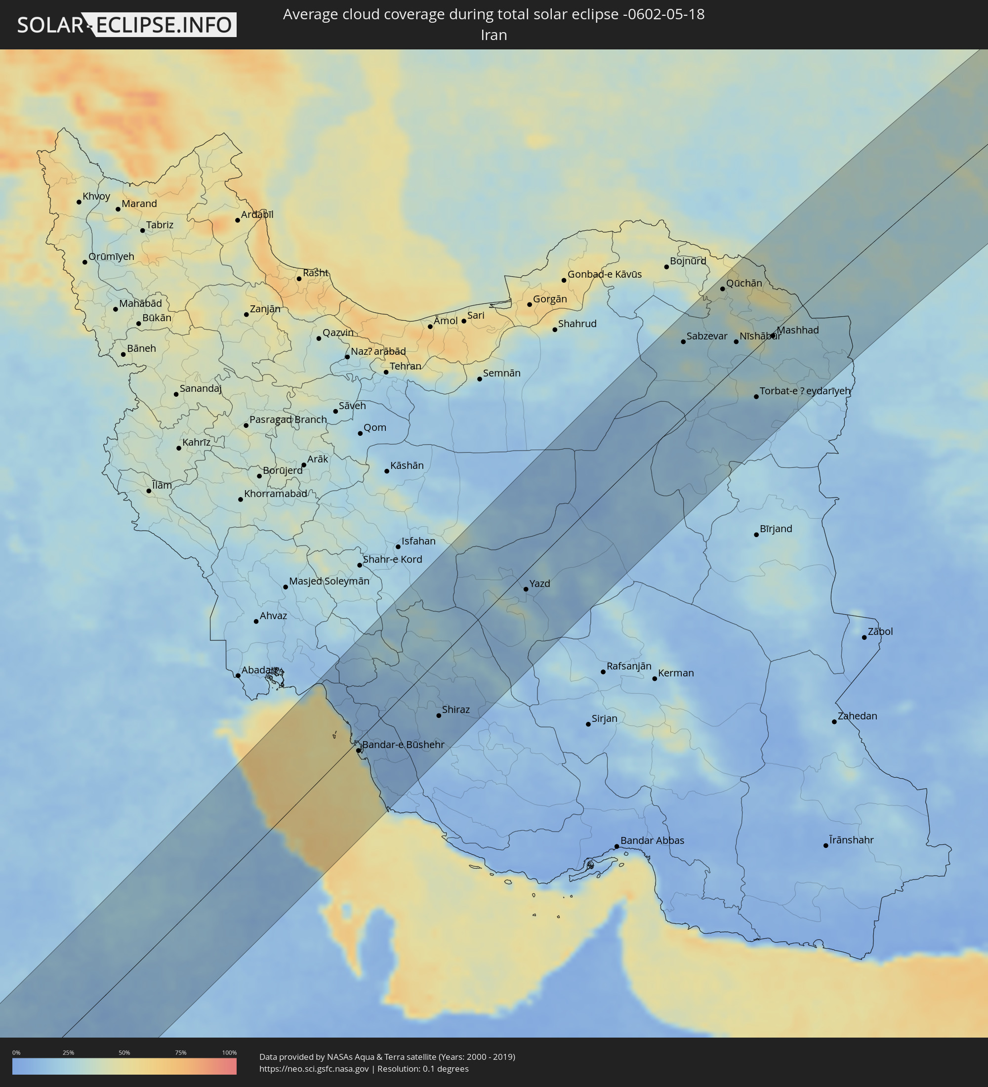 Iran
Iran
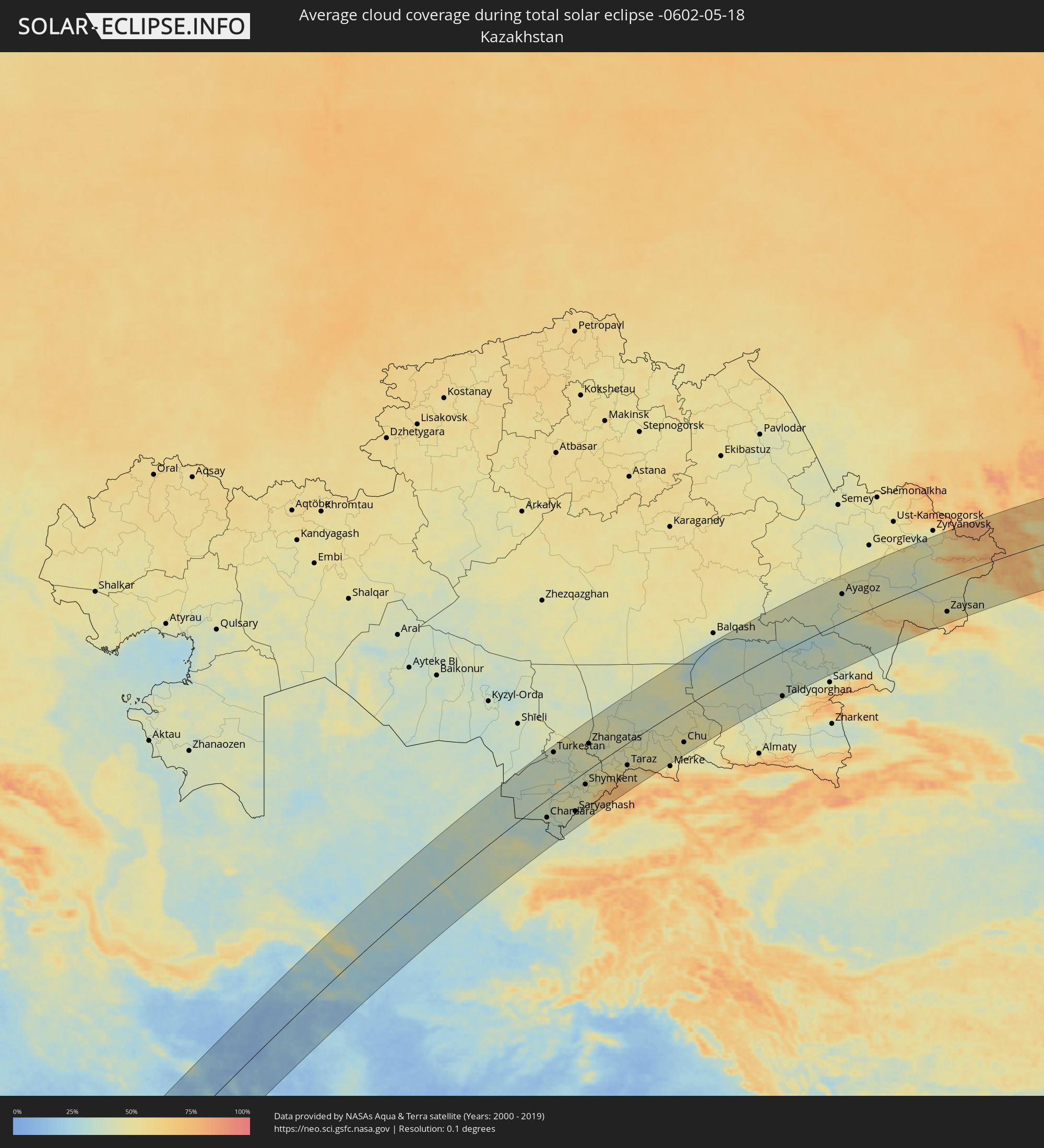 Kazakhstan
 Kuwait
 Turkmenistan
 Uzbekistan
 Kyrgyzstan
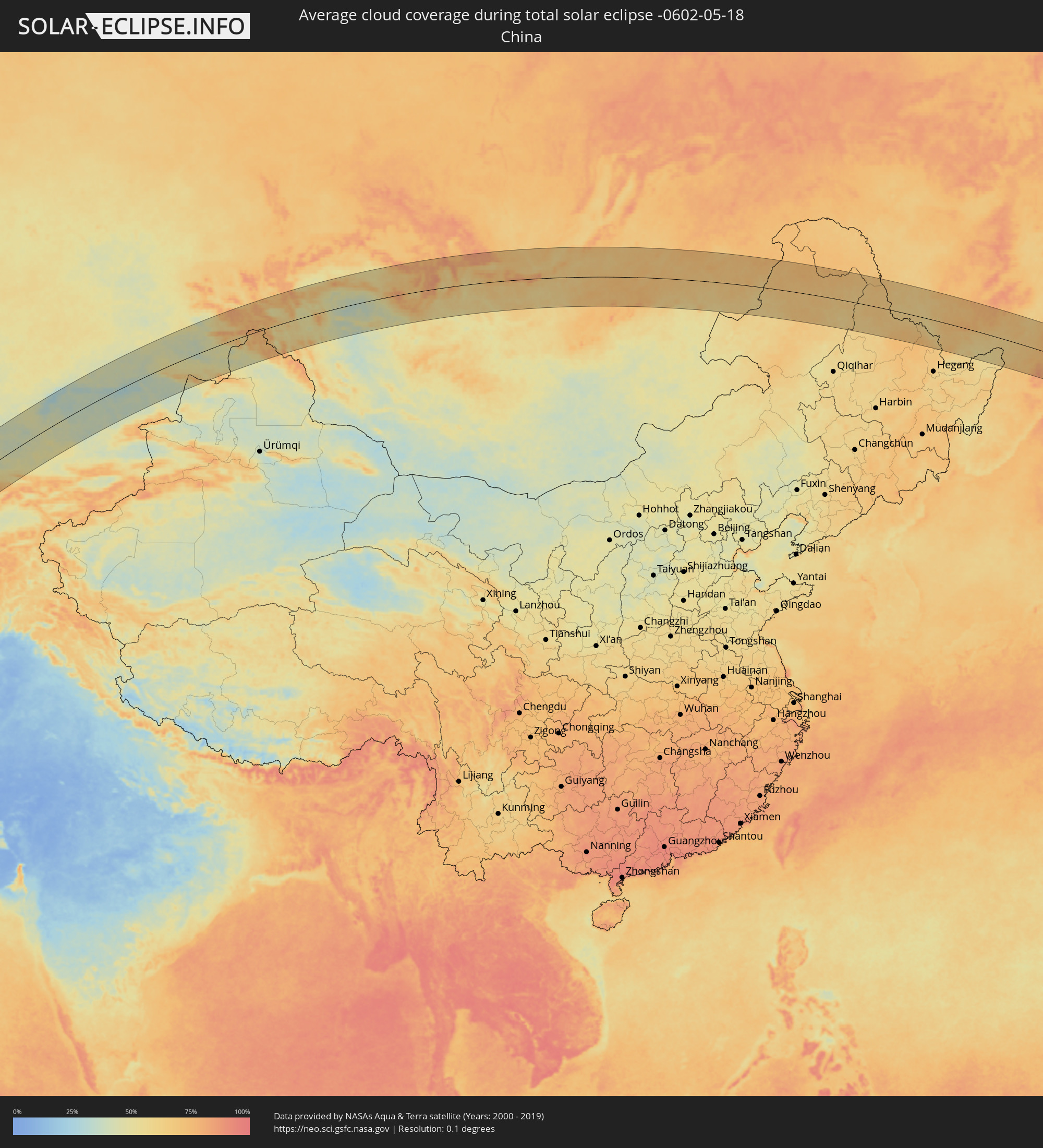 China
China
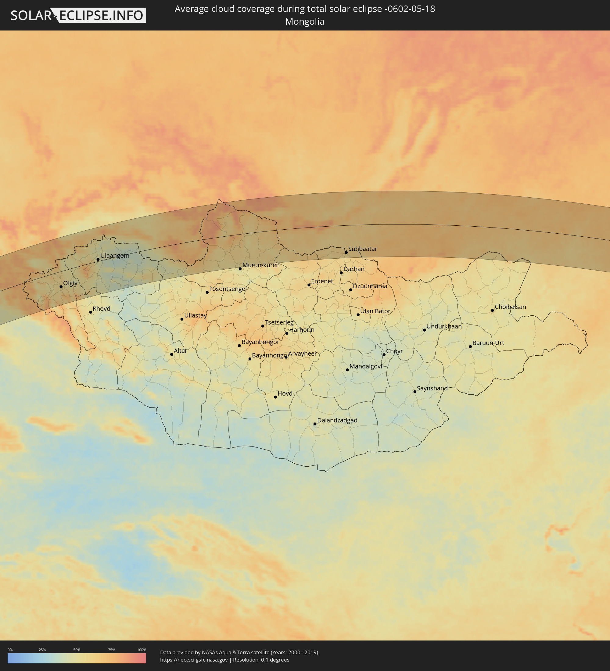 Mongolia
Cities inside the path of the eclipse
The following table shows all locations with a population of more than 5,000 inside the eclipse path. Cities which have more than 100,000 inhabitants are marked bold. A click at the locations opens a detailed map.
| City | Type | Eclipse duration | Local time of max. eclipse | Distance to central line | Ø Cloud coverage |
|
Bata, Litoral
|
total | - | 05:32:22 UTC+00:13 | 39 km | 88% |
|
Kribi, South
|
total | - | 05:33:15 UTC+00:13 | 69 km | 85% |
|
Evinayong, Centro Sur
|
total | - | 05:31:51 UTC+00:13 | 112 km | 90% |
|
Akom II, South
|
total | - | 05:32:59 UTC+00:13 | 29 km | 91% |
|
Mikomeseng, Kié-Ntem
|
total | - | 05:32:26 UTC+00:13 | 41 km | 91% |
|
Lolodorf, South
|
total | - | 05:33:21 UTC+00:13 | 69 km | 89% |
|
Eséka, Centre
|
total | - | 05:33:43 UTC+00:13 | 112 km | 86% |
|
Añisoc, Wele-Nzas
|
total | - | 05:32:10 UTC+00:13 | 75 km | 87% |
|
Ébolowa, South
|
total | - | 05:32:59 UTC+00:13 | 19 km | 88% |
|
Ambam, South
|
total | - | 05:32:31 UTC+00:13 | 40 km | 88% |
|
Ebebiyin, Kié-Ntem
|
total | - | 05:32:18 UTC+00:13 | 67 km | 89% |
|
Mbalmayo, Centre
|
total | - | 05:33:28 UTC+00:13 | 70 km | 86% |
|
Bitam, Woleu-Ntem
|
total | - | 05:32:13 UTC+00:13 | 81 km | 90% |
|
Yaoundé, Centre
|
total | - | 05:33:47 UTC+00:13 | 106 km | 91% |
|
Sangmélima, South
|
total | - | 05:32:52 UTC+00:13 | 10 km | 87% |
|
Akonolinga, Centre
|
total | - | 05:33:35 UTC+00:13 | 67 km | 88% |
|
Abong Mbang, East
|
total | - | 05:33:39 UTC+00:13 | 52 km | 86% |
|
Doumé, East
|
total | - | 05:33:51 UTC+00:13 | 67 km | 81% |
|
Dimako, East
|
total | - | 05:33:59 UTC+00:13 | 77 km | 81% |
|
Bertoua, East
|
total | - | 05:34:09 UTC+00:13 | 93 km | 83% |
|
Batouri, East
|
total | - | 05:33:57 UTC+00:13 | 50 km | 79% |
|
Yokadouma, East
|
total | - | 05:33:02 UTC+00:13 | 74 km | 83% |
|
Gamboula, Mambéré-Kadéï
|
total | - | 05:33:35 UTC+00:13 | 16 km | 77% |
|
Berbérati, Mambéré-Kadéï
|
total | - | 05:33:41 UTC+00:13 | 29 km | 78% |
|
Carnot, Mambéré-Kadéï
|
total | - | 05:34:20 UTC+00:13 | 37 km | 75% |
|
Baoro, Nana-Mambéré
|
total | - | 05:35:03 UTC+00:13 | 107 km | 72% |
|
Nola, Sangha-Mbaéré
|
total | - | 05:32:58 UTC+00:13 | 115 km | 73% |
|
Bossangoa, Ouham
|
total | - | 05:35:52 UTC+00:13 | 124 km | 73% |
|
Boda, Lobaye
|
total | - | 05:33:40 UTC+00:13 | 97 km | 72% |
|
Boali, Ombella-M'Poko
|
total | - | 05:34:08 UTC+00:13 | 78 km | 72% |
|
Bouca, Ouham
|
total | - | 05:35:53 UTC+00:13 | 88 km | 73% |
|
Damara, Ombella-M'Poko
|
total | - | 05:34:18 UTC+00:13 | 88 km | 72% |
|
Sibut, Kémo
|
total | - | 05:35:05 UTC+00:13 | 29 km | 75% |
|
Kaga Bandoro, Nana-Grébizi
|
total | - | 05:36:26 UTC+00:13 | 93 km | 74% |
|
Bambari, Ouaka
|
total | - | 05:35:13 UTC+00:13 | 101 km | 74% |
|
Ippy, Ouaka
|
total | - | 05:35:48 UTC+00:13 | 78 km | 66% |
|
Bria, Haute-Kotto
|
total | - | 05:36:10 UTC+00:13 | 89 km | 66% |
|
Ouadda, Haute-Kotto
|
total | - | 05:37:57 UTC+00:13 | 41 km | 62% |
|
Dilling, Southern Kordofan
|
total | - | 07:41:22 UTC+02:10 | 14 km | 26% |
|
Kadugli, Southern Kordofan
|
total | - | 07:40:00 UTC+02:10 | 86 km | 37% |
|
El Obeid, North Kordofan
|
total | - | 07:43:10 UTC+02:10 | 85 km | 18% |
|
Ar Rahad, North Kordofan
|
total | - | 07:42:41 UTC+02:10 | 15 km | 22% |
|
Umm Ruwaba, North Kordofan
|
total | - | 07:43:12 UTC+02:10 | 3 km | 21% |
|
Tandaltī, White Nile
|
total | - | 07:43:39 UTC+02:10 | 33 km | 21% |
|
Ad Douiem, White Nile
|
total | - | 07:45:16 UTC+02:10 | 28 km | 19% |
|
Kosti, White Nile
|
total | - | 07:44:13 UTC+02:10 | 70 km | 25% |
|
Al Manāqil, Al Jazīrah
|
total | - | 07:45:58 UTC+02:10 | 7 km | 17% |
|
Al Hasaheisa, Al Jazīrah
|
total | - | 07:46:52 UTC+02:10 | 33 km | 18% |
|
Wad Medani, Al Jazīrah
|
total | - | 07:46:28 UTC+02:10 | 13 km | 20% |
|
Sinnar, Sinnār
|
total | - | 07:45:16 UTC+02:10 | 91 km | 23% |
|
Maiurno, Sinnār
|
total | - | 07:45:05 UTC+02:10 | 111 km | 21% |
|
As Sūkī, Sinnār
|
total | - | 07:45:03 UTC+02:10 | 134 km | 22% |
|
Kassala, Kassala
|
total | - | 07:49:42 UTC+02:10 | 109 km | 14% |
|
Sawākin, Red Sea
|
total | - | 07:56:09 UTC+02:10 | 142 km | 14% |
|
Ash Shafā, Makkah
|
total | - | 08:58:27 UTC+03:06 | 100 km | 17% |
|
Ta’if, Makkah
|
total | - | 08:58:53 UTC+03:06 | 109 km | 23% |
|
Al Mindak, Al Bahah
|
total | - | 08:57:42 UTC+03:06 | 44 km | 21% |
|
Al Bāḩah, Al Bahah
|
total | - | 08:57:36 UTC+03:06 | 69 km | 19% |
|
Turabah, Makkah
|
total | - | 08:59:49 UTC+03:06 | 19 km | 19% |
|
Ad Dawādimī, Ar Riyāḑ
|
total | - | 09:08:13 UTC+03:06 | 88 km | 15% |
|
Sājir, Ar Riyāḑ
|
total | - | 09:09:38 UTC+03:06 | 127 km | 16% |
|
Marāt, Ar Riyāḑ
|
total | - | 09:10:19 UTC+03:06 | 57 km | 17% |
|
Tumayr, Ar Riyāḑ
|
total | - | 09:11:53 UTC+03:06 | 78 km | 21% |
|
Riyadh, Ar Riyāḑ
|
total | - | 09:10:56 UTC+03:06 | 63 km | 15% |
|
Al Khafjī, Eastern Province
|
total | - | 09:19:50 UTC+03:06 | 107 km | 32% |
|
Al Jubayl, Eastern Province
|
total | - | 09:18:32 UTC+03:06 | 87 km | 31% |
|
Umm as Sāhik, Eastern Province
|
total | - | 09:18:10 UTC+03:06 | 133 km | 17% |
|
Al Awjām, Eastern Province
|
total | - | 09:18:02 UTC+03:06 | 142 km | 15% |
|
Şafwá, Eastern Province
|
total | - | 09:18:13 UTC+03:06 | 136 km | 24% |
|
Raḩīmah, Eastern Province
|
total | - | 09:18:27 UTC+03:06 | 139 km | 56% |
|
Dogonbadan, Kohgīlūyeh va Būyer Aḩmad
|
total | - | 09:45:02 UTC+03:25 | 95 km | 15% |
|
Bandar-e Būshehr, Bushehr
|
total | - | 09:42:29 UTC+03:25 | 16 km | 39% |
|
Borāzjān, Bushehr
|
total | - | 09:43:31 UTC+03:25 | 19 km | 12% |
|
Nūrābād, Fars
|
total | - | 09:45:28 UTC+03:25 | 27 km | 15% |
|
Yasuj, Kohgīlūyeh va Būyer Aḩmad
|
total | - | 09:46:35 UTC+03:25 | 65 km | 22% |
|
Kāzerūn, Fars
|
total | - | 09:44:43 UTC+03:25 | 21 km | 13% |
|
Shiraz, Fars
|
total | - | 09:45:49 UTC+03:25 | 82 km | 15% |
|
Akbarābād, Fars
|
total | - | 09:45:28 UTC+03:25 | 128 km | 15% |
|
Ardakān, Yazd
|
total | - | 09:52:48 UTC+03:25 | 29 km | 16% |
|
Yazd, Yazd
|
total | - | 09:52:30 UTC+03:25 | 27 km | 17% |
|
Sabzevar, Razavi Khorasan
|
total | - | 10:04:54 UTC+03:25 | 102 km | 23% |
|
Kāshmar, Razavi Khorasan
|
total | - | 10:04:20 UTC+03:25 | 25 km | 19% |
|
Qūchān, Razavi Khorasan
|
total | - | 10:07:38 UTC+03:25 | 123 km | 36% |
|
Nīshābūr, Razavi Khorasan
|
total | - | 10:06:31 UTC+03:25 | 33 km | 24% |
|
Torbat-e Ḩeydarīyeh, Razavi Khorasan
|
total | - | 10:05:31 UTC+03:25 | 69 km | 20% |
|
Mashhad, Razavi Khorasan
|
total | - | 10:07:50 UTC+03:25 | 5 km | 27% |
|
Kaka, Ahal
|
total | - | 10:37:28 UTC+03:53 | 76 km | 37% |
|
Tejen, Ahal
|
total | - | 10:38:51 UTC+03:53 | 26 km | 27% |
|
Mary, Mary
|
total | - | 10:41:12 UTC+03:53 | 35 km | 31% |
|
Murgab
|
total | - | 10:41:16 UTC+03:53 | 51 km | 32% |
|
Bayramaly, Mary
|
total | - | 10:41:46 UTC+03:53 | 52 km | 32% |
|
Yolöten, Mary
|
total | - | 10:41:32 UTC+03:53 | 90 km | 31% |
|
Seydi, Mary
|
total | - | 10:45:54 UTC+03:53 | 62 km | 31% |
|
Türkmenabat, Lebap
|
total | - | 10:46:17 UTC+03:53 | 9 km | 40% |
|
Farap, Lebap
|
total | - | 10:46:29 UTC+03:53 | 3 km | 39% |
|
Saýat, Lebap
|
total | - | 10:46:18 UTC+03:53 | 51 km | 35% |
|
Bukhara, Bukhara
|
total | - | 11:23:02 UTC+04:27 | 4 km | 38% |
|
Shofirkon, Bukhara
|
total | - | 11:23:40 UTC+04:27 | 30 km | 37% |
|
Ghijduwon, Bukhara
|
total | - | 11:23:55 UTC+04:27 | 18 km | 39% |
|
Muborak, Qashqadaryo
|
total | - | 11:23:23 UTC+04:27 | 80 km | 36% |
|
Navoiy, Navoiy
|
total | - | 11:24:59 UTC+04:27 | 20 km | 39% |
|
Koson, Qashqadaryo
|
total | - | 11:23:44 UTC+04:27 | 123 km | 39% |
|
Nurota, Navoiy
|
total | - | 11:26:10 UTC+04:27 | 5 km | 42% |
|
Oqtosh, Samarqand
|
total | - | 11:25:36 UTC+04:27 | 64 km | 40% |
|
Kattaqo’rg’on, Samarqand
|
total | - | 11:26:06 UTC+04:27 | 83 km | 40% |
|
Chardara, Ongtüstik Qazaqstan
|
total | - | 11:24:44 UTC+04:21 | 51 km | 39% |
|
Gagarin, Jizzax
|
total | - | 11:30:16 UTC+04:27 | 114 km | 37% |
|
Turkestan, Ongtüstik Qazaqstan
|
total | - | 11:27:52 UTC+04:21 | 118 km | 42% |
|
Kentau, Ongtüstik Qazaqstan
|
total | - | 11:28:32 UTC+04:21 | 126 km | 43% |
|
Sirdaryo, Sirdaryo
|
total | - | 11:31:18 UTC+04:27 | 122 km | 39% |
|
Arys, Ongtüstik Qazaqstan
|
total | - | 11:27:37 UTC+04:21 | 13 km | 40% |
|
Yangiyŭl, Toshkent
|
total | - | 11:32:18 UTC+04:27 | 117 km | 39% |
|
Saryaghash, Ongtüstik Qazaqstan
|
total | - | 11:26:56 UTC+04:21 | 92 km | 40% |
|
Tashkent, Toshkent Shahri
|
total | - | 11:32:46 UTC+04:27 | 112 km | 42% |
|
Salor, Toshkent
|
total | - | 11:33:11 UTC+04:27 | 110 km | 43% |
|
Chirchiq, Toshkent
|
total | - | 11:33:38 UTC+04:27 | 111 km | 43% |
|
Shymkent, Ongtüstik Qazaqstan
|
total | - | 11:28:43 UTC+04:21 | 36 km | 46% |
|
Parkent, Toshkent
|
total | - | 11:33:33 UTC+04:27 | 131 km | 45% |
|
Zhangatas, Zhambyl
|
total | - | 11:30:29 UTC+04:21 | 73 km | 44% |
|
Belyye Vody, Ongtüstik Qazaqstan
|
total | - | 11:29:14 UTC+04:21 | 36 km | 47% |
|
Lenger, Ongtüstik Qazaqstan
|
total | - | 11:29:01 UTC+04:21 | 61 km | 50% |
|
Vannovka, Ongtüstik Qazaqstan
|
total | - | 11:30:12 UTC+04:21 | 50 km | 51% |
|
Karatau, Zhambyl
|
total | - | 11:31:10 UTC+04:21 | 4 km | 46% |
|
Taraz, Zhambyl
|
total | - | 11:32:16 UTC+04:21 | 63 km | 53% |
|
Chu, Zhambyl
|
total | - | 11:36:54 UTC+04:21 | 101 km | 48% |
|
Taldyqorghan, Almaty Oblysy
|
total | - | 11:44:53 UTC+04:21 | 130 km | 44% |
|
Ush-Tyube, Almaty Oblysy
|
total | - | 11:45:12 UTC+04:21 | 107 km | 38% |
|
Ayagoz, East Kazakhstan
|
total | - | 11:50:50 UTC+04:21 | 81 km | 41% |
|
Ölgiy, Bayan-Ölgiy
|
total | - | 13:49:29 UTC+06:06 | 63 km | 57% |
|
Ulaangom, Uvs
|
total | - | 13:52:20 UTC+06:06 | 6 km | 46% |
|
Shelekhov, Irkutsk
|
total | - | 14:56:02 UTC+06:57 | 118 km | 67% |
|
Irkutsk, Irkutsk
|
total | - | 14:56:11 UTC+06:57 | 126 km | 65% |
|
Sühbaatar, Selenge
|
total | - | 15:09:40 UTC+07:07 | 111 km | 58% |
|
Gusinoozyorsk, Respublika Buryatiya
|
total | - | 14:58:54 UTC+06:57 | 6 km | 64% |
|
Ulan-Ude, Respublika Buryatiya
|
total | - | 14:59:37 UTC+06:57 | 64 km | 62% |
|
Petrovsk-Zabaykal’skiy, Transbaikal Territory
|
total | - | 16:43:00 UTC+08:38 | 1 km | 67% |
|
Chita, Transbaikal Territory
|
total | - | 16:46:24 UTC+08:38 | 94 km | 70% |
|
Borzya, Transbaikal Territory
|
total | - | 16:50:02 UTC+08:38 | 74 km | 61% |
|
Krasnokamensk, Transbaikal Territory
|
total | - | 16:51:22 UTC+08:38 | 94 km | 60% |
|
Genhe, Inner Mongolia
|
total | - | 16:14:04 UTC+08:00 | 14 km | 68% |
|
Oroqen Zizhiqi, Inner Mongolia
|
total | - | 16:15:32 UTC+08:00 | 16 km | 65% |
|
Jagdaqi, Inner Mongolia
|
total | - | 16:15:54 UTC+08:00 | 4 km | 65% |
|
Nenjiang, Heilongjiang
|
total | - | 16:17:39 UTC+08:00 | 117 km | 62% |
|
Heihe, Heilongjiang
|
total | - | 16:17:44 UTC+08:00 | 33 km | 65% |
|
Blagoveshchensk, Amur
|
total | - | 16:56:41 UTC+08:38 | 38 km | 66% |
|
Belogorsk, Amur
|
total | - | 16:56:28 UTC+08:38 | 121 km | 63% |
|
Raychikhinsk, Amur
|
total | - | 16:57:58 UTC+08:38 | 14 km | 61% |
|
Birobidzhan, Jewish Autonomous Oblast
|
total | - | 17:08:47 UTC+08:47 | 29 km | 60% |
|
Fuyuan, Heilongjiang
|
total | - | 16:22:07 UTC+08:00 | 48 km | 58% |
|
Khabarovsk, Khabarovsk Krai
|
total | - | 17:09:44 UTC+08:47 | 19 km | 62% |
|
Kholmsk, Sakhalin
|
total | - | 18:39:47 UTC+10:14 | 8 km | 78% |
|
Yuzhno-Sakhalinsk, Sakhalin
|
total | - | 18:39:56 UTC+10:14 | 1 km | 76% |
|
Korsakov, Sakhalin
|
total | - | 18:40:15 UTC+10:14 | 33 km | 74% |