Totale Sonnenfinsternis vom 28.05.-0603
| Wochentag: | Freitag |
| Maximale Dauer der Verfinsterung: | 05m54s |
| Maximale Breite des Finsternispfades: | 222 km |
| Saroszyklus: | 47 |
| Bedeckungsgrad: | 100% |
| Magnitude: | 1.0637 |
| Gamma: | -0.3517 |
Wo kann man die Sonnenfinsternis vom 28.05.-0603 sehen?
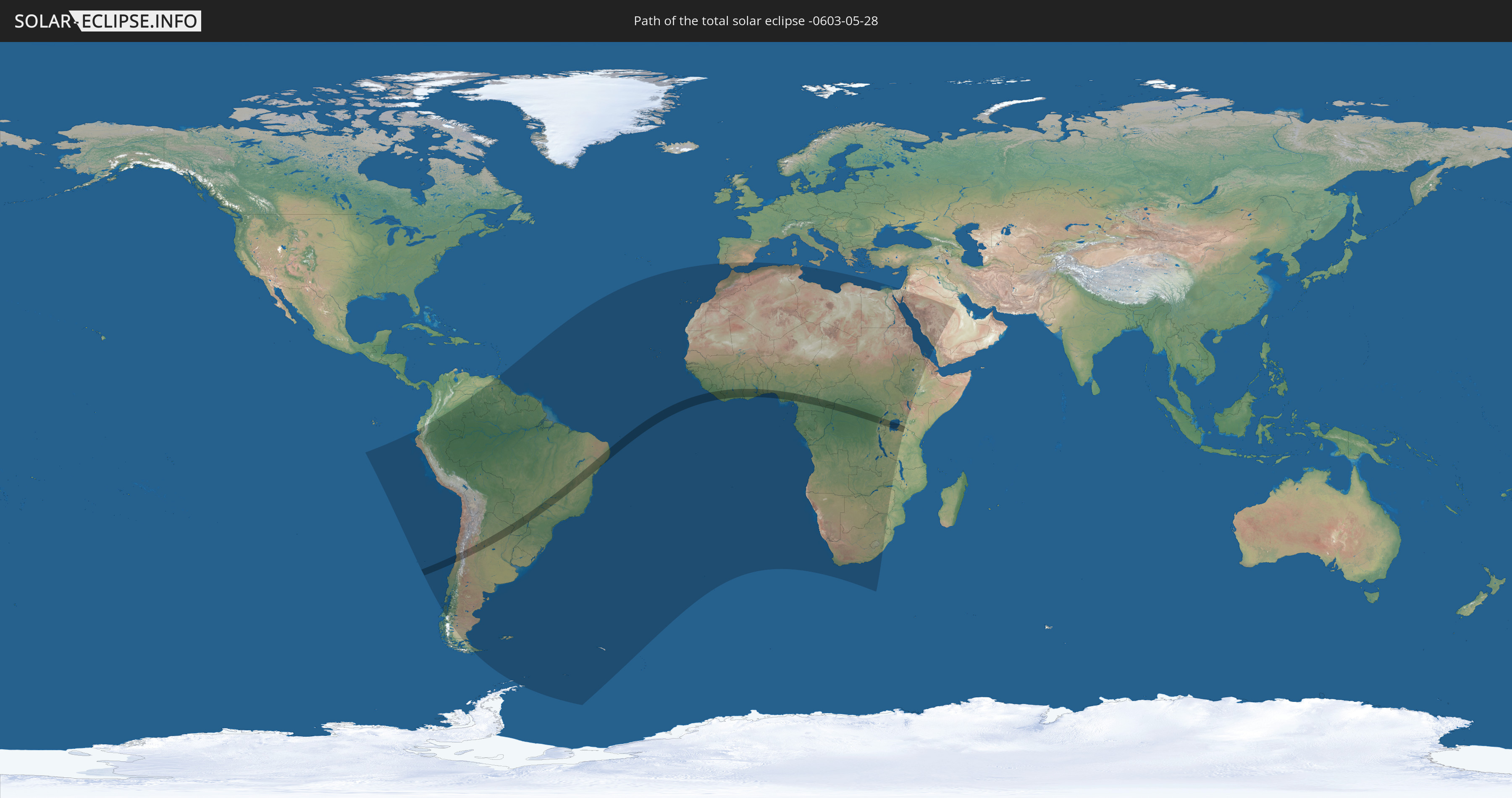
Die Sonnenfinsternis am 28.05.-0603 kann man in 73 Ländern als partielle Sonnenfinsternis beobachten.
Der Finsternispfad verläuft durch 18 Länder. Nur in diesen Ländern ist sie als totale Sonnenfinsternis zu sehen.
In den folgenden Ländern ist die Sonnenfinsternis total zu sehen
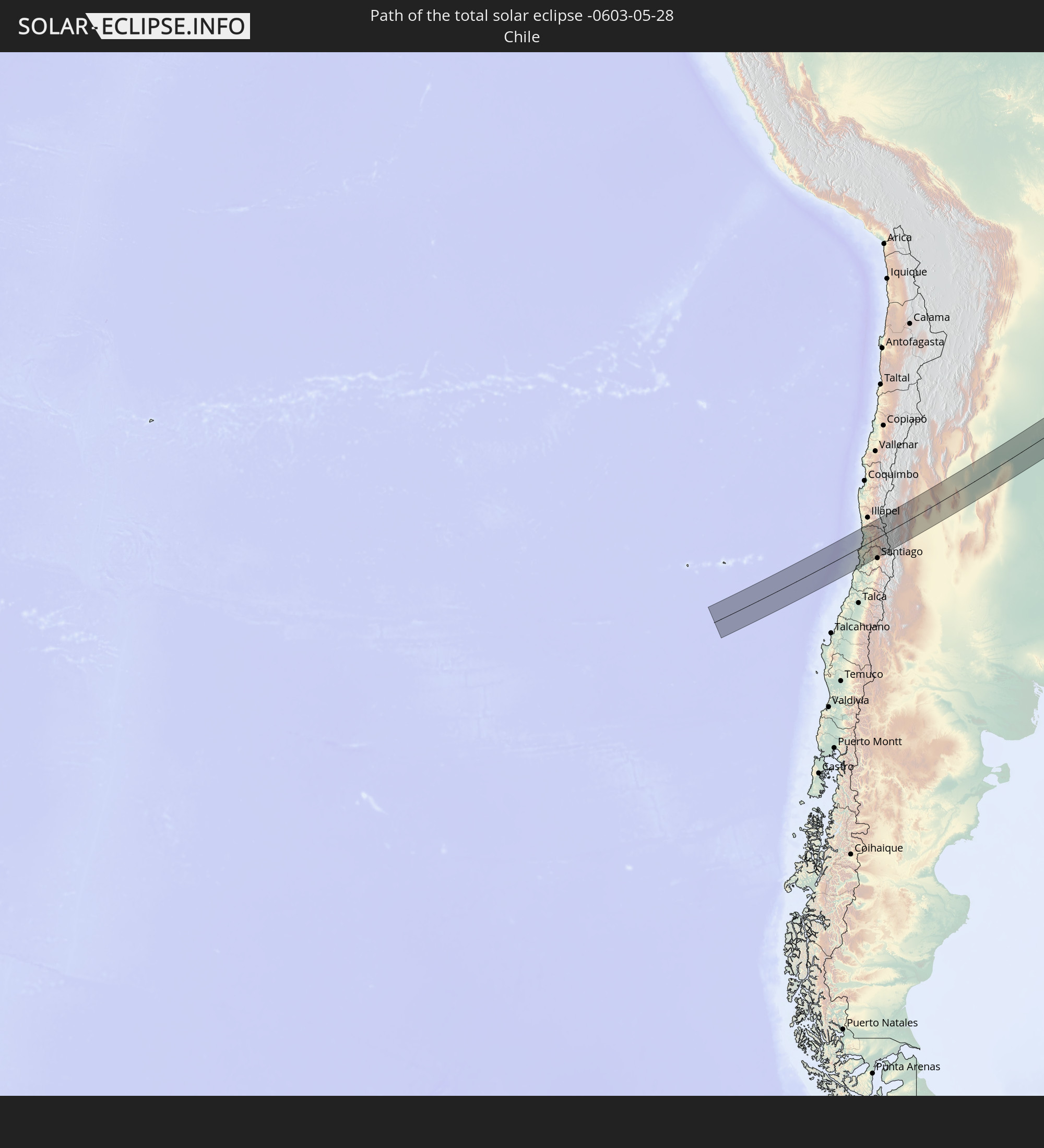 Chile
Chile
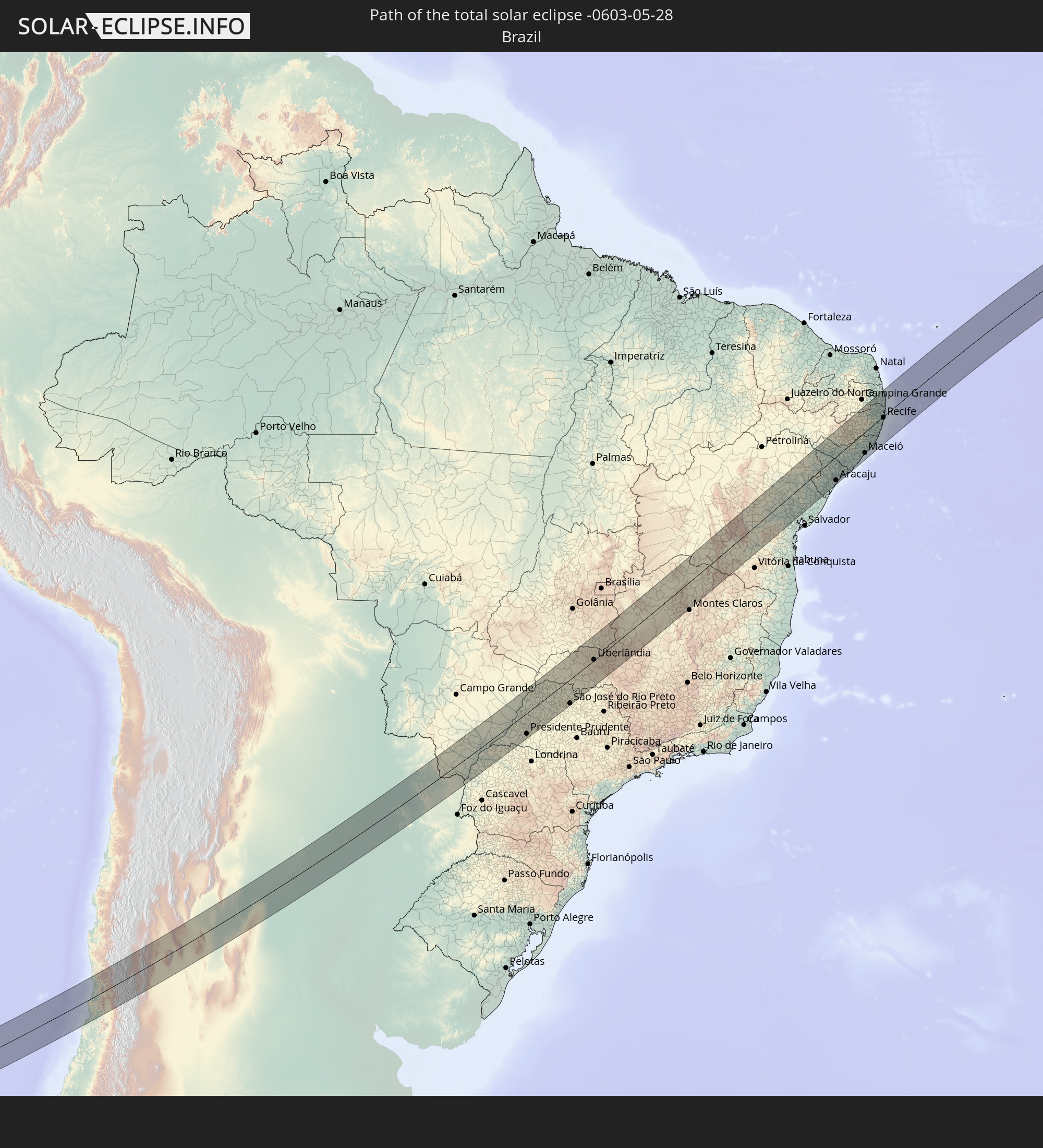 Brasilien
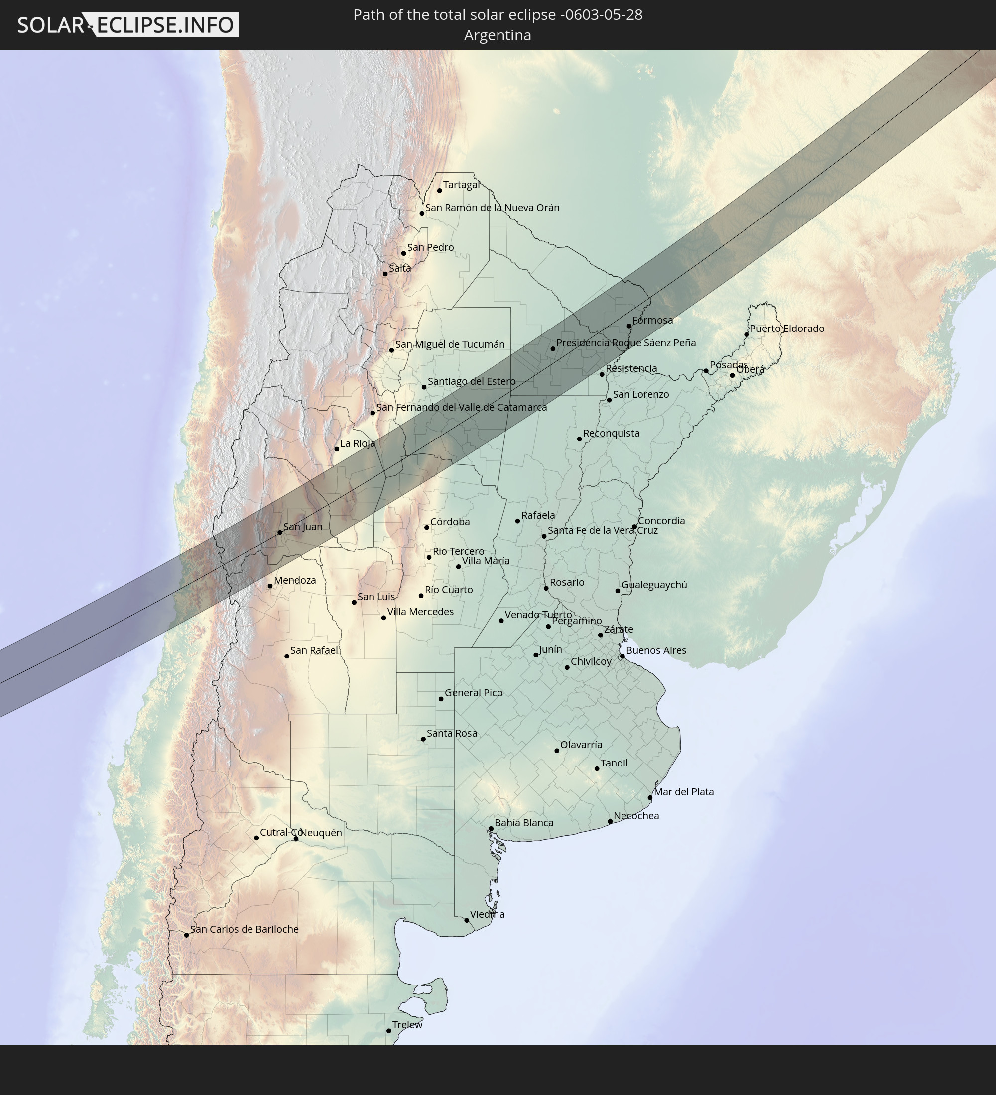 Argentinien
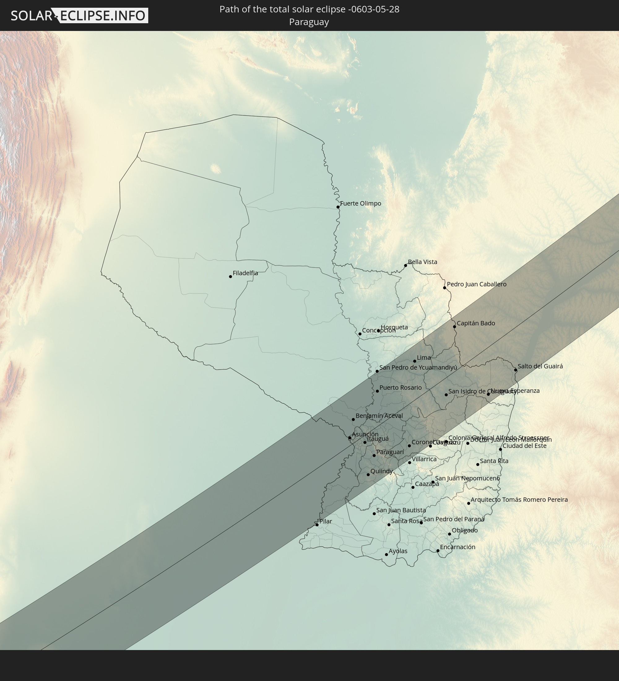 Paraguay
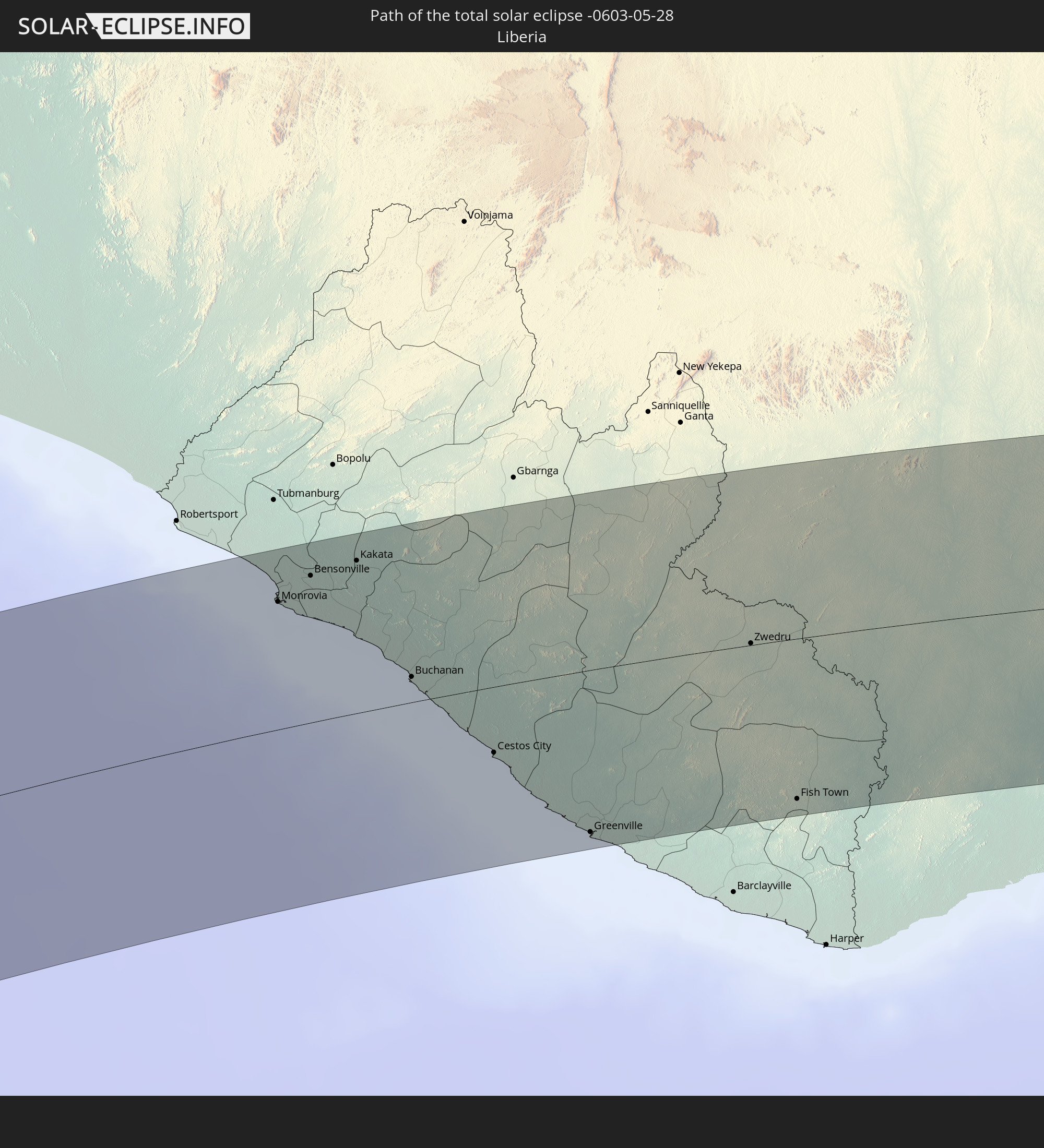 Liberia
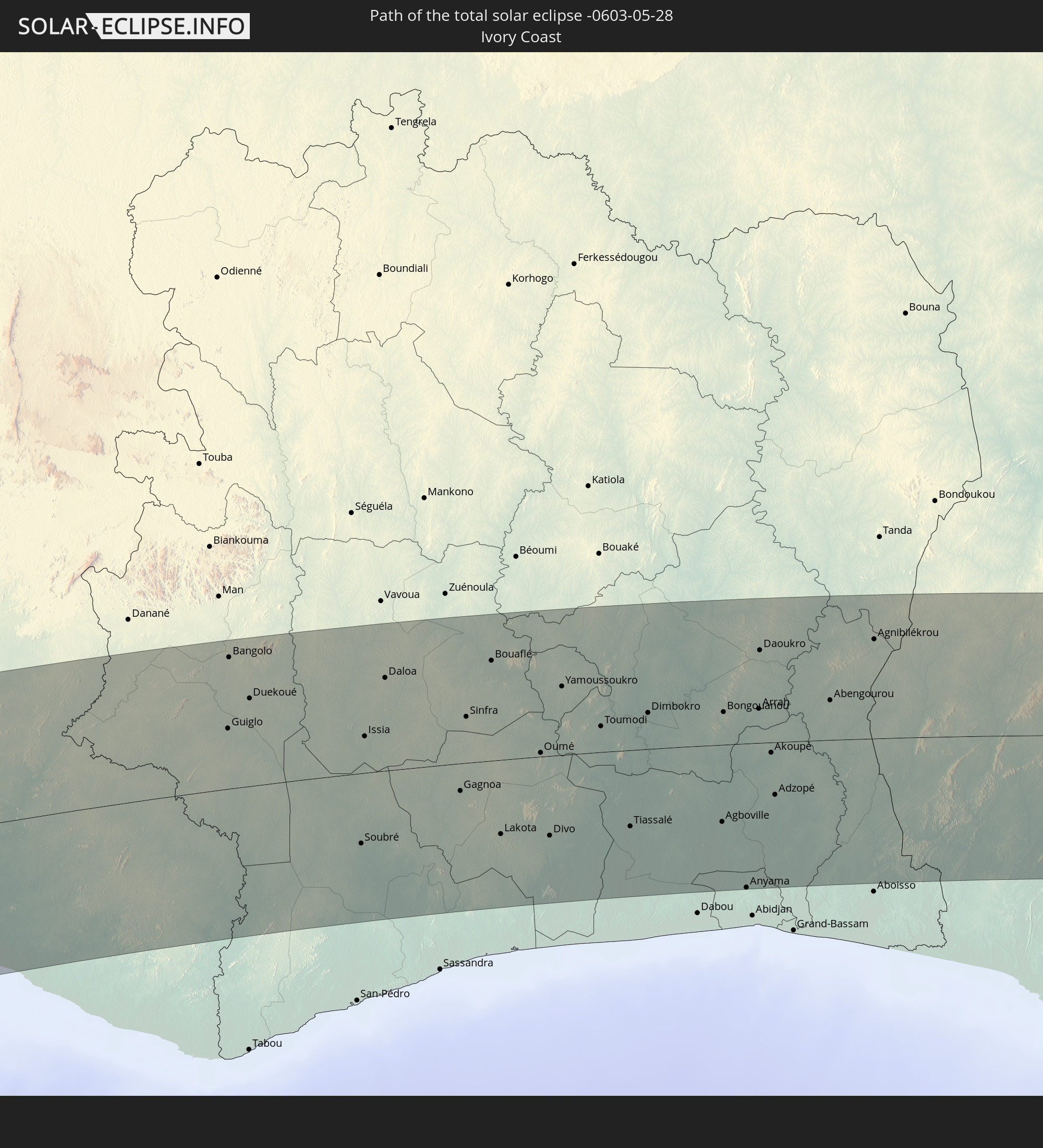 Elfenbeinküste
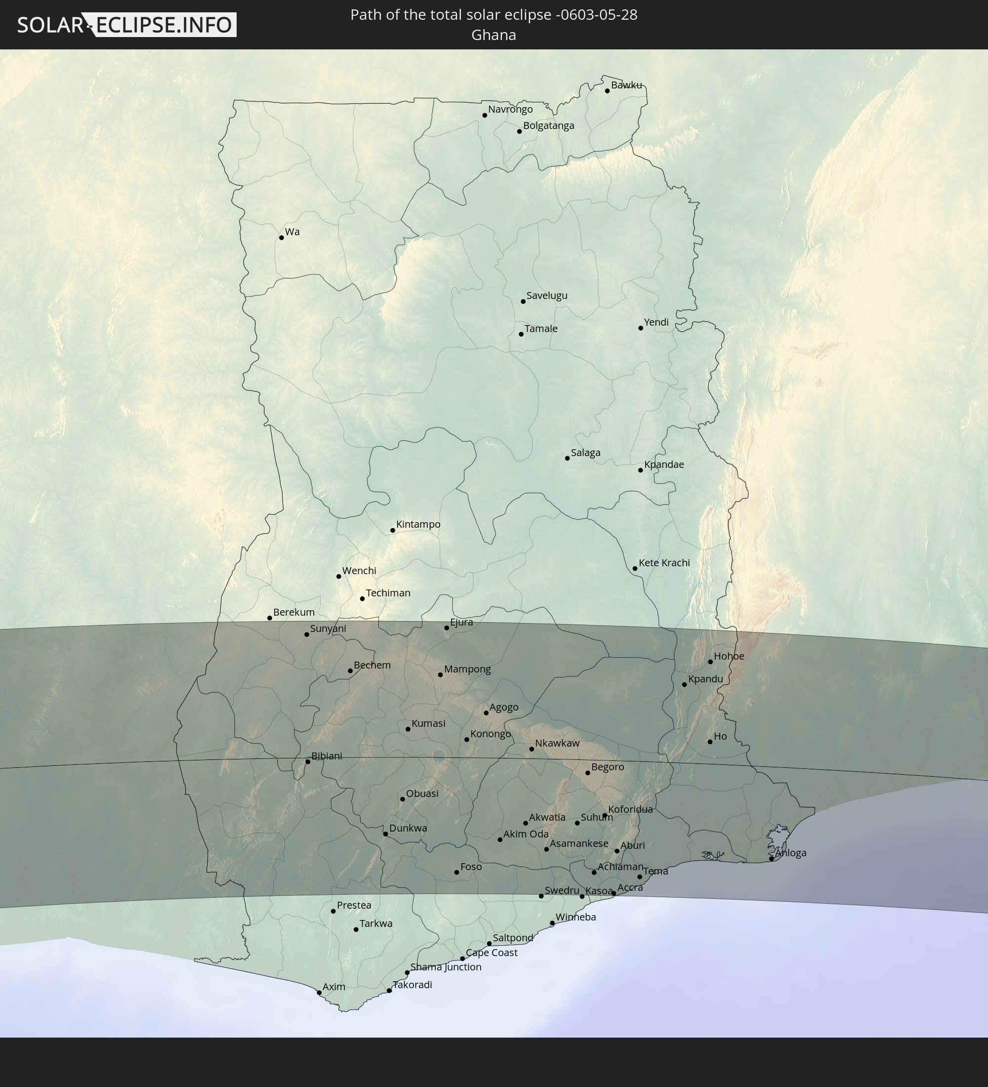 Ghana
Ghana
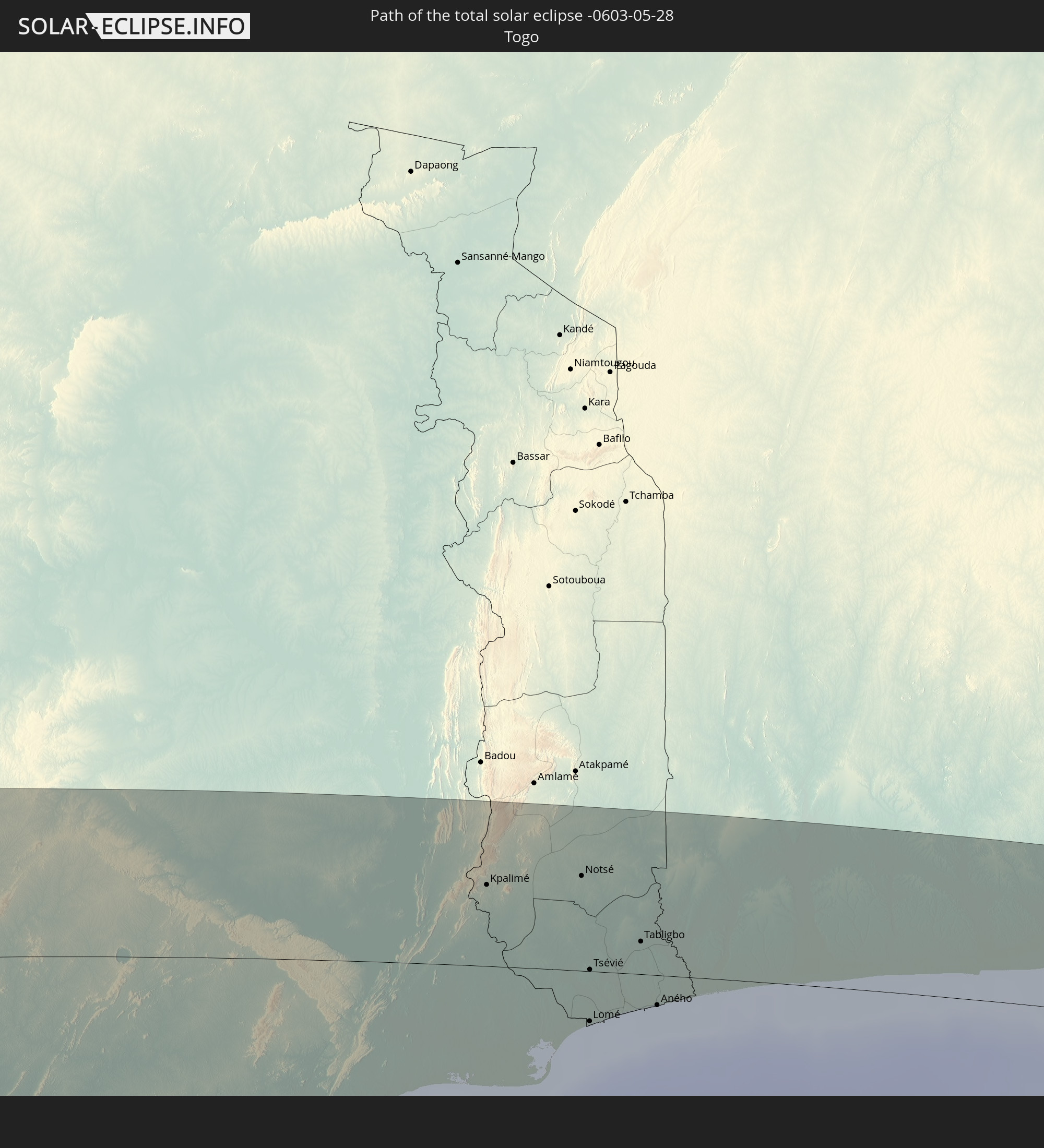 Togo
Togo
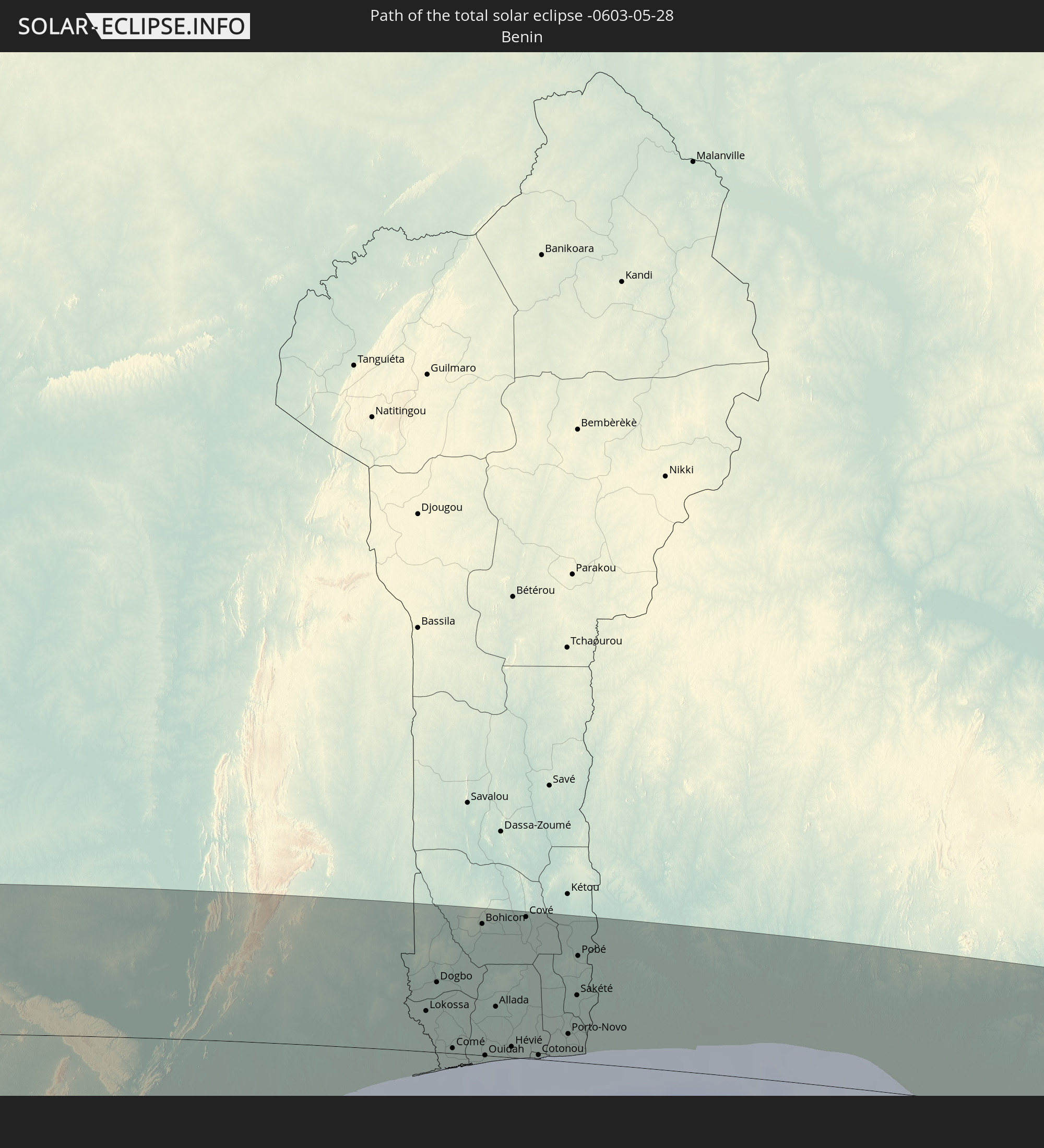 Benin
Benin
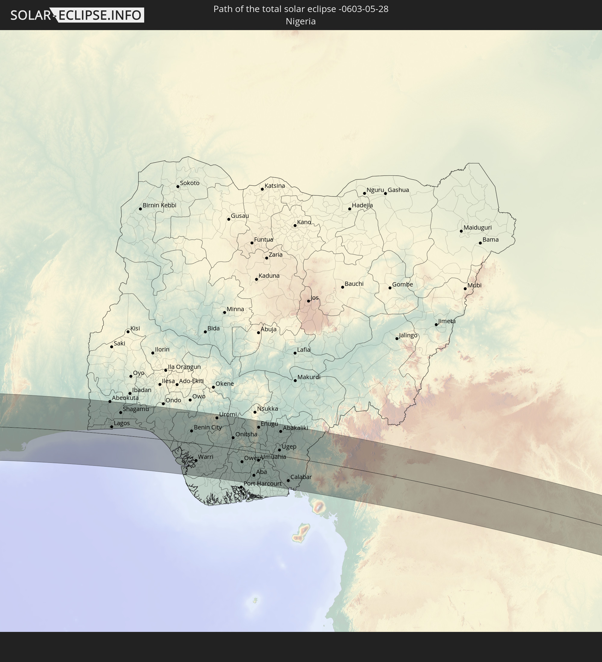 Nigeria
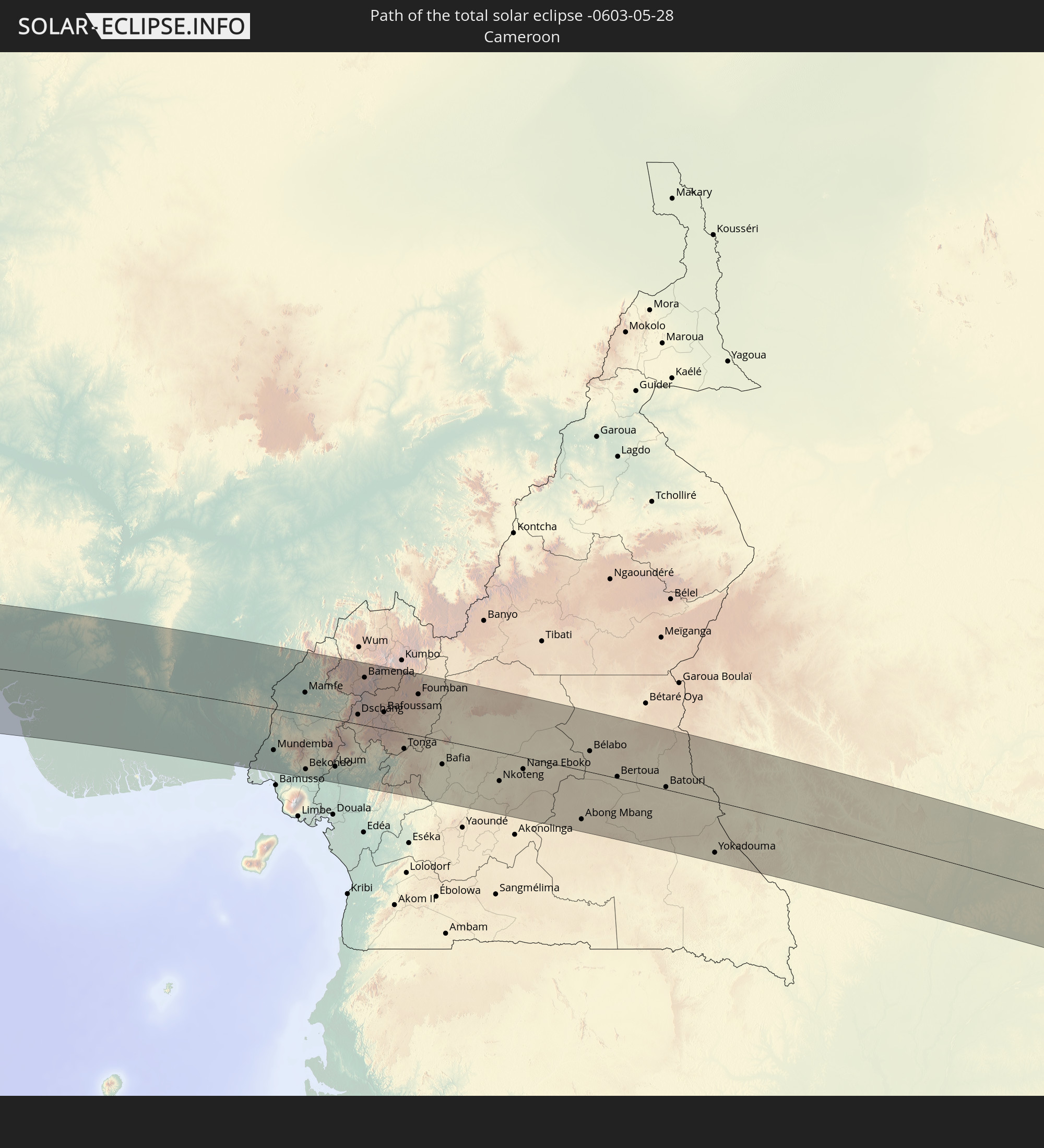 Kamerun
 Republik Kongo
 Demokratische Republik Kongo
 Zentralafrikanische Republik
 Ruanda
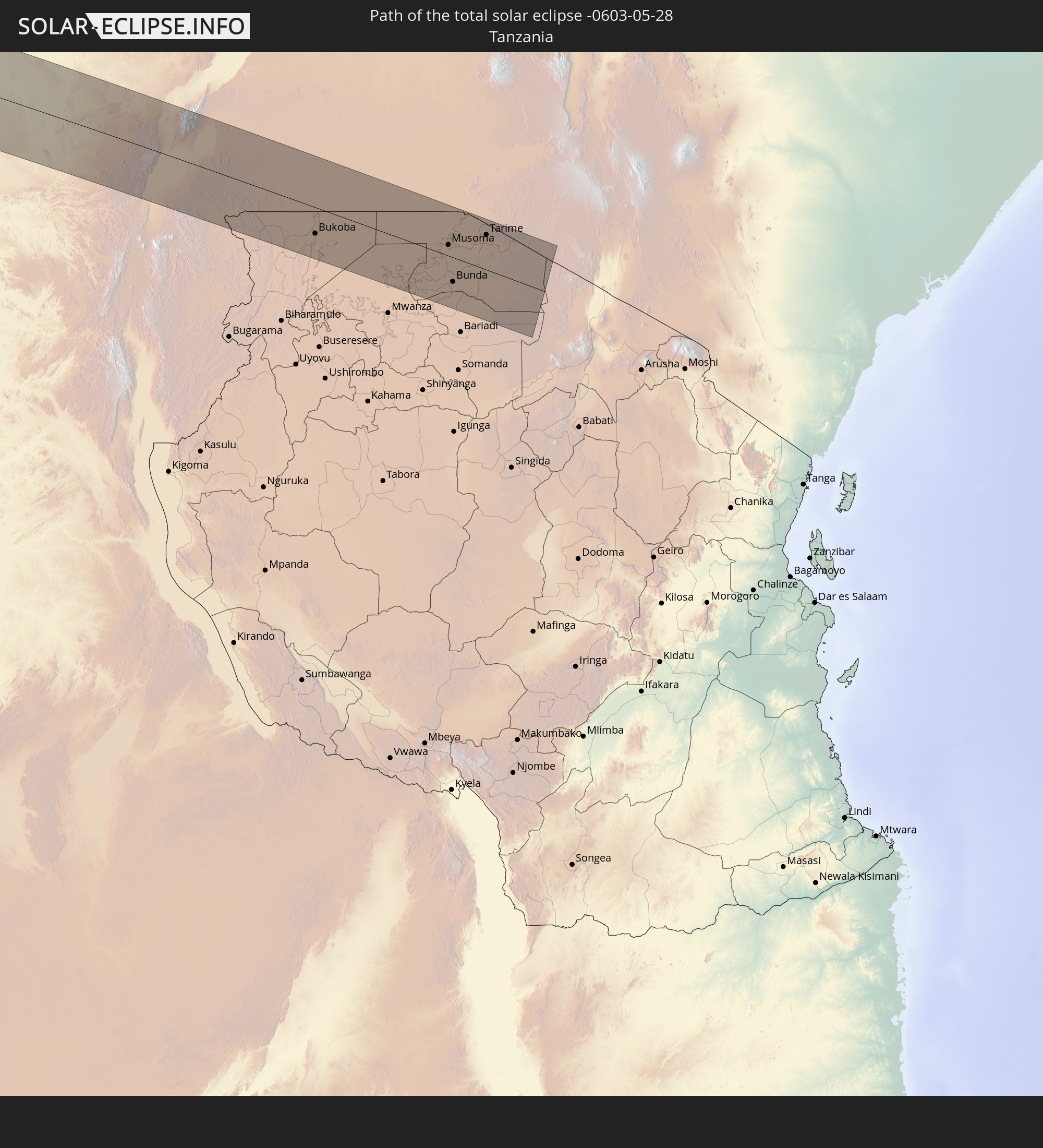 Tansania
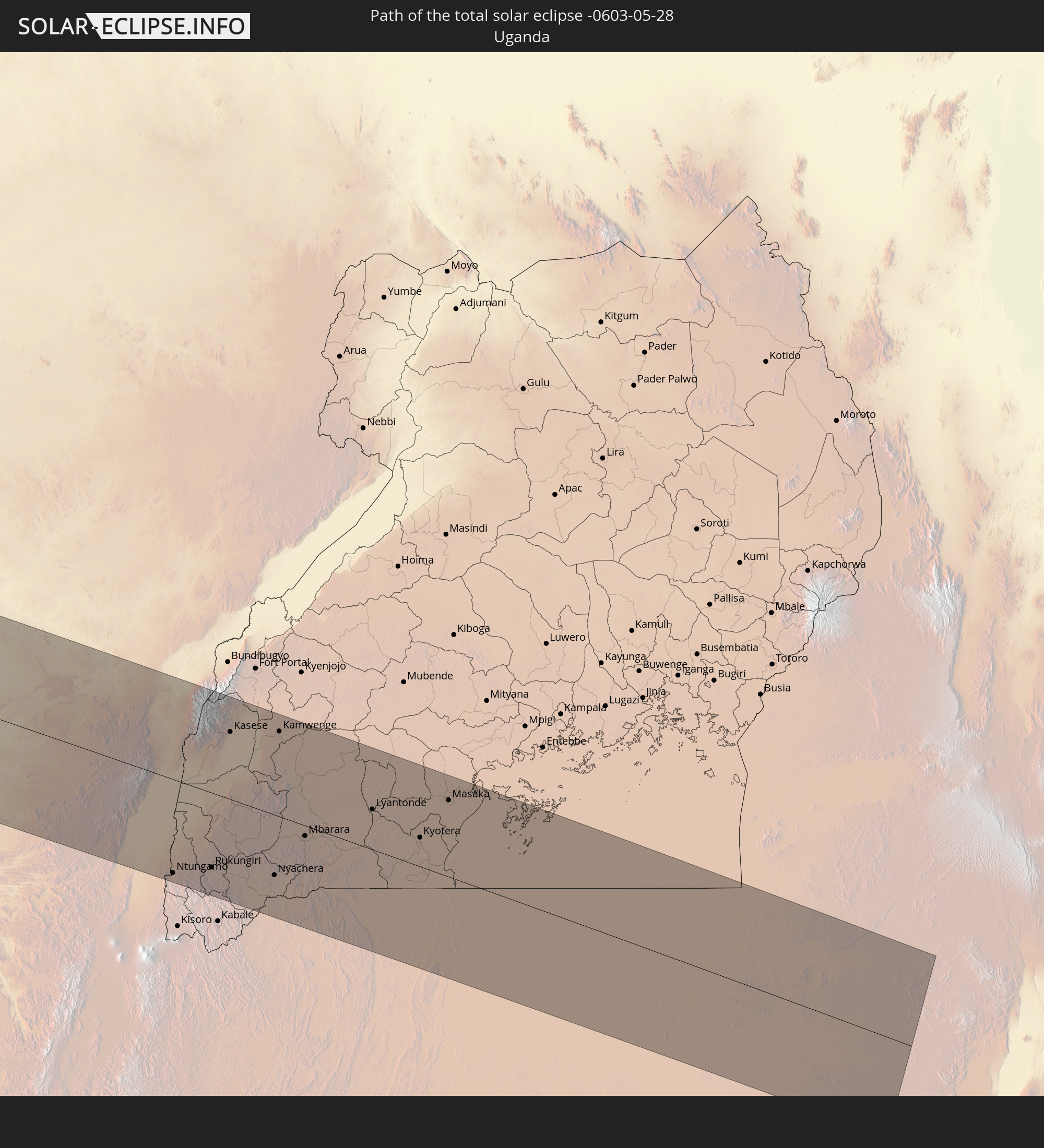 Uganda
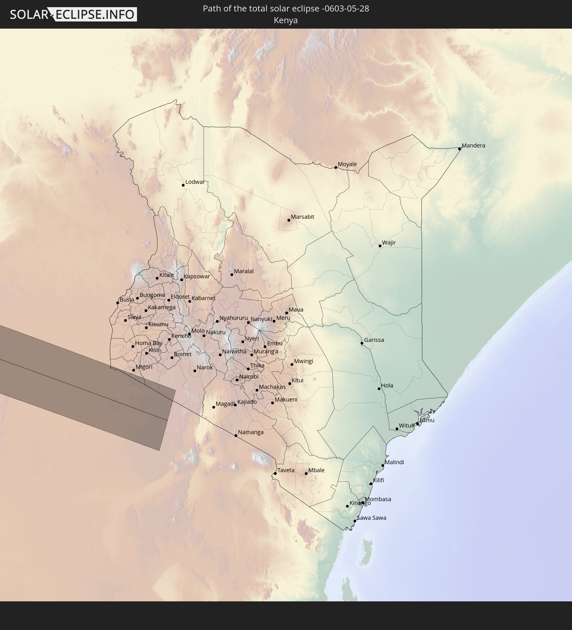 Kenia
Kenia
In den folgenden Ländern ist die Sonnenfinsternis partiell zu sehen
 Antarktika
 Chile
Chile
 Ecuador
 Kolumbien
 Peru
Peru
 Brasilien
 Argentinien
 Venezuela
 Bolivien
 Paraguay
 Trinidad und Tobago
 Falklandinseln
 Guyana
 Uruguay
 Suriname
 Französisch-Guayana
 Südgeorgien und die Südlichen Sandwichinseln
 Portugal
 Kap Verde
 Spanien
 Senegal
 Mauretanien
 Gambia
 Guinea-Bissau
 Guinea
 St. Helena
 Sierra Leone
 Marokko
 Mali
Mali
 Liberia
 Algerien
 Elfenbeinküste
 Burkina Faso
 Gibraltar
 Ghana
Ghana
 Togo
Togo
 Niger
Niger
 Benin
Benin
 Nigeria
 Äquatorialguinea
 São Tomé und Príncipe
 Italien
 Tunesien
 Kamerun
 Gabun
Gabun
 Libyen
 Republik Kongo
 Angola
 Namibia
 Demokratische Republik Kongo
 Tschad
 Malta
Malta
 Zentralafrikanische Republik
 Südafrika
 Botswana
 Sudan
Sudan
 Sambia
 Ägypten
 Simbabwe
 Lesotho
 Ruanda
 Burundi
 Tansania
 Uganda
 Mosambik
 Malawi
 Äthiopien
 Kenia
Kenia
 Staat Palästina
 Israel
 Saudi-Arabien
 Jordanien
 Eritrea
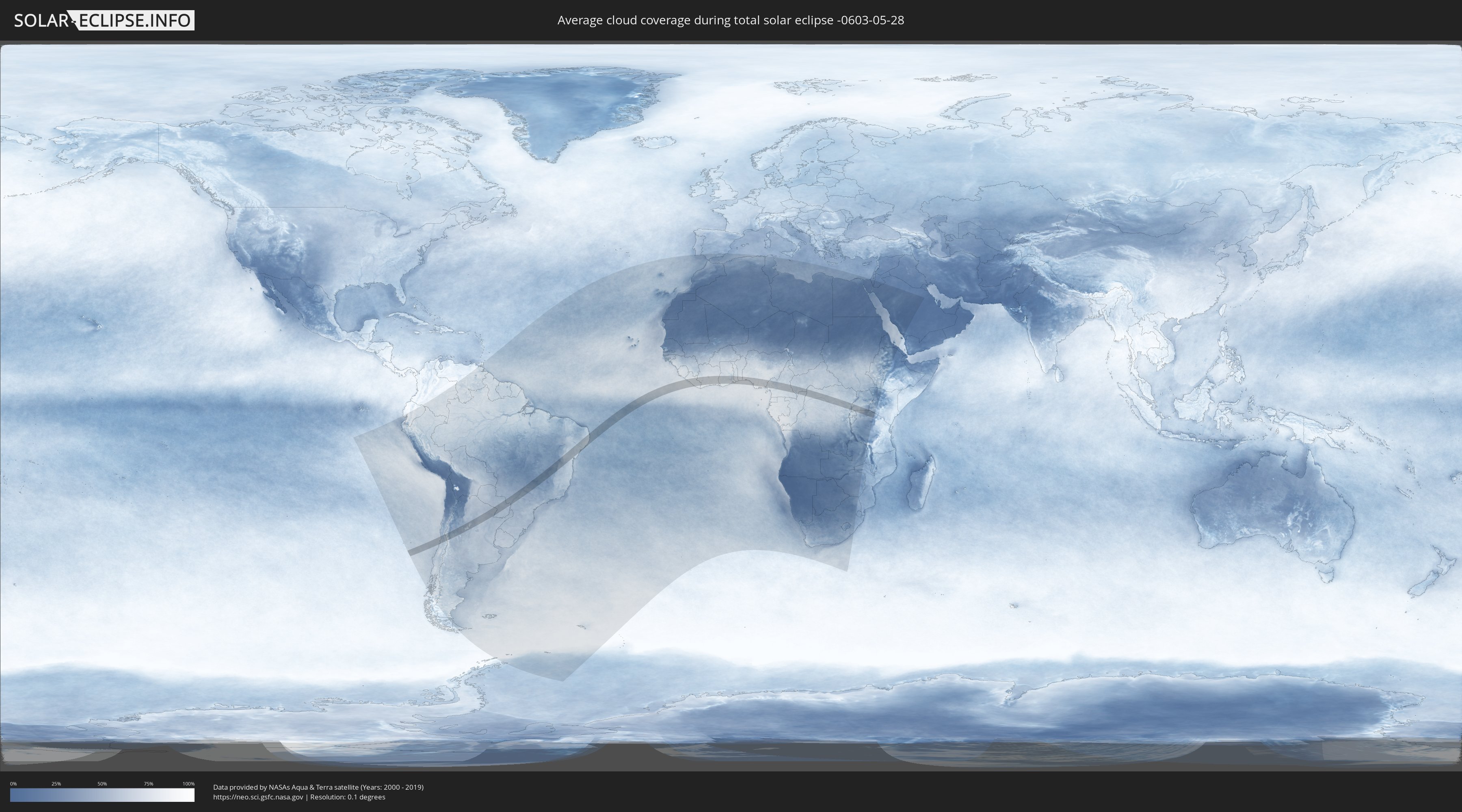
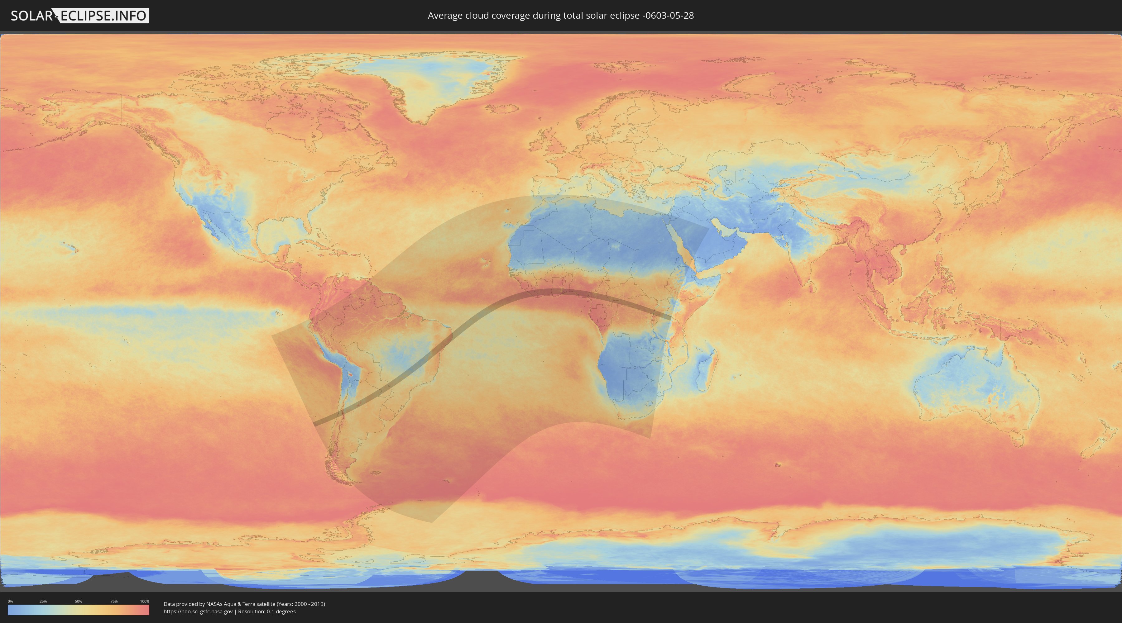
Wie wird das Wetter während der totalen Sonnenfinsternis am 28.05.-0603?
Wo ist der beste Ort, um die totale Sonnenfinsternis vom 28.05.-0603 zu beobachten?
Die folgenden Karten zeigen die durchschnittliche Bewölkung für den Tag, an dem die totale Sonnenfinsternis
stattfindet. Mit Hilfe der Karten lässt sich der Ort entlang des Finsternispfades eingrenzen,
der die besten Aussichen auf einen klaren wolkenfreien Himmel bietet.
Trotzdem muss man immer lokale Gegenenheiten beachten und sollte sich genau über das Wetter an seinem
gewählten Beobachtungsort informieren.
Die Daten stammen von den beiden NASA-Satelliten
AQUA und TERRA
und wurden über einen Zeitraum von 19 Jahren (2000 - 2019) gemittelt.
Detaillierte Länderkarten
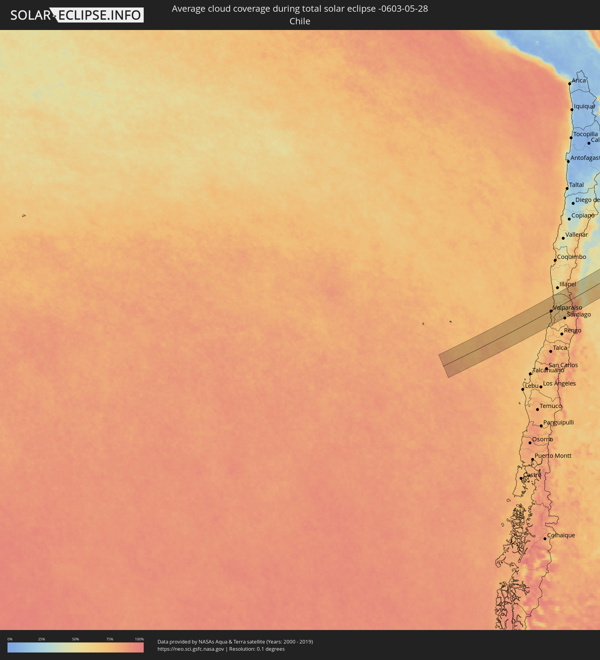 Chile
Chile
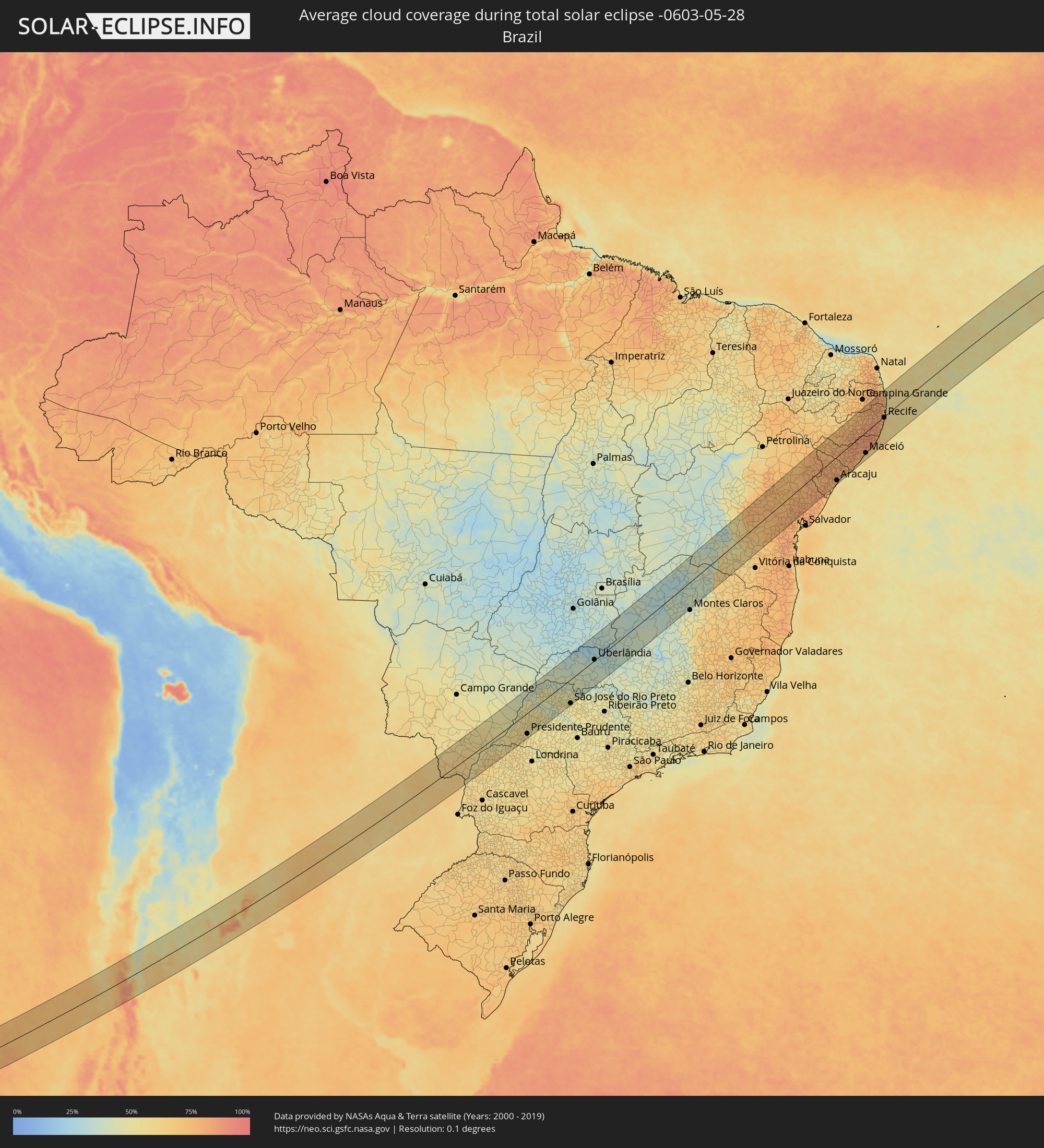 Brasilien
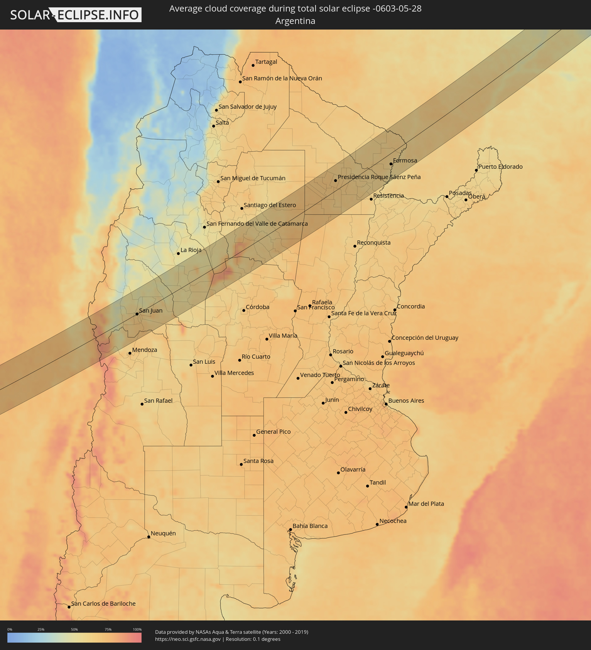 Argentinien
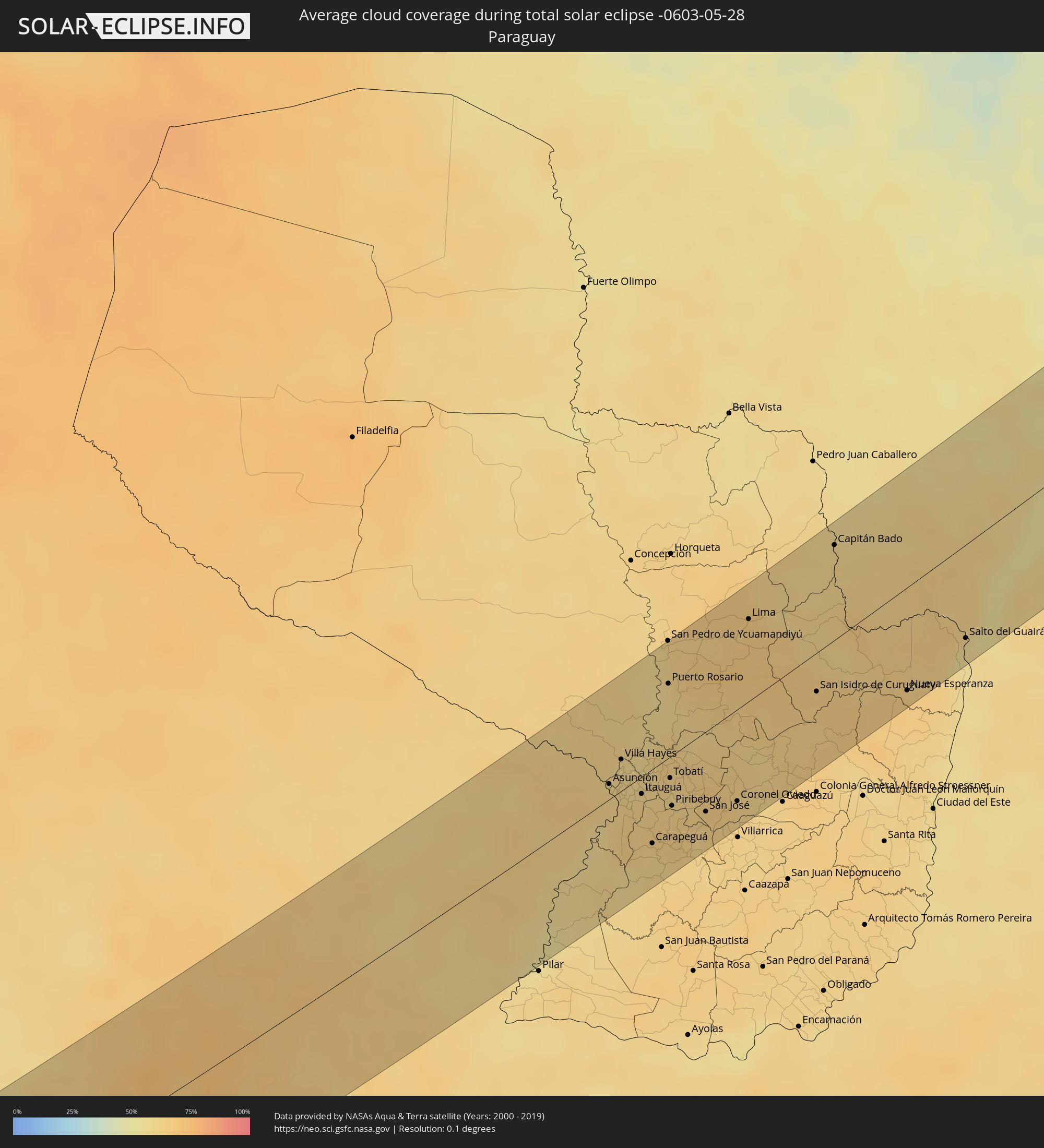 Paraguay
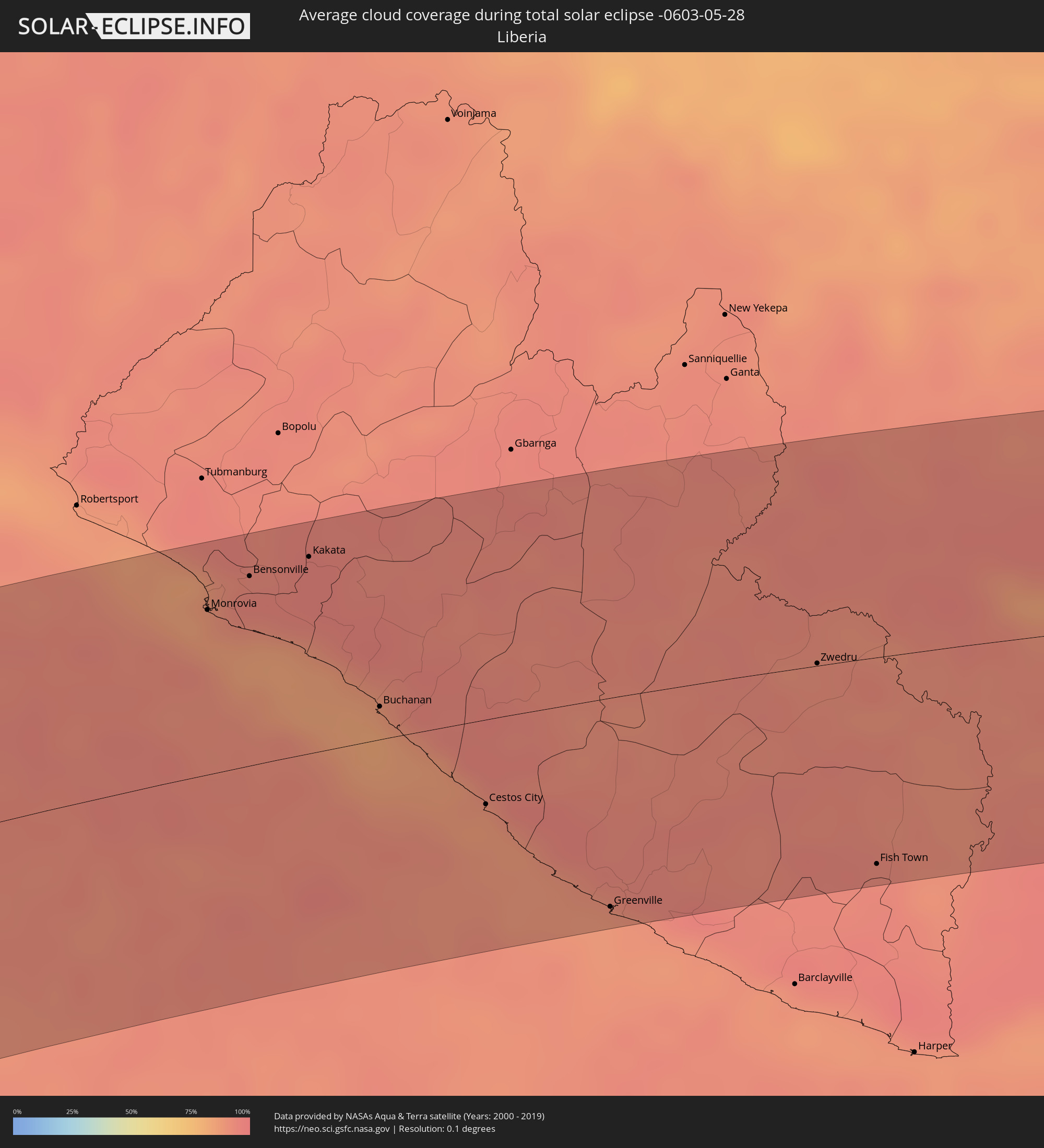 Liberia
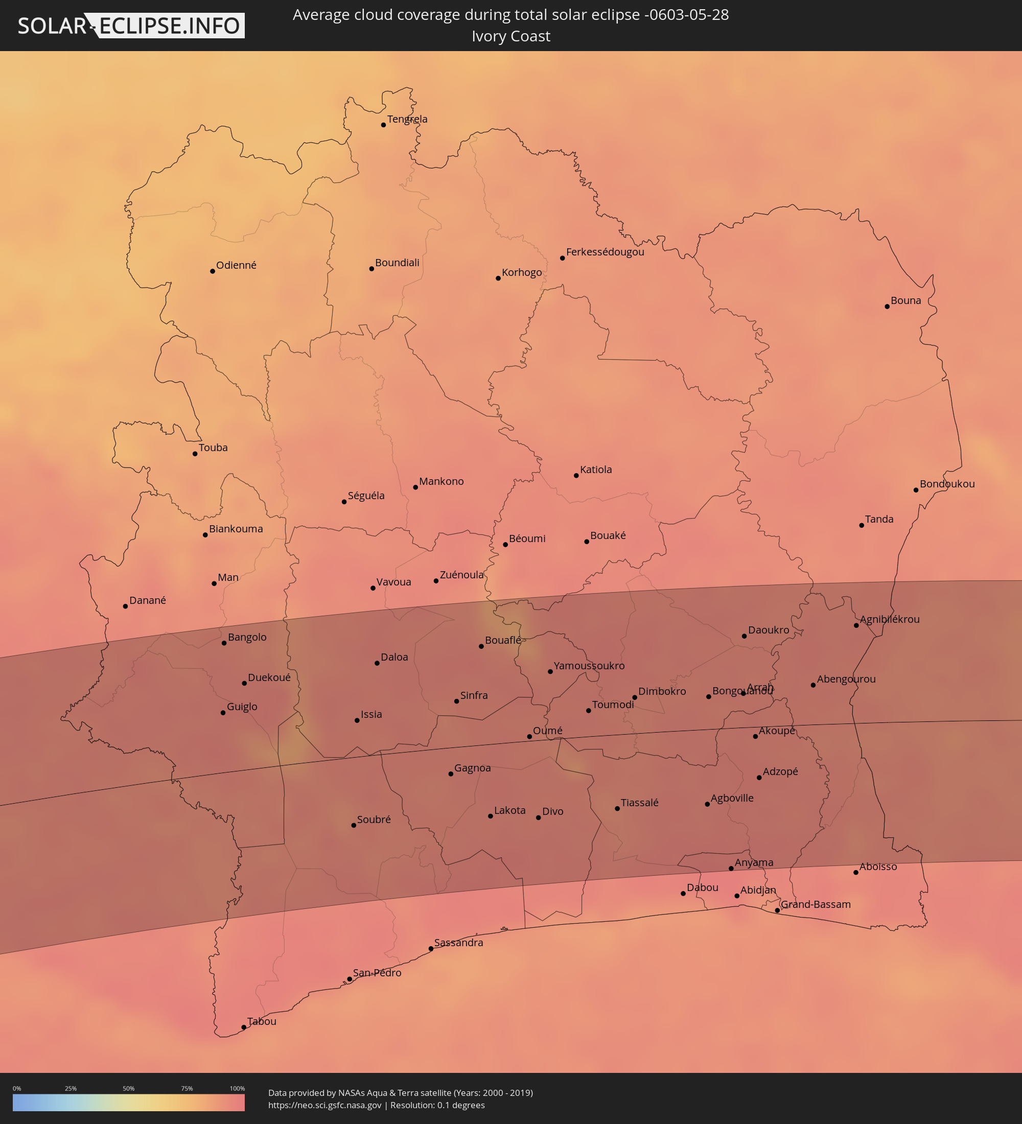 Elfenbeinküste
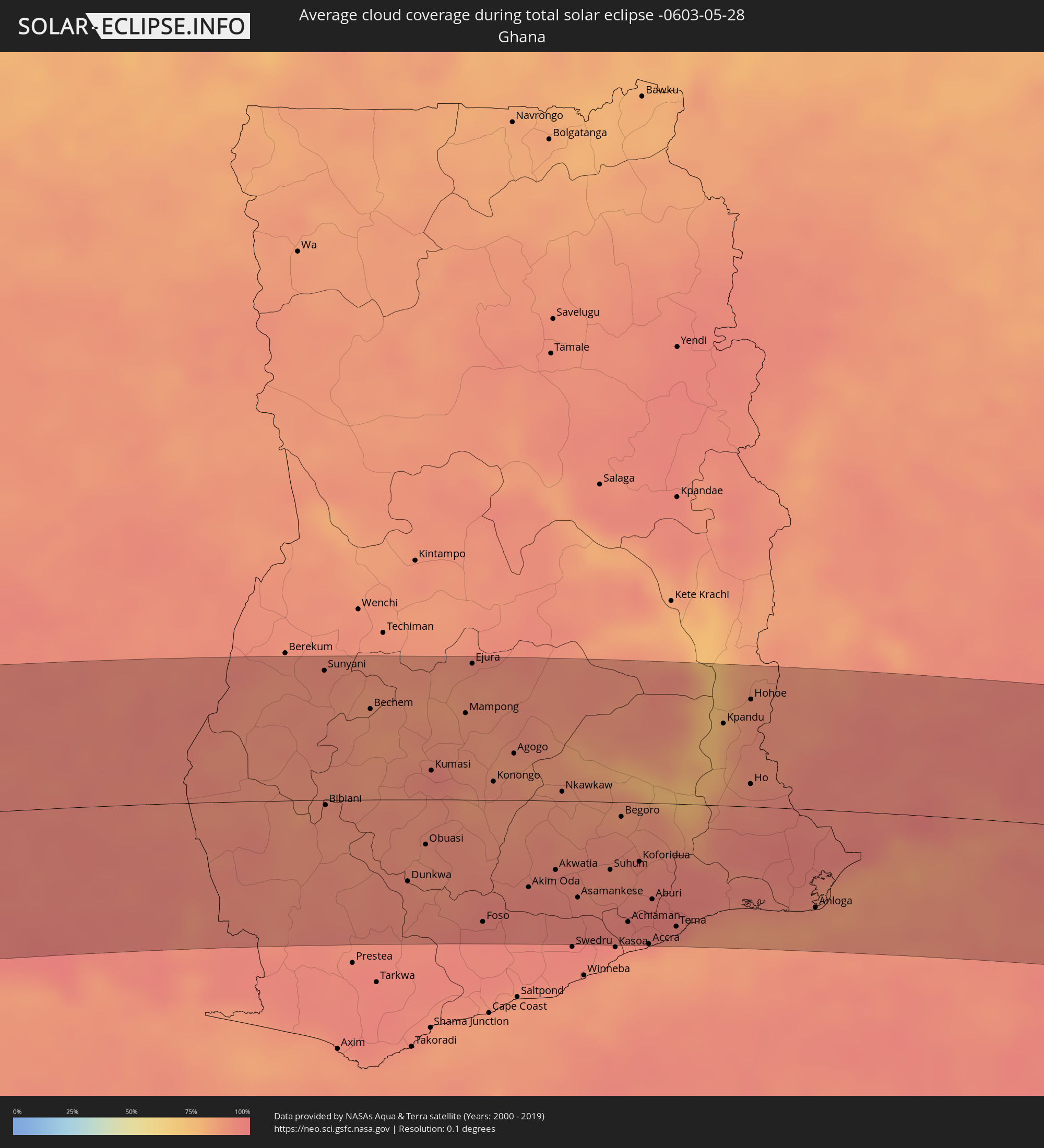 Ghana
Ghana
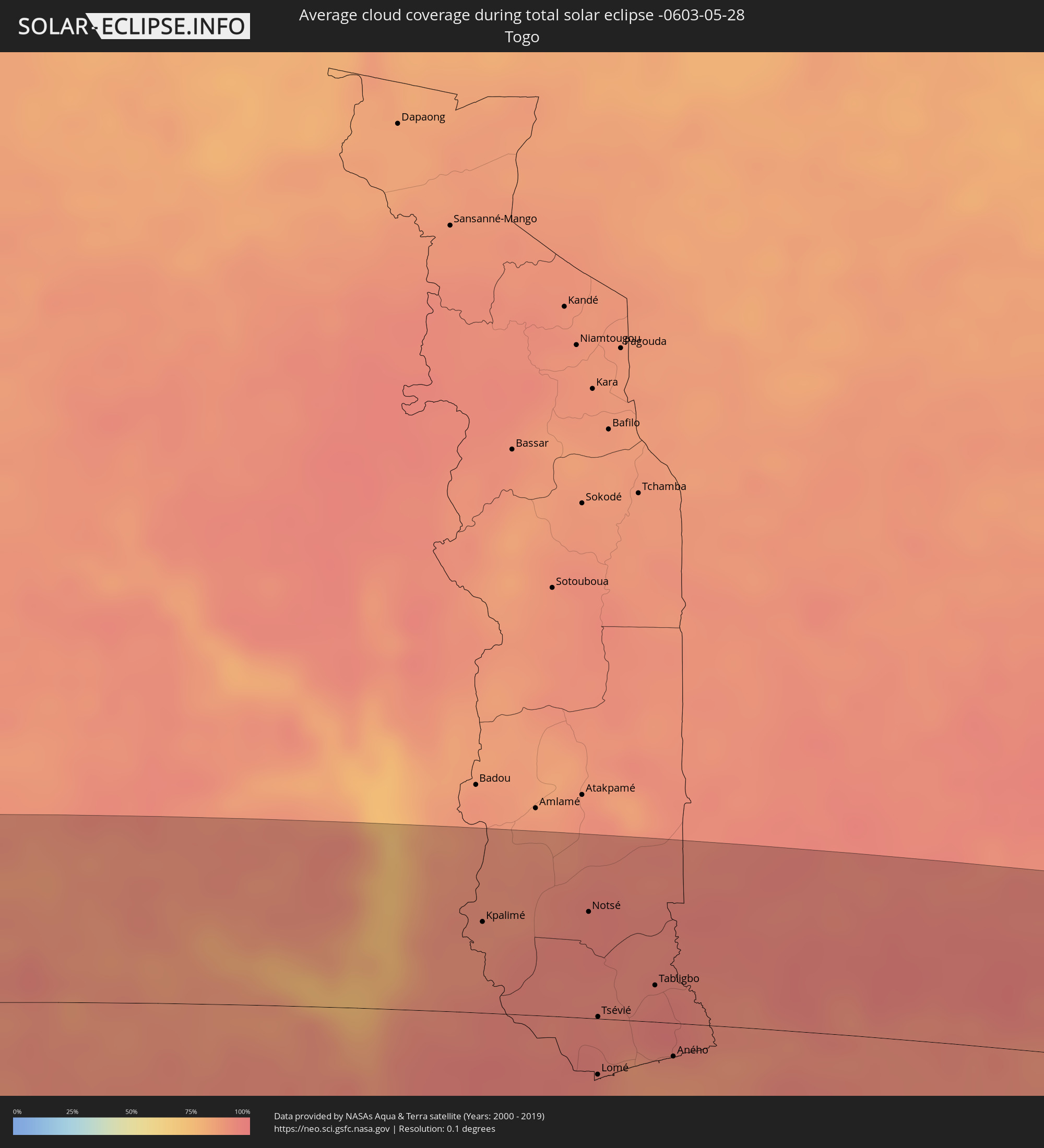 Togo
Togo
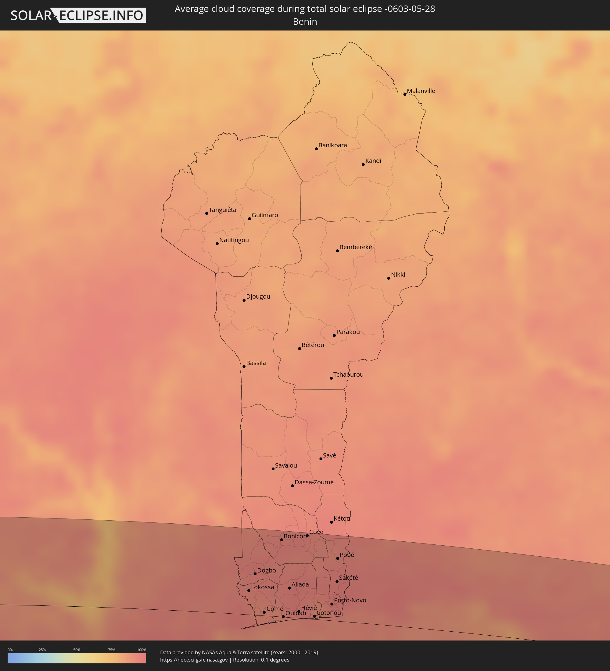 Benin
Benin
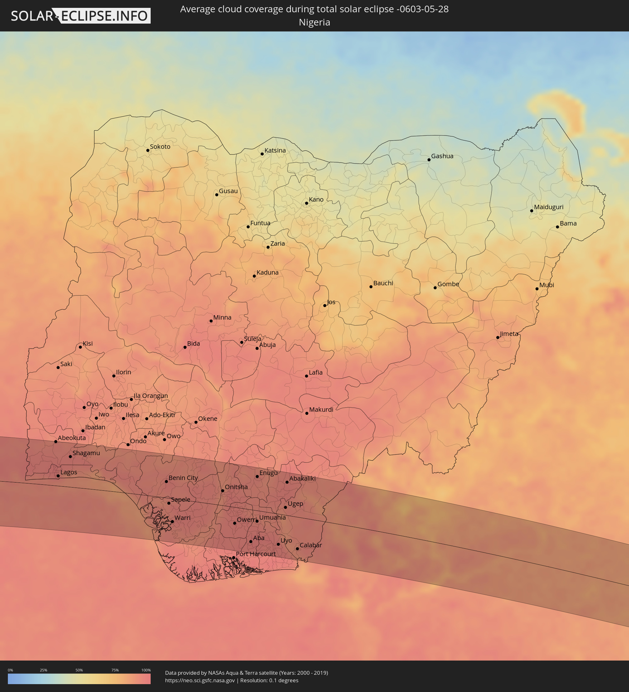 Nigeria
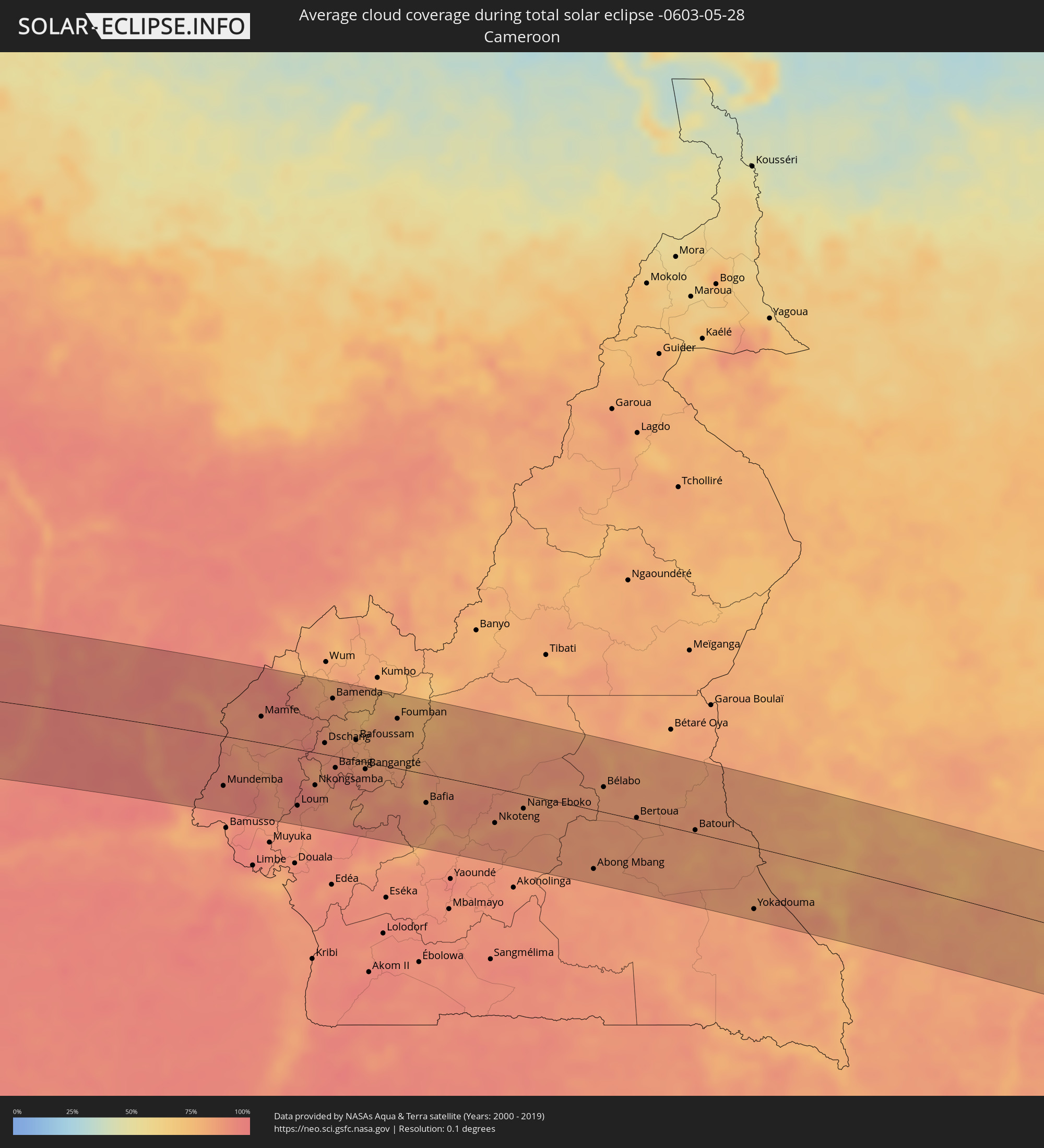 Kamerun
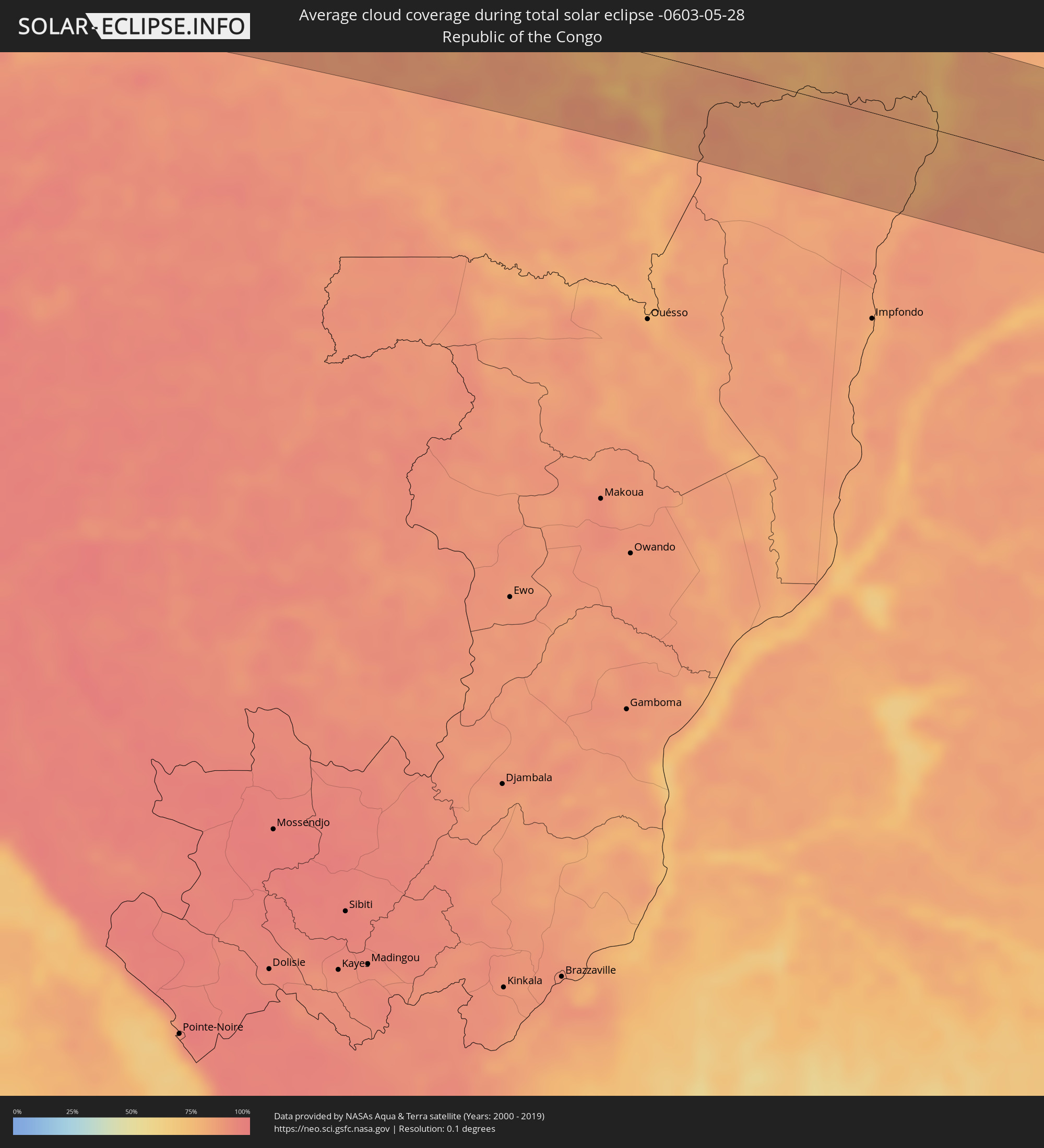 Republik Kongo
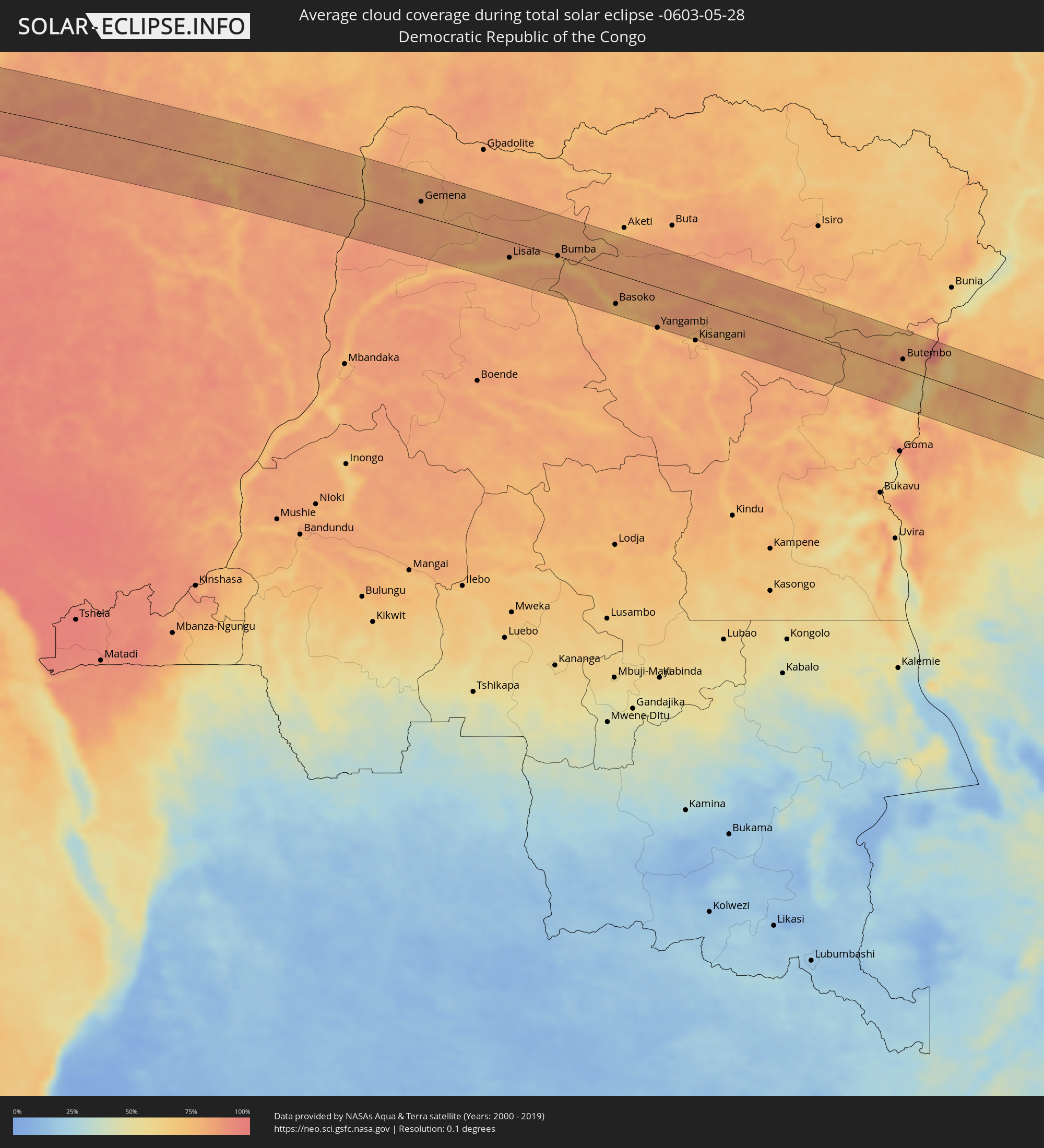 Demokratische Republik Kongo
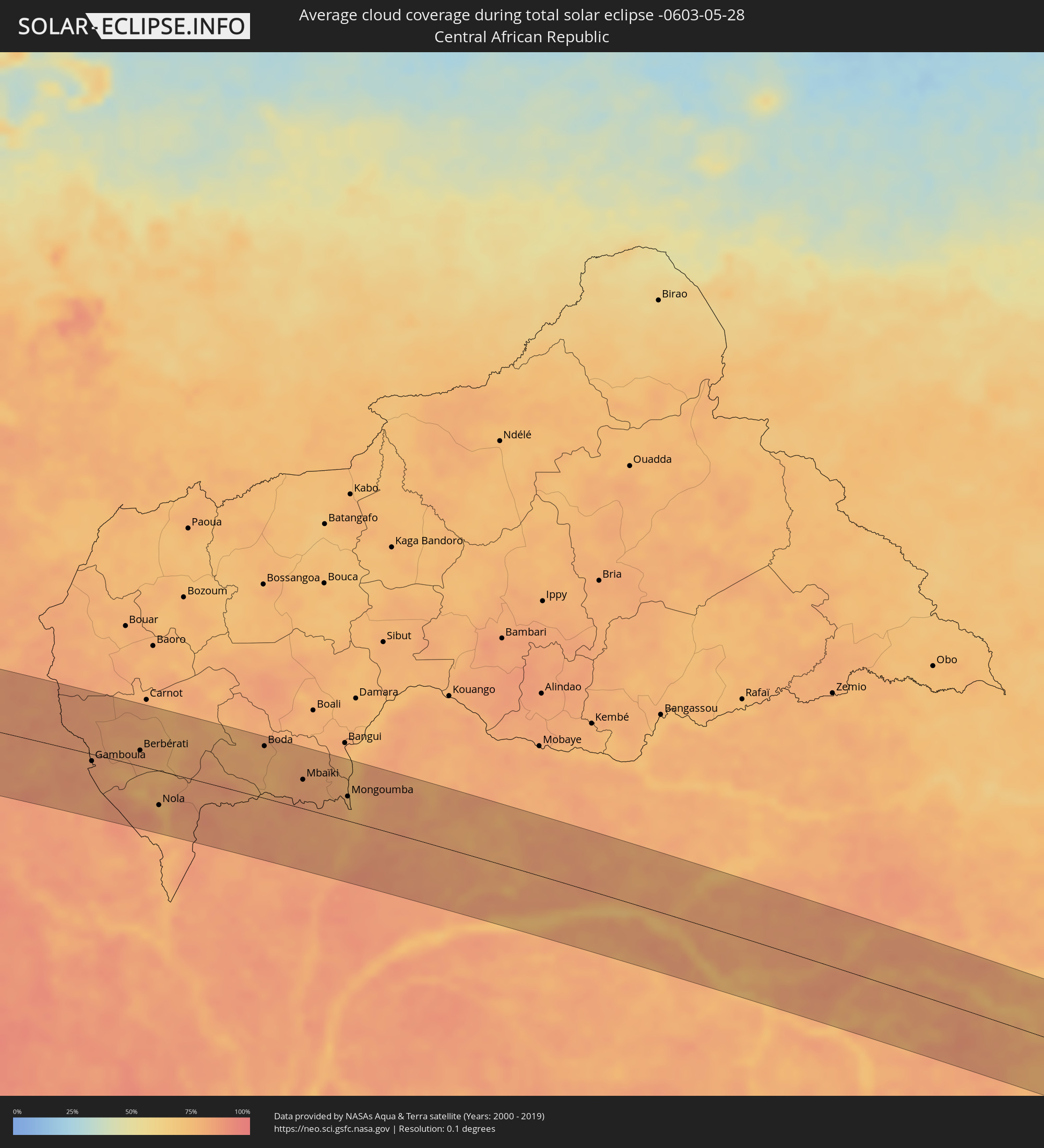 Zentralafrikanische Republik
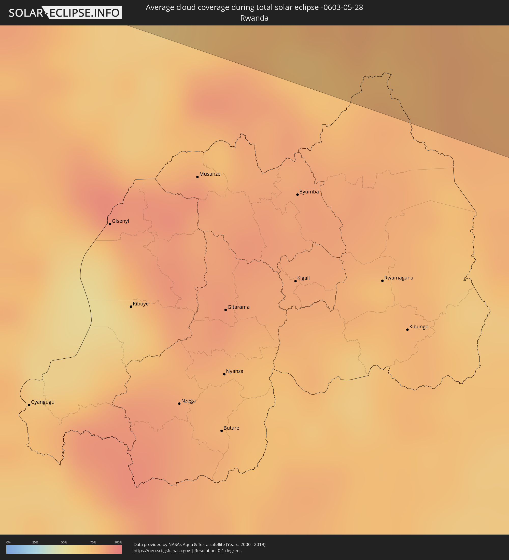 Ruanda
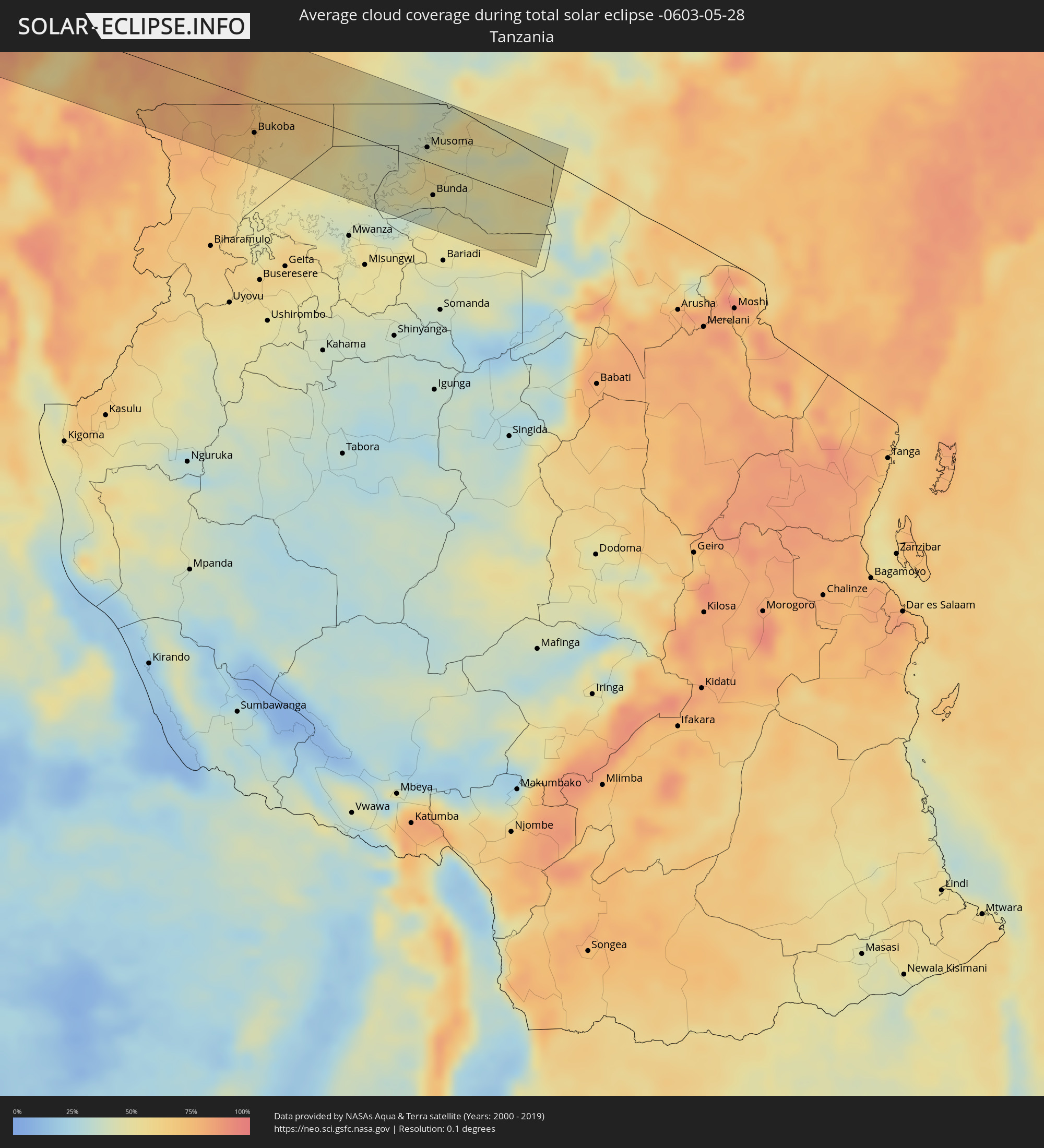 Tansania
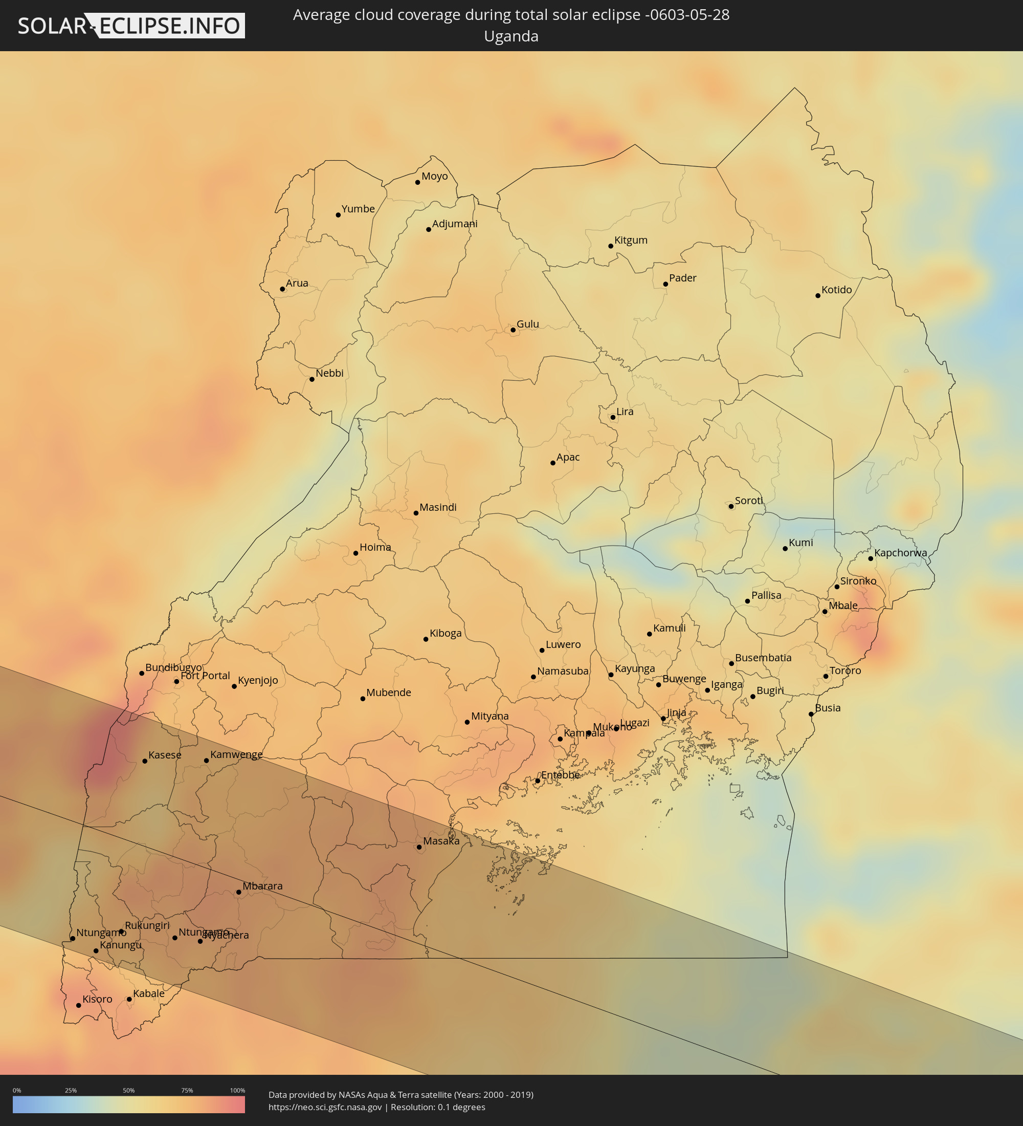 Uganda
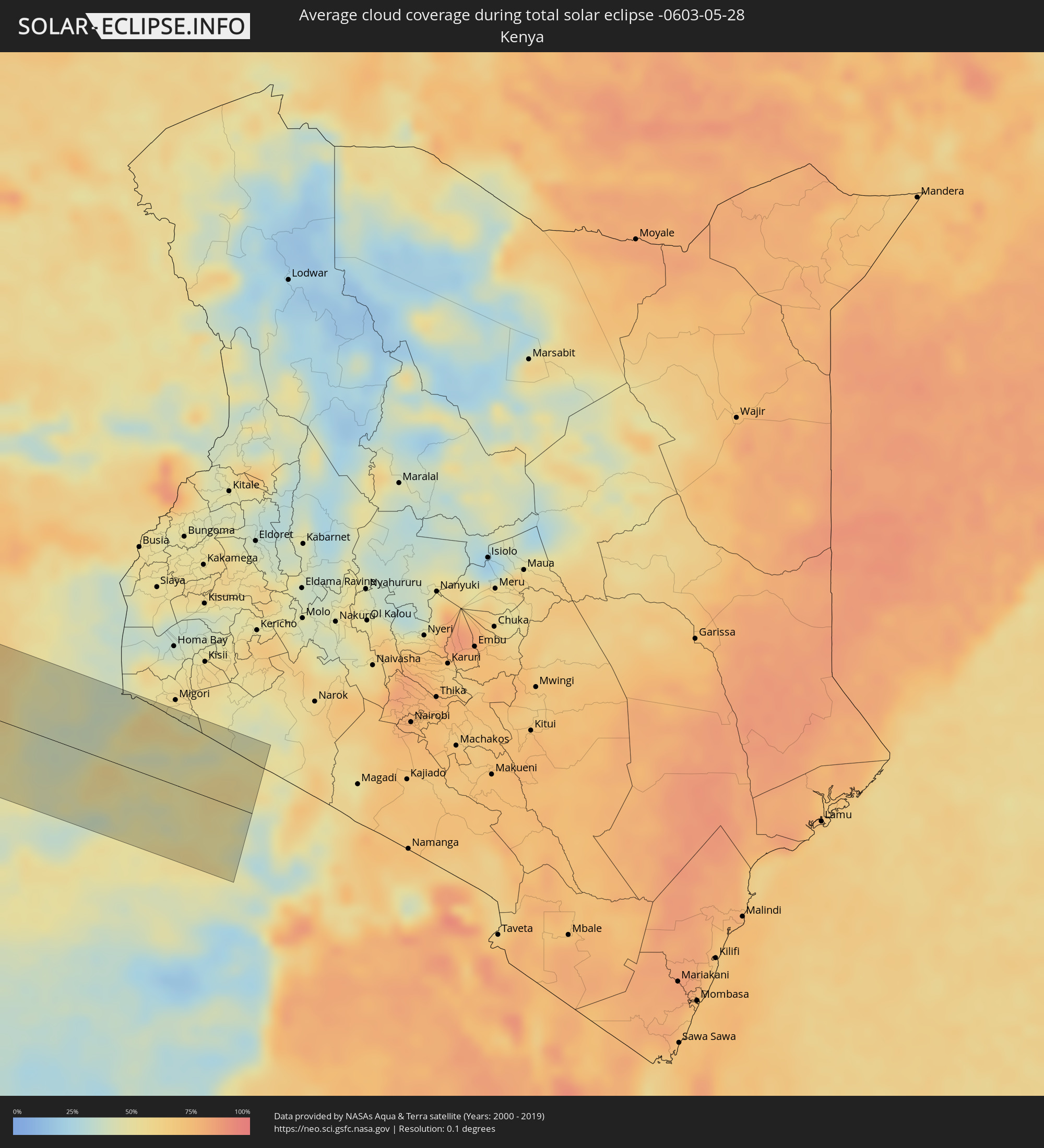 Kenia
Kenia
Orte im Finsternispfad
Die nachfolgene Tabelle zeigt Städte und Orte mit mehr als 5.000 Einwohnern, die sich im Finsternispfad befinden. Städte mit mehr als 100.000 Einwohnern sind dick gekennzeichnet. Mit einem Klick auf den Ort öffnet sich eine Detailkarte die die Lage des jeweiligen Ortes zusammen mit dem Verlauf der zentralen Finsternis präsentiert.
| Ort | Typ | Dauer der Verfinsterung | Ortszeit bei maximaler Verfinsterung | Entfernung zur Zentrallinie | Ø Bewölkung |
|
Cartagena, Valparaíso
|
total | - | 07:30:05 UTC-04:42 | 56 km | 68% |
|
San Antonio, Valparaíso
|
total | - | 07:30:05 UTC-04:42 | 60 km | 68% |
|
Viña del Mar, Valparaíso
|
total | - | 07:29:59 UTC-04:42 | 6 km | 68% |
|
Quilpué, Valparaíso
|
total | - | 07:30:02 UTC-04:42 | 14 km | 68% |
|
Villa Alemana, Valparaíso
|
total | - | 07:30:03 UTC-04:42 | 16 km | 68% |
|
Limache, Valparaíso
|
total | - | 07:30:05 UTC-04:42 | 19 km | 68% |
|
Quillota, Valparaíso
|
total | - | 07:30:04 UTC-04:42 | 6 km | 67% |
|
La Ligua, Valparaíso
|
total | - | 07:30:00 UTC-04:42 | 35 km | 62% |
|
Hacienda La Calera, Valparaíso
|
total | - | 07:30:03 UTC-04:42 | 2 km | 67% |
|
Llaillay, Valparaíso
|
total | - | 07:30:10 UTC-04:42 | 15 km | 63% |
|
Lampa, Santiago Metropolitan
|
total | - | 07:30:16 UTC-04:42 | 62 km | 68% |
|
San Felipe, Valparaíso
|
total | - | 07:30:14 UTC-04:42 | 17 km | 65% |
|
Chicureo Abajo, Santiago Metropolitan
|
total | - | 07:30:21 UTC-04:42 | 72 km | 72% |
|
Los Andes, Valparaíso
|
total | - | 07:30:17 UTC-04:42 | 31 km | 64% |
|
Pocito, San Juan Province
|
total | - | 07:56:53 UTC-04:16 | 14 km | 68% |
|
San Juan, San Juan Province
|
total | - | 07:56:53 UTC-04:16 | 2 km | 64% |
|
Caucete, San Juan Province
|
total | - | 07:57:00 UTC-04:16 | 25 km | 65% |
|
Añatuya, Santiago del Estero Province
|
total | - | 07:59:48 UTC-04:16 | 5 km | 64% |
|
Charata, Chaco Province
|
total | - | 08:01:00 UTC-04:16 | 34 km | 70% |
|
Las Breñas, Chaco Province
|
total | - | 08:01:05 UTC-04:16 | 40 km | 68% |
|
Villa Ángela, Chaco Province
|
total | - | 08:01:17 UTC-04:16 | 25 km | 68% |
|
Presidencia Roque Sáenz Peña, Chaco Province
|
total | - | 08:01:35 UTC-04:16 | 33 km | 69% |
|
Tres Isletas, Chaco Province
|
total | - | 08:01:40 UTC-04:16 | 74 km | 63% |
|
Quitilipi, Chaco Province
|
total | - | 08:01:44 UTC-04:16 | 13 km | 67% |
|
Machagai, Chaco Province
|
total | - | 08:01:51 UTC-04:16 | 2 km | 66% |
|
General José de San Martín, Chaco Province
|
total | - | 08:02:26 UTC-04:16 | 5 km | 62% |
|
Pirané, Formosa Province
|
total | - | 08:02:47 UTC-04:16 | 56 km | 62% |
|
Formosa, Formosa Province
|
total | - | 08:03:25 UTC-04:16 | 38 km | 57% |
|
Asunción, Asunción
|
total | - | 08:30:12 UTC-03:50 | 12 km | 60% |
|
Limpio, Central
|
total | - | 08:30:21 UTC-03:50 | 15 km | 60% |
|
Guarambaré, Central
|
total | - | 08:30:17 UTC-03:50 | 15 km | 62% |
|
Capiatá, Central
|
total | - | 08:30:20 UTC-03:50 | 4 km | 62% |
|
Itá, Central
|
total | - | 08:30:22 UTC-03:50 | 22 km | 63% |
|
Paraguarí, Paraguarí
|
total | - | 08:30:31 UTC-03:50 | 46 km | 65% |
|
Caacupé, Cordillera
|
total | - | 08:30:35 UTC-03:50 | 24 km | 62% |
|
San Pedro de Ycuamandiyú, San Pedro
|
total | - | 08:31:01 UTC-03:50 | 91 km | 61% |
|
Tobatí, Cordillera
|
total | - | 08:30:41 UTC-03:50 | 16 km | 61% |
|
Coronel Oviedo, Caaguazú
|
total | - | 08:31:10 UTC-03:50 | 70 km | 62% |
|
Lima, San Pedro
|
total | - | 08:31:44 UTC-03:50 | 64 km | 65% |
|
San Isidro de Curuguaty, Canindeyú
|
total | - | 08:32:06 UTC-03:50 | 30 km | 65% |
|
Capitán Bado, Amambay
|
total | - | 08:32:41 UTC-03:50 | 73 km | 60% |
|
Nueva Esperanza, Canindeyú
|
total | - | 08:32:53 UTC-03:50 | 79 km | 66% |
|
Presidente Prudente, São Paulo
|
total | - | 09:21:35 UTC-03:06 | 79 km | 53% |
|
Araçatuba, São Paulo
|
total | - | 09:23:08 UTC-03:06 | 58 km | 46% |
|
São José do Rio Preto, São Paulo
|
total | - | 09:24:35 UTC-03:06 | 91 km | 51% |
|
Uberlândia, Minas Gerais
|
total | - | 09:27:10 UTC-03:06 | 3 km | 33% |
|
Uberaba, Minas Gerais
|
total | - | 09:27:03 UTC-03:06 | 92 km | 43% |
|
Patos de Minas, Minas Gerais
|
total | - | 09:29:43 UTC-03:06 | 85 km | 39% |
|
Feira de Santana, Bahia
|
total | - | 10:20:07 UTC-02:34 | 70 km | 80% |
|
Aracaju, Sergipe
|
total | - | 10:25:19 UTC-02:34 | 91 km | 71% |
|
Arapiraca, Alagoas
|
total | - | 10:27:35 UTC-02:34 | 22 km | 80% |
|
Caruaru, Pernambuco
|
total | - | 10:45:18 UTC-02:19 | 54 km | 78% |
|
Maceió, Alagoas
|
total | - | 10:29:34 UTC-02:34 | 81 km | 57% |
|
Jaboatão, Pernambuco
|
total | - | 10:47:28 UTC-02:19 | 7 km | 72% |
|
Recife, Pernambuco
|
total | - | 10:47:53 UTC-02:19 | 5 km | 65% |
|
João Pessoa, Paraíba
|
total | - | 10:34:49 UTC-02:34 | 74 km | 73% |
|
Monrovia, Montserrado
|
total | - | 13:47:51 UTC-00:43 | 78 km | 89% |
|
Bensonville, Montserrado
|
total | - | 13:48:29 UTC-00:43 | 90 km | 95% |
|
Kakata, Margibi
|
total | - | 13:49:14 UTC-00:43 | 93 km | 95% |
|
Buchanan, Grand Bassa
|
total | - | 13:49:23 UTC-00:43 | 16 km | 90% |
|
Cestos City, River Cess
|
total | - | 13:50:11 UTC-00:43 | 40 km | 89% |
|
Greenville, Sinoe
|
total | - | 13:51:09 UTC-00:43 | 100 km | 89% |
|
Zwedru, Grand Gedeh
|
total | - | 13:54:25 UTC-00:43 | 1 km | 91% |
|
Fish Town, River Gee
|
total | - | 13:54:17 UTC-00:43 | 99 km | 93% |
|
Soubré, Bas-Sassandra
|
total | - | 14:24:56 UTC-00:16 | 51 km | 92% |
|
Issia, Sassandra-Marahoué
|
total | - | 14:25:35 UTC-00:16 | 27 km | 93% |
|
Daloa, Sassandra-Marahoué
|
total | - | 14:26:13 UTC-00:16 | 68 km | 93% |
|
Gagnoa, Gôh-Djiboua
|
total | - | 14:26:48 UTC-00:16 | 20 km | 92% |
|
Sinfra, Zanzan
|
total | - | 14:27:17 UTC-00:16 | 34 km | 92% |
|
Bouaflé, Sassandra-Marahoué
|
total | - | 14:27:58 UTC-00:16 | 73 km | 93% |
|
Oumé, Gôh-Djiboua
|
total | - | 14:28:16 UTC-00:16 | 3 km | 92% |
|
Divo, Gôh-Djiboua
|
total | - | 14:27:59 UTC-00:16 | 58 km | 94% |
|
Yamoussoukro, Lacs
|
total | - | 14:28:55 UTC-00:16 | 50 km | 93% |
|
Dimbokro, Lacs
|
total | - | 14:30:07 UTC-00:16 | 27 km | 91% |
|
Agboville, Lagunes
|
total | - | 14:30:42 UTC-00:16 | 56 km | 93% |
|
Anyama, Abidjan
|
total | - | 14:30:45 UTC-00:16 | 106 km | 97% |
|
Adzopé, Lagunes
|
total | - | 14:31:38 UTC-00:16 | 39 km | 94% |
|
Abengourou, Comoé
|
total | - | 14:32:54 UTC-00:16 | 29 km | 92% |
|
Sunyani, Brong-Ahafo
|
total | - | 14:51:06 UTC-00:00 | 94 km | 90% |
|
Obuasi, Ashanti
|
total | - | 14:51:47 UTC-00:00 | 33 km | 89% |
|
Kumasi, Ashanti
|
total | - | 14:52:10 UTC-00:00 | 21 km | 95% |
|
Mampong, Ashanti
|
total | - | 14:52:52 UTC-00:00 | 63 km | 89% |
|
Ejura, Ashanti
|
total | - | 14:53:09 UTC-00:00 | 99 km | 89% |
|
Akim Oda, Eastern
|
total | - | 14:53:02 UTC-00:00 | 63 km | 95% |
|
Nkawkaw, Eastern
|
total | - | 14:53:52 UTC-00:00 | 7 km | 89% |
|
Suhum, Eastern
|
total | - | 14:54:12 UTC-00:00 | 49 km | 92% |
|
Achiaman, Greater Accra
|
total | - | 14:54:14 UTC-00:00 | 87 km | 95% |
|
Koforidua, Eastern
|
total | - | 14:54:38 UTC-00:00 | 43 km | 92% |
|
Accra, Greater Accra
|
total | - | 14:54:26 UTC-00:00 | 102 km | 92% |
|
Tema, Greater Accra
|
total | - | 14:54:52 UTC-00:00 | 89 km | 93% |
|
Ho, Volta
|
total | - | 14:56:22 UTC-00:00 | 16 km | 92% |
|
Hohoe, Volta
|
total | - | 14:56:41 UTC-00:00 | 78 km | 89% |
|
Kpalimé, Plateaux
|
total | - | 14:41:35 UTC-00:16 | 50 km | 90% |
|
Notsé, Plateaux
|
total | - | 14:42:38 UTC-00:16 | 59 km | 95% |
|
Lomé, Maritime
|
total | - | 14:42:18 UTC-00:16 | 31 km | 86% |
|
Tsévié, Maritime
|
total | - | 14:42:27 UTC-00:16 | 1 km | 95% |
|
Tabligbo, Maritime
|
total | - | 14:43:05 UTC-00:16 | 20 km | 94% |
|
Vogan, Maritime
|
total | - | 14:43:01 UTC-00:16 | 7 km | 90% |
|
Aného, Maritime
|
total | - | 14:43:04 UTC-00:16 | 19 km | 87% |
|
Aplahoué, Kouffo
|
total | - | 15:13:19 UTC+00:13 | 60 km | 94% |
|
Lokossa, Mono
|
total | - | 15:13:14 UTC+00:13 | 28 km | 94% |
|
Dogbo, Kouffo
|
total | - | 15:13:27 UTC+00:13 | 48 km | 95% |
|
Comé, Mono
|
total | - | 15:13:26 UTC+00:13 | 3 km | 92% |
|
Abomey, Zou
|
total | - | 15:14:01 UTC+00:13 | 90 km | 95% |
|
Bohicon, Zou
|
total | - | 15:14:09 UTC+00:13 | 90 km | 95% |
|
Ouidah, Atlantique
|
total | - | 15:13:47 UTC+00:13 | 1 km | 91% |
|
Allada, Atlantique
|
total | - | 15:14:03 UTC+00:13 | 34 km | 96% |
|
Hévié, Atlantique
|
total | - | 15:14:07 UTC+00:13 | 7 km | 93% |
|
Cové, Zou
|
total | - | 15:14:40 UTC+00:13 | 97 km | 94% |
|
Cotonou, Littoral
|
total | - | 15:14:24 UTC+00:13 | 3 km | 94% |
|
Porto-Novo, Ouémé
|
total | - | 15:14:48 UTC+00:13 | 19 km | 93% |
|
Sakété, Plateau
|
total | - | 15:15:01 UTC+00:13 | 46 km | 97% |
|
Pobé, Plateau
|
total | - | 15:15:09 UTC+00:13 | 73 km | 95% |
|
Ikeja, Lagos
|
total | - | 15:16:11 UTC+00:13 | 37 km | 97% |
|
Abeokuta, Ogun
|
total | - | 15:16:26 UTC+00:13 | 99 km | 95% |
|
Lagos, Lagos
|
total | - | 15:16:12 UTC+00:13 | 22 km | 94% |
|
Ebute Ikorodu, Lagos
|
total | - | 15:16:26 UTC+00:13 | 39 km | 89% |
|
Benin City, Edo
|
total | - | 15:19:56 UTC+00:13 | 36 km | 95% |
|
Warri, Delta
|
total | - | 15:19:47 UTC+00:13 | 53 km | 94% |
|
Onitsha, Anambra
|
total | - | 15:21:41 UTC+00:13 | 33 km | 92% |
|
Owerri, Imo
|
total | - | 15:21:48 UTC+00:13 | 37 km | 96% |
|
Aba, Abia
|
total | - | 15:22:09 UTC+00:13 | 73 km | 97% |
|
Umuahia, Abia
|
total | - | 15:22:31 UTC+00:13 | 25 km | 95% |
|
Enugu, Enugu
|
total | - | 15:22:53 UTC+00:13 | 76 km | 93% |
|
Ikot Ekpene, Akwa Ibom
|
total | - | 15:22:43 UTC+00:13 | 59 km | 97% |
|
Uyo, Akwa Ibom
|
total | - | 15:22:59 UTC+00:13 | 69 km | 96% |
|
Calabar, Cross River
|
total | - | 15:23:32 UTC+00:13 | 72 km | 92% |
|
Kumba, South-West
|
total | - | 15:25:00 UTC+00:13 | 86 km | 89% |
|
Loum, Littoral
|
total | - | 15:25:26 UTC+00:13 | 72 km | 92% |
|
Nkongsamba, Littoral
|
total | - | 15:25:48 UTC+00:13 | 42 km | 93% |
|
Bali, North-West
|
total | - | 15:26:14 UTC+00:13 | 62 km | 87% |
|
Dschang, West
|
total | - | 15:26:08 UTC+00:13 | 14 km | 89% |
|
Bamenda, North-West
|
total | - | 15:26:26 UTC+00:13 | 73 km | 85% |
|
Bafang, West
|
total | - | 15:26:12 UTC+00:13 | 14 km | 91% |
|
Mbouda, West
|
total | - | 15:26:28 UTC+00:13 | 38 km | 83% |
|
Bafoussam, West
|
total | - | 15:26:38 UTC+00:13 | 26 km | 84% |
|
Bangangté, West
|
total | - | 15:26:39 UTC+00:13 | 9 km | 90% |
|
Foumbot, West
|
total | - | 15:26:55 UTC+00:13 | 33 km | 81% |
|
Foumban, West
|
total | - | 15:27:20 UTC+00:13 | 63 km | 79% |
|
Bafia, Centre
|
total | - | 15:27:26 UTC+00:13 | 36 km | 86% |
|
Bertoua, East
|
total | - | 15:30:19 UTC+00:13 | 2 km | 86% |
|
Gamboula, Mambéré-Kadéï
|
total | - | 15:31:45 UTC+00:13 | 10 km | 83% |
|
Berbérati, Mambéré-Kadéï
|
total | - | 15:32:28 UTC+00:13 | 23 km | 82% |
|
Nola, Sangha-Mbaéré
|
total | - | 15:32:29 UTC+00:13 | 50 km | 79% |
|
Boda, Lobaye
|
total | - | 15:34:05 UTC+00:13 | 75 km | 78% |
|
Mbaïki, Lobaye
|
total | - | 15:34:25 UTC+00:13 | 42 km | 81% |
|
Mongoumba, Lobaye
|
total | - | 15:34:53 UTC+00:13 | 35 km | 73% |
|
Libenge, Équateur
|
total | - | 15:34:55 UTC+00:13 | 38 km | 72% |
|
Gemena, Équateur
|
total | - | 15:35:44 UTC+00:13 | 29 km | 80% |
|
Businga, Équateur
|
total | - | 15:36:36 UTC+00:13 | 72 km | 82% |
|
Lisala, Équateur
|
total | - | 15:36:43 UTC+00:13 | 34 km | 75% |
|
Bumba, Équateur
|
total | - | 15:37:22 UTC+00:13 | 0 km | 73% |
|
Basoko, Orientale
|
total | - | 17:34:34 UTC+02:10 | 63 km | 73% |
|
Yangambi, Orientale
|
total | - | 17:34:54 UTC+02:10 | 85 km | 76% |
|
Butembo, Nord Kivu
|
total | - | 17:36:56 UTC+02:10 | 20 km | 79% |
|
Beni, Nord Kivu
|
total | - | 17:37:06 UTC+02:10 | 64 km | 80% |
|
Ntungamo, Western Region
|
total | - | 17:53:39 UTC+02:27 | 74 km | 83% |
|
Kanungu, Western Region
|
total | - | 17:53:40 UTC+02:27 | 77 km | 85% |
|
Margherita, Western Region
|
total | - | 17:37:13 UTC+02:10 | 71 km | 94% |
|
Rukungiri, Western Region
|
total | - | 17:53:46 UTC+02:27 | 59 km | 75% |
|
Kilembe, Western Region
|
total | - | 17:54:08 UTC+02:27 | 53 km | 79% |
|
Kasese, Western Region
|
total | - | 17:54:09 UTC+02:27 | 54 km | 68% |
|
Ntungamo, Western Region
|
total | - | 17:53:52 UTC+02:27 | 51 km | 75% |
|
Nyachera, Western Region
|
total | - | 17:53:54 UTC+02:27 | 48 km | 75% |
|
Kamwenge, Western Region
|
total | - | 17:54:16 UTC+02:27 | 68 km | 74% |
|
Mbarara, Western Region
|
total | - | 17:54:04 UTC+02:27 | 8 km | 80% |
|
Lyantonde, Central Region
|
total | - | 17:54:17 UTC+02:27 | 32 km | 77% |
|
Nsunga, Kagera
|
total | - | 17:54:06 UTC+02:27 | 37 km | 78% |
|
Byakabanda, Central Region
|
total | - | 17:54:15 UTC+02:27 | 5 km | 80% |
|
Kyaka, Kagera
|
total | - | 17:54:04 UTC+02:27 | 47 km | 76% |
|
Kyotera, Central Region
|
total | - | 17:54:19 UTC+02:27 | 23 km | 80% |
|
Kamachumu, Kagera
|
total | - | 17:54:00 UTC+02:27 | 78 km | 69% |
|
Katerero, Kagera
|
total | - | 17:54:06 UTC+02:27 | 51 km | 67% |
|
Masaka, Central Region
|
total | - | 17:54:28 UTC+02:27 | 61 km | 79% |
|
Bukoba, Kagera
|
total | - | 17:54:09 UTC+02:27 | 41 km | 67% |
|
Muriti, Mara
|
total | - | 17:54:11 UTC+02:27 | 67 km | 47% |
|
Kibara, Mara
|
total | - | 17:54:14 UTC+02:27 | 64 km | 35% |
|
Musoma, Mara
|
total | - | 17:54:32 UTC+02:27 | 17 km | 48% |
|
Bunda, Mara
|
total | - | 17:54:21 UTC+02:27 | 38 km | 46% |
|
Butiama, Mara
|
total | - | 17:54:28 UTC+02:27 | 5 km | 51% |
|
Nyamuswa, Mara
|
total | - | 17:54:26 UTC+02:27 | 17 km | 46% |
|
Tarime, Mara
|
total | - | 17:54:41 UTC+02:27 | 54 km | 48% |
|
Sirari, Mara
|
total | - | 17:54:44 UTC+02:27 | 69 km | 55% |
|
Mugumu, Mara
|
total | - | 17:54:34 UTC+02:27 | 15 km | 51% |