Totale Sonnenfinsternis vom 11.02.-0737
| Wochentag: | Freitag |
| Maximale Dauer der Verfinsterung: | 05m27s |
| Maximale Breite des Finsternispfades: | 216 km |
| Saroszyklus: | 38 |
| Bedeckungsgrad: | 100% |
| Magnitude: | 1.0587 |
| Gamma: | 0.4526 |
Wo kann man die Sonnenfinsternis vom 11.02.-0737 sehen?
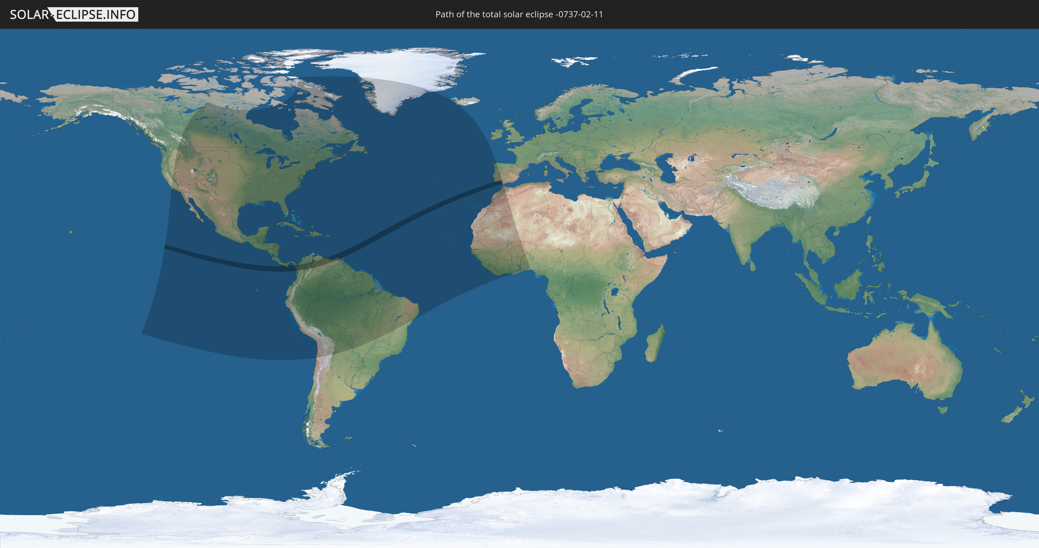
Die Sonnenfinsternis am 11.02.-0737 kann man in 72 Ländern als partielle Sonnenfinsternis beobachten.
Der Finsternispfad verläuft durch 9 Länder. Nur in diesen Ländern ist sie als totale Sonnenfinsternis zu sehen.
In den folgenden Ländern ist die Sonnenfinsternis total zu sehen
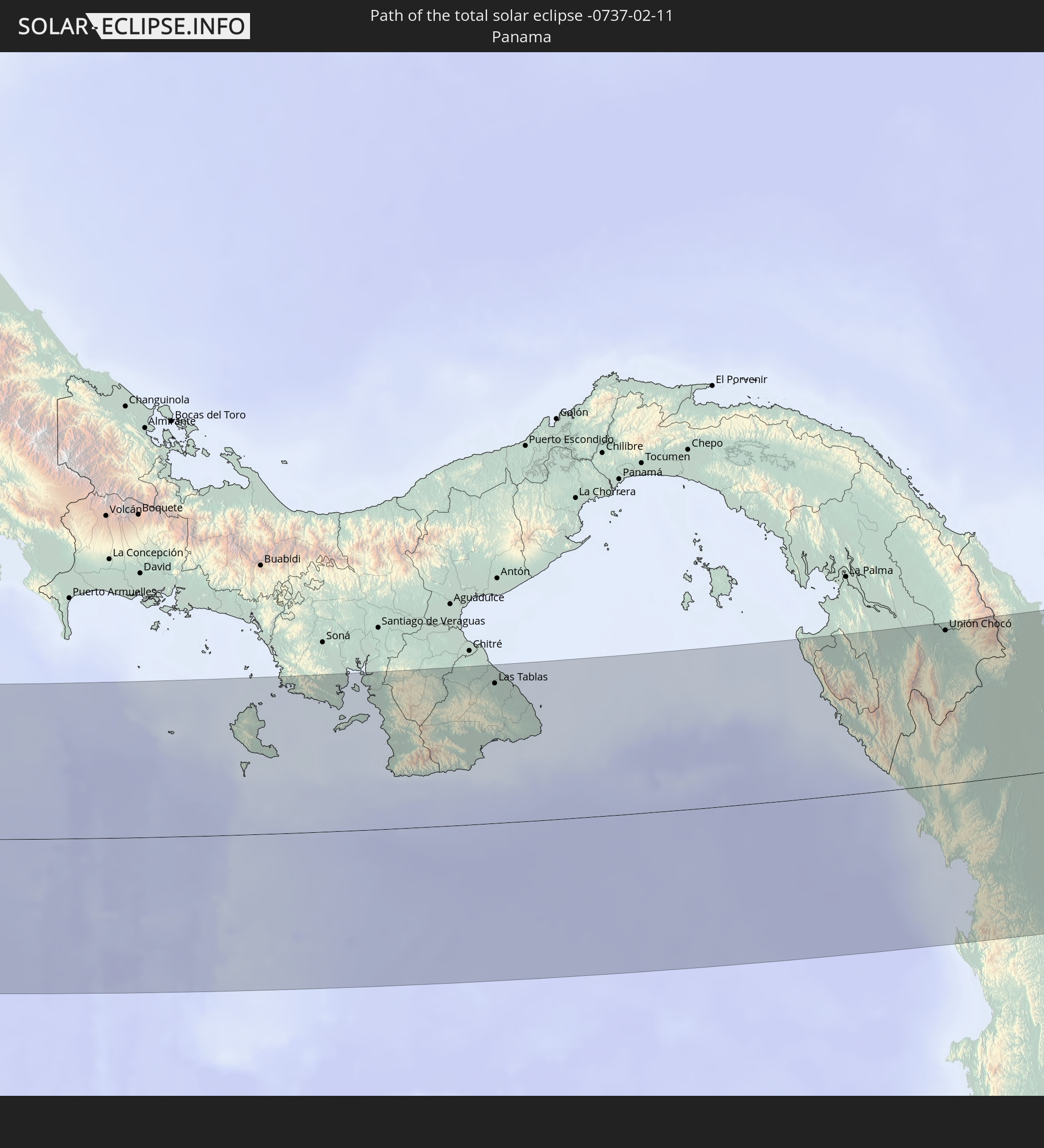 Panama
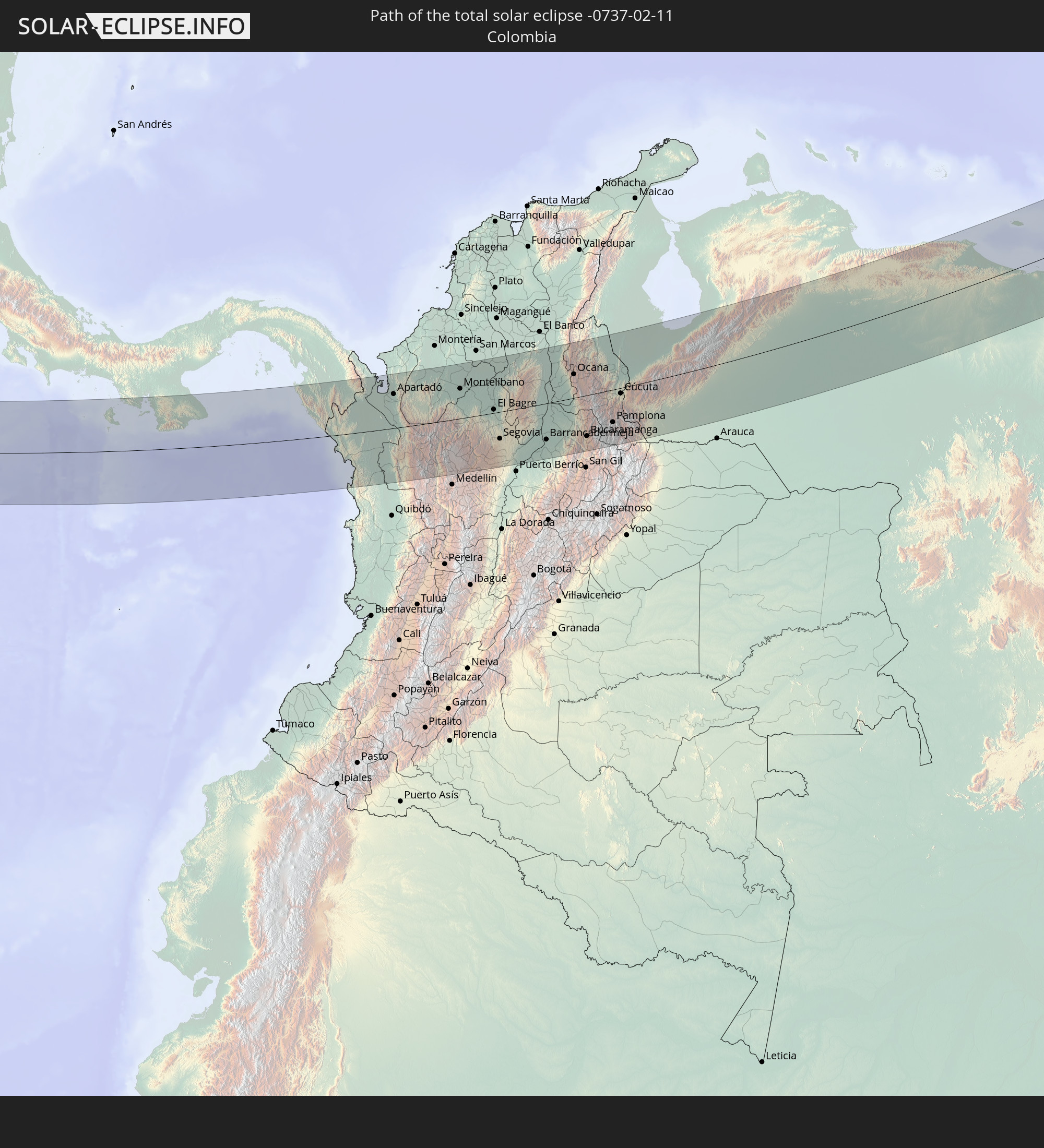 Kolumbien
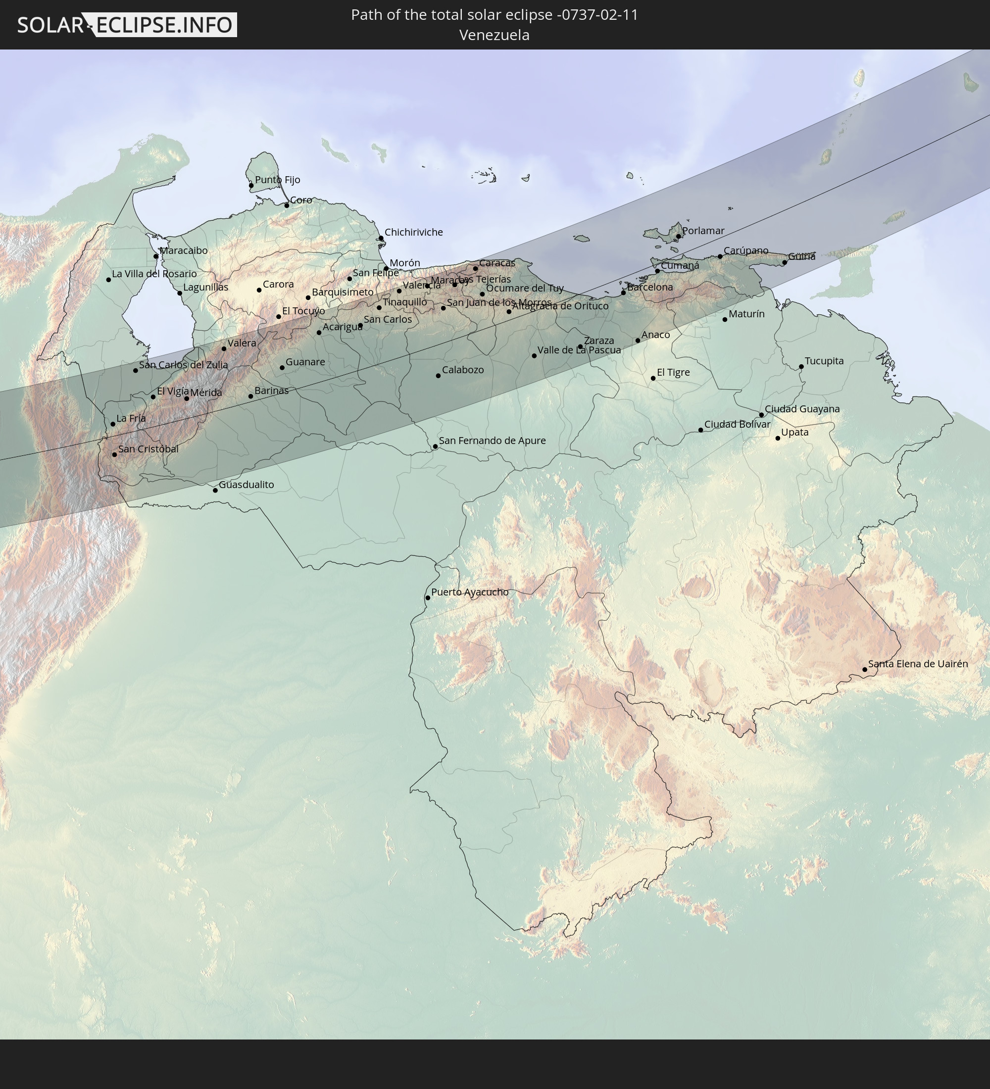 Venezuela
 Trinidad und Tobago
 Grenada
 St. Vincent und die Grenadinen
 Barbados
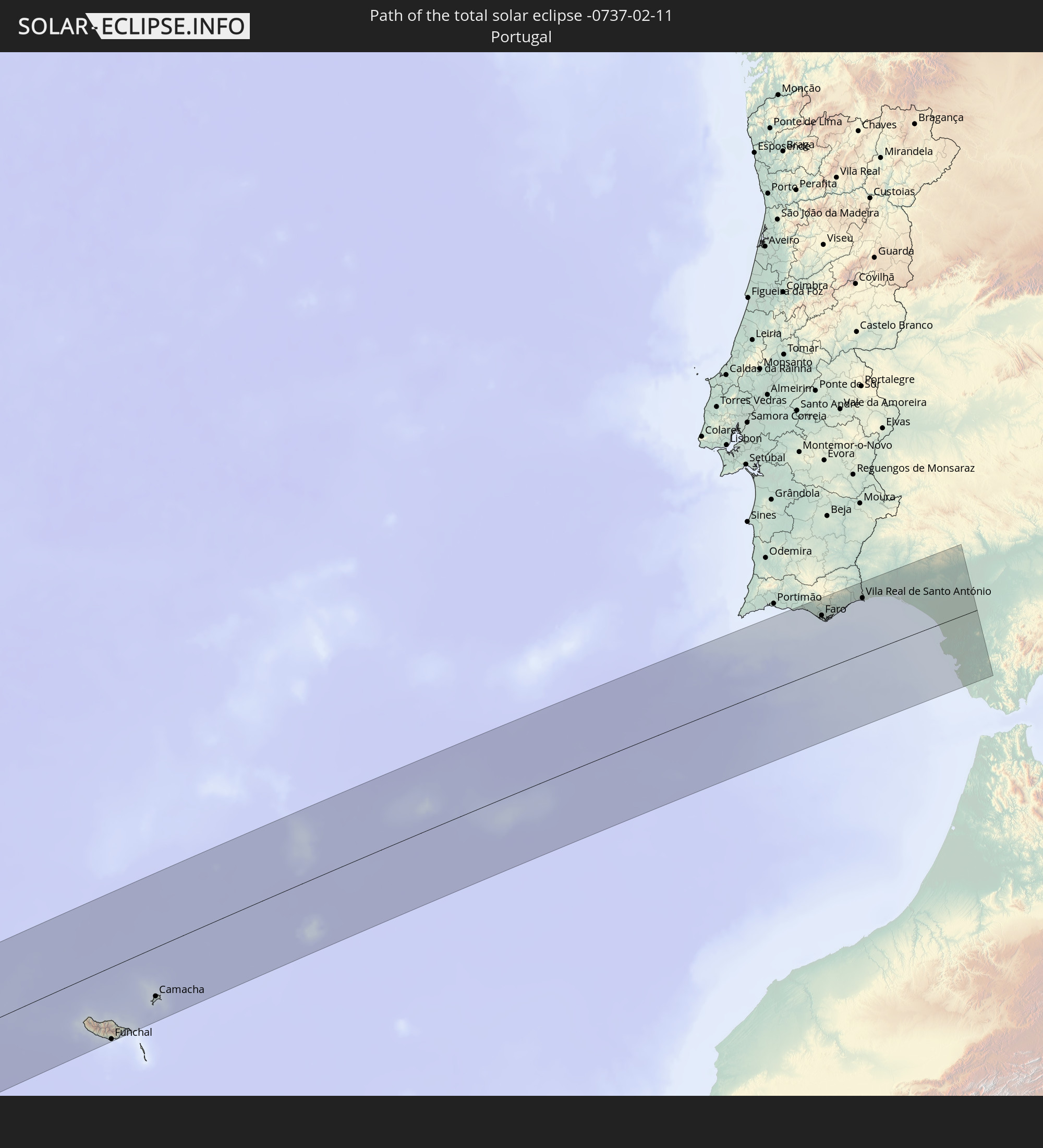 Portugal
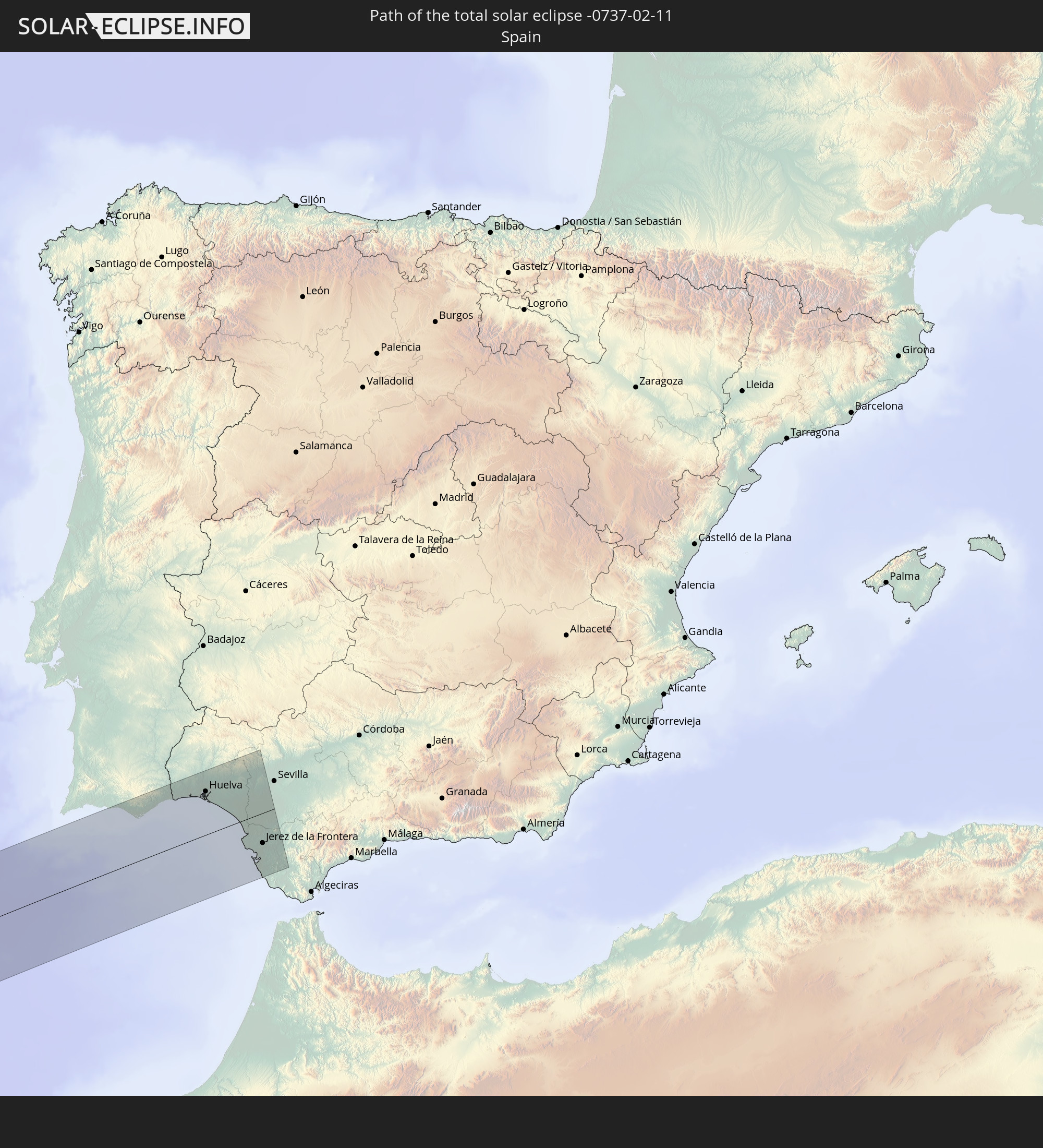 Spanien
In den folgenden Ländern ist die Sonnenfinsternis partiell zu sehen
 Vereinigte Staaten
 United States Minor Outlying Islands
 Kanada
 Mexiko
 Chile
Chile
 Grönland
 Guatemala
 Ecuador
 El Salvador
 Honduras
 Belize
 Nicaragua
 Costa Rica
 Kuba
Kuba
 Panama
 Kolumbien
 Kaimaninseln
 Peru
Peru
 Bahamas
 Jamaika
 Haiti
Haiti
 Brasilien
 Argentinien
 Venezuela
 Turks- und Caicosinseln
 Dominikanische Republik
 Aruba
Aruba
 Bolivien
 Puerto Rico
 Amerikanische Jungferninseln
 Bermuda
 Britische Jungferninseln
 Anguilla
 Saint-Martin
 Saint-Barthélemy
 St. Kitts und Nevis
 Paraguay
 Antigua und Barbuda
 Montserrat
 Trinidad und Tobago
 Guadeloupe
 Grenada
 Dominica
 St. Vincent und die Grenadinen
 Guyana
 Martinique
 St. Lucia
 Barbados
 Suriname
 Saint-Pierre und Miquelon
 Französisch-Guayana
 Portugal
 Kap Verde
 Island
 Spanien
 Senegal
 Mauretanien
 Gambia
 Guinea-Bissau
 Guinea
 Sierra Leone
 Marokko
 Mali
Mali
 Liberia
 Algerien
 Elfenbeinküste
 Burkina Faso
 Ghana
Ghana
 Togo
Togo
 Niger
Niger
 Benin
Benin
 Nigeria
Wie wird das Wetter während der totalen Sonnenfinsternis am 11.02.-0737?
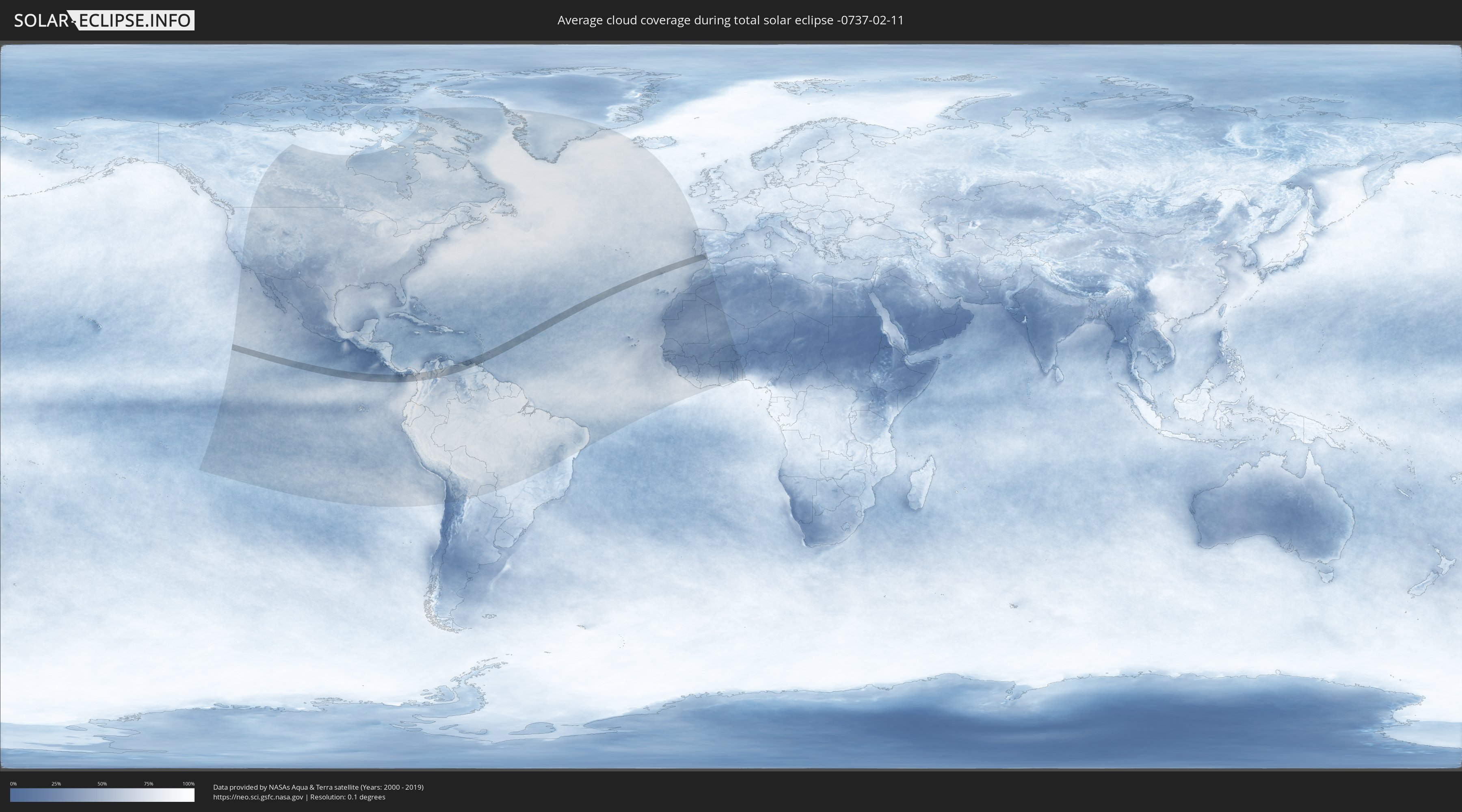
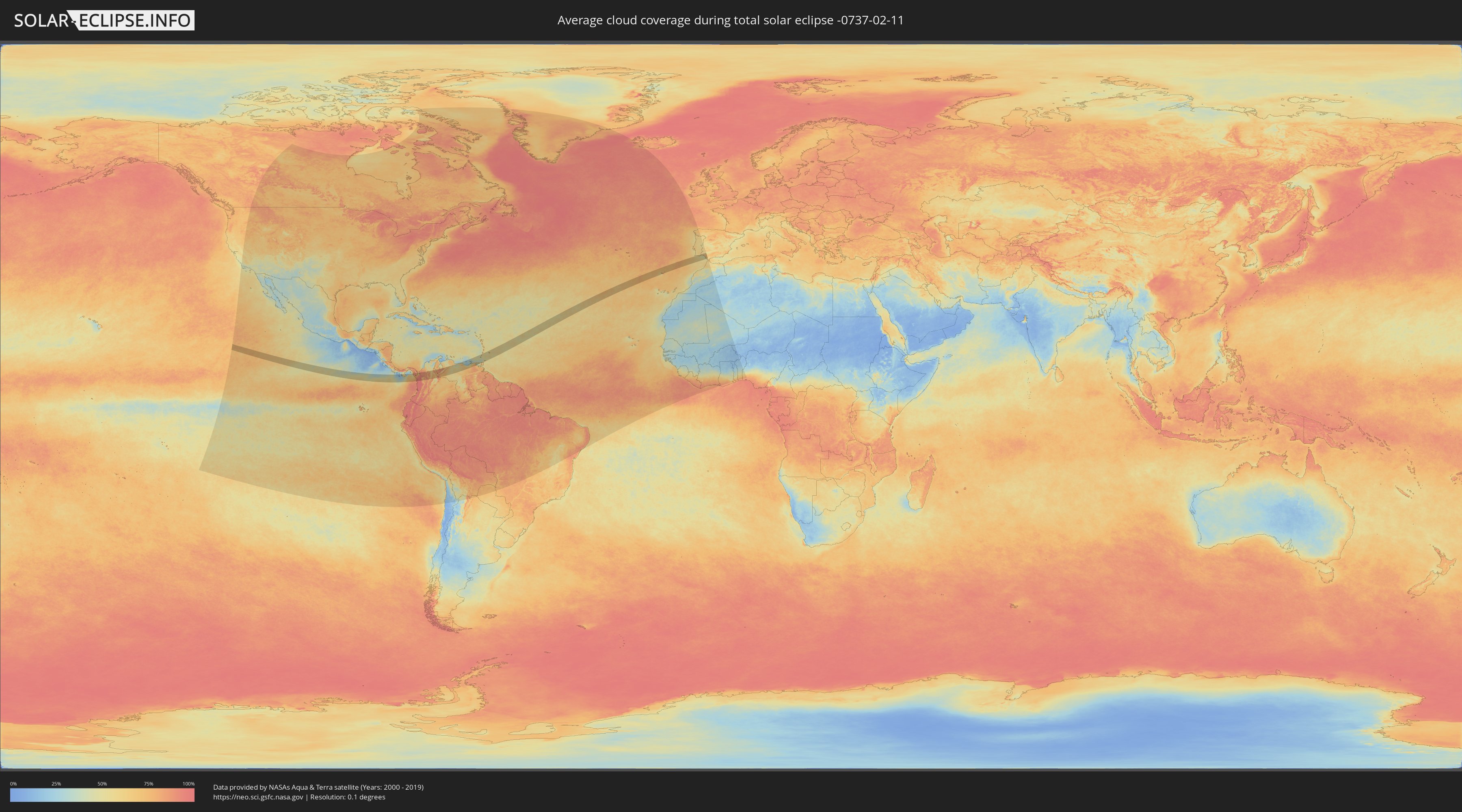
Wo ist der beste Ort, um die totale Sonnenfinsternis vom 11.02.-0737 zu beobachten?
Die folgenden Karten zeigen die durchschnittliche Bewölkung für den Tag, an dem die totale Sonnenfinsternis
stattfindet. Mit Hilfe der Karten lässt sich der Ort entlang des Finsternispfades eingrenzen,
der die besten Aussichen auf einen klaren wolkenfreien Himmel bietet.
Trotzdem muss man immer lokale Gegenenheiten beachten und sollte sich genau über das Wetter an seinem
gewählten Beobachtungsort informieren.
Die Daten stammen von den beiden NASA-Satelliten
AQUA und TERRA
und wurden über einen Zeitraum von 19 Jahren (2000 - 2019) gemittelt.
Detaillierte Länderkarten
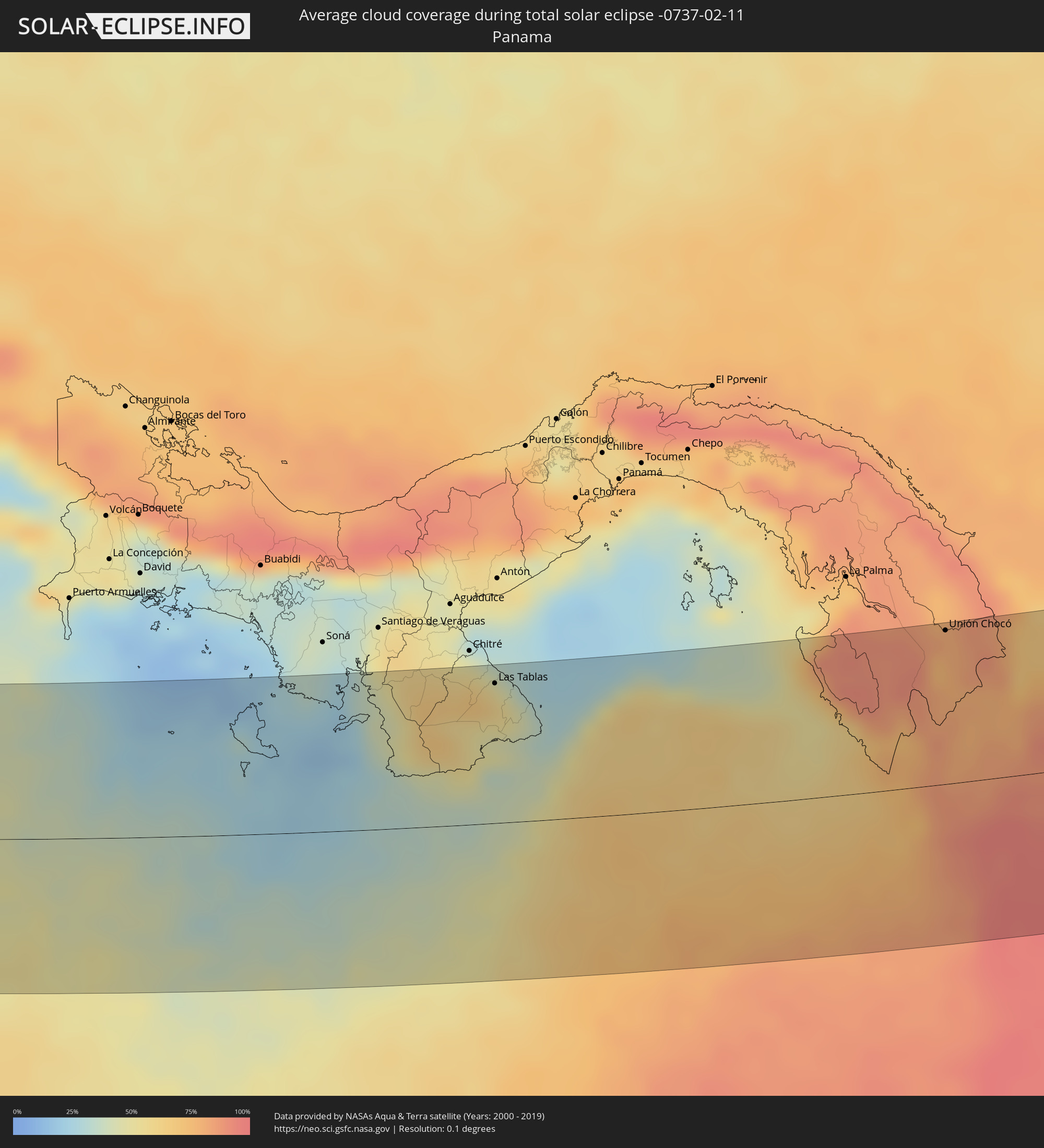 Panama
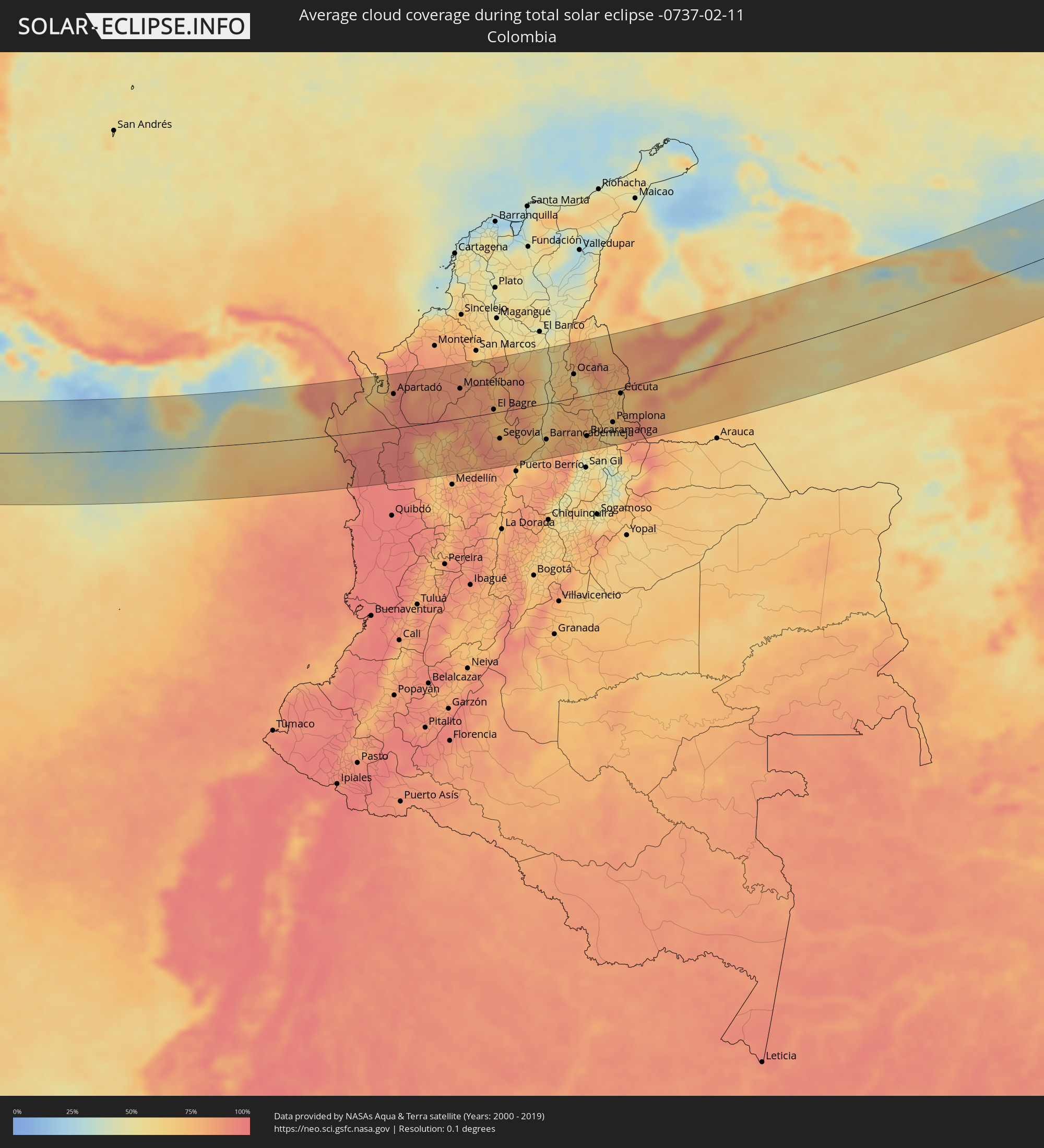 Kolumbien
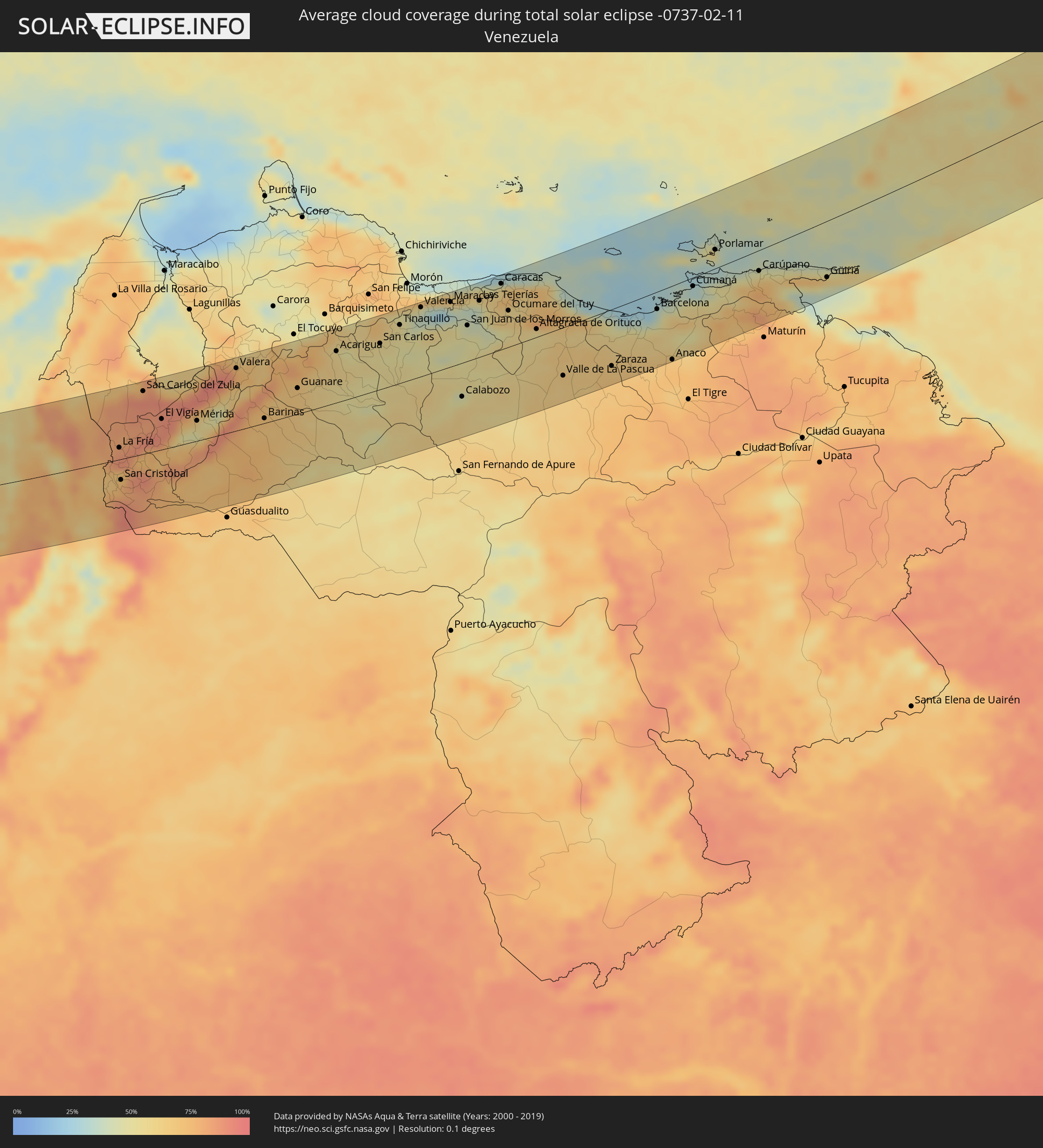 Venezuela
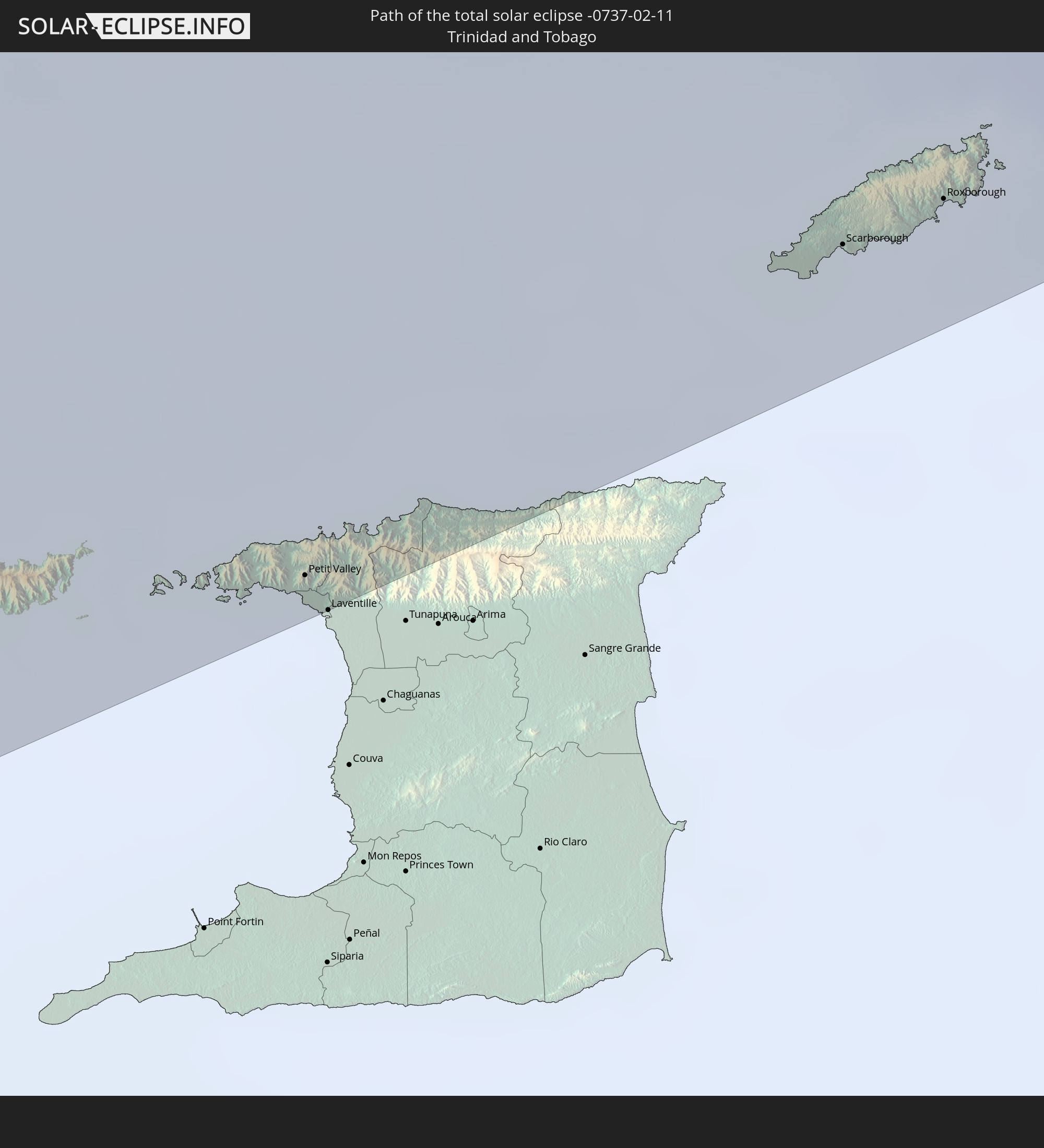
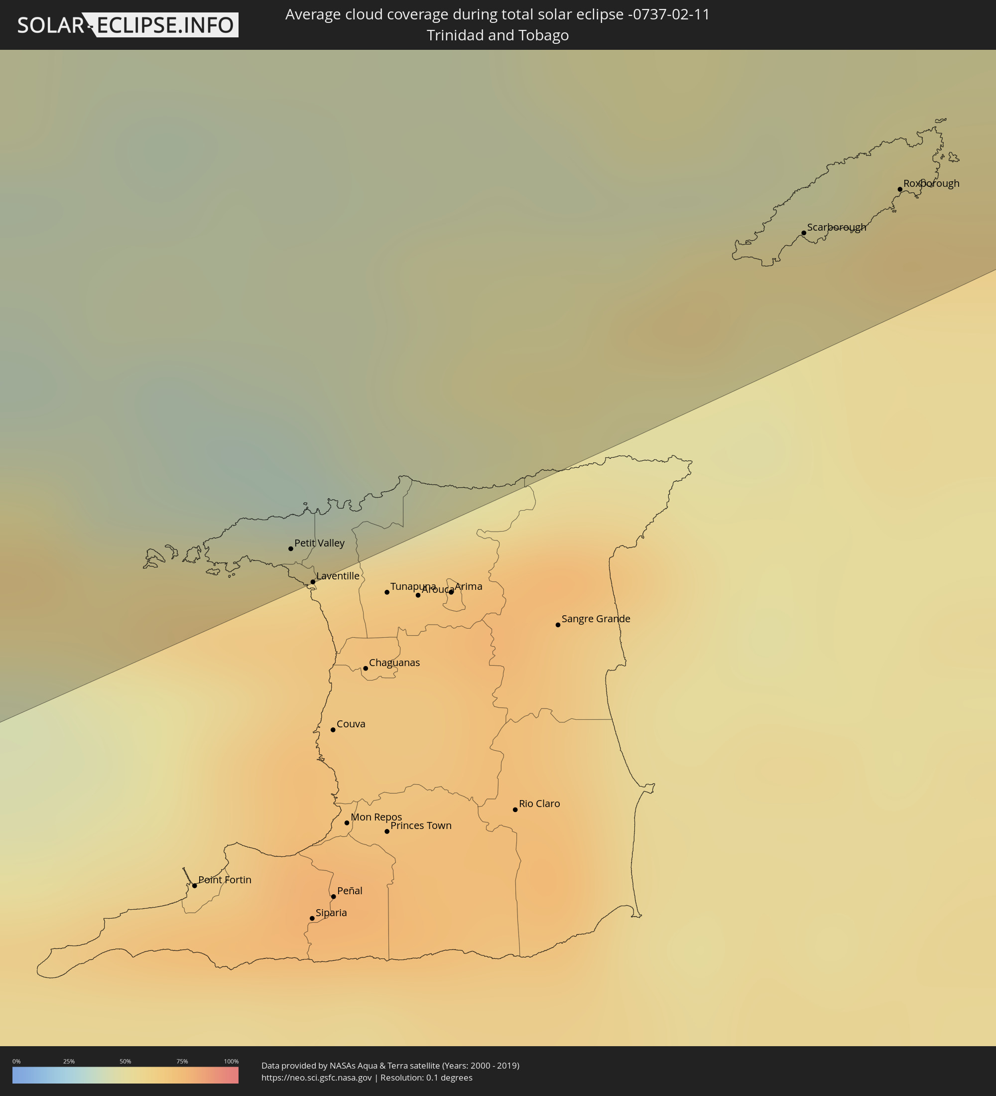 Trinidad und Tobago
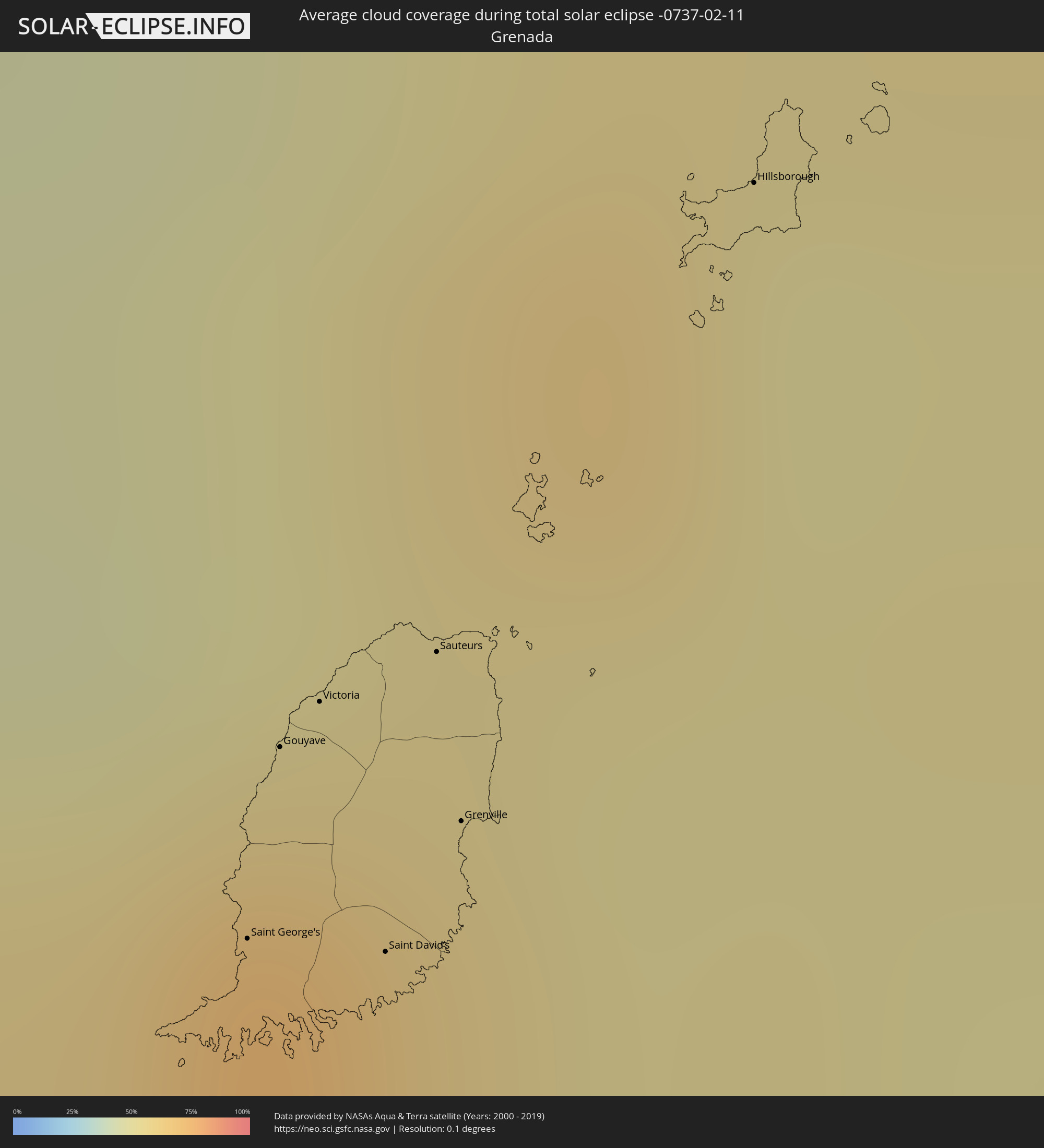 Grenada
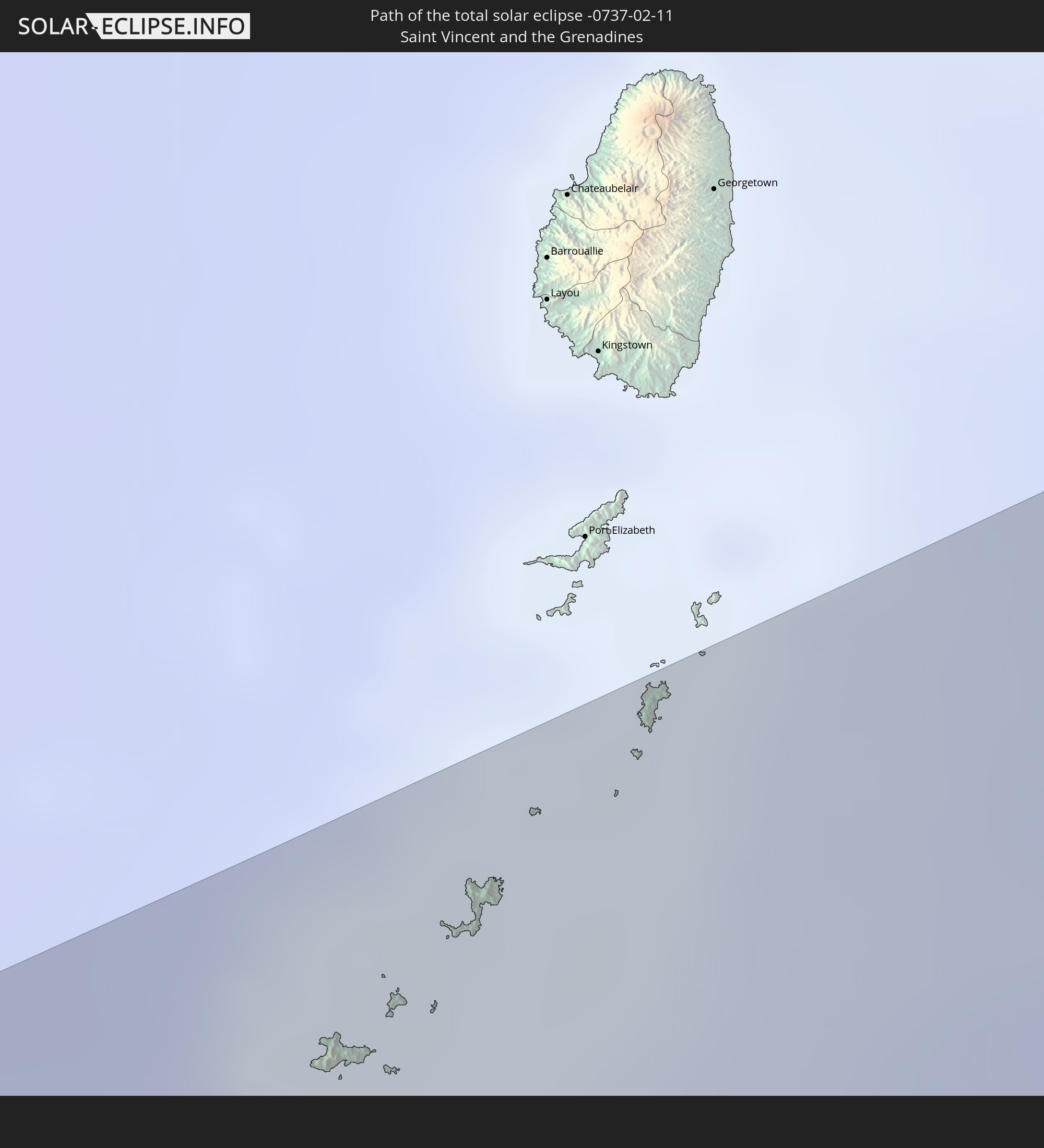
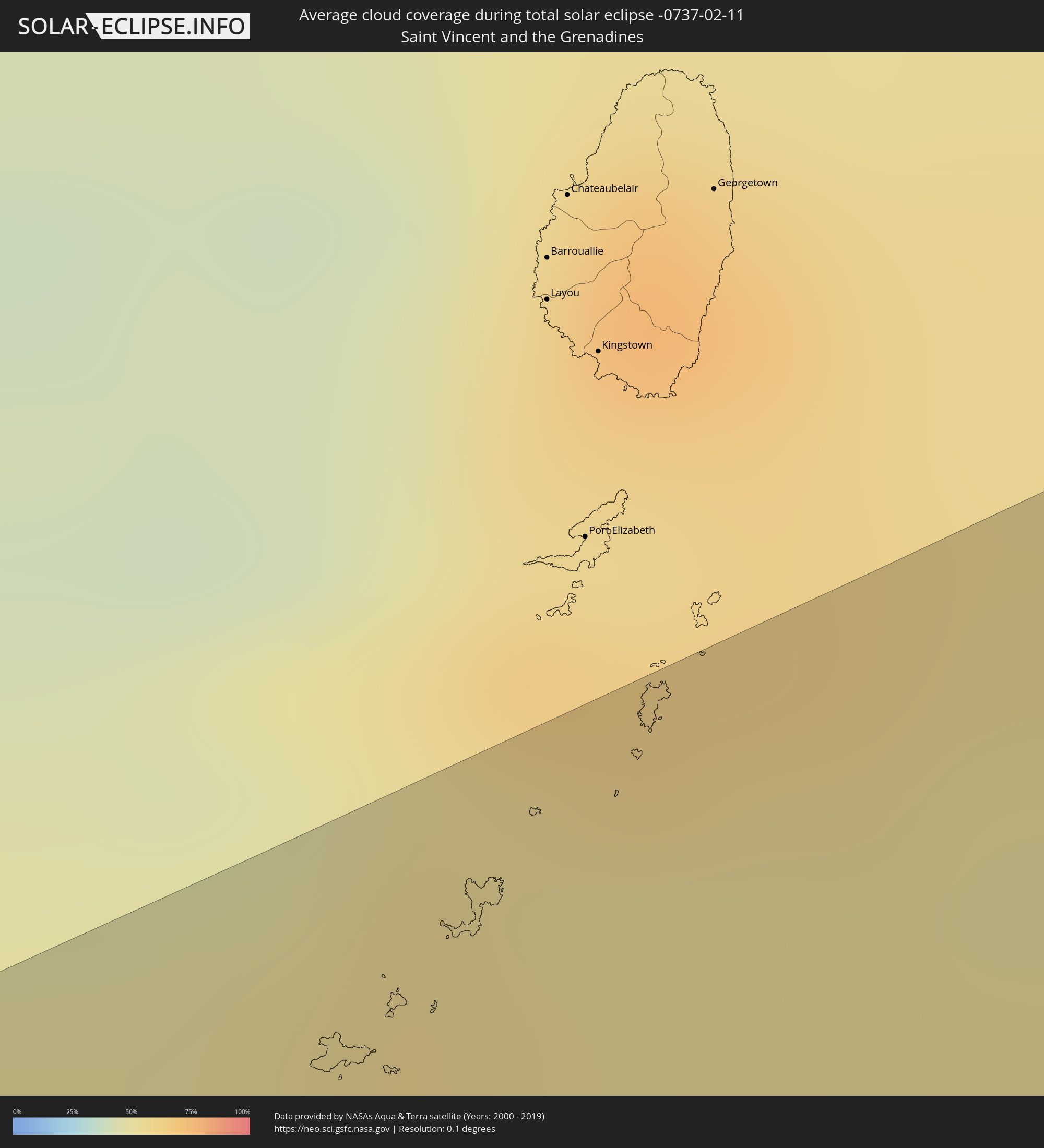 St. Vincent und die Grenadinen
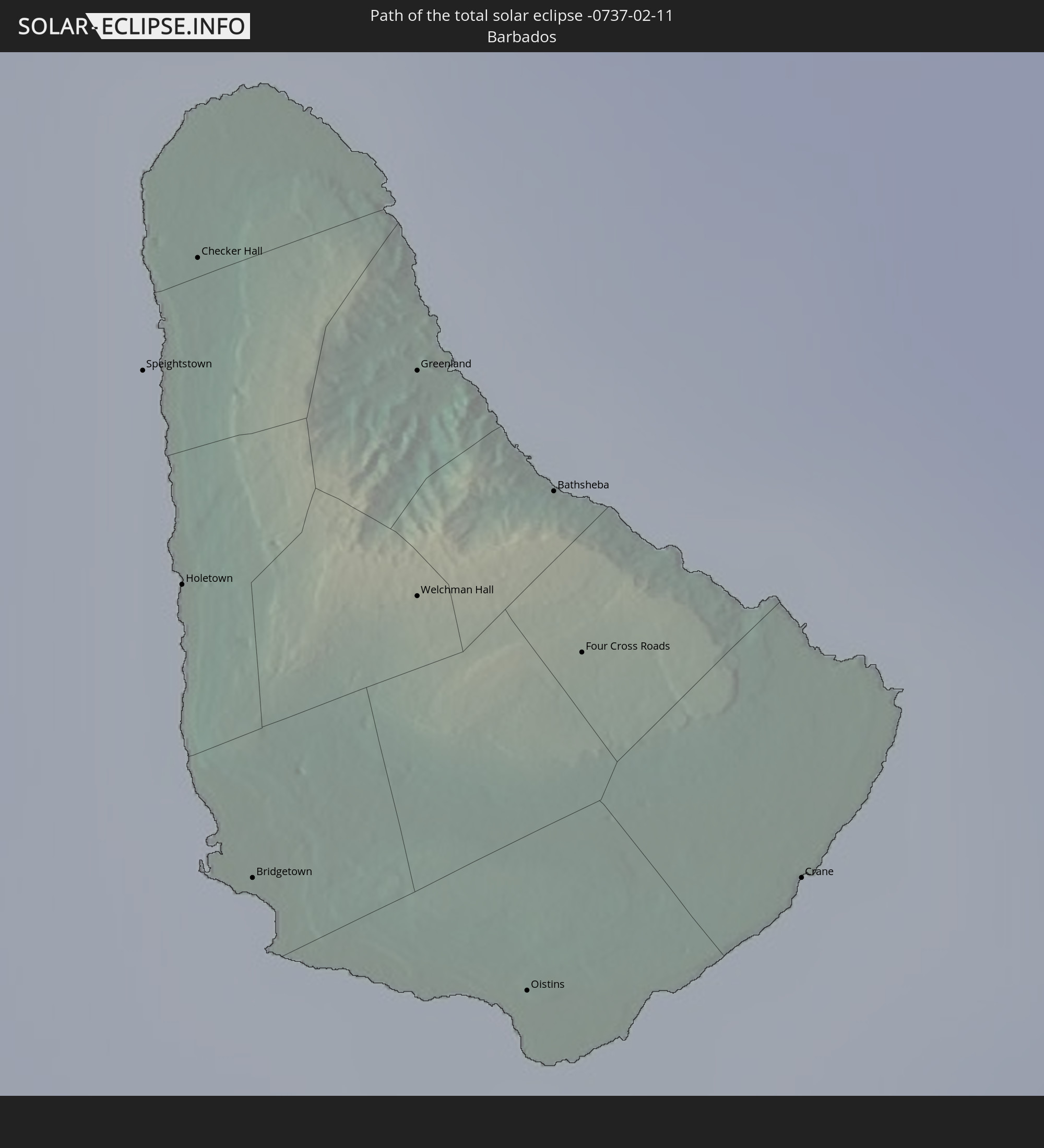
 Barbados
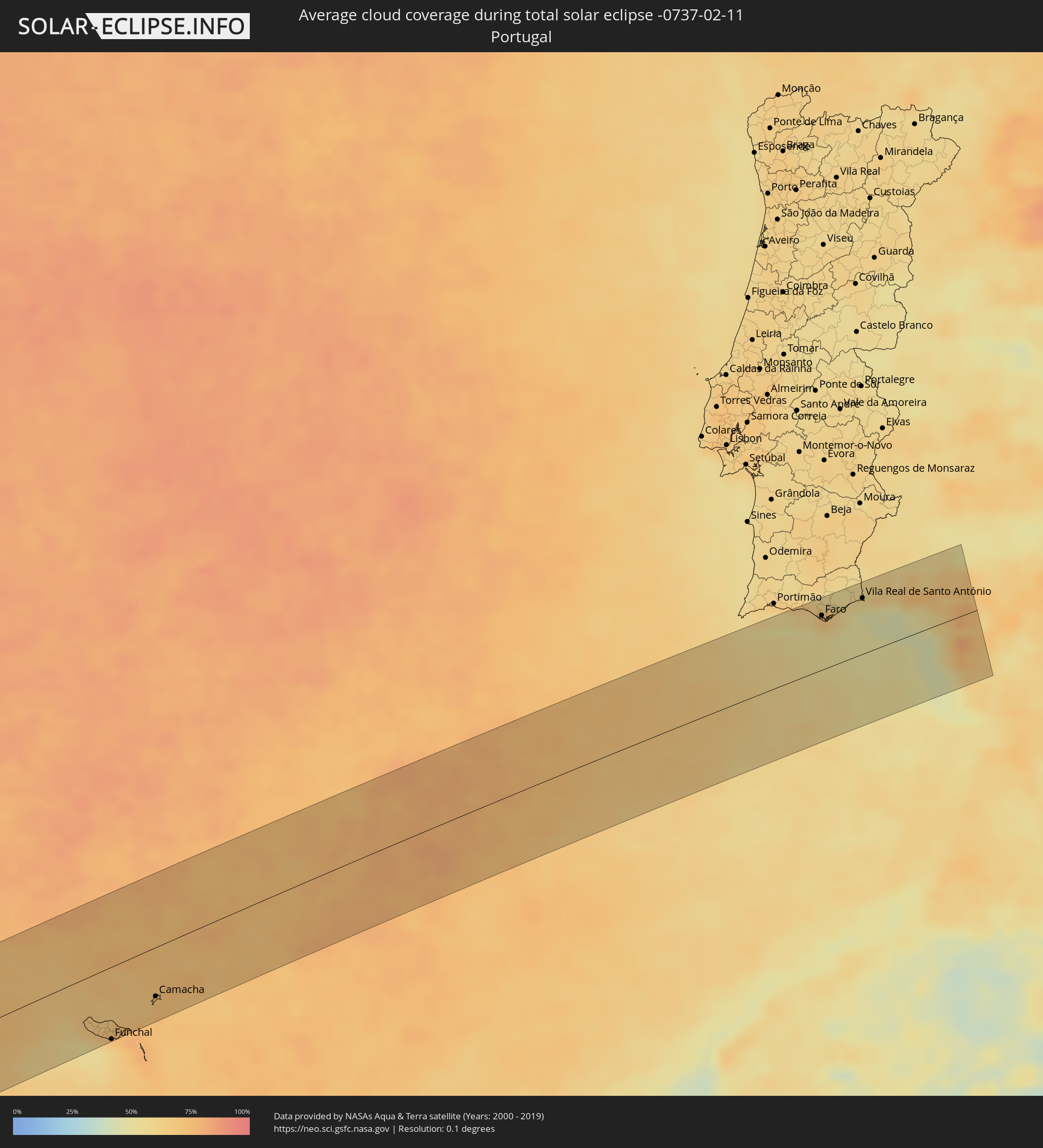 Portugal
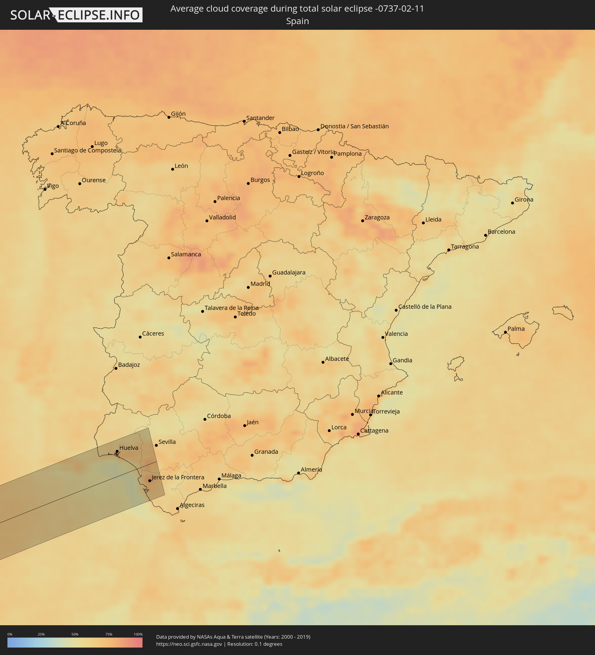 Spanien
Orte im Finsternispfad
Die nachfolgene Tabelle zeigt Städte und Orte mit mehr als 5.000 Einwohnern, die sich im Finsternispfad befinden. Städte mit mehr als 100.000 Einwohnern sind dick gekennzeichnet. Mit einem Klick auf den Ort öffnet sich eine Detailkarte die die Lage des jeweiligen Ortes zusammen mit dem Verlauf der zentralen Finsternis präsentiert.
| Ort | Typ | Dauer der Verfinsterung | Ortszeit bei maximaler Verfinsterung | Entfernung zur Zentrallinie | Ø Bewölkung |
|
Las Tablas, Los Santos
|
total | - | 10:16:44 UTC-05:19 | 94 km | 57% |
|
Unión Chocó, Emberá
|
total | - | 10:24:10 UTC-05:19 | 102 km | 80% |
|
Turbo, Antioquia
|
total | - | 10:49:41 UTC-04:56 | 92 km | 81% |
|
Chigorodó, Antioquia
|
total | - | 10:49:27 UTC-04:56 | 45 km | 90% |
|
Apartadó, Antioquia
|
total | - | 10:49:47 UTC-04:56 | 68 km | 91% |
|
Dabeiba, Antioquia
|
total | - | 10:50:00 UTC-04:56 | 35 km | 90% |
|
Tierralta, Córdoba
|
total | - | 10:51:35 UTC-04:56 | 91 km | 87% |
|
Antioquia, Antioquia
|
total | - | 10:50:49 UTC-04:56 | 91 km | 65% |
|
Montelíbano, Córdoba
|
total | - | 10:53:11 UTC-04:56 | 59 km | 88% |
|
Yarumal, Antioquia
|
total | - | 10:52:18 UTC-04:56 | 53 km | 80% |
|
Caucasia, Antioquia
|
total | - | 10:53:49 UTC-04:56 | 56 km | 83% |
|
Ayapel, Córdoba
|
total | - | 10:54:16 UTC-04:56 | 91 km | 81% |
|
El Bagre, Antioquia
|
total | - | 10:54:33 UTC-04:56 | 7 km | 76% |
|
San Carlos, Antioquia
|
total | - | 10:54:49 UTC-04:56 | 27 km | 76% |
|
Segovia, Antioquia
|
total | - | 10:54:24 UTC-04:56 | 53 km | 80% |
|
Puerto Wilches, Santander
|
total | - | 10:56:53 UTC-04:56 | 39 km | 58% |
|
Morales, Bolívar
|
total | - | 10:57:48 UTC-04:56 | 61 km | 59% |
|
Barrancabermeja, Santander
|
total | - | 10:56:45 UTC-04:56 | 71 km | 67% |
|
Pelaya, Cesar
|
total | - | 10:58:46 UTC-04:56 | 102 km | 59% |
|
Aguachica, Cesar
|
total | - | 10:58:33 UTC-04:56 | 60 km | 65% |
|
Ocaña, Norte de Santander
|
total | - | 10:59:14 UTC-04:56 | 46 km | 71% |
|
Bucaramanga, Santander
|
total | - | 10:58:53 UTC-04:56 | 80 km | 74% |
|
Piedecuesta, Santander
|
total | - | 10:58:58 UTC-04:56 | 97 km | 73% |
|
Tibú, Norte de Santander
|
total | - | 11:01:23 UTC-04:56 | 76 km | 78% |
|
Pamplona, Norte de Santander
|
total | - | 11:00:28 UTC-04:56 | 64 km | 68% |
|
Cúcuta, Norte de Santander
|
total | - | 11:01:20 UTC-04:56 | 11 km | 70% |
|
Puerto Santander, Norte de Santander
|
total | - | 11:02:04 UTC-04:56 | 38 km | 80% |
|
San Cristóbal, Táchira
|
total | - | 11:30:38 UTC-04:27 | 31 km | 78% |
|
Mérida, Mérida
|
total | - | 11:34:30 UTC-04:27 | 30 km | 53% |
|
Mucumpiz, Mérida
|
total | - | 11:34:24 UTC-04:27 | 11 km | 73% |
|
Valera, Trujillo
|
total | - | 11:36:48 UTC-04:27 | 93 km | 76% |
|
Barinas, Barinas
|
total | - | 11:37:18 UTC-04:27 | 7 km | 69% |
|
Guanare, Portuguesa
|
total | - | 11:39:04 UTC-04:27 | 38 km | 66% |
|
Acarigua, Portuguesa
|
total | - | 11:41:10 UTC-04:27 | 76 km | 58% |
|
Valencia, Carabobo
|
total | - | 11:45:15 UTC-04:27 | 101 km | 38% |
|
Guacara, Carabobo
|
total | - | 11:45:42 UTC-04:27 | 104 km | 31% |
|
Mariara, Carabobo
|
total | - | 11:46:14 UTC-04:27 | 105 km | 32% |
|
Maracay, Aragua
|
total | - | 11:46:33 UTC-04:27 | 95 km | 31% |
|
Cagua, Aragua
|
total | - | 11:46:53 UTC-04:27 | 85 km | 37% |
|
Calabozo, Guárico
|
total | - | 11:45:44 UTC-04:27 | 49 km | 58% |
|
San Juan de los Morros, Guárico
|
total | - | 11:46:56 UTC-04:27 | 52 km | 47% |
|
Los Teques, Miranda
|
total | - | 11:48:16 UTC-04:27 | 87 km | 59% |
|
Cúa, Miranda
|
total | - | 11:48:33 UTC-04:27 | 61 km | 62% |
|
Caracas, Capital
|
total | - | 11:48:53 UTC-04:27 | 96 km | 59% |
|
Santa Teresa, Miranda
|
total | - | 11:49:16 UTC-04:27 | 61 km | 58% |
|
Guatire, Miranda
|
total | - | 11:49:52 UTC-04:27 | 82 km | 61% |
|
Valle de La Pascua, Guárico
|
total | - | 11:50:11 UTC-04:27 | 70 km | 62% |
|
Barcelona, Anzoátegui
|
total | - | 11:54:57 UTC-04:27 | 25 km | 42% |
|
Anaco, Anzoátegui
|
total | - | 11:54:53 UTC-04:27 | 106 km | 73% |
|
Cumaná, Sucre
|
total | - | 11:56:44 UTC-04:27 | 12 km | 33% |
|
Porlamar, Nueva Esparta
|
total | - | 11:58:08 UTC-04:27 | 27 km | 47% |
|
Carúpano, Sucre
|
total | - | 11:59:37 UTC-04:27 | 29 km | 60% |
|
Saint George's, Saint George
|
total | - | 12:26:51 UTC-04:06 | 47 km | 63% |
|
Gouyave, Saint John
|
total | - | 12:27:01 UTC-04:06 | 57 km | 71% |
|
Victoria, Saint Mark
|
total | - | 12:27:06 UTC-04:06 | 59 km | 71% |
|
Saint David’s, Saint David
|
total | - | 12:27:05 UTC-04:06 | 43 km | 52% |
|
Sauteurs, Saint Patrick
|
total | - | 12:27:19 UTC-04:06 | 59 km | 60% |
|
Grenville, Saint Andrew
|
total | - | 12:27:16 UTC-04:06 | 48 km | 58% |
|
Petit Valley, Diego Martin
|
total | - | 12:26:09 UTC-04:06 | 100 km | 66% |
|
Port of Spain, City of Port of Spain
|
total | - | 12:26:10 UTC-04:06 | 104 km | 66% |
|
Laventille, San Juan/Laventille
|
total | - | 12:26:12 UTC-04:06 | 107 km | 65% |
|
Hillsborough, Carriacou and Petite Martinique
|
total | - | 12:28:05 UTC-04:06 | 77 km | 60% |
|
Scarborough, Tobago
|
total | - | 12:28:52 UTC-04:06 | 87 km | 52% |
|
Roxborough, Eastern Tobago
|
total | - | 12:29:21 UTC-04:06 | 87 km | 60% |
|
Speightstown, Saint Peter
|
total | - | 12:41:24 UTC-03:58 | 70 km | 69% |
|
Holetown, Saint James
|
total | - | 12:41:22 UTC-03:58 | 63 km | 73% |
|
Checker Hall, Saint Lucy
|
total | - | 12:41:28 UTC-03:58 | 73 km | 61% |
|
Bridgetown, Saint Michael
|
total | - | 12:41:21 UTC-03:58 | 53 km | 65% |
|
Greenland, Saint Andrew
|
total | - | 12:41:37 UTC-03:58 | 66 km | 61% |
|
Welchman Hall, Saint Thomas
|
total | - | 12:41:34 UTC-03:58 | 59 km | 73% |
|
Oistins, Christ Church
|
total | - | 12:41:33 UTC-03:58 | 46 km | 62% |
|
Bathsheba, Saint Joseph
|
total | - | 12:41:42 UTC-03:58 | 61 km | 65% |
|
Four Cross Roads, Saint John
|
total | - | 12:41:41 UTC-03:58 | 55 km | 65% |
|
Crane, Saint Philip
|
total | - | 12:41:48 UTC-03:58 | 46 km | 62% |
|
Ribeira Brava, Madeira
|
total | - | 17:49:49 UTC+00:00 | 70 km | 62% |
|
São Vicente, Madeira
|
total | - | 17:13:01 UTC-00:36 | 56 km | 71% |
|
Câmara de Lobos, Madeira
|
total | - | 17:49:52 UTC+00:00 | 75 km | 59% |
|
Nossa Senhora do Monte, Madeira
|
total | - | 17:13:08 UTC-00:36 | 74 km | 72% |
|
Funchal, Madeira
|
total | - | 17:49:54 UTC+00:00 | 78 km | 63% |
|
Santana, Madeira
|
total | - | 17:13:06 UTC-00:36 | 61 km | 75% |
|
Caniço, Madeira
|
total | - | 17:13:11 UTC-00:36 | 80 km | 63% |
|
Camacha, Madeira
|
total | - | 17:13:10 UTC-00:36 | 75 km | 75% |
|
Santa Cruz, Madeira
|
total | - | 17:13:11 UTC-00:36 | 77 km | 75% |
|
Machico, Madeira
|
total | - | 17:13:12 UTC-00:36 | 76 km | 75% |
|
Camacha, Madeira
|
total | - | 17:13:14 UTC-00:36 | 53 km | 72% |
|
Albufeira, Faro
|
total | - | 17:14:04 UTC-00:36 | 74 km | 58% |
|
Quarteira, Faro
|
total | - | 17:14:07 UTC-00:36 | 68 km | 59% |
|
Almancil, Faro
|
total | - | 17:14:08 UTC-00:36 | 67 km | 65% |
|
Loulé, Faro
|
total | - | 17:14:06 UTC-00:36 | 72 km | 65% |
|
Faro, Faro
|
total | - | 17:14:12 UTC-00:36 | 57 km | 60% |
|
São Brás de Alportel, Faro
|
total | - | 17:14:07 UTC-00:36 | 69 km | 63% |
|
Olhão, Faro
|
total | - | 17:14:13 UTC-00:36 | 55 km | 57% |
|
Laranjeiro, Faro
|
total | - | 17:14:12 UTC-00:36 | 58 km | 61% |
|
Moncarapacho, Faro
|
total | - | 17:14:11 UTC-00:36 | 59 km | 61% |
|
Tavira, Faro
|
total | - | 17:14:12 UTC-00:36 | 59 km | 52% |
|
Castro Marim, Faro
|
total | - | 17:14:11 UTC-00:36 | 62 km | 54% |
|
Vila Real de Santo António, Faro
|
total | - | 17:14:12 UTC-00:36 | 59 km | 54% |
|
Ayamonte, Andalusia
|
total | - | 17:50:57 UTC+00:00 | 60 km | 54% |
|
Lepe, Andalusia
|
total | - | 17:50:58 UTC+00:00 | 58 km | 63% |
|
Cartaya, Andalusia
|
total | - | 17:50:58 UTC+00:00 | 59 km | 63% |
|
Gibraleón, Andalusia
|
total | - | 17:50:56 UTC+00:00 | 63 km | 68% |
|
Punta Umbría, Andalusia
|
total | - | 17:51:04 UTC+00:00 | 43 km | 50% |
|
Huelva, Andalusia
|
total | - | 17:51:01 UTC+00:00 | 51 km | 70% |
|
Palos de la Frontera, Andalusia
|
total | - | 17:51:03 UTC+00:00 | 46 km | 59% |
|
San Juan del Puerto, Andalusia
|
total | - | 17:51:00 UTC+00:00 | 53 km | 72% |
|
Trigueros, Andalusia
|
total | - | 17:50:58 UTC+00:00 | 59 km | 73% |
|
La Palma del Condado, Andalusia
|
total | - | 17:51:01 UTC+00:00 | 51 km | 74% |
|
Bollullos par del Condado, Andalusia
|
total | - | 17:51:03 UTC+00:00 | 46 km | 69% |
|
Almonte, Andalusia
|
total | - | 17:51:06 UTC+00:00 | 37 km | 69% |
|
Sanlúcar de Barrameda, Andalusia
|
total | - | 17:51:26 UTC+00:00 | 19 km | 57% |
|
Pilas, Andalusia
|
total | - | 17:51:07 UTC+00:00 | 37 km | 66% |
|
Cadiz, Andalusia
|
total | - | 17:51:35 UTC+00:00 | 47 km | 51% |
|
Sanlúcar la Mayor, Andalusia
|
total | - | 17:51:05 UTC+00:00 | 40 km | 69% |
|
Olivares, Andalusia
|
total | - | 17:51:05 UTC+00:00 | 41 km | 69% |
|
Chiclana de la Frontera, Andalusia
|
total | - | 17:51:41 UTC+00:00 | 63 km | 61% |
|
Jerez de la Frontera, Andalusia
|
total | - | 17:51:32 UTC+00:00 | 35 km | 71% |
|
Espartinas, Andalusia
|
total | - | 17:51:06 UTC+00:00 | 37 km | 73% |
|
Gines, Andalusia
|
total | - | 17:51:07 UTC+00:00 | 36 km | 73% |
|
Lebrija, Andalusia
|
total | - | 17:51:24 UTC+00:00 | 18 km | 78% |
|
Mairena del Aljarafe, Andalusia
|
total | - | 17:51:08 UTC+00:00 | 31 km | 70% |
|
La Puebla del Río, Andalusia
|
total | - | 17:51:11 UTC+00:00 | 23 km | 70% |
|
Medina Sidonia, Andalusia
|
total | - | 17:51:42 UTC+00:00 | 68 km | 61% |