Totale Sonnenfinsternis vom 08.02.-0913
| Wochentag: | Sonntag |
| Maximale Dauer der Verfinsterung: | 03m51s |
| Maximale Breite des Finsternispfades: | 154 km |
| Saroszyklus: | 45 |
| Bedeckungsgrad: | 100% |
| Magnitude: | 1.0416 |
| Gamma: | 0.4384 |
Wo kann man die Sonnenfinsternis vom 08.02.-0913 sehen?
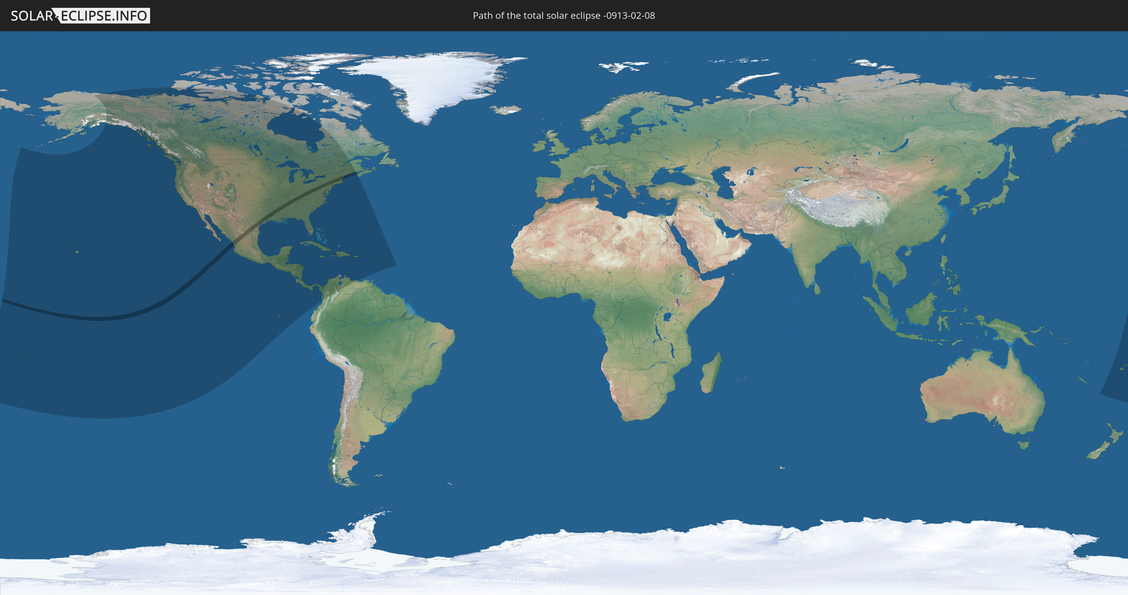
Die Sonnenfinsternis am 08.02.-0913 kann man in 52 Ländern als partielle Sonnenfinsternis beobachten.
Der Finsternispfad verläuft durch 4 Länder. Nur in diesen Ländern ist sie als totale Sonnenfinsternis zu sehen.
In den folgenden Ländern ist die Sonnenfinsternis total zu sehen
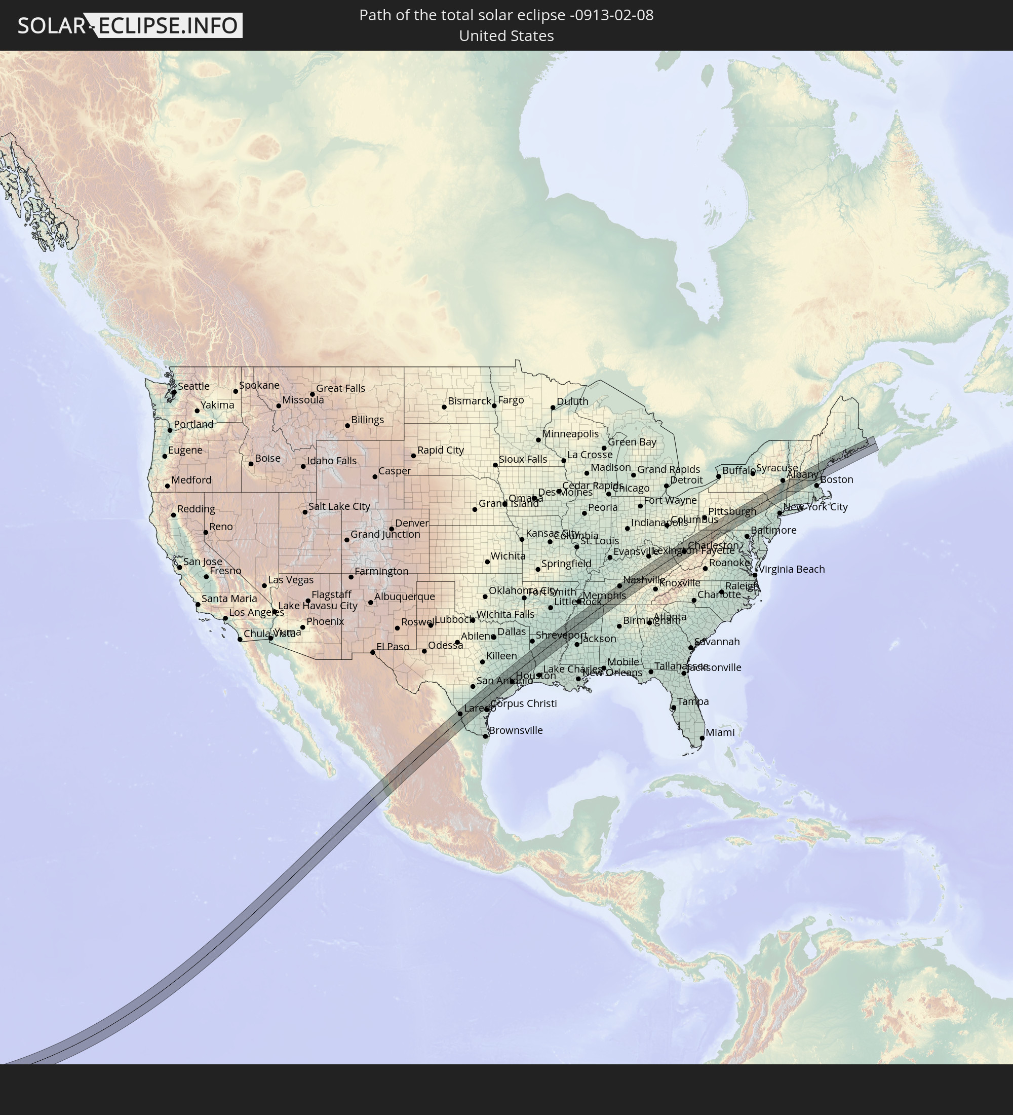 Vereinigte Staaten
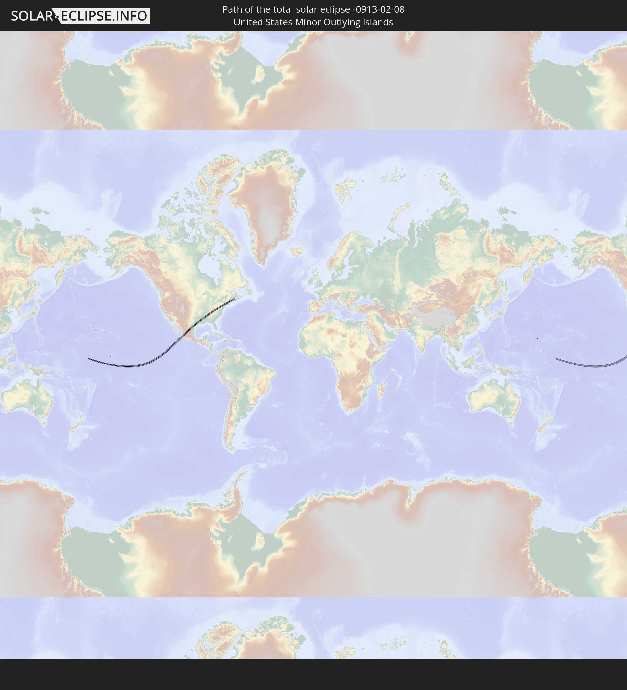 United States Minor Outlying Islands
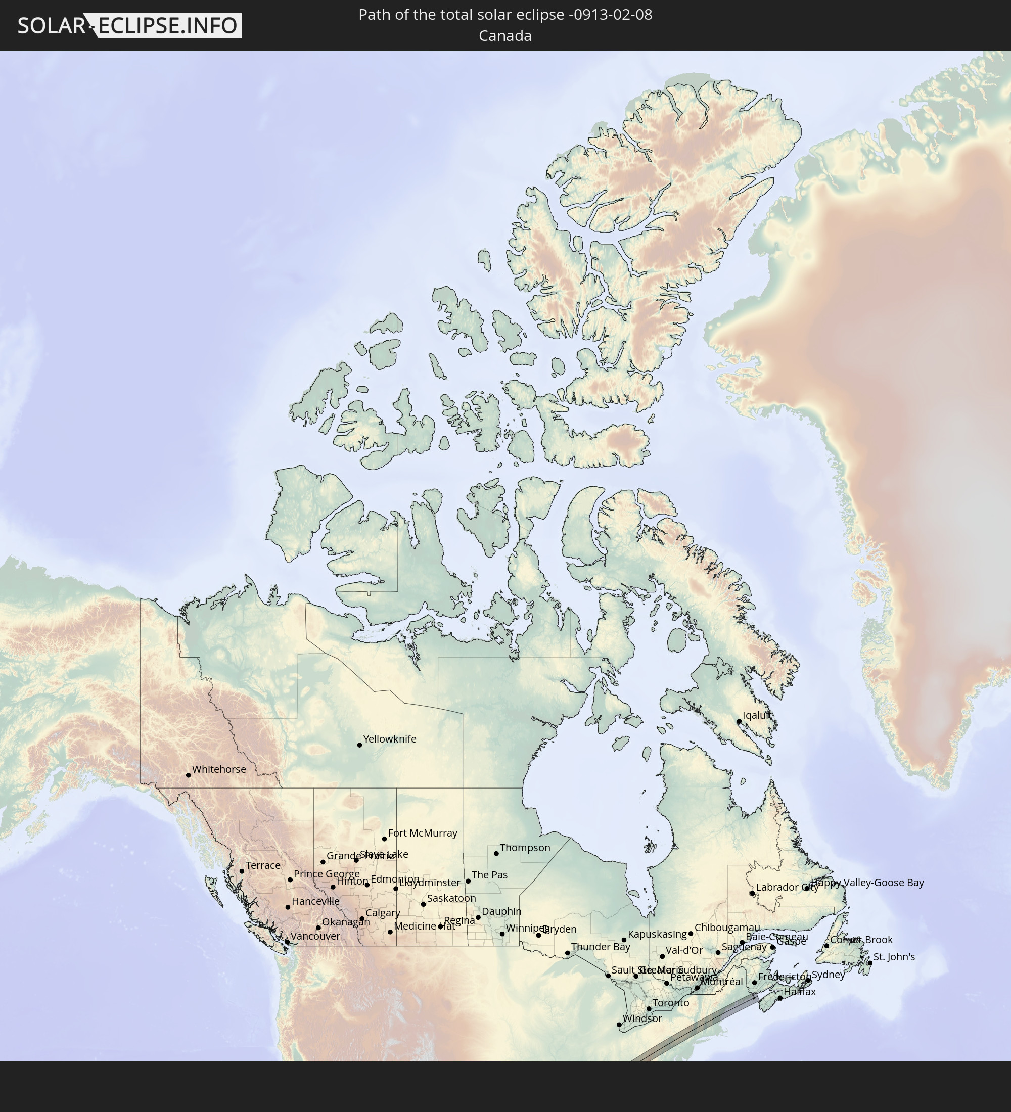 Kanada
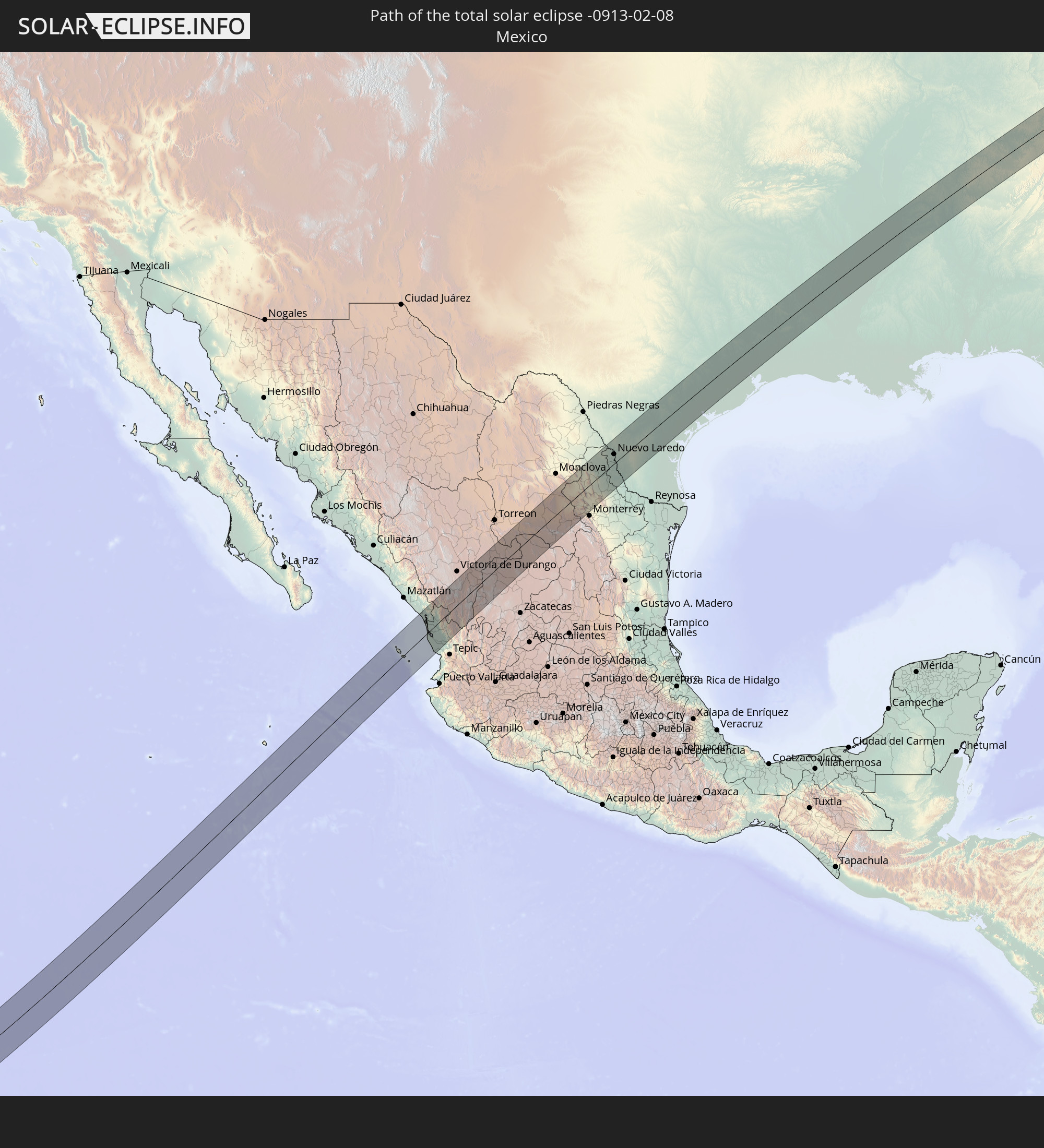 Mexiko
In den folgenden Ländern ist die Sonnenfinsternis partiell zu sehen
 Fidschi
 Vereinigte Staaten
 United States Minor Outlying Islands
 Wallis und Futuna
 Tonga
Tonga
 Kiribati
 Samoa
Samoa
 Tokelau
 Amerikanisch-Samoa
 Niue
Niue
 Cookinseln
 Französisch-Polynesien
 Kanada
 Pitcairninseln
 Mexiko
 Grönland
 Guatemala
 Ecuador
 El Salvador
 Honduras
 Belize
 Nicaragua
 Costa Rica
 Kuba
Kuba
 Panama
 Kolumbien
 Kaimaninseln
 Bahamas
 Jamaika
 Haiti
Haiti
 Venezuela
 Turks- und Caicosinseln
 Dominikanische Republik
 Aruba
Aruba
 Puerto Rico
 Amerikanische Jungferninseln
 Bermuda
 Britische Jungferninseln
 Anguilla
 Saint-Martin
 Saint-Barthélemy
 St. Kitts und Nevis
 Antigua und Barbuda
 Montserrat
 Guadeloupe
 Grenada
 Dominica
 St. Vincent und die Grenadinen
 Martinique
 St. Lucia
 Barbados
 Tuvalu
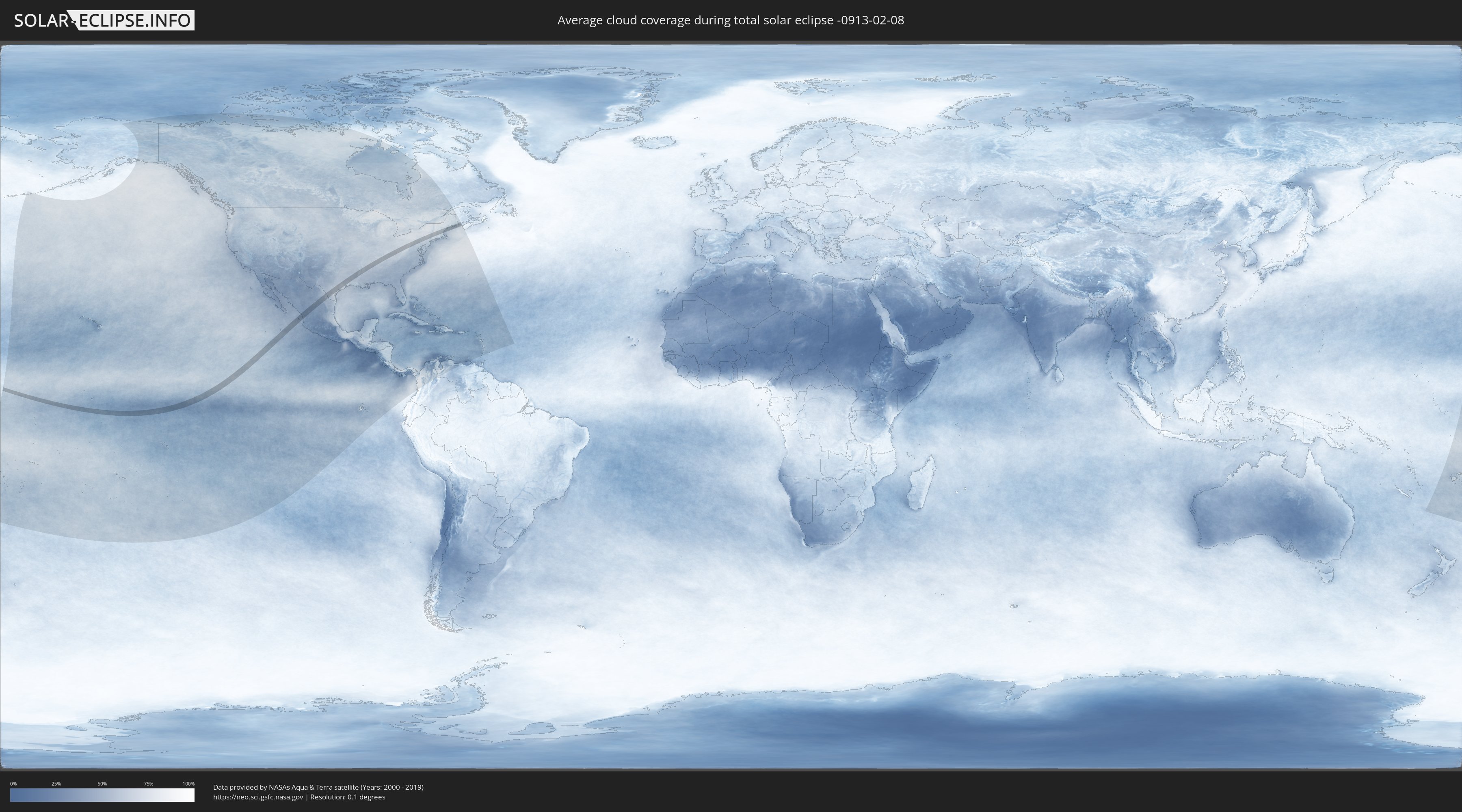
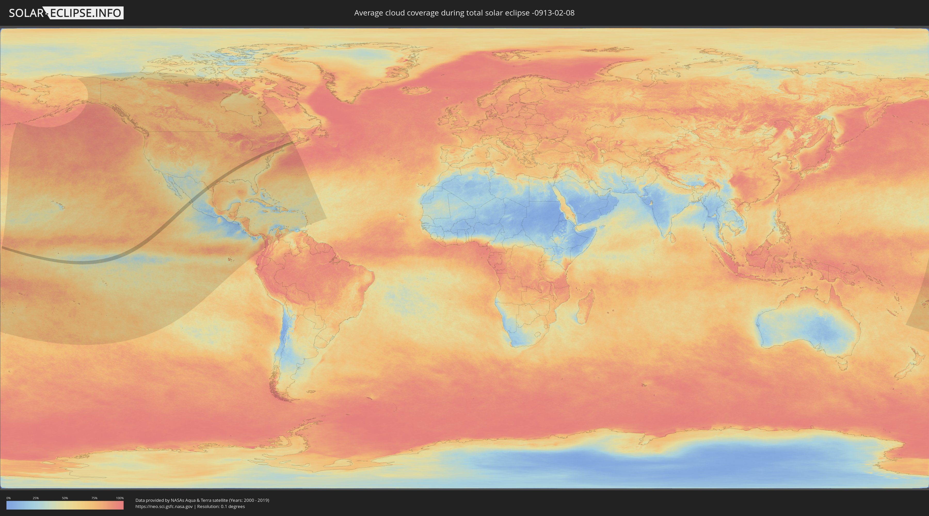
Wie wird das Wetter während der totalen Sonnenfinsternis am 08.02.-0913?
Wo ist der beste Ort, um die totale Sonnenfinsternis vom 08.02.-0913 zu beobachten?
Die folgenden Karten zeigen die durchschnittliche Bewölkung für den Tag, an dem die totale Sonnenfinsternis
stattfindet. Mit Hilfe der Karten lässt sich der Ort entlang des Finsternispfades eingrenzen,
der die besten Aussichen auf einen klaren wolkenfreien Himmel bietet.
Trotzdem muss man immer lokale Gegenenheiten beachten und sollte sich genau über das Wetter an seinem
gewählten Beobachtungsort informieren.
Die Daten stammen von den beiden NASA-Satelliten
AQUA und TERRA
und wurden über einen Zeitraum von 19 Jahren (2000 - 2019) gemittelt.
Detaillierte Länderkarten
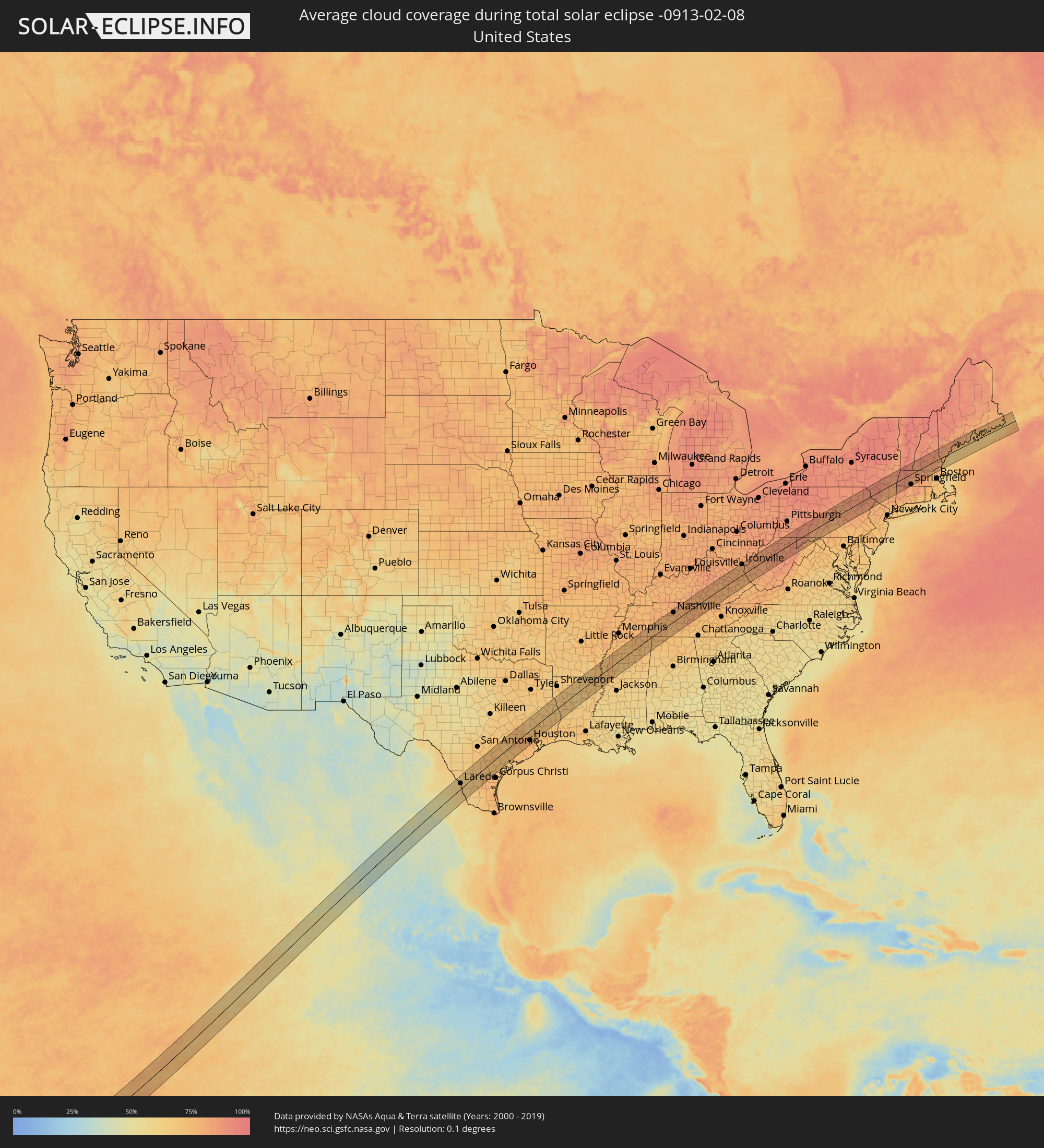 Vereinigte Staaten
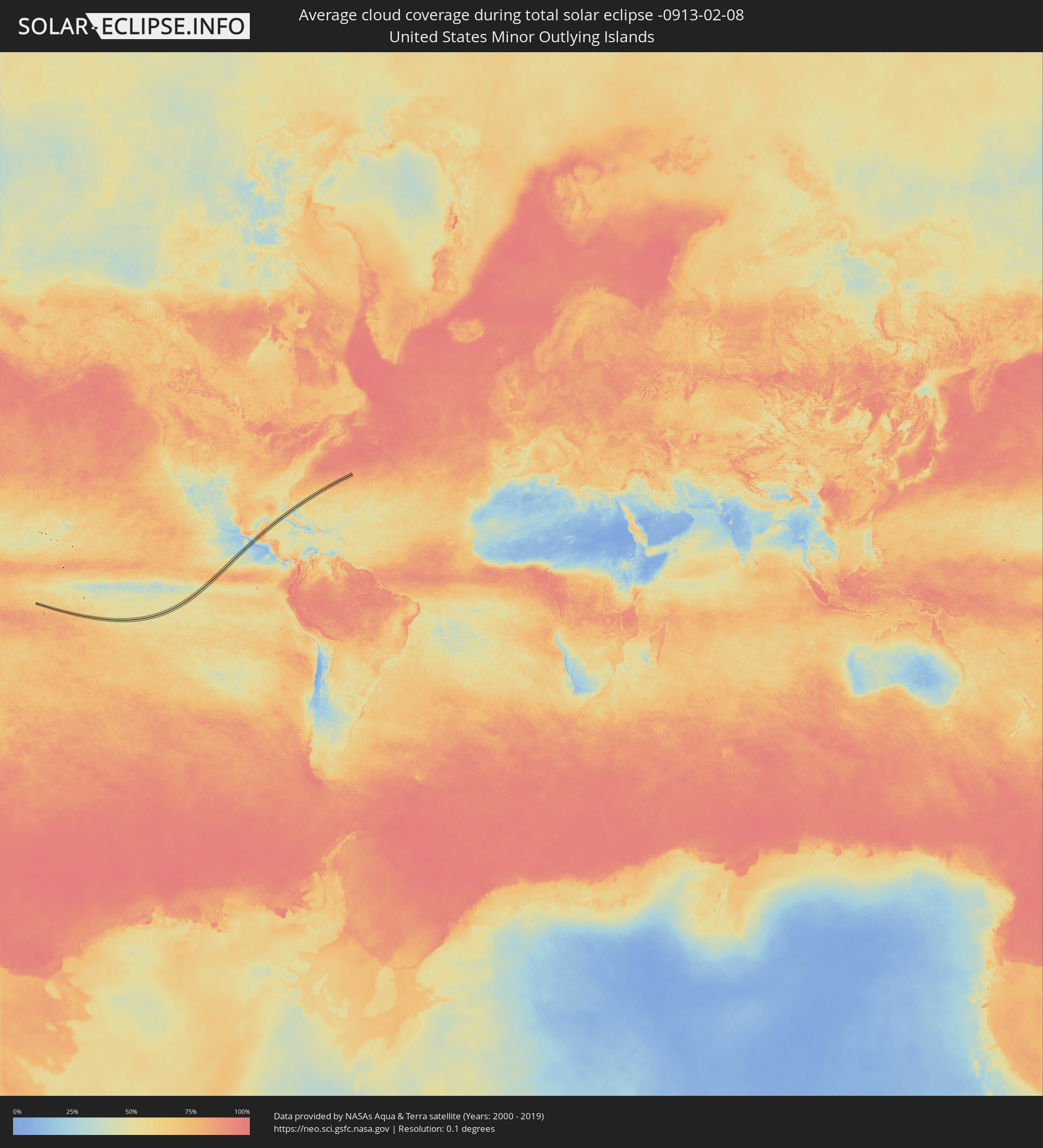 United States Minor Outlying Islands
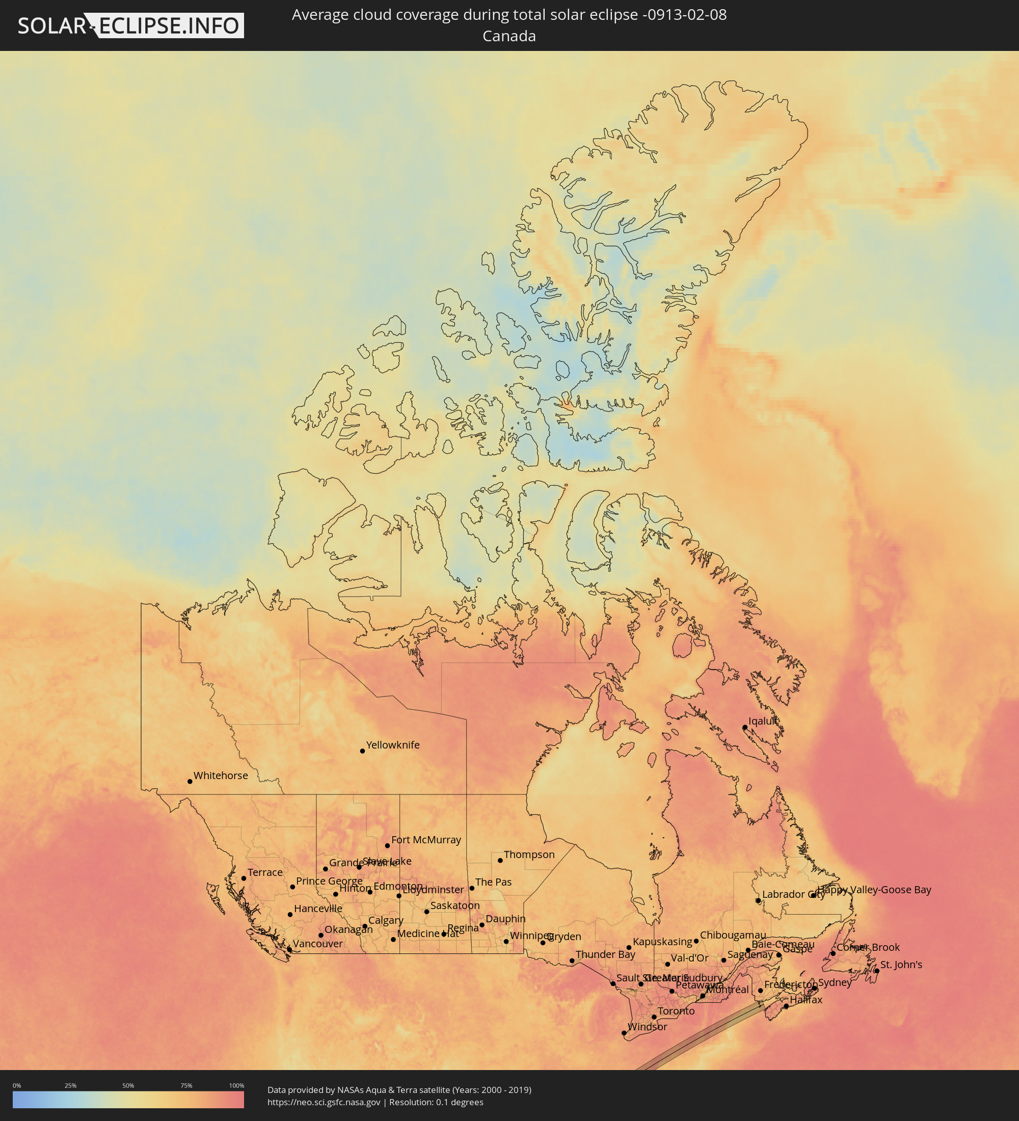 Kanada
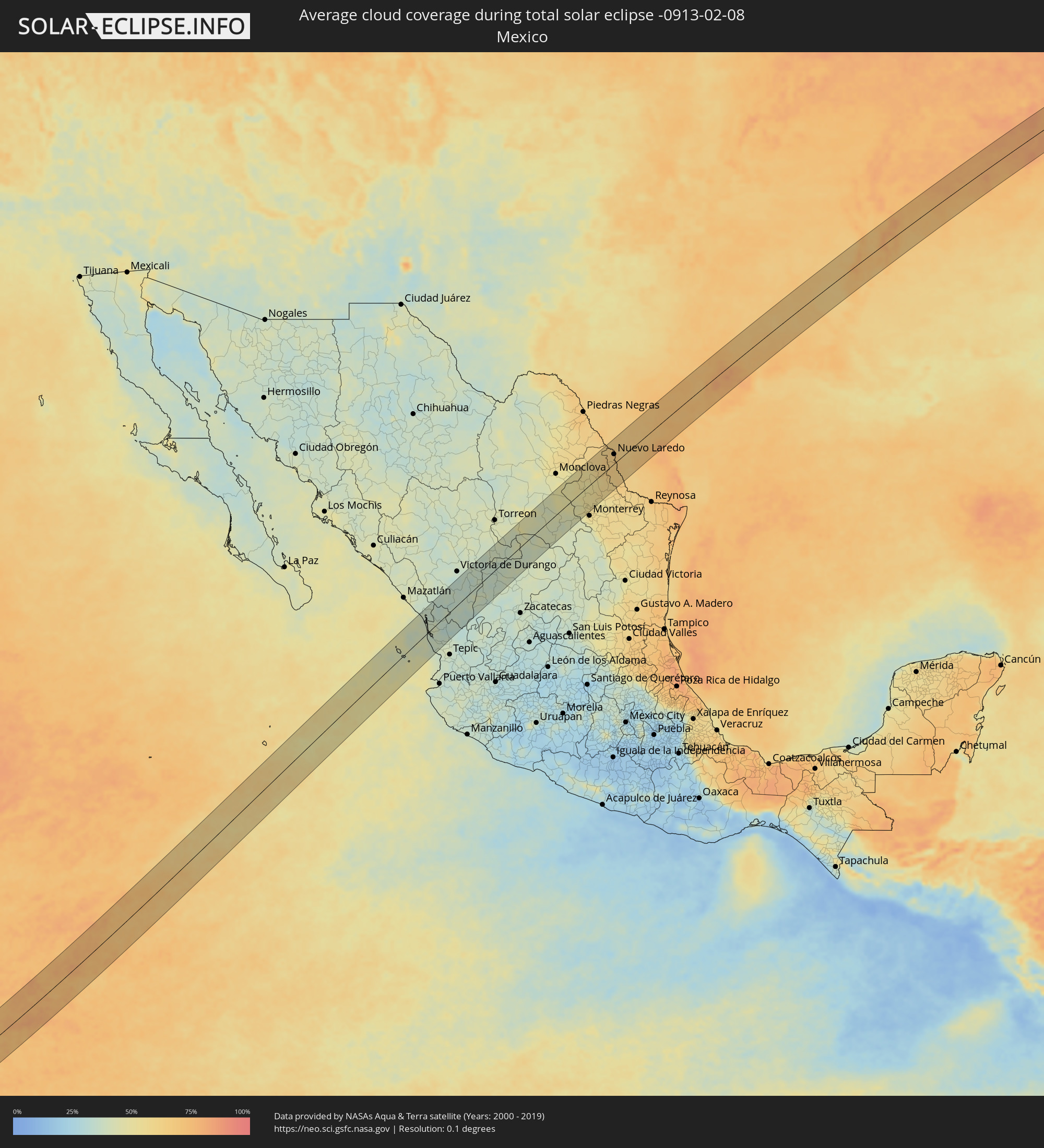 Mexiko
Orte im Finsternispfad
Die nachfolgene Tabelle zeigt Städte und Orte mit mehr als 5.000 Einwohnern, die sich im Finsternispfad befinden. Städte mit mehr als 100.000 Einwohnern sind dick gekennzeichnet. Mit einem Klick auf den Ort öffnet sich eine Detailkarte die die Lage des jeweiligen Ortes zusammen mit dem Verlauf der zentralen Finsternis präsentiert.
| Ort | Typ | Dauer der Verfinsterung | Ortszeit bei maximaler Verfinsterung | Entfernung zur Zentrallinie | Ø Bewölkung |
|
Isla del Bosque, Sinaloa
|
total | - | 13:49:54 UTC-07:05 | 61 km | 39% |
|
Escuinapa de Hidalgo, Sinaloa
|
total | - | 13:50:06 UTC-07:05 | 65 km | 39% |
|
Tecuala, Nayarit
|
total | - | 13:50:13 UTC-07:05 | 7 km | 41% |
|
San Felipe Aztatán, Nayarit
|
total | - | 13:50:16 UTC-07:05 | 3 km | 42% |
|
Acaponeta, Nayarit
|
total | - | 13:50:27 UTC-07:05 | 8 km | 40% |
|
Villa Hidalgo, Nayarit
|
total | - | 13:49:57 UTC-07:05 | 62 km | 39% |
|
Santiago Ixcuintla, Nayarit
|
total | - | 13:50:04 UTC-07:05 | 58 km | 39% |
|
Estación Ruiz, Nayarit
|
total | - | 13:50:18 UTC-07:05 | 52 km | 37% |
|
Vicente Guerrero, Durango
|
total | - | 14:22:44 UTC-06:36 | 13 km | 38% |
|
Sombrerete, Zacatecas
|
total | - | 14:23:10 UTC-06:36 | 19 km | 37% |
|
Miguel Auza, Zacatecas
|
total | - | 14:24:00 UTC-06:36 | 22 km | 37% |
|
Juan Aldama, Zacatecas
|
total | - | 14:24:05 UTC-06:36 | 18 km | 36% |
|
Río Grande, Zacatecas
|
total | - | 14:24:14 UTC-06:36 | 45 km | 38% |
|
Nieves, Zacatecas
|
total | - | 14:24:23 UTC-06:36 | 32 km | 39% |
|
Parras de la Fuente, Coahuila
|
total | - | 14:26:42 UTC-06:36 | 30 km | 43% |
|
Saltillo, Coahuila
|
total | - | 14:28:19 UTC-06:36 | 51 km | 42% |
|
Ramos Arizpe, Coahuila
|
total | - | 14:28:28 UTC-06:36 | 45 km | 42% |
|
Arteaga, Coahuila
|
total | - | 14:28:33 UTC-06:36 | 59 km | 44% |
|
García, Nuevo León
|
total | - | 14:29:08 UTC-06:36 | 46 km | 50% |
|
Lampazos de Naranjo, Nuevo León
|
total | - | 14:30:02 UTC-06:36 | 50 km | 52% |
|
Valle de Lincoln, Nuevo León
|
total | - | 14:29:17 UTC-06:36 | 55 km | 52% |
|
Parque Industrial Ciudad Mitras, Nuevo León
|
total | - | 14:29:19 UTC-06:36 | 57 km | 55% |
|
Mitras Poniente, Nuevo León
|
total | - | 14:29:20 UTC-06:36 | 60 km | 55% |
|
Emiliano Zapata, Nuevo León
|
total | - | 14:29:37 UTC-06:36 | 58 km | 55% |
|
Sabinas Hidalgo, Nuevo León
|
total | - | 14:30:08 UTC-06:36 | 15 km | 53% |
|
Real del Sol, Nuevo León
|
total | - | 14:29:46 UTC-06:36 | 62 km | 55% |
|
Ciénega de Flores, Nuevo León
|
total | - | 14:29:48 UTC-06:36 | 62 km | 54% |
|
Ciudad Anáhuac, Nuevo León
|
total | - | 14:30:39 UTC-06:36 | 44 km | 59% |
|
Anáhuac, Nuevo León
|
total | - | 14:30:39 UTC-06:36 | 43 km | 59% |
|
El Campanario y Oradel, Tamaulipas
|
total | - | 14:31:27 UTC-06:36 | 29 km | 66% |
|
Nuevo Laredo, Tamaulipas
|
total | - | 14:31:35 UTC-06:36 | 23 km | 67% |
|
Laredo, Texas
|
total | - | 15:08:12 UTC-06:00 | 25 km | 67% |
|
Alice, Texas
|
total | - | 15:10:08 UTC-06:00 | 47 km | 77% |
|
Beeville, Texas
|
total | - | 15:10:51 UTC-06:00 | 12 km | 74% |
|
Victoria, Texas
|
total | - | 15:11:55 UTC-06:00 | 25 km | 72% |
|
Brenham, Texas
|
total | - | 15:13:12 UTC-06:00 | 54 km | 73% |
|
El Campo, Texas
|
total | - | 15:12:57 UTC-06:00 | 37 km | 73% |
|
Rosenberg, Texas
|
total | - | 15:13:37 UTC-06:00 | 34 km | 77% |
|
Cinco Ranch, Texas
|
total | - | 15:13:44 UTC-06:00 | 22 km | 79% |
|
Cypress, Texas
|
total | - | 15:13:54 UTC-06:00 | 6 km | 80% |
|
Sugar Land, Texas
|
total | - | 15:13:50 UTC-06:00 | 40 km | 76% |
|
Huntsville, Texas
|
total | - | 15:14:20 UTC-06:00 | 50 km | 68% |
|
The Woodlands, Texas
|
total | - | 15:14:12 UTC-06:00 | 2 km | 73% |
|
Conroe, Texas
|
total | - | 15:14:17 UTC-06:00 | 9 km | 70% |
|
Fresno, Texas
|
total | - | 15:14:00 UTC-06:00 | 58 km | 76% |
|
Aldine, Texas
|
total | - | 15:14:14 UTC-06:00 | 28 km | 74% |
|
Houston, Texas
|
total | - | 15:14:11 UTC-06:00 | 44 km | 75% |
|
Pasadena, Texas
|
total | - | 15:14:19 UTC-06:00 | 60 km | 76% |
|
Atascocita, Texas
|
total | - | 15:14:29 UTC-06:00 | 35 km | 73% |
|
Lufkin, Texas
|
total | - | 15:15:24 UTC-06:00 | 54 km | 68% |
|
Natchitoches, Louisiana
|
total | - | 15:17:12 UTC-06:00 | 6 km | 69% |
|
Ruston, Louisiana
|
total | - | 15:17:49 UTC-06:00 | 34 km | 65% |
|
Monroe, Louisiana
|
total | - | 15:18:18 UTC-06:00 | 3 km | 66% |
|
Bastrop, Louisiana
|
total | - | 15:18:35 UTC-06:00 | 11 km | 68% |
|
Greenville, Mississippi
|
total | - | 15:19:26 UTC-06:00 | 23 km | 68% |
|
Cleveland, Mississippi
|
total | - | 15:19:47 UTC-06:00 | 34 km | 79% |
|
Indianola, Mississippi
|
total | - | 15:19:49 UTC-06:00 | 4 km | 78% |
|
Greenwood, Mississippi
|
total | - | 15:20:14 UTC-06:00 | 17 km | 74% |
|
Grenada, Mississippi
|
total | - | 15:20:36 UTC-06:00 | 15 km | 68% |
|
Oxford, Mississippi
|
total | - | 15:20:54 UTC-06:00 | 23 km | 72% |
|
Tupelo, Mississippi
|
total | - | 15:21:34 UTC-06:00 | 31 km | 73% |
|
Corinth, Mississippi
|
total | - | 15:21:45 UTC-06:00 | 20 km | 77% |
|
Florence, Alabama
|
total | - | 15:22:25 UTC-06:00 | 37 km | 74% |
|
Lawrenceburg, Tennessee
|
total | - | 15:22:42 UTC-06:00 | 15 km | 79% |
|
Columbia, Tennessee
|
total | - | 15:22:56 UTC-06:00 | 3 km | 75% |
|
Spring Hill, Tennessee
|
total | - | 15:23:00 UTC-06:00 | 10 km | 77% |
|
Franklin, Tennessee
|
total | - | 15:23:03 UTC-06:00 | 22 km | 77% |
|
Lewisburg, Tennessee
|
total | - | 15:23:07 UTC-06:00 | 25 km | 74% |
|
Nashville, Tennessee
|
total | - | 15:23:06 UTC-06:00 | 40 km | 80% |
|
Hendersonville, Tennessee
|
total | - | 15:23:13 UTC-06:00 | 44 km | 78% |
|
Smyrna, Tennessee
|
total | - | 15:23:18 UTC-06:00 | 9 km | 78% |
|
Shelbyville, Tennessee
|
total | - | 15:23:22 UTC-06:00 | 39 km | 77% |
|
Gallatin, Tennessee
|
total | - | 15:23:21 UTC-06:00 | 43 km | 79% |
|
Murfreesboro, Tennessee
|
total | - | 15:23:24 UTC-06:00 | 10 km | 77% |
|
Lebanon, Tennessee
|
total | - | 15:23:28 UTC-06:00 | 18 km | 78% |
|
Cookeville, Tennessee
|
total | - | 15:24:02 UTC-06:00 | 26 km | 80% |
|
Somerset, Kentucky
|
total | - | 16:24:35 UTC-05:00 | 14 km | 82% |
|
Berea, Kentucky
|
total | - | 16:24:44 UTC-05:00 | 43 km | 80% |
|
Meads, Kentucky
|
total | - | 16:25:36 UTC-05:00 | 44 km | 80% |
|
Huntington, West Virginia
|
total | - | 16:25:46 UTC-05:00 | 32 km | 82% |
|
Teays Valley, West Virginia
|
total | - | 16:26:04 UTC-05:00 | 10 km | 81% |
|
Charleston, West Virginia
|
total | - | 16:26:15 UTC-05:00 | 13 km | 82% |
|
Clarksburg, West Virginia
|
total | - | 16:26:47 UTC-05:00 | 14 km | 86% |
|
Fairmont, West Virginia
|
total | - | 16:26:50 UTC-05:00 | 24 km | 84% |
|
Morgantown, West Virginia
|
total | - | 16:26:54 UTC-05:00 | 30 km | 86% |
|
Uniontown, Pennsylvania
|
total | - | 16:26:57 UTC-05:00 | 44 km | 89% |
|
Johnstown, Pennsylvania
|
total | - | 16:27:14 UTC-05:00 | 49 km | 87% |
|
Cumberland, Maryland
|
total | - | 16:27:30 UTC-05:00 | 22 km | 79% |
|
Altoona, Pennsylvania
|
total | - | 16:27:26 UTC-05:00 | 44 km | 87% |
|
State College, Pennsylvania
|
total | - | 16:27:36 UTC-05:00 | 47 km | 86% |
|
Chambersburg, Pennsylvania
|
total | - | 16:27:57 UTC-05:00 | 43 km | 77% |
|
Carlisle, Pennsylvania
|
total | - | 16:28:05 UTC-05:00 | 39 km | 77% |
|
Harrisburg, Pennsylvania
|
total | - | 16:28:12 UTC-05:00 | 45 km | 78% |
|
Sunbury, Pennsylvania
|
total | - | 16:28:03 UTC-05:00 | 8 km | 82% |
|
Bloomsburg, Pennsylvania
|
total | - | 16:28:09 UTC-05:00 | 7 km | 81% |
|
Berwick, Pennsylvania
|
total | - | 16:28:14 UTC-05:00 | 2 km | 83% |
|
Pottsville, Pennsylvania
|
total | - | 16:28:22 UTC-05:00 | 35 km | 83% |
|
Hazleton, Pennsylvania
|
total | - | 16:28:22 UTC-05:00 | 18 km | 83% |
|
Wilkes-Barre, Pennsylvania
|
total | - | 16:28:18 UTC-05:00 | 6 km | 87% |
|
Scranton, Pennsylvania
|
total | - | 16:28:20 UTC-05:00 | 13 km | 86% |
|
East Stroudsburg, Pennsylvania
|
total | - | 16:28:41 UTC-05:00 | 47 km | 82% |
|
Middletown, New York
|
total | - | 16:28:49 UTC-05:00 | 35 km | 76% |
|
Manorville, New York
|
total | - | 16:28:41 UTC-05:00 | 17 km | 84% |
|
Newburgh, New York
|
total | - | 16:28:57 UTC-05:00 | 46 km | 79% |
|
Kingston, New York
|
total | - | 16:28:47 UTC-05:00 | 5 km | 82% |
|
Poughkeepsie, New York
|
total | - | 16:28:54 UTC-05:00 | 31 km | 80% |
|
Pittsfield, Massachusetts
|
total | - | 16:28:50 UTC-05:00 | 15 km | 90% |
|
Winchester Center, Connecticut
|
total | - | 16:29:06 UTC-05:00 | 43 km | 87% |
|
North Adams, Massachusetts
|
total | - | 16:28:46 UTC-05:00 | 34 km | 89% |
|
Northampton, Massachusetts
|
total | - | 16:29:06 UTC-05:00 | 21 km | 80% |
|
Greenfield, Massachusetts
|
total | - | 16:29:00 UTC-05:00 | 3 km | 84% |
|
Springfield, Massachusetts
|
total | - | 16:29:12 UTC-05:00 | 45 km | 81% |
|
Keene, New Hampshire
|
total | - | 16:28:57 UTC-05:00 | 25 km | 84% |
|
Gardner, Massachusetts
|
total | - | 16:29:12 UTC-05:00 | 21 km | 84% |
|
Holden, Massachusetts
|
total | - | 16:29:20 UTC-05:00 | 48 km | 84% |
|
Leominster, Massachusetts
|
total | - | 16:29:17 UTC-05:00 | 35 km | 81% |
|
Concord, New Hampshire
|
total | - | 16:29:03 UTC-05:00 | 23 km | 83% |
|
Nashua, New Hampshire
|
total | - | 16:29:16 UTC-05:00 | 23 km | 80% |
|
Manchester, New Hampshire
|
total | - | 16:29:10 UTC-05:00 | 1 km | 83% |
|
Lowell, Massachusetts
|
total | - | 16:29:23 UTC-05:00 | 42 km | 78% |
|
Derry Village, New Hampshire
|
total | - | 16:29:16 UTC-05:00 | 17 km | 82% |
|
Haverhill, Massachusetts
|
total | - | 16:29:23 UTC-05:00 | 37 km | 78% |
|
Amesbury, Massachusetts
|
total | - | 16:29:24 UTC-05:00 | 34 km | 76% |
|
Dover, New Hampshire
|
total | - | 16:29:15 UTC-05:00 | 3 km | 78% |
|
Sanford, Maine
|
total | - | 16:29:10 UTC-05:00 | 17 km | 82% |
|
Portsmouth, New Hampshire
|
total | - | 16:29:21 UTC-05:00 | 20 km | 76% |
|
York Beach, Maine
|
total | - | 16:29:20 UTC-05:00 | 16 km | 70% |
|
Wells Beach Station, Maine
|
total | - | 16:29:16 UTC-05:00 | 1 km | 73% |
|
Biddeford, Maine
|
total | - | 16:29:14 UTC-05:00 | 10 km | 80% |
|
Portland, Maine
|
total | - | 16:29:12 UTC-05:00 | 19 km | 79% |
|
Brunswick, Maine
|
total | - | 16:29:09 UTC-05:00 | 34 km | 83% |