Totale Sonnenfinsternis vom 09.05.-0992
| Wochentag: | Samstag |
| Maximale Dauer der Verfinsterung: | 04m12s |
| Maximale Breite des Finsternispfades: | 429 km |
| Saroszyklus: | 51 |
| Bedeckungsgrad: | 100% |
| Magnitude: | 1.0712 |
| Gamma: | 0.8433 |
Wo kann man die Sonnenfinsternis vom 09.05.-0992 sehen?
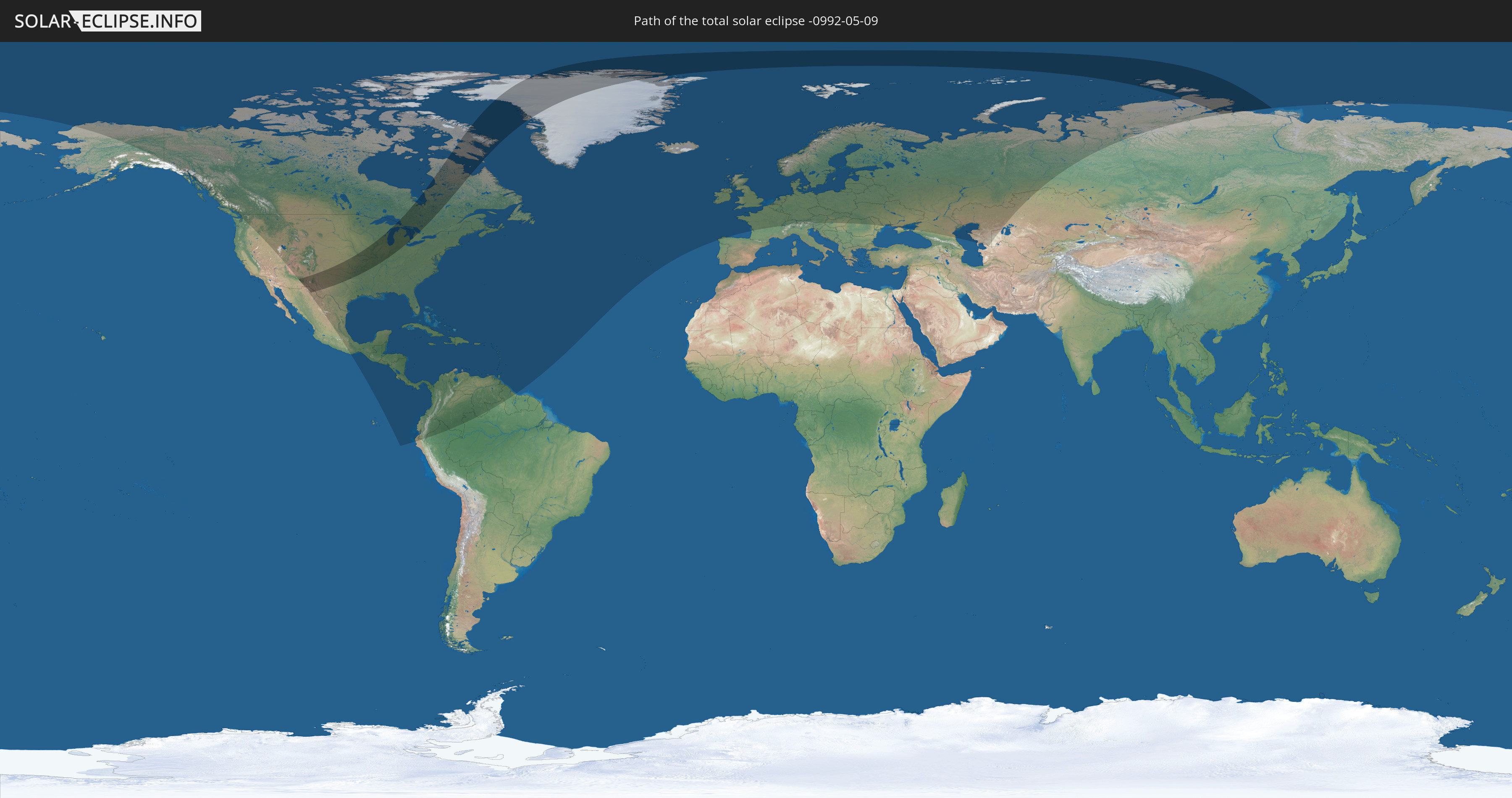
Die Sonnenfinsternis am 09.05.-0992 kann man in 84 Ländern als partielle Sonnenfinsternis beobachten.
Der Finsternispfad verläuft durch 5 Länder. Nur in diesen Ländern ist sie als totale Sonnenfinsternis zu sehen.
In den folgenden Ländern ist die Sonnenfinsternis total zu sehen
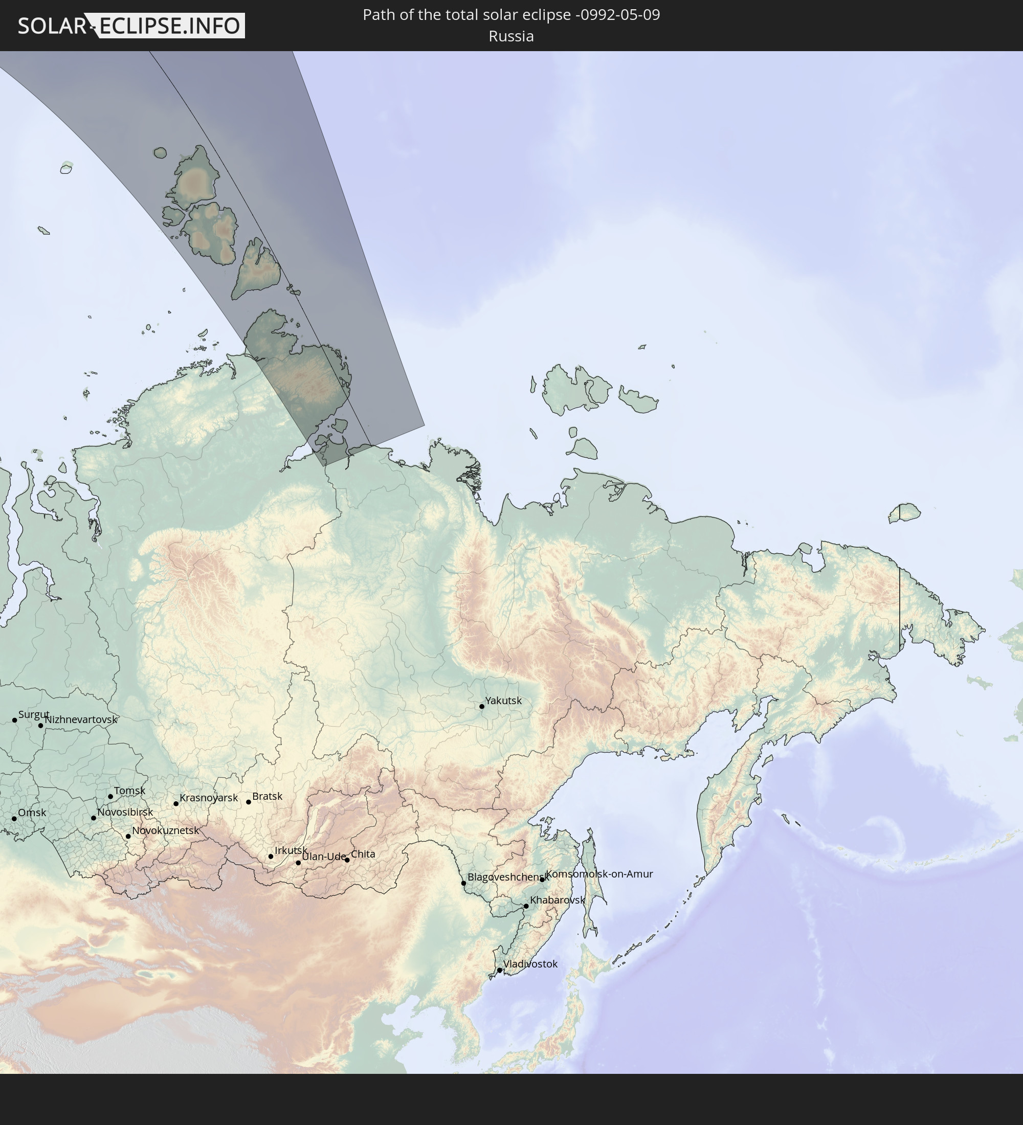 Russland
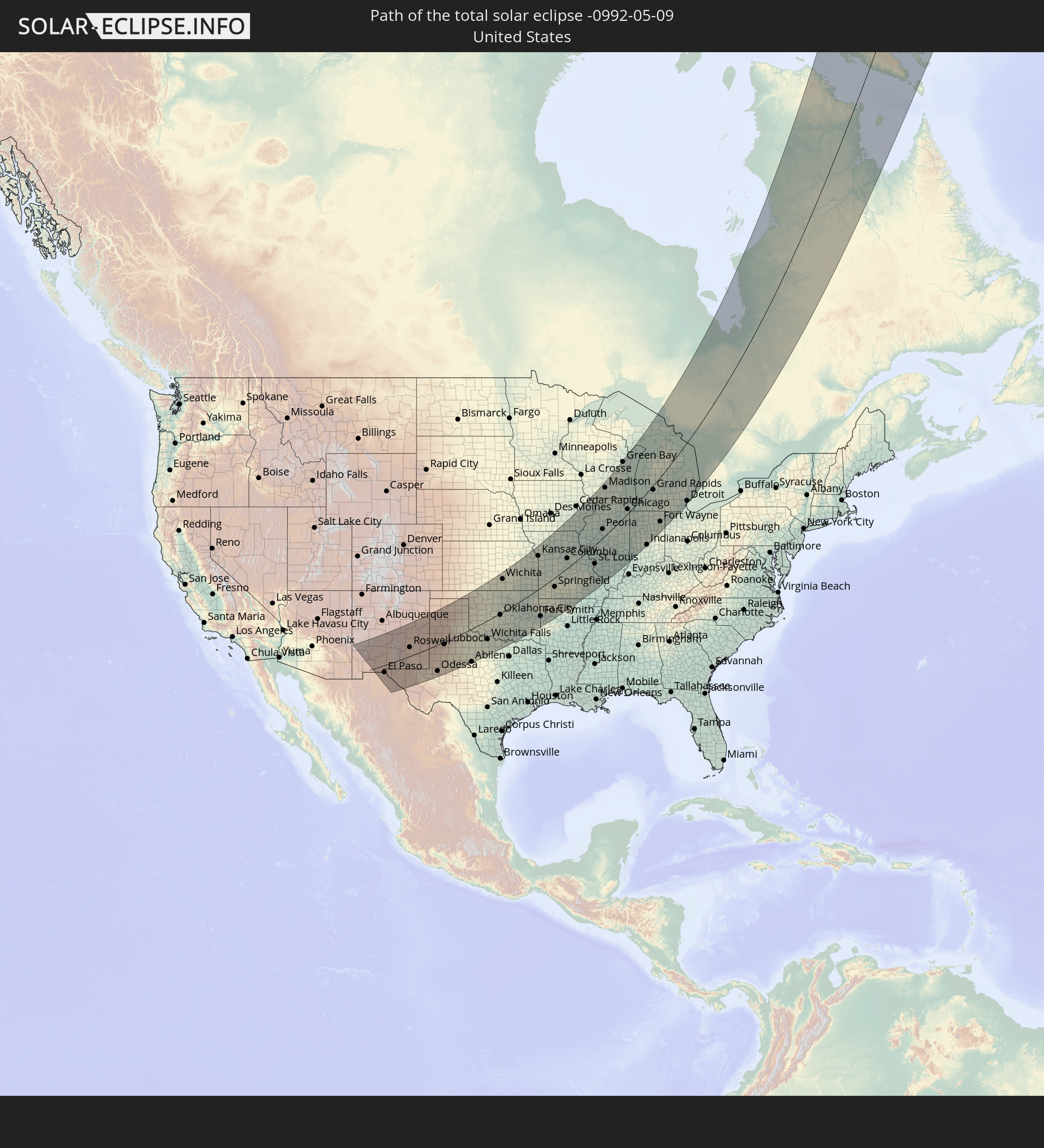 Vereinigte Staaten
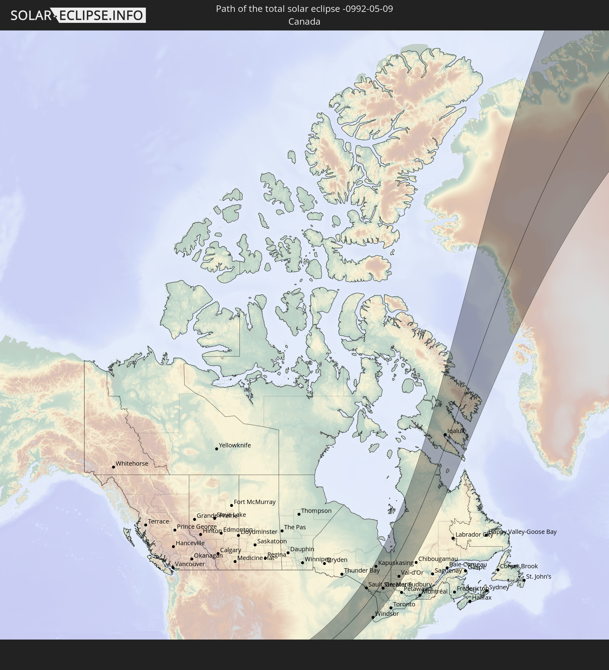 Kanada
 Mexiko
 Grönland
In den folgenden Ländern ist die Sonnenfinsternis partiell zu sehen
 Russland
 Vereinigte Staaten
 United States Minor Outlying Islands
 Kanada
 Mexiko
 Grönland
 Guatemala
 Ecuador
 El Salvador
 Honduras
 Belize
 Nicaragua
 Costa Rica
 Kuba
Kuba
 Panama
 Kolumbien
 Kaimaninseln
 Peru
Peru
 Bahamas
 Jamaika
 Haiti
Haiti
 Brasilien
 Venezuela
 Turks- und Caicosinseln
 Dominikanische Republik
 Aruba
Aruba
 Puerto Rico
 Amerikanische Jungferninseln
 Bermuda
 Britische Jungferninseln
 Anguilla
 Saint-Martin
 Saint-Barthélemy
 St. Kitts und Nevis
 Antigua und Barbuda
 Montserrat
 Trinidad und Tobago
 Guadeloupe
 Grenada
 Dominica
 St. Vincent und die Grenadinen
 Guyana
 Martinique
 St. Lucia
 Barbados
 Saint-Pierre und Miquelon
 Portugal
 Island
 Spanien
 Irland
 Spitzbergen
 Vereinigtes Königreich
 Färöer
 Frankreich
 Isle of Man
 Guernsey
 Jersey
 Belgien
 Niederlande
 Norwegen
 Luxemburg
 Deutschland
 Schweiz
 Italien
 Dänemark
 Liechtenstein
 Österreich
 Schweden
 Tschechien
 Polen
Polen
 Ungarn
 Slowakei
 Åland Islands
 Rumänien
 Finnland
 Litauen
 Lettland
 Estland
 Ukraine
 Weißrussland
 Moldawien
 Kasachstan
 Turkmenistan
 Usbekistan
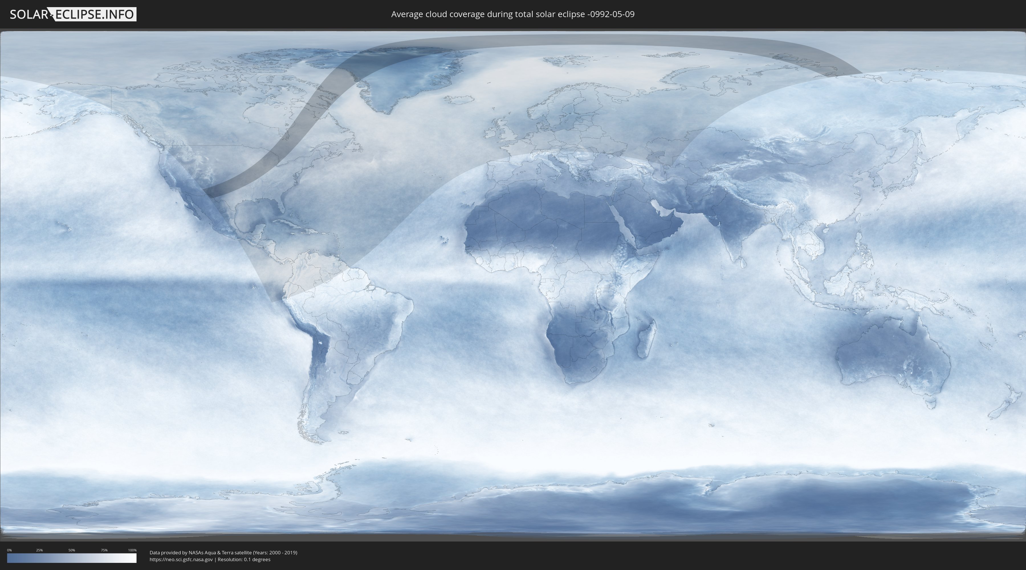
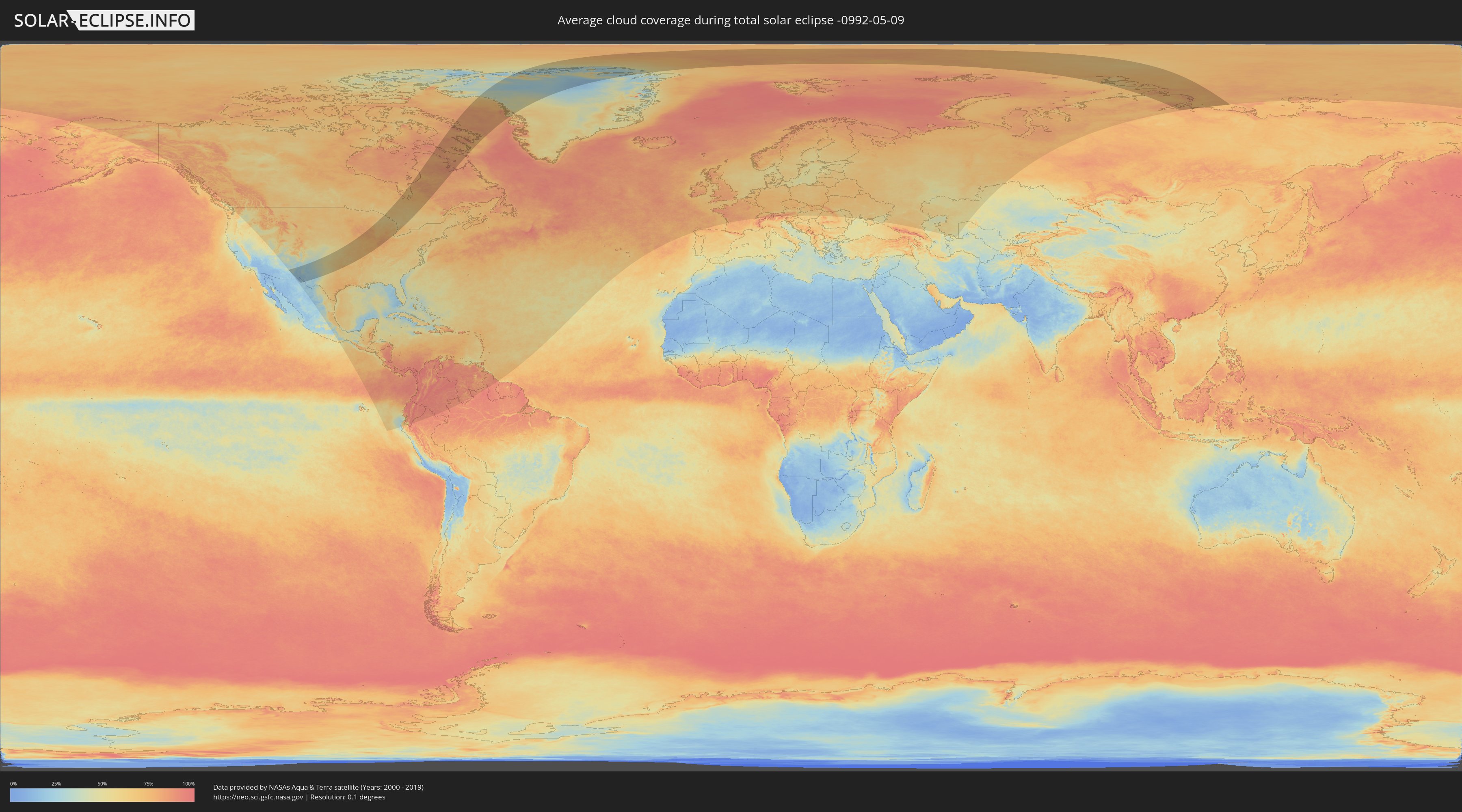
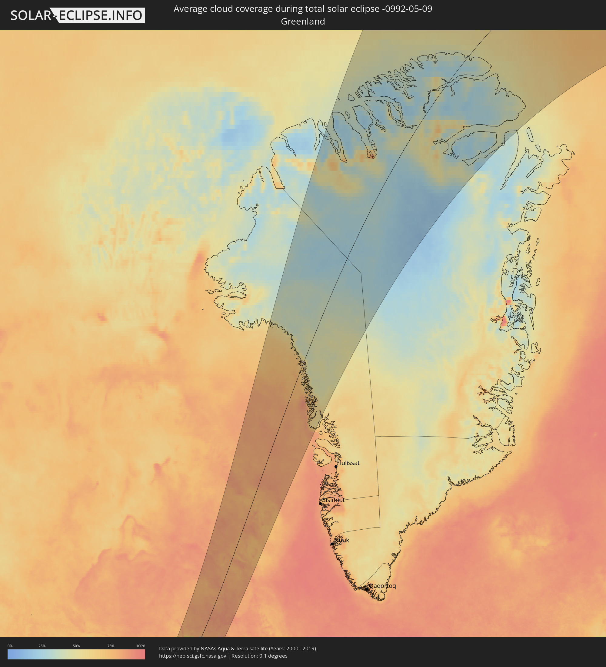
Wie wird das Wetter während der totalen Sonnenfinsternis am 09.05.-0992?
Wo ist der beste Ort, um die totale Sonnenfinsternis vom 09.05.-0992 zu beobachten?
Die folgenden Karten zeigen die durchschnittliche Bewölkung für den Tag, an dem die totale Sonnenfinsternis
stattfindet. Mit Hilfe der Karten lässt sich der Ort entlang des Finsternispfades eingrenzen,
der die besten Aussichen auf einen klaren wolkenfreien Himmel bietet.
Trotzdem muss man immer lokale Gegenenheiten beachten und sollte sich genau über das Wetter an seinem
gewählten Beobachtungsort informieren.
Die Daten stammen von den beiden NASA-Satelliten
AQUA und TERRA
und wurden über einen Zeitraum von 19 Jahren (2000 - 2019) gemittelt.
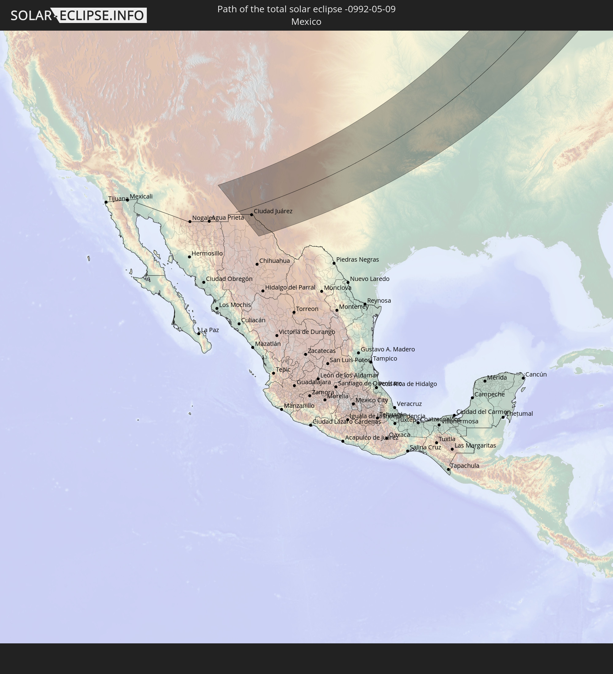
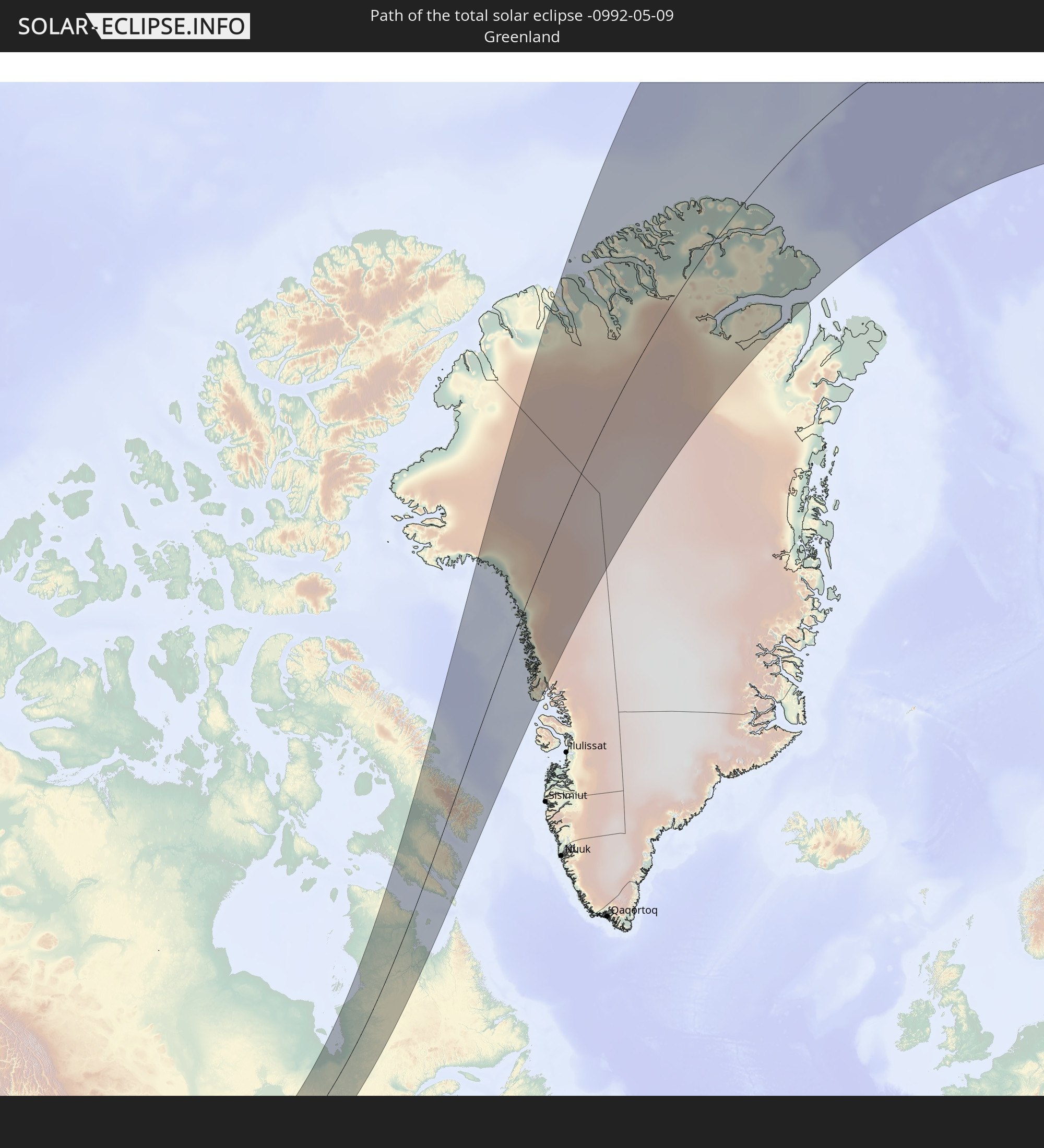
Detaillierte Länderkarten
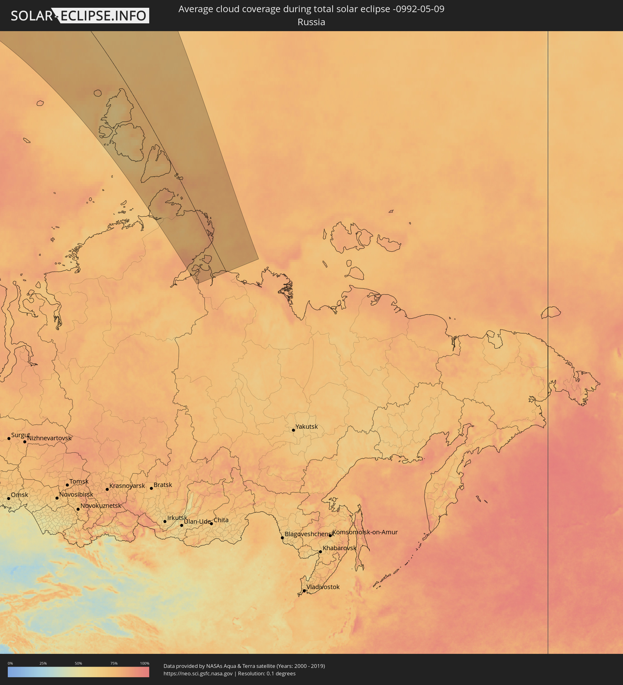 Russland
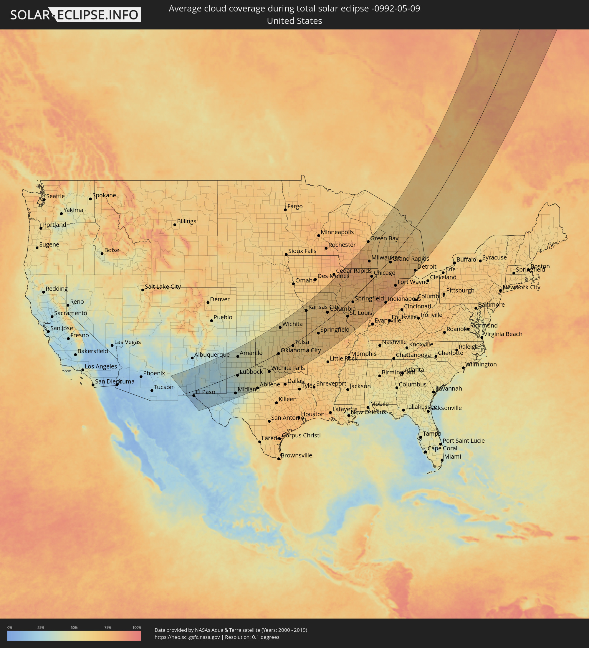 Vereinigte Staaten
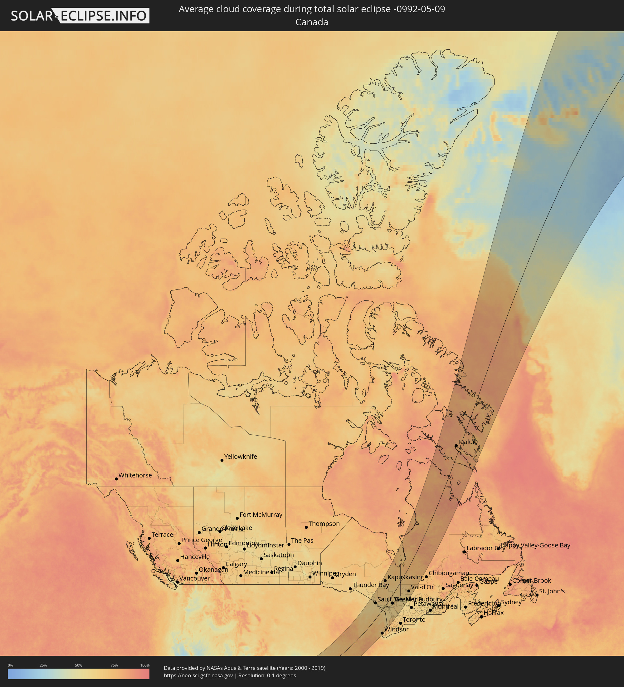 Kanada
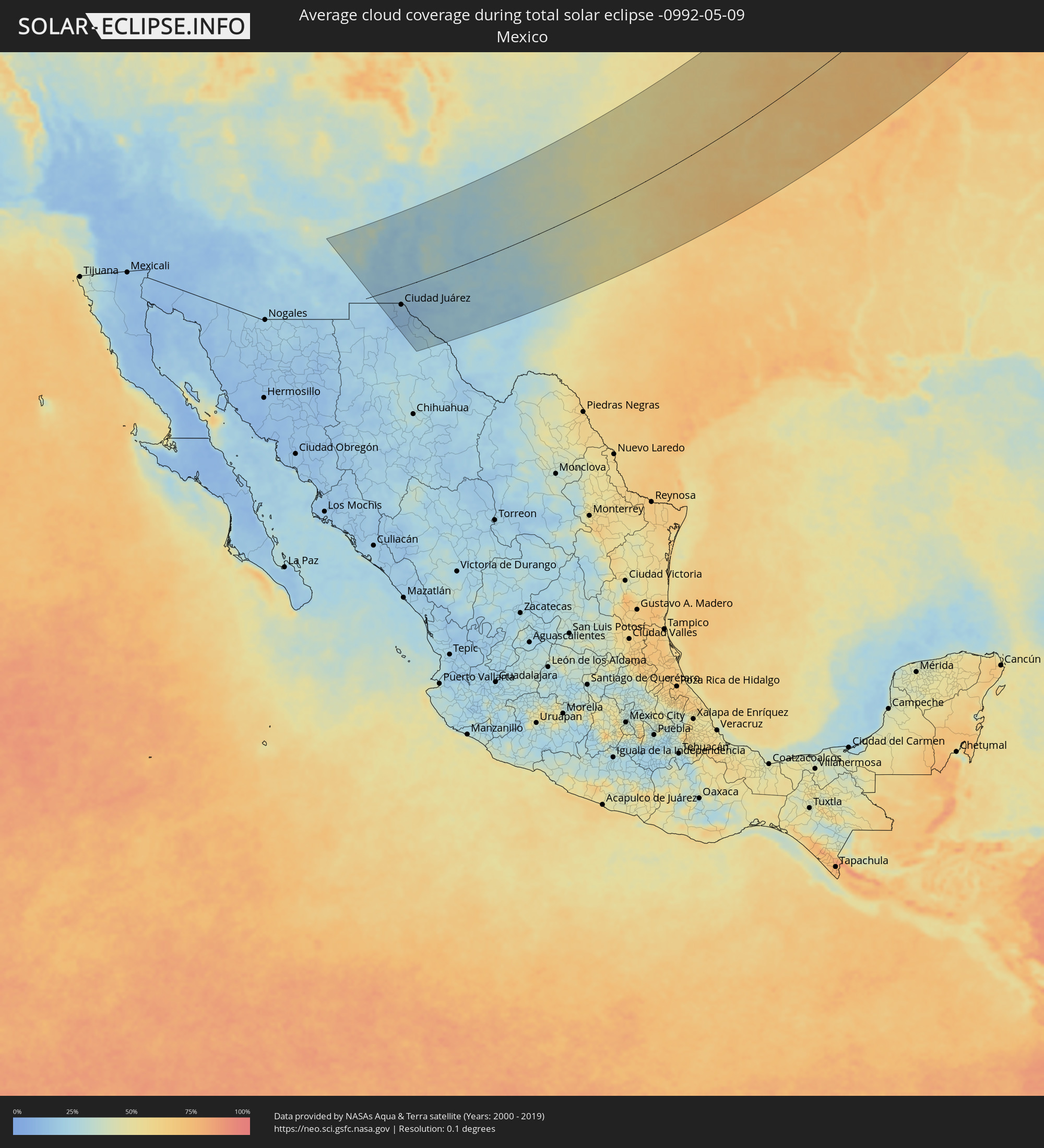 Mexiko
 Grönland
Orte im Finsternispfad
Die nachfolgene Tabelle zeigt Städte und Orte mit mehr als 5.000 Einwohnern, die sich im Finsternispfad befinden. Städte mit mehr als 100.000 Einwohnern sind dick gekennzeichnet. Mit einem Klick auf den Ort öffnet sich eine Detailkarte die die Lage des jeweiligen Ortes zusammen mit dem Verlauf der zentralen Finsternis präsentiert.
| Ort | Typ | Dauer der Verfinsterung | Ortszeit bei maximaler Verfinsterung | Entfernung zur Zentrallinie | Ø Bewölkung |
|
Las Cruces, New Mexico
|
total | - | 05:26:40 UTC-07:00 | 28 km | 19% |
|
El Paso, Texas
|
total | - | 05:25:48 UTC-07:00 | 51 km | 18% |
|
Ciudad Juárez, Chihuahua
|
total | - | 05:20:06 UTC-07:05 | 54 km | 17% |
|
Odessa, Texas
|
total | - | 06:24:39 UTC-06:00 | 175 km | 24% |
|
Midland, Texas
|
total | - | 06:24:48 UTC-06:00 | 171 km | 27% |
|
Lubbock, Texas
|
total | - | 06:27:01 UTC-06:00 | 18 km | 35% |
|
Amarillo, Texas
|
total | - | 06:29:27 UTC-06:00 | 150 km | 40% |
|
Abilene, Texas
|
total | - | 06:24:53 UTC-06:00 | 214 km | 53% |
|
Wichita Falls, Texas
|
total | - | 06:26:49 UTC-06:00 | 118 km | 53% |
|
Lawton, Oklahoma
|
total | - | 06:27:51 UTC-06:00 | 56 km | 56% |
|
Oklahoma City, Oklahoma
|
total | - | 06:29:02 UTC-06:00 | 11 km | 58% |
|
Edmond, Oklahoma
|
total | - | 06:29:19 UTC-06:00 | 10 km | 59% |
|
Norman, Oklahoma
|
total | - | 06:28:38 UTC-06:00 | 39 km | 61% |
|
Wichita, Kansas
|
total | - | 06:32:30 UTC-06:00 | 195 km | 57% |
|
Tulsa, Oklahoma
|
total | - | 06:29:55 UTC-06:00 | 14 km | 64% |
|
Broken Arrow, Oklahoma
|
total | - | 06:29:44 UTC-06:00 | 33 km | 65% |
|
Topeka, Kansas
|
total | - | 06:34:32 UTC-06:00 | 237 km | 59% |
|
Lawrence, Kansas
|
total | - | 06:34:23 UTC-06:00 | 207 km | 59% |
|
Olathe, Kansas
|
total | - | 06:34:13 UTC-06:00 | 178 km | 63% |
|
Overland Park, Kansas
|
total | - | 06:34:22 UTC-06:00 | 179 km | 62% |
|
Kansas City, Missouri
|
total | - | 06:34:33 UTC-06:00 | 186 km | 62% |
|
Fort Smith, Arkansas
|
total | - | 06:28:33 UTC-06:00 | 164 km | 65% |
|
Lee's Summit, Missouri
|
total | - | 06:34:14 UTC-06:00 | 159 km | 61% |
|
East Independence, Missouri
|
total | - | 06:34:32 UTC-06:00 | 173 km | 62% |
|
Fayetteville, Arkansas
|
total | - | 06:29:36 UTC-06:00 | 113 km | 64% |
|
Springfield, Missouri
|
total | - | 06:31:25 UTC-06:00 | 53 km | 70% |
|
Columbia, Missouri
|
total | - | 06:34:15 UTC-06:00 | 52 km | 70% |
|
O'Fallon, Missouri
|
total | - | 06:34:02 UTC-06:00 | 51 km | 69% |
|
Davenport, Iowa
|
total | - | 06:38:39 UTC-06:00 | 168 km | 73% |
|
St. Louis, Missouri
|
total | - | 06:33:44 UTC-06:00 | 95 km | 73% |
|
Springfield, Illinois
|
total | - | 06:35:45 UTC-06:00 | 32 km | 73% |
|
Peoria, Illinois
|
total | - | 06:37:17 UTC-06:00 | 51 km | 72% |
|
Madison, Wisconsin
|
total | - | 06:41:26 UTC-06:00 | 217 km | 77% |
|
Rockford, Illinois
|
total | - | 06:40:03 UTC-06:00 | 138 km | 78% |
|
Bloomington, Illinois
|
total | - | 06:36:57 UTC-06:00 | 12 km | 76% |
|
Decatur, Illinois
|
total | - | 06:35:51 UTC-06:00 | 64 km | 73% |
|
Appleton, Wisconsin
|
total | - | 06:43:38 UTC-06:00 | 244 km | 74% |
|
Aurora, Illinois
|
total | - | 06:39:14 UTC-06:00 | 55 km | 76% |
|
Elgin, Illinois
|
total | - | 06:39:43 UTC-06:00 | 74 km | 77% |
|
Champaign, Illinois
|
total | - | 06:36:23 UTC-06:00 | 83 km | 72% |
|
Waukesha, Wisconsin
|
total | - | 06:41:26 UTC-06:00 | 142 km | 77% |
|
Joliet, Illinois
|
total | - | 06:38:51 UTC-06:00 | 22 km | 75% |
|
Bolingbrook, Illinois
|
total | - | 06:39:09 UTC-06:00 | 41 km | 79% |
|
Green Bay, Wisconsin
|
total | - | 06:44:08 UTC-06:00 | 240 km | 71% |
|
Arlington Heights, Illinois
|
total | - | 06:39:50 UTC-06:00 | 57 km | 77% |
|
Milwaukee, Wisconsin
|
total | - | 06:41:31 UTC-06:00 | 127 km | 77% |
|
Waukegan, Illinois
|
total | - | 06:40:20 UTC-06:00 | 75 km | 74% |
|
Kenosha, Wisconsin
|
total | - | 06:40:44 UTC-06:00 | 85 km | 72% |
|
Racine, Wisconsin
|
total | - | 06:40:59 UTC-06:00 | 94 km | 73% |
|
Evanston, Illinois
|
total | - | 06:39:47 UTC-06:00 | 39 km | 75% |
|
Chicago, Illinois
|
total | - | 06:39:28 UTC-06:00 | 19 km | 76% |
|
Hammond, Indiana
|
total | - | 06:39:01 UTC-06:00 | 15 km | 75% |
|
South Bend, Indiana
|
total | - | 07:39:21 UTC-05:00 | 79 km | 78% |
|
Indianapolis, Indiana
|
total | - | 07:36:00 UTC-05:00 | 234 km | 77% |
|
Carmel, Indiana
|
total | - | 07:36:22 UTC-05:00 | 219 km | 76% |
|
Grand Rapids, Michigan
|
total | - | 07:41:42 UTC-05:00 | 27 km | 71% |
|
Kalamazoo, Michigan
|
total | - | 07:40:31 UTC-05:00 | 79 km | 74% |
|
Fort Wayne, Indiana
|
total | - | 07:38:32 UTC-05:00 | 190 km | 77% |
|
Lansing, Michigan
|
total | - | 07:41:29 UTC-05:00 | 104 km | 76% |
|
Sault Ste. Marie, Ontario
|
total | - | 07:48:23 UTC-05:00 | 142 km | 61% |
|
Ann Arbor, Michigan
|
total | - | 07:40:49 UTC-05:00 | 188 km | 67% |
|
Flint, Michigan
|
total | - | 07:42:09 UTC-05:00 | 137 km | 71% |
|
Waterford, Michigan
|
total | - | 07:41:38 UTC-05:00 | 178 km | 67% |
|
Livonia, Michigan
|
total | - | 07:41:03 UTC-05:00 | 207 km | 67% |
|
Southfield, Michigan
|
total | - | 07:41:16 UTC-05:00 | 206 km | 69% |
|
Troy, Michigan
|
total | - | 07:41:32 UTC-05:00 | 200 km | 70% |
|
Detroit, Michigan
|
total | - | 07:41:03 UTC-05:00 | 228 km | 66% |
|
Warren, Michigan
|
total | - | 07:41:19 UTC-05:00 | 217 km | 69% |
|
Windsor, Ontario
|
total | - | 07:41:00 UTC-05:00 | 232 km | 66% |
|
Clinton, Michigan
|
total | - | 07:41:32 UTC-05:00 | 216 km | 67% |
|
Elliot Lake, Ontario
|
total | - | 07:48:32 UTC-05:00 | 30 km | 64% |
|
Kapuskasing, Ontario
|
total | - | 07:54:11 UTC-05:00 | 193 km | 68% |
|
Sarnia, Ontario
|
total | - | 07:42:22 UTC-05:00 | 220 km | 67% |
|
Camlachie, Ontario
|
total | - | 07:42:31 UTC-05:00 | 231 km | 66% |
|
Goderich, Ontario
|
total | - | 07:43:55 UTC-05:00 | 211 km | 65% |
|
Kincardine, Ontario
|
total | - | 07:44:45 UTC-05:00 | 184 km | 66% |
|
Timmins, Ontario
|
total | - | 07:52:43 UTC-05:00 | 69 km | 64% |
|
Rayside-Balfour, Ontario
|
total | - | 07:49:19 UTC-05:00 | 61 km | 61% |
|
Hanover, Ontario
|
total | - | 07:44:50 UTC-05:00 | 226 km | 69% |
|
Greater Sudbury, Ontario
|
total | - | 07:49:10 UTC-05:00 | 79 km | 62% |
|
Owen Sound, Ontario
|
total | - | 07:45:38 UTC-05:00 | 201 km | 62% |
|
Kirkland Lake, Ontario
|
total | - | 07:52:31 UTC-05:00 | 35 km | 62% |
|
Parry Sound, Ontario
|
total | - | 07:47:19 UTC-05:00 | 208 km | 57% |
|
Temiskaming Shores, Ontario
|
total | - | 07:51:24 UTC-05:00 | 97 km | 64% |
|
North Bay, Ontario
|
total | - | 07:49:17 UTC-05:00 | 180 km | 60% |
|
La Sarre, Quebec
|
total | - | 07:54:00 UTC-05:00 | 57 km | 63% |
|
Rouyn-Noranda, Quebec
|
total | - | 07:53:00 UTC-05:00 | 90 km | 61% |
|
Amos, Quebec
|
total | - | 07:53:56 UTC-05:00 | 128 km | 66% |
|
Val-d'Or, Quebec
|
total | - | 07:53:10 UTC-05:00 | 177 km | 63% |
|
Iqaluit, Nunavut
|
total | - | 08:25:46 UTC-05:00 | 33 km | 78% |