Totale Sonnenfinsternis vom 28.05.-1124
| Wochentag: | Dienstag |
| Maximale Dauer der Verfinsterung: | 07m03s |
| Maximale Breite des Finsternispfades: | 288 km |
| Saroszyklus: | 29 |
| Bedeckungsgrad: | 100% |
| Magnitude: | 1.0804 |
| Gamma: | -0.449 |
Wo kann man die Sonnenfinsternis vom 28.05.-1124 sehen?
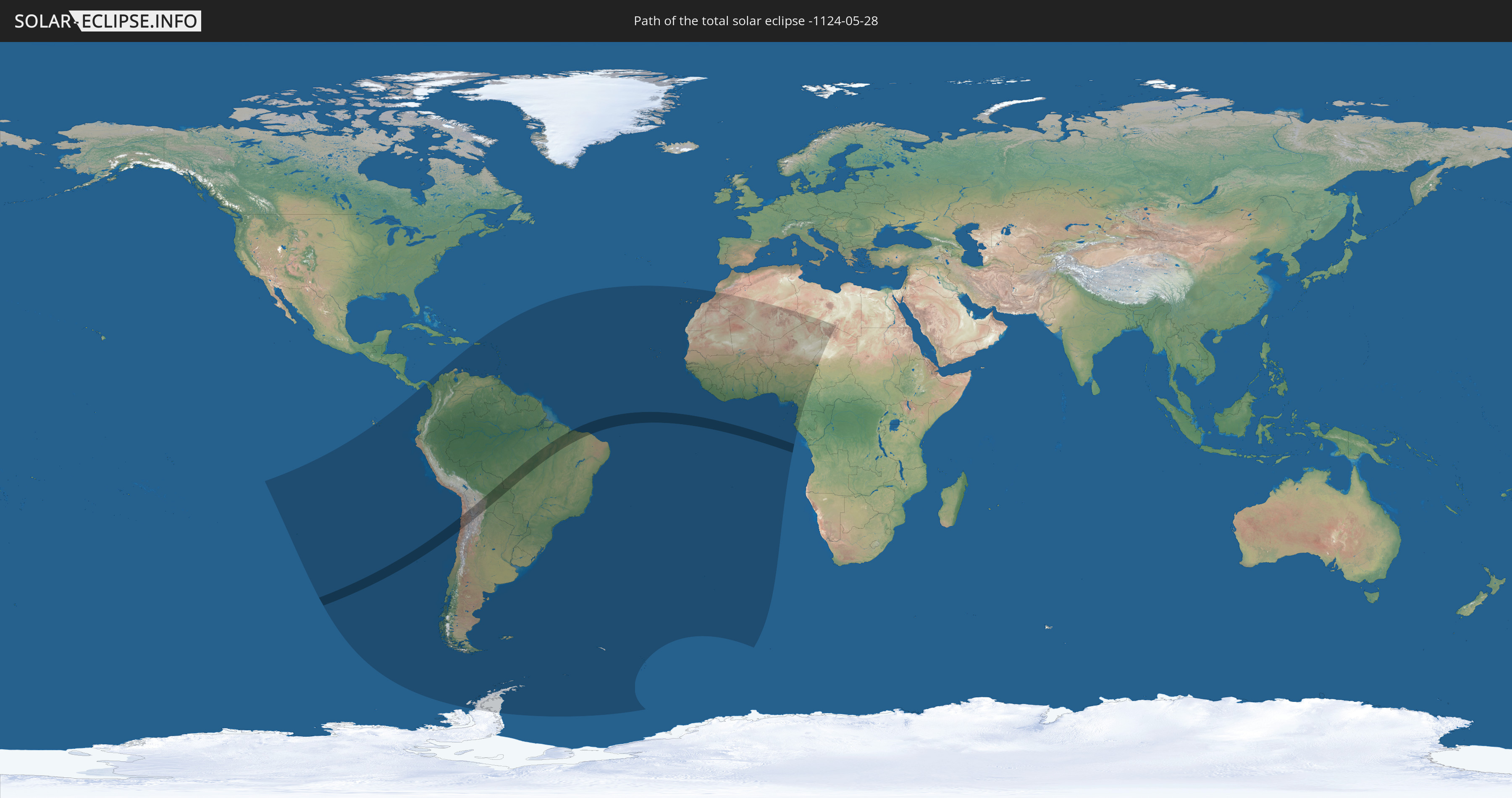
Die Sonnenfinsternis am 28.05.-1124 kann man in 62 Ländern als partielle Sonnenfinsternis beobachten.
Der Finsternispfad verläuft durch 4 Länder. Nur in diesen Ländern ist sie als totale Sonnenfinsternis zu sehen.
In den folgenden Ländern ist die Sonnenfinsternis total zu sehen
 Chile
Chile
 Brasilien
 Argentinien
 Bolivien
In den folgenden Ländern ist die Sonnenfinsternis partiell zu sehen
 Antarktika
 Chile
Chile
 Ecuador
 Panama
 Kolumbien
 Peru
Peru
 Brasilien
 Argentinien
 Venezuela
 Aruba
Aruba
 Bolivien
 Puerto Rico
 Amerikanische Jungferninseln
 Britische Jungferninseln
 Anguilla
 Saint-Martin
 Saint-Barthélemy
 St. Kitts und Nevis
 Paraguay
 Antigua und Barbuda
 Montserrat
 Trinidad und Tobago
 Guadeloupe
 Grenada
 Dominica
 St. Vincent und die Grenadinen
 Falklandinseln
 Guyana
 Martinique
 St. Lucia
 Barbados
 Uruguay
 Suriname
 Französisch-Guayana
 Südgeorgien und die Südlichen Sandwichinseln
 Portugal
 Kap Verde
 Spanien
 Senegal
 Mauretanien
 Gambia
 Guinea-Bissau
 Guinea
 St. Helena
 Sierra Leone
 Marokko
 Mali
Mali
 Liberia
 Algerien
 Elfenbeinküste
 Burkina Faso
 Ghana
Ghana
 Togo
Togo
 Niger
Niger
 Benin
Benin
 Nigeria
 Äquatorialguinea
 São Tomé und Príncipe
 Kamerun
 Gabun
Gabun
 Libyen
 Tschad
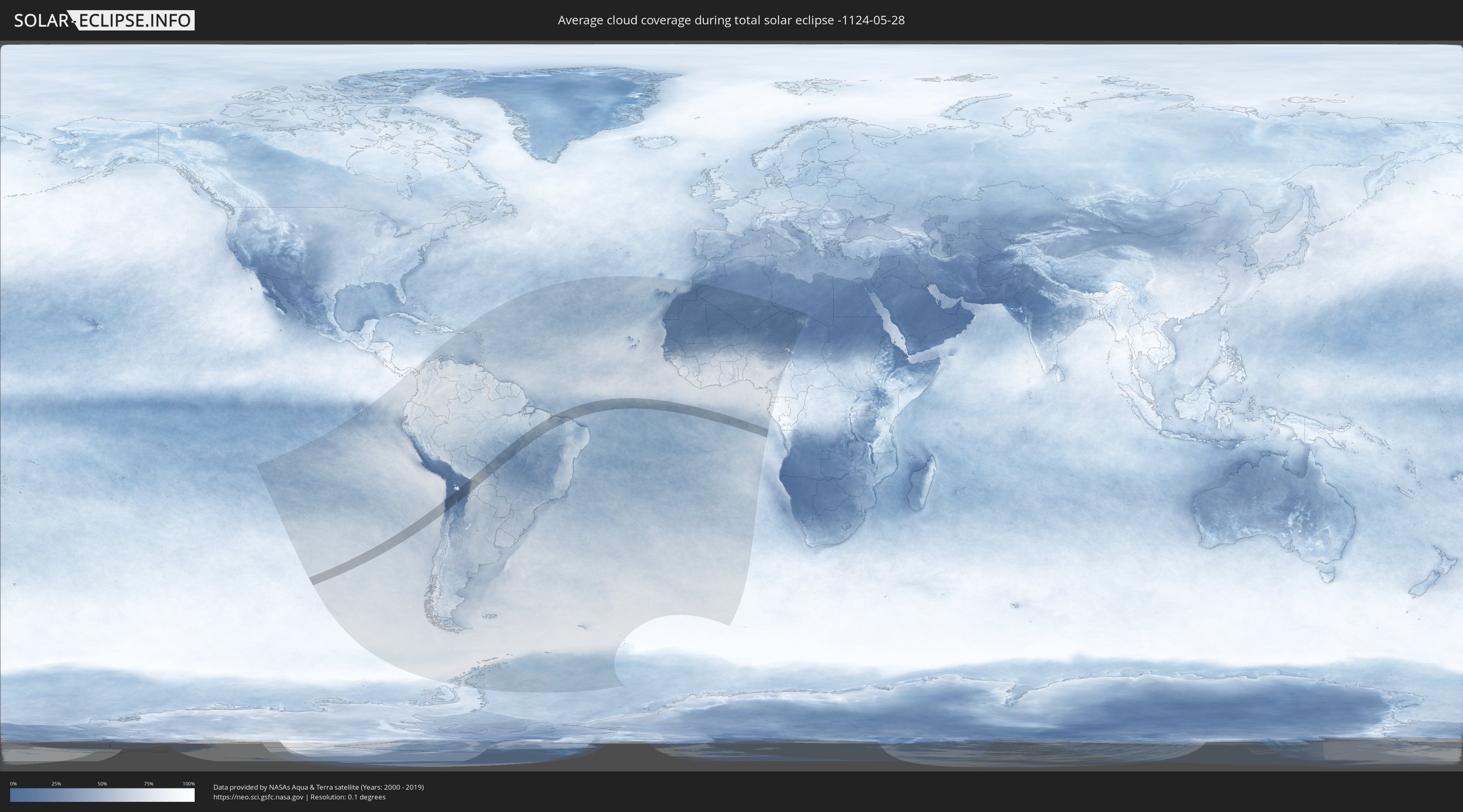
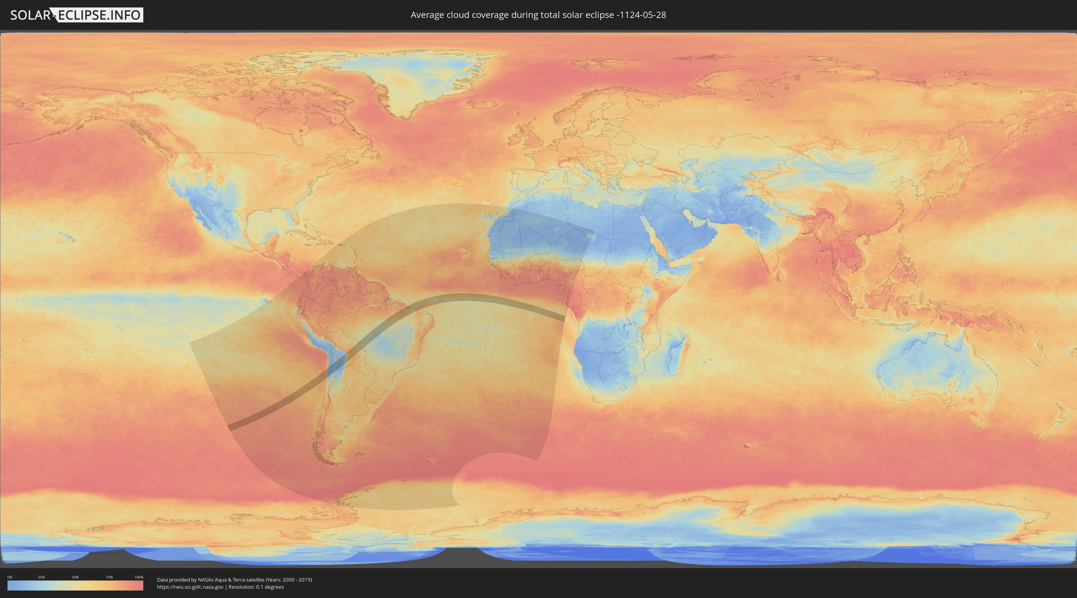
Wie wird das Wetter während der totalen Sonnenfinsternis am 28.05.-1124?
Wo ist der beste Ort, um die totale Sonnenfinsternis vom 28.05.-1124 zu beobachten?
Die folgenden Karten zeigen die durchschnittliche Bewölkung für den Tag, an dem die totale Sonnenfinsternis
stattfindet. Mit Hilfe der Karten lässt sich der Ort entlang des Finsternispfades eingrenzen,
der die besten Aussichen auf einen klaren wolkenfreien Himmel bietet.
Trotzdem muss man immer lokale Gegenenheiten beachten und sollte sich genau über das Wetter an seinem
gewählten Beobachtungsort informieren.
Die Daten stammen von den beiden NASA-Satelliten
AQUA und TERRA
und wurden über einen Zeitraum von 19 Jahren (2000 - 2019) gemittelt.
Detaillierte Länderkarten
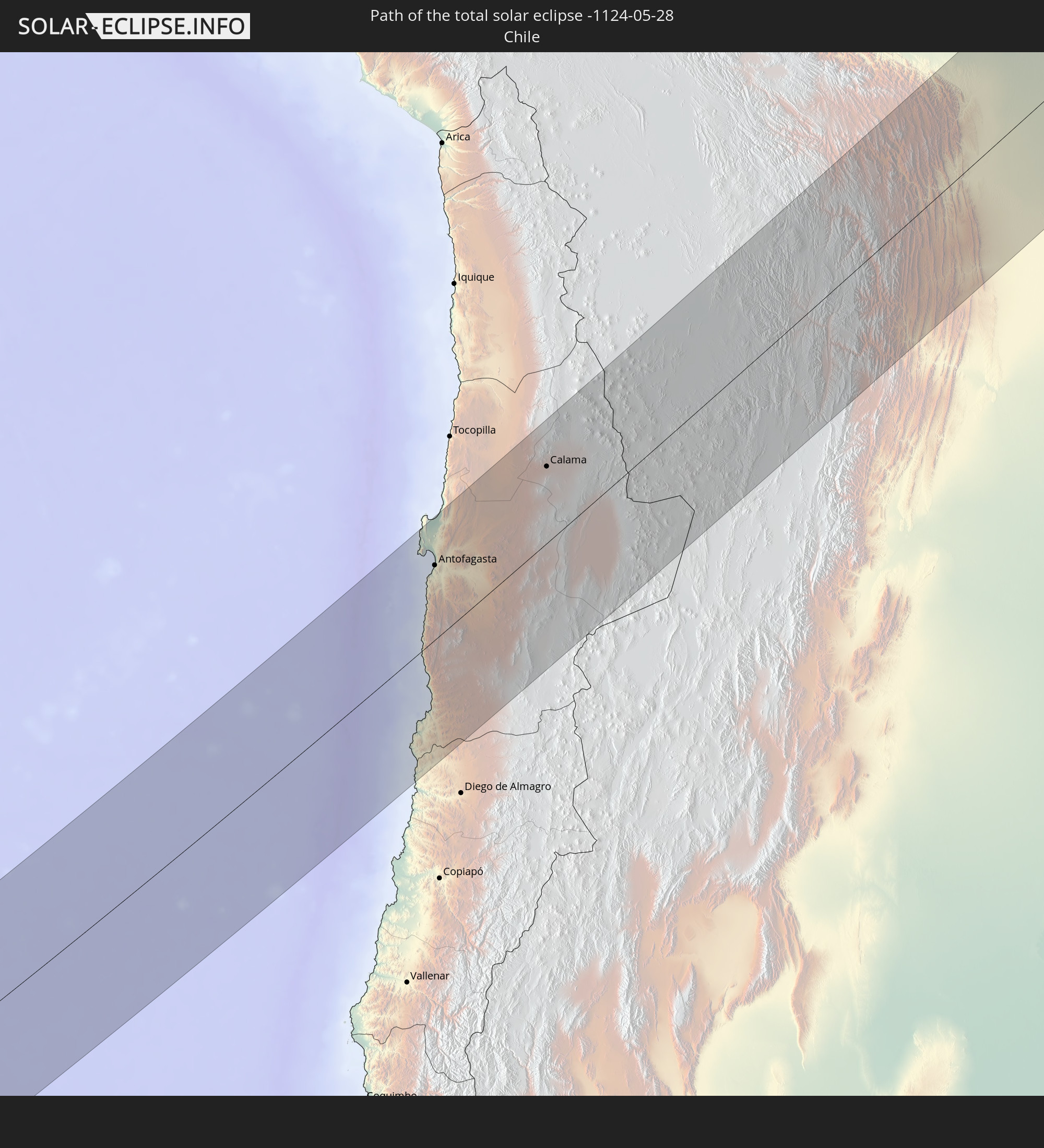
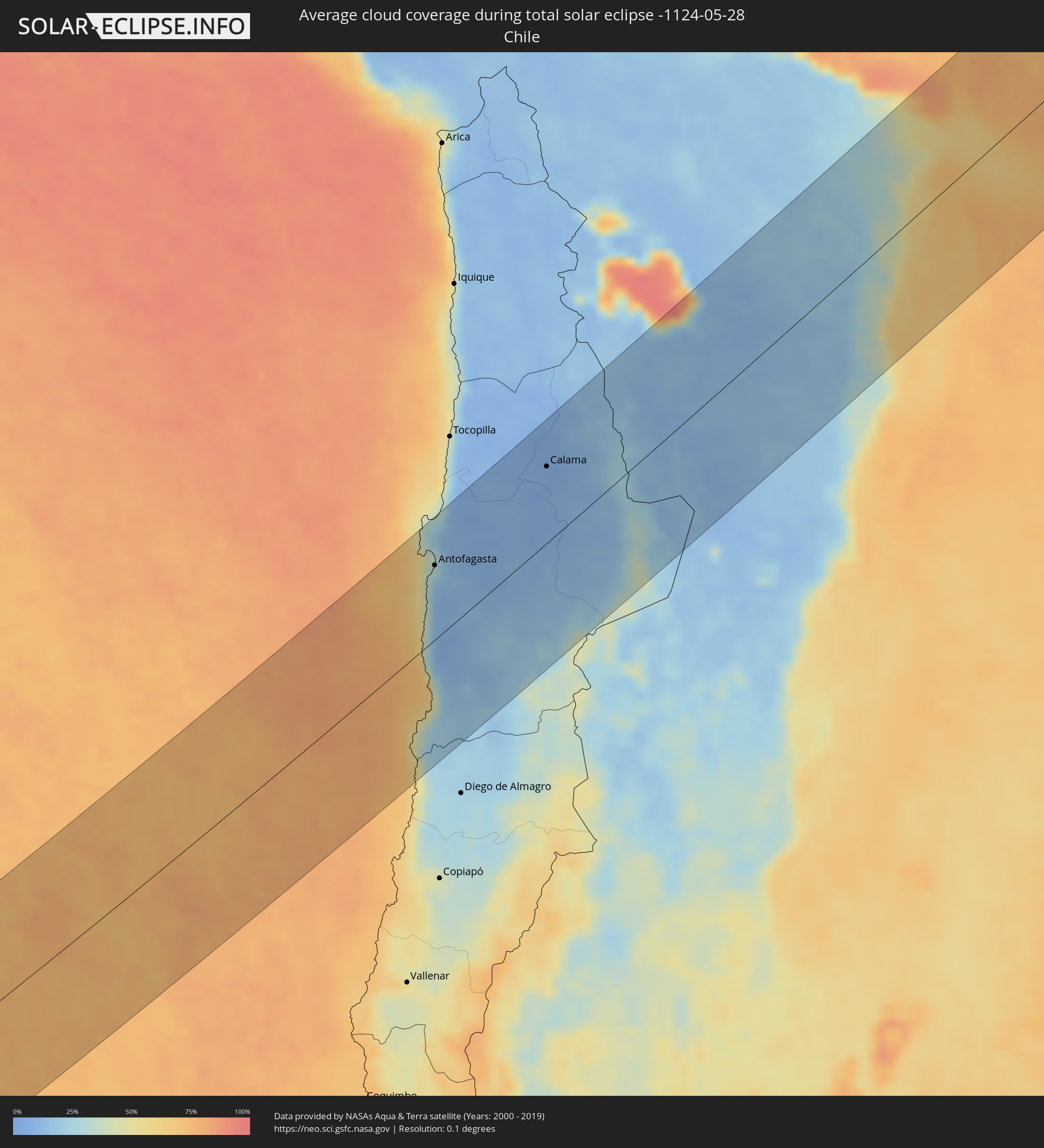 Chile
Chile
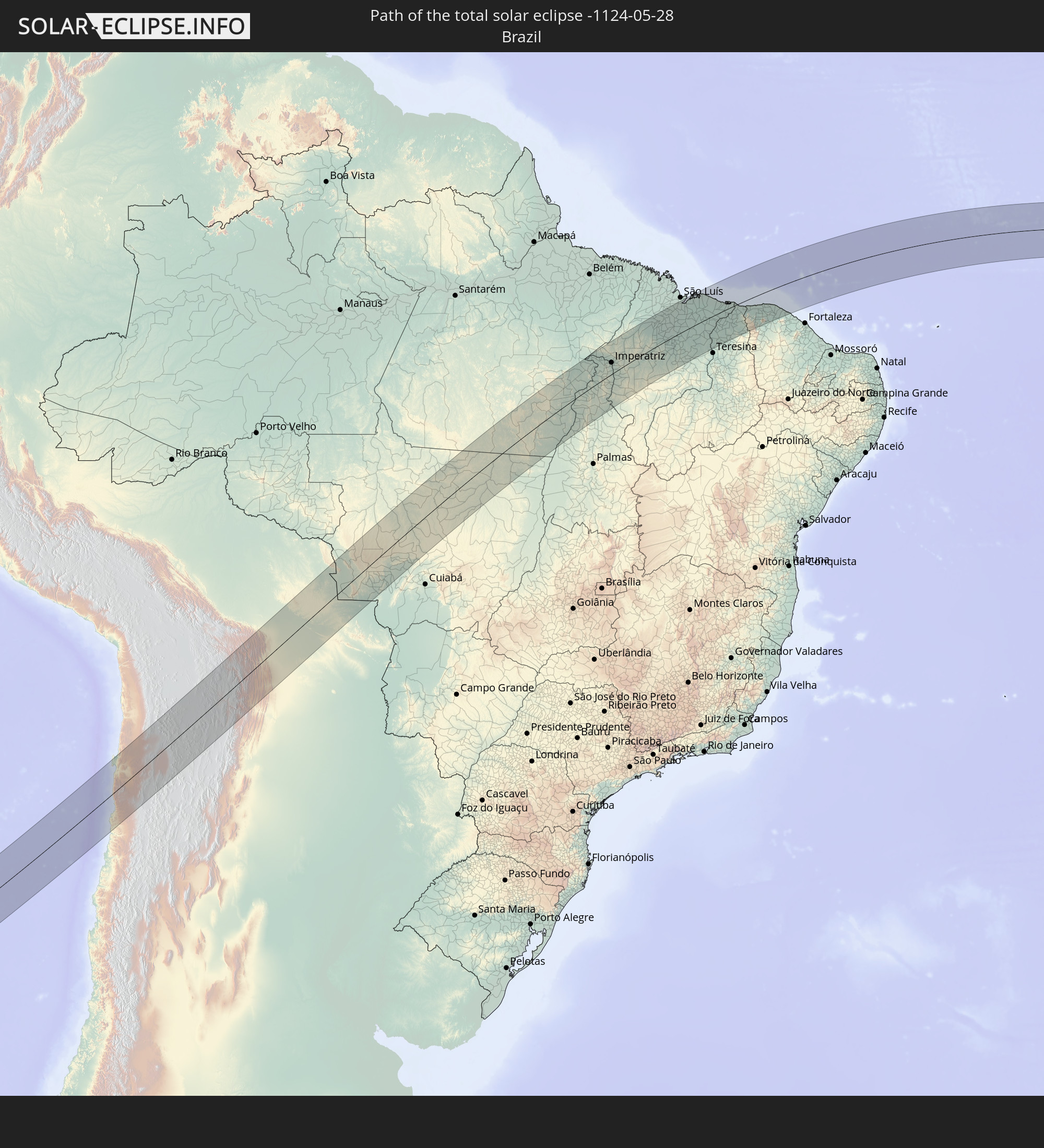
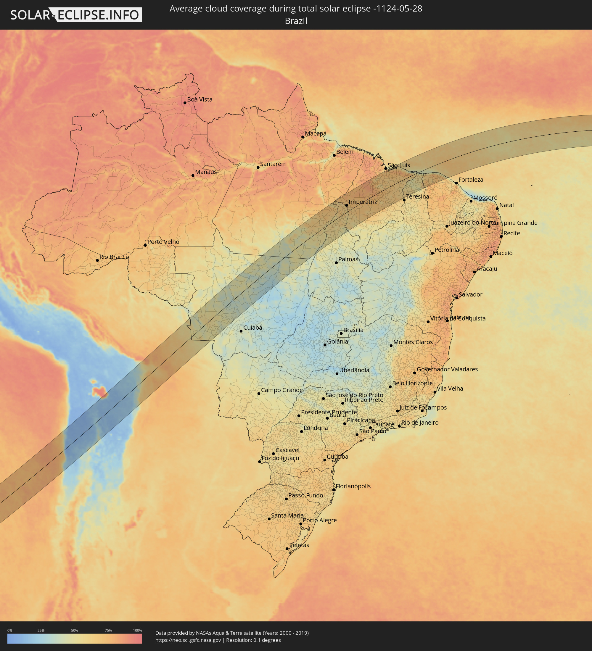 Brasilien
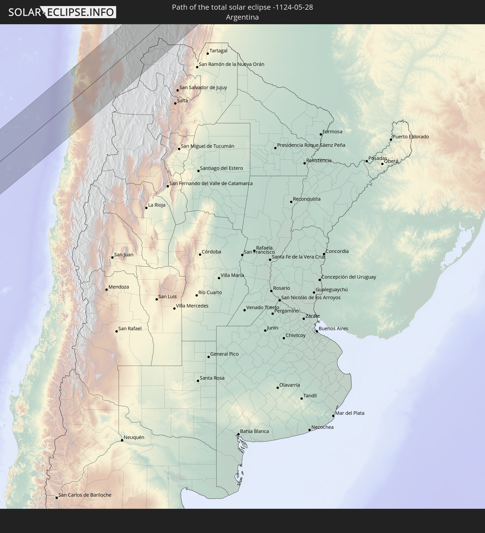
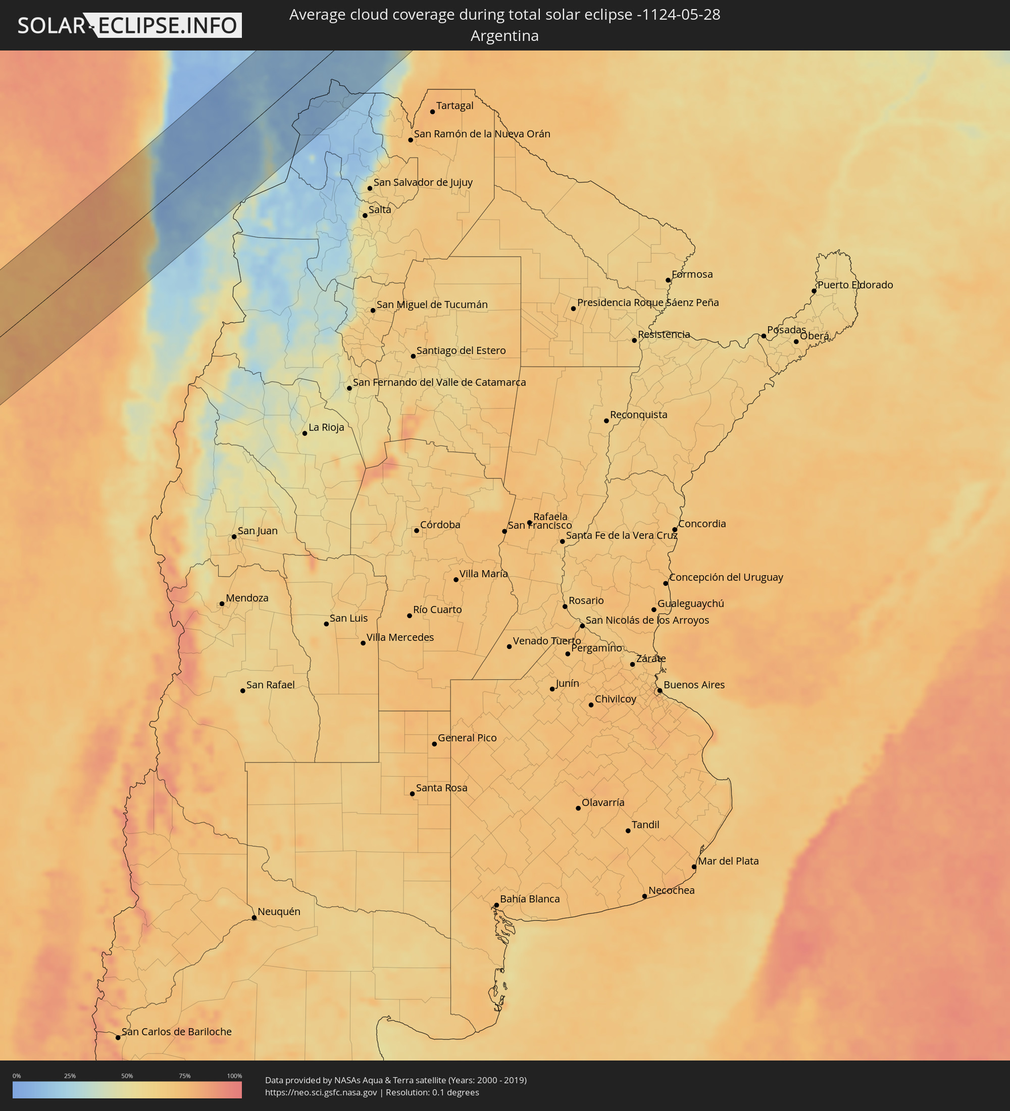 Argentinien
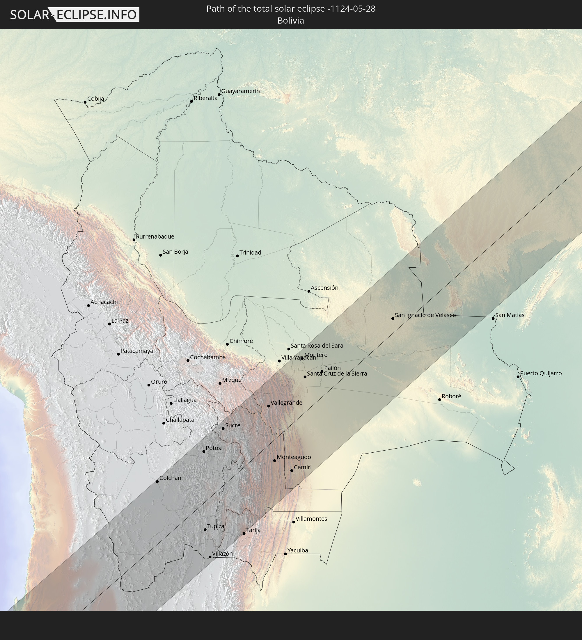
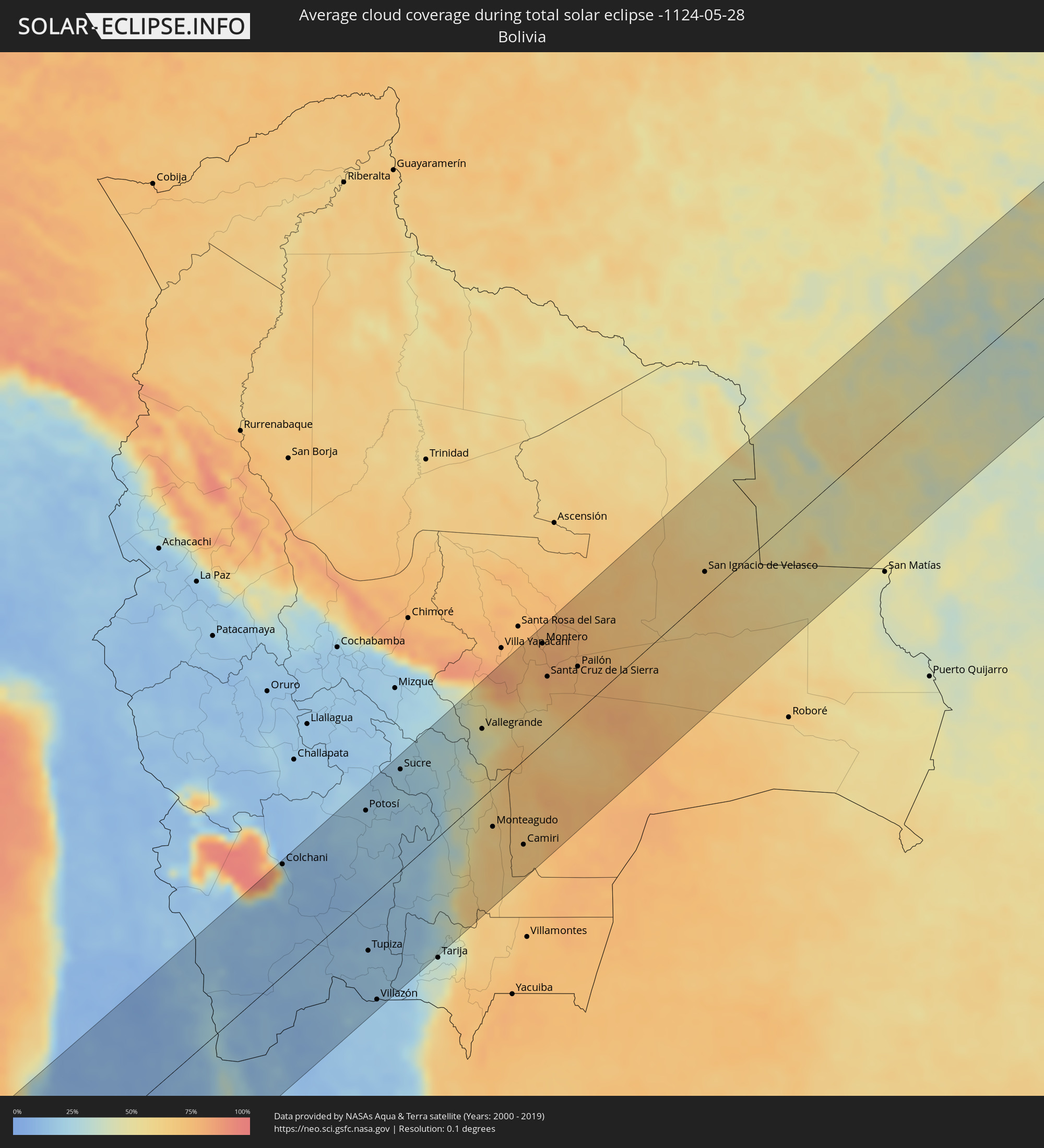 Bolivien
Orte im Finsternispfad
Die nachfolgene Tabelle zeigt Städte und Orte mit mehr als 5.000 Einwohnern, die sich im Finsternispfad befinden. Städte mit mehr als 100.000 Einwohnern sind dick gekennzeichnet. Mit einem Klick auf den Ort öffnet sich eine Detailkarte die die Lage des jeweiligen Ortes zusammen mit dem Verlauf der zentralen Finsternis präsentiert.
| Ort | Typ | Dauer der Verfinsterung | Ortszeit bei maximaler Verfinsterung | Entfernung zur Zentrallinie | Ø Bewölkung |
|
Taltal, Antofagasta
|
total | - | 09:41:47 UTC-04:42 | 67 km | 46% |
|
Antofagasta, Antofagasta
|
total | - | 09:42:57 UTC-04:42 | 76 km | 21% |
|
Calama, Antofagasta
|
total | - | 09:45:50 UTC-04:42 | 78 km | 8% |
|
Colchani, Potosí
|
total | - | 10:00:42 UTC-04:32 | 123 km | 29% |
|
Uyuni, Potosí
|
total | - | 10:00:44 UTC-04:32 | 102 km | 13% |
|
Potosí, Potosí
|
total | - | 10:03:13 UTC-04:32 | 101 km | 19% |
|
Tupiza, Potosí
|
total | - | 10:01:41 UTC-04:32 | 56 km | 17% |
|
Villazón, Potosí
|
total | - | 10:01:22 UTC-04:32 | 118 km | 17% |
|
La Quiaca, Jujuy Province
|
total | - | 10:17:10 UTC-04:16 | 120 km | 17% |
|
Sucre, Chuquisaca
|
total | - | 10:04:32 UTC-04:32 | 112 km | 21% |
|
Vallegrande, Santa Cruz
|
total | - | 10:07:01 UTC-04:32 | 76 km | 45% |
|
Monteagudo, Chuquisaca
|
total | - | 10:06:03 UTC-04:32 | 43 km | 63% |
|
Camiri, Santa Cruz
|
total | - | 10:06:35 UTC-04:32 | 93 km | 68% |
|
Portachuelo, Santa Cruz
|
total | - | 10:09:25 UTC-04:32 | 120 km | 76% |
|
Santiago del Torno, Santa Cruz
|
total | - | 10:08:48 UTC-04:32 | 67 km | 65% |
|
Montero, Santa Cruz
|
total | - | 10:09:41 UTC-04:32 | 111 km | 78% |
|
Mineros, Santa Cruz
|
total | - | 10:09:57 UTC-04:32 | 128 km | 77% |
|
La Bélgica, Santa Cruz
|
total | - | 10:09:32 UTC-04:32 | 91 km | 79% |
|
Santa Cruz de la Sierra, Santa Cruz
|
total | - | 10:09:21 UTC-04:32 | 69 km | 79% |
|
Warnes, Santa Cruz
|
total | - | 10:09:39 UTC-04:32 | 91 km | 79% |
|
Cotoca, Santa Cruz
|
total | - | 10:09:33 UTC-04:32 | 57 km | 77% |
|
San Julian, Santa Cruz
|
total | - | 10:09:55 UTC-04:32 | 47 km | 77% |
|
Pailón, Santa Cruz
|
total | - | 10:10:16 UTC-04:32 | 50 km | 76% |
|
San Ignacio de Velasco, Santa Cruz
|
total | - | 10:15:00 UTC-04:32 | 28 km | 66% |
|
Concepción, Santa Cruz
|
total | - | 10:15:01 UTC-04:32 | 19 km | 65% |
|
Pontes e Lacerda, Mato Grosso
|
total | - | 11:13:37 UTC-03:38 | 8 km | 45% |
|
Nova Olímpia, Mato Grosso
|
total | - | 11:18:22 UTC-03:38 | 103 km | 48% |
|
Barra do Bugres, Mato Grosso
|
total | - | 11:18:15 UTC-03:38 | 133 km | 43% |
|
Diamantino, Mato Grosso
|
total | - | 11:20:39 UTC-03:38 | 130 km | 39% |
|
Sinop, Mato Grosso
|
total | - | 11:26:03 UTC-03:38 | 17 km | 46% |
|
Conceição do Araguaia, Pará
|
total | - | 12:10:40 UTC-03:13 | 92 km | 47% |
|
Araguaína, Tocantins
|
total | - | 12:54:54 UTC-02:34 | 61 km | 59% |
|
Imperatriz, Maranhão
|
total | - | 12:59:14 UTC-02:34 | 50 km | 64% |
|
Carolina, Maranhão
|
total | - | 12:56:37 UTC-02:34 | 121 km | 43% |
|
Porto Franco, Maranhão
|
total | - | 12:58:16 UTC-02:34 | 32 km | 57% |
|
Grajaú, Maranhão
|
total | - | 13:02:20 UTC-02:34 | 58 km | 68% |
|
Santa Inês, Maranhão
|
total | - | 13:07:30 UTC-02:34 | 106 km | 79% |
|
Lago da Pedra, Maranhão
|
total | - | 13:06:58 UTC-02:34 | 38 km | 79% |
|
Barra do Corda, Maranhão
|
total | - | 13:05:11 UTC-02:34 | 79 km | 69% |
|
Penalva, Maranhão
|
total | - | 13:08:35 UTC-02:34 | 131 km | 61% |
|
Pio XII, Maranhão
|
total | - | 13:07:51 UTC-02:34 | 77 km | 71% |
|
Viana, Maranhão
|
total | - | 13:09:08 UTC-02:34 | 129 km | 63% |
|
Vitória do Mearim, Maranhão
|
total | - | 13:09:08 UTC-02:34 | 98 km | 69% |
|
Bacabal, Maranhão
|
total | - | 13:08:08 UTC-02:34 | 13 km | 75% |
|
Arari, Maranhão
|
total | - | 13:09:23 UTC-02:34 | 94 km | 68% |
|
Tuntum, Maranhão
|
total | - | 13:07:06 UTC-02:34 | 89 km | 67% |
|
Presidente Dutra, Maranhão
|
total | - | 13:07:29 UTC-02:34 | 100 km | 67% |
|
São Mateus do Maranhão, Maranhão
|
total | - | 13:09:20 UTC-02:34 | 20 km | 67% |
|
Dom Pedro, Maranhão
|
total | - | 13:07:59 UTC-02:34 | 79 km | 69% |
|
São Domingos do Maranhão, Maranhão
|
total | - | 13:07:21 UTC-02:34 | 134 km | 67% |
|
Itapecuru Mirim, Maranhão
|
total | - | 13:10:35 UTC-02:34 | 78 km | 69% |
|
Coroatá, Maranhão
|
total | - | 13:10:08 UTC-02:34 | 7 km | 68% |
|
São José de Ribamar, Maranhão
|
total | - | 13:12:35 UTC-02:34 | 144 km | 67% |
|
Timbiras, Maranhão
|
total | - | 13:10:27 UTC-02:34 | 29 km | 69% |
|
Vargem Grande, Maranhão
|
total | - | 13:11:33 UTC-02:34 | 40 km | 67% |
|
Codó, Maranhão
|
total | - | 13:10:18 UTC-02:34 | 51 km | 62% |
|
Chapadinha, Maranhão
|
total | - | 13:12:44 UTC-02:34 | 8 km | 67% |
|
Caxias, Maranhão
|
total | - | 13:11:08 UTC-02:34 | 119 km | 67% |
|
Coelho Neto, Maranhão
|
total | - | 13:12:55 UTC-02:34 | 77 km | 57% |
|
União, Piauí
|
total | - | 13:12:51 UTC-02:34 | 117 km | 61% |
|
Barreirinhas, Maranhão
|
total | - | 13:15:33 UTC-02:34 | 63 km | 77% |
|
Santa Quitéria do Maranhão, Maranhão
|
total | - | 13:15:13 UTC-02:34 | 27 km | 48% |
|
Barras, Piauí
|
total | - | 13:14:52 UTC-02:34 | 112 km | 59% |
|
Esperantina, Piauí
|
total | - | 13:15:31 UTC-02:34 | 81 km | 51% |
|
Piripiri, Piauí
|
total | - | 13:16:13 UTC-02:34 | 140 km | 54% |
|
Parnaíba, Piauí
|
total | - | 13:18:08 UTC-02:34 | 2 km | 61% |
|
Piracuruca, Piauí
|
total | - | 13:16:53 UTC-02:34 | 108 km | 45% |
|
Viçosa do Ceará, Ceará
|
total | - | 13:19:02 UTC-02:34 | 100 km | 70% |
|
Tianguá, Ceará
|
total | - | 13:19:04 UTC-02:34 | 122 km | 71% |
|
Camocim, Ceará
|
total | - | 13:20:37 UTC-02:34 | 44 km | 68% |
|
Granja, Ceará
|
total | - | 13:20:22 UTC-02:34 | 67 km | 66% |
|
Sobral, Ceará
|
total | - | 13:20:51 UTC-02:34 | 146 km | 73% |
|
Santana do Acaraú, Ceará
|
total | - | 13:21:32 UTC-02:34 | 129 km | 72% |
|
Marco, Ceará
|
total | - | 13:22:10 UTC-02:34 | 98 km | 70% |
|
Acaraú, Ceará
|
total | - | 13:22:33 UTC-02:34 | 74 km | 74% |