Total solar eclipse of 05/28/-1124
| Day of week: | Tuesday |
| Maximum duration of eclipse: | 07m03s |
| Maximum width of eclipse path: | 288 km |
| Saros cycle: | 29 |
| Coverage: | 100% |
| Magnitude: | 1.0804 |
| Gamma: | -0.449 |
Wo kann man die Sonnenfinsternis vom 05/28/-1124 sehen?
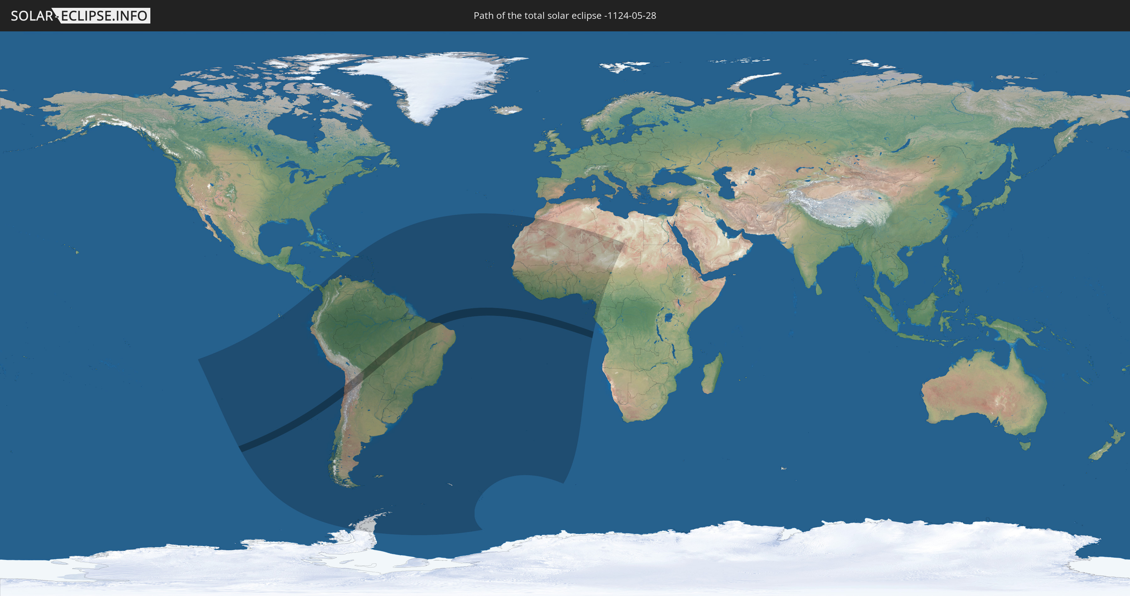
Die Sonnenfinsternis am 05/28/-1124 kann man in 62 Ländern als partielle Sonnenfinsternis beobachten.
Der Finsternispfad verläuft durch 4 Länder. Nur in diesen Ländern ist sie als total Sonnenfinsternis zu sehen.
In den folgenden Ländern ist die Sonnenfinsternis total zu sehen
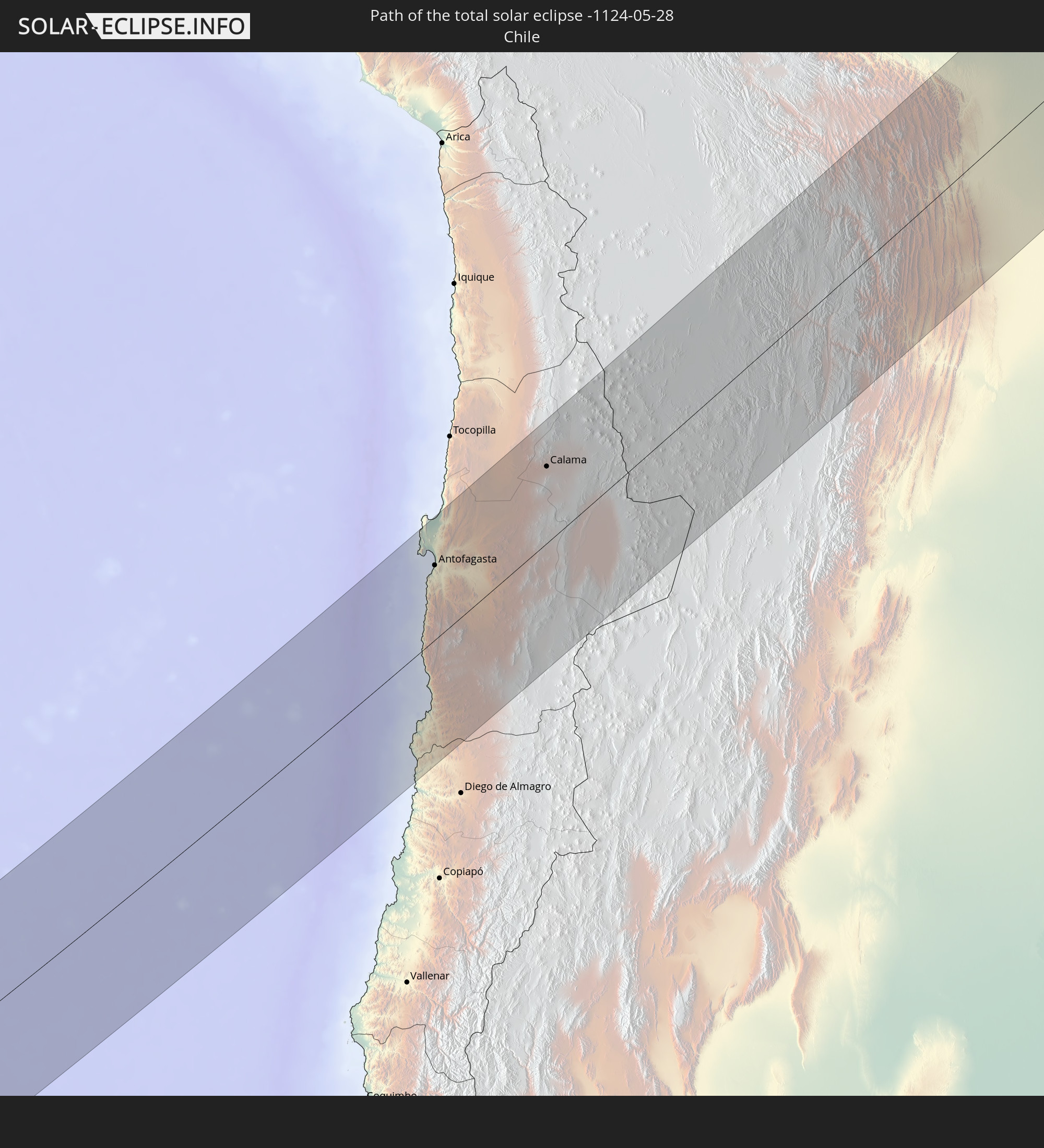 Chile
Chile
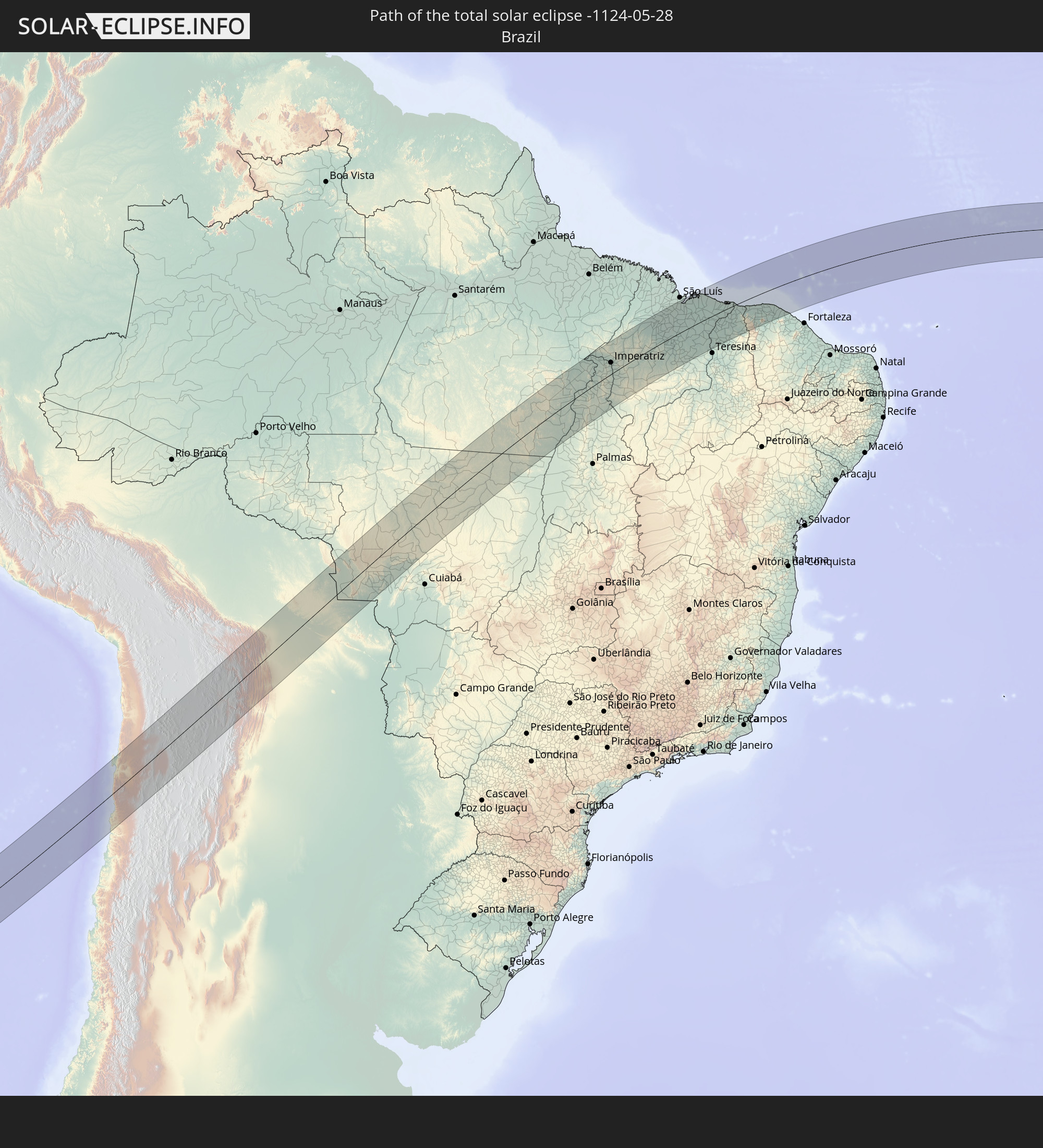 Brazil
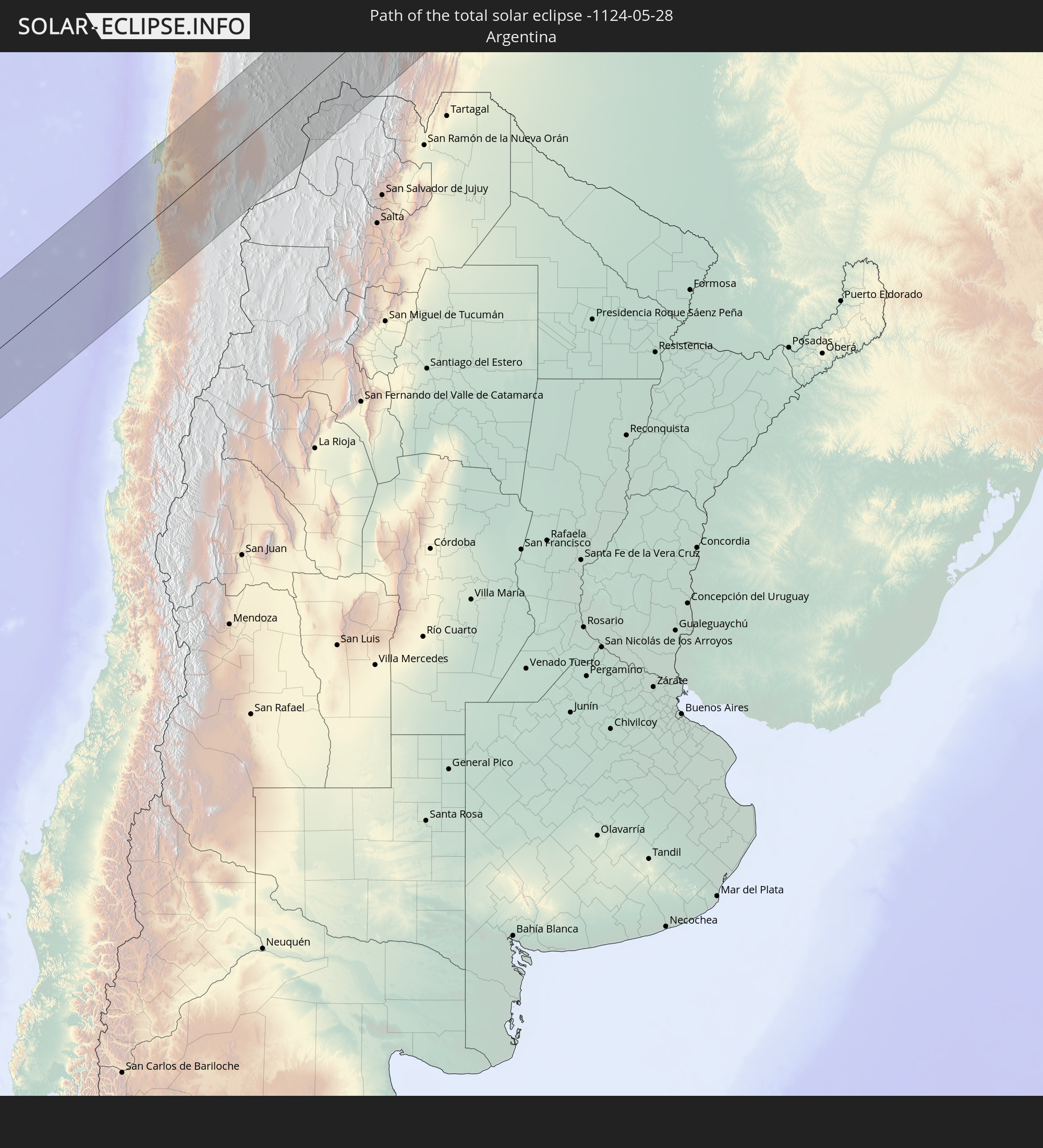 Argentina
 Bolivia
In den folgenden Ländern ist die Sonnenfinsternis partiell zu sehen
 Antarctica
 Chile
Chile
 Ecuador
 Panama
 Colombia
 Peru
Peru
 Brazil
 Argentina
 Venezuela
 Aruba
Aruba
 Bolivia
 Puerto Rico
 United States Virgin Islands
 British Virgin Islands
 Anguilla
 Collectivity of Saint Martin
 Saint Barthélemy
 Saint Kitts and Nevis
 Paraguay
 Antigua and Barbuda
 Montserrat
 Trinidad and Tobago
 Guadeloupe
 Grenada
 Dominica
 Saint Vincent and the Grenadines
 Falkland Islands
 Guyana
 Martinique
 Saint Lucia
 Barbados
 Uruguay
 Suriname
 French Guiana
 South Georgia and the South Sandwich Islands
 Portugal
 Cabo Verde
 Spain
Spain
 Senegal
 Mauritania
 The Gambia
 Guinea-Bissau
 Guinea
 Saint Helena, Ascension and Tristan da Cunha
 Sierra Leone
 Morocco
 Mali
Mali
 Liberia
 Algeria
 Ivory Coast
 Burkina Faso
 Ghana
Ghana
 Togo
Togo
 Niger
Niger
 Benin
Benin
 Nigeria
 Equatorial Guinea
 São Tomé and Príncipe
 Cameroon
 Gabon
Gabon
 Libya
Libya
 Chad
Chad
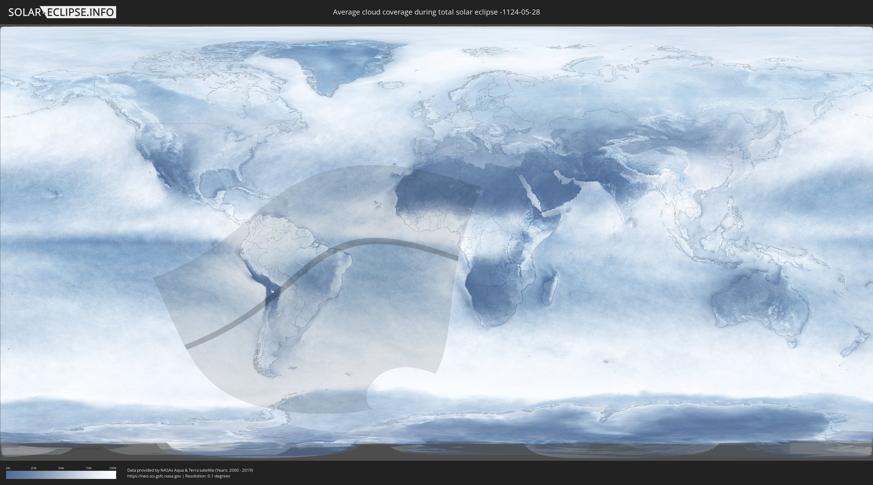
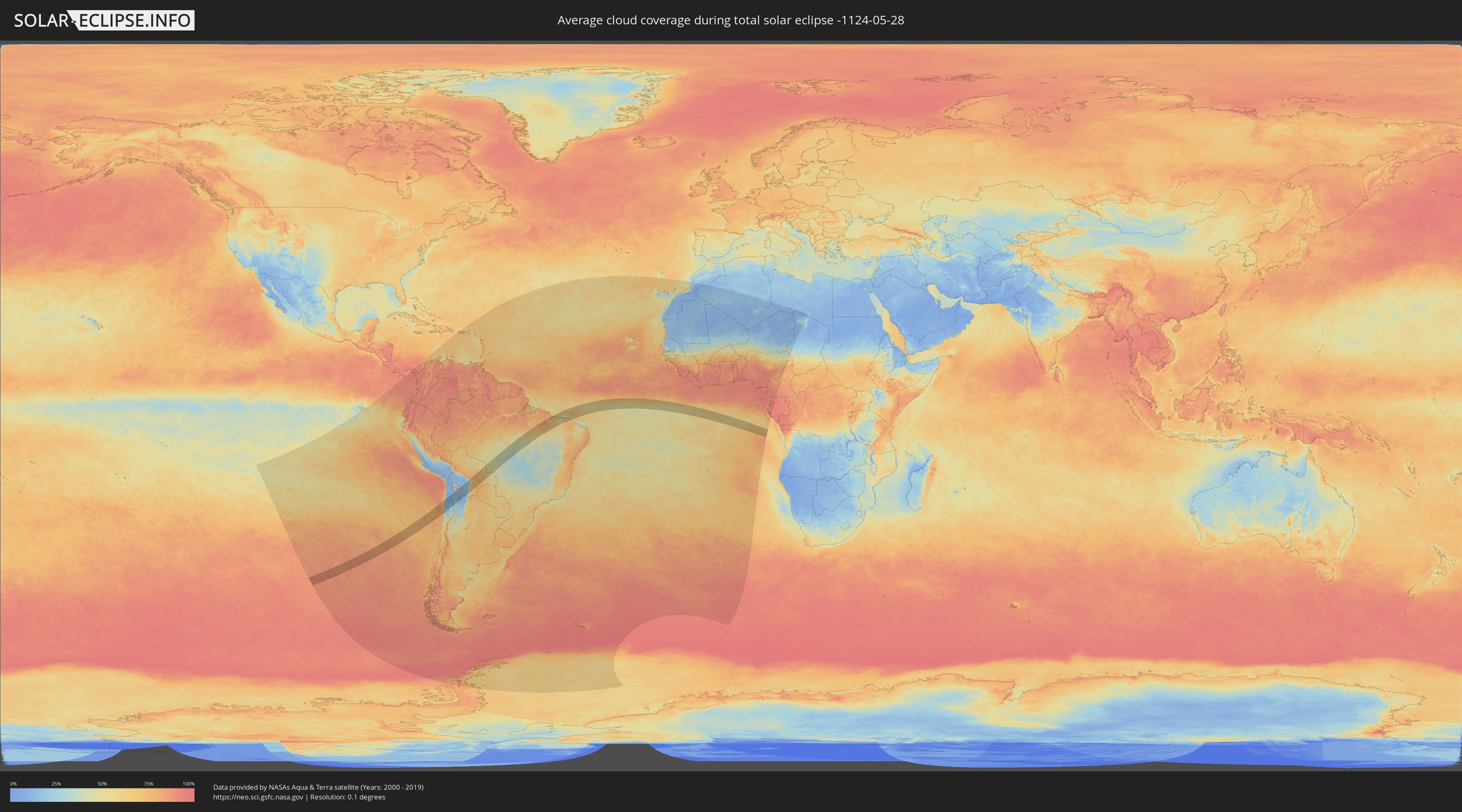
How will be the weather during the total solar eclipse on 05/28/-1124?
Where is the best place to see the total solar eclipse of 05/28/-1124?
The following maps show the average cloud coverage for the day of the total solar eclipse.
With the help of these maps, it is possible to find the place along the eclipse path, which has the best
chance of a cloudless sky.
Nevertheless, you should consider local circumstances and inform about the weather of your chosen
observation site.
The data is provided by NASAs satellites
AQUA and TERRA.
The cloud maps are averaged over a period of 19 years (2000 - 2019).
Detailed country maps
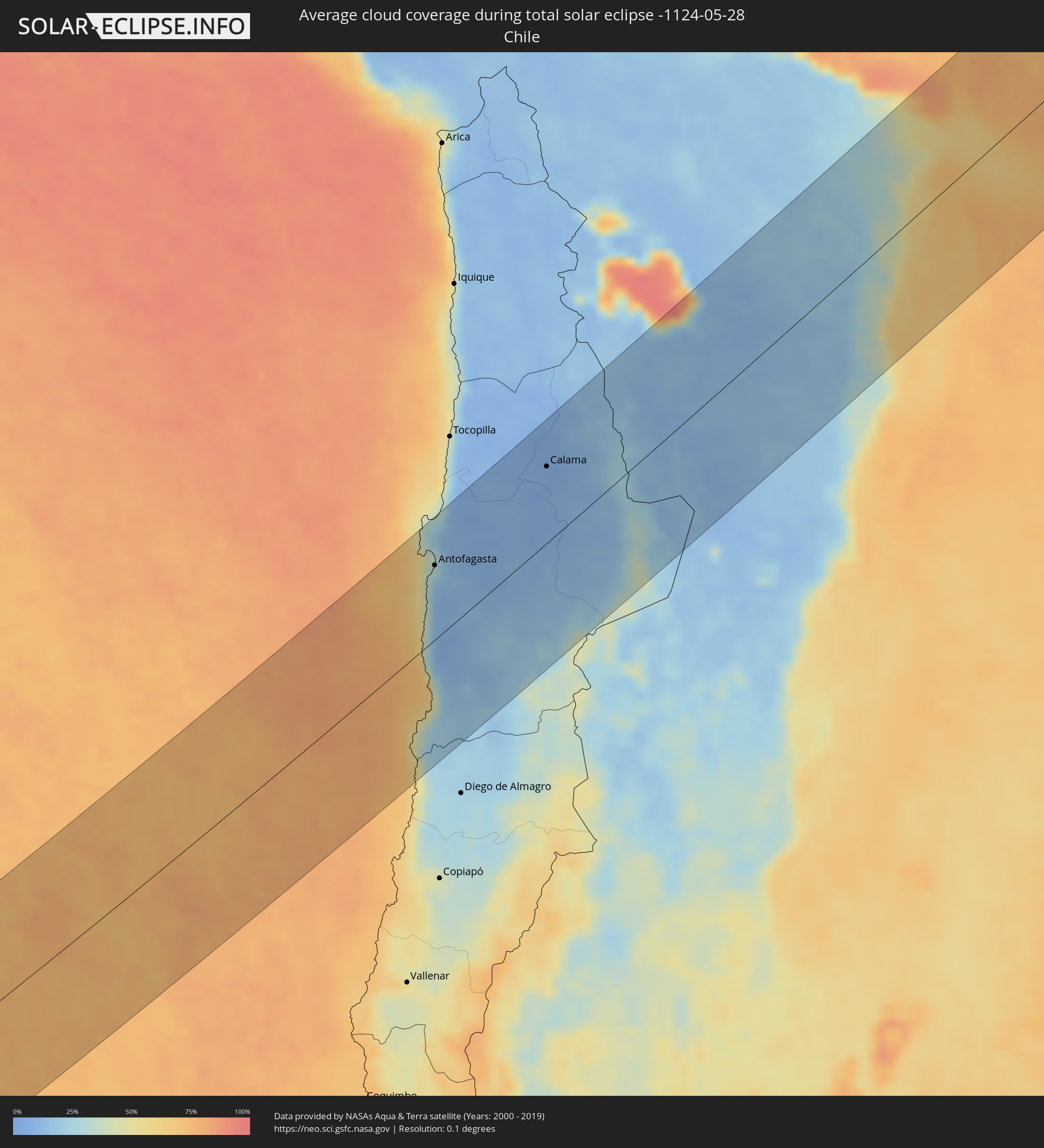 Chile
Chile
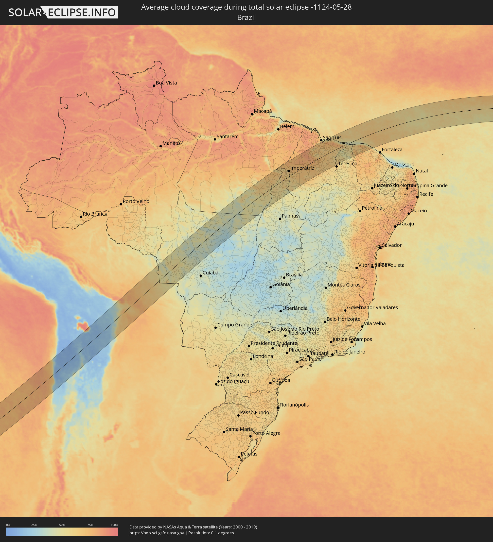 Brazil
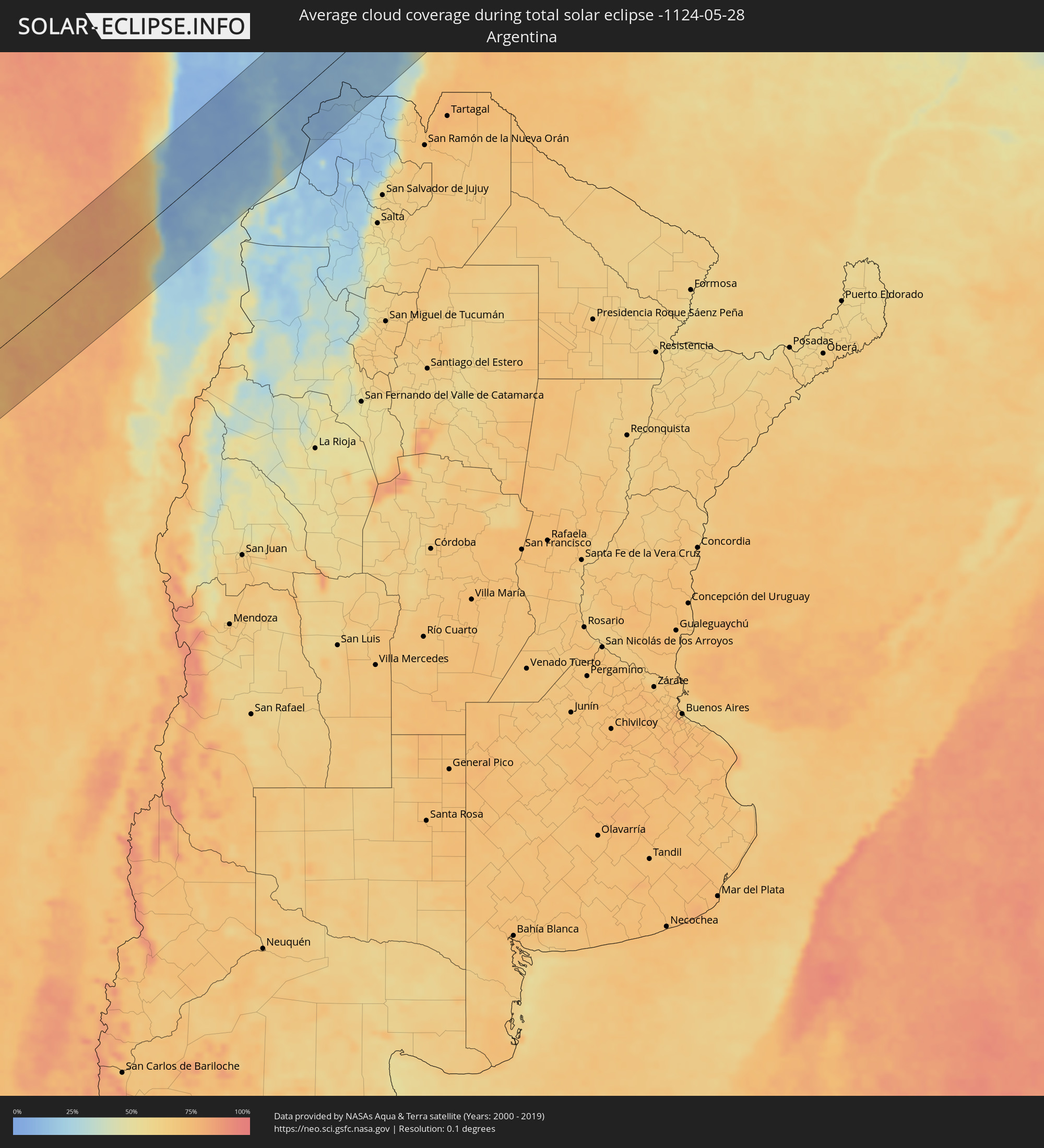 Argentina
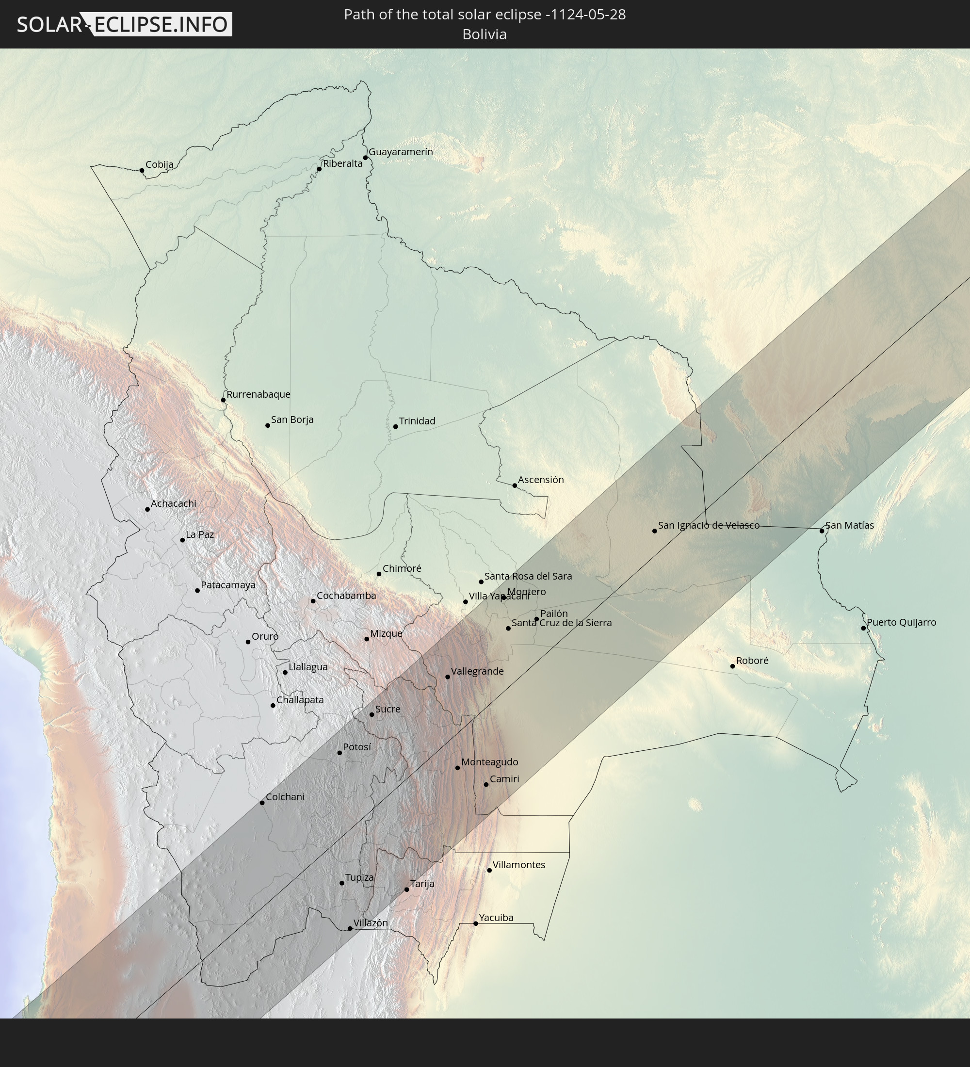
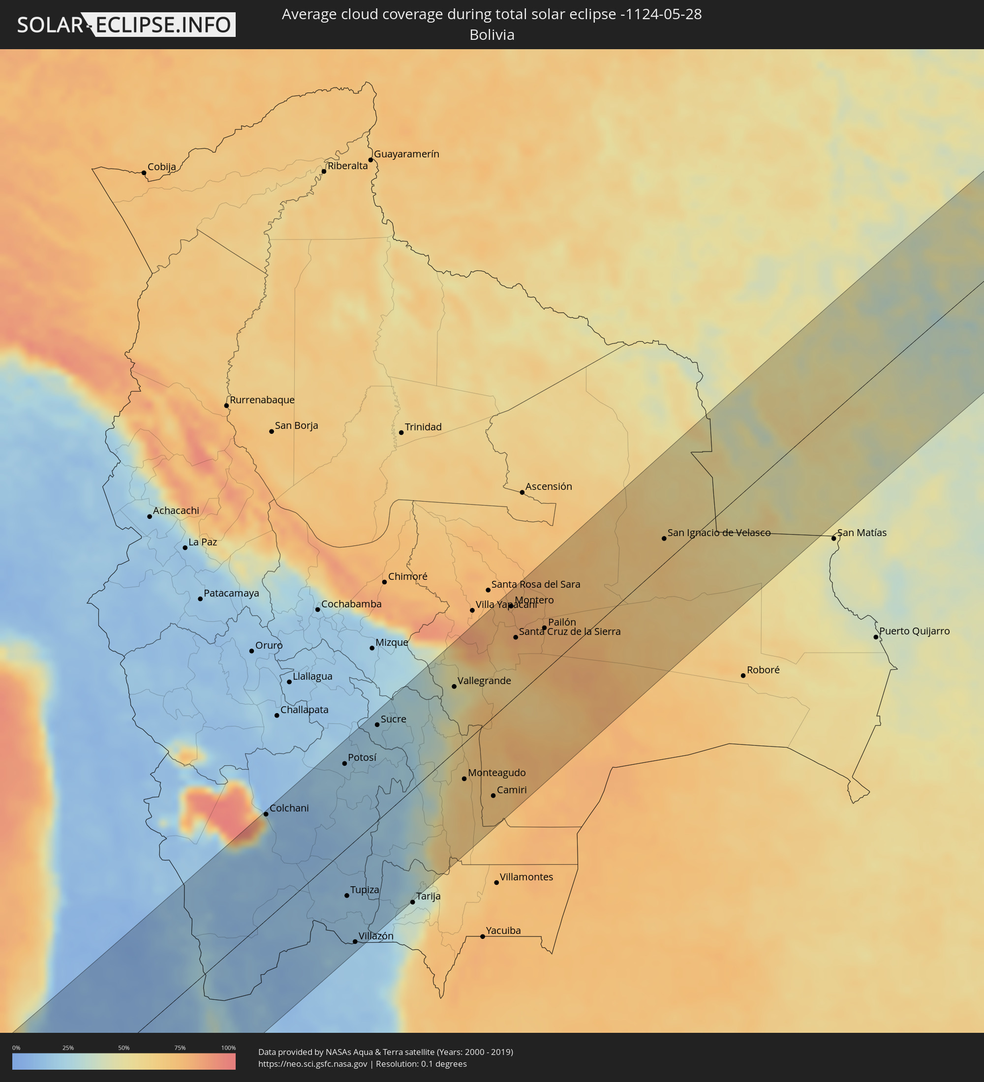 Bolivia
Cities inside the path of the eclipse
The following table shows all locations with a population of more than 5,000 inside the eclipse path. Cities which have more than 100,000 inhabitants are marked bold. A click at the locations opens a detailed map.
| City | Type | Eclipse duration | Local time of max. eclipse | Distance to central line | Ø Cloud coverage |
|
Taltal, Antofagasta
|
total | - | 09:41:47 UTC-04:42 | 67 km | 46% |
|
Antofagasta, Antofagasta
|
total | - | 09:42:57 UTC-04:42 | 76 km | 21% |
|
Calama, Antofagasta
|
total | - | 09:45:50 UTC-04:42 | 78 km | 8% |
|
Colchani, Potosí
|
total | - | 10:00:42 UTC-04:32 | 123 km | 29% |
|
Uyuni, Potosí
|
total | - | 10:00:44 UTC-04:32 | 102 km | 13% |
|
Potosí, Potosí
|
total | - | 10:03:13 UTC-04:32 | 101 km | 19% |
|
Tupiza, Potosí
|
total | - | 10:01:41 UTC-04:32 | 56 km | 17% |
|
Villazón, Potosí
|
total | - | 10:01:22 UTC-04:32 | 118 km | 17% |
|
La Quiaca, Jujuy Province
|
total | - | 10:17:10 UTC-04:16 | 120 km | 17% |
|
Sucre, Chuquisaca
|
total | - | 10:04:32 UTC-04:32 | 112 km | 21% |
|
Vallegrande, Santa Cruz
|
total | - | 10:07:01 UTC-04:32 | 76 km | 45% |
|
Monteagudo, Chuquisaca
|
total | - | 10:06:03 UTC-04:32 | 43 km | 63% |
|
Camiri, Santa Cruz
|
total | - | 10:06:35 UTC-04:32 | 93 km | 68% |
|
Portachuelo, Santa Cruz
|
total | - | 10:09:25 UTC-04:32 | 120 km | 76% |
|
Santiago del Torno, Santa Cruz
|
total | - | 10:08:48 UTC-04:32 | 67 km | 65% |
|
Montero, Santa Cruz
|
total | - | 10:09:41 UTC-04:32 | 111 km | 78% |
|
Mineros, Santa Cruz
|
total | - | 10:09:57 UTC-04:32 | 128 km | 77% |
|
La Bélgica, Santa Cruz
|
total | - | 10:09:32 UTC-04:32 | 91 km | 79% |
|
Santa Cruz de la Sierra, Santa Cruz
|
total | - | 10:09:21 UTC-04:32 | 69 km | 79% |
|
Warnes, Santa Cruz
|
total | - | 10:09:39 UTC-04:32 | 91 km | 79% |
|
Cotoca, Santa Cruz
|
total | - | 10:09:33 UTC-04:32 | 57 km | 77% |
|
San Julian, Santa Cruz
|
total | - | 10:09:55 UTC-04:32 | 47 km | 77% |
|
Pailón, Santa Cruz
|
total | - | 10:10:16 UTC-04:32 | 50 km | 76% |
|
San Ignacio de Velasco, Santa Cruz
|
total | - | 10:15:00 UTC-04:32 | 28 km | 66% |
|
Concepción, Santa Cruz
|
total | - | 10:15:01 UTC-04:32 | 19 km | 65% |
|
Pontes e Lacerda, Mato Grosso
|
total | - | 11:13:37 UTC-03:38 | 8 km | 45% |
|
Nova Olímpia, Mato Grosso
|
total | - | 11:18:22 UTC-03:38 | 103 km | 48% |
|
Barra do Bugres, Mato Grosso
|
total | - | 11:18:15 UTC-03:38 | 133 km | 43% |
|
Diamantino, Mato Grosso
|
total | - | 11:20:39 UTC-03:38 | 130 km | 39% |
|
Sinop, Mato Grosso
|
total | - | 11:26:03 UTC-03:38 | 17 km | 46% |
|
Conceição do Araguaia, Pará
|
total | - | 12:10:40 UTC-03:13 | 92 km | 47% |
|
Araguaína, Tocantins
|
total | - | 12:54:54 UTC-02:34 | 61 km | 59% |
|
Imperatriz, Maranhão
|
total | - | 12:59:14 UTC-02:34 | 50 km | 64% |
|
Carolina, Maranhão
|
total | - | 12:56:37 UTC-02:34 | 121 km | 43% |
|
Porto Franco, Maranhão
|
total | - | 12:58:16 UTC-02:34 | 32 km | 57% |
|
Grajaú, Maranhão
|
total | - | 13:02:20 UTC-02:34 | 58 km | 68% |
|
Santa Inês, Maranhão
|
total | - | 13:07:30 UTC-02:34 | 106 km | 79% |
|
Lago da Pedra, Maranhão
|
total | - | 13:06:58 UTC-02:34 | 38 km | 79% |
|
Barra do Corda, Maranhão
|
total | - | 13:05:11 UTC-02:34 | 79 km | 69% |
|
Penalva, Maranhão
|
total | - | 13:08:35 UTC-02:34 | 131 km | 61% |
|
Pio XII, Maranhão
|
total | - | 13:07:51 UTC-02:34 | 77 km | 71% |
|
Viana, Maranhão
|
total | - | 13:09:08 UTC-02:34 | 129 km | 63% |
|
Vitória do Mearim, Maranhão
|
total | - | 13:09:08 UTC-02:34 | 98 km | 69% |
|
Bacabal, Maranhão
|
total | - | 13:08:08 UTC-02:34 | 13 km | 75% |
|
Arari, Maranhão
|
total | - | 13:09:23 UTC-02:34 | 94 km | 68% |
|
Tuntum, Maranhão
|
total | - | 13:07:06 UTC-02:34 | 89 km | 67% |
|
Presidente Dutra, Maranhão
|
total | - | 13:07:29 UTC-02:34 | 100 km | 67% |
|
São Mateus do Maranhão, Maranhão
|
total | - | 13:09:20 UTC-02:34 | 20 km | 67% |
|
Dom Pedro, Maranhão
|
total | - | 13:07:59 UTC-02:34 | 79 km | 69% |
|
São Domingos do Maranhão, Maranhão
|
total | - | 13:07:21 UTC-02:34 | 134 km | 67% |
|
Itapecuru Mirim, Maranhão
|
total | - | 13:10:35 UTC-02:34 | 78 km | 69% |
|
Coroatá, Maranhão
|
total | - | 13:10:08 UTC-02:34 | 7 km | 68% |
|
São José de Ribamar, Maranhão
|
total | - | 13:12:35 UTC-02:34 | 144 km | 67% |
|
Timbiras, Maranhão
|
total | - | 13:10:27 UTC-02:34 | 29 km | 69% |
|
Vargem Grande, Maranhão
|
total | - | 13:11:33 UTC-02:34 | 40 km | 67% |
|
Codó, Maranhão
|
total | - | 13:10:18 UTC-02:34 | 51 km | 62% |
|
Chapadinha, Maranhão
|
total | - | 13:12:44 UTC-02:34 | 8 km | 67% |
|
Caxias, Maranhão
|
total | - | 13:11:08 UTC-02:34 | 119 km | 67% |
|
Coelho Neto, Maranhão
|
total | - | 13:12:55 UTC-02:34 | 77 km | 57% |
|
União, Piauí
|
total | - | 13:12:51 UTC-02:34 | 117 km | 61% |
|
Barreirinhas, Maranhão
|
total | - | 13:15:33 UTC-02:34 | 63 km | 77% |
|
Santa Quitéria do Maranhão, Maranhão
|
total | - | 13:15:13 UTC-02:34 | 27 km | 48% |
|
Barras, Piauí
|
total | - | 13:14:52 UTC-02:34 | 112 km | 59% |
|
Esperantina, Piauí
|
total | - | 13:15:31 UTC-02:34 | 81 km | 51% |
|
Piripiri, Piauí
|
total | - | 13:16:13 UTC-02:34 | 140 km | 54% |
|
Parnaíba, Piauí
|
total | - | 13:18:08 UTC-02:34 | 2 km | 61% |
|
Piracuruca, Piauí
|
total | - | 13:16:53 UTC-02:34 | 108 km | 45% |
|
Viçosa do Ceará, Ceará
|
total | - | 13:19:02 UTC-02:34 | 100 km | 70% |
|
Tianguá, Ceará
|
total | - | 13:19:04 UTC-02:34 | 122 km | 71% |
|
Camocim, Ceará
|
total | - | 13:20:37 UTC-02:34 | 44 km | 68% |
|
Granja, Ceará
|
total | - | 13:20:22 UTC-02:34 | 67 km | 66% |
|
Sobral, Ceará
|
total | - | 13:20:51 UTC-02:34 | 146 km | 73% |
|
Santana do Acaraú, Ceará
|
total | - | 13:21:32 UTC-02:34 | 129 km | 72% |
|
Marco, Ceará
|
total | - | 13:22:10 UTC-02:34 | 98 km | 70% |
|
Acaraú, Ceará
|
total | - | 13:22:33 UTC-02:34 | 74 km | 74% |