Totale Sonnenfinsternis vom 22.05.-1468
| Wochentag: | Dienstag |
| Maximale Dauer der Verfinsterung: | 03m37s |
| Maximale Breite des Finsternispfades: | 253 km |
| Saroszyklus: | 14 |
| Bedeckungsgrad: | 100% |
| Magnitude: | 1.0533 |
| Gamma: | 0.7155 |
Wo kann man die Sonnenfinsternis vom 22.05.-1468 sehen?
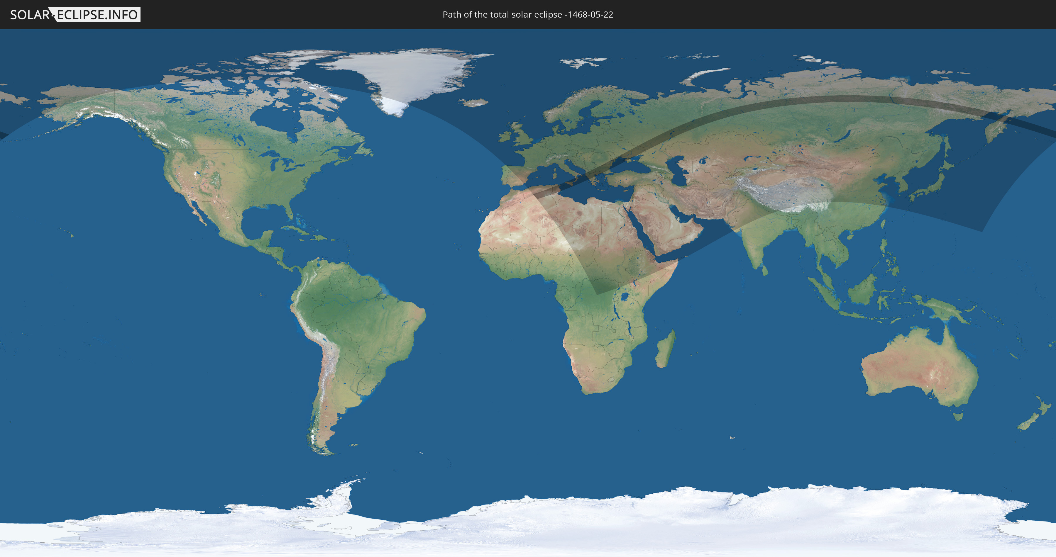
Die Sonnenfinsternis am 22.05.-1468 kann man in 100 Ländern als partielle Sonnenfinsternis beobachten.
Der Finsternispfad verläuft durch 12 Länder. Nur in diesen Ländern ist sie als totale Sonnenfinsternis zu sehen.
In den folgenden Ländern ist die Sonnenfinsternis total zu sehen
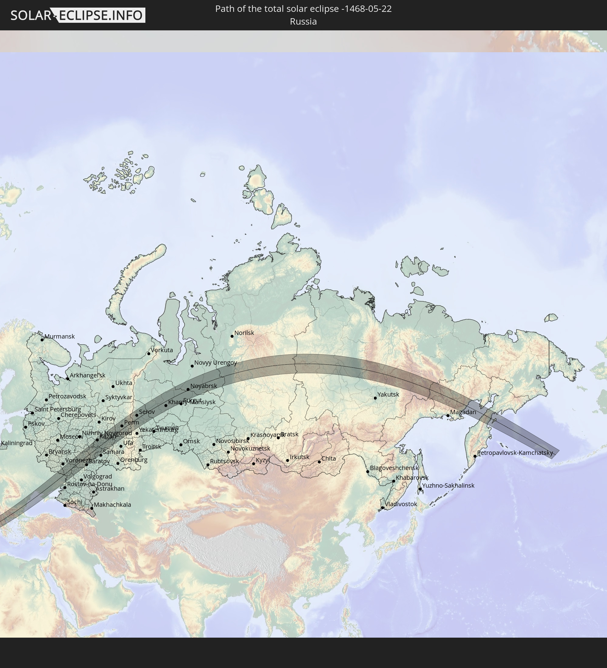 Russland
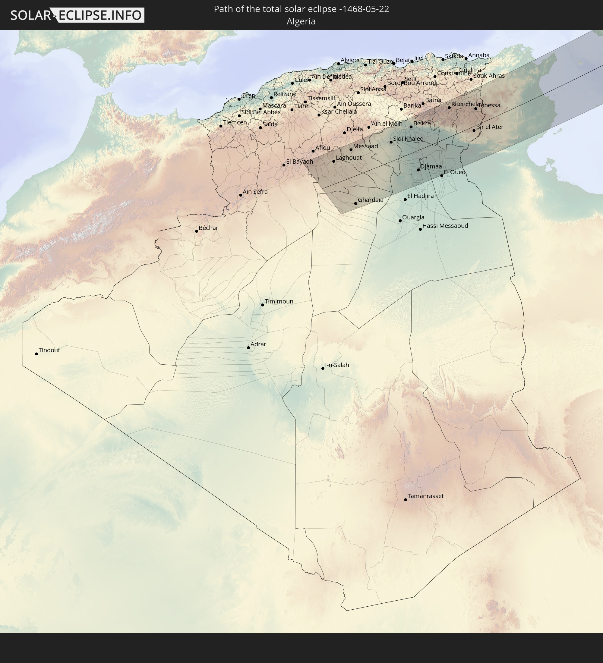 Algerien
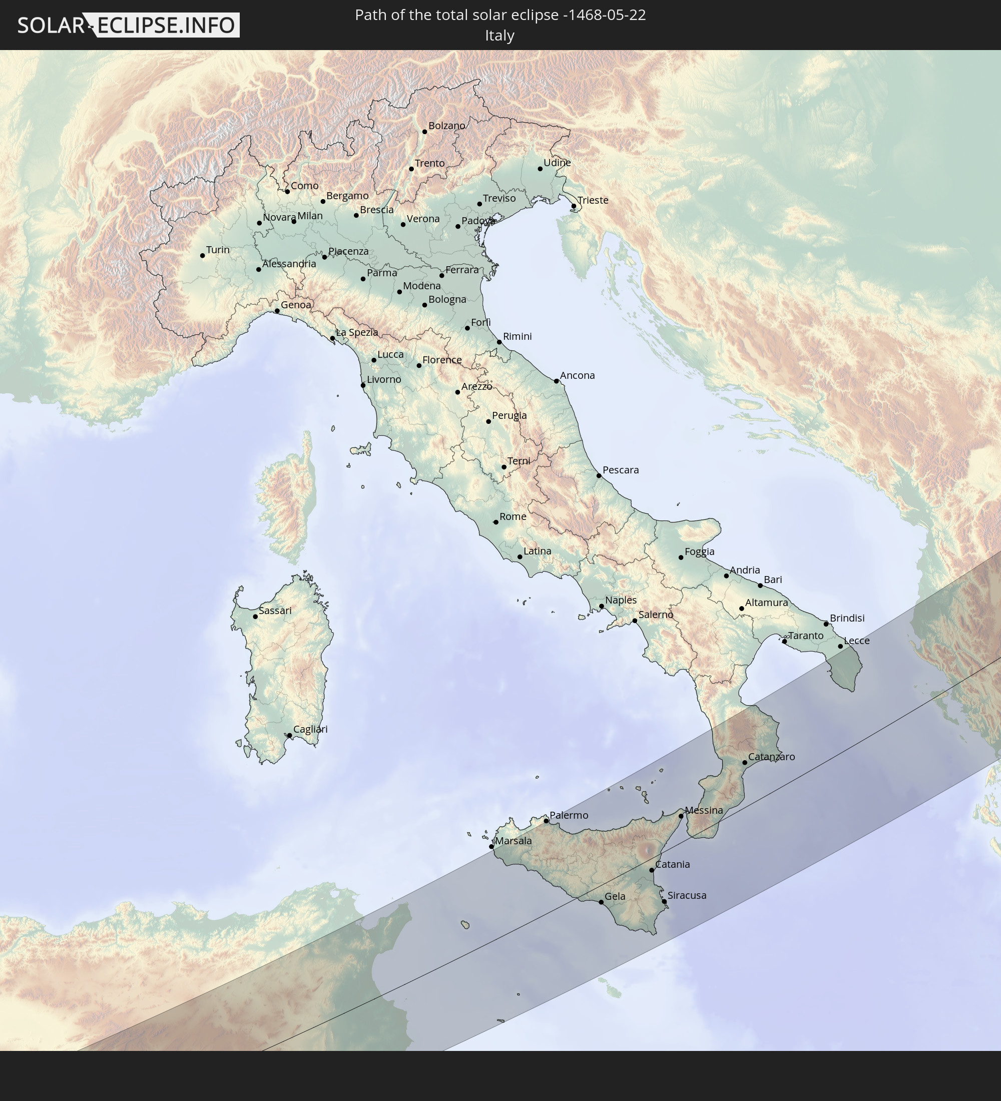 Italien
 Tunesien
 Serbien
 Albanien
 Griechenland
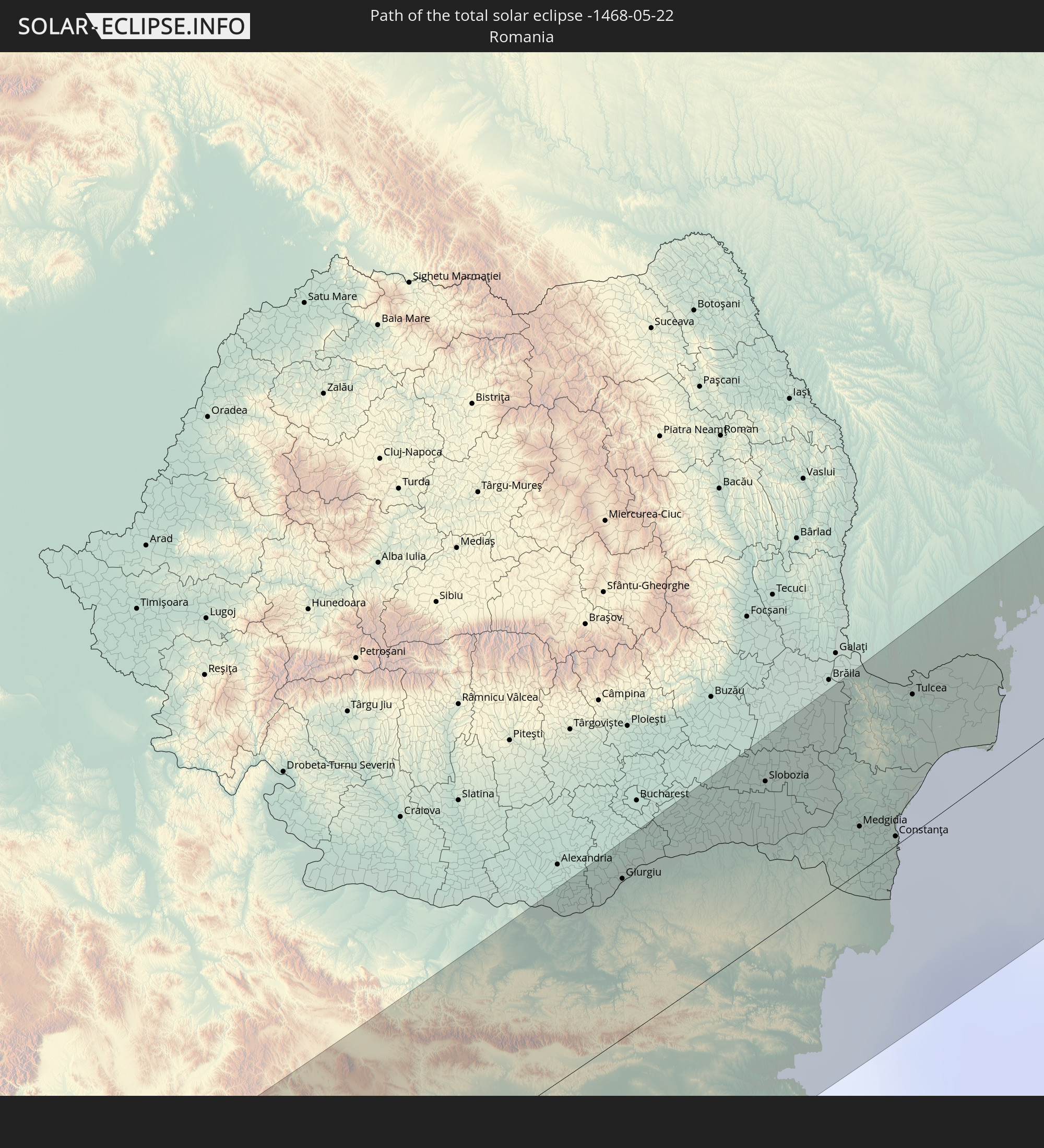 Rumänien
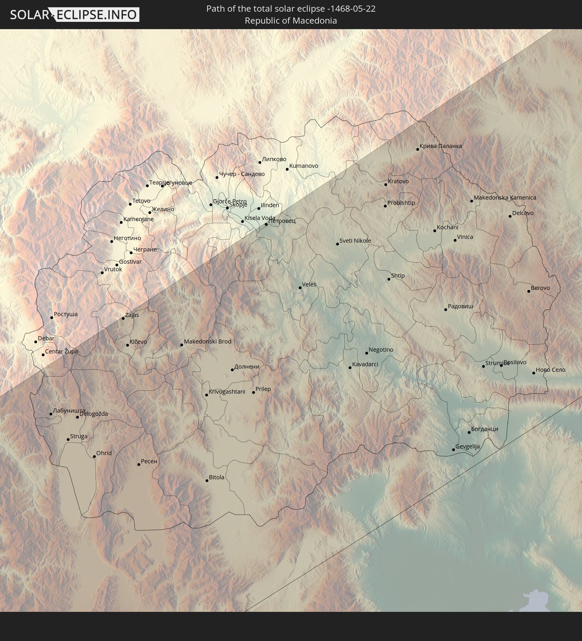 Mazedonien
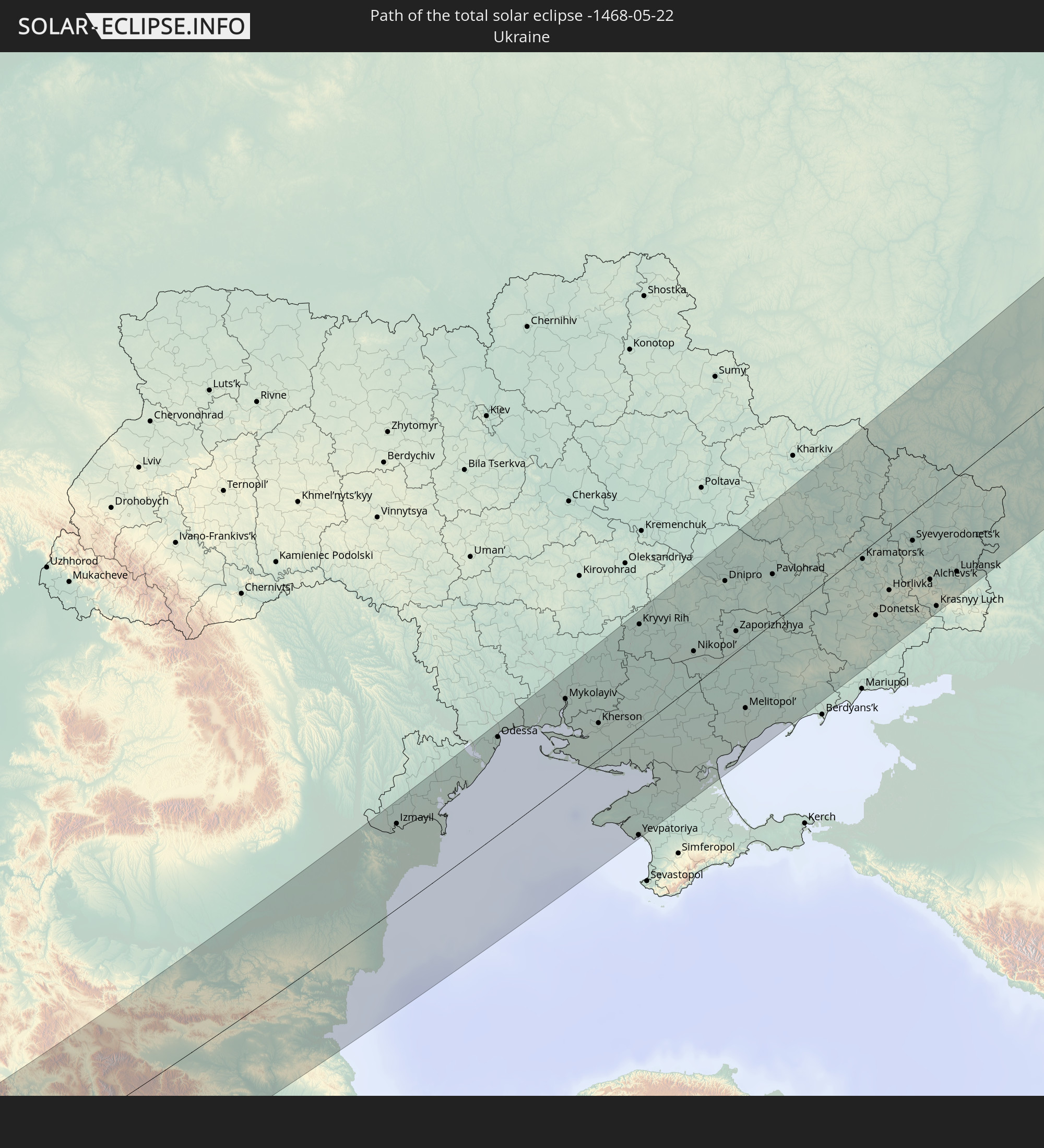 Ukraine
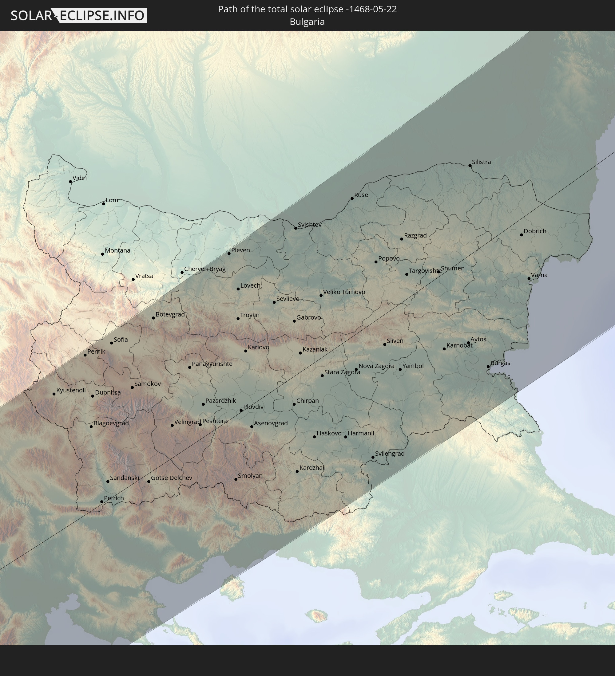 Bulgarien
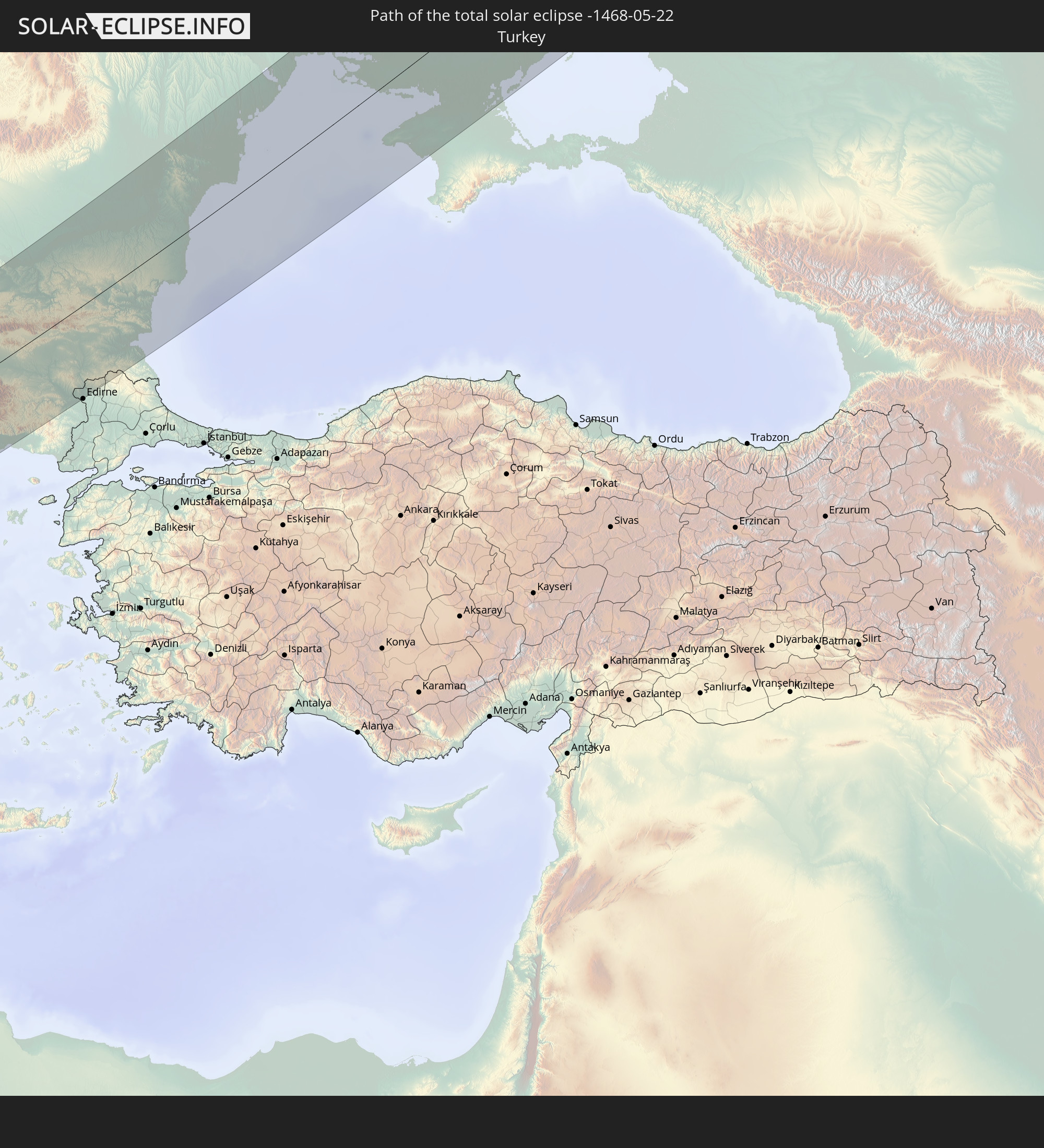 Türkei
In den folgenden Ländern ist die Sonnenfinsternis partiell zu sehen
 Russland
 Vereinigte Staaten
 Kanada
 Grönland
 Island
 Spanien
 Irland
 Spitzbergen
 Algerien
 Vereinigtes Königreich
 Färöer
 Frankreich
 Isle of Man
 Guernsey
 Jersey
 Niger
Niger
 Andorra
 Belgien
 Niederlande
 Norwegen
 Luxemburg
 Deutschland
 Schweiz
 Italien
 Monaco
 Tunesien
 Dänemark
 Libyen
 Liechtenstein
 Österreich
 Schweden
 Tschechien
 Demokratische Republik Kongo
 San Marino
 Vatikanstadt
 Slowenien
 Tschad
 Kroatien
 Polen
Polen
 Malta
Malta
 Zentralafrikanische Republik
 Bosnien und Herzegowina
 Ungarn
 Slowakei
 Montenegro
 Serbien
 Albanien
 Åland Islands
 Griechenland
 Rumänien
 Mazedonien
 Finnland
 Litauen
 Lettland
 Estland
 Sudan
Sudan
 Ukraine
 Bulgarien
 Weißrussland
 Ägypten
 Türkei
 Moldawien
 Uganda
 Republik Zypern
 Äthiopien
 Kenia
Kenia
 Staat Palästina
 Israel
 Saudi-Arabien
 Jordanien
 Libanon
 Syrien
 Eritrea
 Irak
Irak
 Georgien
 Somalia
 Dschibuti
 Jemen
Jemen
 Armenien
 Iran
Iran
 Aserbaidschan
 Kasachstan
 Kuwait
 Bahrain
 Katar
Katar
 Vereinigte Arabische Emirate
 Oman
Oman
 Turkmenistan
 Usbekistan
 Afghanistan
 Pakistan
 Tadschikistan
 Indien
 Kirgisistan
 Volksrepublik China
 Nepal
Nepal
 Mongolei
 Japan
Japan
 Nordkorea
 Südkorea
Wie wird das Wetter während der totalen Sonnenfinsternis am 22.05.-1468?
Wo ist der beste Ort, um die totale Sonnenfinsternis vom 22.05.-1468 zu beobachten?
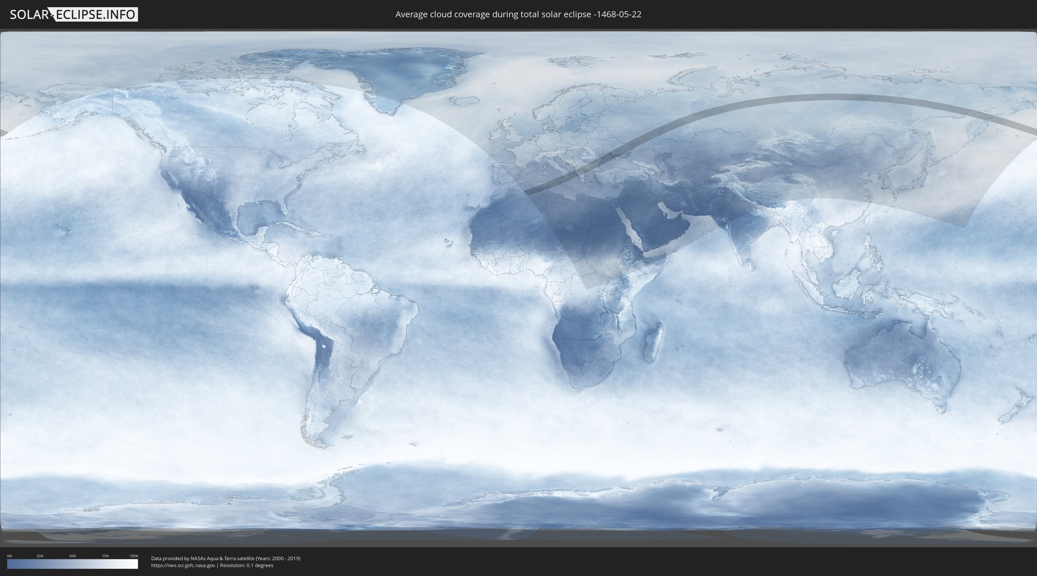
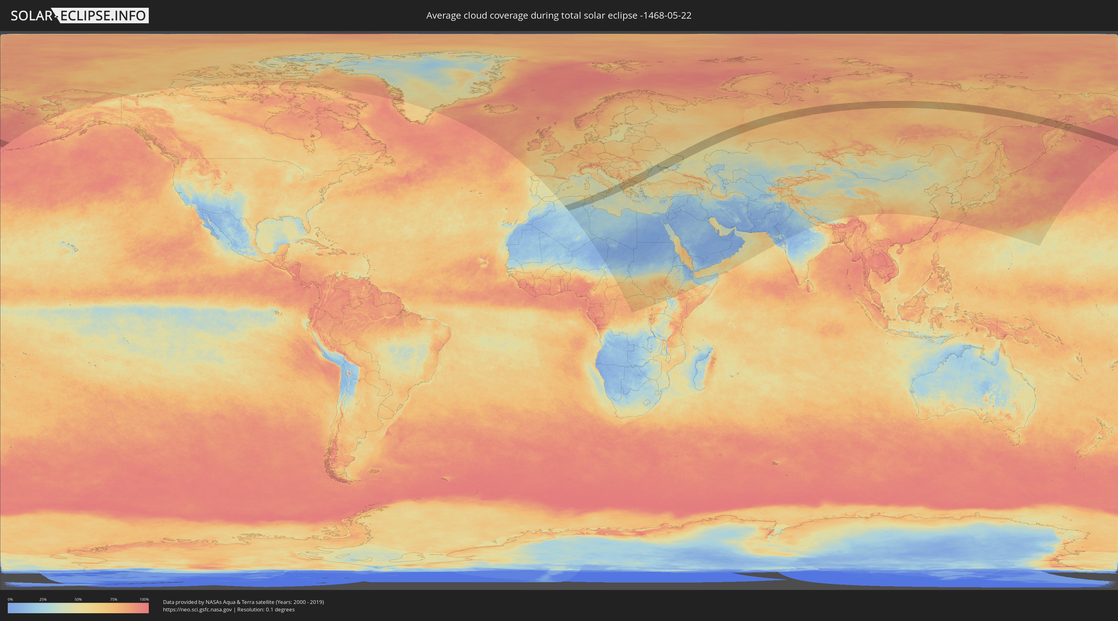
Die folgenden Karten zeigen die durchschnittliche Bewölkung für den Tag, an dem die totale Sonnenfinsternis
stattfindet. Mit Hilfe der Karten lässt sich der Ort entlang des Finsternispfades eingrenzen,
der die besten Aussichen auf einen klaren wolkenfreien Himmel bietet.
Trotzdem muss man immer lokale Gegenenheiten beachten und sollte sich genau über das Wetter an seinem
gewählten Beobachtungsort informieren.
Die Daten stammen von den beiden NASA-Satelliten
AQUA und TERRA
und wurden über einen Zeitraum von 19 Jahren (2000 - 2019) gemittelt.
Detaillierte Länderkarten
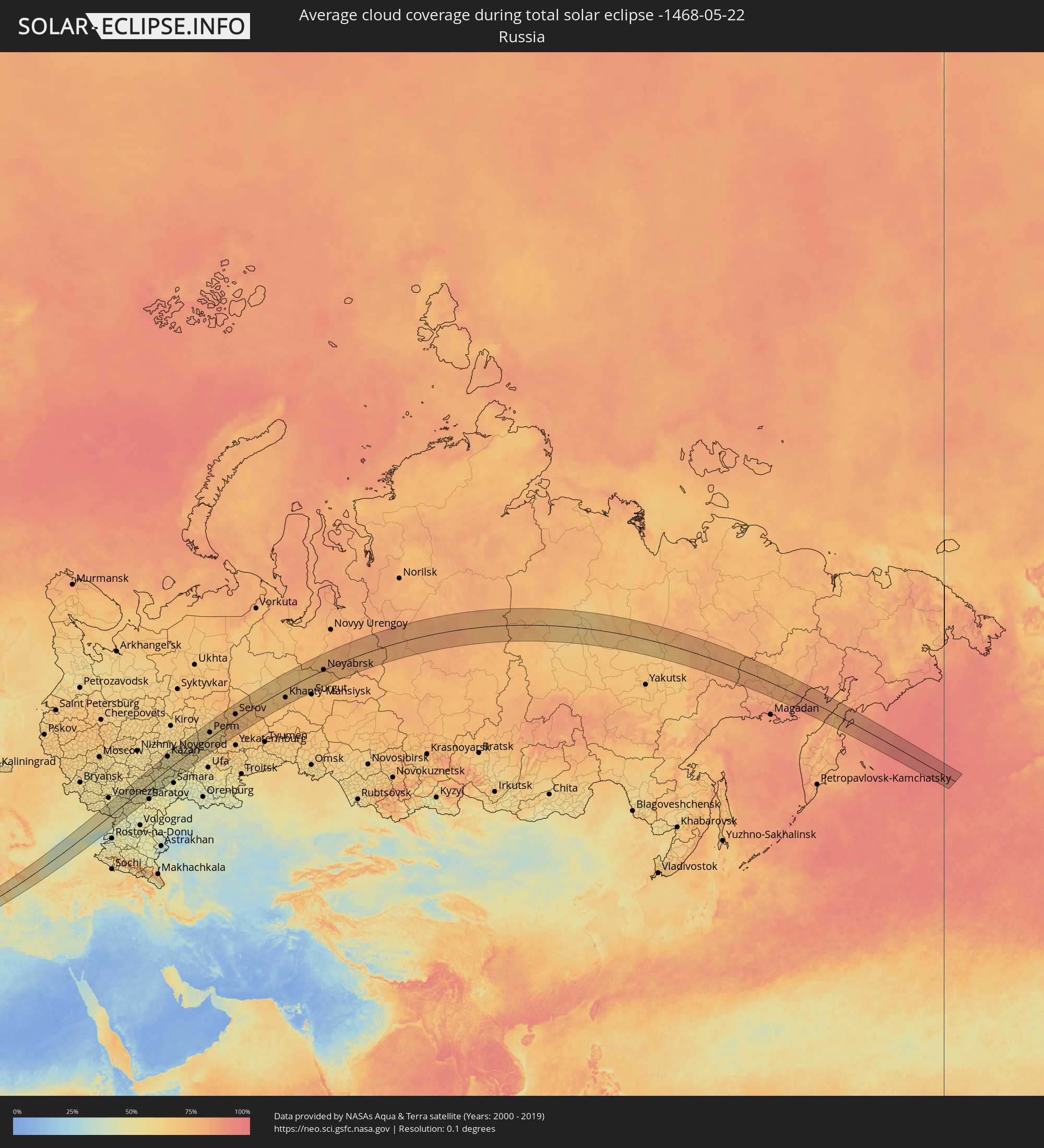 Russland
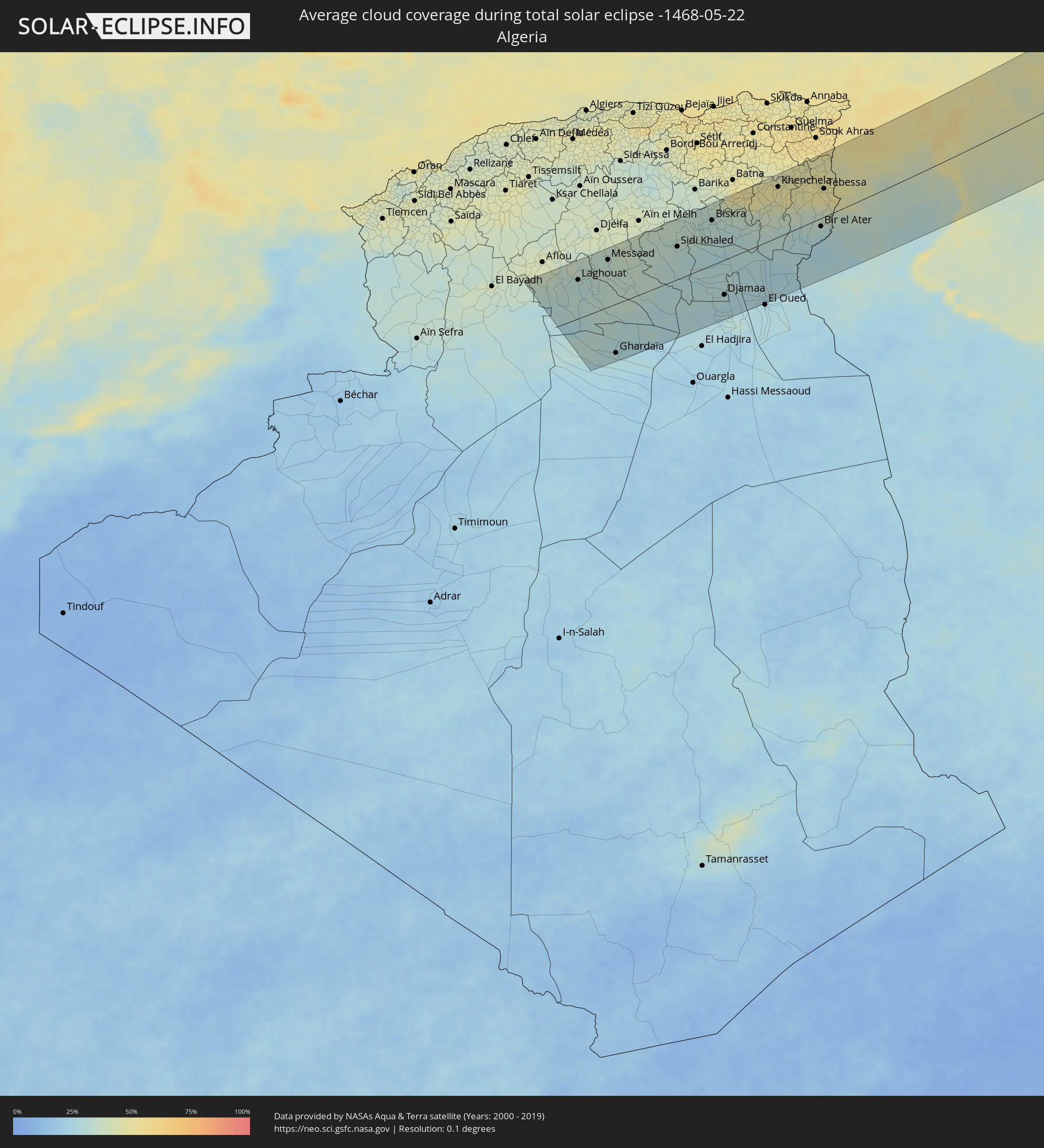 Algerien
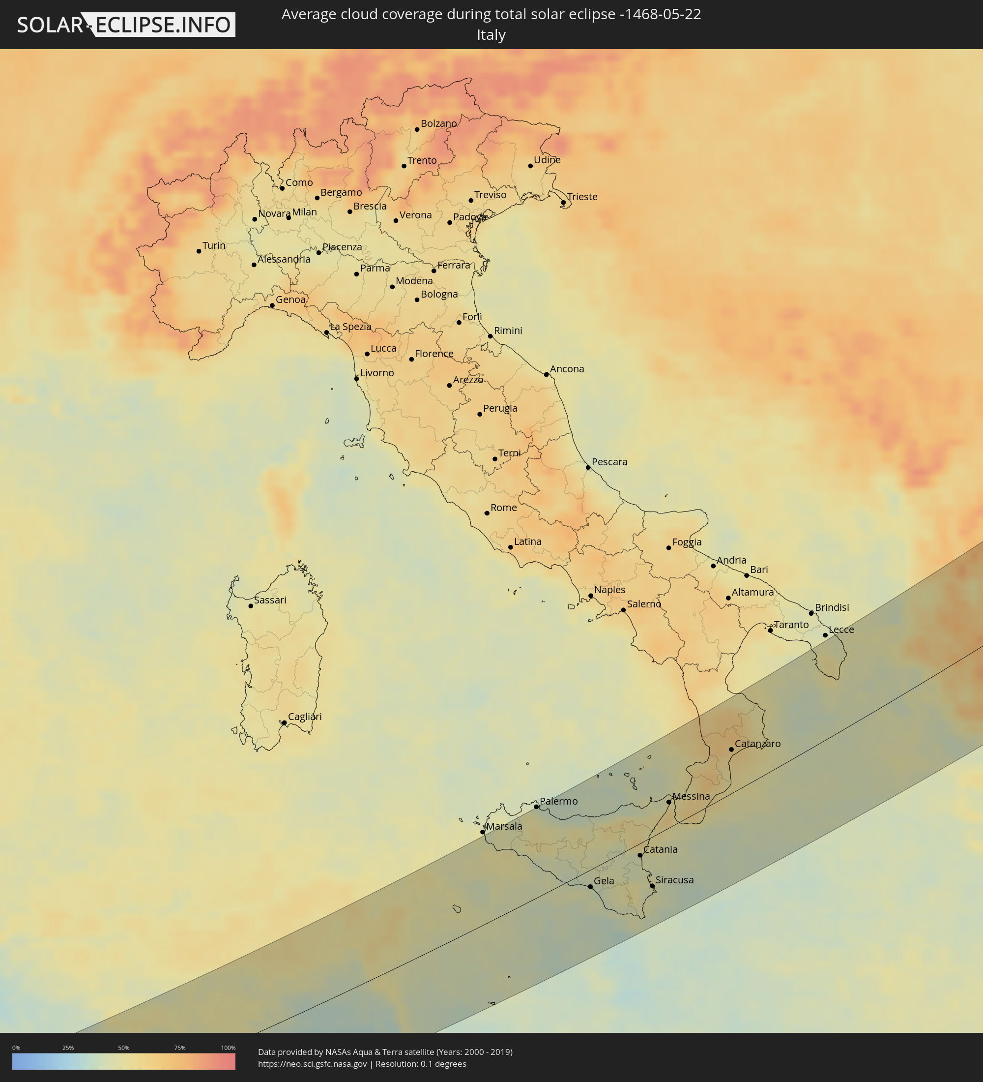 Italien
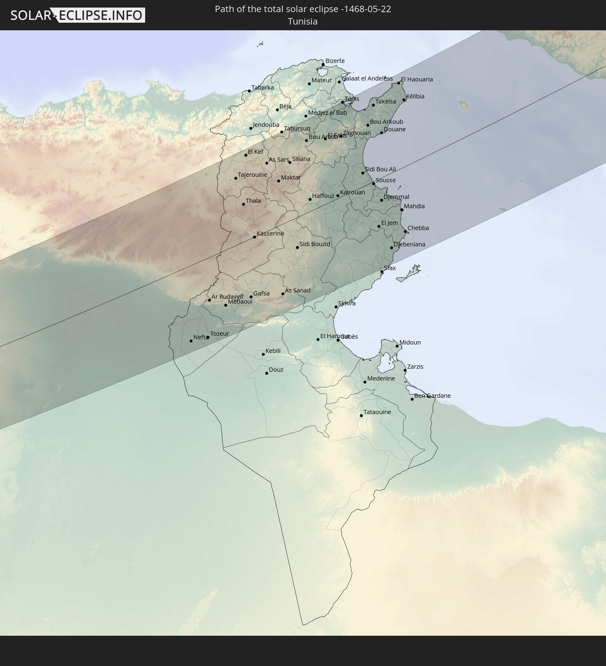
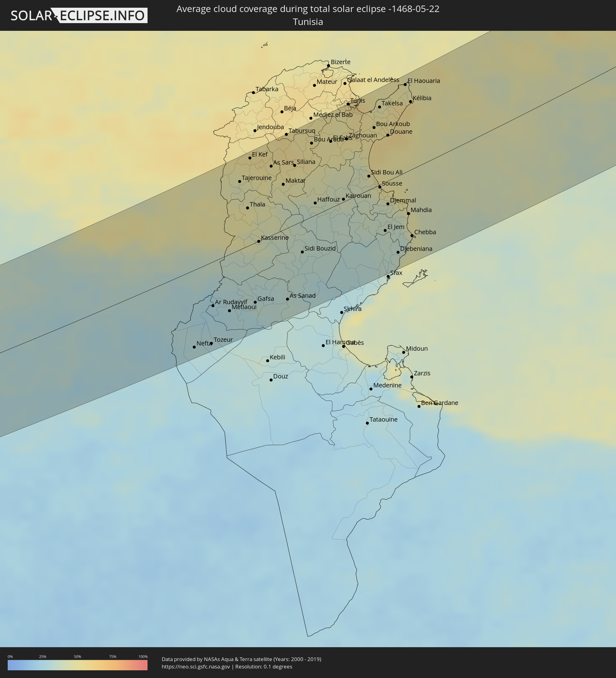 Tunesien
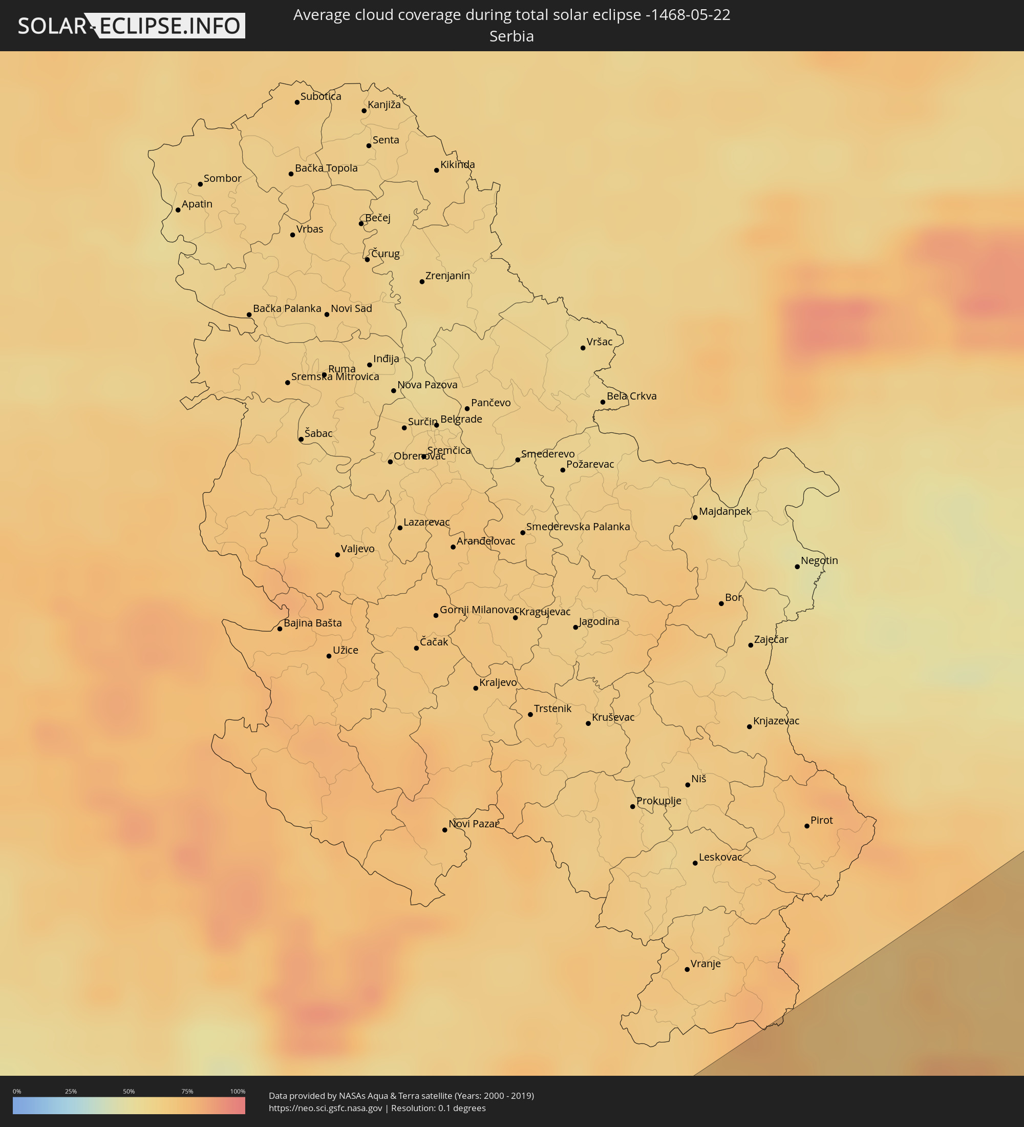 Serbien
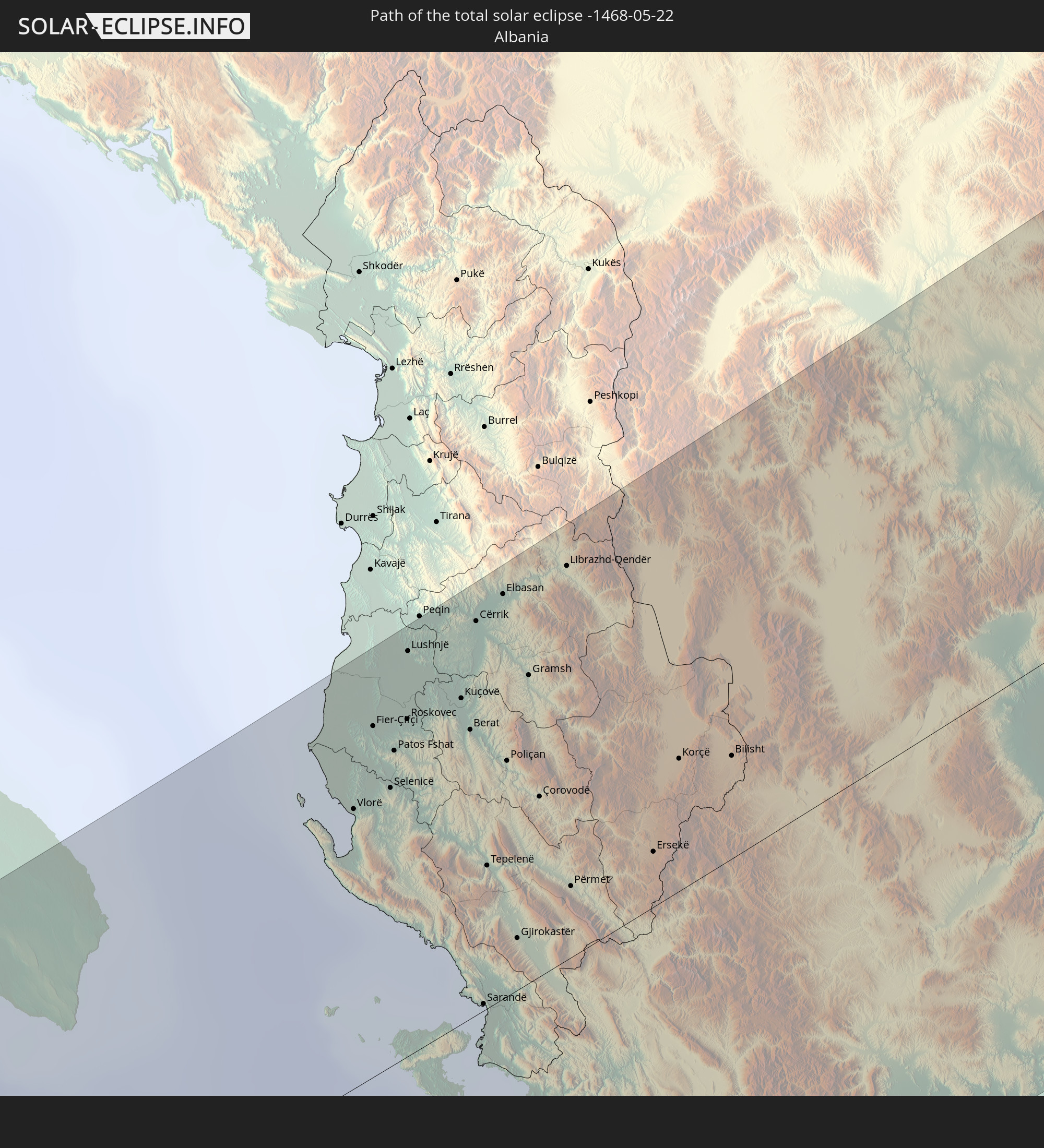
 Albanien
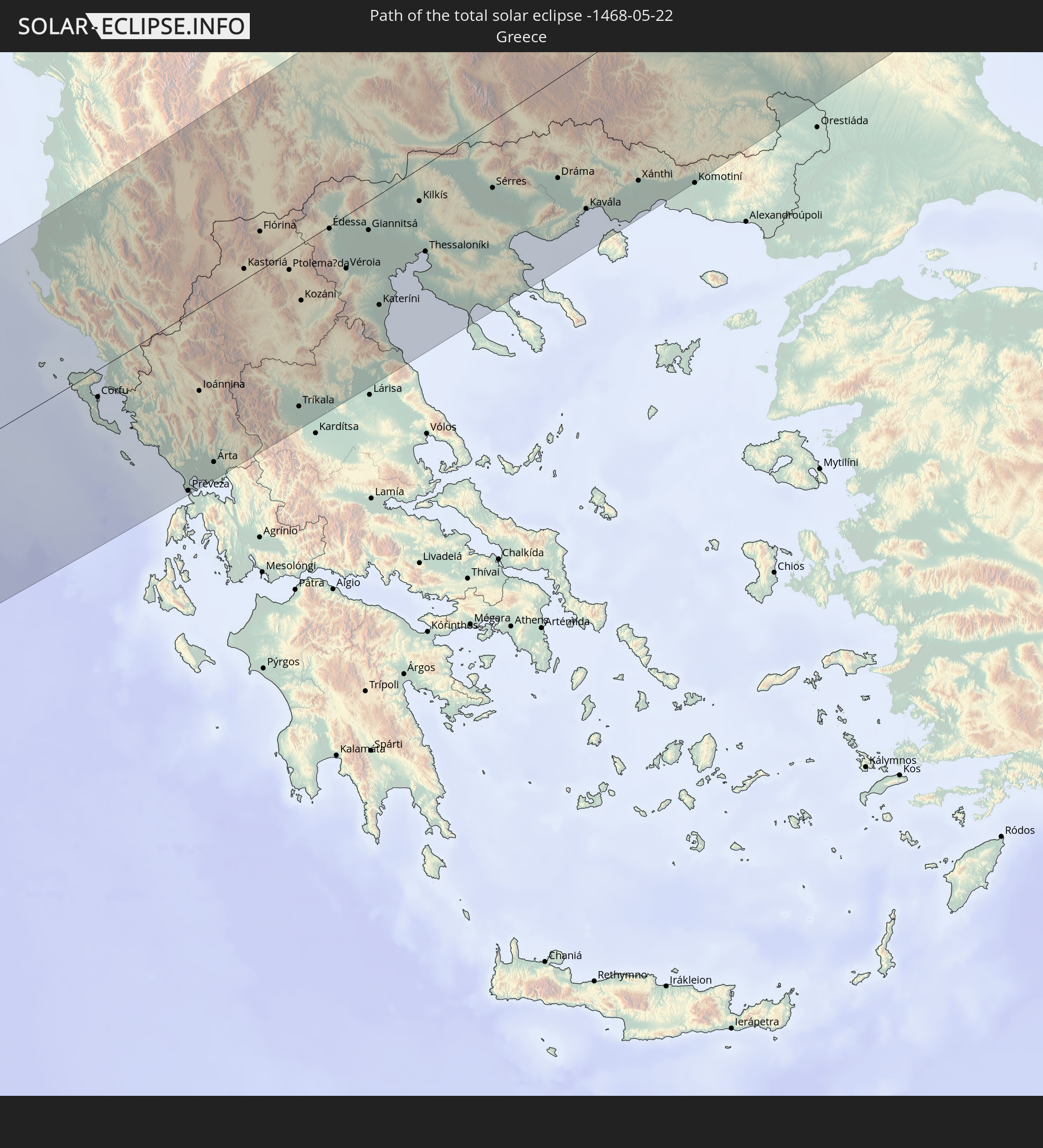
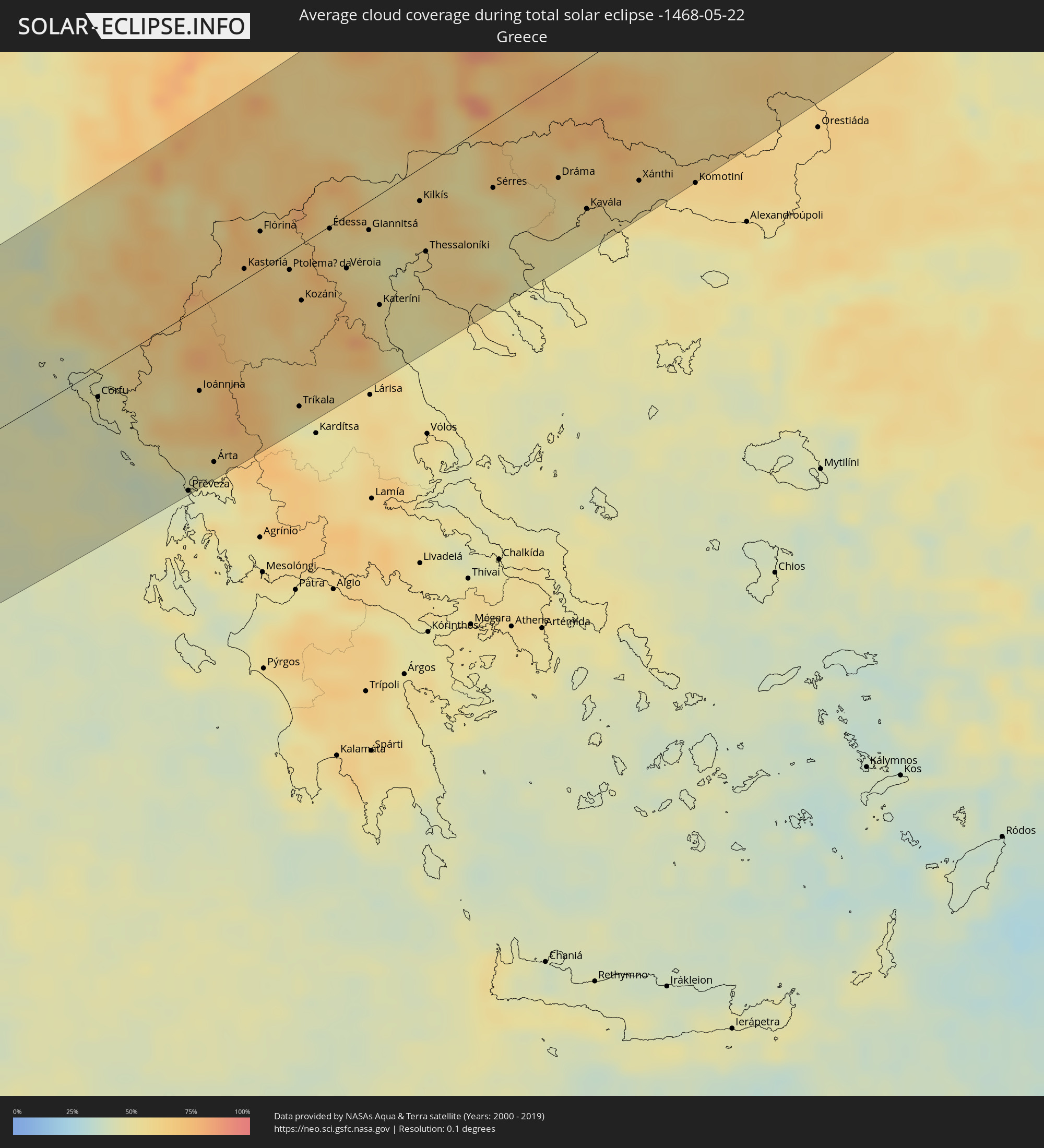 Griechenland
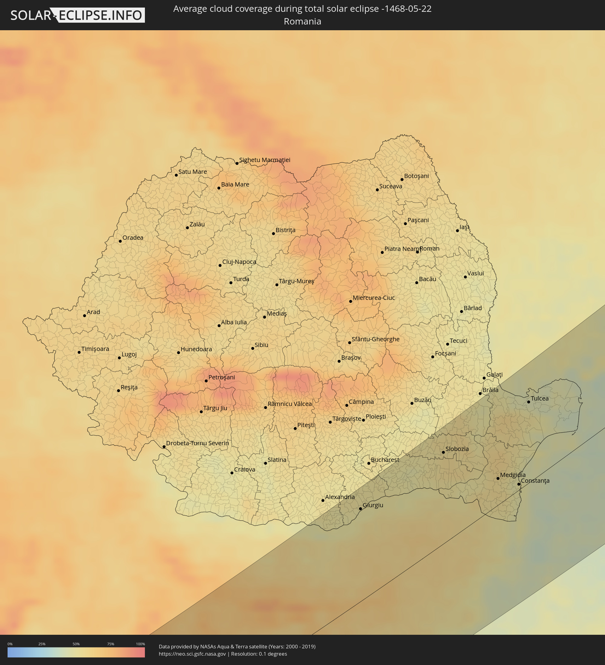 Rumänien
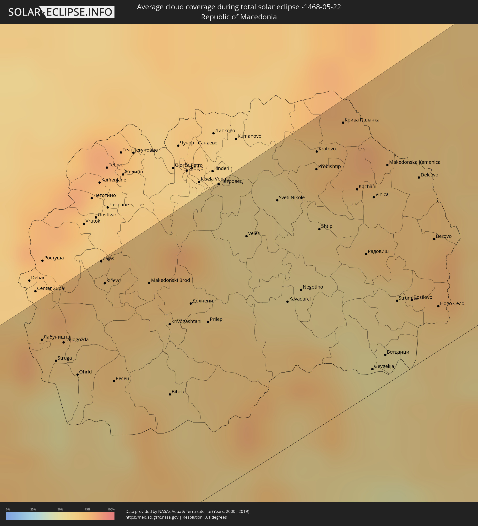 Mazedonien
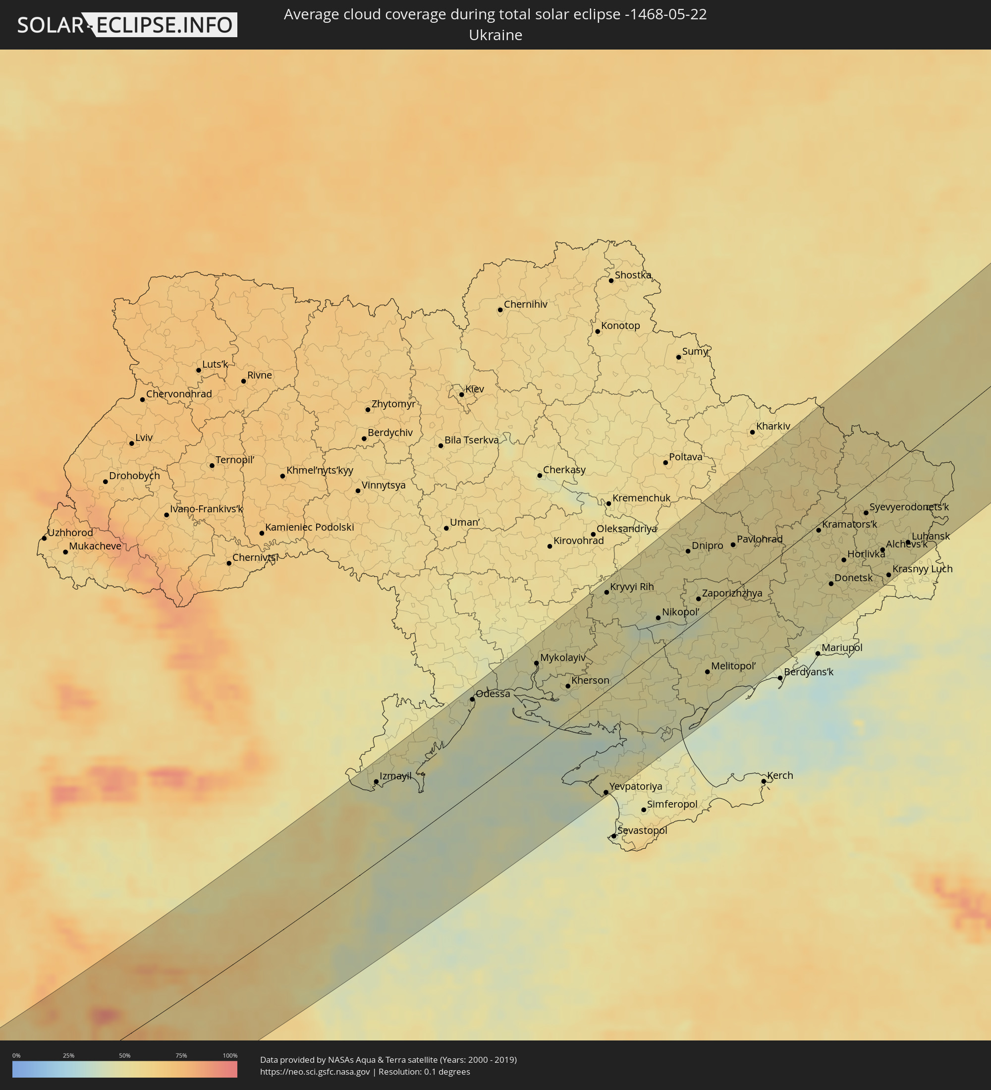 Ukraine
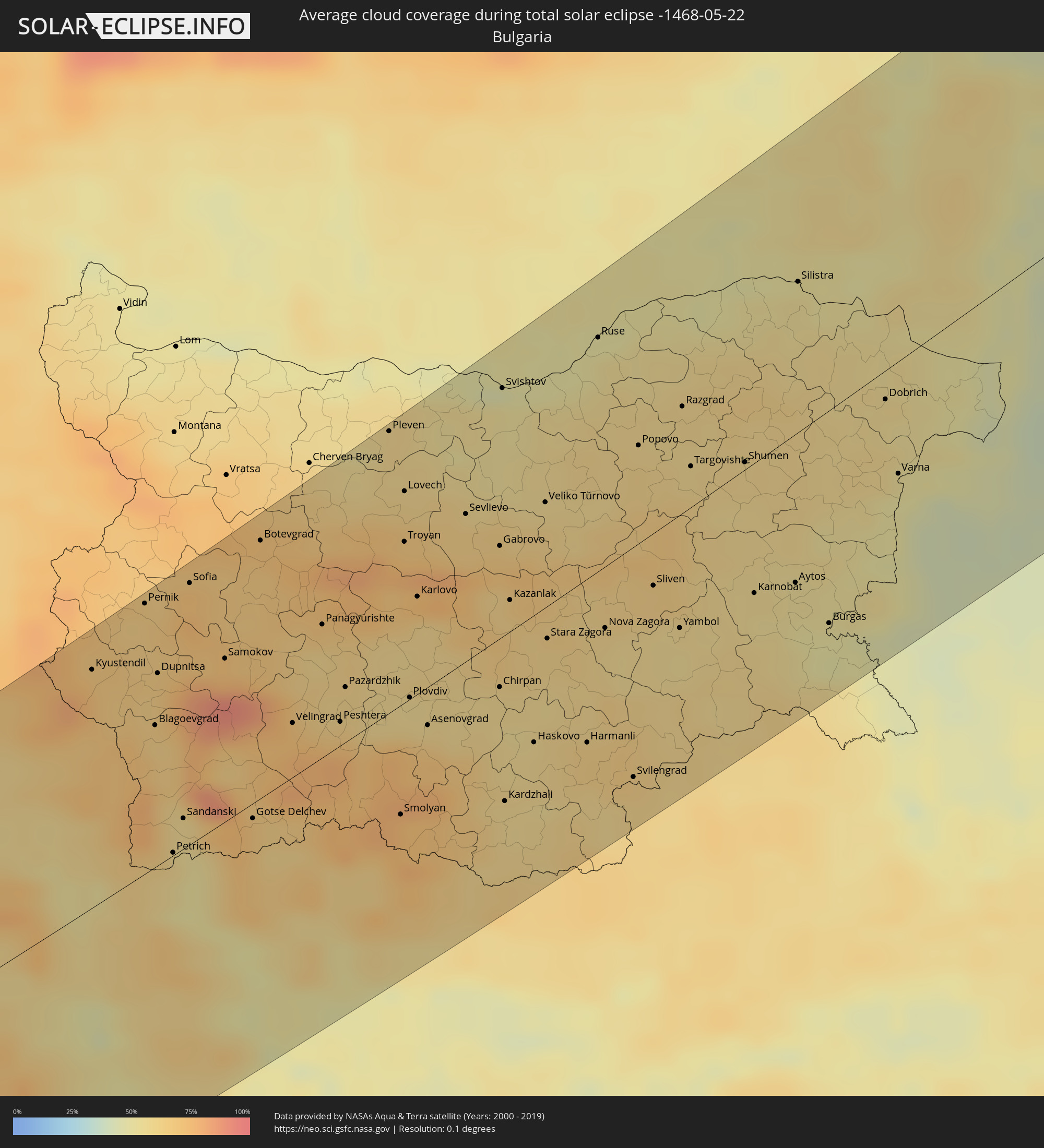 Bulgarien
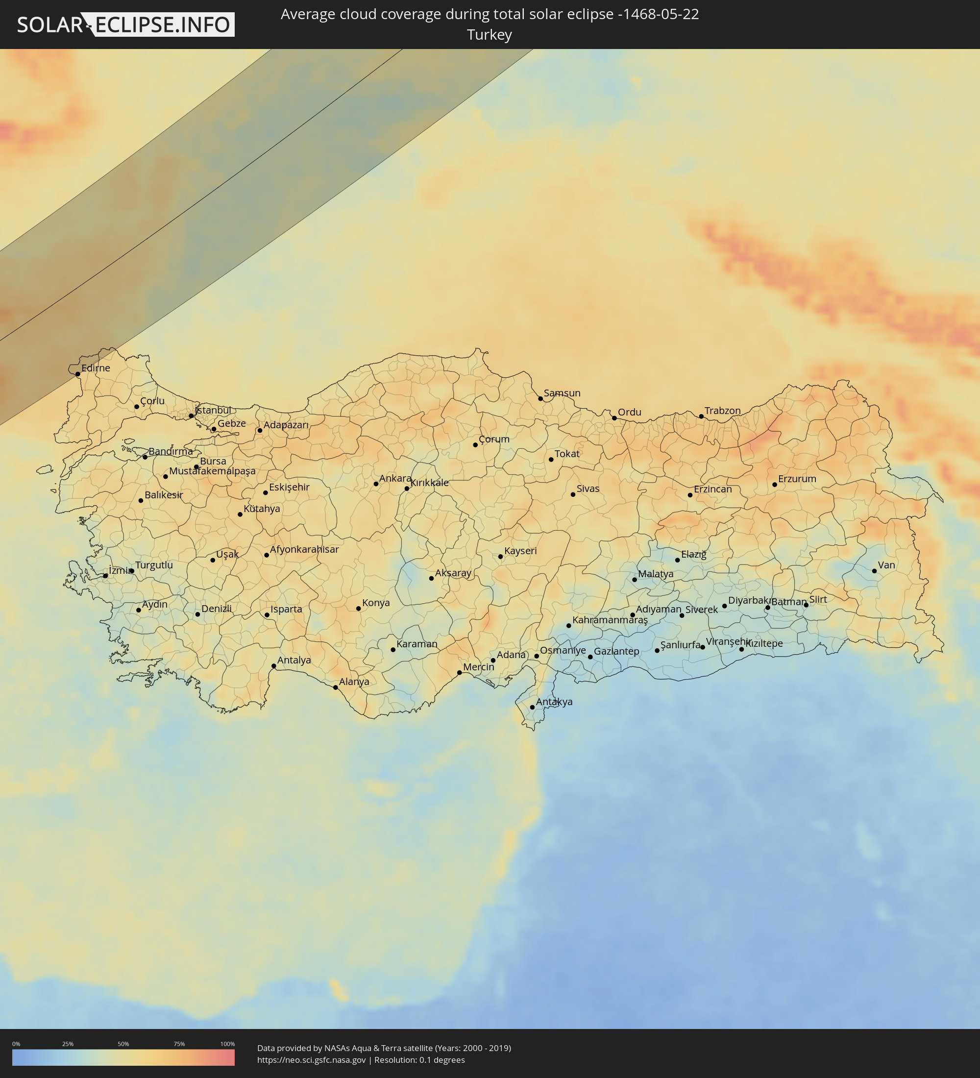 Türkei
Orte im Finsternispfad
Die nachfolgene Tabelle zeigt Städte und Orte mit mehr als 5.000 Einwohnern, die sich im Finsternispfad befinden. Städte mit mehr als 100.000 Einwohnern sind dick gekennzeichnet. Mit einem Klick auf den Ort öffnet sich eine Detailkarte die die Lage des jeweiligen Ortes zusammen mit dem Verlauf der zentralen Finsternis präsentiert.
| Ort | Typ | Dauer der Verfinsterung | Ortszeit bei maximaler Verfinsterung | Entfernung zur Zentrallinie | Ø Bewölkung |
|
Laghouat, Laghouat
|
total | - | 05:04:55 UTC+00:09 | 73 km | 31% |
|
Messaad, Djelfa
|
total | - | 05:05:08 UTC+00:09 | 88 km | 33% |
|
Ghardaïa, Ghardaia
|
total | - | 05:03:02 UTC+00:09 | 91 km | 27% |
|
Berriane, Ghardaia
|
total | - | 05:03:24 UTC+00:09 | 60 km | 27% |
|
Sidi Khaled, Biskra
|
total | - | 05:04:56 UTC+00:09 | 64 km | 31% |
|
Tolga, Biskra
|
total | - | 05:05:14 UTC+00:09 | 83 km | 34% |
|
Biskra, Biskra
|
total | - | 05:05:18 UTC+00:09 | 81 km | 31% |
|
Sidi Okba, Biskra
|
total | - | 05:05:07 UTC+00:09 | 66 km | 32% |
|
Djamaa, Ouargla
|
total | - | 05:03:32 UTC+00:09 | 68 km | 27% |
|
Sidi Amrane, Ouargla
|
total | - | 05:03:29 UTC+00:09 | 72 km | 27% |
|
Megarine, Ouargla
|
total | - | 05:03:05 UTC+00:09 | 103 km | 30% |
|
Arris, Batna
|
total | - | 05:05:39 UTC+00:09 | 103 km | 47% |
|
Reguiba, El Oued
|
total | - | 05:03:22 UTC+00:09 | 87 km | 27% |
|
Debila, El Oued
|
total | - | 05:03:14 UTC+00:09 | 100 km | 25% |
|
Khenchela, Khenchela
|
total | - | 05:05:39 UTC+00:09 | 90 km | 50% |
|
Meskiana, Oum el Bouaghi
|
total | - | 05:05:47 UTC+00:09 | 90 km | 49% |
|
Cheria, Tébessa
|
total | - | 05:05:17 UTC+00:09 | 50 km | 47% |
|
El Aouinet, Oum el Bouaghi
|
total | - | 05:06:02 UTC+00:09 | 106 km | 45% |
|
Bir el Ater, Tébessa
|
total | - | 05:04:31 UTC+00:09 | 15 km | 29% |
|
Tébessa, Tébessa
|
total | - | 05:05:22 UTC+00:09 | 50 km | 50% |
|
Tozeur, Tawzar
|
total | - | 05:03:25 UTC+00:09 | 103 km | 28% |
|
Ar Rudayyif, Gafsa
|
total | - | 05:04:01 UTC+00:09 | 55 km | 26% |
|
Metlaoui, Gafsa
|
total | - | 05:03:52 UTC+00:09 | 71 km | 27% |
|
El Kef, Kef
|
total | - | 05:06:16 UTC+00:09 | 108 km | 51% |
|
Gafsa, Gafsa
|
total | - | 05:03:54 UTC+00:09 | 74 km | 31% |
|
Kasserine, Al Qaşrayn
|
total | - | 05:04:53 UTC+00:09 | 17 km | 43% |
|
Siliana, Silyānah
|
total | - | 05:05:59 UTC+00:09 | 75 km | 50% |
|
Sidi Bouzid, Sīdī Bū Zayd
|
total | - | 05:04:33 UTC+00:09 | 43 km | 32% |
|
Kairouan, Al Qayrawān
|
total | - | 05:05:17 UTC+00:09 | 11 km | 39% |
|
La Mohammedia, Tūnis
|
total | - | 05:06:38 UTC+00:09 | 102 km | 53% |
|
Tunis, Tūnis
|
total | - | 05:06:50 UTC+00:09 | 117 km | 53% |
|
Al Marsá, Tūnis
|
total | - | 05:06:53 UTC+00:09 | 115 km | 58% |
|
Hammam-Lif, Tūnis
|
total | - | 05:06:41 UTC+00:09 | 100 km | 53% |
|
Sousse, Sūsah
|
total | - | 05:05:23 UTC+00:09 | 13 km | 41% |
|
Douane, Nābul
|
total | - | 05:06:13 UTC+00:09 | 55 km | 54% |
|
Djemmal, Al Munastīr
|
total | - | 05:05:05 UTC+00:09 | 31 km | 39% |
|
Monastir, Al Munastīr
|
total | - | 05:05:17 UTC+00:09 | 29 km | 45% |
|
Korba, Nābul
|
total | - | 05:06:22 UTC+00:09 | 66 km | 57% |
|
Mahdia, Al Mahdīyah
|
total | - | 05:04:52 UTC+00:09 | 55 km | 48% |
|
Kélibia, Nābul
|
total | - | 05:06:42 UTC+00:09 | 81 km | 54% |
|
Mazara del Vallo, Sicily
|
total | - | 05:58:16 UTC+01:00 | 101 km | 47% |
|
Alcamo, Sicily
|
total | - | 05:58:41 UTC+01:00 | 119 km | 43% |
|
Sciacca, Sicily
|
total | - | 05:58:00 UTC+01:00 | 67 km | 48% |
|
Palermo, Sicily
|
total | - | 05:58:52 UTC+01:00 | 118 km | 48% |
|
Bagheria, Sicily
|
total | - | 05:58:46 UTC+01:00 | 106 km | 42% |
|
Licata, Sicily
|
total | - | 05:57:19 UTC+01:00 | 13 km | 45% |
|
Caltanissetta, Sicily
|
total | - | 05:57:52 UTC+01:00 | 32 km | 46% |
|
Gela, Sicily
|
total | - | 05:57:15 UTC+01:00 | 26 km | 43% |
|
Caltagirone, Sicily
|
total | - | 05:57:27 UTC+01:00 | 20 km | 43% |
|
Vittoria, Sicily
|
total | - | 05:57:02 UTC+01:00 | 52 km | 40% |
|
Ragusa, Sicily
|
total | - | 05:56:59 UTC+01:00 | 58 km | 42% |
|
Paternò, Sicily
|
total | - | 05:57:54 UTC+01:00 | 2 km | 43% |
|
Catania, Sicily
|
total | - | 05:57:46 UTC+01:00 | 16 km | 45% |
|
Acireale, Sicily
|
total | - | 05:57:56 UTC+01:00 | 9 km | 46% |
|
Siracusa, Sicily
|
total | - | 05:57:10 UTC+01:00 | 65 km | 45% |
|
Messina, Sicily
|
total | - | 05:58:46 UTC+01:00 | 32 km | 60% |
|
Cosenza, Calabria
|
total | - | 06:00:23 UTC+01:00 | 110 km | 60% |
|
Lamezia Terme, Calabria
|
total | - | 05:59:52 UTC+01:00 | 75 km | 63% |
|
Catanzaro, Calabria
|
total | - | 05:59:45 UTC+01:00 | 55 km | 57% |
|
Crotone, Calabria
|
total | - | 06:00:02 UTC+01:00 | 52 km | 51% |
|
Vlorë, Vlorë
|
total | - | 06:21:32 UTC+01:19 | 81 km | 46% |
|
Fier, Fier
|
total | - | 06:21:57 UTC+01:19 | 102 km | 48% |
|
Fier-Çifçi, Fier
|
total | - | 06:21:56 UTC+01:19 | 101 km | 48% |
|
Patos Fshat, Fier
|
total | - | 06:21:49 UTC+01:19 | 90 km | 54% |
|
Lushnjë, Fier
|
total | - | 06:22:18 UTC+01:19 | 117 km | 52% |
|
Ballsh, Fier
|
total | - | 06:21:45 UTC+01:19 | 83 km | 54% |
|
Kuçovë, Berat
|
total | - | 06:22:05 UTC+01:19 | 94 km | 54% |
|
Corfu, Ionian Islands
|
total | - | 06:35:46 UTC+01:34 | 19 km | 44% |
|
Berat, Berat
|
total | - | 06:21:56 UTC+01:19 | 83 km | 57% |
|
Cërrik, Elbasan
|
total | - | 06:22:27 UTC+01:19 | 114 km | 51% |
|
Sarandë, Vlorë
|
total | - | 06:20:38 UTC+01:19 | 2 km | 48% |
|
Tepelenë, Gjirokastër
|
total | - | 06:21:18 UTC+01:19 | 47 km | 61% |
|
Elbasan, Elbasan
|
total | - | 06:22:35 UTC+01:19 | 117 km | 55% |
|
Poliçan, Berat
|
total | - | 06:21:48 UTC+01:19 | 68 km | 61% |
|
Gjirokastër, Gjirokastër
|
total | - | 06:20:58 UTC+01:19 | 15 km | 63% |
|
Gramsh, Elbasan
|
total | - | 06:22:13 UTC+01:19 | 91 km | 60% |
|
Çorovodë, Berat
|
total | - | 06:21:38 UTC+01:19 | 52 km | 60% |
|
Librazhd-Qendër, Elbasan
|
total | - | 06:22:44 UTC+01:19 | 112 km | 61% |
|
Përmet, Gjirokastër
|
total | - | 06:21:13 UTC+01:19 | 21 km | 72% |
|
Лабуништа
|
total | - | 06:03:33 UTC+01:00 | 110 km | 69% |
|
Ersekë, Korçë
|
total | - | 06:21:24 UTC+01:19 | 27 km | 74% |
|
Préveza, Epirus
|
total | - | 06:34:47 UTC+01:34 | 119 km | 43% |
|
Korçë, Korçë
|
total | - | 06:21:52 UTC+01:19 | 38 km | 66% |
|
Ohrid, Ohrid
|
total | - | 06:03:19 UTC+01:00 | 86 km | 55% |
|
Ioánnina, Epirus
|
total | - | 06:35:54 UTC+01:34 | 56 km | 62% |
|
Kičevo, Kičevo
|
total | - | 06:03:58 UTC+01:00 | 116 km | 68% |
|
Árta, Epirus
|
total | - | 06:35:07 UTC+01:34 | 111 km | 51% |
|
Ресен, Resen Municipality
|
total | - | 06:03:18 UTC+01:00 | 72 km | 63% |
|
Bitola, Bitola
|
total | - | 06:03:14 UTC+01:00 | 54 km | 69% |
|
Flórina, West Macedonia
|
total | - | 06:37:43 UTC+01:34 | 26 km | 69% |
|
Prilep, Prilep
|
total | - | 06:03:45 UTC+01:00 | 71 km | 68% |
|
Петровец, Petrovec
|
total | - | 06:04:43 UTC+01:00 | 125 km | 60% |
|
Ptolemaḯda, West Macedonia
|
total | - | 06:37:19 UTC+01:34 | 16 km | 65% |
|
Tríkala, Thessaly
|
total | - | 06:35:48 UTC+01:34 | 108 km | 52% |
|
Veles, Veles
|
total | - | 06:04:23 UTC+01:00 | 97 km | 58% |
|
Kozáni, West Macedonia
|
total | - | 06:36:59 UTC+01:34 | 38 km | 63% |
|
Sveti Nikole, Sveti Nikole Municipality
|
total | - | 06:04:39 UTC+01:00 | 103 km | 58% |
|
Kavadarci, Kavadarci
|
total | - | 06:03:57 UTC+01:00 | 60 km | 62% |
|
Édessa, Central Macedonia
|
total | - | 06:37:49 UTC+01:34 | 4 km | 61% |
|
Náousa, Central Macedonia
|
total | - | 06:37:32 UTC+01:34 | 20 km | 66% |
|
Probishtip, Probištip
|
total | - | 06:04:54 UTC+01:00 | 106 km | 66% |
|
Shtip, Štip
|
total | - | 06:04:29 UTC+01:00 | 83 km | 59% |
|
Véroia, Central Macedonia
|
total | - | 06:37:23 UTC+01:34 | 35 km | 62% |
|
Крива Паланка, Kriva Palanka
|
total | - | 06:05:14 UTC+01:00 | 117 km | 73% |
|
Giannitsá, Central Macedonia
|
total | - | 06:37:50 UTC+01:34 | 28 km | 55% |
|
Kochani, Kočani
|
total | - | 06:04:47 UTC+01:00 | 86 km | 64% |
|
Радовиш, Radoviš
|
total | - | 06:04:20 UTC+01:00 | 60 km | 59% |
|
Gevgelija, Gevgelija
|
total | - | 06:03:33 UTC+01:00 | 12 km | 56% |
|
Kateríni, Central Macedonia
|
total | - | 06:37:01 UTC+01:34 | 73 km | 57% |
|
Strumica, Strumica
|
total | - | 06:04:02 UTC+01:00 | 35 km | 58% |
|
Delcevo, Delčevo
|
total | - | 06:04:55 UTC+01:00 | 78 km | 71% |
|
Berovo, Berovo
|
total | - | 06:04:30 UTC+01:00 | 49 km | 76% |
|
Kilkís, Central Macedonia
|
total | - | 06:38:13 UTC+01:34 | 32 km | 63% |
|
Ново Село, Novo Selo
|
total | - | 06:04:02 UTC+01:00 | 18 km | 64% |
|
Peraía, Central Macedonia
|
total | - | 06:37:26 UTC+01:34 | 70 km | 55% |
|
Thessaloníki, Central Macedonia
|
total | - | 06:37:40 UTC+01:34 | 57 km | 53% |
|
Pernik, Pernik
|
total | - | 07:05:59 UTC+02:00 | 122 km | 65% |
|
Blagoevgrad, Blagoevgrad
|
total | - | 07:05:03 UTC+02:00 | 64 km | 62% |
|
Sofia, Sofia-Capital
|
total | - | 07:06:12 UTC+02:00 | 117 km | 71% |
|
Sérres, Central Macedonia
|
total | - | 06:38:28 UTC+01:34 | 49 km | 52% |
|
Dráma, East Macedonia and Thrace
|
total | - | 06:38:40 UTC+01:34 | 68 km | 60% |
|
Pazardzhik, Pazardzhik
|
total | - | 07:05:33 UTC+02:00 | 25 km | 61% |
|
Kavála, East Macedonia and Thrace
|
total | - | 06:38:22 UTC+01:34 | 99 km | 54% |
|
Pleven, Pleven
|
total | - | 07:07:37 UTC+02:00 | 123 km | 60% |
|
Plovdiv, Plovdiv
|
total | - | 07:05:33 UTC+02:00 | 24 km | 57% |
|
Asenovgrad, Plovdiv
|
total | - | 07:05:21 UTC+02:00 | 30 km | 63% |
|
Xánthi, East Macedonia and Thrace
|
total | - | 06:38:46 UTC+01:34 | 102 km | 61% |
|
Gabrovo, Gabrovo
|
total | - | 07:06:52 UTC+02:00 | 42 km | 67% |
|
Kardzhali, Kŭrdzhali
|
total | - | 07:04:51 UTC+02:00 | 75 km | 58% |
|
Zimnicea, Teleorman
|
total | - | 06:52:36 UTC+01:44 | 112 km | 48% |
|
Kazanlak, Stara Zagora
|
total | - | 07:06:27 UTC+02:00 | 14 km | 63% |
|
Haskovo, Khaskovo
|
total | - | 07:05:21 UTC+02:00 | 59 km | 59% |
|
Veliko Tŭrnovo, Veliko Tŭrnovo
|
total | - | 07:07:16 UTC+02:00 | 46 km | 58% |
|
Stara Zagora, Stara Zagora
|
total | - | 07:06:12 UTC+02:00 | 15 km | 61% |
|
Giurgiu, Giurgiu
|
total | - | 06:53:06 UTC+01:44 | 105 km | 49% |
|
Ruse, Ruse
|
total | - | 07:08:39 UTC+02:00 | 102 km | 49% |
|
Sliven, Sliven
|
total | - | 07:06:46 UTC+02:00 | 28 km | 63% |
|
Budeşti, Călăraşi
|
total | - | 06:53:49 UTC+01:44 | 114 km | 51% |
|
Yambol, Yambol
|
total | - | 07:06:28 UTC+02:00 | 52 km | 58% |
|
Olteniţa, Călăraşi
|
total | - | 06:53:36 UTC+01:44 | 93 km | 48% |
|
Shumen, Shumen
|
total | - | 07:07:54 UTC+02:00 | 6 km | 59% |
|
Dragalina, Călăraşi
|
total | - | 06:54:22 UTC+01:44 | 90 km | 55% |
|
Slobozia, Ialomiţa
|
total | - | 06:54:37 UTC+01:44 | 100 km | 56% |
|
Modelu, Călăraşi
|
total | - | 06:53:59 UTC+01:44 | 67 km | 51% |
|
Burgas, Burgas
|
total | - | 07:06:45 UTC+02:00 | 94 km | 49% |
|
Ţăndărei, Ialomiţa
|
total | - | 06:54:51 UTC+01:44 | 94 km | 58% |
|
Feteşti, Ialomiţa
|
total | - | 06:54:26 UTC+01:44 | 65 km | 53% |
|
Dobrich, Dobrich
|
total | - | 07:08:39 UTC+02:00 | 27 km | 57% |
|
Varna, Varna
|
total | - | 07:08:05 UTC+02:00 | 49 km | 50% |
|
Hârşova, Constanța
|
total | - | 06:54:59 UTC+01:44 | 84 km | 51% |
|
Cernavodă, Constanța
|
total | - | 06:54:25 UTC+01:44 | 50 km | 52% |
|
Măcin, Tulcea
|
total | - | 06:56:00 UTC+01:44 | 125 km | 49% |
|
Cobadin, Constanța
|
total | - | 06:54:02 UTC+01:44 | 23 km | 54% |
|
Medgidia, Constanța
|
total | - | 06:54:20 UTC+01:44 | 29 km | 54% |
|
Mangalia, Constanța
|
total | - | 06:53:40 UTC+01:44 | 28 km | 48% |
|
Năvodari, Constanța
|
total | - | 06:54:33 UTC+01:44 | 31 km | 48% |
|
Constanţa, Constanța
|
total | - | 06:54:20 UTC+01:44 | 18 km | 48% |
|
Eforie Sud, Constanța
|
total | - | 06:54:04 UTC+01:44 | 12 km | 45% |
|
Babadag, Tulcea
|
total | - | 06:55:35 UTC+01:44 | 67 km | 51% |
|
Tulcea, Tulcea
|
total | - | 06:56:04 UTC+01:44 | 87 km | 47% |
|
Odessa, Odessa
|
total | - | 07:16:41 UTC+02:02 | 113 km | 46% |
|
Mykolayiv, Mykolaiv
|
total | - | 07:18:02 UTC+02:02 | 99 km | 45% |
|
Kherson, Kherson
|
total | - | 07:17:45 UTC+02:02 | 41 km | 45% |
|
Yevpatoriya, Republic of Crimea
|
total | - | 07:29:27 UTC+02:16 | 124 km | 47% |
|
Kryvyi Rih, Dnipropetrovsk
|
total | - | 07:20:18 UTC+02:02 | 114 km | 50% |
|
Nikopol’, Dnipropetrovsk
|
total | - | 07:20:10 UTC+02:02 | 38 km | 40% |
|
Dniprodzerzhyns’k, Dnipropetrovsk
|
total | - | 07:21:56 UTC+02:02 | 110 km | 51% |
|
Dnipro, Dnipropetrovsk
|
total | - | 07:22:00 UTC+02:02 | 87 km | 50% |
|
Zaporizhzhya, Zaporizhia
|
total | - | 07:21:00 UTC+02:02 | 23 km | 46% |
|
Melitopol’, Zaporizhia
|
total | - | 07:19:21 UTC+02:02 | 71 km | 50% |
|
Pavlohrad, Dnipropetrovsk
|
total | - | 07:22:36 UTC+02:02 | 53 km | 53% |
|
Kramators’k, Donetsk
|
total | - | 07:23:51 UTC+02:02 | 8 km | 53% |
|
Sloviansk, Donetsk
|
total | - | 07:24:08 UTC+02:02 | 13 km | 51% |
|
Kostyantynivka, Donetsk
|
total | - | 07:23:35 UTC+02:02 | 32 km | 53% |
|
Donetsk, Donetsk
|
total | - | 07:22:44 UTC+02:02 | 81 km | 52% |
|
Horlivka, Donetsk
|
total | - | 07:23:26 UTC+02:02 | 64 km | 52% |
|
Yenakiyeve, Donetsk
|
total | - | 07:23:20 UTC+02:02 | 80 km | 51% |
|
Syevyerodonets’k, Luhansk
|
total | - | 07:24:47 UTC+02:02 | 37 km | 53% |
|
Alchevs’k, Luhansk
|
total | - | 07:24:07 UTC+02:02 | 88 km | 51% |
|
Luhansk, Luhansk
|
total | - | 07:24:35 UTC+02:02 | 102 km | 53% |
|
Balashov, Saratov
|
total | - | 08:50:40 UTC+03:20 | 14 km | 57% |
|
Penza, Penza
|
total | - | 08:04:49 UTC+02:30 | 51 km | 57% |
|
Saransk, Mordoviya
|
total | - | 08:06:39 UTC+02:30 | 128 km | 58% |
|
Kuznetsk, Penza
|
total | - | 08:05:52 UTC+02:30 | 25 km | 57% |
|
Ulyanovsk, Ulyanovsk
|
total | - | 08:59:23 UTC+03:20 | 9 km | 56% |
|
Syzran’, Samara
|
total | - | 08:57:28 UTC+03:20 | 97 km | 53% |
|
Kazan, Tatarstan
|
total | - | 08:12:22 UTC+02:30 | 108 km | 60% |
|
Tol’yatti, Samara
|
total | - | 08:58:50 UTC+03:20 | 100 km | 52% |
|
Dimitrovgrad, Ulyanovsk
|
total | - | 09:00:12 UTC+03:20 | 52 km | 54% |
|
Nizhnekamsk, Tatarstan
|
total | - | 08:14:21 UTC+02:30 | 20 km | 58% |
|
Al’met’yevsk, Tatarstan
|
total | - | 08:13:36 UTC+02:30 | 95 km | 61% |
|
Naberezhnyye Chelny, Tatarstan
|
total | - | 08:15:00 UTC+02:30 | 28 km | 60% |
|
Izhevsk, Udmurtiya
|
total | - | 09:07:32 UTC+03:20 | 46 km | 63% |
|
Sarapul, Udmurtiya
|
total | - | 09:07:28 UTC+03:20 | 18 km | 61% |
|
Votkinsk, Udmurtiya
|
total | - | 09:08:31 UTC+03:20 | 37 km | 62% |
|
Neftekamsk, Bashkortostan
|
total | - | 09:49:30 UTC+04:02 | 63 km | 59% |
|
Perm, Perm
|
total | - | 09:54:12 UTC+04:02 | 42 km | 65% |
|
Nizhniy Tagil, Sverdlovsk
|
total | - | 09:57:34 UTC+04:02 | 93 km | 76% |
|
Serov, Sverdlovsk
|
total | - | 10:00:25 UTC+04:02 | 43 km | 75% |
|
Noyabrsk, Yamalo-Nenetskiy Avtonomnyy Okrug
|
total | - | 10:18:33 UTC+04:02 | 3 km | 74% |