Totale Sonnenfinsternis vom 11.05.-1513
| Wochentag: | Freitag |
| Maximale Dauer der Verfinsterung: | 04m23s |
| Maximale Breite des Finsternispfades: | 326 km |
| Saroszyklus: | 33 |
| Bedeckungsgrad: | 100% |
| Magnitude: | 1.068 |
| Gamma: | 0.7399 |
Wo kann man die Sonnenfinsternis vom 11.05.-1513 sehen?
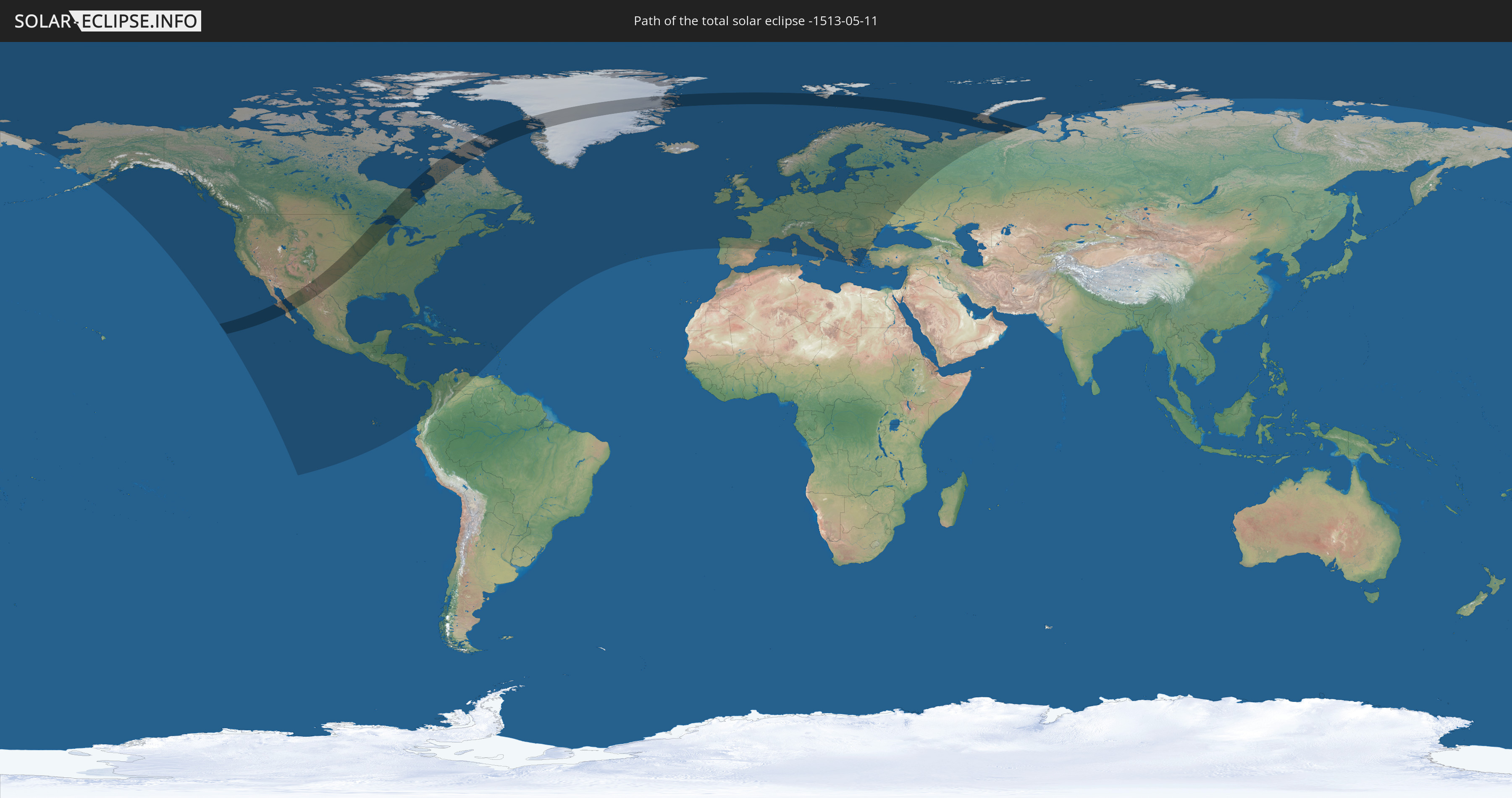
Die Sonnenfinsternis am 11.05.-1513 kann man in 85 Ländern als partielle Sonnenfinsternis beobachten.
Der Finsternispfad verläuft durch 6 Länder. Nur in diesen Ländern ist sie als totale Sonnenfinsternis zu sehen.
In den folgenden Ländern ist die Sonnenfinsternis total zu sehen
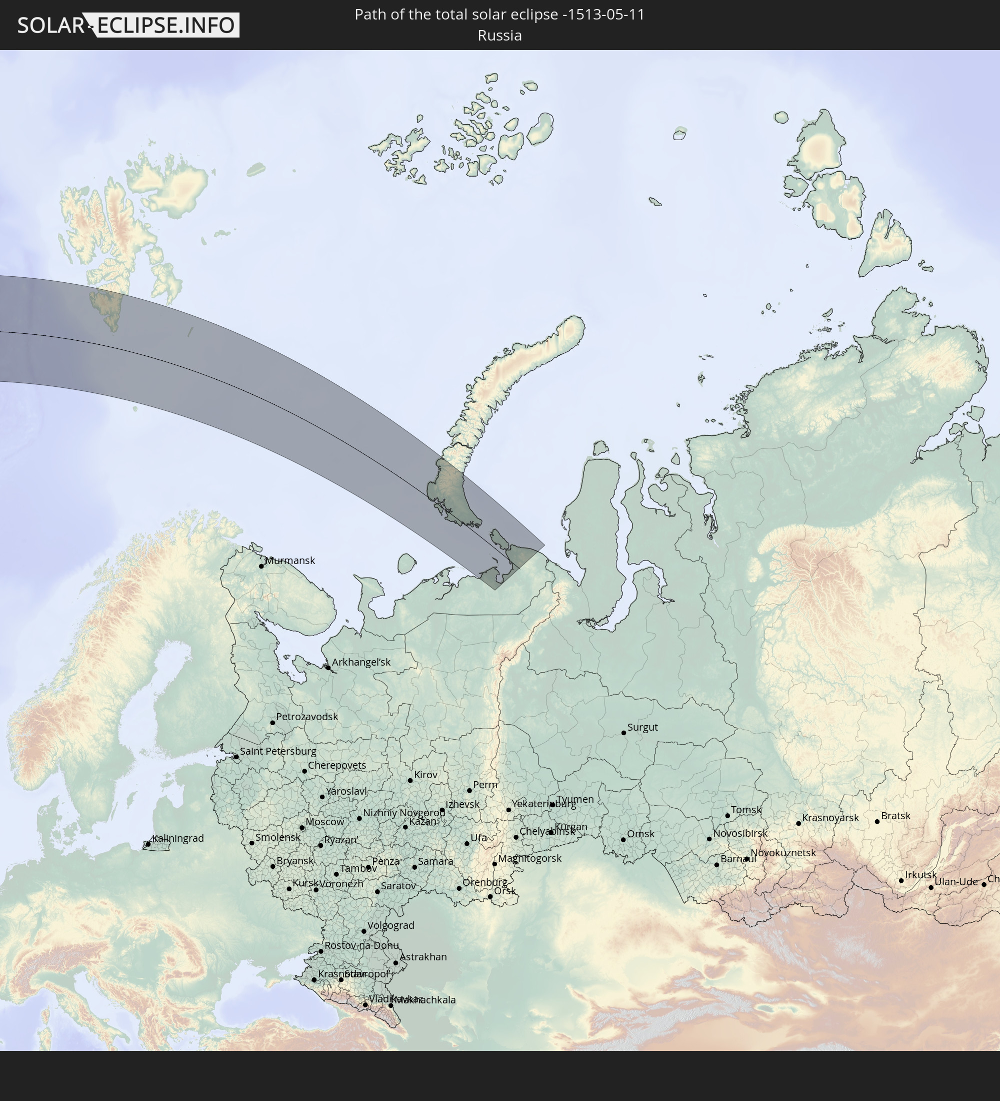 Russland
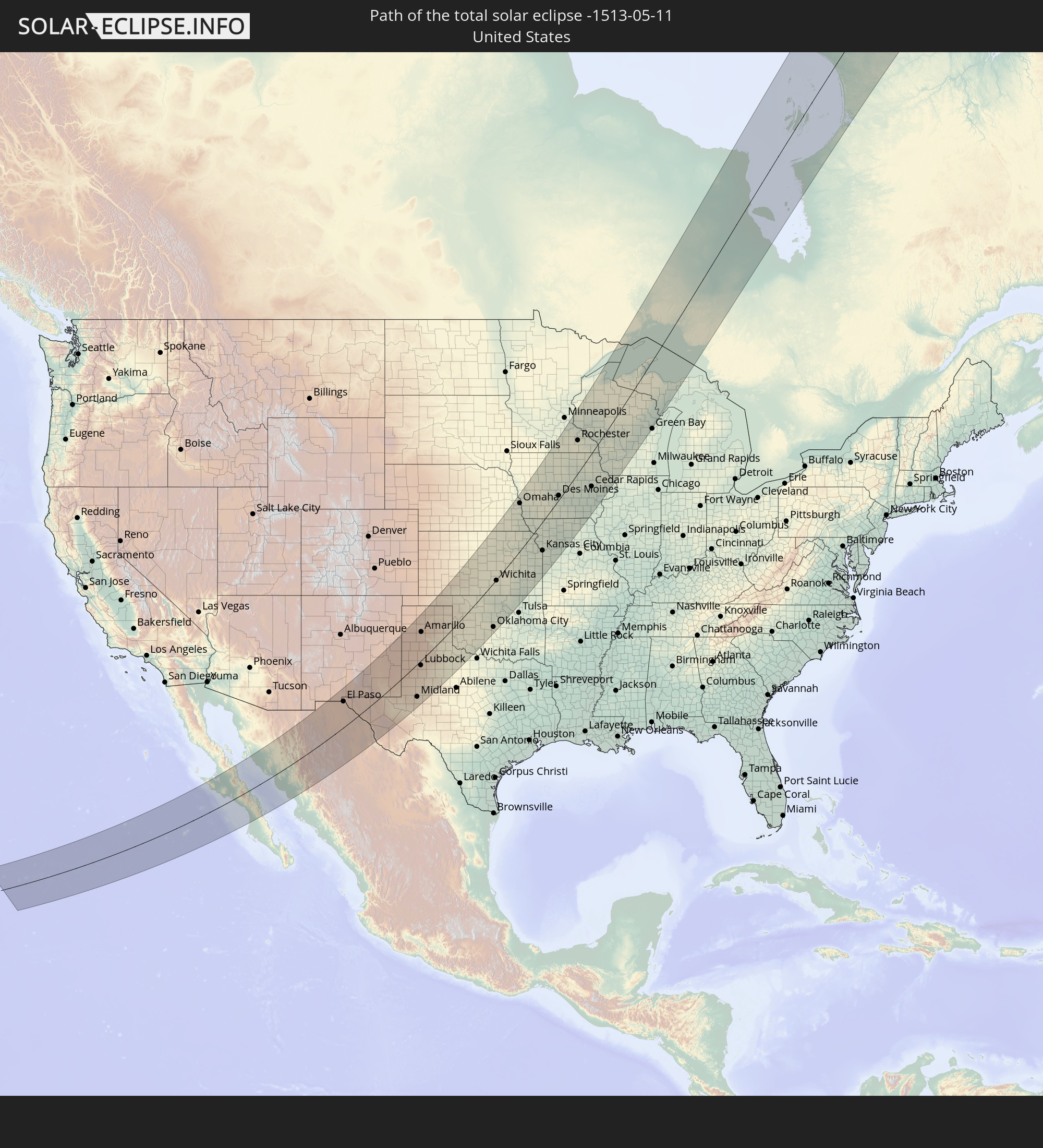 Vereinigte Staaten
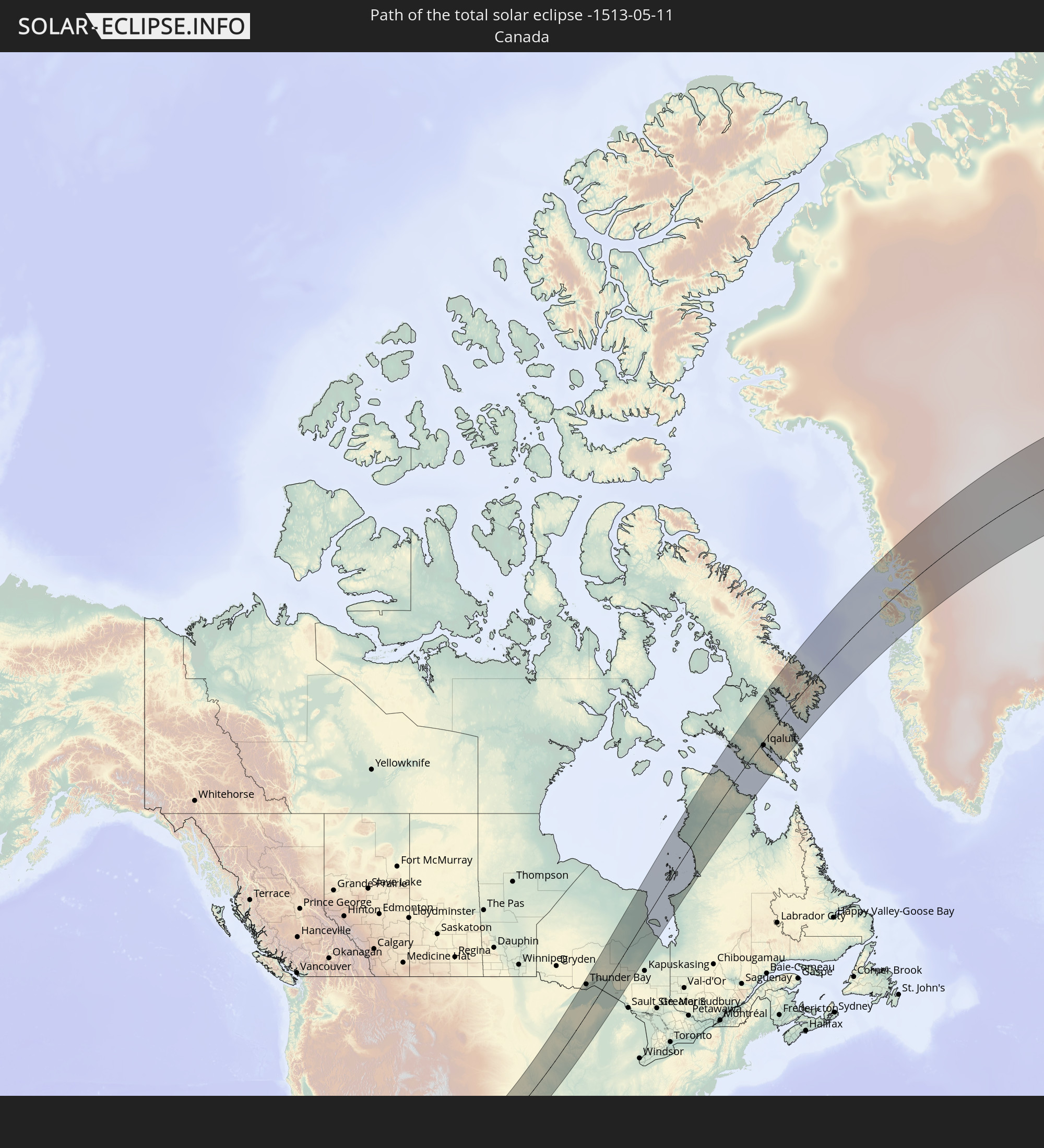 Kanada
 Mexiko
 Grönland
 Spitzbergen
In den folgenden Ländern ist die Sonnenfinsternis partiell zu sehen
 Russland
 Vereinigte Staaten
 United States Minor Outlying Islands
 Kanada
 Mexiko
 Grönland
 Guatemala
 Ecuador
 El Salvador
 Honduras
 Belize
 Nicaragua
 Costa Rica
 Kuba
Kuba
 Panama
 Kolumbien
 Kaimaninseln
 Bahamas
 Jamaika
 Haiti
Haiti
 Venezuela
 Turks- und Caicosinseln
 Dominikanische Republik
 Aruba
Aruba
 Puerto Rico
 Amerikanische Jungferninseln
 Bermuda
 Britische Jungferninseln
 Anguilla
 Saint-Martin
 Saint-Barthélemy
 St. Kitts und Nevis
 Antigua und Barbuda
 Montserrat
 Guadeloupe
 Saint-Pierre und Miquelon
 Portugal
 Island
 Spanien
 Irland
 Spitzbergen
 Vereinigtes Königreich
 Färöer
 Frankreich
 Isle of Man
 Guernsey
 Jersey
 Andorra
 Belgien
 Niederlande
 Norwegen
 Luxemburg
 Deutschland
 Schweiz
 Italien
 Monaco
 Dänemark
 Liechtenstein
 Österreich
 Schweden
 Tschechien
 San Marino
 Vatikanstadt
 Slowenien
 Kroatien
 Polen
Polen
 Bosnien und Herzegowina
 Ungarn
 Slowakei
 Montenegro
 Serbien
 Albanien
 Åland Islands
 Griechenland
 Rumänien
 Mazedonien
 Finnland
 Litauen
 Lettland
 Estland
 Ukraine
 Bulgarien
 Weißrussland
 Türkei
 Moldawien
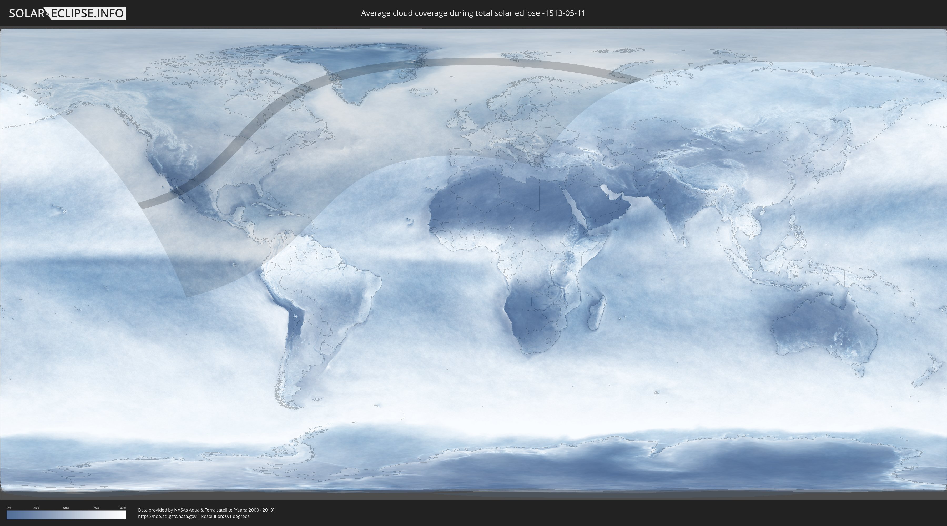
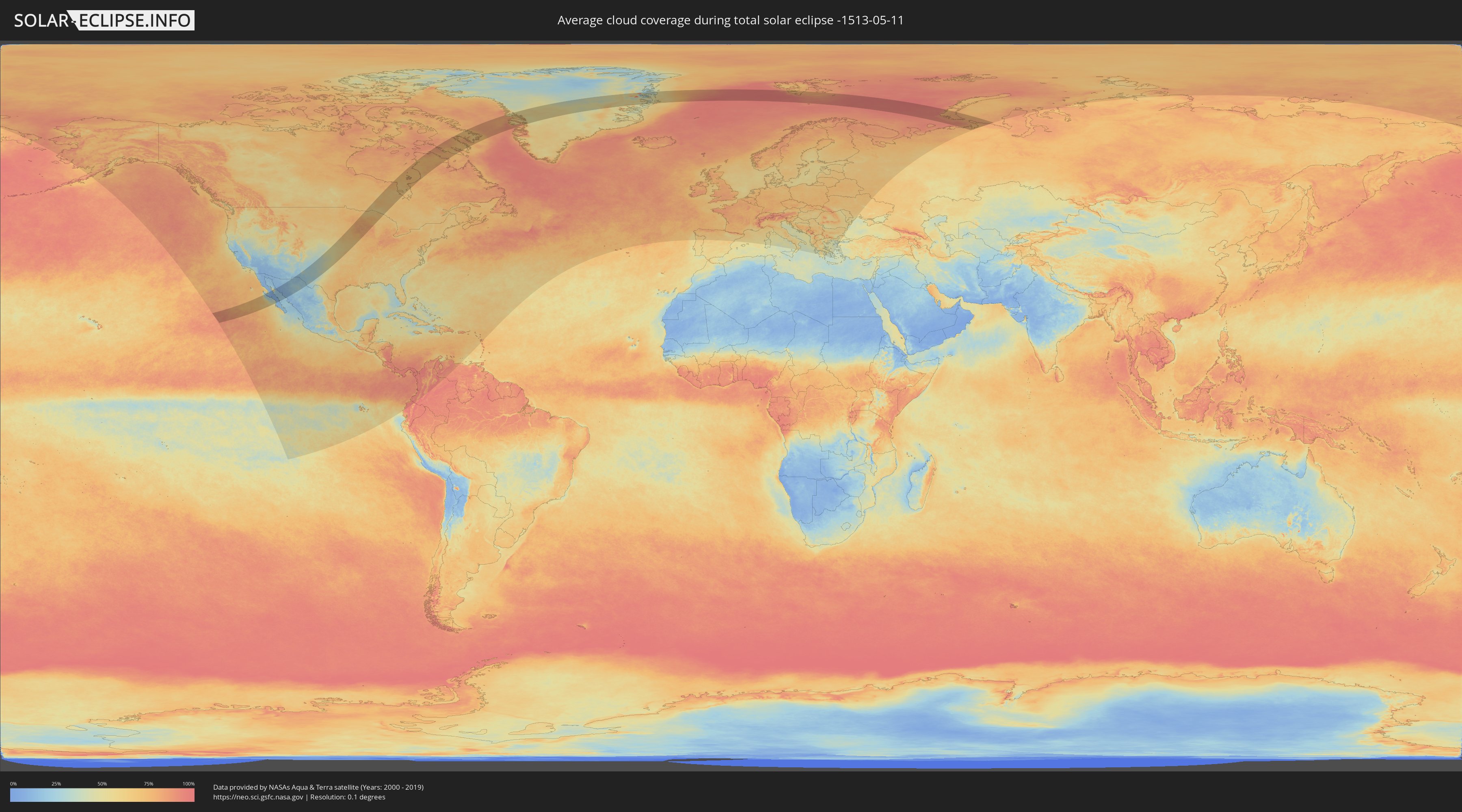
Wie wird das Wetter während der totalen Sonnenfinsternis am 11.05.-1513?
Wo ist der beste Ort, um die totale Sonnenfinsternis vom 11.05.-1513 zu beobachten?
Die folgenden Karten zeigen die durchschnittliche Bewölkung für den Tag, an dem die totale Sonnenfinsternis
stattfindet. Mit Hilfe der Karten lässt sich der Ort entlang des Finsternispfades eingrenzen,
der die besten Aussichen auf einen klaren wolkenfreien Himmel bietet.
Trotzdem muss man immer lokale Gegenenheiten beachten und sollte sich genau über das Wetter an seinem
gewählten Beobachtungsort informieren.
Die Daten stammen von den beiden NASA-Satelliten
AQUA und TERRA
und wurden über einen Zeitraum von 19 Jahren (2000 - 2019) gemittelt.
Detaillierte Länderkarten
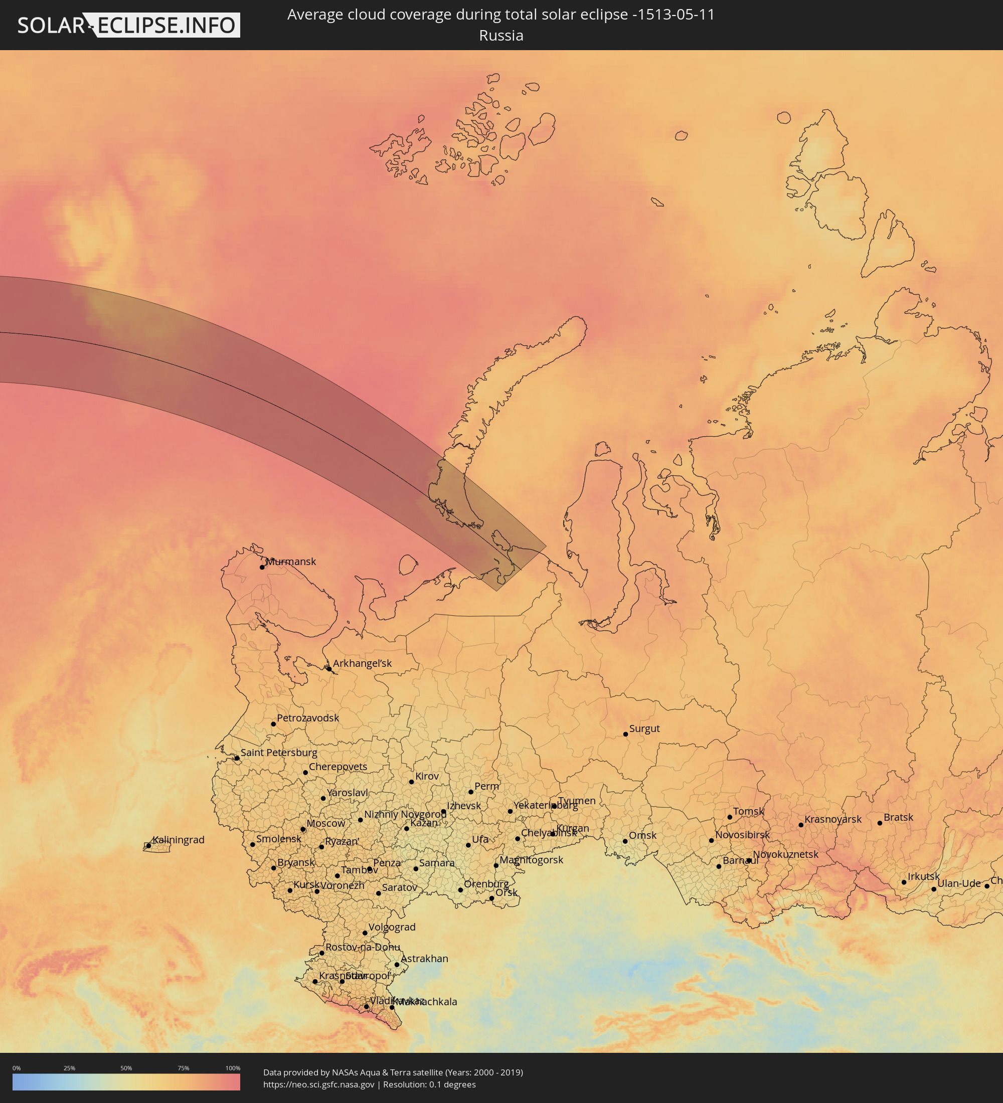 Russland
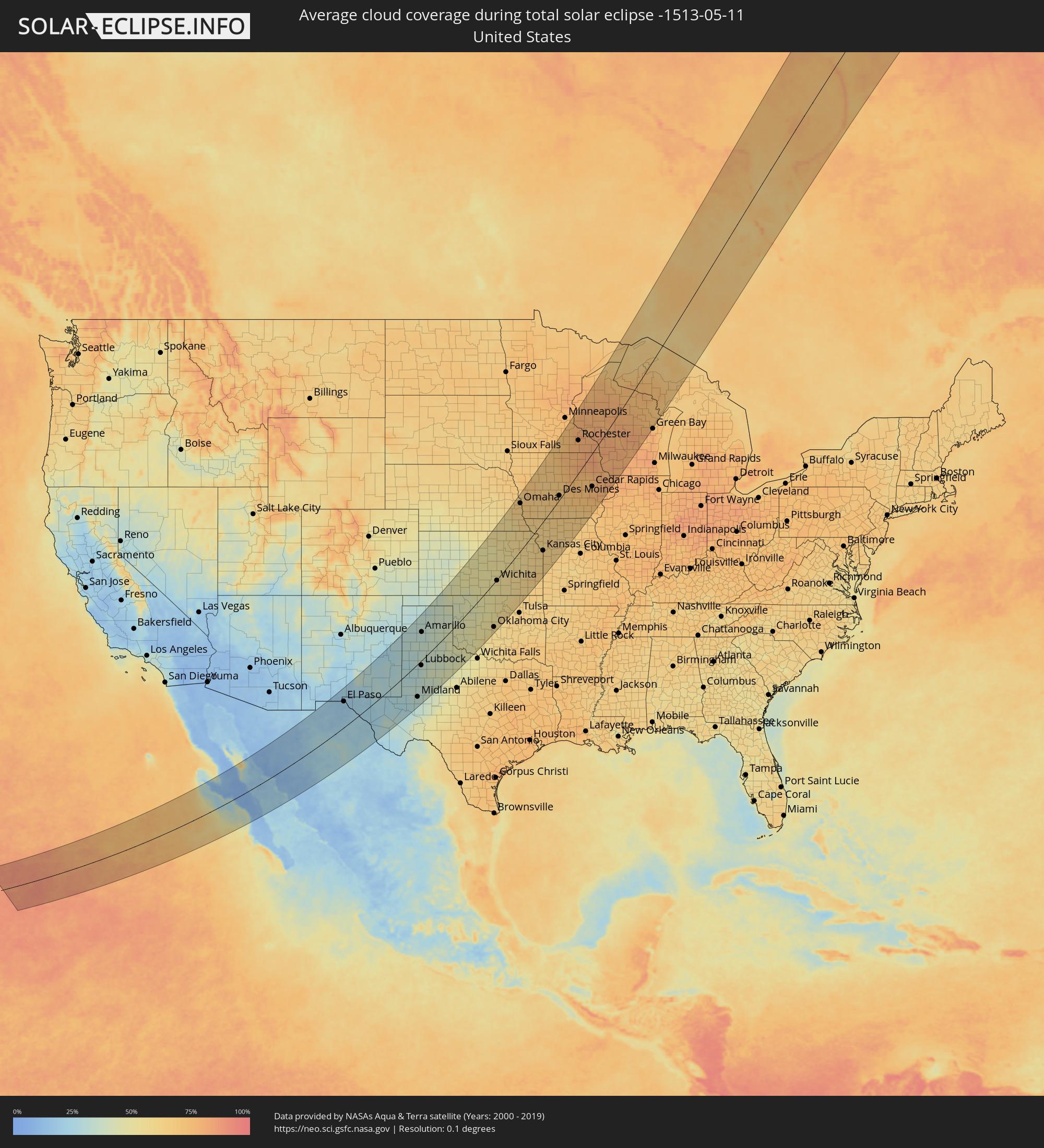 Vereinigte Staaten
 Kanada
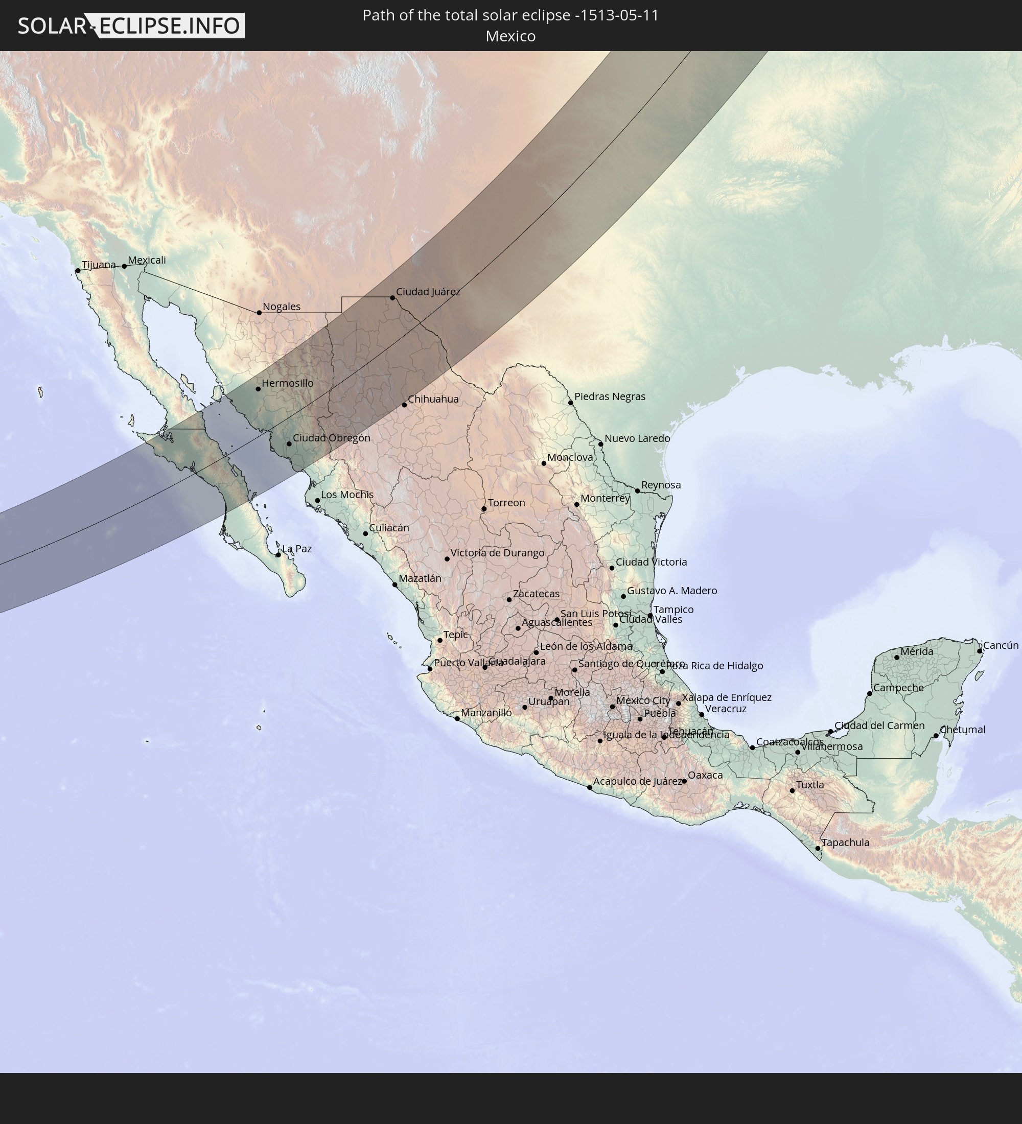
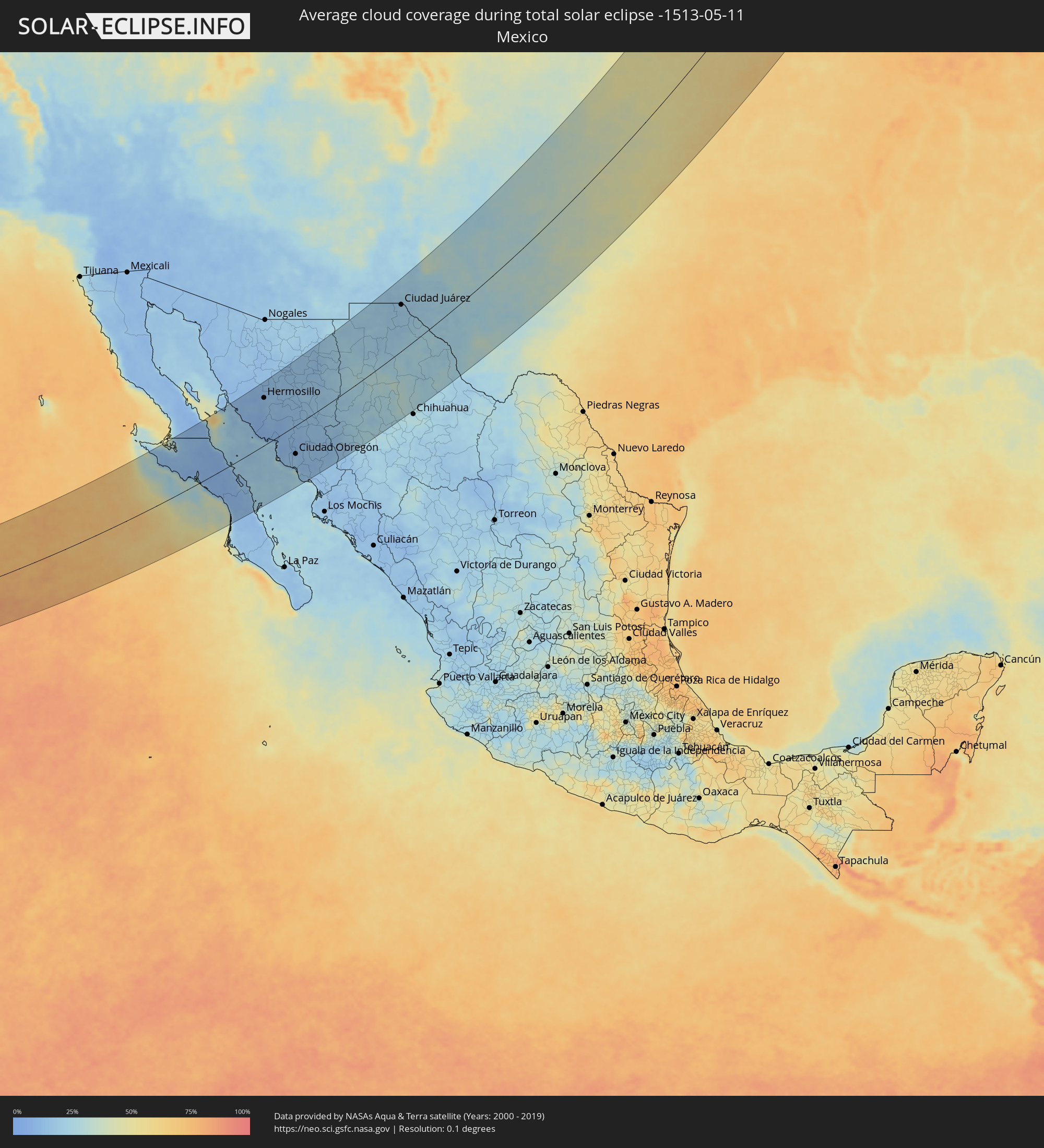 Mexiko
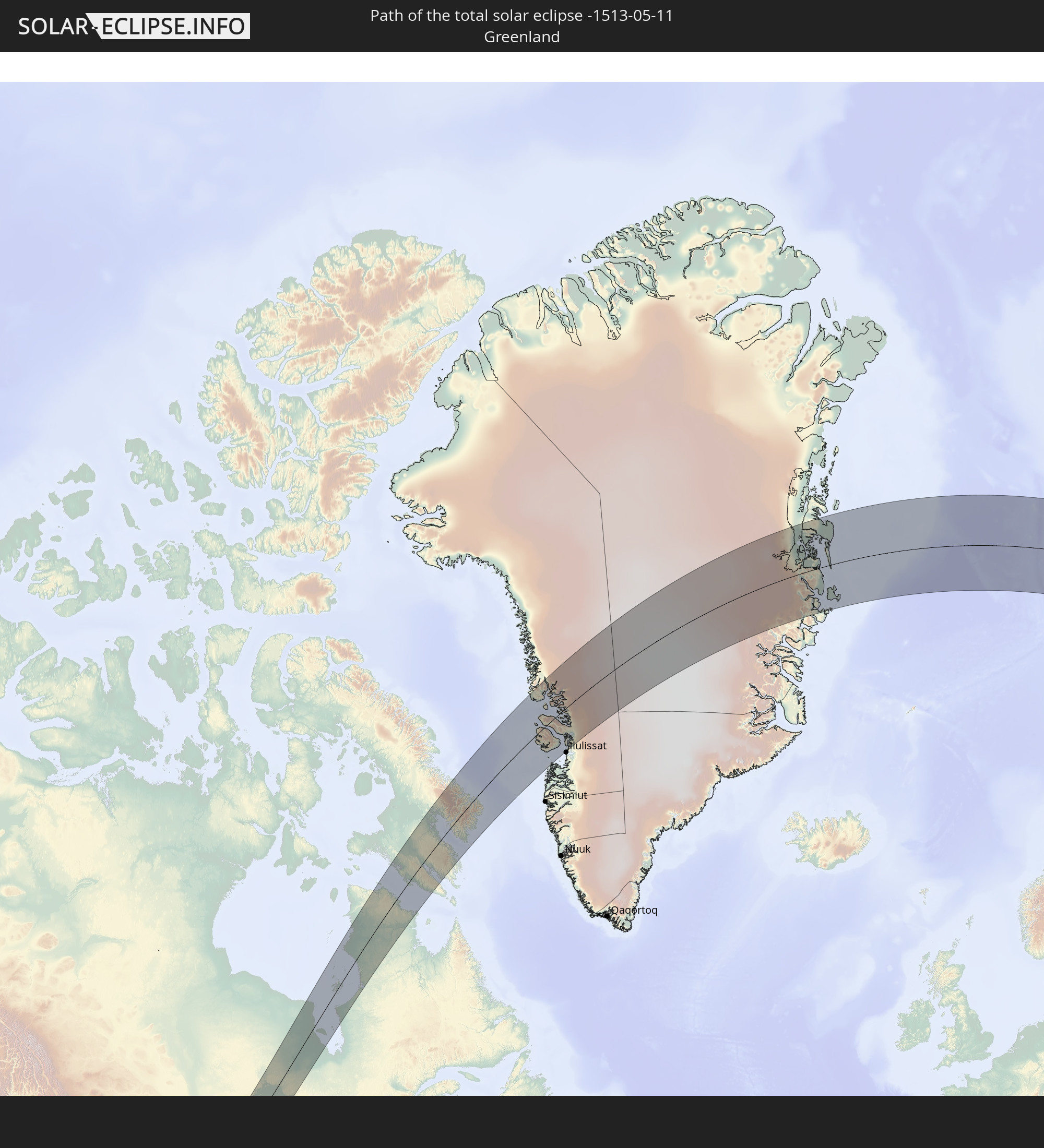
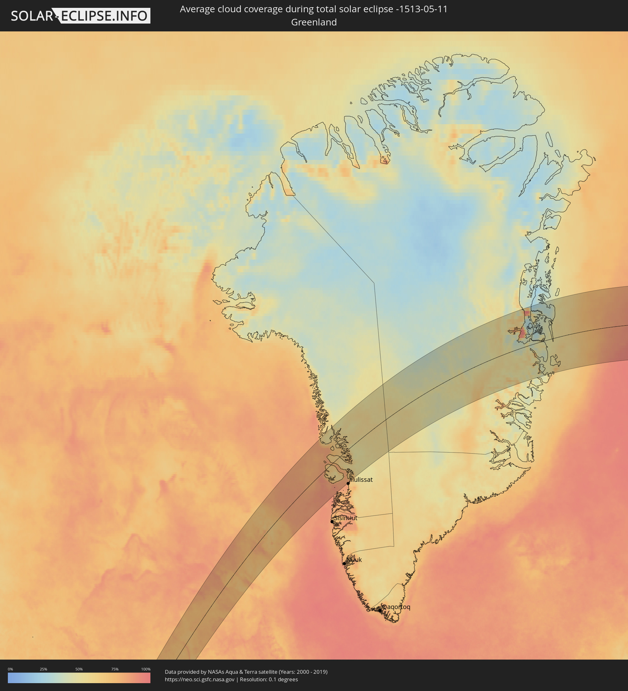 Grönland
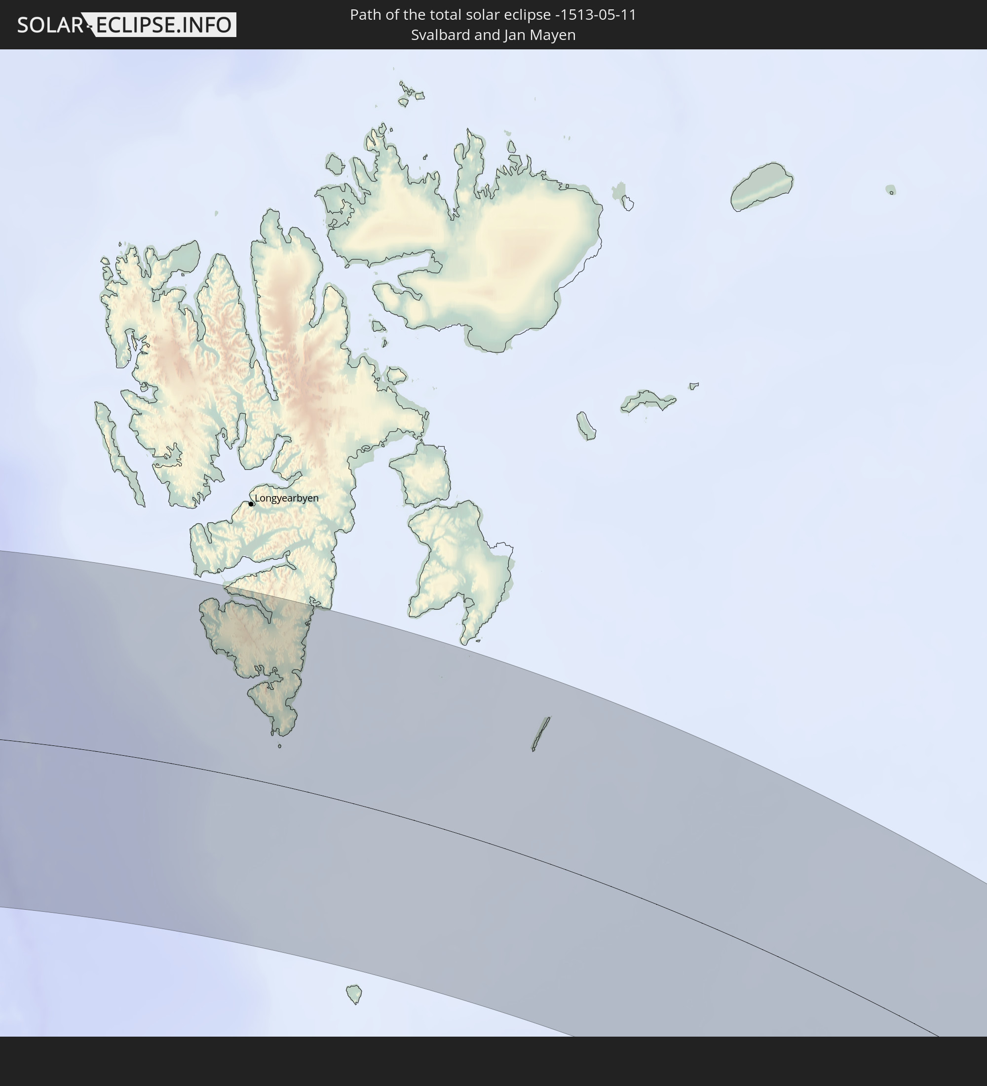
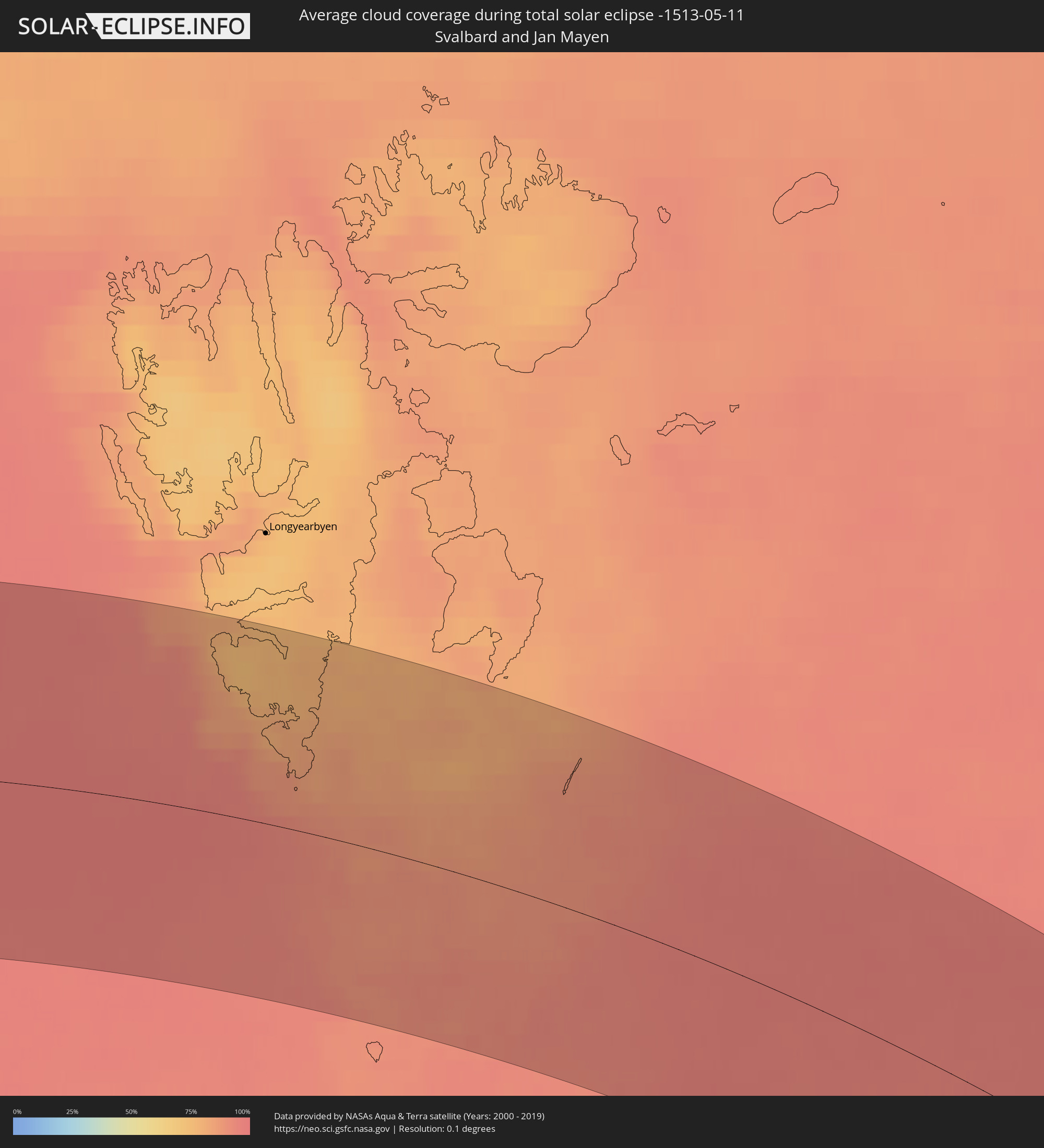 Spitzbergen
Orte im Finsternispfad
Die nachfolgene Tabelle zeigt Städte und Orte mit mehr als 5.000 Einwohnern, die sich im Finsternispfad befinden. Städte mit mehr als 100.000 Einwohnern sind dick gekennzeichnet. Mit einem Klick auf den Ort öffnet sich eine Detailkarte die die Lage des jeweiligen Ortes zusammen mit dem Verlauf der zentralen Finsternis präsentiert.
| Ort | Typ | Dauer der Verfinsterung | Ortszeit bei maximaler Verfinsterung | Entfernung zur Zentrallinie | Ø Bewölkung |
|
Villa Alberto Andrés Alvarado Arámburo, Baja California Sur
|
total | - | 07:00:08 UTC-07:05 | 113 km | 11% |
|
Santa Rosalia, Baja California Sur
|
total | - | 06:59:43 UTC-07:05 | 31 km | 8% |
|
Bahía de Kino, Sonora
|
total | - | 06:43:54 UTC-07:23 | 154 km | 17% |
|
Miguel Alemán (La Doce), Sonora
|
total | - | 06:43:58 UTC-07:23 | 133 km | 10% |
|
Loreto, Baja California Sur
|
total | - | 06:57:42 UTC-07:05 | 146 km | 21% |
|
Hermosillo, Sonora
|
total | - | 06:44:27 UTC-07:23 | 132 km | 11% |
|
Heroica Guaymas, Sonora
|
total | - | 06:42:33 UTC-07:23 | 24 km | 23% |
|
Pesqueira, Sonora
|
total | - | 06:44:54 UTC-07:23 | 151 km | 12% |
|
Empalme, Sonora
|
total | - | 06:42:37 UTC-07:23 | 31 km | 12% |
|
Potam, Sonora
|
total | - | 06:42:08 UTC-07:23 | 42 km | 10% |
|
Vicam, Sonora
|
total | - | 06:42:10 UTC-07:23 | 44 km | 11% |
|
San Ignacio Río Muerto, Sonora
|
total | - | 06:41:49 UTC-07:23 | 69 km | 13% |
|
Campo Sesenta, Sonora
|
total | - | 06:41:53 UTC-07:23 | 72 km | 12% |
|
Pueblo Yaqui, Sonora
|
total | - | 06:41:44 UTC-07:23 | 85 km | 14% |
|
Cocorit, Sonora
|
total | - | 06:42:06 UTC-07:23 | 71 km | 12% |
|
Ciudad Obregón, Sonora
|
total | - | 06:41:58 UTC-07:23 | 79 km | 12% |
|
El Tobarito, Sonora
|
total | - | 06:41:47 UTC-07:23 | 92 km | 13% |
|
Marte R. Gómez (Tobarito), Sonora
|
total | - | 06:41:47 UTC-07:23 | 92 km | 13% |
|
Villa Juarez, Sonora
|
total | - | 06:41:24 UTC-07:23 | 116 km | 14% |
|
Bacobampo, Sonora
|
total | - | 06:41:11 UTC-07:23 | 140 km | 15% |
|
Huatabampo, Sonora
|
total | - | 06:40:56 UTC-07:23 | 155 km | 18% |
|
Etchojoa, Sonora
|
total | - | 06:41:05 UTC-07:23 | 148 km | 16% |
|
La Unión, Sonora
|
total | - | 06:40:56 UTC-07:23 | 158 km | 18% |
|
Navojoa, Sonora
|
total | - | 06:41:21 UTC-07:23 | 145 km | 12% |
|
San Pedro Madera, Chihuahua
|
total | - | 07:03:12 UTC-07:05 | 33 km | 22% |
|
Ascención, Chihuahua
|
total | - | 07:06:26 UTC-07:05 | 146 km | 21% |
|
Benito Juárez, Chihuahua
|
total | - | 07:04:10 UTC-07:05 | 32 km | 27% |
|
Nuevo Casas Grandes, Chihuahua
|
total | - | 07:05:17 UTC-07:05 | 82 km | 21% |
|
Buenaventura, Chihuahua
|
total | - | 07:04:25 UTC-07:05 | 9 km | 28% |
|
Adolfo López Mateos, Chihuahua
|
total | - | 07:02:09 UTC-07:05 | 130 km | 22% |
|
Ejido Benito Juárez, Chihuahua
|
total | - | 07:05:03 UTC-07:05 | 13 km | 23% |
|
Cuauhtémoc, Chihuahua
|
total | - | 07:02:09 UTC-07:05 | 161 km | 25% |
|
Anáhuac, Chihuahua
|
total | - | 07:02:17 UTC-07:05 | 161 km | 24% |
|
Miguel Ahumada, Chihuahua
|
total | - | 07:05:56 UTC-07:05 | 22 km | 23% |
|
El Paso, Texas
|
total | - | 07:13:33 UTC-07:00 | 119 km | 19% |
|
Ciudad Juárez, Chihuahua
|
total | - | 07:07:51 UTC-07:05 | 117 km | 20% |
|
Socorro, Texas
|
total | - | 07:13:25 UTC-07:00 | 98 km | 19% |
|
Roswell, New Mexico
|
total | - | 07:16:57 UTC-07:00 | 135 km | 28% |
|
Carlsbad, New Mexico
|
total | - | 07:15:19 UTC-07:00 | 36 km | 31% |
|
Clovis, New Mexico
|
total | - | 07:19:11 UTC-07:00 | 136 km | 29% |
|
Hobbs, New Mexico
|
total | - | 07:16:10 UTC-07:00 | 27 km | 32% |
|
Odessa, Texas
|
total | - | 08:14:55 UTC-06:00 | 132 km | 31% |
|
Midland, Texas
|
total | - | 08:15:17 UTC-06:00 | 134 km | 31% |
|
Lubbock, Texas
|
total | - | 08:18:11 UTC-06:00 | 19 km | 34% |
|
Amarillo, Texas
|
total | - | 08:21:10 UTC-06:00 | 110 km | 33% |
|
Plainview, Texas
|
total | - | 08:19:20 UTC-06:00 | 21 km | 35% |
|
Big Spring, Texas
|
total | - | 08:15:57 UTC-06:00 | 151 km | 37% |
|
Altus, Oklahoma
|
total | - | 08:21:08 UTC-06:00 | 100 km | 48% |
|
Lawton, Oklahoma
|
total | - | 08:21:30 UTC-06:00 | 165 km | 52% |
|
Hutchinson, Kansas
|
total | - | 08:28:09 UTC-06:00 | 65 km | 48% |
|
Enid, Oklahoma
|
total | - | 08:25:03 UTC-06:00 | 64 km | 49% |
|
Yukon, Oklahoma
|
total | - | 08:23:27 UTC-06:00 | 137 km | 52% |
|
Salina, Kansas
|
total | - | 08:29:46 UTC-06:00 | 102 km | 51% |
|
Oklahoma City, Oklahoma
|
total | - | 08:23:30 UTC-06:00 | 158 km | 55% |
|
Edmond, Oklahoma
|
total | - | 08:23:52 UTC-06:00 | 146 km | 56% |
|
Newton, Kansas
|
total | - | 08:28:25 UTC-06:00 | 30 km | 51% |
|
Wichita, Kansas
|
total | - | 08:27:45 UTC-06:00 | 18 km | 54% |
|
Derby, Kansas
|
total | - | 08:27:31 UTC-06:00 | 21 km | 53% |
|
Ponca City, Oklahoma
|
total | - | 08:26:02 UTC-06:00 | 94 km | 53% |
|
Stillwater, Oklahoma
|
total | - | 08:24:56 UTC-06:00 | 141 km | 58% |
|
Junction City, Kansas
|
total | - | 08:30:32 UTC-06:00 | 62 km | 55% |
|
Lincoln, Nebraska
|
total | - | 08:33:58 UTC-06:00 | 167 km | 60% |
|
Manhattan, Kansas
|
total | - | 08:30:58 UTC-06:00 | 53 km | 57% |
|
Emporia, Kansas
|
total | - | 08:29:42 UTC-06:00 | 31 km | 56% |
|
Bartlesville, Oklahoma
|
total | - | 08:26:41 UTC-06:00 | 164 km | 62% |
|
Omaha, Nebraska
|
total | - | 08:35:15 UTC-06:00 | 147 km | 65% |
|
Topeka, Kansas
|
total | - | 08:31:12 UTC-06:00 | 28 km | 59% |
|
Lawrence, Kansas
|
total | - | 08:31:18 UTC-06:00 | 64 km | 60% |
|
Leavenworth, Kansas
|
total | - | 08:32:08 UTC-06:00 | 54 km | 62% |
|
Saint Joseph, Missouri
|
total | - | 08:33:03 UTC-06:00 | 30 km | 61% |
|
Olathe, Kansas
|
total | - | 08:31:22 UTC-06:00 | 91 km | 63% |
|
Overland Park, Kansas
|
total | - | 08:31:39 UTC-06:00 | 93 km | 62% |
|
Kansas City, Missouri
|
total | - | 08:31:56 UTC-06:00 | 92 km | 63% |
|
Belton, Missouri
|
total | - | 08:31:24 UTC-06:00 | 114 km | 61% |
|
Liberty, Missouri
|
total | - | 08:32:18 UTC-06:00 | 98 km | 63% |
|
Lee's Summit, Missouri
|
total | - | 08:31:41 UTC-06:00 | 117 km | 62% |
|
East Independence, Missouri
|
total | - | 08:32:03 UTC-06:00 | 109 km | 63% |
|
Fort Dodge, Iowa
|
total | - | 08:38:39 UTC-06:00 | 109 km | 69% |
|
Ames, Iowa
|
total | - | 08:38:06 UTC-06:00 | 51 km | 68% |
|
Des Moines, Iowa
|
total | - | 08:37:17 UTC-06:00 | 12 km | 68% |
|
Faribault, Minnesota
|
total | - | 08:42:38 UTC-06:00 | 160 km | 74% |
|
Owatonna, Minnesota
|
total | - | 08:42:15 UTC-06:00 | 148 km | 74% |
|
Mason City, Iowa
|
total | - | 08:40:30 UTC-06:00 | 87 km | 77% |
|
Northfield, Minnesota
|
total | - | 08:43:01 UTC-06:00 | 162 km | 74% |
|
Farmington, Minnesota
|
total | - | 08:43:22 UTC-06:00 | 173 km | 73% |
|
Austin, Minnesota
|
total | - | 08:41:37 UTC-06:00 | 101 km | 77% |
|
Cottage Grove, Minnesota
|
total | - | 08:43:51 UTC-06:00 | 172 km | 73% |
|
Marshalltown, Iowa
|
total | - | 08:38:35 UTC-06:00 | 8 km | 75% |
|
Rochester, Minnesota
|
total | - | 08:42:37 UTC-06:00 | 90 km | 77% |
|
Ottumwa, Iowa
|
total | - | 08:36:56 UTC-06:00 | 107 km | 66% |
|
Waterloo, Iowa
|
total | - | 08:39:47 UTC-06:00 | 15 km | 76% |
|
Cedar Rapids, Iowa
|
total | - | 08:39:19 UTC-06:00 | 94 km | 74% |
|
Winona, Minnesota
|
total | - | 08:43:14 UTC-06:00 | 49 km | 81% |
|
Iowa City, Iowa
|
total | - | 08:38:44 UTC-06:00 | 129 km | 77% |
|
Eau Claire, Wisconsin
|
total | - | 08:44:46 UTC-06:00 | 80 km | 77% |
|
La Crosse, Wisconsin
|
total | - | 08:43:01 UTC-06:00 | 29 km | 78% |
|
Muscatine, Iowa
|
total | - | 08:38:36 UTC-06:00 | 175 km | 75% |
|
Dubuque, Iowa
|
total | - | 08:40:56 UTC-06:00 | 127 km | 78% |
|
Wausau, Wisconsin
|
total | - | 08:46:21 UTC-06:00 | 41 km | 77% |
|
Stevens Point, Wisconsin
|
total | - | 08:45:33 UTC-06:00 | 76 km | 79% |
|
Thunder Bay, Ontario
|
total | - | 09:53:04 UTC-05:00 | 140 km | 65% |
|
Appleton, Wisconsin
|
total | - | 08:45:54 UTC-06:00 | 165 km | 79% |
|
Marquette, Michigan
|
total | - | 09:50:59 UTC-05:00 | 90 km | 68% |
|
Iqaluit, Nunavut
|
total | - | 10:33:30 UTC-05:00 | 25 km | 74% |