Total solar eclipse of 05/11/-1513
| Day of week: | Friday |
| Maximum duration of eclipse: | 04m23s |
| Maximum width of eclipse path: | 326 km |
| Saros cycle: | 33 |
| Coverage: | 100% |
| Magnitude: | 1.068 |
| Gamma: | 0.7399 |
Wo kann man die Sonnenfinsternis vom 05/11/-1513 sehen?
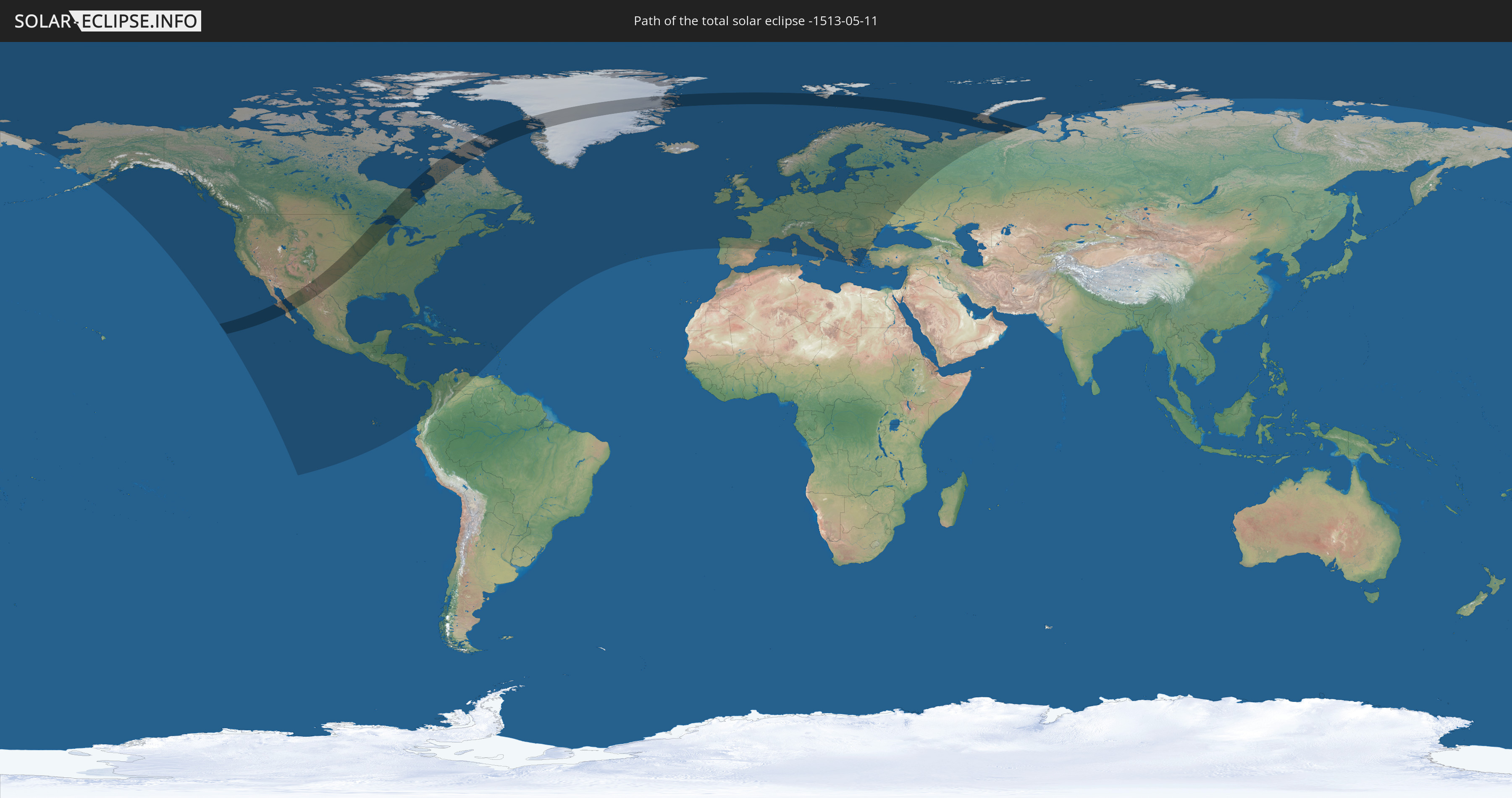
Die Sonnenfinsternis am 05/11/-1513 kann man in 85 Ländern als partielle Sonnenfinsternis beobachten.
Der Finsternispfad verläuft durch 6 Länder. Nur in diesen Ländern ist sie als total Sonnenfinsternis zu sehen.
In den folgenden Ländern ist die Sonnenfinsternis total zu sehen
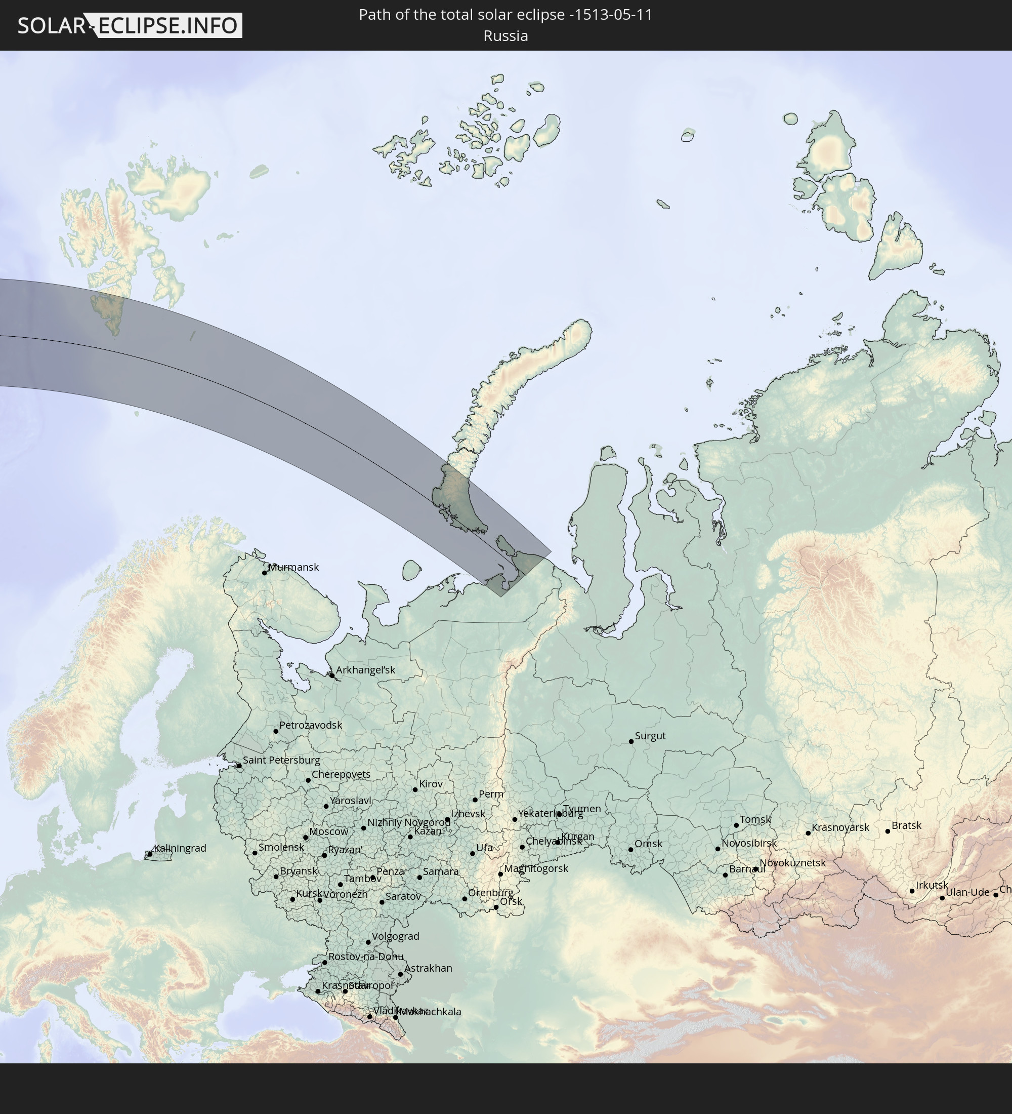 Russia
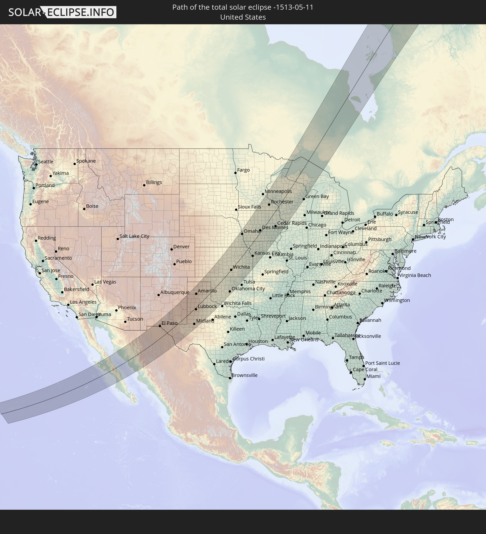 United States
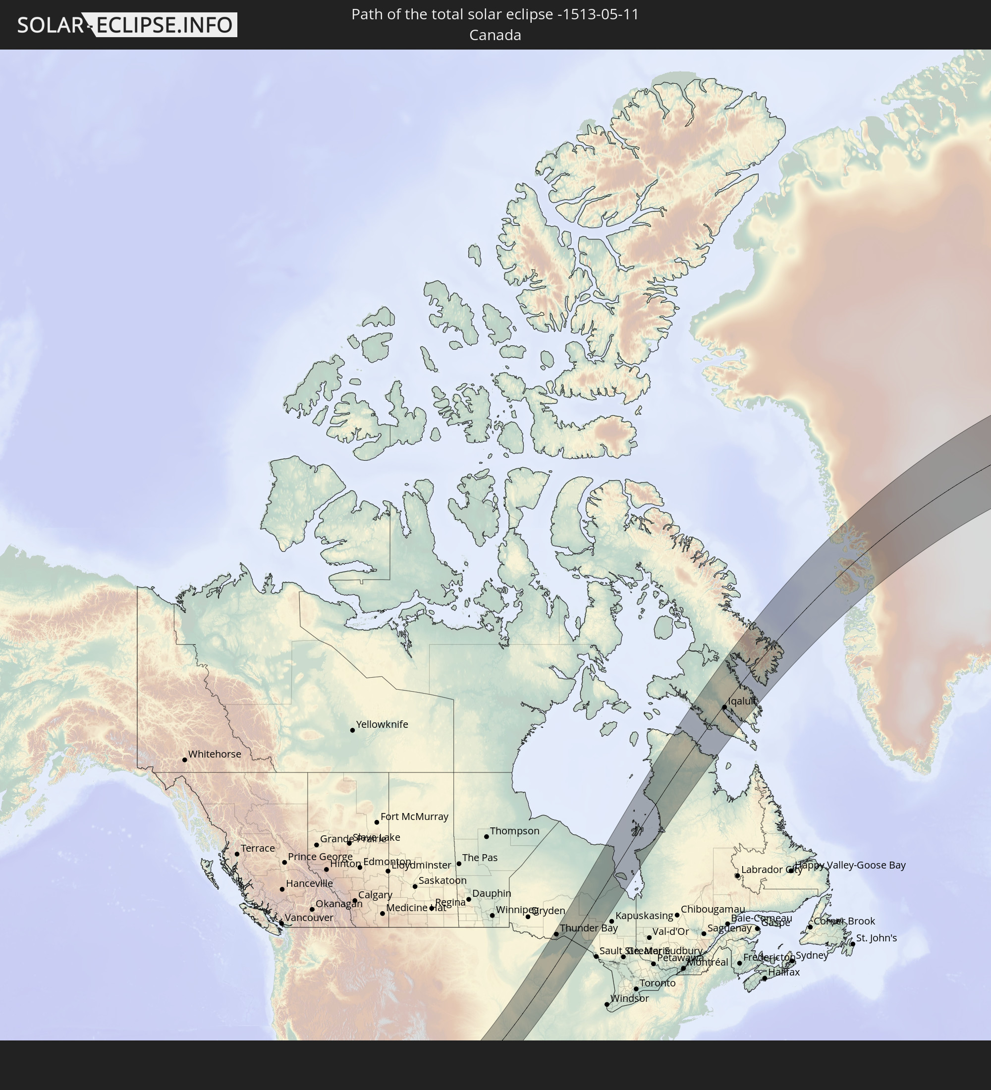 Canada
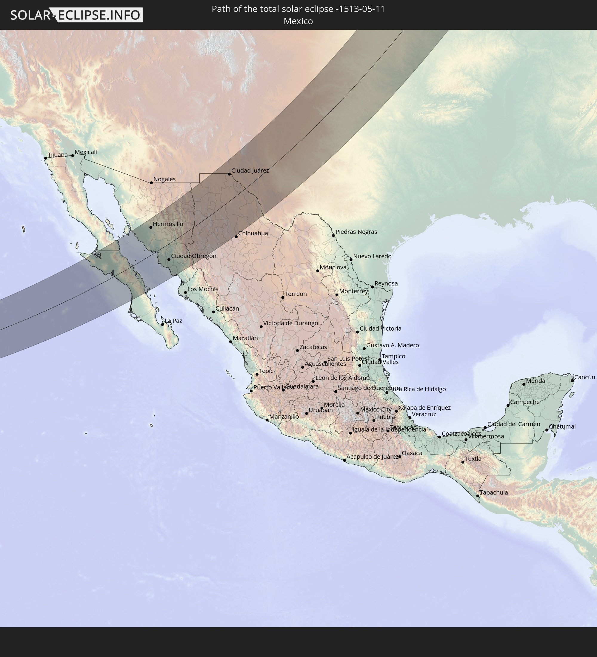 Mexico
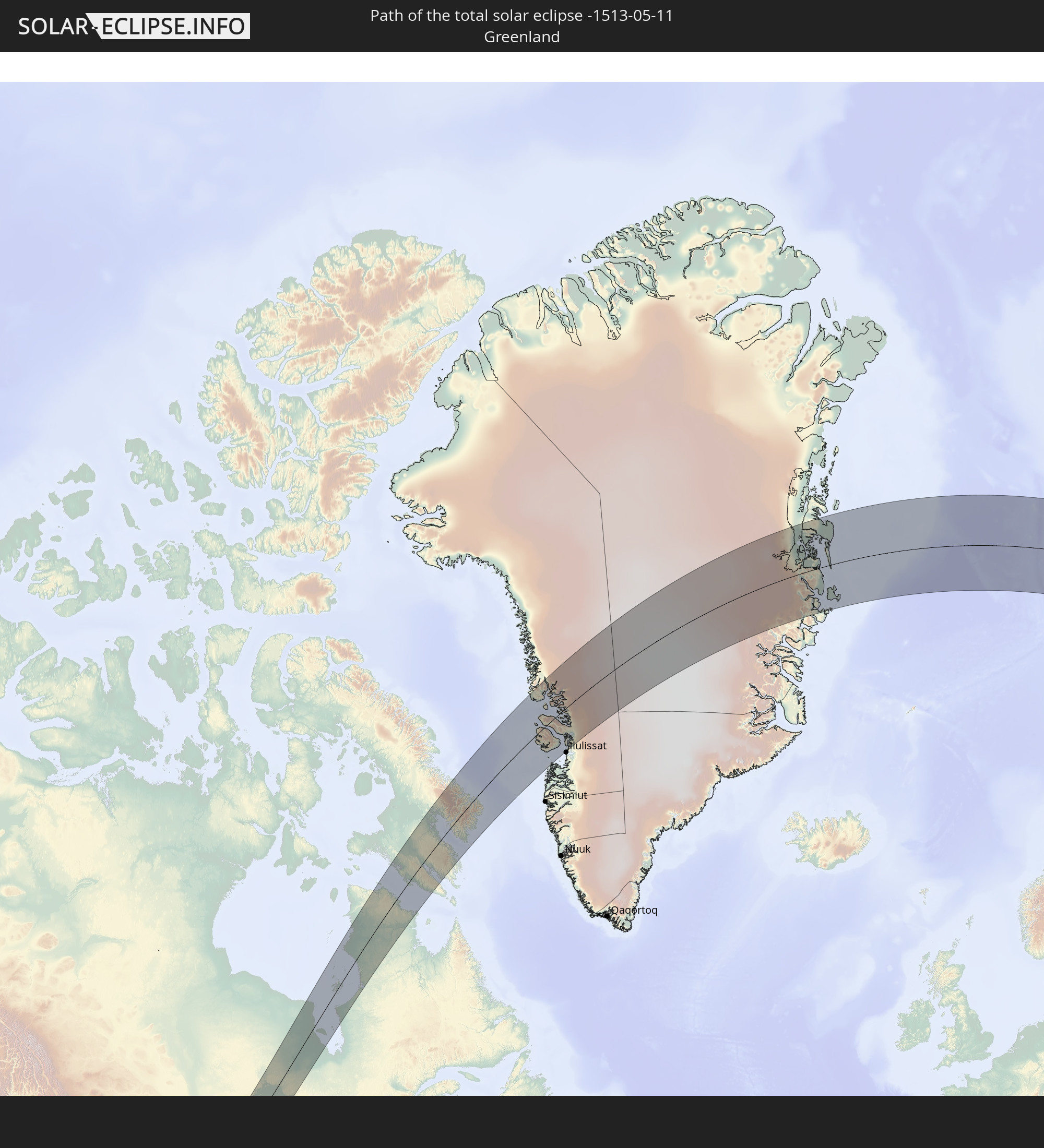 Greenland
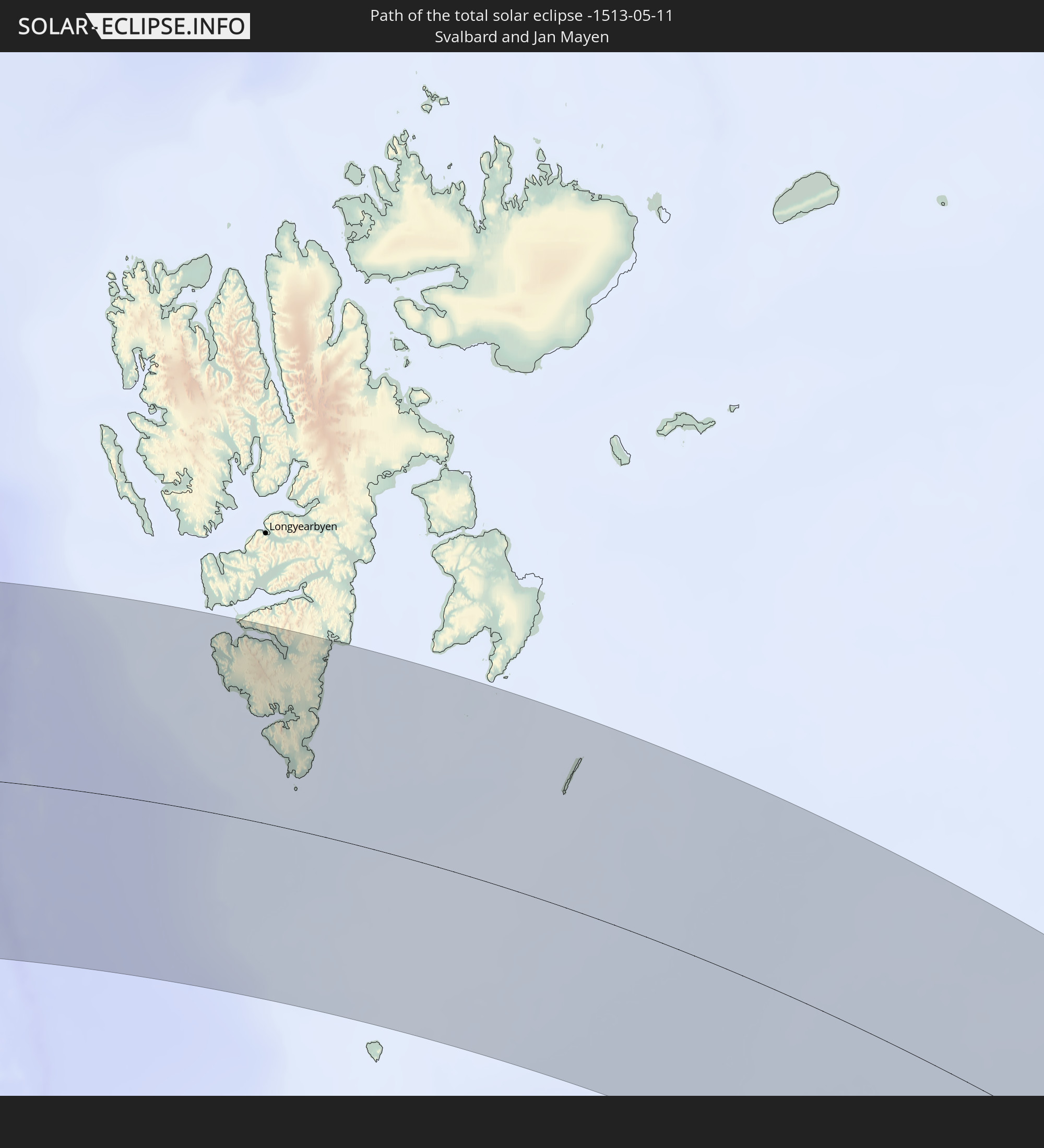 Svalbard and Jan Mayen
In den folgenden Ländern ist die Sonnenfinsternis partiell zu sehen
 Russia
 United States
 United States Minor Outlying Islands
 Canada
 Mexico
 Greenland
 Guatemala
 Ecuador
 El Salvador
 Honduras
 Belize
 Nicaragua
 Costa Rica
 Cuba
Cuba
 Panama
 Colombia
 Cayman Islands
 The Bahamas
 Jamaica
 Haiti
Haiti
 Venezuela
 Turks and Caicos Islands
 Dominican Republic
 Aruba
Aruba
 Puerto Rico
 United States Virgin Islands
 Bermuda
 British Virgin Islands
 Anguilla
 Collectivity of Saint Martin
 Saint Barthélemy
 Saint Kitts and Nevis
 Antigua and Barbuda
 Montserrat
 Guadeloupe
 Saint Pierre and Miquelon
 Portugal
 Iceland
 Spain
Spain
 Republic of Ireland
 Svalbard and Jan Mayen
 United Kingdom
 Faroe Islands
 France
 Isle of Man
 Guernsey
 Jersey
 Andorra
 Belgium
 Netherlands
 Norway
 Luxembourg
 Germany
 Switzerland
 Italy
Italy
 Monaco
 Denmark
 Liechtenstein
 Austria
 Sweden
 Czechia
 San Marino
 Vatican City
 Slovenia
 Croatia
 Poland
 Bosnia and Herzegovina
 Hungary
 Slovakia
 Montenegro
 Serbia
 Albania
 Åland Islands
 Greece
 Romania
 Republic of Macedonia
 Finland
 Lithuania
 Latvia
 Estonia
 Ukraine
 Bulgaria
 Belarus
 Turkey
 Moldova
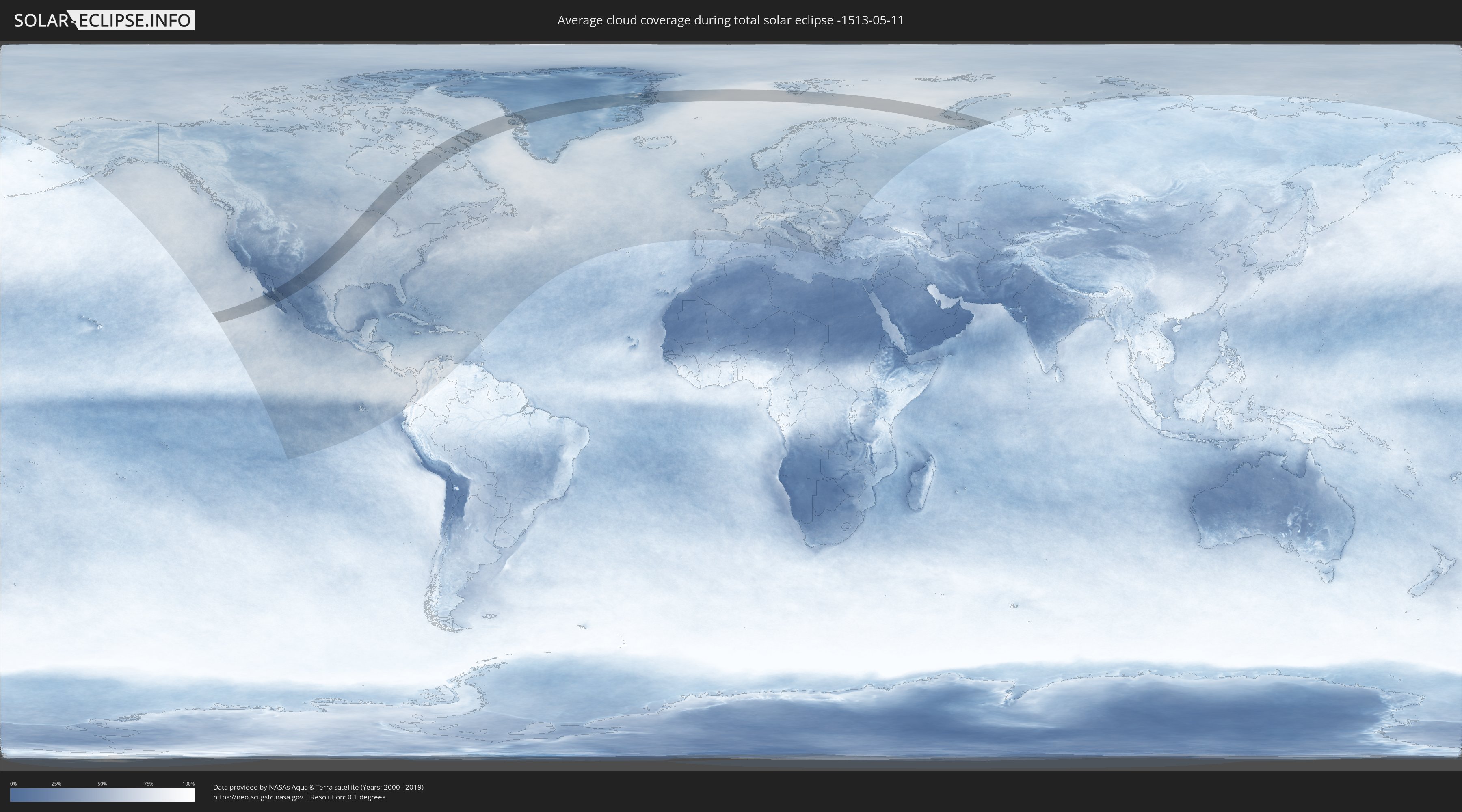
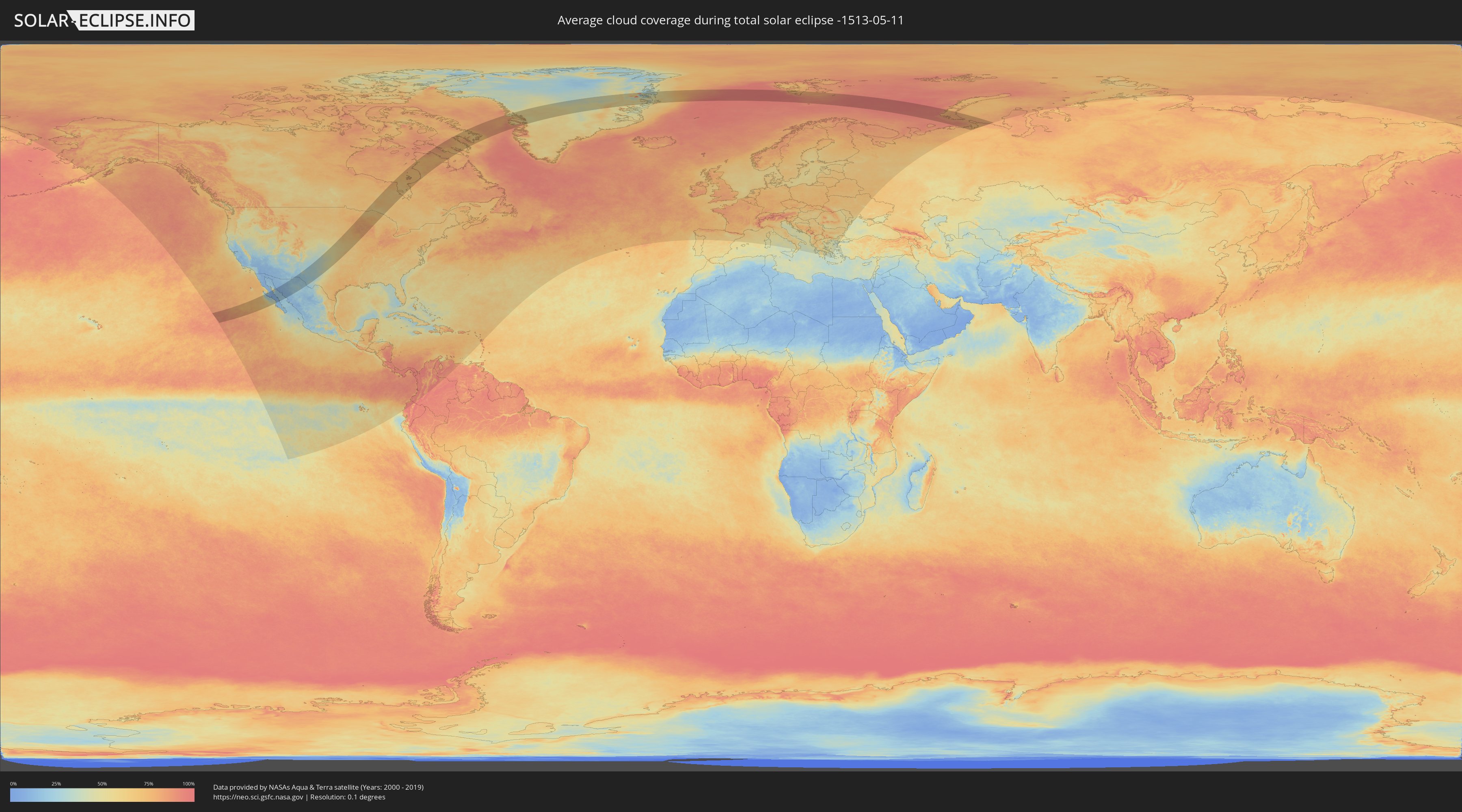
How will be the weather during the total solar eclipse on 05/11/-1513?
Where is the best place to see the total solar eclipse of 05/11/-1513?
The following maps show the average cloud coverage for the day of the total solar eclipse.
With the help of these maps, it is possible to find the place along the eclipse path, which has the best
chance of a cloudless sky.
Nevertheless, you should consider local circumstances and inform about the weather of your chosen
observation site.
The data is provided by NASAs satellites
AQUA and TERRA.
The cloud maps are averaged over a period of 19 years (2000 - 2019).
Detailed country maps
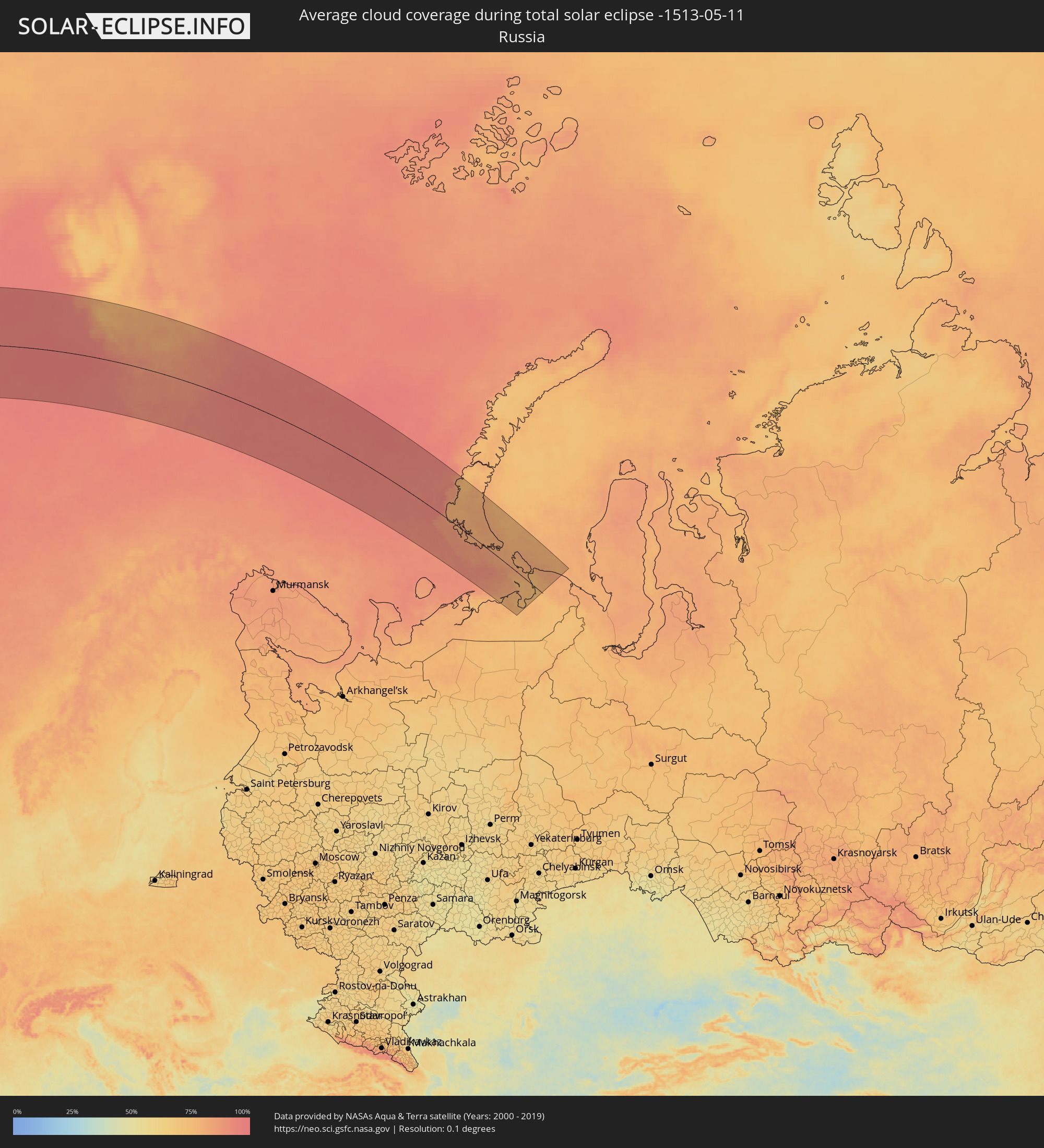 Russia
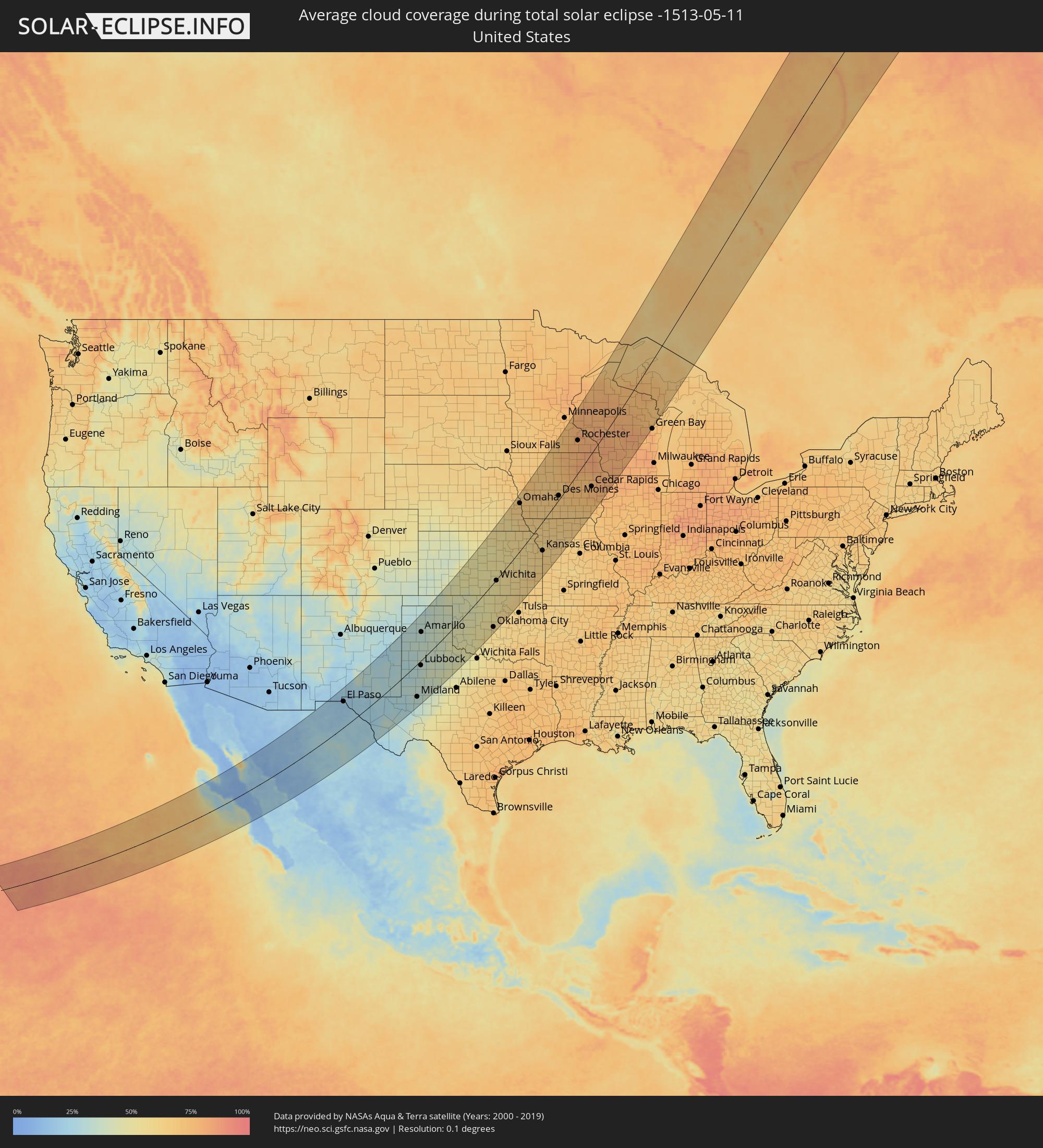 United States
 Canada
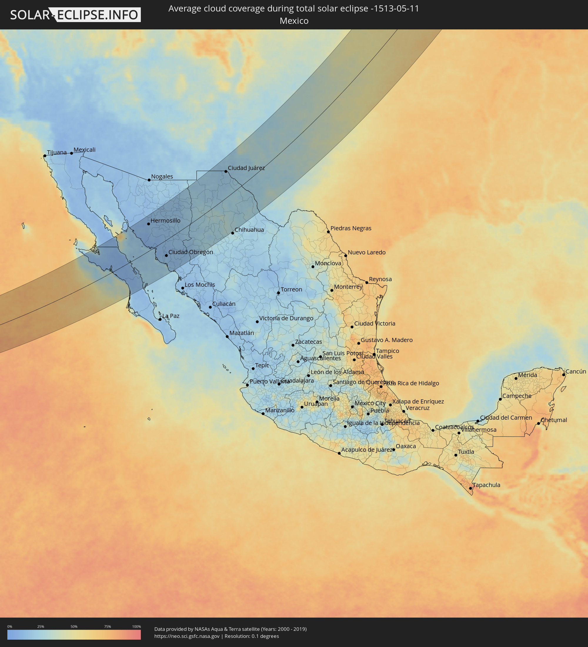 Mexico
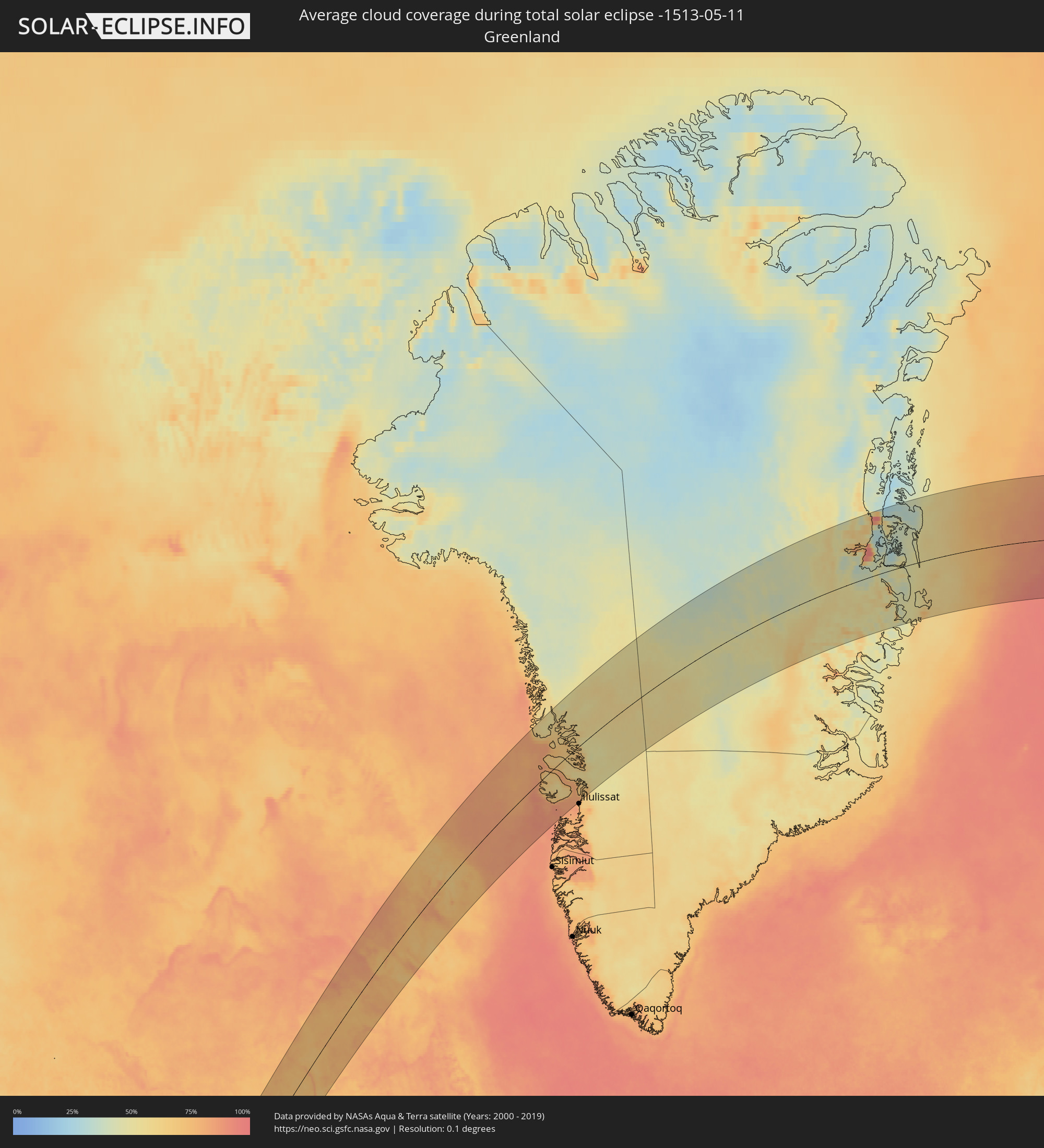 Greenland
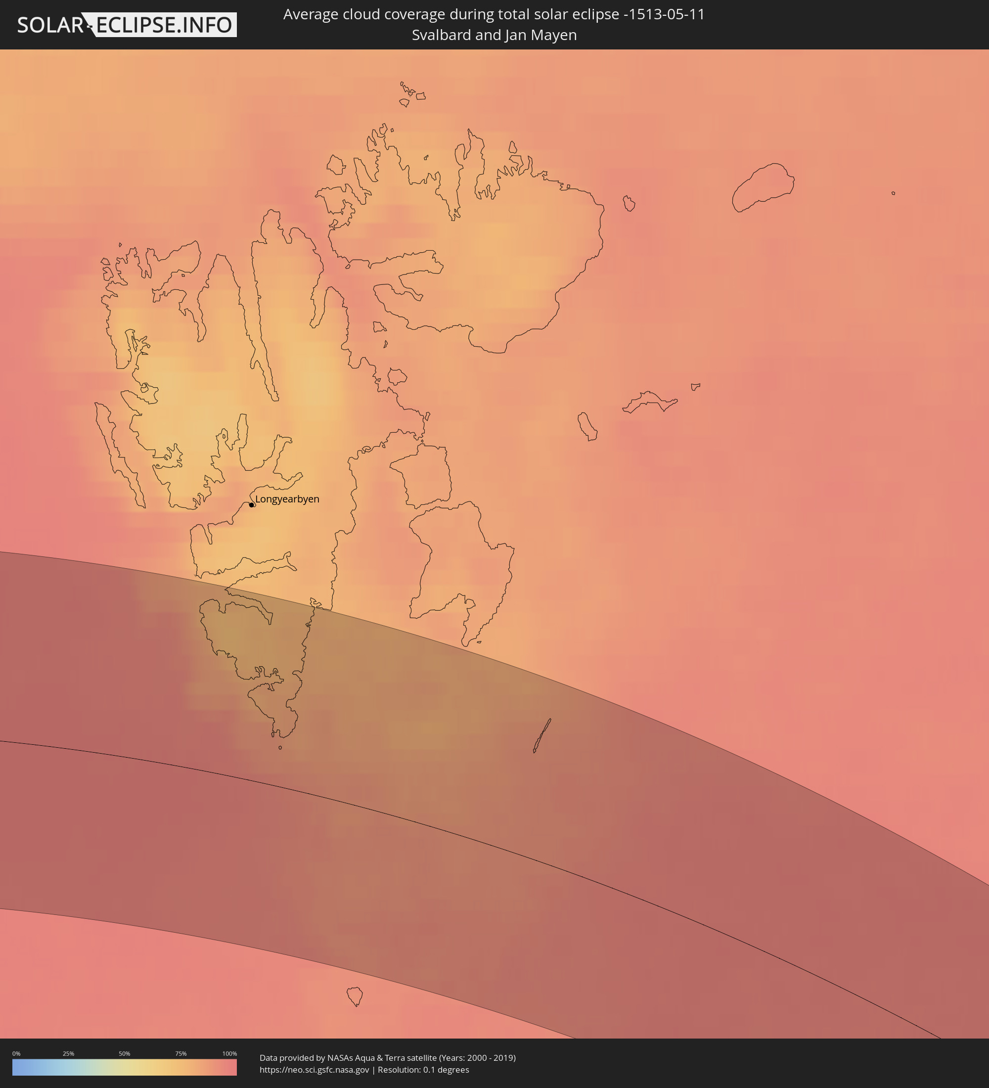 Svalbard and Jan Mayen
Cities inside the path of the eclipse
The following table shows all locations with a population of more than 5,000 inside the eclipse path. Cities which have more than 100,000 inhabitants are marked bold. A click at the locations opens a detailed map.
| City | Type | Eclipse duration | Local time of max. eclipse | Distance to central line | Ø Cloud coverage |
|
Villa Alberto Andrés Alvarado Arámburo, Baja California Sur
|
total | - | 07:00:08 UTC-07:05 | 113 km | 11% |
|
Santa Rosalia, Baja California Sur
|
total | - | 06:59:43 UTC-07:05 | 31 km | 8% |
|
Bahía de Kino, Sonora
|
total | - | 06:43:54 UTC-07:23 | 154 km | 17% |
|
Miguel Alemán (La Doce), Sonora
|
total | - | 06:43:58 UTC-07:23 | 133 km | 10% |
|
Loreto, Baja California Sur
|
total | - | 06:57:42 UTC-07:05 | 146 km | 21% |
|
Hermosillo, Sonora
|
total | - | 06:44:27 UTC-07:23 | 132 km | 11% |
|
Heroica Guaymas, Sonora
|
total | - | 06:42:33 UTC-07:23 | 24 km | 23% |
|
Pesqueira, Sonora
|
total | - | 06:44:54 UTC-07:23 | 151 km | 12% |
|
Empalme, Sonora
|
total | - | 06:42:37 UTC-07:23 | 31 km | 12% |
|
Potam, Sonora
|
total | - | 06:42:08 UTC-07:23 | 42 km | 10% |
|
Vicam, Sonora
|
total | - | 06:42:10 UTC-07:23 | 44 km | 11% |
|
San Ignacio Río Muerto, Sonora
|
total | - | 06:41:49 UTC-07:23 | 69 km | 13% |
|
Campo Sesenta, Sonora
|
total | - | 06:41:53 UTC-07:23 | 72 km | 12% |
|
Pueblo Yaqui, Sonora
|
total | - | 06:41:44 UTC-07:23 | 85 km | 14% |
|
Cocorit, Sonora
|
total | - | 06:42:06 UTC-07:23 | 71 km | 12% |
|
Ciudad Obregón, Sonora
|
total | - | 06:41:58 UTC-07:23 | 79 km | 12% |
|
El Tobarito, Sonora
|
total | - | 06:41:47 UTC-07:23 | 92 km | 13% |
|
Marte R. Gómez (Tobarito), Sonora
|
total | - | 06:41:47 UTC-07:23 | 92 km | 13% |
|
Villa Juarez, Sonora
|
total | - | 06:41:24 UTC-07:23 | 116 km | 14% |
|
Bacobampo, Sonora
|
total | - | 06:41:11 UTC-07:23 | 140 km | 15% |
|
Huatabampo, Sonora
|
total | - | 06:40:56 UTC-07:23 | 155 km | 18% |
|
Etchojoa, Sonora
|
total | - | 06:41:05 UTC-07:23 | 148 km | 16% |
|
La Unión, Sonora
|
total | - | 06:40:56 UTC-07:23 | 158 km | 18% |
|
Navojoa, Sonora
|
total | - | 06:41:21 UTC-07:23 | 145 km | 12% |
|
San Pedro Madera, Chihuahua
|
total | - | 07:03:12 UTC-07:05 | 33 km | 22% |
|
Ascención, Chihuahua
|
total | - | 07:06:26 UTC-07:05 | 146 km | 21% |
|
Benito Juárez, Chihuahua
|
total | - | 07:04:10 UTC-07:05 | 32 km | 27% |
|
Nuevo Casas Grandes, Chihuahua
|
total | - | 07:05:17 UTC-07:05 | 82 km | 21% |
|
Buenaventura, Chihuahua
|
total | - | 07:04:25 UTC-07:05 | 9 km | 28% |
|
Adolfo López Mateos, Chihuahua
|
total | - | 07:02:09 UTC-07:05 | 130 km | 22% |
|
Ejido Benito Juárez, Chihuahua
|
total | - | 07:05:03 UTC-07:05 | 13 km | 23% |
|
Cuauhtémoc, Chihuahua
|
total | - | 07:02:09 UTC-07:05 | 161 km | 25% |
|
Anáhuac, Chihuahua
|
total | - | 07:02:17 UTC-07:05 | 161 km | 24% |
|
Miguel Ahumada, Chihuahua
|
total | - | 07:05:56 UTC-07:05 | 22 km | 23% |
|
El Paso, Texas
|
total | - | 07:13:33 UTC-07:00 | 119 km | 19% |
|
Ciudad Juárez, Chihuahua
|
total | - | 07:07:51 UTC-07:05 | 117 km | 20% |
|
Socorro, Texas
|
total | - | 07:13:25 UTC-07:00 | 98 km | 19% |
|
Roswell, New Mexico
|
total | - | 07:16:57 UTC-07:00 | 135 km | 28% |
|
Carlsbad, New Mexico
|
total | - | 07:15:19 UTC-07:00 | 36 km | 31% |
|
Clovis, New Mexico
|
total | - | 07:19:11 UTC-07:00 | 136 km | 29% |
|
Hobbs, New Mexico
|
total | - | 07:16:10 UTC-07:00 | 27 km | 32% |
|
Odessa, Texas
|
total | - | 08:14:55 UTC-06:00 | 132 km | 31% |
|
Midland, Texas
|
total | - | 08:15:17 UTC-06:00 | 134 km | 31% |
|
Lubbock, Texas
|
total | - | 08:18:11 UTC-06:00 | 19 km | 34% |
|
Amarillo, Texas
|
total | - | 08:21:10 UTC-06:00 | 110 km | 33% |
|
Plainview, Texas
|
total | - | 08:19:20 UTC-06:00 | 21 km | 35% |
|
Big Spring, Texas
|
total | - | 08:15:57 UTC-06:00 | 151 km | 37% |
|
Altus, Oklahoma
|
total | - | 08:21:08 UTC-06:00 | 100 km | 48% |
|
Lawton, Oklahoma
|
total | - | 08:21:30 UTC-06:00 | 165 km | 52% |
|
Hutchinson, Kansas
|
total | - | 08:28:09 UTC-06:00 | 65 km | 48% |
|
Enid, Oklahoma
|
total | - | 08:25:03 UTC-06:00 | 64 km | 49% |
|
Yukon, Oklahoma
|
total | - | 08:23:27 UTC-06:00 | 137 km | 52% |
|
Salina, Kansas
|
total | - | 08:29:46 UTC-06:00 | 102 km | 51% |
|
Oklahoma City, Oklahoma
|
total | - | 08:23:30 UTC-06:00 | 158 km | 55% |
|
Edmond, Oklahoma
|
total | - | 08:23:52 UTC-06:00 | 146 km | 56% |
|
Newton, Kansas
|
total | - | 08:28:25 UTC-06:00 | 30 km | 51% |
|
Wichita, Kansas
|
total | - | 08:27:45 UTC-06:00 | 18 km | 54% |
|
Derby, Kansas
|
total | - | 08:27:31 UTC-06:00 | 21 km | 53% |
|
Ponca City, Oklahoma
|
total | - | 08:26:02 UTC-06:00 | 94 km | 53% |
|
Stillwater, Oklahoma
|
total | - | 08:24:56 UTC-06:00 | 141 km | 58% |
|
Junction City, Kansas
|
total | - | 08:30:32 UTC-06:00 | 62 km | 55% |
|
Lincoln, Nebraska
|
total | - | 08:33:58 UTC-06:00 | 167 km | 60% |
|
Manhattan, Kansas
|
total | - | 08:30:58 UTC-06:00 | 53 km | 57% |
|
Emporia, Kansas
|
total | - | 08:29:42 UTC-06:00 | 31 km | 56% |
|
Bartlesville, Oklahoma
|
total | - | 08:26:41 UTC-06:00 | 164 km | 62% |
|
Omaha, Nebraska
|
total | - | 08:35:15 UTC-06:00 | 147 km | 65% |
|
Topeka, Kansas
|
total | - | 08:31:12 UTC-06:00 | 28 km | 59% |
|
Lawrence, Kansas
|
total | - | 08:31:18 UTC-06:00 | 64 km | 60% |
|
Leavenworth, Kansas
|
total | - | 08:32:08 UTC-06:00 | 54 km | 62% |
|
Saint Joseph, Missouri
|
total | - | 08:33:03 UTC-06:00 | 30 km | 61% |
|
Olathe, Kansas
|
total | - | 08:31:22 UTC-06:00 | 91 km | 63% |
|
Overland Park, Kansas
|
total | - | 08:31:39 UTC-06:00 | 93 km | 62% |
|
Kansas City, Missouri
|
total | - | 08:31:56 UTC-06:00 | 92 km | 63% |
|
Belton, Missouri
|
total | - | 08:31:24 UTC-06:00 | 114 km | 61% |
|
Liberty, Missouri
|
total | - | 08:32:18 UTC-06:00 | 98 km | 63% |
|
Lee's Summit, Missouri
|
total | - | 08:31:41 UTC-06:00 | 117 km | 62% |
|
East Independence, Missouri
|
total | - | 08:32:03 UTC-06:00 | 109 km | 63% |
|
Fort Dodge, Iowa
|
total | - | 08:38:39 UTC-06:00 | 109 km | 69% |
|
Ames, Iowa
|
total | - | 08:38:06 UTC-06:00 | 51 km | 68% |
|
Des Moines, Iowa
|
total | - | 08:37:17 UTC-06:00 | 12 km | 68% |
|
Faribault, Minnesota
|
total | - | 08:42:38 UTC-06:00 | 160 km | 74% |
|
Owatonna, Minnesota
|
total | - | 08:42:15 UTC-06:00 | 148 km | 74% |
|
Mason City, Iowa
|
total | - | 08:40:30 UTC-06:00 | 87 km | 77% |
|
Northfield, Minnesota
|
total | - | 08:43:01 UTC-06:00 | 162 km | 74% |
|
Farmington, Minnesota
|
total | - | 08:43:22 UTC-06:00 | 173 km | 73% |
|
Austin, Minnesota
|
total | - | 08:41:37 UTC-06:00 | 101 km | 77% |
|
Cottage Grove, Minnesota
|
total | - | 08:43:51 UTC-06:00 | 172 km | 73% |
|
Marshalltown, Iowa
|
total | - | 08:38:35 UTC-06:00 | 8 km | 75% |
|
Rochester, Minnesota
|
total | - | 08:42:37 UTC-06:00 | 90 km | 77% |
|
Ottumwa, Iowa
|
total | - | 08:36:56 UTC-06:00 | 107 km | 66% |
|
Waterloo, Iowa
|
total | - | 08:39:47 UTC-06:00 | 15 km | 76% |
|
Cedar Rapids, Iowa
|
total | - | 08:39:19 UTC-06:00 | 94 km | 74% |
|
Winona, Minnesota
|
total | - | 08:43:14 UTC-06:00 | 49 km | 81% |
|
Iowa City, Iowa
|
total | - | 08:38:44 UTC-06:00 | 129 km | 77% |
|
Eau Claire, Wisconsin
|
total | - | 08:44:46 UTC-06:00 | 80 km | 77% |
|
La Crosse, Wisconsin
|
total | - | 08:43:01 UTC-06:00 | 29 km | 78% |
|
Muscatine, Iowa
|
total | - | 08:38:36 UTC-06:00 | 175 km | 75% |
|
Dubuque, Iowa
|
total | - | 08:40:56 UTC-06:00 | 127 km | 78% |
|
Wausau, Wisconsin
|
total | - | 08:46:21 UTC-06:00 | 41 km | 77% |
|
Stevens Point, Wisconsin
|
total | - | 08:45:33 UTC-06:00 | 76 km | 79% |
|
Thunder Bay, Ontario
|
total | - | 09:53:04 UTC-05:00 | 140 km | 65% |
|
Appleton, Wisconsin
|
total | - | 08:45:54 UTC-06:00 | 165 km | 79% |
|
Marquette, Michigan
|
total | - | 09:50:59 UTC-05:00 | 90 km | 68% |
|
Iqaluit, Nunavut
|
total | - | 10:33:30 UTC-05:00 | 25 km | 74% |