Totale Sonnenfinsternis vom 18.03.-1595
| Wochentag: | Mittwoch |
| Maximale Dauer der Verfinsterung: | 03m33s |
| Maximale Breite des Finsternispfades: | 607 km |
| Saroszyklus: | 4 |
| Bedeckungsgrad: | 100% |
| Magnitude: | 1.0547 |
| Gamma: | 0.9531 |
Wo kann man die Sonnenfinsternis vom 18.03.-1595 sehen?
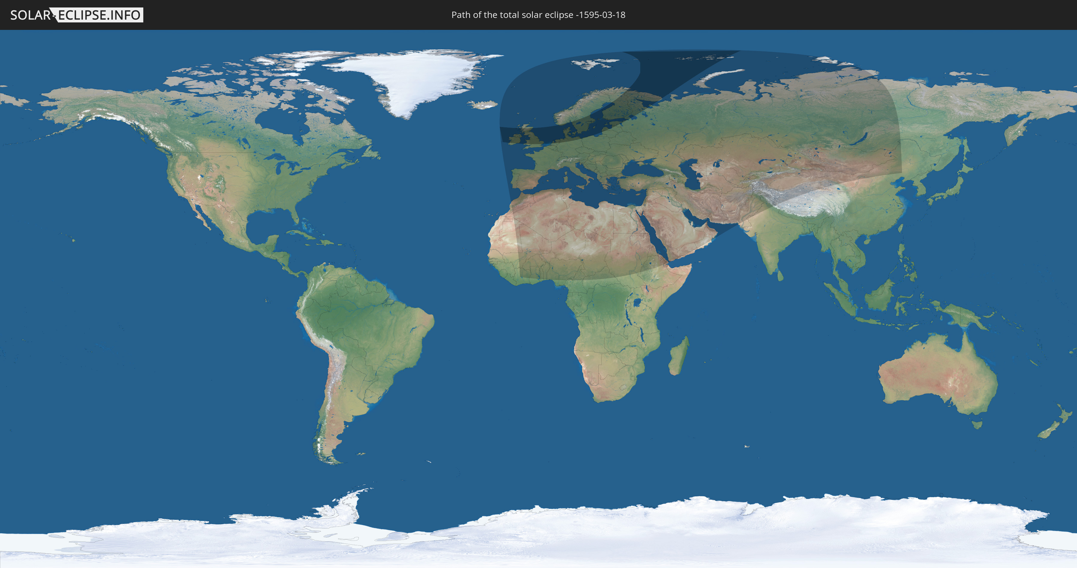
Die Sonnenfinsternis am 18.03.-1595 kann man in 100 Ländern als partielle Sonnenfinsternis beobachten.
Der Finsternispfad verläuft durch 16 Länder. Nur in diesen Ländern ist sie als totale Sonnenfinsternis zu sehen.
In den folgenden Ländern ist die Sonnenfinsternis total zu sehen
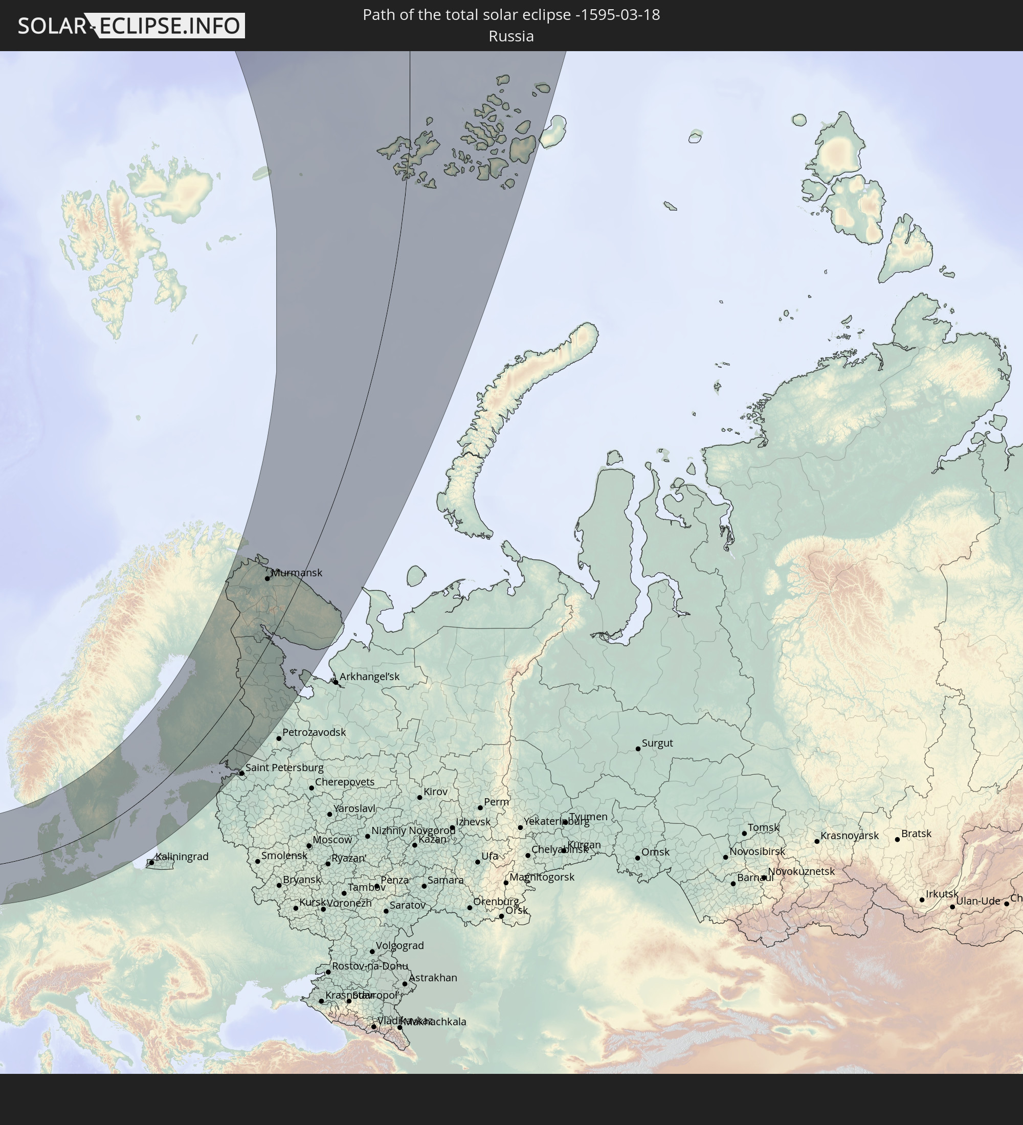 Russland
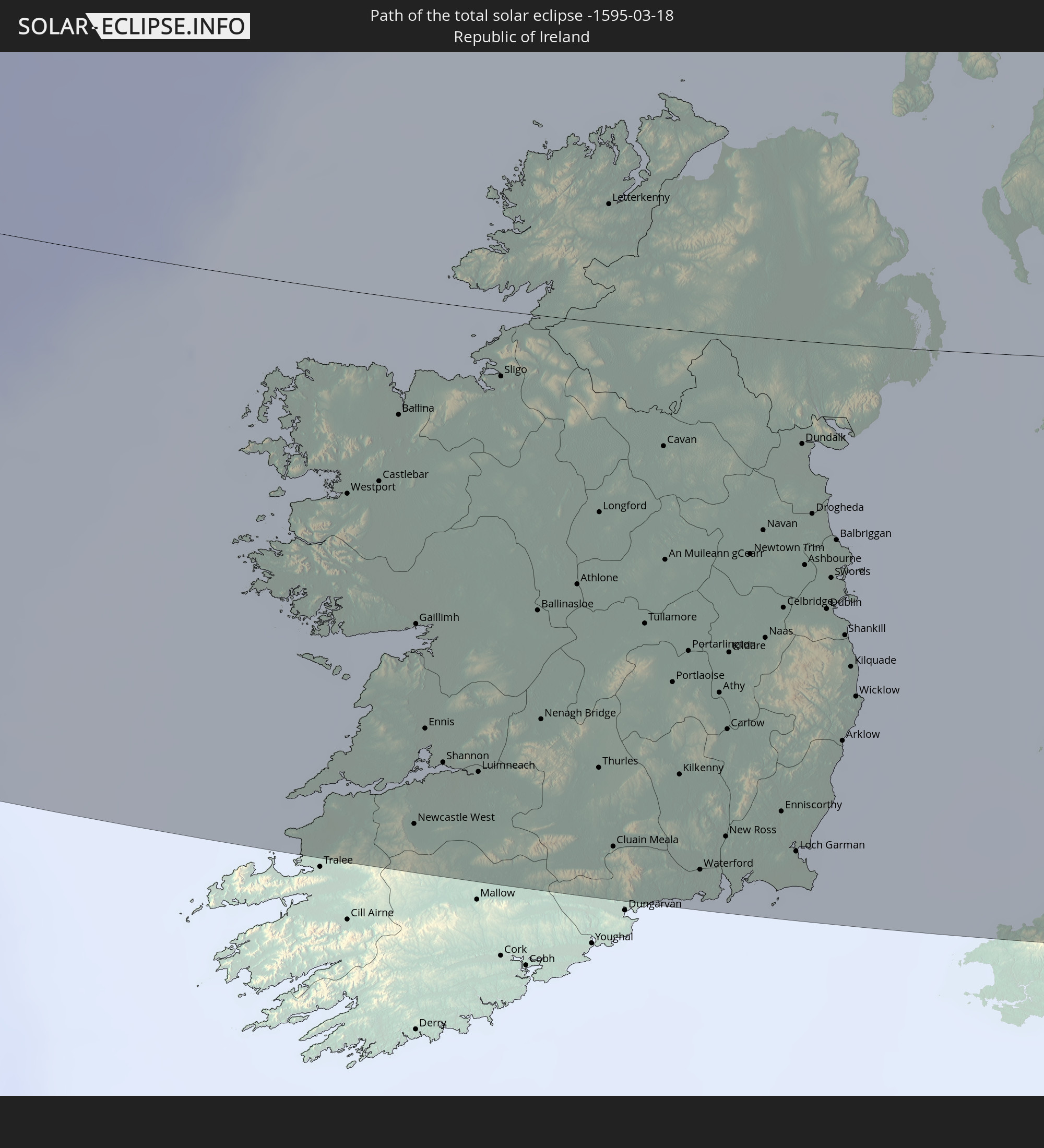 Irland
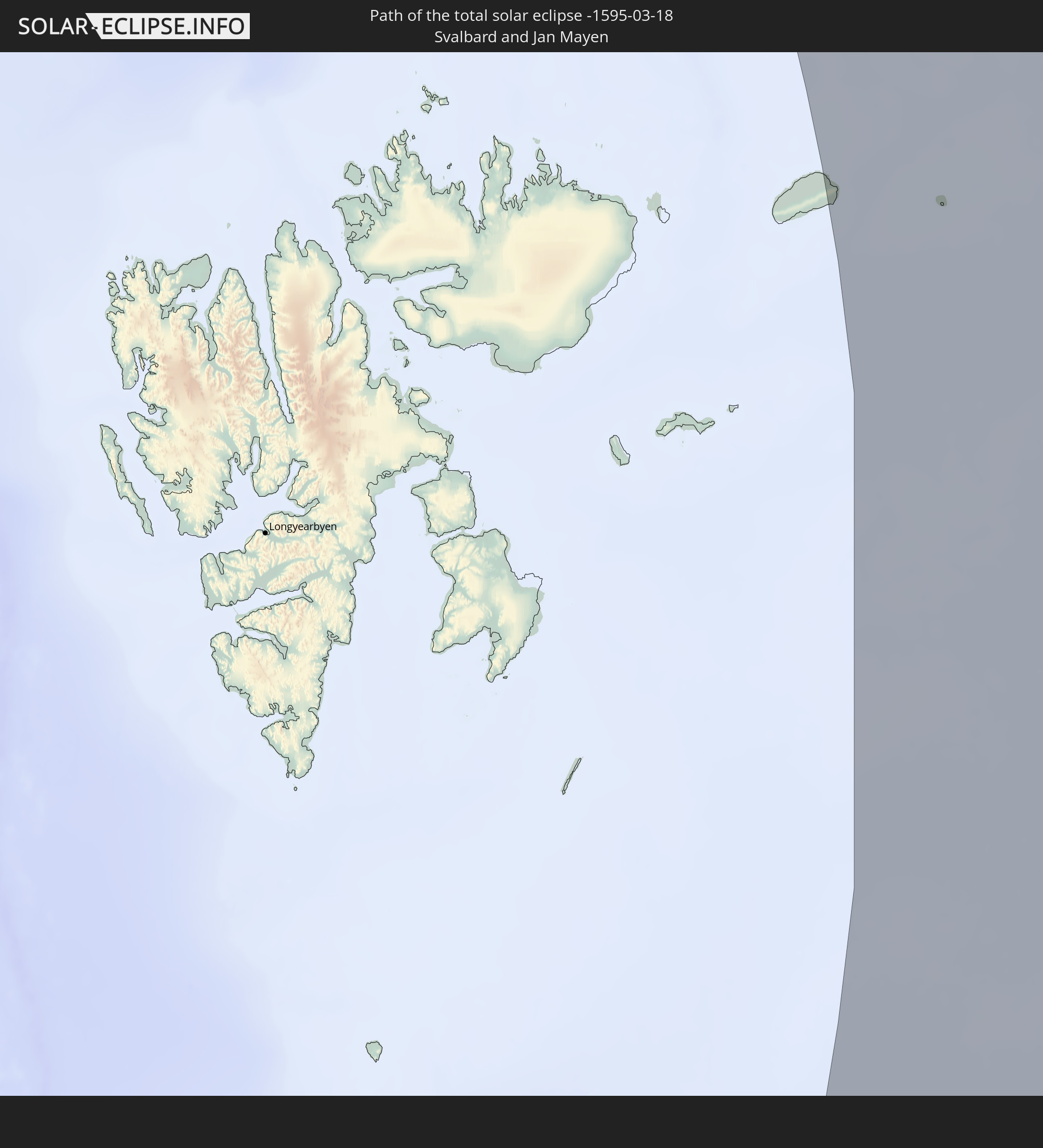 Spitzbergen
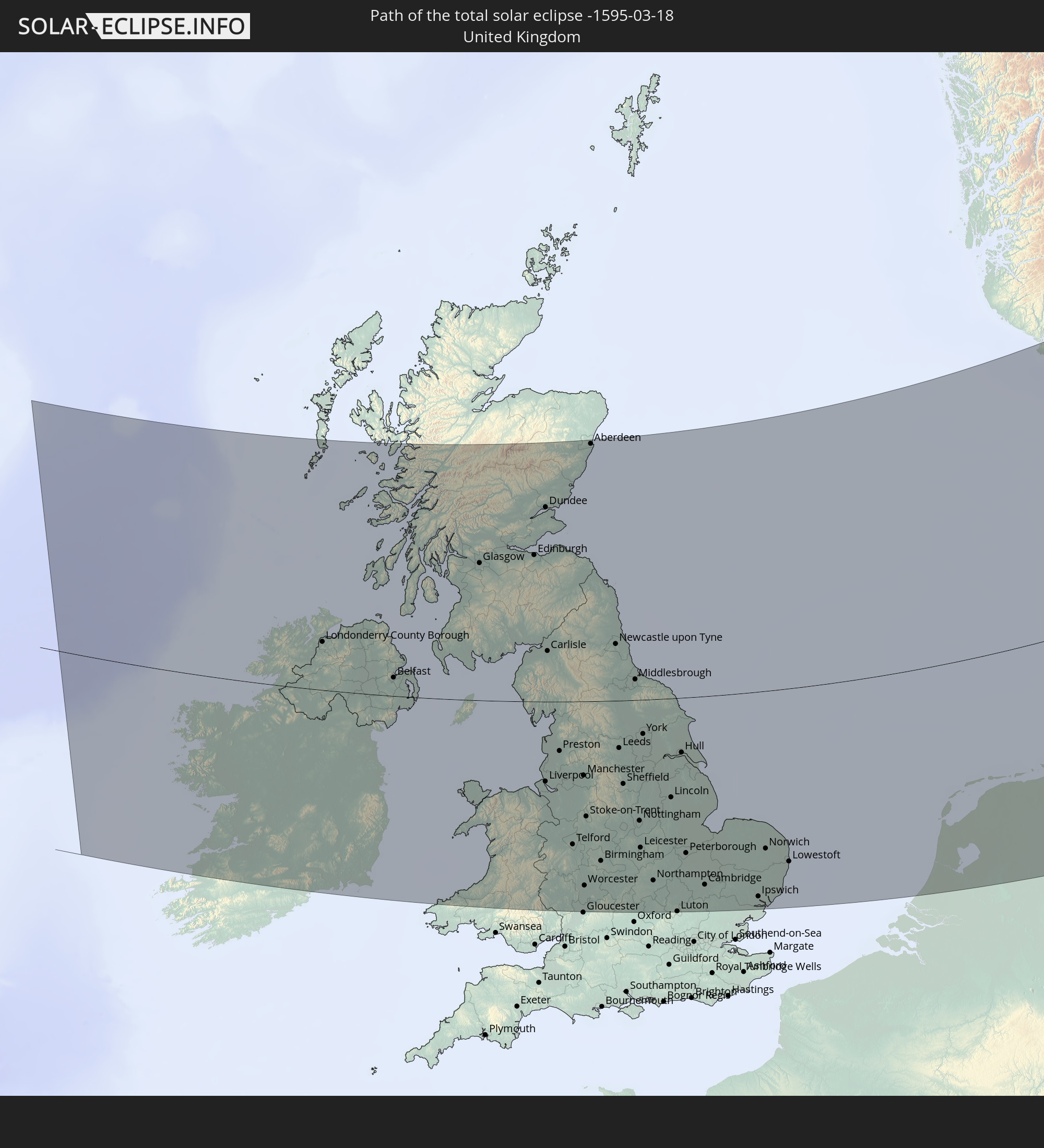 Vereinigtes Königreich
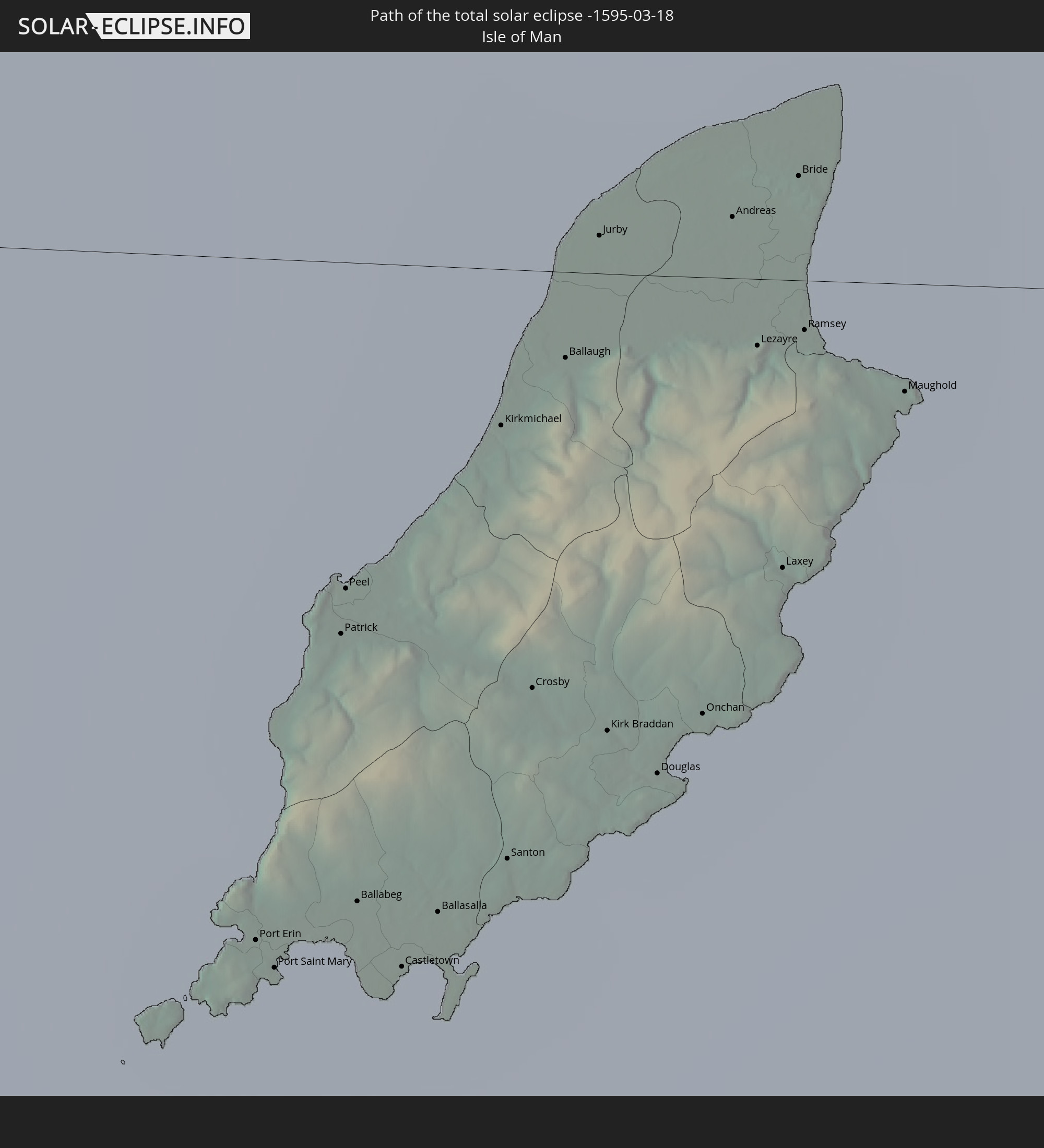 Isle of Man
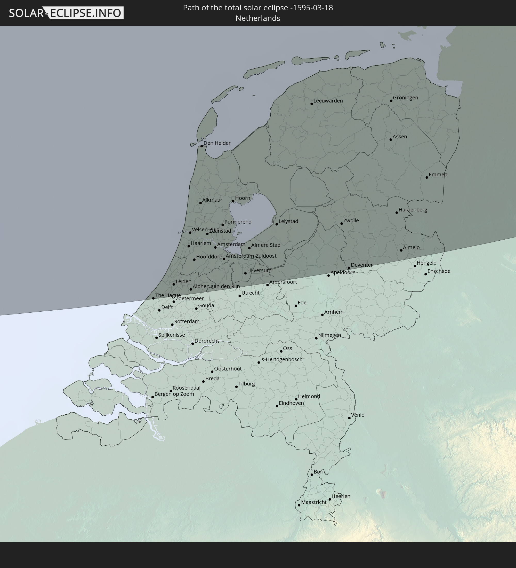 Niederlande
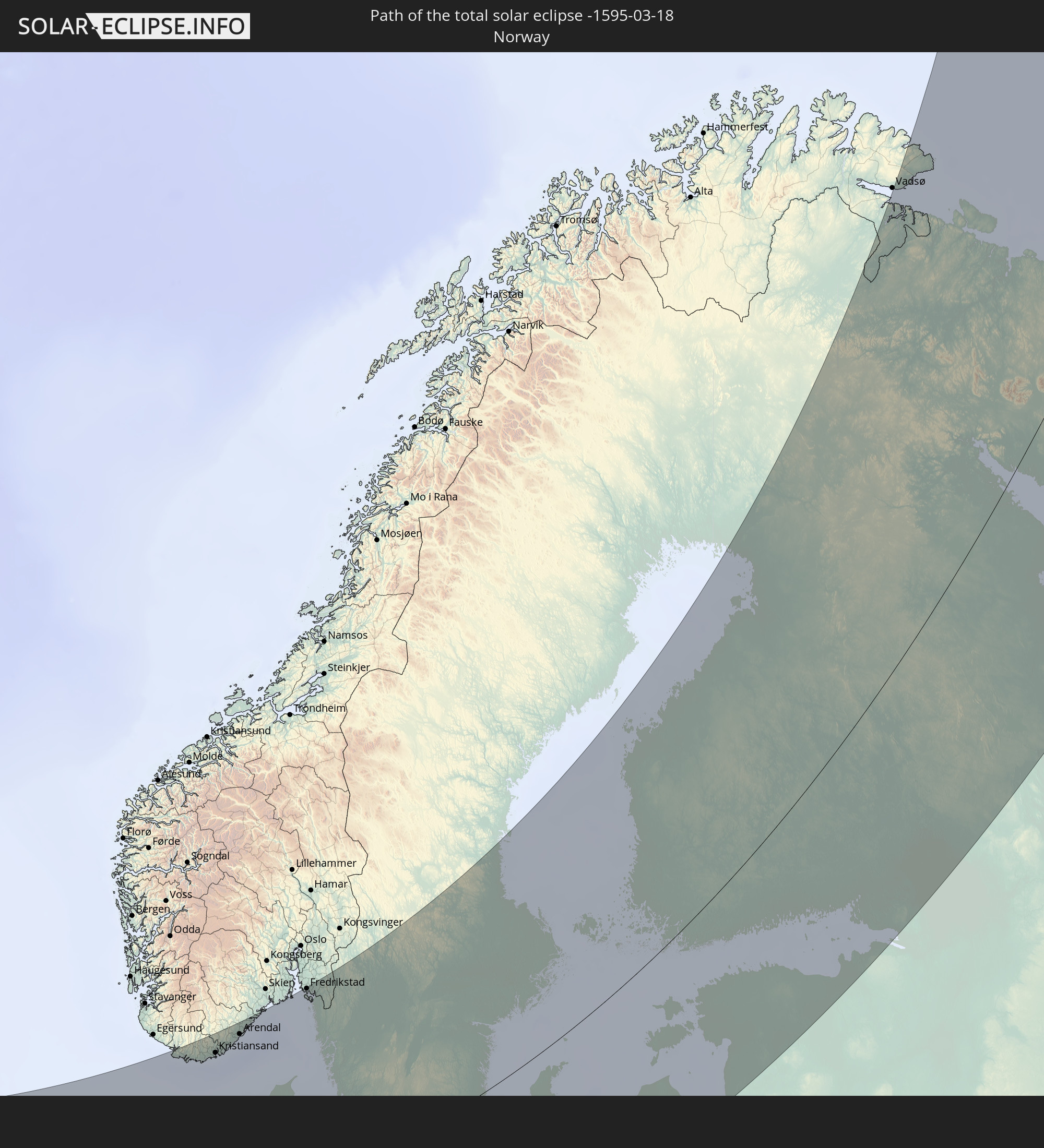 Norwegen
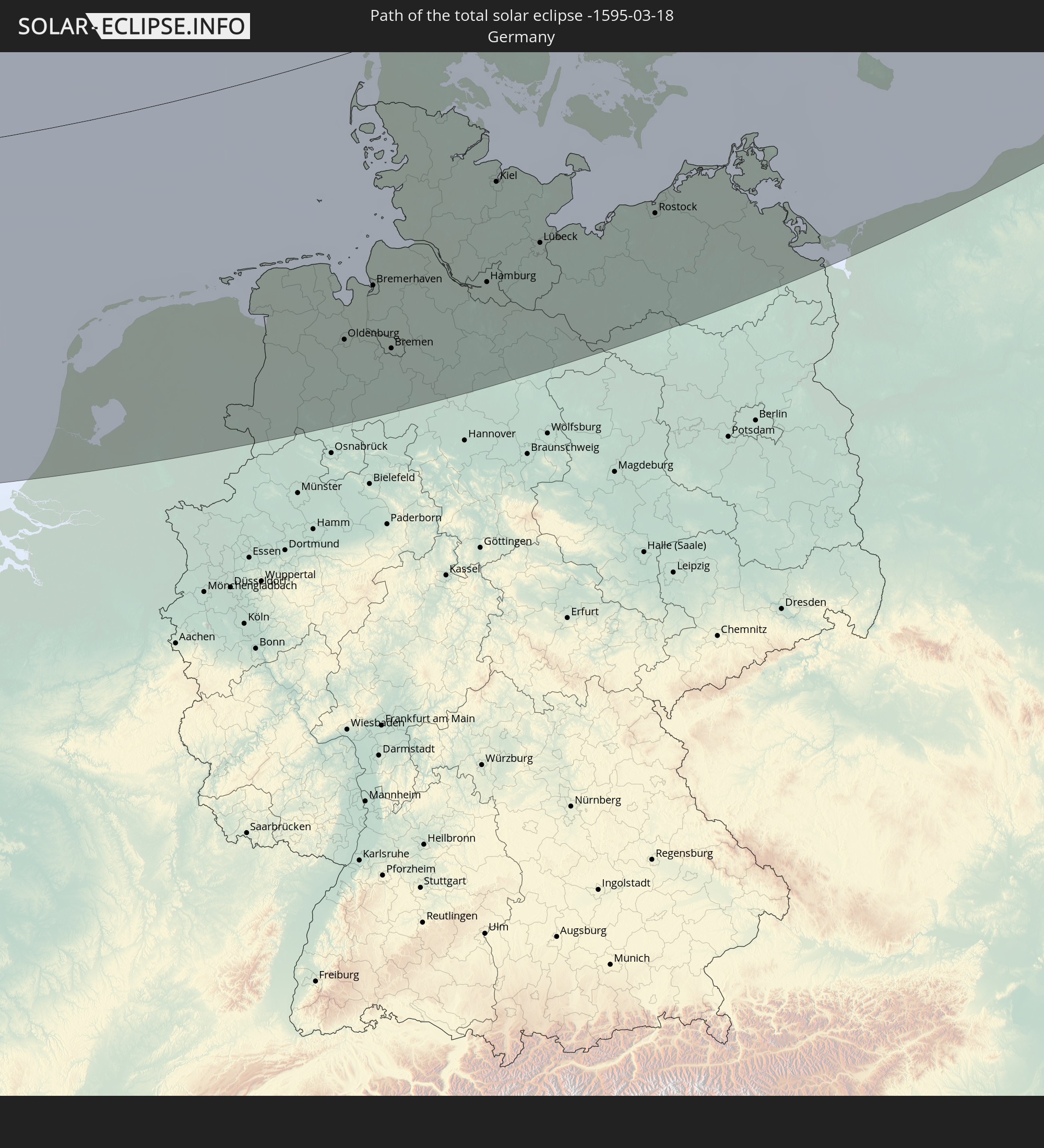 Deutschland
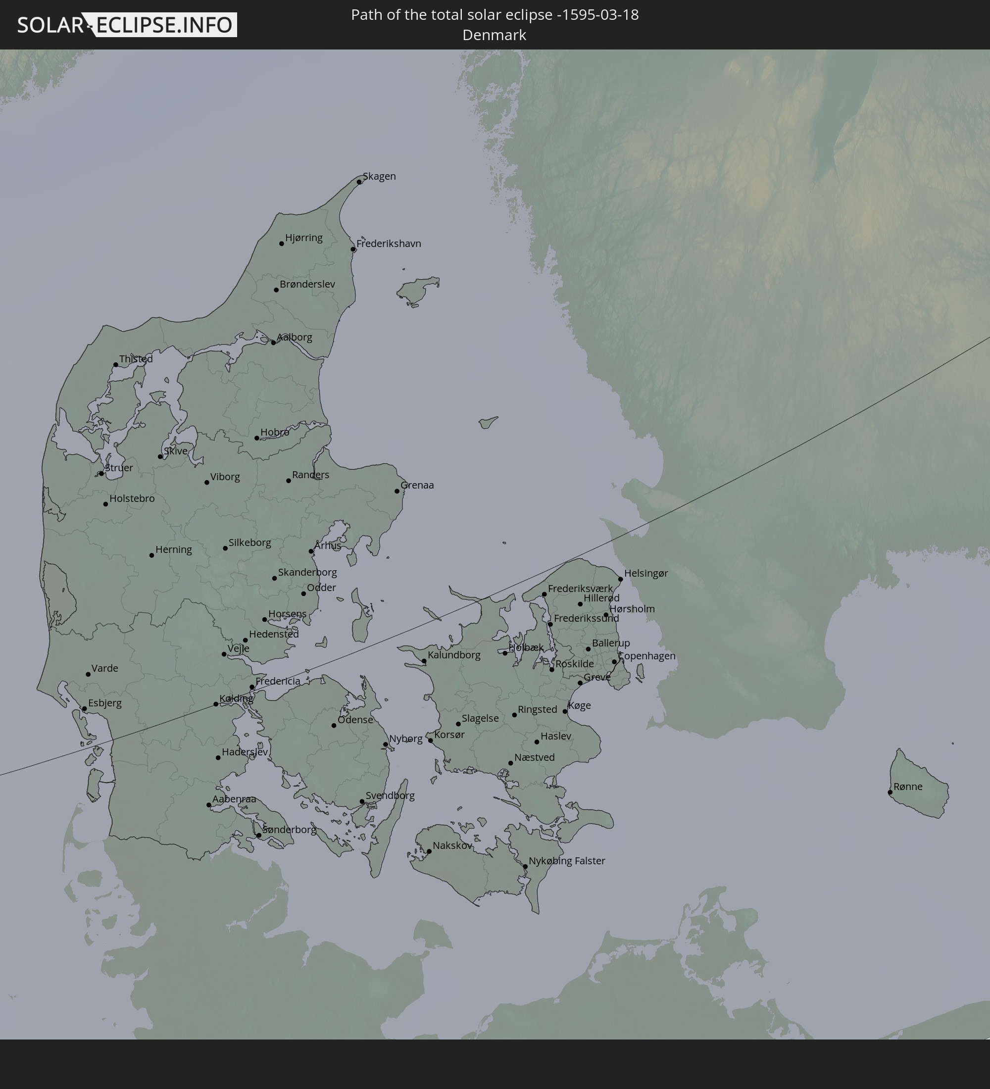 Dänemark
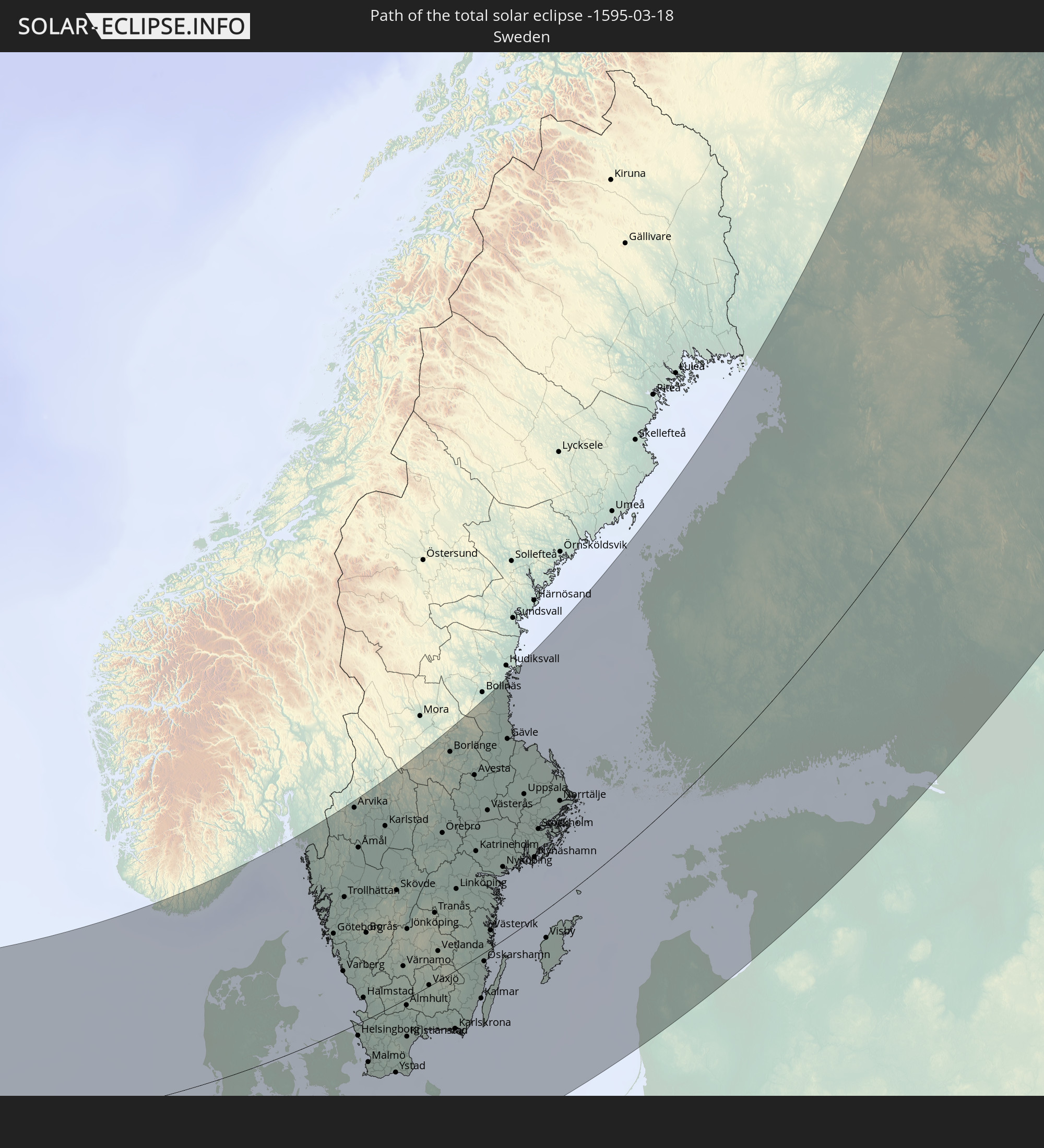 Schweden
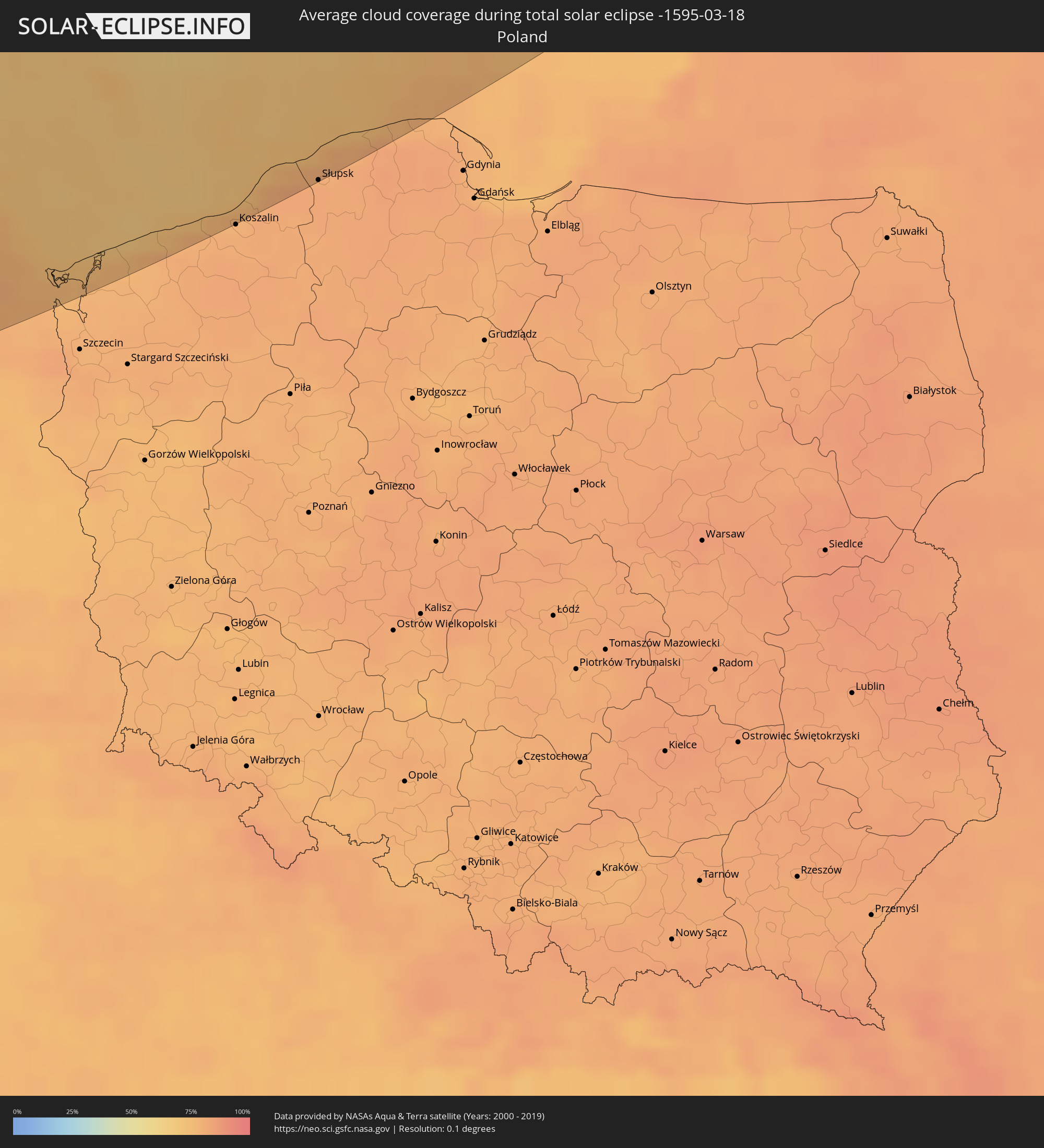
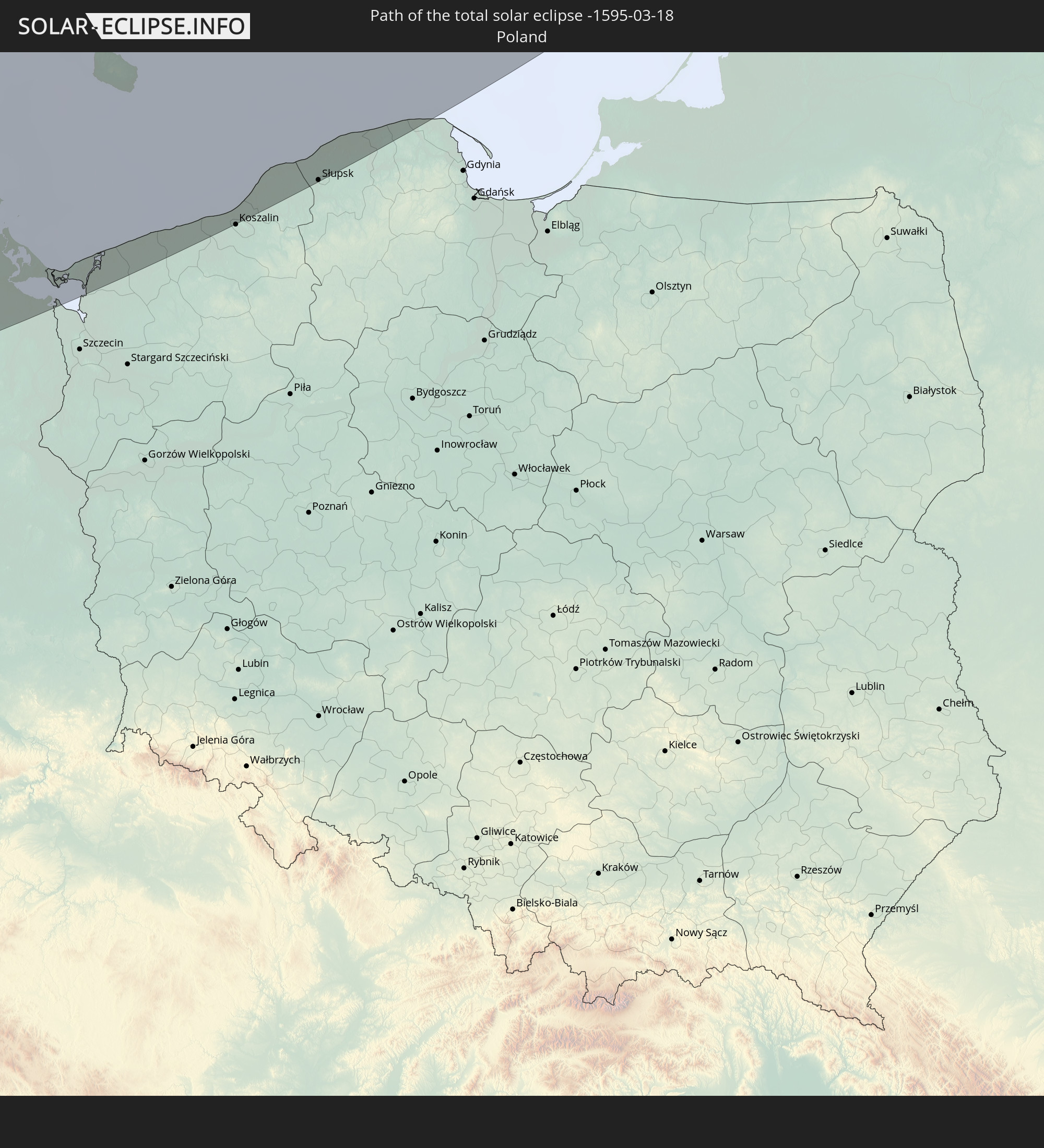 Polen
Polen
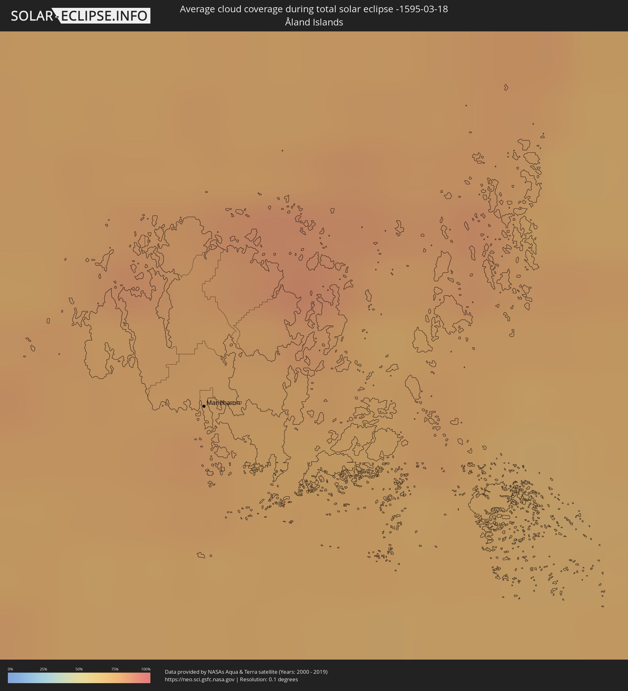
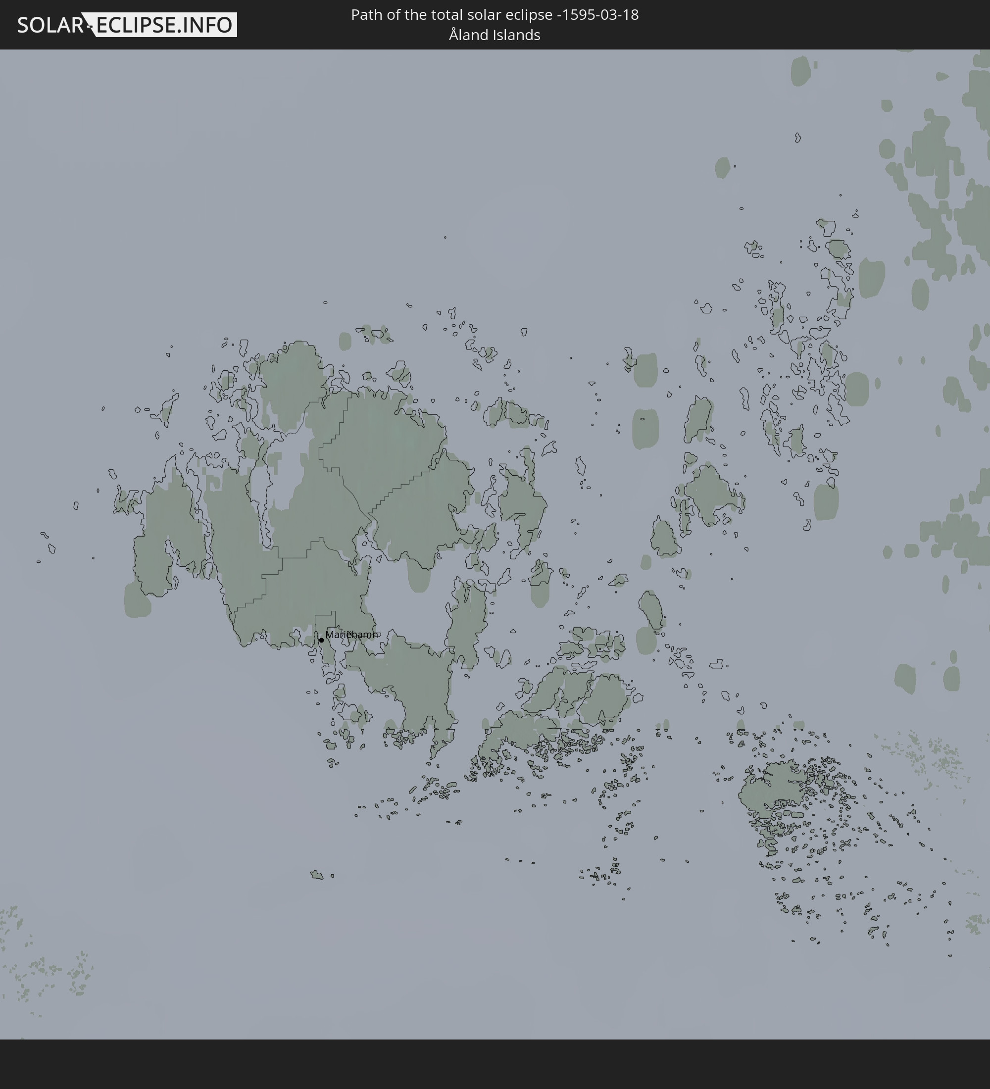 Åland Islands
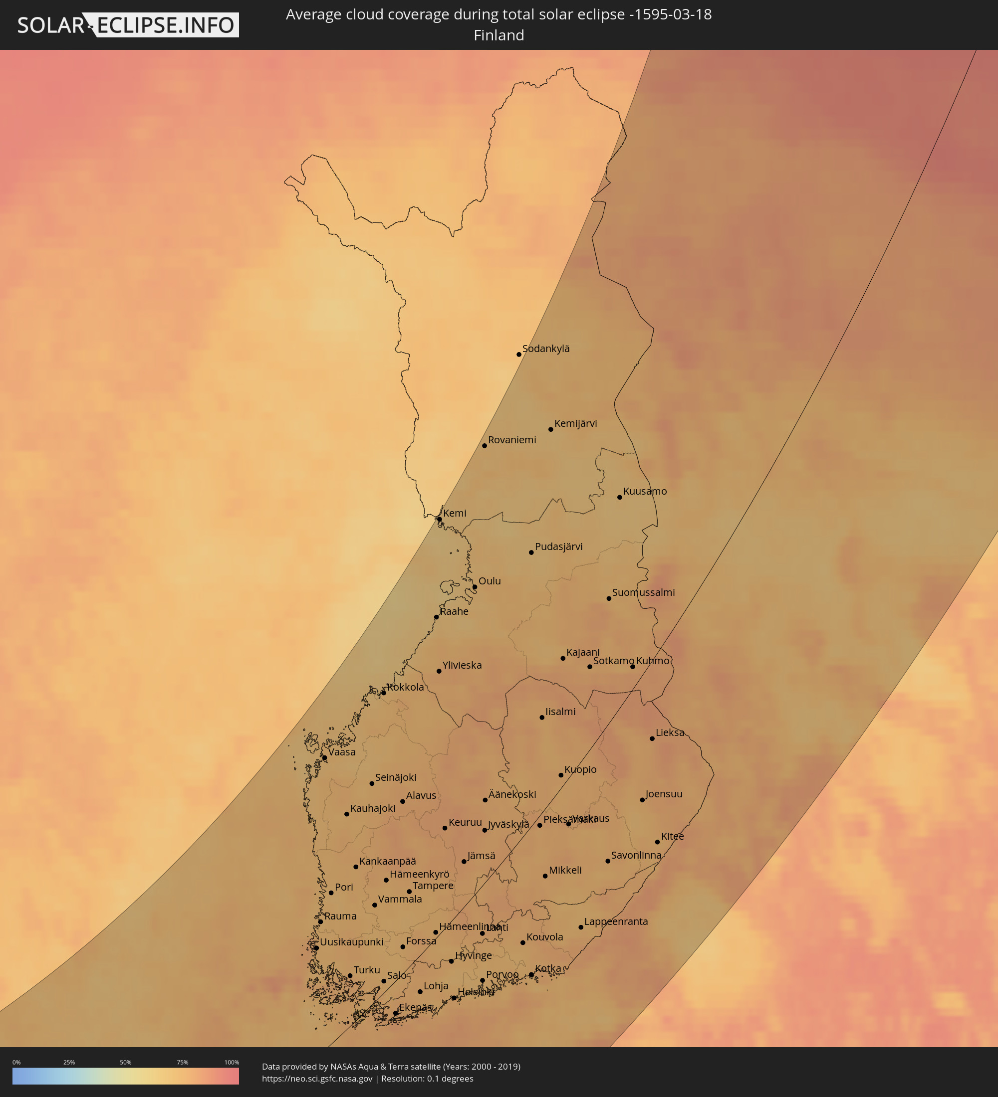
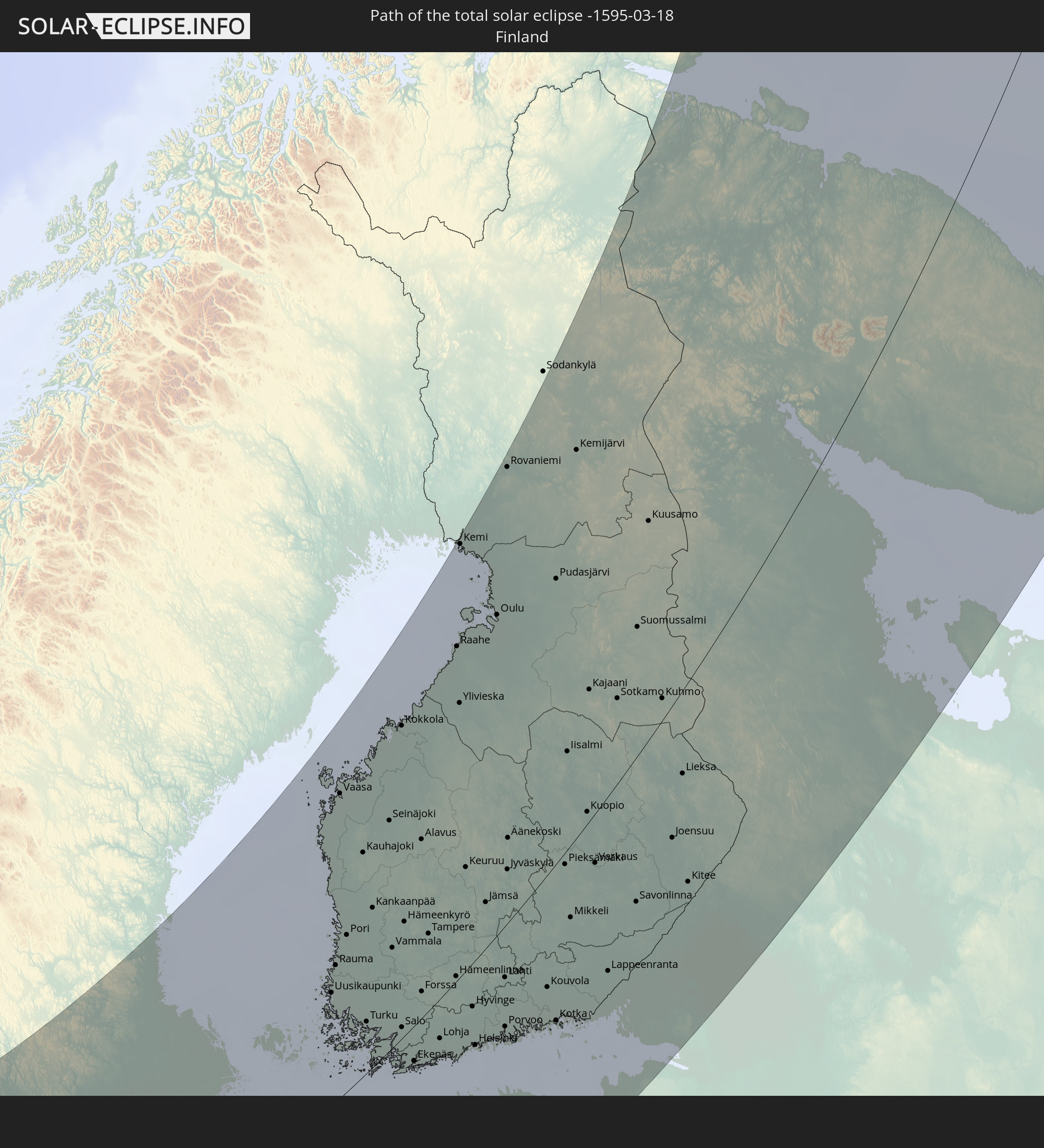 Finnland
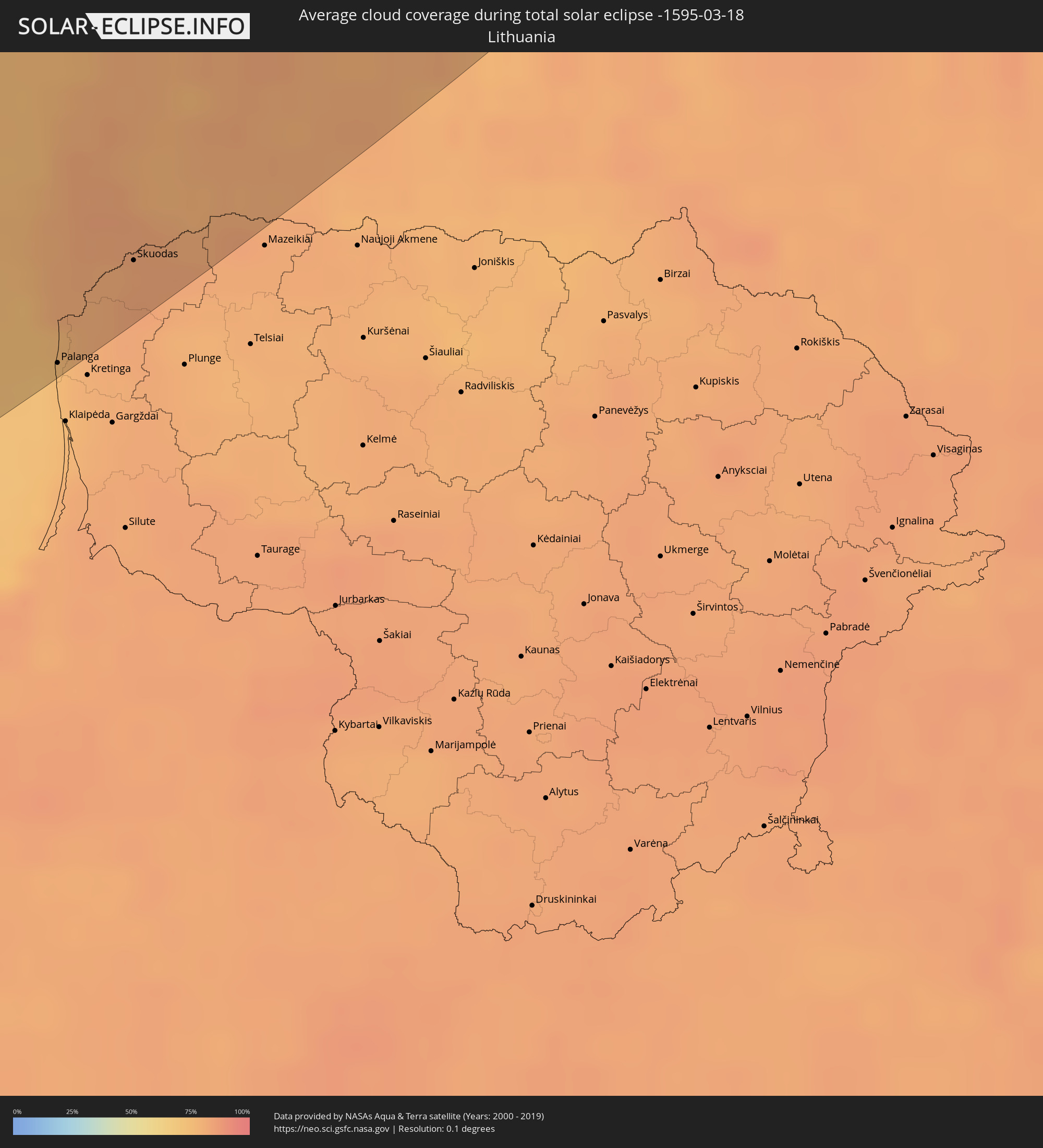
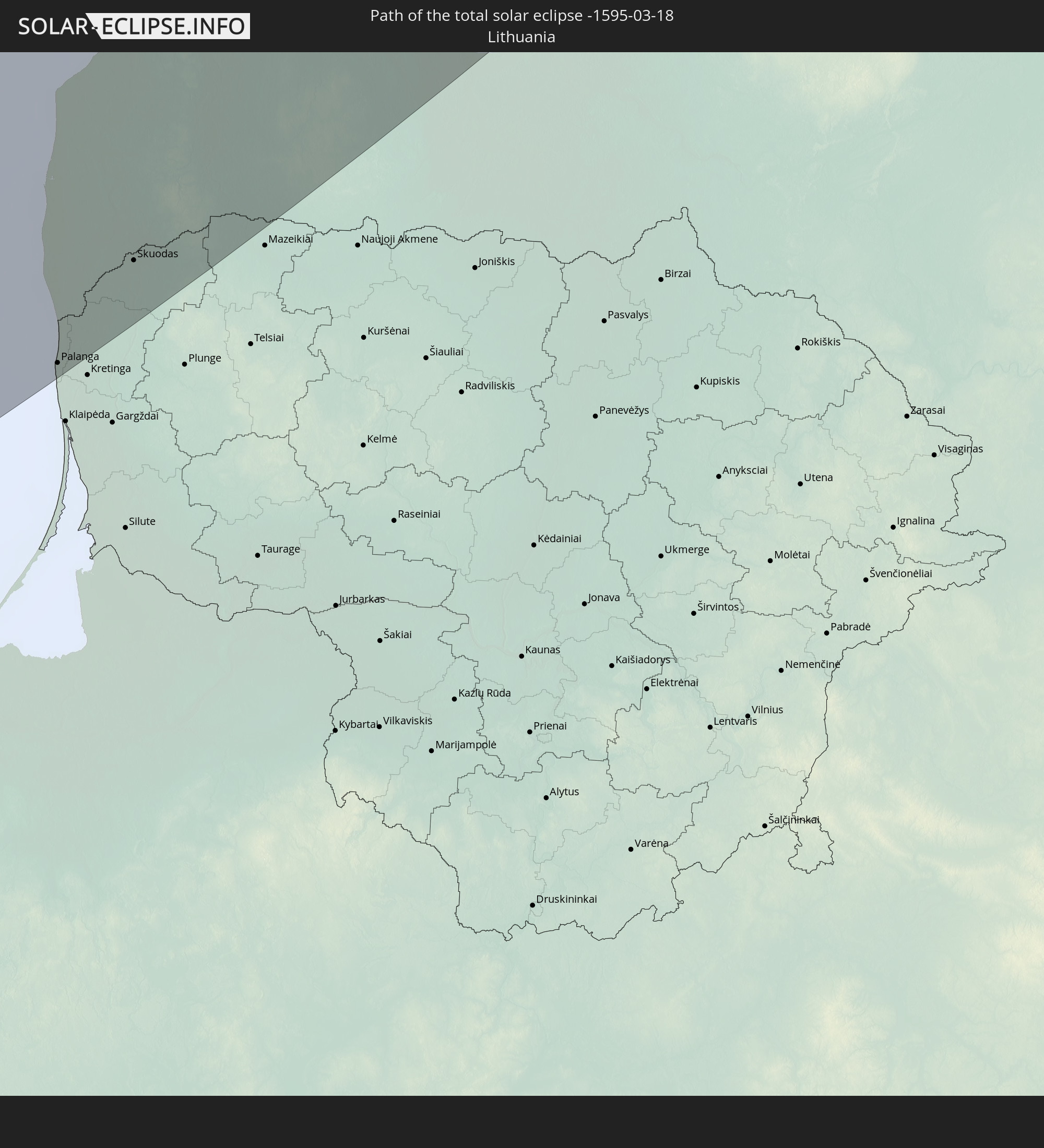 Litauen
 Lettland
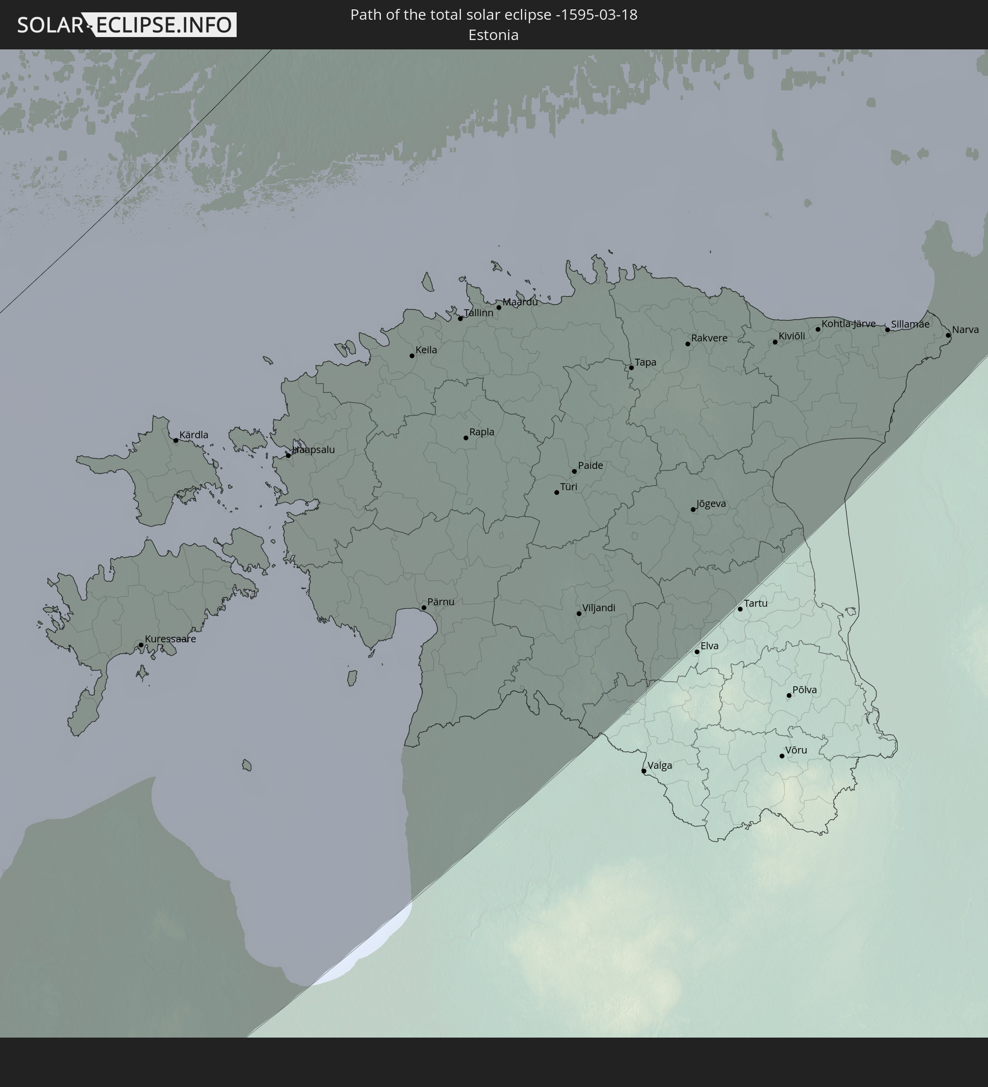 Estland
In den folgenden Ländern ist die Sonnenfinsternis partiell zu sehen
 Russland
 Portugal
 Spanien
 Mauretanien
 Marokko
 Mali
Mali
 Irland
 Spitzbergen
 Algerien
 Vereinigtes Königreich
 Elfenbeinküste
 Färöer
 Burkina Faso
 Gibraltar
 Frankreich
 Isle of Man
 Ghana
Ghana
 Guernsey
 Jersey
 Togo
Togo
 Niger
Niger
 Benin
Benin
 Andorra
 Belgien
 Nigeria
 Niederlande
 Norwegen
 Luxemburg
 Deutschland
 Schweiz
 Italien
 Monaco
 Tunesien
 Dänemark
 Kamerun
 Libyen
 Liechtenstein
 Österreich
 Schweden
 Tschechien
 San Marino
 Vatikanstadt
 Slowenien
 Tschad
 Kroatien
 Polen
Polen
 Malta
Malta
 Zentralafrikanische Republik
 Bosnien und Herzegowina
 Ungarn
 Slowakei
 Montenegro
 Serbien
 Albanien
 Åland Islands
 Griechenland
 Rumänien
 Mazedonien
 Finnland
 Litauen
 Lettland
 Estland
 Sudan
Sudan
 Ukraine
 Bulgarien
 Weißrussland
 Ägypten
 Türkei
 Moldawien
 Republik Zypern
 Äthiopien
 Staat Palästina
 Israel
 Saudi-Arabien
 Jordanien
 Libanon
 Syrien
 Eritrea
 Irak
Irak
 Georgien
 Dschibuti
 Jemen
Jemen
 Armenien
 Iran
Iran
 Aserbaidschan
 Kasachstan
 Kuwait
 Bahrain
 Katar
Katar
 Vereinigte Arabische Emirate
 Oman
Oman
 Turkmenistan
 Usbekistan
 Afghanistan
 Pakistan
 Tadschikistan
 Indien
 Kirgisistan
 Volksrepublik China
 Mongolei
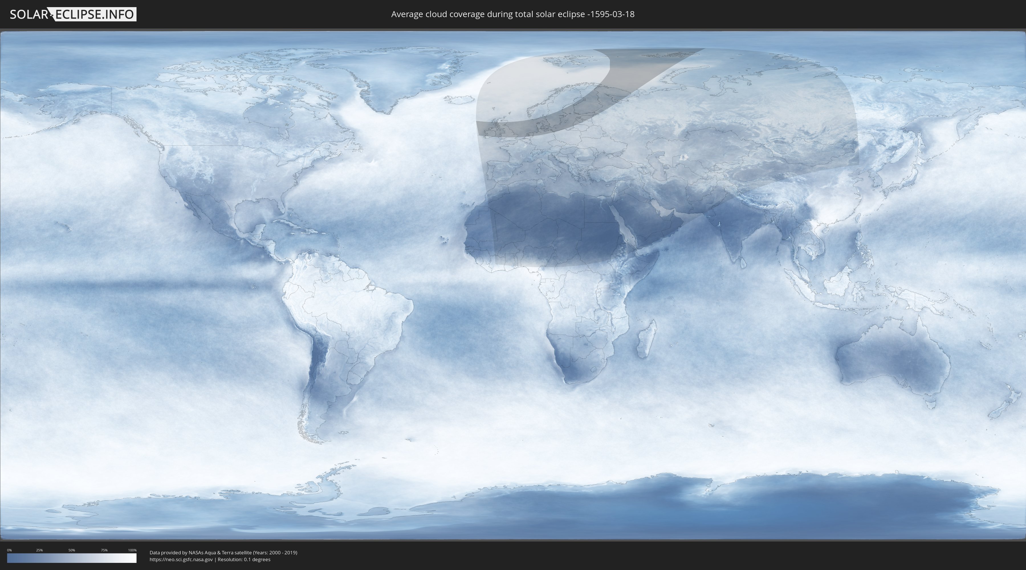
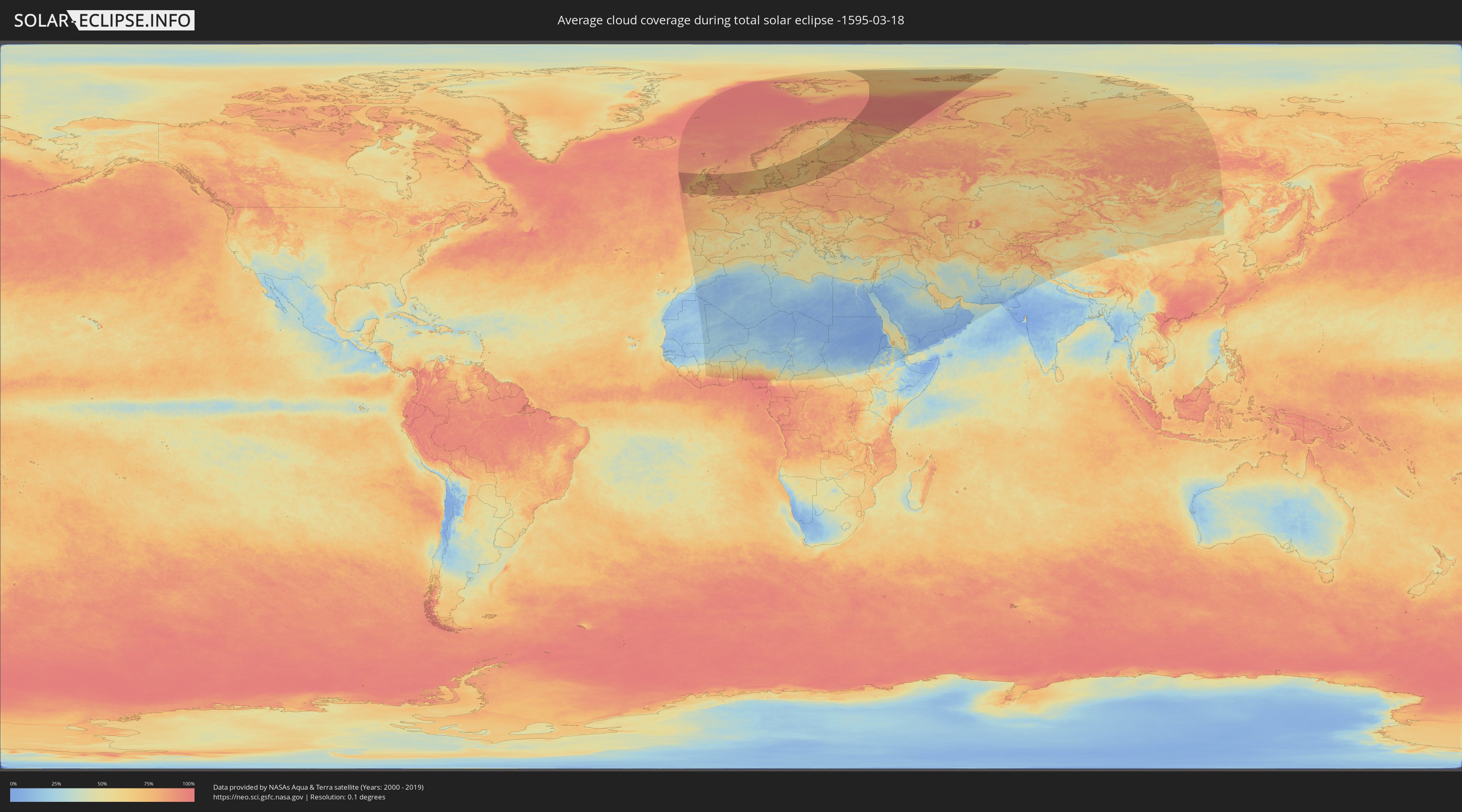
Wie wird das Wetter während der totalen Sonnenfinsternis am 18.03.-1595?
Wo ist der beste Ort, um die totale Sonnenfinsternis vom 18.03.-1595 zu beobachten?
Die folgenden Karten zeigen die durchschnittliche Bewölkung für den Tag, an dem die totale Sonnenfinsternis
stattfindet. Mit Hilfe der Karten lässt sich der Ort entlang des Finsternispfades eingrenzen,
der die besten Aussichen auf einen klaren wolkenfreien Himmel bietet.
Trotzdem muss man immer lokale Gegenenheiten beachten und sollte sich genau über das Wetter an seinem
gewählten Beobachtungsort informieren.
Die Daten stammen von den beiden NASA-Satelliten
AQUA und TERRA
und wurden über einen Zeitraum von 19 Jahren (2000 - 2019) gemittelt.
Detaillierte Länderkarten
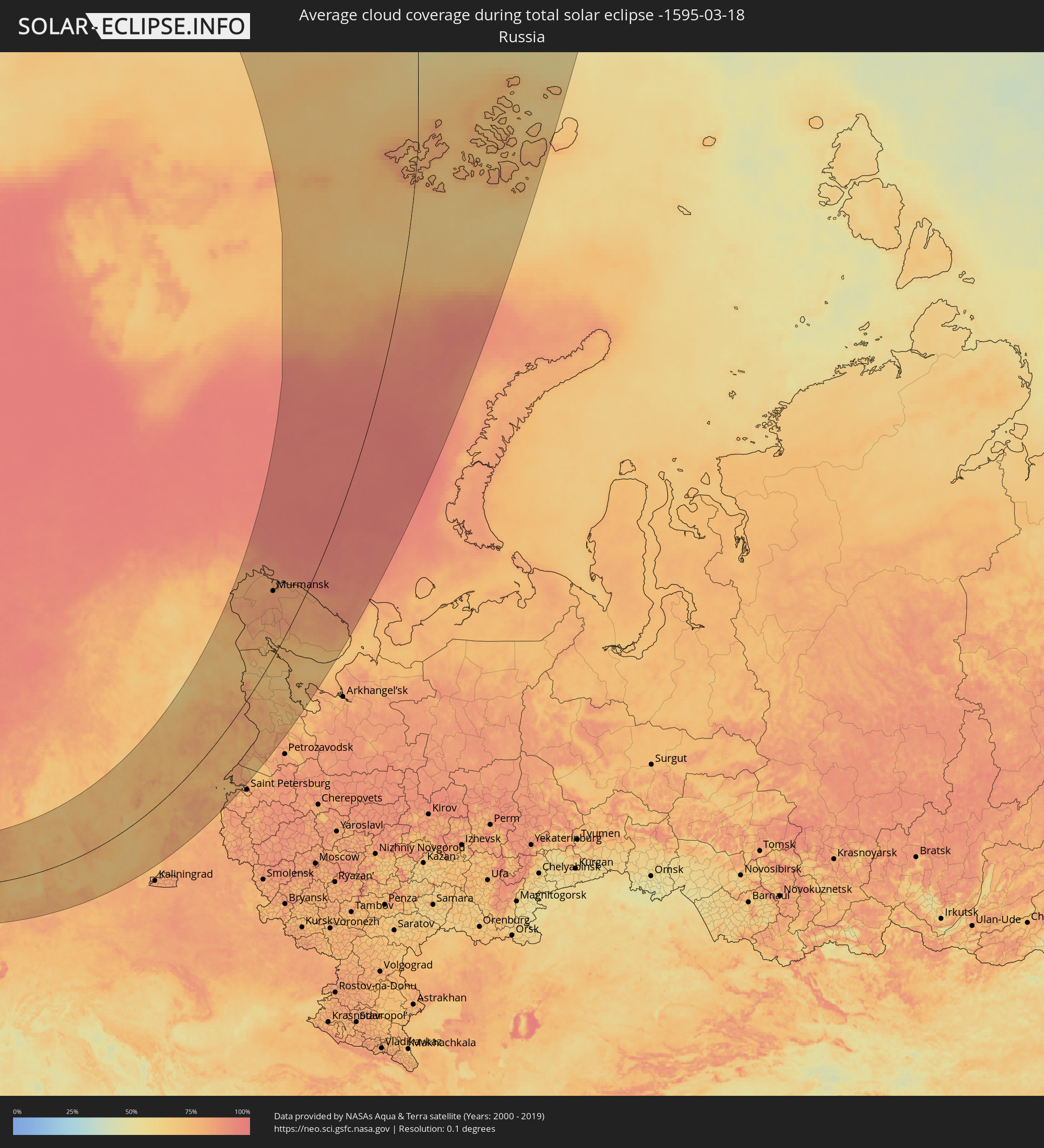 Russland
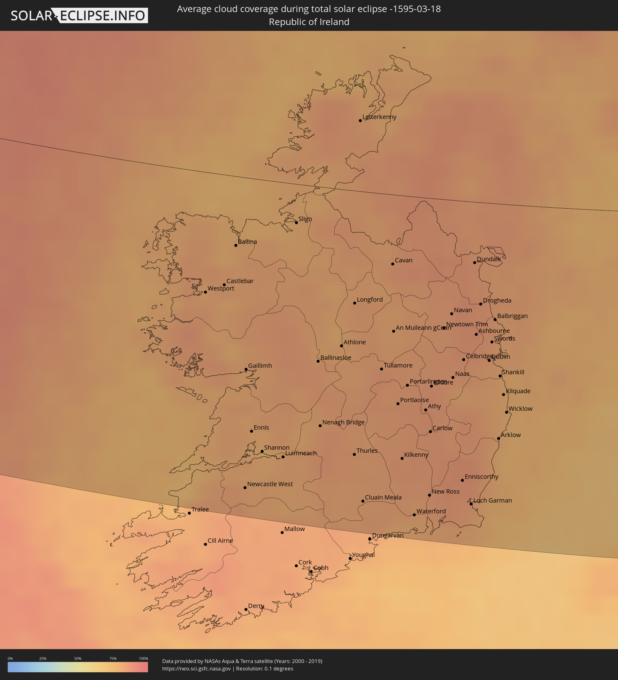 Irland
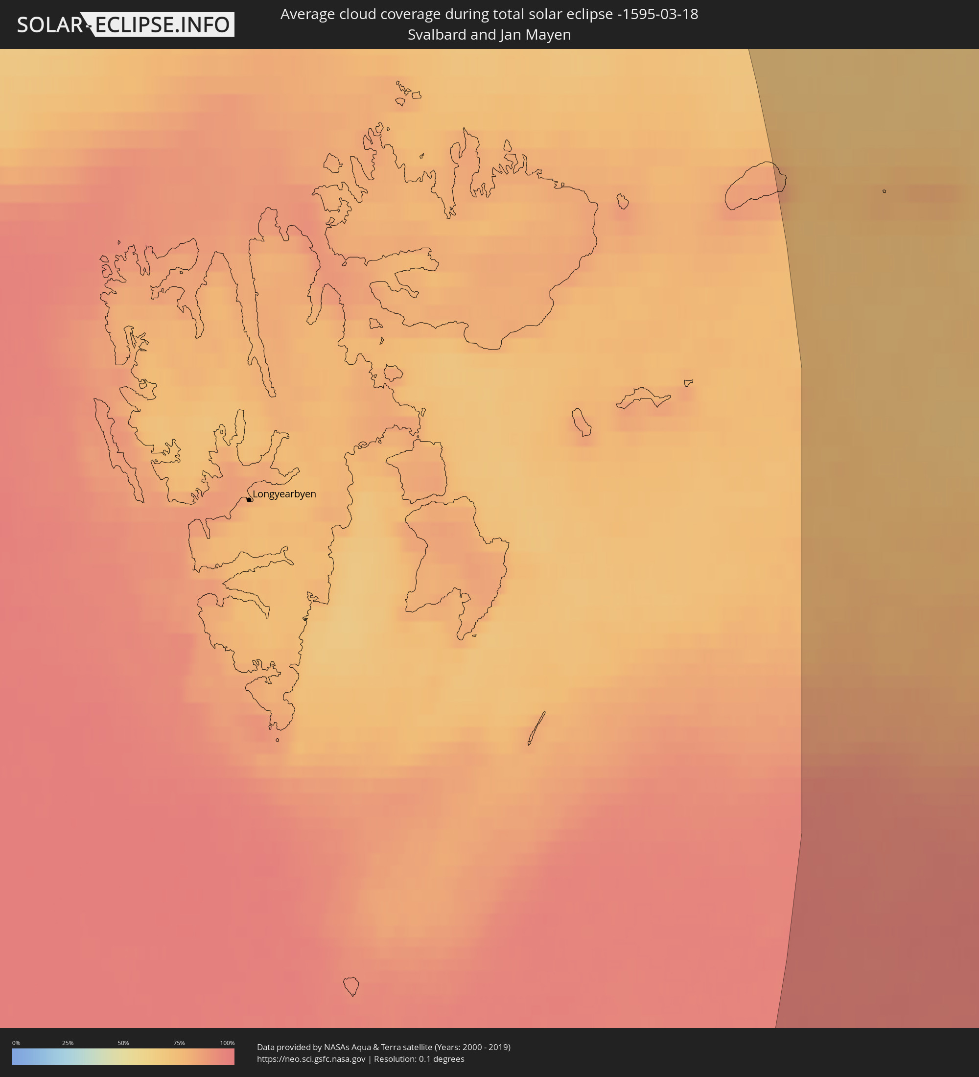 Spitzbergen
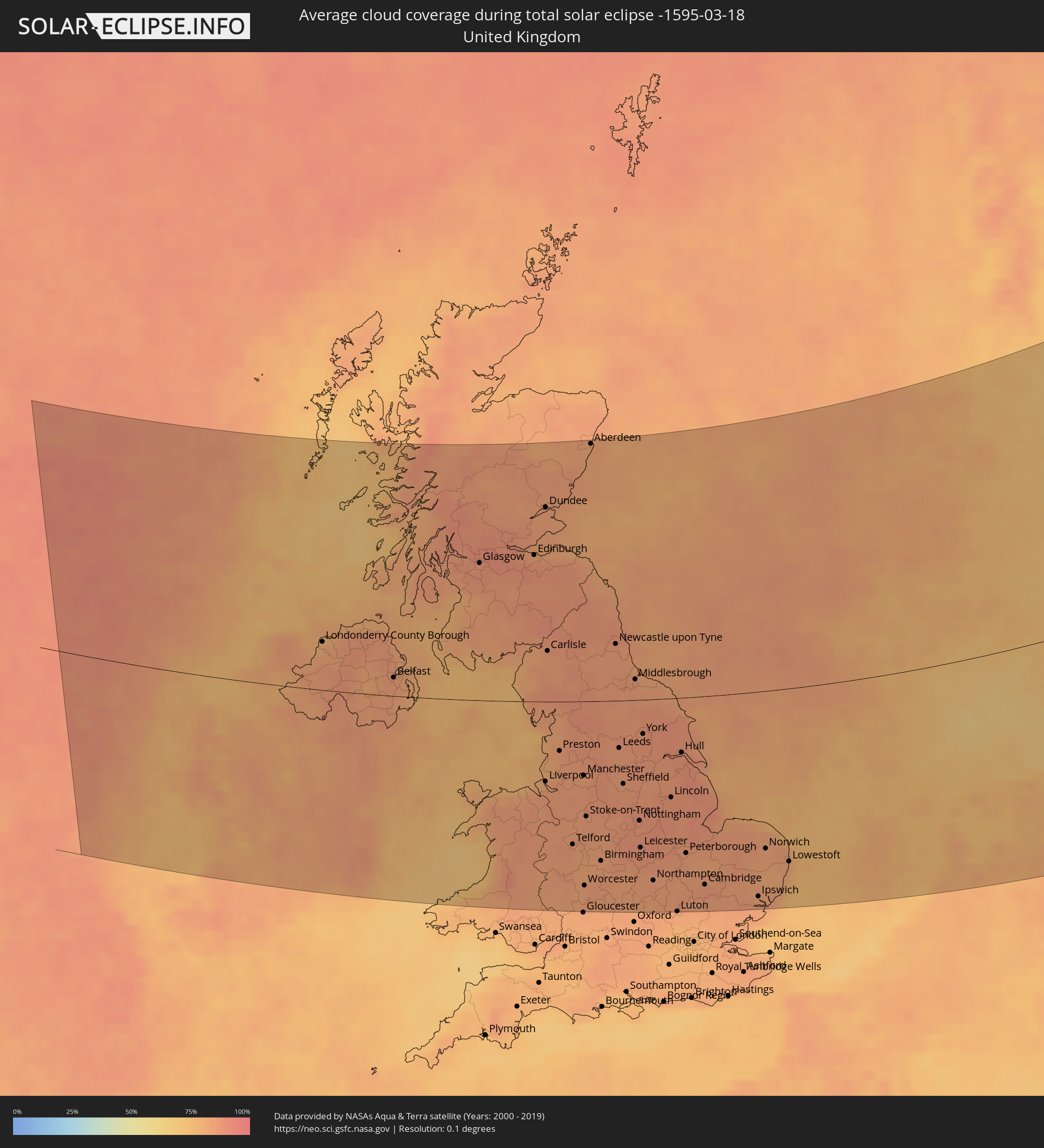 Vereinigtes Königreich
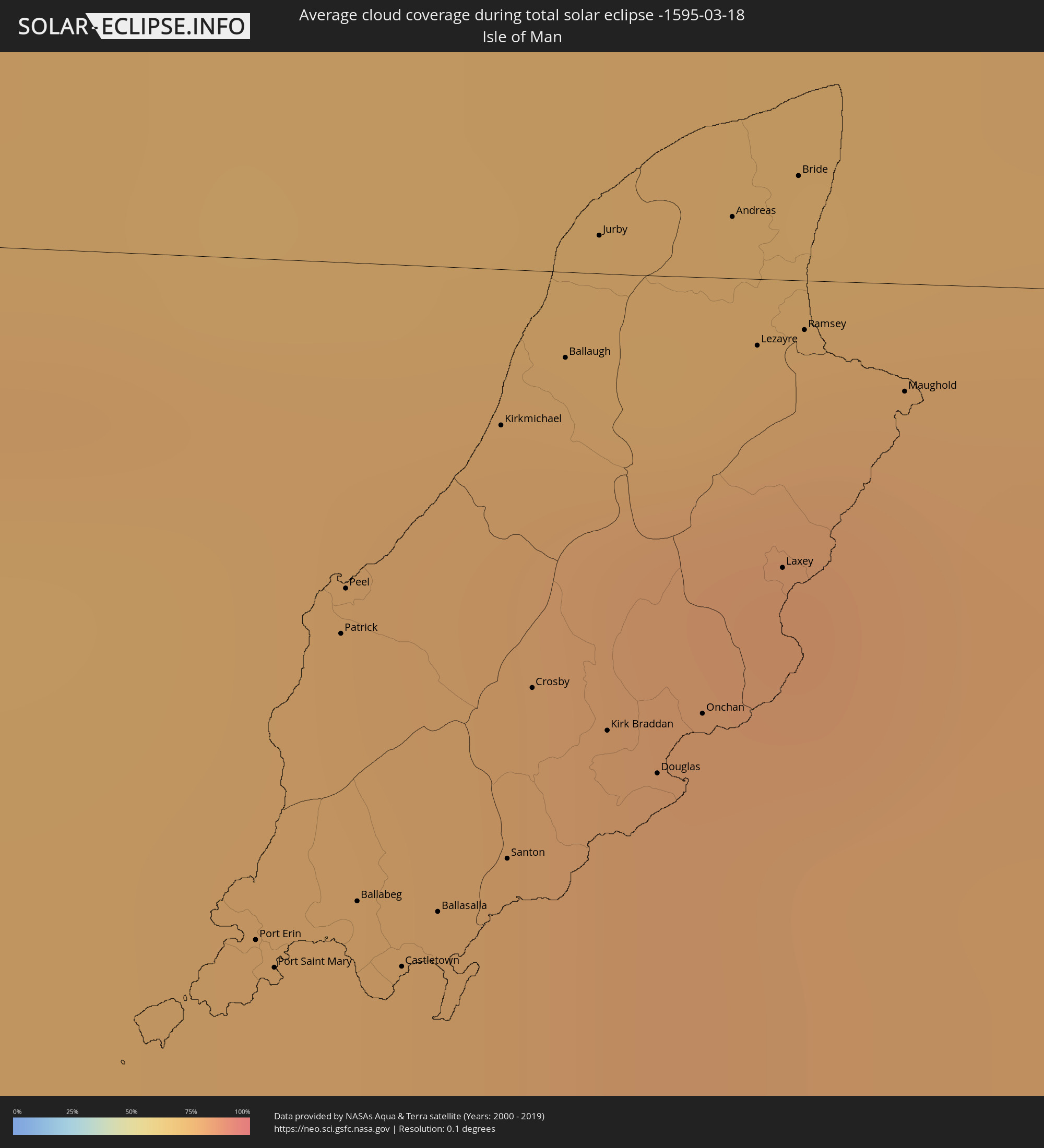 Isle of Man
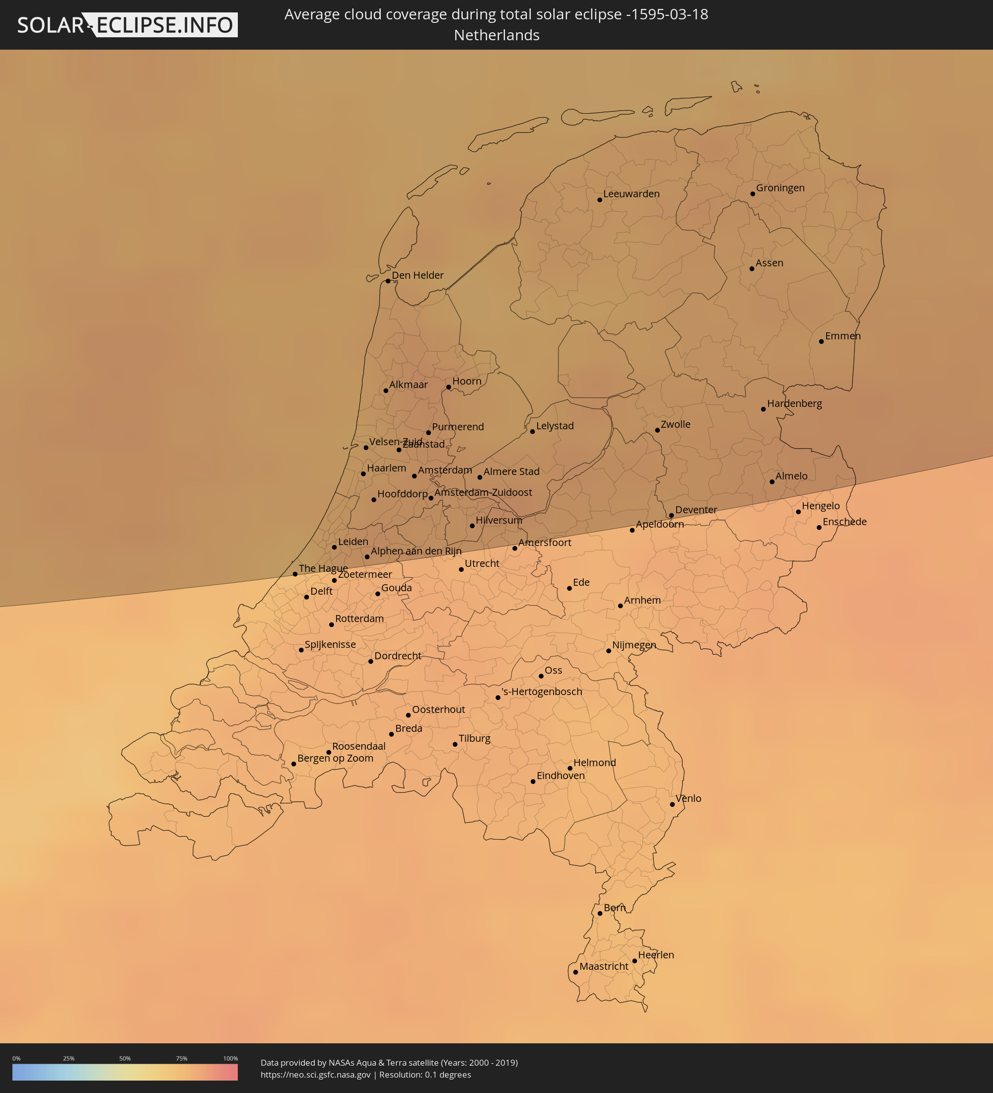 Niederlande
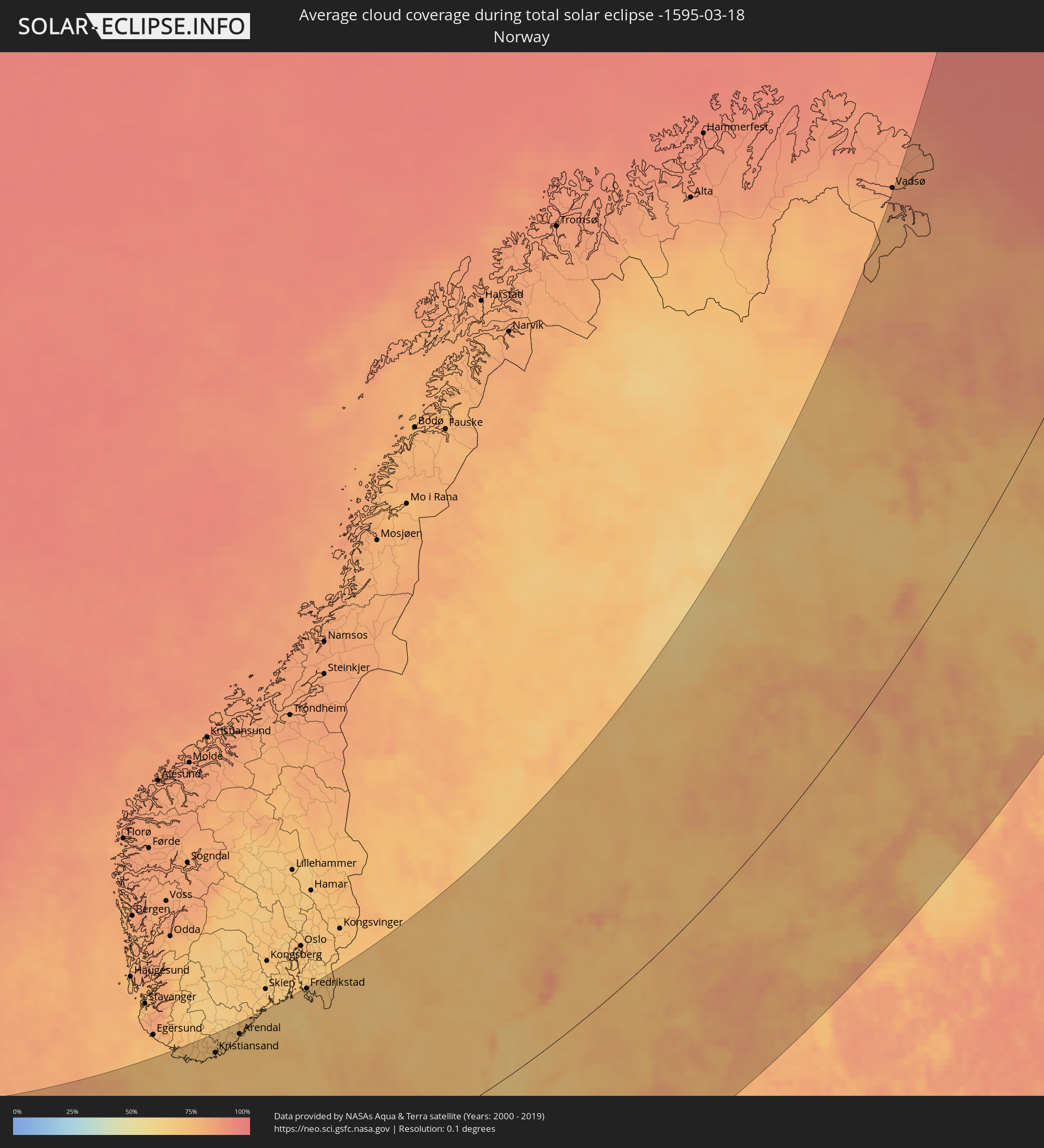 Norwegen
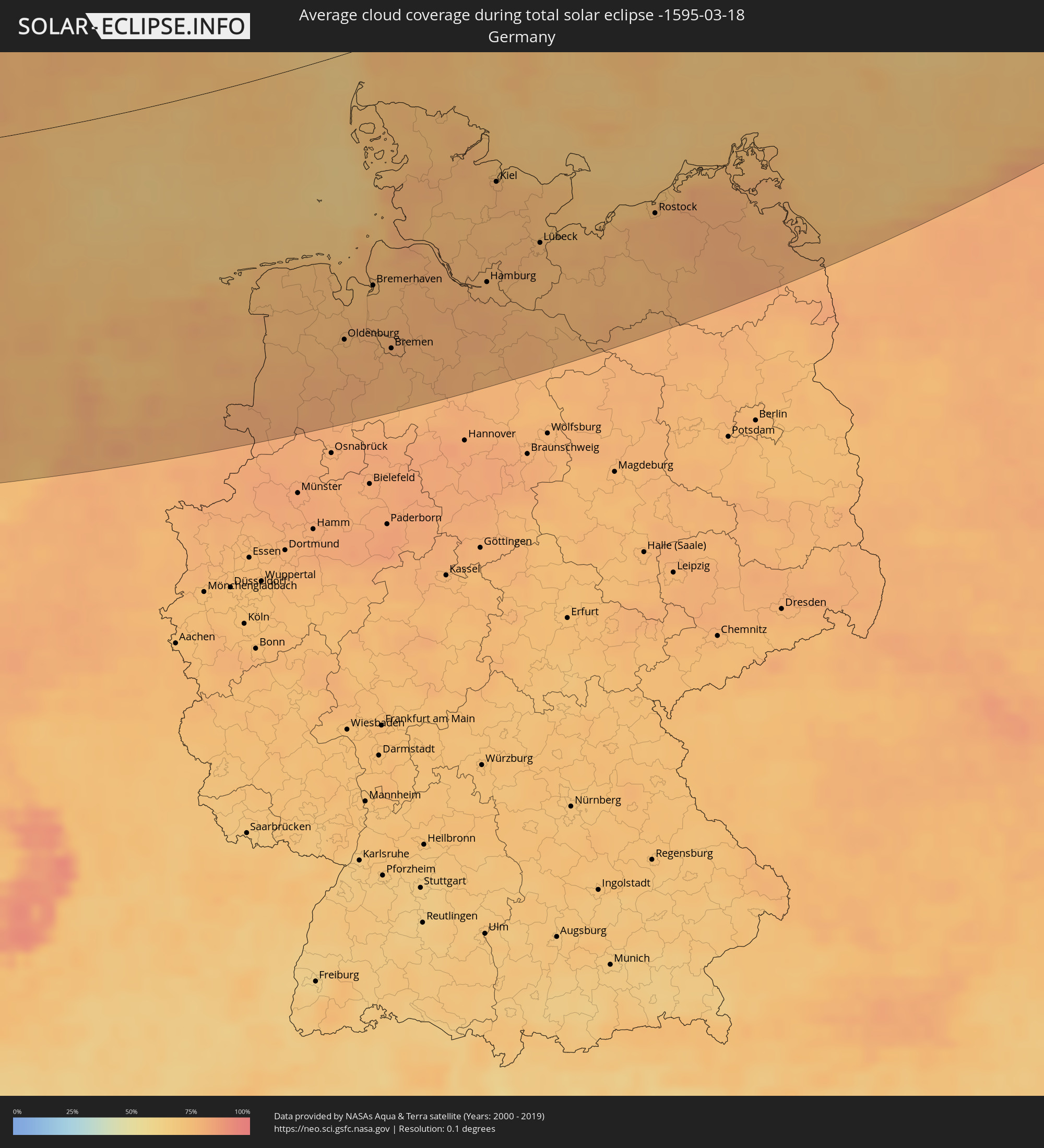 Deutschland
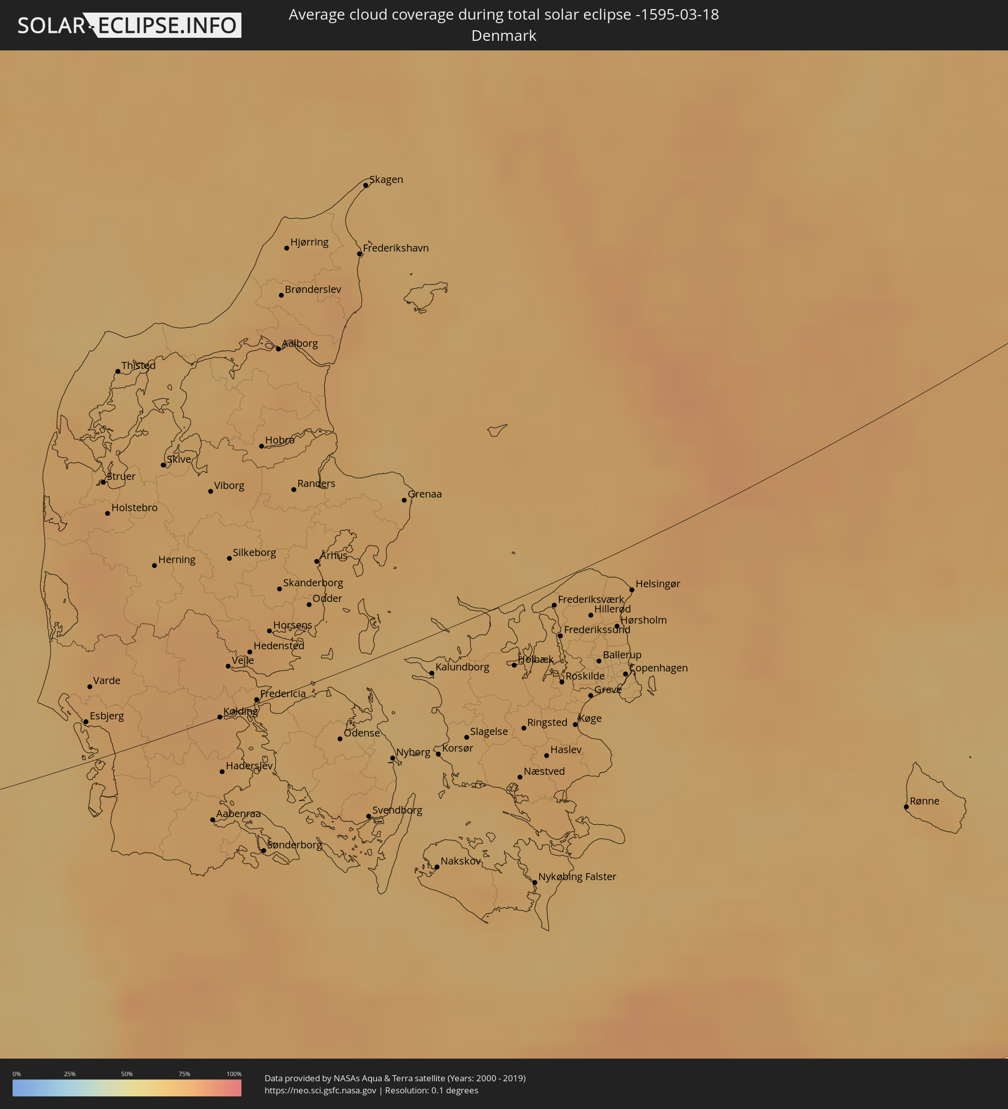 Dänemark
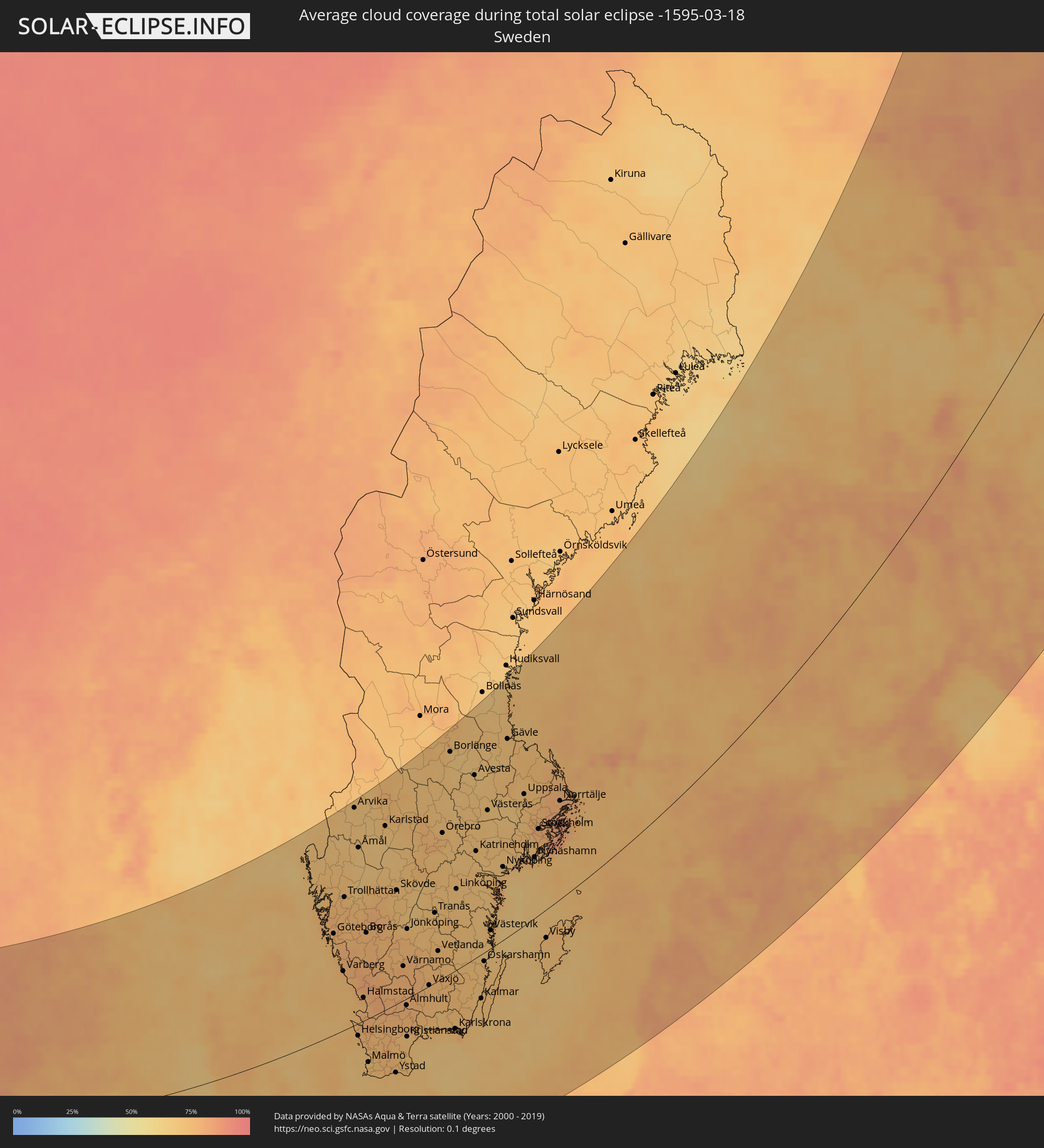 Schweden
 Polen
Polen
 Åland Islands
 Finnland
 Litauen
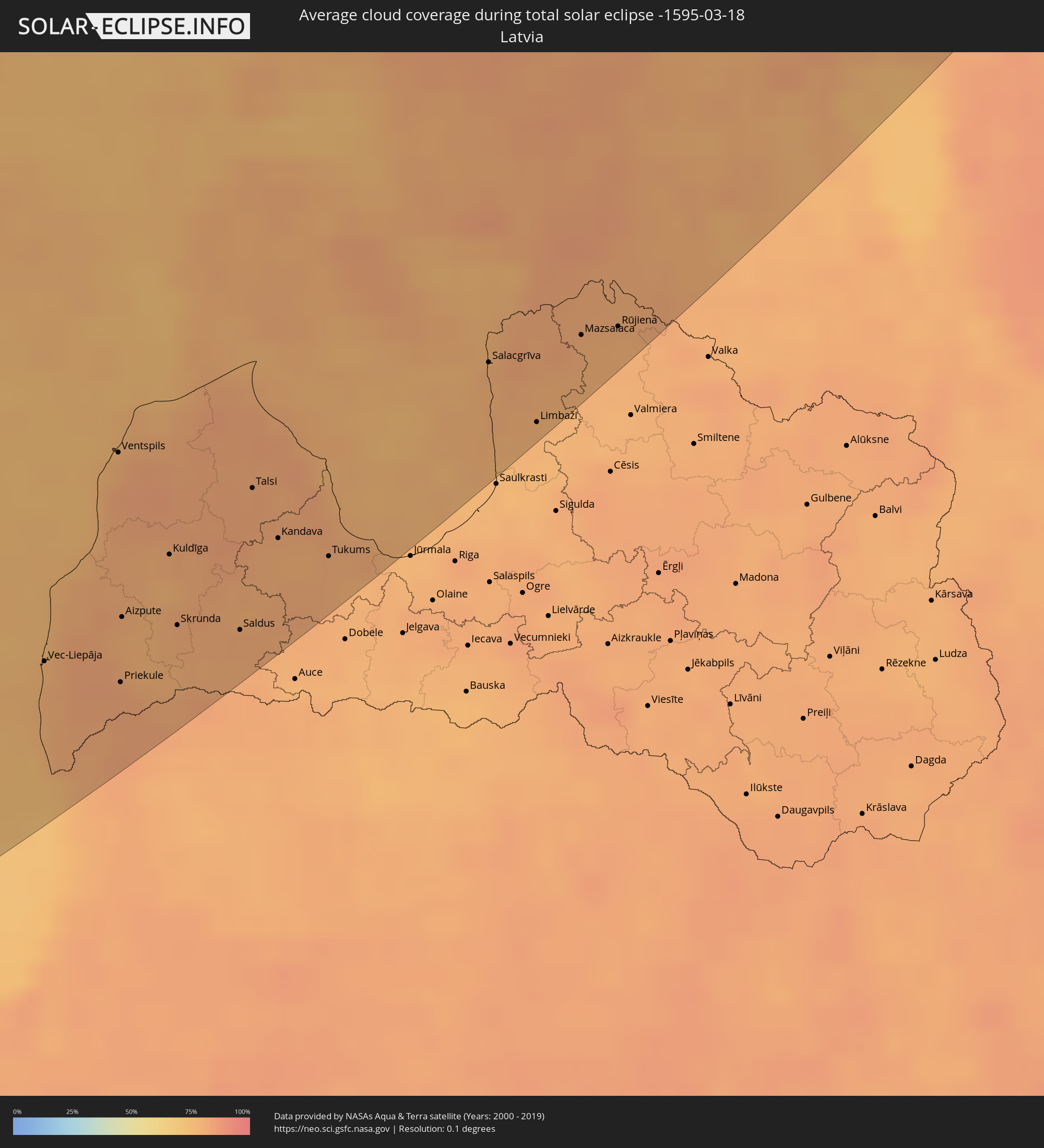 Lettland
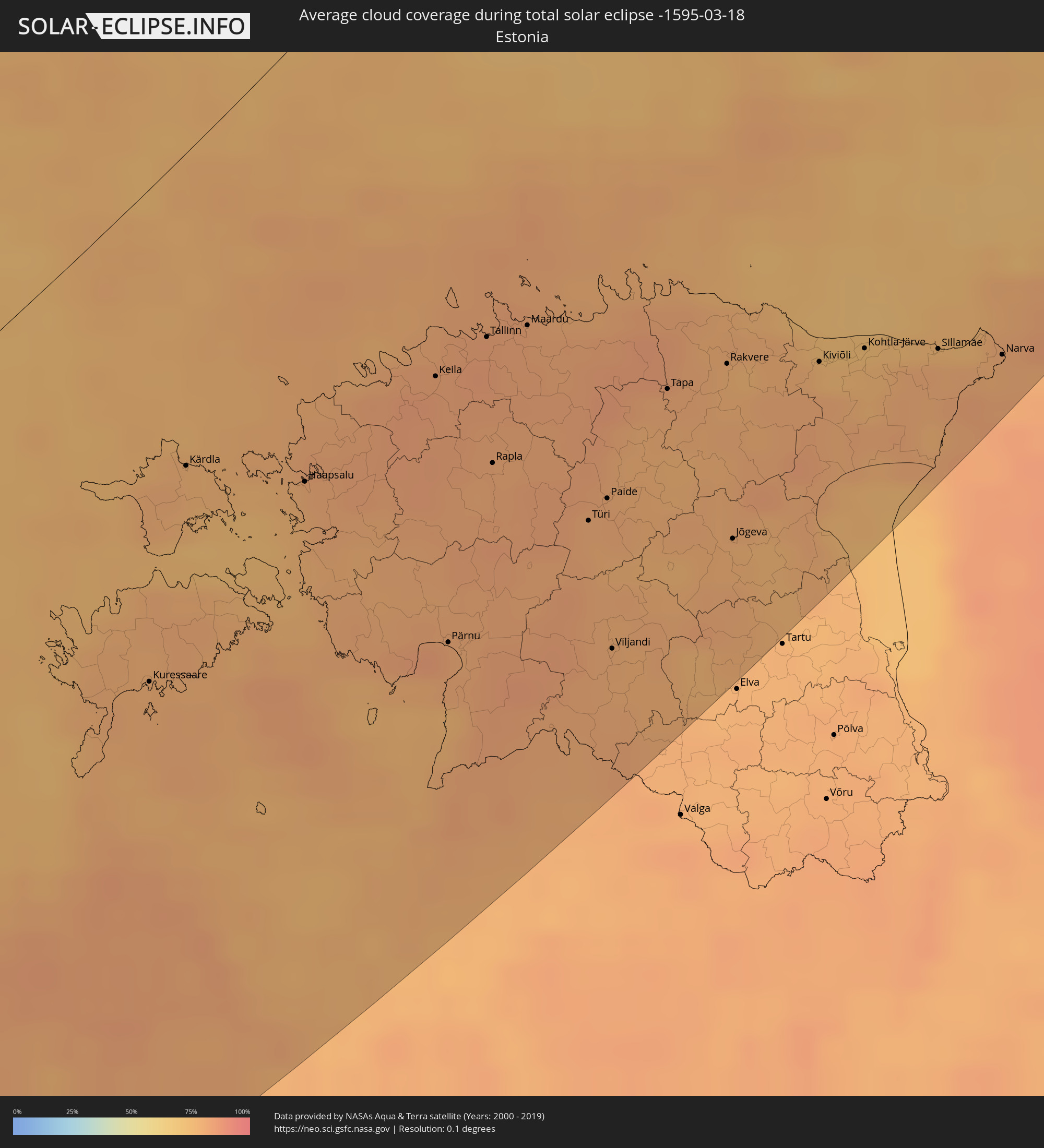 Estland
Orte im Finsternispfad
Die nachfolgene Tabelle zeigt Städte und Orte mit mehr als 5.000 Einwohnern, die sich im Finsternispfad befinden. Städte mit mehr als 100.000 Einwohnern sind dick gekennzeichnet. Mit einem Klick auf den Ort öffnet sich eine Detailkarte die die Lage des jeweiligen Ortes zusammen mit dem Verlauf der zentralen Finsternis präsentiert.
| Ort | Typ | Dauer der Verfinsterung | Ortszeit bei maximaler Verfinsterung | Entfernung zur Zentrallinie | Ø Bewölkung |
|
Gaillimh, Connaught
|
total | - | 07:15:06 UTC-00:25 | 144 km | 78% |
|
Ennis, Munster
|
total | - | 07:14:22 UTC-00:25 | 190 km | 77% |
|
Luimneach, Munster
|
total | - | 07:14:09 UTC-00:25 | 207 km | 80% |
|
Sligo, Connaught
|
total | - | 07:17:02 UTC-00:25 | 29 km | 76% |
|
Kilkenny, Leinster
|
total | - | 07:14:33 UTC-00:25 | 199 km | 84% |
|
Waterford, Munster
|
total | - | 07:13:54 UTC-00:25 | 243 km | 80% |
|
Carlow, Leinster
|
total | - | 07:14:59 UTC-00:25 | 177 km | 85% |
|
Navan, Leinster
|
total | - | 07:16:30 UTC-00:25 | 85 km | 83% |
|
Naas, Leinster
|
total | - | 07:15:44 UTC-00:25 | 134 km | 82% |
|
Loch Garman, Leinster
|
total | - | 07:14:15 UTC-00:25 | 231 km | 82% |
|
Dundalk, Leinster
|
total | - | 07:17:12 UTC-00:25 | 46 km | 84% |
|
Drogheda, Leinster
|
total | - | 07:16:44 UTC-00:25 | 76 km | 84% |
|
Dublin, Leinster
|
total | - | 07:16:05 UTC-00:25 | 119 km | 80% |
|
Balbriggan, Leinster
|
total | - | 07:16:36 UTC-00:25 | 87 km | 83% |
|
Belfast, Northern Ireland
|
total | - | 07:43:47 UTC+00:00 | 23 km | 83% |
|
Port Erin, Port Erin
|
total | - | 07:43:18 UTC+00:00 | 30 km | 78% |
|
Port Saint Mary, Port St Mary
|
total | - | 07:43:17 UTC+00:00 | 31 km | 79% |
|
Peel, Peel
|
total | - | 07:43:34 UTC+00:00 | 14 km | 76% |
|
Ballasalla, Malew
|
total | - | 07:43:22 UTC+00:00 | 28 km | 80% |
|
Kirkmichael, Michael
|
total | - | 07:43:43 UTC+00:00 | 7 km | 78% |
|
Santon, Santon
|
total | - | 07:43:25 UTC+00:00 | 26 km | 80% |
|
Crosby, Marown
|
total | - | 07:43:33 UTC+00:00 | 18 km | 78% |
|
Ballaugh, Ballaugh
|
total | - | 07:43:47 UTC+00:00 | 4 km | 80% |
|
Jurby, Jurby
|
total | - | 07:43:52 UTC+00:00 | 2 km | 74% |
|
Douglas, Douglas
|
total | - | 07:43:31 UTC+00:00 | 22 km | 80% |
|
Onchan, Onchan
|
total | - | 07:43:34 UTC+00:00 | 19 km | 80% |
|
Andreas, Andreas
|
total | - | 07:43:55 UTC+00:00 | 3 km | 77% |
|
Lezayre, Lezayre
|
total | - | 07:43:50 UTC+00:00 | 3 km | 81% |
|
Ramsey, Ramsey
|
total | - | 07:43:52 UTC+00:00 | 2 km | 81% |
|
Glasgow, Scotland
|
total | - | 07:46:40 UTC+00:00 | 170 km | 85% |
|
Edinburgh, Scotland
|
total | - | 07:47:14 UTC+00:00 | 181 km | 83% |
|
Liverpool, England
|
total | - | 07:42:48 UTC+00:00 | 102 km | 84% |
|
Manchester, England
|
total | - | 07:43:14 UTC+00:00 | 94 km | 83% |
|
Stoke-on-Trent, England
|
total | - | 07:42:25 UTC+00:00 | 147 km | 85% |
|
Wolverhampton, England
|
total | - | 07:41:42 UTC+00:00 | 194 km | 81% |
|
Birmingham, England
|
total | - | 07:41:37 UTC+00:00 | 206 km | 82% |
|
Leeds, England
|
total | - | 07:44:06 UTC+00:00 | 60 km | 84% |
|
Coventry, England
|
total | - | 07:41:39 UTC+00:00 | 215 km | 82% |
|
Sheffield, England
|
total | - | 07:43:24 UTC+00:00 | 106 km | 85% |
|
Nottingham, England
|
total | - | 07:42:47 UTC+00:00 | 155 km | 86% |
|
Leicester, England
|
total | - | 07:42:14 UTC+00:00 | 190 km | 86% |
|
Hull, England
|
total | - | 07:44:33 UTC+00:00 | 69 km | 88% |
|
The Hague, South Holland
|
total | - | 08:03:36 UTC+00:19 | 287 km | 76% |
|
Leiden, South Holland
|
total | - | 08:03:51 UTC+00:19 | 281 km | 77% |
|
Haarlem, North Holland
|
total | - | 08:04:20 UTC+00:19 | 258 km | 76% |
|
Alkmaar, North Holland
|
total | - | 08:04:50 UTC+00:19 | 231 km | 74% |
|
Amsterdam, North Holland
|
total | - | 08:04:28 UTC+00:19 | 261 km | 79% |
|
Purmerend, North Holland
|
total | - | 08:04:44 UTC+00:19 | 248 km | 80% |
|
Hilversum, North Holland
|
total | - | 08:04:23 UTC+00:19 | 281 km | 78% |
|
Almere Stad, Flevoland
|
total | - | 08:04:39 UTC+00:19 | 266 km | 80% |
|
Lelystad, Flevoland
|
total | - | 08:05:03 UTC+00:19 | 254 km | 78% |
|
Leeuwarden, Friesland
|
total | - | 08:06:28 UTC+00:19 | 182 km | 76% |
|
Zwolle, Overijssel
|
total | - | 08:05:27 UTC+00:19 | 261 km | 78% |
|
Deventer, Overijssel
|
total | - | 08:05:02 UTC+00:19 | 290 km | 79% |
|
Groningen, Groningen
|
total | - | 08:06:58 UTC+00:19 | 191 km | 77% |
|
Almelo, Overijssel
|
total | - | 08:05:32 UTC+00:19 | 286 km | 80% |
|
Mandal, Vest-Agder
|
total | - | 08:56:18 UTC+01:00 | 307 km | 74% |
|
Søgne, Vest-Agder
|
total | - | 08:56:37 UTC+01:00 | 307 km | 74% |
|
Vennesla, Vest-Agder
|
total | - | 08:57:02 UTC+01:00 | 321 km | 70% |
|
Kristiansand, Vest-Agder
|
total | - | 08:56:50 UTC+01:00 | 308 km | 72% |
|
Wilhelmshaven, Lower Saxony
|
total | - | 08:48:59 UTC+01:00 | 182 km | 75% |
|
Oldenburg, Lower Saxony
|
total | - | 08:48:23 UTC+01:00 | 226 km | 78% |
|
Lillesand, Aust-Agder
|
total | - | 08:57:15 UTC+01:00 | 310 km | 71% |
|
Esbjerg, South Denmark
|
total | - | 08:52:33 UTC+01:00 | 18 km | 74% |
|
Bremerhaven, Bremen
|
total | - | 08:49:20 UTC+01:00 | 188 km | 74% |
|
Grimstad, Aust-Agder
|
total | - | 08:57:32 UTC+01:00 | 315 km | 72% |
|
Arendal, Aust-Agder
|
total | - | 08:57:51 UTC+01:00 | 323 km | 70% |
|
Bremen, Bremen
|
total | - | 08:48:40 UTC+01:00 | 244 km | 79% |
|
Herning, Central Jutland
|
total | - | 08:54:02 UTC+01:00 | 78 km | 72% |
|
Flensburg, Schleswig-Holstein
|
total | - | 08:52:02 UTC+01:00 | 74 km | 75% |
|
Kolding, South Denmark
|
total | - | 08:53:15 UTC+01:00 | 0 km | 76% |
|
Vejle, South Denmark
|
total | - | 08:53:40 UTC+01:00 | 21 km | 77% |
|
Silkeborg, Central Jutland
|
total | - | 08:54:28 UTC+01:00 | 69 km | 74% |
|
Horsens, Central Jutland
|
total | - | 08:54:09 UTC+01:00 | 30 km | 74% |
|
Aalborg, North Denmark
|
total | - | 08:56:12 UTC+01:00 | 151 km | 74% |
|
Neumünster, Schleswig-Holstein
|
total | - | 08:51:12 UTC+01:00 | 160 km | 75% |
|
Hamburg, Hamburg
|
total | - | 08:50:22 UTC+01:00 | 213 km | 77% |
|
Randers, Central Jutland
|
total | - | 08:55:17 UTC+01:00 | 88 km | 74% |
|
Kiel, Schleswig-Holstein
|
total | - | 08:51:43 UTC+01:00 | 137 km | 77% |
|
Århus, Central Jutland
|
total | - | 08:54:53 UTC+01:00 | 53 km | 73% |
|
Bergedorf, Hamburg
|
total | - | 08:50:22 UTC+01:00 | 227 km | 77% |
|
Odense, South Denmark
|
total | - | 08:53:43 UTC+01:00 | 30 km | 72% |
|
Lüneburg, Lower Saxony
|
total | - | 08:50:06 UTC+01:00 | 256 km | 77% |
|
Lübeck, Schleswig-Holstein
|
total | - | 08:51:21 UTC+01:00 | 196 km | 76% |
|
Fredrikstad, Østfold
|
total | - | 09:00:30 UTC+01:00 | 341 km | 70% |
|
Sarpsborg, Østfold
|
total | - | 09:00:44 UTC+01:00 | 343 km | 67% |
|
Halden, Østfold
|
total | - | 09:00:39 UTC+01:00 | 319 km | 71% |
|
Schwerin, Mecklenburg-Vorpommern
|
total | - | 08:51:28 UTC+01:00 | 238 km | 77% |
|
Næstved, Zealand
|
total | - | 08:54:25 UTC+01:00 | 80 km | 74% |
|
Göteborg, Västra Götaland
|
total | - | 08:58:42 UTC+01:00 | 165 km | 76% |
|
Roskilde, Zealand
|
total | - | 08:55:21 UTC+01:00 | 45 km | 74% |
|
Rostock, Mecklenburg-Vorpommern
|
total | - | 08:52:47 UTC+01:00 | 206 km | 78% |
|
Greve, Zealand
|
total | - | 08:55:25 UTC+01:00 | 57 km | 72% |
|
Copenhagen, Capital Region
|
total | - | 08:55:46 UTC+01:00 | 54 km | 71% |
|
Helsingborg, Skåne
|
total | - | 08:56:28 UTC+01:00 | 20 km | 73% |
|
Borås, Västra Götaland
|
total | - | 08:59:25 UTC+01:00 | 139 km | 76% |
|
Malmö, Skåne
|
total | - | 08:55:58 UTC+01:00 | 73 km | 69% |
|
Lund, Skåne
|
total | - | 08:56:17 UTC+01:00 | 68 km | 72% |
|
Neubrandenburg, Mecklenburg-Vorpommern
|
total | - | 08:52:46 UTC+01:00 | 288 km | 81% |
|
Jönköping, Jönköping
|
total | - | 09:00:24 UTC+01:00 | 108 km | 73% |
|
Świnoujście, West Pomeranian Voivodeship
|
total | - | 09:18:07 UTC+01:24 | 278 km | 76% |
|
Międzyzdroje, West Pomeranian Voivodeship
|
total | - | 09:18:19 UTC+01:24 | 281 km | 75% |
|
Wolin, West Pomeranian Voivodeship
|
total | - | 09:18:18 UTC+01:24 | 295 km | 78% |
|
Kamień Pomorski, West Pomeranian Voivodeship
|
total | - | 09:18:38 UTC+01:24 | 286 km | 76% |
|
Örebro, Örebro
|
total | - | 09:03:34 UTC+01:00 | 212 km | 75% |
|
Trzebiatów, West Pomeranian Voivodeship
|
total | - | 09:19:11 UTC+01:24 | 290 km | 78% |
|
Kołobrzeg, West Pomeranian Voivodeship
|
total | - | 09:19:38 UTC+01:24 | 287 km | 76% |
|
Linköping, Östergötland
|
total | - | 09:02:30 UTC+01:00 | 120 km | 72% |
|
Norrköping, Östergötland
|
total | - | 09:03:13 UTC+01:00 | 118 km | 73% |
|
Darłowo, West Pomeranian Voivodeship
|
total | - | 09:20:44 UTC+01:24 | 287 km | 78% |
|
Västerås, Västmanland
|
total | - | 09:05:06 UTC+01:00 | 196 km | 71% |
|
Sławno, West Pomeranian Voivodeship
|
total | - | 09:20:51 UTC+01:24 | 301 km | 81% |
|
Ustka, Pomeranian Voivodeship
|
total | - | 09:21:22 UTC+01:24 | 285 km | 79% |
|
Słupsk, Pomeranian Voivodeship
|
total | - | 09:21:19 UTC+01:24 | 301 km | 81% |
|
Gävle, Gävleborg
|
total | - | 09:07:10 UTC+01:00 | 264 km | 73% |
|
Uppsala, Uppsala
|
total | - | 09:06:17 UTC+01:00 | 178 km | 72% |
|
Stockholm, Stockholm
|
total | - | 09:05:49 UTC+01:00 | 117 km | 78% |
|
Haninge, Stockholm
|
total | - | 09:05:37 UTC+01:00 | 100 km | 75% |
|
Mariehamn, Mariehamns stad
|
total | - | 09:48:15 UTC+01:39 | 112 km | 78% |
|
Vec-Liepāja, Liepāja
|
total | - | 09:40:35 UTC+01:36 | 236 km | 79% |
|
Palanga, Klaipėda County
|
total | - | 09:27:08 UTC+01:24 | 294 km | 75% |
|
Skuodas, Klaipėda County
|
total | - | 09:28:05 UTC+01:24 | 279 km | 81% |
|
Ventspils, Ventspils
|
total | - | 09:42:22 UTC+01:36 | 179 km | 81% |
|
Priekule, Priekule
|
total | - | 09:40:58 UTC+01:36 | 264 km | 82% |
|
Aizpute, Aizpute
|
total | - | 09:41:23 UTC+01:36 | 240 km | 79% |
|
Vaasa, Ostrobothnia
|
total | - | 09:53:49 UTC+01:39 | 268 km | 71% |
|
Pori, Satakunta
|
total | - | 09:51:42 UTC+01:39 | 148 km | 70% |
|
Kuldīga, Kuldīgas Rajons
|
total | - | 09:42:05 UTC+01:36 | 230 km | 81% |
|
Skrunda, Skrunda
|
total | - | 09:41:42 UTC+01:36 | 258 km | 80% |
|
Turku, Southwest Finland
|
total | - | 09:50:38 UTC+01:39 | 50 km | 77% |
|
Saldus, Saldus Rajons
|
total | - | 09:42:06 UTC+01:36 | 277 km | 80% |
|
Kuressaare, Saare
|
total | - | 09:46:52 UTC+01:39 | 139 km | 79% |
|
Talsi, Talsu Rajons
|
total | - | 09:43:03 UTC+01:36 | 229 km | 82% |
|
Kandava, Kandava
|
total | - | 09:42:55 UTC+01:36 | 254 km | 79% |
|
Tukums, Tukuma Rajons
|
total | - | 09:43:10 UTC+01:36 | 275 km | 79% |
|
Haapsalu, Lääne
|
total | - | 09:48:46 UTC+01:39 | 121 km | 76% |
|
Tampere, Pirkanmaa
|
total | - | 09:53:19 UTC+01:39 | 69 km | 75% |
|
Salacgrīva, Salacgrīvas
|
total | - | 09:45:23 UTC+01:36 | 252 km | 80% |
|
Keila, Harjumaa
|
total | - | 09:50:02 UTC+01:39 | 125 km | 84% |
|
Pärnu, Pärnumaa
|
total | - | 09:48:50 UTC+01:39 | 204 km | 81% |
|
Espoo, Uusimaa
|
total | - | 09:52:17 UTC+01:39 | 63 km | 75% |
|
Limbaži, Limbažu Rajons
|
total | - | 09:45:23 UTC+01:36 | 286 km | 77% |
|
Tallinn, Harjumaa
|
total | - | 09:50:31 UTC+01:39 | 128 km | 83% |
|
Helsinki, Uusimaa
|
total | - | 09:52:29 UTC+01:39 | 77 km | 75% |
|
Maardu, Harjumaa
|
total | - | 09:50:48 UTC+01:39 | 135 km | 82% |
|
Vantaa, Uusimaa
|
total | - | 09:52:45 UTC+01:39 | 72 km | 74% |
|
Mazsalaca, Mazsalaca
|
total | - | 09:46:11 UTC+01:36 | 269 km | 79% |
|
Rūjiena, Rūjienas
|
total | - | 09:46:29 UTC+01:36 | 277 km | 78% |
|
Oulu, Northern Ostrobothnia
|
total | - | 09:59:10 UTC+01:39 | 231 km | 71% |
|
Paide, Järvamaa
|
total | - | 09:50:29 UTC+01:39 | 204 km | 81% |
|
Viljandi, Viljandimaa
|
total | - | 09:49:48 UTC+01:39 | 248 km | 79% |
|
Lahti, Päijänne Tavastia
|
total | - | 09:54:11 UTC+01:39 | 44 km | 75% |
|
Jyväskylä, Central Finland
|
total | - | 09:55:52 UTC+01:39 | 44 km | 77% |
|
Rakvere, Lääne-Virumaa
|
total | - | 09:51:49 UTC+01:39 | 198 km | 78% |
|
Kotka, Kymenlaakso
|
total | - | 09:54:36 UTC+01:39 | 133 km | 72% |
|
Kiviõli, Ida-Virumaa
|
total | - | 09:52:23 UTC+01:39 | 222 km | 76% |
|
Kohtla-Järve, Ida-Virumaa
|
total | - | 09:52:43 UTC+01:39 | 231 km | 76% |
|
Jõhvi, Ida-Virumaa
|
total | - | 09:52:48 UTC+01:39 | 240 km | 77% |
|
Kuopio, Northern Savo
|
total | - | 09:58:17 UTC+01:39 | 9 km | 76% |
|
Sillamäe, Ida-Virumaa
|
total | - | 09:53:10 UTC+01:39 | 250 km | 79% |
|
Slantsy, Leningradskaya Oblast'
|
total | - | 10:44:24 UTC+02:30 | 285 km | 82% |
|
Lappeenranta, South Karelia
|
total | - | 09:56:28 UTC+01:39 | 140 km | 75% |
|
Narva, Ida-Virumaa
|
total | - | 09:53:32 UTC+01:39 | 269 km | 80% |
|
Vyborg, Leningradskaya Oblast'
|
total | - | 10:47:00 UTC+02:30 | 189 km | 77% |
|
Sosnovyy Bor, Leningradskaya Oblast'
|
total | - | 10:46:18 UTC+02:30 | 264 km | 79% |
|
Joensuu, North Karelia
|
total | - | 09:59:41 UTC+01:39 | 95 km | 74% |
|
Kurortnyy, Leningradskaya Oblast'
|
total | - | 10:47:23 UTC+02:30 | 277 km | 79% |
|
Kovdor, Murmansk
|
total | - | 10:56:08 UTC+02:30 | 166 km | 83% |
|
Kostomuksha, Republic of Karelia
|
total | - | 10:53:02 UTC+02:30 | 1 km | 82% |
|
Sortavala, Republic of Karelia
|
total | - | 10:49:56 UTC+02:30 | 195 km | 73% |
|
Kandalaksha, Murmansk
|
total | - | 10:57:06 UTC+02:30 | 72 km | 76% |
|
Monchegorsk, Murmansk
|
total | - | 10:58:10 UTC+02:30 | 92 km | 82% |
|
Murmansk, Murmansk
|
total | - | 10:59:17 UTC+02:30 | 132 km | 84% |
|
Olenegorsk, Murmansk
|
total | - | 10:58:37 UTC+02:30 | 88 km | 85% |
|
Apatity, Murmansk
|
total | - | 10:58:12 UTC+02:30 | 54 km | 83% |
|
Severomorsk, Murmansk
|
total | - | 10:59:35 UTC+02:30 | 124 km | 83% |
|
Segezha, Republic of Karelia
|
total | - | 10:55:15 UTC+02:30 | 203 km | 69% |