Totale Sonnenfinsternis vom 27.03.-1604
| Wochentag: | Dienstag |
| Maximale Dauer der Verfinsterung: | 04m56s |
| Maximale Breite des Finsternispfades: | 211 km |
| Saroszyklus: | 23 |
| Bedeckungsgrad: | 100% |
| Magnitude: | 1.0603 |
| Gamma: | 0.3569 |
Wo kann man die Sonnenfinsternis vom 27.03.-1604 sehen?
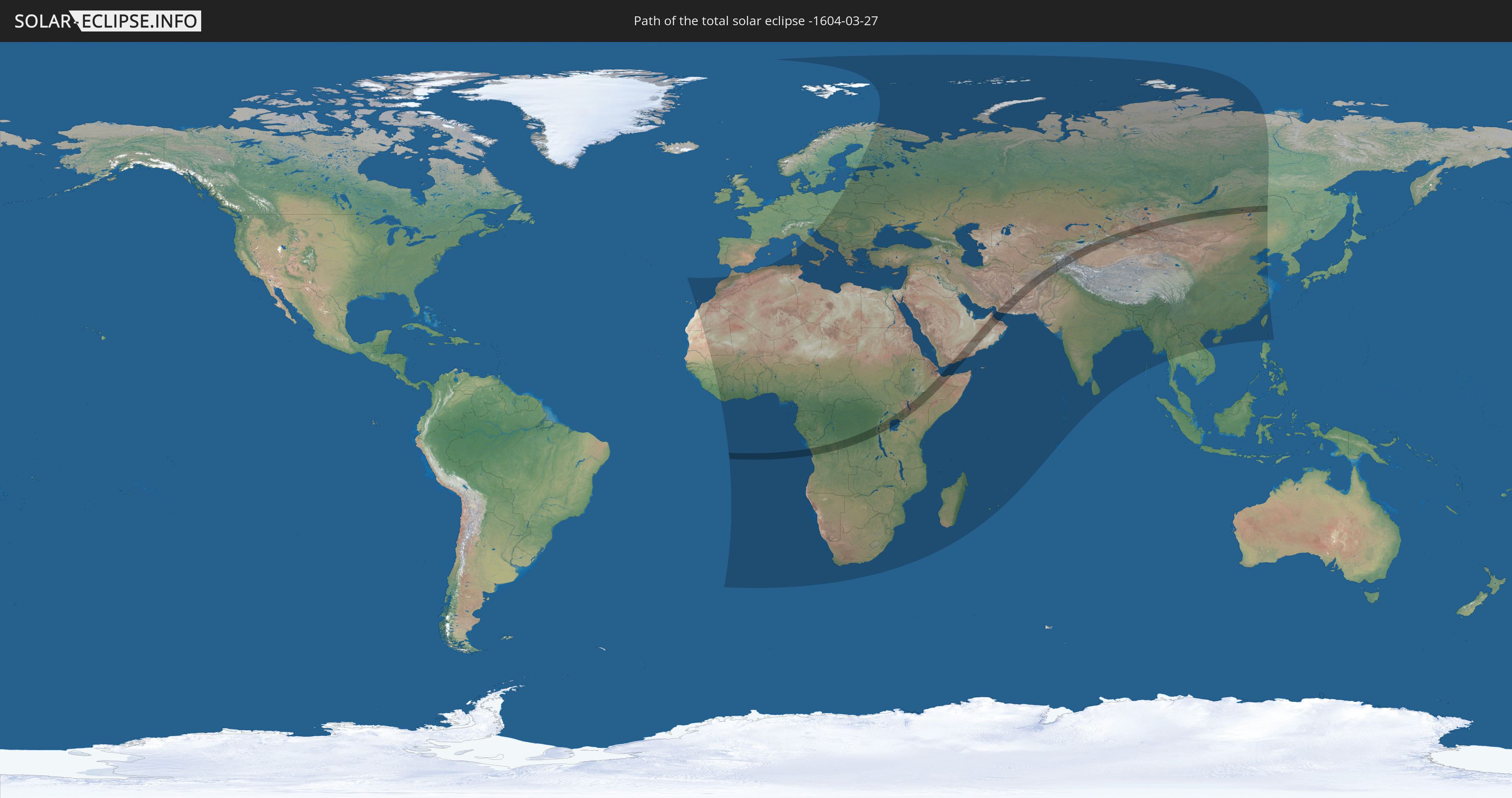
Die Sonnenfinsternis am 27.03.-1604 kann man in 124 Ländern als partielle Sonnenfinsternis beobachten.
Der Finsternispfad verläuft durch 21 Länder. Nur in diesen Ländern ist sie als totale Sonnenfinsternis zu sehen.
In den folgenden Ländern ist die Sonnenfinsternis total zu sehen
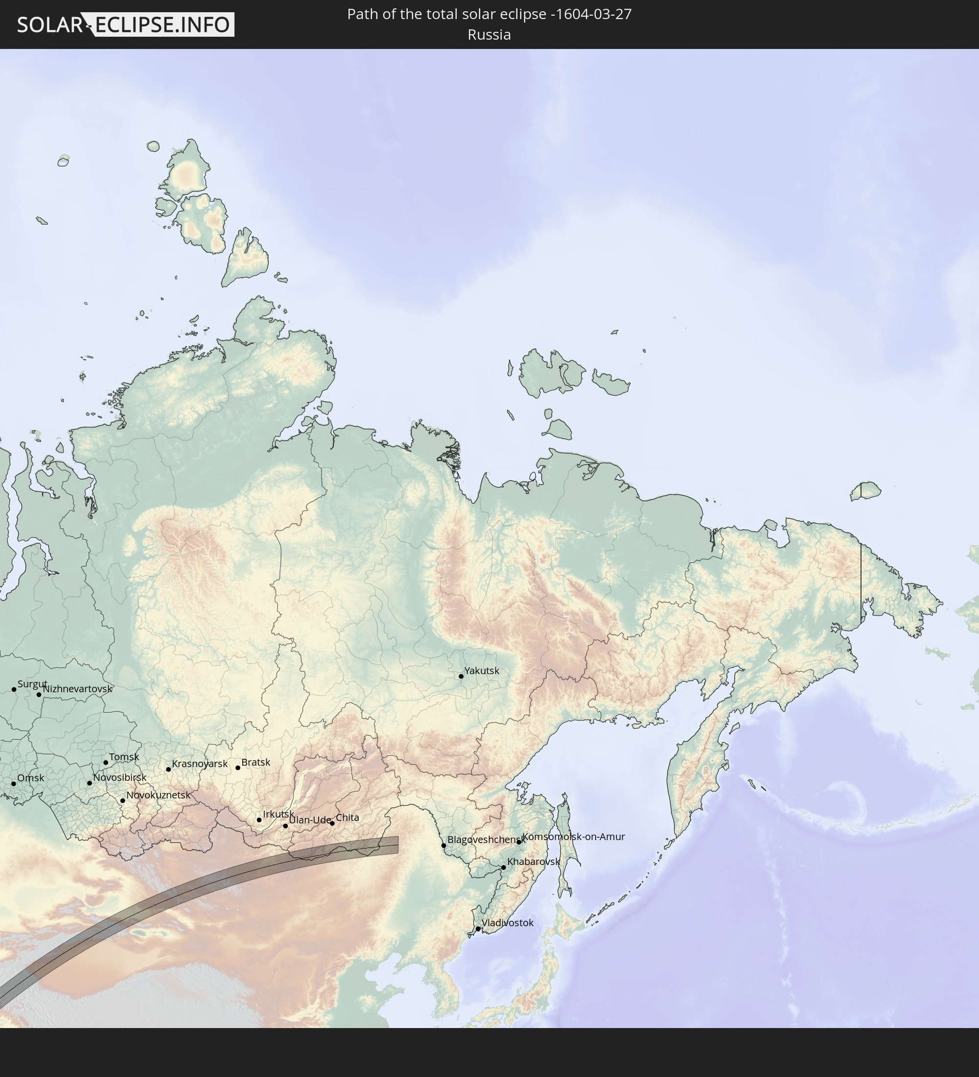 Russland
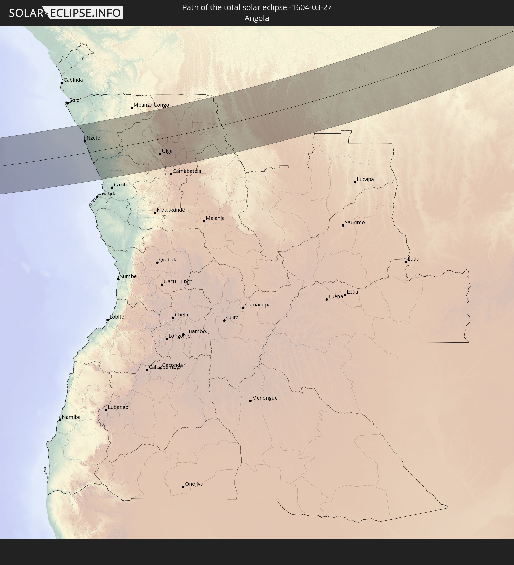 Angola
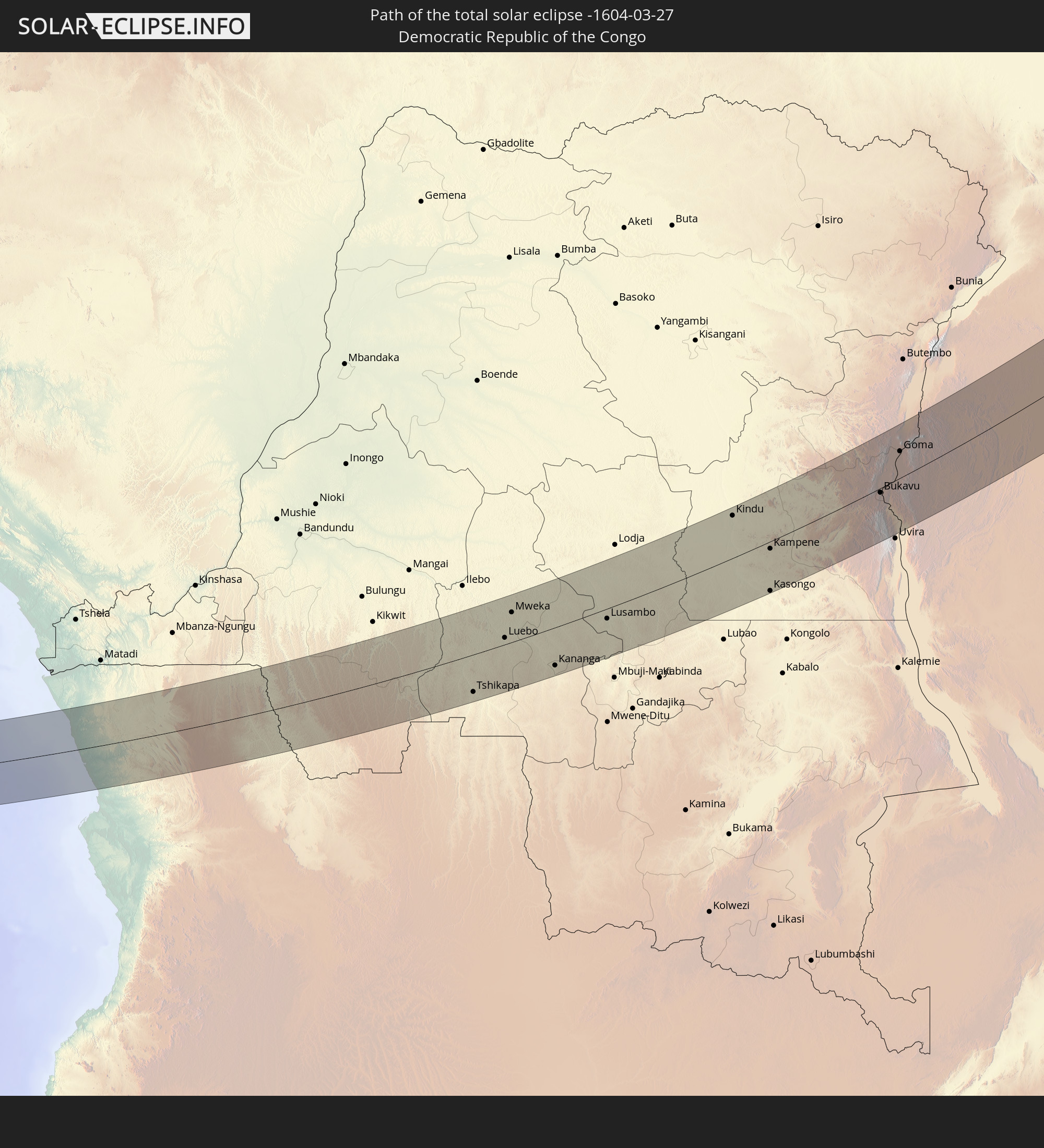 Demokratische Republik Kongo
 Ruanda
 Burundi
 Tansania
 Uganda
 Äthiopien
 Kenia
Kenia
 Saudi-Arabien
 Somalia
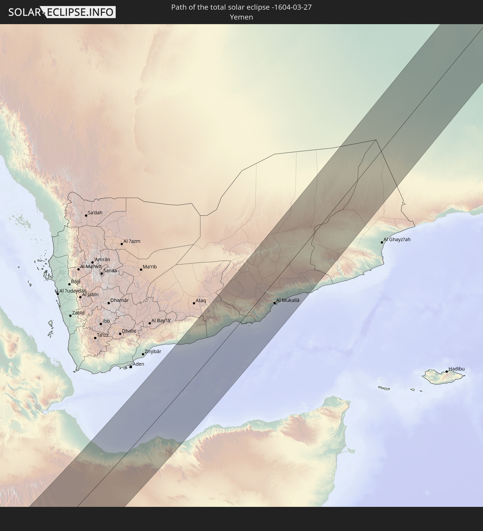 Jemen
Jemen
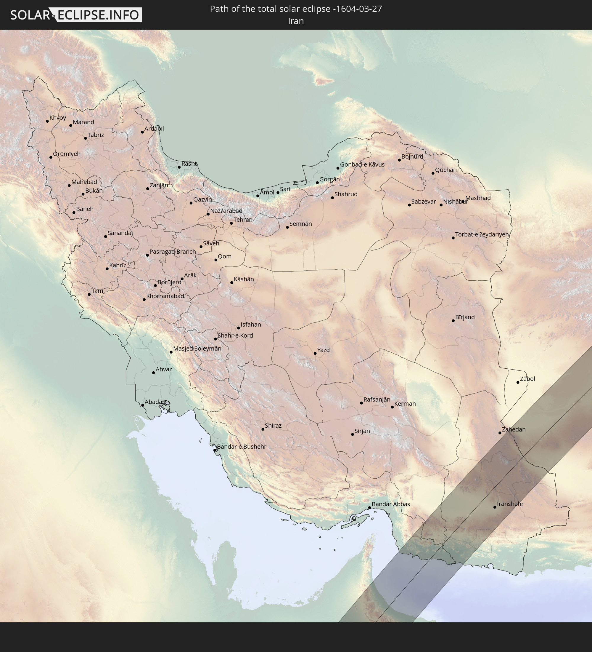 Iran
Iran
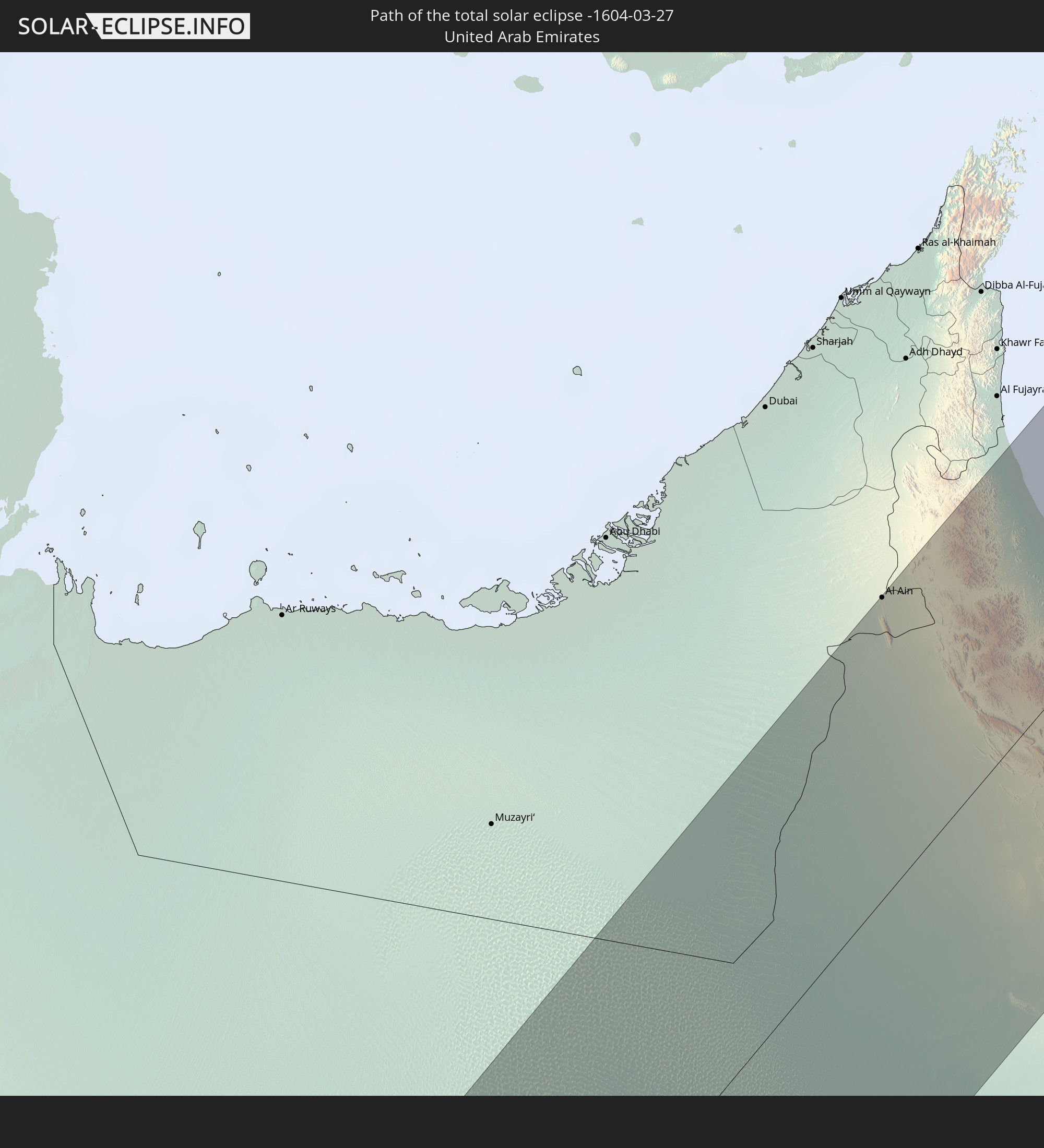 Vereinigte Arabische Emirate
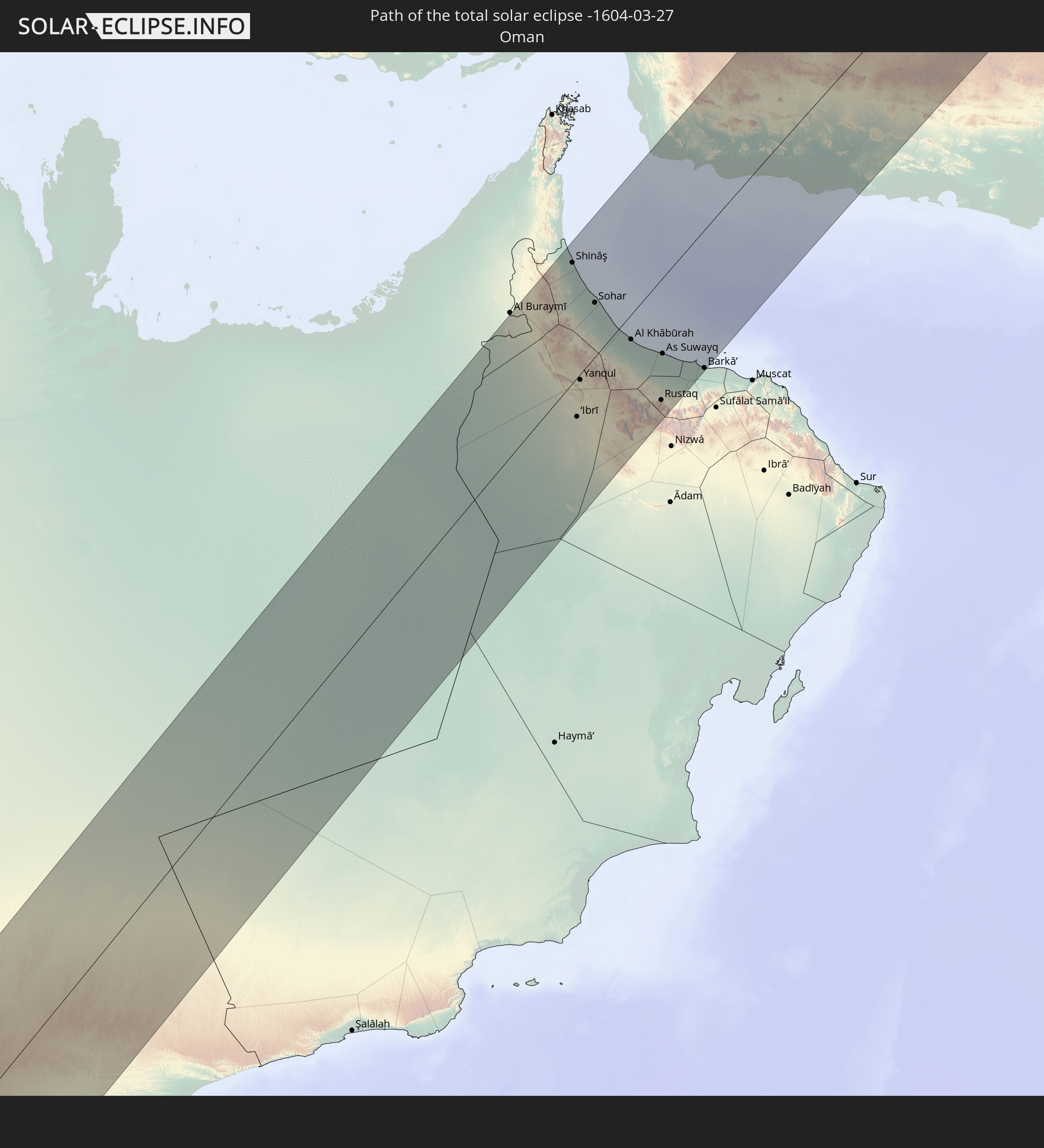 Oman
Oman
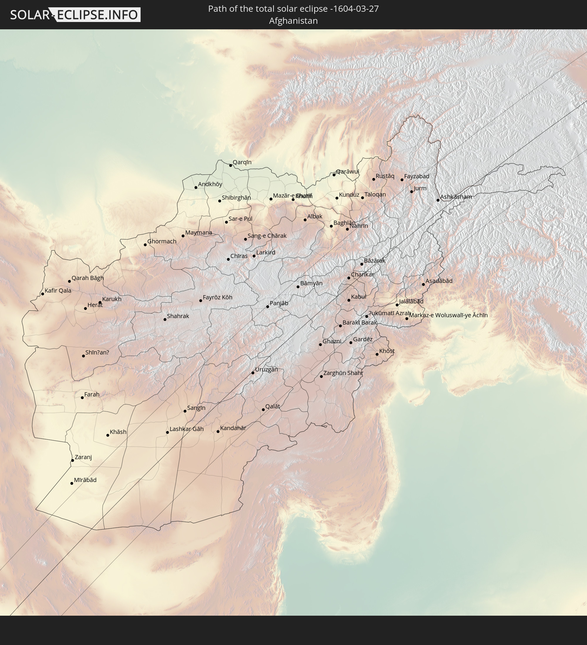 Afghanistan
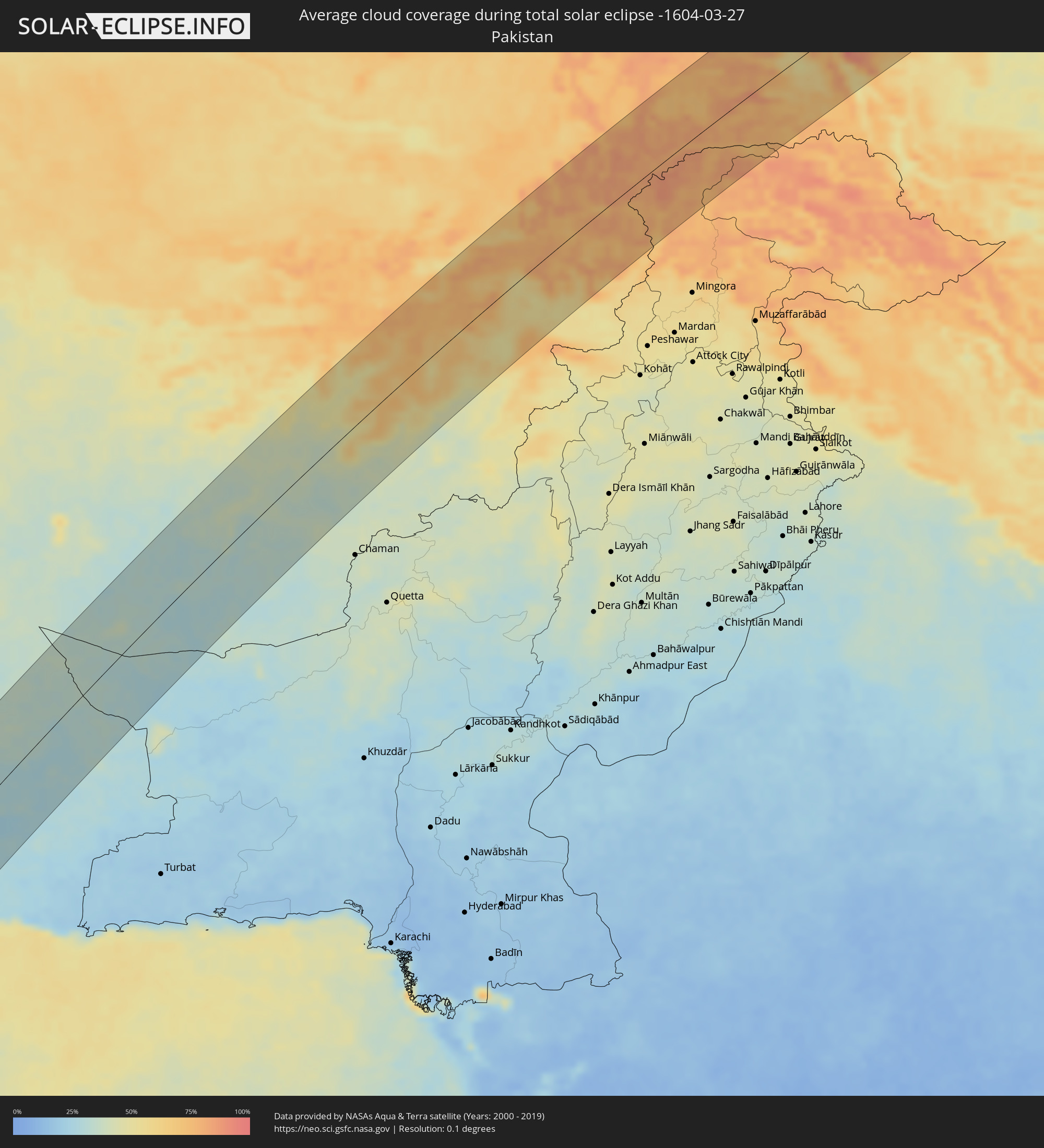
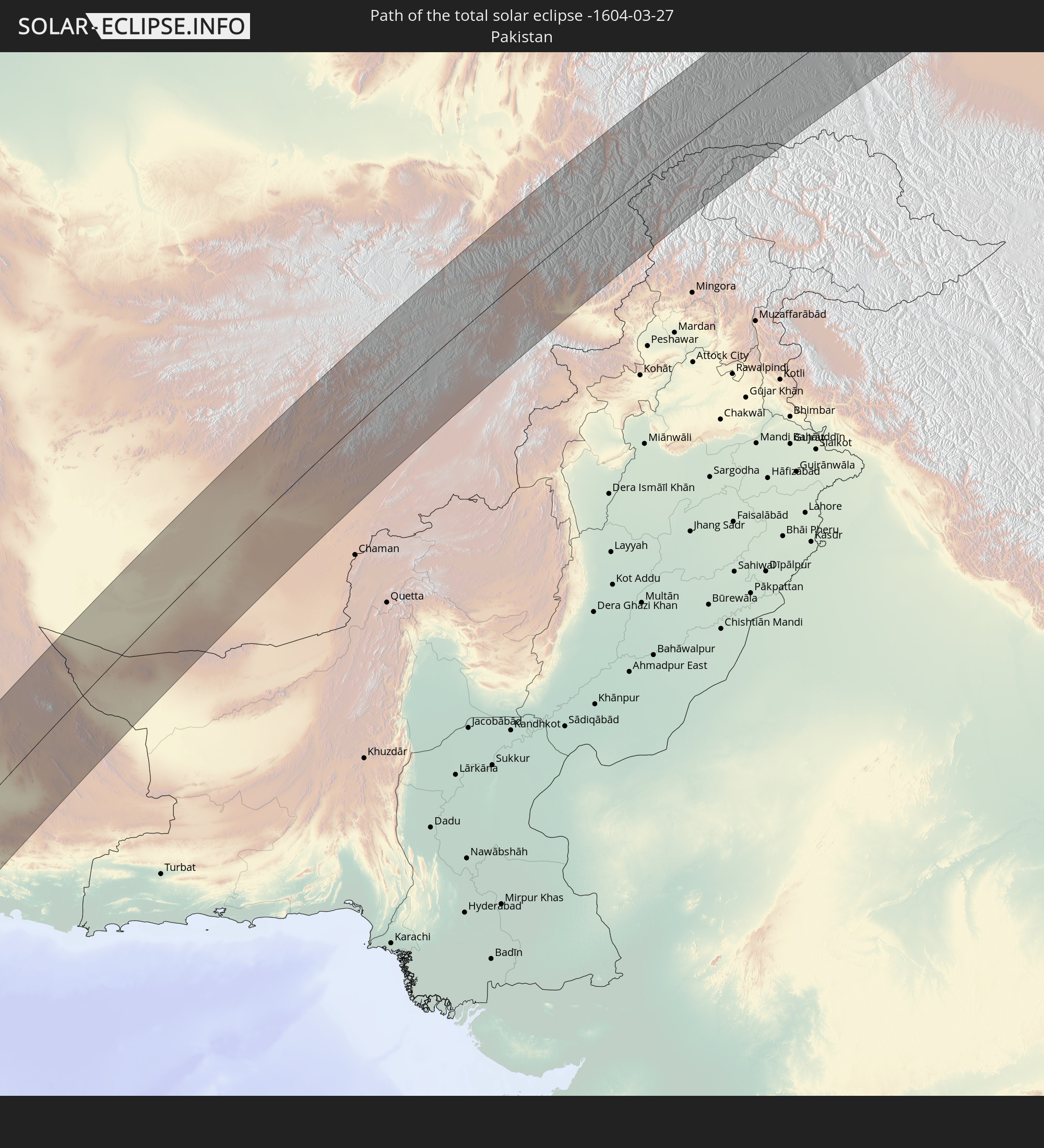 Pakistan
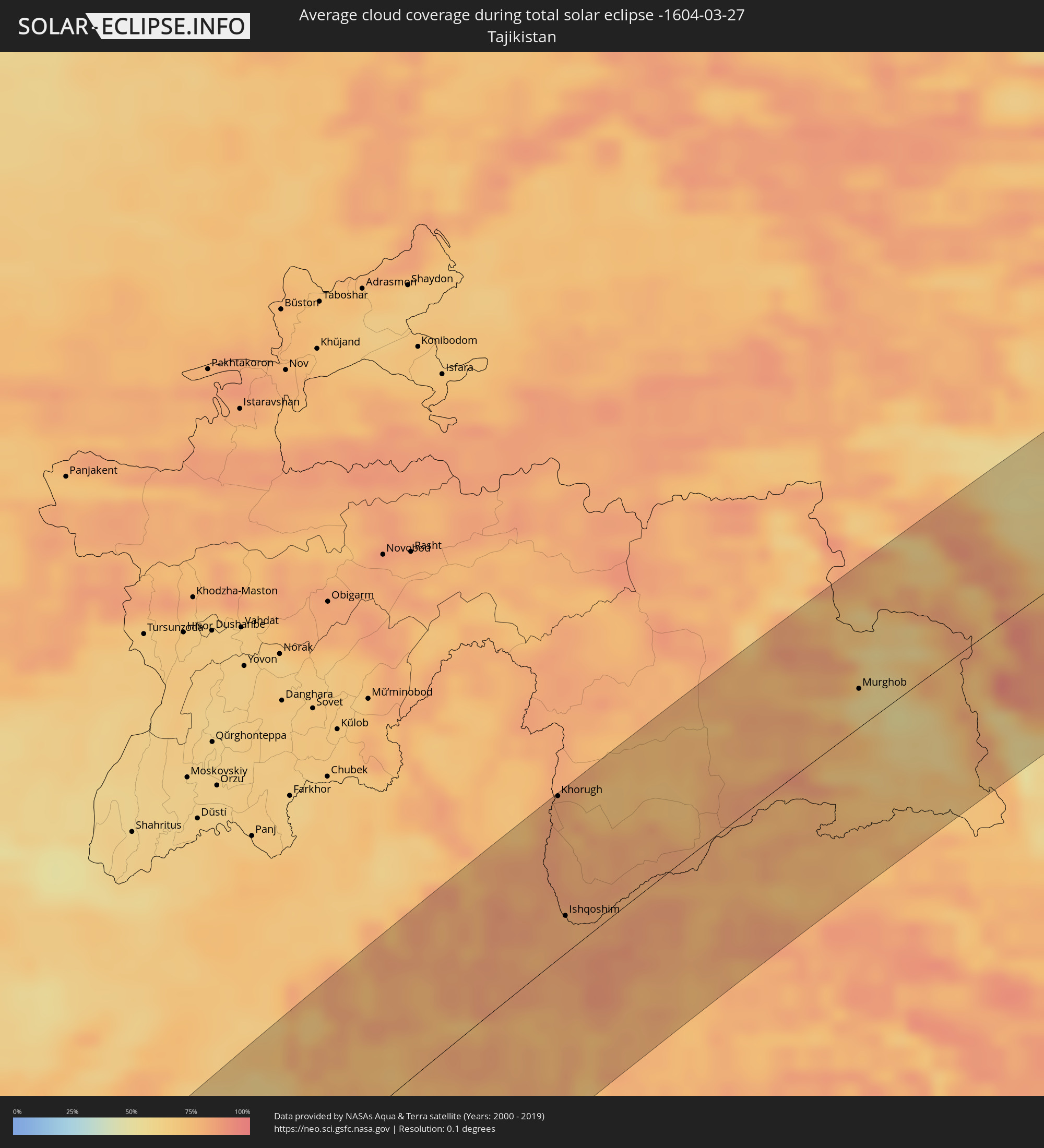
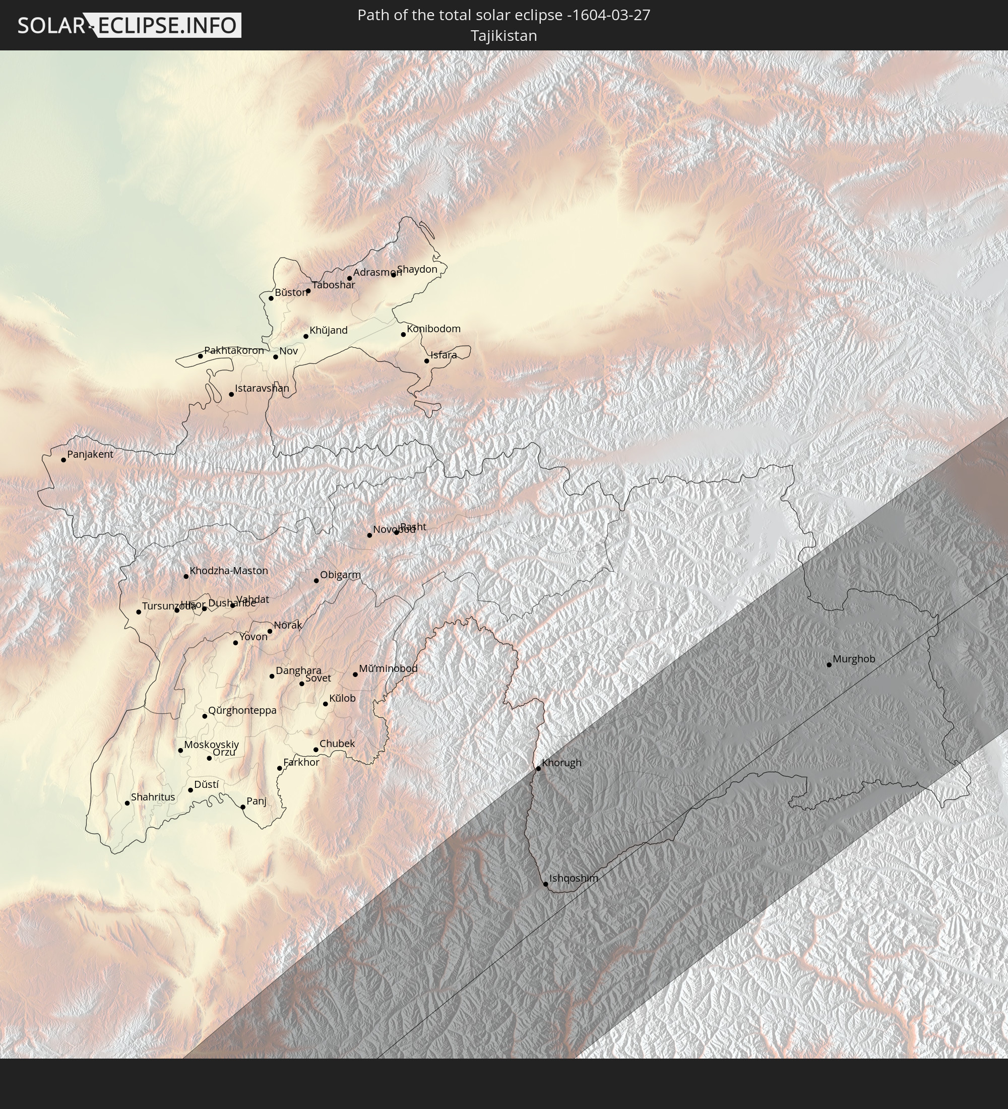 Tadschikistan
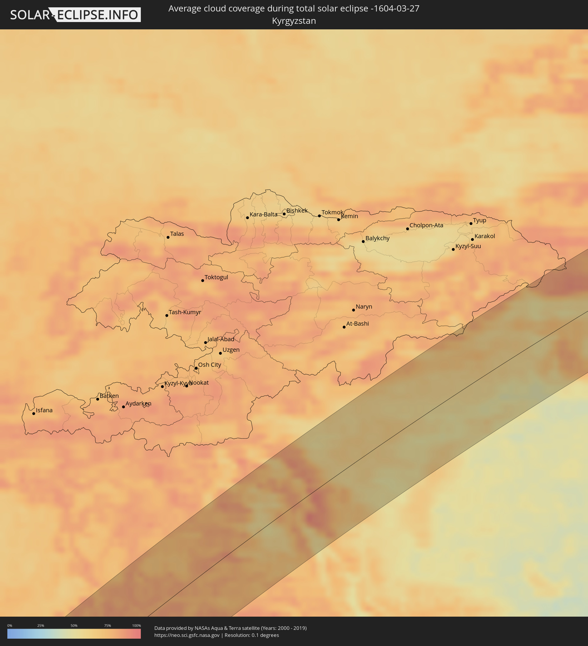
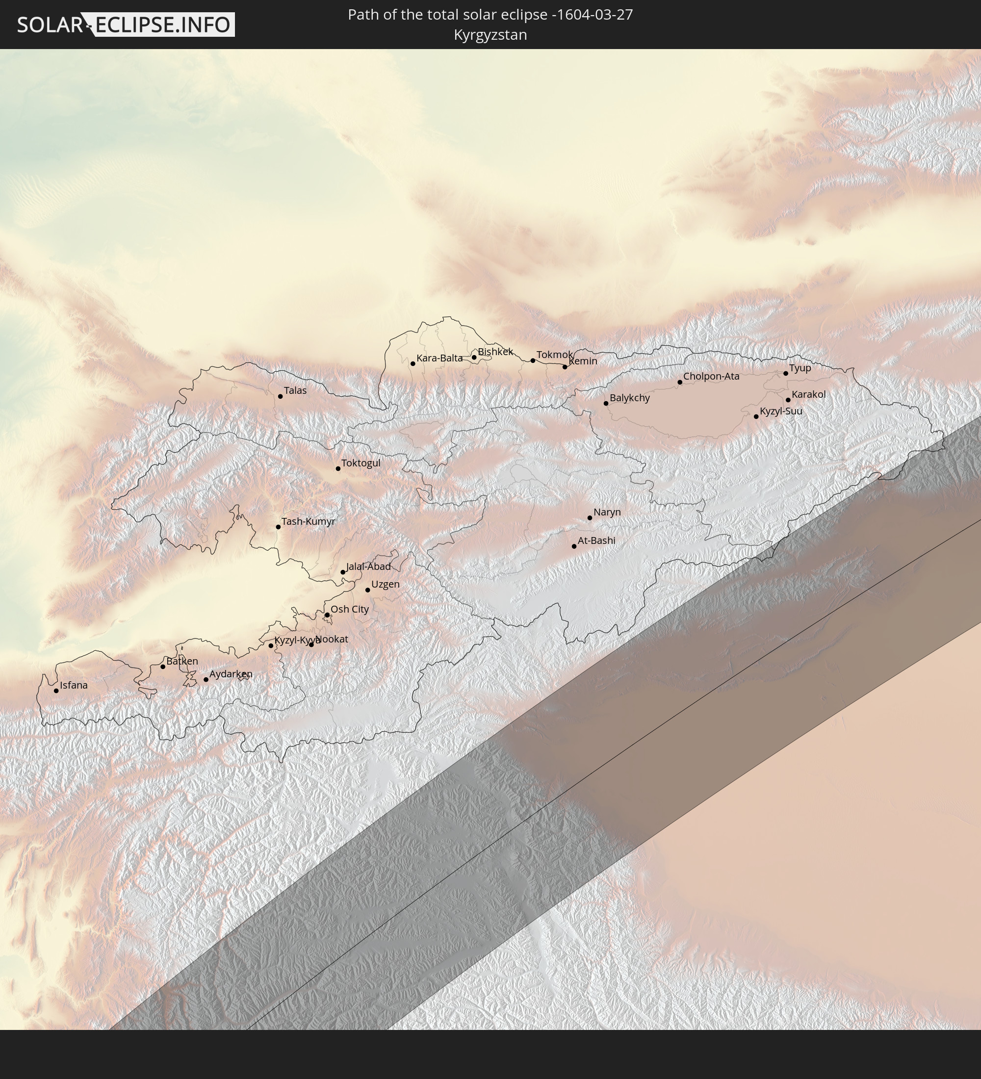 Kirgisistan
 Volksrepublik China
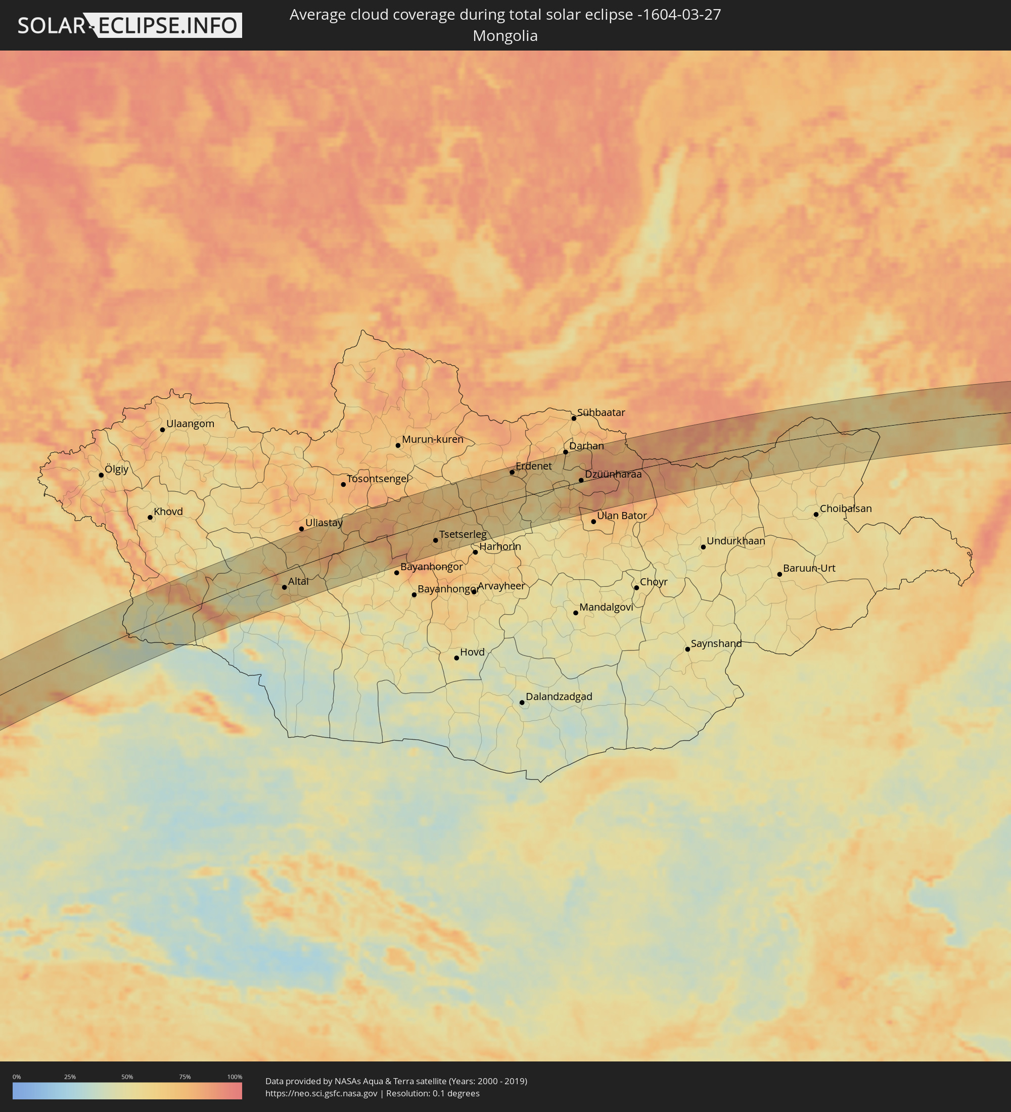
 Mongolei
In den folgenden Ländern ist die Sonnenfinsternis partiell zu sehen
 Russland
 Spanien
 Mauretanien
 Guinea
 St. Helena
 Marokko
 Mali
Mali
 Liberia
 Spitzbergen
 Algerien
 Elfenbeinküste
 Burkina Faso
 Ghana
Ghana
 Togo
Togo
 Niger
Niger
 Benin
Benin
 Nigeria
 Norwegen
 Äquatorialguinea
 São Tomé und Príncipe
 Italien
 Tunesien
 Kamerun
 Gabun
Gabun
 Libyen
 Österreich
 Republik Kongo
 Angola
 Namibia
 Tschechien
 Demokratische Republik Kongo
 Vatikanstadt
 Slowenien
 Tschad
 Kroatien
 Polen
Polen
 Malta
Malta
 Zentralafrikanische Republik
 Bosnien und Herzegowina
 Ungarn
 Südafrika
 Slowakei
 Montenegro
 Serbien
 Albanien
 Griechenland
 Botswana
 Rumänien
 Mazedonien
 Finnland
 Litauen
 Lettland
 Estland
 Sudan
Sudan
 Sambia
 Ukraine
 Bulgarien
 Weißrussland
 Ägypten
 Simbabwe
 Türkei
 Moldawien
 Lesotho
 Ruanda
 Burundi
 Tansania
 Uganda
 Mosambik
 Swasiland
 Republik Zypern
 Malawi
 Äthiopien
 Kenia
Kenia
 Staat Palästina
 Israel
 Saudi-Arabien
 Jordanien
 Libanon
 Syrien
 Eritrea
 Irak
Irak
 Georgien
 Französische Süd- und Antarktisgebiete
 Somalia
 Dschibuti
 Jemen
Jemen
 Madagaskar
 Komoren
 Armenien
 Iran
Iran
 Aserbaidschan
 Mayotte
 Seychellen
 Kasachstan
 Kuwait
 Bahrain
 Katar
Katar
 Vereinigte Arabische Emirate
 Oman
Oman
 Turkmenistan
 Réunion
 Usbekistan
 Mauritius
 Afghanistan
 Pakistan
 Tadschikistan
 Indien
 Kirgisistan
 Britisches Territorium im Indischen Ozean
 Malediven
 Volksrepublik China
 Sri Lanka
 Nepal
Nepal
 Mongolei
 Bangladesch
 Bhutan
 Myanmar
 Thailand
 Laos
Laos
 Vietnam
 Macau
Macau
 Hongkong
 Taiwan
 Philippinen
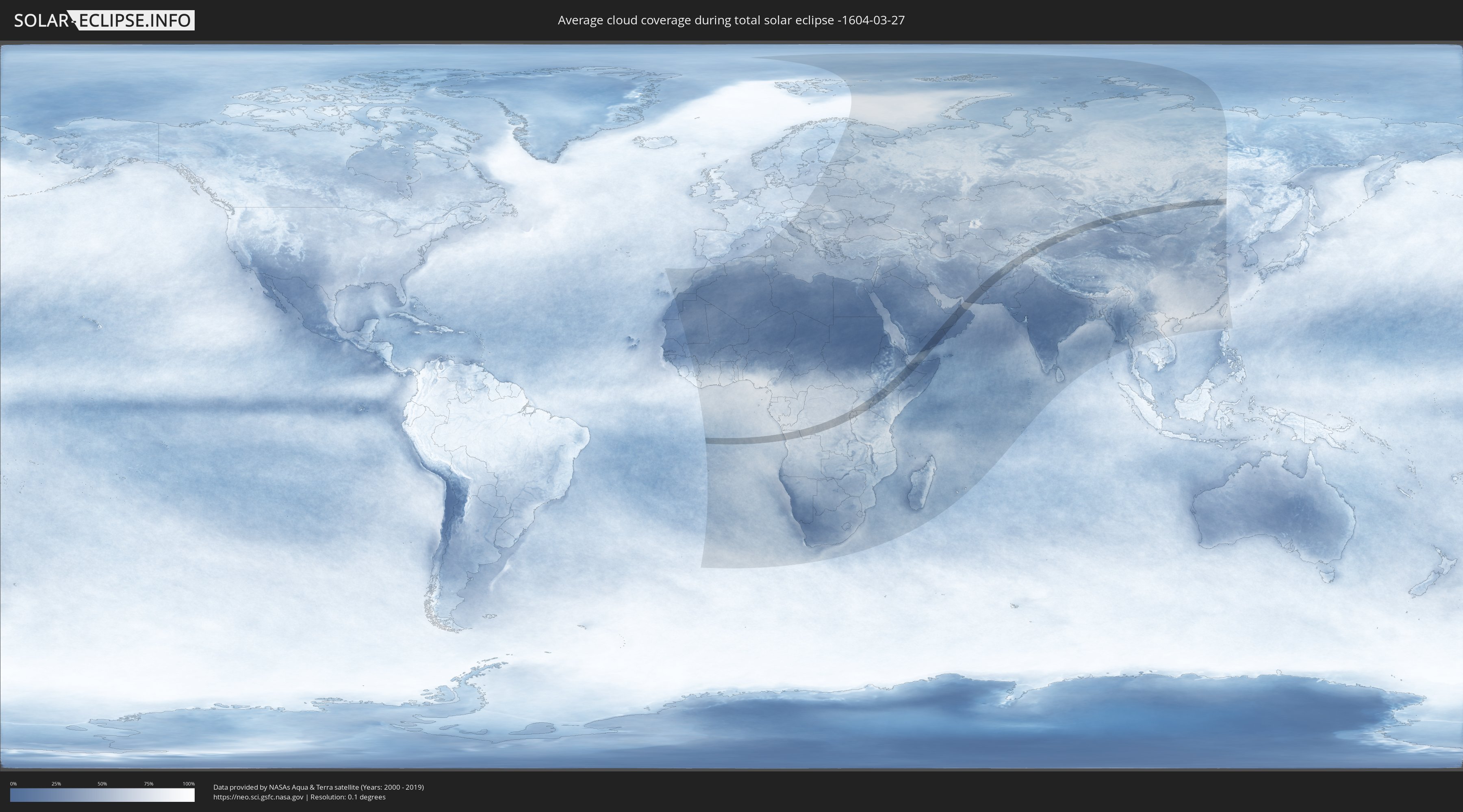
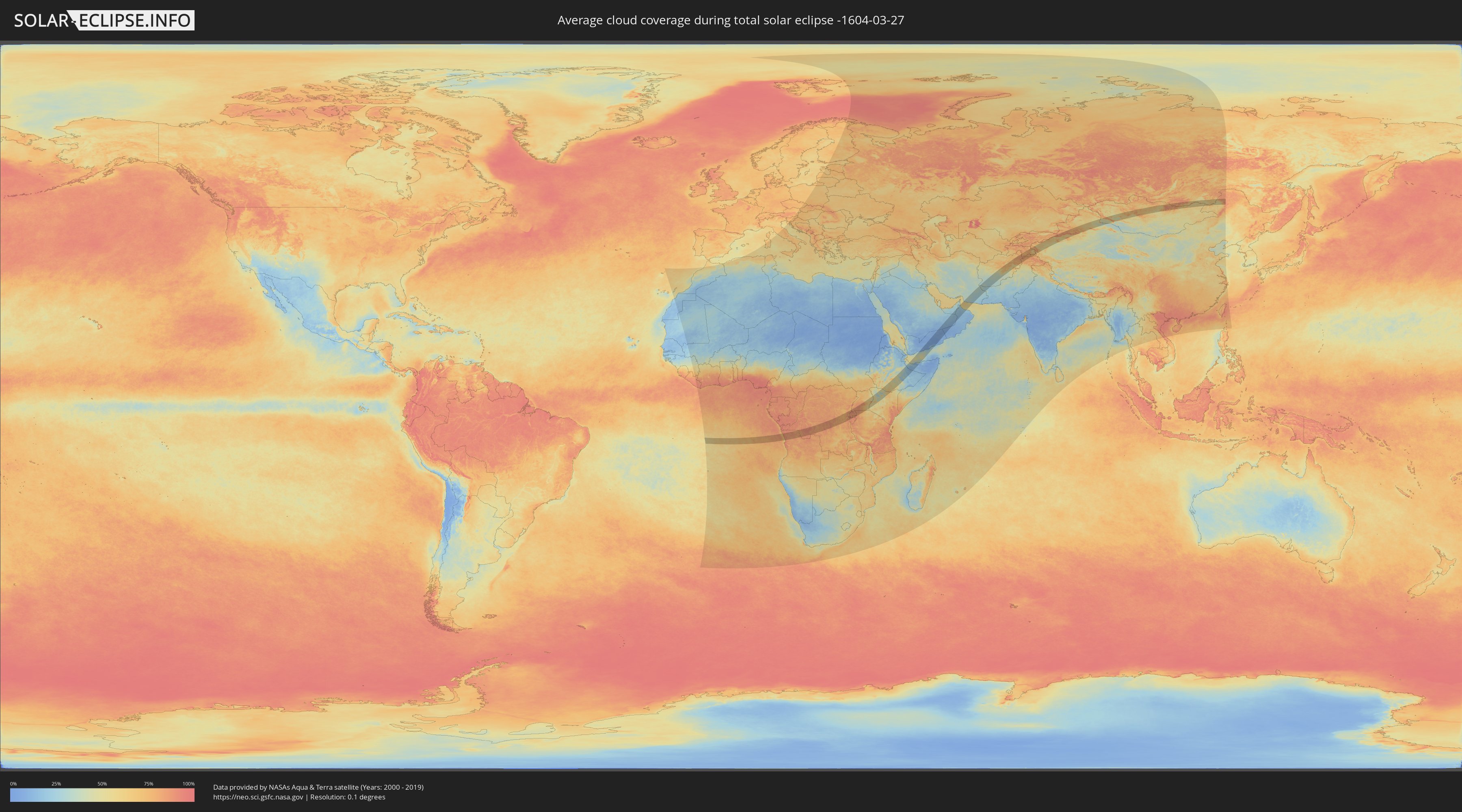
Wie wird das Wetter während der totalen Sonnenfinsternis am 27.03.-1604?
Wo ist der beste Ort, um die totale Sonnenfinsternis vom 27.03.-1604 zu beobachten?
Die folgenden Karten zeigen die durchschnittliche Bewölkung für den Tag, an dem die totale Sonnenfinsternis
stattfindet. Mit Hilfe der Karten lässt sich der Ort entlang des Finsternispfades eingrenzen,
der die besten Aussichen auf einen klaren wolkenfreien Himmel bietet.
Trotzdem muss man immer lokale Gegenenheiten beachten und sollte sich genau über das Wetter an seinem
gewählten Beobachtungsort informieren.
Die Daten stammen von den beiden NASA-Satelliten
AQUA und TERRA
und wurden über einen Zeitraum von 19 Jahren (2000 - 2019) gemittelt.
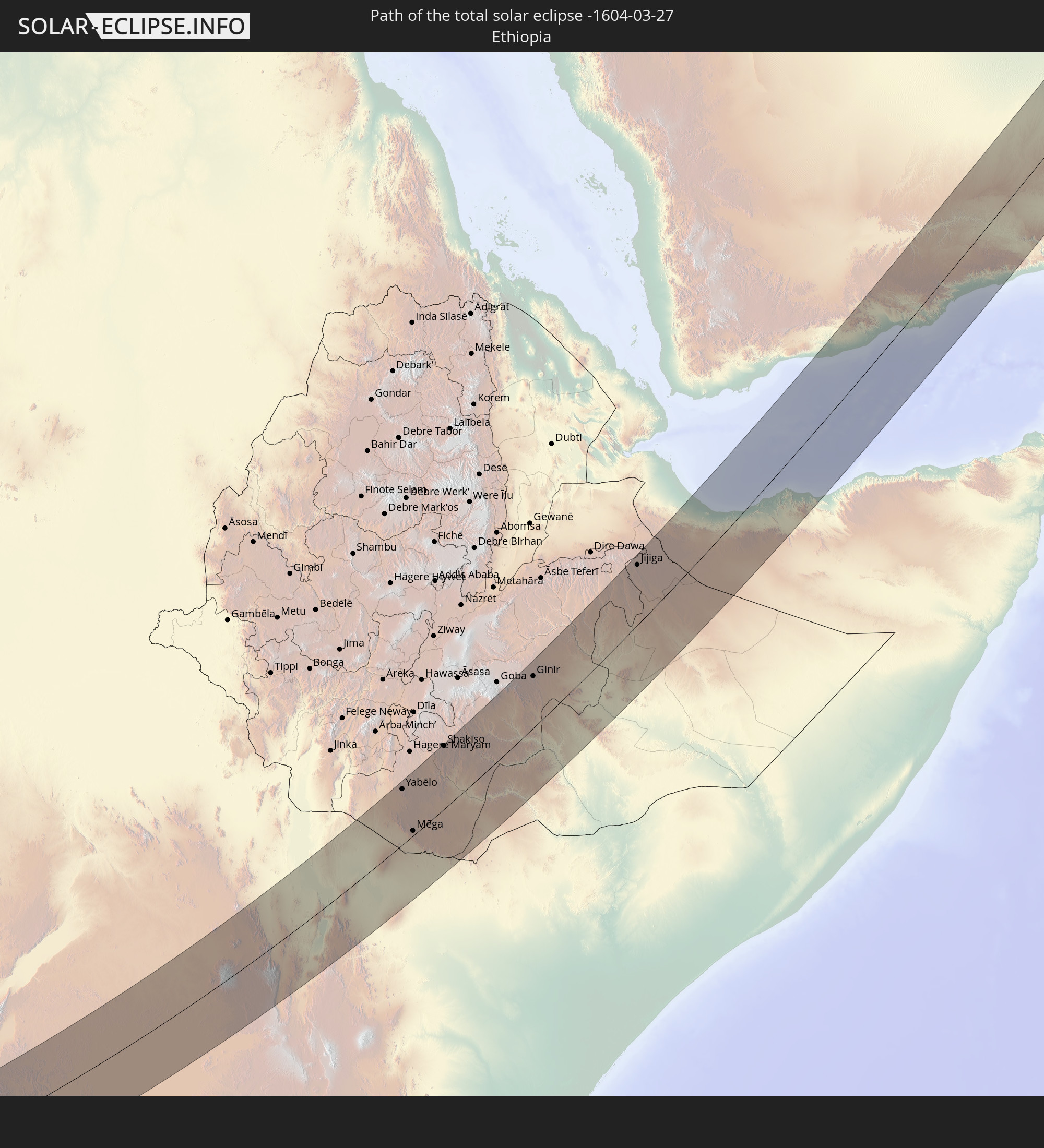
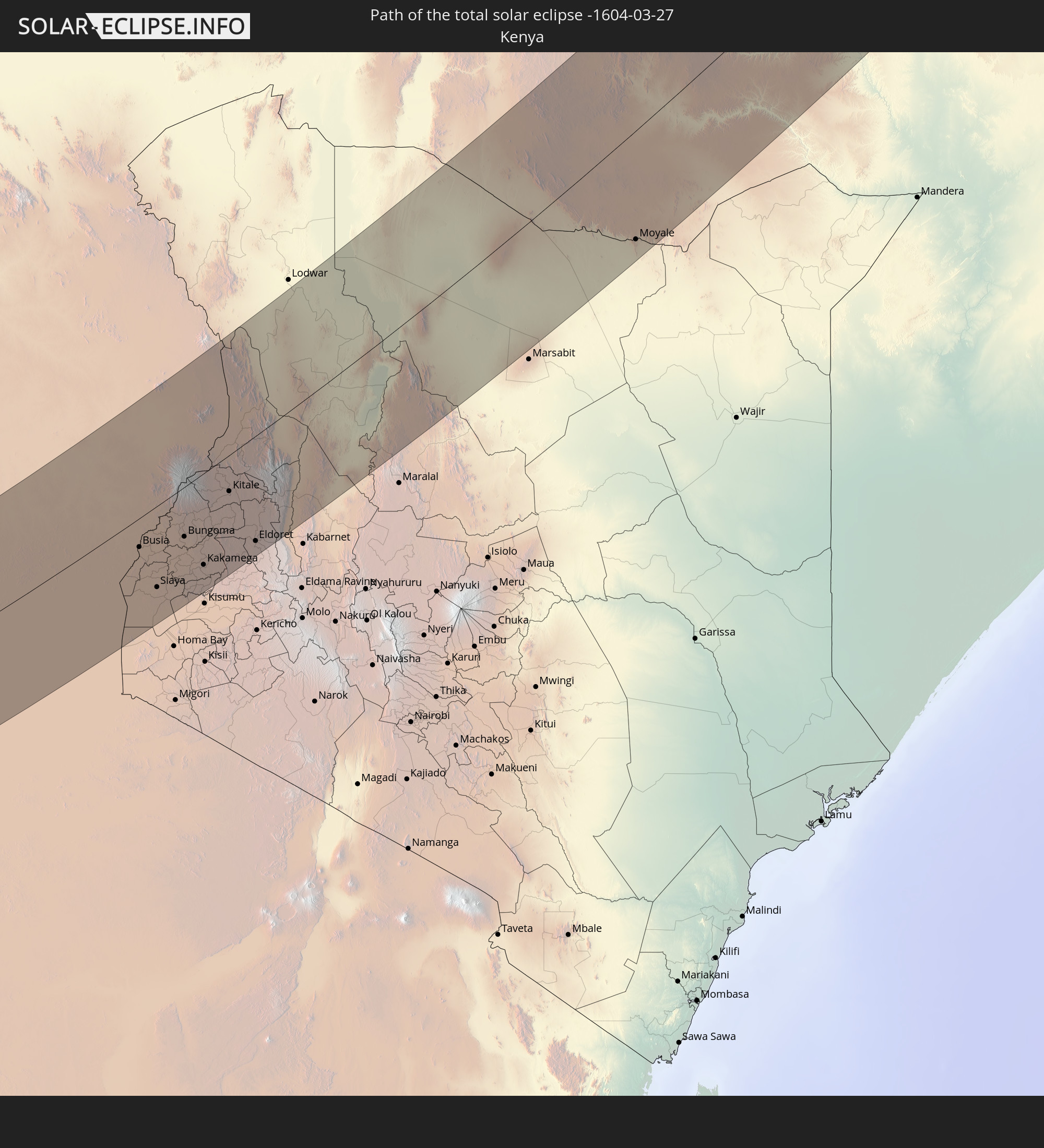
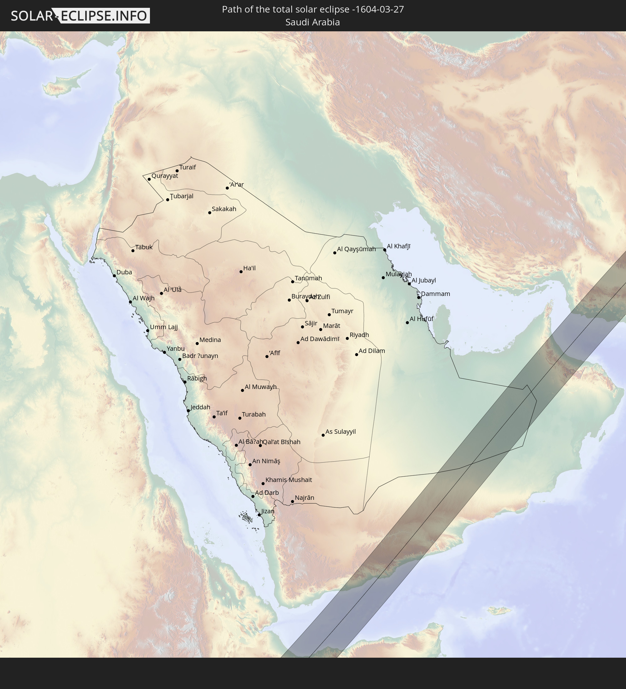
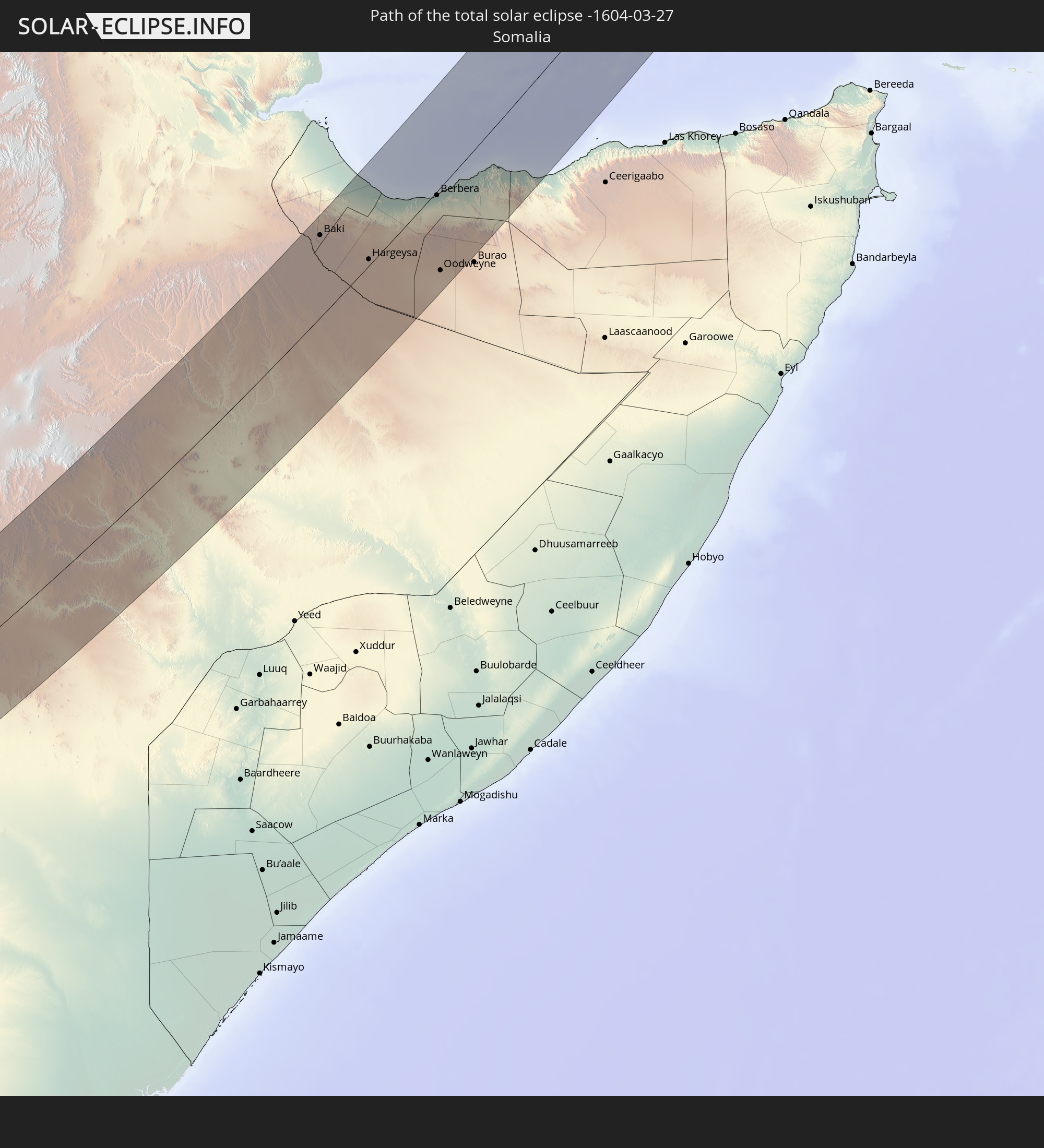
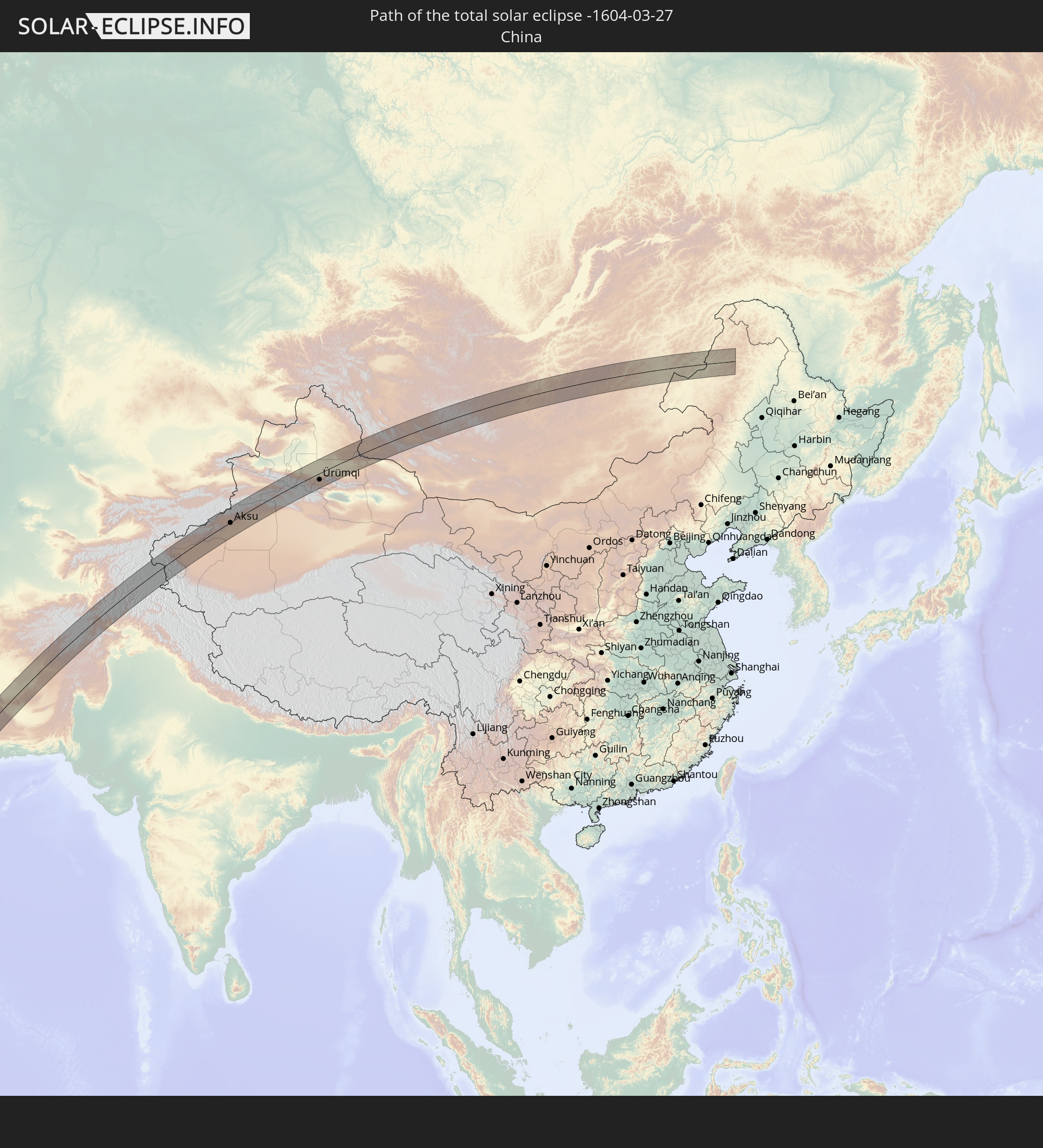
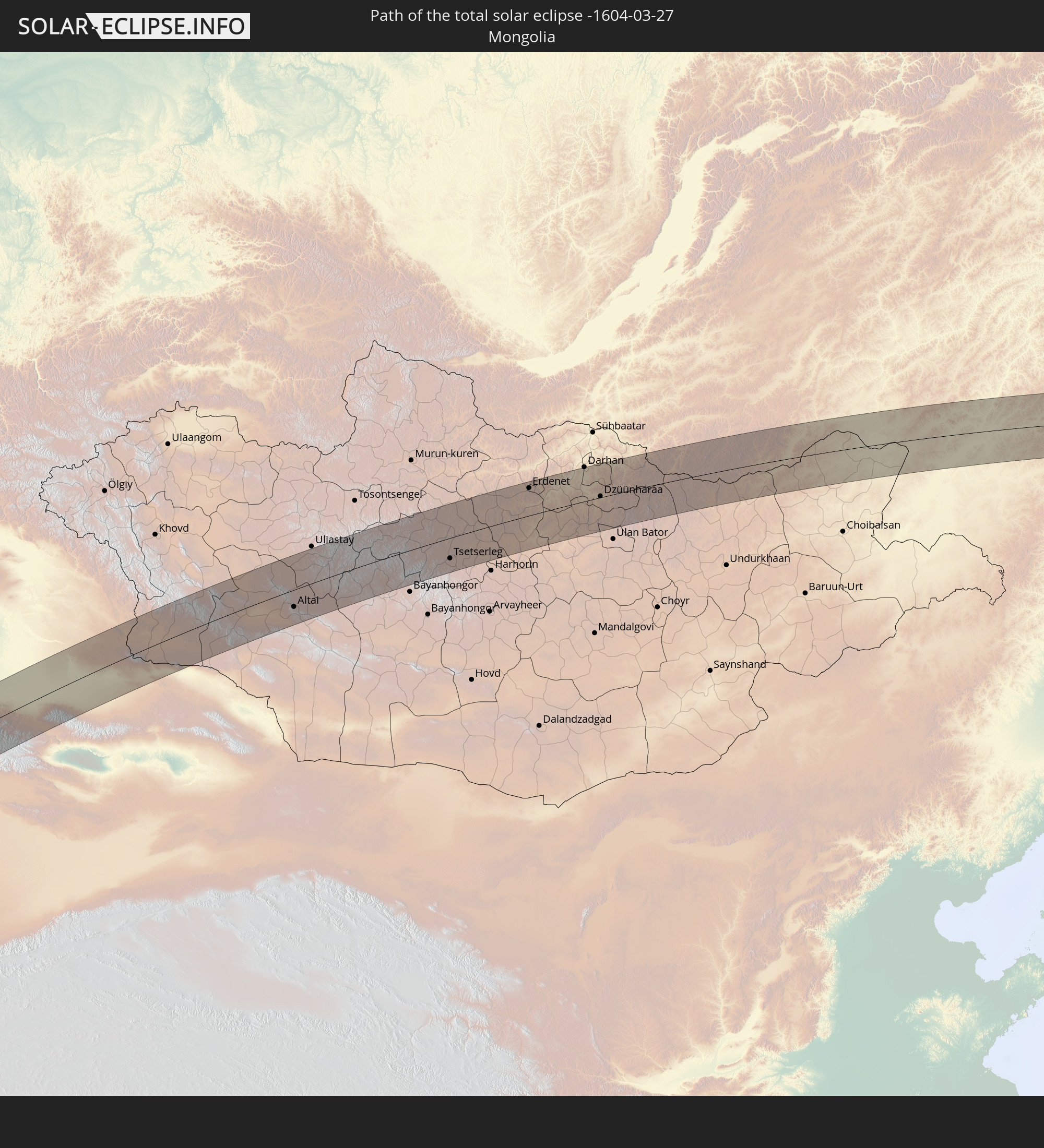
Detaillierte Länderkarten
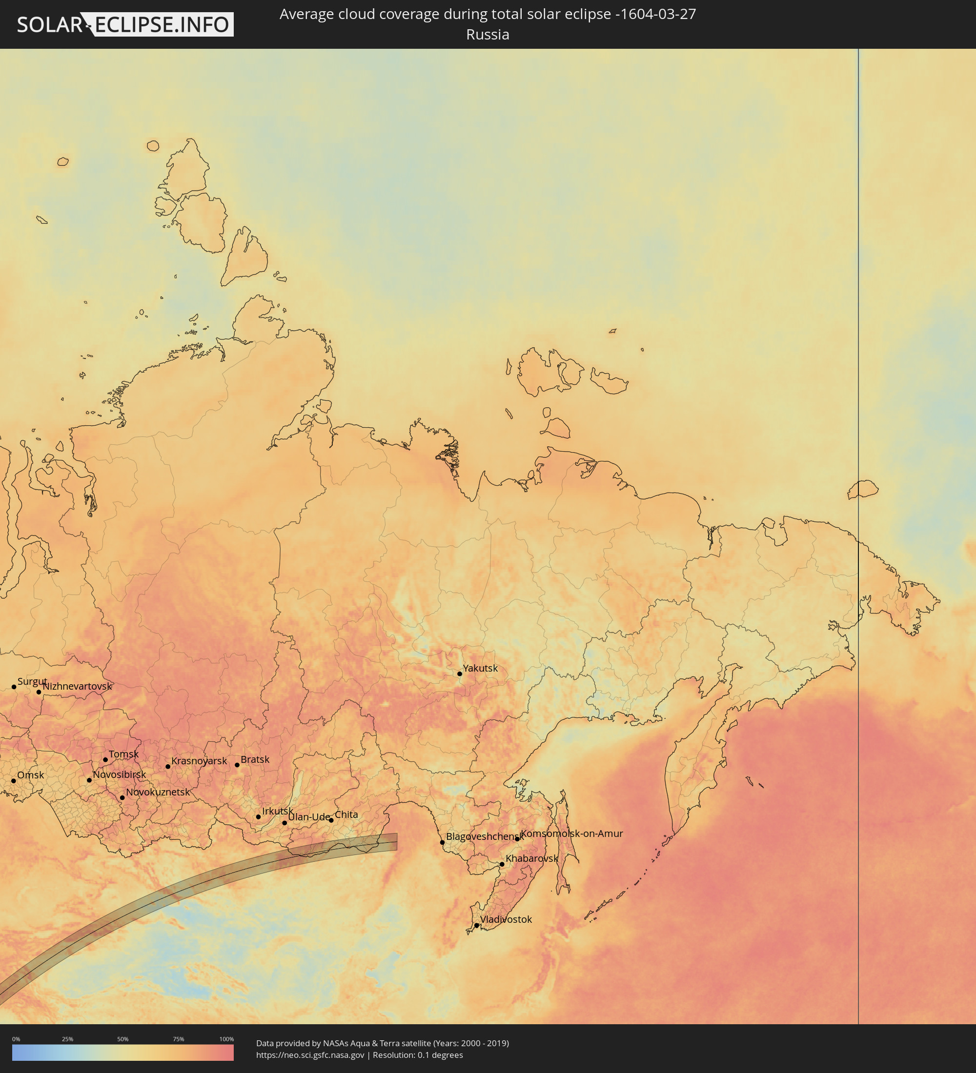 Russland
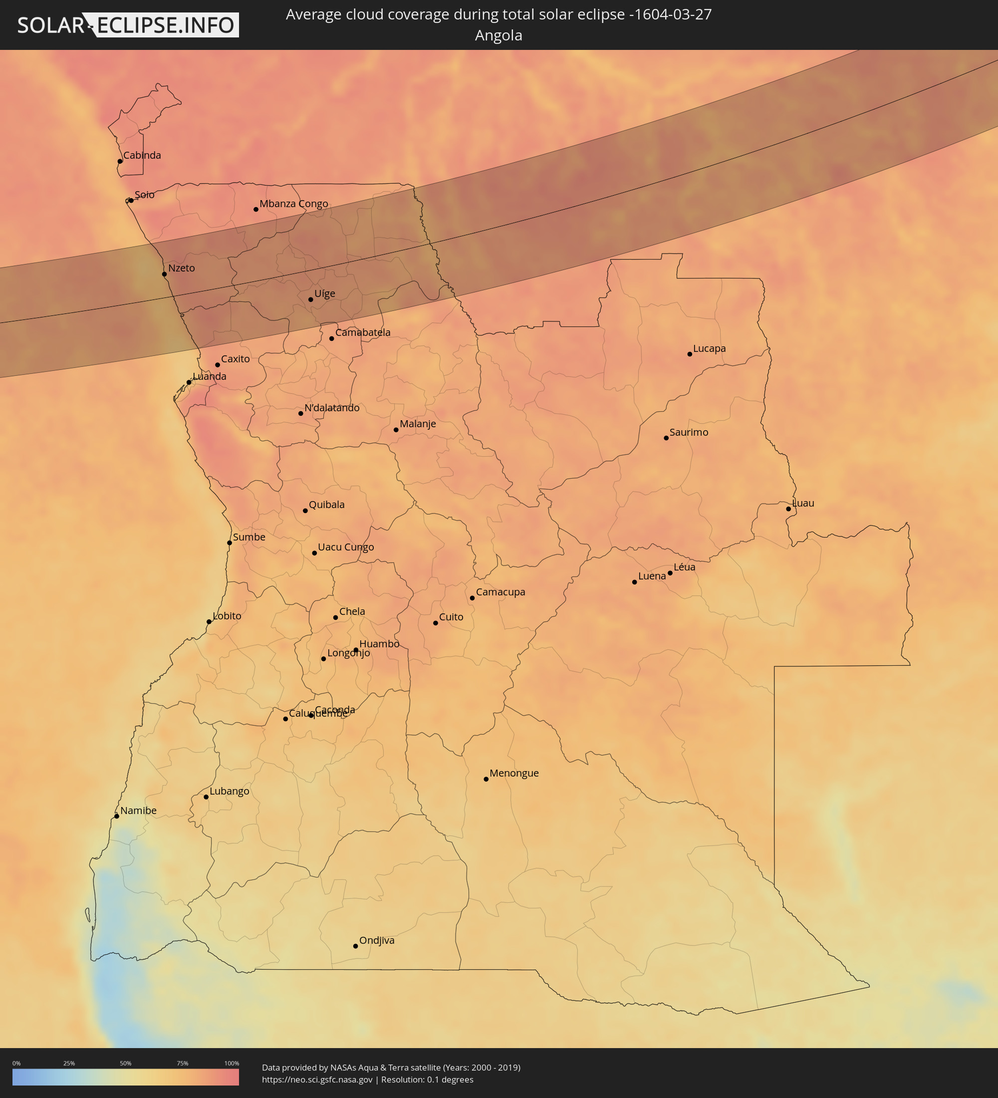 Angola
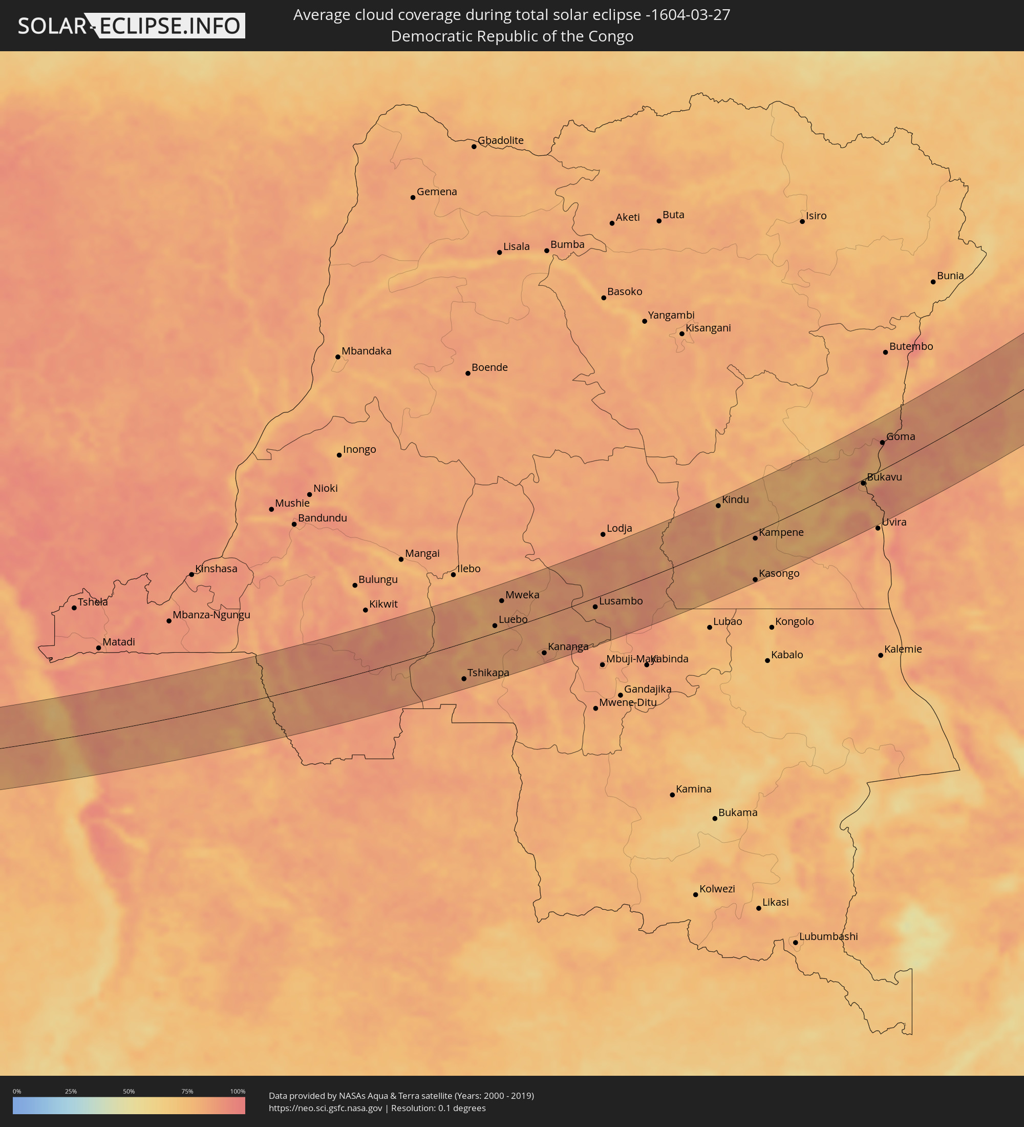 Demokratische Republik Kongo
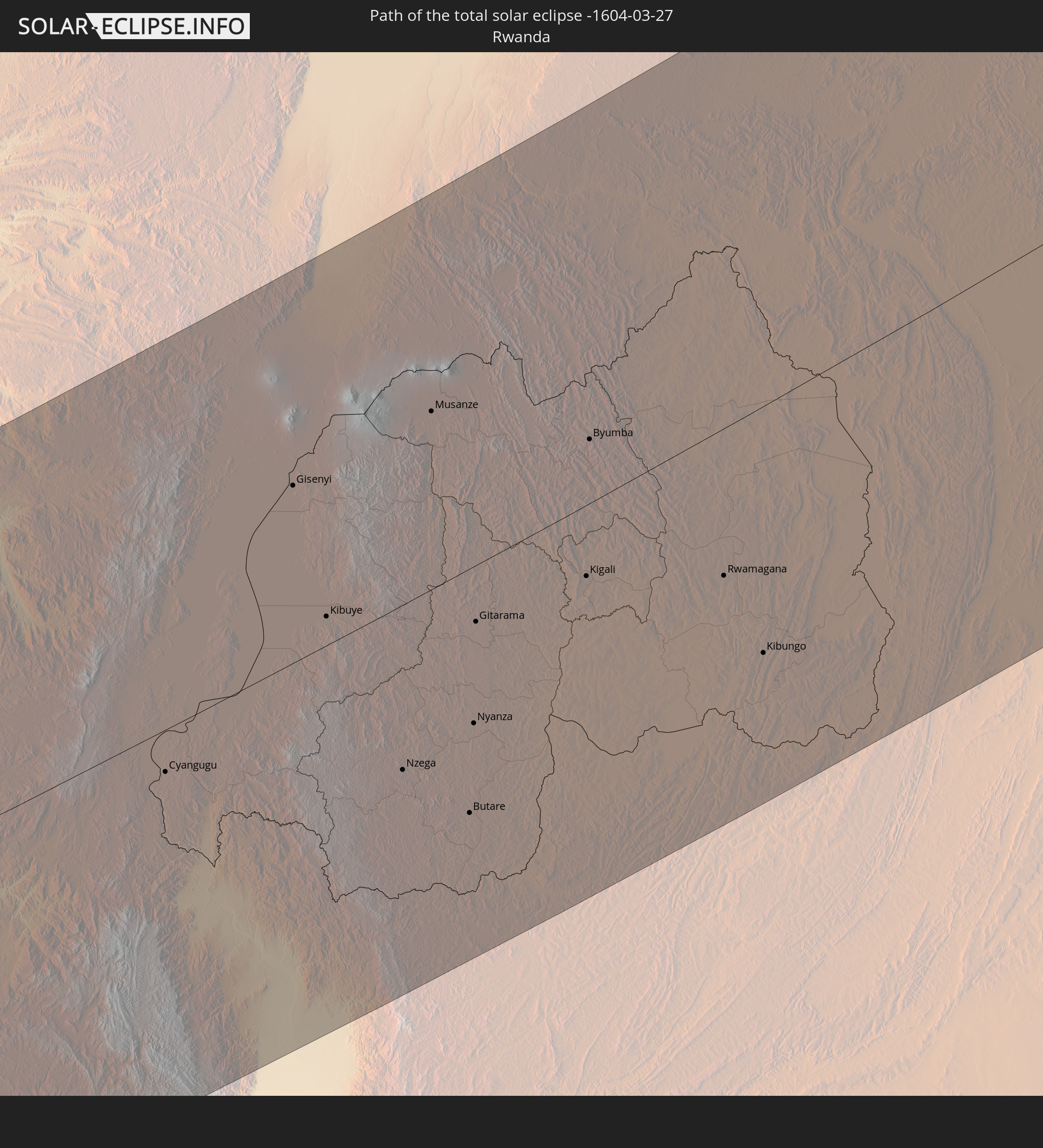
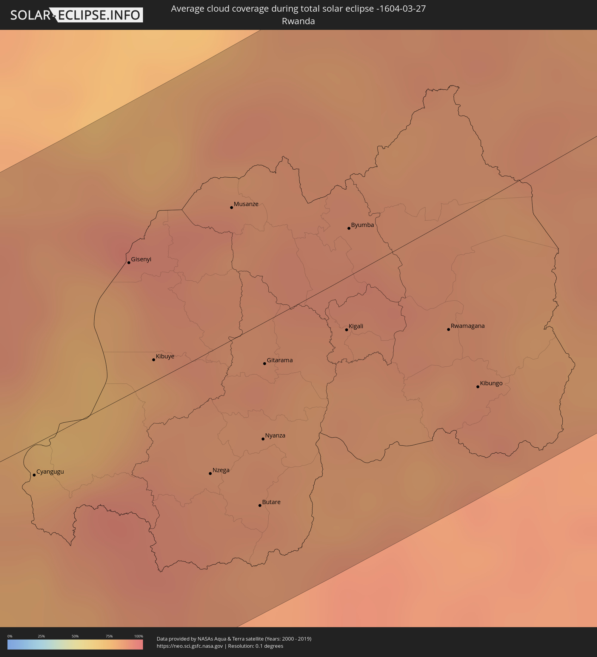 Ruanda
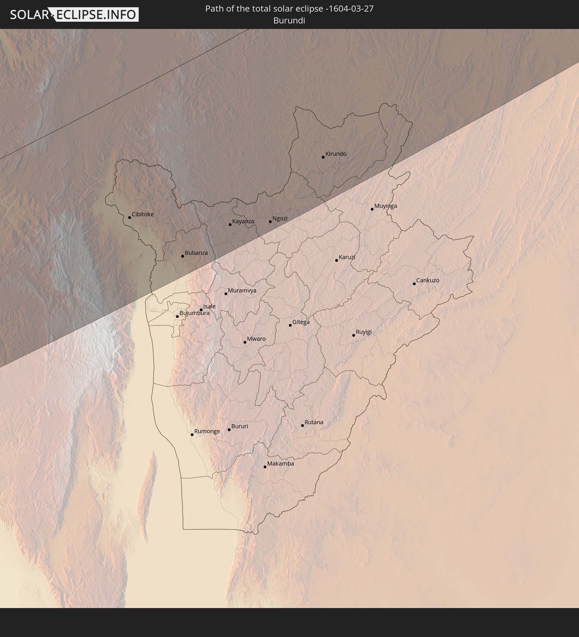
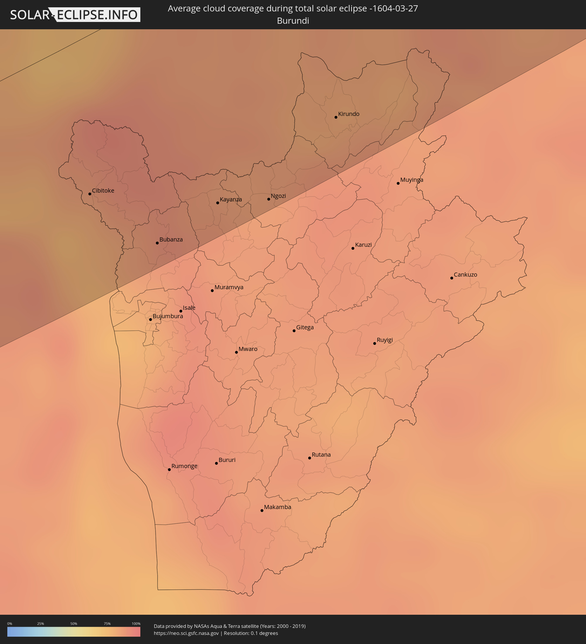 Burundi
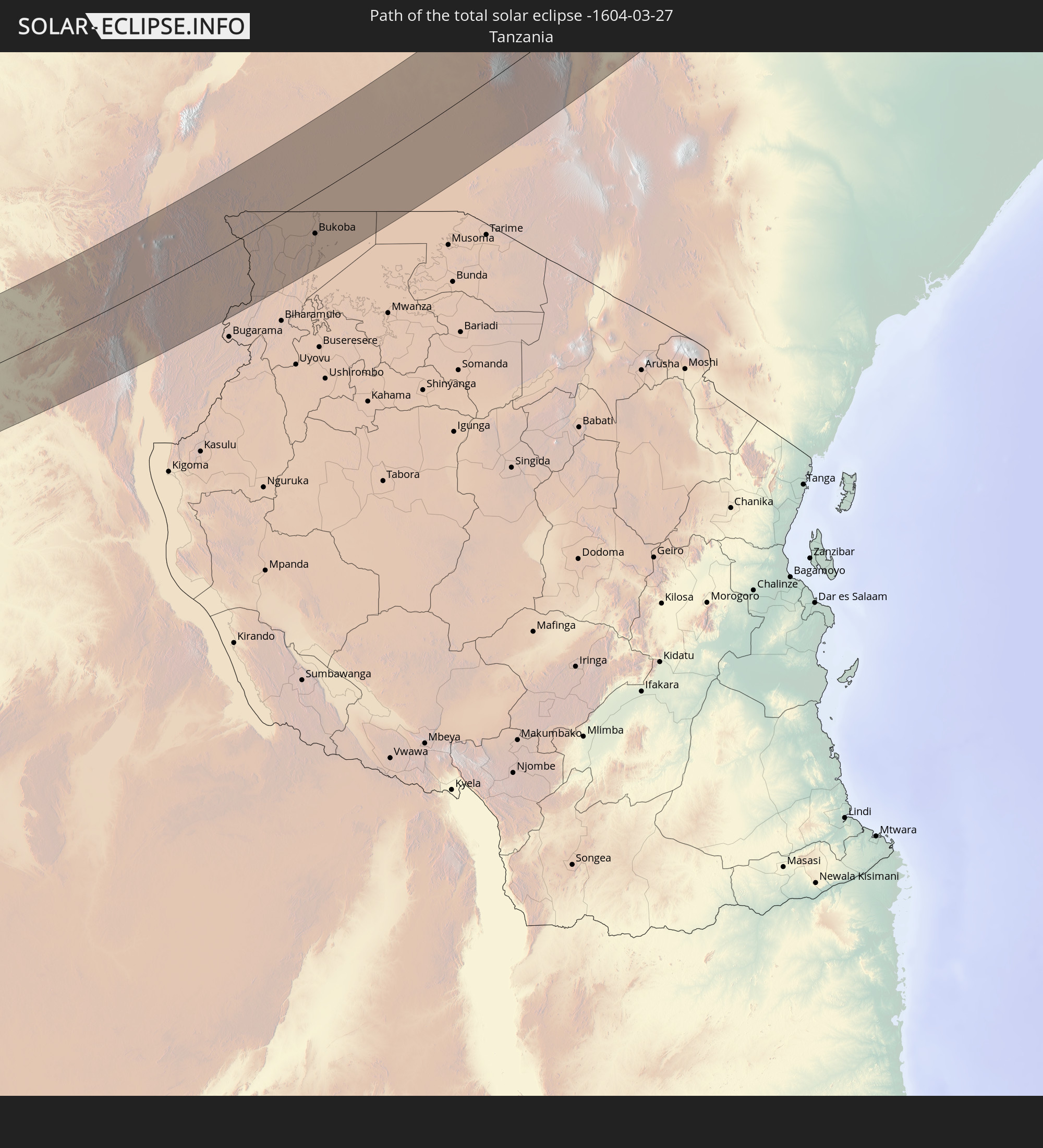
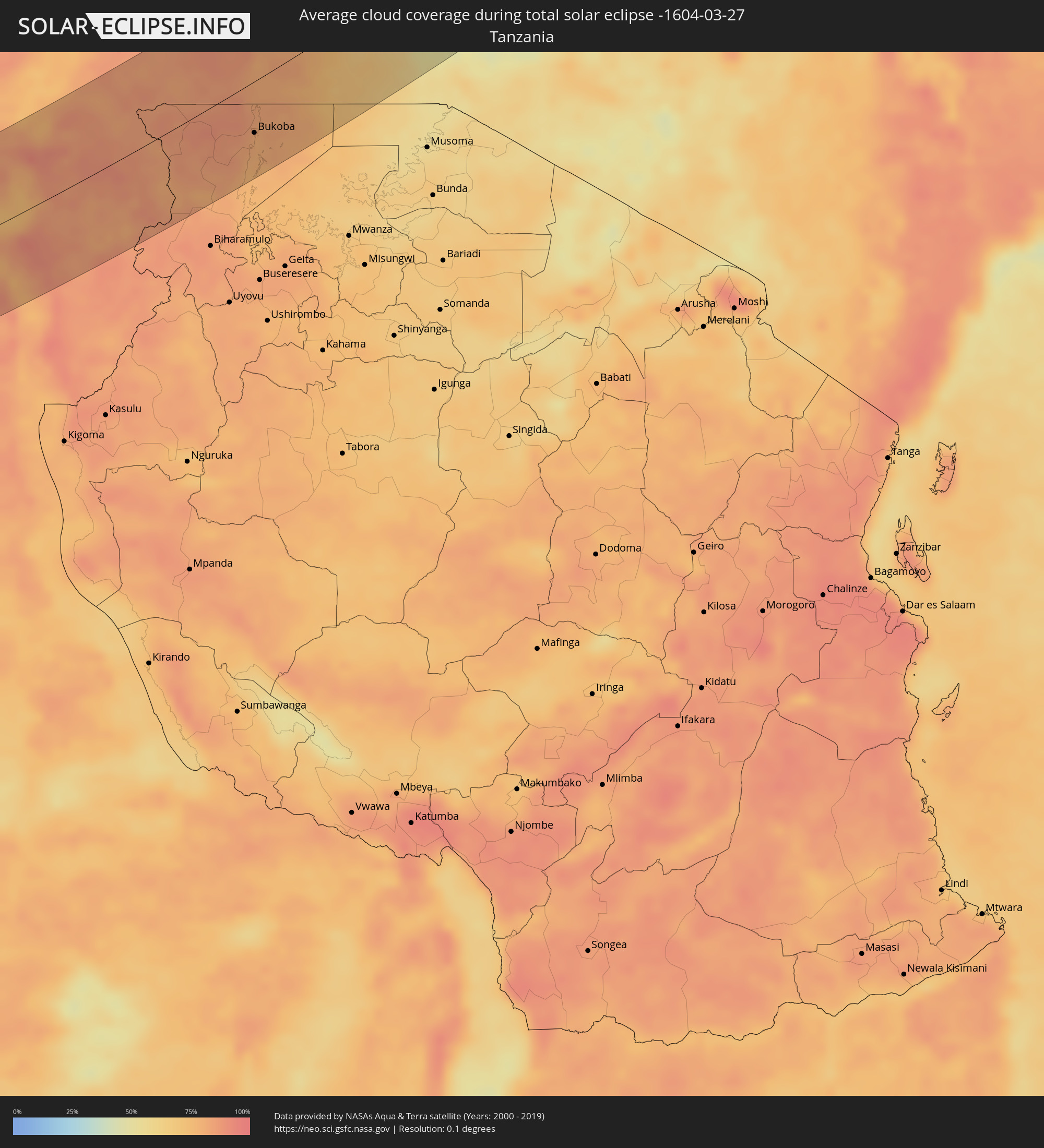 Tansania
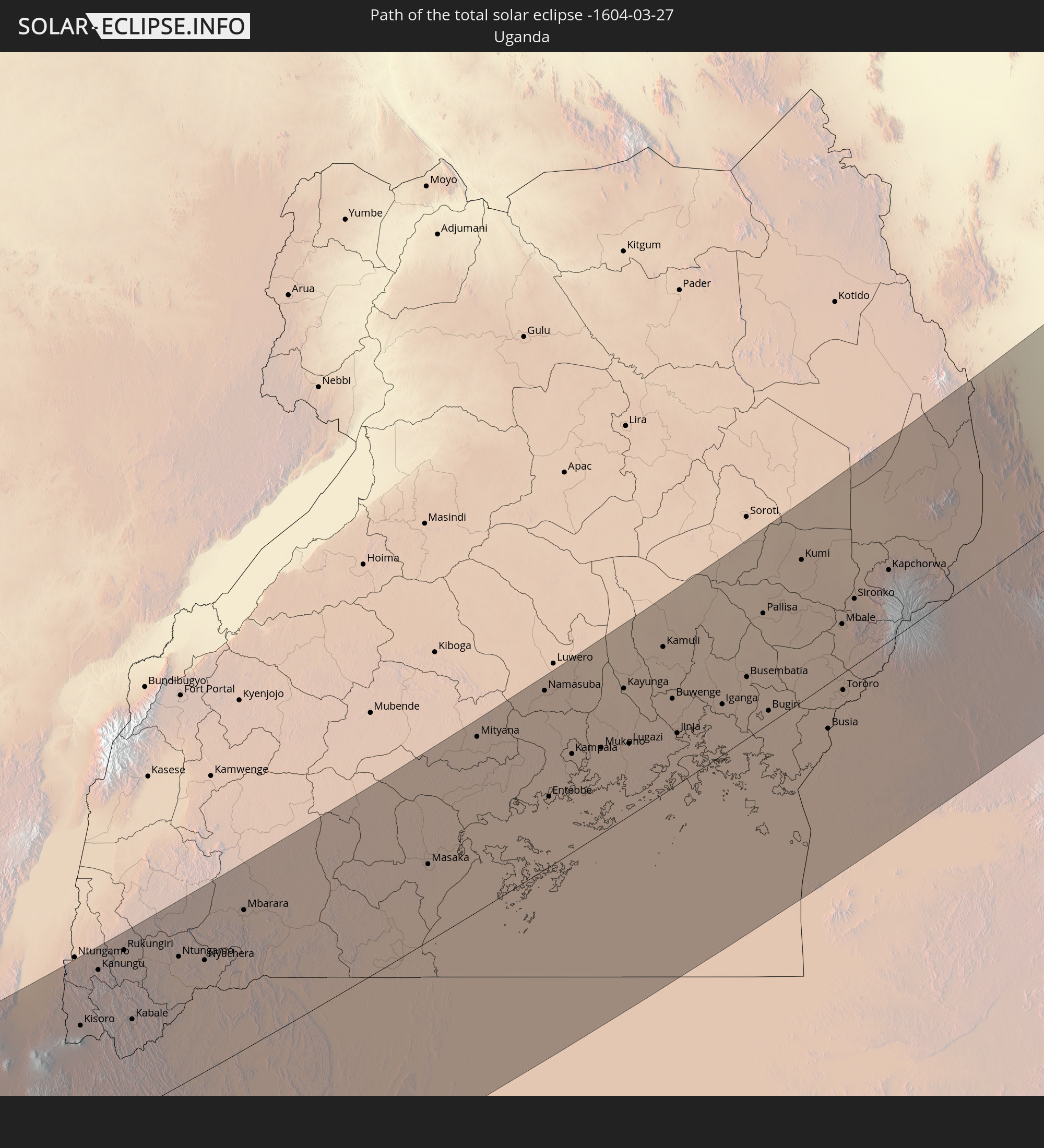
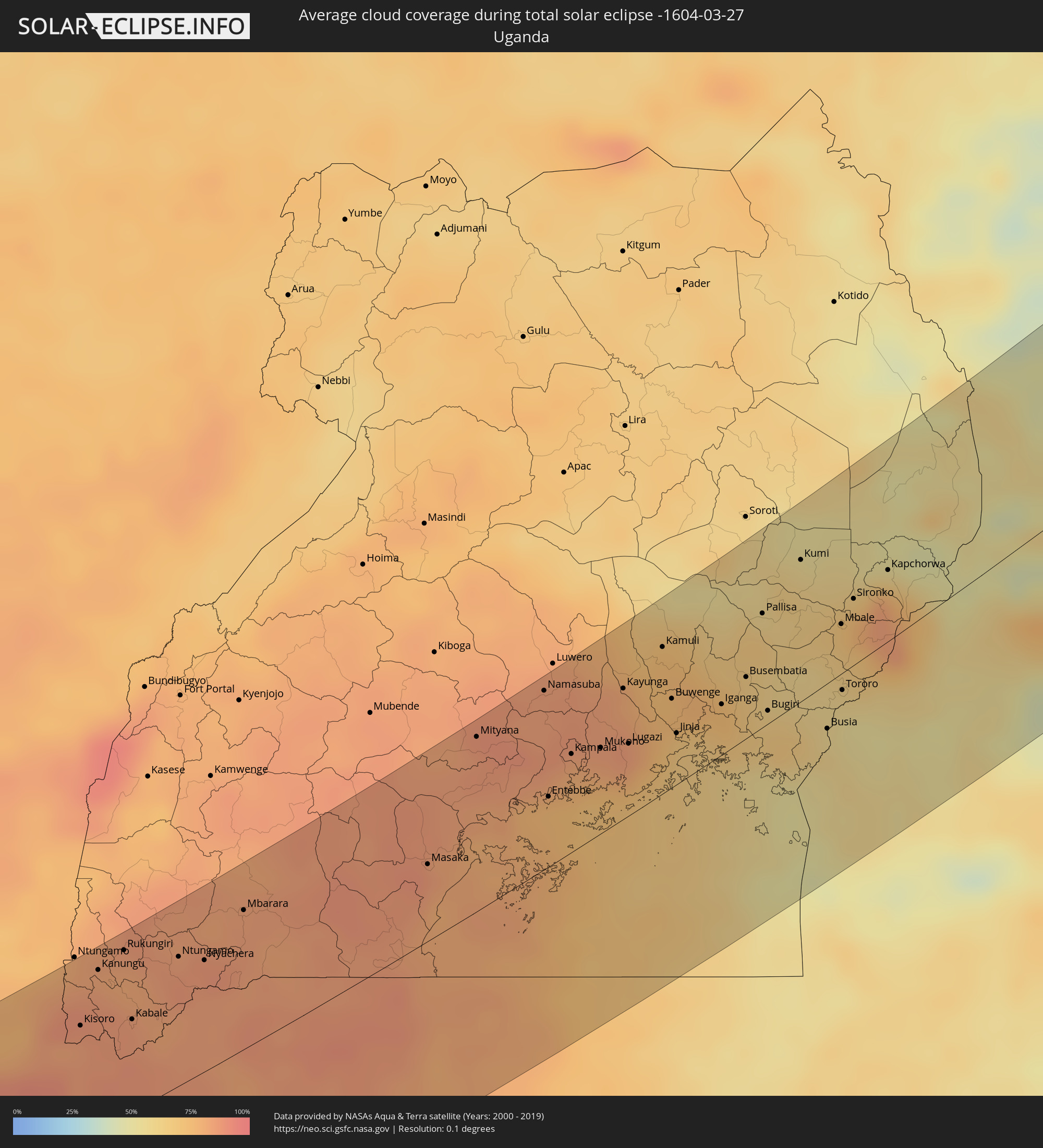 Uganda
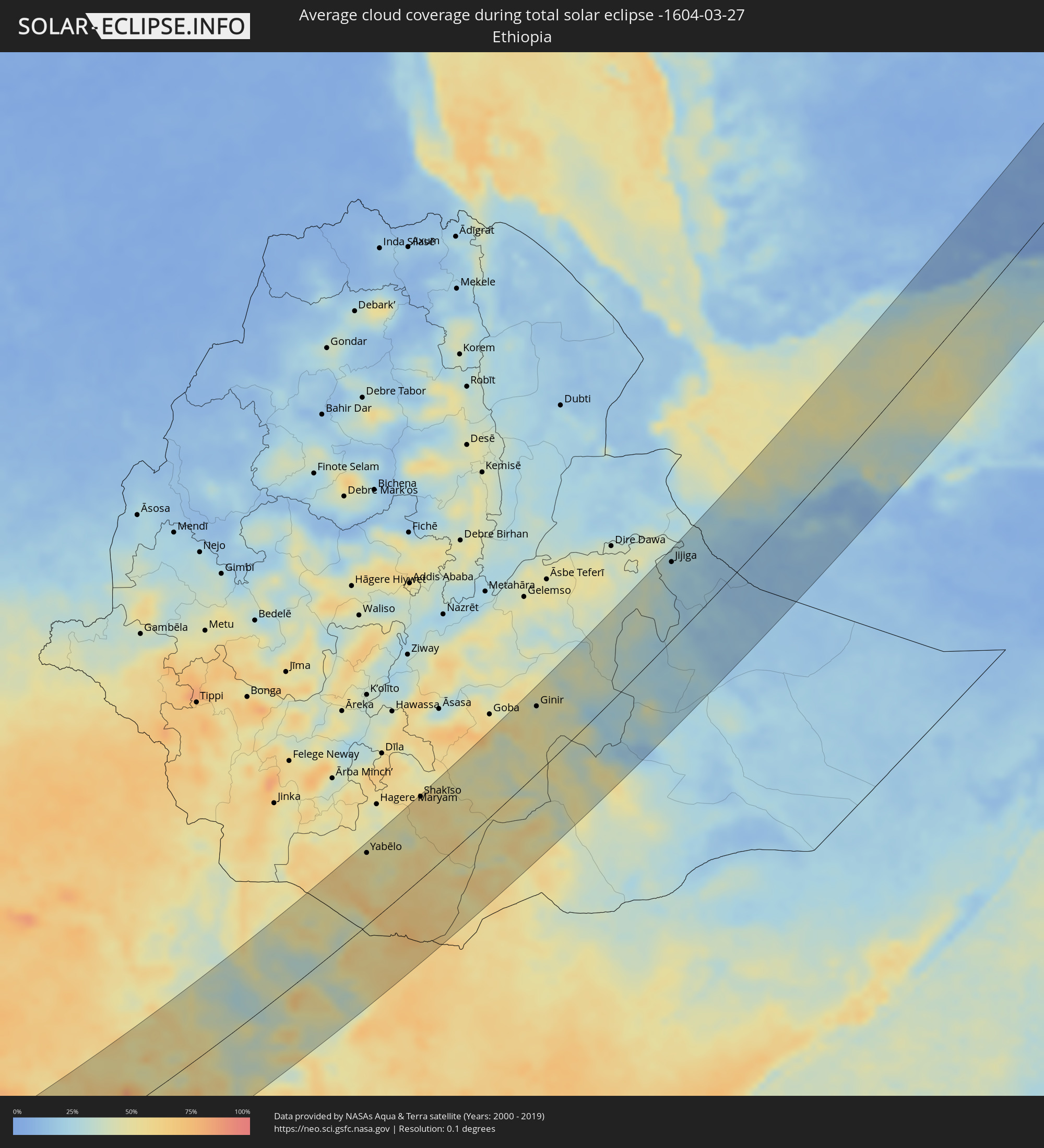 Äthiopien
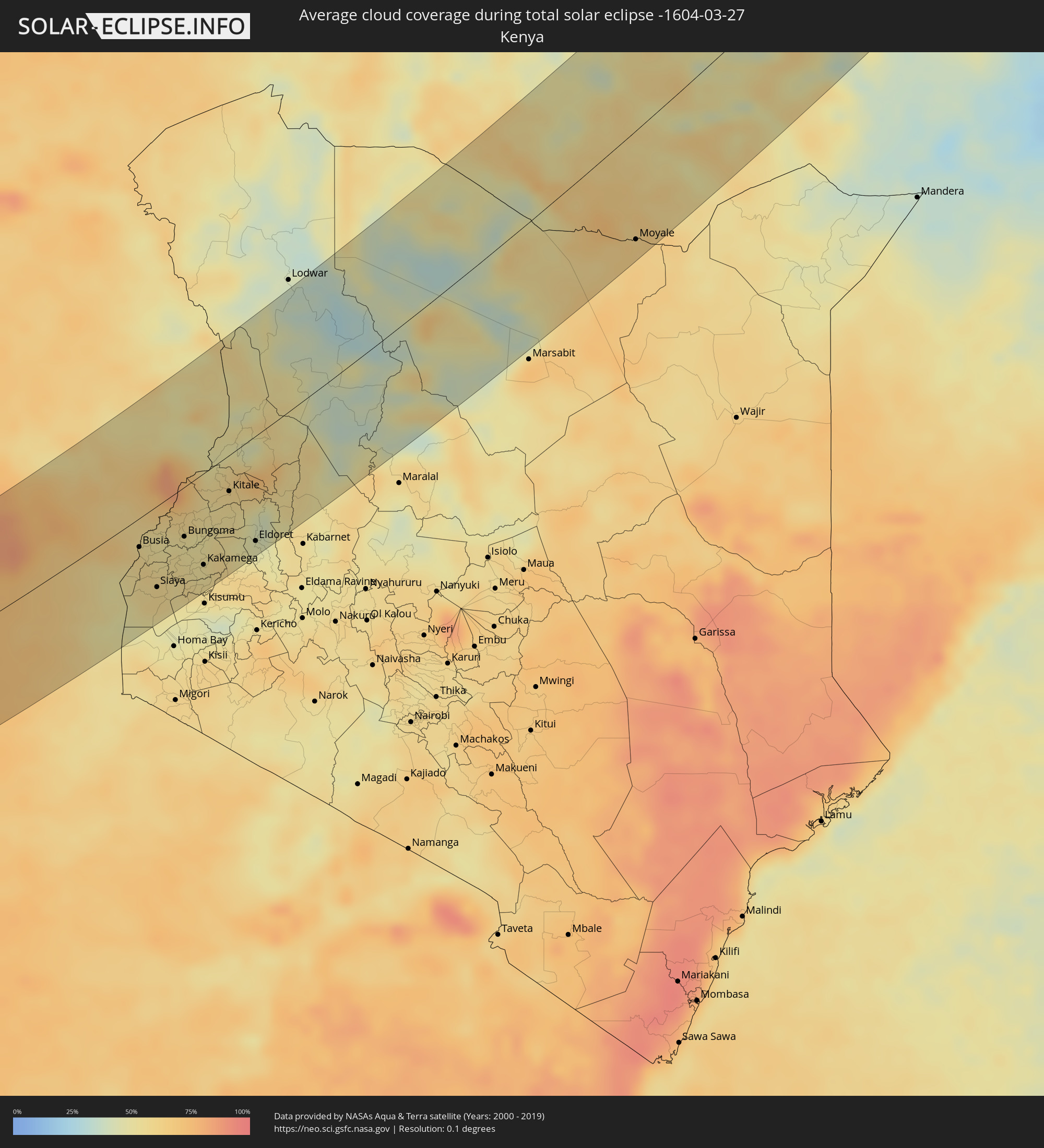 Kenia
Kenia
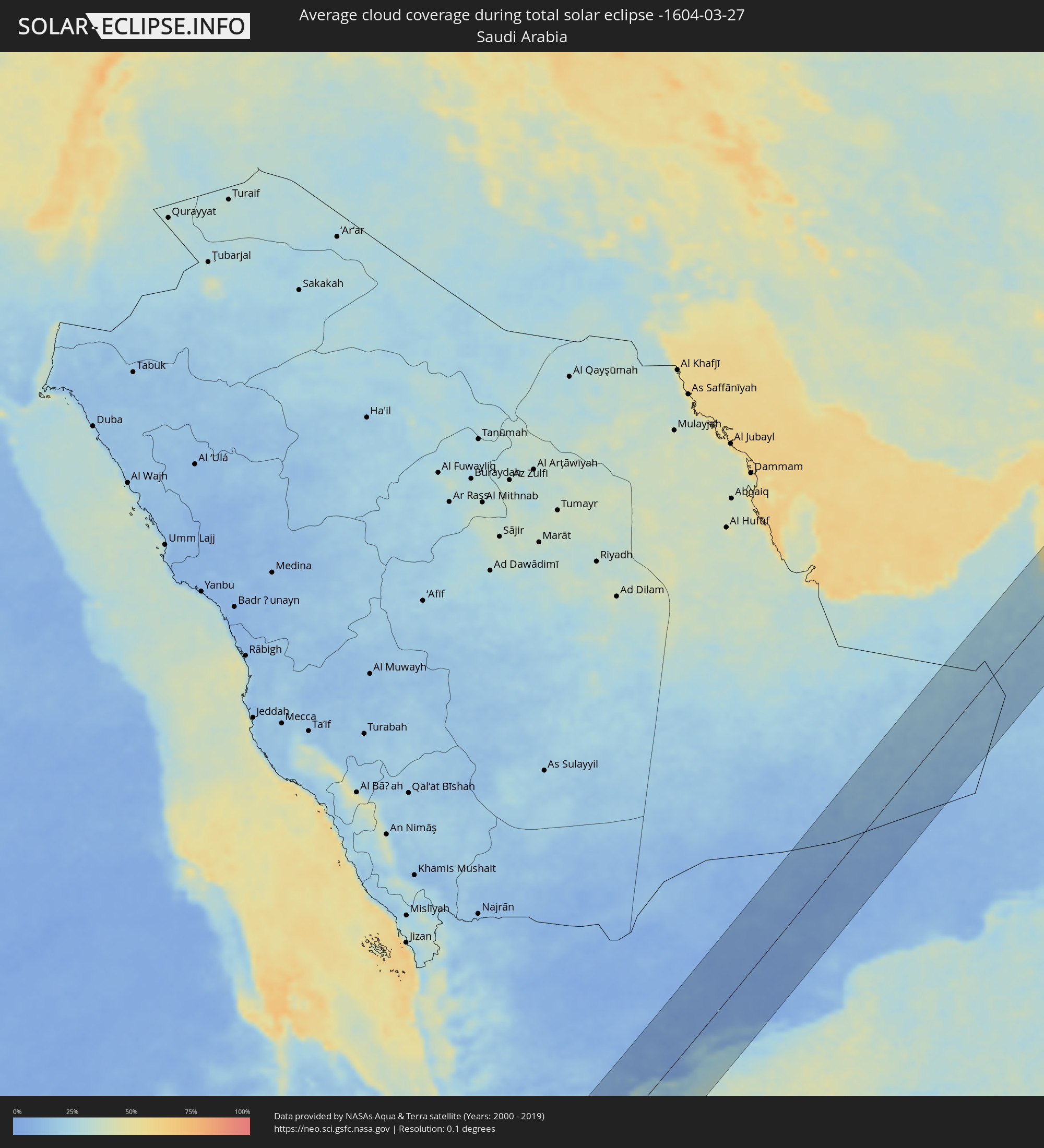 Saudi-Arabien
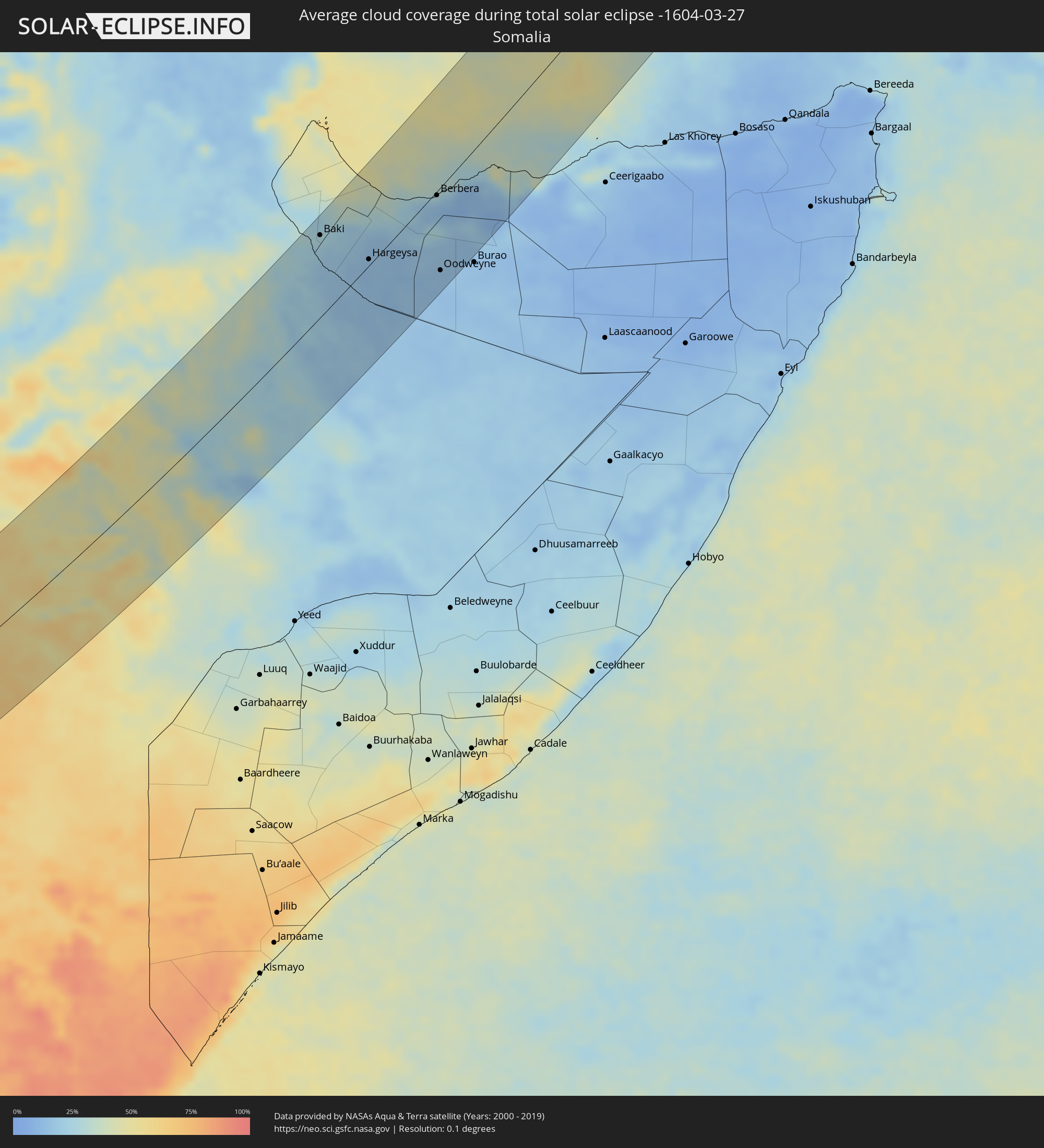 Somalia
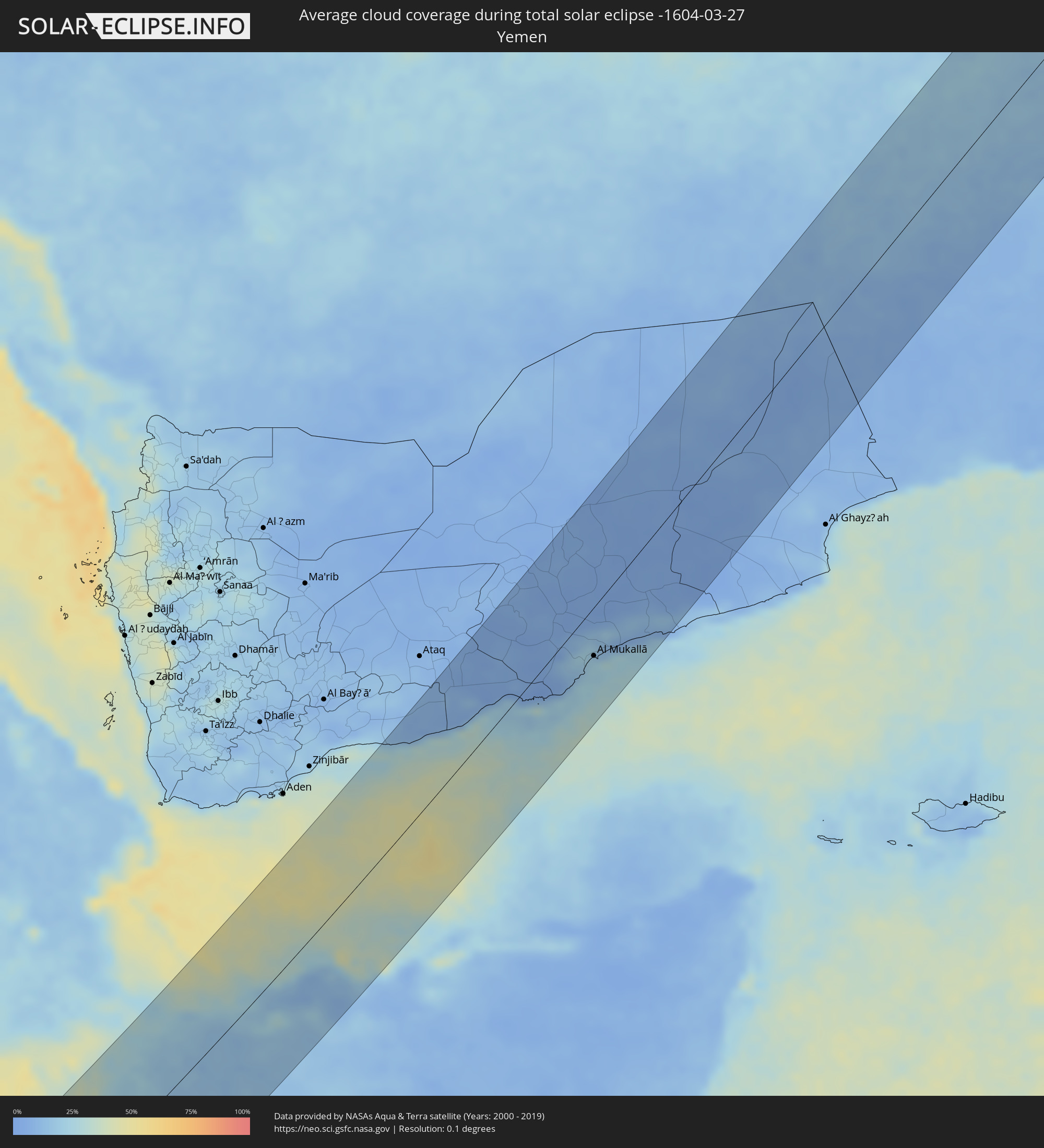 Jemen
Jemen
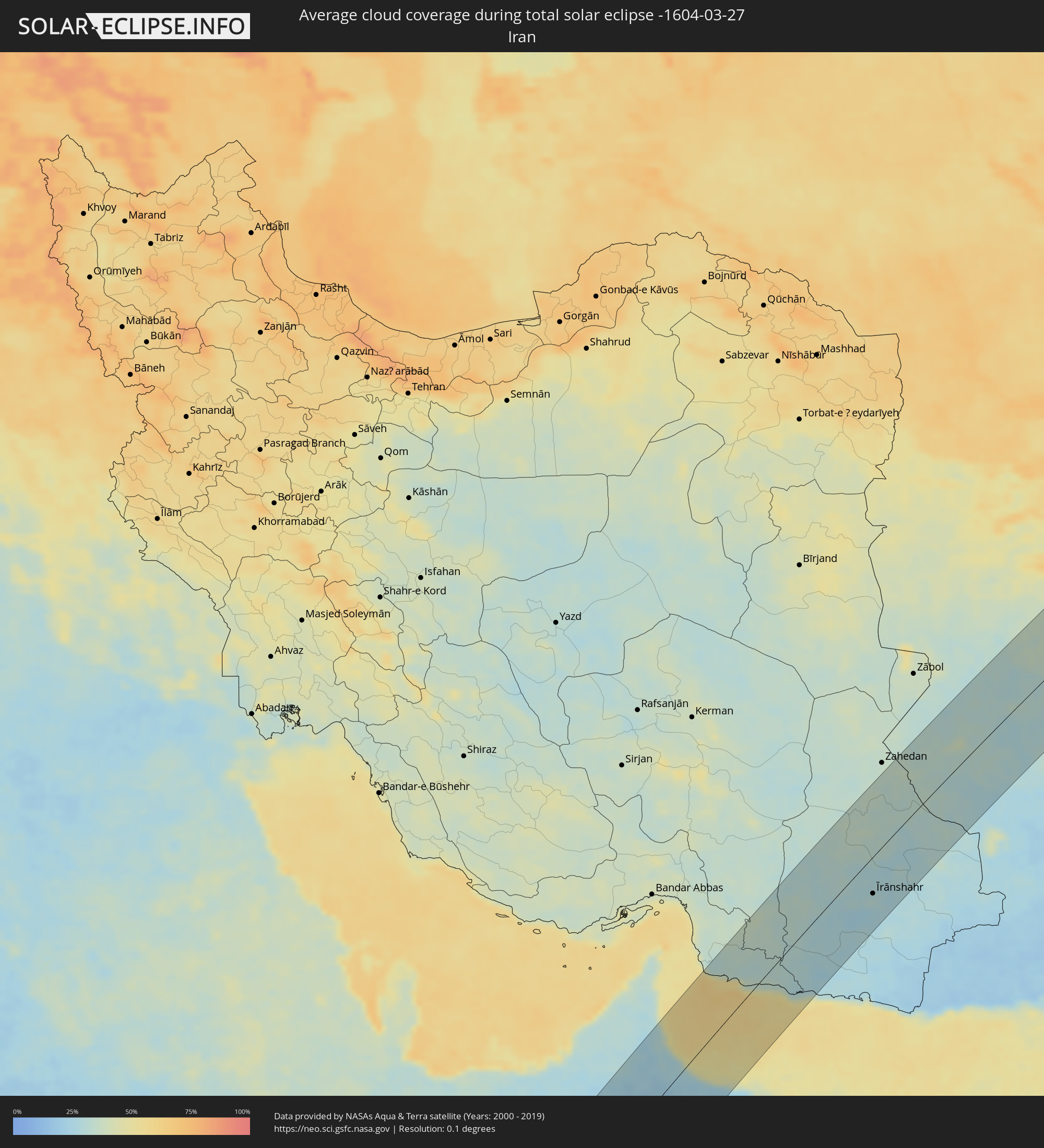 Iran
Iran
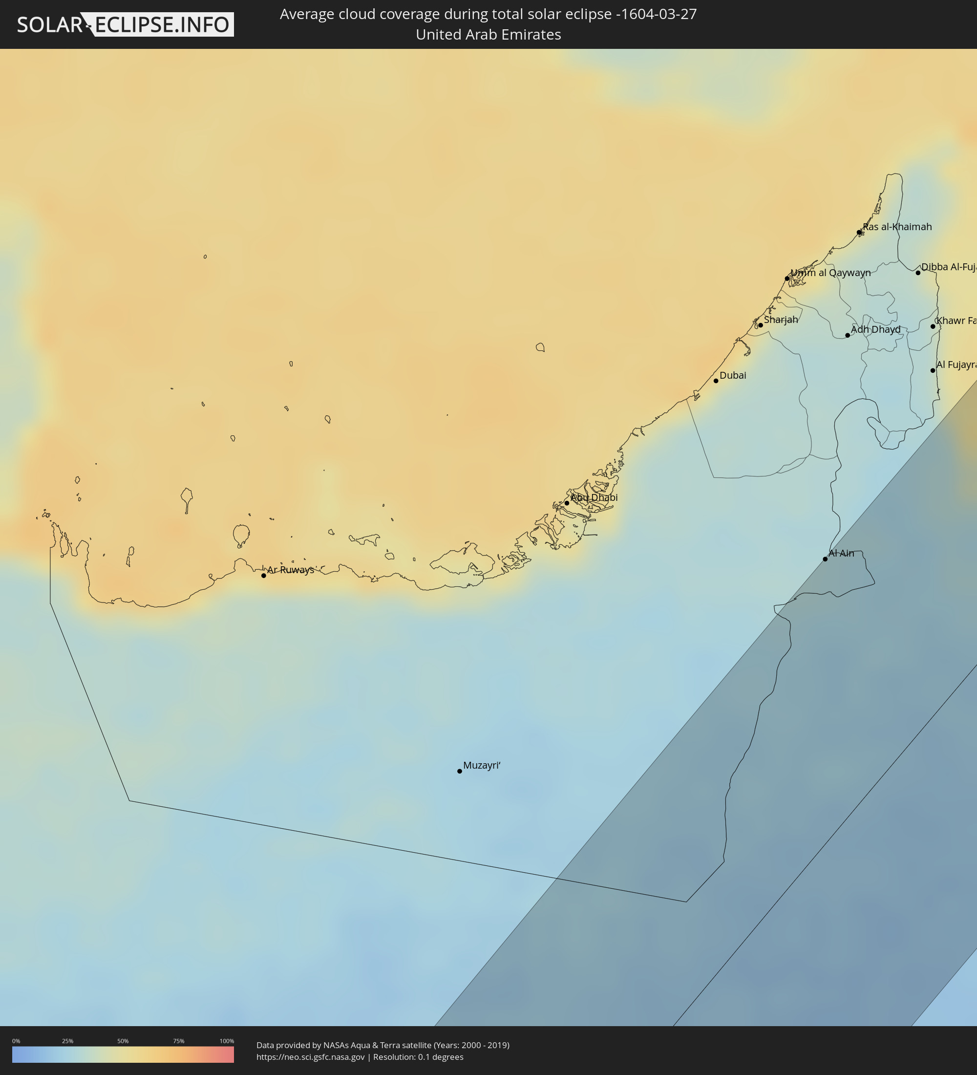 Vereinigte Arabische Emirate
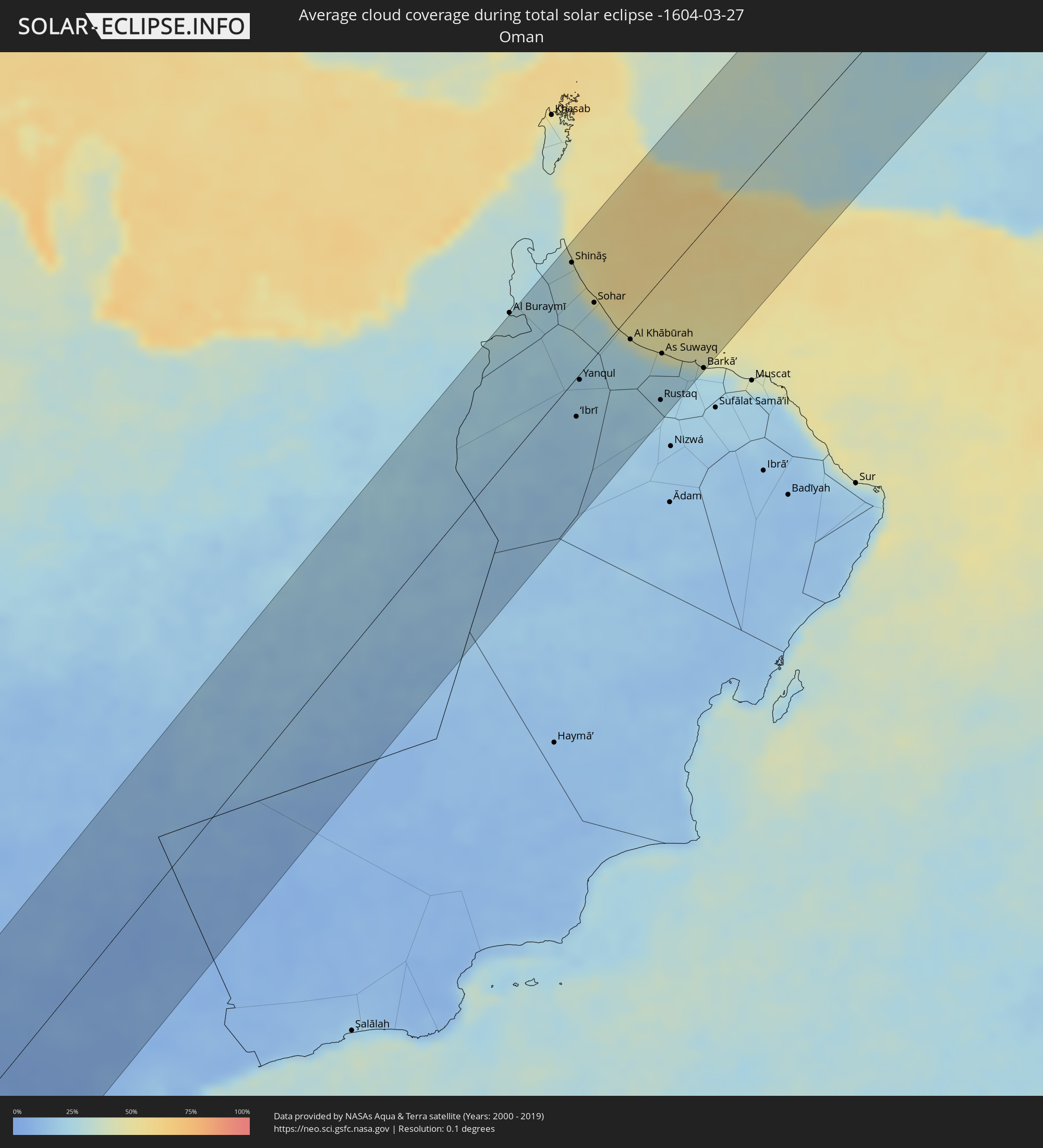 Oman
Oman
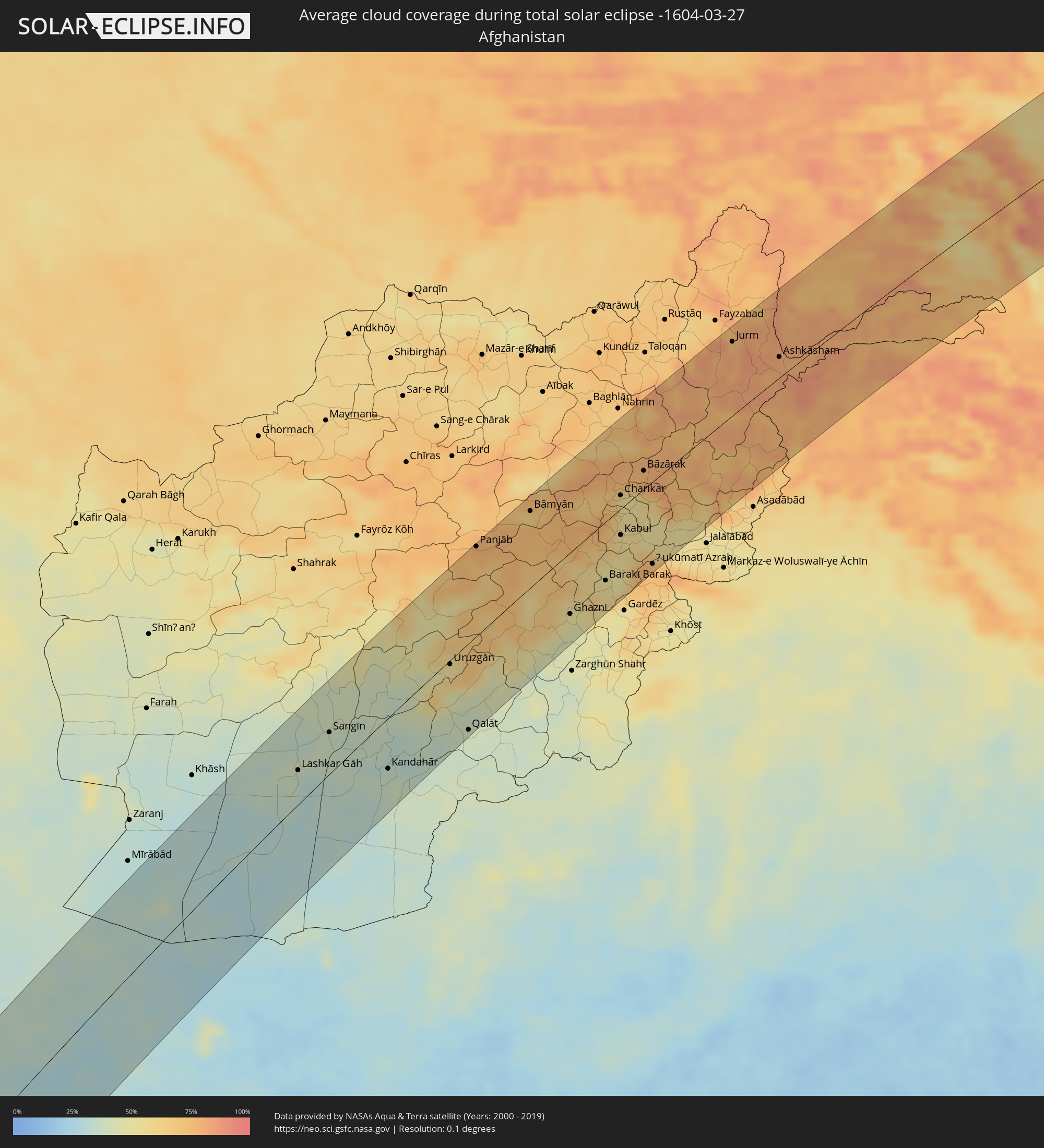 Afghanistan
 Pakistan
 Tadschikistan
 Kirgisistan
 Volksrepublik China
 Mongolei
Orte im Finsternispfad
Die nachfolgene Tabelle zeigt Städte und Orte mit mehr als 5.000 Einwohnern, die sich im Finsternispfad befinden. Städte mit mehr als 100.000 Einwohnern sind dick gekennzeichnet. Mit einem Klick auf den Ort öffnet sich eine Detailkarte die die Lage des jeweiligen Ortes zusammen mit dem Verlauf der zentralen Finsternis präsentiert.
| Ort | Typ | Dauer der Verfinsterung | Ortszeit bei maximaler Verfinsterung | Entfernung zur Zentrallinie | Ø Bewölkung |
|
Nzeto, Zaire
|
total | - | 06:55:25 UTC+00:13 | 37 km | 82% |
|
Uíge, Uíge
|
total | - | 06:56:38 UTC+00:13 | 49 km | 82% |
|
Tshikapa, Kasaï-Occidental
|
total | - | 08:59:40 UTC+02:10 | 78 km | 82% |
|
Luebo, Kasaï-Occidental
|
total | - | 09:01:34 UTC+02:10 | 14 km | 82% |
|
Mweka, Kasaï-Occidental
|
total | - | 09:02:19 UTC+02:10 | 62 km | 82% |
|
Demba, Kasaï-Occidental
|
total | - | 09:02:16 UTC+02:10 | 31 km | 82% |
|
Kananga, Kasaï-Occidental
|
total | - | 09:01:56 UTC+02:10 | 79 km | 85% |
|
Lusambo, Kasaï-Oriental
|
total | - | 09:04:12 UTC+02:10 | 20 km | 81% |
|
Kindu, Maniema
|
total | - | 09:09:51 UTC+02:10 | 86 km | 80% |
|
Kasongo, Maniema
|
total | - | 09:08:41 UTC+02:10 | 99 km | 81% |
|
Kampene, Maniema
|
total | - | 09:09:51 UTC+02:10 | 15 km | 81% |
|
Kabare, South Kivu
|
total | - | 09:14:12 UTC+02:10 | 7 km | 83% |
|
Bukavu, South Kivu
|
total | - | 09:14:16 UTC+02:10 | 9 km | 83% |
|
Cyangugu, Western Province
|
total | - | 09:14:22 UTC+02:10 | 11 km | 84% |
|
Cibitoke, Cibitoke
|
total | - | 09:14:03 UTC+02:10 | 62 km | 79% |
|
Goma, Nord Kivu
|
total | - | 09:16:02 UTC+02:10 | 52 km | 80% |
|
Gisenyi, Western Province
|
total | - | 09:16:02 UTC+02:10 | 48 km | 87% |
|
Kibuye, Western Province
|
total | - | 09:15:36 UTC+02:10 | 8 km | 82% |
|
Bubanza, Bubanza
|
total | - | 09:14:07 UTC+02:10 | 95 km | 84% |
|
Nzega, Southern Province
|
total | - | 09:15:15 UTC+02:10 | 44 km | 87% |
|
Kayanza, Kayanza
|
total | - | 09:14:40 UTC+02:10 | 92 km | 87% |
|
Musanze, Northern Province
|
total | - | 09:16:52 UTC+02:10 | 48 km | 85% |
|
Butare, Southern Province
|
total | - | 09:15:19 UTC+02:10 | 65 km | 84% |
|
Nyanza, Southern Province
|
total | - | 09:15:42 UTC+02:10 | 42 km | 84% |
|
Gitarama, Southern Province
|
total | - | 09:16:09 UTC+02:10 | 15 km | 83% |
|
Ngozi, Ngozi
|
total | - | 09:14:58 UTC+02:10 | 101 km | 85% |
|
Kabale, Western Region
|
total | - | 09:34:41 UTC+02:27 | 53 km | 86% |
|
Kigali, Kigali
|
total | - | 09:16:45 UTC+02:10 | 19 km | 86% |
|
Byumba, Northern Province
|
total | - | 09:17:21 UTC+02:10 | 17 km | 91% |
|
Kirundo, Kirundo
|
total | - | 09:15:49 UTC+02:10 | 83 km | 87% |
|
Rwamagana, Eastern Province
|
total | - | 09:17:16 UTC+02:10 | 39 km | 85% |
|
Kibungo, Eastern Province
|
total | - | 09:17:06 UTC+02:10 | 66 km | 86% |
|
Mbarara, Western Region
|
total | - | 09:36:39 UTC+02:27 | 79 km | 84% |
|
Bugene, Kagera
|
total | - | 09:35:46 UTC+02:27 | 43 km | 83% |
|
Nyakahanga, Kagera
|
total | - | 09:35:45 UTC+02:27 | 45 km | 83% |
|
Nsunga, Kagera
|
total | - | 09:36:51 UTC+02:27 | 15 km | 88% |
|
Kyaka, Kagera
|
total | - | 09:36:42 UTC+02:27 | 26 km | 86% |
|
Katoro, Kagera
|
total | - | 09:36:35 UTC+02:27 | 45 km | 84% |
|
Nshamba, Kagera
|
total | - | 09:36:01 UTC+02:27 | 86 km | 78% |
|
Kamachumu, Kagera
|
total | - | 09:36:24 UTC+02:27 | 73 km | 83% |
|
Muleba, Kagera
|
total | - | 09:36:06 UTC+02:27 | 96 km | 76% |
|
Katerero, Kagera
|
total | - | 09:36:55 UTC+02:27 | 58 km | 81% |
|
Masaka, Central Region
|
total | - | 09:38:40 UTC+02:27 | 43 km | 87% |
|
Bukoba, Kagera
|
total | - | 09:37:08 UTC+02:27 | 56 km | 79% |
|
Mityana, Central Region
|
total | - | 09:40:21 UTC+02:27 | 97 km | 84% |
|
Entebbe, Central Region
|
total | - | 09:40:23 UTC+02:27 | 39 km | 76% |
|
Kampala, Central Region
|
total | - | 09:41:00 UTC+02:27 | 54 km | 79% |
|
Mukono, Central Region
|
total | - | 09:41:20 UTC+02:27 | 47 km | 84% |
|
Jinja, Eastern Region
|
total | - | 09:42:09 UTC+02:27 | 28 km | 68% |
|
Iganga, Eastern Region
|
total | - | 09:42:51 UTC+02:27 | 28 km | 73% |
|
Busia, Eastern Region
|
total | - | 09:43:33 UTC+02:27 | 24 km | 57% |
|
Busia, Busia
|
total | - | 09:43:34 UTC+02:27 | 26 km | 57% |
|
Mbale, Eastern Region
|
total | - | 09:44:45 UTC+02:27 | 27 km | 71% |
|
Tororo, Eastern Region
|
total | - | 09:44:05 UTC+02:27 | 9 km | 58% |
|
Siaya, Siaya
|
total | - | 09:43:09 UTC+02:27 | 74 km | 58% |
|
Lugulu, Busia
|
total | - | 09:43:45 UTC+02:27 | 45 km | 54% |
|
Mumias, Kakamega
|
total | - | 09:43:55 UTC+02:27 | 61 km | 56% |
|
Butere, Kakamega
|
total | - | 09:43:42 UTC+02:27 | 74 km | 56% |
|
Bungoma, Bungoma
|
total | - | 09:44:26 UTC+02:27 | 45 km | 54% |
|
Kakamega, Kakamega
|
total | - | 09:44:14 UTC+02:27 | 83 km | 54% |
|
Webuye, Bungoma
|
total | - | 09:44:50 UTC+02:27 | 54 km | 52% |
|
Kitale, Trans Nzoia
|
total | - | 09:45:55 UTC+02:27 | 33 km | 58% |
|
Kapenguria, West Pokot
|
total | - | 09:46:29 UTC+02:27 | 20 km | 63% |
|
Eldoret, Uasin Gishu
|
total | - | 09:45:27 UTC+02:27 | 95 km | 46% |
|
Yabēlo, Oromiya
|
total | - | 09:58:05 UTC+02:27 | 94 km | 54% |
|
Mēga, Oromiya
|
total | - | 09:56:51 UTC+02:27 | 8 km | 67% |
|
Shakīso, Oromiya
|
total | - | 10:01:11 UTC+02:27 | 106 km | 59% |
|
Moyale, Marsabit
|
total | - | 09:57:05 UTC+02:27 | 91 km | 63% |
|
Ginir, Oromiya
|
total | - | 10:07:01 UTC+02:27 | 83 km | 46% |
|
Jijiga, Somali
|
total | - | 10:15:09 UTC+02:27 | 92 km | 26% |
|
Baki, Awdal
|
total | - | 10:17:18 UTC+02:27 | 86 km | 27% |
|
Hargeysa, Woqooyi Galbeed
|
total | - | 10:17:50 UTC+02:27 | 7 km | 15% |
|
Berbera, Woqooyi Galbeed
|
total | - | 10:21:20 UTC+02:27 | 4 km | 17% |
|
Oodweyne, Togdheer
|
total | - | 10:19:17 UTC+02:27 | 85 km | 15% |
|
Al Mukallā, Muḩāfaz̧at Ḩaḑramawt
|
total | - | 11:16:44 UTC+03:06 | 44 km | 23% |
|
Al Ain, Abu Dhabi
|
total | - | 12:20:59 UTC+03:41 | 100 km | 27% |
|
Shināş, Al Batinah North Governorate
|
total | - | 12:23:05 UTC+03:41 | 86 km | 38% |
|
‘Ibrī, Az̧ Z̧āhirah
|
total | - | 12:20:35 UTC+03:41 | 28 km | 18% |
|
Yanqul, Az̧ Z̧āhirah
|
total | - | 12:21:16 UTC+03:41 | 4 km | 21% |
|
Al Liwā’, Al Batinah North Governorate
|
total | - | 12:22:54 UTC+03:41 | 63 km | 33% |
|
Sohar, Al Batinah North Governorate
|
total | - | 12:22:50 UTC+03:41 | 38 km | 35% |
|
Şaḩam, Al Batinah North Governorate
|
total | - | 12:22:50 UTC+03:41 | 12 km | 37% |
|
Al Khābūrah, Al Batinah North Governorate
|
total | - | 12:22:52 UTC+03:41 | 18 km | 31% |
|
Rustaq, Al Batinah South Governorate
|
total | - | 12:22:24 UTC+03:41 | 86 km | 23% |
|
As Suwayq, Al Batinah North Governorate
|
total | - | 12:23:12 UTC+03:41 | 54 km | 25% |
|
Bayt al ‘Awābī, Al Batinah South Governorate
|
total | - | 12:22:25 UTC+03:41 | 100 km | 21% |
|
Barkā’, Al Batinah South Governorate
|
total | - | 12:23:43 UTC+03:41 | 99 km | 25% |
|
Īrānshahr, Sistan and Baluchestan
|
total | - | 12:18:22 UTC+03:25 | 49 km | 30% |
|
Khāsh, Sistan and Baluchestan
|
total | - | 12:20:42 UTC+03:25 | 10 km | 29% |
|
Lashkar Gāh, Helmand
|
total | - | 13:04:09 UTC+04:00 | 35 km | 36% |
|
Gereshk, Helmand
|
total | - | 13:04:42 UTC+04:00 | 40 km | 38% |
|
Sangīn, Helmand
|
total | - | 13:05:23 UTC+04:00 | 42 km | 38% |
|
Kandahār, Kandahar
|
total | - | 13:06:07 UTC+04:00 | 52 km | 35% |
|
Bāmyān, Bamyan
|
total | - | 13:12:25 UTC+04:00 | 78 km | 65% |
|
Ghazni, Ghazni
|
total | - | 13:12:00 UTC+04:00 | 64 km | 50% |
|
Barakī Barak, Logar
|
total | - | 13:13:07 UTC+04:00 | 61 km | 54% |
|
Paghmān, Kabul
|
total | - | 13:13:42 UTC+04:00 | 9 km | 65% |
|
Charikar, Parwan
|
total | - | 13:14:23 UTC+04:00 | 14 km | 57% |
|
Kabul, Kabul
|
total | - | 13:13:57 UTC+04:00 | 27 km | 57% |
|
Bāzārak, Panjshir
|
total | - | 13:15:06 UTC+04:00 | 19 km | 78% |
|
Mehtar Lām, Laghman
|
total | - | 13:15:26 UTC+04:00 | 76 km | 55% |
|
Khorugh, Gorno-Badakhshan
|
total | - | 13:54:35 UTC+04:35 | 91 km | 81% |
|
Ishqoshim, Gorno-Badakhshan
|
total | - | 13:54:06 UTC+04:35 | 21 km | 80% |
|
Murghob, Gorno-Badakhshan
|
total | - | 13:57:54 UTC+04:35 | 22 km | 56% |
|
Kashgar, Xinjiang Uyghur Autonomous Region
|
total | - | 17:25:42 UTC+08:00 | 37 km | 64% |
|
Aykol, Xinjiang Uyghur Autonomous Region
|
total | - | 17:30:38 UTC+08:00 | 18 km | 74% |
|
Aksu, Xinjiang Uyghur Autonomous Region
|
total | - | 17:30:51 UTC+08:00 | 3 km | 70% |
|
Kuqa, Xinjiang Uyghur Autonomous Region
|
total | - | 17:33:31 UTC+08:00 | 64 km | 77% |
|
Shihezi, Xinjiang Uyghur Autonomous Region
|
total | - | 17:36:29 UTC+08:00 | 68 km | 65% |
|
Changji, Xinjiang Uyghur Autonomous Region
|
total | - | 17:37:29 UTC+08:00 | 7 km | 61% |
|
Ürümqi, Xinjiang Uyghur Autonomous Region
|
total | - | 17:37:42 UTC+08:00 | 38 km | 62% |
|
Altai, Govĭ-Altay
|
total | - | 15:49:48 UTC+06:06 | 41 km | 59% |
|
Tsetserleg, Arhangay
|
total | - | 16:52:59 UTC+07:07 | 49 km | 68% |
|
Bulgan, Bulgan
|
total | - | 16:53:18 UTC+07:07 | 52 km | 65% |
|
Erdenet, Orhon
|
total | - | 16:53:24 UTC+07:07 | 65 km | 69% |
|
Dzüünharaa, Selenge
|
total | - | 16:54:19 UTC+07:07 | 3 km | 61% |
|
Borzya, Transbaikal Territory
|
total | - | 18:27:09 UTC+08:38 | 37 km | 58% |
|
Zabaykal’sk, Transbaikal Territory
|
total | - | 18:27:41 UTC+08:38 | 51 km | 66% |
|
Manzhouli, Inner Mongolia
|
total | - | 17:48:46 UTC+08:00 | 57 km | 68% |
|
Jalai Nur, Inner Mongolia
|
total | - | 17:48:53 UTC+08:00 | 76 km | 72% |
|
Krasnokamensk, Transbaikal Territory
|
total | - | 18:27:30 UTC+08:38 | 8 km | 69% |
|
Priargunsk, Transbaikal Territory
|
total | - | 18:27:26 UTC+08:38 | 14 km | 63% |
|
Genhe, Inner Mongolia
|
total | - | 17:48:21 UTC+08:00 | 43 km | 84% |