Totale Sonnenfinsternis vom 29.06.-1637
| Wochentag: | Freitag |
| Maximale Dauer der Verfinsterung: | 06m27s |
| Maximale Breite des Finsternispfades: | 241 km |
| Saroszyklus: | 20 |
| Bedeckungsgrad: | 100% |
| Magnitude: | 1.074 |
| Gamma: | 0.0694 |
Wo kann man die Sonnenfinsternis vom 29.06.-1637 sehen?
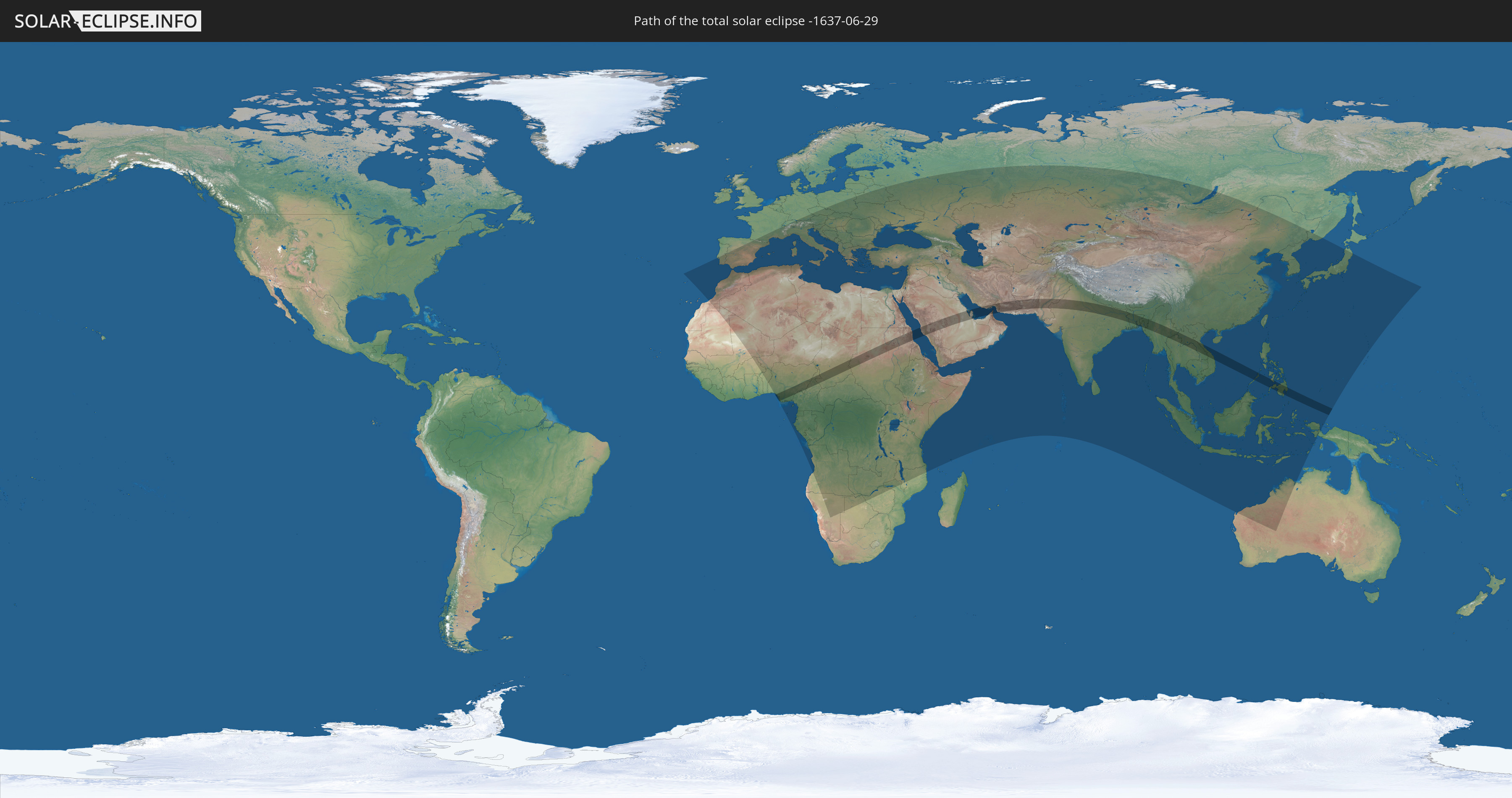
Die Sonnenfinsternis am 29.06.-1637 kann man in 126 Ländern als partielle Sonnenfinsternis beobachten.
Der Finsternispfad verläuft durch 19 Länder. Nur in diesen Ländern ist sie als totale Sonnenfinsternis zu sehen.
In den folgenden Ländern ist die Sonnenfinsternis total zu sehen
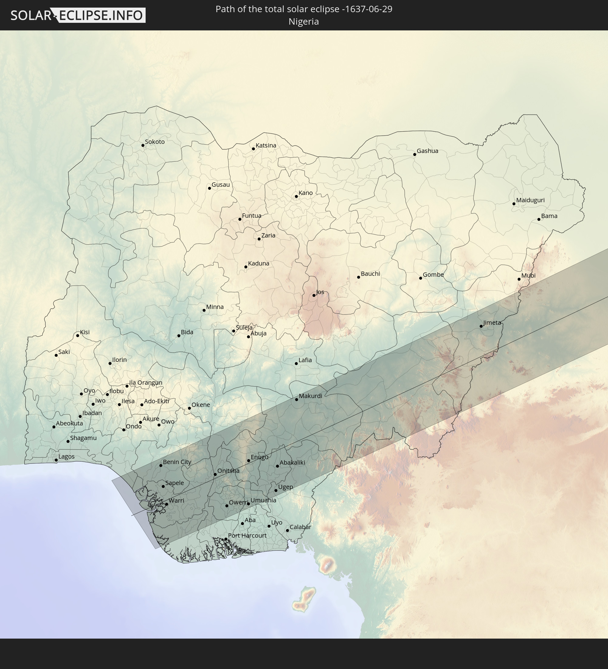 Nigeria
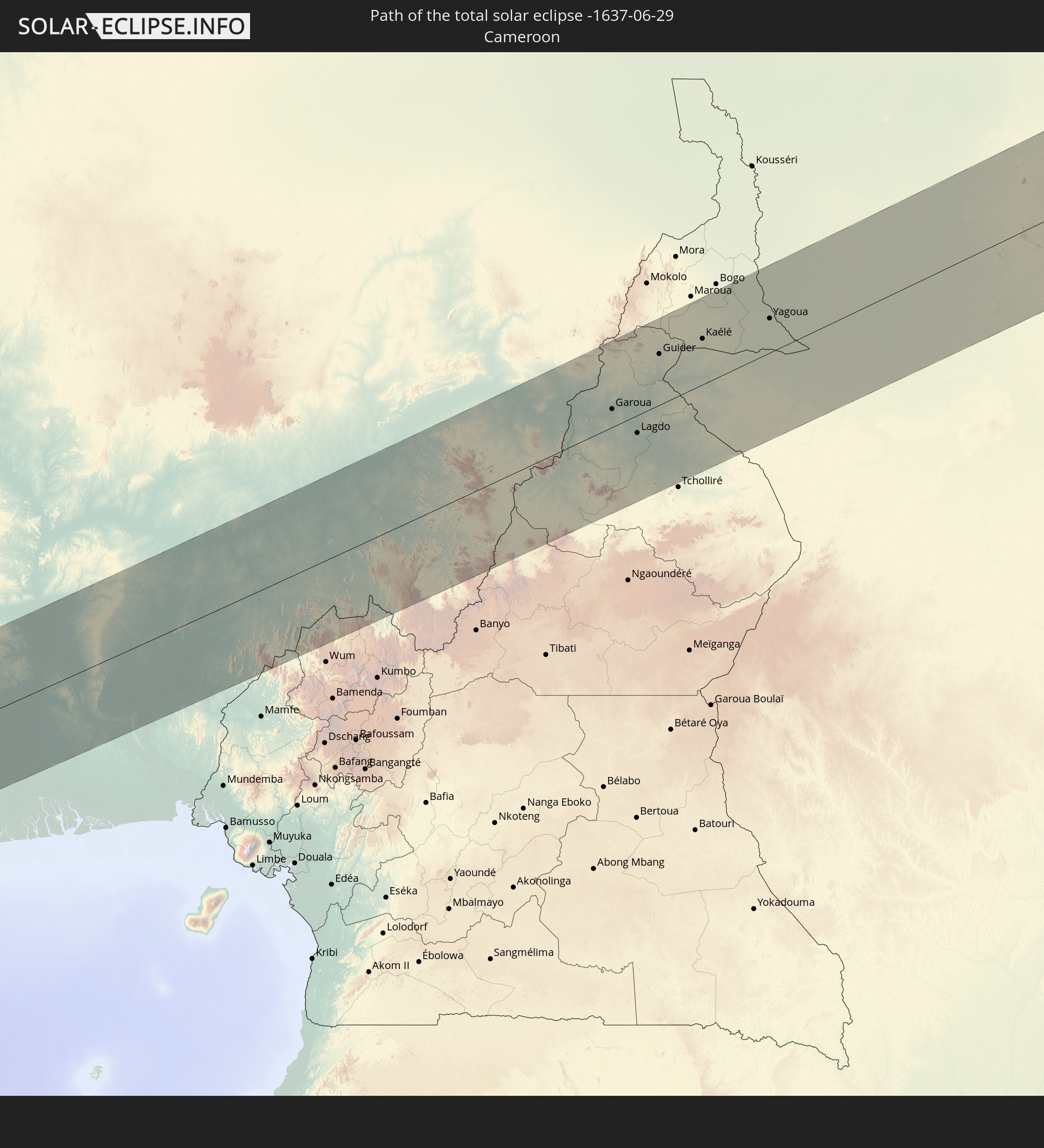 Kamerun
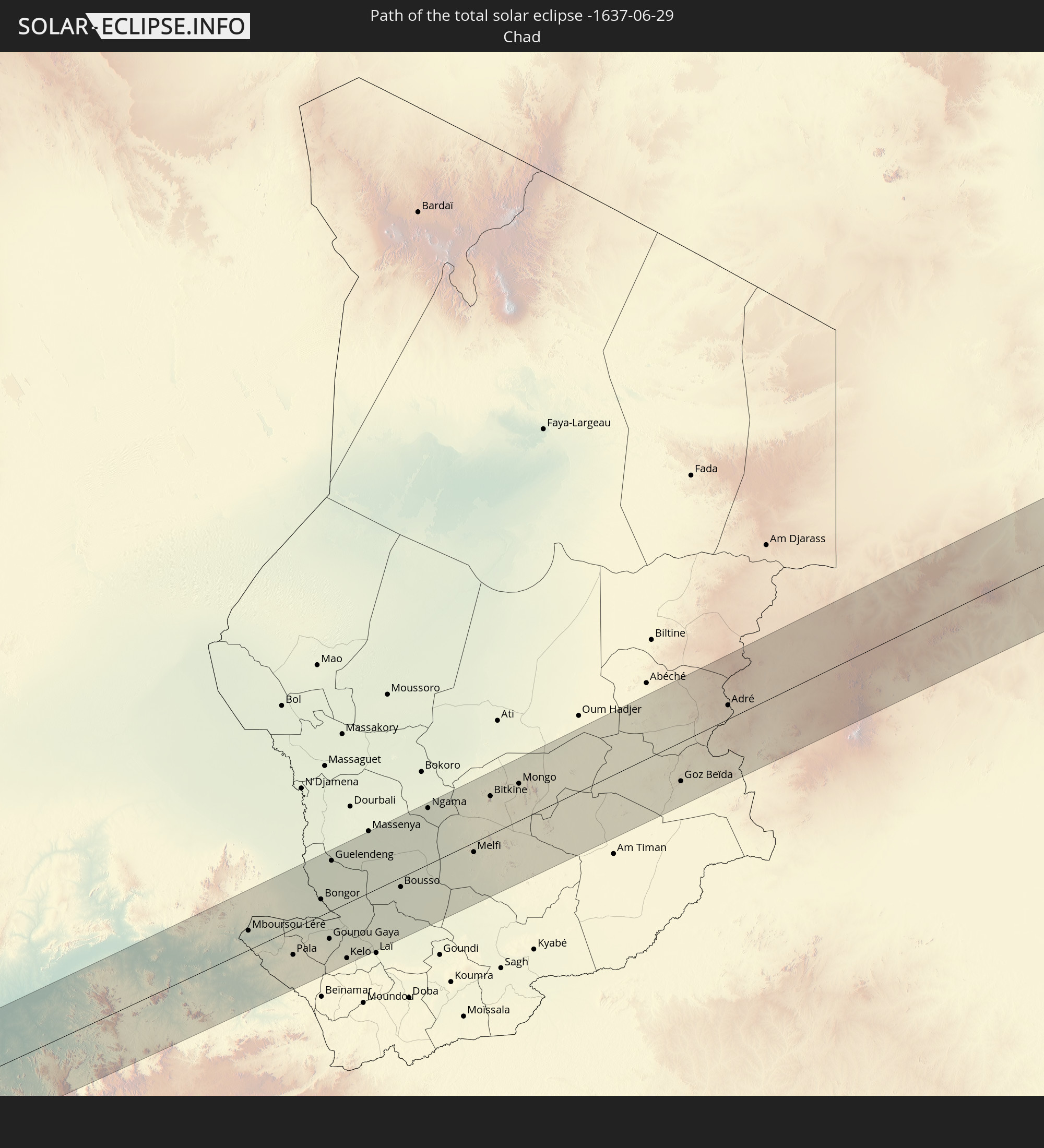 Tschad
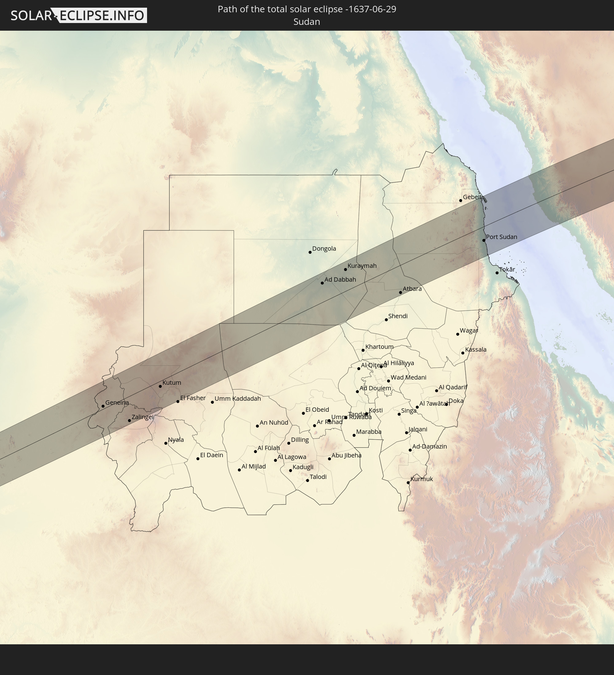 Sudan
Sudan
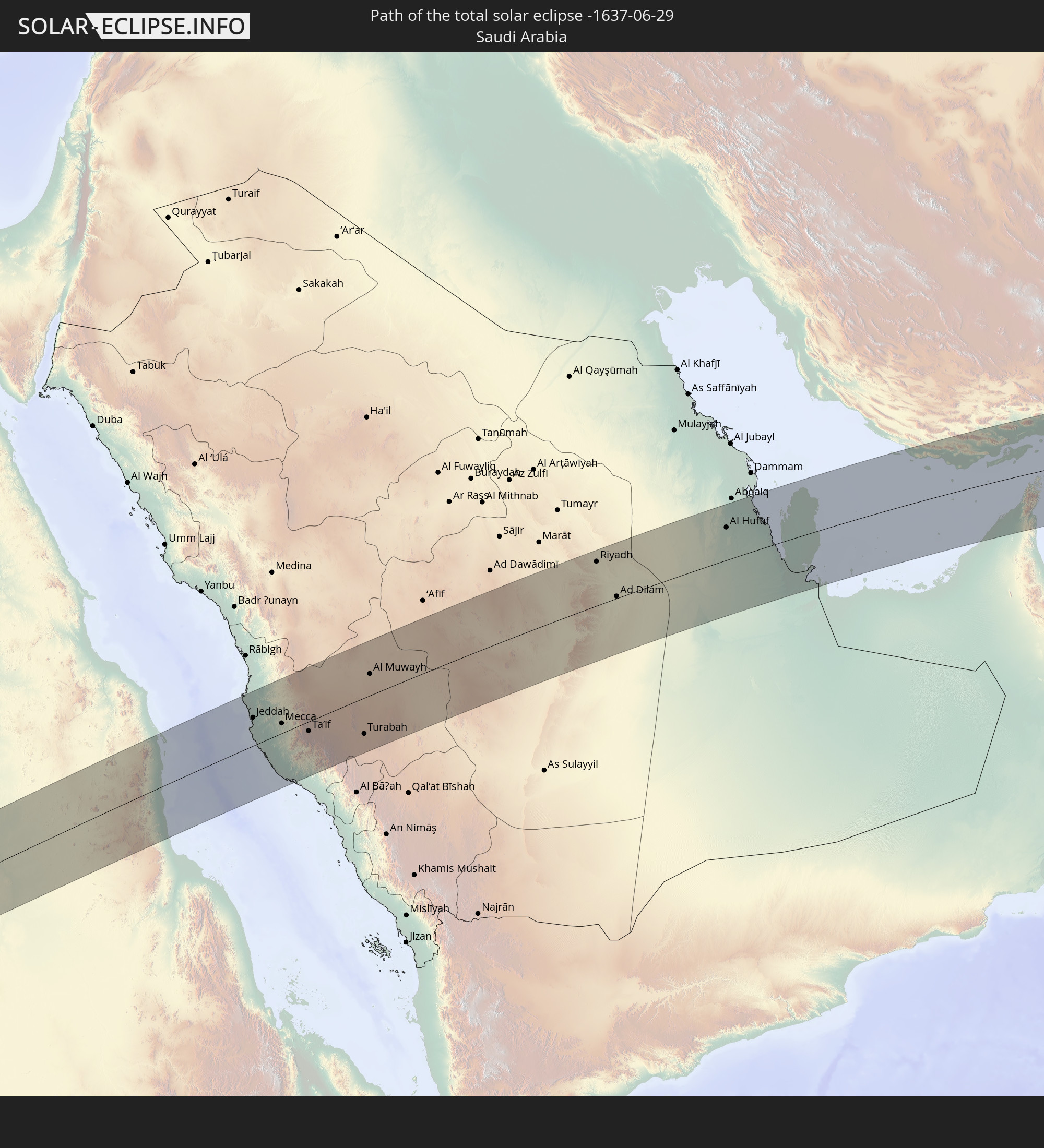 Saudi-Arabien
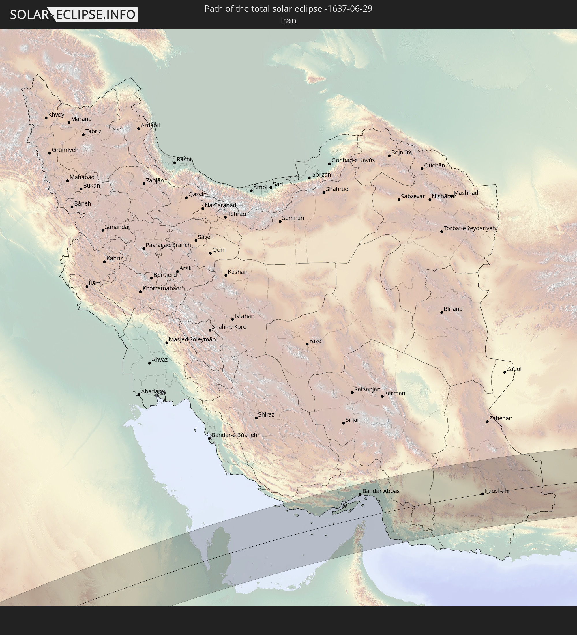 Iran
Iran
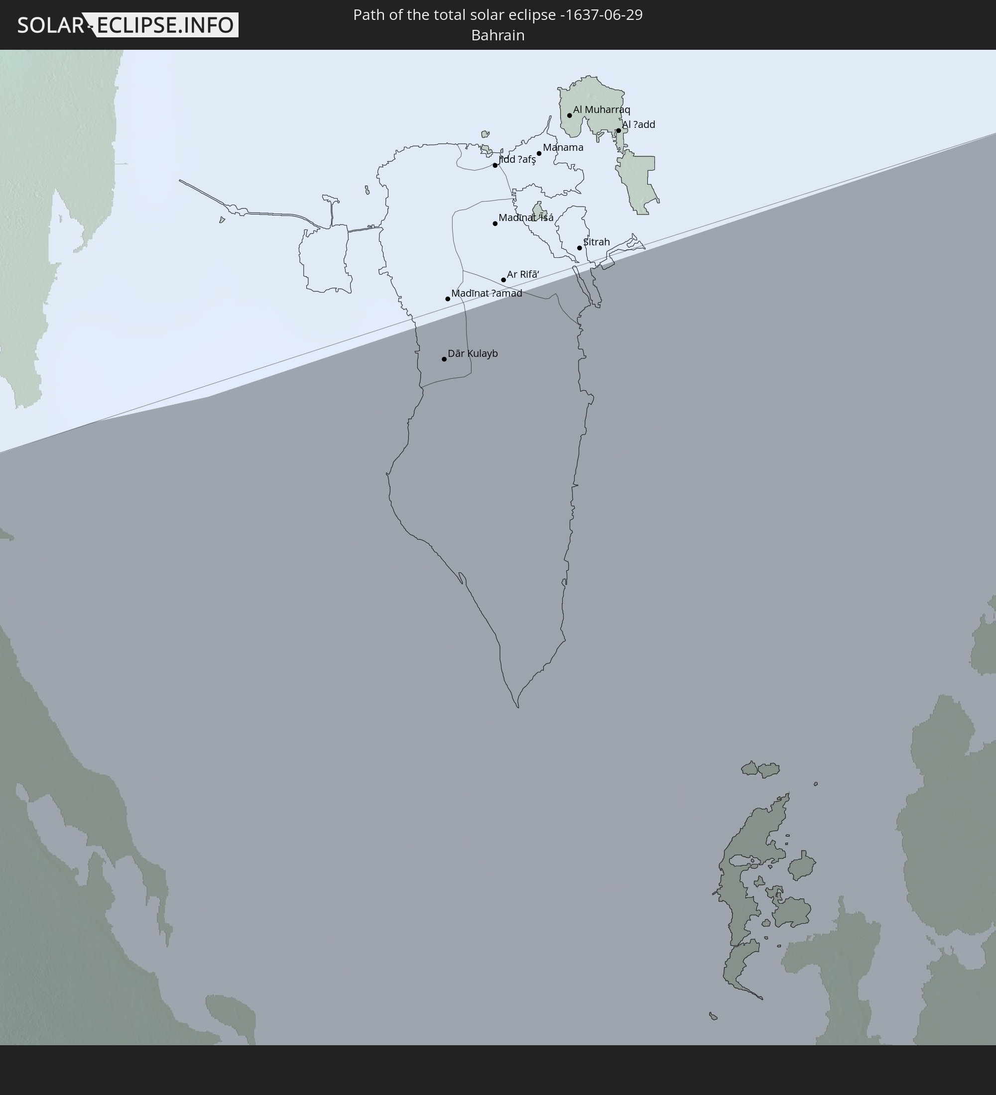 Bahrain
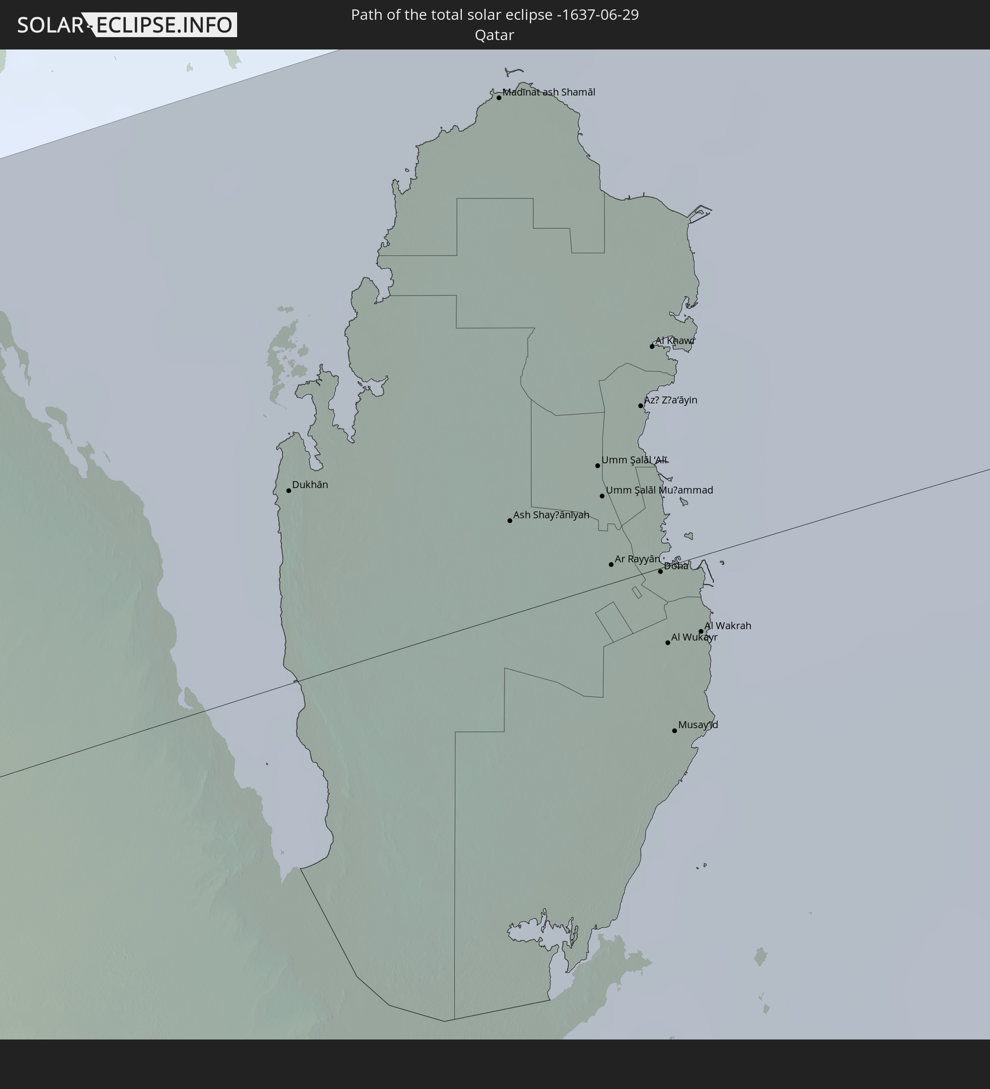 Katar
Katar
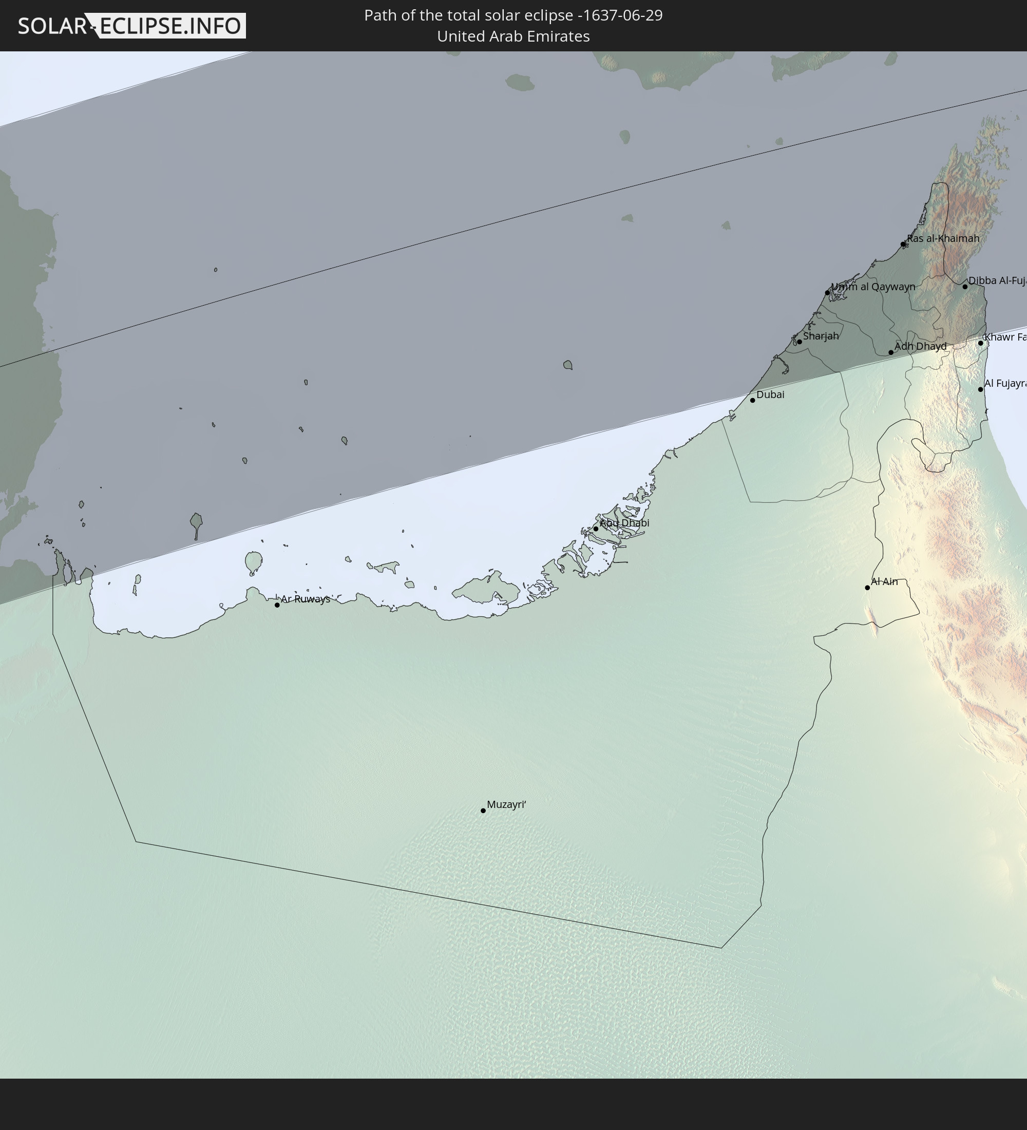 Vereinigte Arabische Emirate
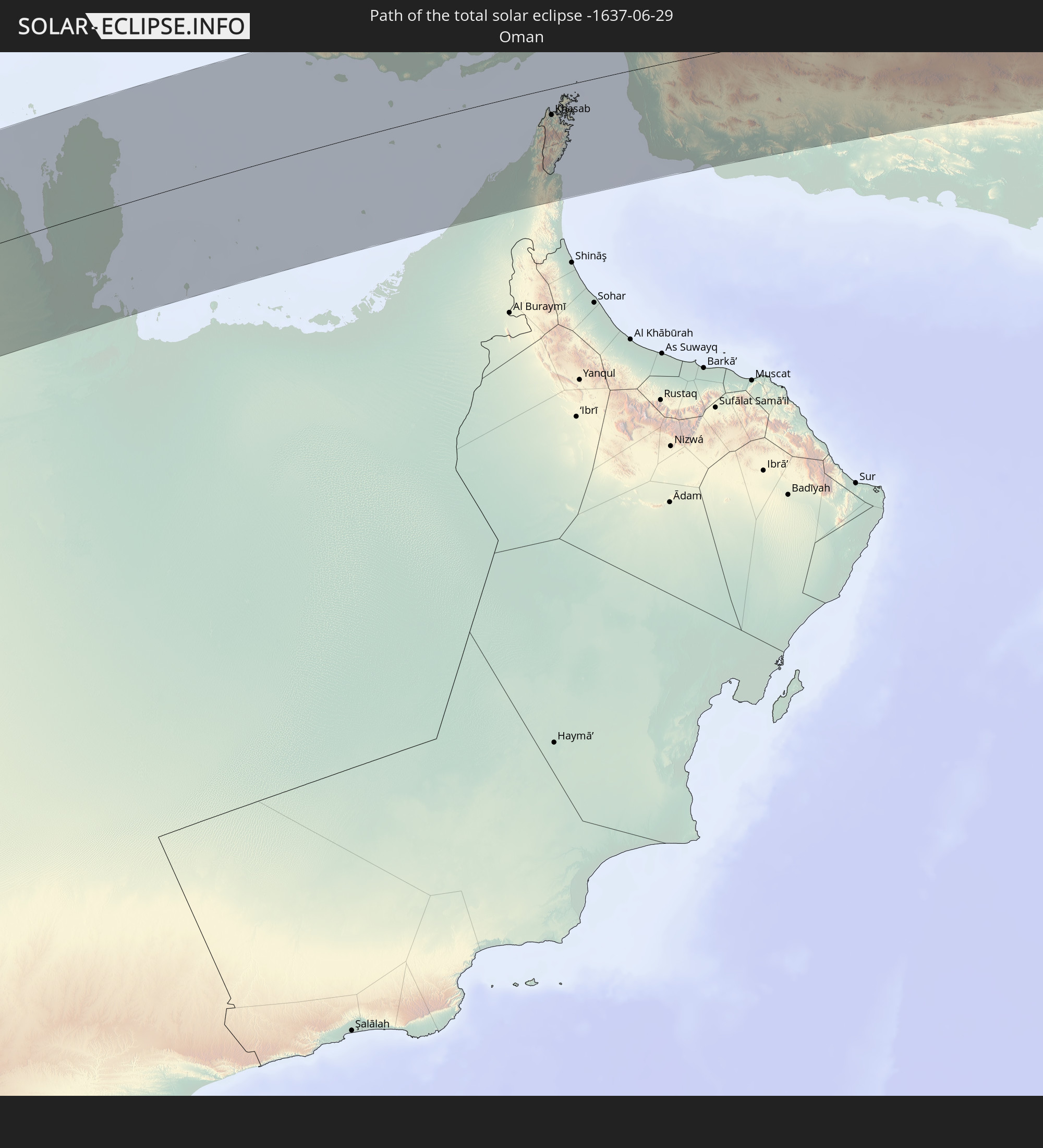 Oman
Oman
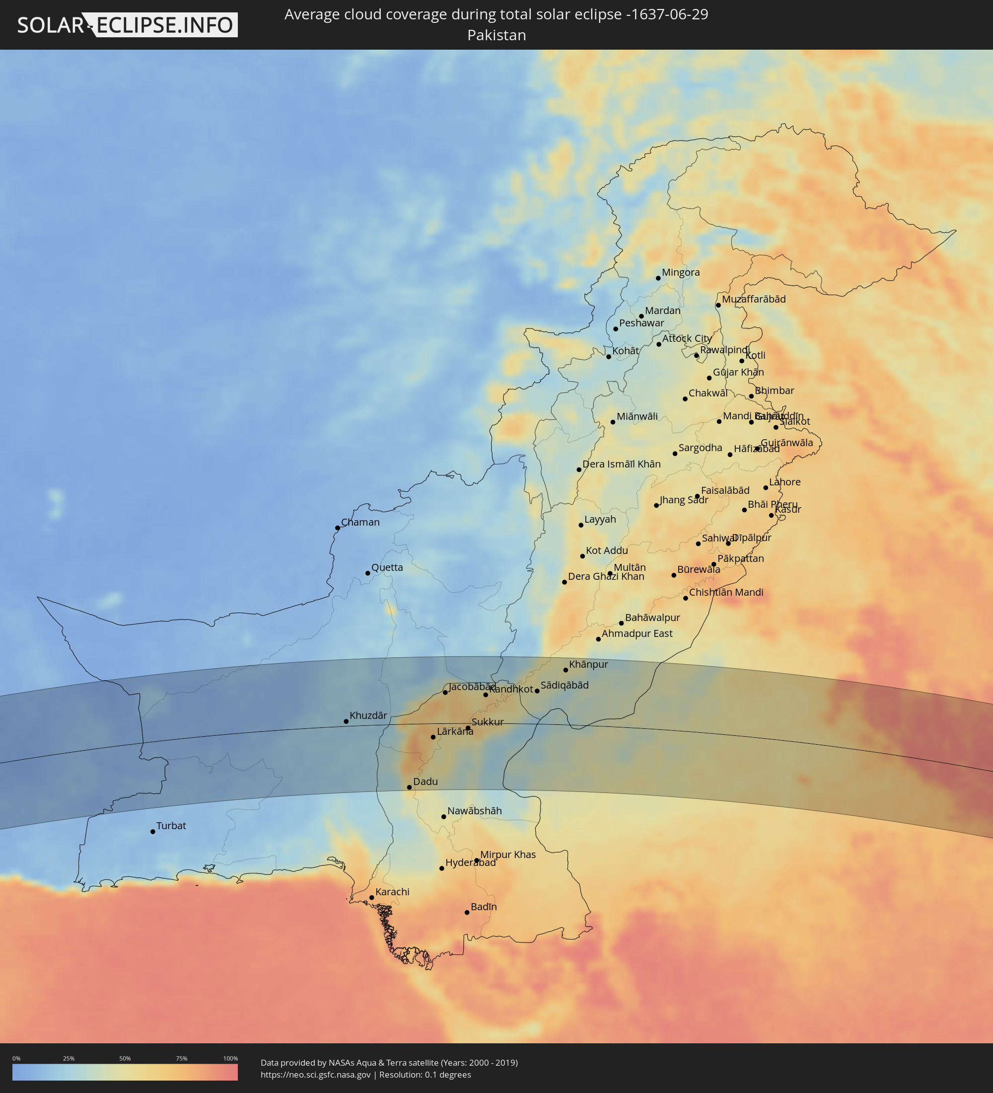
 Pakistan
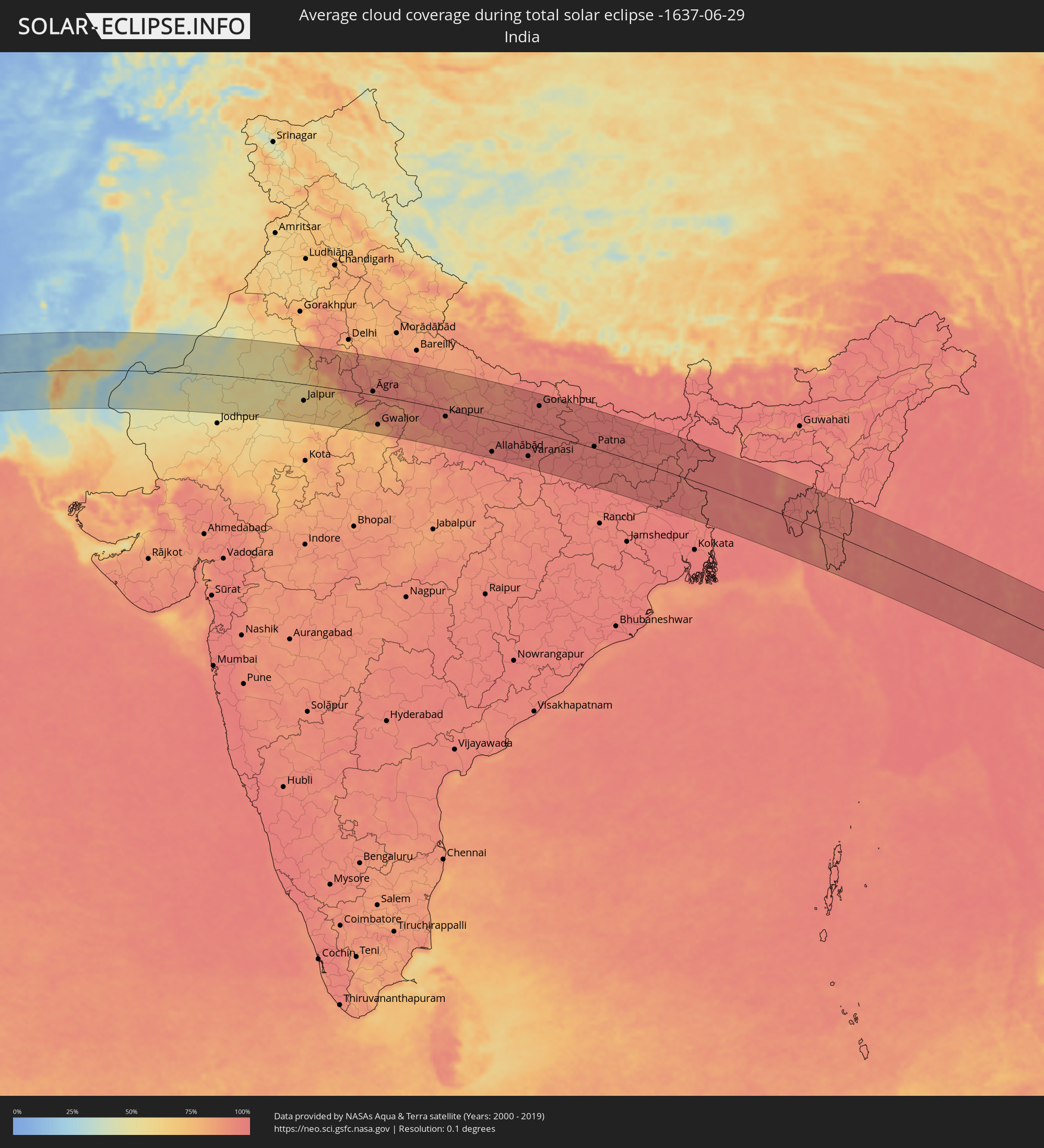
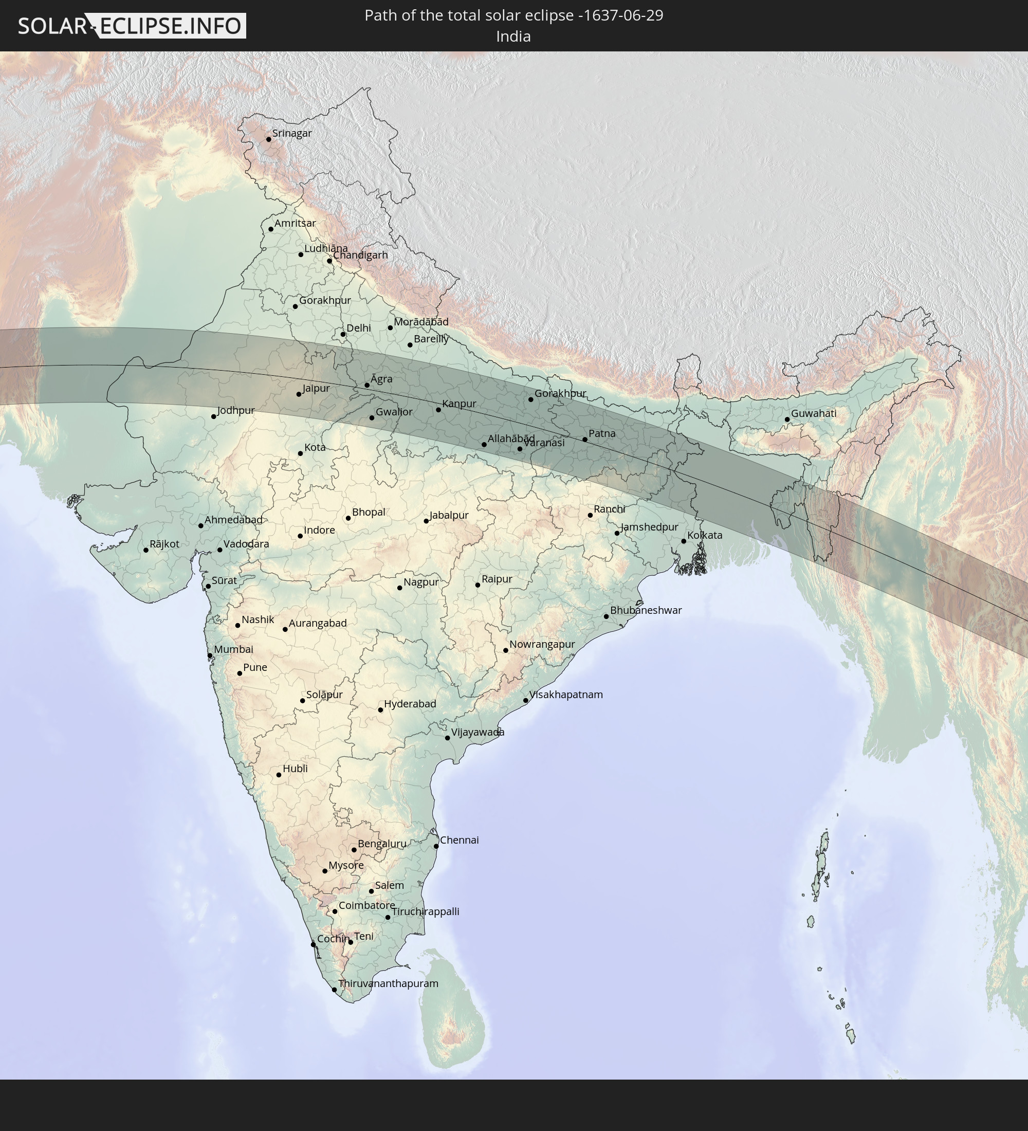 Indien
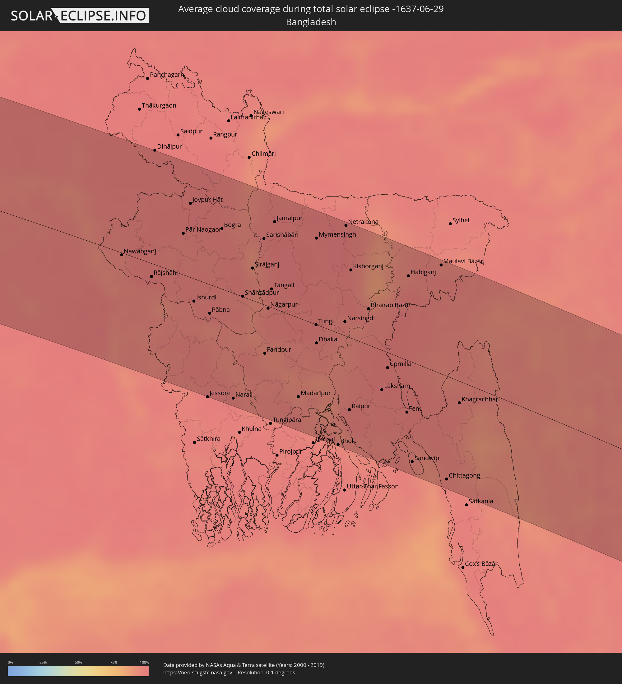
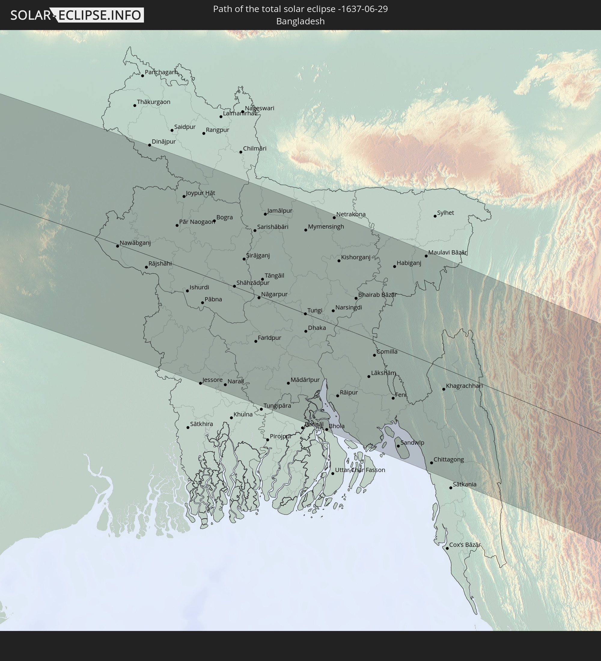 Bangladesch
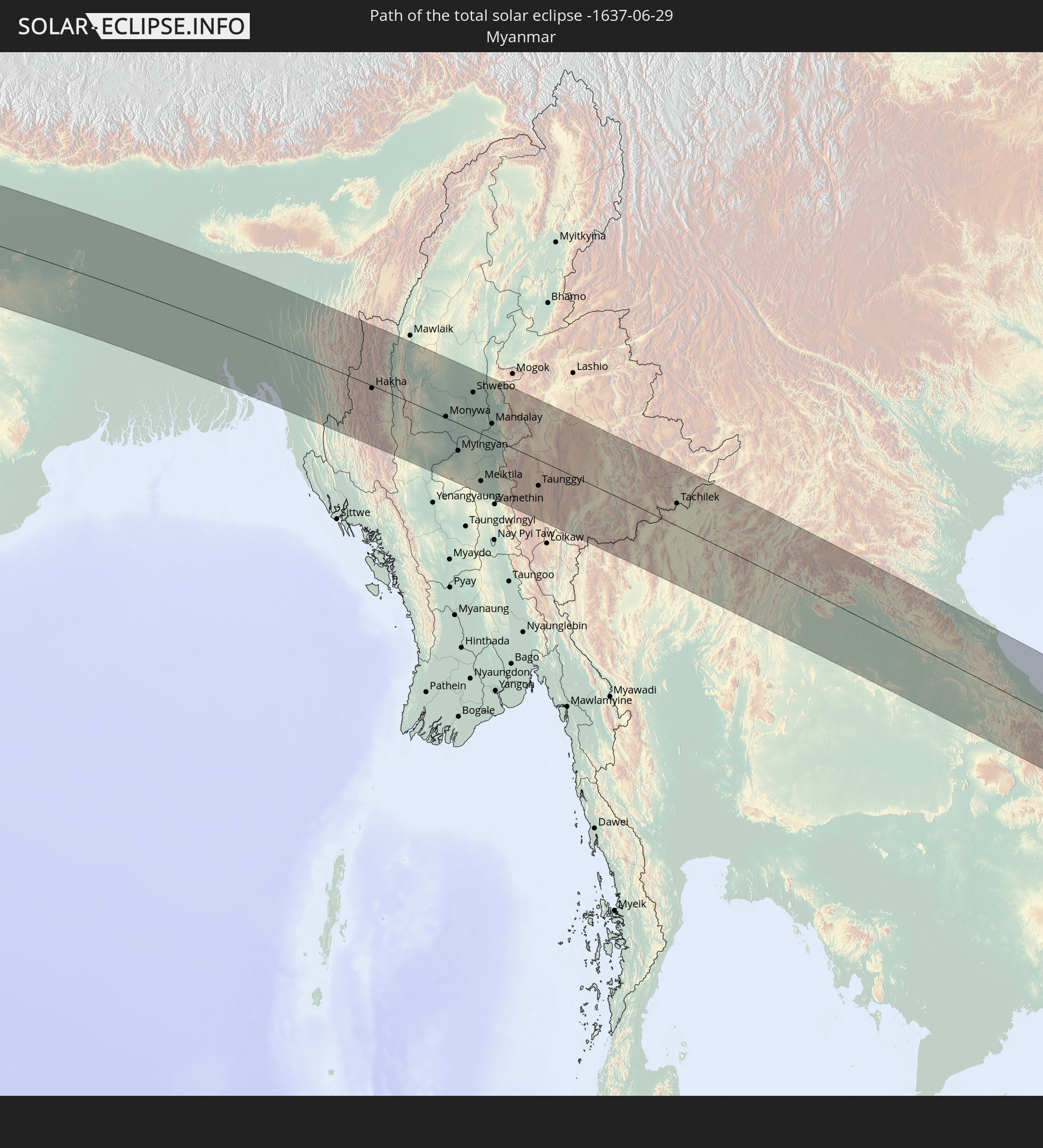 Myanmar
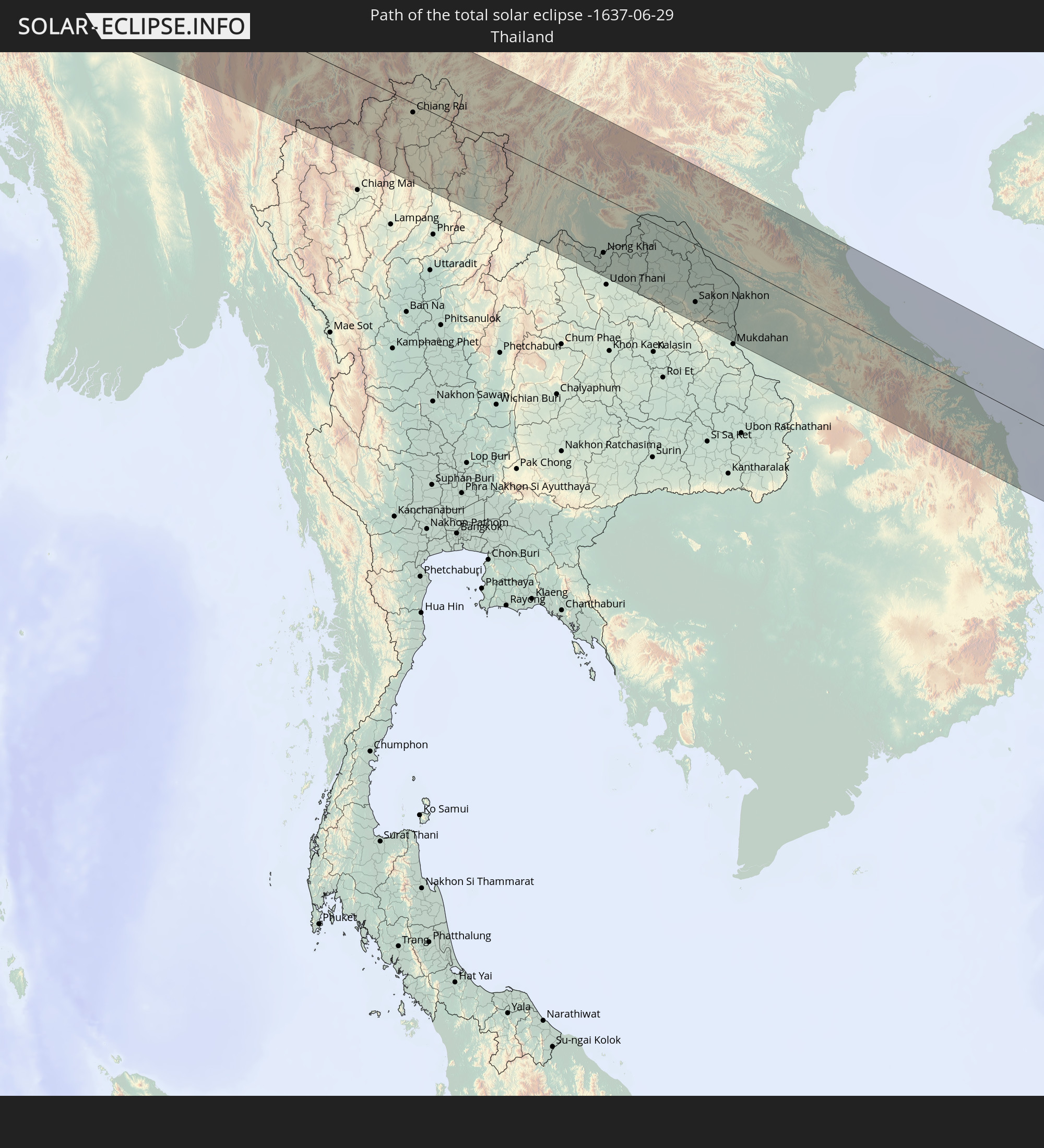 Thailand
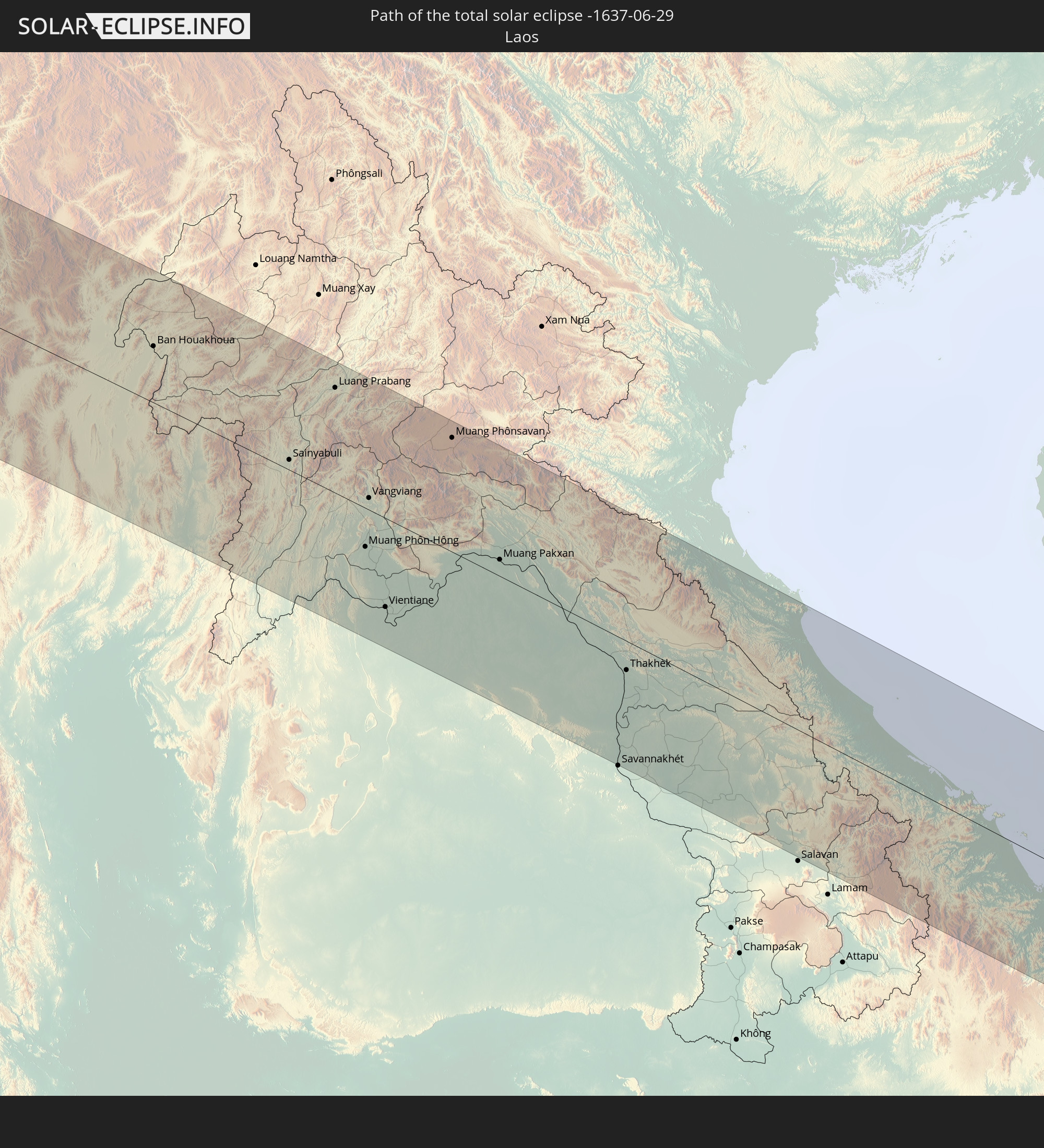 Laos
Laos
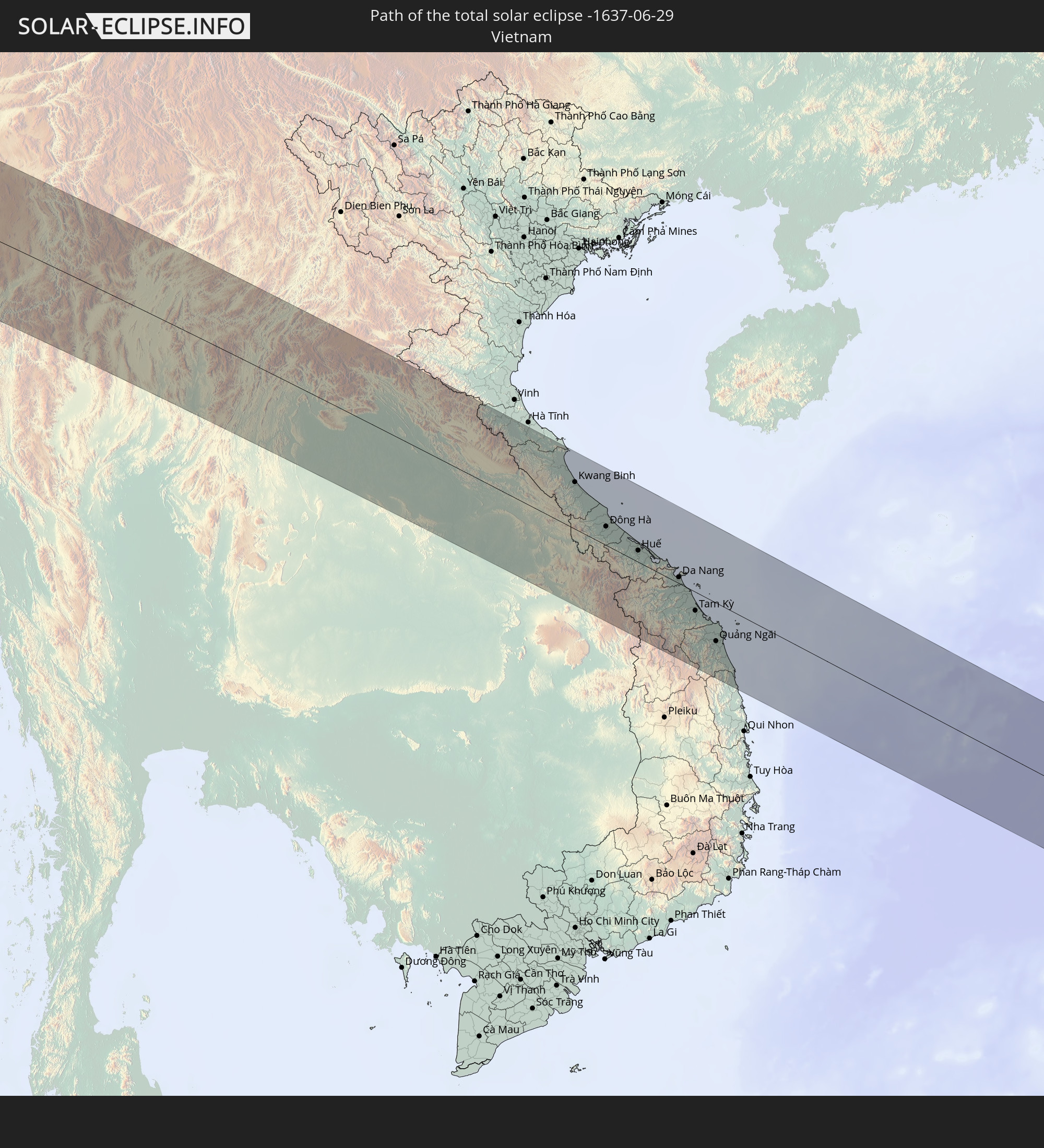 Vietnam
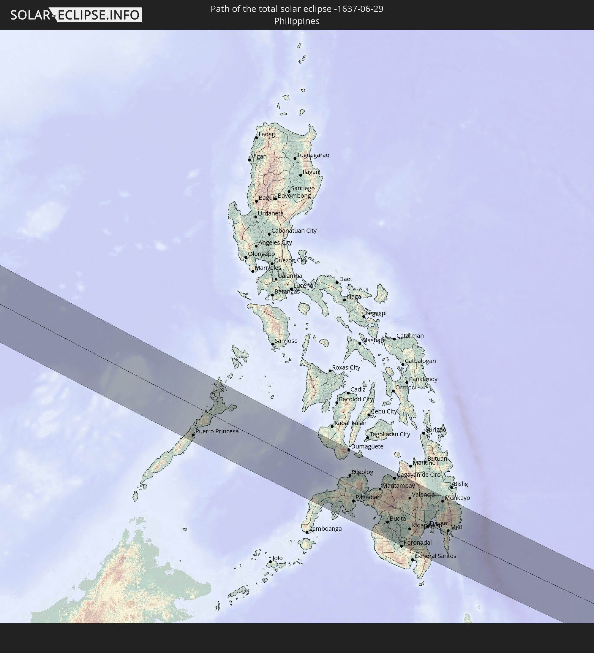 Philippinen
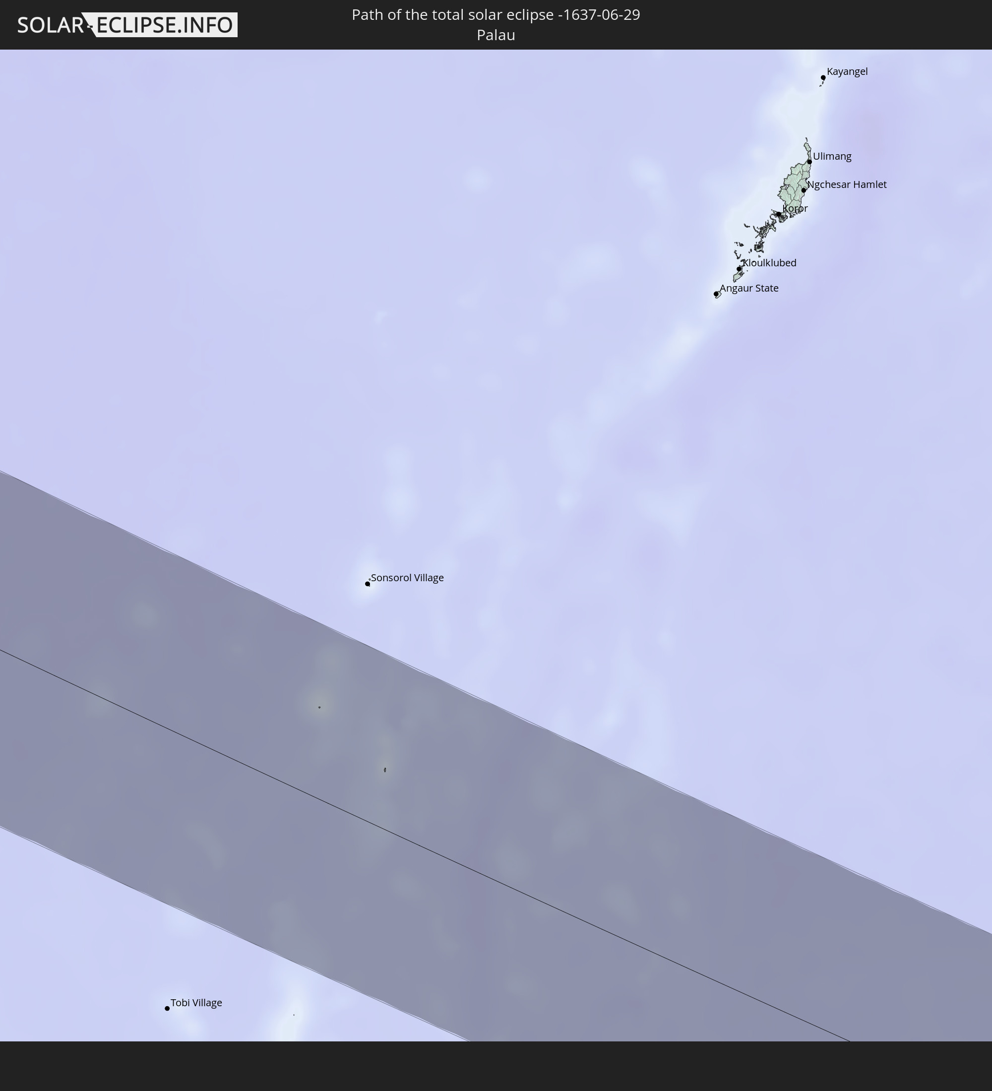 Palau
Palau
In den folgenden Ländern ist die Sonnenfinsternis partiell zu sehen
 Russland
 Portugal
 Spanien
 Mauretanien
 Marokko
 Mali
Mali
 Algerien
 Burkina Faso
 Gibraltar
 Frankreich
 Niger
Niger
 Benin
Benin
 Andorra
 Nigeria
 Äquatorialguinea
 Deutschland
 Schweiz
 São Tomé und Príncipe
 Italien
 Monaco
 Tunesien
 Kamerun
 Gabun
Gabun
 Libyen
 Liechtenstein
 Österreich
 Republik Kongo
 Angola
 Namibia
 Tschechien
 Demokratische Republik Kongo
 San Marino
 Vatikanstadt
 Slowenien
 Tschad
 Kroatien
 Polen
Polen
 Malta
Malta
 Zentralafrikanische Republik
 Bosnien und Herzegowina
 Ungarn
 Slowakei
 Montenegro
 Serbien
 Albanien
 Griechenland
 Botswana
 Rumänien
 Mazedonien
 Sudan
Sudan
 Sambia
 Ukraine
 Bulgarien
 Weißrussland
 Ägypten
 Simbabwe
 Türkei
 Moldawien
 Ruanda
 Burundi
 Tansania
 Uganda
 Mosambik
 Republik Zypern
 Malawi
 Äthiopien
 Kenia
Kenia
 Staat Palästina
 Israel
 Saudi-Arabien
 Jordanien
 Libanon
 Syrien
 Eritrea
 Irak
Irak
 Georgien
 Somalia
 Dschibuti
 Jemen
Jemen
 Armenien
 Iran
Iran
 Aserbaidschan
 Seychellen
 Kasachstan
 Kuwait
 Bahrain
 Katar
Katar
 Vereinigte Arabische Emirate
 Oman
Oman
 Turkmenistan
 Usbekistan
 Afghanistan
 Pakistan
 Tadschikistan
 Indien
 Kirgisistan
 Malediven
 Volksrepublik China
 Sri Lanka
 Nepal
Nepal
 Mongolei
 Bangladesch
 Bhutan
 Myanmar
 Indonesien
 Kokosinseln
 Thailand
 Malaysia
 Laos
Laos
 Vietnam
 Kambodscha
 Singapur
 Weihnachtsinsel
 Australien
 Macau
Macau
 Hongkong
 Brunei
 Taiwan
 Philippinen
 Japan
Japan
 Osttimor
 Nordkorea
 Südkorea
 Palau
Palau
 Föderierte Staaten von Mikronesien
 Nördliche Marianen
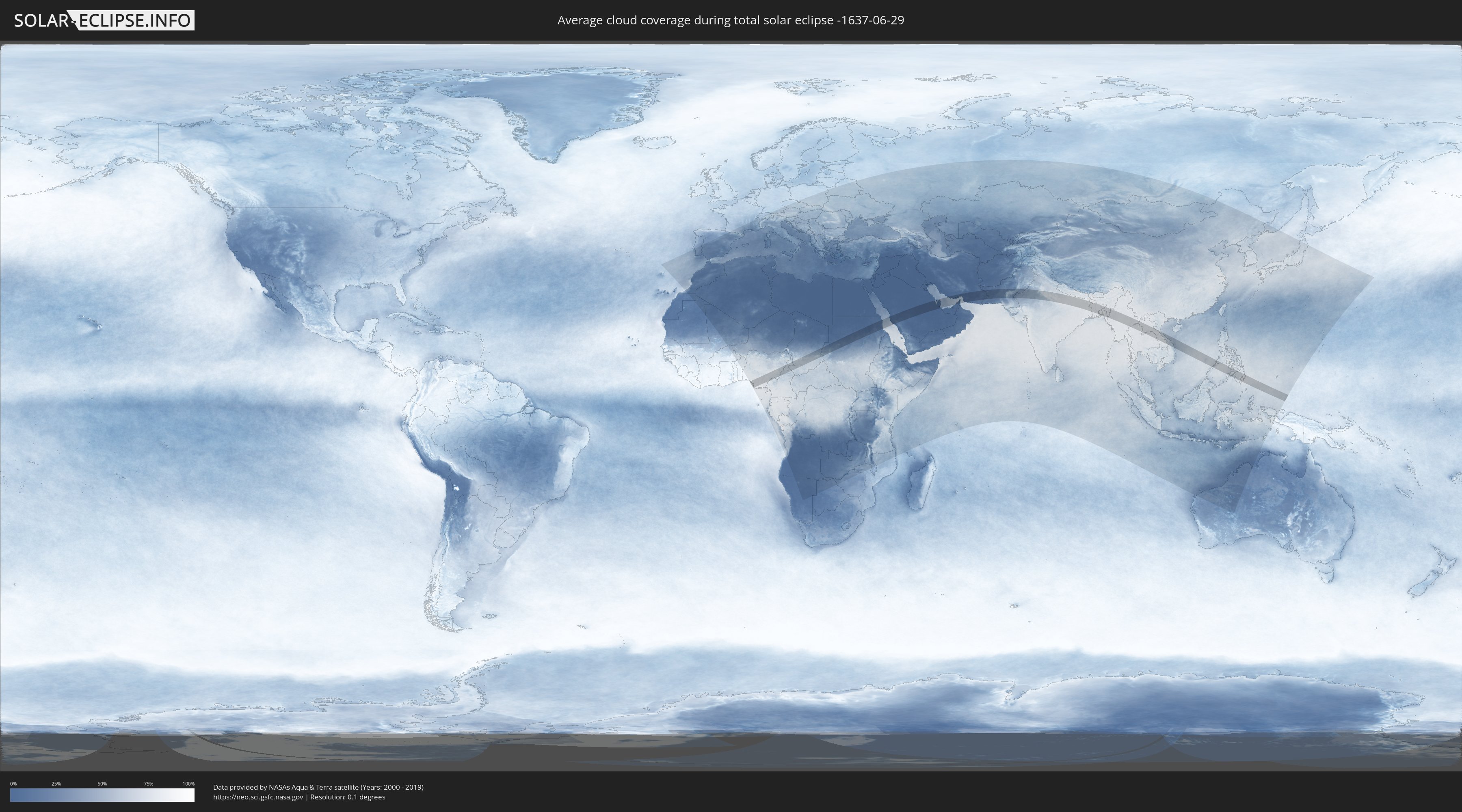
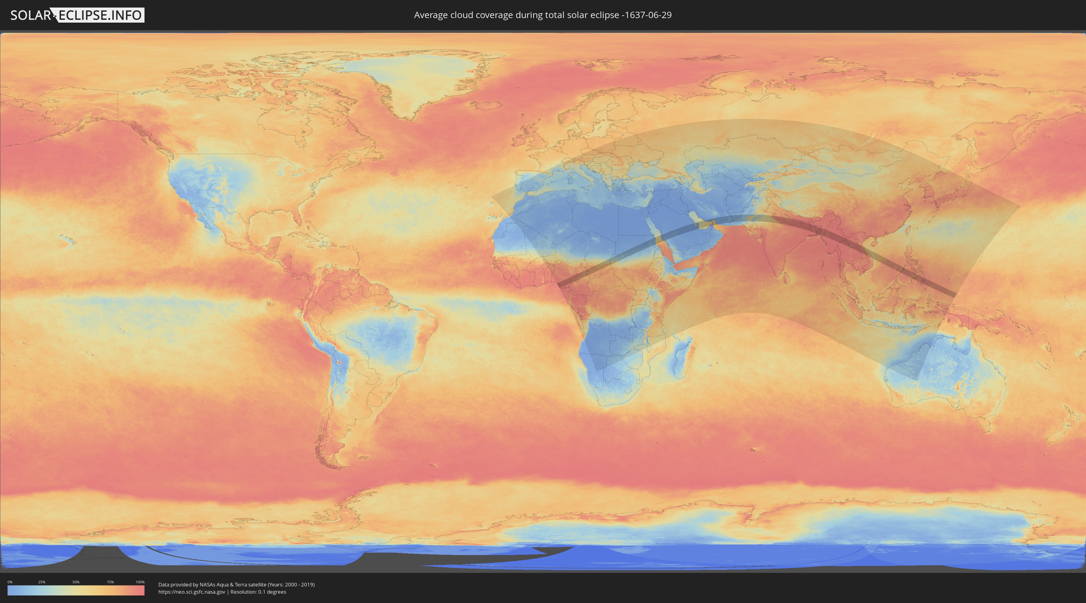
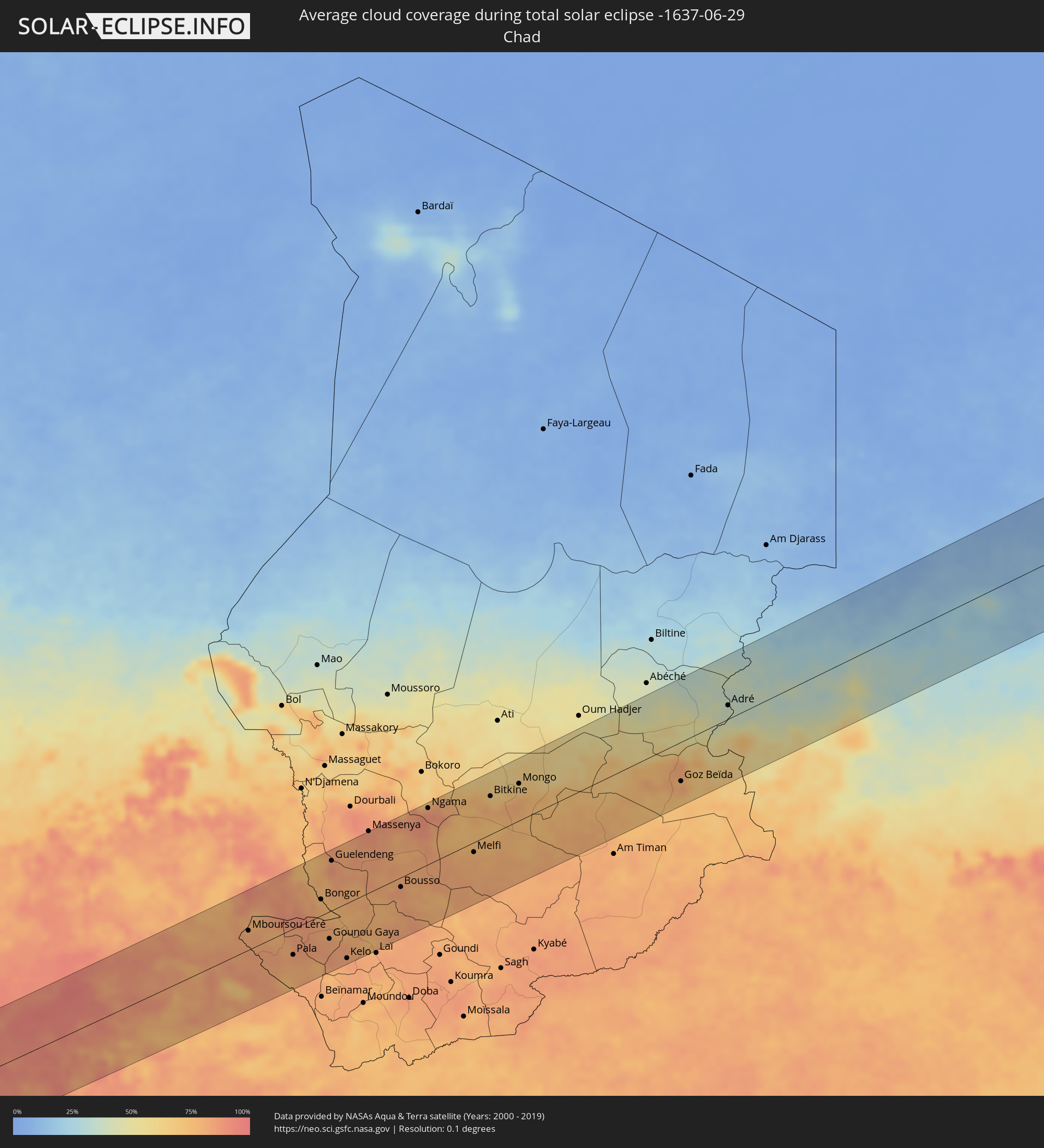
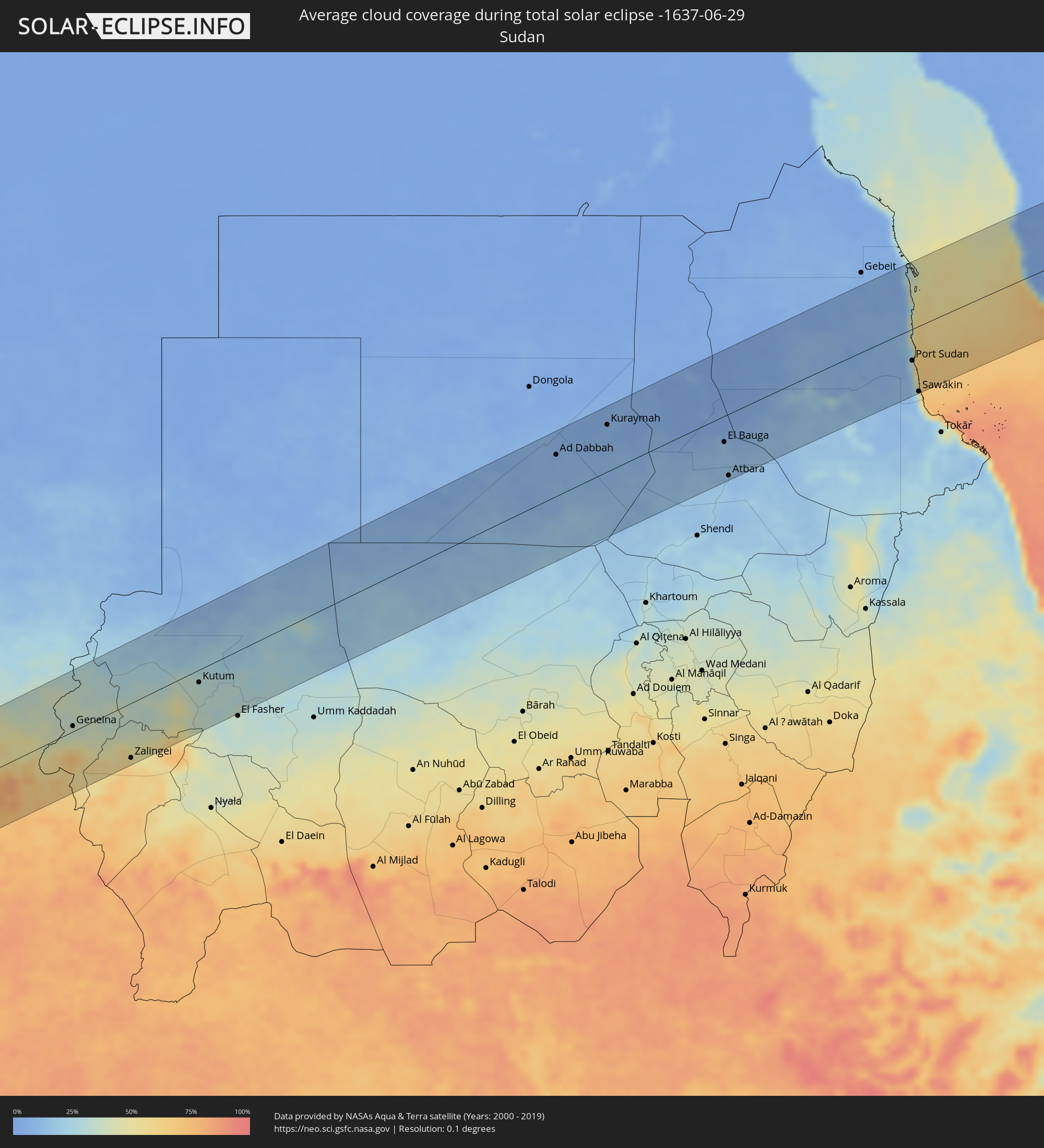
Wie wird das Wetter während der totalen Sonnenfinsternis am 29.06.-1637?
Wo ist der beste Ort, um die totale Sonnenfinsternis vom 29.06.-1637 zu beobachten?
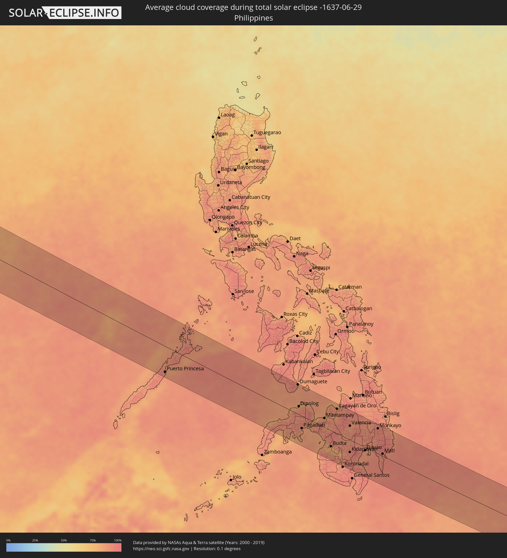
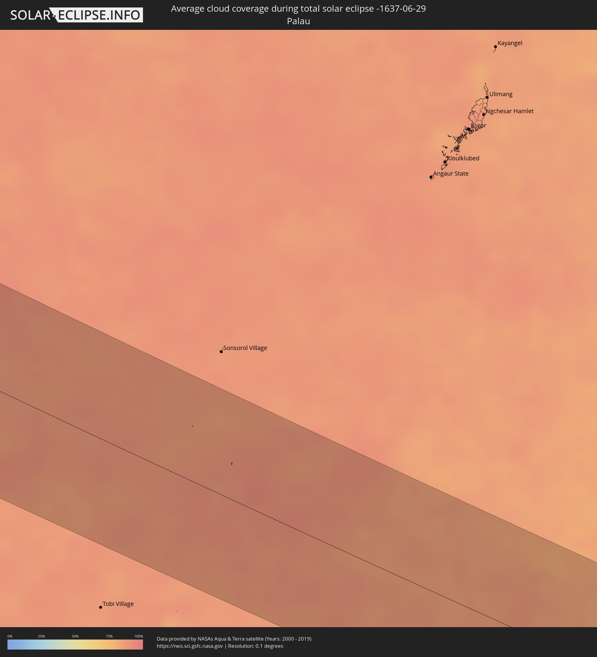
Die folgenden Karten zeigen die durchschnittliche Bewölkung für den Tag, an dem die totale Sonnenfinsternis
stattfindet. Mit Hilfe der Karten lässt sich der Ort entlang des Finsternispfades eingrenzen,
der die besten Aussichen auf einen klaren wolkenfreien Himmel bietet.
Trotzdem muss man immer lokale Gegenenheiten beachten und sollte sich genau über das Wetter an seinem
gewählten Beobachtungsort informieren.
Die Daten stammen von den beiden NASA-Satelliten
AQUA und TERRA
und wurden über einen Zeitraum von 19 Jahren (2000 - 2019) gemittelt.
Detaillierte Länderkarten
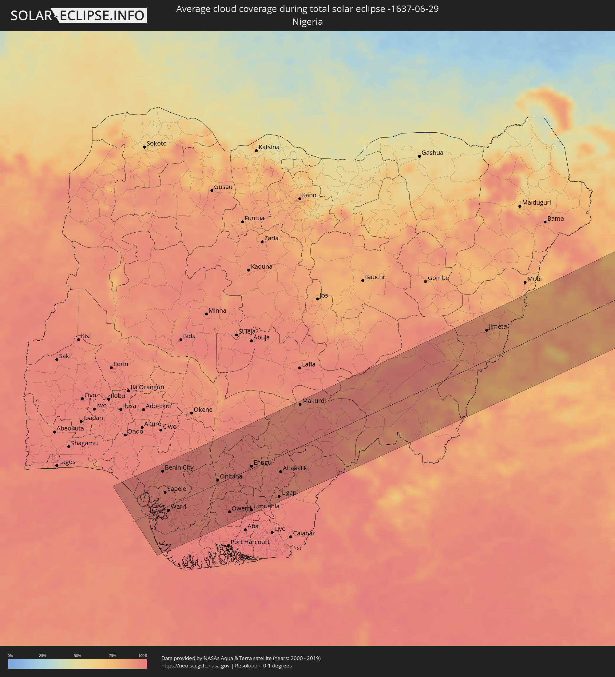 Nigeria
 Kamerun
 Tschad
 Sudan
Sudan
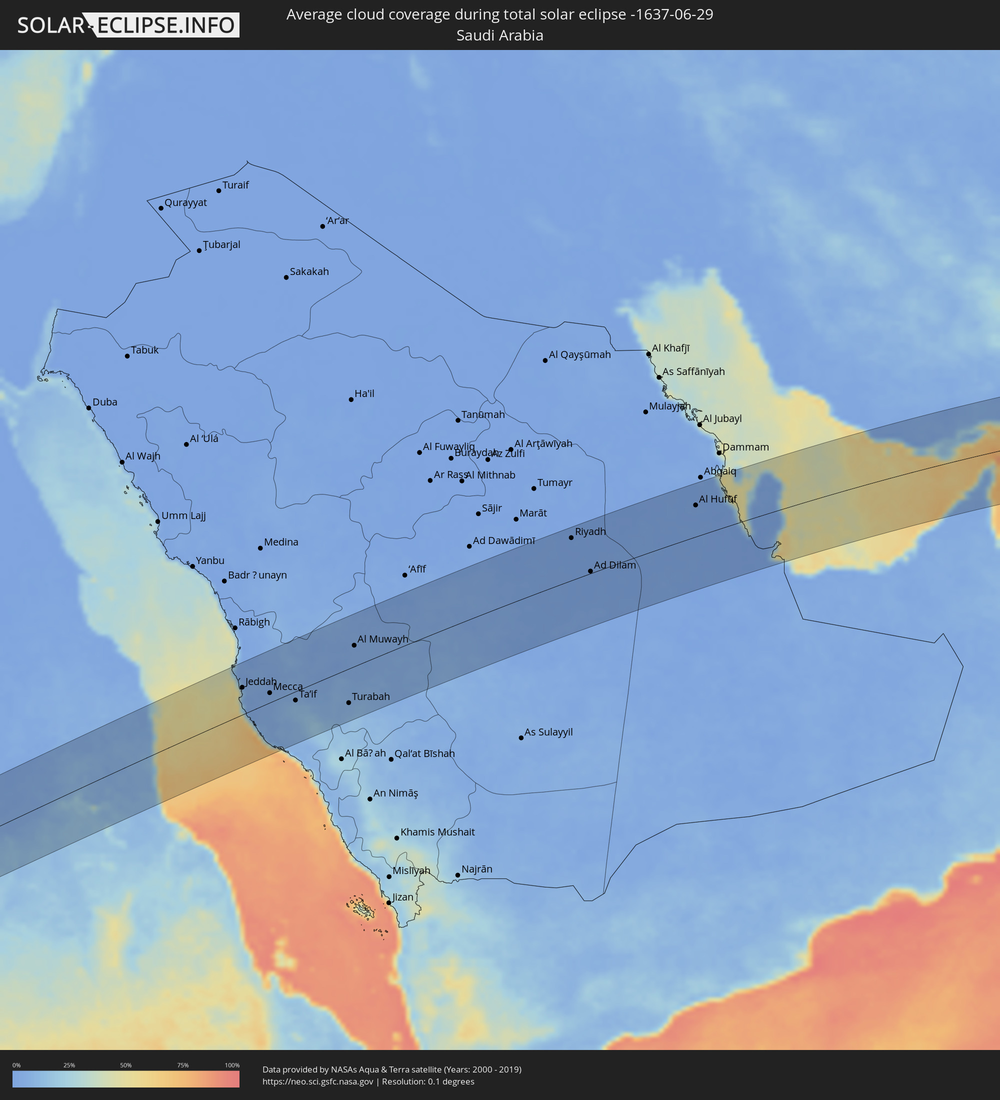 Saudi-Arabien
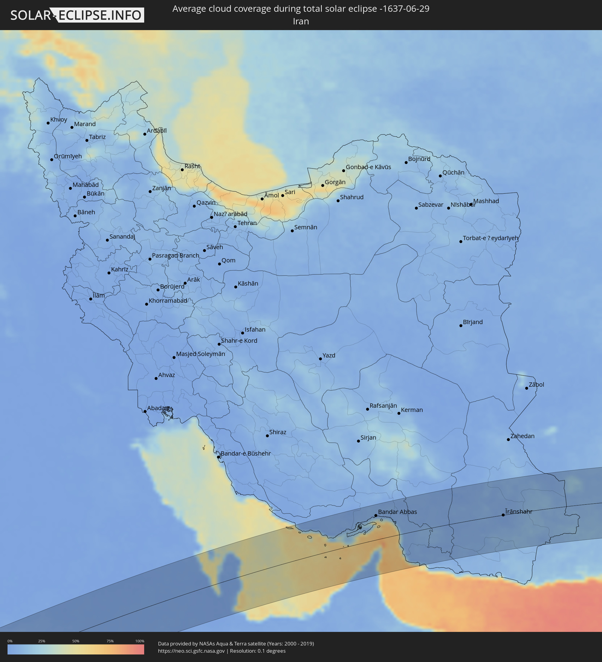 Iran
Iran
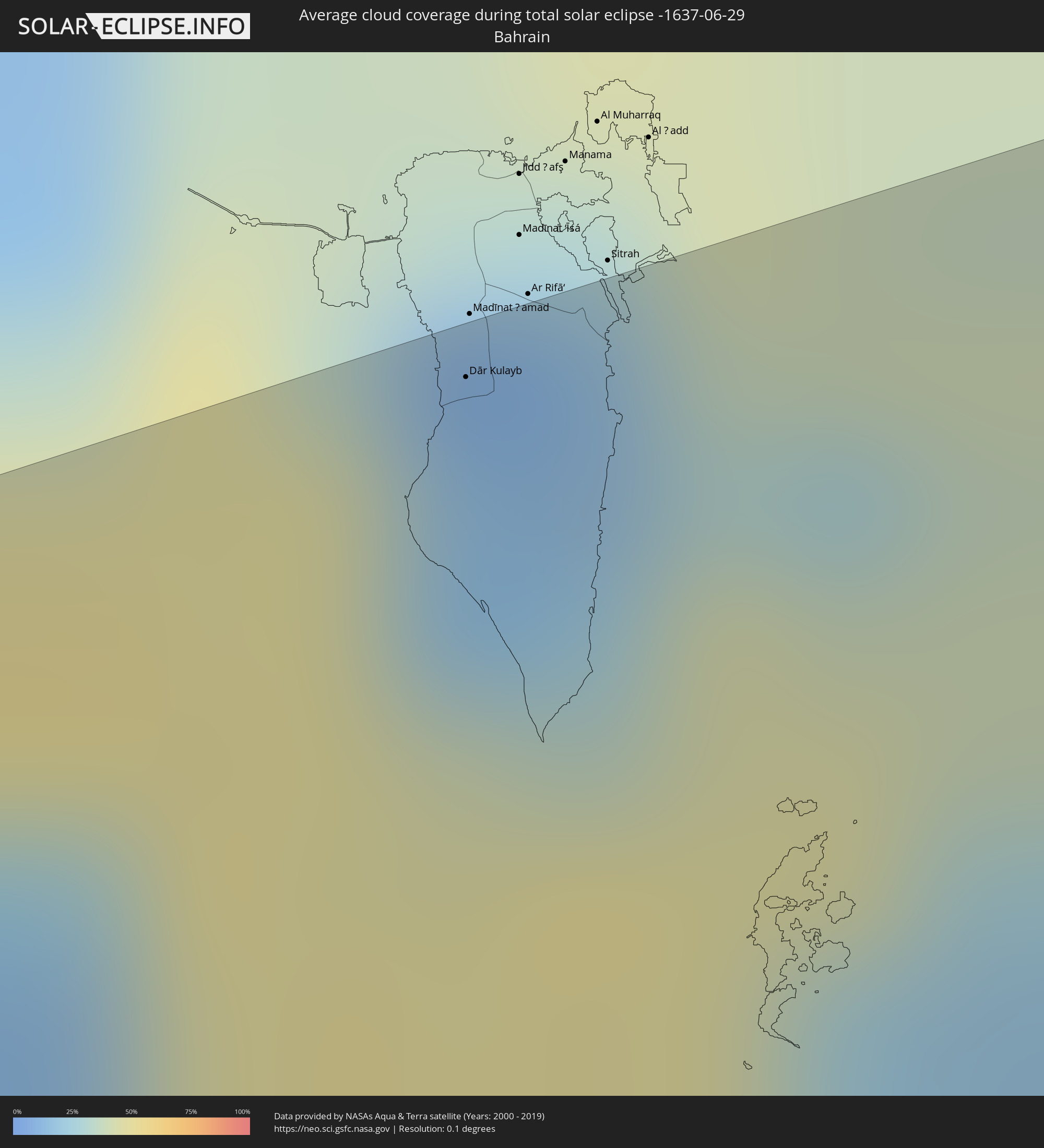 Bahrain
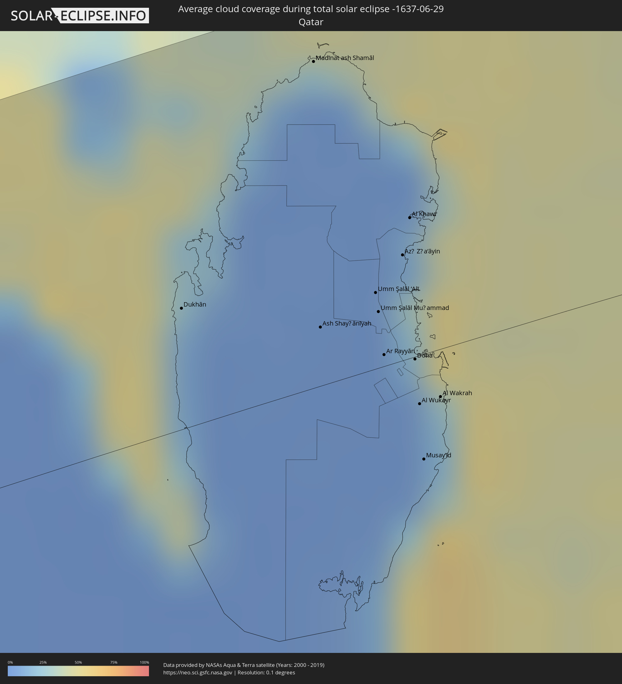 Katar
Katar
 Vereinigte Arabische Emirate
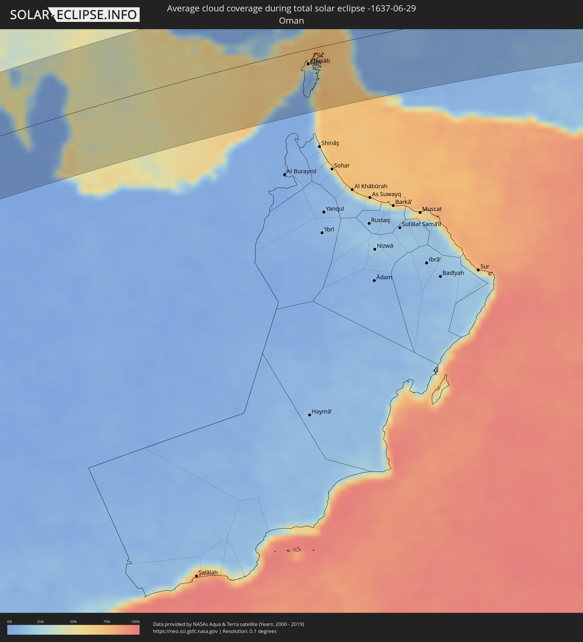 Oman
Oman
 Pakistan
 Indien
 Bangladesch
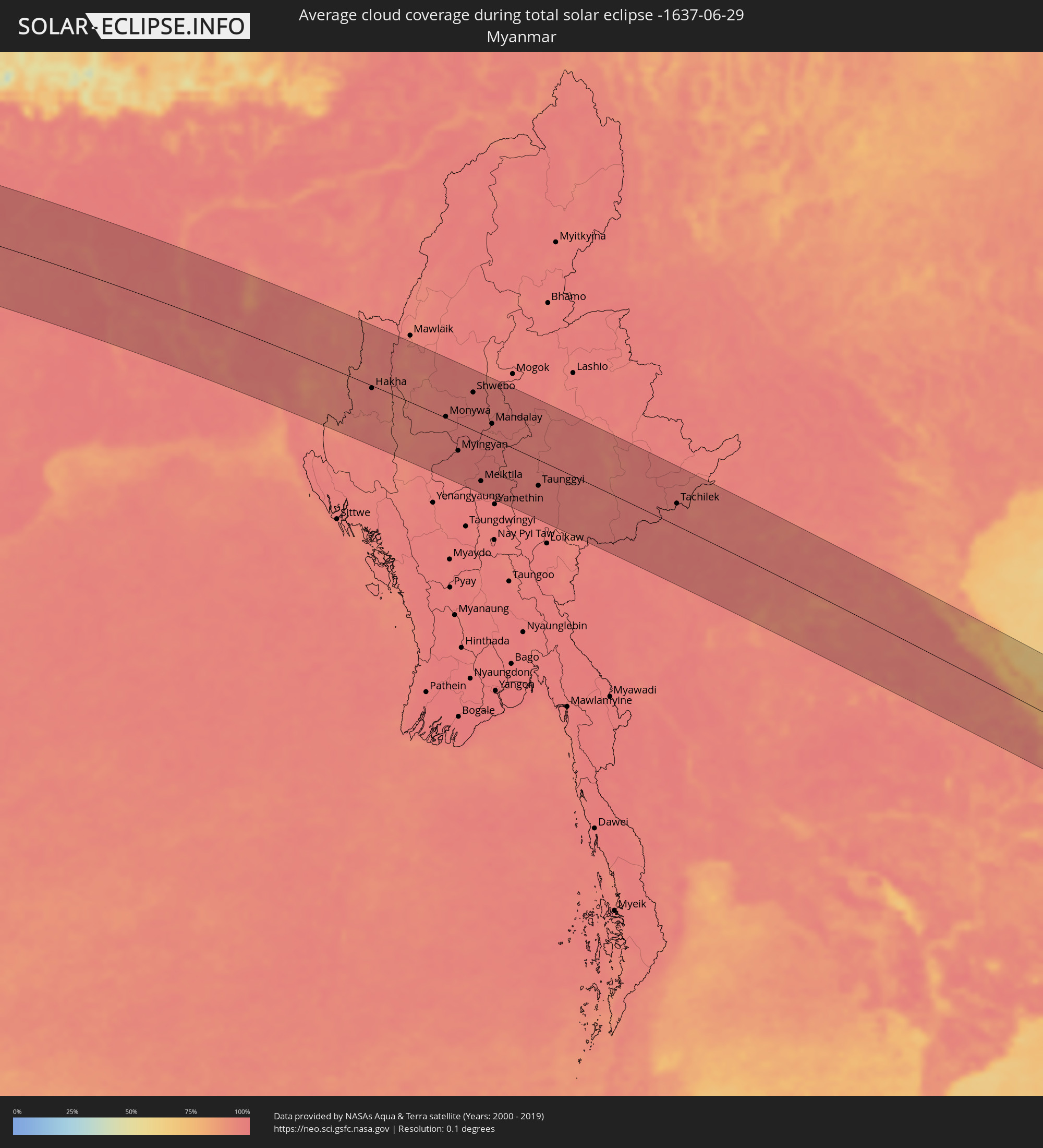 Myanmar
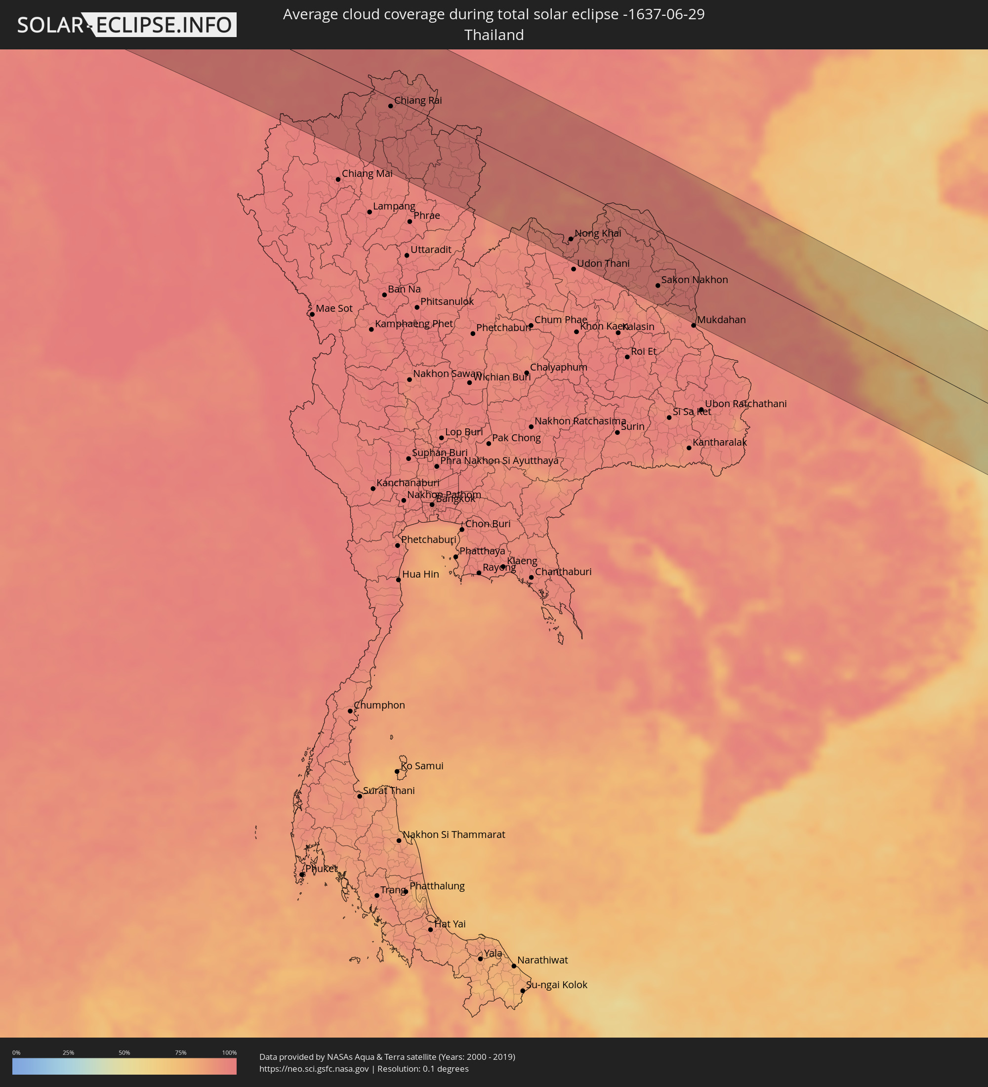 Thailand
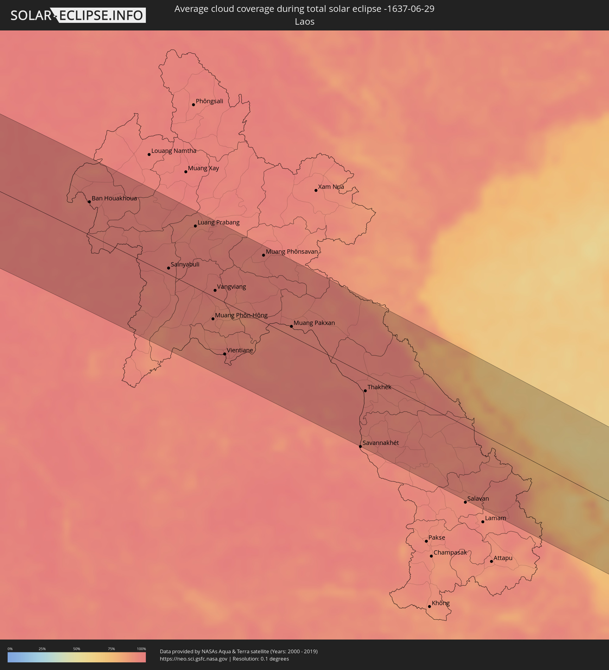 Laos
Laos
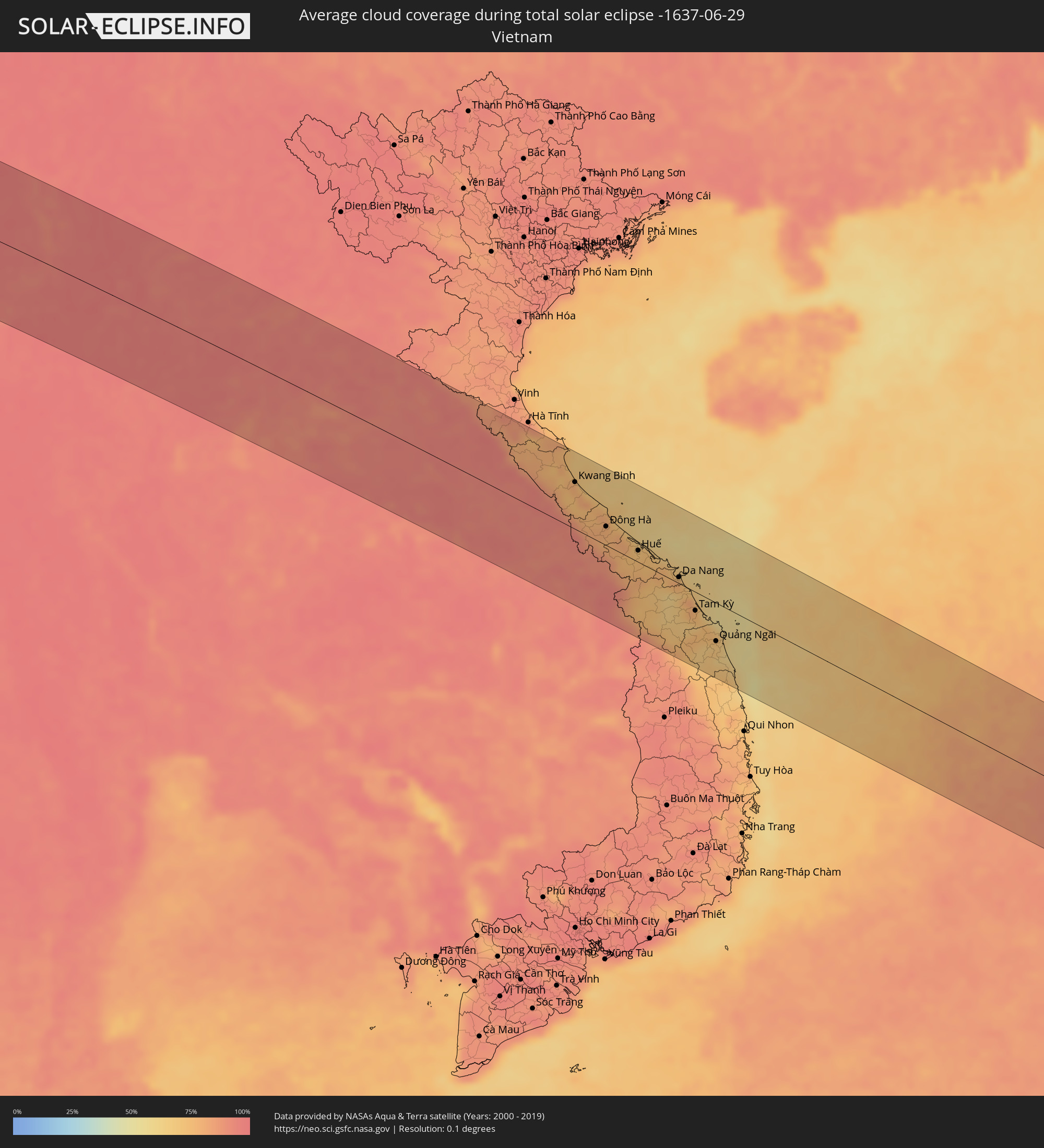 Vietnam
 Philippinen
 Palau
Palau
Orte im Finsternispfad
Die nachfolgene Tabelle zeigt Städte und Orte mit mehr als 5.000 Einwohnern, die sich im Finsternispfad befinden. Städte mit mehr als 100.000 Einwohnern sind dick gekennzeichnet. Mit einem Klick auf den Ort öffnet sich eine Detailkarte die die Lage des jeweiligen Ortes zusammen mit dem Verlauf der zentralen Finsternis präsentiert.
| Ort | Typ | Dauer der Verfinsterung | Ortszeit bei maximaler Verfinsterung | Entfernung zur Zentrallinie | Ø Bewölkung |
|
Benin City, Edo
|
total | - | 05:37:18 UTC+00:13 | 79 km | 96% |
|
Sapele, Delta
|
total | - | 05:37:07 UTC+00:13 | 31 km | 95% |
|
Warri, Delta
|
total | - | 05:36:57 UTC+00:13 | 10 km | 96% |
|
Onitsha, Anambra
|
total | - | 05:37:04 UTC+00:13 | 7 km | 94% |
|
Nnewi, Anambra
|
total | - | 05:37:00 UTC+00:13 | 12 km | 96% |
|
Owerri, Imo
|
total | - | 05:36:46 UTC+00:13 | 72 km | 97% |
|
Awka, Anambra
|
total | - | 05:37:04 UTC+00:13 | 1 km | 95% |
|
Umuahia, Abia
|
total | - | 05:36:44 UTC+00:13 | 89 km | 96% |
|
Enugu, Enugu
|
total | - | 05:37:07 UTC+00:13 | 4 km | 93% |
|
Ugep, Cross River
|
total | - | 05:36:48 UTC+00:13 | 86 km | 94% |
|
Makurdi, Benue
|
total | - | 05:37:38 UTC+00:13 | 89 km | 93% |
|
Kontcha, Adamaoua
|
total | - | 05:37:43 UTC+00:13 | 59 km | 78% |
|
Jimeta, Adamawa
|
total | - | 05:38:25 UTC+00:13 | 63 km | 85% |
|
Poli, North
|
total | - | 05:38:03 UTC+00:13 | 55 km | 83% |
|
Garoua, North
|
total | - | 05:38:31 UTC+00:13 | 21 km | 83% |
|
Pitoa, North
|
total | - | 05:38:34 UTC+00:13 | 24 km | 82% |
|
Lagdo, North
|
total | - | 05:38:23 UTC+00:13 | 21 km | 73% |
|
Guider, North
|
total | - | 05:38:55 UTC+00:13 | 59 km | 81% |
|
Mboursou Léré, Mayo-Kebbi Ouest
|
total | - | 06:25:28 UTC+01:00 | 32 km | 82% |
|
Rey Bouba, North
|
total | - | 05:38:15 UTC+00:13 | 79 km | 84% |
|
Mindif, Far North
|
total | - | 05:39:15 UTC+00:13 | 82 km | 85% |
|
Kaélé, Far North
|
total | - | 05:39:05 UTC+00:13 | 53 km | 84% |
|
Pala, Mayo-Kebbi Ouest
|
total | - | 06:25:20 UTC+01:00 | 43 km | 82% |
|
Yagoua, Far North
|
total | - | 05:39:20 UTC+00:13 | 39 km | 83% |
|
Bongor, Mayo-Kebbi Est
|
total | - | 06:25:57 UTC+01:00 | 27 km | 75% |
|
Gounou Gaya, Mayo-Kebbi Est
|
total | - | 06:25:35 UTC+01:00 | 45 km | 82% |
|
Guelendeng, Mayo-Kebbi Est
|
total | - | 06:26:22 UTC+01:00 | 82 km | 85% |
|
Kelo, Tandjilé
|
total | - | 06:25:27 UTC+01:00 | 91 km | 85% |
|
Bousso, Chari-Baguirmi
|
total | - | 06:26:19 UTC+01:00 | 16 km | 83% |
|
Ngama, Chari-Baguirmi
|
total | - | 06:27:15 UTC+01:00 | 93 km | 89% |
|
Melfi, Guéra
|
total | - | 06:26:58 UTC+01:00 | 16 km | 78% |
|
Bitkine, Guéra
|
total | - | 06:27:38 UTC+01:00 | 63 km | 72% |
|
Mongo, Guéra
|
total | - | 06:27:55 UTC+01:00 | 61 km | 69% |
|
Adré, Ouadaï
|
total | - | 06:30:06 UTC+01:00 | 22 km | 38% |
|
Geneina, Western Darfur
|
total | - | 07:40:08 UTC+02:10 | 9 km | 36% |
|
Zalingei, Central Darfur
|
total | - | 07:40:12 UTC+02:10 | 94 km | 53% |
|
Kutum, Northern Darfur
|
total | - | 07:41:47 UTC+02:10 | 21 km | 32% |
|
Ad Dabbah, Northern State
|
total | - | 07:49:24 UTC+02:10 | 70 km | 7% |
|
Marawī, Northern State
|
total | - | 07:50:33 UTC+02:10 | 74 km | 7% |
|
Kuraymah, Northern State
|
total | - | 07:50:39 UTC+02:10 | 79 km | 8% |
|
El Bauga, River Nile
|
total | - | 07:52:21 UTC+02:10 | 44 km | 14% |
|
Berber, River Nile
|
total | - | 07:52:12 UTC+02:10 | 71 km | 14% |
|
Atbara, River Nile
|
total | - | 07:51:55 UTC+02:10 | 104 km | 13% |
|
Port Sudan, Red Sea
|
total | - | 07:57:16 UTC+02:10 | 53 km | 23% |
|
Sawākin, Red Sea
|
total | - | 07:56:55 UTC+02:10 | 110 km | 20% |
|
Jeddah, Makkah
|
total | - | 08:58:20 UTC+03:06 | 58 km | 17% |
|
Al Jumūm, Makkah
|
total | - | 08:59:04 UTC+03:06 | 45 km | 4% |
|
Mecca, Makkah
|
total | - | 08:59:03 UTC+03:06 | 20 km | 4% |
|
Ash Shafā, Makkah
|
total | - | 08:59:22 UTC+03:06 | 36 km | 10% |
|
Ta’if, Makkah
|
total | - | 08:59:42 UTC+03:06 | 20 km | 9% |
|
Turabah, Makkah
|
total | - | 09:01:23 UTC+03:06 | 75 km | 8% |
|
Riyadh, Ar Riyāḑ
|
total | - | 09:12:52 UTC+03:06 | 92 km | 1% |
|
Ad Dilam, Ar Riyāḑ
|
total | - | 09:12:59 UTC+03:06 | 4 km | 1% |
|
Al Hufūf, Eastern Province
|
total | - | 09:18:40 UTC+03:06 | 68 km | 2% |
|
Al Baţţālīyah, Eastern Province
|
total | - | 09:18:52 UTC+03:06 | 73 km | 2% |
|
Al Munayzilah, Eastern Province
|
total | - | 09:18:53 UTC+03:06 | 67 km | 2% |
|
Aţ Ţaraf, Eastern Province
|
total | - | 09:18:58 UTC+03:06 | 63 km | 2% |
|
Dār Kulayb, Southern Governorate
|
total | - | 09:40:22 UTC+03:26 | 114 km | 17% |
|
Dukhān, Baladīyat ar Rayyān
|
total | - | 09:40:21 UTC+03:26 | 37 km | 14% |
|
Madīnat ash Shamāl, Madīnat ash Shamāl
|
total | - | 09:41:47 UTC+03:26 | 99 km | 4% |
|
Ash Shayḩānīyah, Baladīyat ar Rayyān
|
total | - | 09:41:10 UTC+03:26 | 18 km | 2% |
|
Umm Şalāl ‘Alī, Baladīyat Umm Şalāl
|
total | - | 09:41:36 UTC+03:26 | 23 km | 3% |
|
Umm Şalāl Muḩammad, Baladīyat Umm Şalāl
|
total | - | 09:41:35 UTC+03:26 | 17 km | 2% |
|
Ar Rayyān, Baladīyat ar Rayyān
|
total | - | 09:41:31 UTC+03:26 | 4 km | 1% |
|
Az̧ Z̧a‘āyin, Baladīyat az̧ Z̧a‘āyin
|
total | - | 09:41:52 UTC+03:26 | 32 km | 29% |
|
Al Khawr, Al Khawr
|
total | - | 09:42:01 UTC+03:26 | 43 km | 14% |
|
Doha, Baladīyat ad Dawḩah
|
total | - | 09:41:42 UTC+03:26 | 1 km | 5% |
|
Al Wukayr, Al Wakrah
|
total | - | 09:41:37 UTC+03:26 | 15 km | 4% |
|
Musay‘īd, Al Wakrah
|
total | - | 09:41:31 UTC+03:26 | 32 km | 32% |
|
Al Wakrah, Al Wakrah
|
total | - | 09:41:46 UTC+03:26 | 15 km | 21% |
|
Kīsh, Hormozgan
|
total | - | 09:47:32 UTC+03:25 | 67 km | 41% |
|
Bandar-e Lengeh, Hormozgan
|
total | - | 09:49:24 UTC+03:25 | 45 km | 30% |
|
Sharjah, Ash Shāriqah
|
total | - | 10:05:08 UTC+03:41 | 99 km | 7% |
|
Ajman, Ajman
|
total | - | 10:05:15 UTC+03:41 | 92 km | 27% |
|
Umm al Qaywayn, Umm al Qaywayn
|
total | - | 10:05:37 UTC+03:41 | 78 km | 23% |
|
Adh Dhayd, Ash Shāriqah
|
total | - | 10:06:10 UTC+03:41 | 116 km | 2% |
|
Ras al-Khaimah, Raʼs al Khaymah
|
total | - | 10:06:40 UTC+03:41 | 63 km | 35% |
|
Khasab, Musandam
|
total | - | 10:07:38 UTC+03:41 | 28 km | 21% |
|
Dibba Al-Fujairah, Al Fujayrah
|
total | - | 10:07:15 UTC+03:41 | 92 km | 18% |
|
Qeshm, Hormozgan
|
total | - | 09:52:45 UTC+03:25 | 55 km | 57% |
|
Dibba Al-Hisn, Al Fujayrah
|
total | - | 10:07:18 UTC+03:41 | 89 km | 18% |
|
Bandar Abbas, Hormozgan
|
total | - | 09:52:57 UTC+03:25 | 81 km | 37% |
|
Mīnāb, Hormozgan
|
total | - | 09:54:44 UTC+03:25 | 57 km | 6% |
|
Īrānshahr, Sistan and Baluchestan
|
total | - | 10:03:17 UTC+03:25 | 1 km | 2% |
|
Qaşr-e Qand, Sistan and Baluchestan
|
total | - | 10:02:59 UTC+03:25 | 107 km | 11% |
|
Khāsh, Sistan and Baluchestan
|
total | - | 10:05:04 UTC+03:25 | 103 km | 7% |
|
Khuzdār, Balochistān
|
total | - | 11:21:00 UTC+04:28 | 7 km | 20% |
|
Dadu, Sindh
|
total | - | 11:23:57 UTC+04:28 | 117 km | 56% |
|
Shahdād Kot, Sindh
|
total | - | 11:24:23 UTC+04:28 | 7 km | 67% |
|
Kambar, Sindh
|
total | - | 11:24:37 UTC+04:28 | 22 km | 70% |
|
Lārkāna, Sindh
|
total | - | 11:25:10 UTC+04:28 | 26 km | 62% |
|
Jacobābād, Sindh
|
total | - | 11:25:48 UTC+04:28 | 55 km | 61% |
|
Shikārpur, Sindh
|
total | - | 11:26:18 UTC+04:28 | 18 km | 67% |
|
Khairpur, Sindh
|
total | - | 11:26:37 UTC+04:28 | 29 km | 45% |
|
Sukkur, Sindh
|
total | - | 11:26:53 UTC+04:28 | 10 km | 51% |
|
Kandhkot, Sindh
|
total | - | 11:27:44 UTC+04:28 | 50 km | 62% |
|
Sādiqābād, Punjab
|
total | - | 11:30:13 UTC+04:28 | 58 km | 42% |
|
Khānpur, Punjab
|
total | - | 11:31:33 UTC+04:28 | 98 km | 41% |
|
Bīkaner, Rajasthan
|
total | - | 12:31:33 UTC+05:21 | 43 km | 47% |
|
Ajmer, Rajasthan
|
total | - | 12:35:32 UTC+05:21 | 118 km | 58% |
|
Jaipur, Rajasthan
|
total | - | 12:38:25 UTC+05:21 | 52 km | 62% |
|
Āgra, Uttar Pradesh
|
total | - | 12:44:04 UTC+05:21 | 11 km | 86% |
|
Alīgarh, Uttar Pradesh
|
total | - | 12:43:51 UTC+05:21 | 88 km | 89% |
|
Gwalior, Madhya Pradesh
|
total | - | 12:45:00 UTC+05:21 | 91 km | 76% |
|
Kanpur, Uttar Pradesh
|
total | - | 12:50:24 UTC+05:21 | 23 km | 86% |
|
Lucknow, Uttar Pradesh
|
total | - | 12:51:34 UTC+05:21 | 30 km | 91% |
|
Allahābād, Uttar Pradesh
|
total | - | 12:54:50 UTC+05:21 | 99 km | 95% |
|
Varanasi, Uttar Pradesh
|
total | - | 12:57:48 UTC+05:21 | 84 km | 93% |
|
Gorakhpur, Uttar Pradesh
|
total | - | 12:57:30 UTC+05:21 | 82 km | 94% |
|
Patna, Bihar
|
total | - | 13:02:35 UTC+05:21 | 5 km | 95% |
|
Rājshāhi, Rājshāhi
|
total | - | 13:43:34 UTC+05:53 | 14 km | 97% |
|
Pār Naogaon, Rājshāhi
|
total | - | 13:43:53 UTC+05:53 | 43 km | 96% |
|
Pābna, Rājshāhi
|
total | - | 13:45:17 UTC+05:53 | 30 km | 93% |
|
Bogra, Rājshāhi
|
total | - | 13:44:43 UTC+05:53 | 63 km | 97% |
|
Nāgarpur, Dhaka
|
total | - | 13:46:33 UTC+05:53 | 2 km | 97% |
|
Tāngāil, Dhaka
|
total | - | 13:46:26 UTC+05:53 | 19 km | 96% |
|
Tungi, Dhaka
|
total | - | 13:47:48 UTC+05:53 | 1 km | 97% |
|
Mymensingh, Dhaka
|
total | - | 13:46:55 UTC+05:53 | 90 km | 97% |
|
Dhaka, Dhaka
|
total | - | 13:48:00 UTC+05:53 | 19 km | 96% |
|
Narsingdi, Dhaka
|
total | - | 13:48:24 UTC+05:53 | 14 km | 95% |
|
Comilla, Chittagong
|
total | - | 13:49:49 UTC+05:53 | 16 km | 98% |
|
Chittagong, Chittagong
|
total | - | 13:52:16 UTC+05:53 | 107 km | 94% |
|
Hakha, Chin
|
total | - | 14:26:47 UTC+06:24 | 5 km | 96% |
|
Pakokku, Magway
|
total | - | 14:30:52 UTC+06:24 | 79 km | 97% |
|
Monywa, Sagain
|
total | - | 14:30:06 UTC+06:24 | 2 km | 95% |
|
Myingyan, Mandalay
|
total | - | 14:31:15 UTC+06:24 | 53 km | 97% |
|
Shwebo, Sagain
|
total | - | 14:30:34 UTC+06:24 | 73 km | 97% |
|
Meiktila, Mandalay
|
total | - | 14:32:42 UTC+06:24 | 92 km | 96% |
|
Sagaing, Sagain
|
total | - | 14:31:49 UTC+06:24 | 15 km | 96% |
|
Mandalay, Mandalay
|
total | - | 14:31:53 UTC+06:24 | 29 km | 97% |
|
Kyaukse, Mandalay
|
total | - | 14:32:23 UTC+06:24 | 7 km | 97% |
|
Pyin Oo Lwin, Mandalay
|
total | - | 14:32:27 UTC+06:24 | 51 km | 97% |
|
Taunggyi, Shan
|
total | - | 14:34:47 UTC+06:24 | 50 km | 96% |
|
Chiang Rai, Chiang Rai
|
total | - | 14:57:23 UTC+06:42 | 13 km | 96% |
|
Mae Chan, Chiang Rai
|
total | - | 14:57:09 UTC+06:42 | 11 km | 97% |
|
Mae Sai, Chiang Rai
|
total | - | 14:56:52 UTC+06:42 | 41 km | 98% |
|
Tachilek, Shan
|
total | - | 14:56:51 UTC+06:42 | 43 km | 98% |
|
Dok Kham Tai, Phayao
|
total | - | 14:58:26 UTC+06:42 | 81 km | 97% |
|
Ban Houayxay, Bokeo Province
|
total | - | 14:57:49 UTC+06:42 | 50 km | 95% |
|
Ban Houakhoua, Bokeo Province
|
total | - | 14:57:55 UTC+06:42 | 49 km | 94% |
|
Nan, Nan
|
total | - | 14:59:58 UTC+06:42 | 82 km | 97% |
|
Sainyabuli, Xiagnabouli
|
total | - | 15:00:45 UTC+06:42 | 9 km | 95% |
|
Luang Prabang, Louangphabang
|
total | - | 15:00:38 UTC+06:42 | 91 km | 93% |
|
Muang Phôn-Hông, Vientiane Province
|
total | - | 15:02:31 UTC+06:42 | 34 km | 93% |
|
Vangviang, Vientiane Province
|
total | - | 15:02:06 UTC+06:42 | 10 km | 94% |
|
Tha Bo, Nong Khai
|
total | - | 15:03:25 UTC+06:42 | 90 km | 92% |
|
Vientiane, Vientiane
|
total | - | 15:03:19 UTC+06:42 | 78 km | 95% |
|
Nong Khai, Nong Khai
|
total | - | 15:03:36 UTC+06:42 | 80 km | 94% |
|
Muang Phônsavan, Xiangkhoang
|
total | - | 15:02:31 UTC+06:42 | 99 km | 95% |
|
Ban Dung, Changwat Udon Thani
|
total | - | 15:04:27 UTC+06:42 | 73 km | 95% |
|
Sawang Daen Din, Sakon Nakhon
|
total | - | 15:04:56 UTC+06:42 | 85 km | 95% |
|
Muang Pakxan, Bolikhamsai Province
|
total | - | 15:04:13 UTC+06:42 | 14 km | 93% |
|
Seka, Changwat Bueng Kan
|
total | - | 15:05:04 UTC+06:42 | 16 km | 95% |
|
Sakon Nakhon, Sakon Nakhon
|
total | - | 15:06:07 UTC+06:42 | 83 km | 96% |
|
Nakhon Phanom, Nakhon Phanom
|
total | - | 15:06:36 UTC+06:42 | 28 km | 94% |
|
Thakhèk, Khammouan
|
total | - | 15:06:40 UTC+06:42 | 25 km | 94% |
|
Kwang Binh, Quảng Bình
|
total | - | 15:33:13 UTC+07:06 | 68 km | 79% |
|
Ðông Hà, Quảng Trị
|
total | - | 15:34:24 UTC+07:06 | 27 km | 78% |
|
Huế, Thừa Thiên-Huế
|
total | - | 15:35:16 UTC+07:06 | 17 km | 71% |
|
Da Nang, Đà Nẵng
|
total | - | 15:36:18 UTC+07:06 | 9 km | 78% |
|
Hội An, Quảng Nam
|
total | - | 15:36:35 UTC+07:06 | 4 km | 71% |
|
Tam Kỳ, Quảng Nam
|
total | - | 15:37:02 UTC+07:06 | 27 km | 74% |
|
Quảng Ngãi, Quảng Ngãi
|
total | - | 15:37:47 UTC+07:06 | 56 km | 69% |
|
Puerto Princesa, Mimaropa
|
total | - | 16:42:39 UTC+08:00 | 86 km | 87% |
|
Dumaguete, Central Visayas
|
total | - | 16:44:38 UTC+08:00 | 99 km | 87% |
|
Pagadian, Zamboanga Peninsula
|
total | - | 16:45:40 UTC+08:00 | 42 km | 85% |
|
Mantampay, Northern Mindanao
|
total | - | 16:45:39 UTC+08:00 | 31 km | 83% |
|
Cotabato, Autonomous Region in Muslim Mindanao
|
total | - | 16:46:15 UTC+08:00 | 62 km | 84% |
|
Marawi City, Autonomous Region in Muslim Mindanao
|
total | - | 16:45:46 UTC+08:00 | 18 km | 83% |
|
Iligan City, Soccsksargen
|
total | - | 16:45:38 UTC+08:00 | 48 km | 86% |
|
Budta, Autonomous Region in Muslim Mindanao
|
total | - | 16:46:19 UTC+08:00 | 54 km | 76% |
|
Cagayan de Oro, Northern Mindanao
|
total | - | 16:45:32 UTC+08:00 | 83 km | 88% |
|
Digos, Davao
|
total | - | 16:46:47 UTC+08:00 | 55 km | 85% |
|
Davao, Davao
|
total | - | 16:46:38 UTC+08:00 | 10 km | 89% |
|
Tagum, Davao
|
total | - | 16:46:26 UTC+08:00 | 37 km | 87% |