Total solar eclipse of 06/29/-1637
| Day of week: | Friday |
| Maximum duration of eclipse: | 06m27s |
| Maximum width of eclipse path: | 241 km |
| Saros cycle: | 20 |
| Coverage: | 100% |
| Magnitude: | 1.074 |
| Gamma: | 0.0694 |
Wo kann man die Sonnenfinsternis vom 06/29/-1637 sehen?
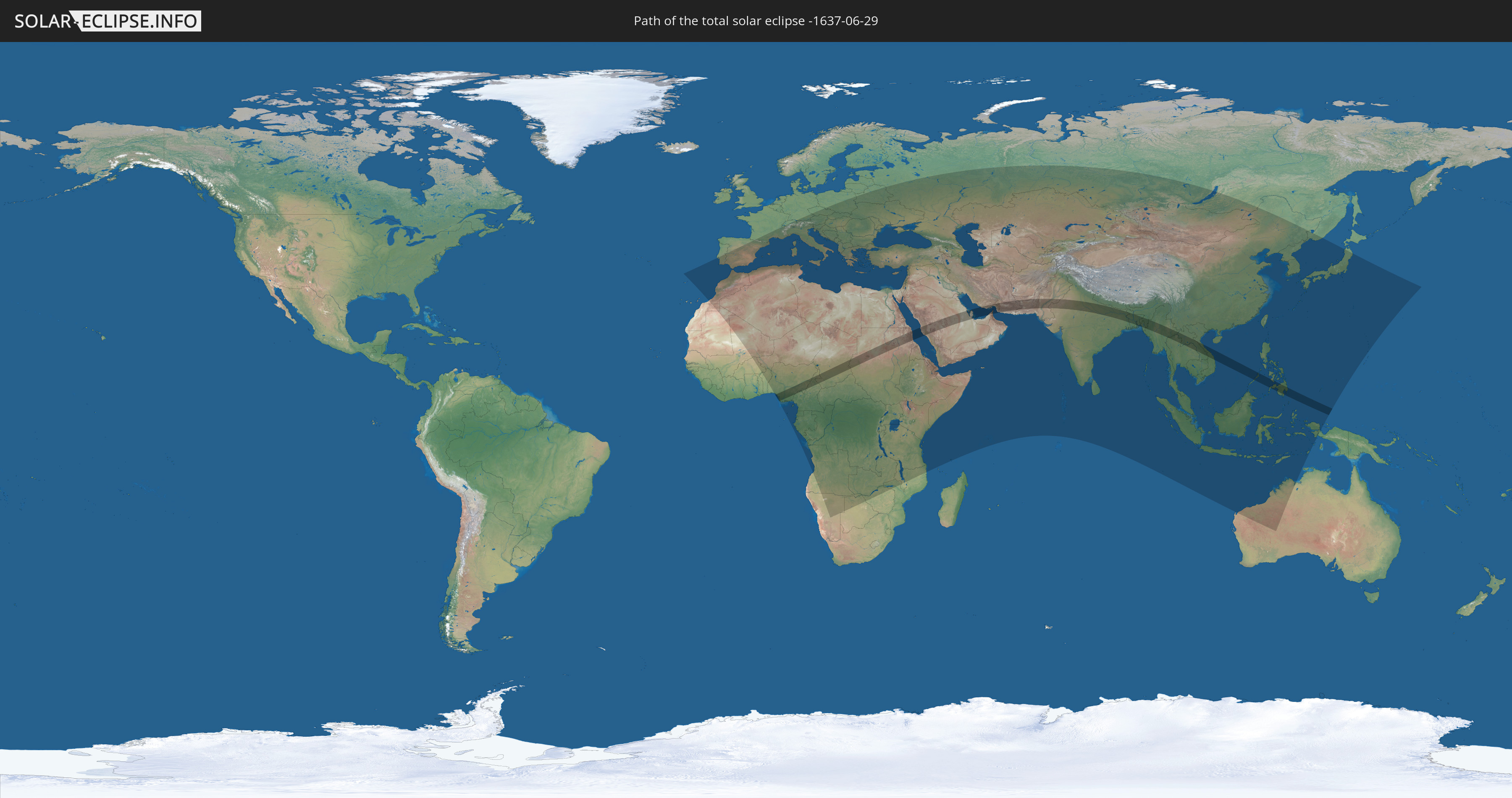
Die Sonnenfinsternis am 06/29/-1637 kann man in 126 Ländern als partielle Sonnenfinsternis beobachten.
Der Finsternispfad verläuft durch 19 Länder. Nur in diesen Ländern ist sie als total Sonnenfinsternis zu sehen.
In den folgenden Ländern ist die Sonnenfinsternis total zu sehen
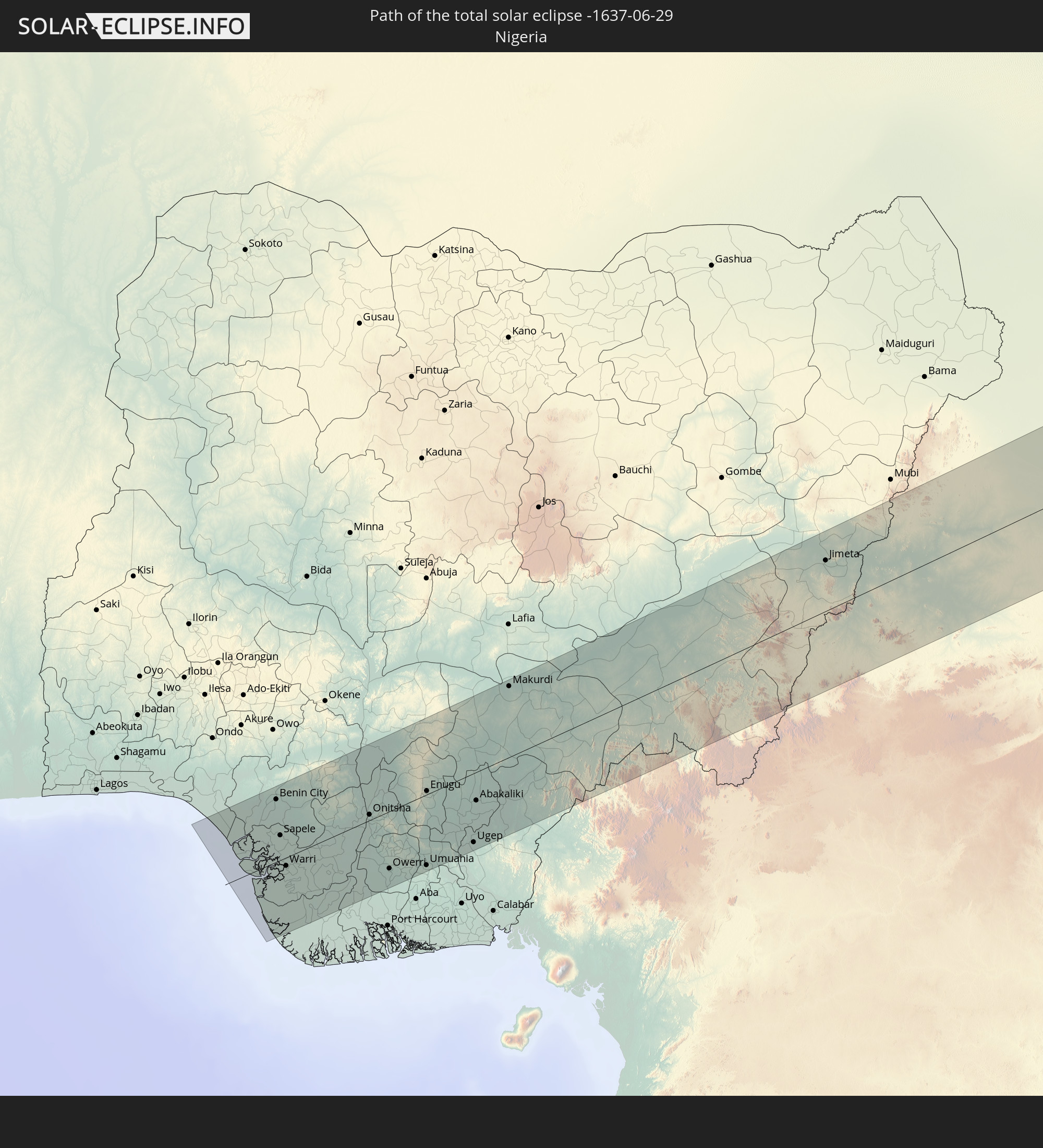 Nigeria
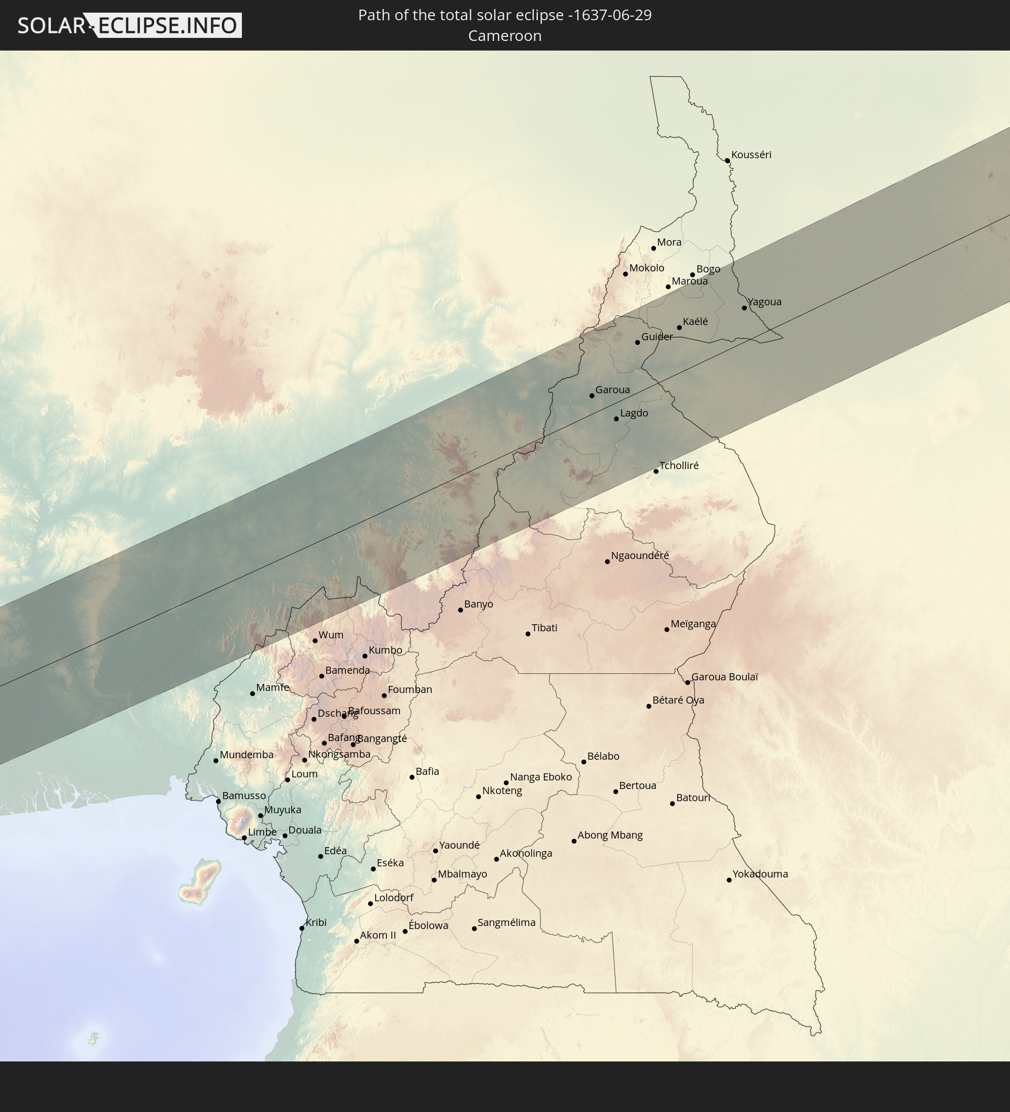 Cameroon
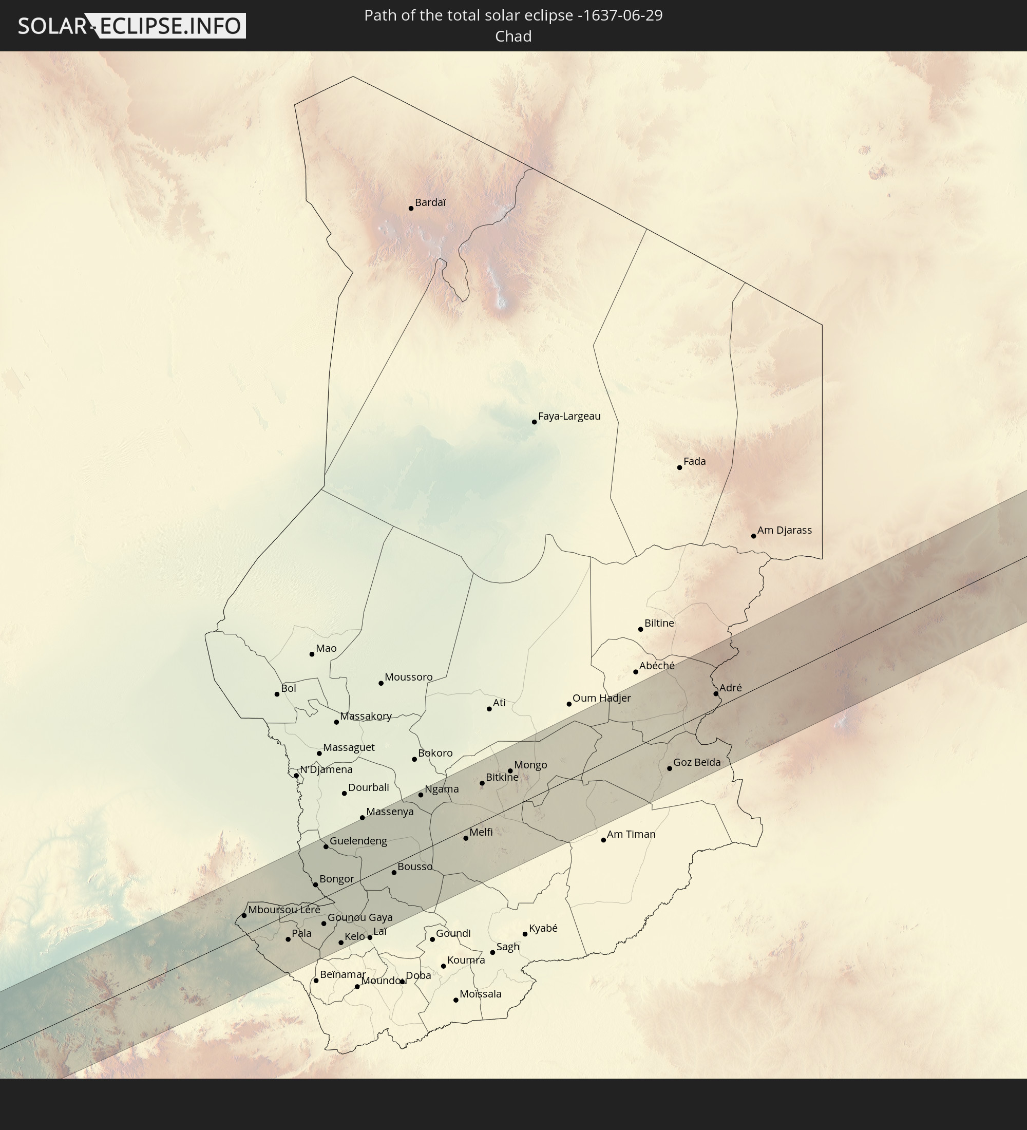 Chad
Chad
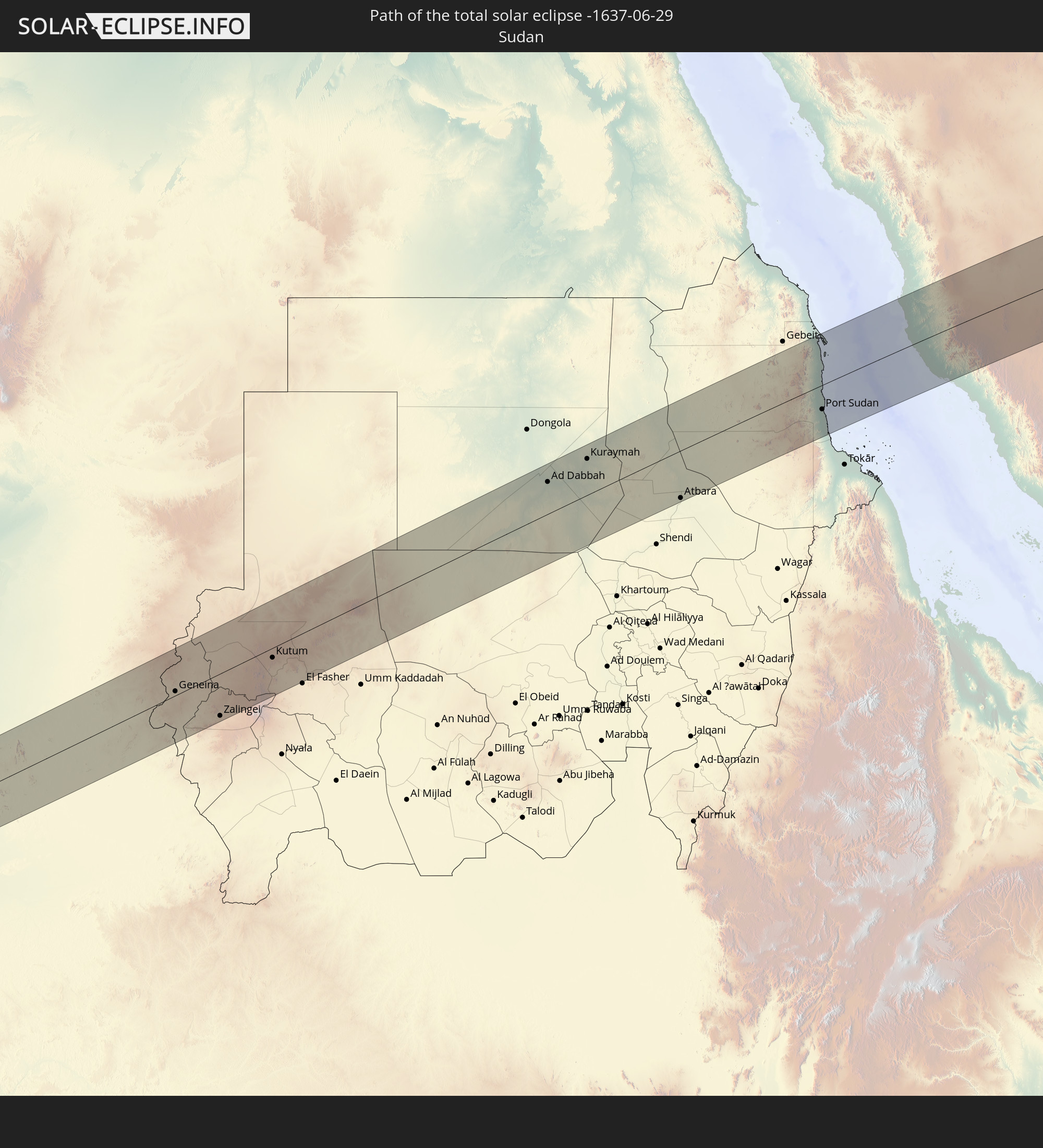 Sudan
Sudan
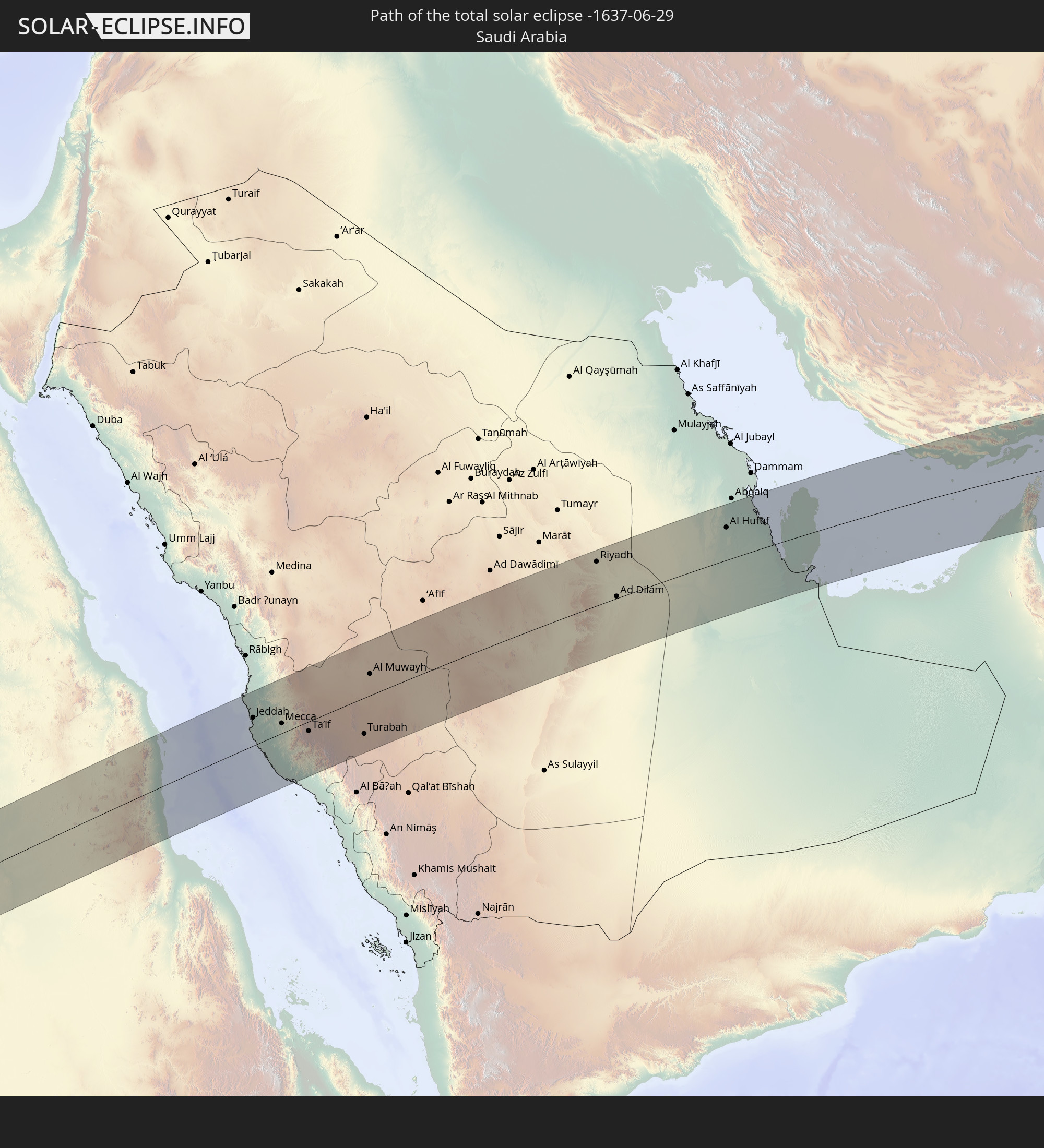 Saudi Arabia
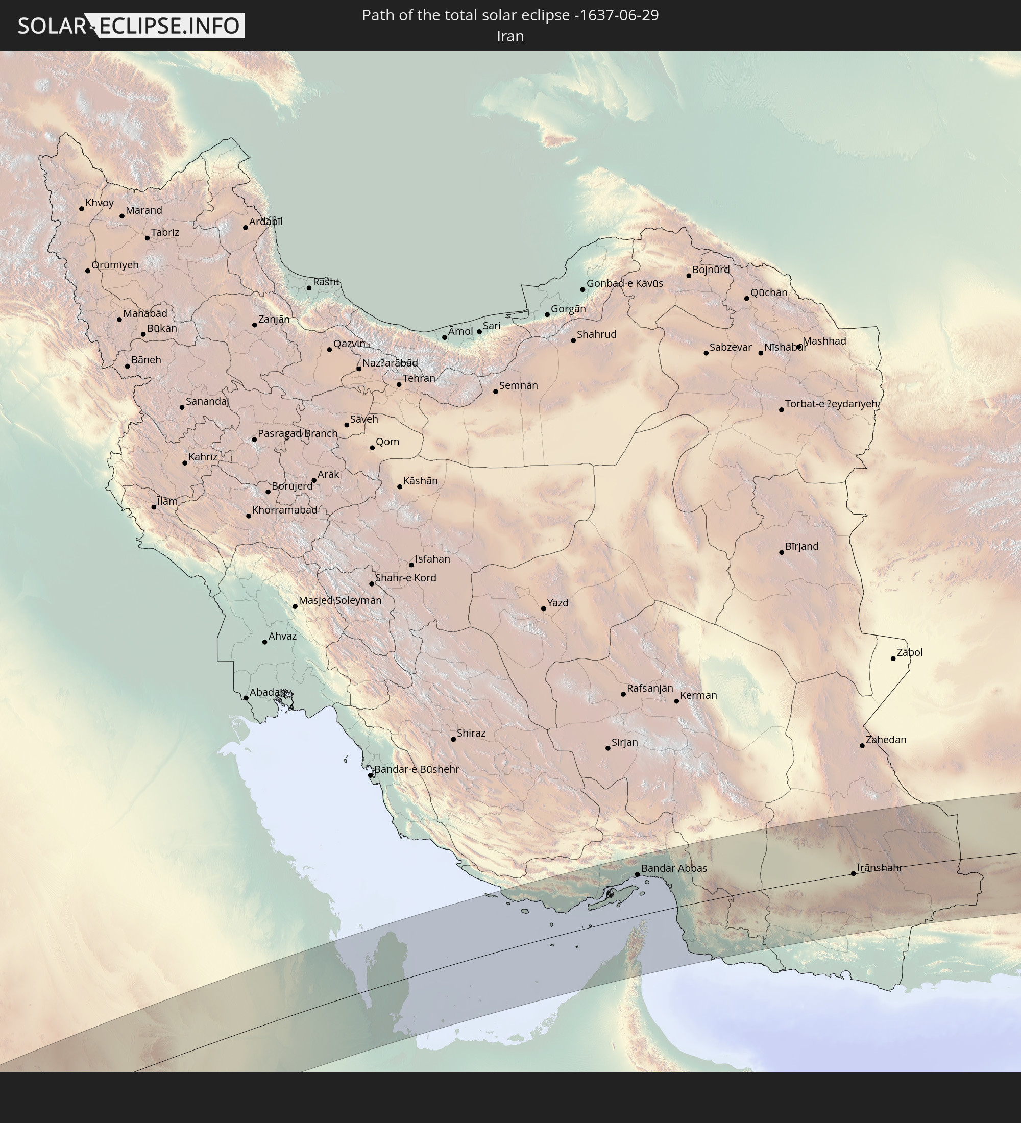 Iran
Iran
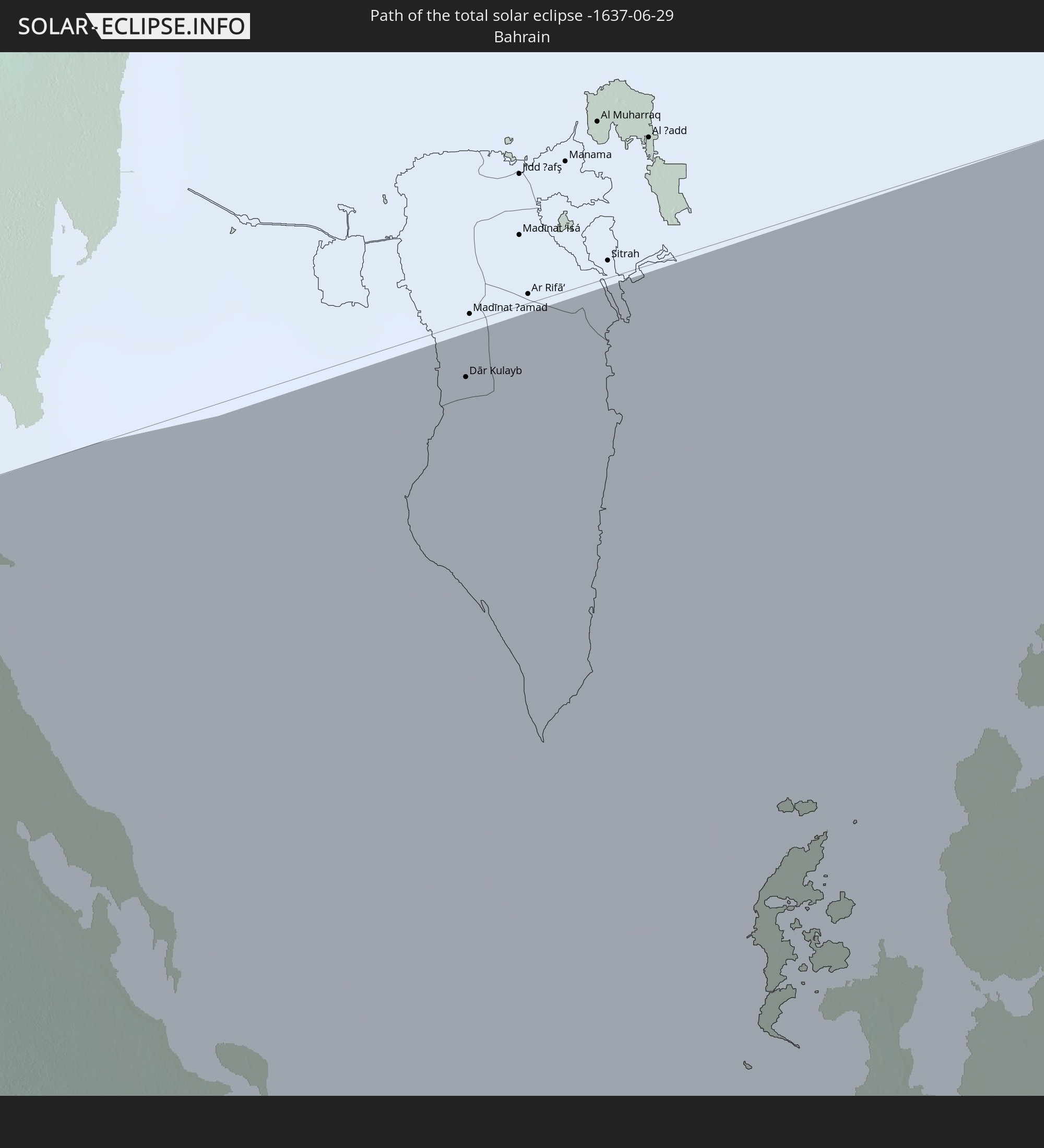 Bahrain
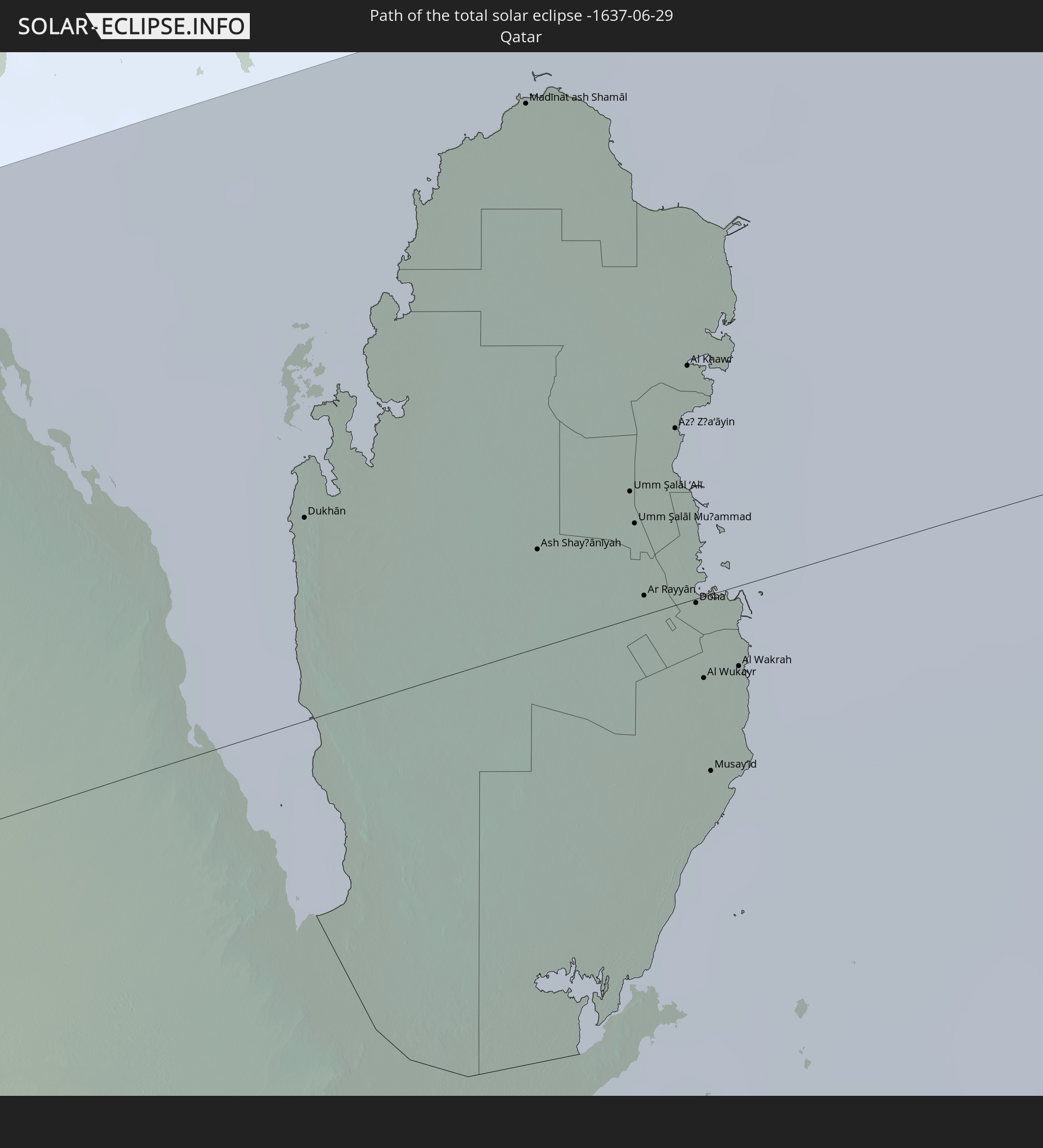 Qatar
Qatar
 United Arab Emirates
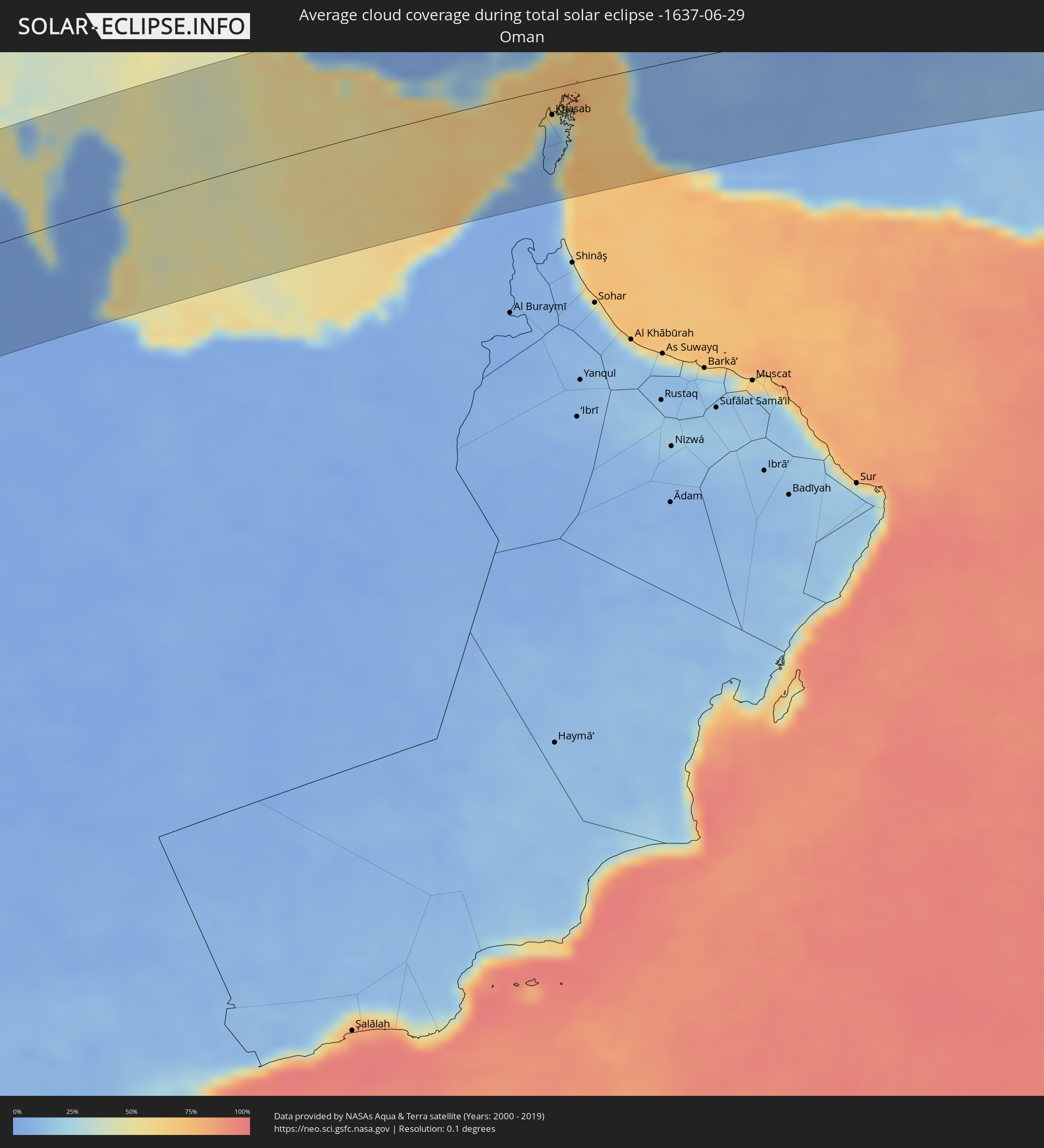
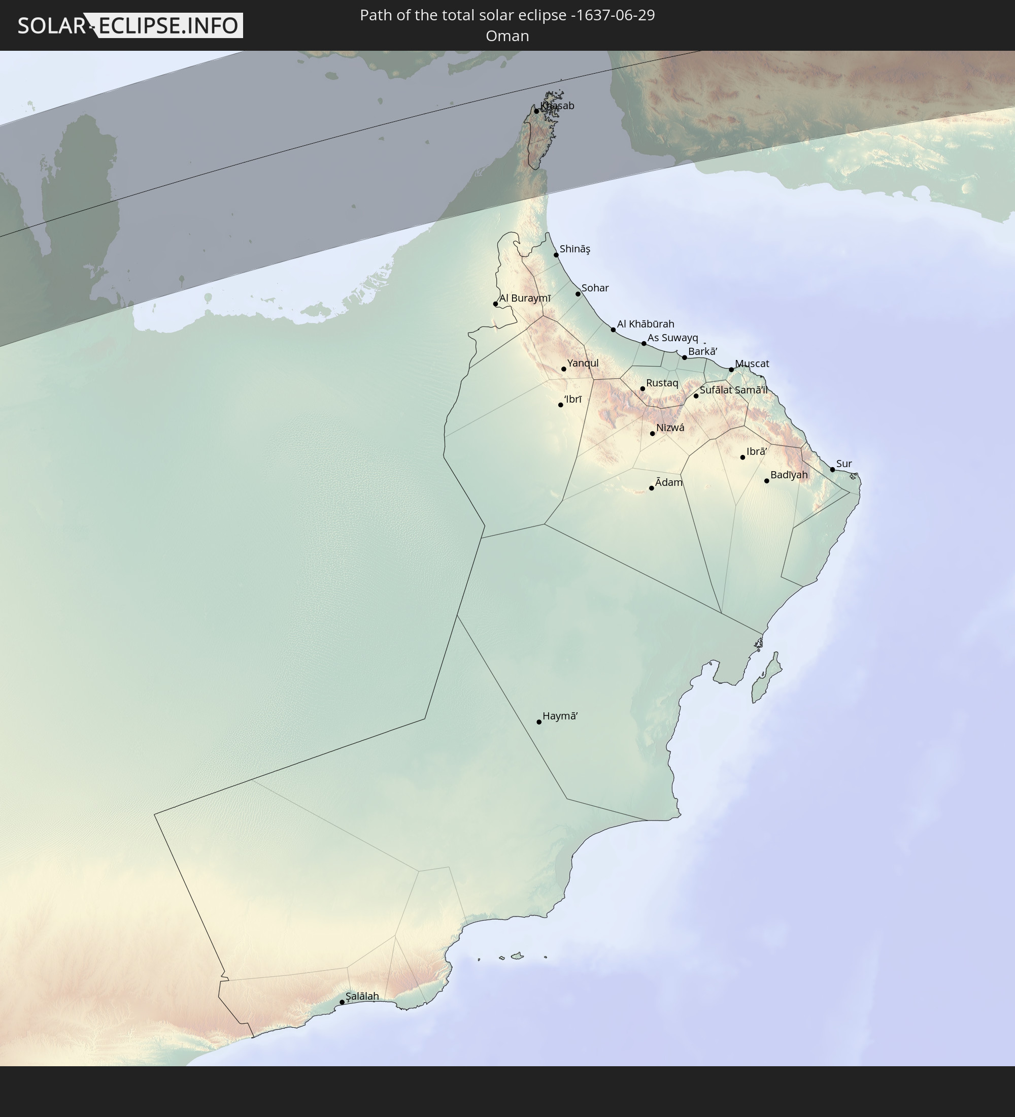 Oman
Oman
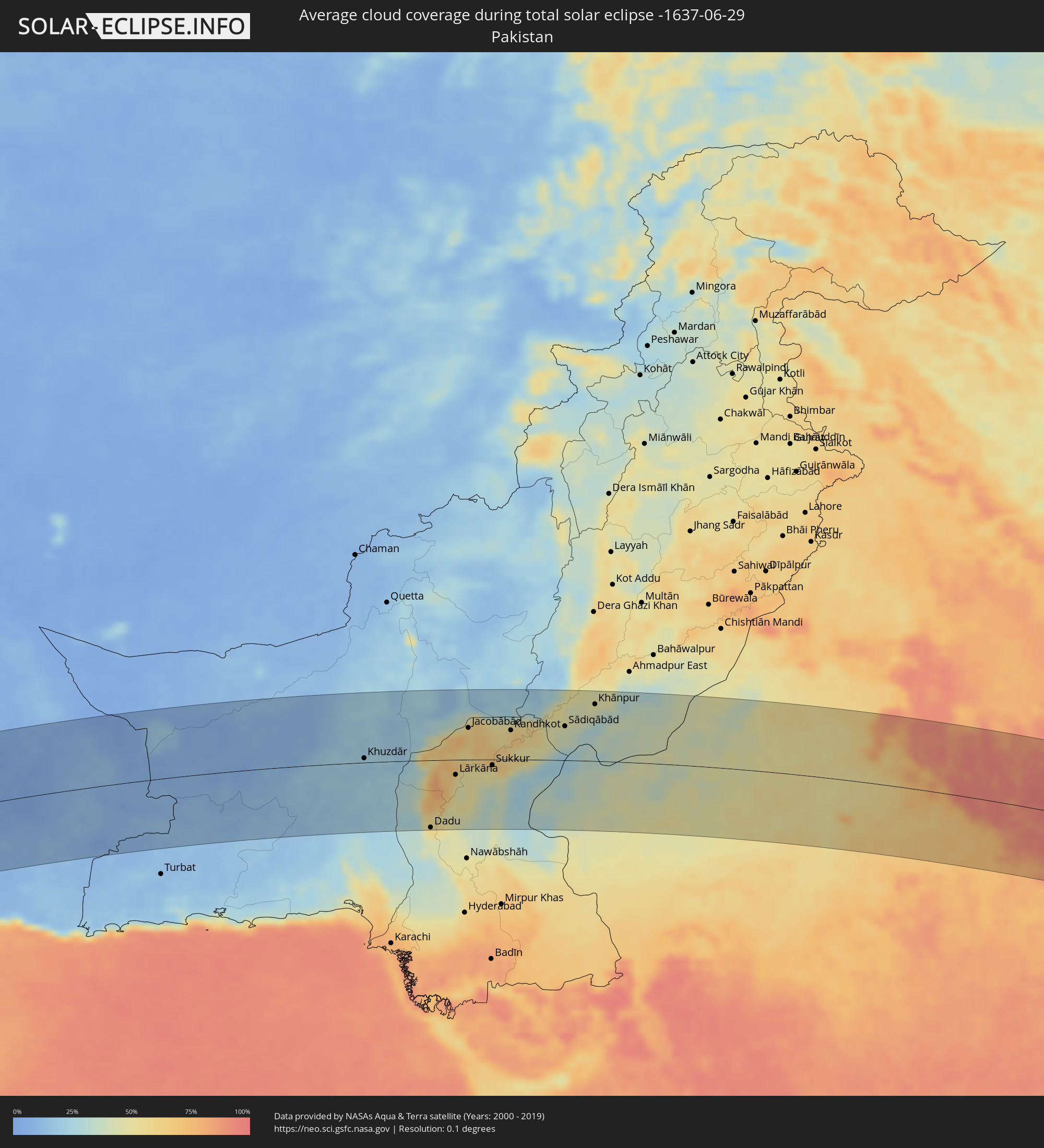
 Pakistan
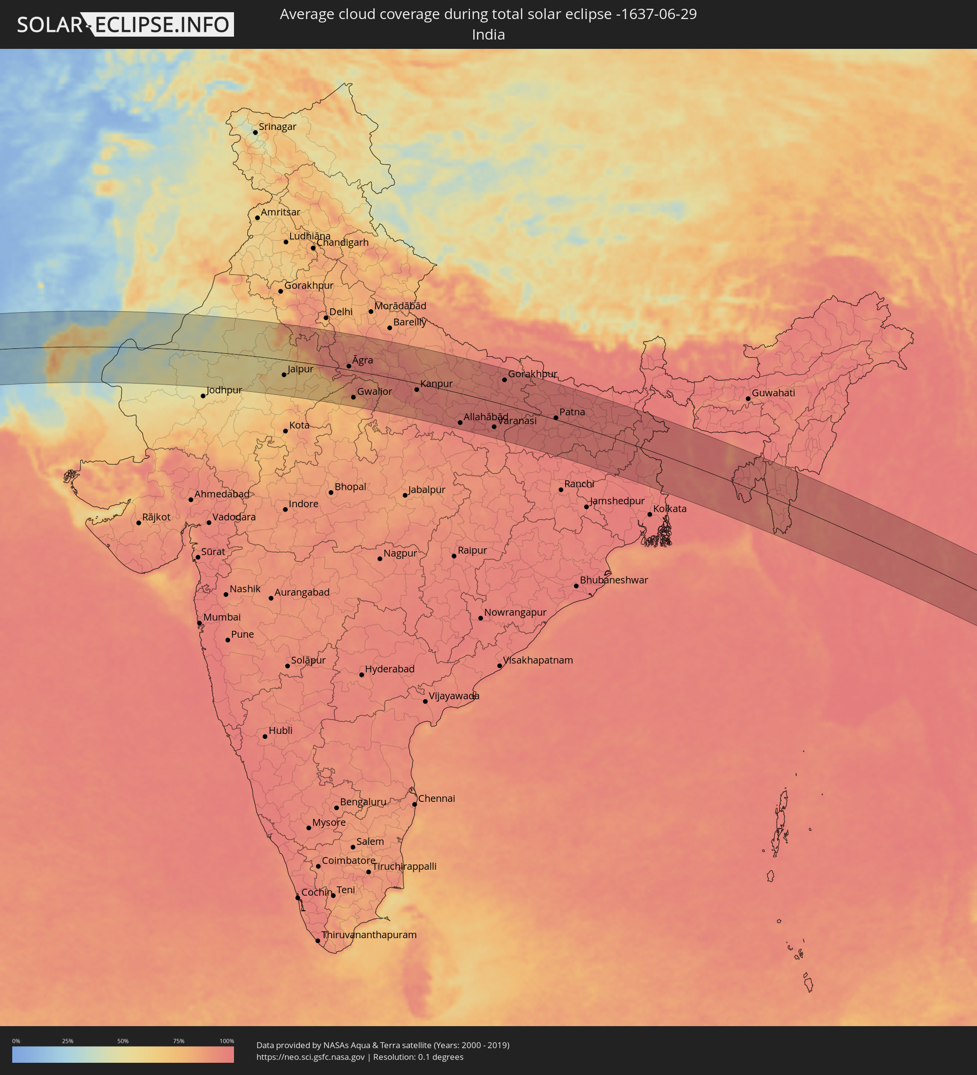
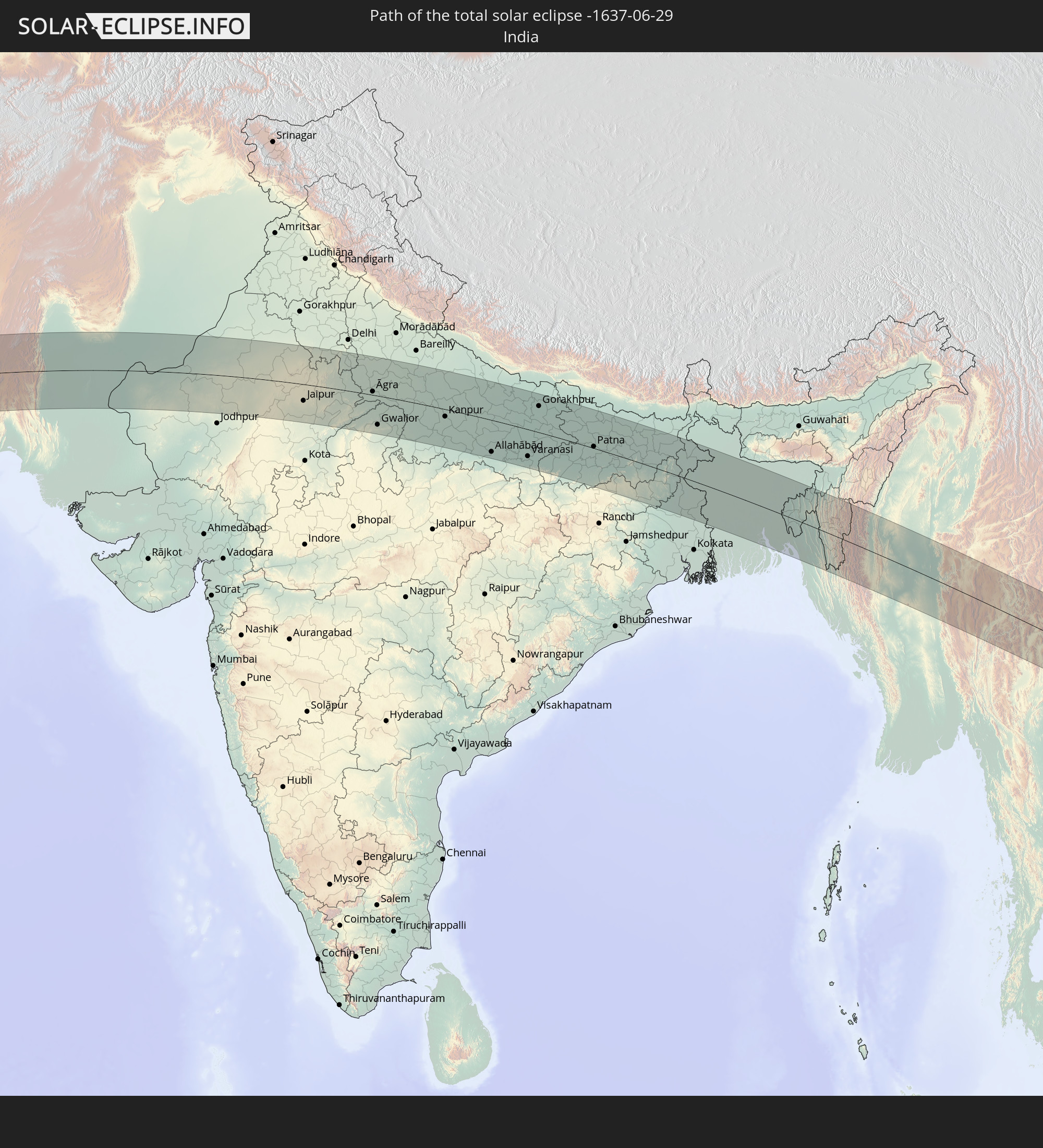 India
India
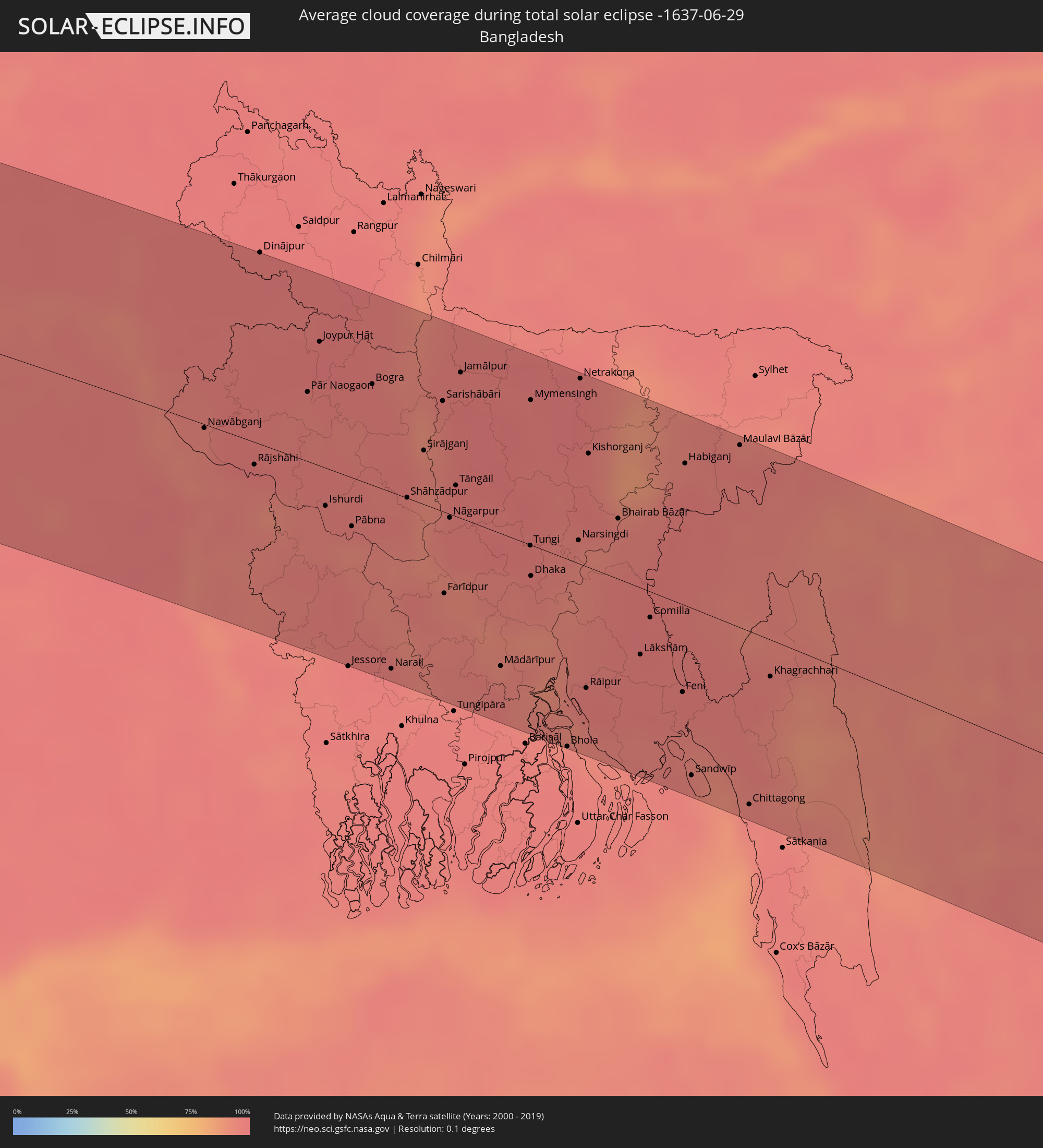
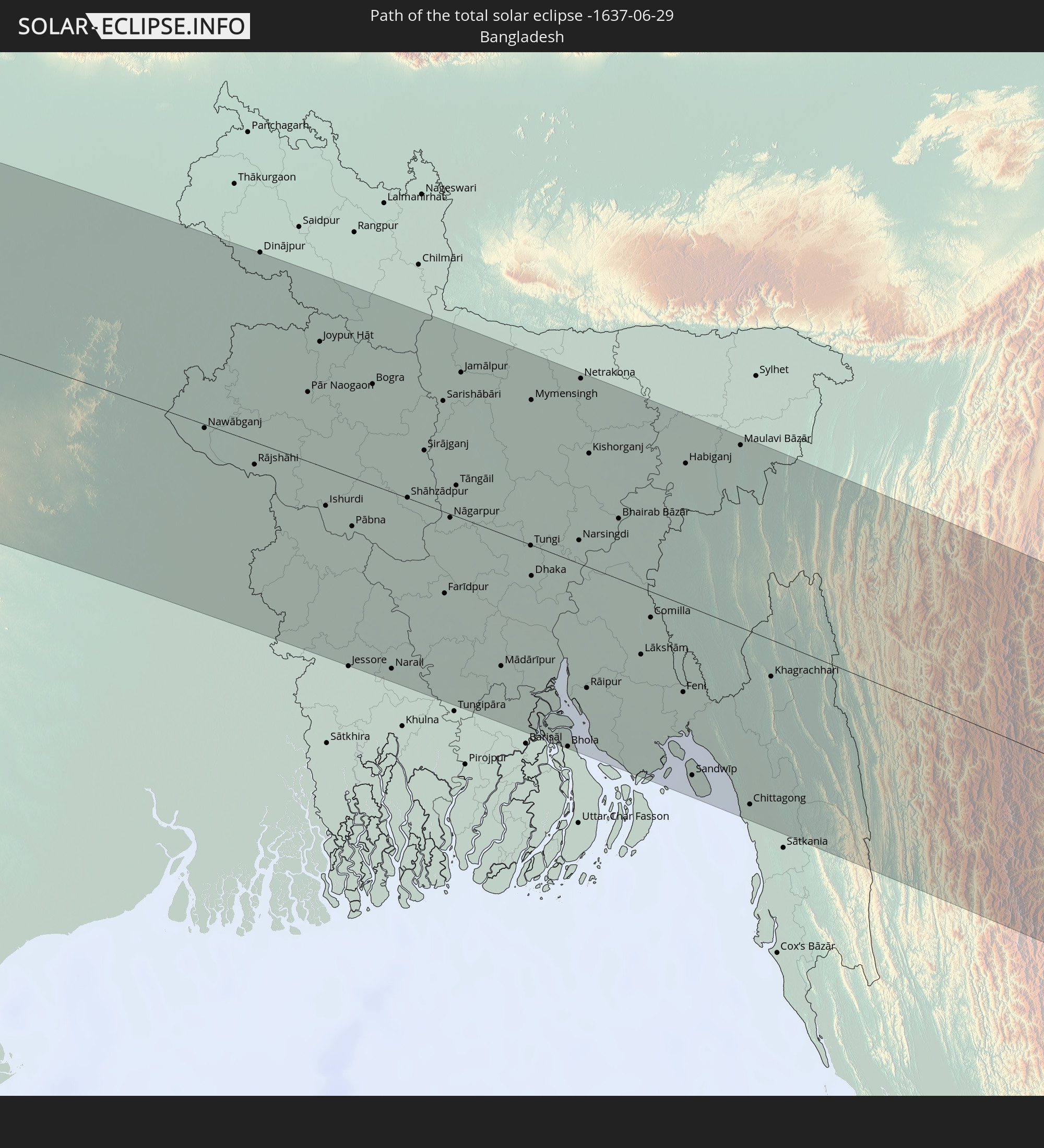 Bangladesh
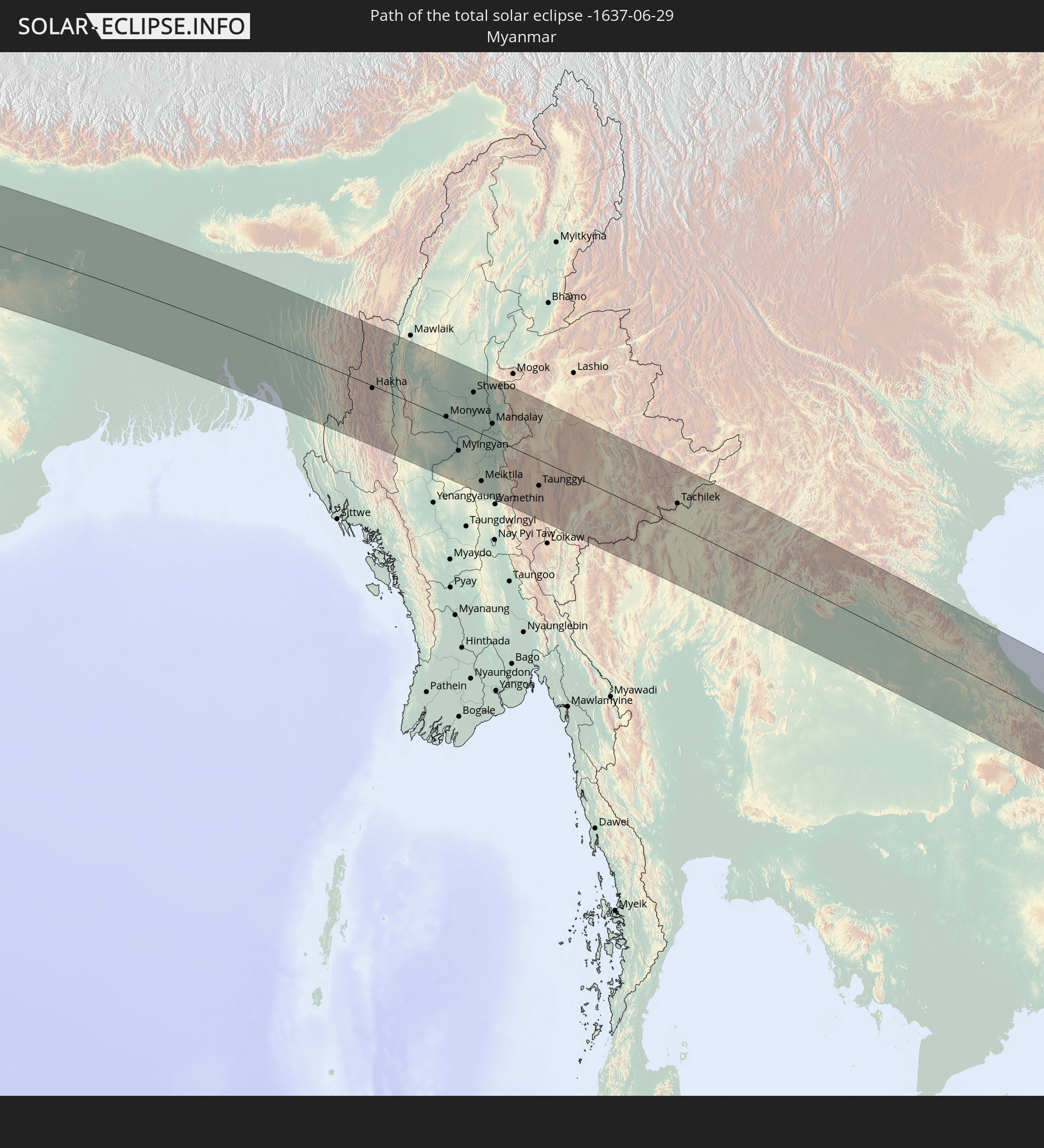 Myanmar
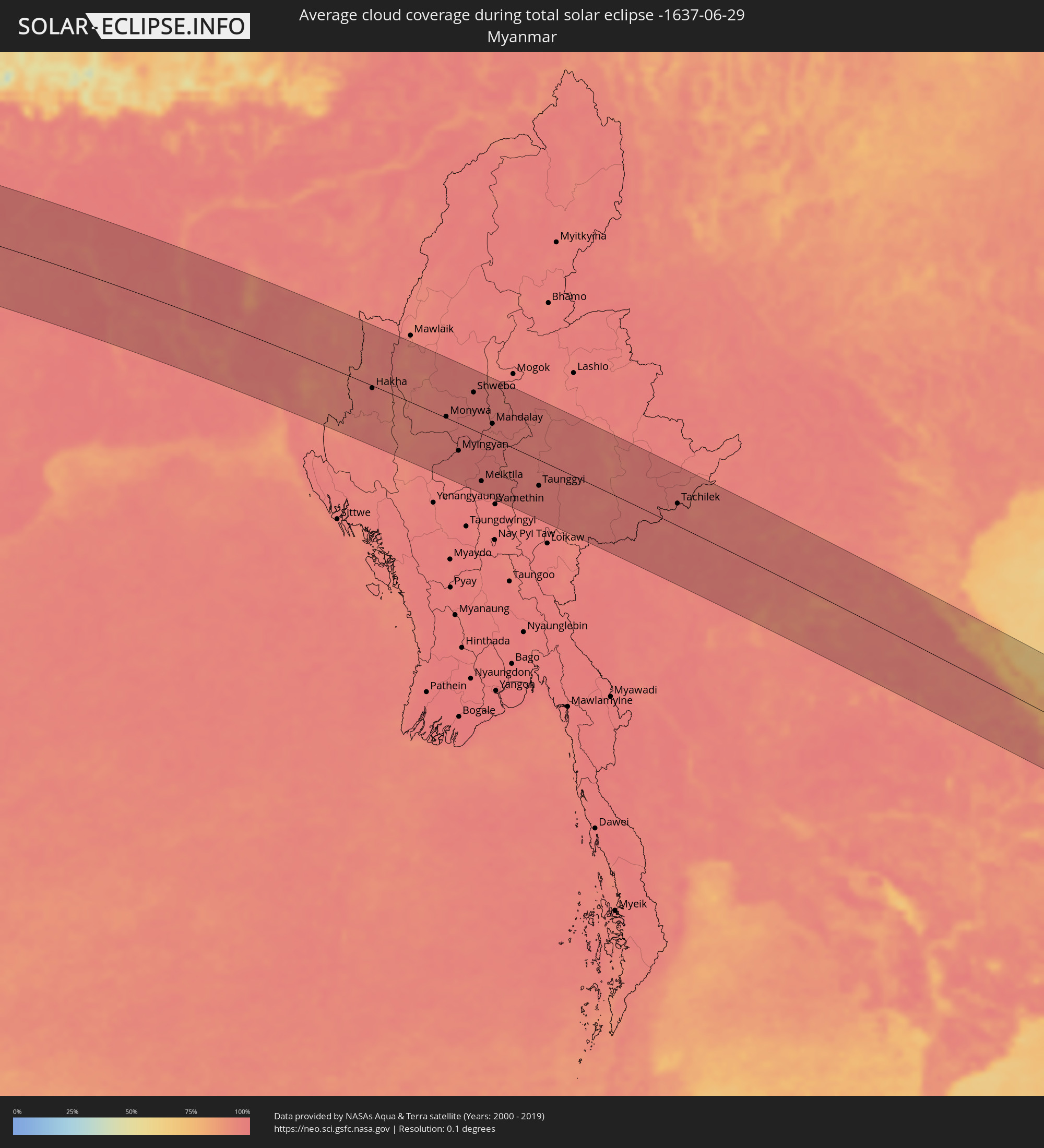
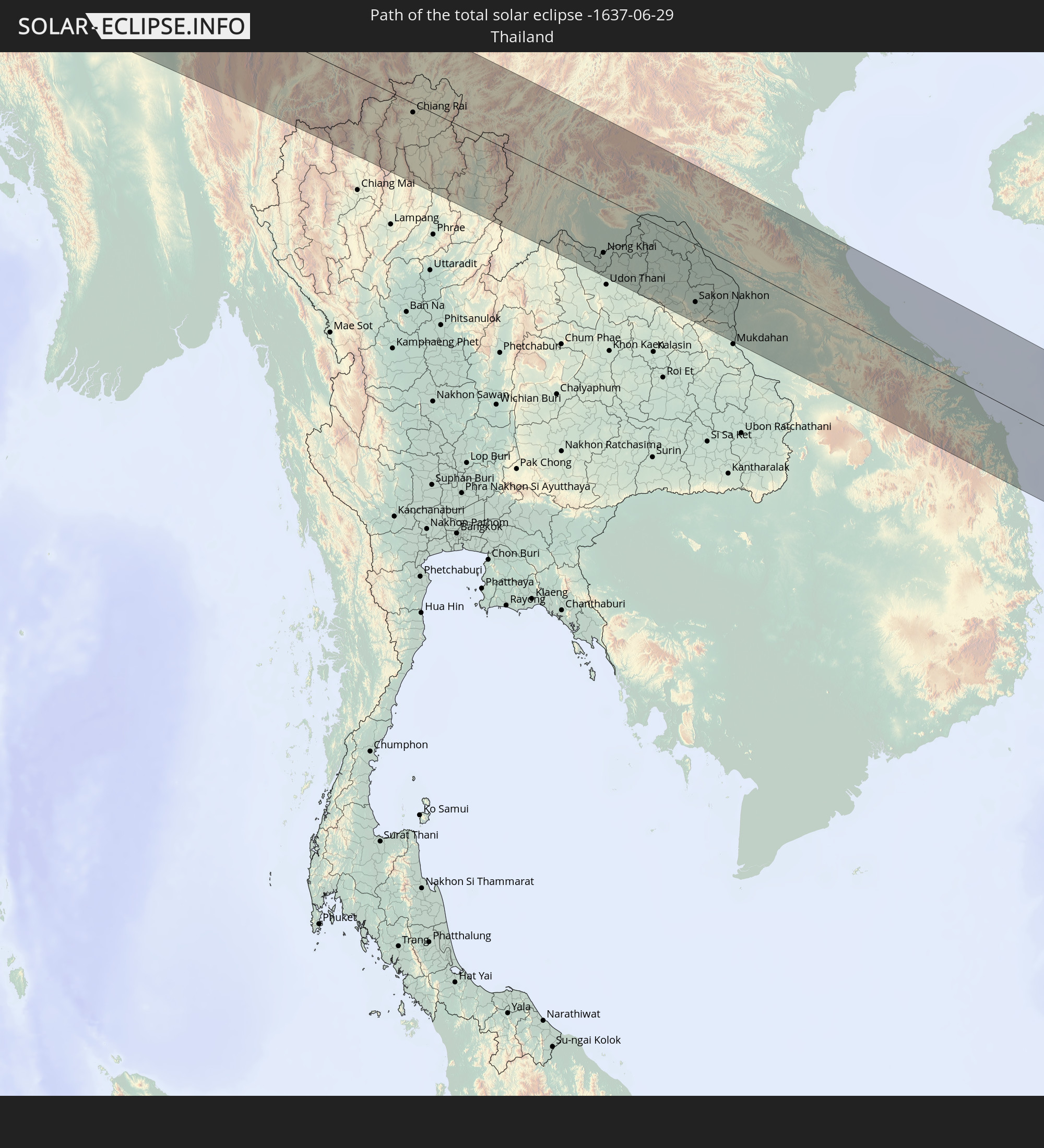 Thailand
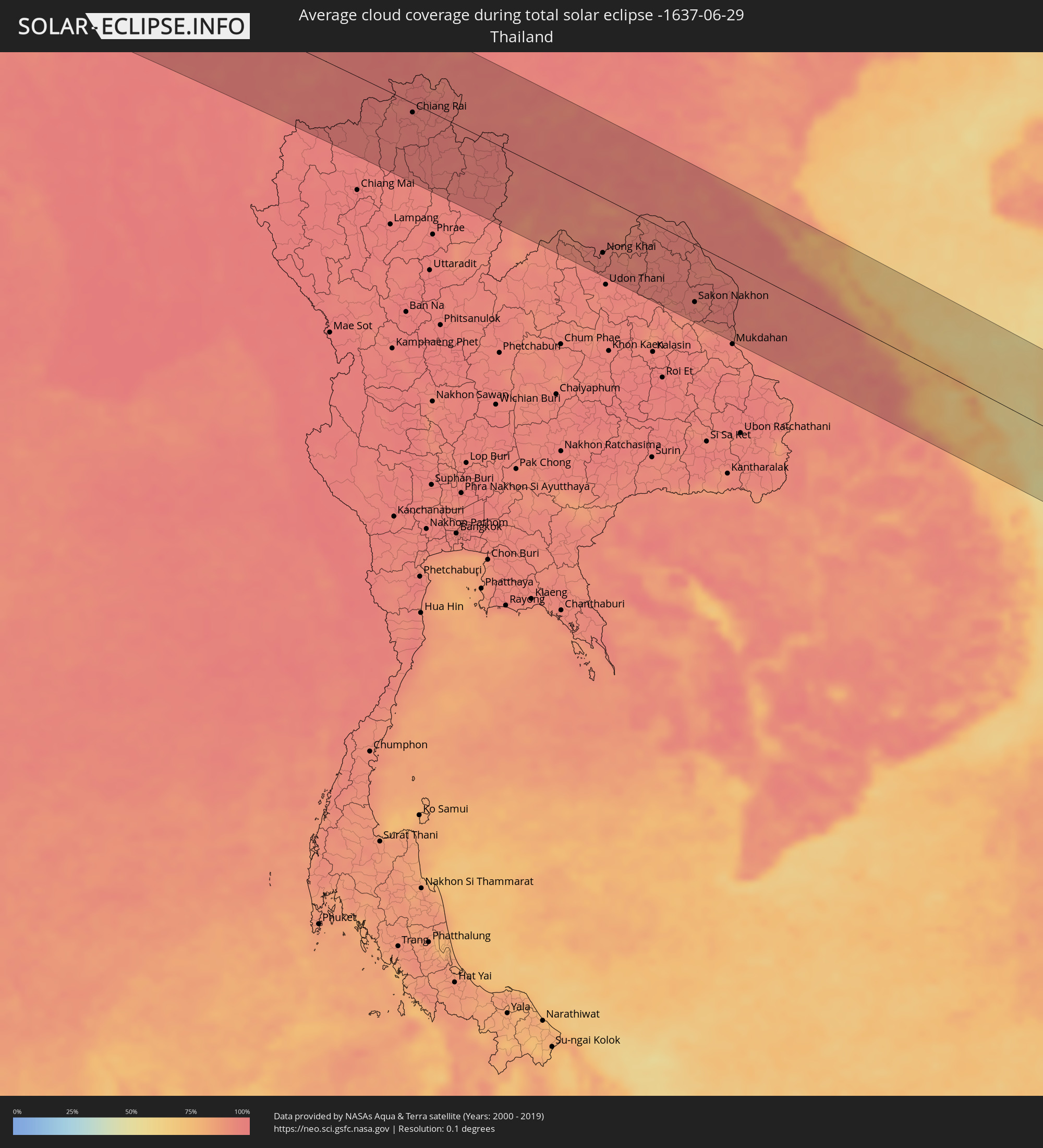
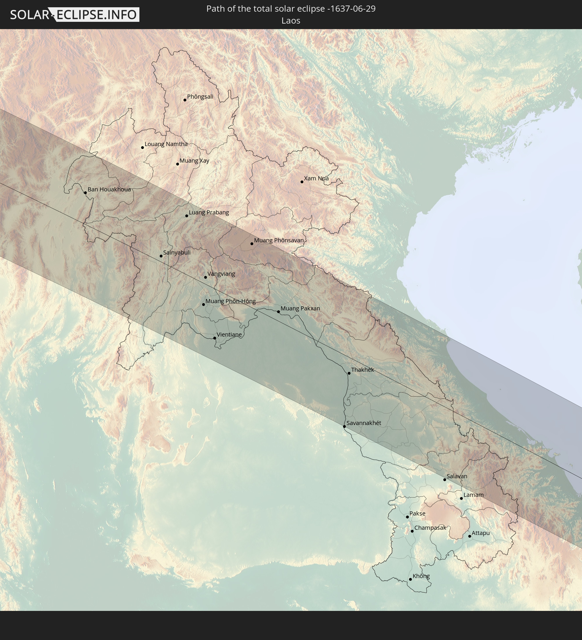 Laos
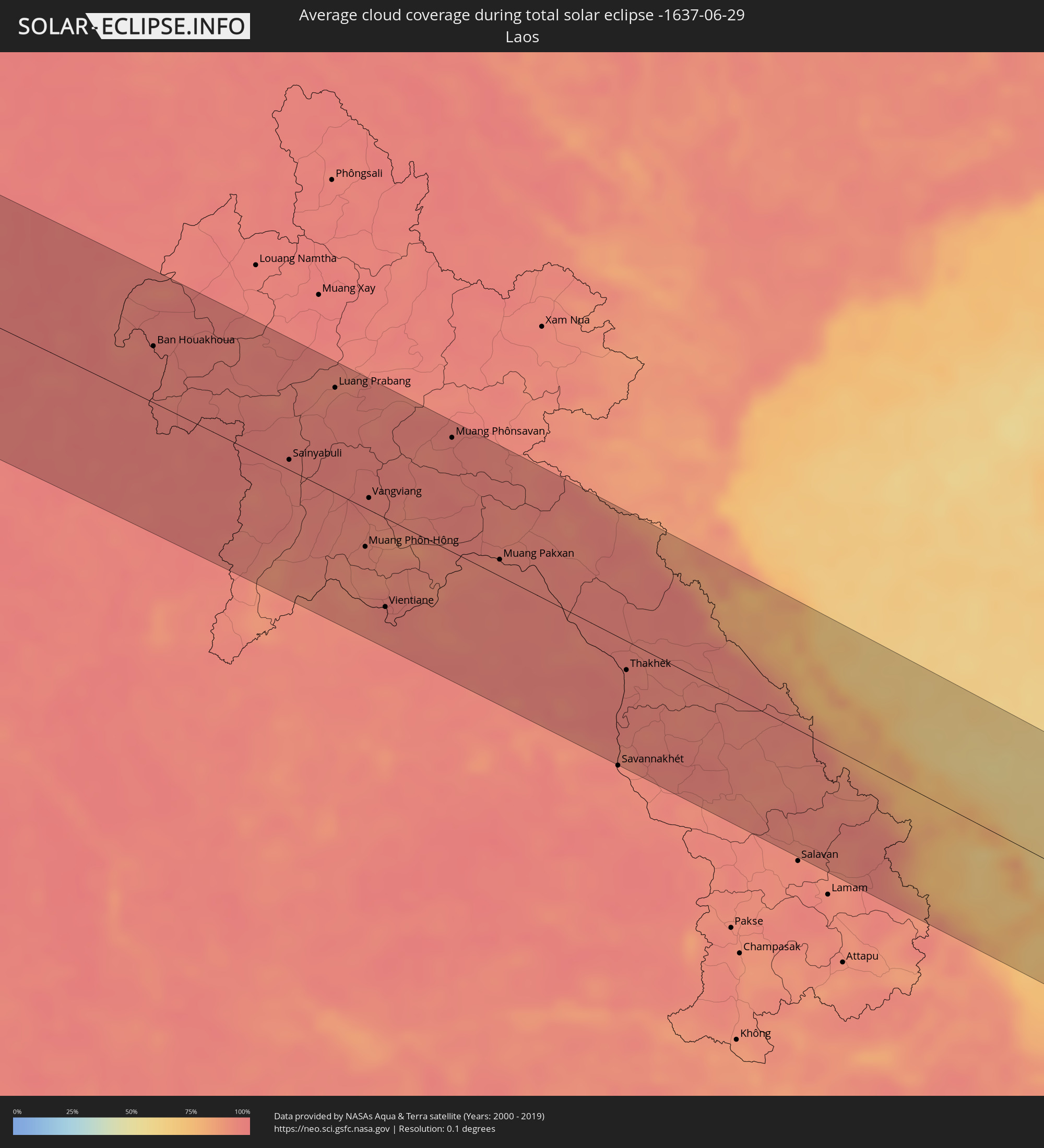
Laos
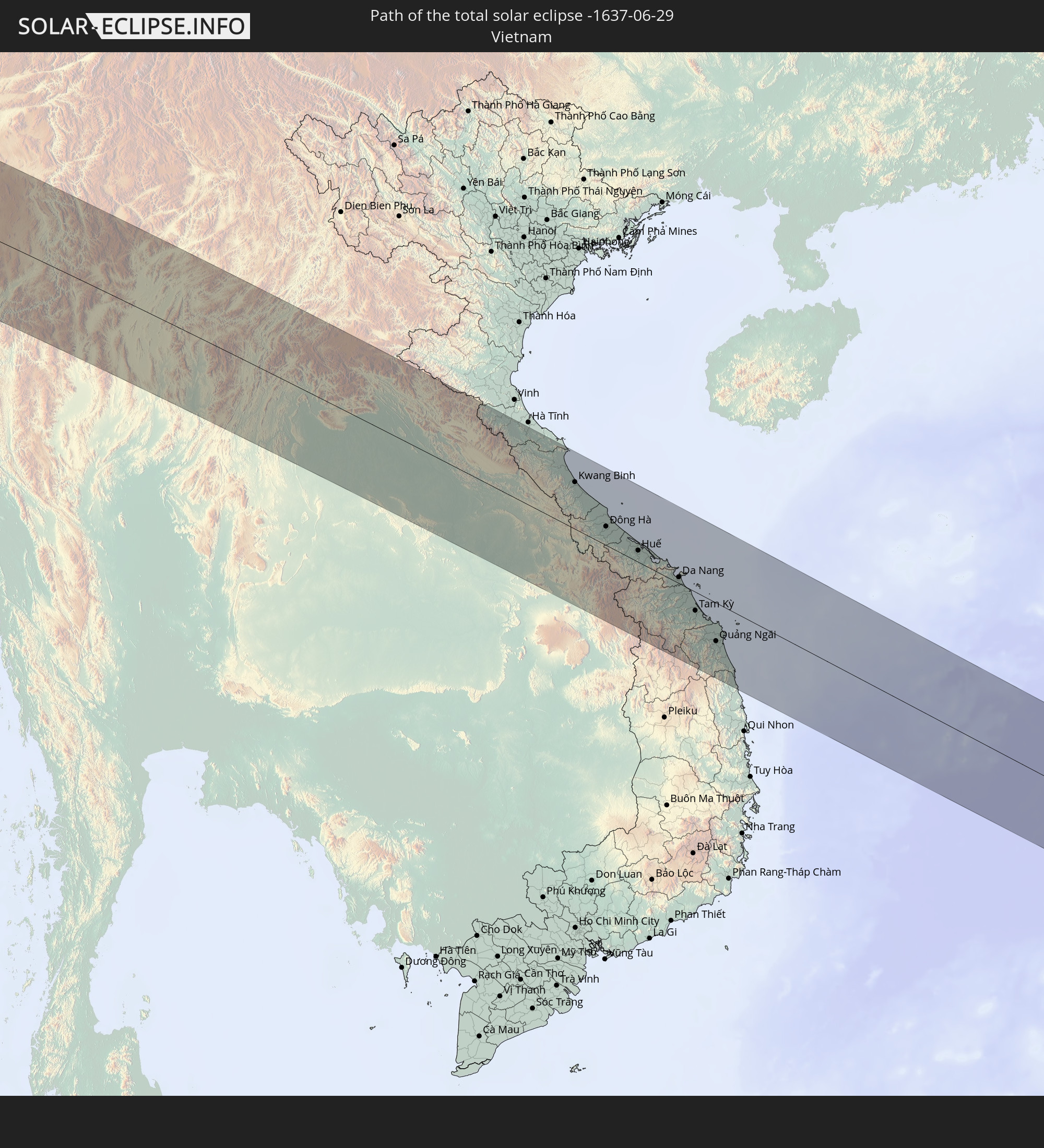 Vietnam
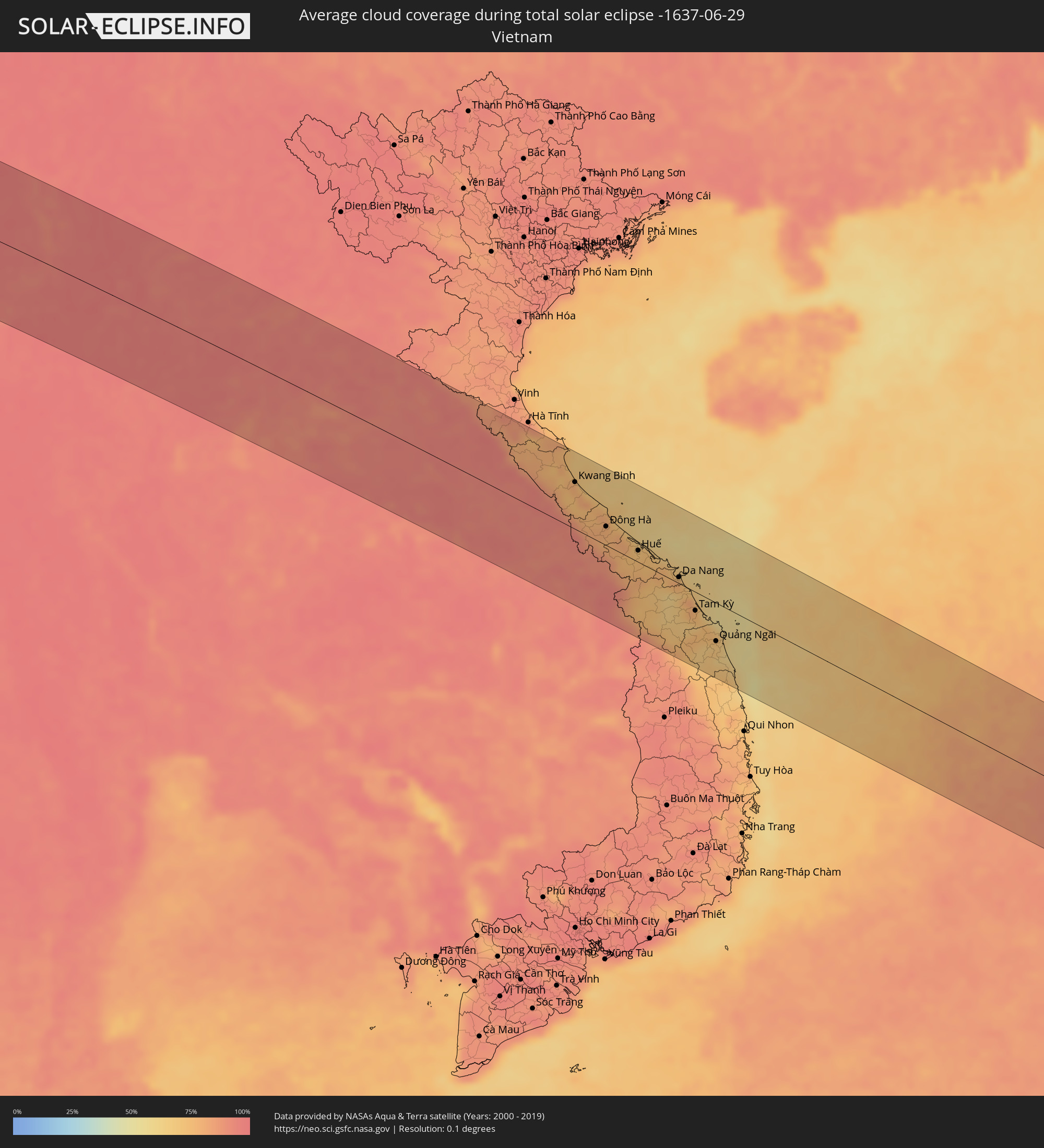
 Philippines
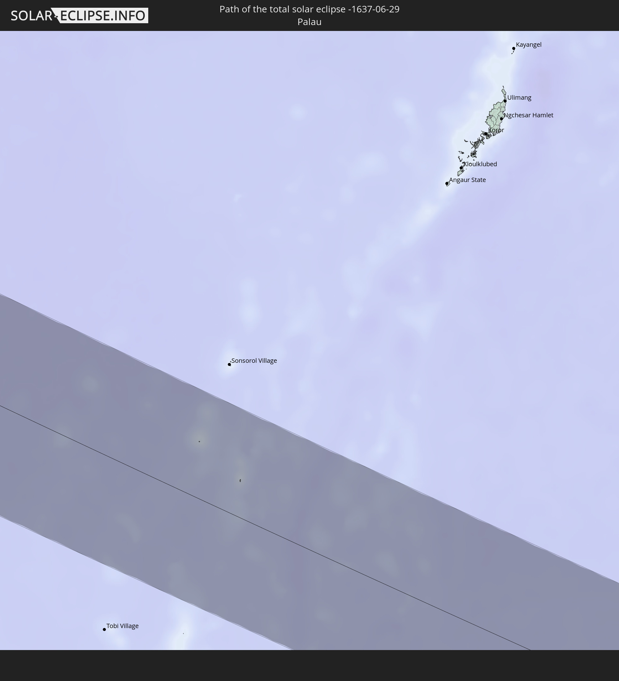 Palau
Palau
In den folgenden Ländern ist die Sonnenfinsternis partiell zu sehen
 Russia
 Portugal
 Spain
Spain
 Mauritania
 Morocco
 Mali
Mali
 Algeria
 Burkina Faso
 Gibraltar
 France
 Niger
Niger
 Benin
Benin
 Andorra
 Nigeria
 Equatorial Guinea
 Germany
 Switzerland
 São Tomé and Príncipe
 Italy
Italy
 Monaco
 Tunisia
 Cameroon
 Gabon
Gabon
 Libya
Libya
 Liechtenstein
 Austria
 Republic of the Congo
 Angola
 Namibia
 Czechia
 Democratic Republic of the Congo
 San Marino
 Vatican City
 Slovenia
 Chad
Chad
 Croatia
 Poland
 Malta
Malta
 Central African Republic
 Bosnia and Herzegovina
 Hungary
 Slovakia
 Montenegro
 Serbia
 Albania
 Greece
 Botswana
 Romania
 Republic of Macedonia
 Sudan
Sudan
 Zambia
 Ukraine
 Bulgaria
 Belarus
 Egypt
Egypt
 Zimbabwe
 Turkey
 Moldova
 Rwanda
 Burundi
 Tanzania
 Uganda
 Mozambique
 Cyprus
 Malawi
 Ethiopia
 Kenya
Kenya
 State of Palestine
 Israel
 Saudi Arabia
 Jordan
 Lebanon
 Syria
Syria
 Eritrea
 Iraq
Iraq
 Georgia
 Somalia
 Djibouti
 Yemen
Yemen
 Armenia
 Iran
Iran
 Azerbaijan
 Seychelles
 Kazakhstan
 Kuwait
 Bahrain
 Qatar
Qatar
 United Arab Emirates
 Oman
Oman
 Turkmenistan
 Uzbekistan
 Afghanistan
 Pakistan
 Tajikistan
 India
India
 Kyrgyzstan
 Maldives
 China
China
 Sri Lanka
 Nepal
Nepal
 Mongolia
 Bangladesh
 Bhutan
 Myanmar
 Indonesia
 Cocos Islands
 Thailand
 Malaysia
 Laos
Laos
 Vietnam
 Cambodia
 Singapore
 Christmas Island
 Australia
 Macau
Macau
 Hong Kong
 Brunei
 Taiwan
 Philippines
 Japan
Japan
 East Timor
 North Korea
 South Korea
 Palau
Palau
 Federated States of Micronesia
 Northern Mariana Islands
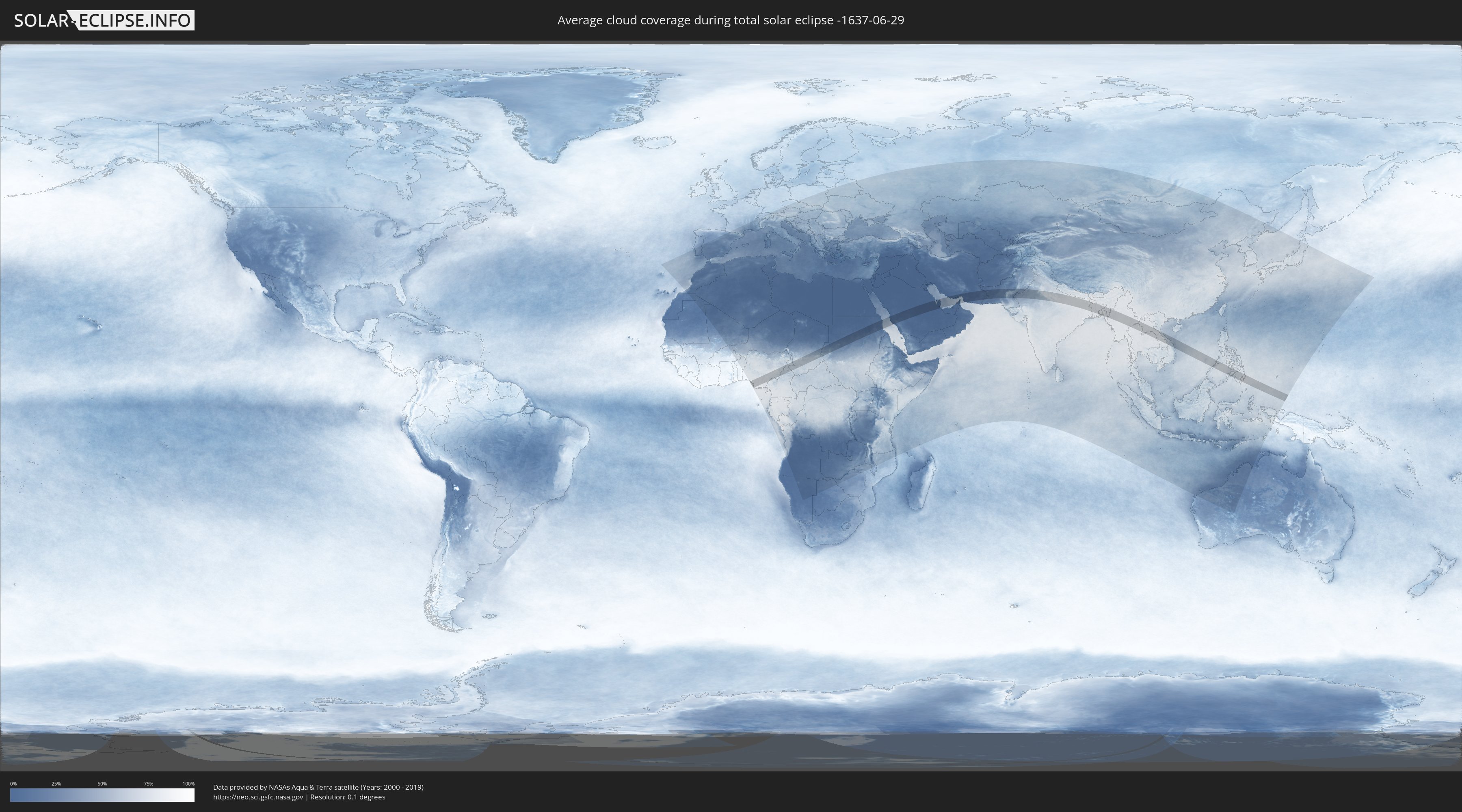
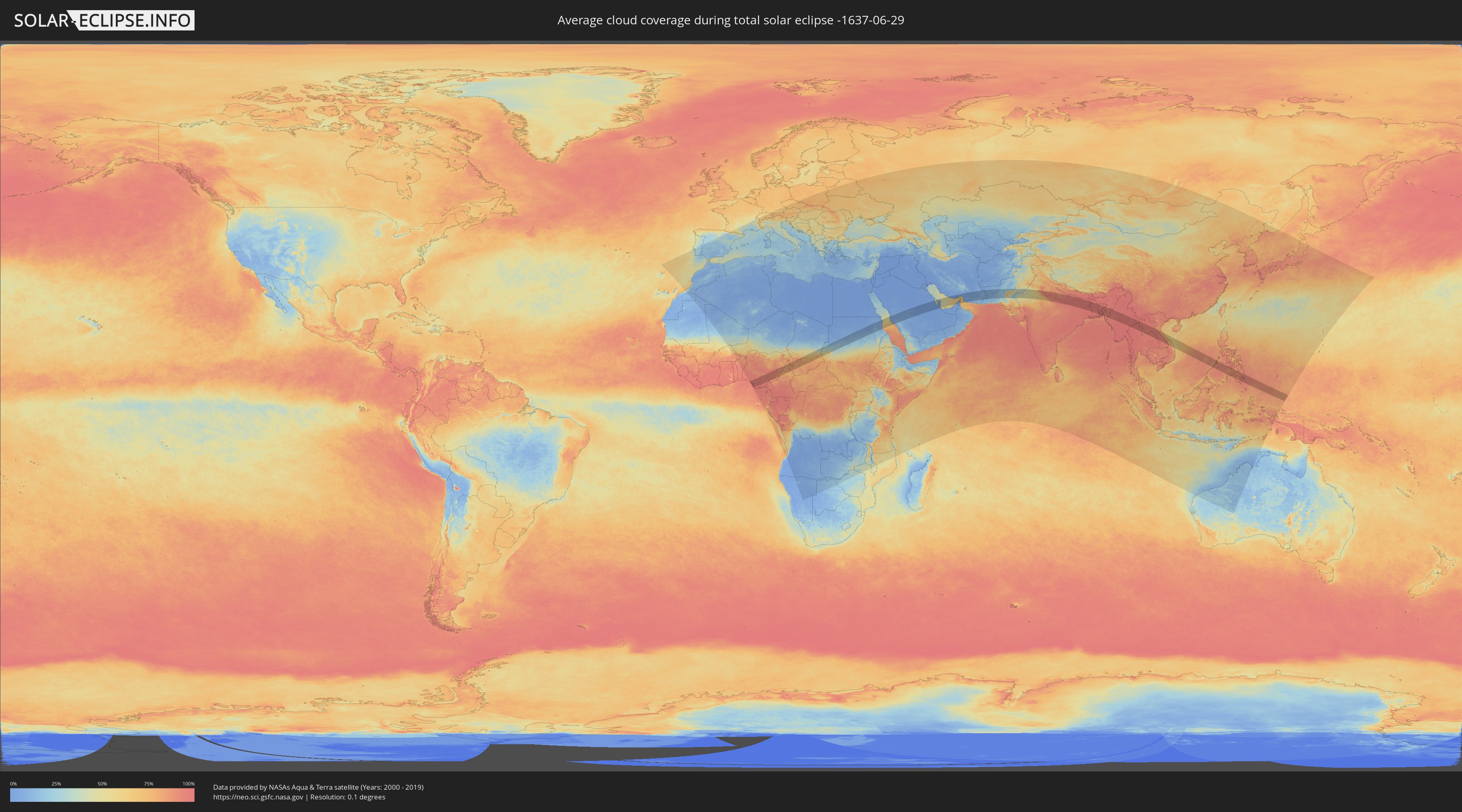
How will be the weather during the total solar eclipse on 06/29/-1637?
Where is the best place to see the total solar eclipse of 06/29/-1637?
The following maps show the average cloud coverage for the day of the total solar eclipse.
With the help of these maps, it is possible to find the place along the eclipse path, which has the best
chance of a cloudless sky.
Nevertheless, you should consider local circumstances and inform about the weather of your chosen
observation site.
The data is provided by NASAs satellites
AQUA and TERRA.
The cloud maps are averaged over a period of 19 years (2000 - 2019).
Detailed country maps
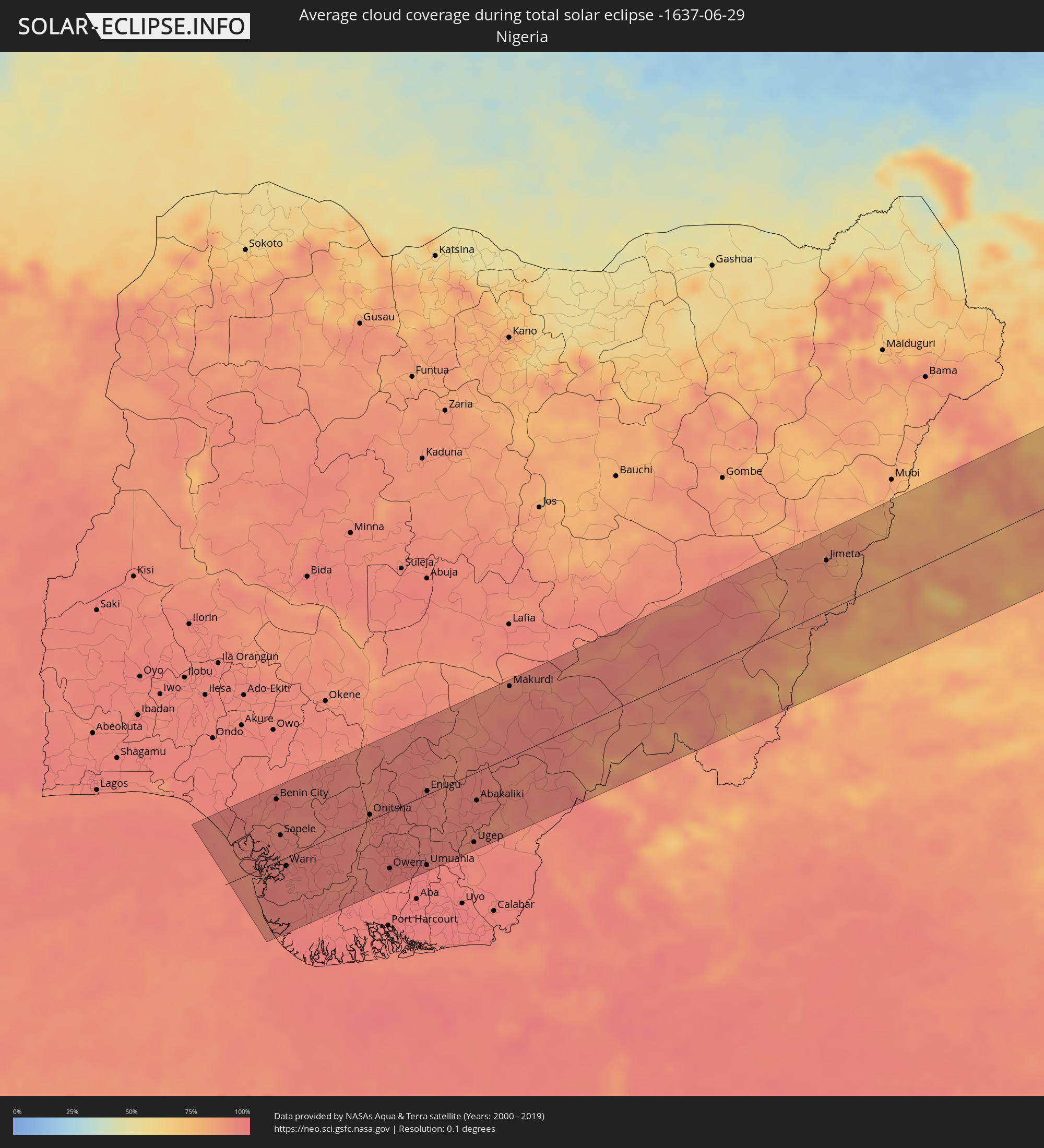 Nigeria
 Cameroon
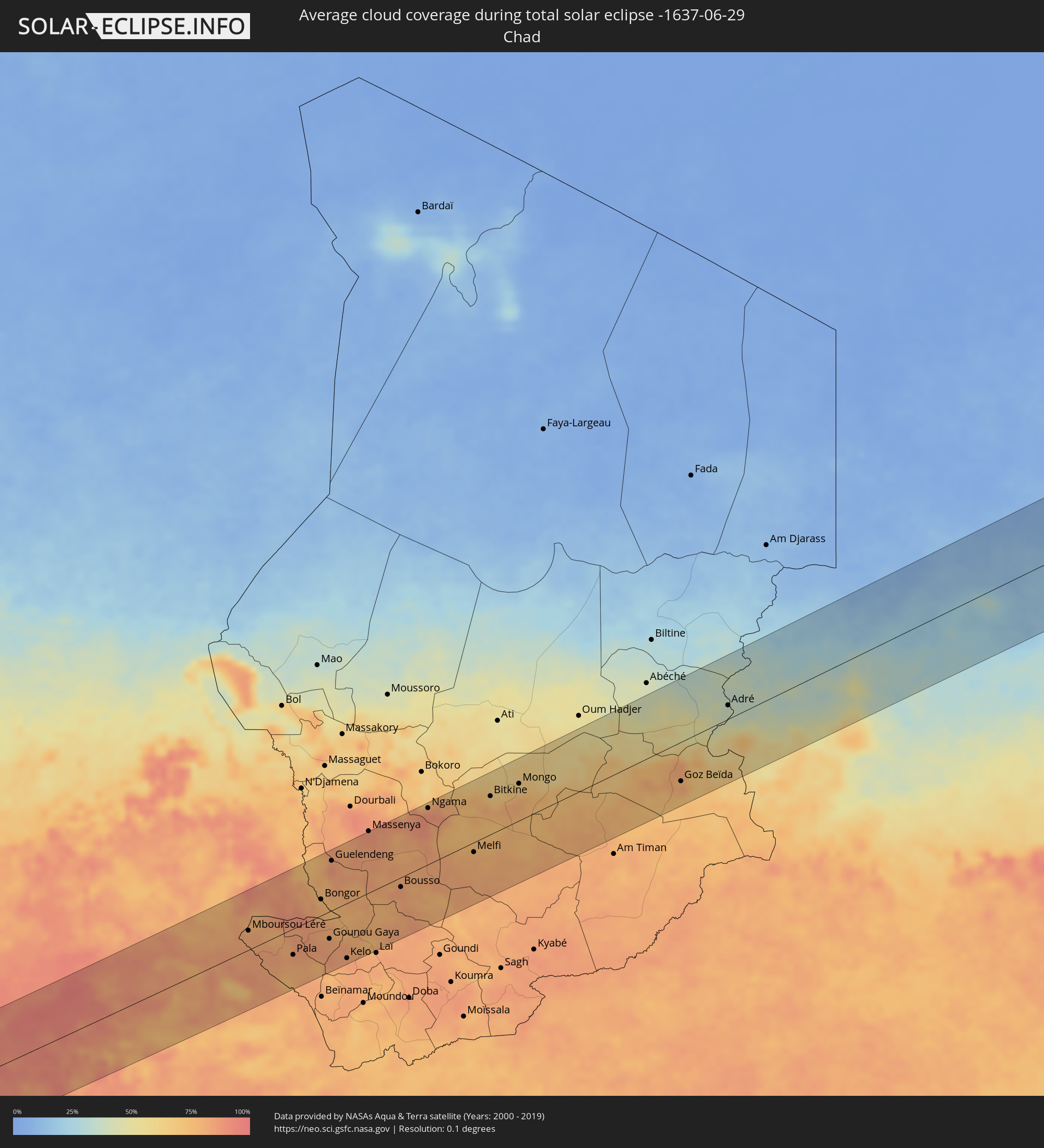 Chad
Chad
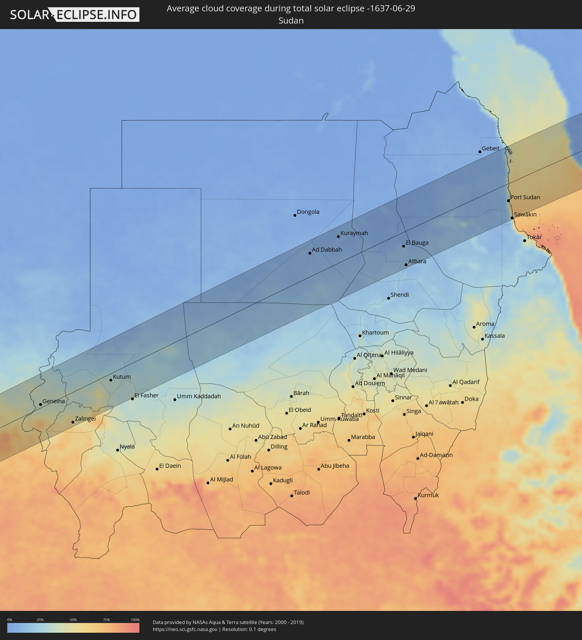 Sudan
Sudan
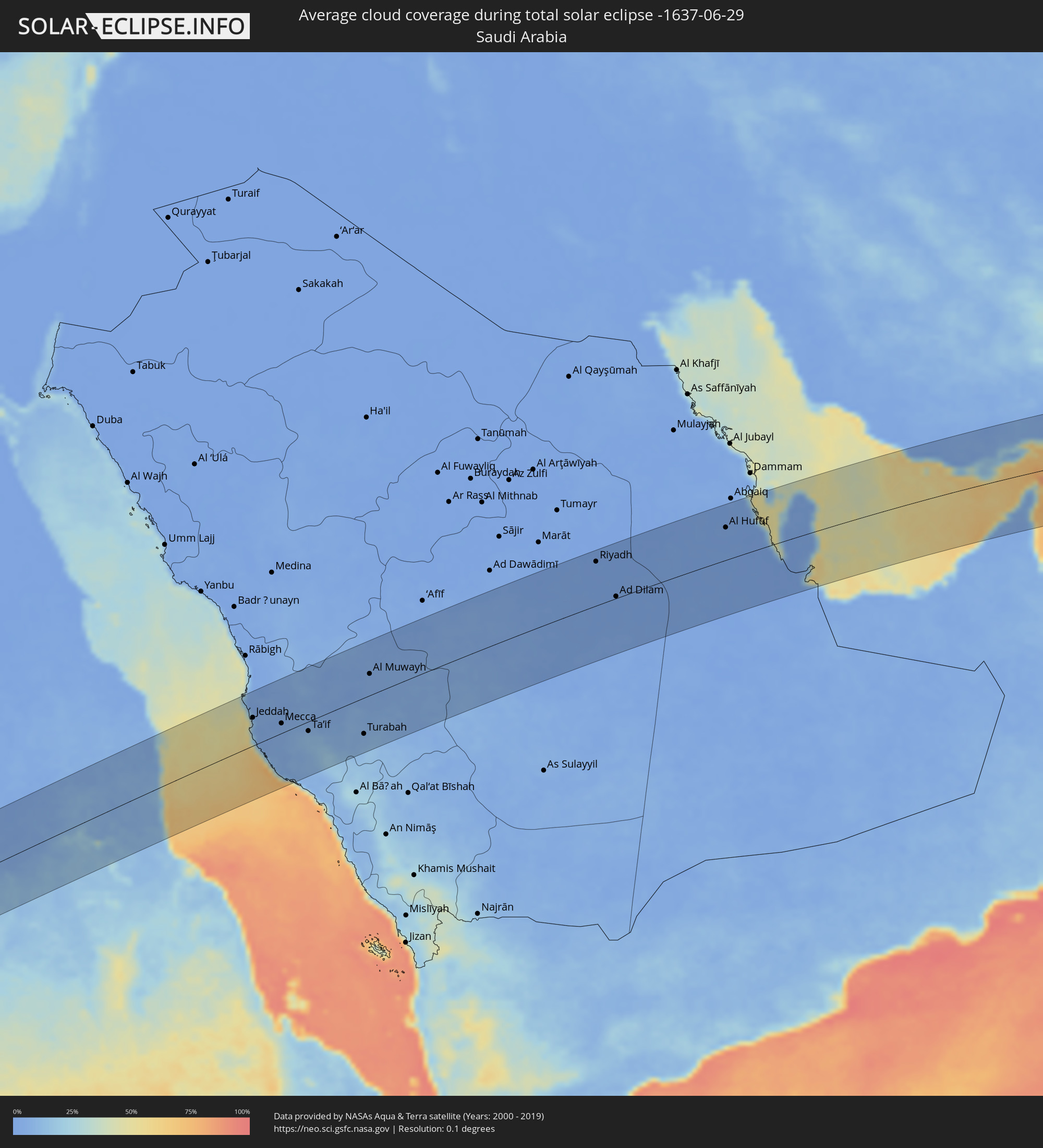 Saudi Arabia
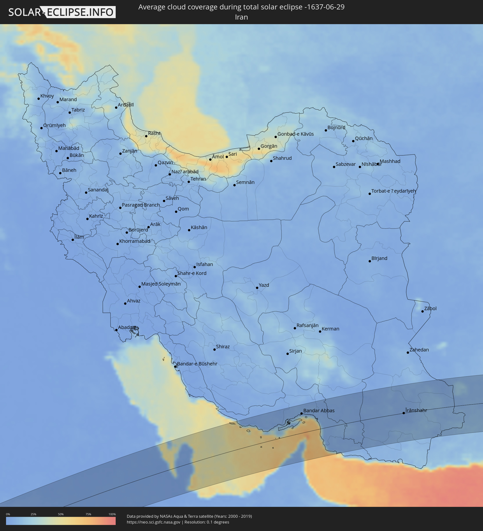 Iran
Iran
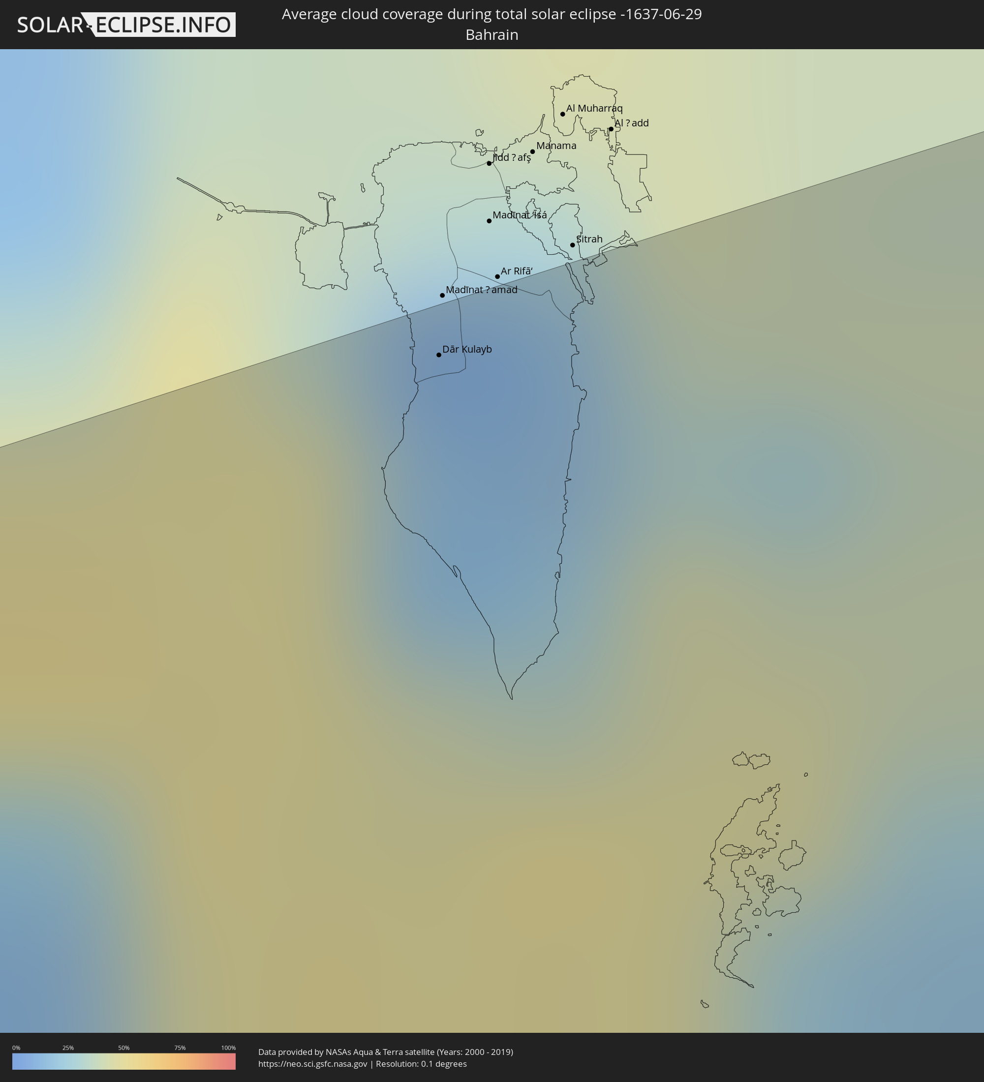 Bahrain
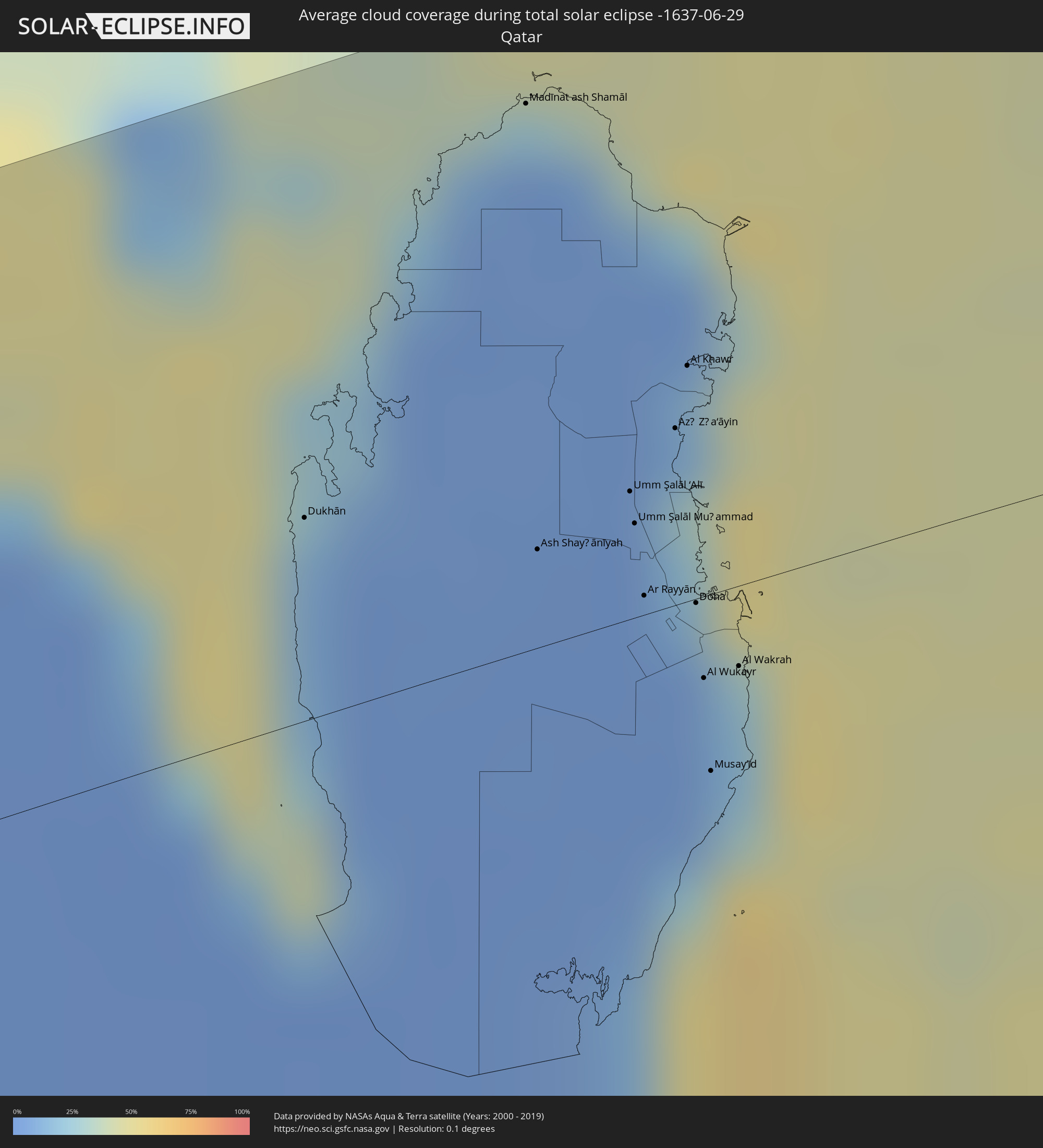 Qatar
Qatar
 United Arab Emirates
 Oman
Oman
 Pakistan
 India
India
 Bangladesh
 Myanmar
 Thailand
 Laos
Laos
 Vietnam
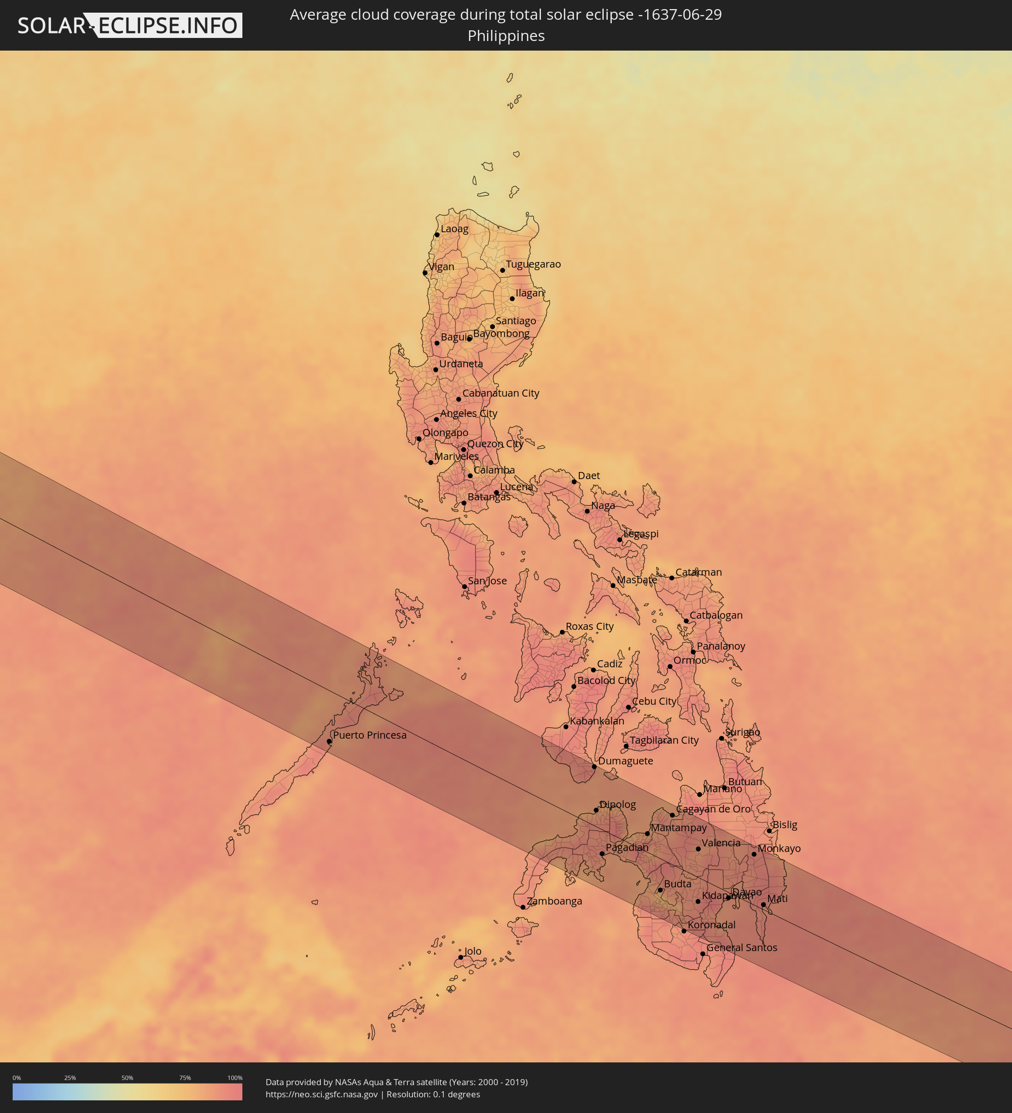 Philippines
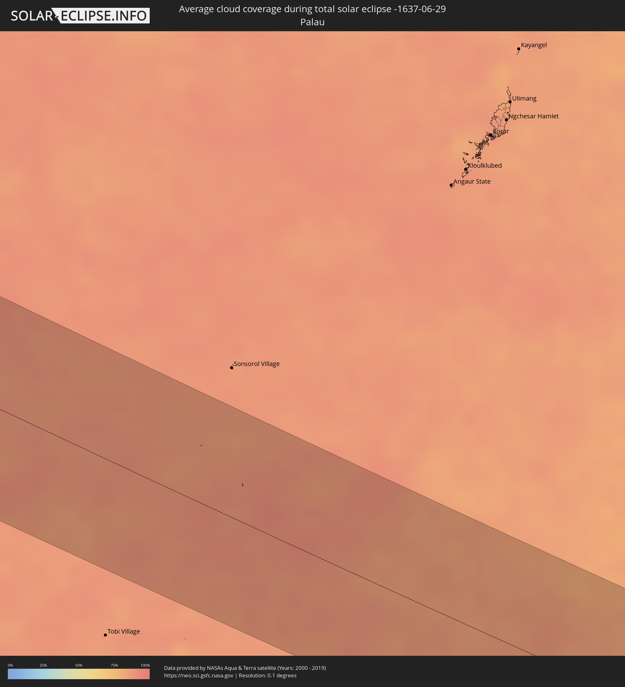 Palau
Palau
Cities inside the path of the eclipse
The following table shows all locations with a population of more than 5,000 inside the eclipse path. Cities which have more than 100,000 inhabitants are marked bold. A click at the locations opens a detailed map.
| City | Type | Eclipse duration | Local time of max. eclipse | Distance to central line | Ø Cloud coverage |
|
Benin City, Edo
|
total | - | 05:37:18 UTC+00:13 | 79 km | 96% |
|
Sapele, Delta
|
total | - | 05:37:07 UTC+00:13 | 31 km | 95% |
|
Warri, Delta
|
total | - | 05:36:57 UTC+00:13 | 10 km | 96% |
|
Onitsha, Anambra
|
total | - | 05:37:04 UTC+00:13 | 7 km | 94% |
|
Nnewi, Anambra
|
total | - | 05:37:00 UTC+00:13 | 12 km | 96% |
|
Owerri, Imo
|
total | - | 05:36:46 UTC+00:13 | 72 km | 97% |
|
Awka, Anambra
|
total | - | 05:37:04 UTC+00:13 | 1 km | 95% |
|
Umuahia, Abia
|
total | - | 05:36:44 UTC+00:13 | 89 km | 96% |
|
Enugu, Enugu
|
total | - | 05:37:07 UTC+00:13 | 4 km | 93% |
|
Ugep, Cross River
|
total | - | 05:36:48 UTC+00:13 | 86 km | 94% |
|
Makurdi, Benue
|
total | - | 05:37:38 UTC+00:13 | 89 km | 93% |
|
Kontcha, Adamaoua
|
total | - | 05:37:43 UTC+00:13 | 59 km | 78% |
|
Jimeta, Adamawa
|
total | - | 05:38:25 UTC+00:13 | 63 km | 85% |
|
Poli, North
|
total | - | 05:38:03 UTC+00:13 | 55 km | 83% |
|
Garoua, North
|
total | - | 05:38:31 UTC+00:13 | 21 km | 83% |
|
Pitoa, North
|
total | - | 05:38:34 UTC+00:13 | 24 km | 82% |
|
Lagdo, North
|
total | - | 05:38:23 UTC+00:13 | 21 km | 73% |
|
Guider, North
|
total | - | 05:38:55 UTC+00:13 | 59 km | 81% |
|
Mboursou Léré, Mayo-Kebbi Ouest
|
total | - | 06:25:28 UTC+01:00 | 32 km | 82% |
|
Rey Bouba, North
|
total | - | 05:38:15 UTC+00:13 | 79 km | 84% |
|
Mindif, Far North
|
total | - | 05:39:15 UTC+00:13 | 82 km | 85% |
|
Kaélé, Far North
|
total | - | 05:39:05 UTC+00:13 | 53 km | 84% |
|
Pala, Mayo-Kebbi Ouest
|
total | - | 06:25:20 UTC+01:00 | 43 km | 82% |
|
Yagoua, Far North
|
total | - | 05:39:20 UTC+00:13 | 39 km | 83% |
|
Bongor, Mayo-Kebbi Est
|
total | - | 06:25:57 UTC+01:00 | 27 km | 75% |
|
Gounou Gaya, Mayo-Kebbi Est
|
total | - | 06:25:35 UTC+01:00 | 45 km | 82% |
|
Guelendeng, Mayo-Kebbi Est
|
total | - | 06:26:22 UTC+01:00 | 82 km | 85% |
|
Kelo, Tandjilé
|
total | - | 06:25:27 UTC+01:00 | 91 km | 85% |
|
Bousso, Chari-Baguirmi
|
total | - | 06:26:19 UTC+01:00 | 16 km | 83% |
|
Ngama, Chari-Baguirmi
|
total | - | 06:27:15 UTC+01:00 | 93 km | 89% |
|
Melfi, Guéra
|
total | - | 06:26:58 UTC+01:00 | 16 km | 78% |
|
Bitkine, Guéra
|
total | - | 06:27:38 UTC+01:00 | 63 km | 72% |
|
Mongo, Guéra
|
total | - | 06:27:55 UTC+01:00 | 61 km | 69% |
|
Adré, Ouadaï
|
total | - | 06:30:06 UTC+01:00 | 22 km | 38% |
|
Geneina, Western Darfur
|
total | - | 07:40:08 UTC+02:10 | 9 km | 36% |
|
Zalingei, Central Darfur
|
total | - | 07:40:12 UTC+02:10 | 94 km | 53% |
|
Kutum, Northern Darfur
|
total | - | 07:41:47 UTC+02:10 | 21 km | 32% |
|
Ad Dabbah, Northern State
|
total | - | 07:49:24 UTC+02:10 | 70 km | 7% |
|
Marawī, Northern State
|
total | - | 07:50:33 UTC+02:10 | 74 km | 7% |
|
Kuraymah, Northern State
|
total | - | 07:50:39 UTC+02:10 | 79 km | 8% |
|
El Bauga, River Nile
|
total | - | 07:52:21 UTC+02:10 | 44 km | 14% |
|
Berber, River Nile
|
total | - | 07:52:12 UTC+02:10 | 71 km | 14% |
|
Atbara, River Nile
|
total | - | 07:51:55 UTC+02:10 | 104 km | 13% |
|
Port Sudan, Red Sea
|
total | - | 07:57:16 UTC+02:10 | 53 km | 23% |
|
Sawākin, Red Sea
|
total | - | 07:56:55 UTC+02:10 | 110 km | 20% |
|
Jeddah, Makkah
|
total | - | 08:58:20 UTC+03:06 | 58 km | 17% |
|
Al Jumūm, Makkah
|
total | - | 08:59:04 UTC+03:06 | 45 km | 4% |
|
Mecca, Makkah
|
total | - | 08:59:03 UTC+03:06 | 20 km | 4% |
|
Ash Shafā, Makkah
|
total | - | 08:59:22 UTC+03:06 | 36 km | 10% |
|
Ta’if, Makkah
|
total | - | 08:59:42 UTC+03:06 | 20 km | 9% |
|
Turabah, Makkah
|
total | - | 09:01:23 UTC+03:06 | 75 km | 8% |
|
Riyadh, Ar Riyāḑ
|
total | - | 09:12:52 UTC+03:06 | 92 km | 1% |
|
Ad Dilam, Ar Riyāḑ
|
total | - | 09:12:59 UTC+03:06 | 4 km | 1% |
|
Al Hufūf, Eastern Province
|
total | - | 09:18:40 UTC+03:06 | 68 km | 2% |
|
Al Baţţālīyah, Eastern Province
|
total | - | 09:18:52 UTC+03:06 | 73 km | 2% |
|
Al Munayzilah, Eastern Province
|
total | - | 09:18:53 UTC+03:06 | 67 km | 2% |
|
Aţ Ţaraf, Eastern Province
|
total | - | 09:18:58 UTC+03:06 | 63 km | 2% |
|
Dār Kulayb, Southern Governorate
|
total | - | 09:40:22 UTC+03:26 | 114 km | 17% |
|
Dukhān, Baladīyat ar Rayyān
|
total | - | 09:40:21 UTC+03:26 | 37 km | 14% |
|
Madīnat ash Shamāl, Madīnat ash Shamāl
|
total | - | 09:41:47 UTC+03:26 | 99 km | 4% |
|
Ash Shayḩānīyah, Baladīyat ar Rayyān
|
total | - | 09:41:10 UTC+03:26 | 18 km | 2% |
|
Umm Şalāl ‘Alī, Baladīyat Umm Şalāl
|
total | - | 09:41:36 UTC+03:26 | 23 km | 3% |
|
Umm Şalāl Muḩammad, Baladīyat Umm Şalāl
|
total | - | 09:41:35 UTC+03:26 | 17 km | 2% |
|
Ar Rayyān, Baladīyat ar Rayyān
|
total | - | 09:41:31 UTC+03:26 | 4 km | 1% |
|
Az̧ Z̧a‘āyin, Baladīyat az̧ Z̧a‘āyin
|
total | - | 09:41:52 UTC+03:26 | 32 km | 29% |
|
Al Khawr, Al Khawr
|
total | - | 09:42:01 UTC+03:26 | 43 km | 14% |
|
Doha, Baladīyat ad Dawḩah
|
total | - | 09:41:42 UTC+03:26 | 1 km | 5% |
|
Al Wukayr, Al Wakrah
|
total | - | 09:41:37 UTC+03:26 | 15 km | 4% |
|
Musay‘īd, Al Wakrah
|
total | - | 09:41:31 UTC+03:26 | 32 km | 32% |
|
Al Wakrah, Al Wakrah
|
total | - | 09:41:46 UTC+03:26 | 15 km | 21% |
|
Kīsh, Hormozgan
|
total | - | 09:47:32 UTC+03:25 | 67 km | 41% |
|
Bandar-e Lengeh, Hormozgan
|
total | - | 09:49:24 UTC+03:25 | 45 km | 30% |
|
Sharjah, Ash Shāriqah
|
total | - | 10:05:08 UTC+03:41 | 99 km | 7% |
|
Ajman, Ajman
|
total | - | 10:05:15 UTC+03:41 | 92 km | 27% |
|
Umm al Qaywayn, Umm al Qaywayn
|
total | - | 10:05:37 UTC+03:41 | 78 km | 23% |
|
Adh Dhayd, Ash Shāriqah
|
total | - | 10:06:10 UTC+03:41 | 116 km | 2% |
|
Ras al-Khaimah, Raʼs al Khaymah
|
total | - | 10:06:40 UTC+03:41 | 63 km | 35% |
|
Khasab, Musandam
|
total | - | 10:07:38 UTC+03:41 | 28 km | 21% |
|
Dibba Al-Fujairah, Al Fujayrah
|
total | - | 10:07:15 UTC+03:41 | 92 km | 18% |
|
Qeshm, Hormozgan
|
total | - | 09:52:45 UTC+03:25 | 55 km | 57% |
|
Dibba Al-Hisn, Al Fujayrah
|
total | - | 10:07:18 UTC+03:41 | 89 km | 18% |
|
Bandar Abbas, Hormozgan
|
total | - | 09:52:57 UTC+03:25 | 81 km | 37% |
|
Mīnāb, Hormozgan
|
total | - | 09:54:44 UTC+03:25 | 57 km | 6% |
|
Īrānshahr, Sistan and Baluchestan
|
total | - | 10:03:17 UTC+03:25 | 1 km | 2% |
|
Qaşr-e Qand, Sistan and Baluchestan
|
total | - | 10:02:59 UTC+03:25 | 107 km | 11% |
|
Khāsh, Sistan and Baluchestan
|
total | - | 10:05:04 UTC+03:25 | 103 km | 7% |
|
Khuzdār, Balochistān
|
total | - | 11:21:00 UTC+04:28 | 7 km | 20% |
|
Dadu, Sindh
|
total | - | 11:23:57 UTC+04:28 | 117 km | 56% |
|
Shahdād Kot, Sindh
|
total | - | 11:24:23 UTC+04:28 | 7 km | 67% |
|
Kambar, Sindh
|
total | - | 11:24:37 UTC+04:28 | 22 km | 70% |
|
Lārkāna, Sindh
|
total | - | 11:25:10 UTC+04:28 | 26 km | 62% |
|
Jacobābād, Sindh
|
total | - | 11:25:48 UTC+04:28 | 55 km | 61% |
|
Shikārpur, Sindh
|
total | - | 11:26:18 UTC+04:28 | 18 km | 67% |
|
Khairpur, Sindh
|
total | - | 11:26:37 UTC+04:28 | 29 km | 45% |
|
Sukkur, Sindh
|
total | - | 11:26:53 UTC+04:28 | 10 km | 51% |
|
Kandhkot, Sindh
|
total | - | 11:27:44 UTC+04:28 | 50 km | 62% |
|
Sādiqābād, Punjab
|
total | - | 11:30:13 UTC+04:28 | 58 km | 42% |
|
Khānpur, Punjab
|
total | - | 11:31:33 UTC+04:28 | 98 km | 41% |
|
Bīkaner, Rajasthan
|
total | - | 12:31:33 UTC+05:21 | 43 km | 47% |
|
Ajmer, Rajasthan
|
total | - | 12:35:32 UTC+05:21 | 118 km | 58% |
|
Jaipur, Rajasthan
|
total | - | 12:38:25 UTC+05:21 | 52 km | 62% |
|
Āgra, Uttar Pradesh
|
total | - | 12:44:04 UTC+05:21 | 11 km | 86% |
|
Alīgarh, Uttar Pradesh
|
total | - | 12:43:51 UTC+05:21 | 88 km | 89% |
|
Gwalior, Madhya Pradesh
|
total | - | 12:45:00 UTC+05:21 | 91 km | 76% |
|
Kanpur, Uttar Pradesh
|
total | - | 12:50:24 UTC+05:21 | 23 km | 86% |
|
Lucknow, Uttar Pradesh
|
total | - | 12:51:34 UTC+05:21 | 30 km | 91% |
|
Allahābād, Uttar Pradesh
|
total | - | 12:54:50 UTC+05:21 | 99 km | 95% |
|
Varanasi, Uttar Pradesh
|
total | - | 12:57:48 UTC+05:21 | 84 km | 93% |
|
Gorakhpur, Uttar Pradesh
|
total | - | 12:57:30 UTC+05:21 | 82 km | 94% |
|
Patna, Bihar
|
total | - | 13:02:35 UTC+05:21 | 5 km | 95% |
|
Rājshāhi, Rājshāhi
|
total | - | 13:43:34 UTC+05:53 | 14 km | 97% |
|
Pār Naogaon, Rājshāhi
|
total | - | 13:43:53 UTC+05:53 | 43 km | 96% |
|
Pābna, Rājshāhi
|
total | - | 13:45:17 UTC+05:53 | 30 km | 93% |
|
Bogra, Rājshāhi
|
total | - | 13:44:43 UTC+05:53 | 63 km | 97% |
|
Nāgarpur, Dhaka
|
total | - | 13:46:33 UTC+05:53 | 2 km | 97% |
|
Tāngāil, Dhaka
|
total | - | 13:46:26 UTC+05:53 | 19 km | 96% |
|
Tungi, Dhaka
|
total | - | 13:47:48 UTC+05:53 | 1 km | 97% |
|
Mymensingh, Dhaka
|
total | - | 13:46:55 UTC+05:53 | 90 km | 97% |
|
Dhaka, Dhaka
|
total | - | 13:48:00 UTC+05:53 | 19 km | 96% |
|
Narsingdi, Dhaka
|
total | - | 13:48:24 UTC+05:53 | 14 km | 95% |
|
Comilla, Chittagong
|
total | - | 13:49:49 UTC+05:53 | 16 km | 98% |
|
Chittagong, Chittagong
|
total | - | 13:52:16 UTC+05:53 | 107 km | 94% |
|
Hakha, Chin
|
total | - | 14:26:47 UTC+06:24 | 5 km | 96% |
|
Pakokku, Magway
|
total | - | 14:30:52 UTC+06:24 | 79 km | 97% |
|
Monywa, Sagain
|
total | - | 14:30:06 UTC+06:24 | 2 km | 95% |
|
Myingyan, Mandalay
|
total | - | 14:31:15 UTC+06:24 | 53 km | 97% |
|
Shwebo, Sagain
|
total | - | 14:30:34 UTC+06:24 | 73 km | 97% |
|
Meiktila, Mandalay
|
total | - | 14:32:42 UTC+06:24 | 92 km | 96% |
|
Sagaing, Sagain
|
total | - | 14:31:49 UTC+06:24 | 15 km | 96% |
|
Mandalay, Mandalay
|
total | - | 14:31:53 UTC+06:24 | 29 km | 97% |
|
Kyaukse, Mandalay
|
total | - | 14:32:23 UTC+06:24 | 7 km | 97% |
|
Pyin Oo Lwin, Mandalay
|
total | - | 14:32:27 UTC+06:24 | 51 km | 97% |
|
Taunggyi, Shan
|
total | - | 14:34:47 UTC+06:24 | 50 km | 96% |
|
Chiang Rai, Chiang Rai
|
total | - | 14:57:23 UTC+06:42 | 13 km | 96% |
|
Mae Chan, Chiang Rai
|
total | - | 14:57:09 UTC+06:42 | 11 km | 97% |
|
Mae Sai, Chiang Rai
|
total | - | 14:56:52 UTC+06:42 | 41 km | 98% |
|
Tachilek, Shan
|
total | - | 14:56:51 UTC+06:42 | 43 km | 98% |
|
Dok Kham Tai, Phayao
|
total | - | 14:58:26 UTC+06:42 | 81 km | 97% |
|
Ban Houayxay, Bokeo Province
|
total | - | 14:57:49 UTC+06:42 | 50 km | 95% |
|
Ban Houakhoua, Bokeo Province
|
total | - | 14:57:55 UTC+06:42 | 49 km | 94% |
|
Nan, Nan
|
total | - | 14:59:58 UTC+06:42 | 82 km | 97% |
|
Sainyabuli, Xiagnabouli
|
total | - | 15:00:45 UTC+06:42 | 9 km | 95% |
|
Luang Prabang, Louangphabang
|
total | - | 15:00:38 UTC+06:42 | 91 km | 93% |
|
Muang Phôn-Hông, Vientiane Province
|
total | - | 15:02:31 UTC+06:42 | 34 km | 93% |
|
Vangviang, Vientiane Province
|
total | - | 15:02:06 UTC+06:42 | 10 km | 94% |
|
Tha Bo, Nong Khai
|
total | - | 15:03:25 UTC+06:42 | 90 km | 92% |
|
Vientiane, Vientiane
|
total | - | 15:03:19 UTC+06:42 | 78 km | 95% |
|
Nong Khai, Nong Khai
|
total | - | 15:03:36 UTC+06:42 | 80 km | 94% |
|
Muang Phônsavan, Xiangkhoang
|
total | - | 15:02:31 UTC+06:42 | 99 km | 95% |
|
Ban Dung, Changwat Udon Thani
|
total | - | 15:04:27 UTC+06:42 | 73 km | 95% |
|
Sawang Daen Din, Sakon Nakhon
|
total | - | 15:04:56 UTC+06:42 | 85 km | 95% |
|
Muang Pakxan, Bolikhamsai Province
|
total | - | 15:04:13 UTC+06:42 | 14 km | 93% |
|
Seka, Changwat Bueng Kan
|
total | - | 15:05:04 UTC+06:42 | 16 km | 95% |
|
Sakon Nakhon, Sakon Nakhon
|
total | - | 15:06:07 UTC+06:42 | 83 km | 96% |
|
Nakhon Phanom, Nakhon Phanom
|
total | - | 15:06:36 UTC+06:42 | 28 km | 94% |
|
Thakhèk, Khammouan
|
total | - | 15:06:40 UTC+06:42 | 25 km | 94% |
|
Kwang Binh, Quảng Bình
|
total | - | 15:33:13 UTC+07:06 | 68 km | 79% |
|
Ðông Hà, Quảng Trị
|
total | - | 15:34:24 UTC+07:06 | 27 km | 78% |
|
Huế, Thừa Thiên-Huế
|
total | - | 15:35:16 UTC+07:06 | 17 km | 71% |
|
Da Nang, Đà Nẵng
|
total | - | 15:36:18 UTC+07:06 | 9 km | 78% |
|
Hội An, Quảng Nam
|
total | - | 15:36:35 UTC+07:06 | 4 km | 71% |
|
Tam Kỳ, Quảng Nam
|
total | - | 15:37:02 UTC+07:06 | 27 km | 74% |
|
Quảng Ngãi, Quảng Ngãi
|
total | - | 15:37:47 UTC+07:06 | 56 km | 69% |
|
Puerto Princesa, Mimaropa
|
total | - | 16:42:39 UTC+08:00 | 86 km | 87% |
|
Dumaguete, Central Visayas
|
total | - | 16:44:38 UTC+08:00 | 99 km | 87% |
|
Pagadian, Zamboanga Peninsula
|
total | - | 16:45:40 UTC+08:00 | 42 km | 85% |
|
Mantampay, Northern Mindanao
|
total | - | 16:45:39 UTC+08:00 | 31 km | 83% |
|
Cotabato, Autonomous Region in Muslim Mindanao
|
total | - | 16:46:15 UTC+08:00 | 62 km | 84% |
|
Marawi City, Autonomous Region in Muslim Mindanao
|
total | - | 16:45:46 UTC+08:00 | 18 km | 83% |
|
Iligan City, Soccsksargen
|
total | - | 16:45:38 UTC+08:00 | 48 km | 86% |
|
Budta, Autonomous Region in Muslim Mindanao
|
total | - | 16:46:19 UTC+08:00 | 54 km | 76% |
|
Cagayan de Oro, Northern Mindanao
|
total | - | 16:45:32 UTC+08:00 | 83 km | 88% |
|
Digos, Davao
|
total | - | 16:46:47 UTC+08:00 | 55 km | 85% |
|
Davao, Davao
|
total | - | 16:46:38 UTC+08:00 | 10 km | 89% |
|
Tagum, Davao
|
total | - | 16:46:26 UTC+08:00 | 37 km | 87% |