Totale Sonnenfinsternis vom 09.09.-1687
| Wochentag: | Montag |
| Maximale Dauer der Verfinsterung: | 02m59s |
| Maximale Breite des Finsternispfades: | 140 km |
| Saroszyklus: | 27 |
| Bedeckungsgrad: | 100% |
| Magnitude: | 1.0364 |
| Gamma: | 0.4896 |
Wo kann man die Sonnenfinsternis vom 09.09.-1687 sehen?
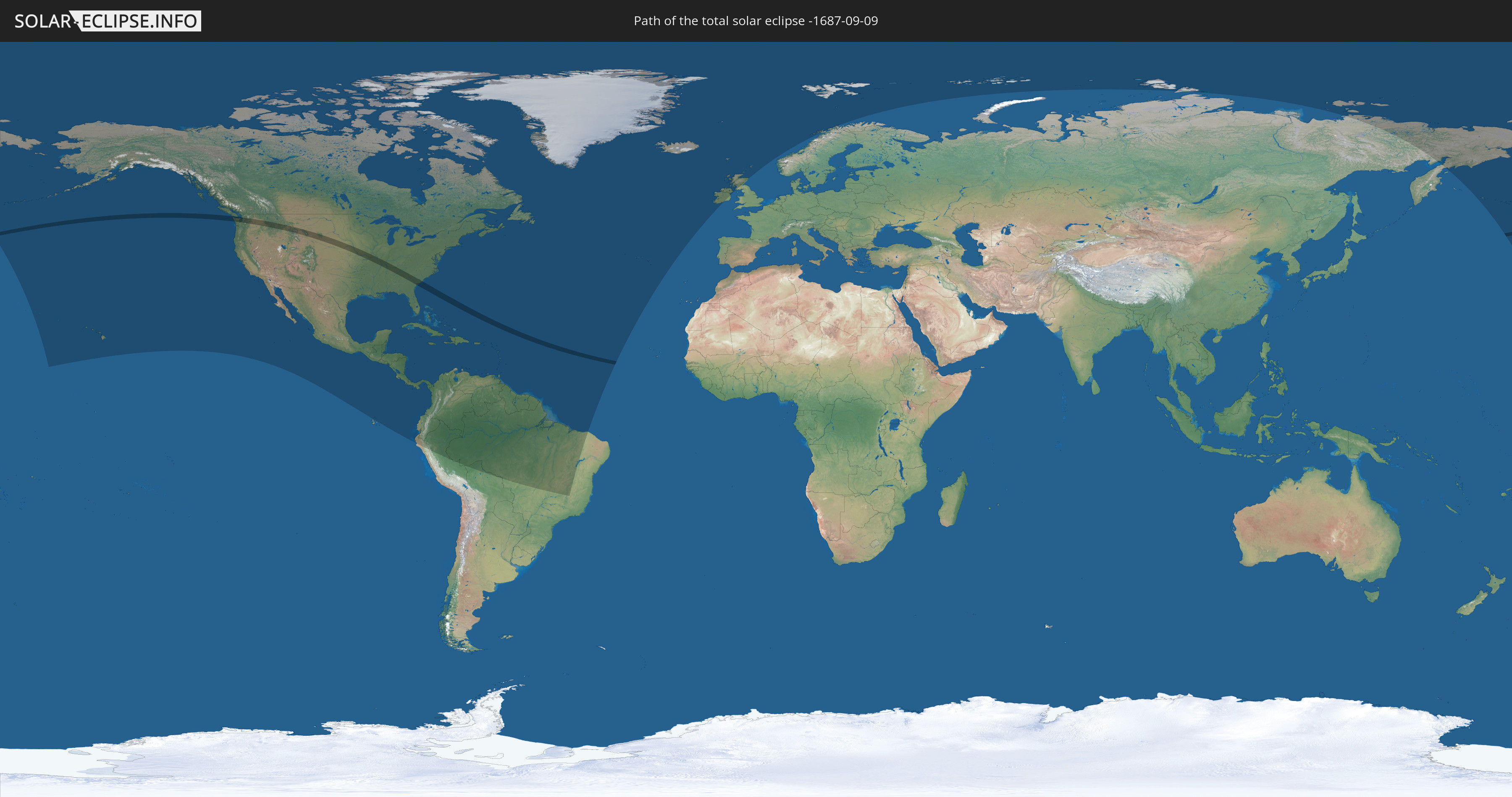
Die Sonnenfinsternis am 09.09.-1687 kann man in 56 Ländern als partielle Sonnenfinsternis beobachten.
Der Finsternispfad verläuft durch 2 Länder. Nur in diesen Ländern ist sie als totale Sonnenfinsternis zu sehen.
In den folgenden Ländern ist die Sonnenfinsternis total zu sehen
 Vereinigte Staaten
 Kanada
In den folgenden Ländern ist die Sonnenfinsternis partiell zu sehen
 Russland
 Vereinigte Staaten
 United States Minor Outlying Islands
 Kanada
 Mexiko
 Grönland
 Guatemala
 Ecuador
 El Salvador
 Honduras
 Belize
 Nicaragua
 Costa Rica
 Kuba
Kuba
 Panama
 Kolumbien
 Kaimaninseln
 Peru
Peru
 Bahamas
 Jamaika
 Haiti
Haiti
 Brasilien
 Venezuela
 Turks- und Caicosinseln
 Dominikanische Republik
 Aruba
Aruba
 Bolivien
 Puerto Rico
 Amerikanische Jungferninseln
 Bermuda
 Britische Jungferninseln
 Anguilla
 Saint-Martin
 Saint-Barthélemy
 St. Kitts und Nevis
 Antigua und Barbuda
 Montserrat
 Trinidad und Tobago
 Guadeloupe
 Grenada
 Dominica
 St. Vincent und die Grenadinen
 Guyana
 Martinique
 St. Lucia
 Barbados
 Suriname
 Saint-Pierre und Miquelon
 Französisch-Guayana
 Portugal
 Island
 Irland
 Spitzbergen
 Vereinigtes Königreich
 Färöer
 Norwegen
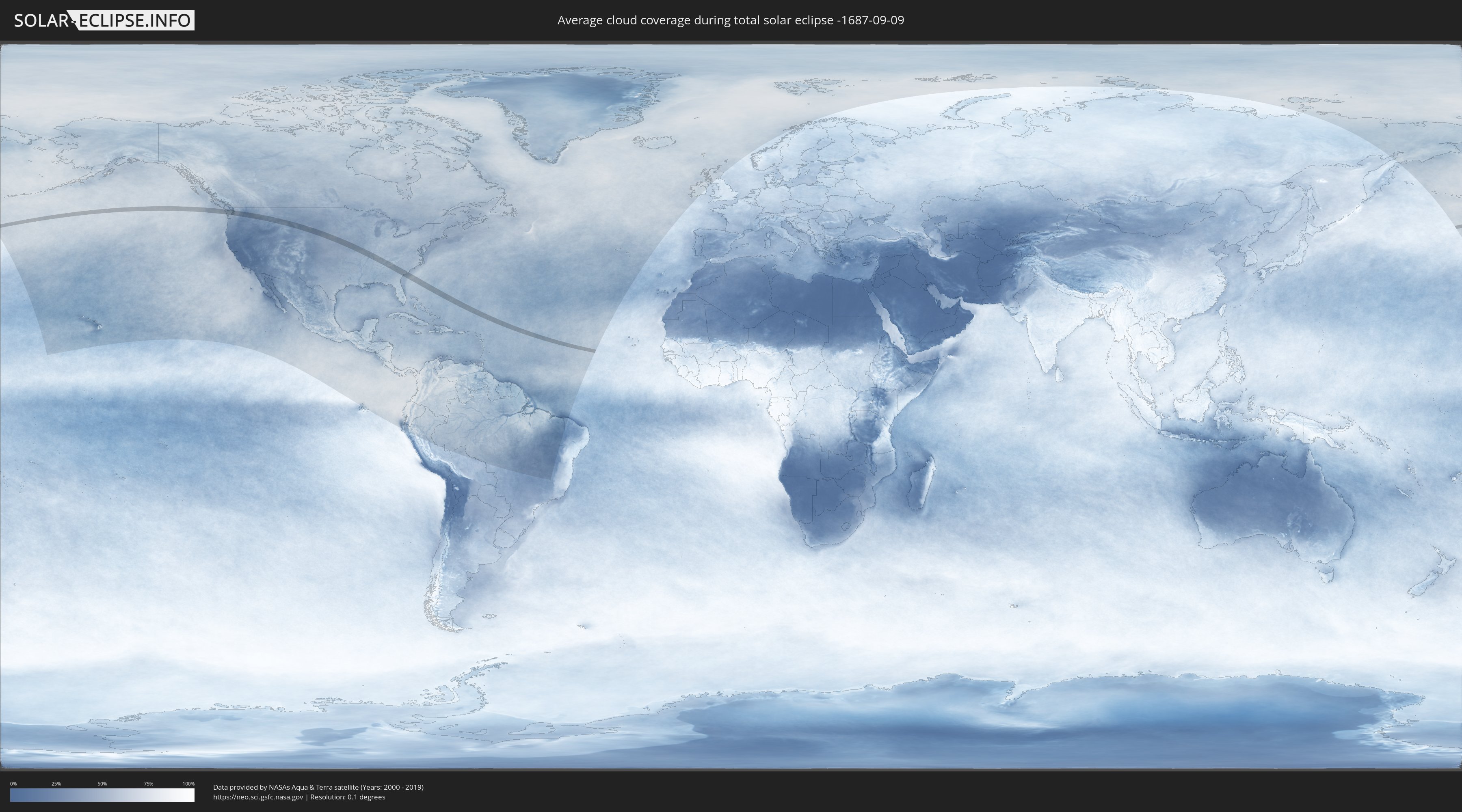
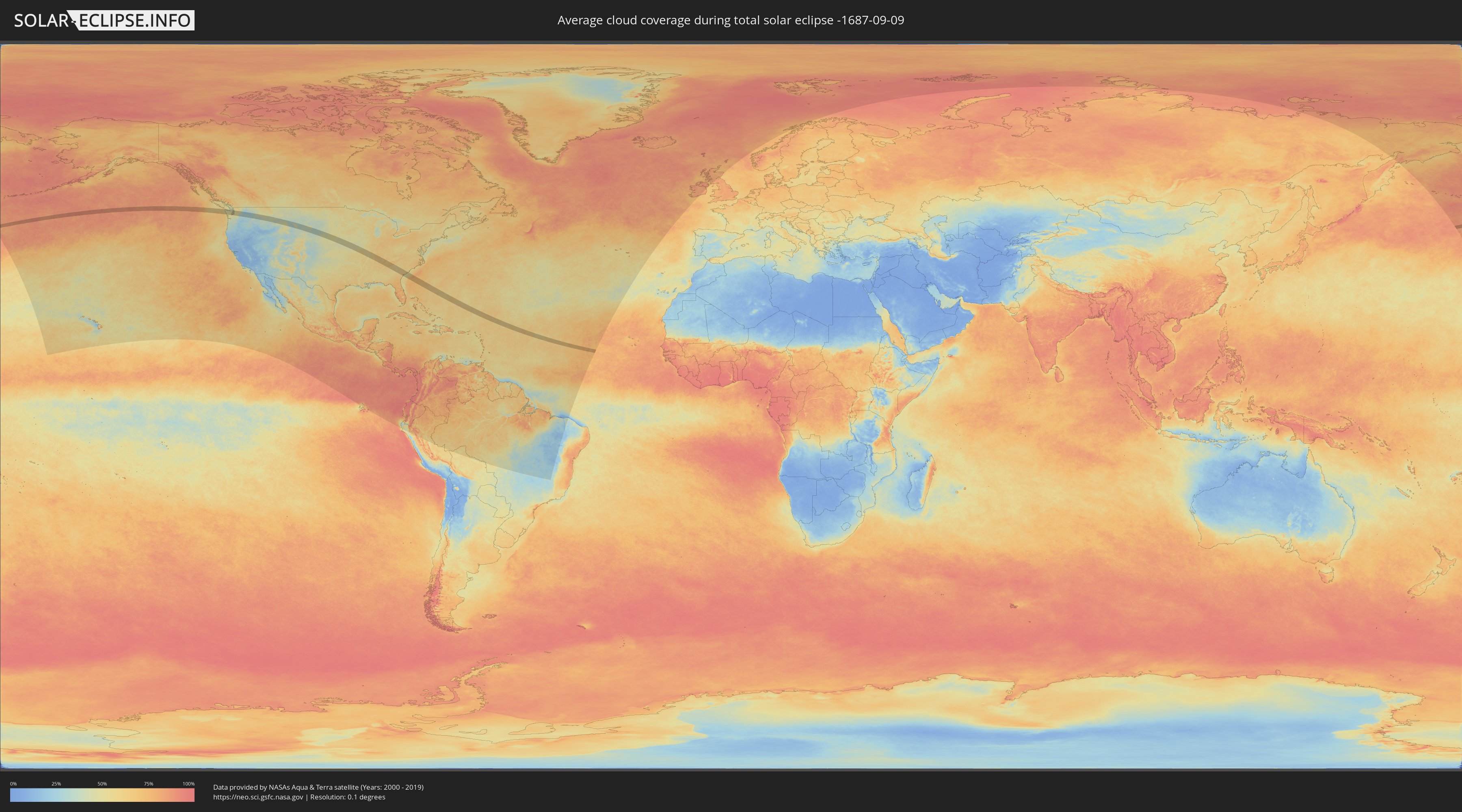
Wie wird das Wetter während der totalen Sonnenfinsternis am 09.09.-1687?
Wo ist der beste Ort, um die totale Sonnenfinsternis vom 09.09.-1687 zu beobachten?
Die folgenden Karten zeigen die durchschnittliche Bewölkung für den Tag, an dem die totale Sonnenfinsternis
stattfindet. Mit Hilfe der Karten lässt sich der Ort entlang des Finsternispfades eingrenzen,
der die besten Aussichen auf einen klaren wolkenfreien Himmel bietet.
Trotzdem muss man immer lokale Gegenenheiten beachten und sollte sich genau über das Wetter an seinem
gewählten Beobachtungsort informieren.
Die Daten stammen von den beiden NASA-Satelliten
AQUA und TERRA
und wurden über einen Zeitraum von 19 Jahren (2000 - 2019) gemittelt.
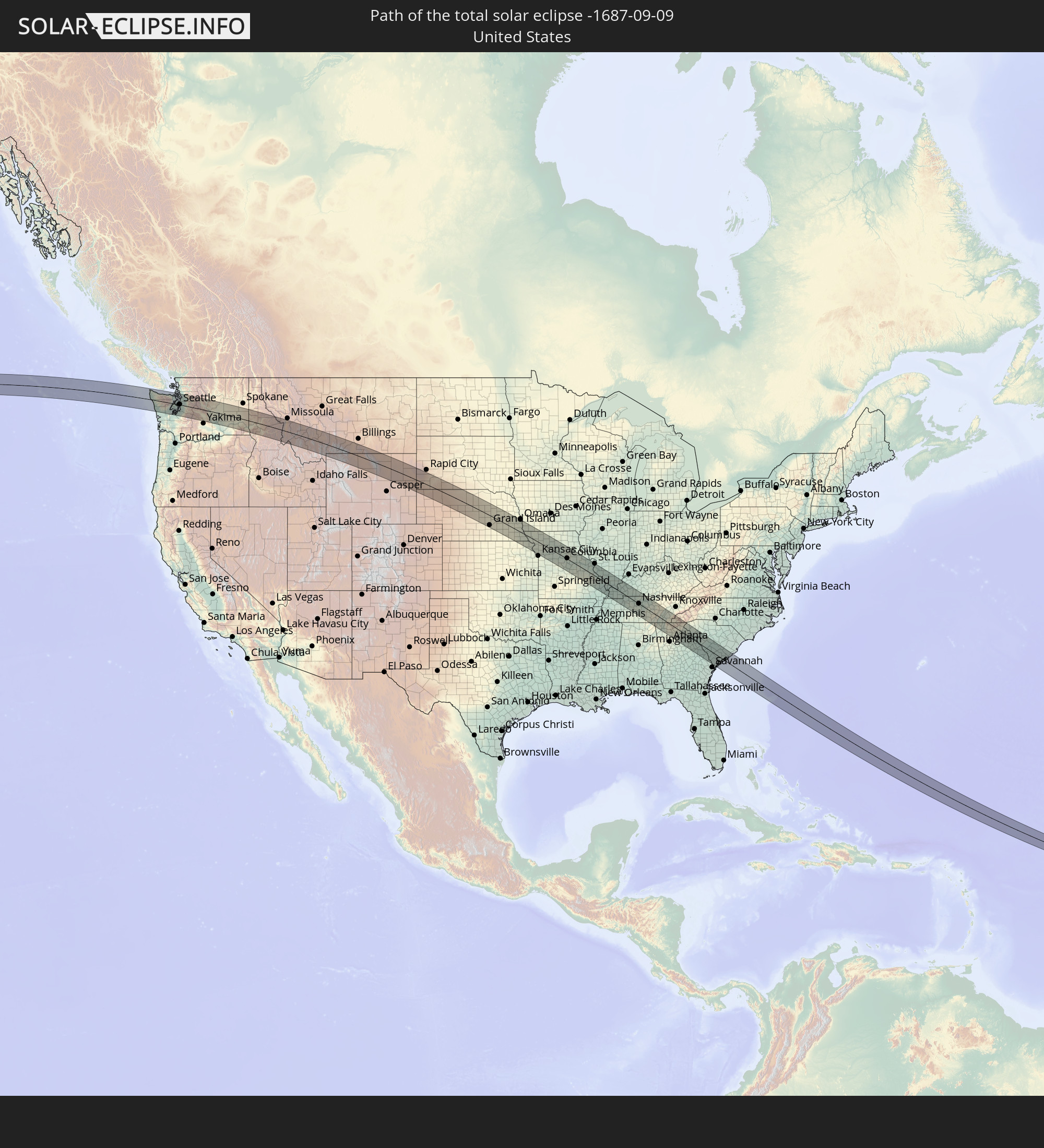
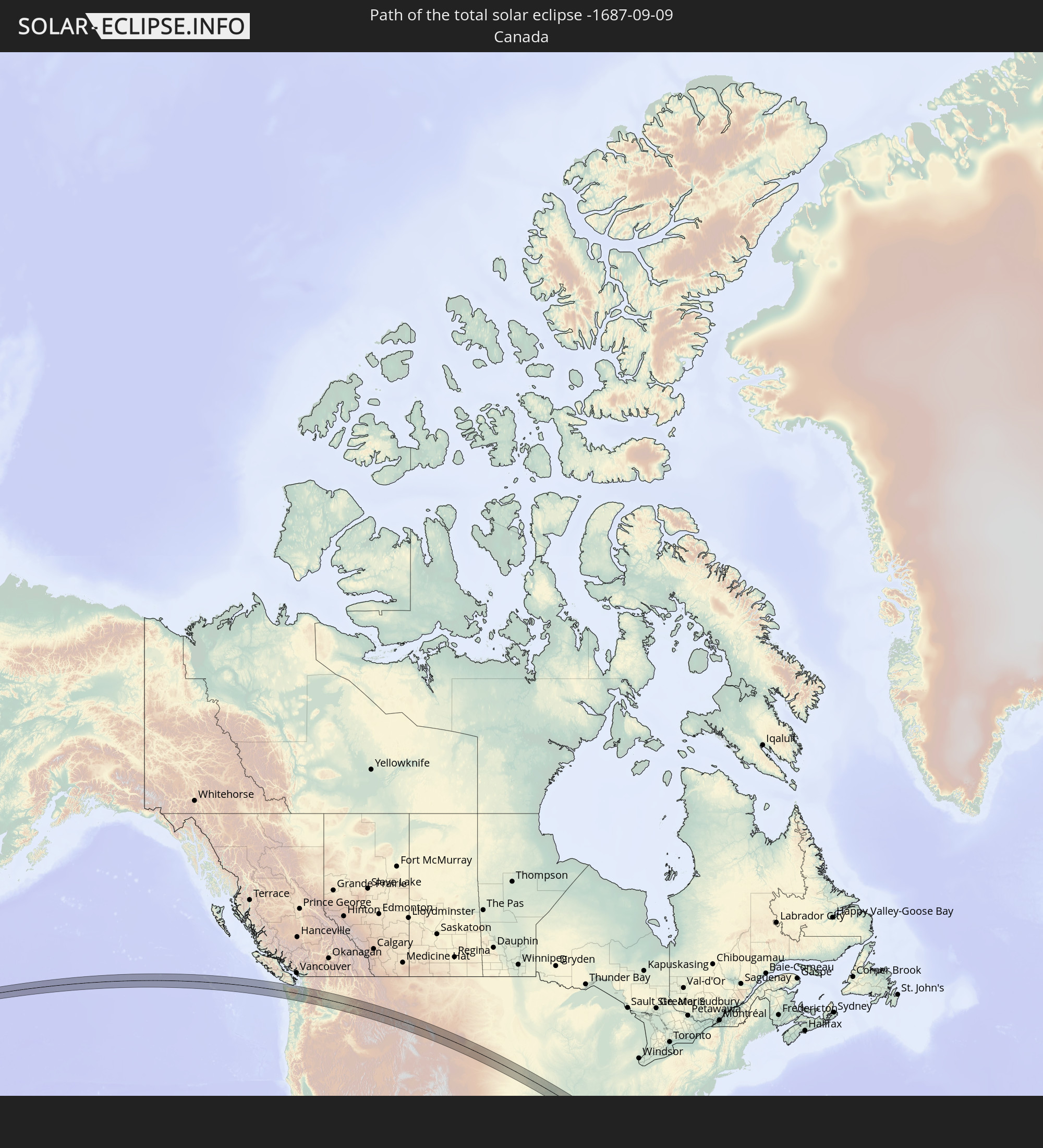
Detaillierte Länderkarten
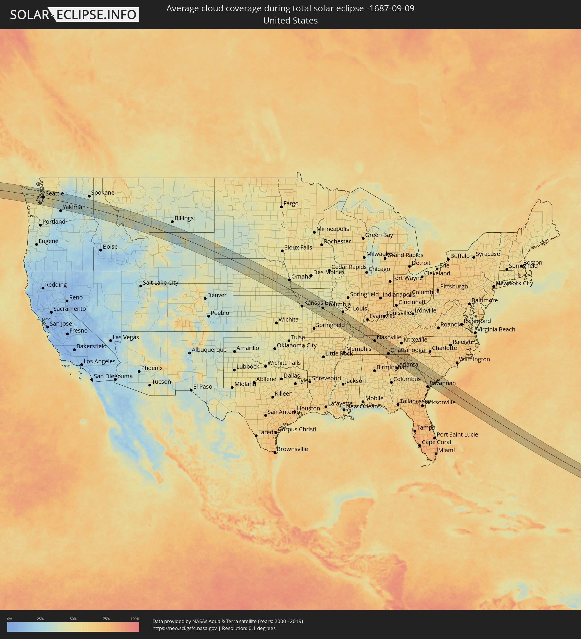 Vereinigte Staaten
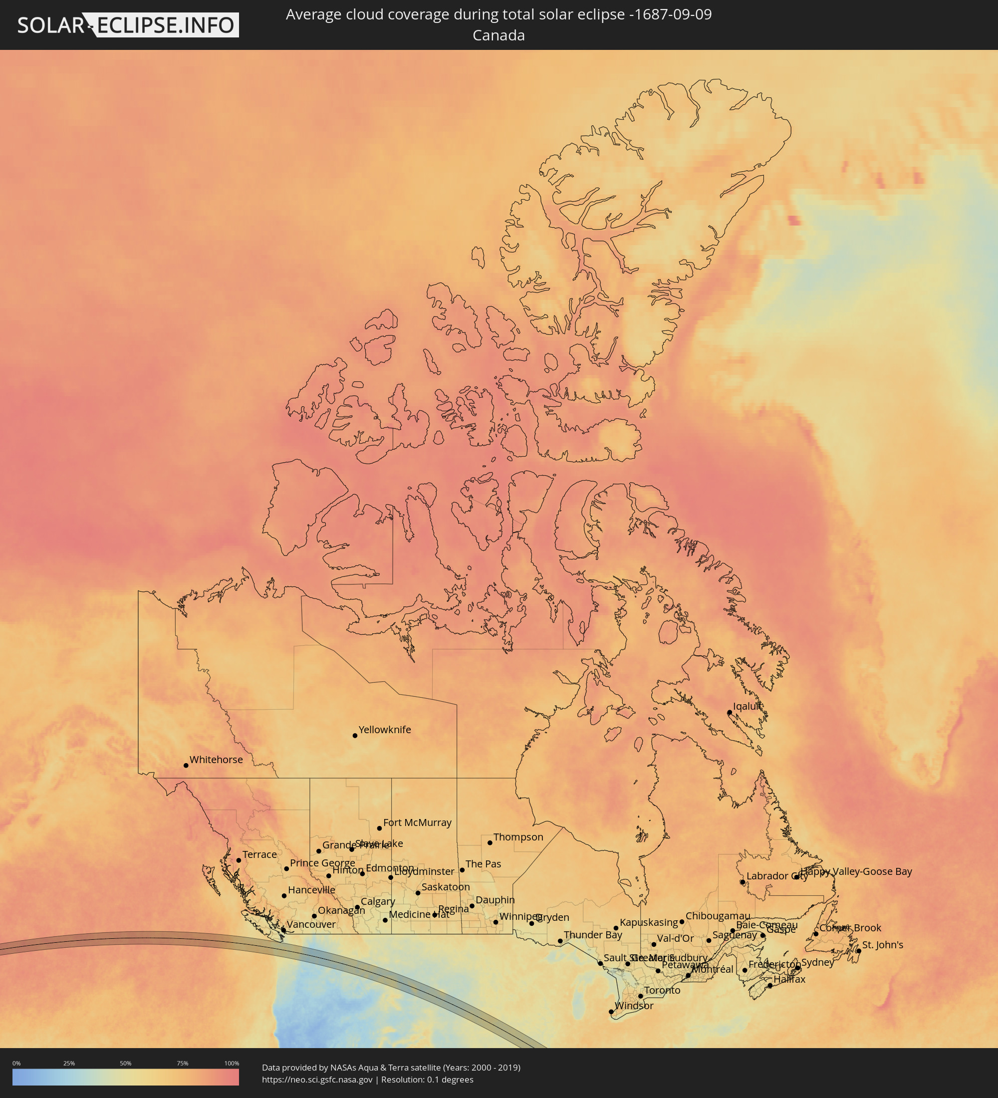 Kanada
Orte im Finsternispfad
Die nachfolgene Tabelle zeigt Städte und Orte mit mehr als 5.000 Einwohnern, die sich im Finsternispfad befinden. Städte mit mehr als 100.000 Einwohnern sind dick gekennzeichnet. Mit einem Klick auf den Ort öffnet sich eine Detailkarte die die Lage des jeweiligen Ortes zusammen mit dem Verlauf der zentralen Finsternis präsentiert.
| Ort | Typ | Dauer der Verfinsterung | Ortszeit bei maximaler Verfinsterung | Entfernung zur Zentrallinie | Ø Bewölkung |
|
Port Angeles, Washington
|
total | - | 10:00:15 UTC-08:00 | 43 km | 47% |
|
Shelton, Washington
|
total | - | 10:00:23 UTC-08:00 | 52 km | 47% |
|
Port Townsend, Washington
|
total | - | 10:01:09 UTC-08:00 | 52 km | 45% |
|
Poulsbo, Washington
|
total | - | 10:01:11 UTC-08:00 | 12 km | 47% |
|
Port Orchard, Washington
|
total | - | 10:01:08 UTC-08:00 | 10 km | 48% |
|
Bremerton, Washington
|
total | - | 10:01:09 UTC-08:00 | 7 km | 46% |
|
DuPont, Washington
|
total | - | 10:01:00 UTC-08:00 | 58 km | 47% |
|
Artondale, Washington
|
total | - | 10:01:05 UTC-08:00 | 36 km | 46% |
|
Fort Lewis, Washington
|
total | - | 10:01:05 UTC-08:00 | 56 km | 47% |
|
Camano, Washington
|
total | - | 10:01:29 UTC-08:00 | 61 km | 45% |
|
Vashon, Washington
|
total | - | 10:01:21 UTC-08:00 | 17 km | 45% |
|
Tacoma, Washington
|
total | - | 10:01:19 UTC-08:00 | 38 km | 46% |
|
Klahanie, Washington
|
total | - | 10:01:23 UTC-08:00 | 19 km | 46% |
|
Midland, Washington
|
total | - | 10:01:20 UTC-08:00 | 47 km | 47% |
|
Waller, Washington
|
total | - | 10:01:24 UTC-08:00 | 43 km | 47% |
|
Fife, Washington
|
total | - | 10:01:26 UTC-08:00 | 38 km | 47% |
|
Summit, Washington
|
total | - | 10:01:24 UTC-08:00 | 47 km | 47% |
|
Shoreline, Washington
|
total | - | 10:01:37 UTC-08:00 | 18 km | 47% |
|
Seattle, Washington
|
total | - | 10:01:35 UTC-08:00 | 2 km | 48% |
|
Edgewood, Washington
|
total | - | 10:01:31 UTC-08:00 | 36 km | 48% |
|
Tulalip, Washington
|
total | - | 10:01:47 UTC-08:00 | 53 km | 46% |
|
Lakeland South, Washington
|
total | - | 10:01:33 UTC-08:00 | 33 km | 48% |
|
Alderwood Manor, Washington
|
total | - | 10:01:43 UTC-08:00 | 26 km | 47% |
|
Lake Forest Park, Washington
|
total | - | 10:01:42 UTC-08:00 | 19 km | 47% |
|
Lakeland North, Washington
|
total | - | 10:01:34 UTC-08:00 | 27 km | 48% |
|
South Hill, Washington
|
total | - | 10:01:31 UTC-08:00 | 48 km | 47% |
|
Sumner, Washington
|
total | - | 10:01:35 UTC-08:00 | 41 km | 49% |
|
Kent, Washington
|
total | - | 10:01:39 UTC-08:00 | 21 km | 48% |
|
Everett, Washington
|
total | - | 10:01:52 UTC-08:00 | 45 km | 45% |
|
Woodinville, Washington
|
total | - | 10:01:51 UTC-08:00 | 21 km | 48% |
|
Newcastle, Washington
|
total | - | 10:01:48 UTC-08:00 | 3 km | 49% |
|
Prairie Ridge, Washington
|
total | - | 10:01:41 UTC-08:00 | 46 km | 49% |
|
Redmond, Washington
|
total | - | 10:01:53 UTC-08:00 | 13 km | 50% |
|
Maltby, Washington
|
total | - | 10:01:56 UTC-08:00 | 27 km | 50% |
|
East Renton Highlands, Washington
|
total | - | 10:01:51 UTC-08:00 | 8 km | 49% |
|
Lake Morton-Berrydale, Washington
|
total | - | 10:01:49 UTC-08:00 | 25 km | 48% |
|
Snohomish, Washington
|
total | - | 10:02:00 UTC-08:00 | 39 km | 49% |
|
Issaquah, Washington
|
total | - | 10:01:58 UTC-08:00 | 2 km | 49% |
|
Enumclaw, Washington
|
total | - | 10:01:56 UTC-08:00 | 37 km | 49% |
|
Monroe, Washington
|
total | - | 10:02:09 UTC-08:00 | 34 km | 50% |
|
Snoqualmie, Washington
|
total | - | 10:02:16 UTC-08:00 | 1 km | 50% |
|
Ellensburg, Washington
|
total | - | 10:03:57 UTC-08:00 | 37 km | 34% |
|
Wenatchee, Washington
|
total | - | 10:04:23 UTC-08:00 | 13 km | 33% |
|
East Wenatchee Bench, Washington
|
total | - | 10:04:26 UTC-08:00 | 14 km | 33% |
|
Ephrata, Washington
|
total | - | 10:05:28 UTC-08:00 | 14 km | 29% |
|
Moses Lake, Washington
|
total | - | 10:05:50 UTC-08:00 | 1 km | 30% |
|
Othello, Washington
|
total | - | 10:05:56 UTC-08:00 | 32 km | 34% |
|
Pullman, Washington
|
total | - | 10:08:56 UTC-08:00 | 6 km | 35% |
|
Lewiston, Idaho
|
total | - | 10:09:10 UTC-08:00 | 37 km | 30% |
|
Anaconda, Montana
|
total | - | 11:15:39 UTC-07:00 | 20 km | 42% |
|
Butte, Montana
|
total | - | 11:16:20 UTC-07:00 | 17 km | 42% |
|
Belgrade, Montana
|
total | - | 11:18:37 UTC-07:00 | 26 km | 34% |
|
Bozeman, Montana
|
total | - | 11:18:52 UTC-07:00 | 19 km | 36% |
|
Cody, Wyoming
|
total | - | 11:22:36 UTC-07:00 | 49 km | 39% |
|
Sheridan, Wyoming
|
total | - | 11:26:08 UTC-07:00 | 39 km | 39% |
|
Gillette, Wyoming
|
total | - | 11:28:56 UTC-07:00 | 31 km | 38% |
|
Grand Island, Nebraska
|
total | - | 12:44:42 UTC-06:00 | 56 km | 49% |
|
York, Nebraska
|
total | - | 12:46:10 UTC-06:00 | 32 km | 50% |
|
Columbus, Nebraska
|
total | - | 12:45:59 UTC-06:00 | 32 km | 47% |
|
Beatrice, Nebraska
|
total | - | 12:48:23 UTC-06:00 | 57 km | 45% |
|
Lincoln, Nebraska
|
total | - | 12:47:57 UTC-06:00 | 2 km | 48% |
|
Fremont, Nebraska
|
total | - | 12:47:35 UTC-06:00 | 67 km | 45% |
|
Elkhorn, Nebraska
|
total | - | 12:48:13 UTC-06:00 | 63 km | 48% |
|
Chalco, Nebraska
|
total | - | 12:48:29 UTC-06:00 | 57 km | 48% |
|
Bellevue, Nebraska
|
total | - | 12:49:01 UTC-06:00 | 63 km | 45% |
|
Atchison, Kansas
|
total | - | 12:52:15 UTC-06:00 | 58 km | 44% |
|
Maryville, Missouri
|
total | - | 12:51:47 UTC-06:00 | 28 km | 48% |
|
Saint Joseph, Missouri
|
total | - | 12:52:31 UTC-06:00 | 27 km | 49% |
|
Smithville, Missouri
|
total | - | 12:53:28 UTC-06:00 | 52 km | 49% |
|
Liberty, Missouri
|
total | - | 12:53:57 UTC-06:00 | 59 km | 47% |
|
Kearney, Missouri
|
total | - | 12:53:54 UTC-06:00 | 45 km | 49% |
|
Cameron, Missouri
|
total | - | 12:53:40 UTC-06:00 | 4 km | 45% |
|
Excelsior Springs, Missouri
|
total | - | 12:54:12 UTC-06:00 | 42 km | 46% |
|
Oak Grove, Missouri
|
total | - | 12:54:47 UTC-06:00 | 70 km | 47% |
|
Chillicothe, Missouri
|
total | - | 12:54:52 UTC-06:00 | 31 km | 47% |
|
Sedalia, Missouri
|
total | - | 12:56:51 UTC-06:00 | 59 km | 49% |
|
Marshall, Missouri
|
total | - | 12:56:23 UTC-06:00 | 18 km | 47% |
|
Boonville, Missouri
|
total | - | 12:57:24 UTC-06:00 | 12 km | 45% |
|
Moberly, Missouri
|
total | - | 12:57:23 UTC-06:00 | 44 km | 48% |
|
Columbia, Missouri
|
total | - | 12:58:11 UTC-06:00 | 4 km | 49% |
|
Jefferson City, Missouri
|
total | - | 12:58:59 UTC-06:00 | 25 km | 51% |
|
Fulton, Missouri
|
total | - | 12:59:02 UTC-06:00 | 11 km | 48% |
|
Mexico, Missouri
|
total | - | 12:58:44 UTC-06:00 | 45 km | 47% |
|
Rolla, Missouri
|
total | - | 13:00:34 UTC-06:00 | 66 km | 56% |
|
Warrenton, Missouri
|
total | - | 13:00:33 UTC-06:00 | 44 km | 49% |
|
Washington, Missouri
|
total | - | 13:01:08 UTC-06:00 | 26 km | 49% |
|
Union, Missouri
|
total | - | 13:01:17 UTC-06:00 | 16 km | 55% |
|
Troy, Missouri
|
total | - | 13:00:37 UTC-06:00 | 67 km | 50% |
|
Dardenne Prairie, Missouri
|
total | - | 13:01:21 UTC-06:00 | 59 km | 55% |
|
O'Fallon, Missouri
|
total | - | 13:01:21 UTC-06:00 | 64 km | 55% |
|
Eureka, Missouri
|
total | - | 13:01:54 UTC-06:00 | 38 km | 54% |
|
Ellisville, Missouri
|
total | - | 13:01:51 UTC-06:00 | 48 km | 54% |
|
Chesterfield, Missouri
|
total | - | 13:01:46 UTC-06:00 | 56 km | 55% |
|
Park Hills, Missouri
|
total | - | 13:03:00 UTC-06:00 | 18 km | 60% |
|
Murphy, Missouri
|
total | - | 13:02:11 UTC-06:00 | 43 km | 55% |
|
Town and Country, Missouri
|
total | - | 13:02:03 UTC-06:00 | 56 km | 55% |
|
Des Peres, Missouri
|
total | - | 13:02:07 UTC-06:00 | 56 km | 55% |
|
Farmington, Missouri
|
total | - | 13:03:17 UTC-06:00 | 21 km | 59% |
|
Sunset Hills, Missouri
|
total | - | 13:02:15 UTC-06:00 | 52 km | 55% |
|
Kirkwood, Missouri
|
total | - | 13:02:11 UTC-06:00 | 56 km | 55% |
|
Festus, Missouri
|
total | - | 13:02:43 UTC-06:00 | 22 km | 57% |
|
Saint Ann, Missouri
|
total | - | 13:02:02 UTC-06:00 | 70 km | 56% |
|
Crestwood, Missouri
|
total | - | 13:02:16 UTC-06:00 | 54 km | 55% |
|
Ladue, Missouri
|
total | - | 13:02:09 UTC-06:00 | 63 km | 55% |
|
Sappington, Missouri
|
total | - | 13:02:18 UTC-06:00 | 53 km | 55% |
|
Olivette, Missouri
|
total | - | 13:02:08 UTC-06:00 | 65 km | 56% |
|
Brentwood, Missouri
|
total | - | 13:02:15 UTC-06:00 | 62 km | 55% |
|
Maplewood, Missouri
|
total | - | 13:02:18 UTC-06:00 | 62 km | 55% |
|
Richmond Heights, Missouri
|
total | - | 13:02:17 UTC-06:00 | 64 km | 55% |
|
Oakville, Missouri
|
total | - | 13:02:32 UTC-06:00 | 50 km | 54% |
|
Columbia, Illinois
|
total | - | 13:02:45 UTC-06:00 | 52 km | 54% |
|
St. Louis, Missouri
|
total | - | 13:02:30 UTC-06:00 | 70 km | 55% |
|
Waterloo, Illinois
|
total | - | 13:03:00 UTC-06:00 | 44 km | 56% |
|
Belleville, Illinois
|
total | - | 13:03:02 UTC-06:00 | 69 km | 56% |
|
Perryville, Missouri
|
total | - | 13:04:23 UTC-06:00 | 0 km | 57% |
|
Chester, Illinois
|
total | - | 13:04:11 UTC-06:00 | 19 km | 51% |
|
Jackson, Missouri
|
total | - | 13:05:13 UTC-06:00 | 23 km | 57% |
|
Sikeston, Missouri
|
total | - | 13:06:06 UTC-06:00 | 68 km | 61% |
|
Cape Girardeau, Missouri
|
total | - | 13:05:36 UTC-06:00 | 24 km | 53% |
|
Murphysboro, Illinois
|
total | - | 13:05:16 UTC-06:00 | 28 km | 58% |
|
Carbondale, Illinois
|
total | - | 13:05:32 UTC-06:00 | 30 km | 53% |
|
Herrin, Illinois
|
total | - | 13:05:46 UTC-06:00 | 46 km | 57% |
|
Marion, Illinois
|
total | - | 13:06:02 UTC-06:00 | 44 km | 57% |
|
West Frankfort, Illinois
|
total | - | 13:05:48 UTC-06:00 | 60 km | 59% |
|
Mayfield, Kentucky
|
total | - | 13:08:01 UTC-06:00 | 35 km | 59% |
|
Paducah, Kentucky
|
total | - | 13:07:35 UTC-06:00 | 1 km | 56% |
|
Harrisburg, Illinois
|
total | - | 13:06:44 UTC-06:00 | 63 km | 61% |
|
Paris, Tennessee
|
total | - | 13:09:14 UTC-06:00 | 62 km | 60% |
|
Murray, Kentucky
|
total | - | 13:08:48 UTC-06:00 | 32 km | 65% |
|
Hopkinsville, Kentucky
|
total | - | 13:09:53 UTC-06:00 | 31 km | 68% |
|
Fort Campbell North, Kentucky
|
total | - | 13:10:15 UTC-06:00 | 13 km | 65% |
|
Oak Grove, Kentucky
|
total | - | 13:10:16 UTC-06:00 | 15 km | 66% |
|
Dickson, Tennessee
|
total | - | 13:11:15 UTC-06:00 | 37 km | 65% |
|
Clarksville, Tennessee
|
total | - | 13:10:37 UTC-06:00 | 6 km | 61% |
|
Fairview, Tennessee
|
total | - | 13:11:52 UTC-06:00 | 33 km | 60% |
|
Columbia, Tennessee
|
total | - | 13:12:35 UTC-06:00 | 64 km | 63% |
|
Spring Hill, Tennessee
|
total | - | 13:12:34 UTC-06:00 | 46 km | 65% |
|
Springfield, Tennessee
|
total | - | 13:11:29 UTC-06:00 | 27 km | 64% |
|
Franklin, Tennessee
|
total | - | 13:12:25 UTC-06:00 | 26 km | 63% |
|
Lewisburg, Tennessee
|
total | - | 13:13:17 UTC-06:00 | 67 km | 64% |
|
Nashville, Tennessee
|
total | - | 13:12:11 UTC-06:00 | 0 km | 67% |
|
White House, Tennessee
|
total | - | 13:11:57 UTC-06:00 | 35 km | 62% |
|
Hendersonville, Tennessee
|
total | - | 13:12:16 UTC-06:00 | 21 km | 59% |
|
Franklin, Kentucky
|
total | - | 13:11:42 UTC-06:00 | 62 km | 69% |
|
Smyrna, Tennessee
|
total | - | 13:12:56 UTC-06:00 | 4 km | 64% |
|
Portland, Tennessee
|
total | - | 13:12:01 UTC-06:00 | 52 km | 64% |
|
Shelbyville, Tennessee
|
total | - | 13:13:49 UTC-06:00 | 48 km | 65% |
|
Gallatin, Tennessee
|
total | - | 13:12:26 UTC-06:00 | 38 km | 58% |
|
Murfreesboro, Tennessee
|
total | - | 13:13:22 UTC-06:00 | 10 km | 64% |
|
Lebanon, Tennessee
|
total | - | 13:12:59 UTC-06:00 | 28 km | 65% |
|
Tullahoma, Tennessee
|
total | - | 13:14:27 UTC-06:00 | 47 km | 62% |
|
Winchester, Tennessee
|
total | - | 13:14:54 UTC-06:00 | 58 km | 62% |
|
Manchester, Tennessee
|
total | - | 13:14:28 UTC-06:00 | 29 km | 60% |
|
McMinnville, Tennessee
|
total | - | 13:14:43 UTC-06:00 | 5 km | 62% |
|
Cookeville, Tennessee
|
total | - | 13:14:25 UTC-06:00 | 63 km | 66% |
|
Signal Mountain, Tennessee
|
total | - | 14:16:20 UTC-05:00 | 26 km | 62% |
|
Chattanooga, Tennessee
|
total | - | 14:16:31 UTC-05:00 | 31 km | 64% |
|
Red Bank, Tennessee
|
total | - | 14:16:26 UTC-05:00 | 24 km | 62% |
|
Fort Oglethorpe, Georgia
|
total | - | 14:16:46 UTC-05:00 | 38 km | 65% |
|
Soddy-Daisy, Tennessee
|
total | - | 14:16:25 UTC-05:00 | 8 km | 61% |
|
Middle Valley, Tennessee
|
total | - | 14:16:29 UTC-05:00 | 11 km | 61% |
|
East Brainerd, Tennessee
|
total | - | 14:16:52 UTC-05:00 | 28 km | 65% |
|
Harrison, Tennessee
|
total | - | 14:16:42 UTC-05:00 | 17 km | 64% |
|
Collegedale, Tennessee
|
total | - | 14:16:57 UTC-05:00 | 18 km | 64% |
|
Crossville, Tennessee
|
total | - | 13:15:34 UTC-06:00 | 67 km | 68% |
|
Dalton, Georgia
|
total | - | 14:17:32 UTC-05:00 | 40 km | 64% |
|
Calhoun, Georgia
|
total | - | 14:18:00 UTC-05:00 | 64 km | 64% |
|
Cleveland, Tennessee
|
total | - | 14:17:05 UTC-05:00 | 1 km | 64% |
|
Athens, Tennessee
|
total | - | 14:17:07 UTC-05:00 | 41 km | 60% |
|
Canton, Georgia
|
total | - | 14:19:13 UTC-05:00 | 66 km | 61% |
|
Johns Creek, Georgia
|
total | - | 14:20:04 UTC-05:00 | 70 km | 62% |
|
Sugar Hill, Georgia
|
total | - | 14:20:13 UTC-05:00 | 55 km | 63% |
|
Buford, Georgia
|
total | - | 14:20:15 UTC-05:00 | 52 km | 63% |
|
Lawrenceville, Georgia
|
total | - | 14:20:32 UTC-05:00 | 66 km | 62% |
|
Gainesville, Georgia
|
total | - | 14:20:16 UTC-05:00 | 26 km | 59% |
|
Braselton, Georgia
|
total | - | 14:20:40 UTC-05:00 | 41 km | 60% |
|
Winder, Georgia
|
total | - | 14:20:56 UTC-05:00 | 49 km | 59% |
|
Monroe, Georgia
|
total | - | 14:21:16 UTC-05:00 | 67 km | 58% |
|
Jefferson, Georgia
|
total | - | 14:20:59 UTC-05:00 | 30 km | 59% |
|
Country Club Estates, Georgia
|
total | - | 14:21:28 UTC-05:00 | 34 km | 60% |
|
Athens, Georgia
|
total | - | 14:21:34 UTC-05:00 | 35 km | 60% |
|
Toccoa, Georgia
|
total | - | 14:20:38 UTC-05:00 | 25 km | 60% |
|
Seneca, South Carolina
|
total | - | 14:21:05 UTC-05:00 | 54 km | 55% |
|
Clemson, South Carolina
|
total | - | 14:21:17 UTC-05:00 | 60 km | 54% |
|
Anderson, South Carolina
|
total | - | 14:21:53 UTC-05:00 | 52 km | 58% |
|
Grovetown, Georgia
|
total | - | 14:24:22 UTC-05:00 | 22 km | 58% |
|
Greenwood, South Carolina
|
total | - | 14:23:12 UTC-05:00 | 49 km | 59% |
|
Evans, Georgia
|
total | - | 14:24:21 UTC-05:00 | 11 km | 61% |
|
Augusta, Georgia
|
total | - | 14:24:42 UTC-05:00 | 9 km | 60% |
|
Aiken, South Carolina
|
total | - | 14:24:58 UTC-05:00 | 13 km | 59% |
|
Bluffton, South Carolina
|
total | - | 14:28:35 UTC-05:00 | 65 km | 61% |
|
Orangeburg, South Carolina
|
total | - | 14:26:29 UTC-05:00 | 51 km | 59% |
|
Hilton Head Island, South Carolina
|
total | - | 14:28:47 UTC-05:00 | 62 km | 55% |
|
Port Royal, South Carolina
|
total | - | 14:28:36 UTC-05:00 | 44 km | 61% |
|
Beaufort, South Carolina
|
total | - | 14:28:33 UTC-05:00 | 37 km | 61% |
|
Summerville, South Carolina
|
total | - | 14:28:21 UTC-05:00 | 43 km | 66% |
|
Sangaree, South Carolina
|
total | - | 14:28:24 UTC-05:00 | 47 km | 66% |
|
Hanahan, South Carolina
|
total | - | 14:28:46 UTC-05:00 | 41 km | 65% |
|
Moncks Corner, South Carolina
|
total | - | 14:28:18 UTC-05:00 | 67 km | 58% |
|
Charleston, South Carolina
|
total | - | 14:29:09 UTC-05:00 | 33 km | 62% |