Total solar eclipse of 09/09/-1687
| Day of week: | Monday |
| Maximum duration of eclipse: | 02m59s |
| Maximum width of eclipse path: | 140 km |
| Saros cycle: | 27 |
| Coverage: | 100% |
| Magnitude: | 1.0364 |
| Gamma: | 0.4896 |
Wo kann man die Sonnenfinsternis vom 09/09/-1687 sehen?
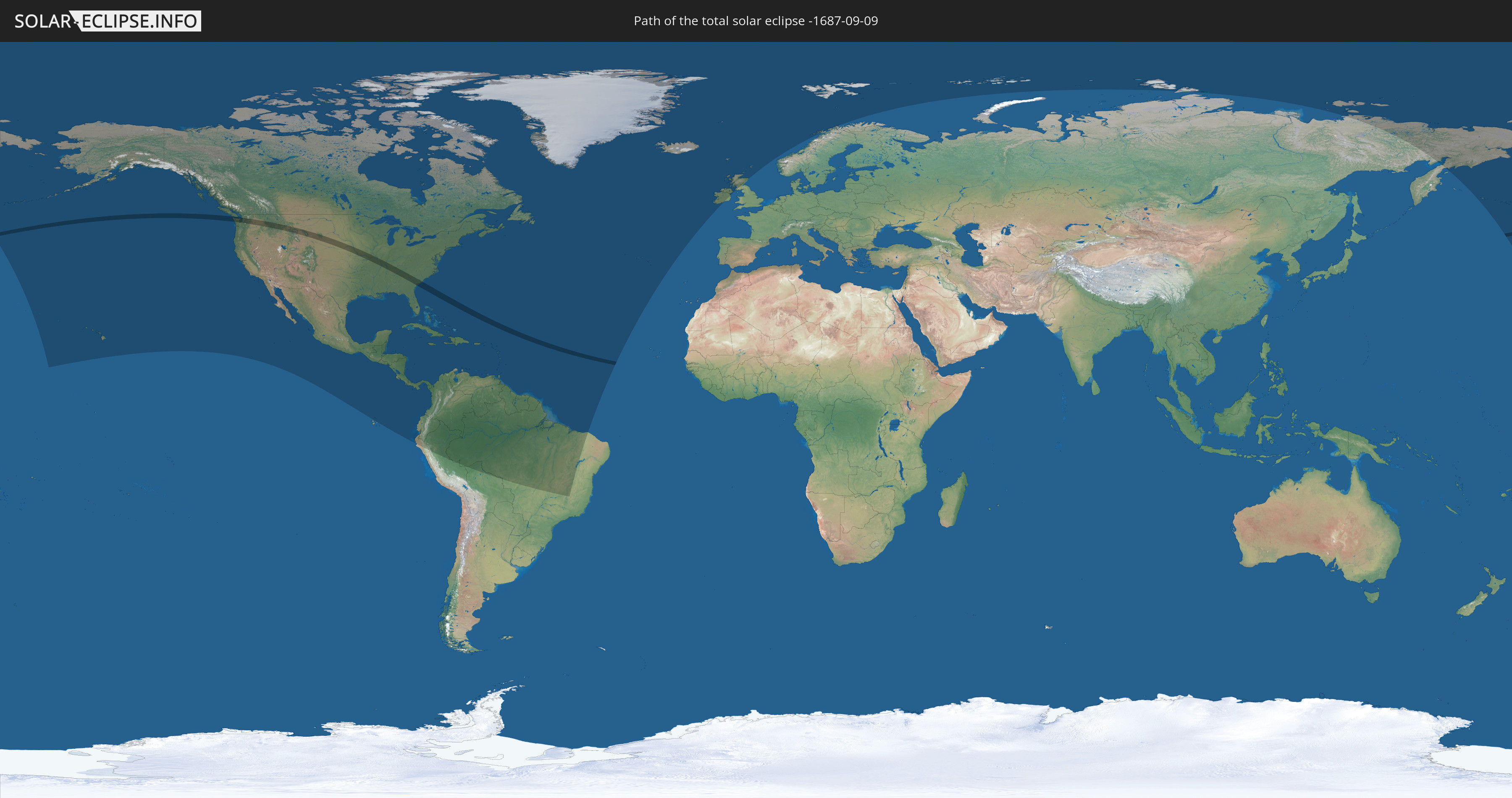
Die Sonnenfinsternis am 09/09/-1687 kann man in 56 Ländern als partielle Sonnenfinsternis beobachten.
Der Finsternispfad verläuft durch 2 Länder. Nur in diesen Ländern ist sie als total Sonnenfinsternis zu sehen.
In den folgenden Ländern ist die Sonnenfinsternis total zu sehen
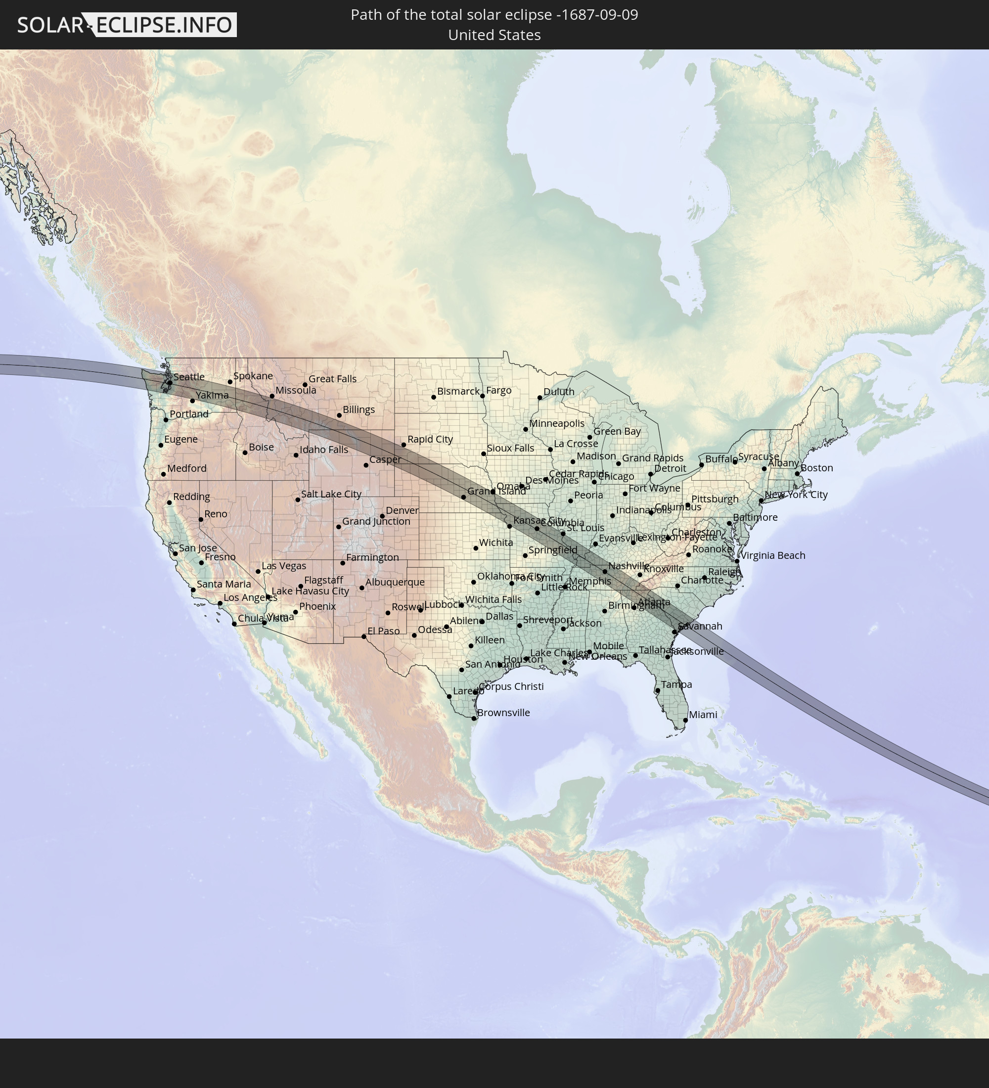 United States
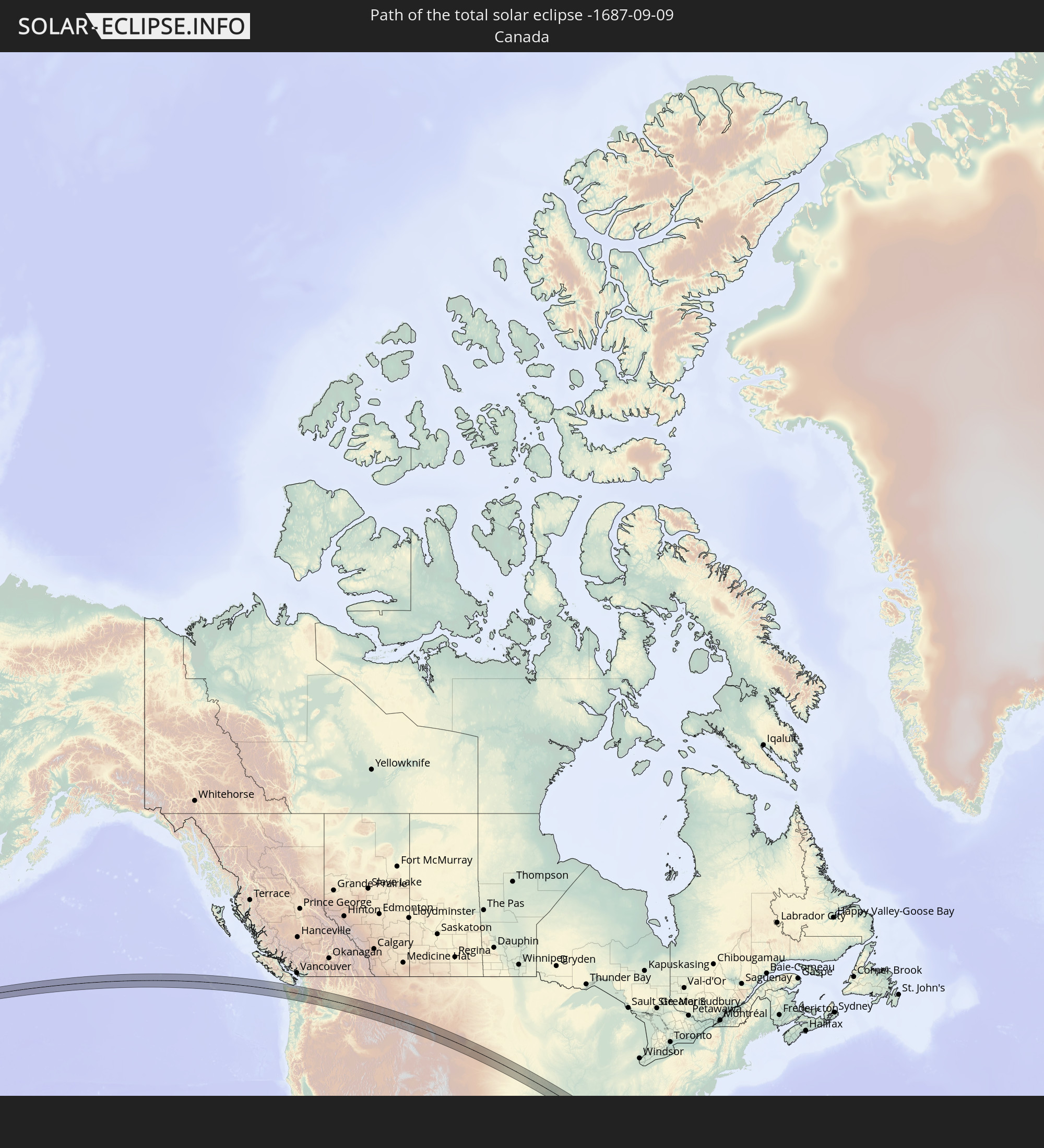 Canada
In den folgenden Ländern ist die Sonnenfinsternis partiell zu sehen
 Russia
 United States
 United States Minor Outlying Islands
 Canada
 Mexico
 Greenland
 Guatemala
 Ecuador
 El Salvador
 Honduras
 Belize
 Nicaragua
 Costa Rica
 Cuba
Cuba
 Panama
 Colombia
 Cayman Islands
 Peru
Peru
 The Bahamas
 Jamaica
 Haiti
Haiti
 Brazil
 Venezuela
 Turks and Caicos Islands
 Dominican Republic
 Aruba
Aruba
 Bolivia
 Puerto Rico
 United States Virgin Islands
 Bermuda
 British Virgin Islands
 Anguilla
 Collectivity of Saint Martin
 Saint Barthélemy
 Saint Kitts and Nevis
 Antigua and Barbuda
 Montserrat
 Trinidad and Tobago
 Guadeloupe
 Grenada
 Dominica
 Saint Vincent and the Grenadines
 Guyana
 Martinique
 Saint Lucia
 Barbados
 Suriname
 Saint Pierre and Miquelon
 French Guiana
 Portugal
 Iceland
 Republic of Ireland
 Svalbard and Jan Mayen
 United Kingdom
 Faroe Islands
 Norway
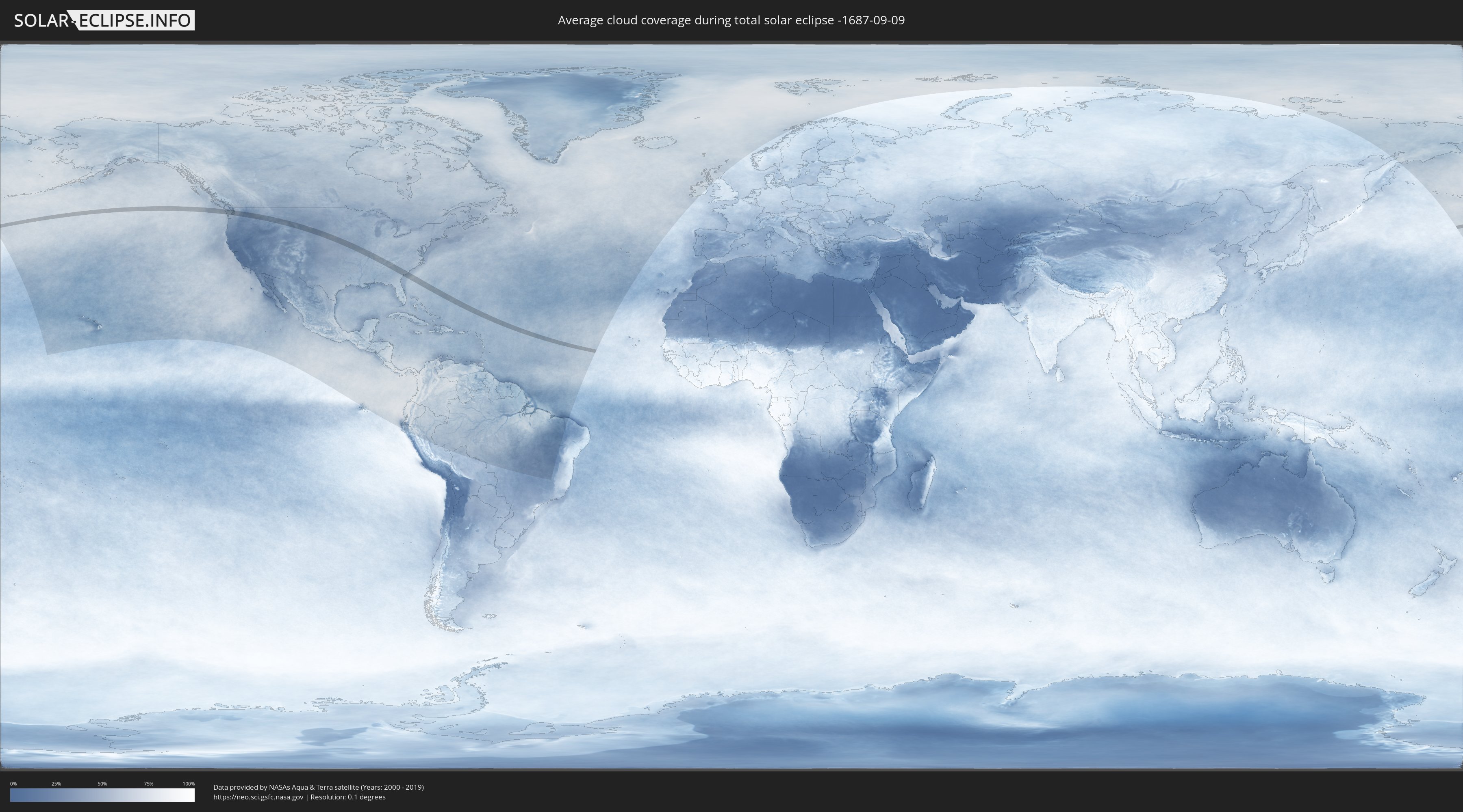
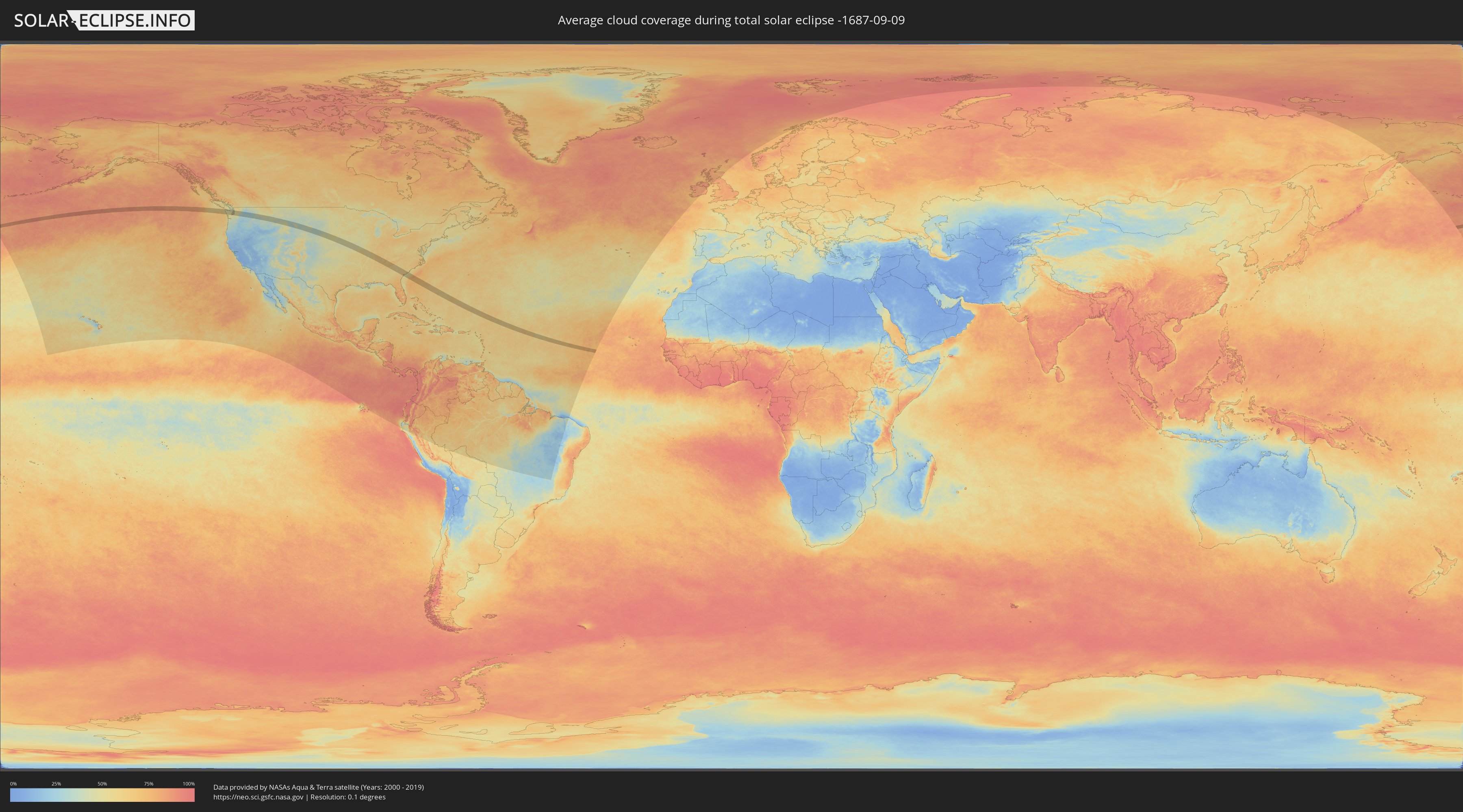
How will be the weather during the total solar eclipse on 09/09/-1687?
Where is the best place to see the total solar eclipse of 09/09/-1687?
The following maps show the average cloud coverage for the day of the total solar eclipse.
With the help of these maps, it is possible to find the place along the eclipse path, which has the best
chance of a cloudless sky.
Nevertheless, you should consider local circumstances and inform about the weather of your chosen
observation site.
The data is provided by NASAs satellites
AQUA and TERRA.
The cloud maps are averaged over a period of 19 years (2000 - 2019).
Detailed country maps
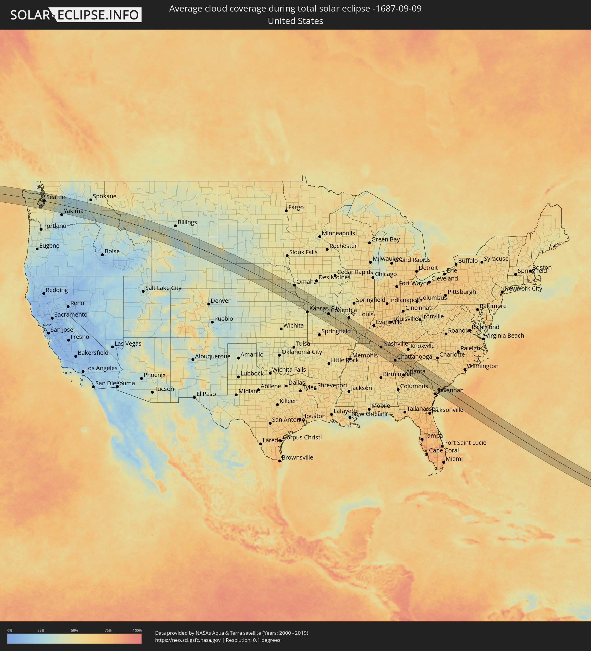 United States
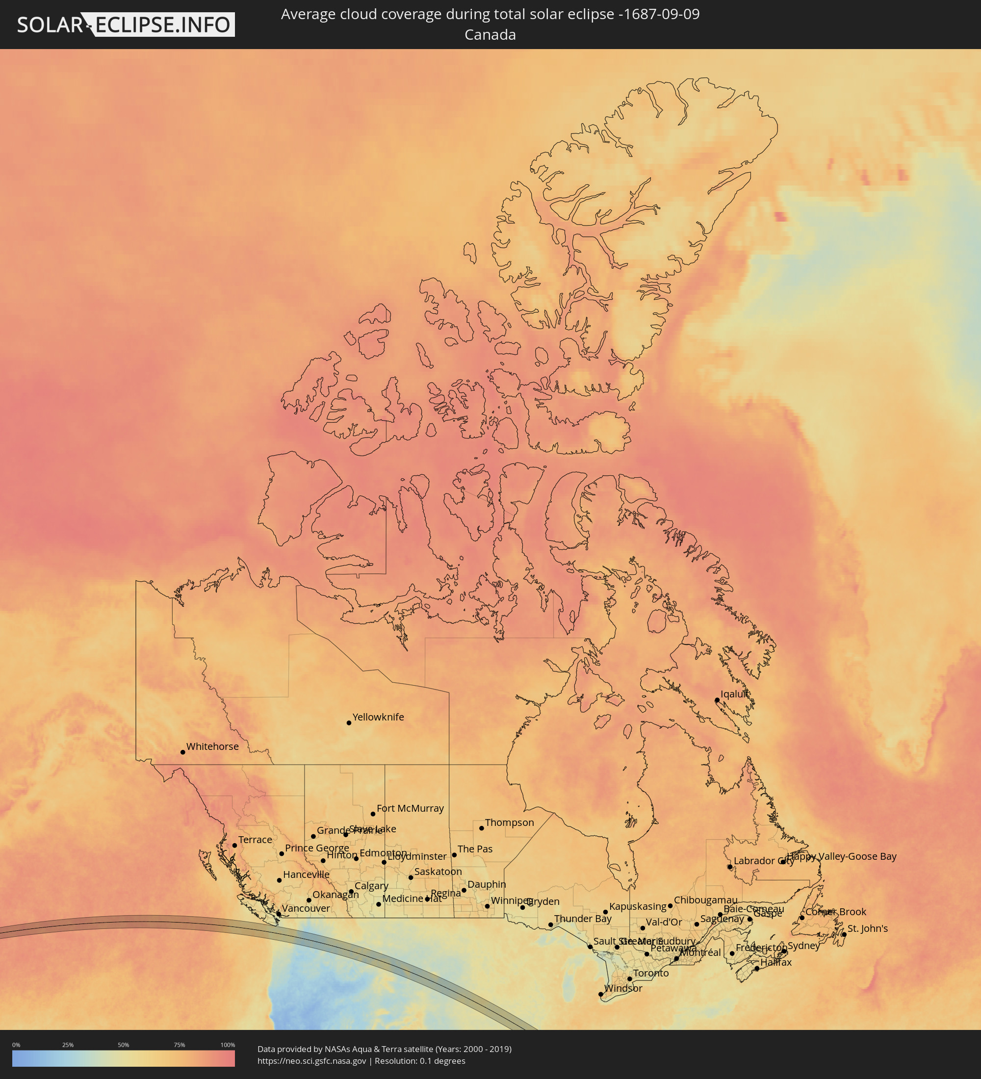 Canada
Cities inside the path of the eclipse
The following table shows all locations with a population of more than 5,000 inside the eclipse path. Cities which have more than 100,000 inhabitants are marked bold. A click at the locations opens a detailed map.
| City | Type | Eclipse duration | Local time of max. eclipse | Distance to central line | Ø Cloud coverage |
|
Port Angeles, Washington
|
total | - | 10:00:15 UTC-08:00 | 43 km | 47% |
|
Shelton, Washington
|
total | - | 10:00:23 UTC-08:00 | 52 km | 47% |
|
Port Townsend, Washington
|
total | - | 10:01:09 UTC-08:00 | 52 km | 45% |
|
Poulsbo, Washington
|
total | - | 10:01:11 UTC-08:00 | 12 km | 47% |
|
Port Orchard, Washington
|
total | - | 10:01:08 UTC-08:00 | 10 km | 48% |
|
Bremerton, Washington
|
total | - | 10:01:09 UTC-08:00 | 7 km | 46% |
|
DuPont, Washington
|
total | - | 10:01:00 UTC-08:00 | 58 km | 47% |
|
Artondale, Washington
|
total | - | 10:01:05 UTC-08:00 | 36 km | 46% |
|
Fort Lewis, Washington
|
total | - | 10:01:05 UTC-08:00 | 56 km | 47% |
|
Camano, Washington
|
total | - | 10:01:29 UTC-08:00 | 61 km | 45% |
|
Vashon, Washington
|
total | - | 10:01:21 UTC-08:00 | 17 km | 45% |
|
Tacoma, Washington
|
total | - | 10:01:19 UTC-08:00 | 38 km | 46% |
|
Klahanie, Washington
|
total | - | 10:01:23 UTC-08:00 | 19 km | 46% |
|
Midland, Washington
|
total | - | 10:01:20 UTC-08:00 | 47 km | 47% |
|
Waller, Washington
|
total | - | 10:01:24 UTC-08:00 | 43 km | 47% |
|
Summit, Washington
|
total | - | 10:01:24 UTC-08:00 | 47 km | 47% |
|
Fife, Washington
|
total | - | 10:01:26 UTC-08:00 | 38 km | 47% |
|
Shoreline, Washington
|
total | - | 10:01:37 UTC-08:00 | 18 km | 47% |
|
Seattle, Washington
|
total | - | 10:01:35 UTC-08:00 | 2 km | 48% |
|
Edgewood, Washington
|
total | - | 10:01:31 UTC-08:00 | 36 km | 48% |
|
Tulalip, Washington
|
total | - | 10:01:47 UTC-08:00 | 53 km | 46% |
|
Lakeland South, Washington
|
total | - | 10:01:33 UTC-08:00 | 33 km | 48% |
|
Alderwood Manor, Washington
|
total | - | 10:01:43 UTC-08:00 | 26 km | 47% |
|
Lake Forest Park, Washington
|
total | - | 10:01:42 UTC-08:00 | 19 km | 47% |
|
Lakeland North, Washington
|
total | - | 10:01:34 UTC-08:00 | 27 km | 48% |
|
South Hill, Washington
|
total | - | 10:01:31 UTC-08:00 | 48 km | 47% |
|
Sumner, Washington
|
total | - | 10:01:35 UTC-08:00 | 41 km | 49% |
|
Kent, Washington
|
total | - | 10:01:39 UTC-08:00 | 21 km | 48% |
|
Everett, Washington
|
total | - | 10:01:52 UTC-08:00 | 45 km | 45% |
|
Woodinville, Washington
|
total | - | 10:01:51 UTC-08:00 | 21 km | 48% |
|
Newcastle, Washington
|
total | - | 10:01:48 UTC-08:00 | 3 km | 49% |
|
Prairie Ridge, Washington
|
total | - | 10:01:41 UTC-08:00 | 46 km | 49% |
|
Redmond, Washington
|
total | - | 10:01:53 UTC-08:00 | 13 km | 50% |
|
Maltby, Washington
|
total | - | 10:01:56 UTC-08:00 | 27 km | 50% |
|
East Renton Highlands, Washington
|
total | - | 10:01:51 UTC-08:00 | 8 km | 49% |
|
Lake Morton-Berrydale, Washington
|
total | - | 10:01:49 UTC-08:00 | 25 km | 48% |
|
Snohomish, Washington
|
total | - | 10:02:00 UTC-08:00 | 39 km | 49% |
|
Issaquah, Washington
|
total | - | 10:01:58 UTC-08:00 | 2 km | 49% |
|
Enumclaw, Washington
|
total | - | 10:01:56 UTC-08:00 | 37 km | 49% |
|
Monroe, Washington
|
total | - | 10:02:09 UTC-08:00 | 34 km | 50% |
|
Snoqualmie, Washington
|
total | - | 10:02:16 UTC-08:00 | 1 km | 50% |
|
Ellensburg, Washington
|
total | - | 10:03:57 UTC-08:00 | 37 km | 34% |
|
Wenatchee, Washington
|
total | - | 10:04:23 UTC-08:00 | 13 km | 33% |
|
East Wenatchee Bench, Washington
|
total | - | 10:04:26 UTC-08:00 | 14 km | 33% |
|
Ephrata, Washington
|
total | - | 10:05:28 UTC-08:00 | 14 km | 29% |
|
Moses Lake, Washington
|
total | - | 10:05:50 UTC-08:00 | 1 km | 30% |
|
Othello, Washington
|
total | - | 10:05:56 UTC-08:00 | 32 km | 34% |
|
Pullman, Washington
|
total | - | 10:08:56 UTC-08:00 | 6 km | 35% |
|
Lewiston, Idaho
|
total | - | 10:09:10 UTC-08:00 | 37 km | 30% |
|
Anaconda, Montana
|
total | - | 11:15:39 UTC-07:00 | 20 km | 42% |
|
Butte, Montana
|
total | - | 11:16:20 UTC-07:00 | 17 km | 42% |
|
Belgrade, Montana
|
total | - | 11:18:37 UTC-07:00 | 26 km | 34% |
|
Bozeman, Montana
|
total | - | 11:18:52 UTC-07:00 | 19 km | 36% |
|
Cody, Wyoming
|
total | - | 11:22:36 UTC-07:00 | 49 km | 39% |
|
Sheridan, Wyoming
|
total | - | 11:26:08 UTC-07:00 | 39 km | 39% |
|
Gillette, Wyoming
|
total | - | 11:28:56 UTC-07:00 | 31 km | 38% |
|
Grand Island, Nebraska
|
total | - | 12:44:42 UTC-06:00 | 56 km | 49% |
|
York, Nebraska
|
total | - | 12:46:10 UTC-06:00 | 32 km | 50% |
|
Columbus, Nebraska
|
total | - | 12:45:59 UTC-06:00 | 32 km | 47% |
|
Beatrice, Nebraska
|
total | - | 12:48:23 UTC-06:00 | 57 km | 45% |
|
Lincoln, Nebraska
|
total | - | 12:47:57 UTC-06:00 | 2 km | 48% |
|
Fremont, Nebraska
|
total | - | 12:47:35 UTC-06:00 | 67 km | 45% |
|
Elkhorn, Nebraska
|
total | - | 12:48:13 UTC-06:00 | 63 km | 48% |
|
Chalco, Nebraska
|
total | - | 12:48:29 UTC-06:00 | 57 km | 48% |
|
Bellevue, Nebraska
|
total | - | 12:49:01 UTC-06:00 | 63 km | 45% |
|
Atchison, Kansas
|
total | - | 12:52:15 UTC-06:00 | 58 km | 44% |
|
Maryville, Missouri
|
total | - | 12:51:47 UTC-06:00 | 28 km | 48% |
|
Saint Joseph, Missouri
|
total | - | 12:52:31 UTC-06:00 | 27 km | 49% |
|
Smithville, Missouri
|
total | - | 12:53:28 UTC-06:00 | 52 km | 49% |
|
Liberty, Missouri
|
total | - | 12:53:57 UTC-06:00 | 59 km | 47% |
|
Kearney, Missouri
|
total | - | 12:53:54 UTC-06:00 | 45 km | 49% |
|
Cameron, Missouri
|
total | - | 12:53:40 UTC-06:00 | 4 km | 45% |
|
Excelsior Springs, Missouri
|
total | - | 12:54:12 UTC-06:00 | 42 km | 46% |
|
Oak Grove, Missouri
|
total | - | 12:54:47 UTC-06:00 | 70 km | 47% |
|
Chillicothe, Missouri
|
total | - | 12:54:52 UTC-06:00 | 31 km | 47% |
|
Sedalia, Missouri
|
total | - | 12:56:51 UTC-06:00 | 59 km | 49% |
|
Marshall, Missouri
|
total | - | 12:56:23 UTC-06:00 | 18 km | 47% |
|
Boonville, Missouri
|
total | - | 12:57:24 UTC-06:00 | 12 km | 45% |
|
Moberly, Missouri
|
total | - | 12:57:23 UTC-06:00 | 44 km | 48% |
|
Columbia, Missouri
|
total | - | 12:58:11 UTC-06:00 | 4 km | 49% |
|
Jefferson City, Missouri
|
total | - | 12:58:59 UTC-06:00 | 25 km | 51% |
|
Fulton, Missouri
|
total | - | 12:59:02 UTC-06:00 | 11 km | 48% |
|
Mexico, Missouri
|
total | - | 12:58:44 UTC-06:00 | 45 km | 47% |
|
Rolla, Missouri
|
total | - | 13:00:34 UTC-06:00 | 66 km | 56% |
|
Warrenton, Missouri
|
total | - | 13:00:33 UTC-06:00 | 44 km | 49% |
|
Washington, Missouri
|
total | - | 13:01:08 UTC-06:00 | 26 km | 49% |
|
Union, Missouri
|
total | - | 13:01:17 UTC-06:00 | 16 km | 55% |
|
Troy, Missouri
|
total | - | 13:00:37 UTC-06:00 | 67 km | 50% |
|
Dardenne Prairie, Missouri
|
total | - | 13:01:21 UTC-06:00 | 59 km | 55% |
|
O'Fallon, Missouri
|
total | - | 13:01:21 UTC-06:00 | 64 km | 55% |
|
Eureka, Missouri
|
total | - | 13:01:54 UTC-06:00 | 38 km | 54% |
|
Ellisville, Missouri
|
total | - | 13:01:51 UTC-06:00 | 48 km | 54% |
|
Chesterfield, Missouri
|
total | - | 13:01:46 UTC-06:00 | 56 km | 55% |
|
Park Hills, Missouri
|
total | - | 13:03:00 UTC-06:00 | 18 km | 60% |
|
Murphy, Missouri
|
total | - | 13:02:11 UTC-06:00 | 43 km | 55% |
|
Town and Country, Missouri
|
total | - | 13:02:03 UTC-06:00 | 56 km | 55% |
|
Des Peres, Missouri
|
total | - | 13:02:07 UTC-06:00 | 56 km | 55% |
|
Farmington, Missouri
|
total | - | 13:03:17 UTC-06:00 | 21 km | 59% |
|
Sunset Hills, Missouri
|
total | - | 13:02:15 UTC-06:00 | 52 km | 55% |
|
Kirkwood, Missouri
|
total | - | 13:02:11 UTC-06:00 | 56 km | 55% |
|
Festus, Missouri
|
total | - | 13:02:43 UTC-06:00 | 22 km | 57% |
|
Saint Ann, Missouri
|
total | - | 13:02:02 UTC-06:00 | 70 km | 56% |
|
Crestwood, Missouri
|
total | - | 13:02:16 UTC-06:00 | 54 km | 55% |
|
Ladue, Missouri
|
total | - | 13:02:09 UTC-06:00 | 63 km | 55% |
|
Sappington, Missouri
|
total | - | 13:02:18 UTC-06:00 | 53 km | 55% |
|
Olivette, Missouri
|
total | - | 13:02:08 UTC-06:00 | 65 km | 56% |
|
Brentwood, Missouri
|
total | - | 13:02:15 UTC-06:00 | 62 km | 55% |
|
Maplewood, Missouri
|
total | - | 13:02:18 UTC-06:00 | 62 km | 55% |
|
Richmond Heights, Missouri
|
total | - | 13:02:17 UTC-06:00 | 64 km | 55% |
|
Oakville, Missouri
|
total | - | 13:02:32 UTC-06:00 | 50 km | 54% |
|
Columbia, Illinois
|
total | - | 13:02:45 UTC-06:00 | 52 km | 54% |
|
St. Louis, Missouri
|
total | - | 13:02:30 UTC-06:00 | 70 km | 55% |
|
Waterloo, Illinois
|
total | - | 13:03:00 UTC-06:00 | 44 km | 56% |
|
Belleville, Illinois
|
total | - | 13:03:02 UTC-06:00 | 69 km | 56% |
|
Perryville, Missouri
|
total | - | 13:04:23 UTC-06:00 | 0 km | 57% |
|
Chester, Illinois
|
total | - | 13:04:11 UTC-06:00 | 19 km | 51% |
|
Jackson, Missouri
|
total | - | 13:05:13 UTC-06:00 | 23 km | 57% |
|
Sikeston, Missouri
|
total | - | 13:06:06 UTC-06:00 | 68 km | 61% |
|
Cape Girardeau, Missouri
|
total | - | 13:05:36 UTC-06:00 | 24 km | 53% |
|
Murphysboro, Illinois
|
total | - | 13:05:16 UTC-06:00 | 28 km | 58% |
|
Carbondale, Illinois
|
total | - | 13:05:32 UTC-06:00 | 30 km | 53% |
|
Herrin, Illinois
|
total | - | 13:05:46 UTC-06:00 | 46 km | 57% |
|
Marion, Illinois
|
total | - | 13:06:02 UTC-06:00 | 44 km | 57% |
|
West Frankfort, Illinois
|
total | - | 13:05:48 UTC-06:00 | 60 km | 59% |
|
Mayfield, Kentucky
|
total | - | 13:08:01 UTC-06:00 | 35 km | 59% |
|
Paducah, Kentucky
|
total | - | 13:07:35 UTC-06:00 | 1 km | 56% |
|
Harrisburg, Illinois
|
total | - | 13:06:44 UTC-06:00 | 63 km | 61% |
|
Paris, Tennessee
|
total | - | 13:09:14 UTC-06:00 | 62 km | 60% |
|
Murray, Kentucky
|
total | - | 13:08:48 UTC-06:00 | 32 km | 65% |
|
Hopkinsville, Kentucky
|
total | - | 13:09:53 UTC-06:00 | 31 km | 68% |
|
Fort Campbell North, Kentucky
|
total | - | 13:10:15 UTC-06:00 | 13 km | 65% |
|
Oak Grove, Kentucky
|
total | - | 13:10:16 UTC-06:00 | 15 km | 66% |
|
Dickson, Tennessee
|
total | - | 13:11:15 UTC-06:00 | 37 km | 65% |
|
Clarksville, Tennessee
|
total | - | 13:10:37 UTC-06:00 | 6 km | 61% |
|
Fairview, Tennessee
|
total | - | 13:11:52 UTC-06:00 | 33 km | 60% |
|
Columbia, Tennessee
|
total | - | 13:12:35 UTC-06:00 | 64 km | 63% |
|
Spring Hill, Tennessee
|
total | - | 13:12:34 UTC-06:00 | 46 km | 65% |
|
Springfield, Tennessee
|
total | - | 13:11:29 UTC-06:00 | 27 km | 64% |
|
Franklin, Tennessee
|
total | - | 13:12:25 UTC-06:00 | 26 km | 63% |
|
Lewisburg, Tennessee
|
total | - | 13:13:17 UTC-06:00 | 67 km | 64% |
|
Nashville, Tennessee
|
total | - | 13:12:11 UTC-06:00 | 0 km | 67% |
|
White House, Tennessee
|
total | - | 13:11:57 UTC-06:00 | 35 km | 62% |
|
Hendersonville, Tennessee
|
total | - | 13:12:16 UTC-06:00 | 21 km | 59% |
|
Franklin, Kentucky
|
total | - | 13:11:42 UTC-06:00 | 62 km | 69% |
|
Smyrna, Tennessee
|
total | - | 13:12:56 UTC-06:00 | 4 km | 64% |
|
Portland, Tennessee
|
total | - | 13:12:01 UTC-06:00 | 52 km | 64% |
|
Shelbyville, Tennessee
|
total | - | 13:13:49 UTC-06:00 | 48 km | 65% |
|
Gallatin, Tennessee
|
total | - | 13:12:26 UTC-06:00 | 38 km | 58% |
|
Murfreesboro, Tennessee
|
total | - | 13:13:22 UTC-06:00 | 10 km | 64% |
|
Lebanon, Tennessee
|
total | - | 13:12:59 UTC-06:00 | 28 km | 65% |
|
Tullahoma, Tennessee
|
total | - | 13:14:27 UTC-06:00 | 47 km | 62% |
|
Winchester, Tennessee
|
total | - | 13:14:54 UTC-06:00 | 58 km | 62% |
|
Manchester, Tennessee
|
total | - | 13:14:28 UTC-06:00 | 29 km | 60% |
|
McMinnville, Tennessee
|
total | - | 13:14:43 UTC-06:00 | 5 km | 62% |
|
Cookeville, Tennessee
|
total | - | 13:14:25 UTC-06:00 | 63 km | 66% |
|
Signal Mountain, Tennessee
|
total | - | 14:16:20 UTC-05:00 | 26 km | 62% |
|
Chattanooga, Tennessee
|
total | - | 14:16:31 UTC-05:00 | 31 km | 64% |
|
Red Bank, Tennessee
|
total | - | 14:16:26 UTC-05:00 | 24 km | 62% |
|
Fort Oglethorpe, Georgia
|
total | - | 14:16:46 UTC-05:00 | 38 km | 65% |
|
Soddy-Daisy, Tennessee
|
total | - | 14:16:25 UTC-05:00 | 8 km | 61% |
|
Middle Valley, Tennessee
|
total | - | 14:16:29 UTC-05:00 | 11 km | 61% |
|
East Brainerd, Tennessee
|
total | - | 14:16:52 UTC-05:00 | 28 km | 65% |
|
Harrison, Tennessee
|
total | - | 14:16:42 UTC-05:00 | 17 km | 64% |
|
Collegedale, Tennessee
|
total | - | 14:16:57 UTC-05:00 | 18 km | 64% |
|
Crossville, Tennessee
|
total | - | 13:15:34 UTC-06:00 | 67 km | 68% |
|
Dalton, Georgia
|
total | - | 14:17:32 UTC-05:00 | 40 km | 64% |
|
Calhoun, Georgia
|
total | - | 14:18:00 UTC-05:00 | 64 km | 64% |
|
Cleveland, Tennessee
|
total | - | 14:17:05 UTC-05:00 | 1 km | 64% |
|
Athens, Tennessee
|
total | - | 14:17:07 UTC-05:00 | 41 km | 60% |
|
Canton, Georgia
|
total | - | 14:19:13 UTC-05:00 | 66 km | 61% |
|
Johns Creek, Georgia
|
total | - | 14:20:04 UTC-05:00 | 70 km | 62% |
|
Sugar Hill, Georgia
|
total | - | 14:20:13 UTC-05:00 | 55 km | 63% |
|
Buford, Georgia
|
total | - | 14:20:15 UTC-05:00 | 52 km | 63% |
|
Lawrenceville, Georgia
|
total | - | 14:20:32 UTC-05:00 | 66 km | 62% |
|
Gainesville, Georgia
|
total | - | 14:20:16 UTC-05:00 | 26 km | 59% |
|
Braselton, Georgia
|
total | - | 14:20:40 UTC-05:00 | 41 km | 60% |
|
Winder, Georgia
|
total | - | 14:20:56 UTC-05:00 | 49 km | 59% |
|
Monroe, Georgia
|
total | - | 14:21:16 UTC-05:00 | 67 km | 58% |
|
Jefferson, Georgia
|
total | - | 14:20:59 UTC-05:00 | 30 km | 59% |
|
Country Club Estates, Georgia
|
total | - | 14:21:28 UTC-05:00 | 34 km | 60% |
|
Athens, Georgia
|
total | - | 14:21:34 UTC-05:00 | 35 km | 60% |
|
Toccoa, Georgia
|
total | - | 14:20:38 UTC-05:00 | 25 km | 60% |
|
Seneca, South Carolina
|
total | - | 14:21:05 UTC-05:00 | 54 km | 55% |
|
Clemson, South Carolina
|
total | - | 14:21:17 UTC-05:00 | 60 km | 54% |
|
Anderson, South Carolina
|
total | - | 14:21:53 UTC-05:00 | 52 km | 58% |
|
Grovetown, Georgia
|
total | - | 14:24:22 UTC-05:00 | 22 km | 58% |
|
Greenwood, South Carolina
|
total | - | 14:23:12 UTC-05:00 | 49 km | 59% |
|
Evans, Georgia
|
total | - | 14:24:21 UTC-05:00 | 11 km | 61% |
|
Augusta, Georgia
|
total | - | 14:24:42 UTC-05:00 | 9 km | 60% |
|
Aiken, South Carolina
|
total | - | 14:24:58 UTC-05:00 | 13 km | 59% |
|
Bluffton, South Carolina
|
total | - | 14:28:35 UTC-05:00 | 65 km | 61% |
|
Orangeburg, South Carolina
|
total | - | 14:26:29 UTC-05:00 | 51 km | 59% |
|
Hilton Head Island, South Carolina
|
total | - | 14:28:47 UTC-05:00 | 62 km | 55% |
|
Port Royal, South Carolina
|
total | - | 14:28:36 UTC-05:00 | 44 km | 61% |
|
Beaufort, South Carolina
|
total | - | 14:28:33 UTC-05:00 | 37 km | 61% |
|
Summerville, South Carolina
|
total | - | 14:28:21 UTC-05:00 | 43 km | 66% |
|
Sangaree, South Carolina
|
total | - | 14:28:24 UTC-05:00 | 47 km | 66% |
|
Hanahan, South Carolina
|
total | - | 14:28:46 UTC-05:00 | 41 km | 65% |
|
Moncks Corner, South Carolina
|
total | - | 14:28:18 UTC-05:00 | 67 km | 58% |
|
Charleston, South Carolina
|
total | - | 14:29:09 UTC-05:00 | 33 km | 62% |