Totale Sonnenfinsternis vom 14.03.-1771
| Wochentag: | Donnerstag |
| Maximale Dauer der Verfinsterung: | 05m39s |
| Maximale Breite des Finsternispfades: | 227 km |
| Saroszyklus: | 11 |
| Bedeckungsgrad: | 100% |
| Magnitude: | 1.0696 |
| Gamma: | -0.0696 |
Wo kann man die Sonnenfinsternis vom 14.03.-1771 sehen?
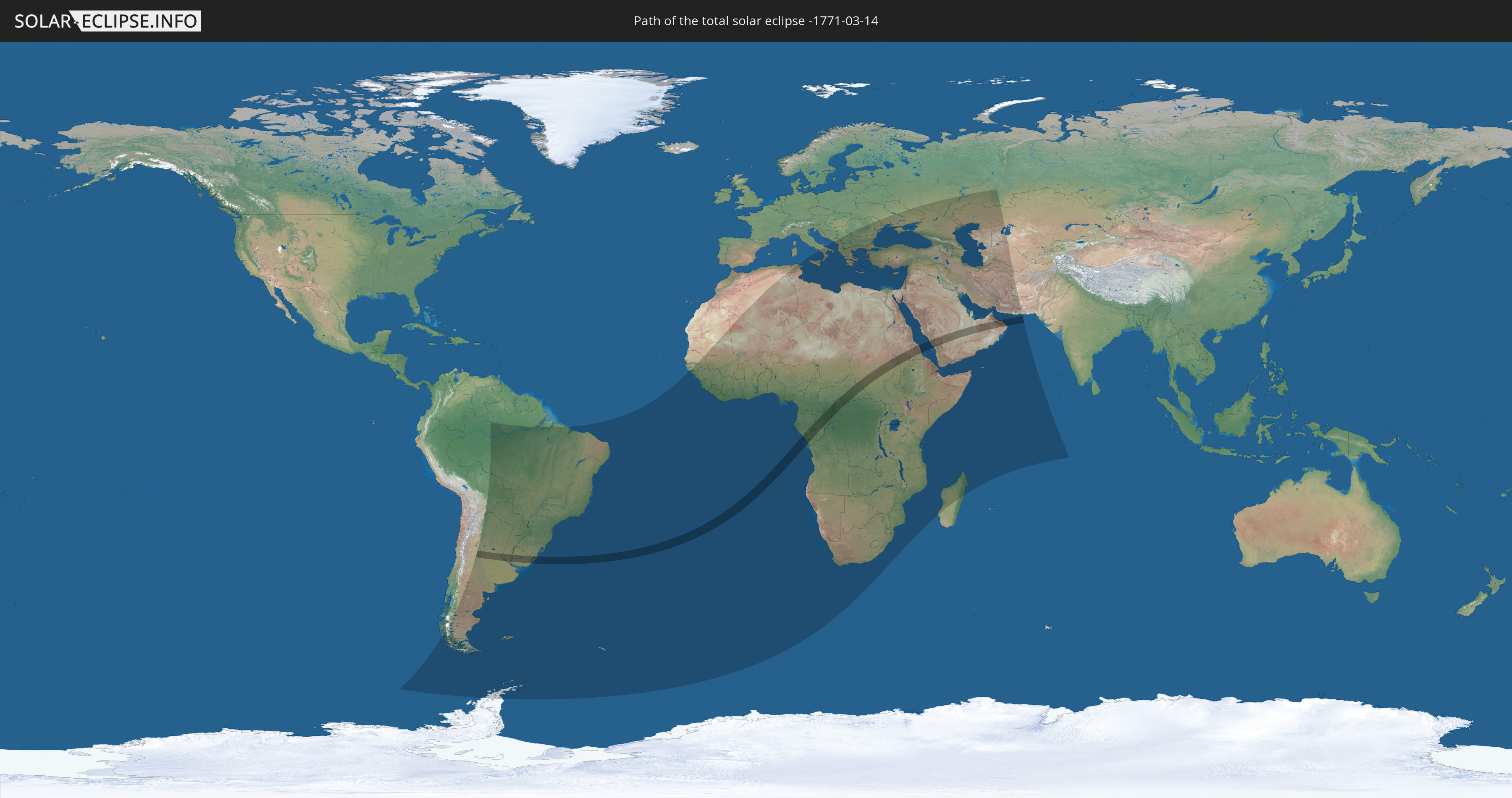
Die Sonnenfinsternis am 14.03.-1771 kann man in 102 Ländern als partielle Sonnenfinsternis beobachten.
Der Finsternispfad verläuft durch 14 Länder. Nur in diesen Ländern ist sie als totale Sonnenfinsternis zu sehen.
In den folgenden Ländern ist die Sonnenfinsternis total zu sehen
 Brasilien
 Argentinien
 Uruguay
 Gabun
Gabun
 Republik Kongo
 Angola
 Demokratische Republik Kongo
 Zentralafrikanische Republik
 Sudan
Sudan
 Südsudan
 Saudi-Arabien
 Eritrea
 Vereinigte Arabische Emirate
 Oman
Oman
In den folgenden Ländern ist die Sonnenfinsternis partiell zu sehen
 Russland
 Antarktika
 Chile
Chile
 Brasilien
 Argentinien
 Bolivien
 Paraguay
 Falklandinseln
 Uruguay
 Südgeorgien und die Südlichen Sandwichinseln
 Senegal
 Mauretanien
 Gambia
 Guinea-Bissau
 Guinea
 St. Helena
 Sierra Leone
 Mali
Mali
 Liberia
 Algerien
 Elfenbeinküste
 Burkina Faso
 Ghana
Ghana
 Togo
Togo
 Niger
Niger
 Benin
Benin
 Nigeria
 Bouvetinsel
 Äquatorialguinea
 São Tomé und Príncipe
 Italien
 Tunesien
 Kamerun
 Gabun
Gabun
 Libyen
 Republik Kongo
 Angola
 Namibia
 Demokratische Republik Kongo
 Tschad
 Kroatien
 Malta
Malta
 Zentralafrikanische Republik
 Südafrika
 Montenegro
 Serbien
 Albanien
 Griechenland
 Botswana
 Rumänien
 Mazedonien
 Sudan
Sudan
 Sambia
 Ukraine
 Bulgarien
 Ägypten
 Simbabwe
 Türkei
 Moldawien
 Lesotho
 Ruanda
 Burundi
 Tansania
 Uganda
 Mosambik
 Swasiland
 Republik Zypern
 Malawi
 Äthiopien
 Kenia
Kenia
 Staat Palästina
 Israel
 Saudi-Arabien
 Jordanien
 Libanon
 Syrien
 Eritrea
 Irak
Irak
 Georgien
 Französische Süd- und Antarktisgebiete
 Somalia
 Dschibuti
 Jemen
Jemen
 Madagaskar
 Komoren
 Armenien
 Iran
Iran
 Aserbaidschan
 Mayotte
 Seychellen
 Kasachstan
 Kuwait
 Bahrain
 Katar
Katar
 Vereinigte Arabische Emirate
 Oman
Oman
 Turkmenistan
 Usbekistan
 Mauritius
 Afghanistan
 Pakistan
 Britisches Territorium im Indischen Ozean
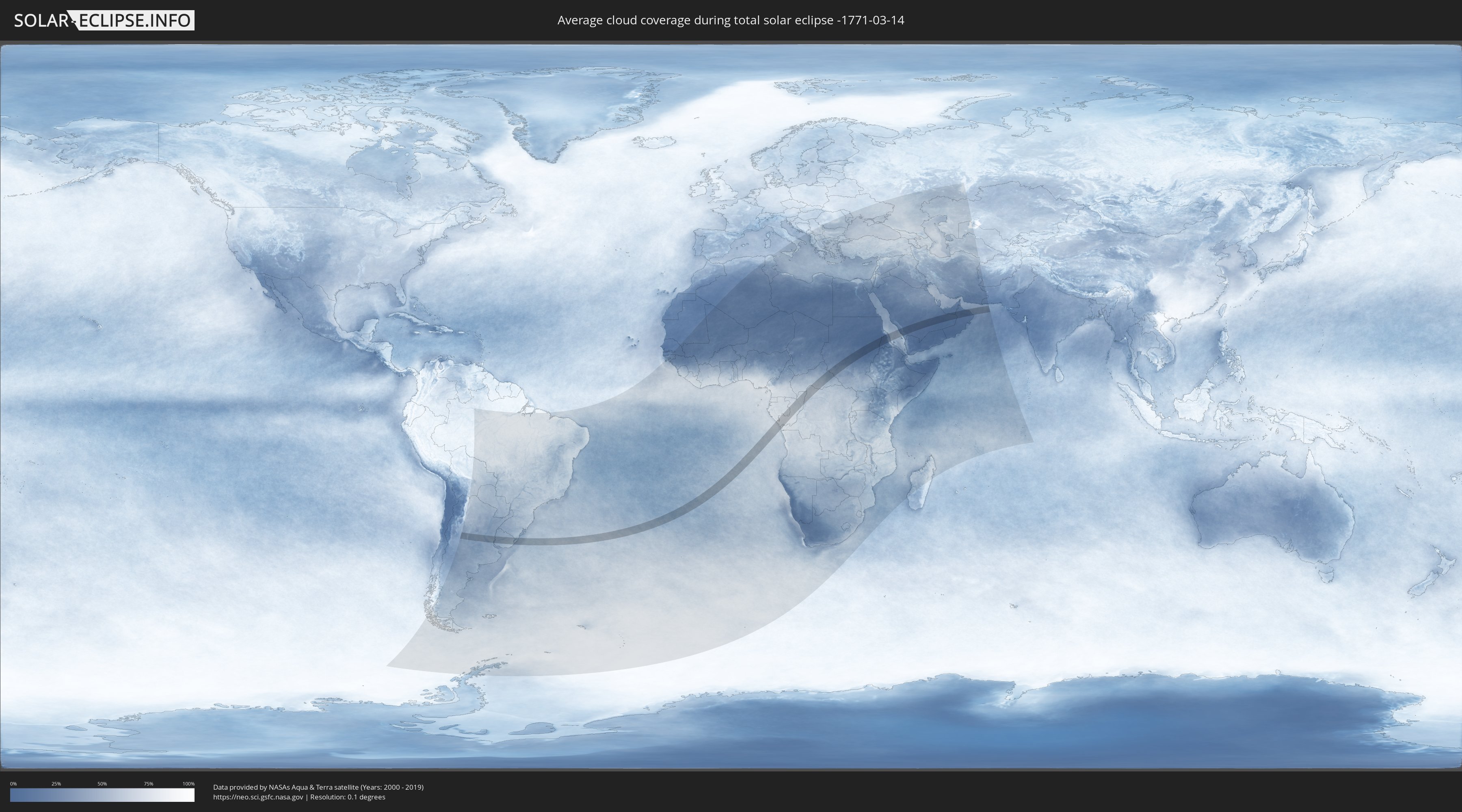
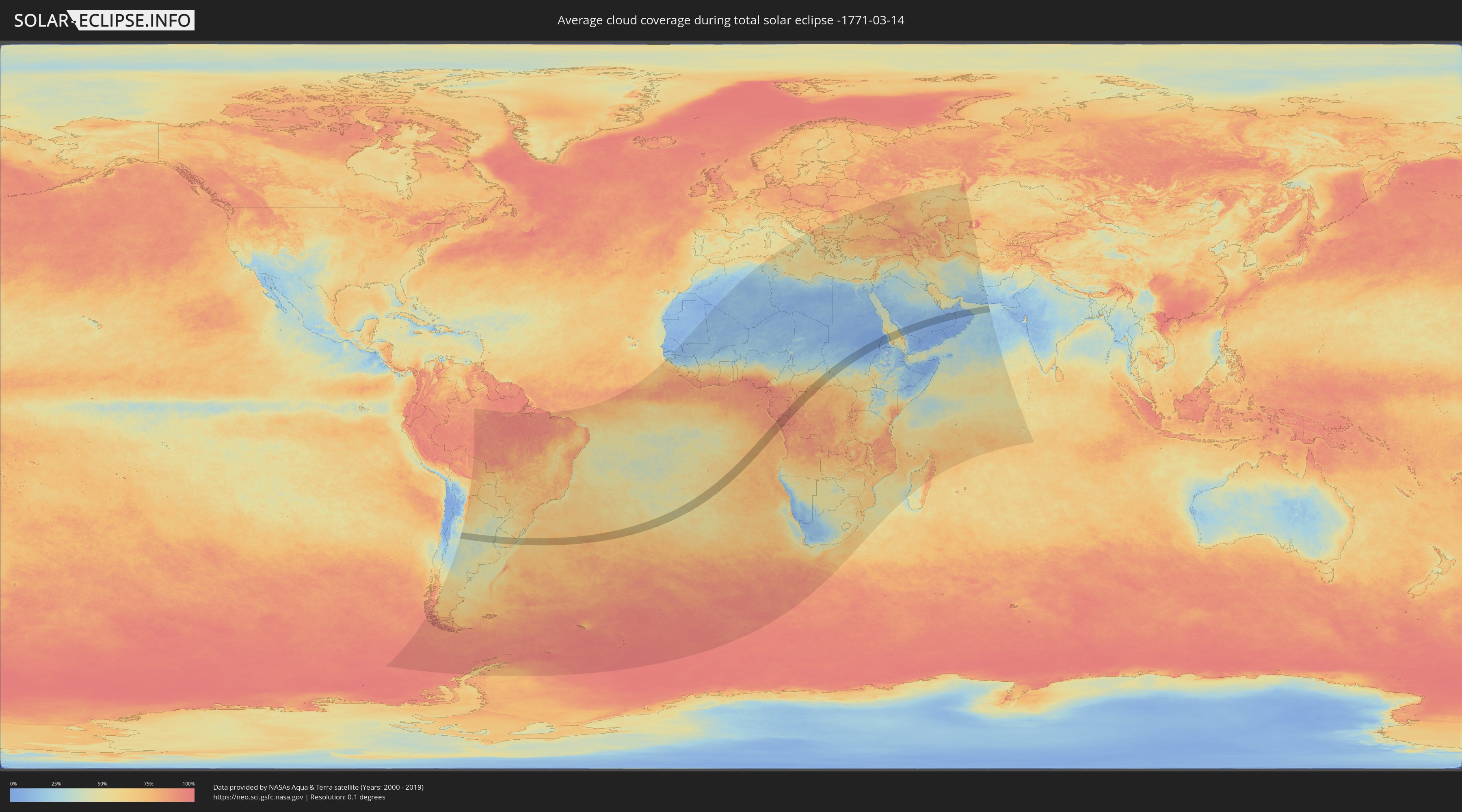
Wie wird das Wetter während der totalen Sonnenfinsternis am 14.03.-1771?
Wo ist der beste Ort, um die totale Sonnenfinsternis vom 14.03.-1771 zu beobachten?
Die folgenden Karten zeigen die durchschnittliche Bewölkung für den Tag, an dem die totale Sonnenfinsternis
stattfindet. Mit Hilfe der Karten lässt sich der Ort entlang des Finsternispfades eingrenzen,
der die besten Aussichen auf einen klaren wolkenfreien Himmel bietet.
Trotzdem muss man immer lokale Gegenenheiten beachten und sollte sich genau über das Wetter an seinem
gewählten Beobachtungsort informieren.
Die Daten stammen von den beiden NASA-Satelliten
AQUA und TERRA
und wurden über einen Zeitraum von 19 Jahren (2000 - 2019) gemittelt.
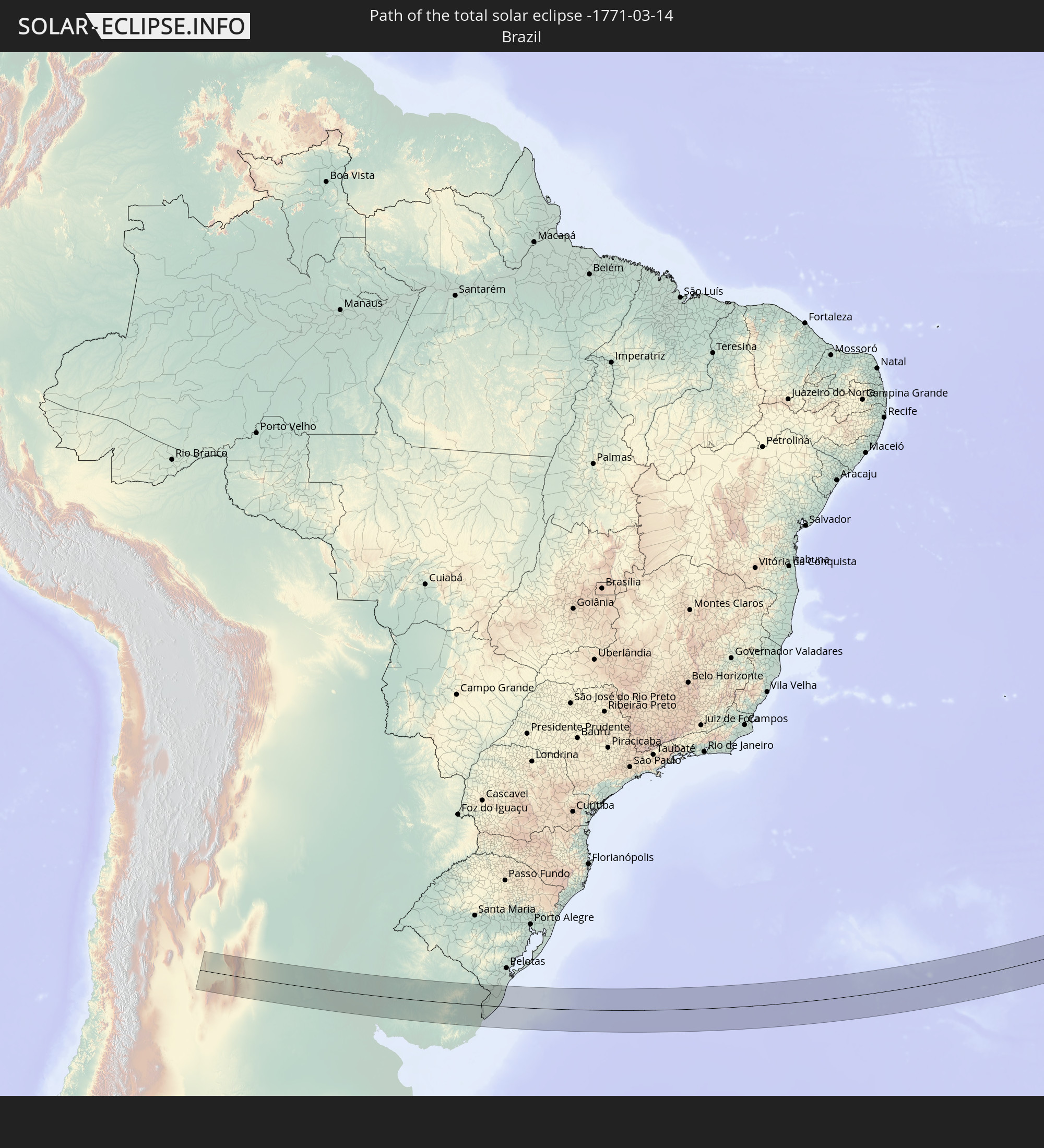
Detaillierte Länderkarten
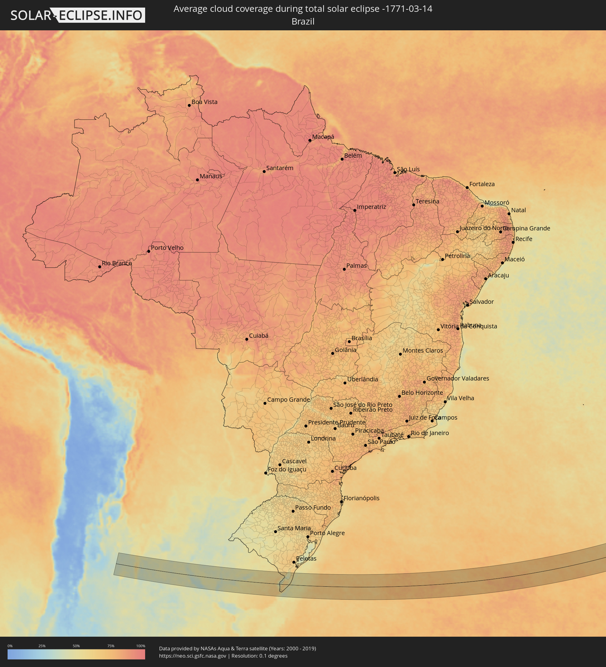 Brasilien
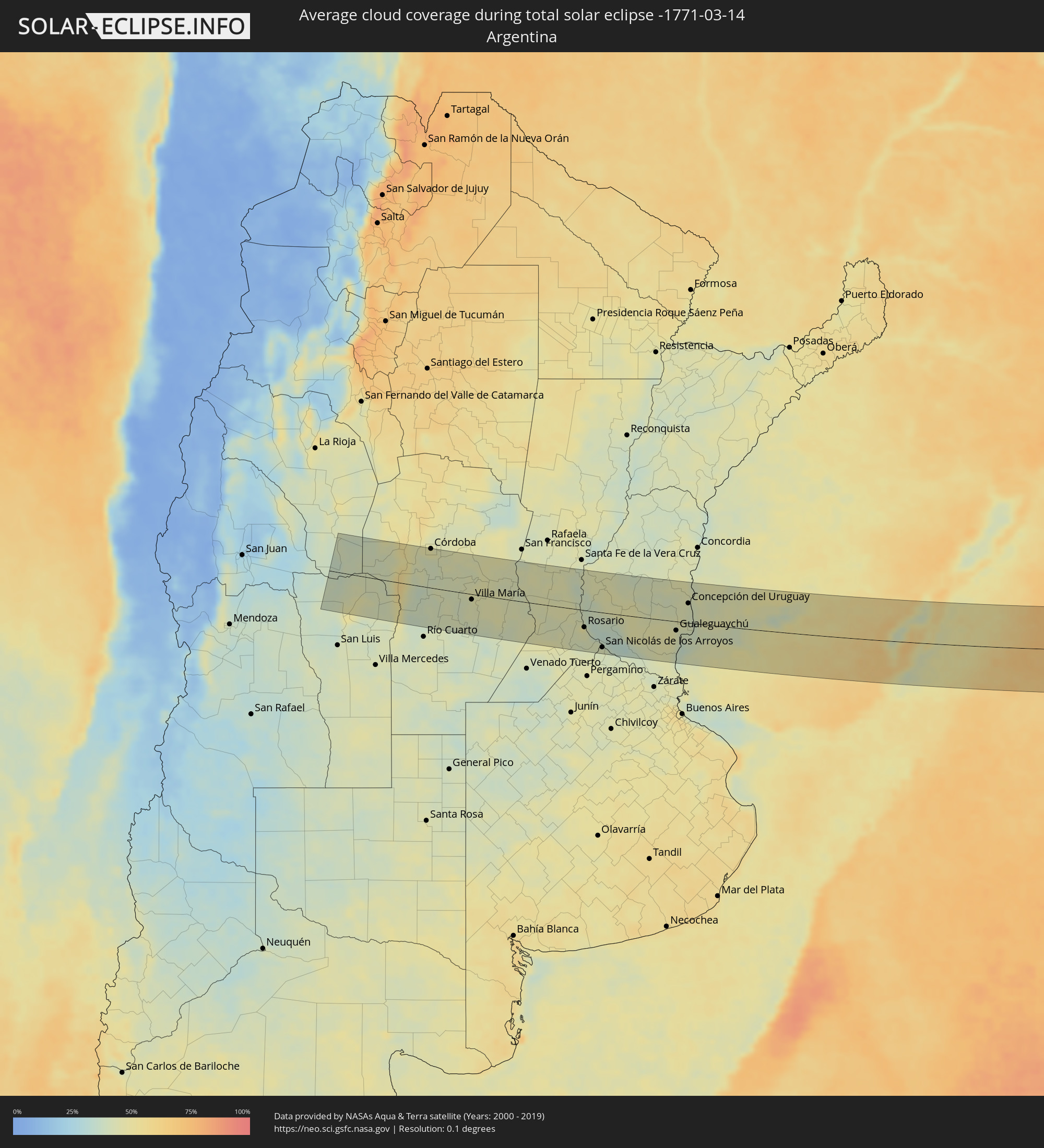 Argentinien
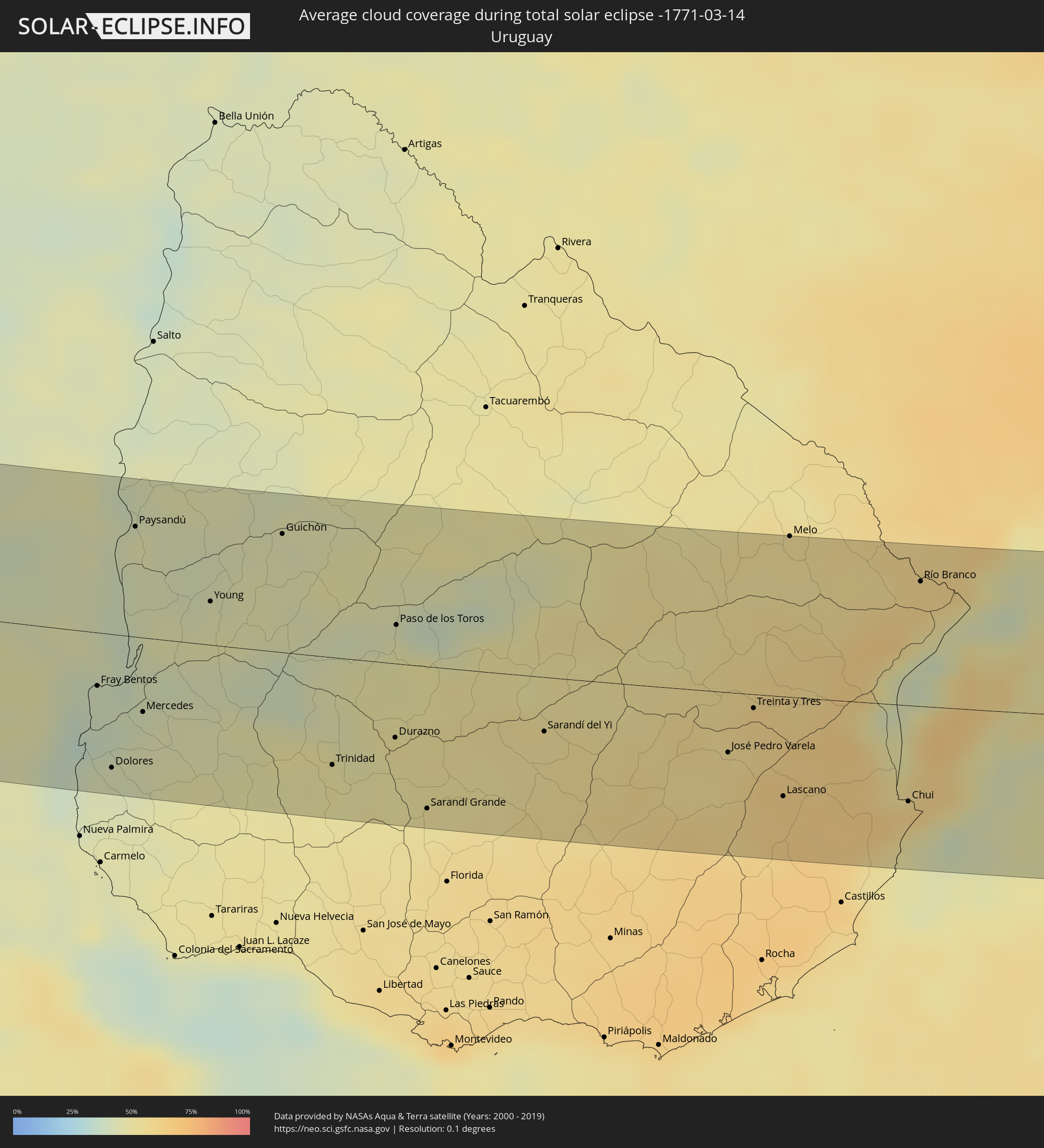 Uruguay
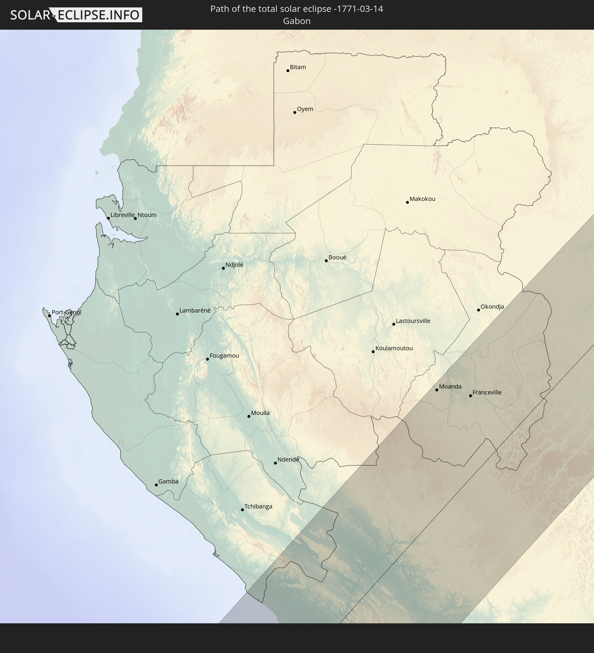
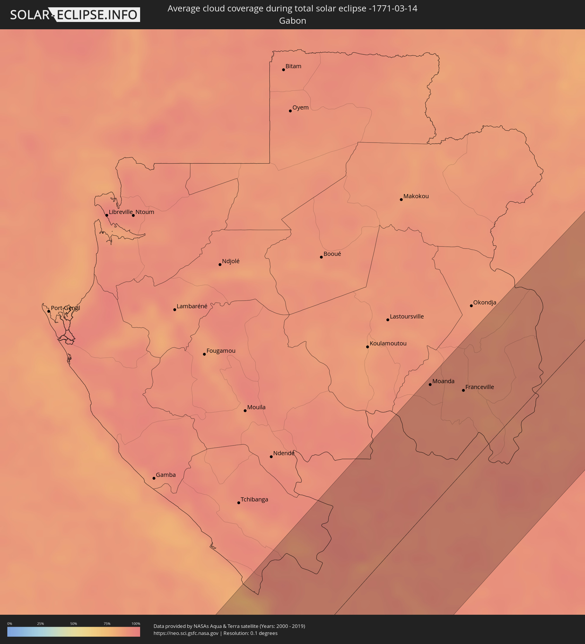 Gabun
Gabun
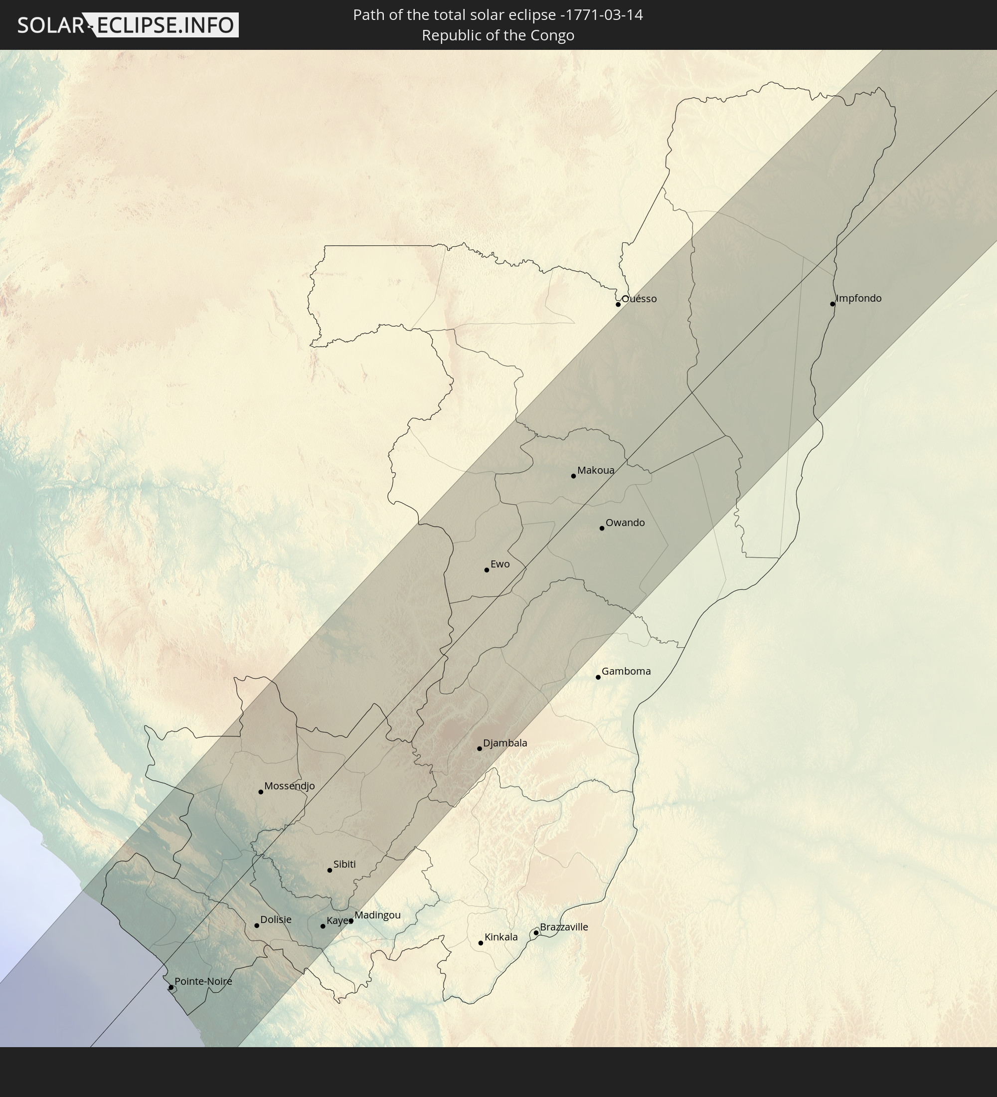
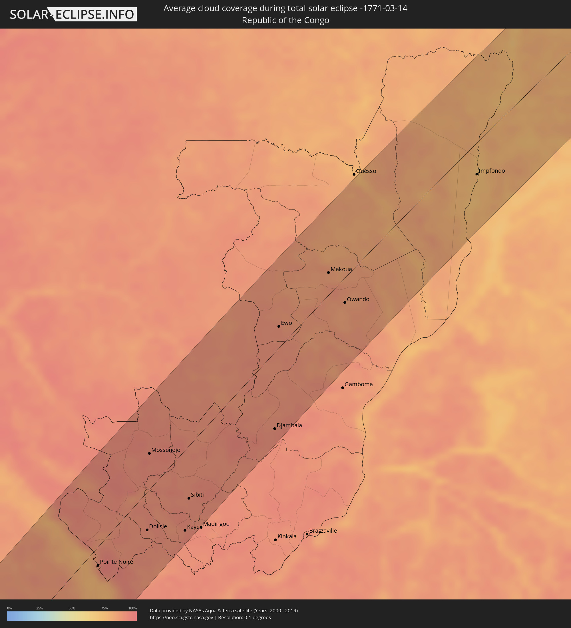 Republik Kongo
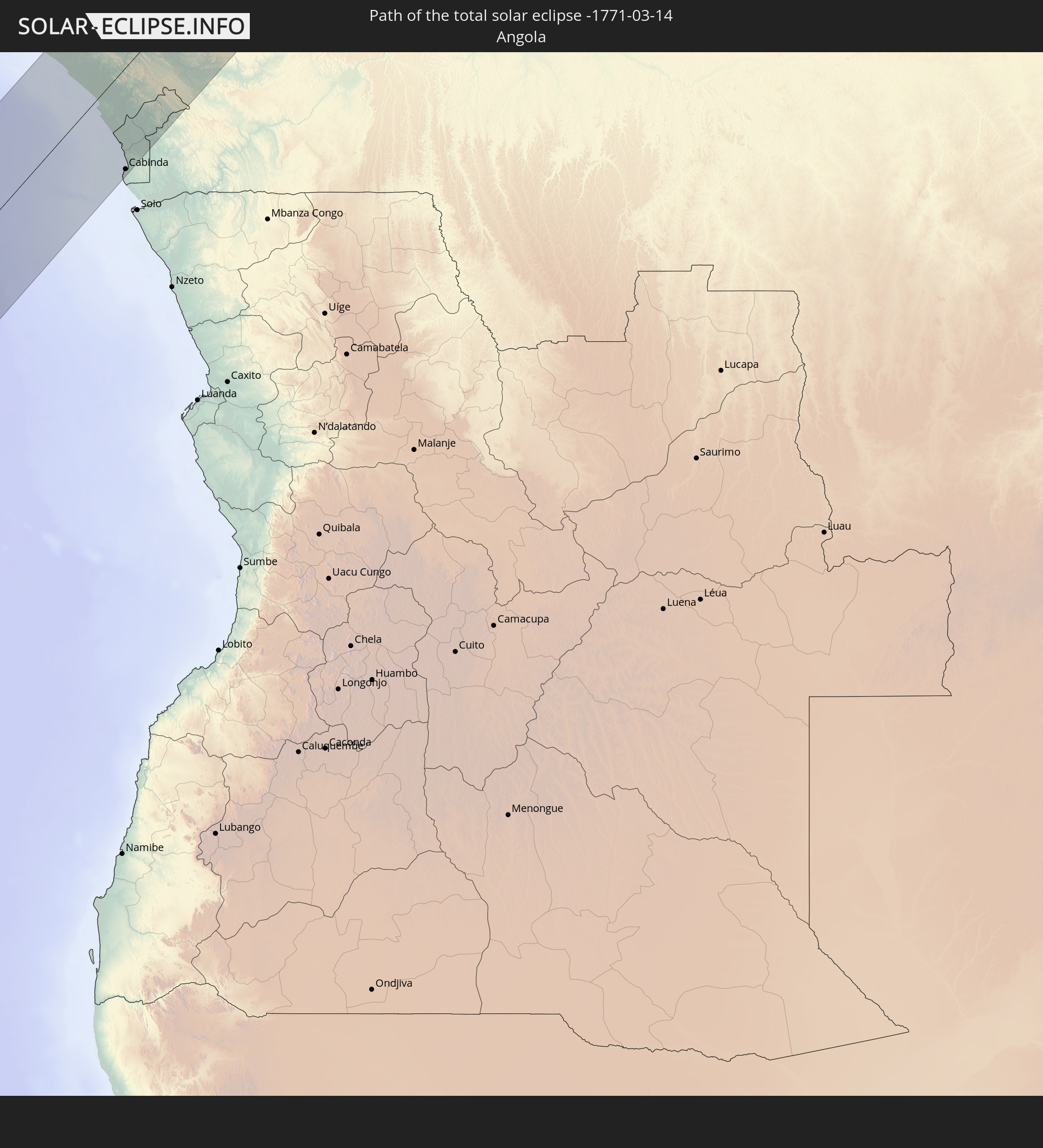
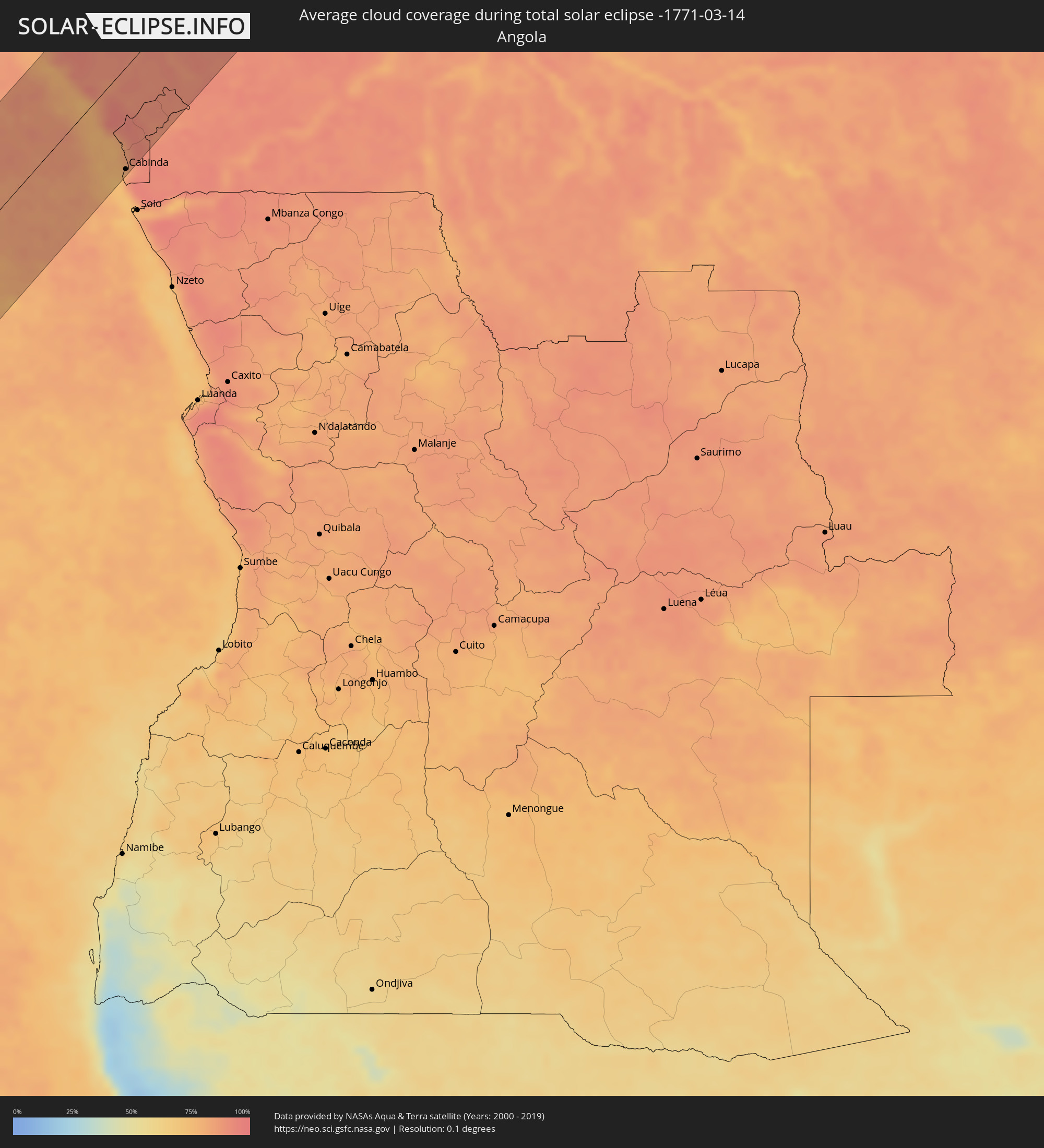 Angola
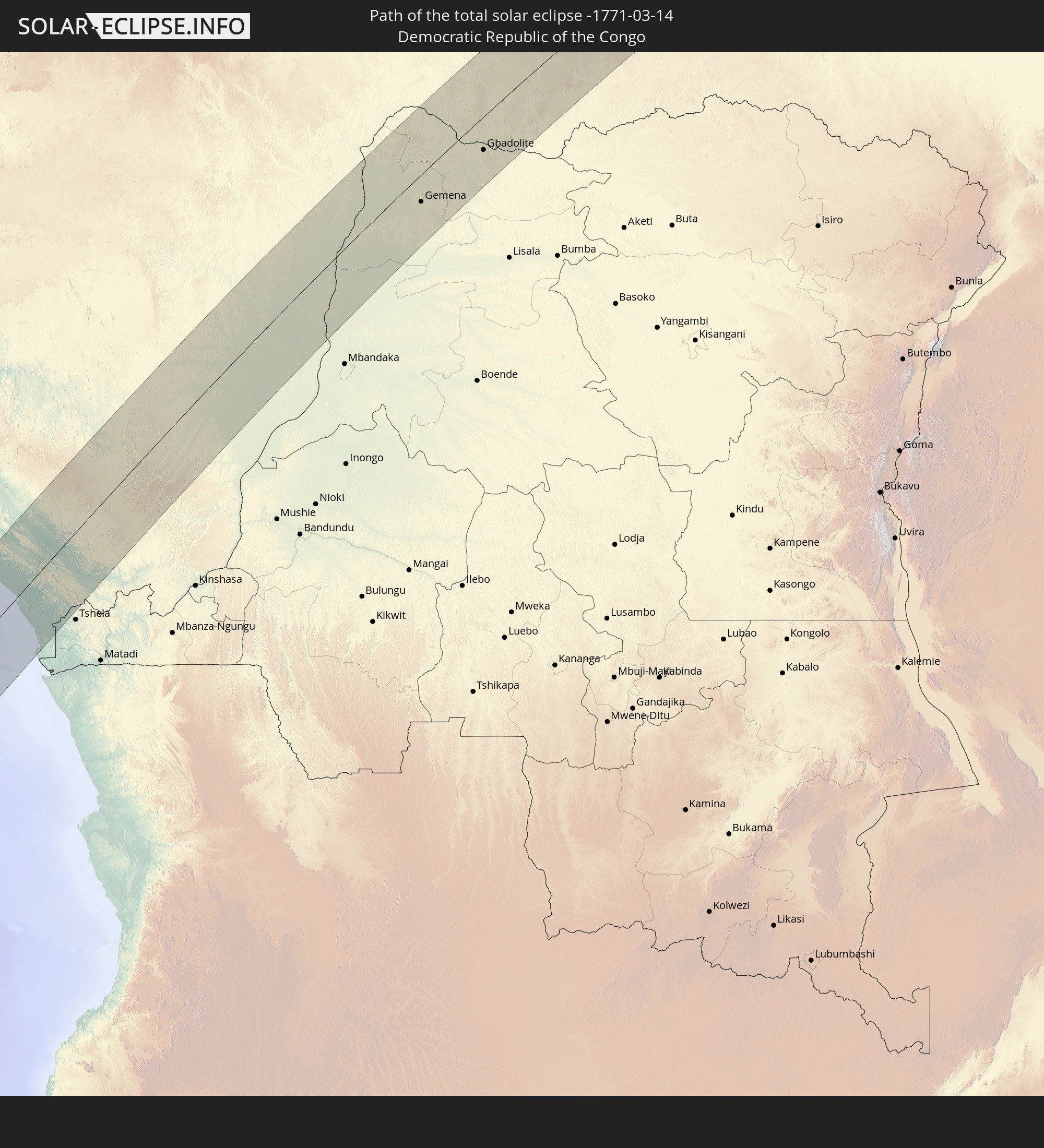
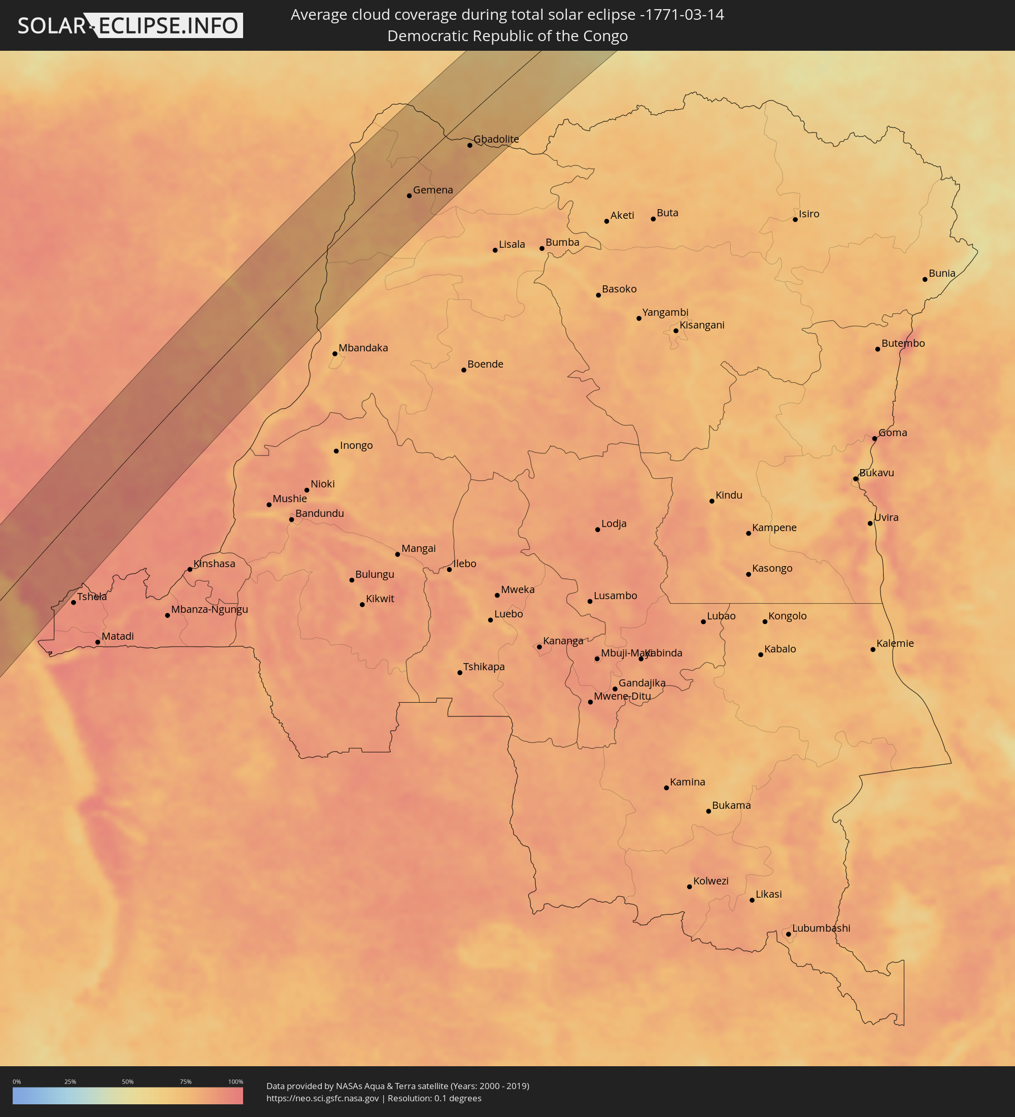 Demokratische Republik Kongo
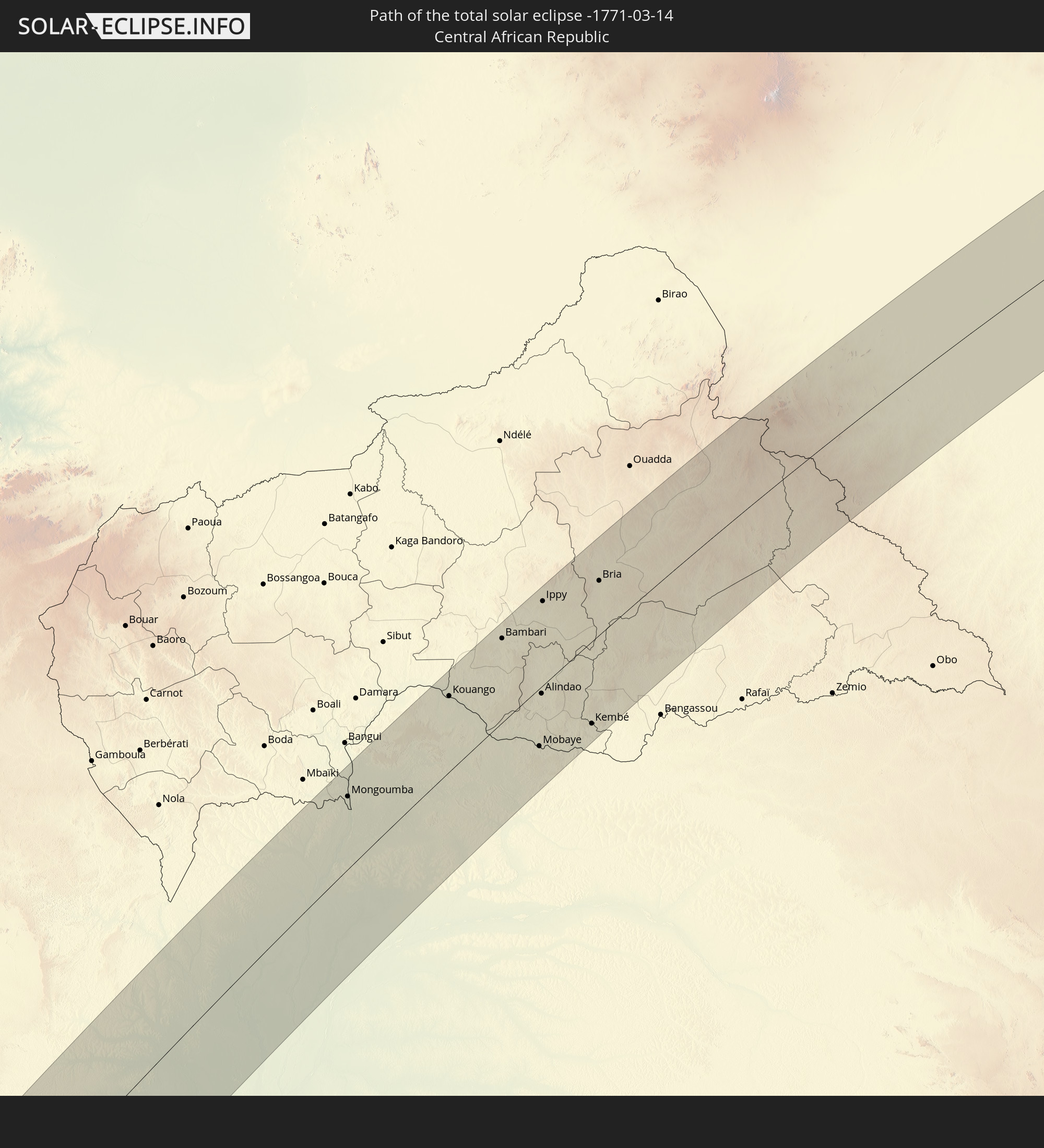
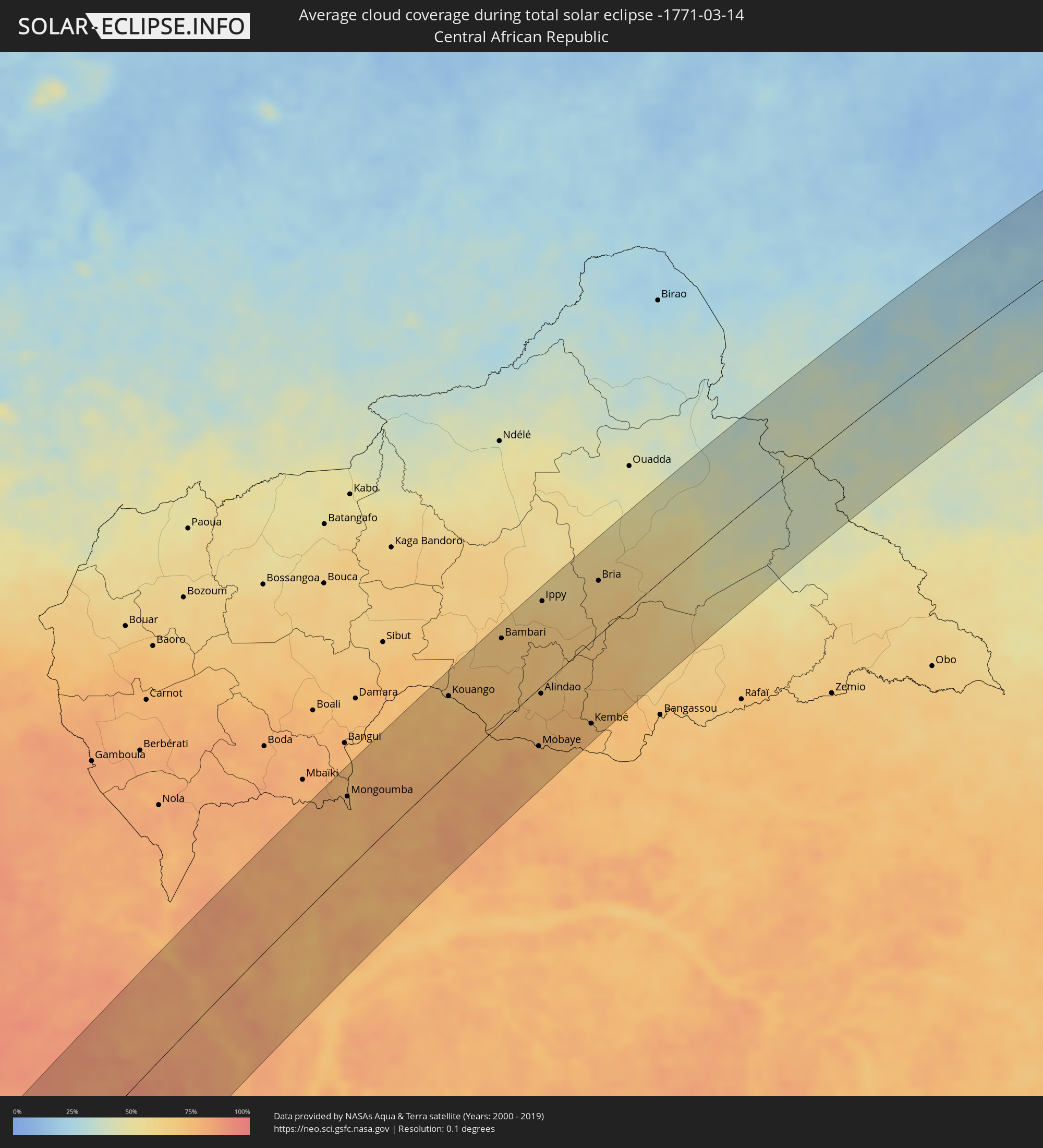 Zentralafrikanische Republik
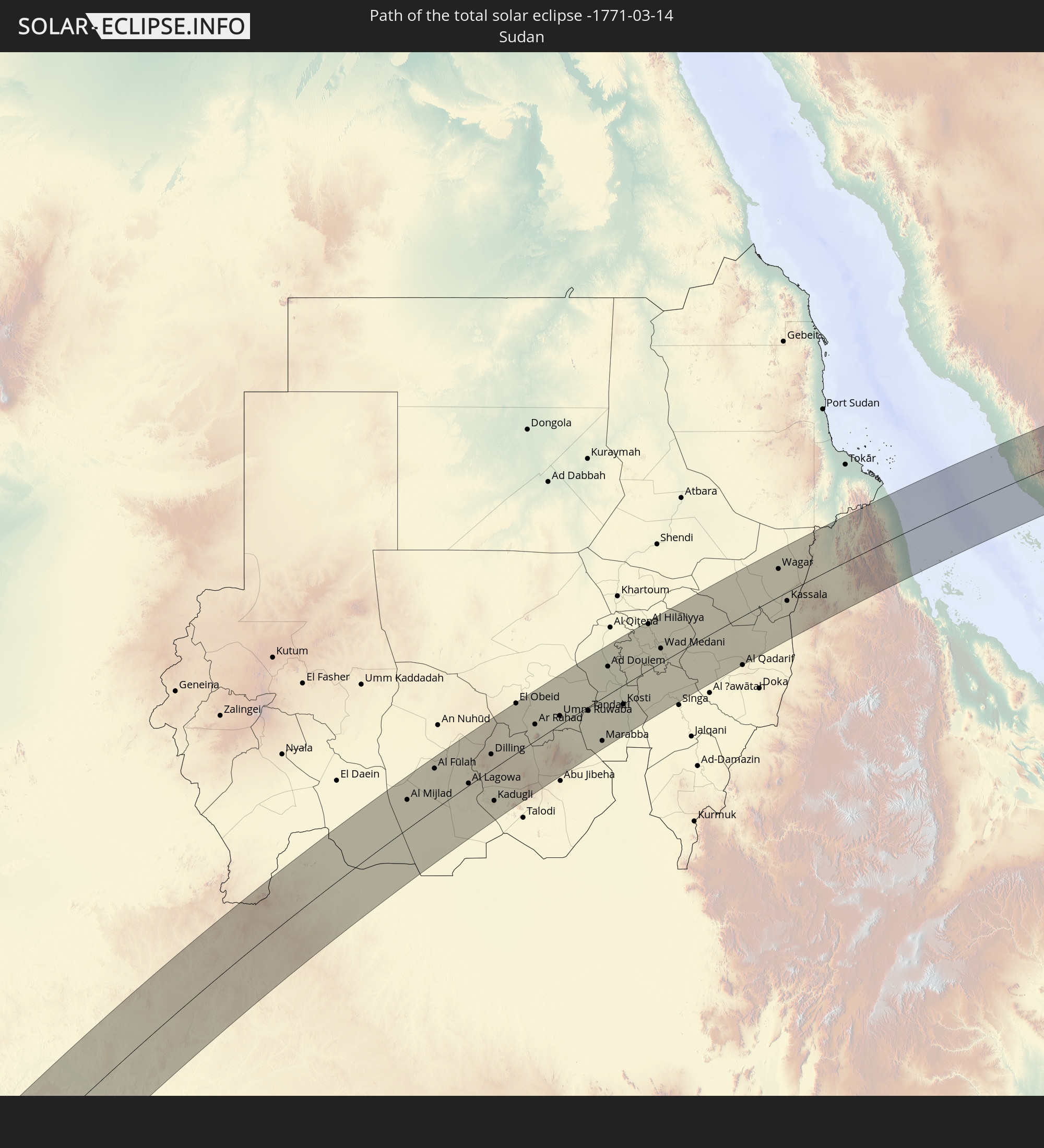
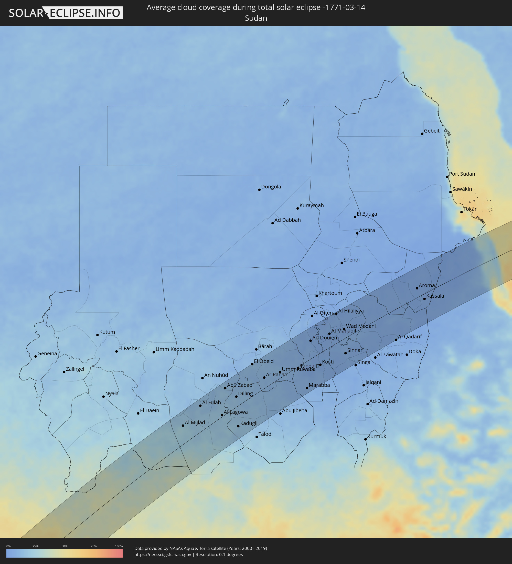 Sudan
Sudan
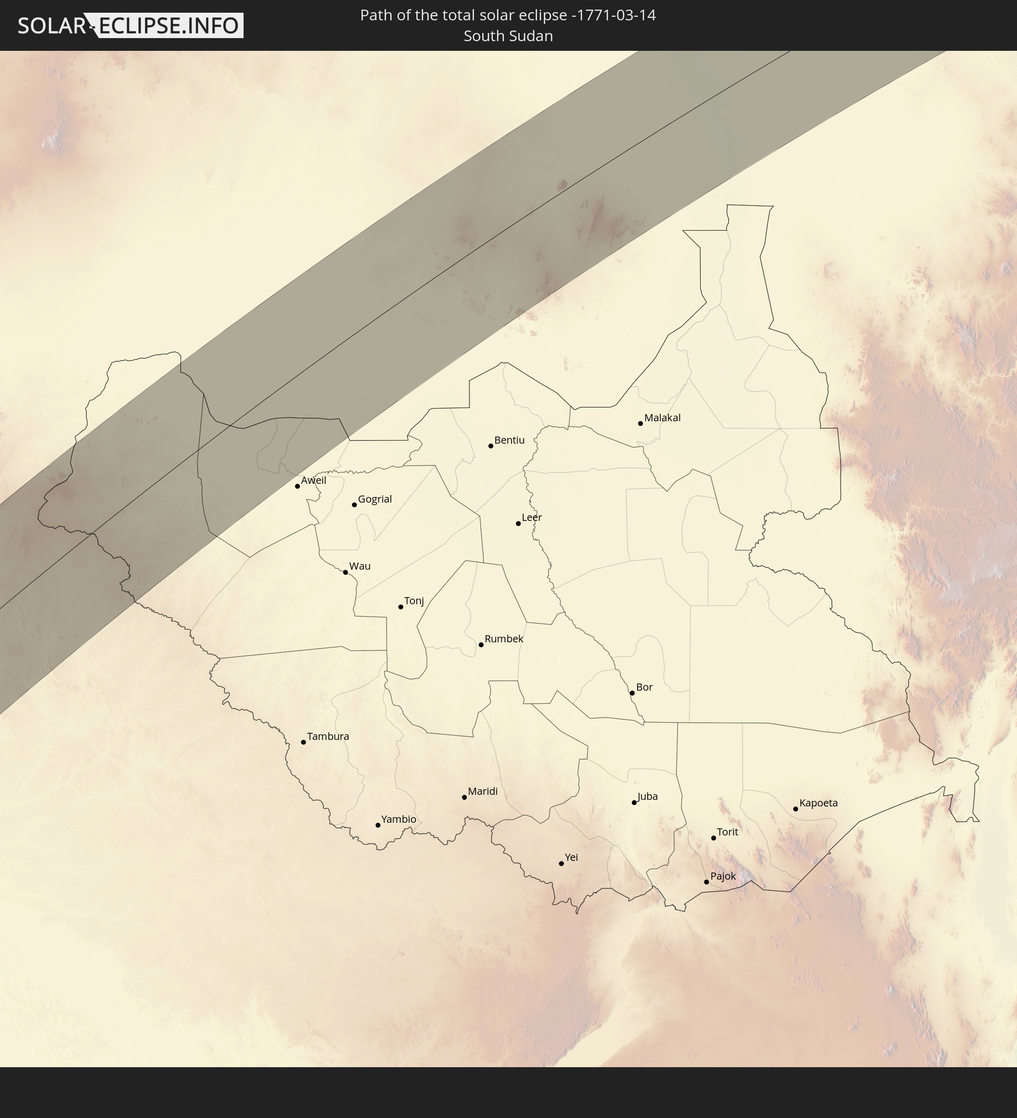
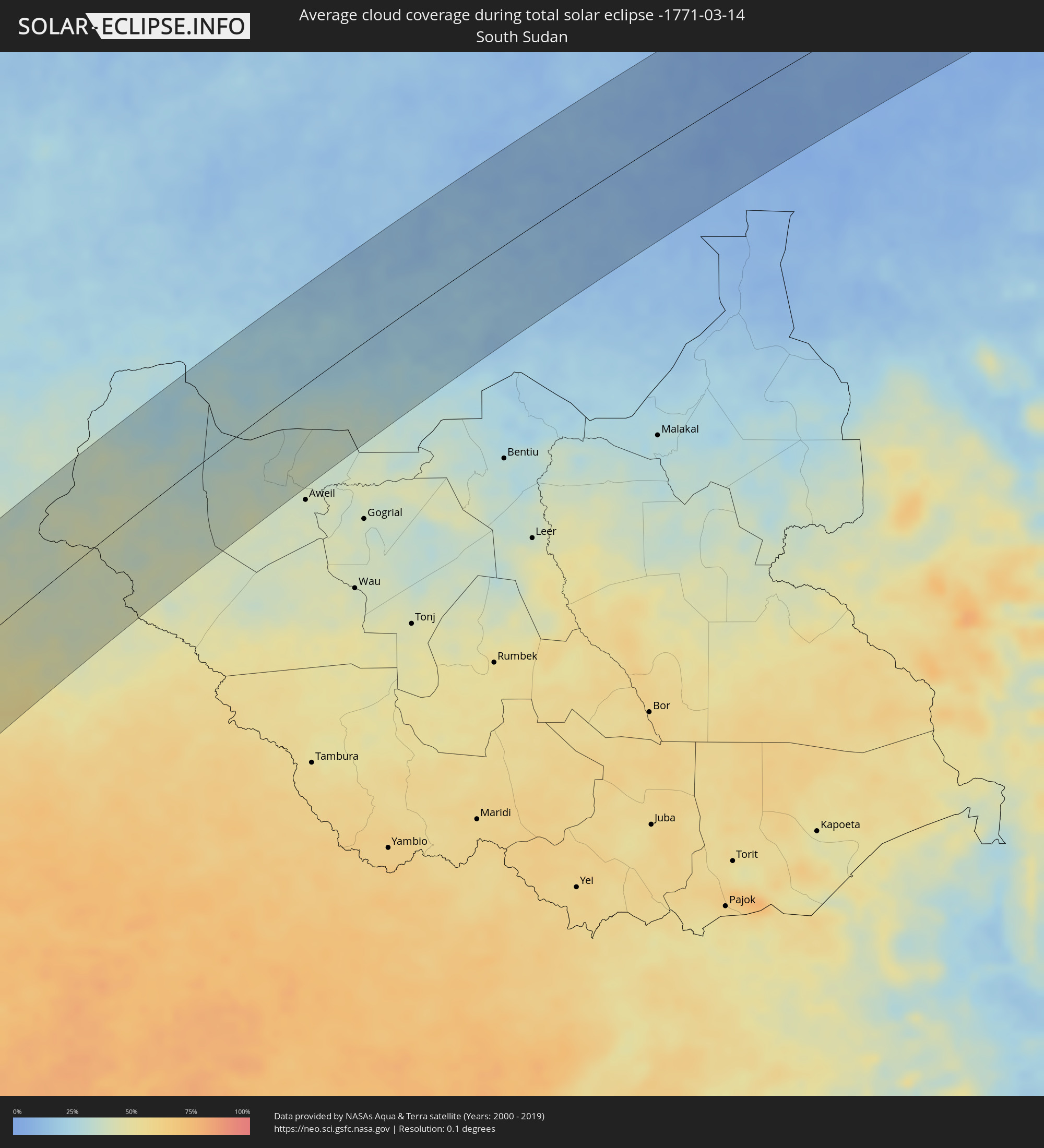 Südsudan
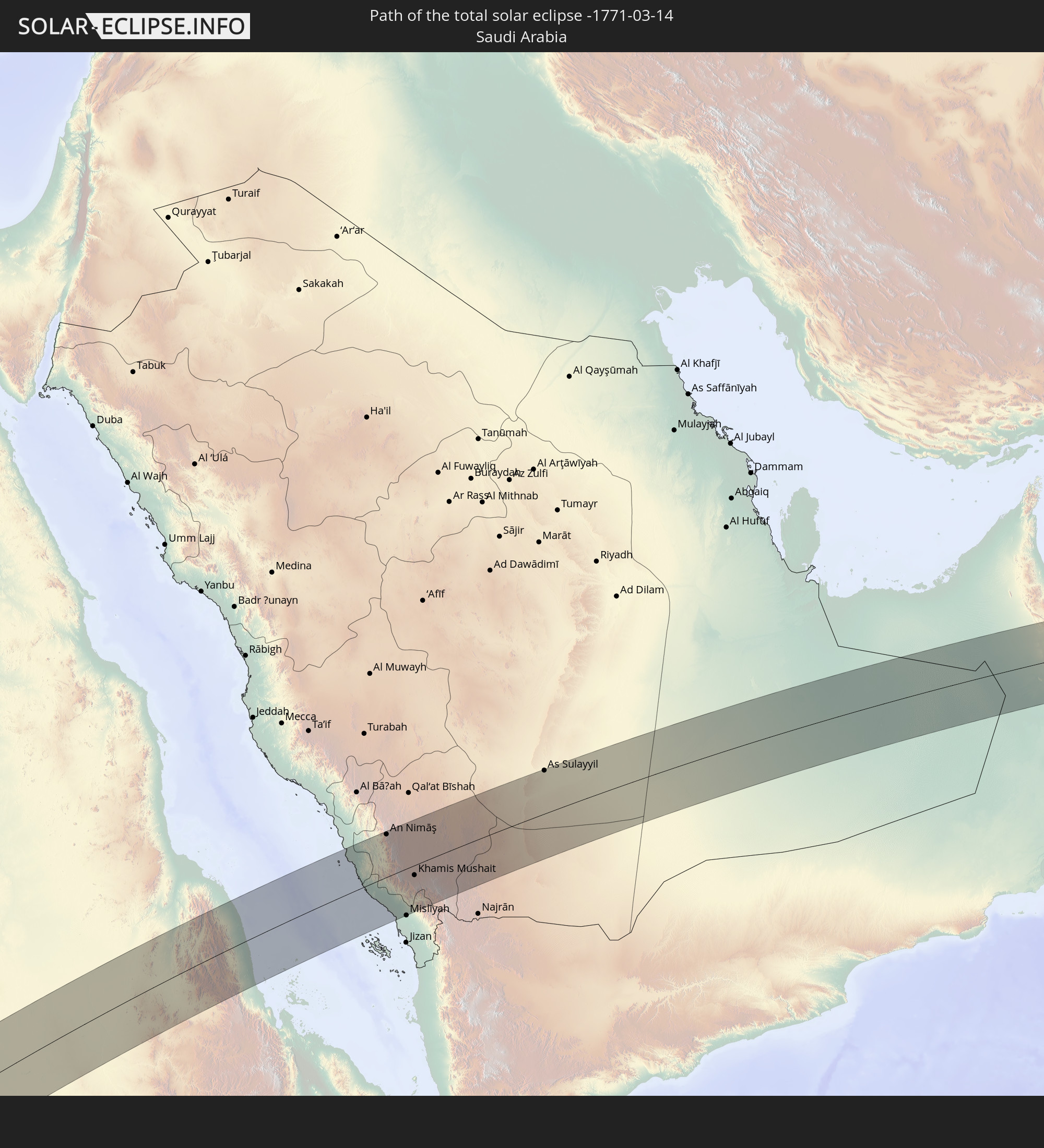
 Saudi-Arabien
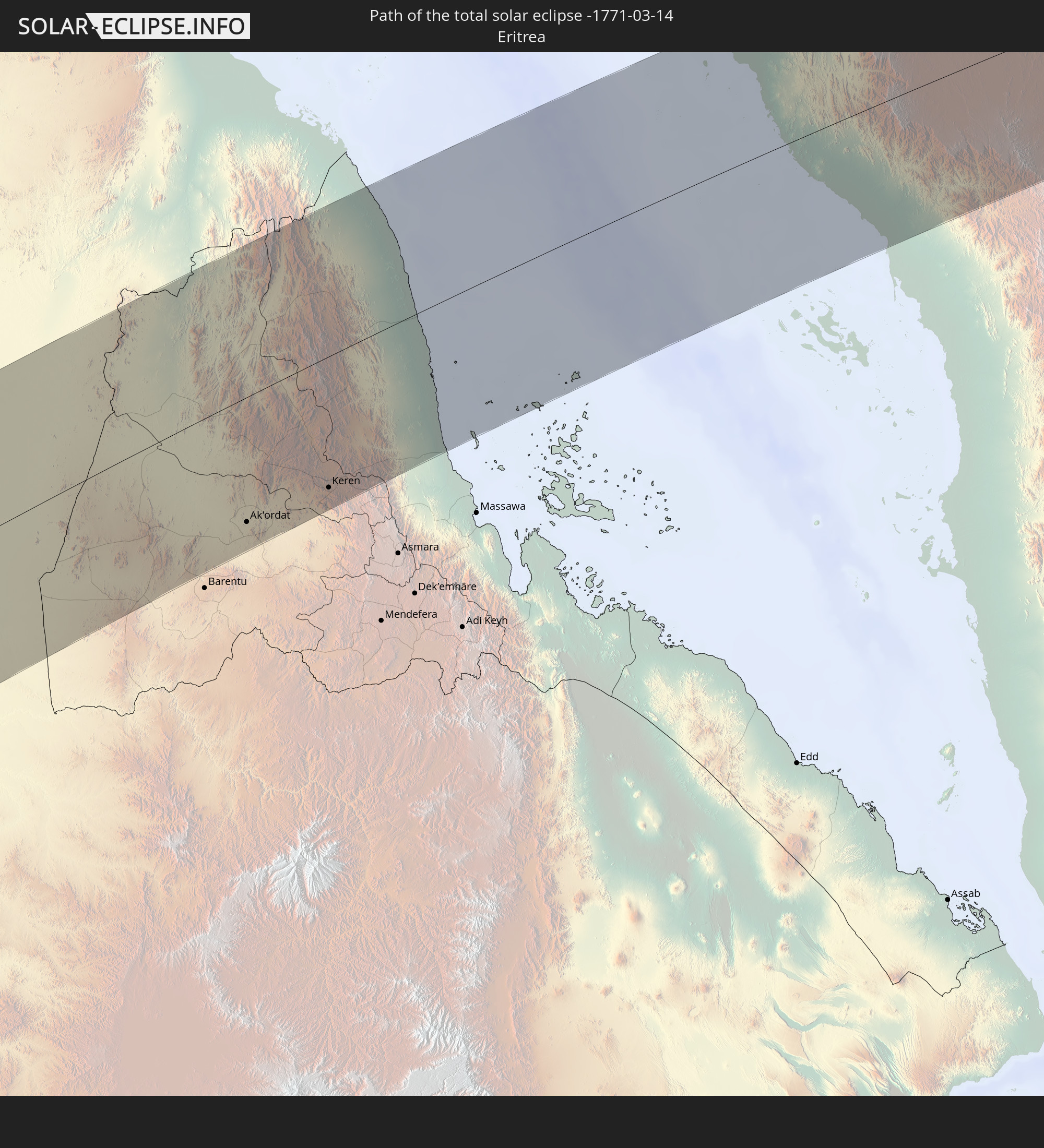
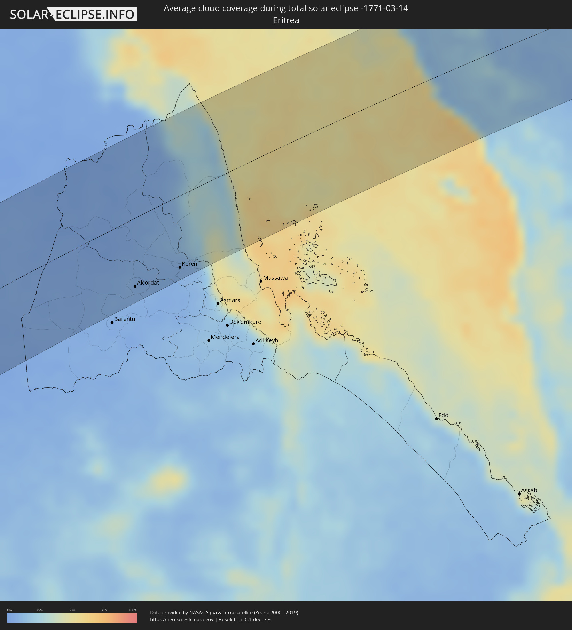 Eritrea
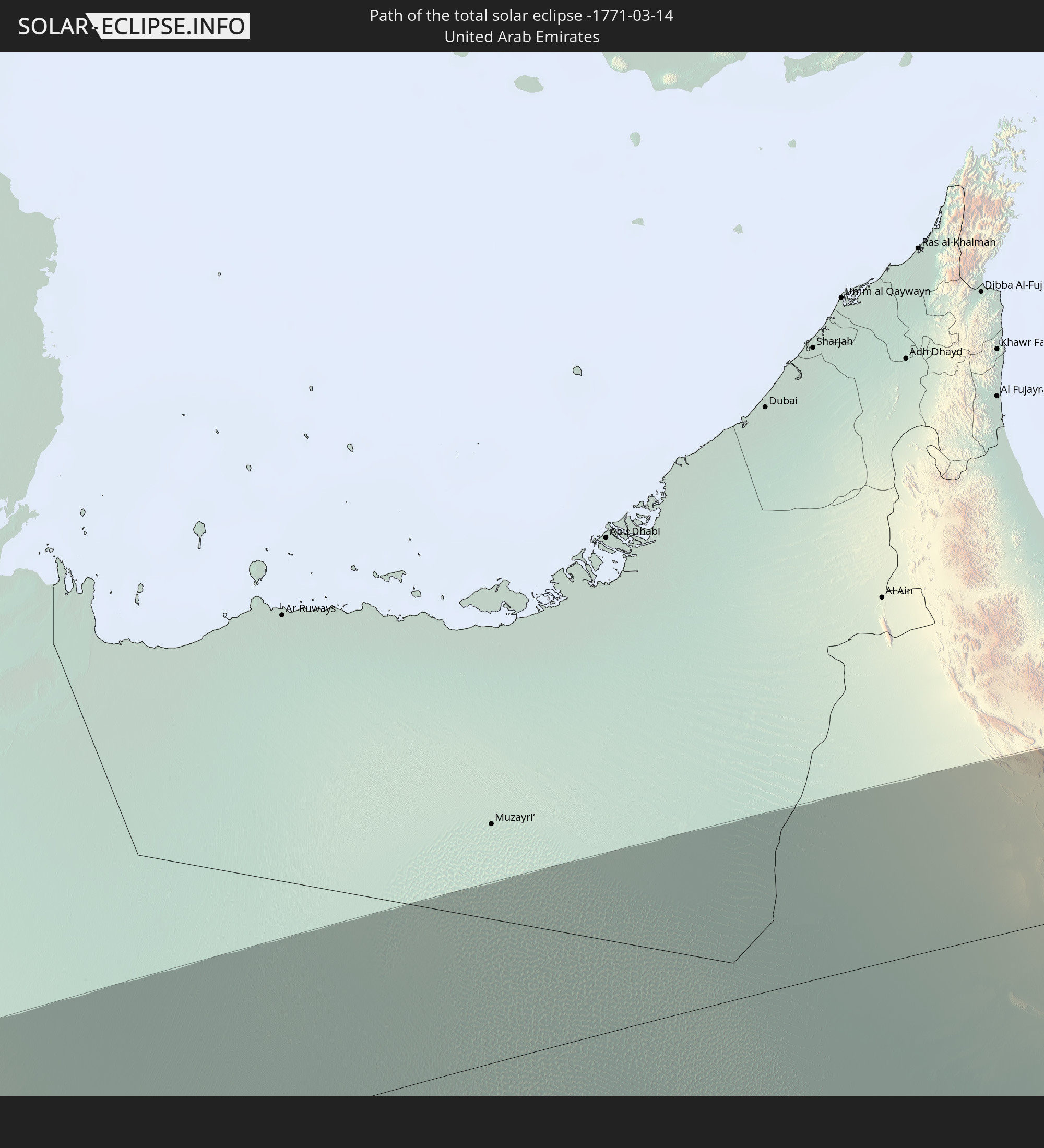
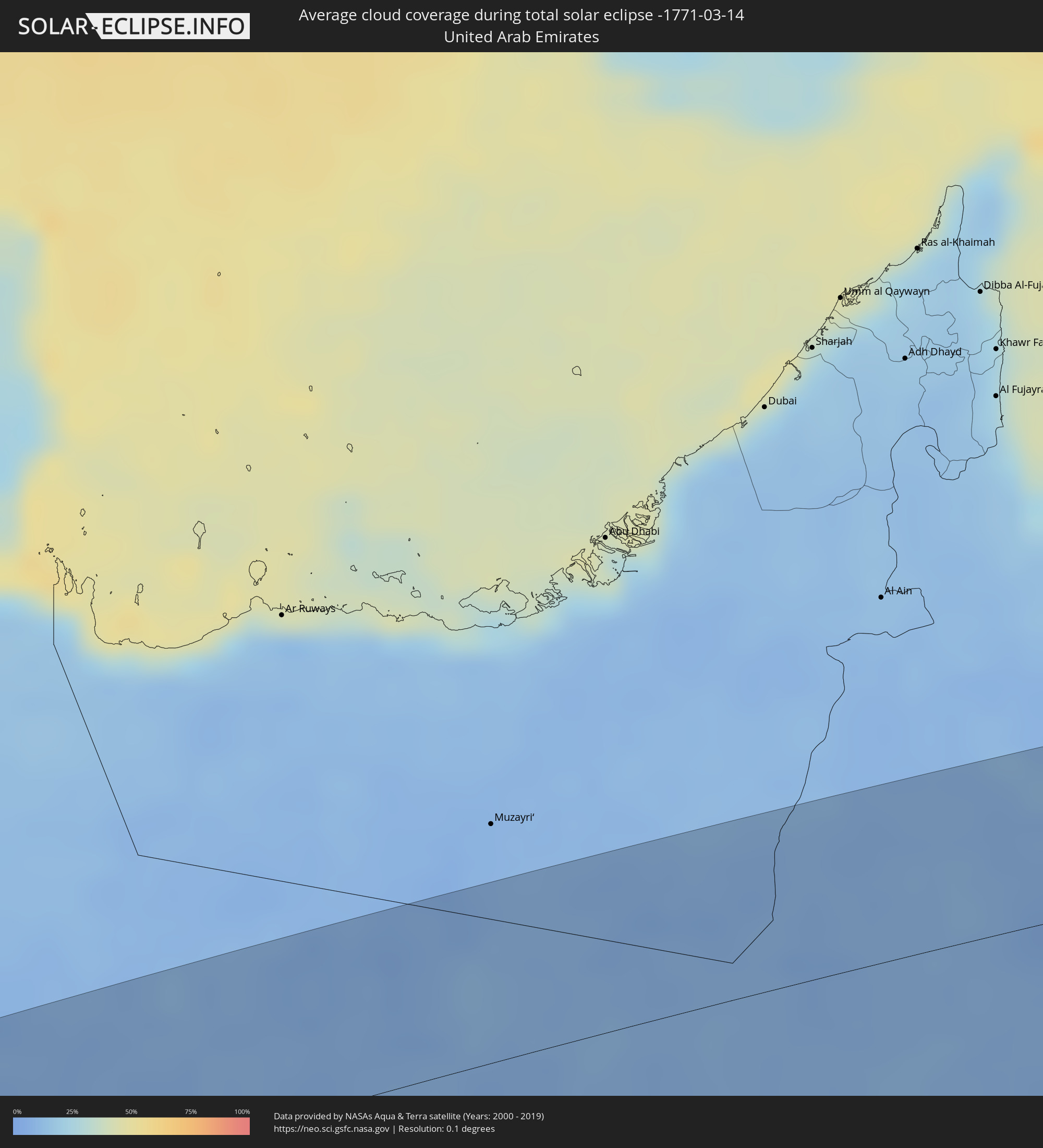 Vereinigte Arabische Emirate
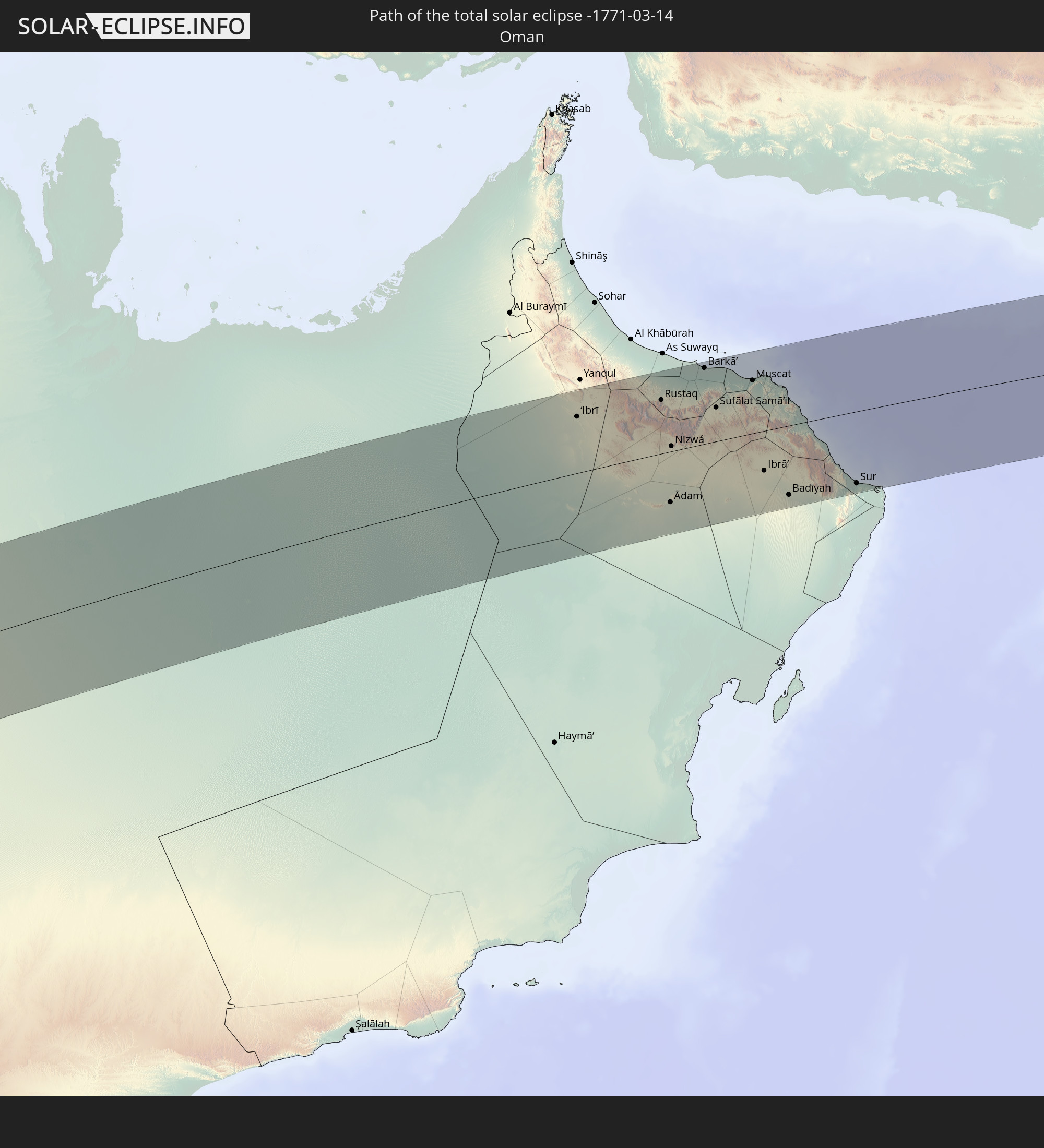
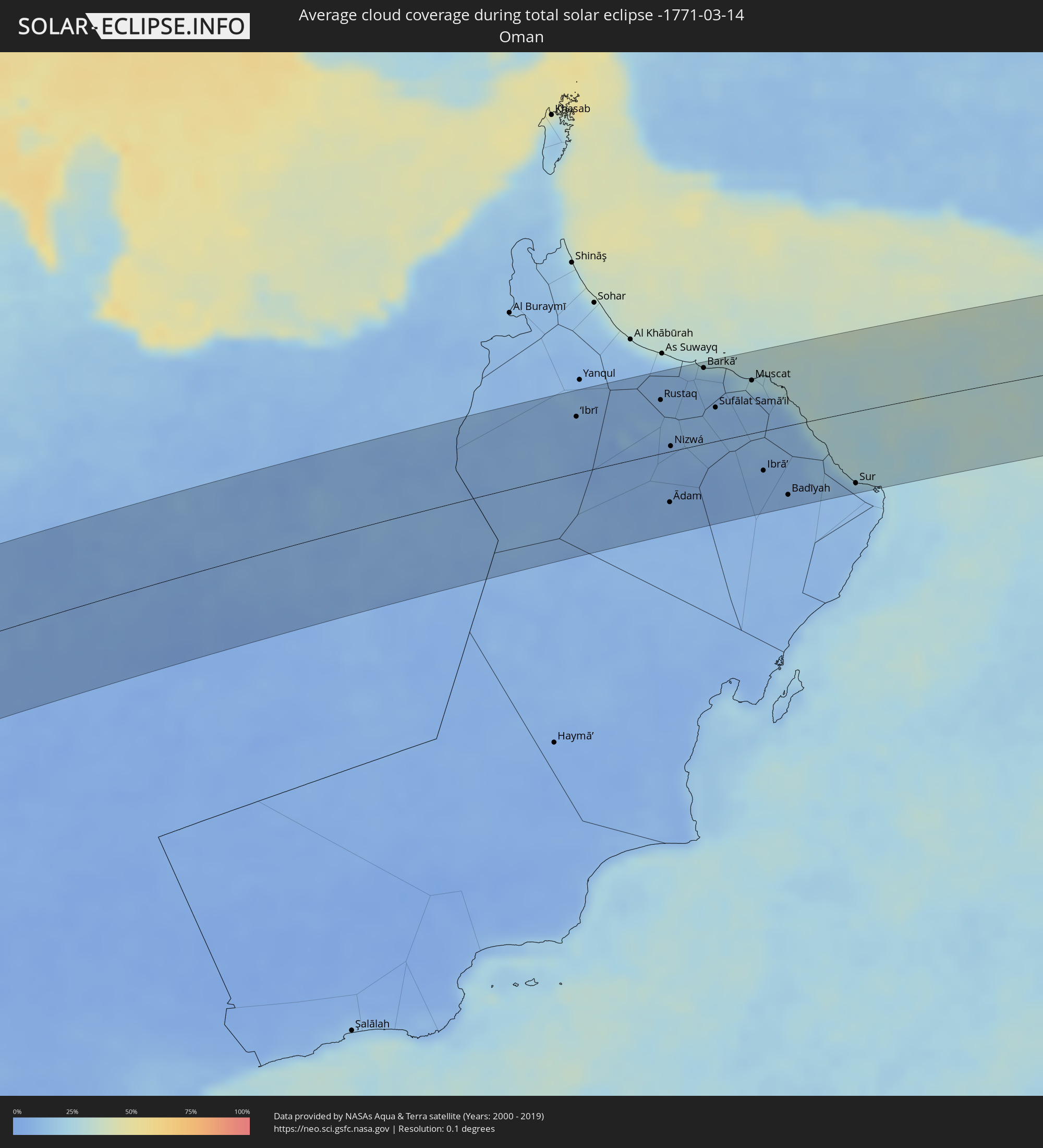 Oman
Oman
Orte im Finsternispfad
Die nachfolgene Tabelle zeigt Städte und Orte mit mehr als 5.000 Einwohnern, die sich im Finsternispfad befinden. Städte mit mehr als 100.000 Einwohnern sind dick gekennzeichnet. Mit einem Klick auf den Ort öffnet sich eine Detailkarte die die Lage des jeweiligen Ortes zusammen mit dem Verlauf der zentralen Finsternis präsentiert.
| Ort | Typ | Dauer der Verfinsterung | Ortszeit bei maximaler Verfinsterung | Entfernung zur Zentrallinie | Ø Bewölkung |
|
Villa Dolores, Cordoba Province
|
total | - | 06:03:22 UTC-04:16 | 10 km | 42% |
|
Villa Carlos Paz, Cordoba Province
|
total | - | 06:03:15 UTC-04:16 | 78 km | 43% |
|
Alta Gracia, Cordoba Province
|
total | - | 06:03:18 UTC-04:16 | 54 km | 44% |
|
Córdoba, Cordoba Province
|
total | - | 06:03:15 UTC-04:16 | 84 km | 47% |
|
Río Tercero, Cordoba Province
|
total | - | 06:03:26 UTC-04:16 | 2 km | 43% |
|
Villa María, Cordoba Province
|
total | - | 06:03:31 UTC-04:16 | 11 km | 45% |
|
Bell Ville, Cordoba Province
|
total | - | 06:03:36 UTC-04:16 | 28 km | 46% |
|
Cañada de Gómez, Santa Fe Province
|
total | - | 06:03:45 UTC-04:16 | 32 km | 43% |
|
Casilda, Santa Fe Province
|
total | - | 06:03:50 UTC-04:16 | 54 km | 45% |
|
Capitán Bermúdez, Santa Fe Province
|
total | - | 06:03:49 UTC-04:16 | 24 km | 45% |
|
Rosario, Santa Fe Province
|
total | - | 06:03:52 UTC-04:16 | 37 km | 43% |
|
Villa Constitución, Santa Fe Province
|
total | - | 06:03:58 UTC-04:16 | 64 km | 42% |
|
San Nicolás de los Arroyos, Buenos Aires
|
total | - | 06:04:00 UTC-04:16 | 75 km | 42% |
|
Victoria, Entre Ríos Province
|
total | - | 06:03:50 UTC-04:16 | 6 km | 41% |
|
Gualeguay, Entre Ríos Province
|
total | - | 06:04:05 UTC-04:16 | 43 km | 46% |
|
Gualeguaychú, Entre Ríos Province
|
total | - | 06:04:11 UTC-04:16 | 19 km | 42% |
|
Fray Bentos, Río Negro
|
total | - | 06:36:11 UTC-03:44 | 30 km | 39% |
|
Concepción del Uruguay, Entre Ríos Province
|
total | - | 06:04:06 UTC-04:16 | 42 km | 41% |
|
Dolores, Soriano
|
total | - | 06:36:19 UTC-03:44 | 74 km | 43% |
|
Paysandú, Paysandú
|
total | - | 06:36:03 UTC-03:44 | 61 km | 44% |
|
Mercedes, Soriano
|
total | - | 06:36:16 UTC-03:44 | 41 km | 44% |
|
Young, Río Negro
|
total | - | 06:36:13 UTC-03:44 | 24 km | 45% |
|
Trinidad, Flores
|
total | - | 06:36:34 UTC-03:44 | 60 km | 50% |
|
Trinidad, Flores
|
total | - | 06:36:34 UTC-03:44 | 62 km | 50% |
|
Durazno, Durazno
|
total | - | 06:36:37 UTC-03:44 | 41 km | 51% |
|
Paso de los Toros, Tacuarembó
|
total | - | 06:36:29 UTC-03:44 | 21 km | 46% |
|
Sarandí Grande, Florida
|
total | - | 06:36:44 UTC-03:44 | 79 km | 51% |
|
Sarandí del Yi, Durazno
|
total | - | 06:36:49 UTC-03:44 | 30 km | 54% |
|
José Pedro Varela, Lavalleja
|
total | - | 06:37:08 UTC-03:44 | 33 km | 57% |
|
Treinta y Tres, Treinta y Tres
|
total | - | 06:37:08 UTC-03:44 | 8 km | 60% |
|
Lascano, Rocha
|
total | - | 06:37:17 UTC-03:44 | 55 km | 62% |
|
Melo, Cerro Largo
|
total | - | 06:37:01 UTC-03:44 | 90 km | 55% |
|
Chui, Rocha
|
total | - | 06:37:30 UTC-03:44 | 53 km | 58% |
|
Chuí, Rio Grande do Sul
|
total | - | 06:37:30 UTC-03:44 | 52 km | 58% |
|
Río Branco, Cerro Largo
|
total | - | 06:37:18 UTC-03:44 | 69 km | 62% |
|
Jaguarão, Rio Grande do Sul
|
total | - | 07:15:41 UTC-03:06 | 73 km | 62% |
|
Santa Vitória do Palmar, Rio Grande do Sul
|
total | - | 07:15:53 UTC-03:06 | 33 km | 60% |
|
Loango, Kouilou
|
total | - | 12:43:43 UTC+00:13 | 9 km | 84% |
|
Loandjili, Pointe-Noire
|
total | - | 12:43:35 UTC+00:13 | 21 km | 87% |
|
Pointe-Noire, Pointe-Noire
|
total | - | 12:43:33 UTC+00:13 | 23 km | 87% |
|
Cabinda, Cabinda
|
total | - | 12:42:34 UTC+00:13 | 108 km | 88% |
|
Dolisie, Niari
|
total | - | 12:46:04 UTC+00:13 | 46 km | 90% |
|
Mossendjo, Niari
|
total | - | 12:48:36 UTC+00:13 | 43 km | 92% |
|
Moanda, Haut-Ogooué
|
total | - | 12:52:08 UTC+00:13 | 106 km | 89% |
|
Kayes, Bouenza
|
total | - | 12:47:04 UTC+00:13 | 98 km | 92% |
|
Sibiti, Lékoumou
|
total | - | 12:48:13 UTC+00:13 | 64 km | 91% |
|
Franceville, Haut-Ogooué
|
total | - | 12:52:38 UTC+00:13 | 70 km | 90% |
|
Djambala, Plateaux
|
total | - | 12:52:44 UTC+00:13 | 95 km | 92% |
|
Ewo, Cuvette-Ouest
|
total | - | 12:56:04 UTC+00:13 | 26 km | 89% |
|
Makoua, Cuvette
|
total | - | 12:59:00 UTC+00:13 | 28 km | 88% |
|
Owando, Cuvette
|
total | - | 12:58:30 UTC+00:13 | 31 km | 84% |
|
Impfondo, Likouala
|
total | - | 13:05:38 UTC+00:13 | 41 km | 73% |
|
Mongoumba, Lobaye
|
total | - | 13:09:59 UTC+00:13 | 78 km | 75% |
|
Libenge, Équateur
|
total | - | 13:10:04 UTC+00:13 | 76 km | 73% |
|
Gemena, Équateur
|
total | - | 13:10:59 UTC+00:13 | 44 km | 82% |
|
Bosobolo, Équateur
|
total | - | 13:12:44 UTC+00:13 | 23 km | 78% |
|
Kouango, Ouaka
|
total | - | 13:14:12 UTC+00:13 | 83 km | 69% |
|
Bambari, Ouaka
|
total | - | 13:16:26 UTC+00:13 | 93 km | 68% |
|
Gbadolite, Équateur
|
total | - | 13:14:25 UTC+00:13 | 54 km | 79% |
|
Mobaye, Basse-Kotto
|
total | - | 13:14:44 UTC+00:13 | 64 km | 76% |
|
Alindao, Basse-Kotto
|
total | - | 13:15:56 UTC+00:13 | 8 km | 72% |
|
Ippy, Ouaka
|
total | - | 13:17:58 UTC+00:13 | 94 km | 61% |
|
Kembé, Basse-Kotto
|
total | - | 13:16:11 UTC+00:13 | 92 km | 74% |
|
Bria, Haute-Kotto
|
total | - | 13:19:23 UTC+00:13 | 61 km | 62% |
|
Al Mijlad, West Kordofan State
|
total | - | 15:29:08 UTC+02:10 | 59 km | 25% |
|
Dilling, Southern Kordofan
|
total | - | 15:32:22 UTC+02:10 | 32 km | 15% |
|
Kadugli, Southern Kordofan
|
total | - | 15:31:10 UTC+02:10 | 68 km | 17% |
|
El Obeid, North Kordofan
|
total | - | 15:34:14 UTC+02:10 | 103 km | 13% |
|
Ar Rahad, North Kordofan
|
total | - | 15:34:07 UTC+02:10 | 34 km | 10% |
|
Umm Ruwaba, North Kordofan
|
total | - | 15:34:53 UTC+02:10 | 18 km | 10% |
|
Tandaltī, White Nile
|
total | - | 15:35:37 UTC+02:10 | 9 km | 7% |
|
Ad Douiem, White Nile
|
total | - | 15:37:05 UTC+02:10 | 59 km | 6% |
|
Kosti, White Nile
|
total | - | 15:36:30 UTC+02:10 | 41 km | 5% |
|
Al Manāqil, Al Jazīrah
|
total | - | 15:37:56 UTC+02:10 | 44 km | 3% |
|
Kināna, Sinnār
|
total | - | 15:37:52 UTC+02:10 | 14 km | 5% |
|
Al Hasaheisa, Al Jazīrah
|
total | - | 15:38:43 UTC+02:10 | 76 km | 6% |
|
Wad Medani, Al Jazīrah
|
total | - | 15:38:33 UTC+02:10 | 30 km | 4% |
|
Sinnar, Sinnār
|
total | - | 15:37:44 UTC+02:10 | 52 km | 7% |
|
Maiurno, Sinnār
|
total | - | 15:37:39 UTC+02:10 | 72 km | 6% |
|
As Sūkī, Sinnār
|
total | - | 15:37:44 UTC+02:10 | 94 km | 6% |
|
Kassala, Kassala
|
total | - | 15:41:53 UTC+02:10 | 19 km | 4% |
|
Ak’ordat, Gash-Barka
|
total | - | 16:00:12 UTC+02:27 | 83 km | 6% |
|
Keren, Anseba
|
total | - | 16:00:49 UTC+02:27 | 87 km | 7% |
|
Al Majāridah, 'Asir
|
total | - | 16:45:08 UTC+03:06 | 97 km | 18% |
|
An Nimāş, 'Asir
|
total | - | 16:45:16 UTC+03:06 | 91 km | 28% |
|
Ad Darb, Jizan
|
total | - | 16:44:21 UTC+03:06 | 60 km | 15% |
|
Abha, 'Asir
|
total | - | 16:44:51 UTC+03:06 | 20 km | 21% |
|
Khamis Mushait, 'Asir
|
total | - | 16:45:02 UTC+03:06 | 21 km | 12% |
|
As Sulayyil, Ar Riyāḑ
|
total | - | 16:47:46 UTC+03:06 | 92 km | 11% |
|
‘Ibrī, Az̧ Z̧āhirah
|
total | - | 17:26:23 UTC+03:41 | 61 km | 9% |
|
Bahlā’, Muḩāfaz̧at ad Dākhilīyah
|
total | - | 17:26:24 UTC+03:41 | 15 km | 7% |
|
Rustaq, Al Batinah South Governorate
|
total | - | 17:26:32 UTC+03:41 | 58 km | 8% |
|
Ādam, Muḩāfaz̧at ad Dākhilīyah
|
total | - | 17:26:13 UTC+03:41 | 55 km | 7% |
|
Bayt al ‘Awābī, Al Batinah South Governorate
|
total | - | 17:26:31 UTC+03:41 | 46 km | 11% |
|
Nizwá, Muḩāfaz̧at ad Dākhilīyah
|
total | - | 17:26:24 UTC+03:41 | 6 km | 8% |
|
Izkī, Muḩāfaz̧at ad Dākhilīyah
|
total | - | 17:26:26 UTC+03:41 | 0 km | 9% |
|
Barkā’, Al Batinah South Governorate
|
total | - | 17:26:41 UTC+03:41 | 82 km | 14% |
|
Sufālat Samā’il, Muḩāfaz̧at ad Dākhilīyah
|
total | - | 17:26:35 UTC+03:41 | 36 km | 9% |
|
Bidbid, Muḩāfaz̧at ad Dākhilīyah
|
total | - | 17:26:37 UTC+03:41 | 44 km | 8% |
|
Seeb, Muḩāfaz̧at Masqaţ
|
total | - | 17:26:42 UTC+03:41 | 71 km | 19% |
|
Bawshar, Muḩāfaz̧at Masqaţ
|
total | - | 17:26:41 UTC+03:41 | 54 km | 13% |
|
Muscat, Muḩāfaz̧at Masqaţ
|
total | - | 17:26:41 UTC+03:41 | 57 km | 13% |
|
Ibrā’, Ash Sharqiyah North Governorate
|
total | - | 17:26:26 UTC+03:41 | 43 km | 7% |
|
Al Qābil, Ash Sharqiyah North Governorate
|
total | - | 17:26:24 UTC+03:41 | 59 km | 8% |
|
Badīyah, Ash Sharqiyah North Governorate
|
total | - | 17:26:23 UTC+03:41 | 75 km | 7% |
|
Sur, Ash Sharqiyah South Governorate
|
total | - | 17:26:28 UTC+03:41 | 77 km | 13% |