Totale Sonnenfinsternis vom 15.06.-1804
| Wochentag: | Montag |
| Maximale Dauer der Verfinsterung: | 04m47s |
| Maximale Breite des Finsternispfades: | 242 km |
| Saroszyklus: | 8 |
| Bedeckungsgrad: | 100% |
| Magnitude: | 1.0643 |
| Gamma: | 0.4884 |
Wo kann man die Sonnenfinsternis vom 15.06.-1804 sehen?
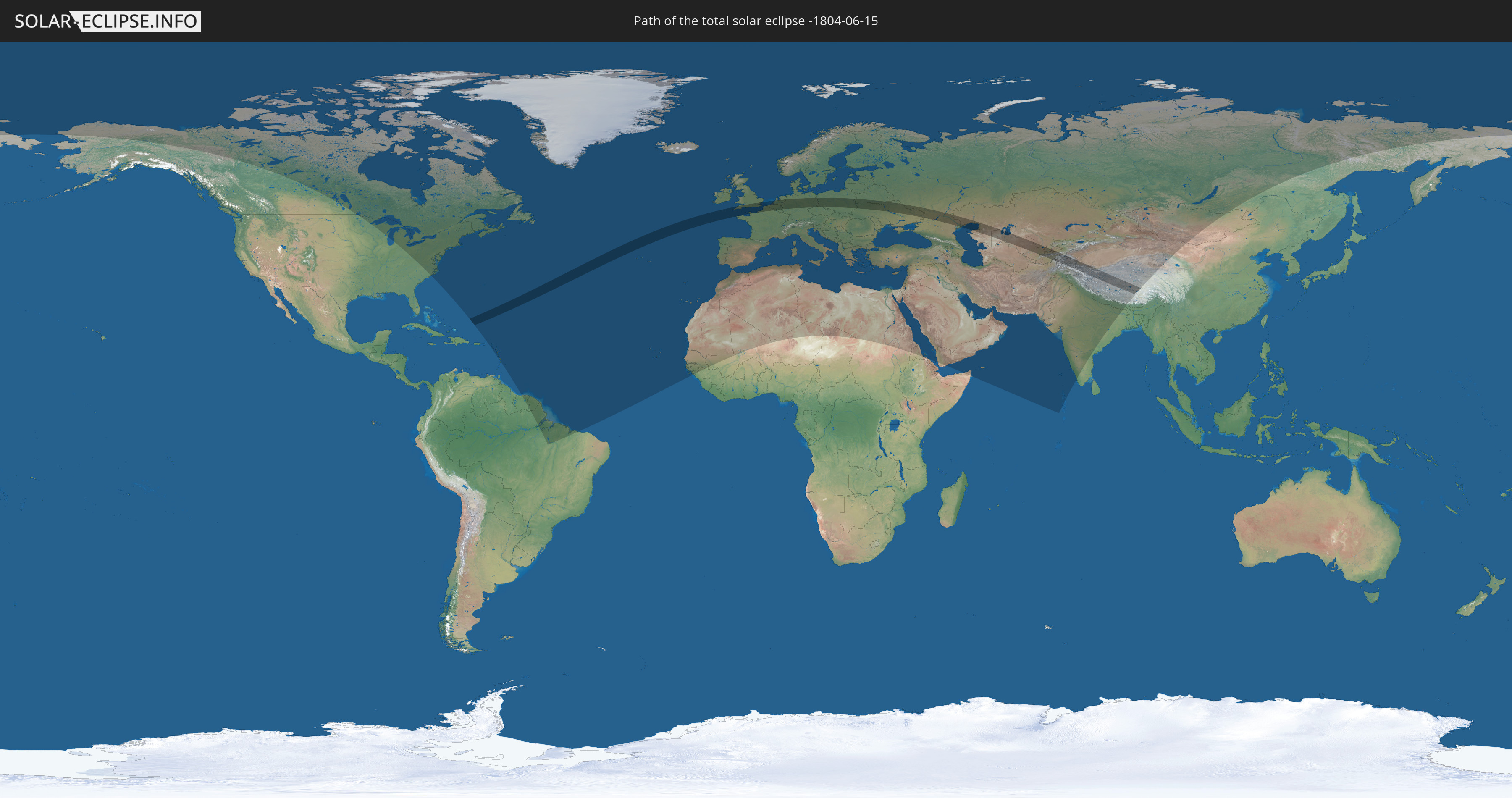
Die Sonnenfinsternis am 15.06.-1804 kann man in 117 Ländern als partielle Sonnenfinsternis beobachten.
Der Finsternispfad verläuft durch 21 Länder. Nur in diesen Ländern ist sie als totale Sonnenfinsternis zu sehen.
In den folgenden Ländern ist die Sonnenfinsternis total zu sehen
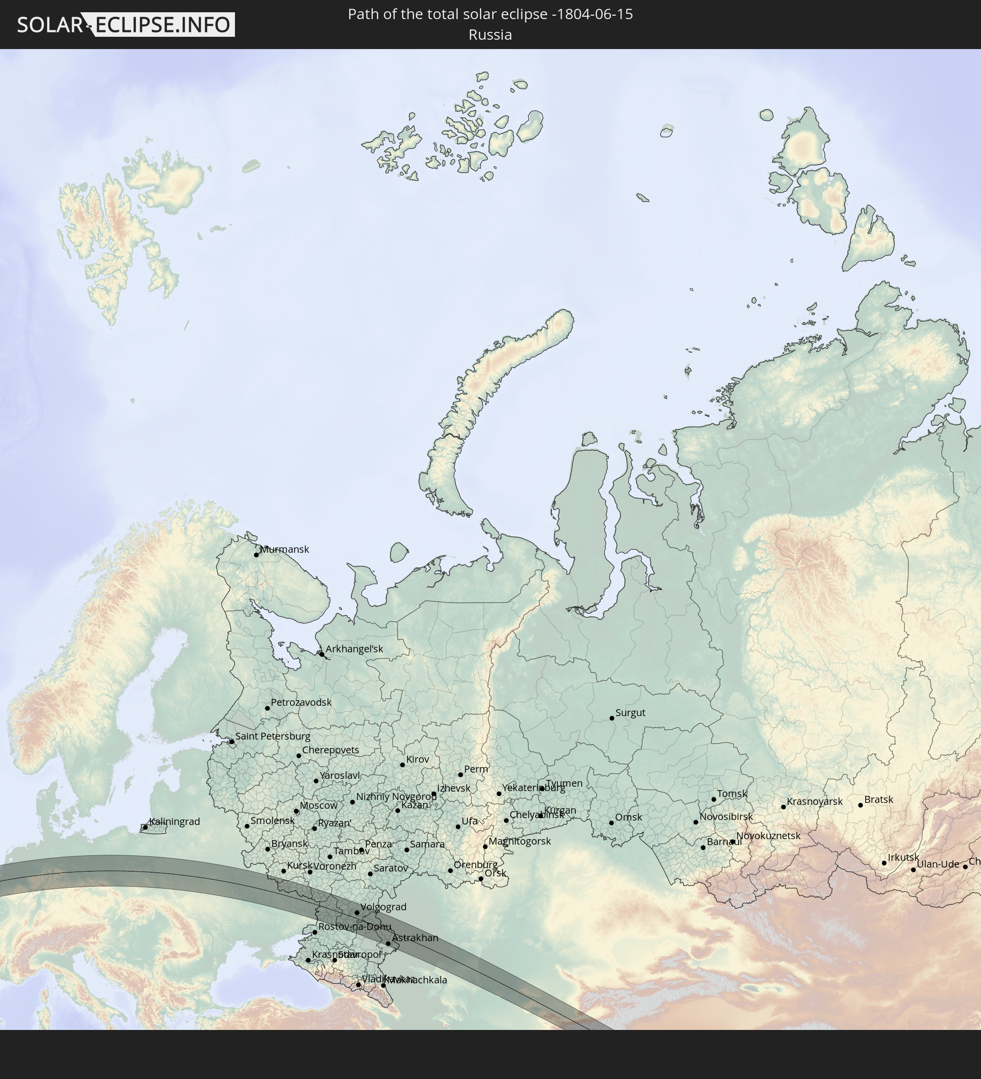 Russland
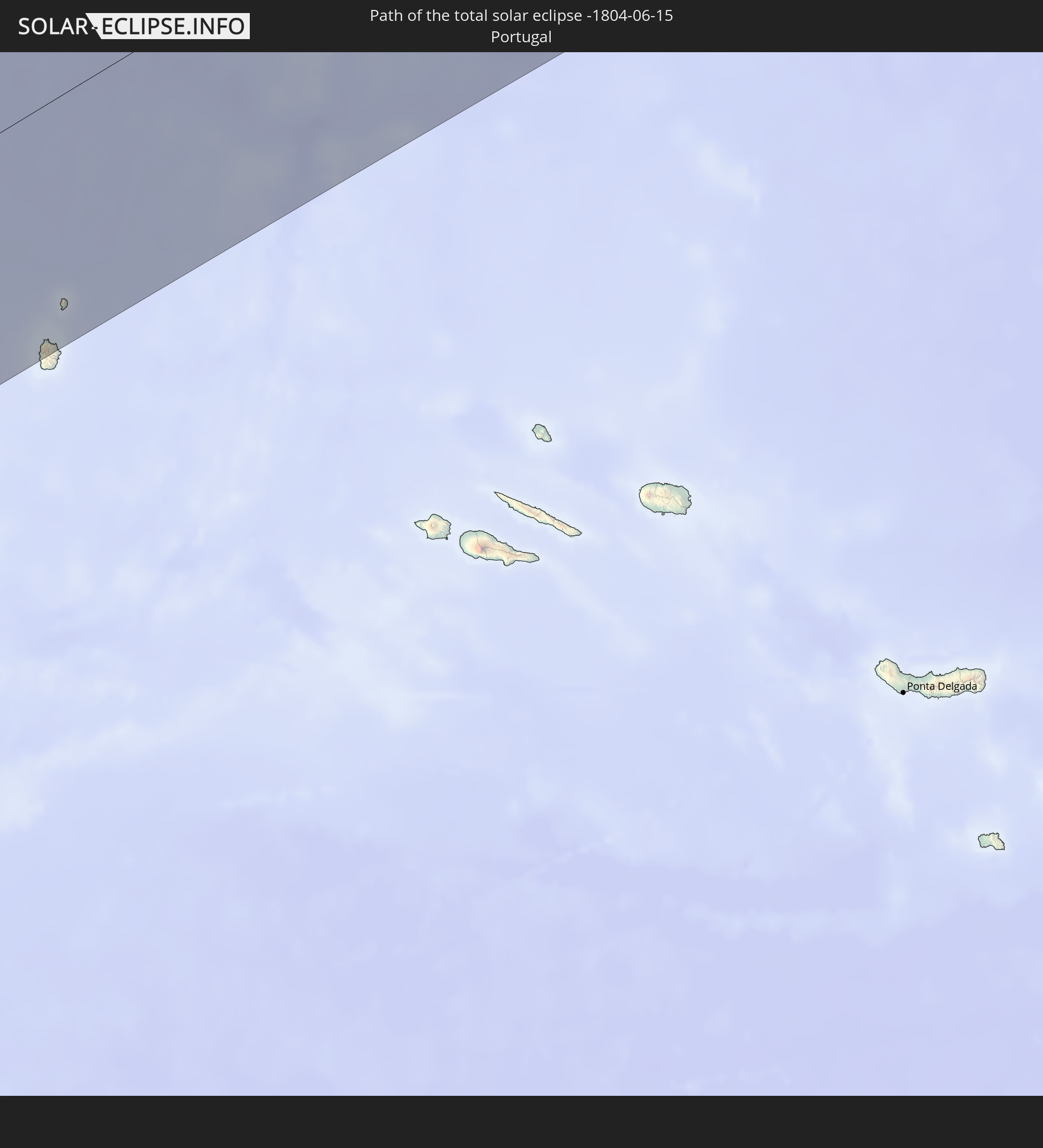 Portugal
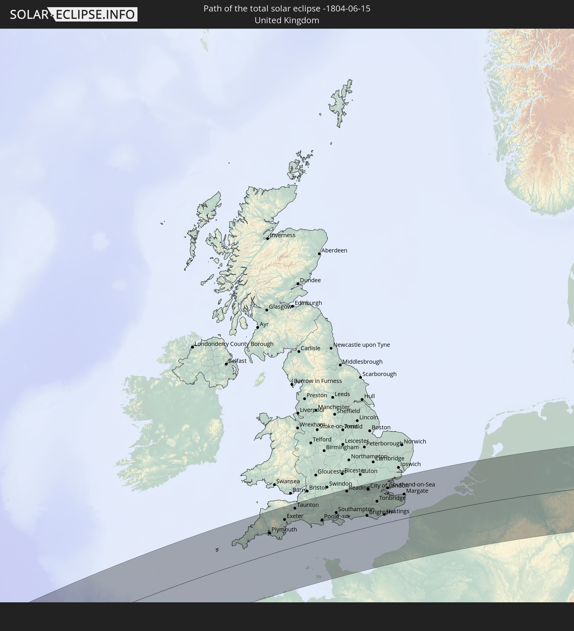 Vereinigtes Königreich
 Frankreich
 Guernsey
 Jersey
 Belgien
 Niederlande
 Deutschland
 Tschechien
 Polen
Polen
 Ukraine
 Weißrussland
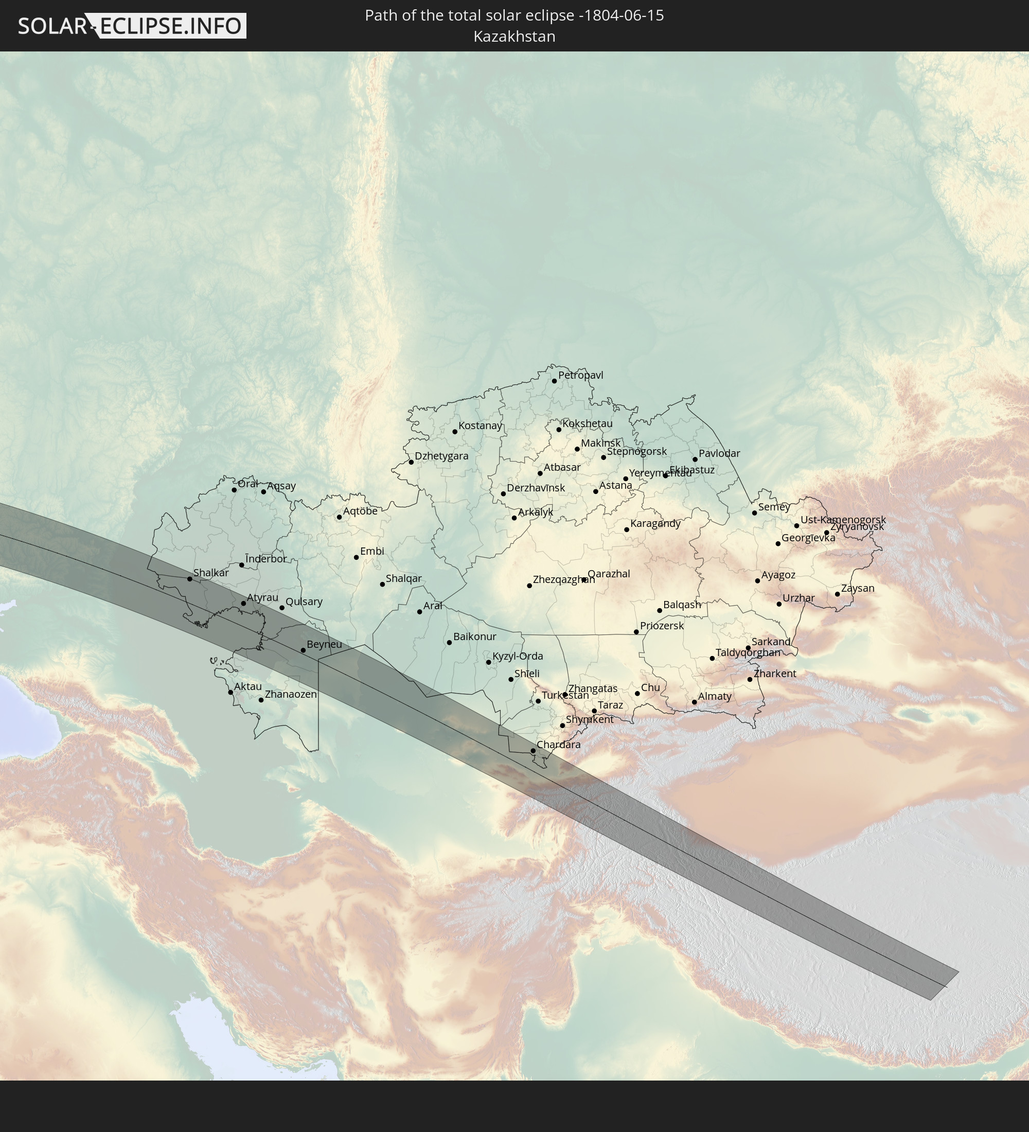 Kasachstan
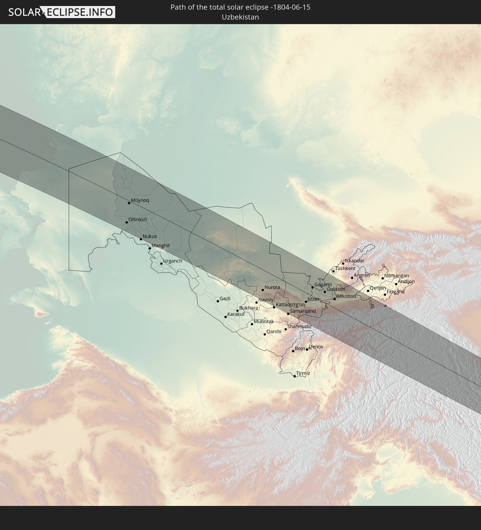 Usbekistan
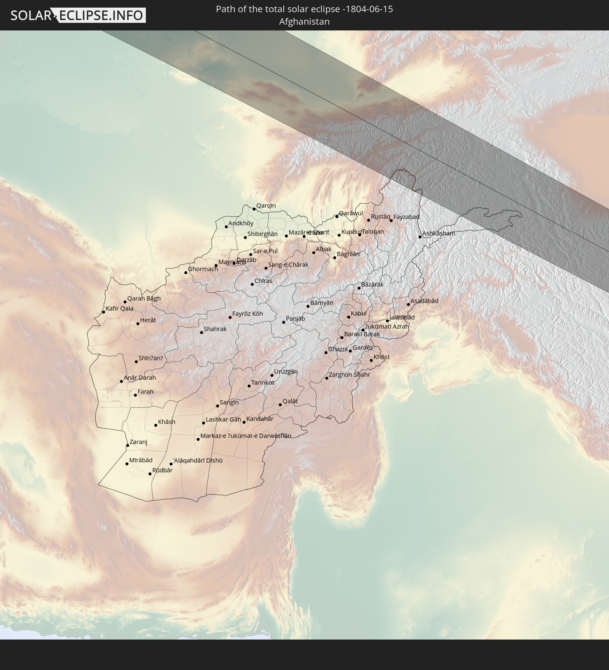 Afghanistan
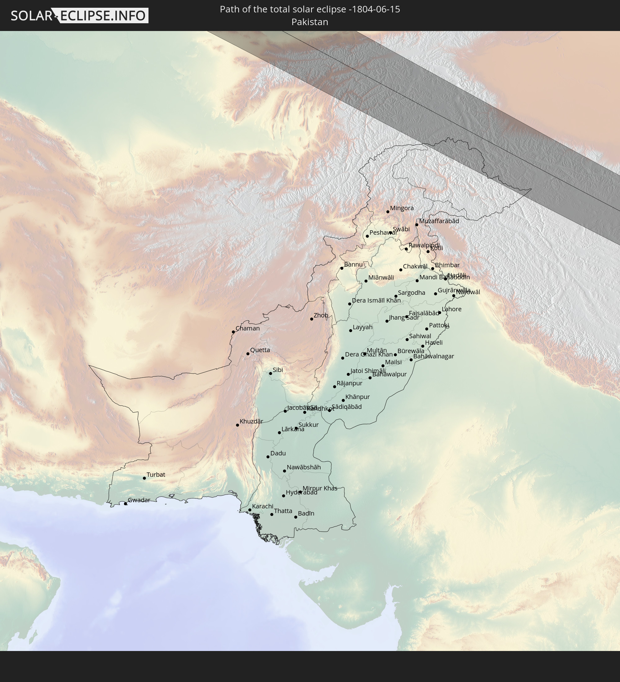 Pakistan
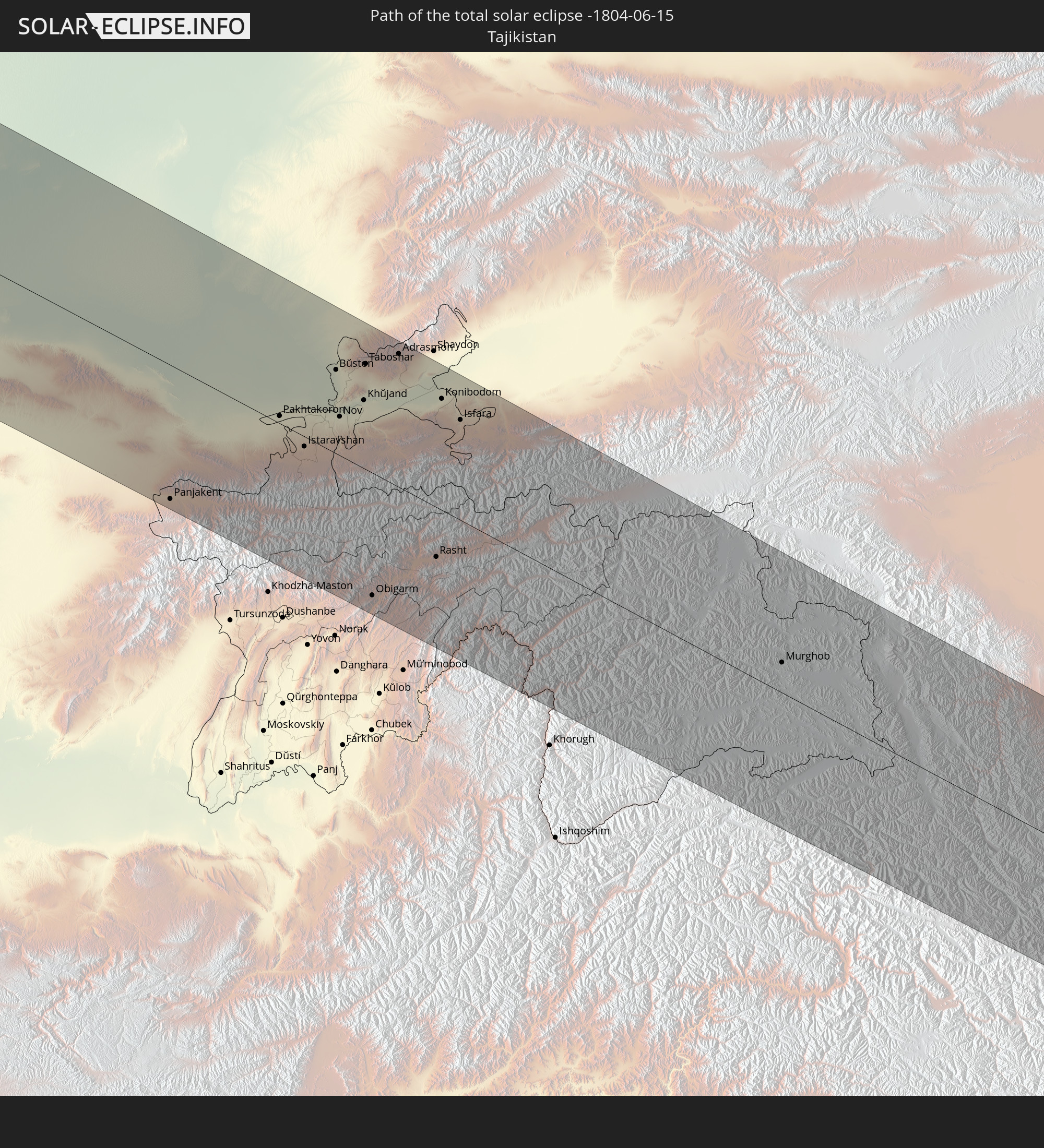 Tadschikistan
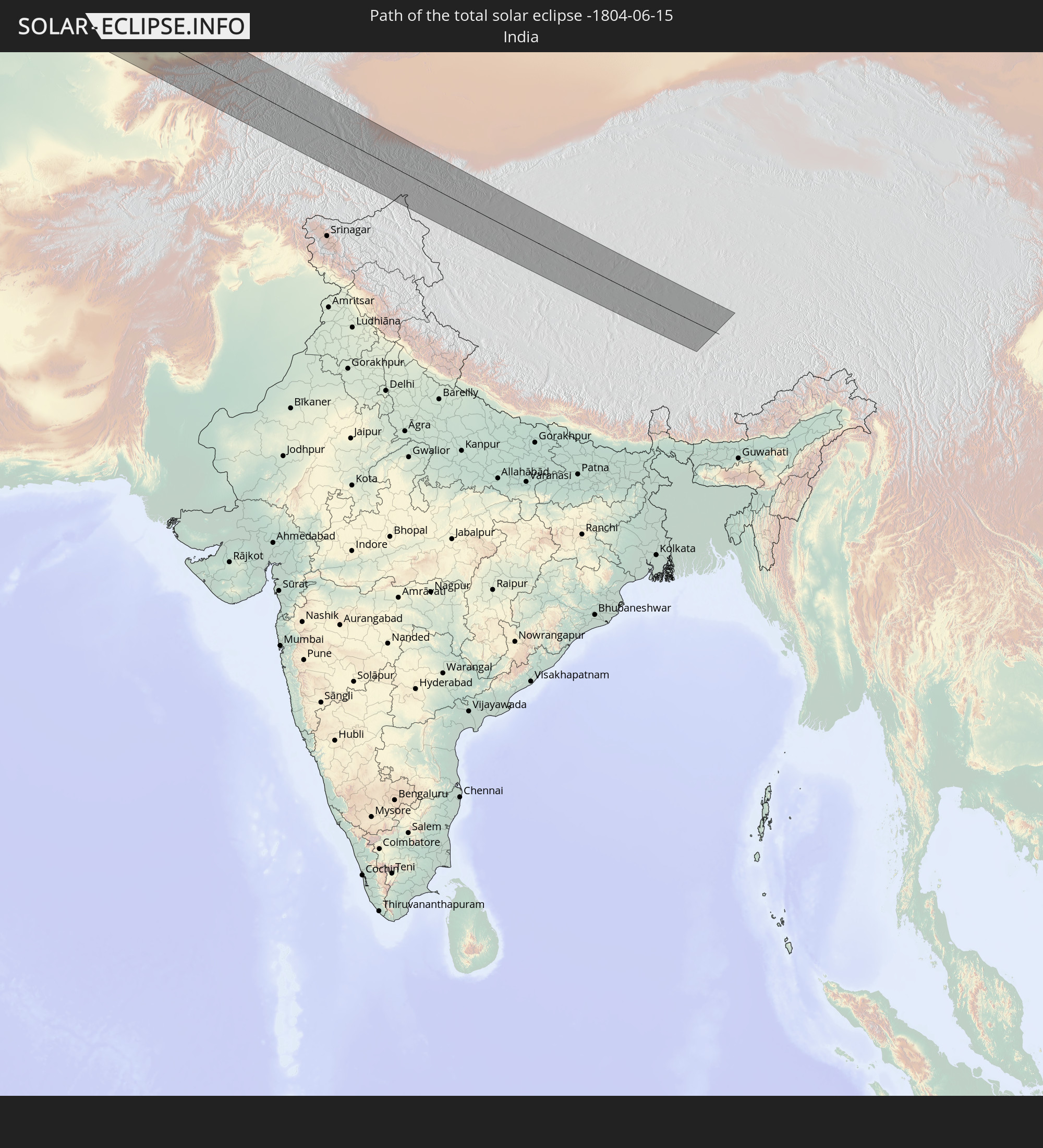 Indien
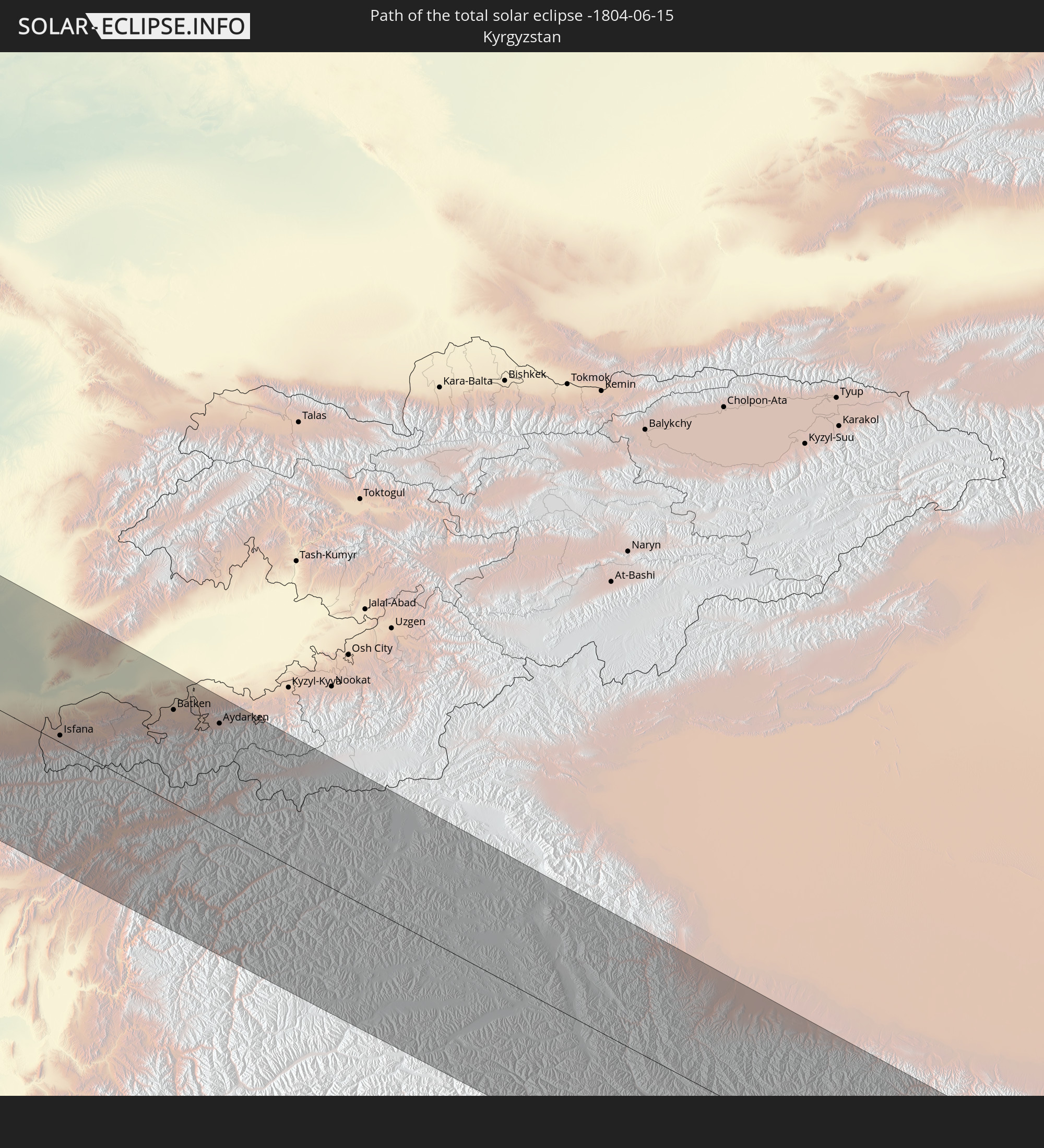 Kirgisistan
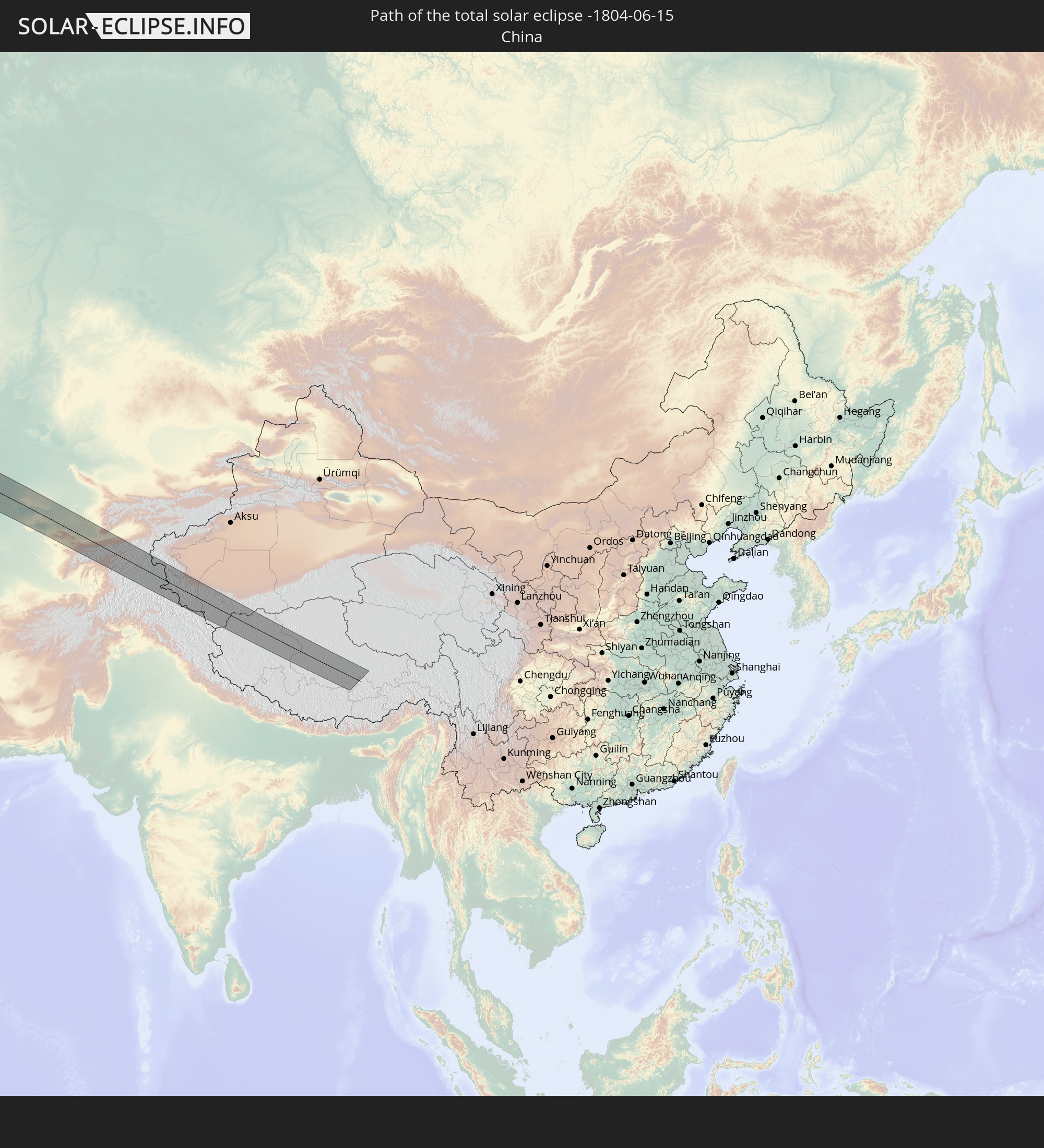 Volksrepublik China
In den folgenden Ländern ist die Sonnenfinsternis partiell zu sehen
 Russland
 Vereinigte Staaten
 Kanada
 Grönland
 Brasilien
 Bermuda
 Anguilla
 Saint-Martin
 Saint-Barthélemy
 St. Kitts und Nevis
 Antigua und Barbuda
 Montserrat
 Guadeloupe
 Dominica
 Martinique
 Barbados
 Suriname
 Saint-Pierre und Miquelon
 Französisch-Guayana
 Portugal
 Kap Verde
 Island
 Spanien
 Senegal
 Mauretanien
 Gambia
 Guinea-Bissau
 Guinea
 Marokko
 Mali
Mali
 Irland
 Spitzbergen
 Algerien
 Vereinigtes Königreich
 Färöer
 Gibraltar
 Frankreich
 Isle of Man
 Guernsey
 Jersey
 Niger
Niger
 Andorra
 Belgien
 Niederlande
 Norwegen
 Luxemburg
 Deutschland
 Schweiz
 Italien
 Monaco
 Tunesien
 Dänemark
 Libyen
 Liechtenstein
 Österreich
 Schweden
 Tschechien
 San Marino
 Vatikanstadt
 Slowenien
 Tschad
 Kroatien
 Polen
Polen
 Malta
Malta
 Bosnien und Herzegowina
 Ungarn
 Slowakei
 Montenegro
 Serbien
 Albanien
 Åland Islands
 Griechenland
 Rumänien
 Mazedonien
 Finnland
 Litauen
 Lettland
 Estland
 Sudan
Sudan
 Ukraine
 Bulgarien
 Weißrussland
 Ägypten
 Türkei
 Moldawien
 Republik Zypern
 Staat Palästina
 Israel
 Saudi-Arabien
 Jordanien
 Libanon
 Syrien
 Eritrea
 Irak
Irak
 Georgien
 Somalia
 Jemen
Jemen
 Armenien
 Iran
Iran
 Aserbaidschan
 Kasachstan
 Kuwait
 Bahrain
 Katar
Katar
 Vereinigte Arabische Emirate
 Oman
Oman
 Turkmenistan
 Usbekistan
 Afghanistan
 Pakistan
 Tadschikistan
 Indien
 Kirgisistan
 Malediven
 Volksrepublik China
 Nepal
Nepal
 Mongolei
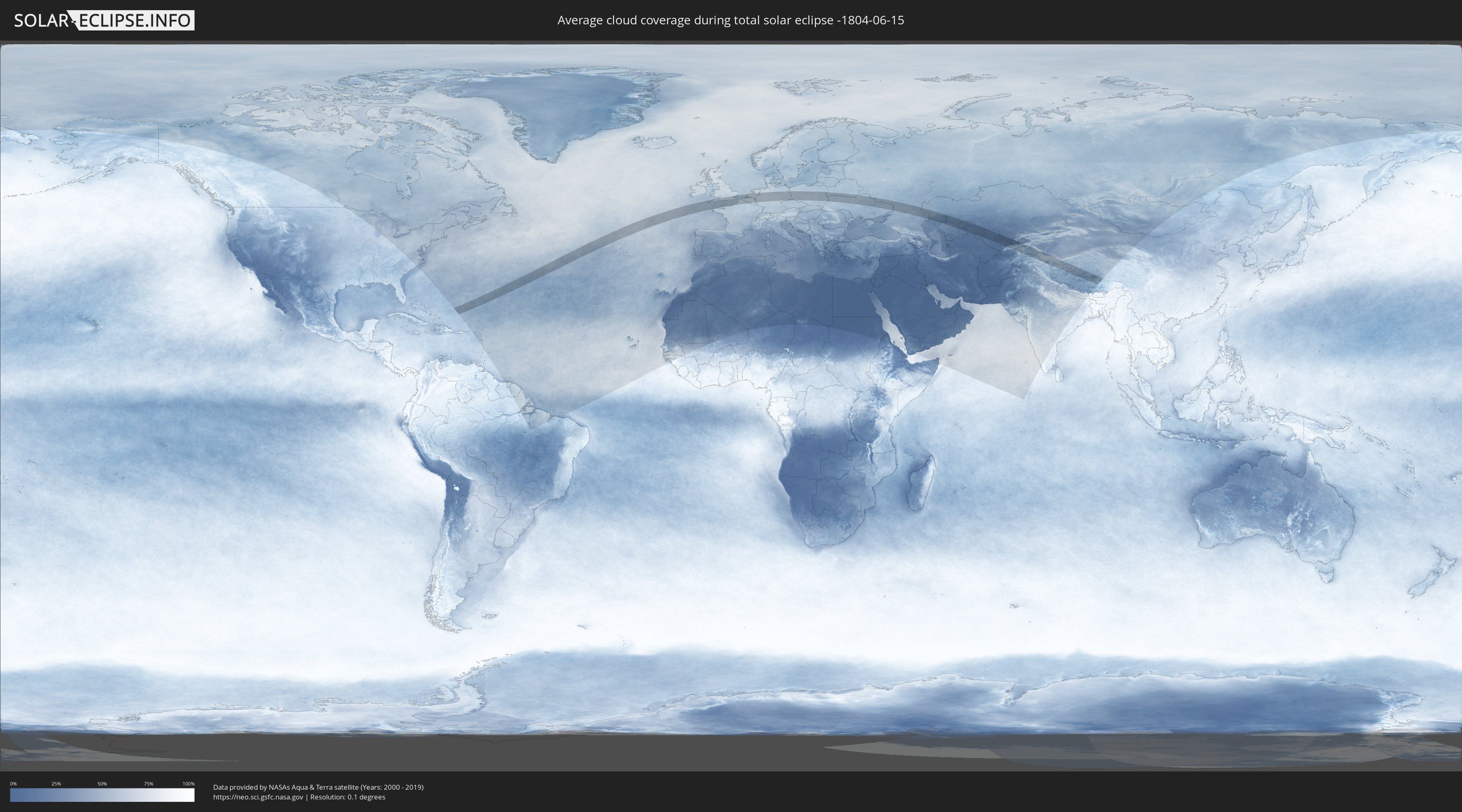
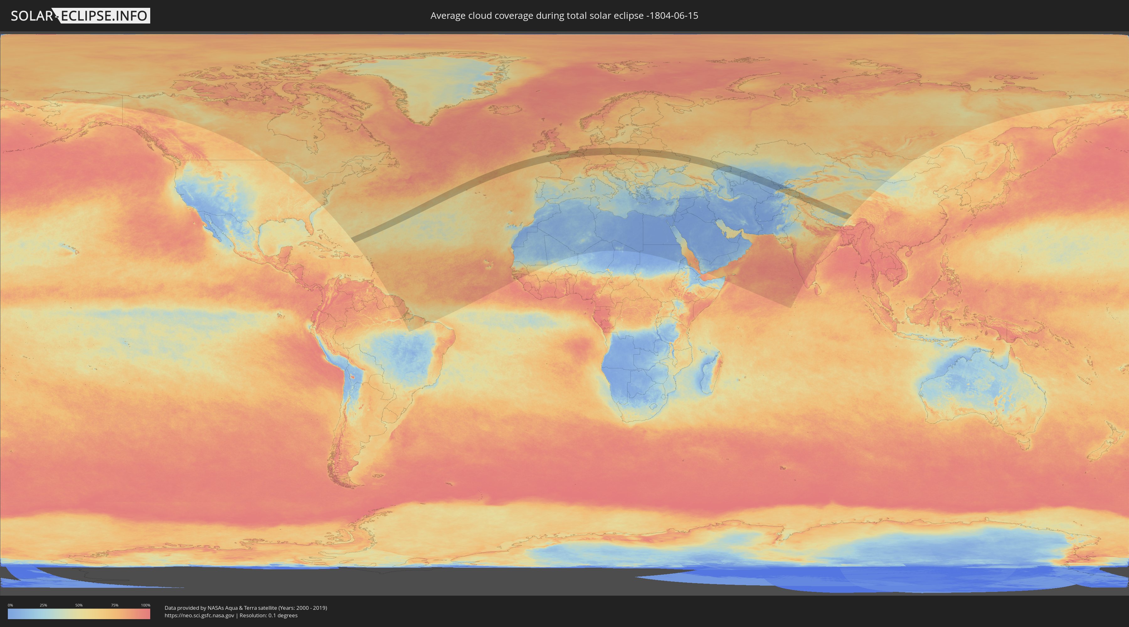
Wie wird das Wetter während der totalen Sonnenfinsternis am 15.06.-1804?
Wo ist der beste Ort, um die totale Sonnenfinsternis vom 15.06.-1804 zu beobachten?
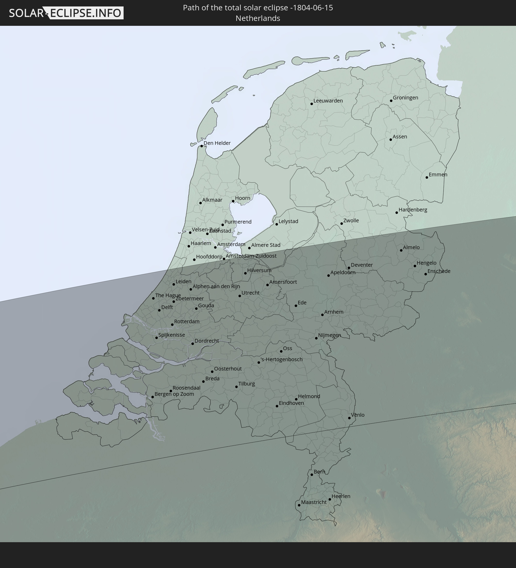
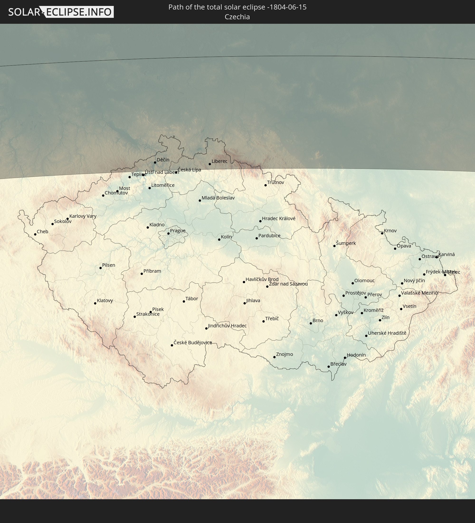
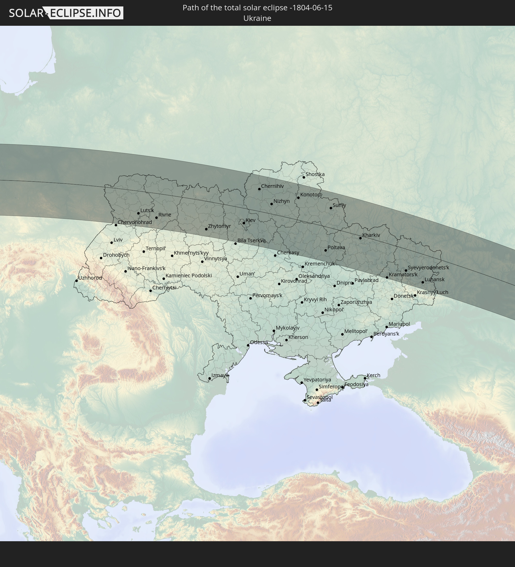
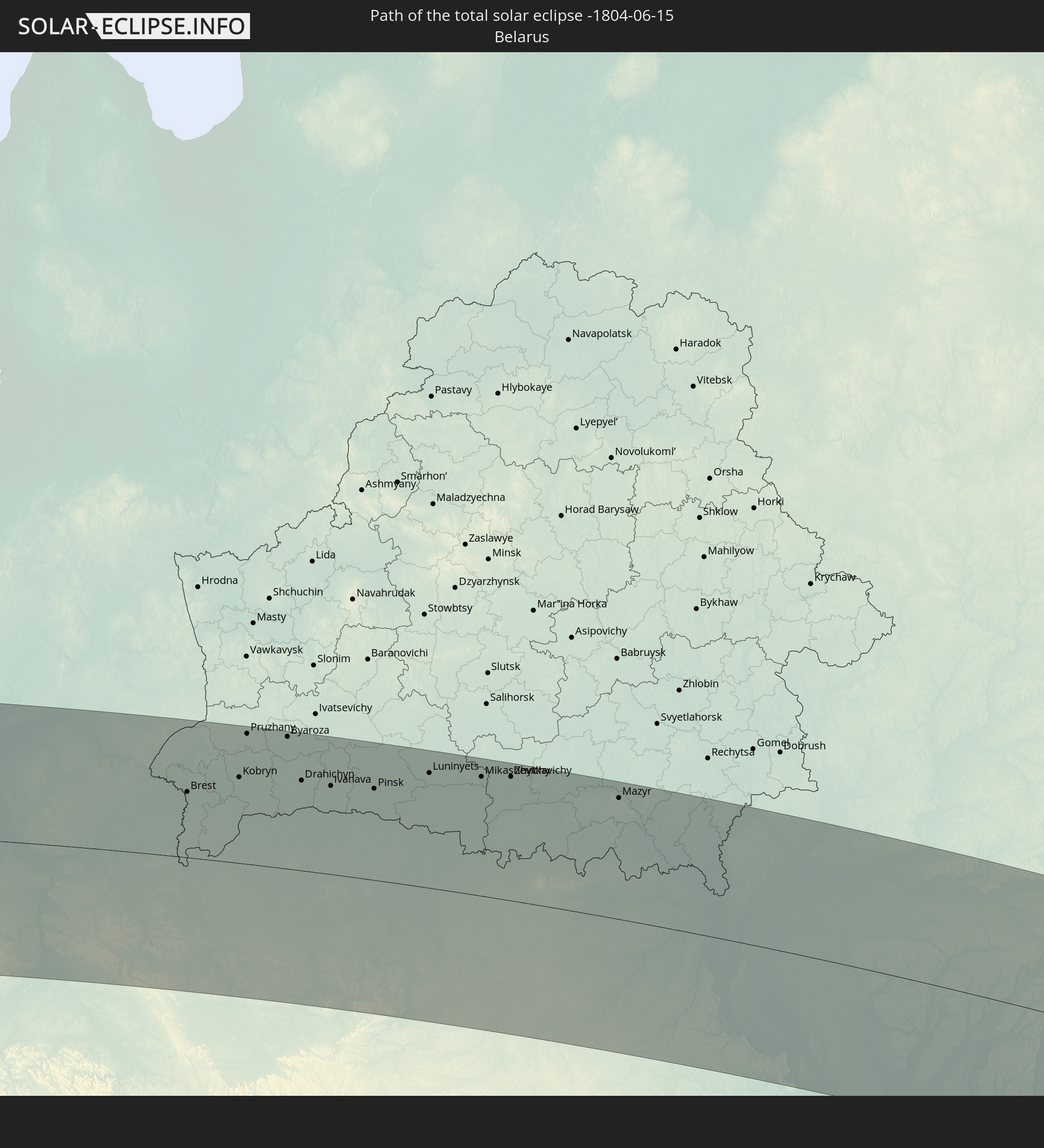
Die folgenden Karten zeigen die durchschnittliche Bewölkung für den Tag, an dem die totale Sonnenfinsternis
stattfindet. Mit Hilfe der Karten lässt sich der Ort entlang des Finsternispfades eingrenzen,
der die besten Aussichen auf einen klaren wolkenfreien Himmel bietet.
Trotzdem muss man immer lokale Gegenenheiten beachten und sollte sich genau über das Wetter an seinem
gewählten Beobachtungsort informieren.
Die Daten stammen von den beiden NASA-Satelliten
AQUA und TERRA
und wurden über einen Zeitraum von 19 Jahren (2000 - 2019) gemittelt.
Detaillierte Länderkarten
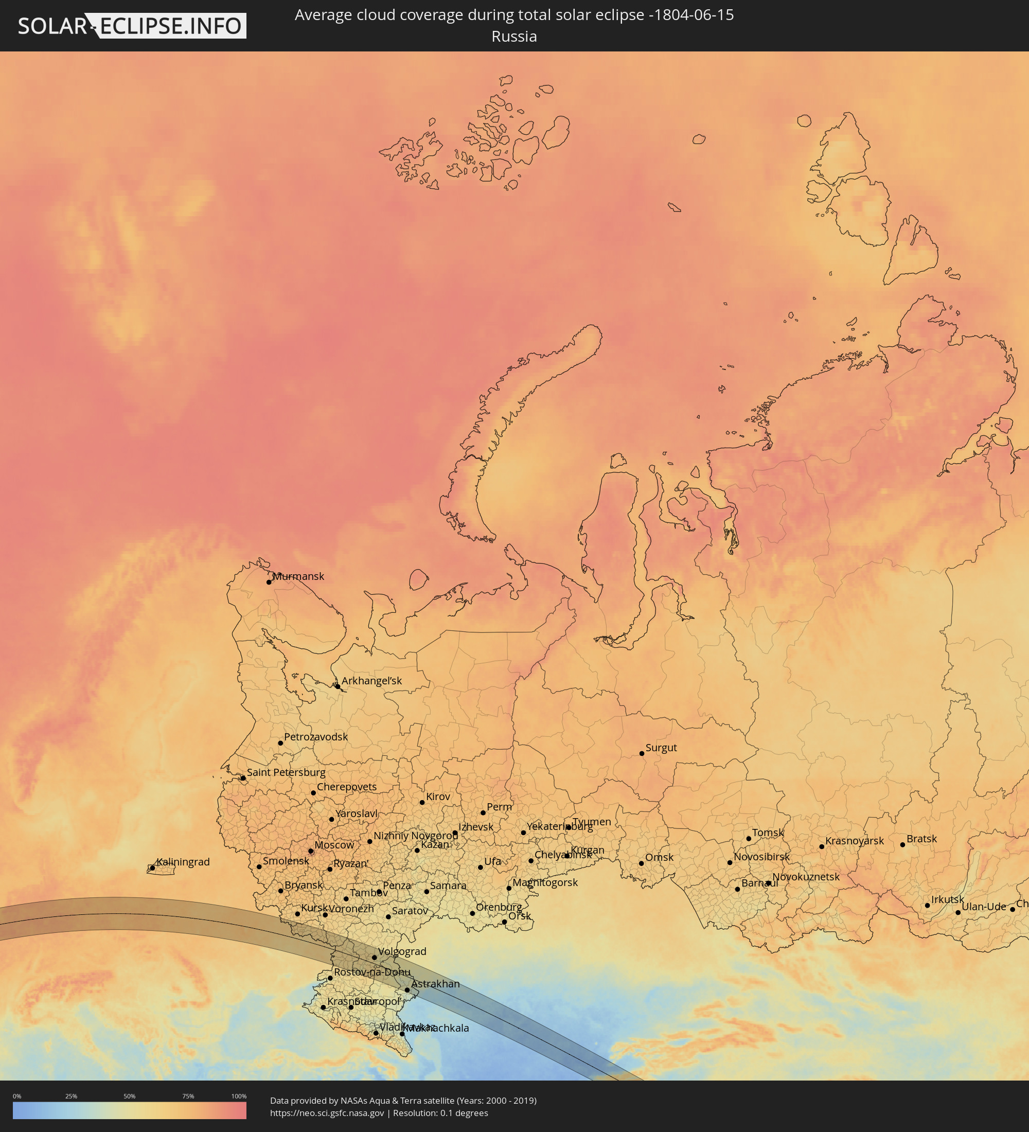 Russland
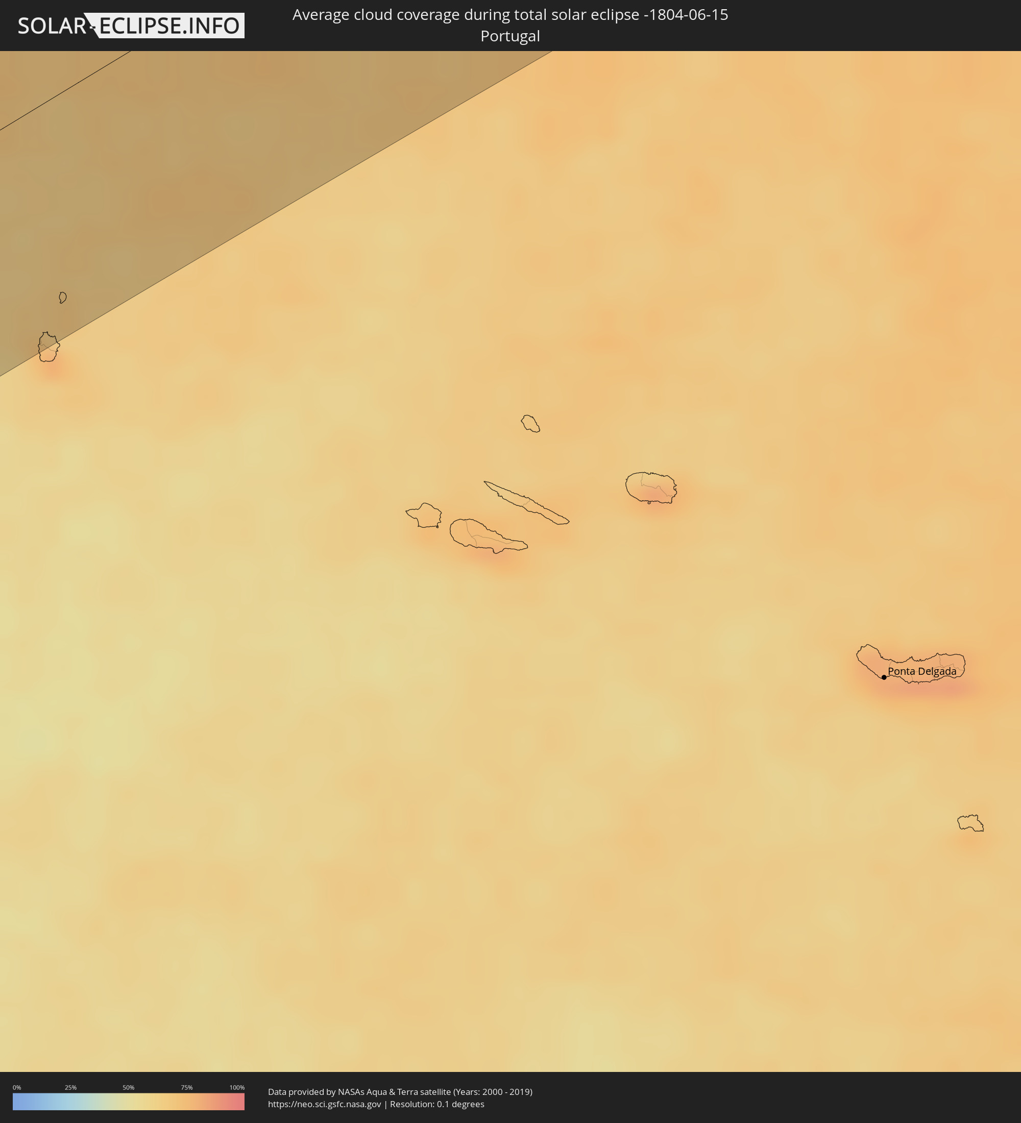 Portugal
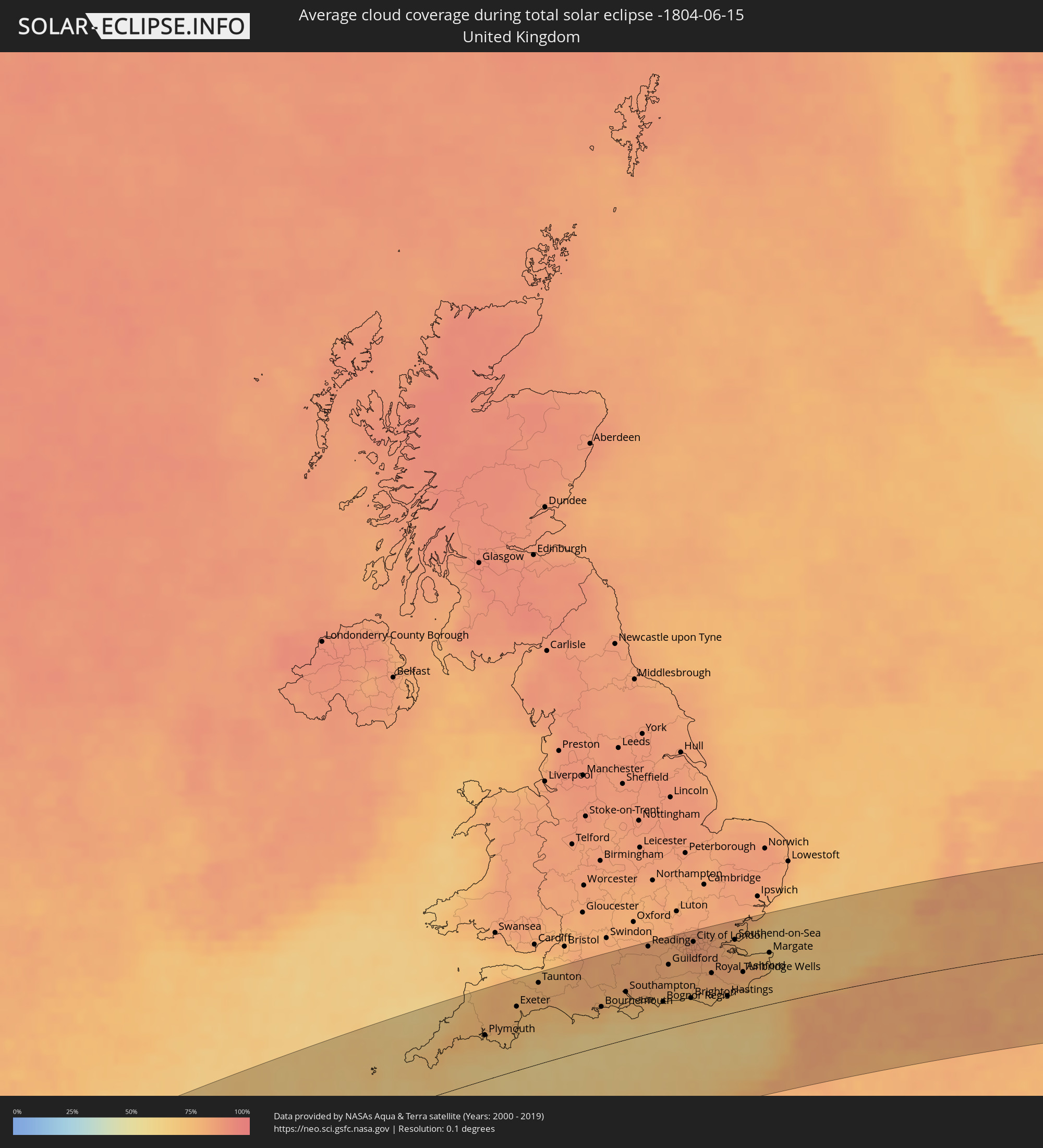 Vereinigtes Königreich
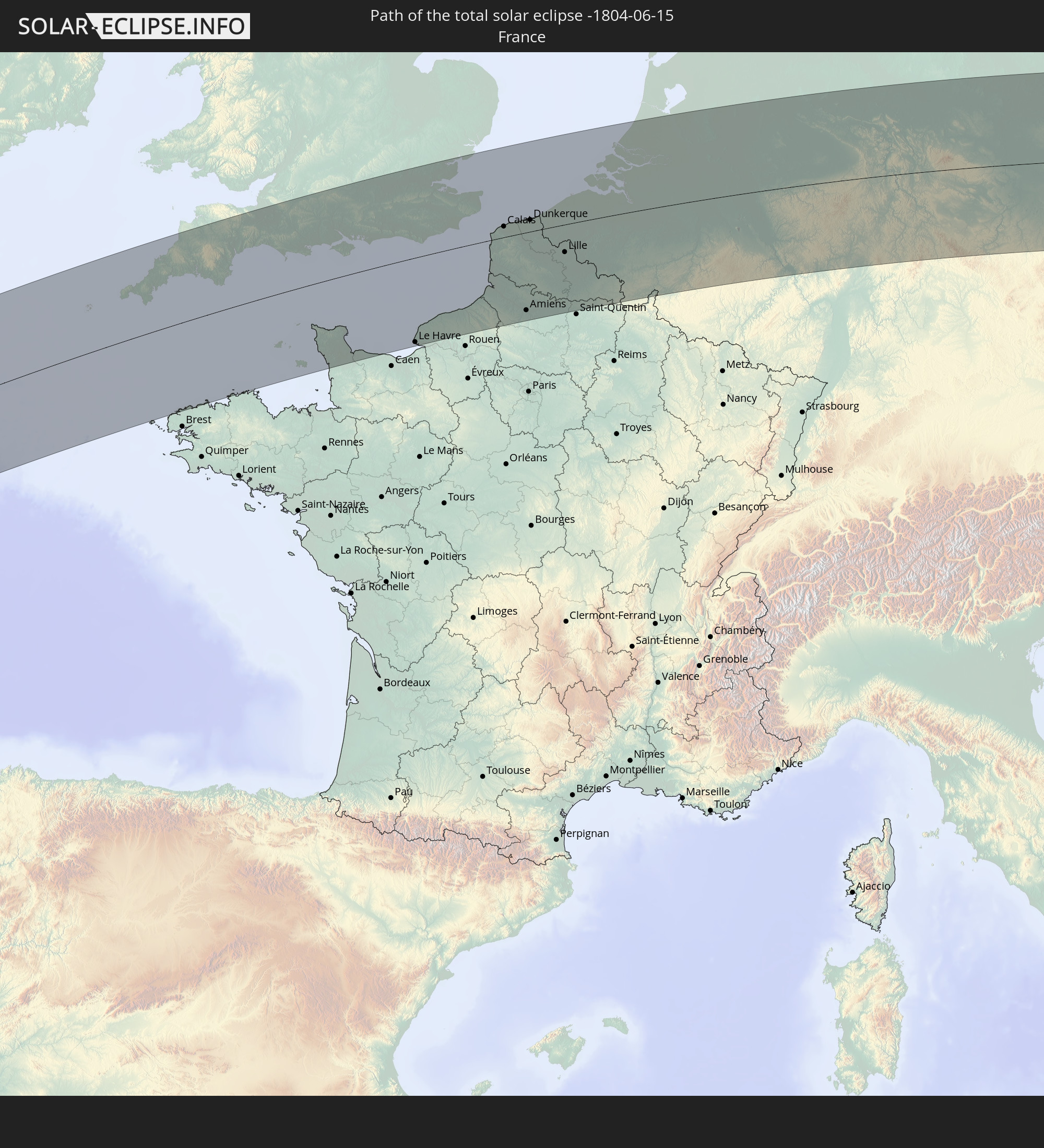
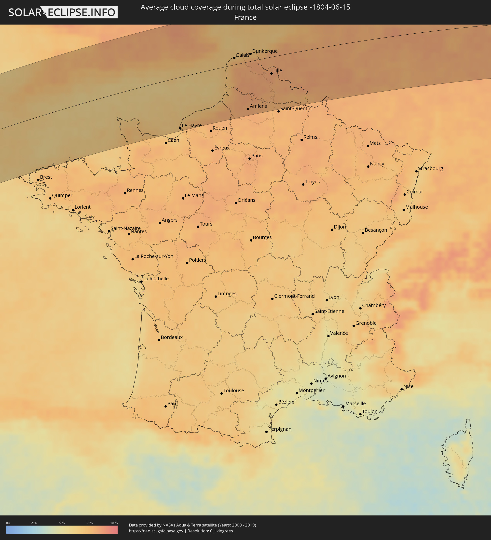 Frankreich
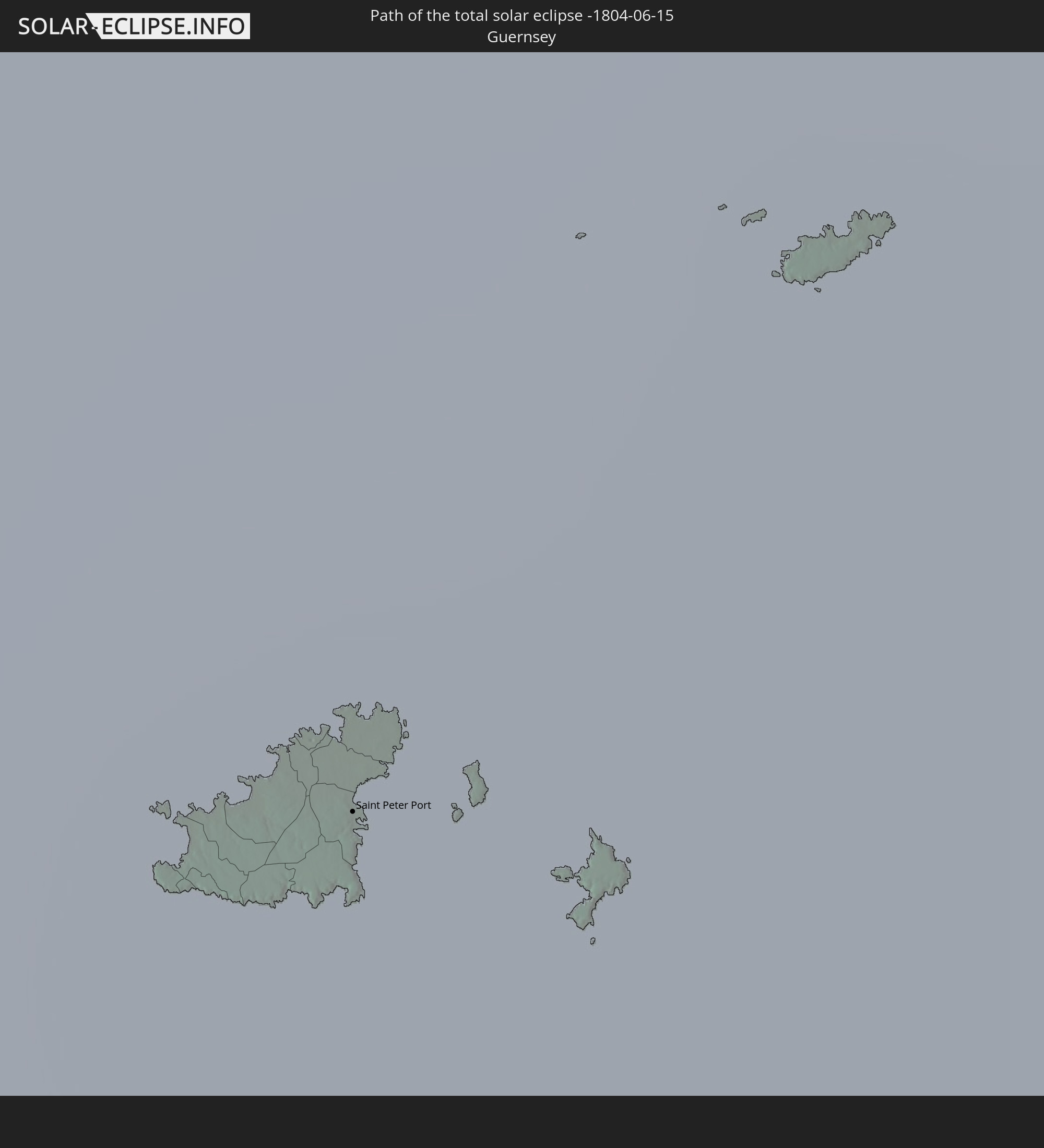
 Guernsey
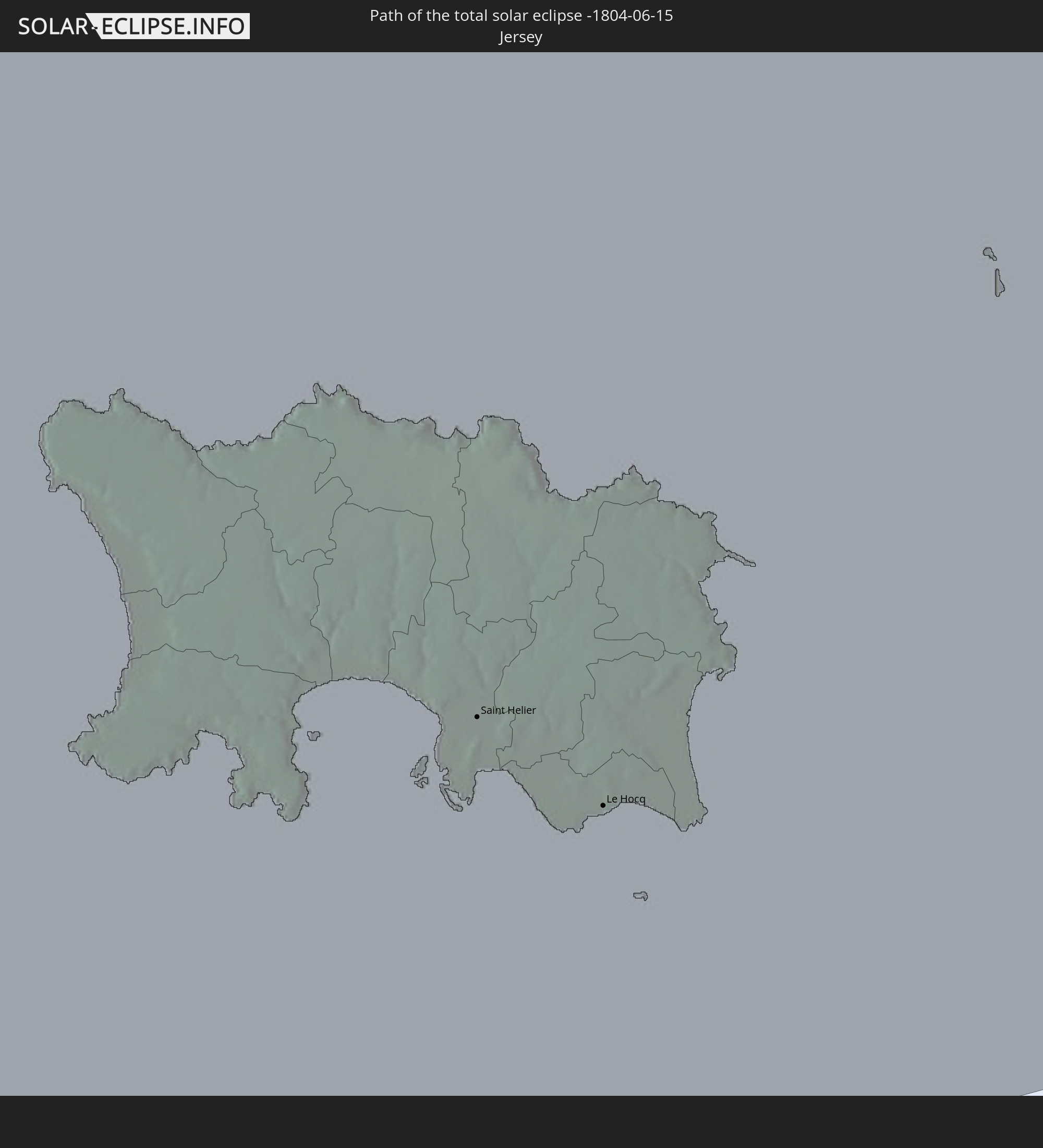
 Jersey
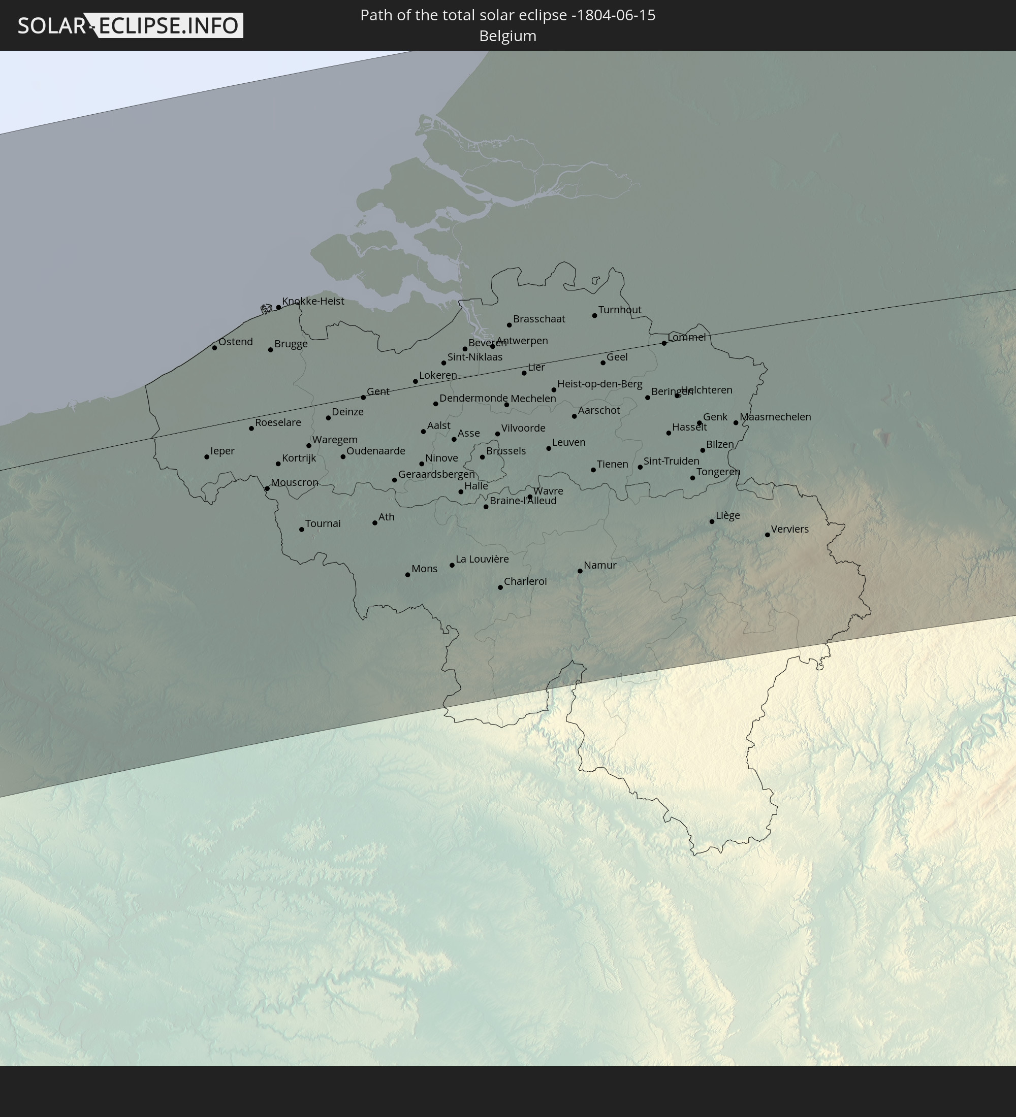
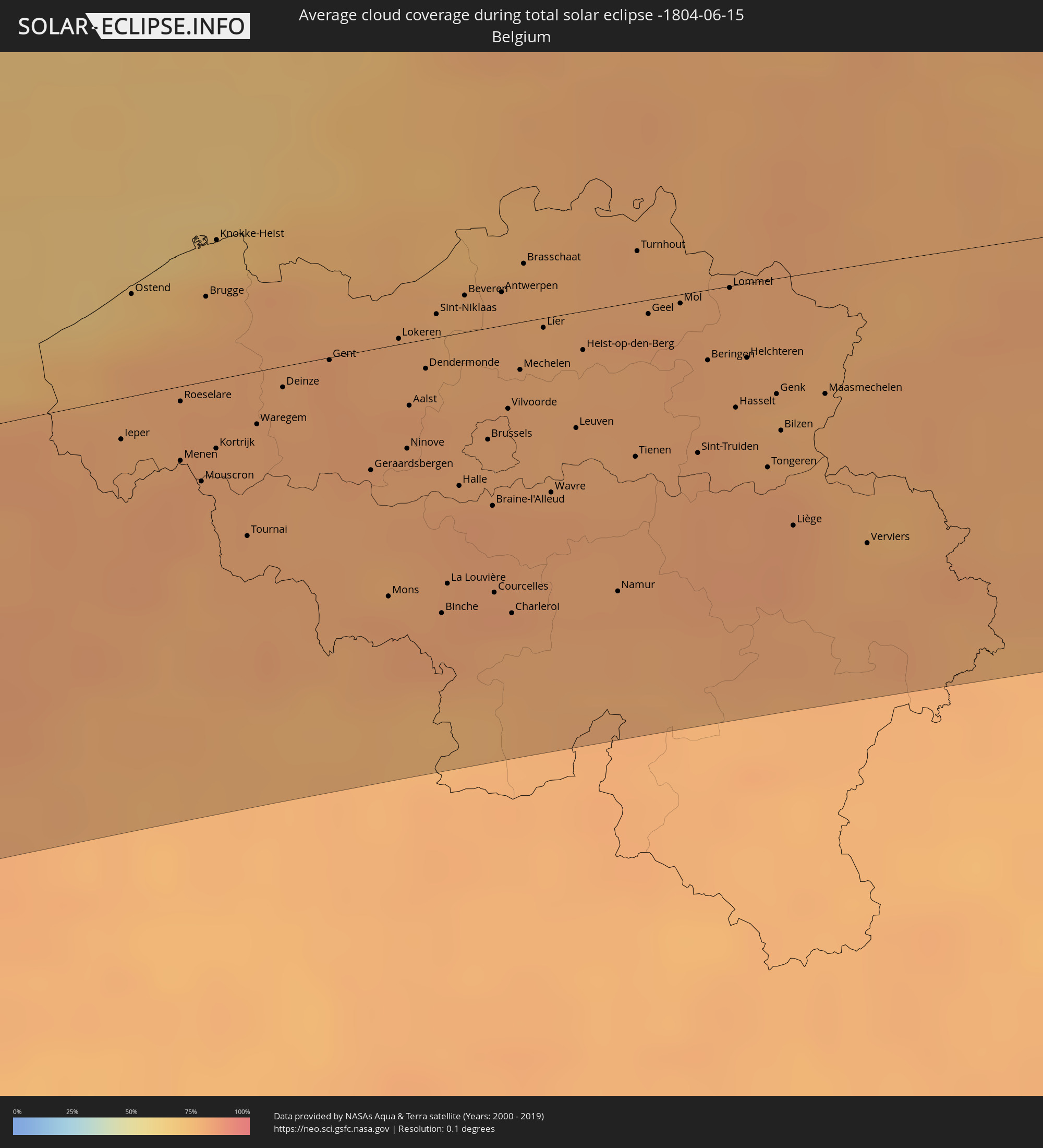 Belgien
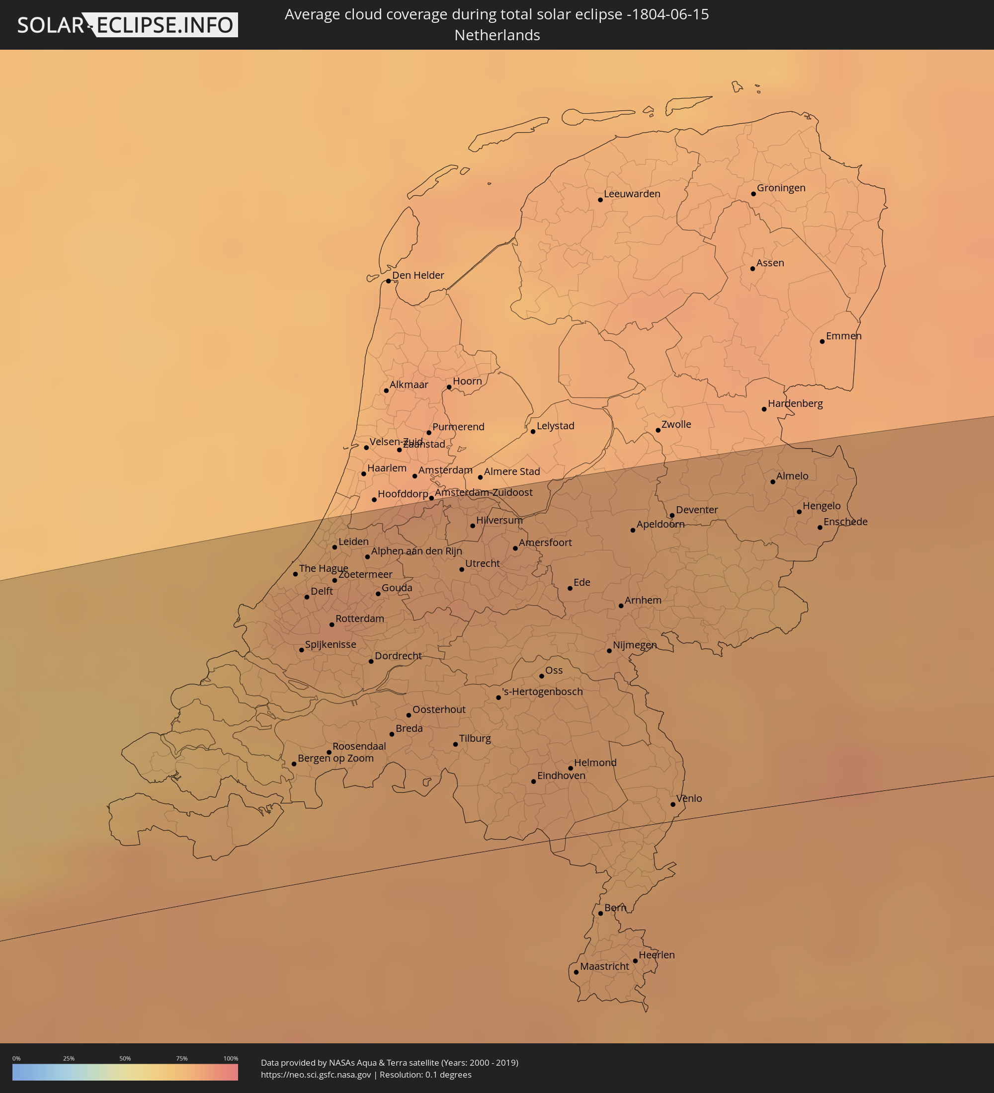 Niederlande
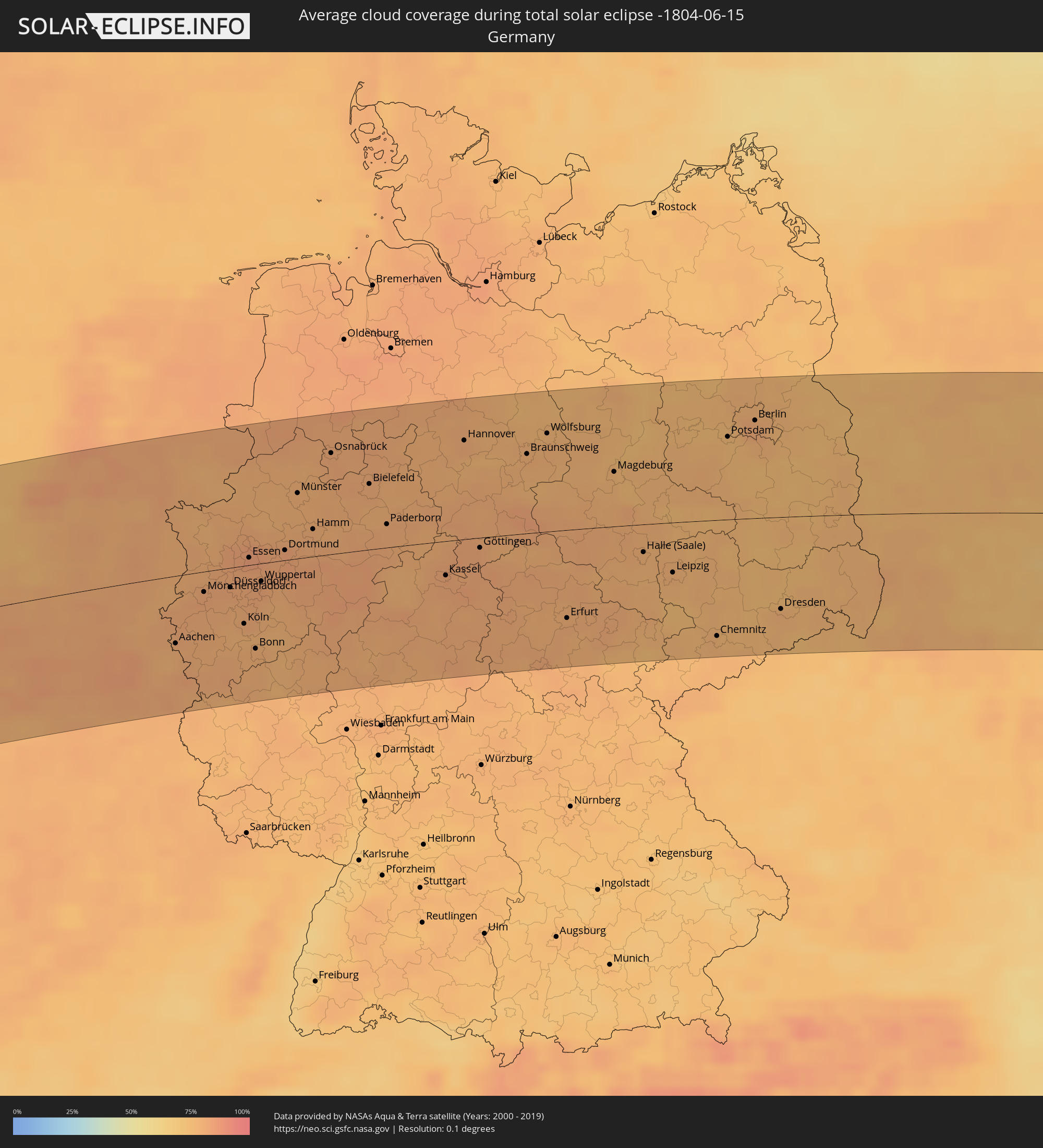 Deutschland
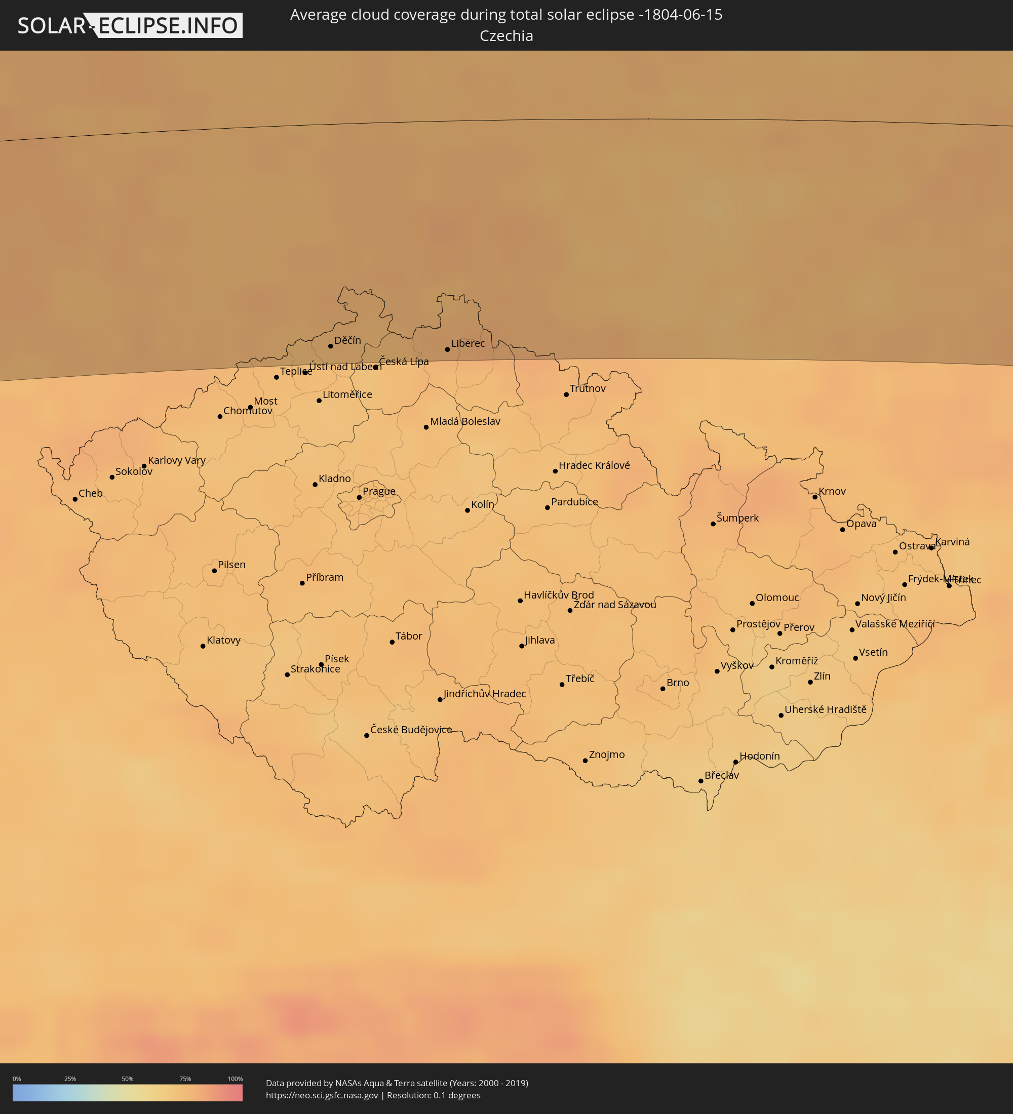 Tschechien
 Polen
Polen
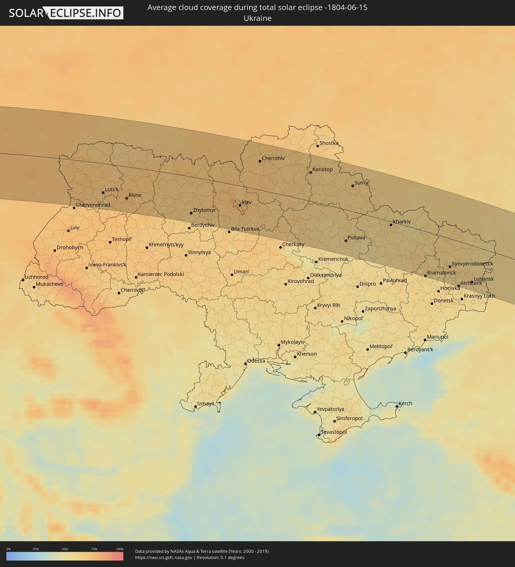 Ukraine
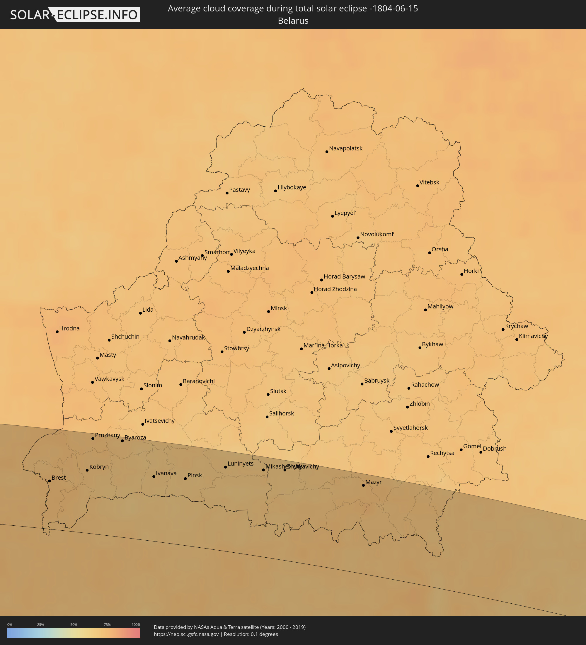 Weißrussland
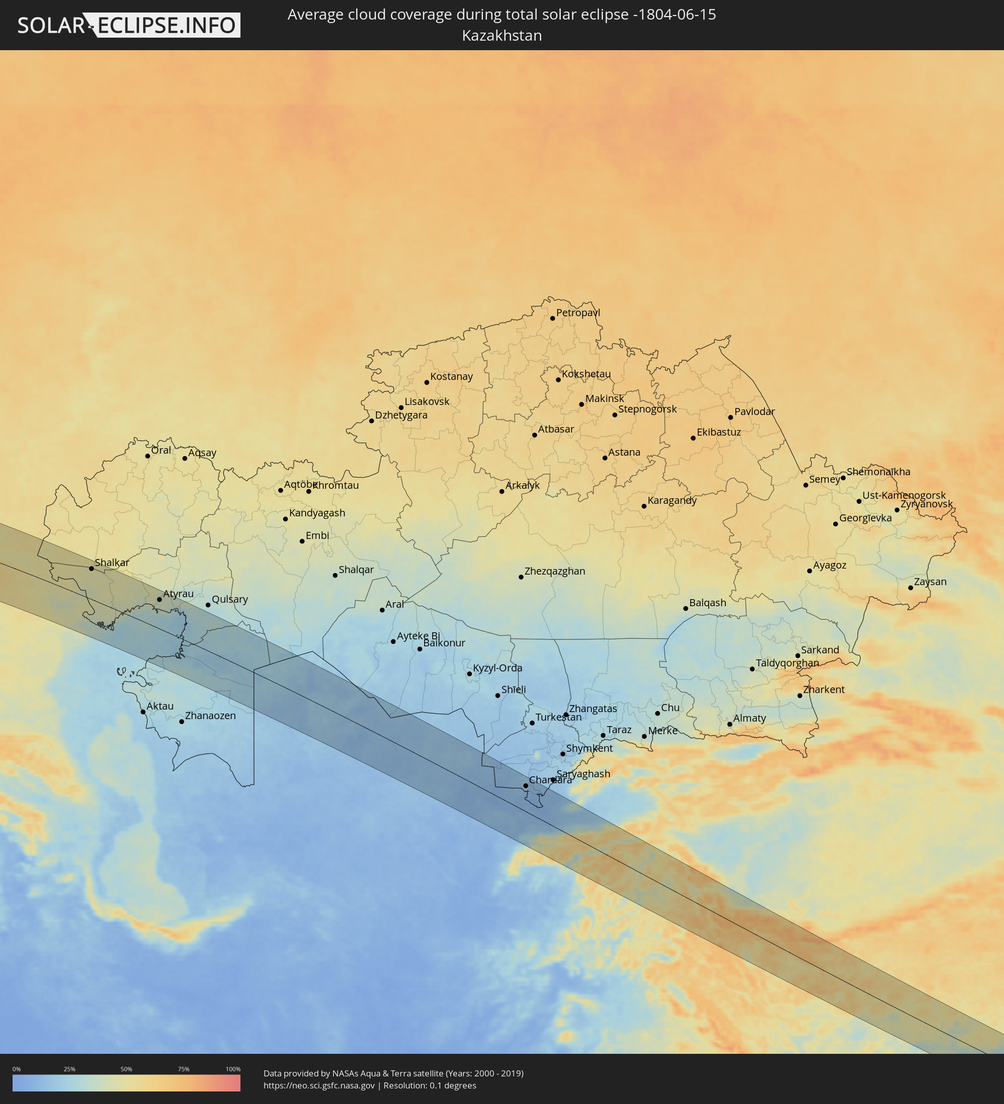 Kasachstan
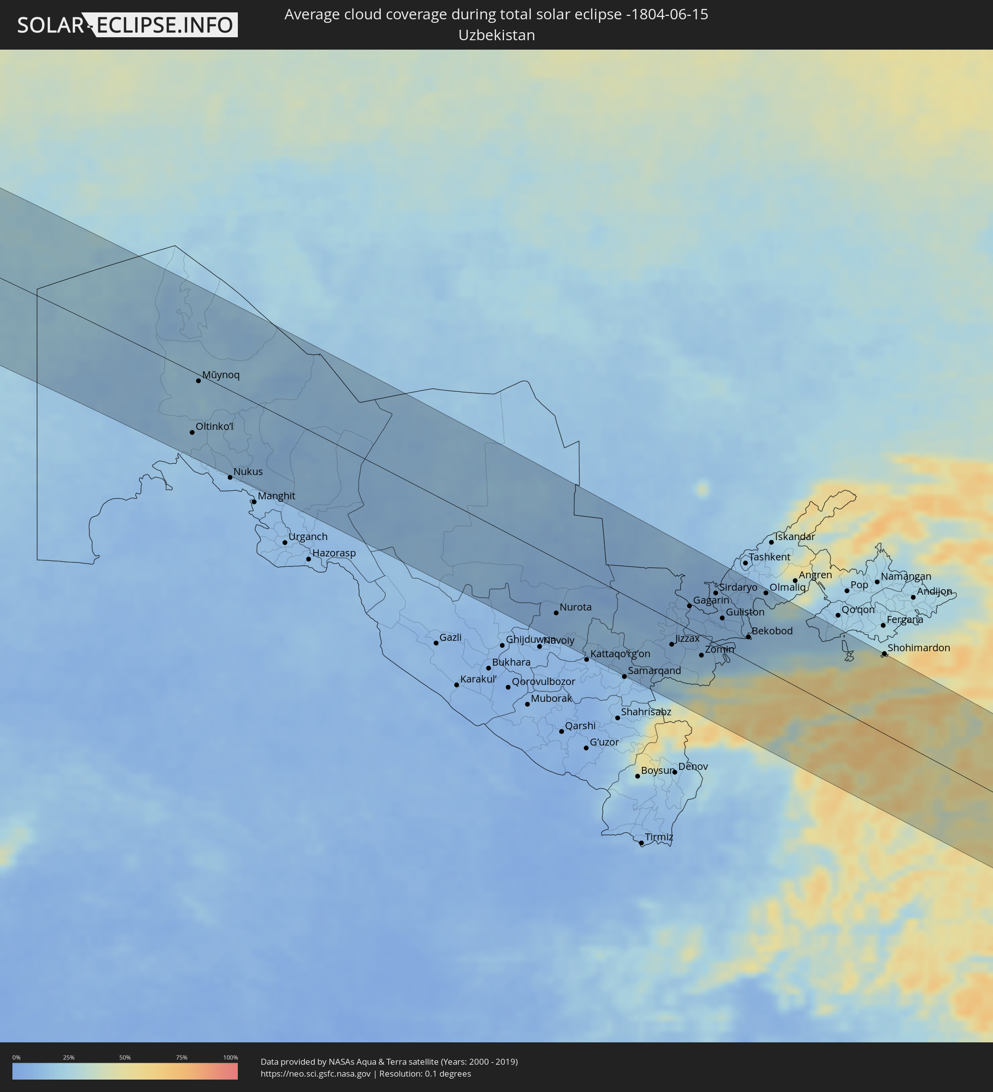 Usbekistan
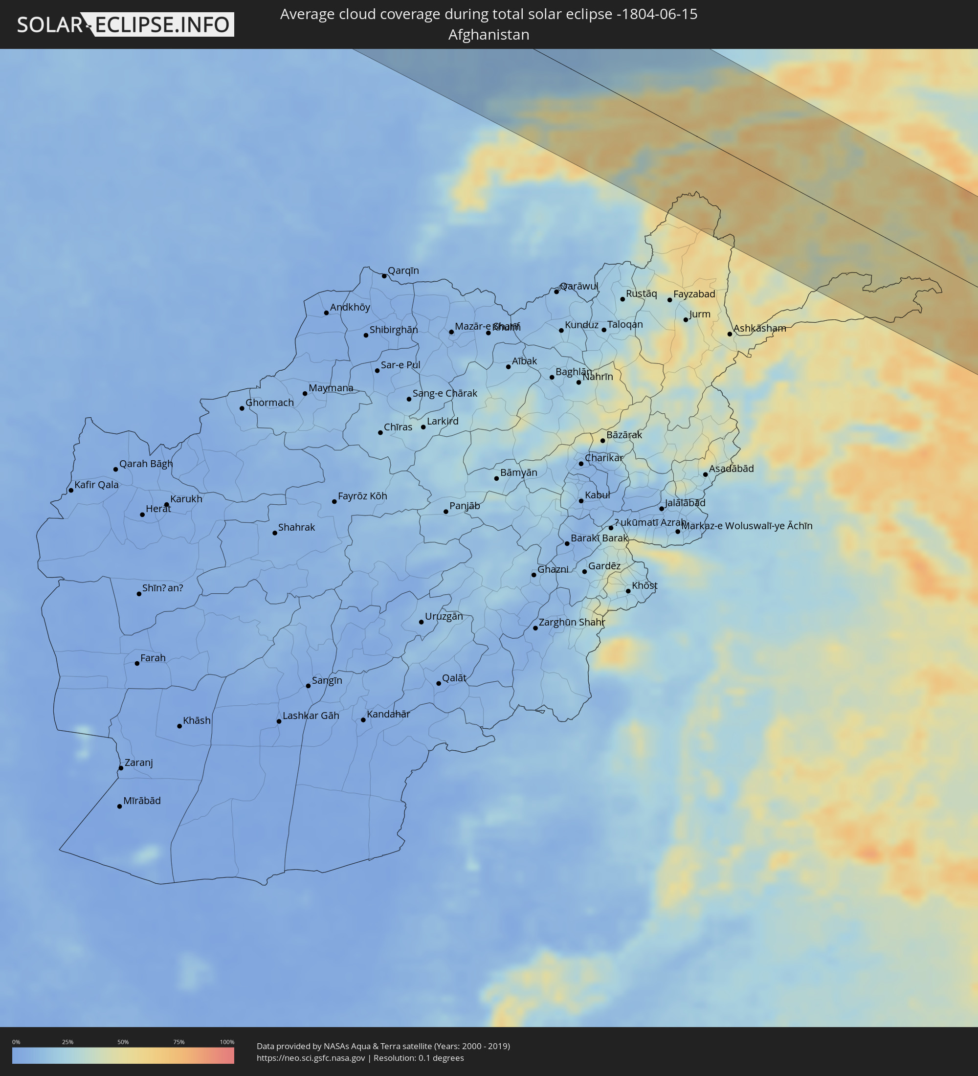 Afghanistan
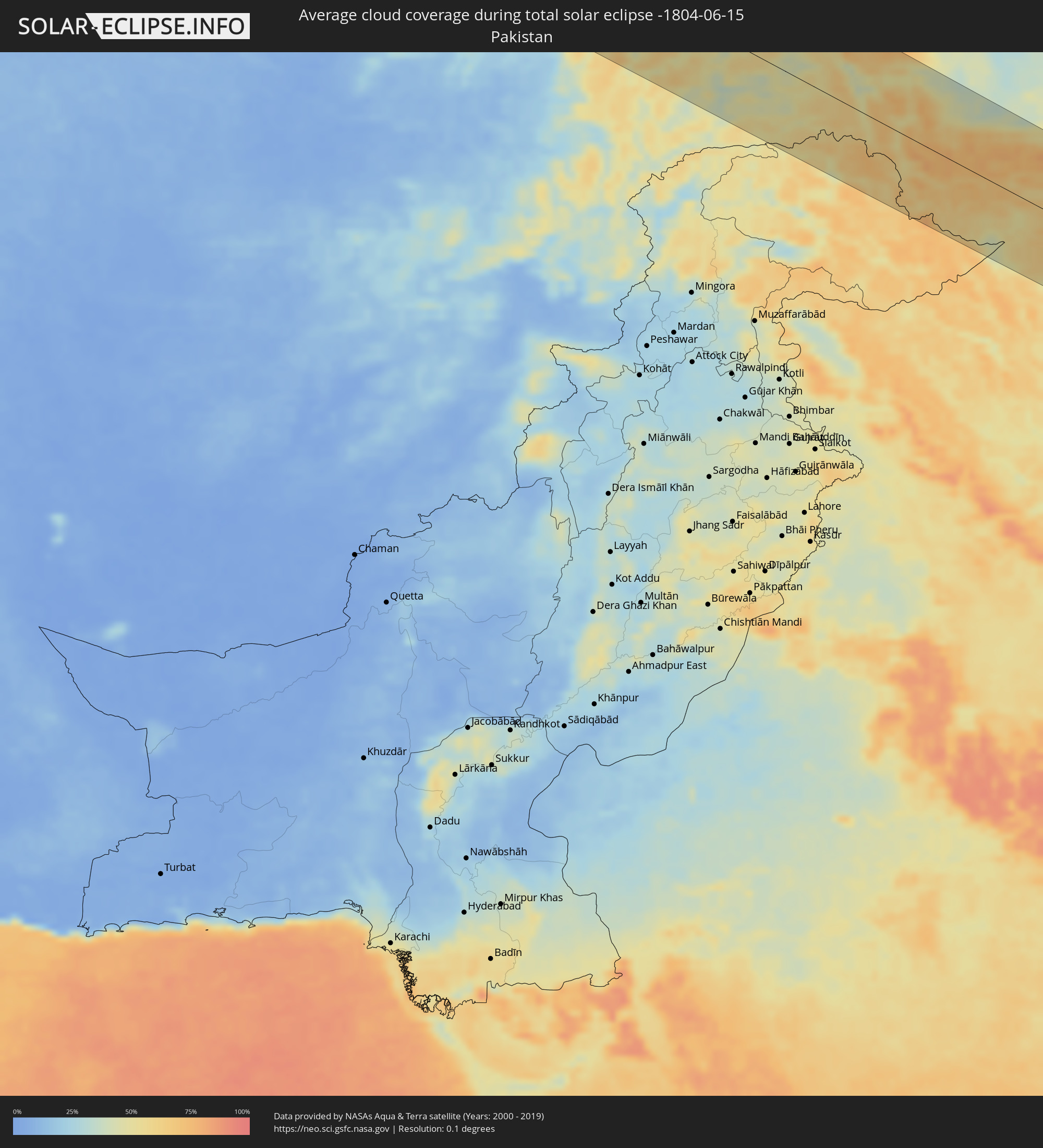 Pakistan
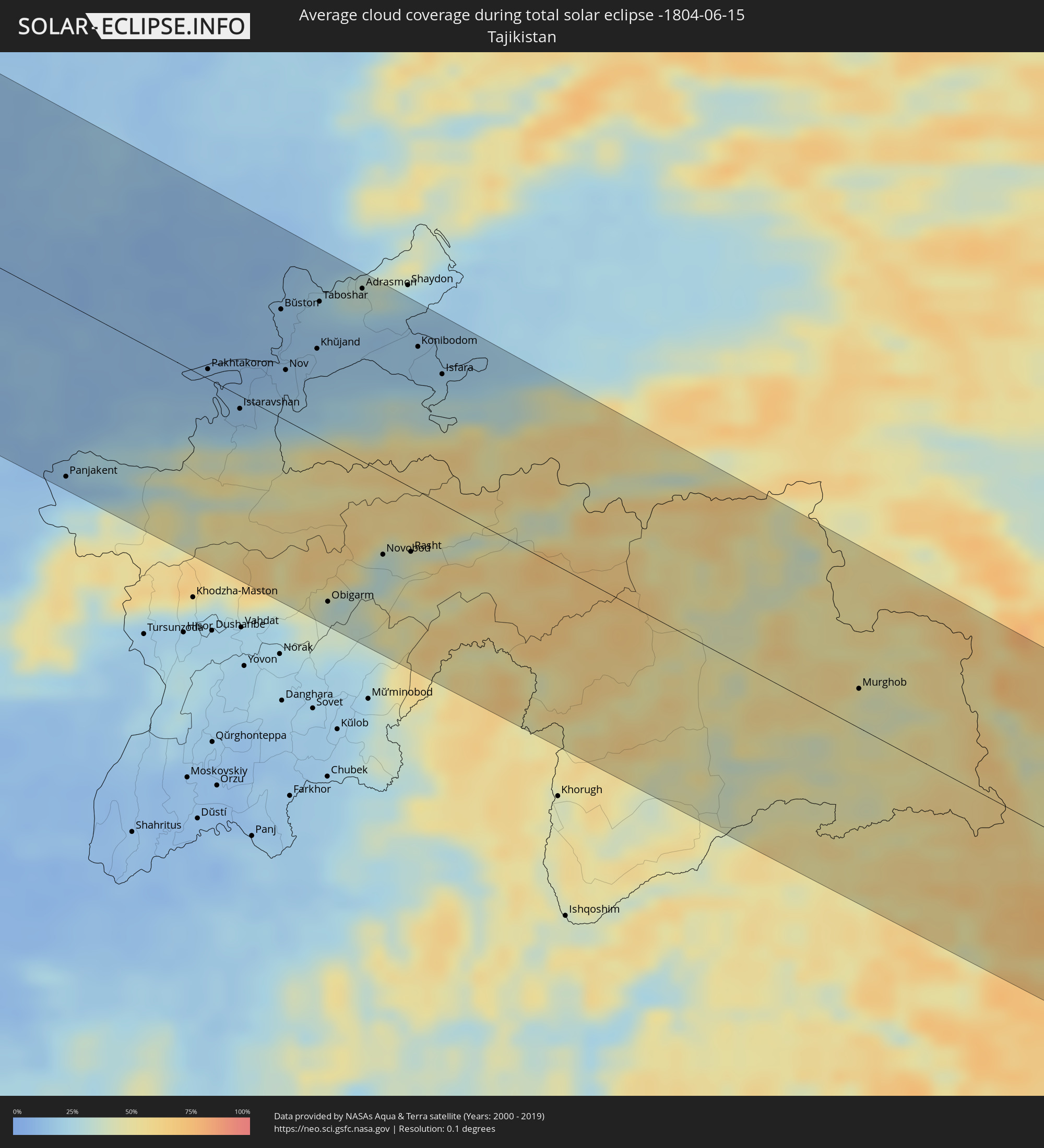 Tadschikistan
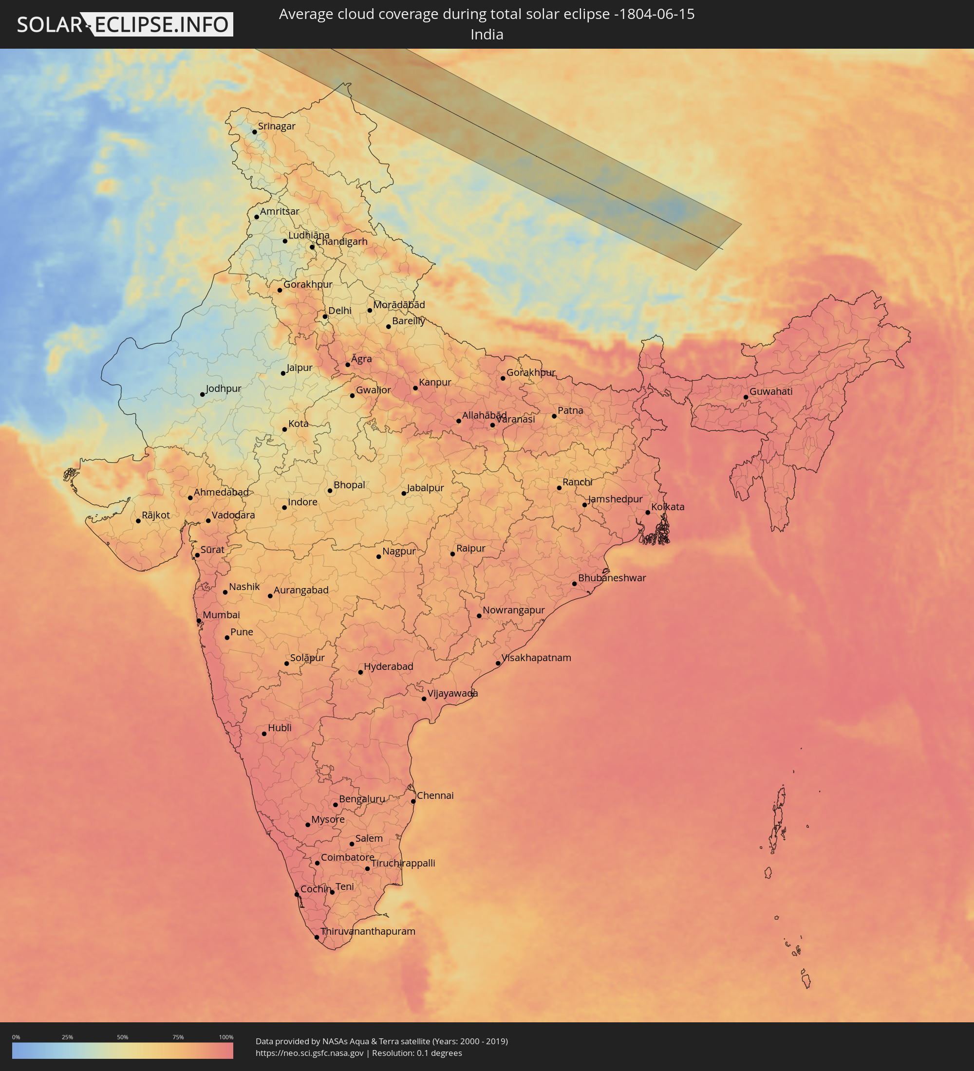 Indien
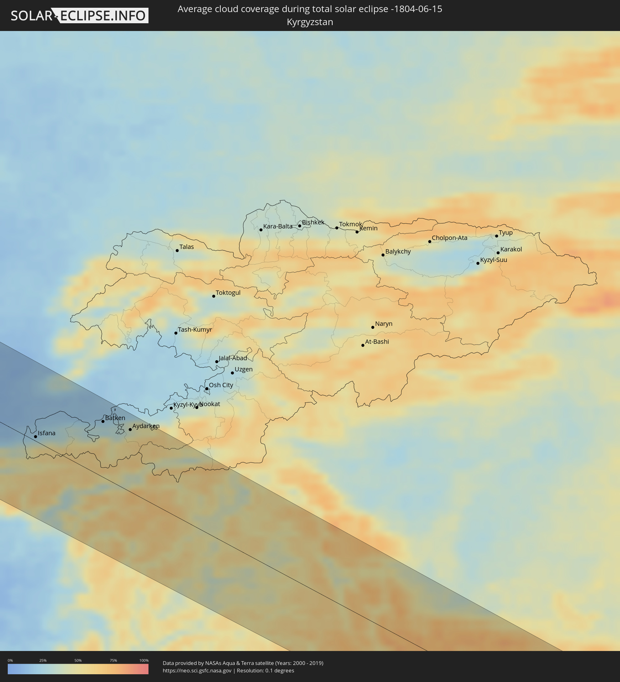 Kirgisistan
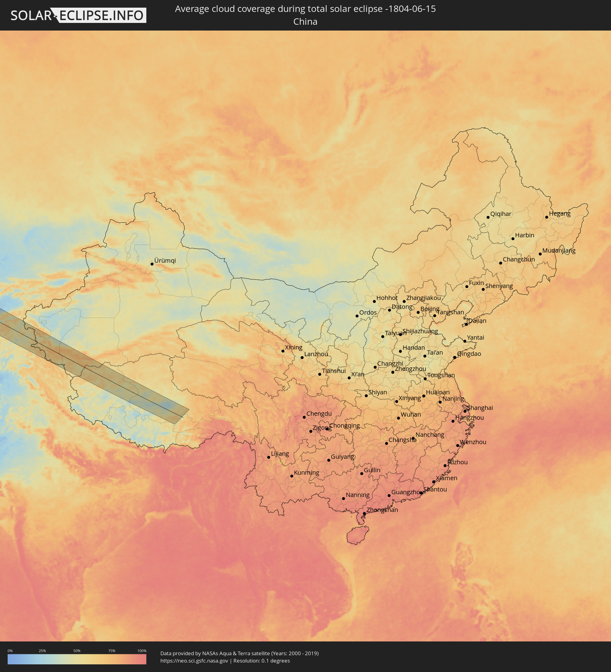 Volksrepublik China
Orte im Finsternispfad
Die nachfolgene Tabelle zeigt Städte und Orte mit mehr als 5.000 Einwohnern, die sich im Finsternispfad befinden. Städte mit mehr als 100.000 Einwohnern sind dick gekennzeichnet. Mit einem Klick auf den Ort öffnet sich eine Detailkarte die die Lage des jeweiligen Ortes zusammen mit dem Verlauf der zentralen Finsternis präsentiert.
| Ort | Typ | Dauer der Verfinsterung | Ortszeit bei maximaler Verfinsterung | Entfernung zur Zentrallinie | Ø Bewölkung |
|
Plymouth, England
|
total | - | 10:53:41 UTC+00:00 | 60 km | 71% |
|
Exeter, England
|
total | - | 10:54:54 UTC+00:00 | 84 km | 74% |
|
Saint Peter Port, St Peter Port
|
total | - | 10:55:19 UTC+00:00 | 70 km | 65% |
|
Saint Helier, St Helier
|
total | - | 10:55:45 UTC+00:00 | 108 km | 68% |
|
Le Hocq, St Clement
|
total | - | 10:55:48 UTC+00:00 | 111 km | 68% |
|
Bournemouth, England
|
total | - | 10:57:20 UTC+00:00 | 52 km | 72% |
|
Southampton, England
|
total | - | 10:58:11 UTC+00:00 | 63 km | 76% |
|
Portsmouth, England
|
total | - | 10:58:34 UTC+00:00 | 46 km | 72% |
|
Reading, England
|
total | - | 10:59:14 UTC+00:00 | 115 km | 81% |
|
Slough, England
|
total | - | 10:59:50 UTC+00:00 | 115 km | 79% |
|
Sutton, England
|
total | - | 11:00:18 UTC+00:00 | 91 km | 82% |
|
Brighton, England
|
total | - | 11:00:02 UTC+00:00 | 33 km | 69% |
|
London, England
|
total | - | 11:00:32 UTC+00:00 | 108 km | 85% |
|
Le Havre, Normandy
|
total | - | 11:08:50 UTC+00:09 | 116 km | 70% |
|
Bexley, England
|
total | - | 11:00:53 UTC+00:00 | 94 km | 82% |
|
Eastbourne, England
|
total | - | 11:00:38 UTC+00:00 | 22 km | 67% |
|
Southend-on-Sea, England
|
total | - | 11:01:48 UTC+00:00 | 96 km | 77% |
|
Dieppe, Normandy
|
total | - | 11:10:40 UTC+00:09 | 85 km | 74% |
|
Boulogne-sur-Mer, Hauts-de-France
|
total | - | 11:12:00 UTC+00:09 | 10 km | 70% |
|
Calais, Hauts-de-France
|
total | - | 11:12:31 UTC+00:09 | 16 km | 71% |
|
Amiens, Hauts-de-France
|
total | - | 11:12:35 UTC+00:09 | 107 km | 81% |
|
Dunkerque, Hauts-de-France
|
total | - | 11:13:22 UTC+00:09 | 17 km | 79% |
|
Arras, Hauts-de-France
|
total | - | 11:13:35 UTC+00:09 | 71 km | 79% |
|
Lens, Hauts-de-France
|
total | - | 11:13:44 UTC+00:09 | 57 km | 82% |
|
Lille, Hauts-de-France
|
total | - | 11:14:13 UTC+00:09 | 38 km | 81% |
|
Douai, Hauts-de-France
|
total | - | 11:14:05 UTC+00:09 | 67 km | 78% |
|
Brugge, Flanders
|
total | - | 11:05:26 UTC+00:00 | 28 km | 78% |
|
Cambrai, Hauts-de-France
|
total | - | 11:14:14 UTC+00:09 | 91 km | 79% |
|
Kortrijk, Flanders
|
total | - | 11:05:17 UTC+00:00 | 24 km | 81% |
|
Valenciennes, Hauts-de-France
|
total | - | 11:14:49 UTC+00:09 | 76 km | 81% |
|
Gent, Flanders
|
total | - | 11:06:07 UTC+00:00 | 15 km | 82% |
|
Mons, Wallonia
|
total | - | 11:06:11 UTC+00:00 | 71 km | 82% |
|
Maubeuge, Hauts-de-France
|
total | - | 11:15:29 UTC+00:09 | 90 km | 79% |
|
Aalst, Flanders
|
total | - | 11:06:33 UTC+00:00 | 17 km | 81% |
|
La Louvière, Wallonia
|
total | - | 11:06:35 UTC+00:00 | 69 km | 81% |
|
The Hague, South Holland
|
total | - | 11:27:02 UTC+00:19 | 104 km | 81% |
|
Brussels, Brussels Capital
|
total | - | 11:07:00 UTC+00:00 | 31 km | 80% |
|
Antwerpen, Flanders
|
total | - | 11:07:16 UTC+00:00 | 9 km | 80% |
|
Charleroi, Wallonia
|
total | - | 11:06:57 UTC+00:00 | 82 km | 80% |
|
Mechelen, Flanders
|
total | - | 11:07:17 UTC+00:00 | 13 km | 80% |
|
Rotterdam, South Holland
|
total | - | 11:27:14 UTC+00:19 | 85 km | 79% |
|
Leuven, Flanders
|
total | - | 11:07:34 UTC+00:00 | 32 km | 80% |
|
Breda, North Brabant
|
total | - | 11:27:32 UTC+00:19 | 45 km | 79% |
|
Namur, Wallonia
|
total | - | 11:07:39 UTC+00:00 | 79 km | 81% |
|
Tilburg, North Brabant
|
total | - | 11:28:01 UTC+00:19 | 38 km | 79% |
|
Utrecht, Utrecht
|
total | - | 11:28:17 UTC+00:19 | 97 km | 83% |
|
's-Hertogenbosch, North Brabant
|
total | - | 11:28:24 UTC+00:19 | 51 km | 78% |
|
Amersfoort, Utrecht
|
total | - | 11:28:43 UTC+00:19 | 101 km | 82% |
|
Eindhoven, North Brabant
|
total | - | 11:28:34 UTC+00:19 | 21 km | 81% |
|
Liège, Wallonia
|
total | - | 11:08:51 UTC+00:00 | 69 km | 82% |
|
Maastricht, Limburg
|
total | - | 11:28:40 UTC+00:19 | 47 km | 79% |
|
Nijmegen, Gelderland
|
total | - | 11:29:18 UTC+00:19 | 61 km | 79% |
|
Arnhem, Gelderland
|
total | - | 11:29:26 UTC+00:19 | 75 km | 82% |
|
Apeldoorn, Gelderland
|
total | - | 11:29:37 UTC+00:19 | 101 km | 80% |
|
Duisburg, North Rhine-Westphalia
|
total | - | 12:11:02 UTC+01:00 | 17 km | 81% |
|
Düsseldorf, North Rhine-Westphalia
|
total | - | 12:10:59 UTC+01:00 | 24 km | 79% |
|
Enschede, Overijssel
|
total | - | 11:31:01 UTC+00:19 | 92 km | 78% |
|
Köln, North Rhine-Westphalia
|
total | - | 12:11:10 UTC+01:00 | 52 km | 77% |
|
Essen, North Rhine-Westphalia
|
total | - | 12:11:26 UTC+01:00 | 7 km | 84% |
|
Bonn, North Rhine-Westphalia
|
total | - | 12:11:20 UTC+01:00 | 74 km | 79% |
|
Wuppertal, North Rhine-Westphalia
|
total | - | 12:11:37 UTC+01:00 | 18 km | 81% |
|
Dortmund, North Rhine-Westphalia
|
total | - | 12:12:09 UTC+01:00 | 9 km | 82% |
|
Münster, North Rhine-Westphalia
|
total | - | 12:12:32 UTC+01:00 | 59 km | 79% |
|
Bielefeld, North Rhine-Westphalia
|
total | - | 12:13:57 UTC+01:00 | 57 km | 80% |
|
Hannover, Lower Saxony
|
total | - | 12:15:51 UTC+01:00 | 85 km | 80% |
|
Leipzig, Saxony
|
total | - | 12:19:52 UTC+01:00 | 44 km | 77% |
|
Berlin, Berlin
|
total | - | 12:21:27 UTC+01:00 | 84 km | 80% |
|
Dresden, Saxony
|
total | - | 12:22:02 UTC+01:00 | 81 km | 78% |
|
Jílové, Ústecký
|
total | - | 12:22:38 UTC+01:00 | 114 km | 74% |
|
Děčín, Ústecký
|
total | - | 12:22:49 UTC+01:00 | 112 km | 73% |
|
Česká Kamenice, Ústecký
|
total | - | 12:23:08 UTC+01:00 | 111 km | 75% |
|
Šluknov, Ústecký
|
total | - | 12:23:11 UTC+01:00 | 88 km | 75% |
|
Nový Bor, Liberecký
|
total | - | 12:23:22 UTC+01:00 | 115 km | 74% |
|
Rumburk, Ústecký
|
total | - | 12:23:21 UTC+01:00 | 94 km | 75% |
|
Varnsdorf, Ústecký
|
total | - | 12:23:27 UTC+01:00 | 98 km | 74% |
|
Hrádek nad Nisou, Liberecký
|
total | - | 12:23:49 UTC+01:00 | 105 km | 76% |
|
Chrastava
|
total | - | 12:24:01 UTC+01:00 | 109 km | 77% |
|
Liberec, Liberecký
|
total | - | 12:24:10 UTC+01:00 | 115 km | 78% |
|
Frýdlant, Liberecký
|
total | - | 12:24:11 UTC+01:00 | 98 km | 77% |
|
Jablonec nad Nisou, Liberecký
|
total | - | 12:24:21 UTC+01:00 | 120 km | 75% |
|
Gorzów Wielkopolski, Lubusz
|
total | - | 12:48:10 UTC+01:24 | 104 km | 75% |
|
Tanvald, Liberecký
|
total | - | 12:24:34 UTC+01:00 | 119 km | 74% |
|
Zielona Góra, Lubusz
|
total | - | 12:48:42 UTC+01:24 | 15 km | 75% |
|
Wałbrzych, Lower Silesian Voivodeship
|
total | - | 12:50:08 UTC+01:24 | 117 km | 77% |
|
Poznań, Greater Poland Voivodeship
|
total | - | 12:50:46 UTC+01:24 | 67 km | 75% |
|
Wrocław, Lower Silesian Voivodeship
|
total | - | 12:51:14 UTC+01:24 | 79 km | 73% |
|
Włocławek, Kujawsko-Pomorskie
|
total | - | 12:53:52 UTC+01:24 | 97 km | 73% |
|
Częstochowa, Silesian Voivodeship
|
total | - | 12:54:36 UTC+01:24 | 110 km | 78% |
|
Łódź, Łódź Voivodeship
|
total | - | 12:54:47 UTC+01:24 | 3 km | 78% |
|
Płock, Masovian Voivodeship
|
total | - | 12:54:50 UTC+01:24 | 88 km | 74% |
|
Kielce, Świętokrzyskie
|
total | - | 12:56:54 UTC+01:24 | 97 km | 78% |
|
Warsaw, Masovian Voivodeship
|
total | - | 12:56:53 UTC+01:24 | 57 km | 76% |
|
Radom, Masovian Voivodeship
|
total | - | 12:57:27 UTC+01:24 | 37 km | 74% |
|
Lublin, Lublin Voivodeship
|
total | - | 12:59:39 UTC+01:24 | 44 km | 76% |
|
Brest, Brest
|
total | - | 13:26:49 UTC+01:50 | 58 km | 73% |
|
Zhabinka, Brest
|
total | - | 13:27:13 UTC+01:50 | 71 km | 71% |
|
Kobryn, Brest
|
total | - | 13:27:41 UTC+01:50 | 76 km | 70% |
|
Pruzhany, Brest
|
total | - | 13:27:37 UTC+01:50 | 115 km | 72% |
|
Byaroza, Brest
|
total | - | 13:28:21 UTC+01:50 | 117 km | 70% |
|
Drahichyn, Brest
|
total | - | 13:28:50 UTC+01:50 | 79 km | 67% |
|
Luts’k, Volyn
|
total | - | 13:42:06 UTC+02:02 | 77 km | 68% |
|
Ivanava, Brest
|
total | - | 13:29:23 UTC+01:50 | 78 km | 67% |
|
Pinsk, Brest
|
total | - | 13:30:10 UTC+01:50 | 80 km | 67% |
|
Rivne, Rivne
|
total | - | 13:43:29 UTC+02:02 | 84 km | 70% |
|
Luninyets, Brest
|
total | - | 13:31:04 UTC+01:50 | 101 km | 68% |
|
Mikashevichy, Brest
|
total | - | 13:31:59 UTC+01:50 | 106 km | 70% |
|
Zhytkavichy, Gomel
|
total | - | 13:32:30 UTC+01:50 | 109 km | 67% |
|
Zhytomyr, Zhytomyr
|
total | - | 13:47:15 UTC+02:02 | 96 km | 68% |
|
Mazyr, Gomel
|
total | - | 13:34:29 UTC+01:50 | 106 km | 73% |
|
Khoyniki, Gomel
|
total | - | 13:35:33 UTC+01:50 | 99 km | 71% |
|
Kiev, Kyiv City
|
total | - | 13:49:38 UTC+02:02 | 51 km | 75% |
|
Chernihiv, Chernihiv
|
total | - | 13:49:41 UTC+02:02 | 74 km | 70% |
|
Poltava, Poltava
|
total | - | 13:55:45 UTC+02:02 | 82 km | 61% |
|
Sumy, Sumy
|
total | - | 13:54:41 UTC+02:02 | 66 km | 65% |
|
Kharkiv, Kharkiv
|
total | - | 13:57:28 UTC+02:02 | 18 km | 65% |
|
Belgorod, Belgorod
|
total | - | 14:25:23 UTC+02:30 | 66 km | 65% |
|
Shebekino, Belgorod
|
total | - | 14:26:00 UTC+02:30 | 53 km | 62% |
|
Kramators’k, Donetsk
|
total | - | 14:00:28 UTC+02:02 | 118 km | 60% |
|
Sloviansk, Donetsk
|
total | - | 14:00:22 UTC+02:02 | 101 km | 61% |
|
Valuyki, Belgorod
|
total | - | 14:27:37 UTC+02:30 | 52 km | 63% |
|
Syevyerodonets’k, Luhansk
|
total | - | 14:01:19 UTC+02:02 | 76 km | 61% |
|
Alekseyevka, Belgorod
|
total | - | 14:27:47 UTC+02:30 | 111 km | 62% |
|
Alchevs’k, Luhansk
|
total | - | 14:02:15 UTC+02:02 | 119 km | 61% |
|
Luhansk, Luhansk
|
total | - | 14:02:43 UTC+02:02 | 98 km | 62% |
|
Rossosh’, Voronezj
|
total | - | 14:29:16 UTC+02:30 | 83 km | 60% |
|
Donetsk, Rostov Oblast
|
total | - | 14:31:57 UTC+02:30 | 108 km | 58% |
|
Kamensk-Shakhtinskiy, Rostov Oblast
|
total | - | 14:32:19 UTC+02:30 | 103 km | 59% |
|
Millerovo, Rostov Oblast
|
total | - | 14:31:44 UTC+02:30 | 35 km | 59% |
|
Belaya Kalitva, Rostov Oblast
|
total | - | 14:33:04 UTC+02:30 | 106 km | 59% |
|
Volgograd, Volgograd
|
total | - | 14:36:18 UTC+02:30 | 43 km | 53% |
|
Volzhskiy, Volgograd
|
total | - | 14:36:29 UTC+02:30 | 57 km | 52% |
|
Akhtubinsk, Astrakhan
|
total | - | 15:28:32 UTC+03:20 | 41 km | 49% |
|
Astrakhan, Astrakhan
|
total | - | 15:32:52 UTC+03:20 | 106 km | 41% |
|
Shalkar, Atyraū
|
total | - | 15:36:23 UTC+03:25 | 92 km | 45% |
|
Maloye Ganyushkino, Atyraū
|
total | - | 15:38:40 UTC+03:25 | 44 km | 37% |
|
Balyqshy, Atyraū
|
total | - | 15:40:08 UTC+03:25 | 83 km | 38% |
|
Atyrau, Atyraū
|
total | - | 15:40:04 UTC+03:25 | 88 km | 38% |
|
Qaraton, Atyraū
|
total | - | 15:42:13 UTC+03:25 | 70 km | 28% |
|
Beyneu, Mangghystaū
|
total | - | 15:44:59 UTC+03:25 | 17 km | 21% |
|
Oltinko’l, Karakalpakstan
|
total | - | 16:52:54 UTC+04:27 | 83 km | 17% |
|
Nurota, Navoiy
|
total | - | 16:59:19 UTC+04:27 | 76 km | 10% |
|
Bulung’ur, Samarqand
|
total | - | 17:00:51 UTC+04:27 | 94 km | 13% |
|
Panjakent, Viloyati Sughd
|
total | - | 17:08:36 UTC+04:35 | 106 km | 15% |
|
Jizzax, Jizzax
|
total | - | 17:00:32 UTC+04:27 | 35 km | 11% |
|
Chardara, Ongtüstik Qazaqstan
|
total | - | 16:53:02 UTC+04:21 | 83 km | 15% |
|
Gagarin, Jizzax
|
total | - | 16:59:54 UTC+04:27 | 32 km | 10% |
|
Asyqata, Ongtüstik Qazaqstan
|
total | - | 16:53:37 UTC+04:21 | 63 km | 9% |
|
Zomin, Jizzax
|
total | - | 17:00:53 UTC+04:27 | 28 km | 16% |
|
Atakent, Ongtüstik Qazaqstan
|
total | - | 16:53:43 UTC+04:21 | 65 km | 10% |
|
Slavyanka, Ongtüstik Qazaqstan
|
total | - | 16:53:58 UTC+04:21 | 52 km | 9% |
|
Sirdaryo, Sirdaryo
|
total | - | 16:59:47 UTC+04:27 | 73 km | 10% |
|
Guliston, Sirdaryo
|
total | - | 17:00:17 UTC+04:27 | 40 km | 9% |
|
Yangiyer, Sirdaryo
|
total | - | 17:00:34 UTC+04:27 | 29 km | 11% |
|
Istaravshan, Viloyati Sughd
|
total | - | 17:08:24 UTC+04:35 | 9 km | 18% |
|
Yangiyŭl, Toshkent
|
total | - | 16:59:31 UTC+04:27 | 112 km | 11% |
|
Bekobod, Toshkent
|
total | - | 17:00:44 UTC+04:27 | 34 km | 13% |
|
Bŭston, Viloyati Sughd
|
total | - | 17:07:40 UTC+04:35 | 65 km | 13% |
|
Piskent, Toshkent
|
total | - | 16:59:52 UTC+04:27 | 105 km | 13% |
|
Nov, Viloyati Sughd
|
total | - | 17:08:10 UTC+04:35 | 36 km | 14% |
|
Proletar, Viloyati Sughd
|
total | - | 17:08:11 UTC+04:35 | 42 km | 15% |
|
Isfana, Batken
|
total | - | 17:31:49 UTC+04:58 | 6 km | 37% |
|
Suluktu, Batken
|
total | - | 17:31:42 UTC+04:58 | 17 km | 26% |
|
Olmaliq, Toshkent
|
total | - | 16:59:59 UTC+04:27 | 107 km | 17% |
|
Khŭjand, Viloyati Sughd
|
total | - | 17:08:03 UTC+04:35 | 56 km | 16% |
|
Taboshar, Viloyati Sughd
|
total | - | 17:07:41 UTC+04:35 | 84 km | 19% |
|
Obigarm
|
total | - | 17:10:06 UTC+04:35 | 97 km | 34% |
|
Adrasmon, Viloyati Sughd
|
total | - | 17:07:39 UTC+04:35 | 104 km | 24% |
|
Rasht
|
total | - | 17:09:50 UTC+04:35 | 39 km | 46% |
|
Konibodom, Viloyati Sughd
|
total | - | 17:08:12 UTC+04:35 | 87 km | 17% |
|
Isfara, Viloyati Sughd
|
total | - | 17:08:27 UTC+04:35 | 79 km | 23% |
|
Batken, Batken
|
total | - | 17:31:46 UTC+04:58 | 80 km | 22% |
|
Aydarken, Batken
|
total | - | 17:32:01 UTC+04:58 | 91 km | 50% |
|
Murghob, Gorno-Badakhshan
|
total | - | 17:11:22 UTC+04:35 | 29 km | 44% |