Total solar eclipse of 06/15/-1804
| Day of week: | Monday |
| Maximum duration of eclipse: | 04m47s |
| Maximum width of eclipse path: | 242 km |
| Saros cycle: | 8 |
| Coverage: | 100% |
| Magnitude: | 1.0643 |
| Gamma: | 0.4884 |
Wo kann man die Sonnenfinsternis vom 06/15/-1804 sehen?
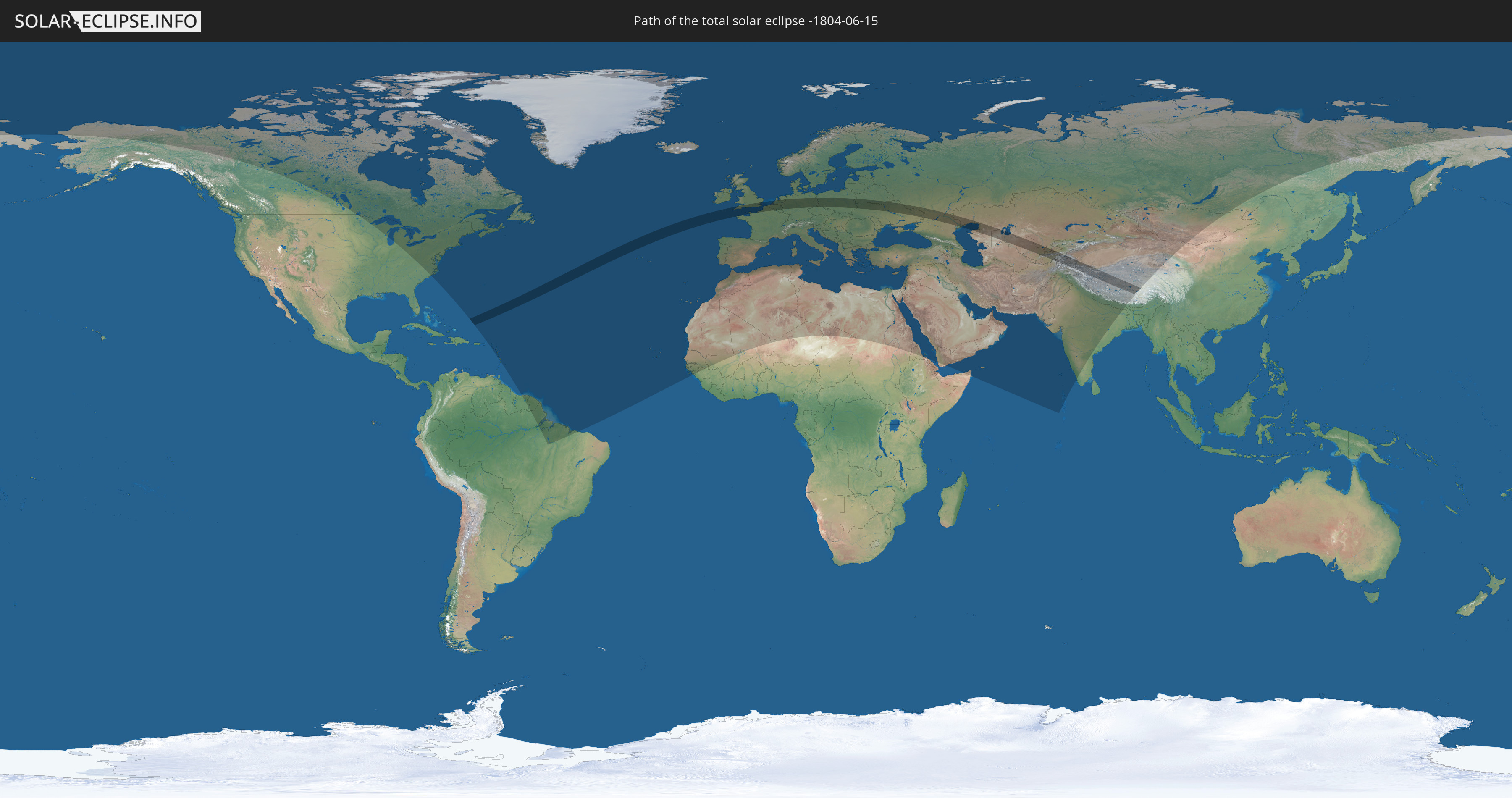
Die Sonnenfinsternis am 06/15/-1804 kann man in 117 Ländern als partielle Sonnenfinsternis beobachten.
Der Finsternispfad verläuft durch 21 Länder. Nur in diesen Ländern ist sie als total Sonnenfinsternis zu sehen.
In den folgenden Ländern ist die Sonnenfinsternis total zu sehen
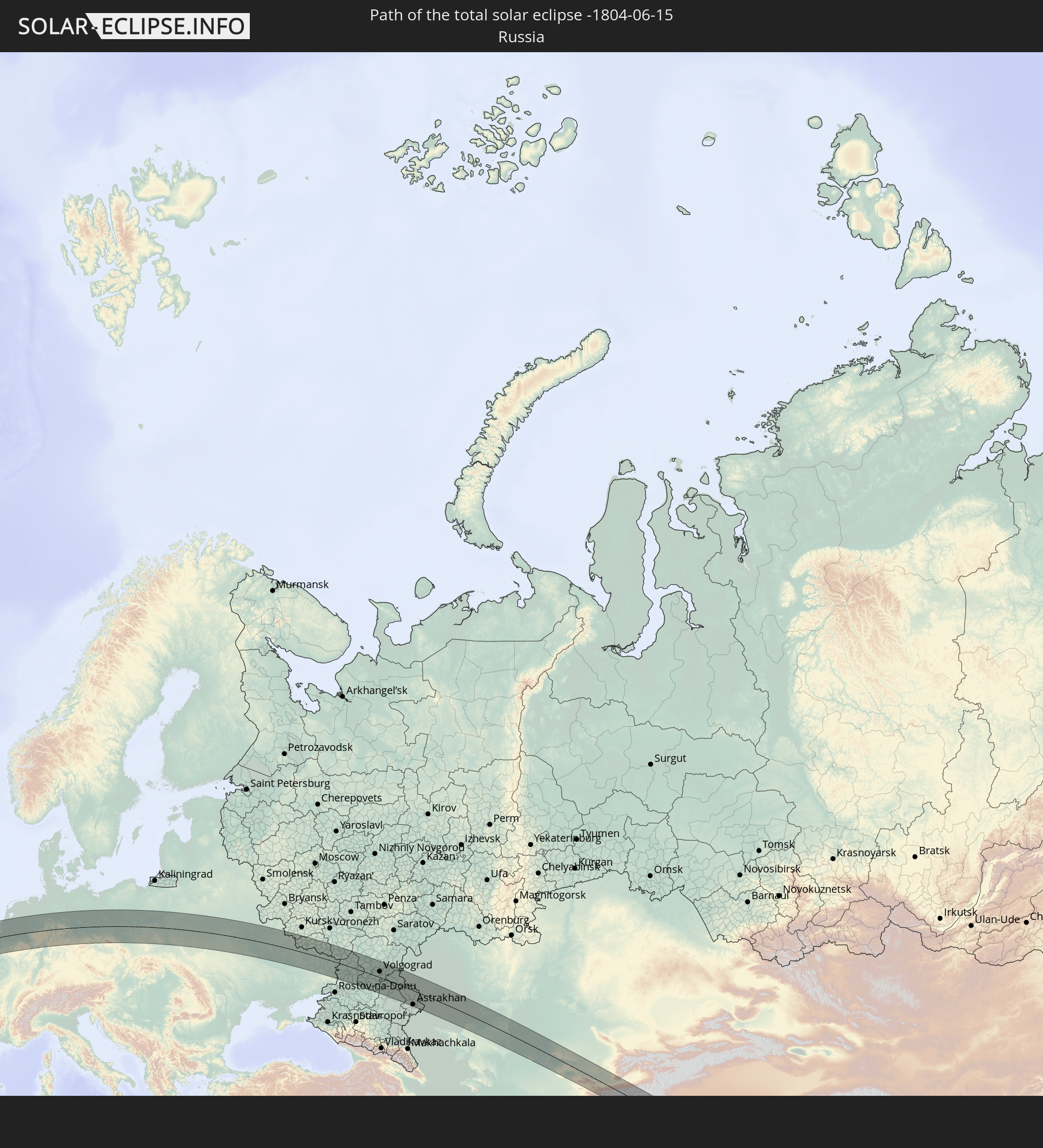 Russia
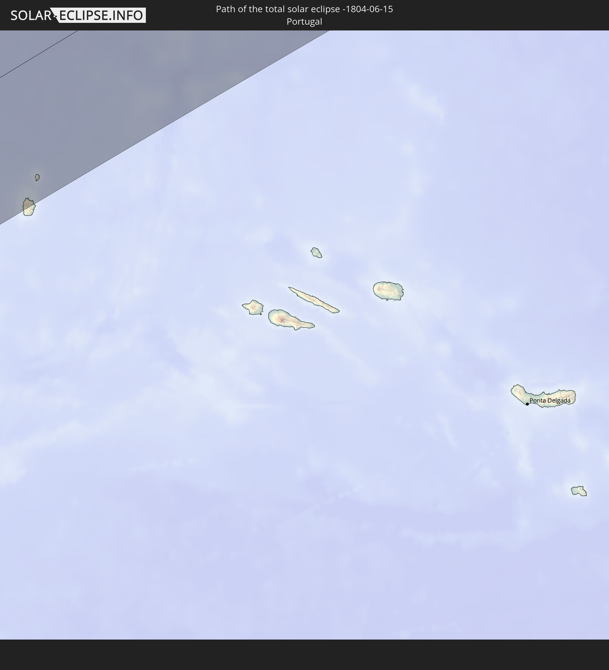 Portugal
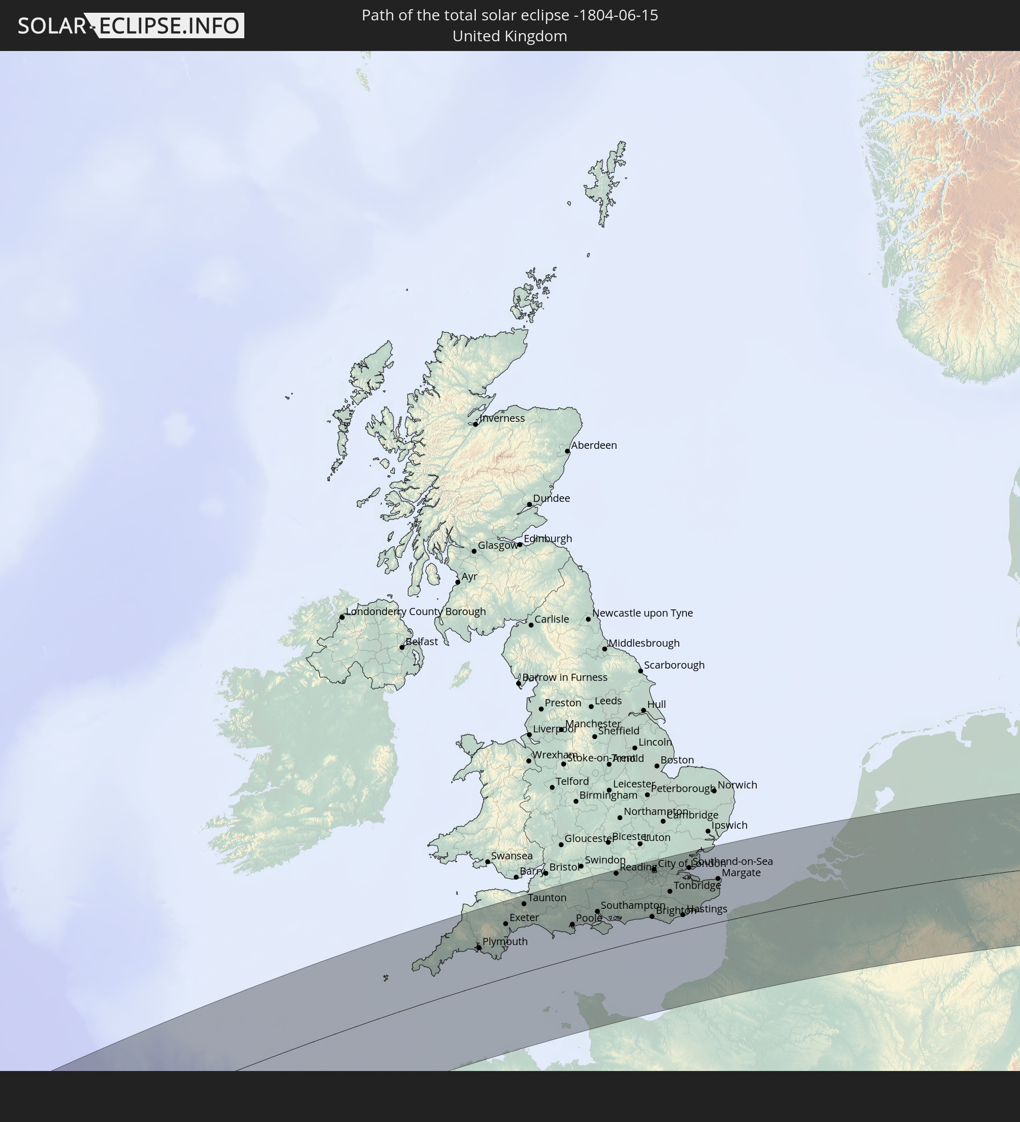 United Kingdom
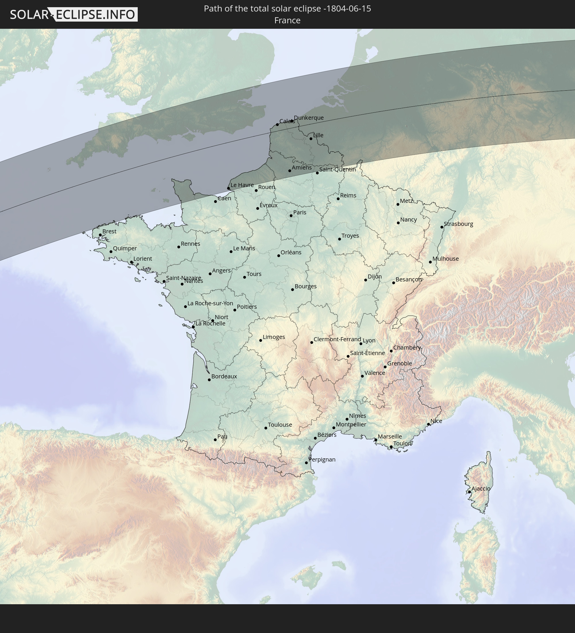 France
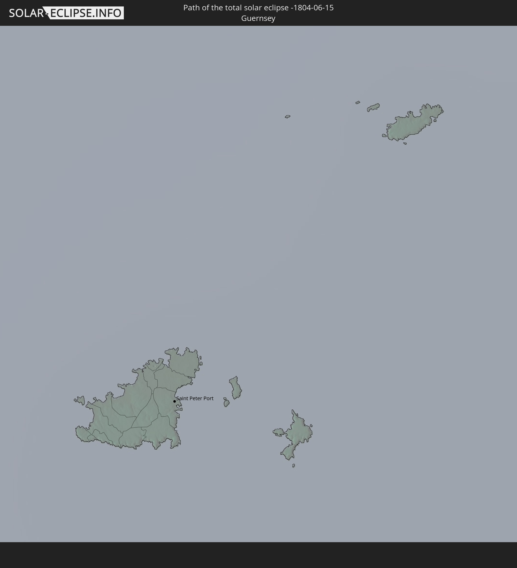 Guernsey
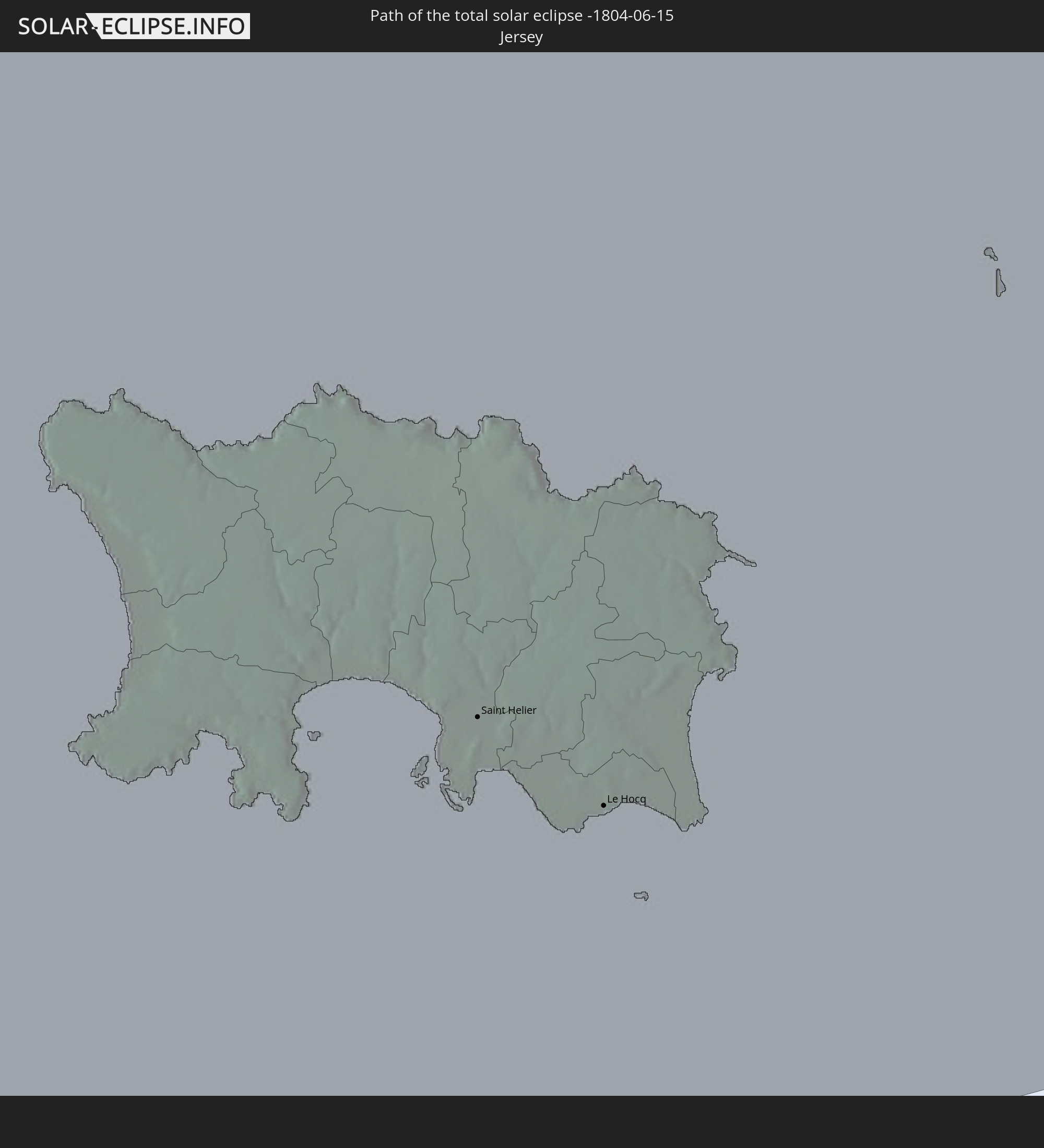 Jersey
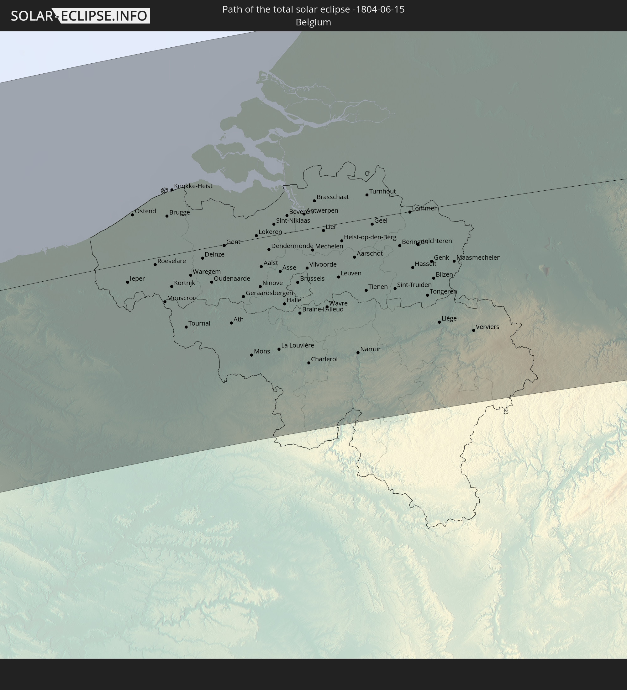 Belgium
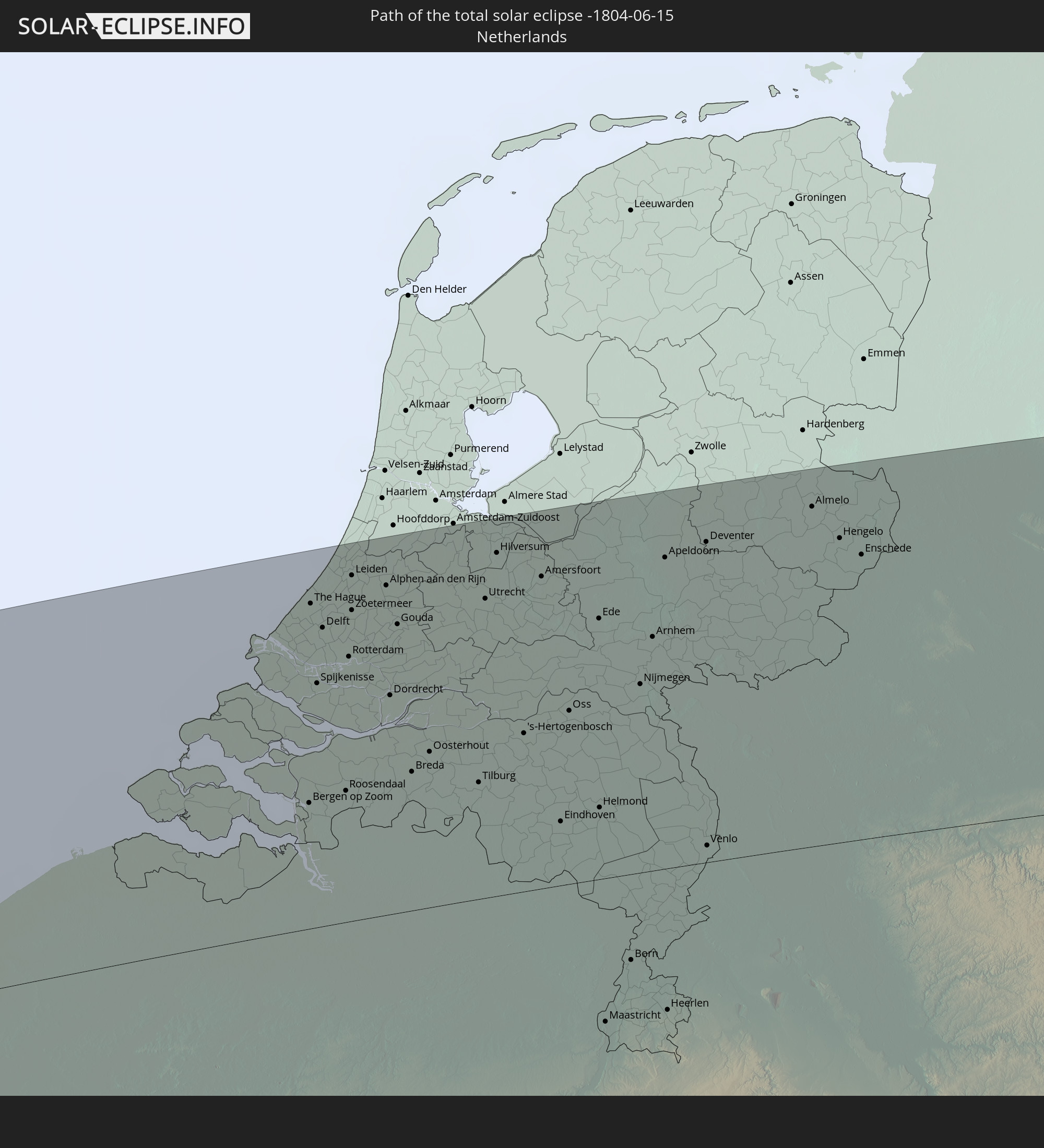 Netherlands
 Germany
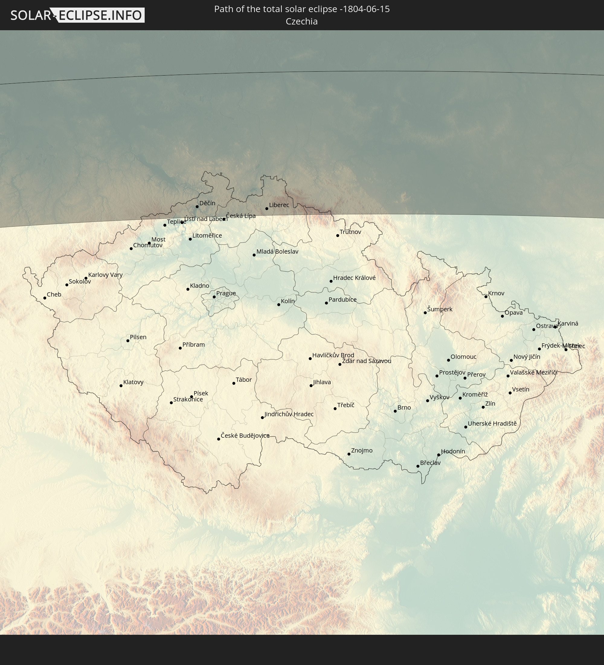 Czechia
 Poland
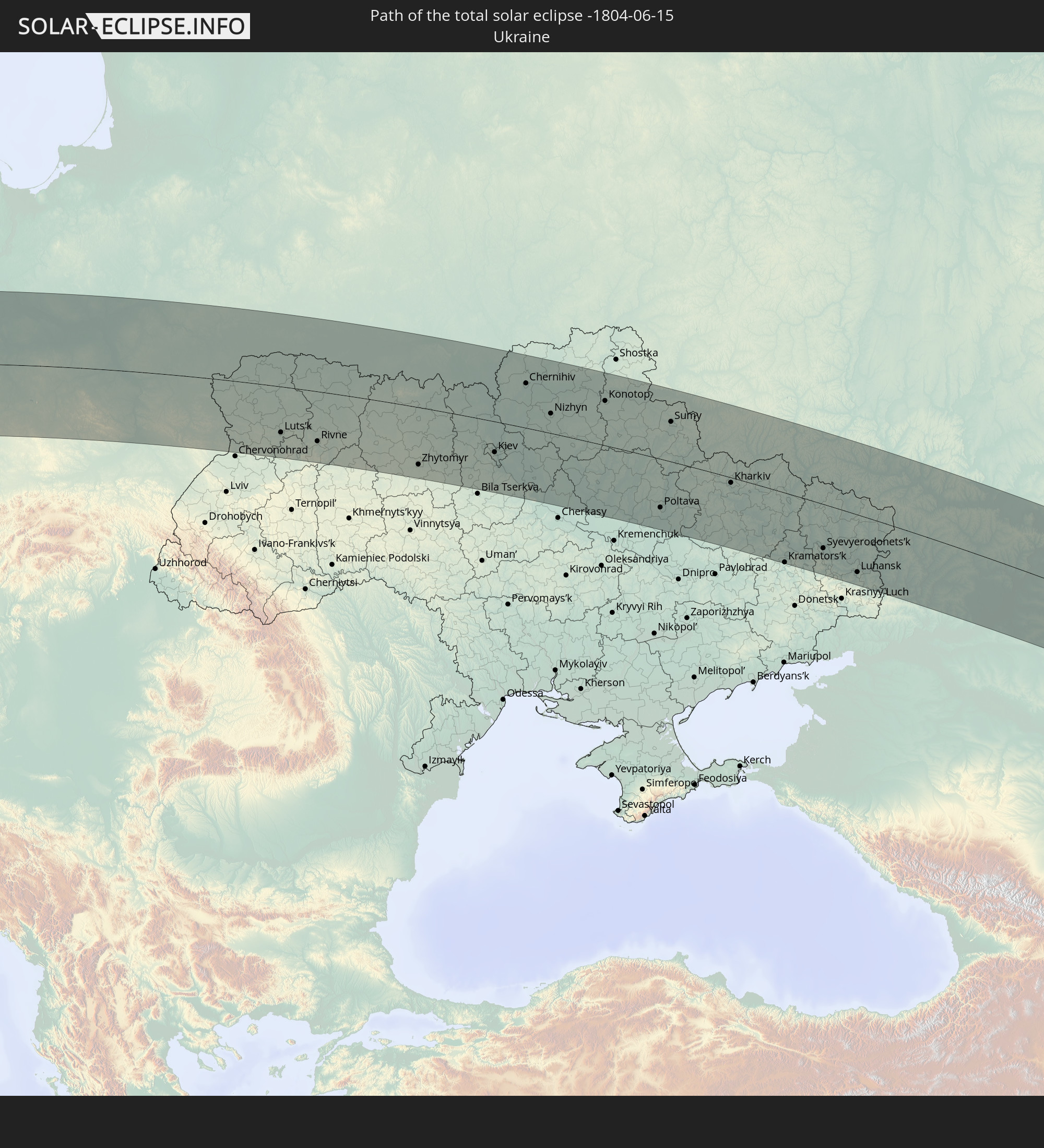 Ukraine
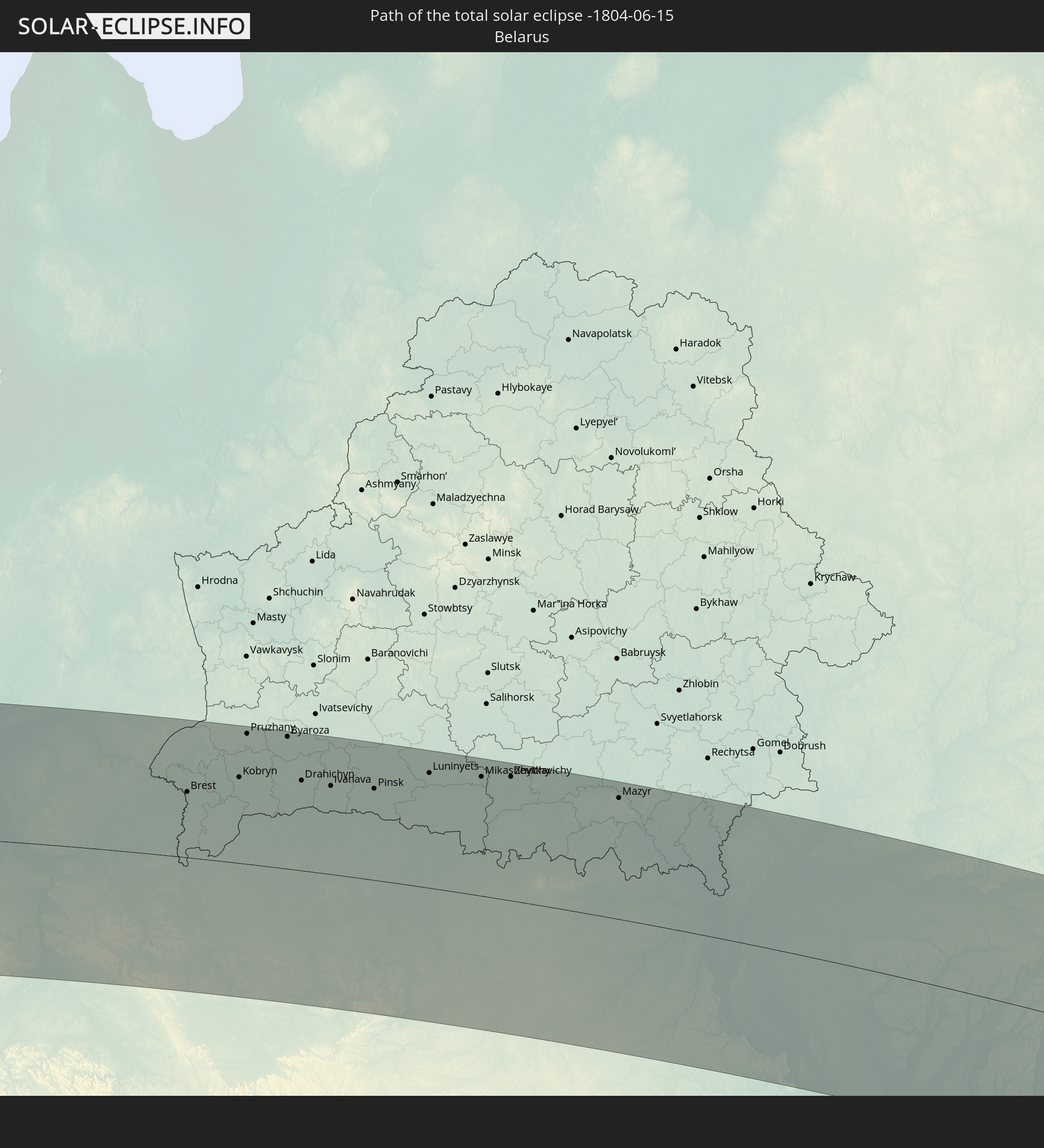 Belarus
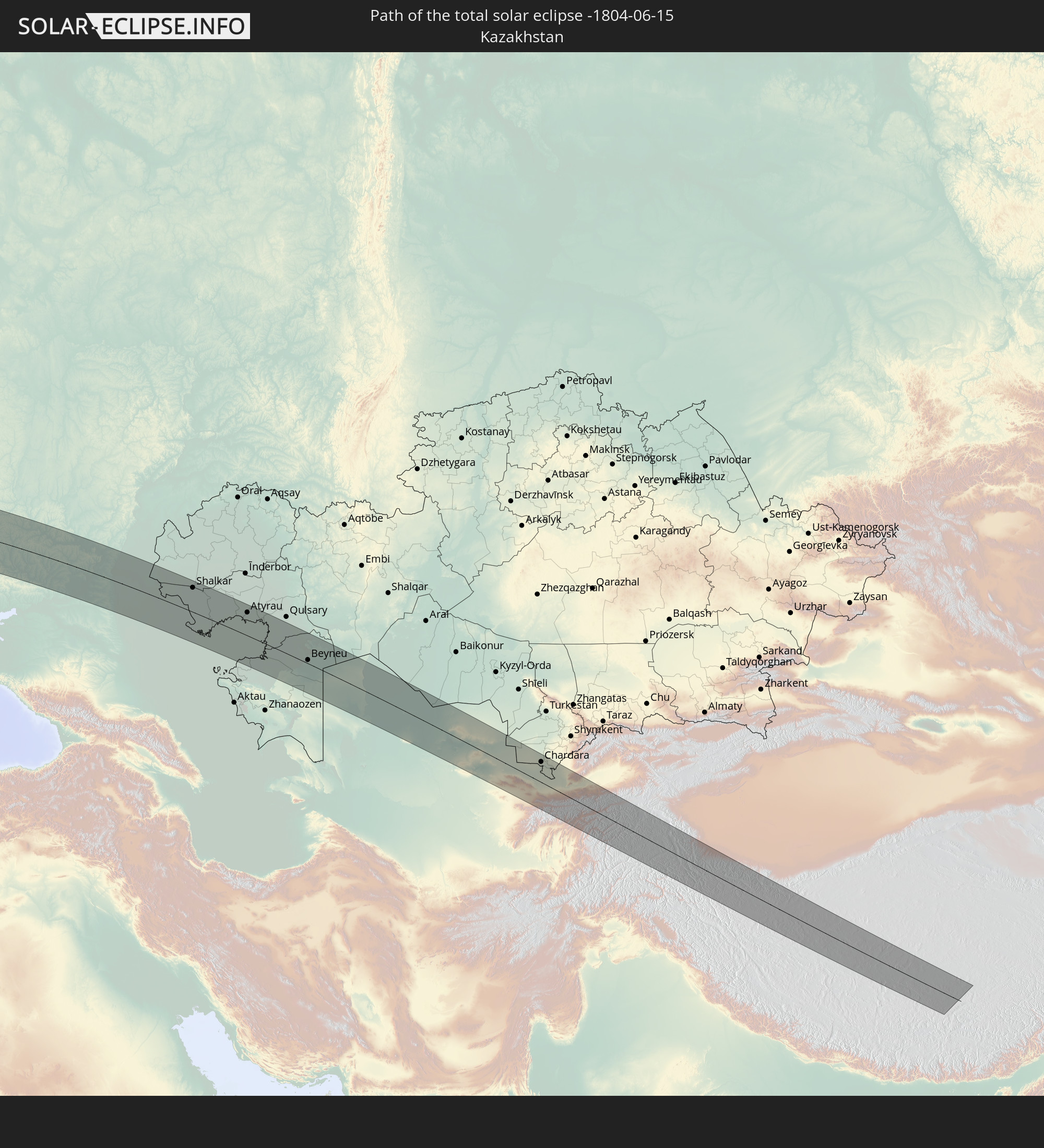 Kazakhstan
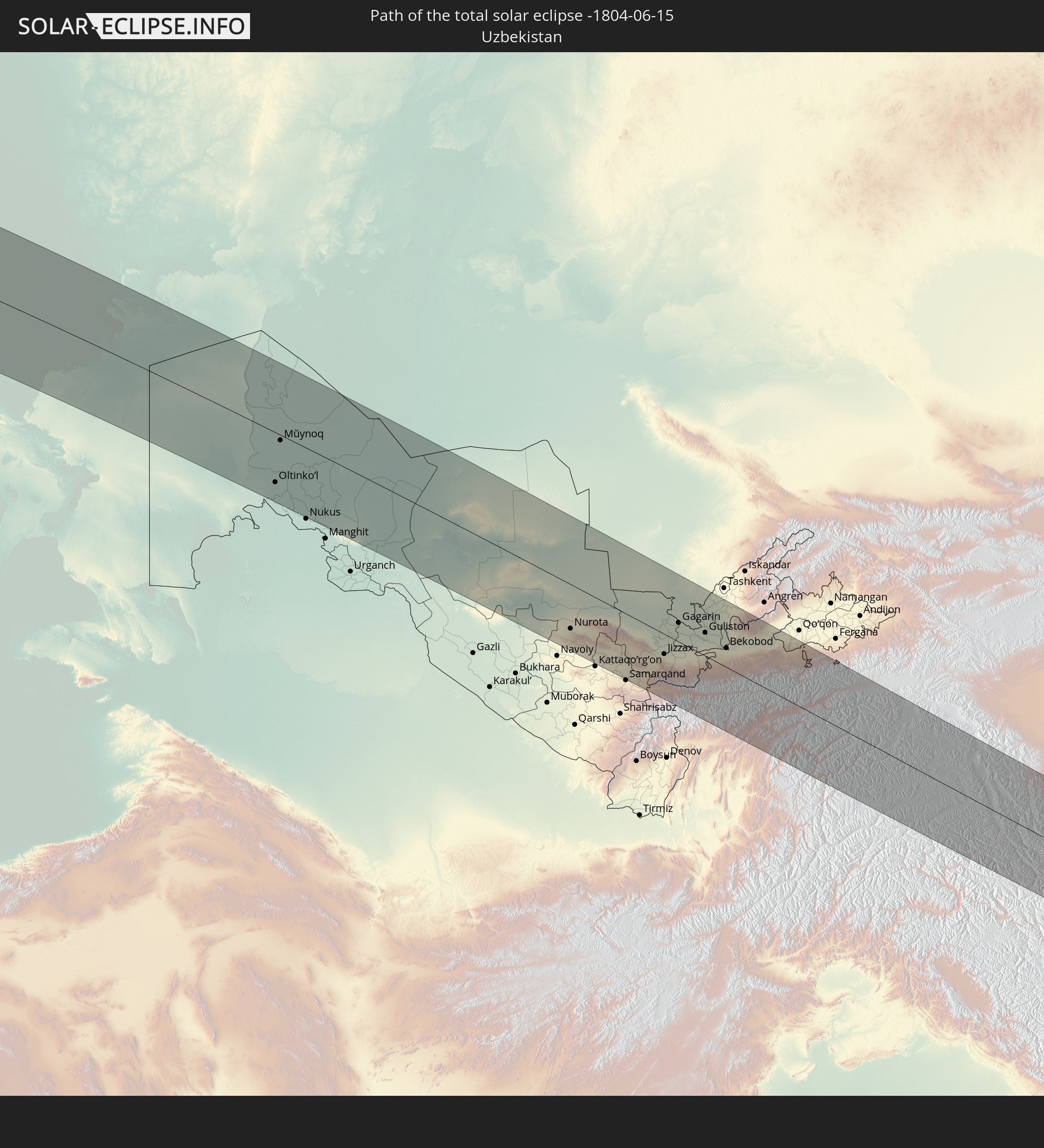 Uzbekistan
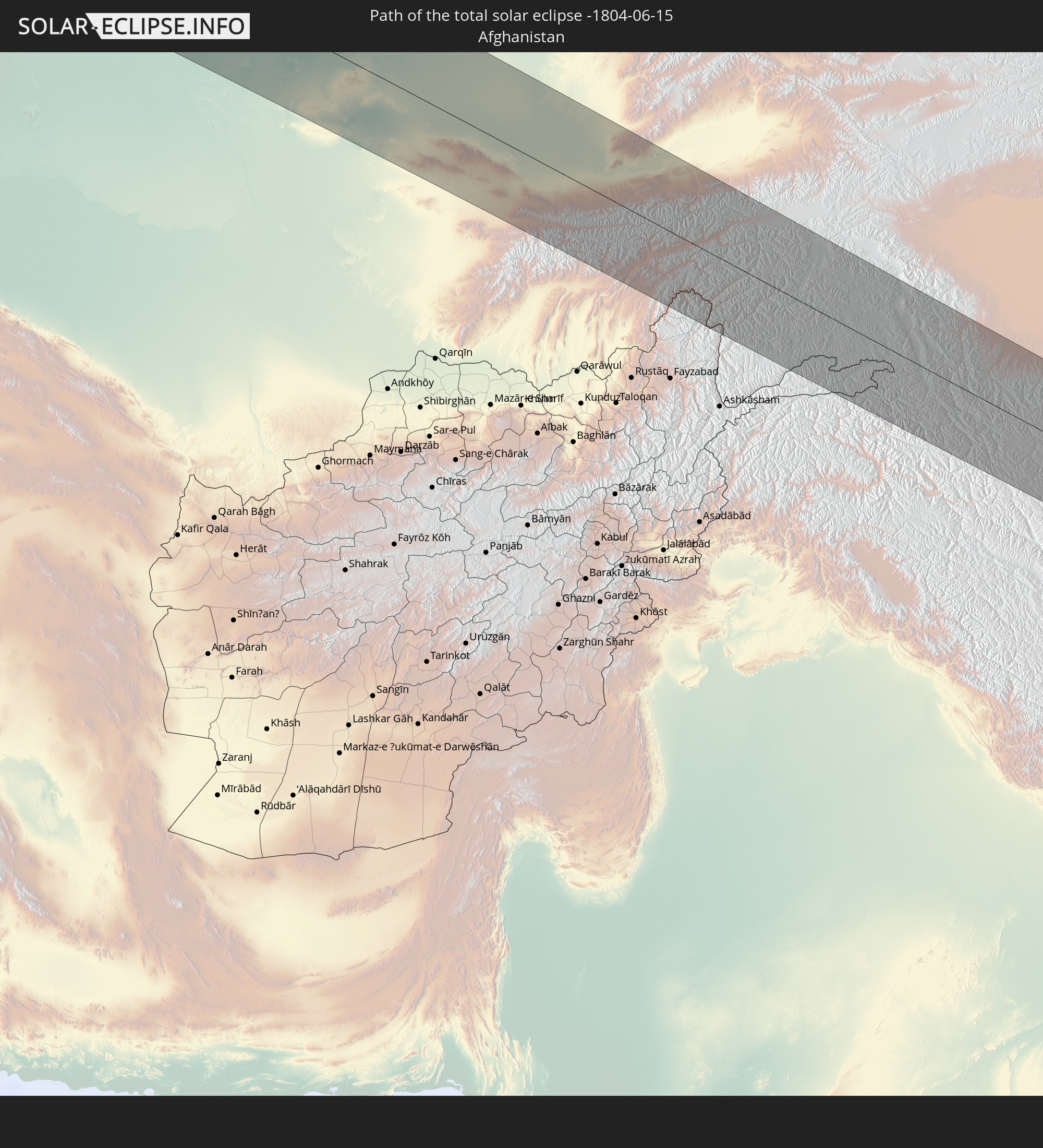 Afghanistan
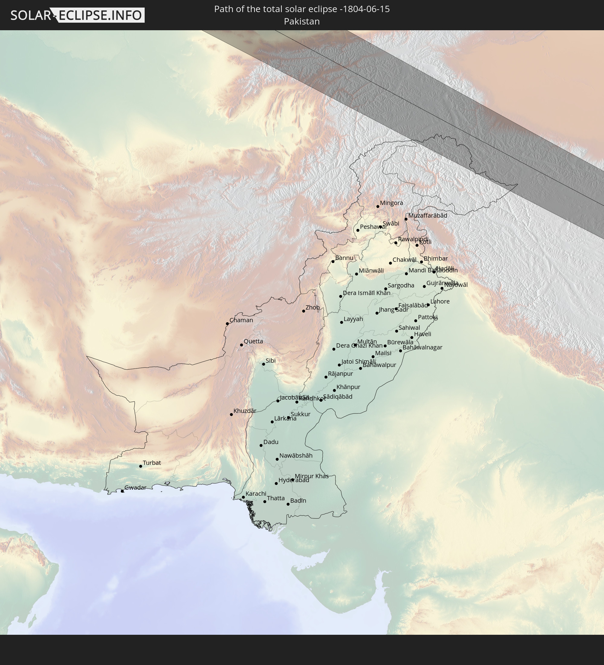 Pakistan
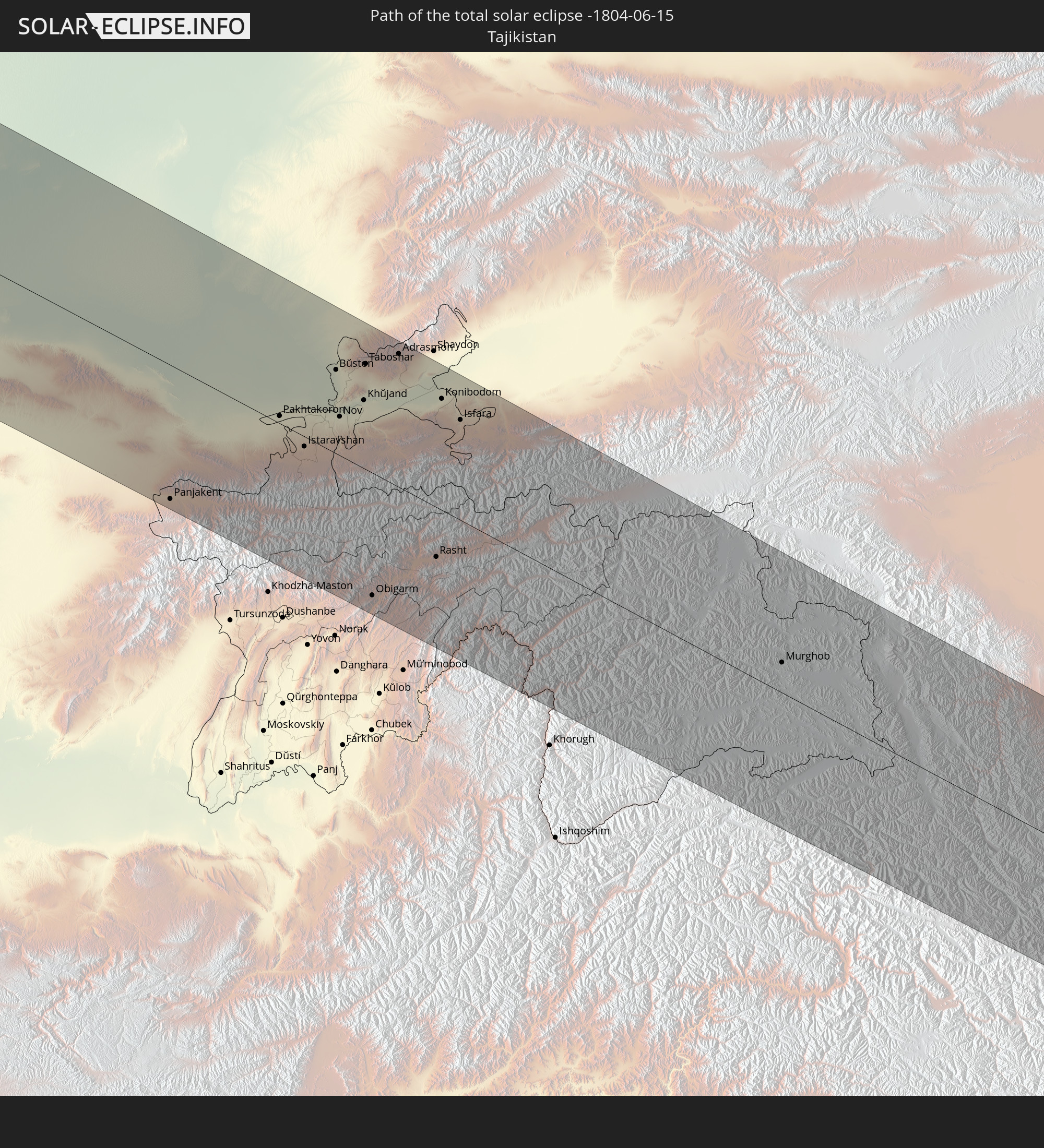 Tajikistan
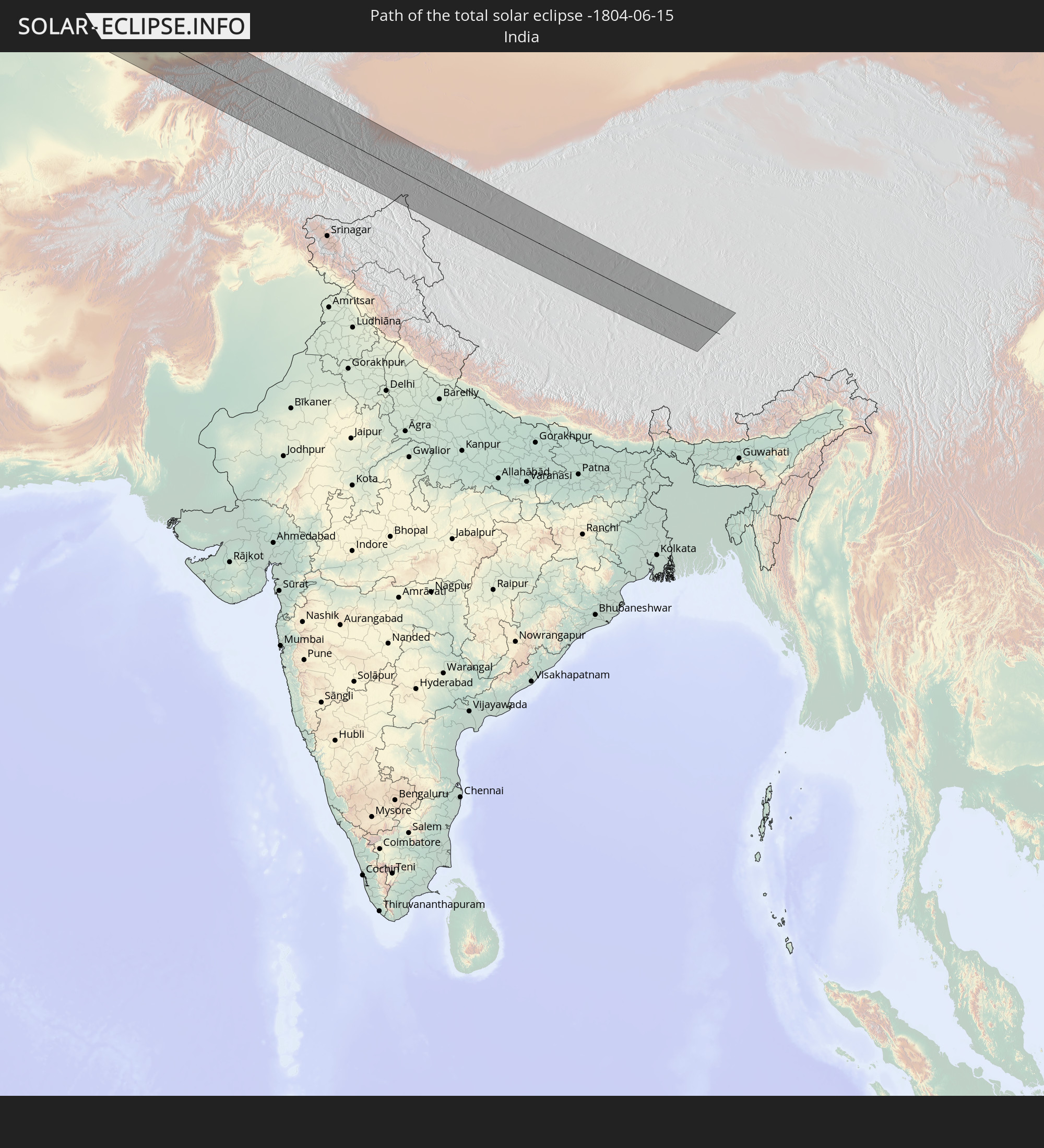 India
India
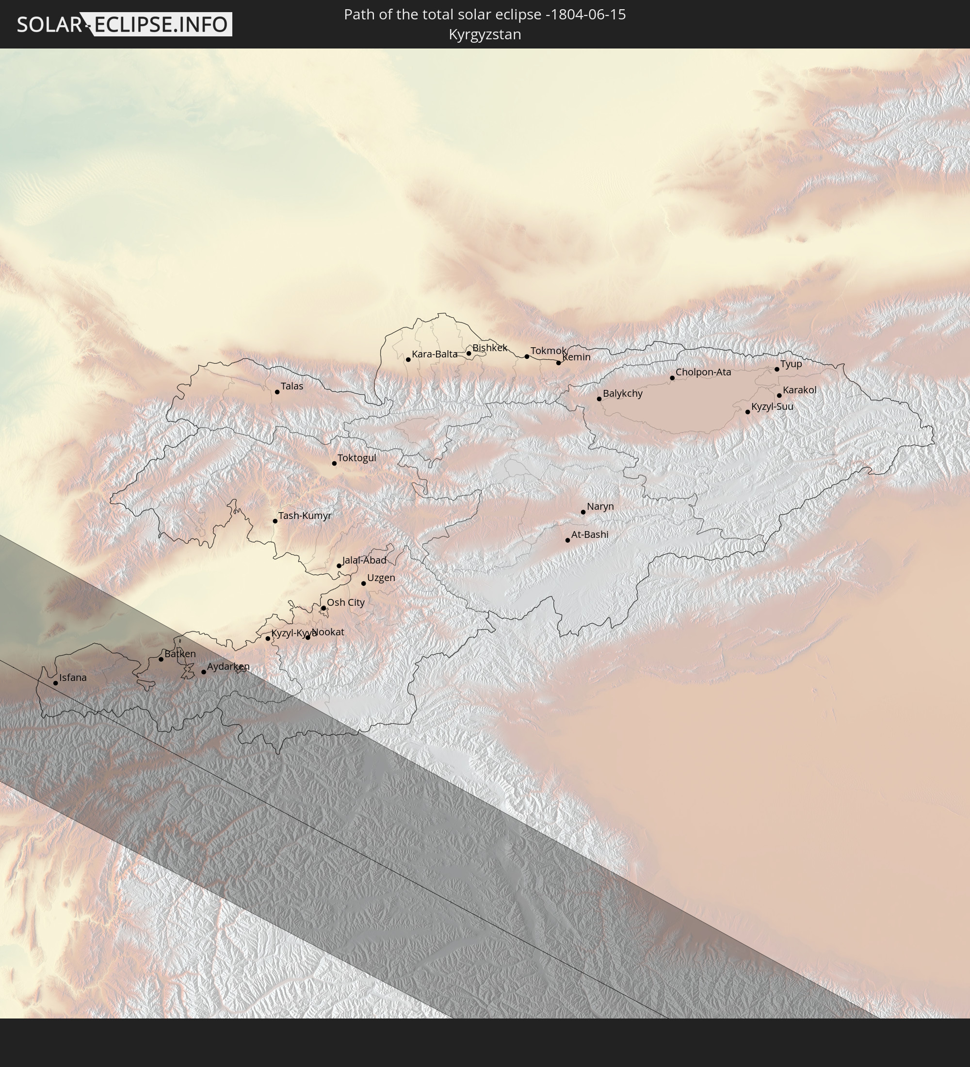 Kyrgyzstan
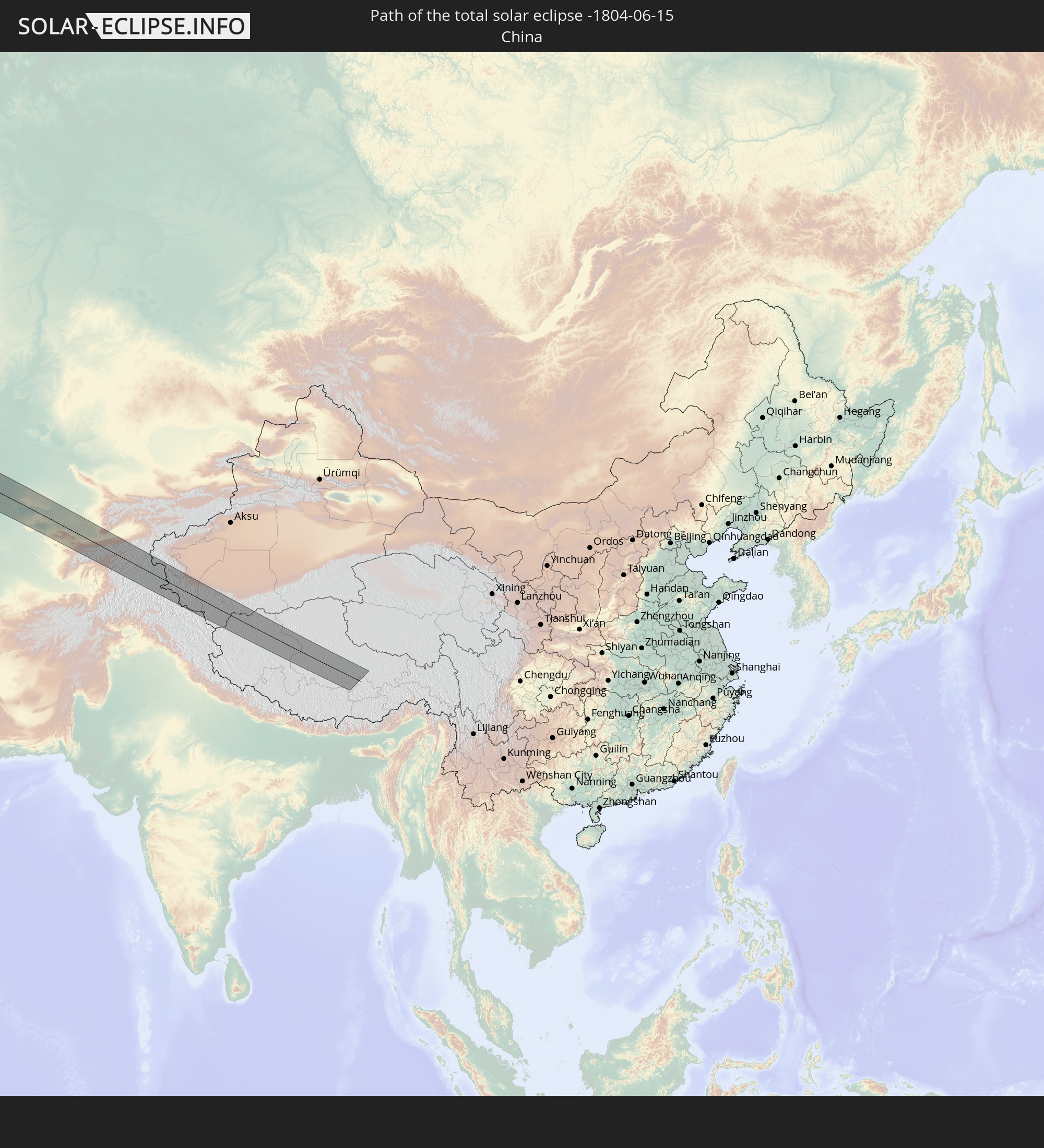 China
China
In den folgenden Ländern ist die Sonnenfinsternis partiell zu sehen
 Russia
 United States
 Canada
 Greenland
 Brazil
 Bermuda
 Anguilla
 Collectivity of Saint Martin
 Saint Barthélemy
 Saint Kitts and Nevis
 Antigua and Barbuda
 Montserrat
 Guadeloupe
 Dominica
 Martinique
 Barbados
 Suriname
 Saint Pierre and Miquelon
 French Guiana
 Portugal
 Cabo Verde
 Iceland
 Spain
Spain
 Senegal
 Mauritania
 The Gambia
 Guinea-Bissau
 Guinea
 Morocco
 Mali
Mali
 Republic of Ireland
 Svalbard and Jan Mayen
 Algeria
 United Kingdom
 Faroe Islands
 Gibraltar
 France
 Isle of Man
 Guernsey
 Jersey
 Niger
Niger
 Andorra
 Belgium
 Netherlands
 Norway
 Luxembourg
 Germany
 Switzerland
 Italy
Italy
 Monaco
 Tunisia
 Denmark
 Libya
Libya
 Liechtenstein
 Austria
 Sweden
 Czechia
 San Marino
 Vatican City
 Slovenia
 Chad
Chad
 Croatia
 Poland
 Malta
Malta
 Bosnia and Herzegovina
 Hungary
 Slovakia
 Montenegro
 Serbia
 Albania
 Åland Islands
 Greece
 Romania
 Republic of Macedonia
 Finland
 Lithuania
 Latvia
 Estonia
 Sudan
Sudan
 Ukraine
 Bulgaria
 Belarus
 Egypt
Egypt
 Turkey
 Moldova
 Cyprus
 State of Palestine
 Israel
 Saudi Arabia
 Jordan
 Lebanon
 Syria
Syria
 Eritrea
 Iraq
Iraq
 Georgia
 Somalia
 Yemen
Yemen
 Armenia
 Iran
Iran
 Azerbaijan
 Kazakhstan
 Kuwait
 Bahrain
 Qatar
Qatar
 United Arab Emirates
 Oman
Oman
 Turkmenistan
 Uzbekistan
 Afghanistan
 Pakistan
 Tajikistan
 India
India
 Kyrgyzstan
 Maldives
 China
China
 Nepal
Nepal
 Mongolia
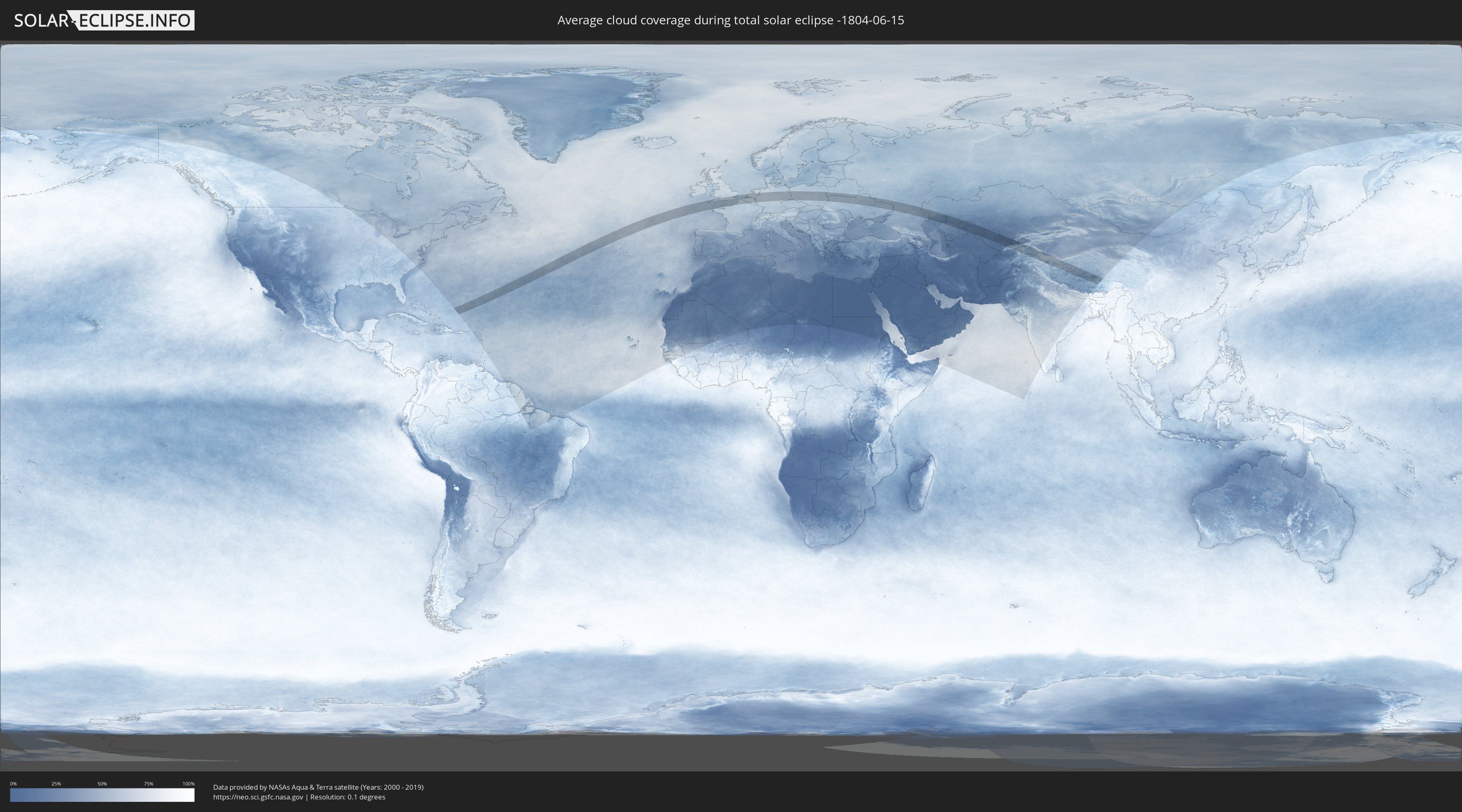
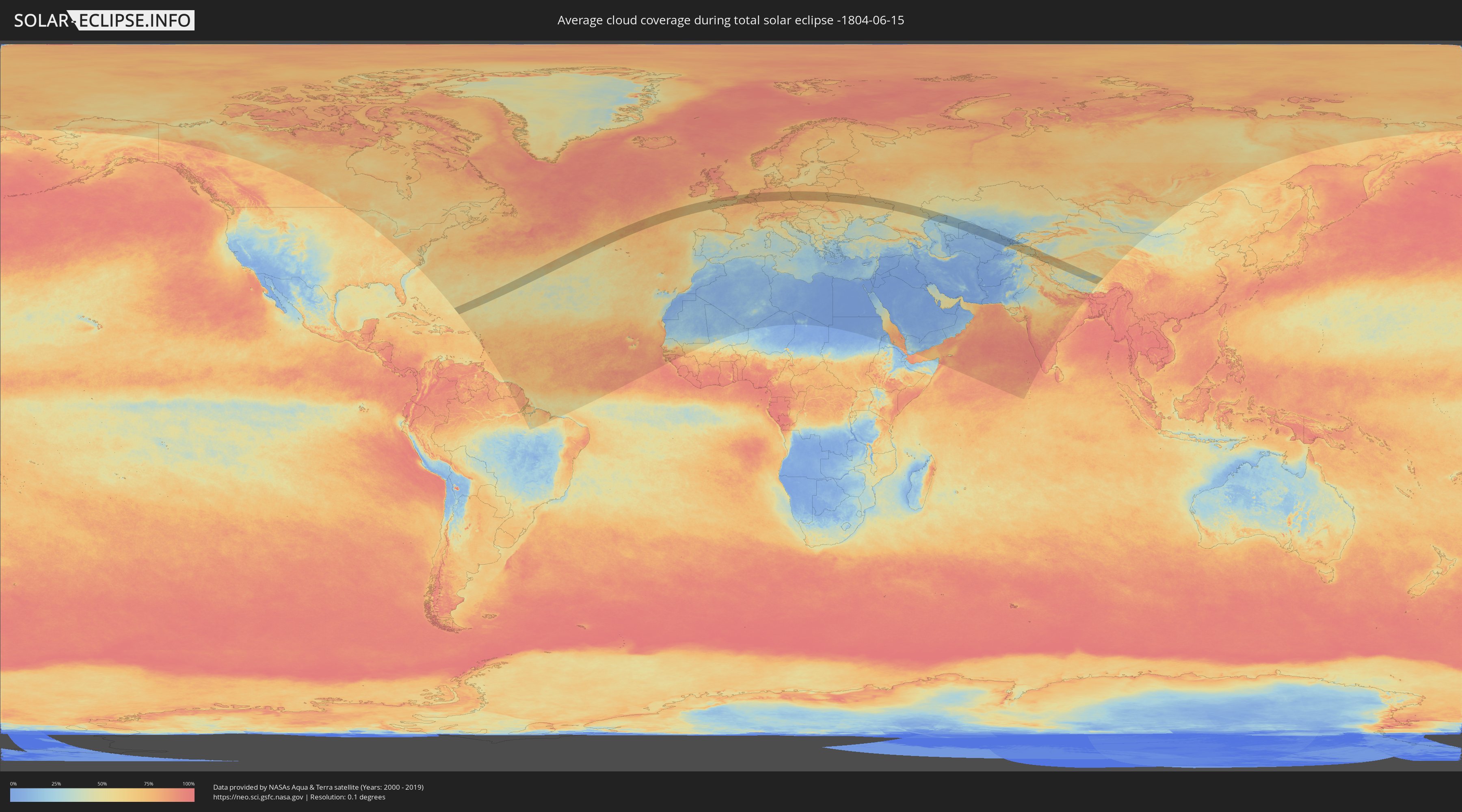
How will be the weather during the total solar eclipse on 06/15/-1804?
Where is the best place to see the total solar eclipse of 06/15/-1804?
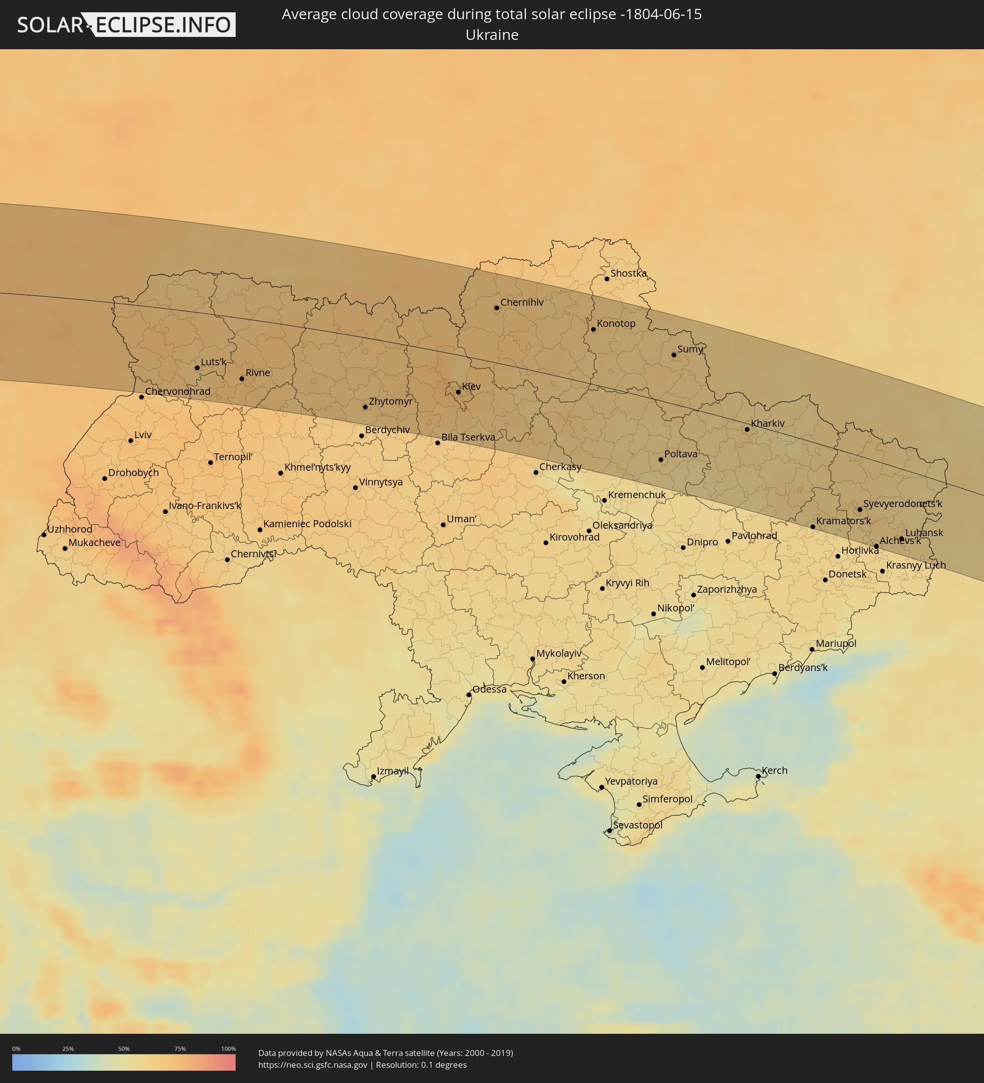
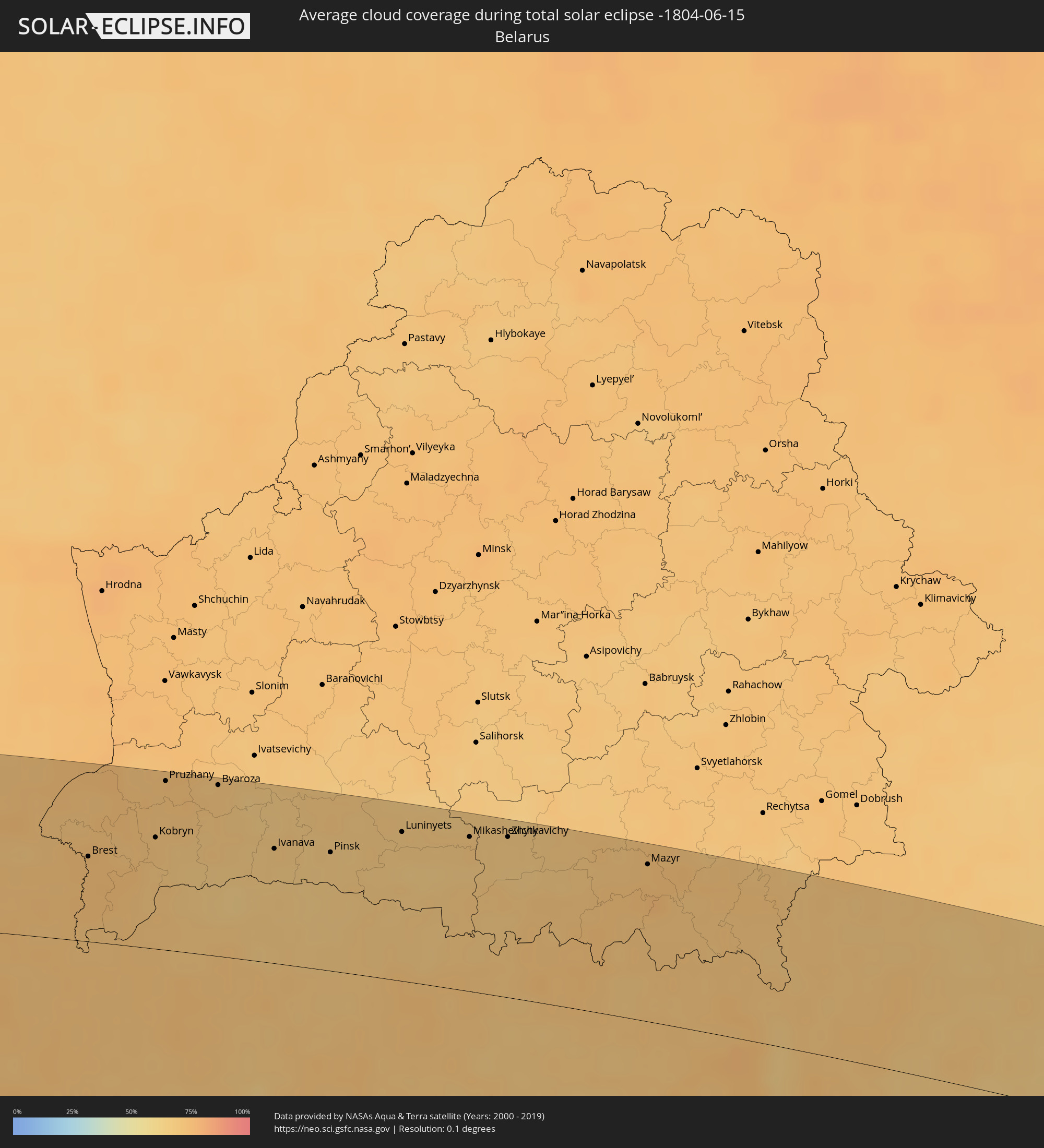
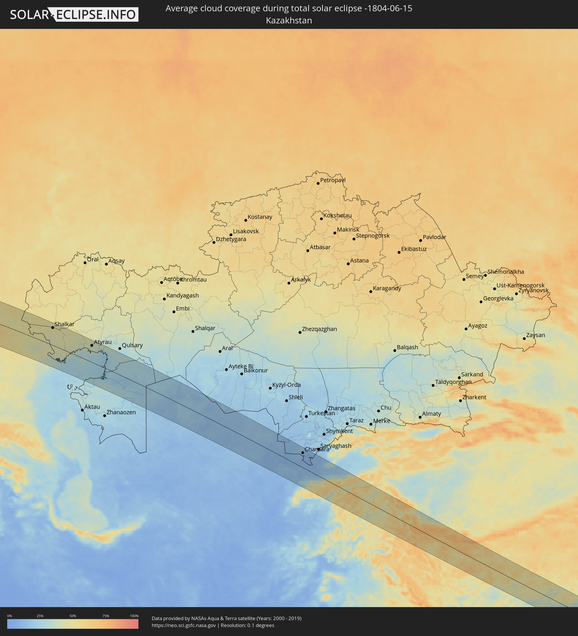
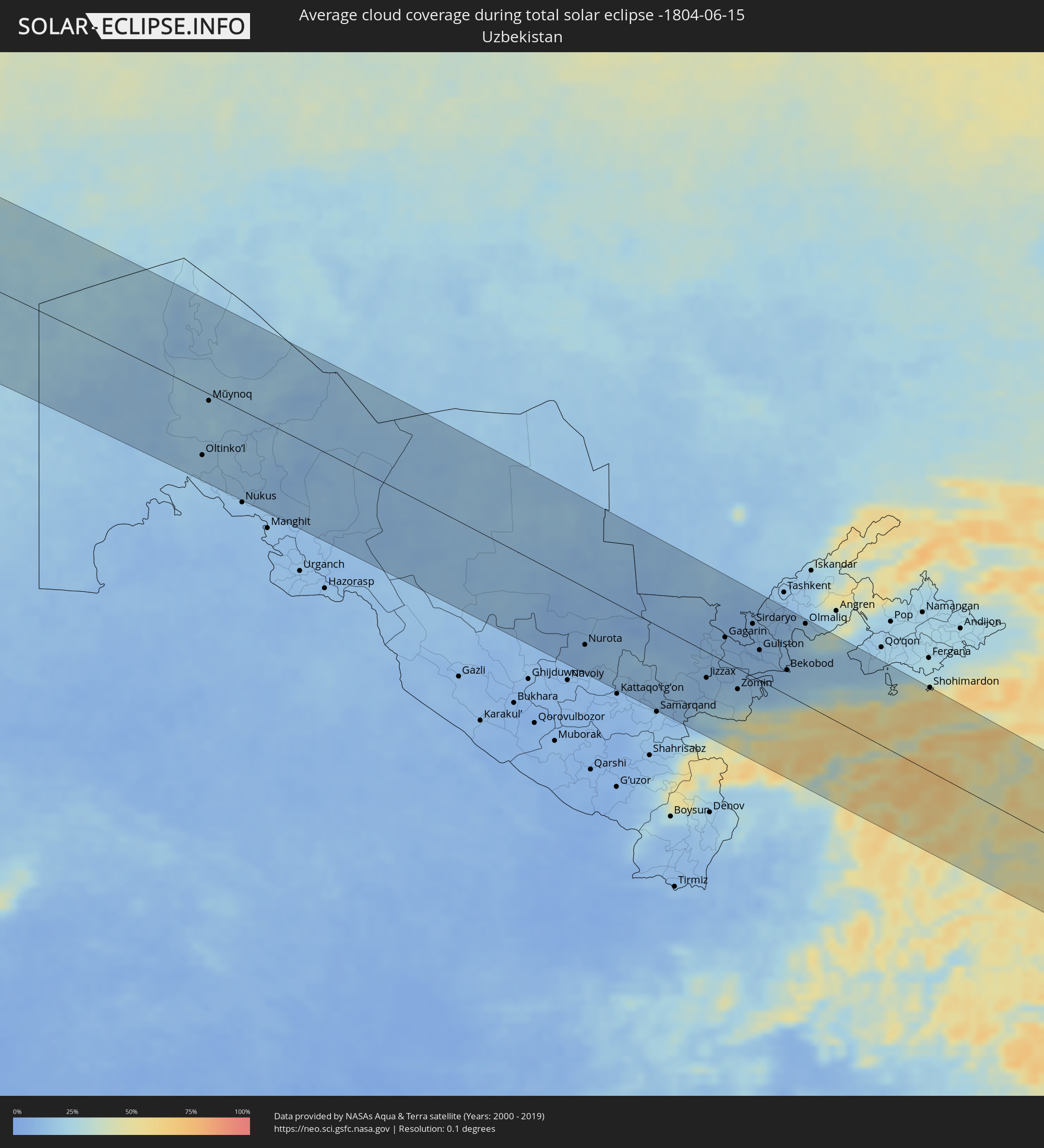
The following maps show the average cloud coverage for the day of the total solar eclipse.
With the help of these maps, it is possible to find the place along the eclipse path, which has the best
chance of a cloudless sky.
Nevertheless, you should consider local circumstances and inform about the weather of your chosen
observation site.
The data is provided by NASAs satellites
AQUA and TERRA.
The cloud maps are averaged over a period of 19 years (2000 - 2019).
Detailed country maps
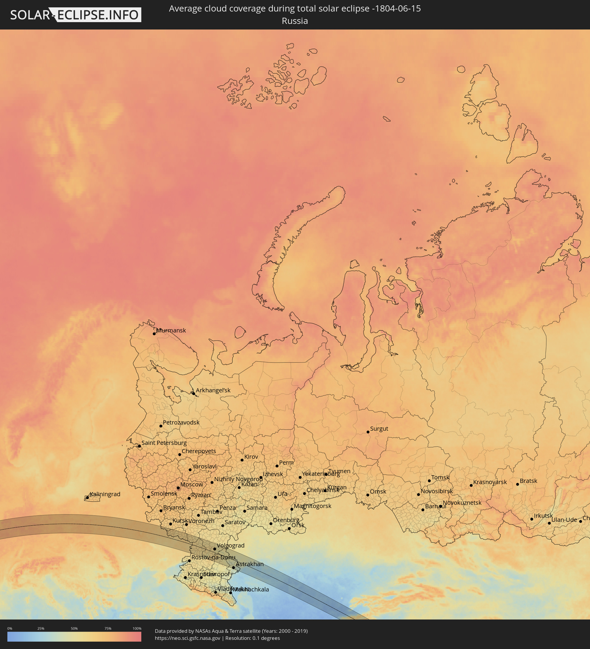 Russia
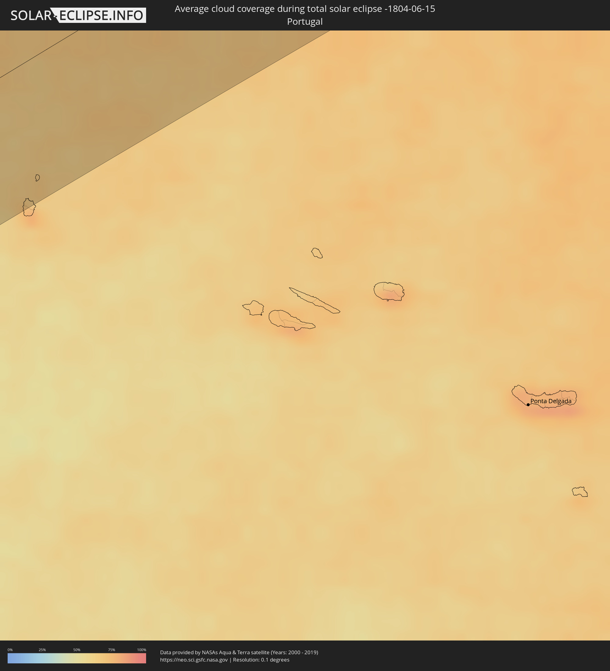 Portugal
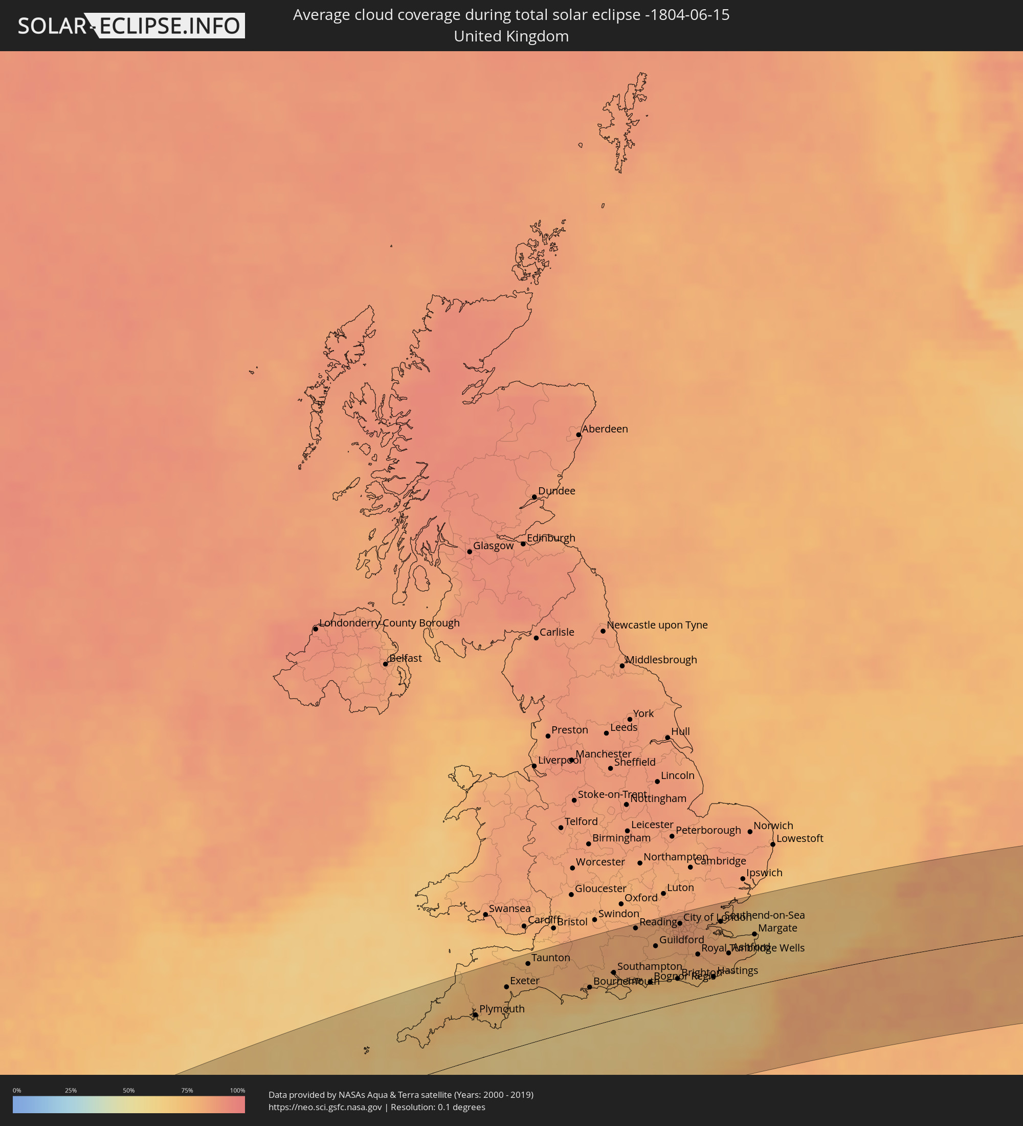 United Kingdom
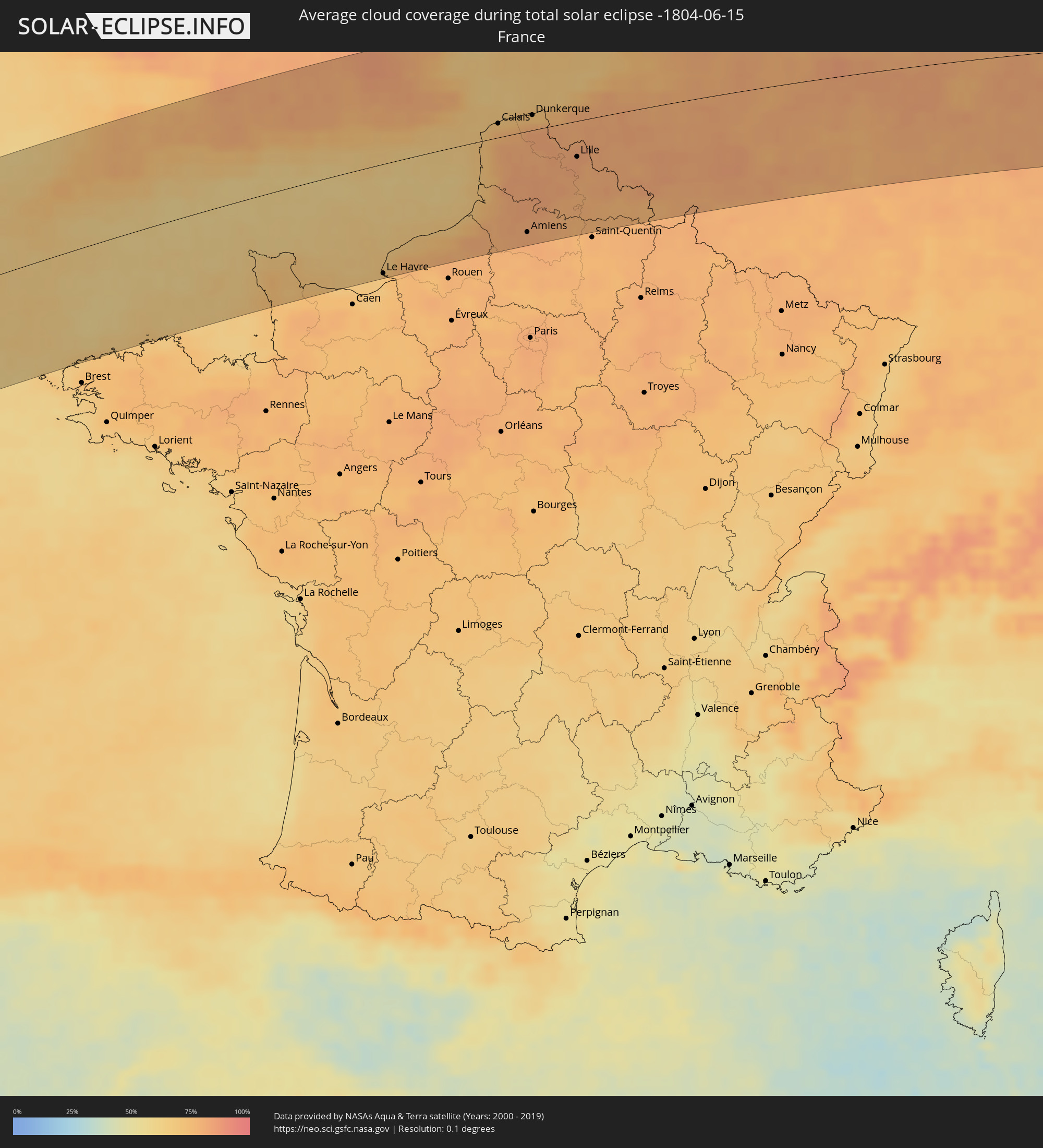 France
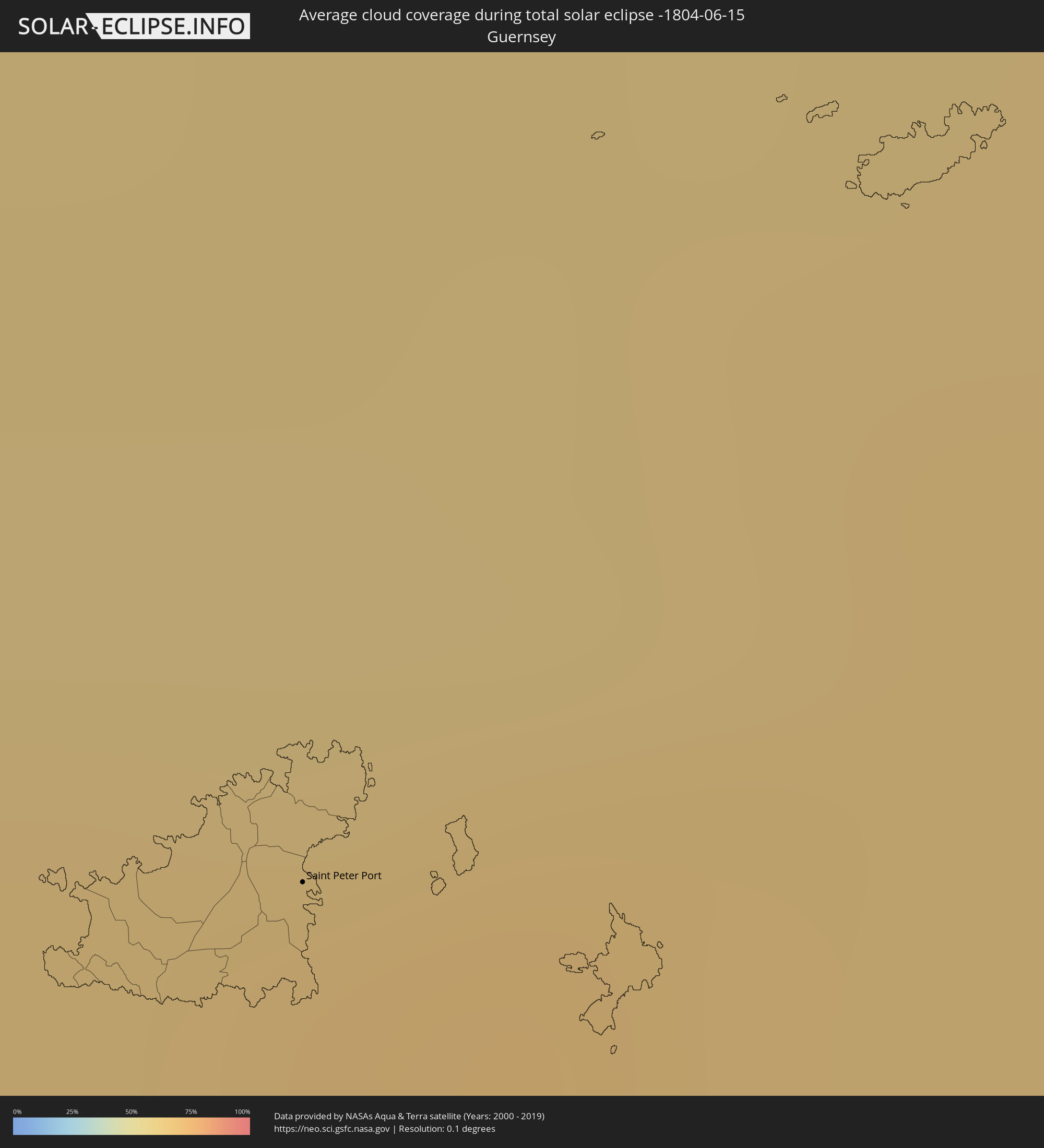 Guernsey
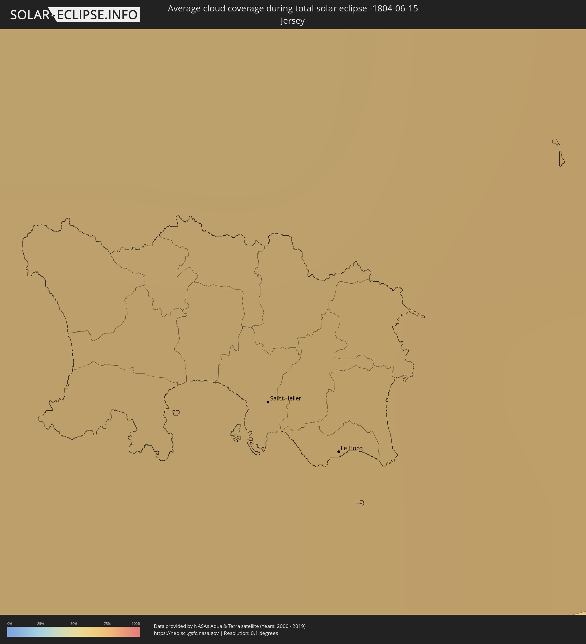 Jersey
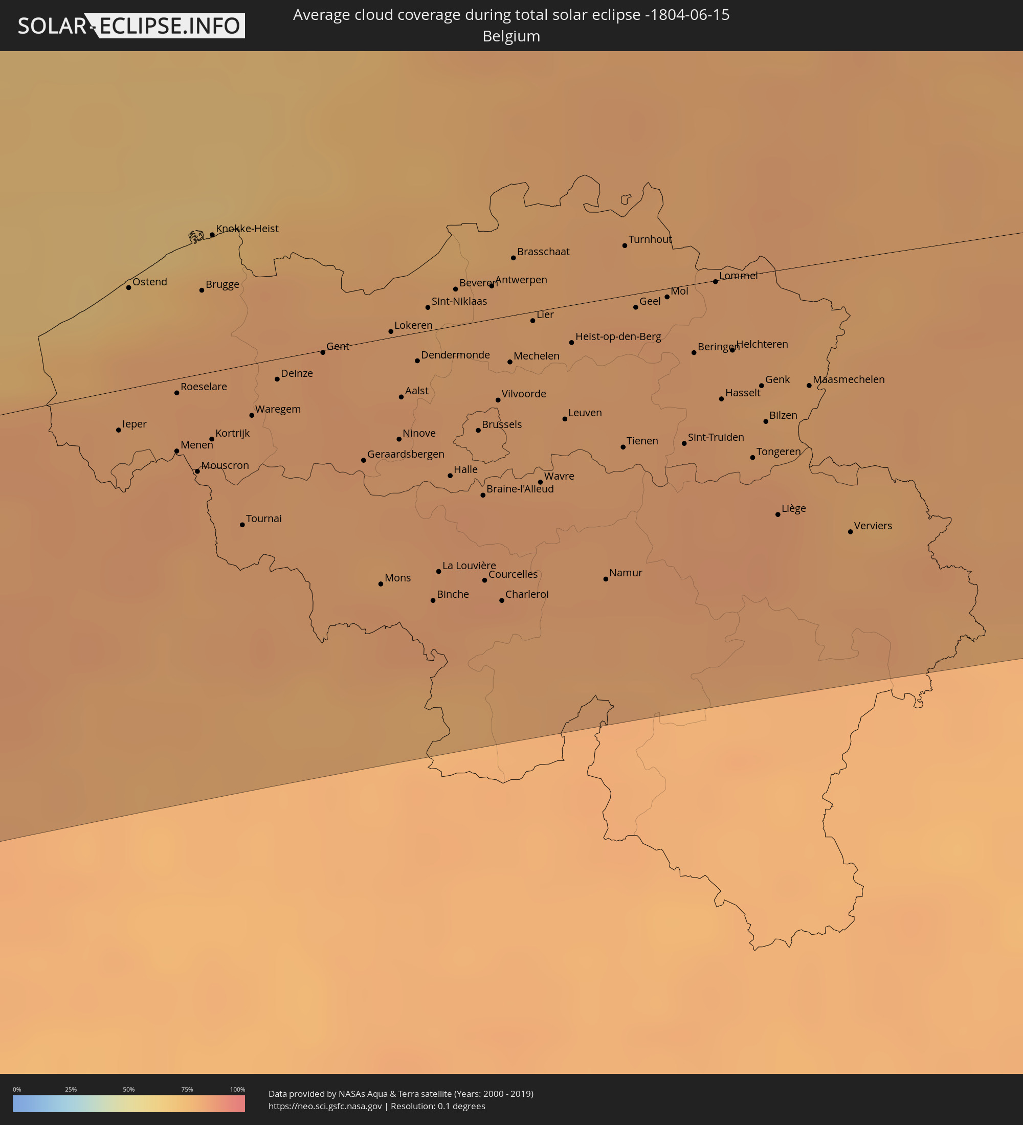 Belgium
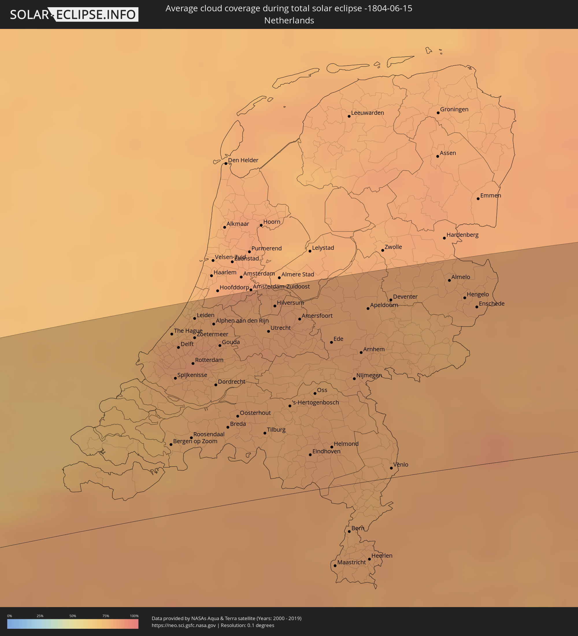 Netherlands
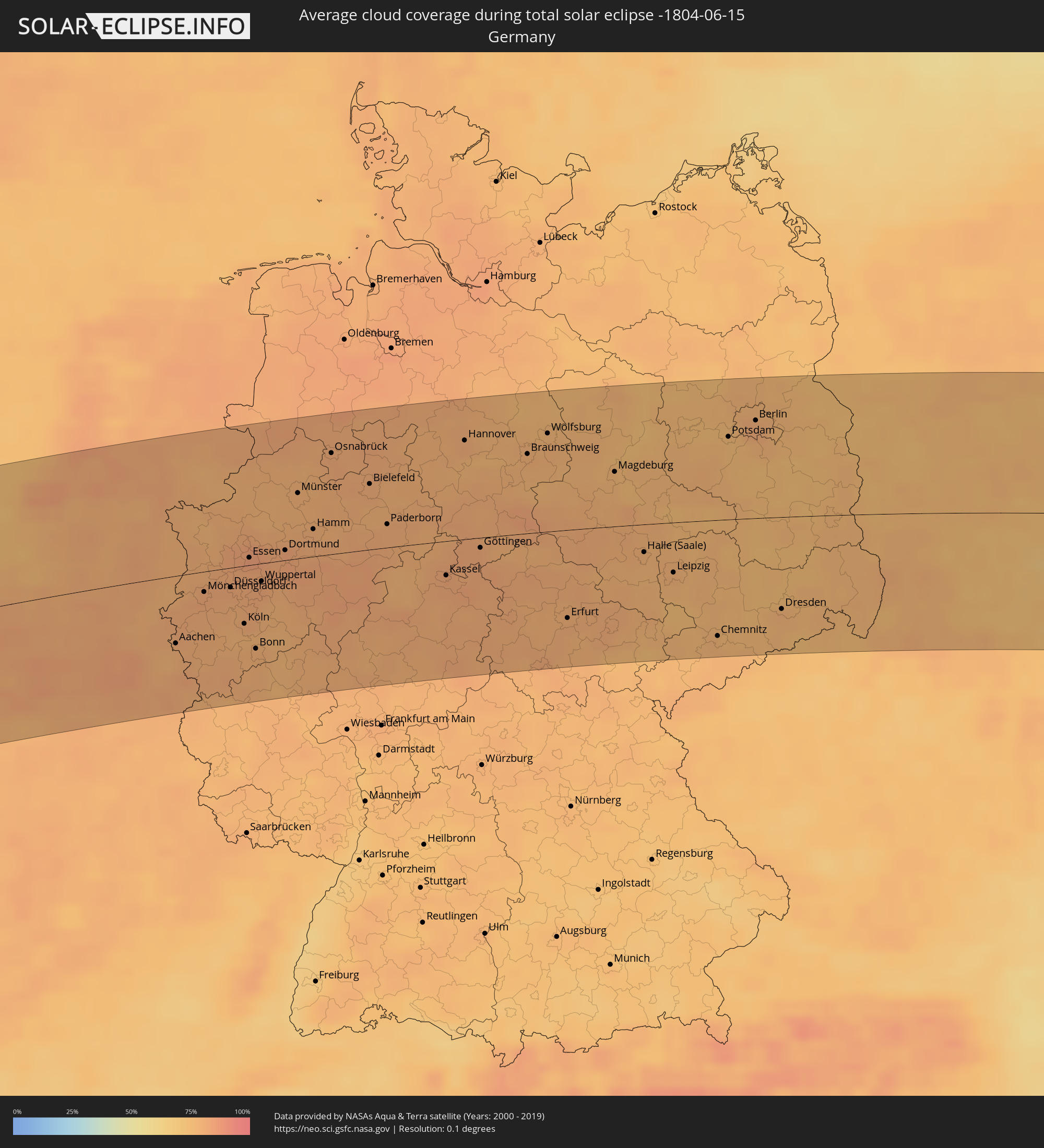 Germany
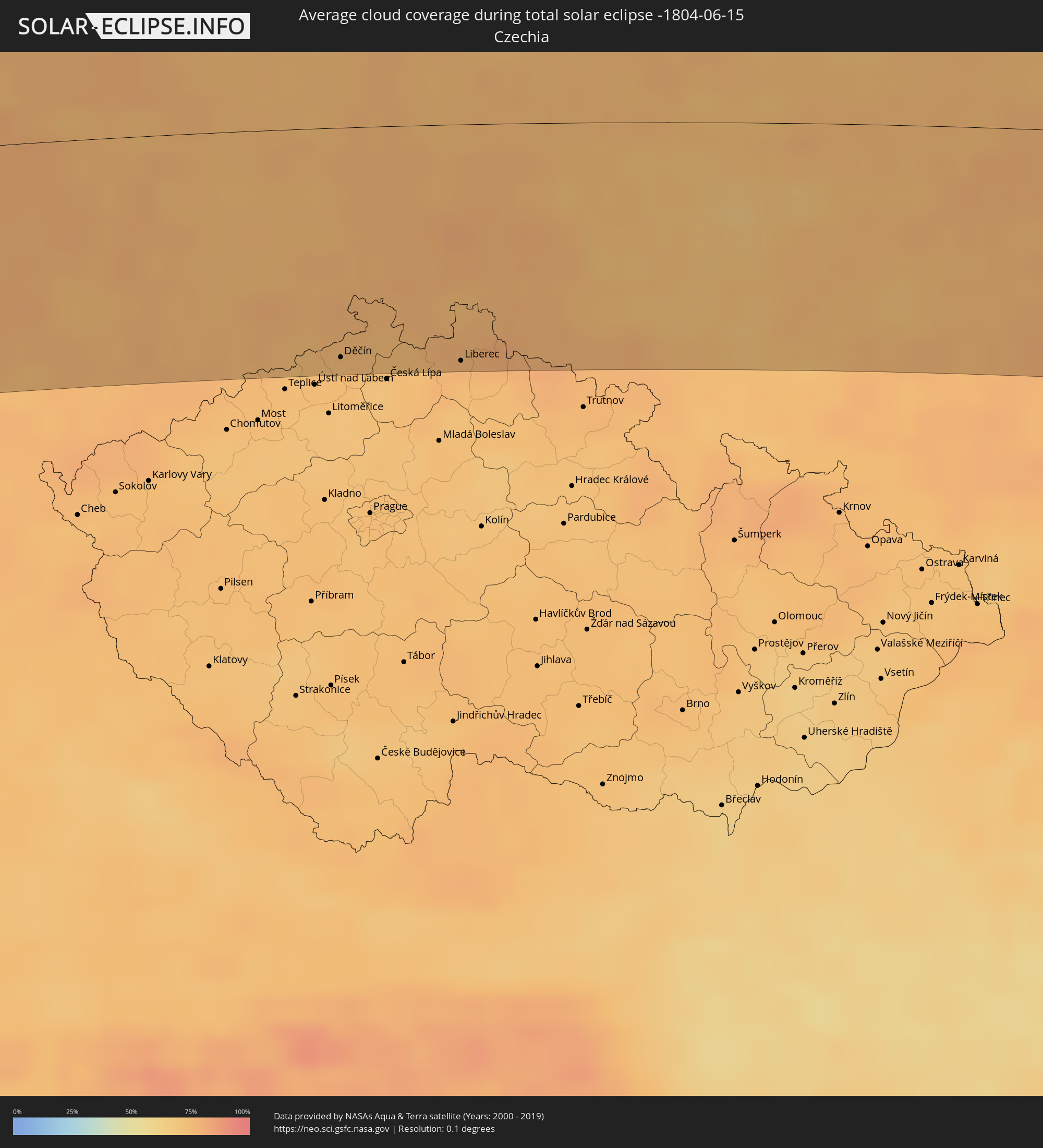 Czechia
 Poland
 Ukraine
 Belarus
 Kazakhstan
 Uzbekistan
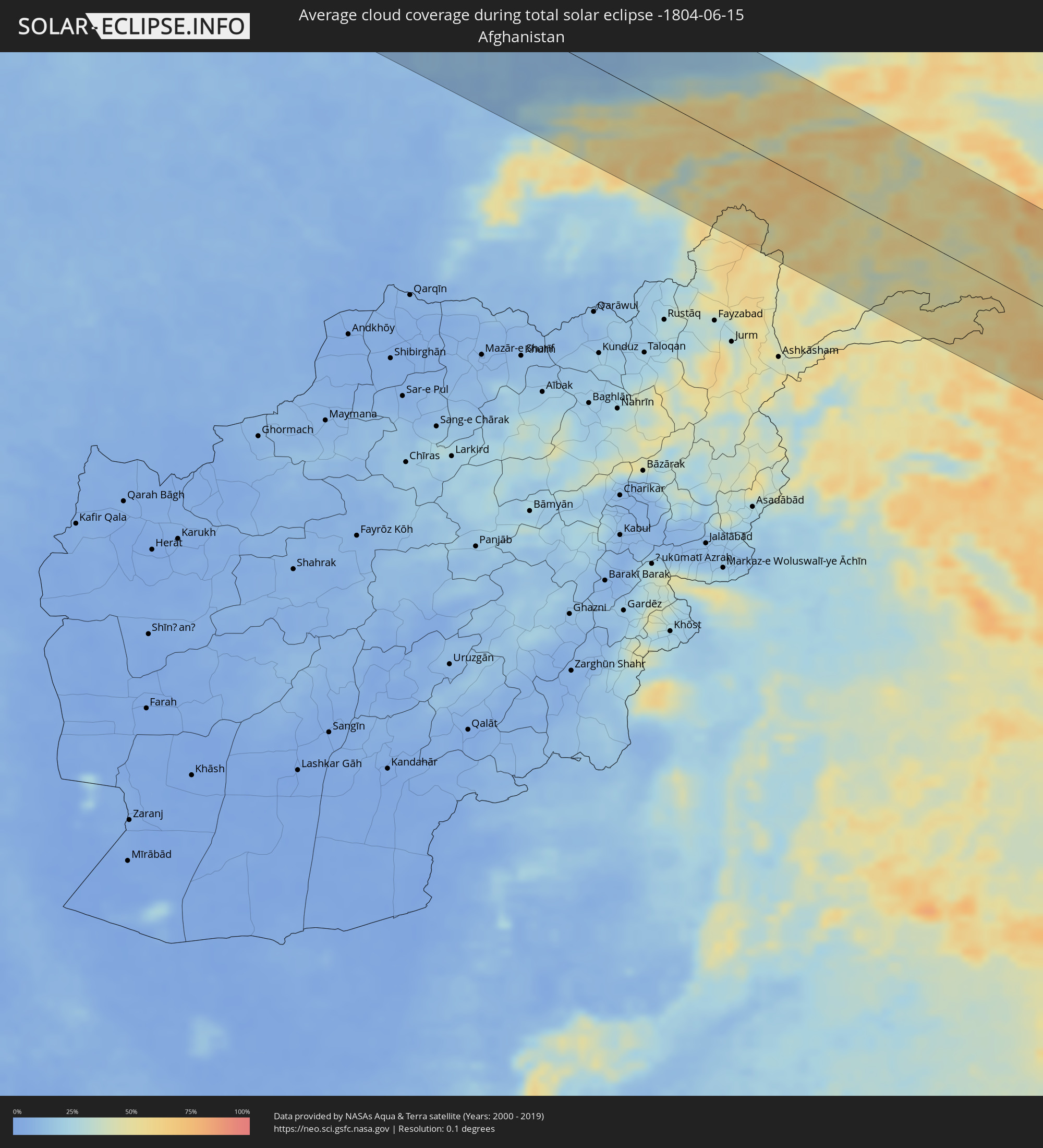 Afghanistan
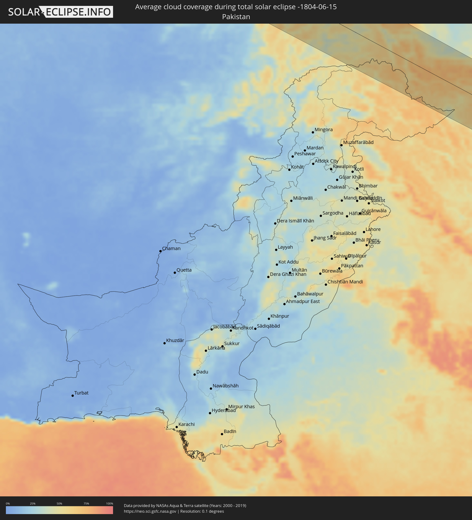 Pakistan
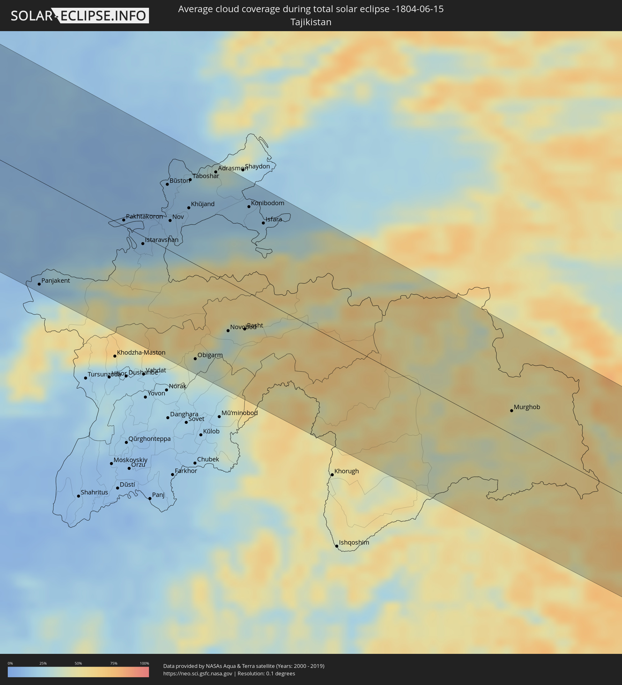 Tajikistan
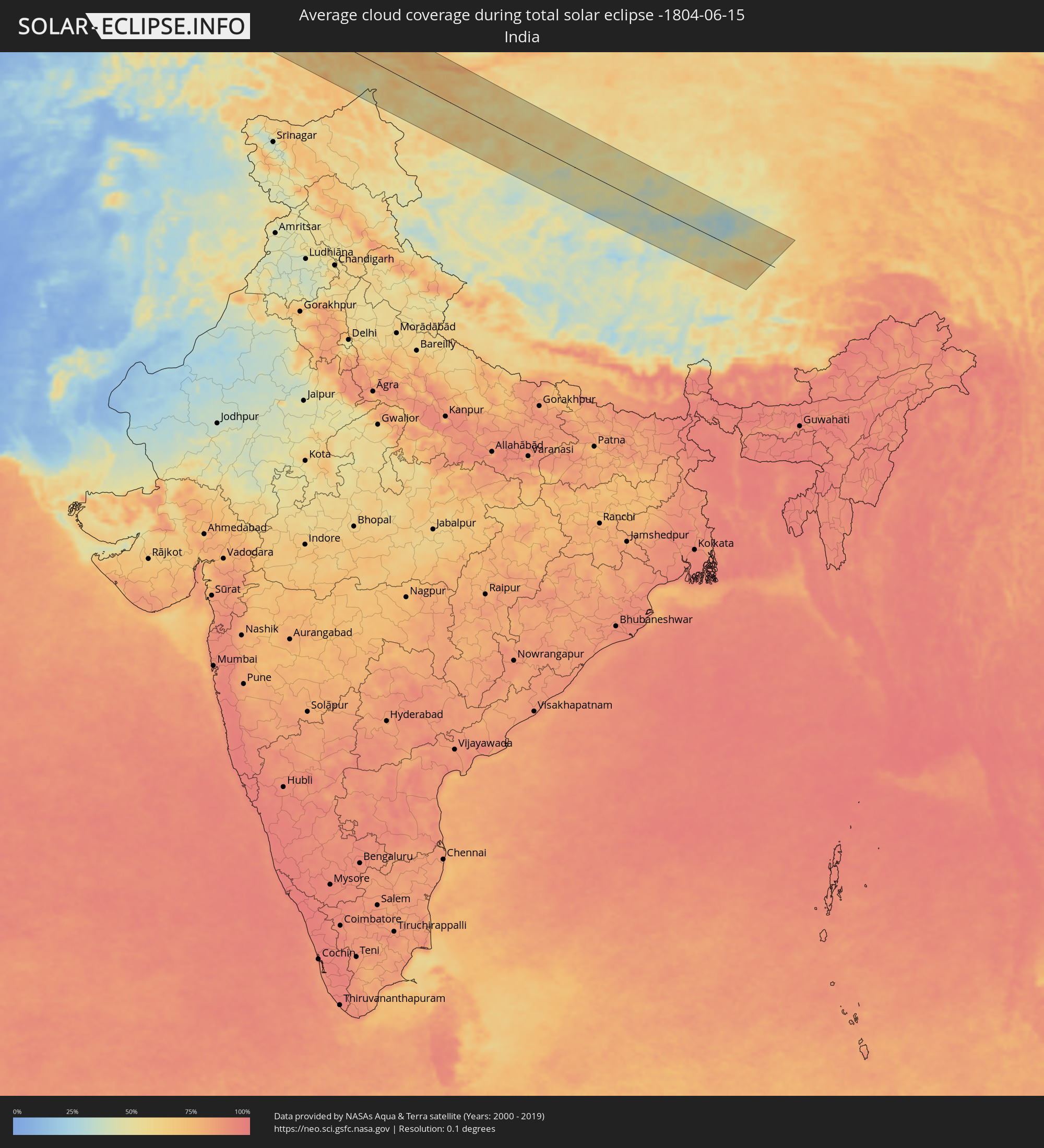 India
India
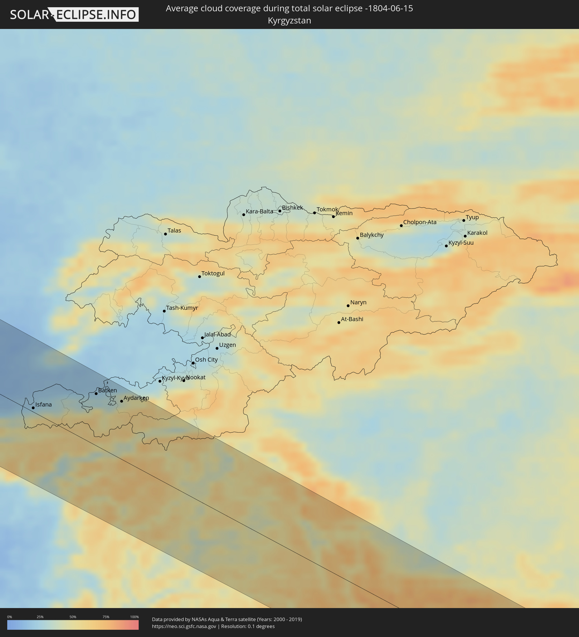 Kyrgyzstan
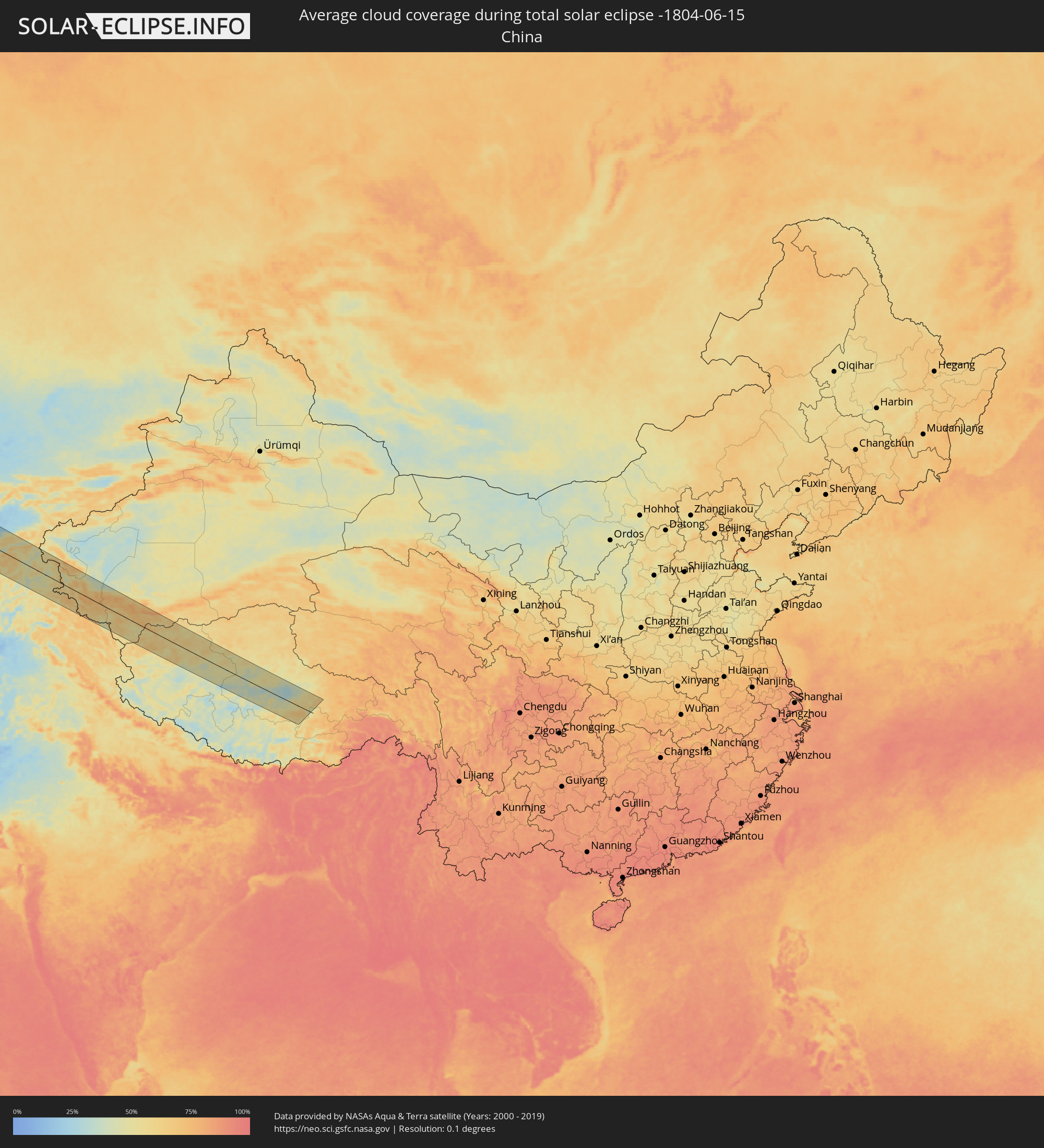 China
China
Cities inside the path of the eclipse
The following table shows all locations with a population of more than 5,000 inside the eclipse path. Cities which have more than 100,000 inhabitants are marked bold. A click at the locations opens a detailed map.
| City | Type | Eclipse duration | Local time of max. eclipse | Distance to central line | Ø Cloud coverage |
|
Plymouth, England
|
total | - | 10:53:41 UTC+00:00 | 60 km | 71% |
|
Exeter, England
|
total | - | 10:54:54 UTC+00:00 | 84 km | 74% |
|
Saint Peter Port, St Peter Port
|
total | - | 10:55:19 UTC+00:00 | 70 km | 65% |
|
Saint Helier, St Helier
|
total | - | 10:55:45 UTC+00:00 | 108 km | 68% |
|
Le Hocq, St Clement
|
total | - | 10:55:48 UTC+00:00 | 111 km | 68% |
|
Bournemouth, England
|
total | - | 10:57:20 UTC+00:00 | 52 km | 72% |
|
Southampton, England
|
total | - | 10:58:11 UTC+00:00 | 63 km | 76% |
|
Portsmouth, England
|
total | - | 10:58:34 UTC+00:00 | 46 km | 72% |
|
Reading, England
|
total | - | 10:59:14 UTC+00:00 | 115 km | 81% |
|
Slough, England
|
total | - | 10:59:50 UTC+00:00 | 115 km | 79% |
|
Sutton, England
|
total | - | 11:00:18 UTC+00:00 | 91 km | 82% |
|
Brighton, England
|
total | - | 11:00:02 UTC+00:00 | 33 km | 69% |
|
London, England
|
total | - | 11:00:32 UTC+00:00 | 108 km | 85% |
|
Le Havre, Normandy
|
total | - | 11:08:50 UTC+00:09 | 116 km | 70% |
|
Bexley, England
|
total | - | 11:00:53 UTC+00:00 | 94 km | 82% |
|
Eastbourne, England
|
total | - | 11:00:38 UTC+00:00 | 22 km | 67% |
|
Southend-on-Sea, England
|
total | - | 11:01:48 UTC+00:00 | 96 km | 77% |
|
Dieppe, Normandy
|
total | - | 11:10:40 UTC+00:09 | 85 km | 74% |
|
Boulogne-sur-Mer, Hauts-de-France
|
total | - | 11:12:00 UTC+00:09 | 10 km | 70% |
|
Calais, Hauts-de-France
|
total | - | 11:12:31 UTC+00:09 | 16 km | 71% |
|
Amiens, Hauts-de-France
|
total | - | 11:12:35 UTC+00:09 | 107 km | 81% |
|
Dunkerque, Hauts-de-France
|
total | - | 11:13:22 UTC+00:09 | 17 km | 79% |
|
Arras, Hauts-de-France
|
total | - | 11:13:35 UTC+00:09 | 71 km | 79% |
|
Lens, Hauts-de-France
|
total | - | 11:13:44 UTC+00:09 | 57 km | 82% |
|
Lille, Hauts-de-France
|
total | - | 11:14:13 UTC+00:09 | 38 km | 81% |
|
Douai, Hauts-de-France
|
total | - | 11:14:05 UTC+00:09 | 67 km | 78% |
|
Brugge, Flanders
|
total | - | 11:05:26 UTC+00:00 | 28 km | 78% |
|
Cambrai, Hauts-de-France
|
total | - | 11:14:14 UTC+00:09 | 91 km | 79% |
|
Kortrijk, Flanders
|
total | - | 11:05:17 UTC+00:00 | 24 km | 81% |
|
Valenciennes, Hauts-de-France
|
total | - | 11:14:49 UTC+00:09 | 76 km | 81% |
|
Gent, Flanders
|
total | - | 11:06:07 UTC+00:00 | 15 km | 82% |
|
Mons, Wallonia
|
total | - | 11:06:11 UTC+00:00 | 71 km | 82% |
|
Maubeuge, Hauts-de-France
|
total | - | 11:15:29 UTC+00:09 | 90 km | 79% |
|
Aalst, Flanders
|
total | - | 11:06:33 UTC+00:00 | 17 km | 81% |
|
La Louvière, Wallonia
|
total | - | 11:06:35 UTC+00:00 | 69 km | 81% |
|
The Hague, South Holland
|
total | - | 11:27:02 UTC+00:19 | 104 km | 81% |
|
Brussels, Brussels Capital
|
total | - | 11:07:00 UTC+00:00 | 31 km | 80% |
|
Antwerpen, Flanders
|
total | - | 11:07:16 UTC+00:00 | 9 km | 80% |
|
Charleroi, Wallonia
|
total | - | 11:06:57 UTC+00:00 | 82 km | 80% |
|
Mechelen, Flanders
|
total | - | 11:07:17 UTC+00:00 | 13 km | 80% |
|
Rotterdam, South Holland
|
total | - | 11:27:14 UTC+00:19 | 85 km | 79% |
|
Leuven, Flanders
|
total | - | 11:07:34 UTC+00:00 | 32 km | 80% |
|
Breda, North Brabant
|
total | - | 11:27:32 UTC+00:19 | 45 km | 79% |
|
Namur, Wallonia
|
total | - | 11:07:39 UTC+00:00 | 79 km | 81% |
|
Tilburg, North Brabant
|
total | - | 11:28:01 UTC+00:19 | 38 km | 79% |
|
Utrecht, Utrecht
|
total | - | 11:28:17 UTC+00:19 | 97 km | 83% |
|
's-Hertogenbosch, North Brabant
|
total | - | 11:28:24 UTC+00:19 | 51 km | 78% |
|
Amersfoort, Utrecht
|
total | - | 11:28:43 UTC+00:19 | 101 km | 82% |
|
Eindhoven, North Brabant
|
total | - | 11:28:34 UTC+00:19 | 21 km | 81% |
|
Liège, Wallonia
|
total | - | 11:08:51 UTC+00:00 | 69 km | 82% |
|
Maastricht, Limburg
|
total | - | 11:28:40 UTC+00:19 | 47 km | 79% |
|
Nijmegen, Gelderland
|
total | - | 11:29:18 UTC+00:19 | 61 km | 79% |
|
Arnhem, Gelderland
|
total | - | 11:29:26 UTC+00:19 | 75 km | 82% |
|
Apeldoorn, Gelderland
|
total | - | 11:29:37 UTC+00:19 | 101 km | 80% |
|
Duisburg, North Rhine-Westphalia
|
total | - | 12:11:02 UTC+01:00 | 17 km | 81% |
|
Düsseldorf, North Rhine-Westphalia
|
total | - | 12:10:59 UTC+01:00 | 24 km | 79% |
|
Enschede, Overijssel
|
total | - | 11:31:01 UTC+00:19 | 92 km | 78% |
|
Köln, North Rhine-Westphalia
|
total | - | 12:11:10 UTC+01:00 | 52 km | 77% |
|
Essen, North Rhine-Westphalia
|
total | - | 12:11:26 UTC+01:00 | 7 km | 84% |
|
Bonn, North Rhine-Westphalia
|
total | - | 12:11:20 UTC+01:00 | 74 km | 79% |
|
Wuppertal, North Rhine-Westphalia
|
total | - | 12:11:37 UTC+01:00 | 18 km | 81% |
|
Dortmund, North Rhine-Westphalia
|
total | - | 12:12:09 UTC+01:00 | 9 km | 82% |
|
Münster, North Rhine-Westphalia
|
total | - | 12:12:32 UTC+01:00 | 59 km | 79% |
|
Bielefeld, North Rhine-Westphalia
|
total | - | 12:13:57 UTC+01:00 | 57 km | 80% |
|
Hannover, Lower Saxony
|
total | - | 12:15:51 UTC+01:00 | 85 km | 80% |
|
Leipzig, Saxony
|
total | - | 12:19:52 UTC+01:00 | 44 km | 77% |
|
Berlin, Berlin
|
total | - | 12:21:27 UTC+01:00 | 84 km | 80% |
|
Dresden, Saxony
|
total | - | 12:22:02 UTC+01:00 | 81 km | 78% |
|
Jílové, Ústecký
|
total | - | 12:22:38 UTC+01:00 | 114 km | 74% |
|
Děčín, Ústecký
|
total | - | 12:22:49 UTC+01:00 | 112 km | 73% |
|
Česká Kamenice, Ústecký
|
total | - | 12:23:08 UTC+01:00 | 111 km | 75% |
|
Šluknov, Ústecký
|
total | - | 12:23:11 UTC+01:00 | 88 km | 75% |
|
Nový Bor, Liberecký
|
total | - | 12:23:22 UTC+01:00 | 115 km | 74% |
|
Rumburk, Ústecký
|
total | - | 12:23:21 UTC+01:00 | 94 km | 75% |
|
Varnsdorf, Ústecký
|
total | - | 12:23:27 UTC+01:00 | 98 km | 74% |
|
Hrádek nad Nisou, Liberecký
|
total | - | 12:23:49 UTC+01:00 | 105 km | 76% |
|
Chrastava
|
total | - | 12:24:01 UTC+01:00 | 109 km | 77% |
|
Liberec, Liberecký
|
total | - | 12:24:10 UTC+01:00 | 115 km | 78% |
|
Frýdlant, Liberecký
|
total | - | 12:24:11 UTC+01:00 | 98 km | 77% |
|
Jablonec nad Nisou, Liberecký
|
total | - | 12:24:21 UTC+01:00 | 120 km | 75% |
|
Gorzów Wielkopolski, Lubusz
|
total | - | 12:48:10 UTC+01:24 | 104 km | 75% |
|
Tanvald, Liberecký
|
total | - | 12:24:34 UTC+01:00 | 119 km | 74% |
|
Zielona Góra, Lubusz
|
total | - | 12:48:42 UTC+01:24 | 15 km | 75% |
|
Wałbrzych, Lower Silesian Voivodeship
|
total | - | 12:50:08 UTC+01:24 | 117 km | 77% |
|
Poznań, Greater Poland Voivodeship
|
total | - | 12:50:46 UTC+01:24 | 67 km | 75% |
|
Wrocław, Lower Silesian Voivodeship
|
total | - | 12:51:14 UTC+01:24 | 79 km | 73% |
|
Włocławek, Kujawsko-Pomorskie
|
total | - | 12:53:52 UTC+01:24 | 97 km | 73% |
|
Częstochowa, Silesian Voivodeship
|
total | - | 12:54:36 UTC+01:24 | 110 km | 78% |
|
Łódź, Łódź Voivodeship
|
total | - | 12:54:47 UTC+01:24 | 3 km | 78% |
|
Płock, Masovian Voivodeship
|
total | - | 12:54:50 UTC+01:24 | 88 km | 74% |
|
Kielce, Świętokrzyskie
|
total | - | 12:56:54 UTC+01:24 | 97 km | 78% |
|
Warsaw, Masovian Voivodeship
|
total | - | 12:56:53 UTC+01:24 | 57 km | 76% |
|
Radom, Masovian Voivodeship
|
total | - | 12:57:27 UTC+01:24 | 37 km | 74% |
|
Lublin, Lublin Voivodeship
|
total | - | 12:59:39 UTC+01:24 | 44 km | 76% |
|
Brest, Brest
|
total | - | 13:26:49 UTC+01:50 | 58 km | 73% |
|
Zhabinka, Brest
|
total | - | 13:27:13 UTC+01:50 | 71 km | 71% |
|
Kobryn, Brest
|
total | - | 13:27:41 UTC+01:50 | 76 km | 70% |
|
Pruzhany, Brest
|
total | - | 13:27:37 UTC+01:50 | 115 km | 72% |
|
Byaroza, Brest
|
total | - | 13:28:21 UTC+01:50 | 117 km | 70% |
|
Drahichyn, Brest
|
total | - | 13:28:50 UTC+01:50 | 79 km | 67% |
|
Luts’k, Volyn
|
total | - | 13:42:06 UTC+02:02 | 77 km | 68% |
|
Ivanava, Brest
|
total | - | 13:29:23 UTC+01:50 | 78 km | 67% |
|
Pinsk, Brest
|
total | - | 13:30:10 UTC+01:50 | 80 km | 67% |
|
Rivne, Rivne
|
total | - | 13:43:29 UTC+02:02 | 84 km | 70% |
|
Luninyets, Brest
|
total | - | 13:31:04 UTC+01:50 | 101 km | 68% |
|
Mikashevichy, Brest
|
total | - | 13:31:59 UTC+01:50 | 106 km | 70% |
|
Zhytkavichy, Gomel
|
total | - | 13:32:30 UTC+01:50 | 109 km | 67% |
|
Zhytomyr, Zhytomyr
|
total | - | 13:47:15 UTC+02:02 | 96 km | 68% |
|
Mazyr, Gomel
|
total | - | 13:34:29 UTC+01:50 | 106 km | 73% |
|
Khoyniki, Gomel
|
total | - | 13:35:33 UTC+01:50 | 99 km | 71% |
|
Kiev, Kyiv City
|
total | - | 13:49:38 UTC+02:02 | 51 km | 75% |
|
Chernihiv, Chernihiv
|
total | - | 13:49:41 UTC+02:02 | 74 km | 70% |
|
Poltava, Poltava
|
total | - | 13:55:45 UTC+02:02 | 82 km | 61% |
|
Sumy, Sumy
|
total | - | 13:54:41 UTC+02:02 | 66 km | 65% |
|
Kharkiv, Kharkiv
|
total | - | 13:57:28 UTC+02:02 | 18 km | 65% |
|
Belgorod, Belgorod
|
total | - | 14:25:23 UTC+02:30 | 66 km | 65% |
|
Shebekino, Belgorod
|
total | - | 14:26:00 UTC+02:30 | 53 km | 62% |
|
Kramators’k, Donetsk
|
total | - | 14:00:28 UTC+02:02 | 118 km | 60% |
|
Sloviansk, Donetsk
|
total | - | 14:00:22 UTC+02:02 | 101 km | 61% |
|
Valuyki, Belgorod
|
total | - | 14:27:37 UTC+02:30 | 52 km | 63% |
|
Syevyerodonets’k, Luhansk
|
total | - | 14:01:19 UTC+02:02 | 76 km | 61% |
|
Alekseyevka, Belgorod
|
total | - | 14:27:47 UTC+02:30 | 111 km | 62% |
|
Alchevs’k, Luhansk
|
total | - | 14:02:15 UTC+02:02 | 119 km | 61% |
|
Luhansk, Luhansk
|
total | - | 14:02:43 UTC+02:02 | 98 km | 62% |
|
Rossosh’, Voronezj
|
total | - | 14:29:16 UTC+02:30 | 83 km | 60% |
|
Donetsk, Rostov Oblast
|
total | - | 14:31:57 UTC+02:30 | 108 km | 58% |
|
Kamensk-Shakhtinskiy, Rostov Oblast
|
total | - | 14:32:19 UTC+02:30 | 103 km | 59% |
|
Millerovo, Rostov Oblast
|
total | - | 14:31:44 UTC+02:30 | 35 km | 59% |
|
Belaya Kalitva, Rostov Oblast
|
total | - | 14:33:04 UTC+02:30 | 106 km | 59% |
|
Volgograd, Volgograd
|
total | - | 14:36:18 UTC+02:30 | 43 km | 53% |
|
Volzhskiy, Volgograd
|
total | - | 14:36:29 UTC+02:30 | 57 km | 52% |
|
Akhtubinsk, Astrakhan
|
total | - | 15:28:32 UTC+03:20 | 41 km | 49% |
|
Astrakhan, Astrakhan
|
total | - | 15:32:52 UTC+03:20 | 106 km | 41% |
|
Shalkar, Atyraū
|
total | - | 15:36:23 UTC+03:25 | 92 km | 45% |
|
Maloye Ganyushkino, Atyraū
|
total | - | 15:38:40 UTC+03:25 | 44 km | 37% |
|
Balyqshy, Atyraū
|
total | - | 15:40:08 UTC+03:25 | 83 km | 38% |
|
Atyrau, Atyraū
|
total | - | 15:40:04 UTC+03:25 | 88 km | 38% |
|
Qaraton, Atyraū
|
total | - | 15:42:13 UTC+03:25 | 70 km | 28% |
|
Beyneu, Mangghystaū
|
total | - | 15:44:59 UTC+03:25 | 17 km | 21% |
|
Oltinko’l, Karakalpakstan
|
total | - | 16:52:54 UTC+04:27 | 83 km | 17% |
|
Nurota, Navoiy
|
total | - | 16:59:19 UTC+04:27 | 76 km | 10% |
|
Bulung’ur, Samarqand
|
total | - | 17:00:51 UTC+04:27 | 94 km | 13% |
|
Panjakent, Viloyati Sughd
|
total | - | 17:08:36 UTC+04:35 | 106 km | 15% |
|
Jizzax, Jizzax
|
total | - | 17:00:32 UTC+04:27 | 35 km | 11% |
|
Chardara, Ongtüstik Qazaqstan
|
total | - | 16:53:02 UTC+04:21 | 83 km | 15% |
|
Gagarin, Jizzax
|
total | - | 16:59:54 UTC+04:27 | 32 km | 10% |
|
Asyqata, Ongtüstik Qazaqstan
|
total | - | 16:53:37 UTC+04:21 | 63 km | 9% |
|
Zomin, Jizzax
|
total | - | 17:00:53 UTC+04:27 | 28 km | 16% |
|
Atakent, Ongtüstik Qazaqstan
|
total | - | 16:53:43 UTC+04:21 | 65 km | 10% |
|
Slavyanka, Ongtüstik Qazaqstan
|
total | - | 16:53:58 UTC+04:21 | 52 km | 9% |
|
Sirdaryo, Sirdaryo
|
total | - | 16:59:47 UTC+04:27 | 73 km | 10% |
|
Guliston, Sirdaryo
|
total | - | 17:00:17 UTC+04:27 | 40 km | 9% |
|
Yangiyer, Sirdaryo
|
total | - | 17:00:34 UTC+04:27 | 29 km | 11% |
|
Istaravshan, Viloyati Sughd
|
total | - | 17:08:24 UTC+04:35 | 9 km | 18% |
|
Yangiyŭl, Toshkent
|
total | - | 16:59:31 UTC+04:27 | 112 km | 11% |
|
Bekobod, Toshkent
|
total | - | 17:00:44 UTC+04:27 | 34 km | 13% |
|
Bŭston, Viloyati Sughd
|
total | - | 17:07:40 UTC+04:35 | 65 km | 13% |
|
Piskent, Toshkent
|
total | - | 16:59:52 UTC+04:27 | 105 km | 13% |
|
Nov, Viloyati Sughd
|
total | - | 17:08:10 UTC+04:35 | 36 km | 14% |
|
Proletar, Viloyati Sughd
|
total | - | 17:08:11 UTC+04:35 | 42 km | 15% |
|
Isfana, Batken
|
total | - | 17:31:49 UTC+04:58 | 6 km | 37% |
|
Suluktu, Batken
|
total | - | 17:31:42 UTC+04:58 | 17 km | 26% |
|
Olmaliq, Toshkent
|
total | - | 16:59:59 UTC+04:27 | 107 km | 17% |
|
Khŭjand, Viloyati Sughd
|
total | - | 17:08:03 UTC+04:35 | 56 km | 16% |
|
Taboshar, Viloyati Sughd
|
total | - | 17:07:41 UTC+04:35 | 84 km | 19% |
|
Obigarm
|
total | - | 17:10:06 UTC+04:35 | 97 km | 34% |
|
Adrasmon, Viloyati Sughd
|
total | - | 17:07:39 UTC+04:35 | 104 km | 24% |
|
Rasht
|
total | - | 17:09:50 UTC+04:35 | 39 km | 46% |
|
Konibodom, Viloyati Sughd
|
total | - | 17:08:12 UTC+04:35 | 87 km | 17% |
|
Isfara, Viloyati Sughd
|
total | - | 17:08:27 UTC+04:35 | 79 km | 23% |
|
Batken, Batken
|
total | - | 17:31:46 UTC+04:58 | 80 km | 22% |
|
Aydarken, Batken
|
total | - | 17:32:01 UTC+04:58 | 91 km | 50% |
|
Murghob, Gorno-Badakhshan
|
total | - | 17:11:22 UTC+04:35 | 29 km | 44% |