Totale Sonnenfinsternis vom 24.11.0029
| Wochentag: | Samstag |
| Maximale Dauer der Verfinsterung: | 01m59s |
| Maximale Breite des Finsternispfades: | 109 km |
| Saroszyklus: | 62 |
| Bedeckungsgrad: | 100% |
| Magnitude: | 1.0217 |
| Gamma: | 0.7424 |
Wo kann man die Sonnenfinsternis vom 24.11.0029 sehen?
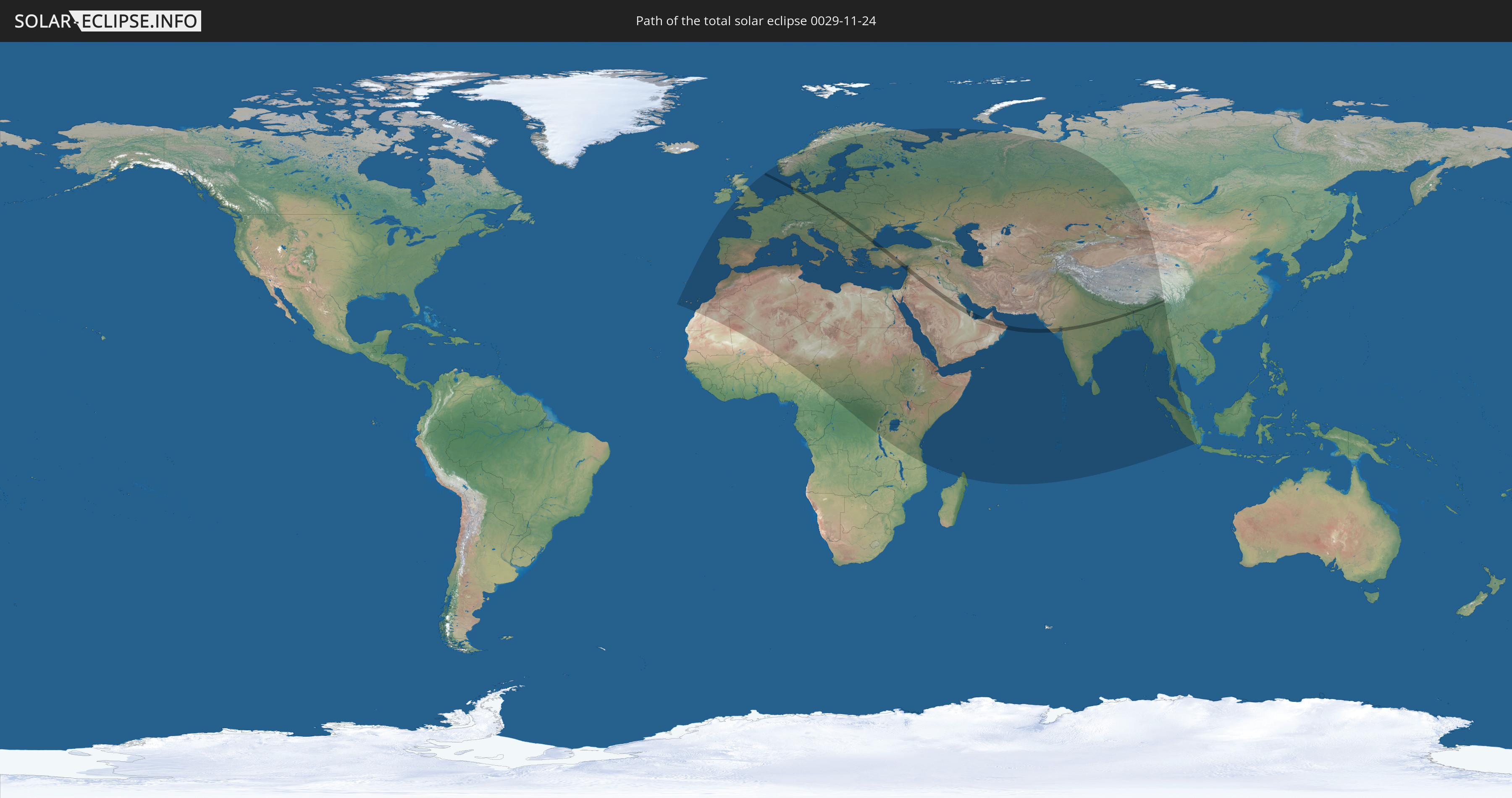
Die Sonnenfinsternis am 24.11.0029 kann man in 113 Ländern als partielle Sonnenfinsternis beobachten.
Der Finsternispfad verläuft durch 20 Länder. Nur in diesen Ländern ist sie als totale Sonnenfinsternis zu sehen.
In den folgenden Ländern ist die Sonnenfinsternis total zu sehen
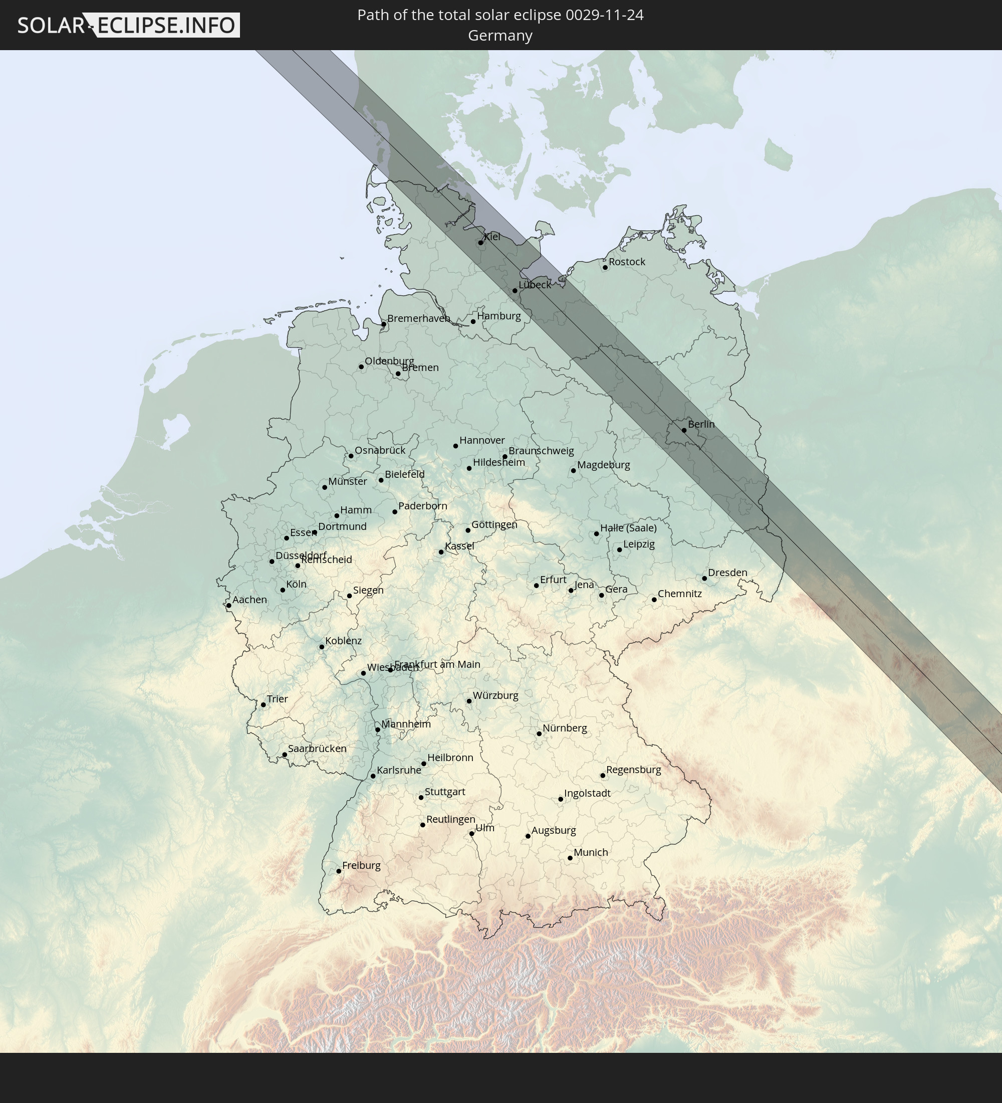 Deutschland
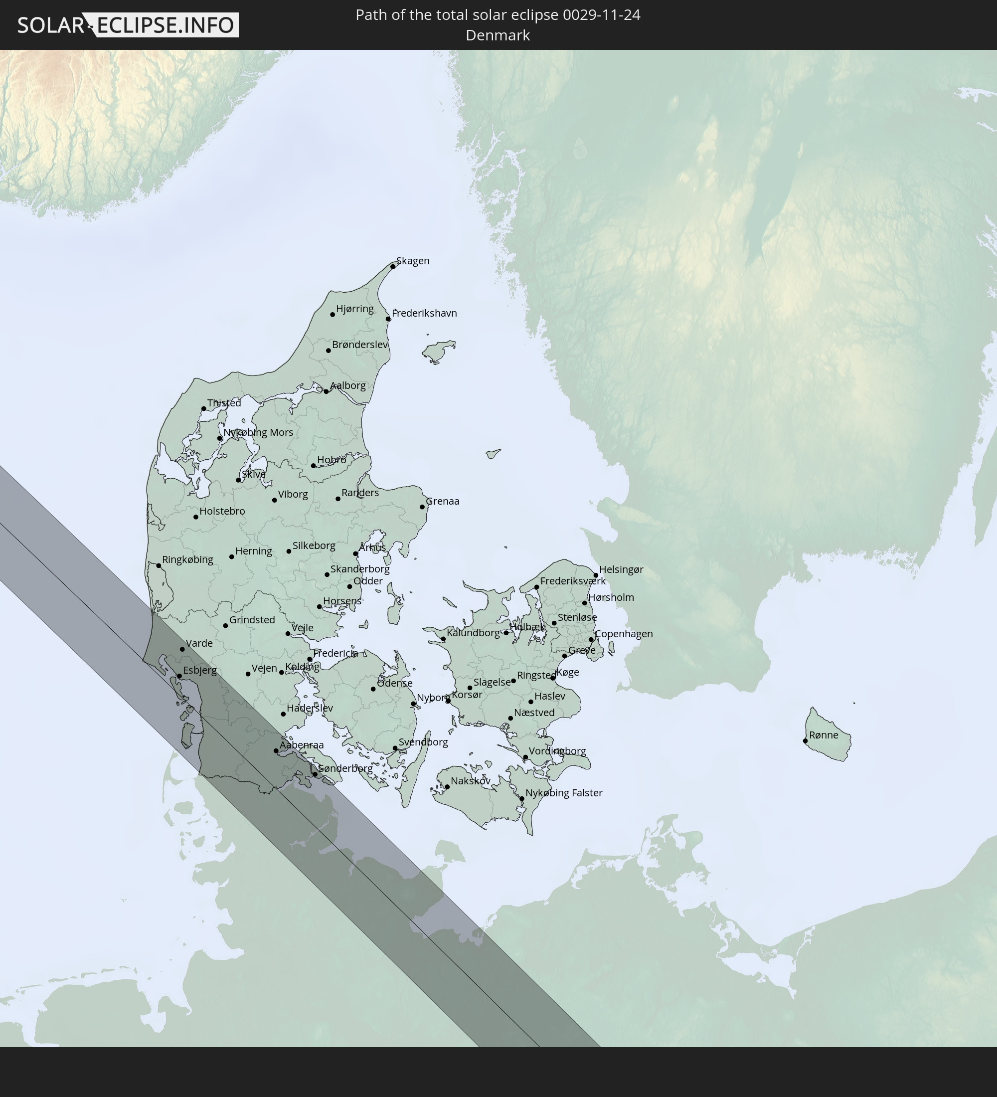 Dänemark
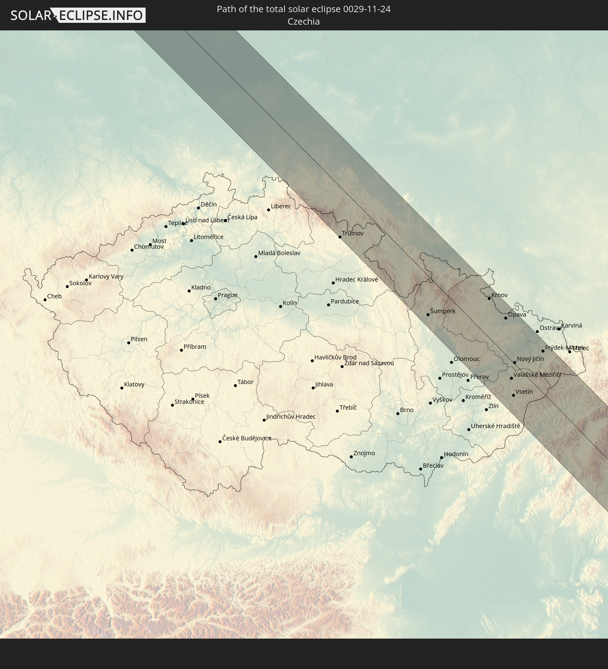 Tschechien
 Polen
Polen
 Ungarn
 Slowakei
 Rumänien
 Bulgarien
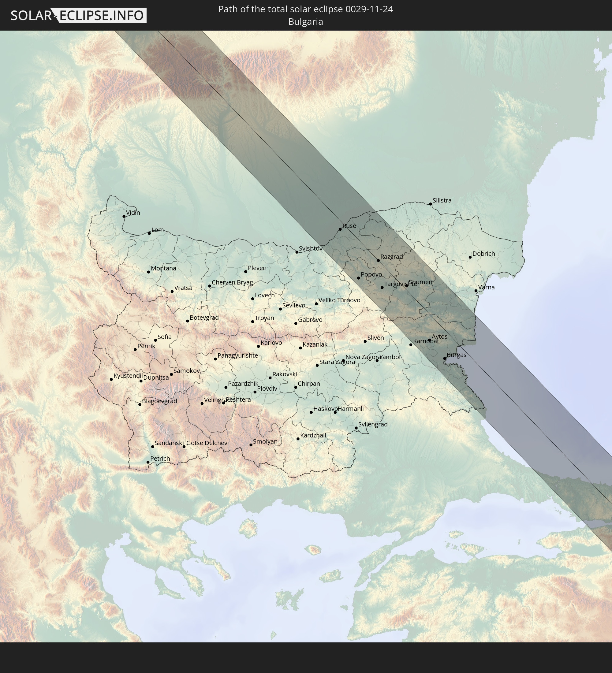
 Türkei
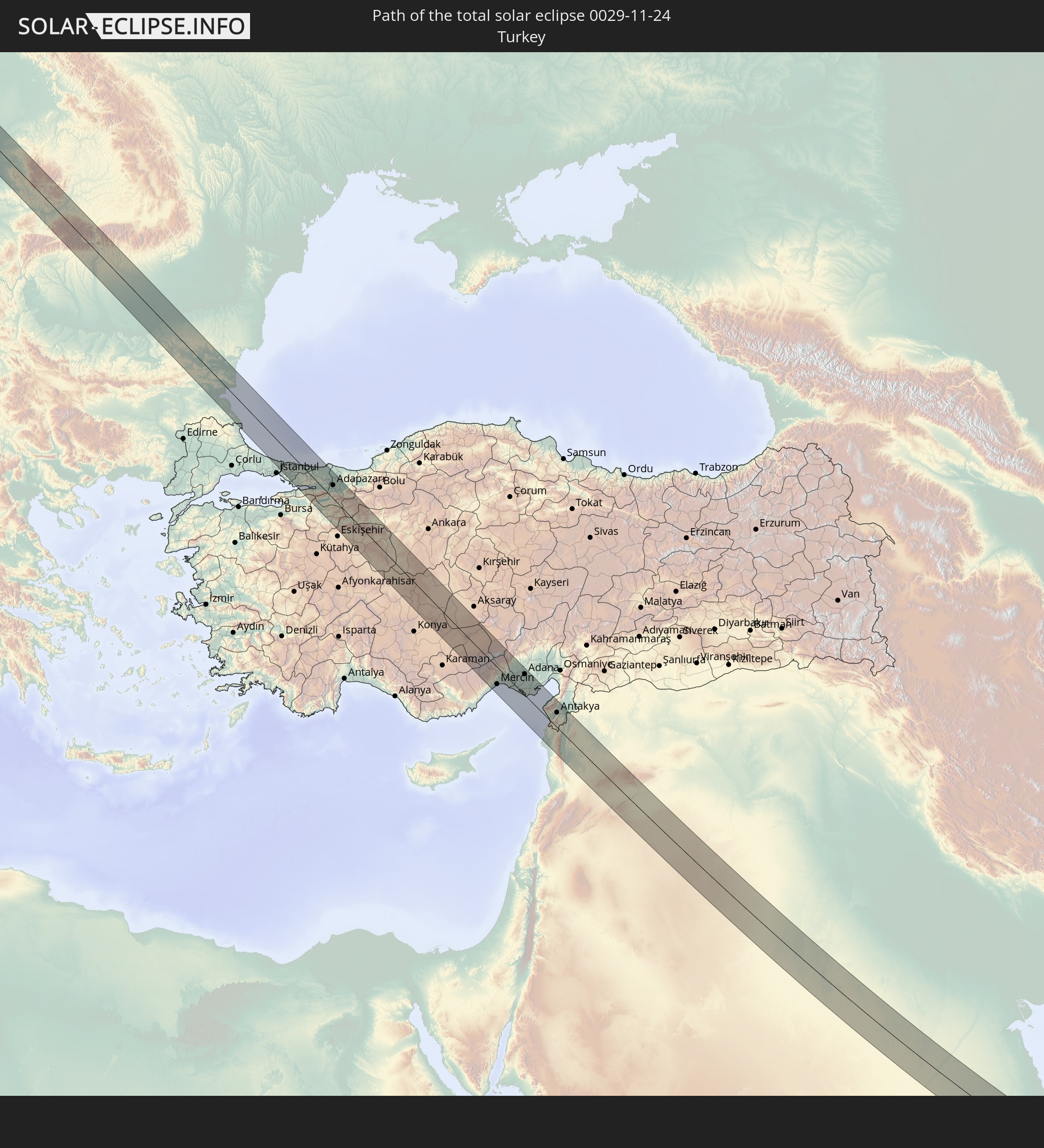
 Saudi-Arabien
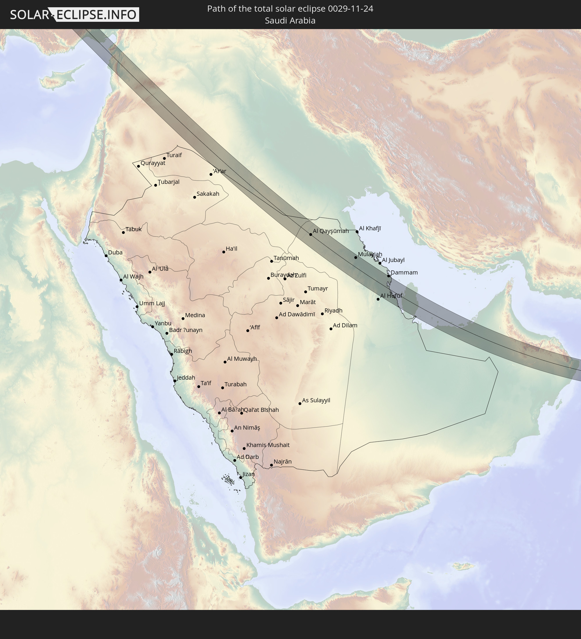
 Jordanien
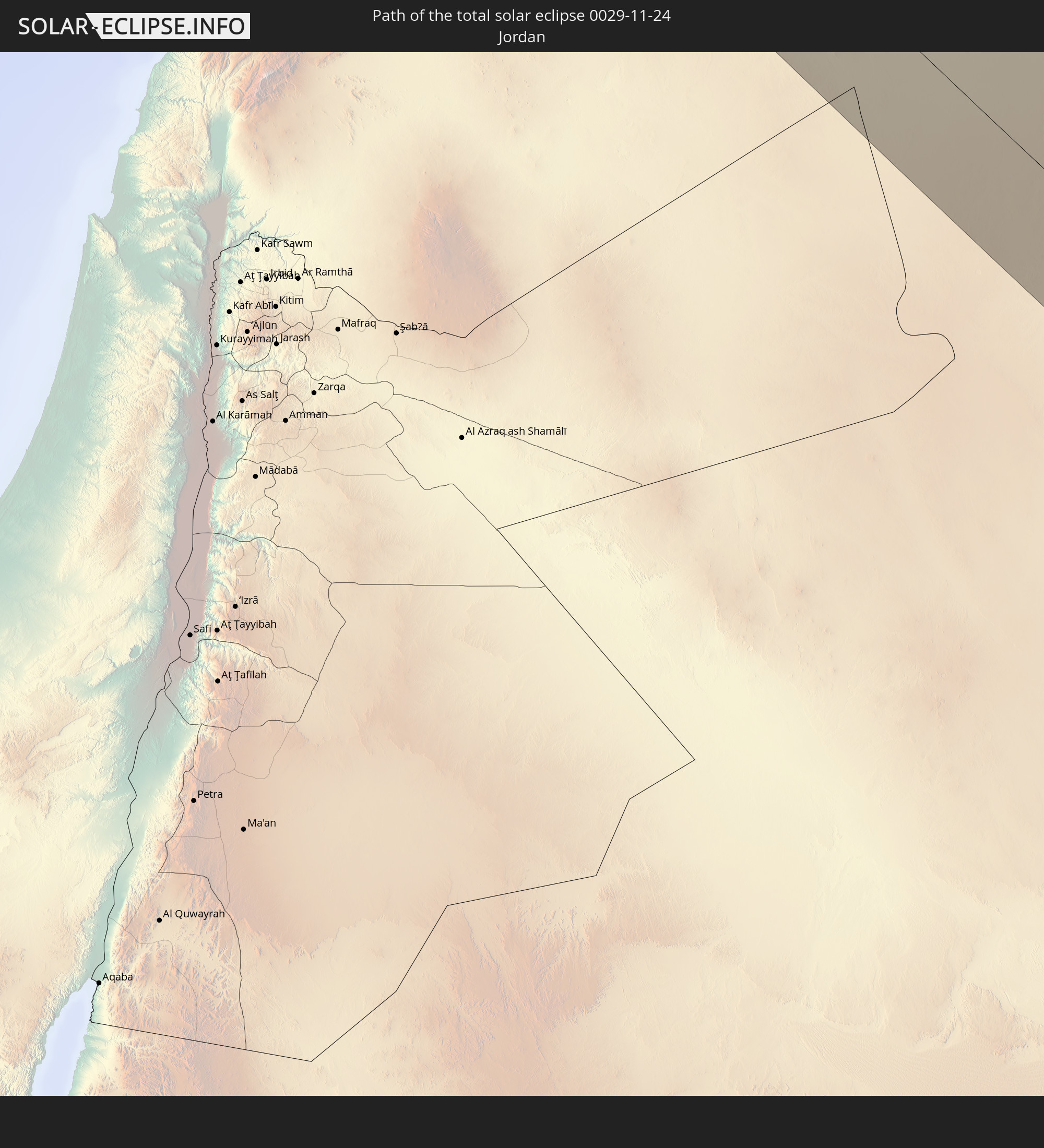
 Syrien
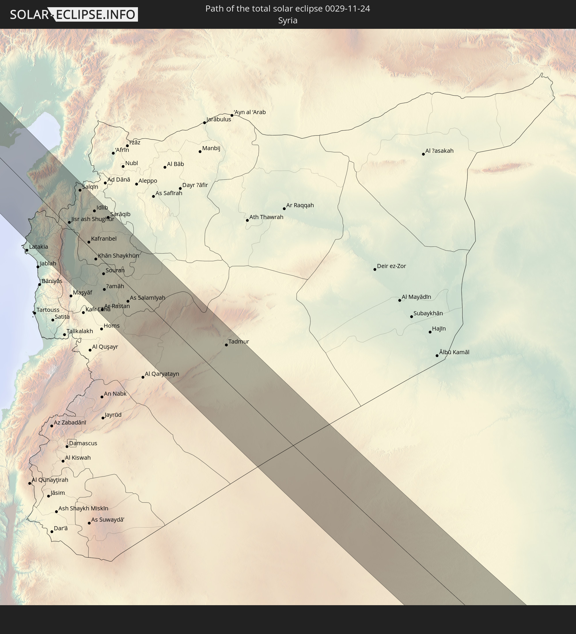
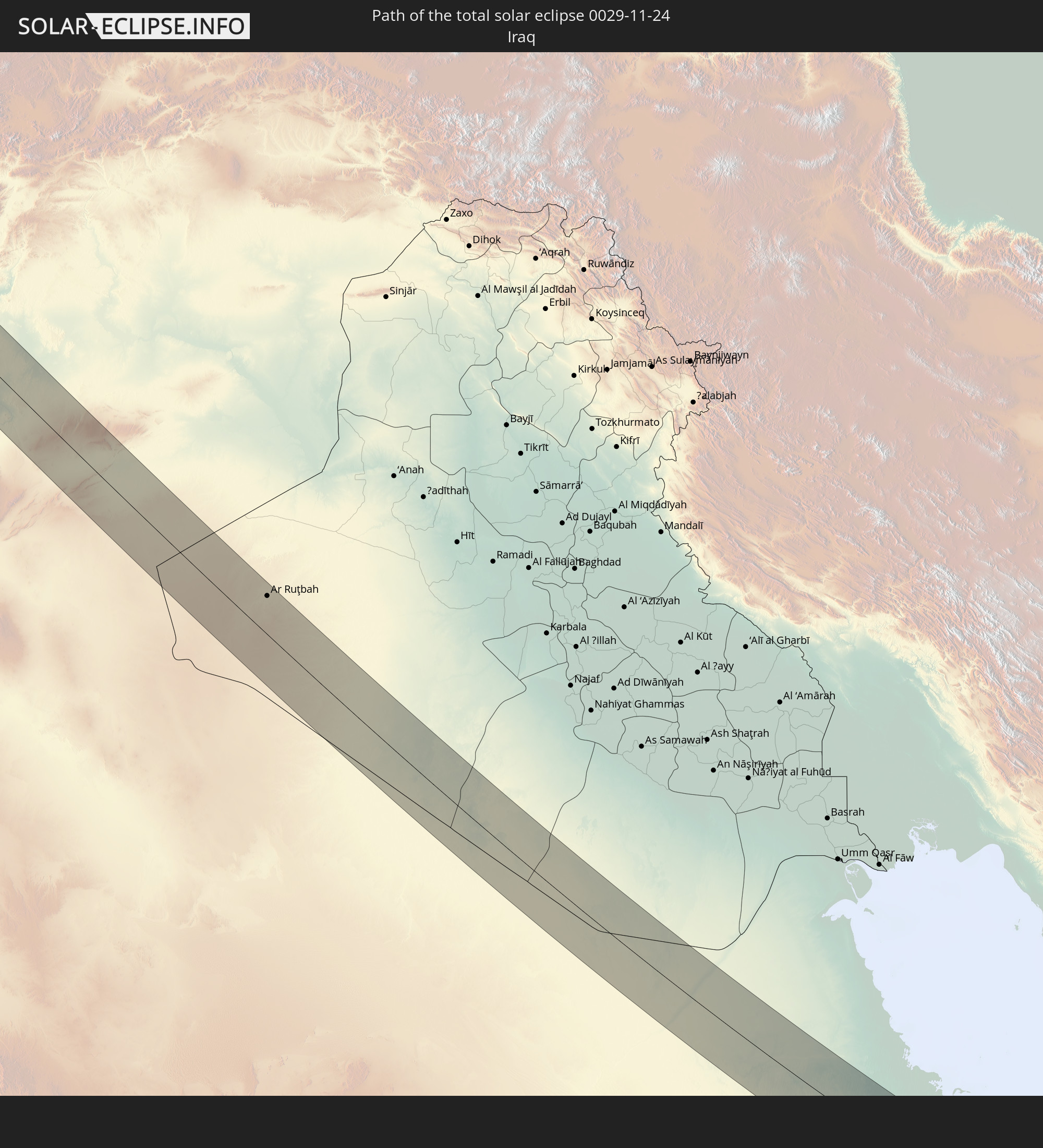 Irak
Irak
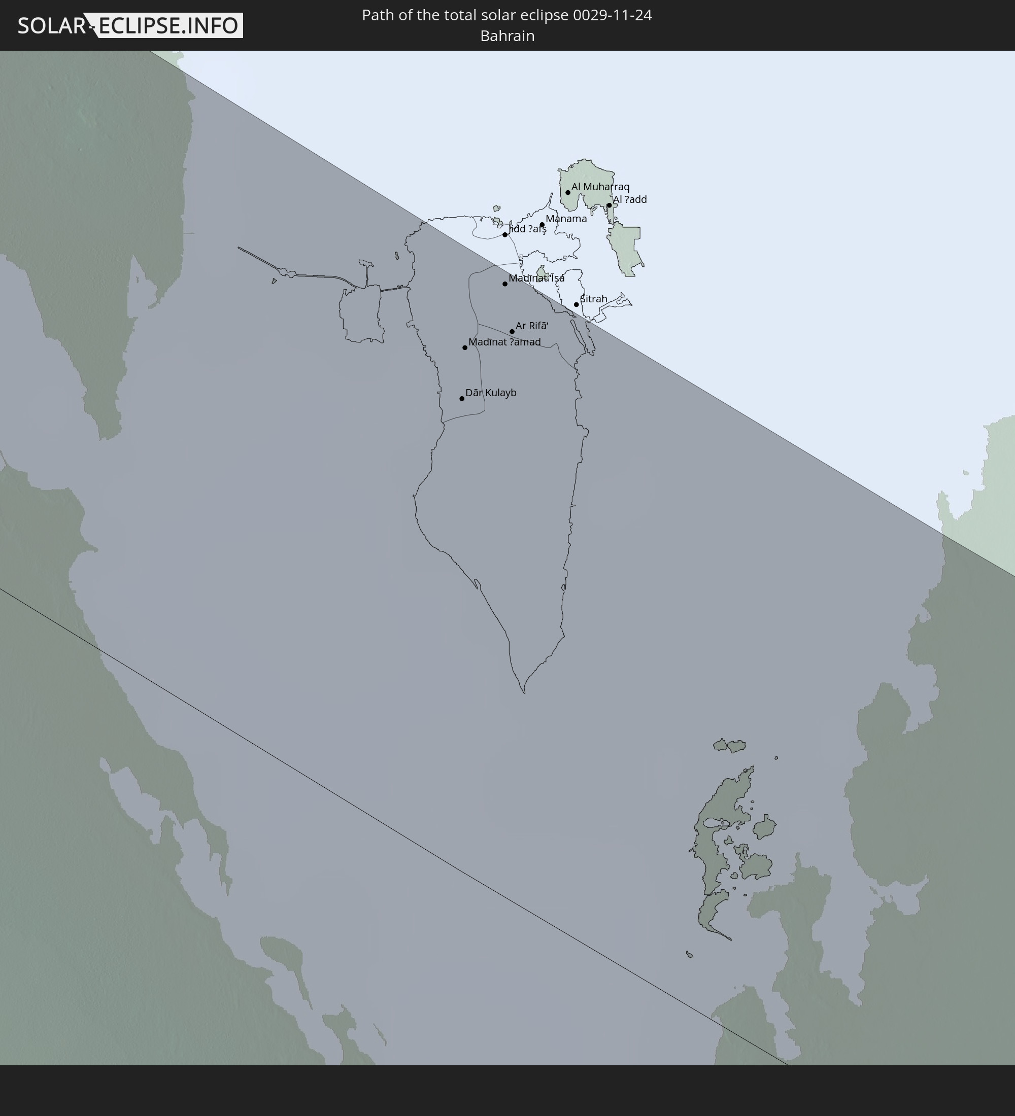 Bahrain
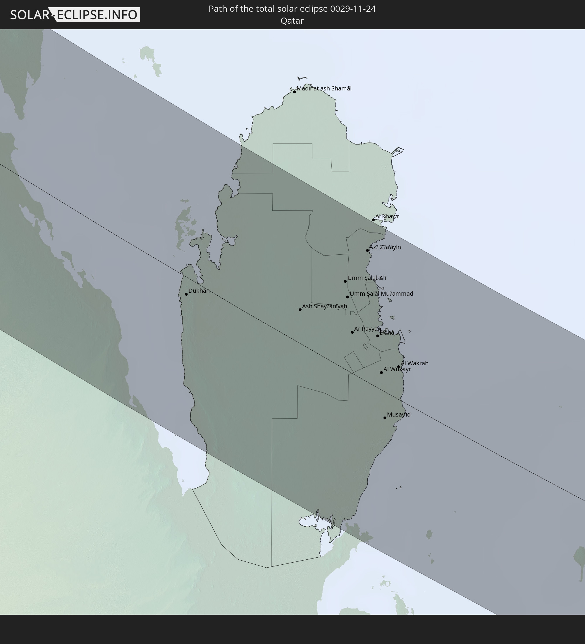 Katar
Katar
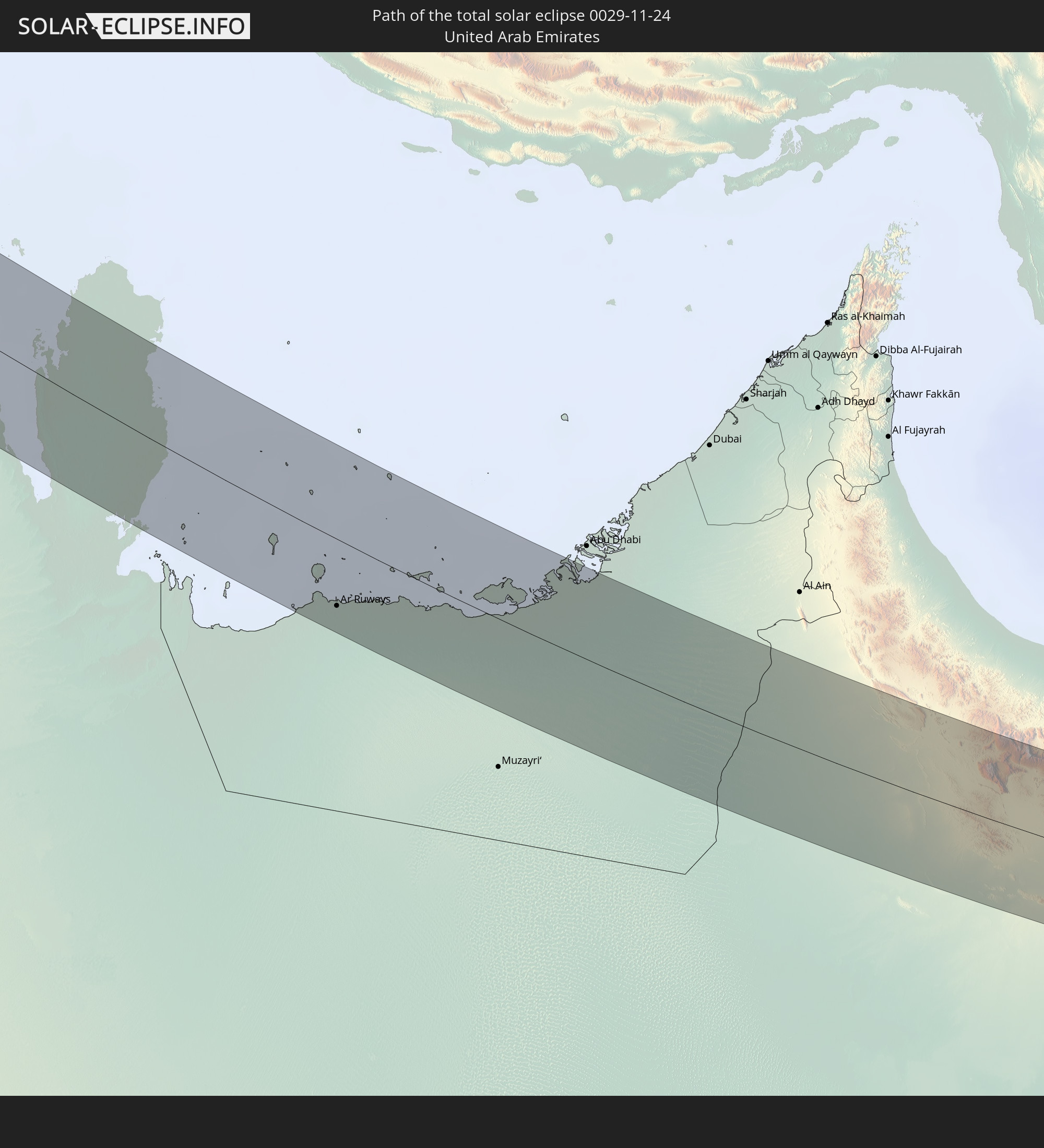 Vereinigte Arabische Emirate
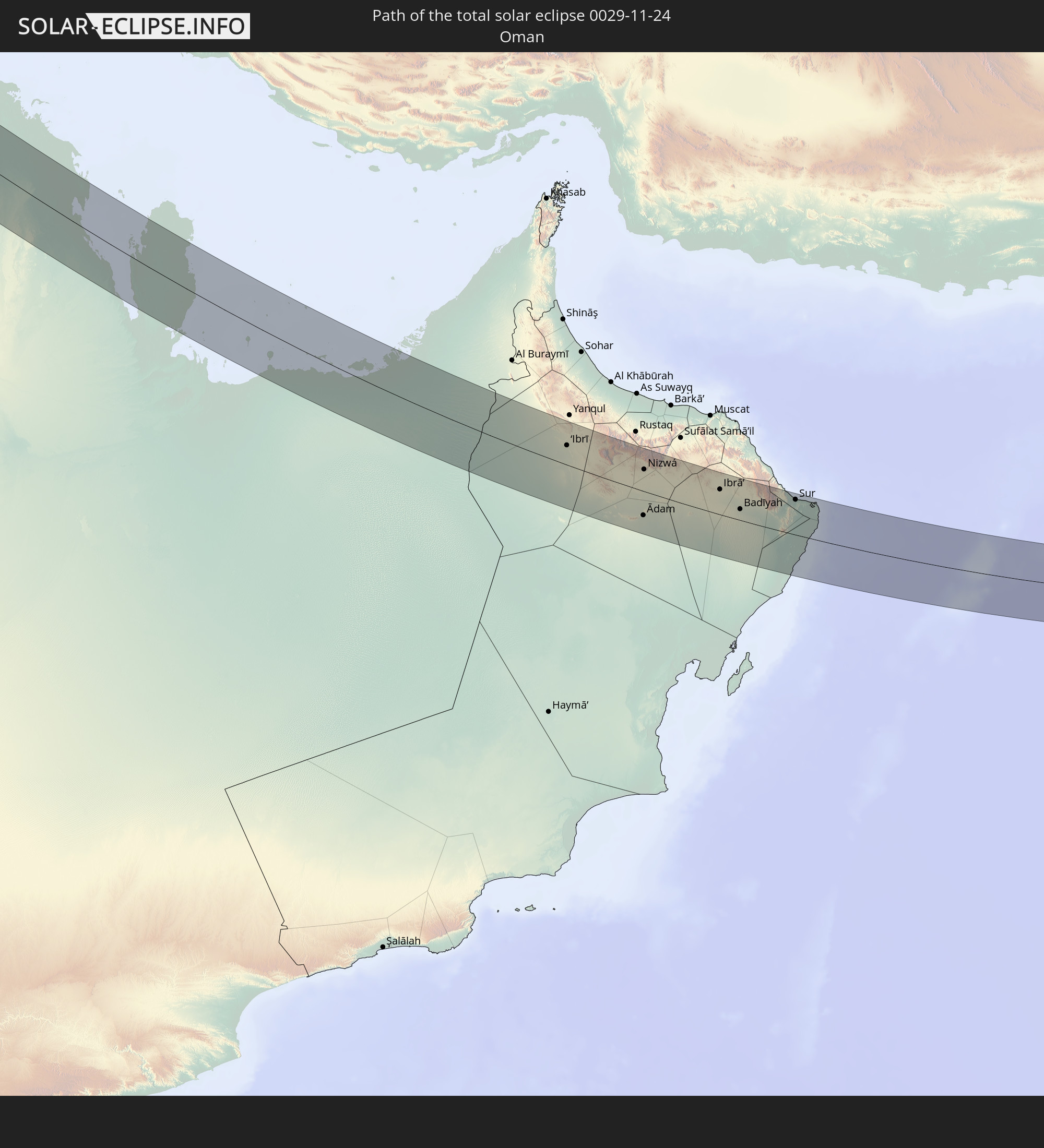 Oman
Oman
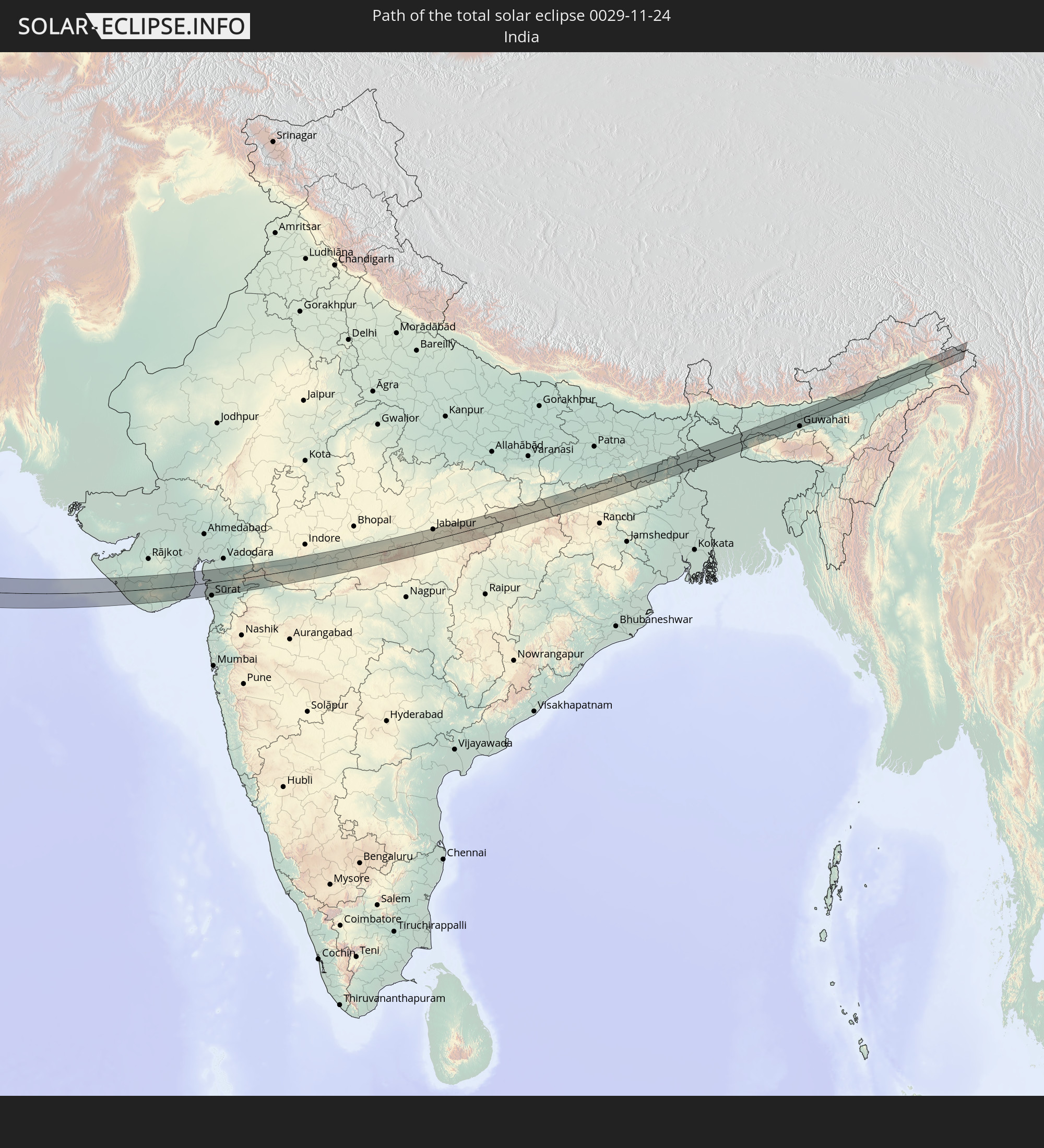 Indien
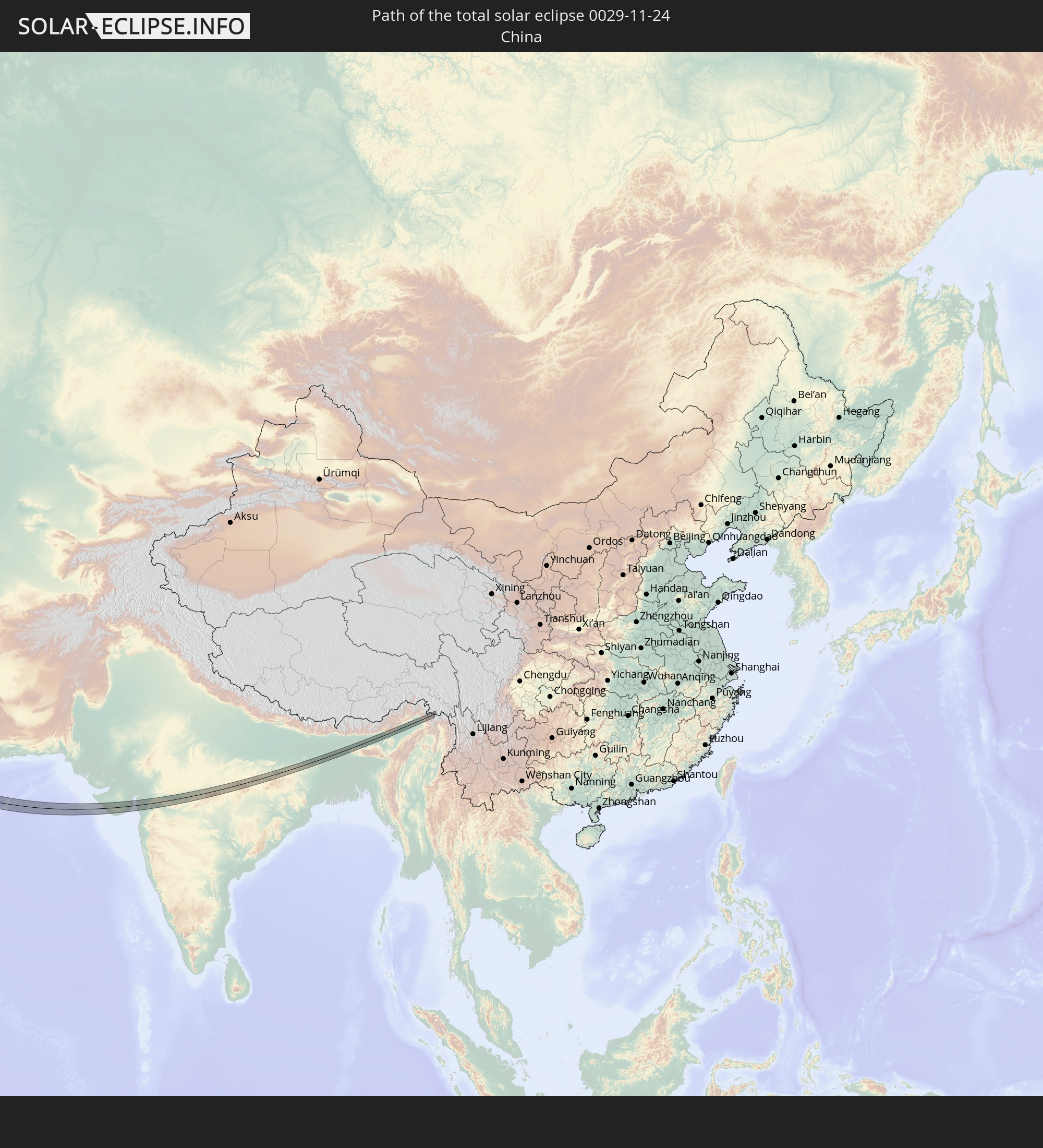 Volksrepublik China
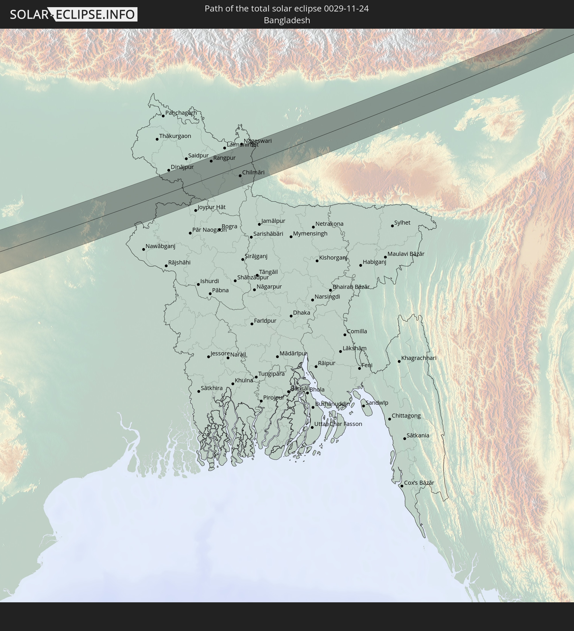 Bangladesch
In den folgenden Ländern ist die Sonnenfinsternis partiell zu sehen
 Russland
 Portugal
 Spanien
 Mauretanien
 Marokko
 Mali
Mali
 Algerien
 Vereinigtes Königreich
 Gibraltar
 Frankreich
 Guernsey
 Jersey
 Niger
Niger
 Andorra
 Belgien
 Nigeria
 Niederlande
 Norwegen
 Luxemburg
 Deutschland
 Schweiz
 Italien
 Monaco
 Tunesien
 Dänemark
 Kamerun
 Libyen
 Liechtenstein
 Österreich
 Schweden
 Tschechien
 Demokratische Republik Kongo
 San Marino
 Vatikanstadt
 Slowenien
 Tschad
 Kroatien
 Polen
Polen
 Malta
Malta
 Zentralafrikanische Republik
 Bosnien und Herzegowina
 Ungarn
 Slowakei
 Montenegro
 Serbien
 Albanien
 Åland Islands
 Griechenland
 Rumänien
 Mazedonien
 Finnland
 Litauen
 Lettland
 Estland
 Sudan
Sudan
 Ukraine
 Bulgarien
 Weißrussland
 Ägypten
 Türkei
 Moldawien
 Ruanda
 Burundi
 Tansania
 Uganda
 Republik Zypern
 Äthiopien
 Kenia
Kenia
 Staat Palästina
 Israel
 Saudi-Arabien
 Jordanien
 Libanon
 Syrien
 Eritrea
 Irak
Irak
 Georgien
 Französische Süd- und Antarktisgebiete
 Somalia
 Dschibuti
 Jemen
Jemen
 Madagaskar
 Komoren
 Armenien
 Iran
Iran
 Aserbaidschan
 Seychellen
 Kasachstan
 Kuwait
 Bahrain
 Katar
Katar
 Vereinigte Arabische Emirate
 Oman
Oman
 Turkmenistan
 Usbekistan
 Mauritius
 Afghanistan
 Pakistan
 Tadschikistan
 Indien
 Kirgisistan
 Britisches Territorium im Indischen Ozean
 Malediven
 Volksrepublik China
 Sri Lanka
 Nepal
Nepal
 Mongolei
 Bangladesch
 Bhutan
 Myanmar
 Indonesien
 Thailand
 Malaysia
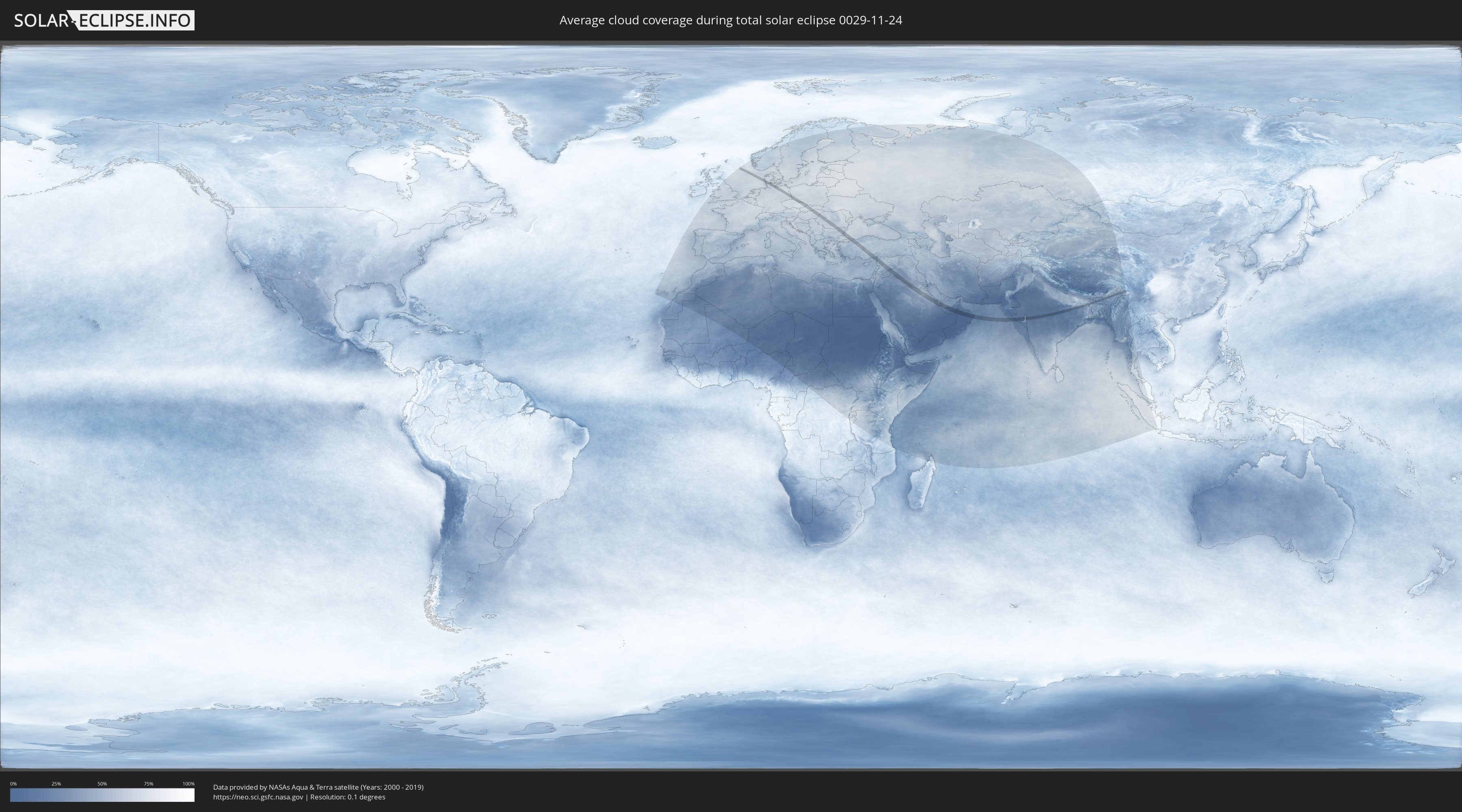
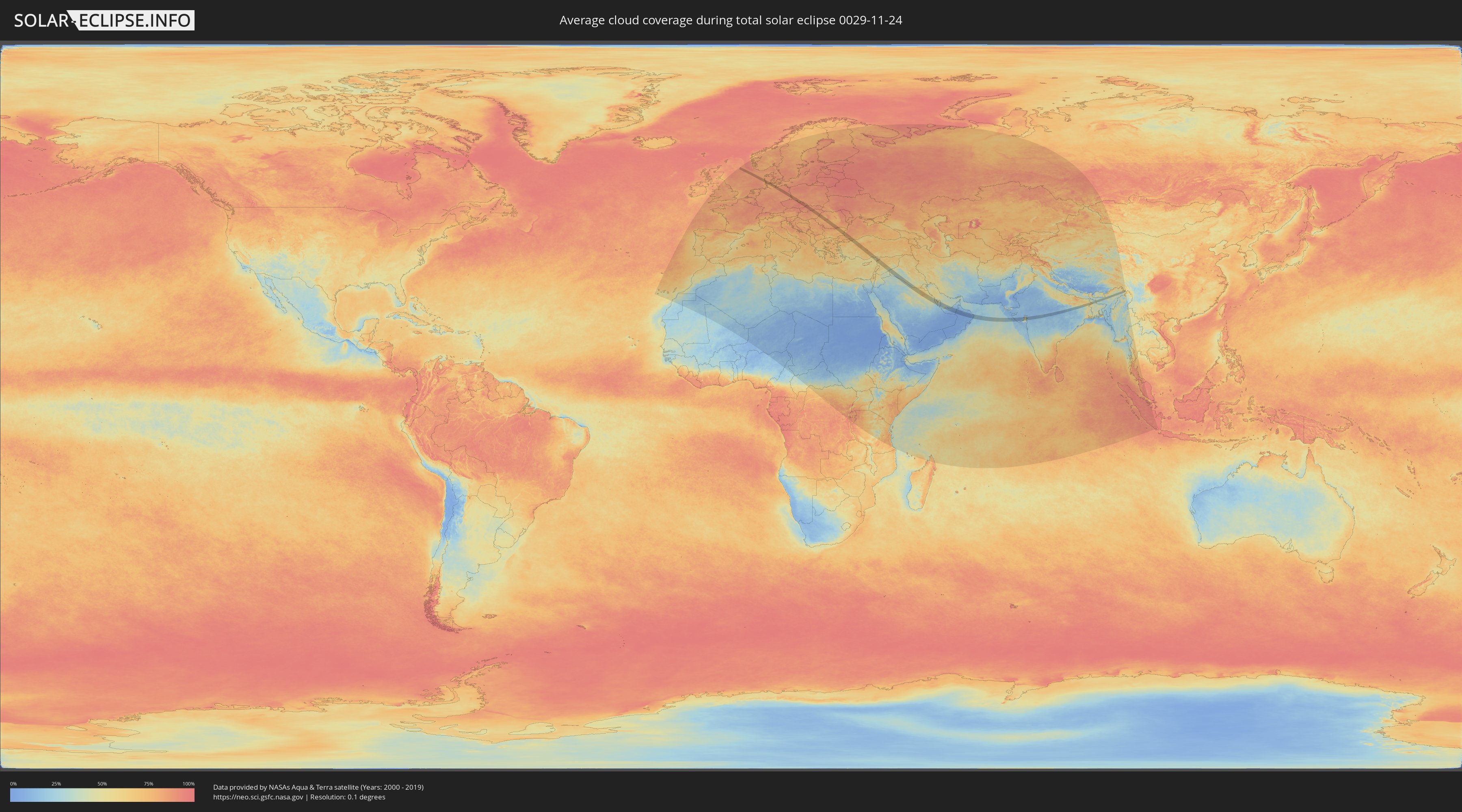
Wie wird das Wetter während der totalen Sonnenfinsternis am 24.11.0029?
Wo ist der beste Ort, um die totale Sonnenfinsternis vom 24.11.0029 zu beobachten?
Die folgenden Karten zeigen die durchschnittliche Bewölkung für den Tag, an dem die totale Sonnenfinsternis
stattfindet. Mit Hilfe der Karten lässt sich der Ort entlang des Finsternispfades eingrenzen,
der die besten Aussichen auf einen klaren wolkenfreien Himmel bietet.
Trotzdem muss man immer lokale Gegenenheiten beachten und sollte sich genau über das Wetter an seinem
gewählten Beobachtungsort informieren.
Die Daten stammen von den beiden NASA-Satelliten
AQUA und TERRA
und wurden über einen Zeitraum von 19 Jahren (2000 - 2019) gemittelt.
Detaillierte Länderkarten
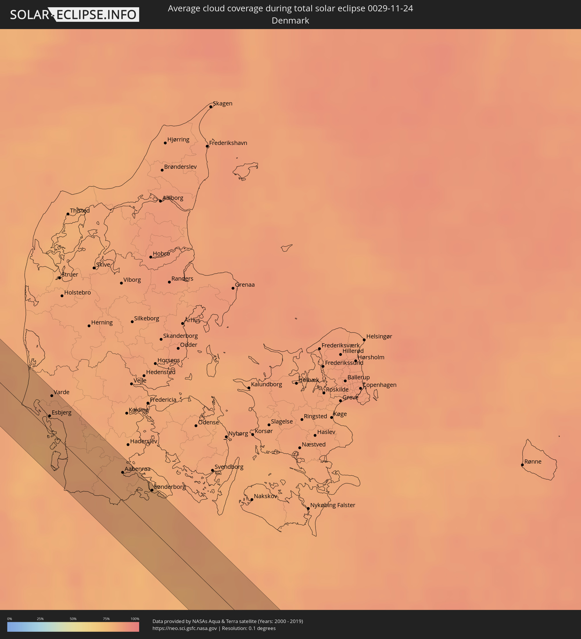
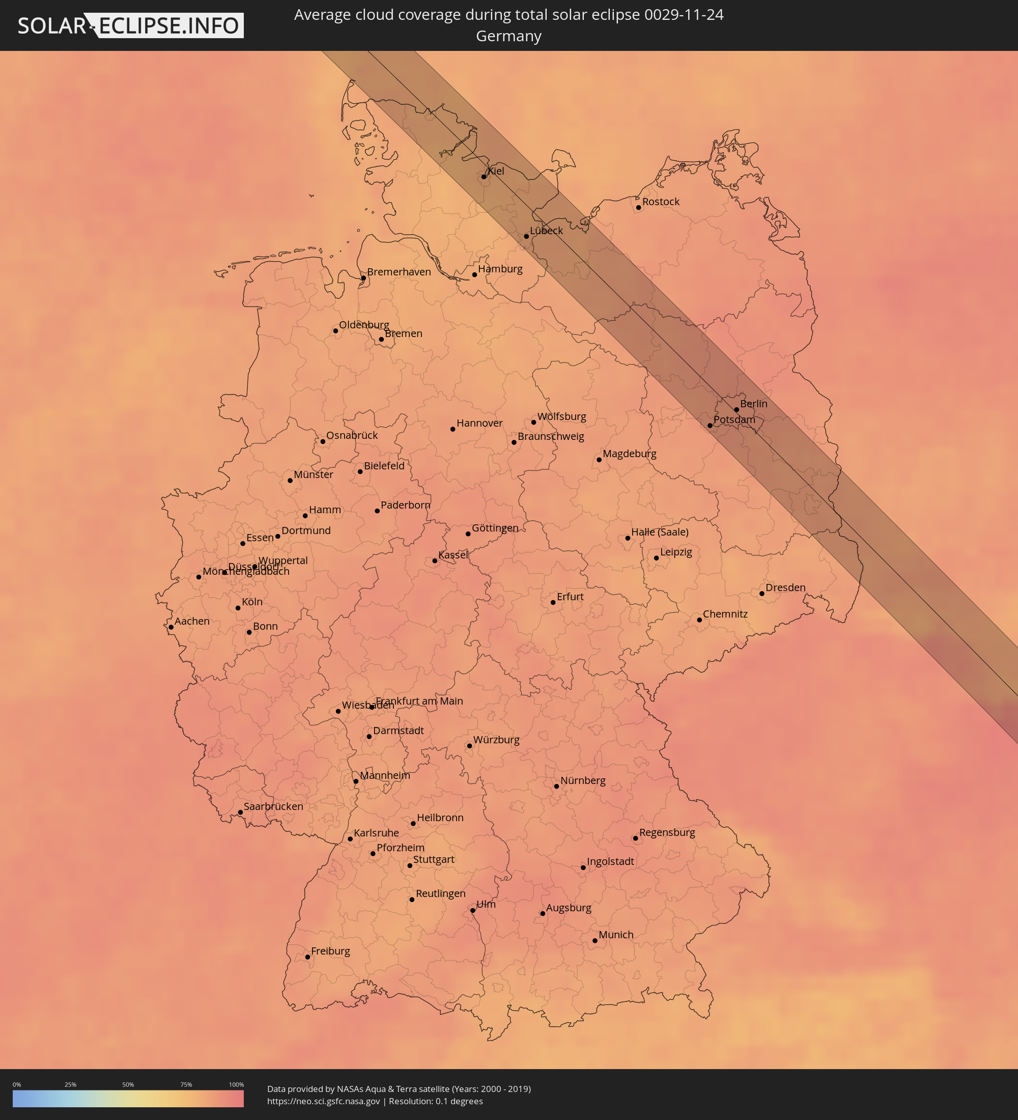 Deutschland
 Dänemark
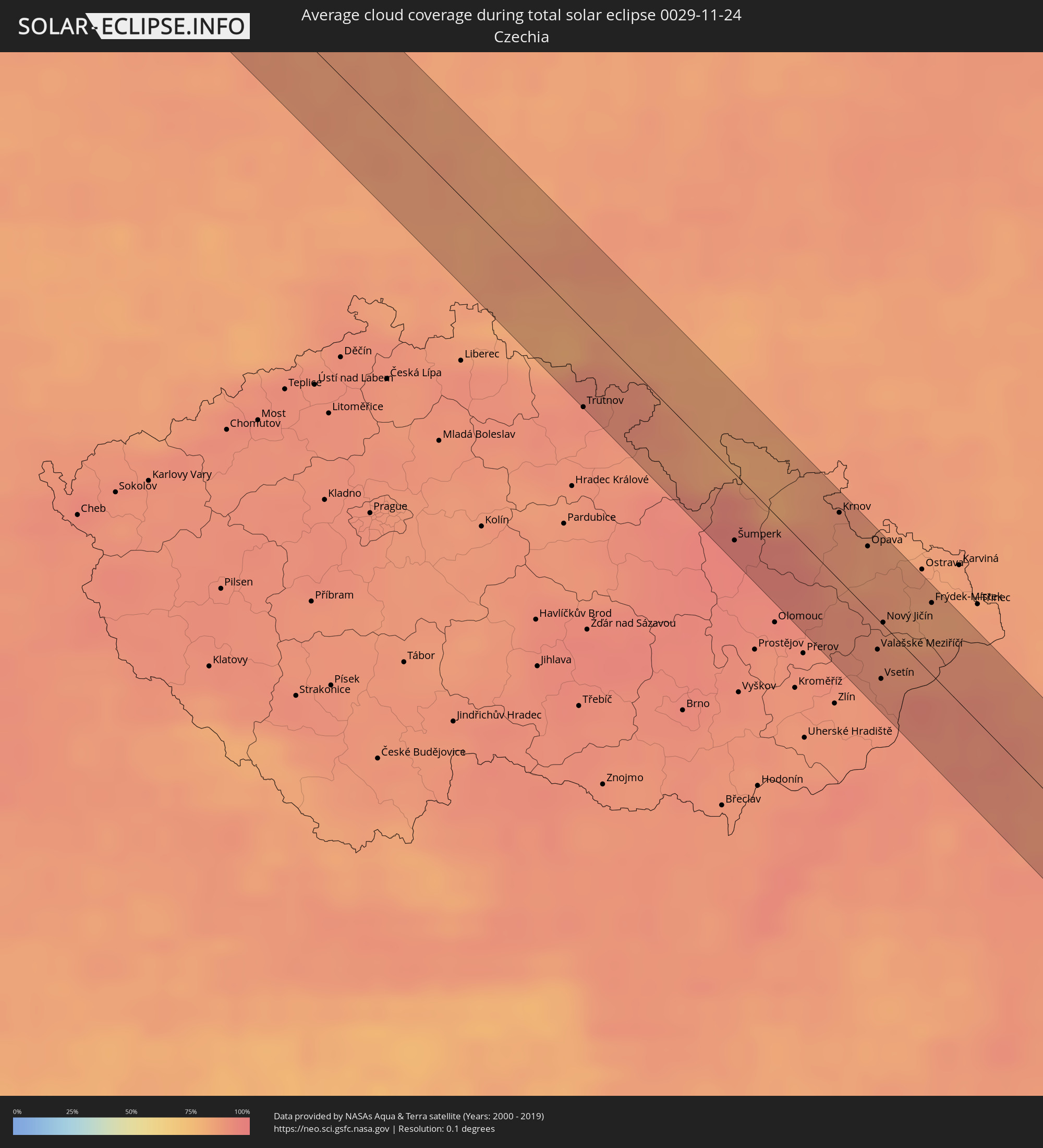 Tschechien
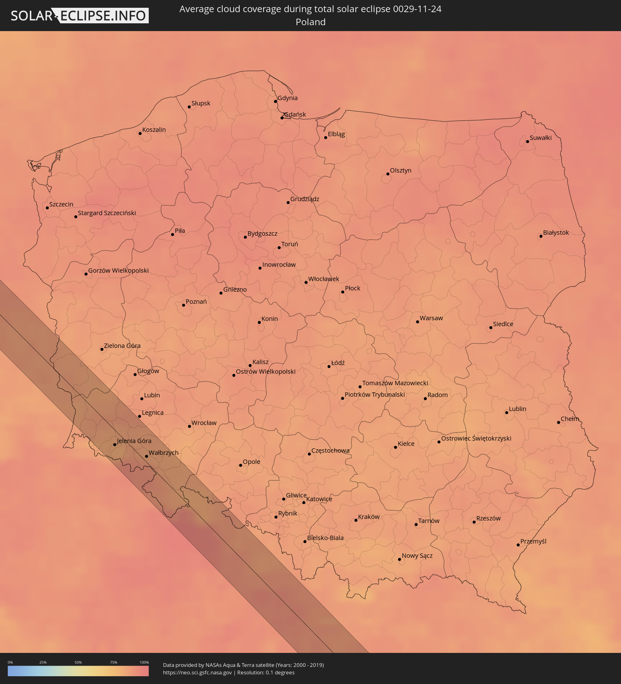 Polen
Polen
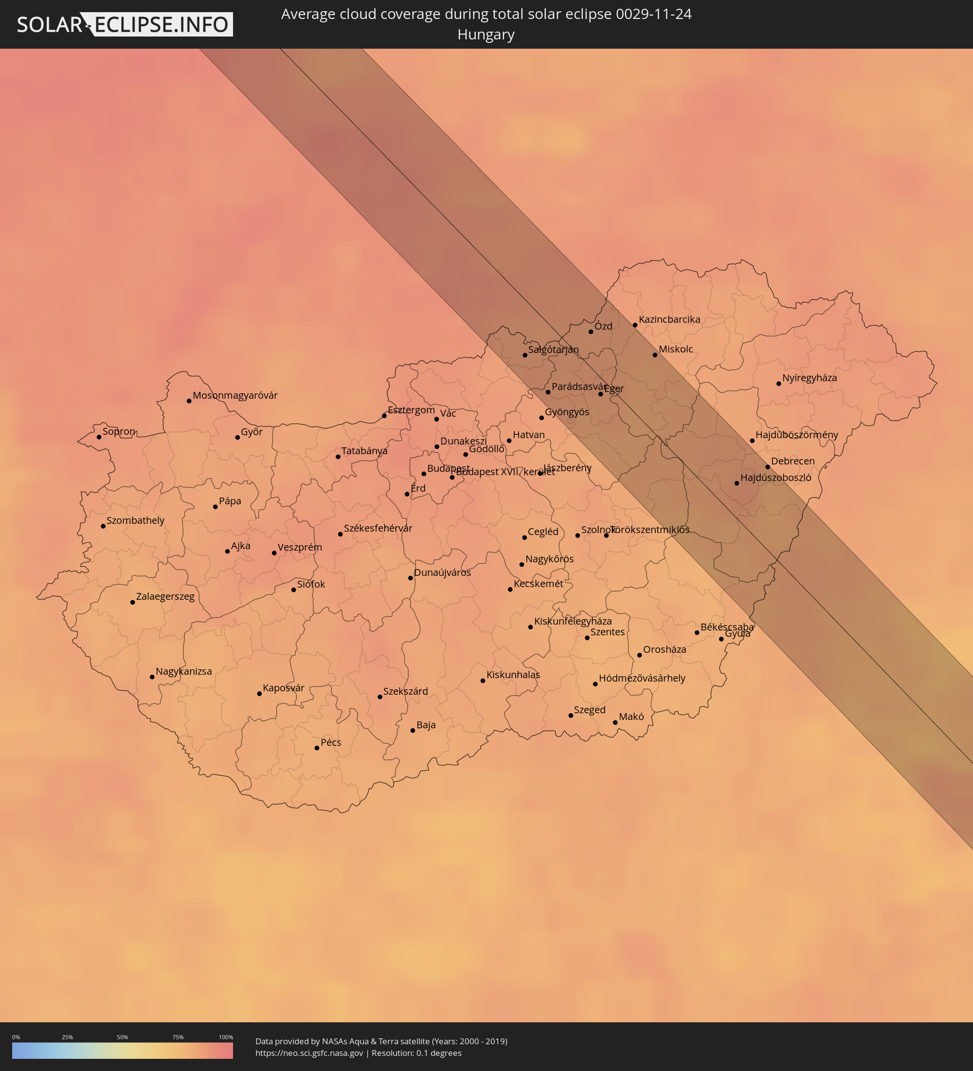 Ungarn
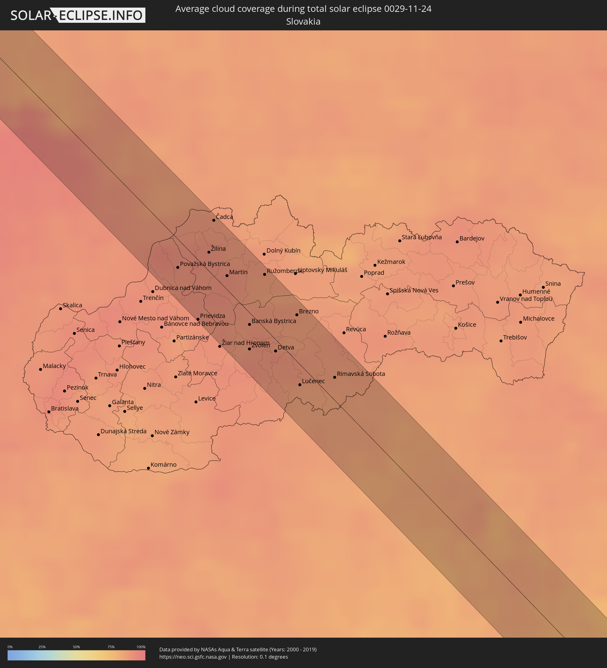 Slowakei
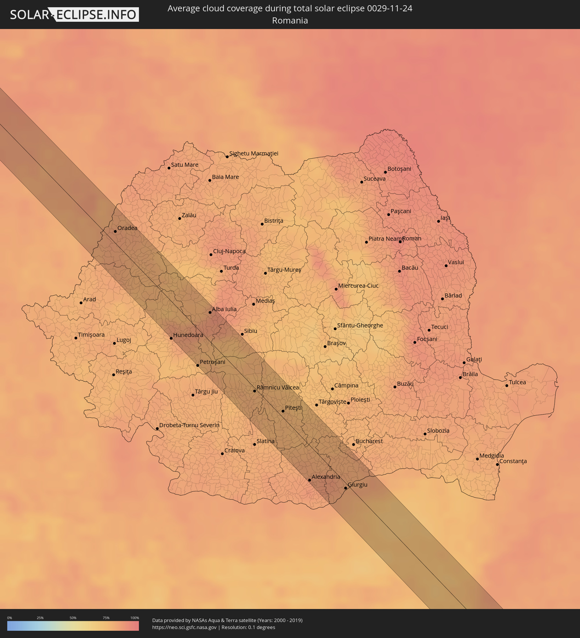 Rumänien
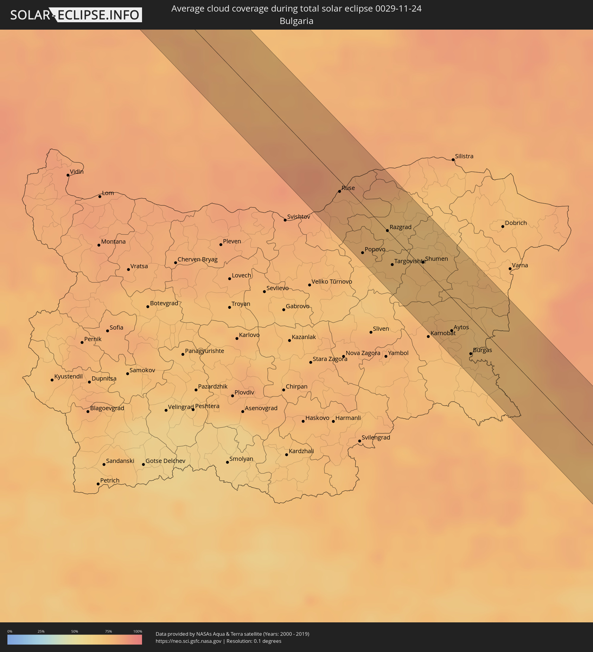 Bulgarien
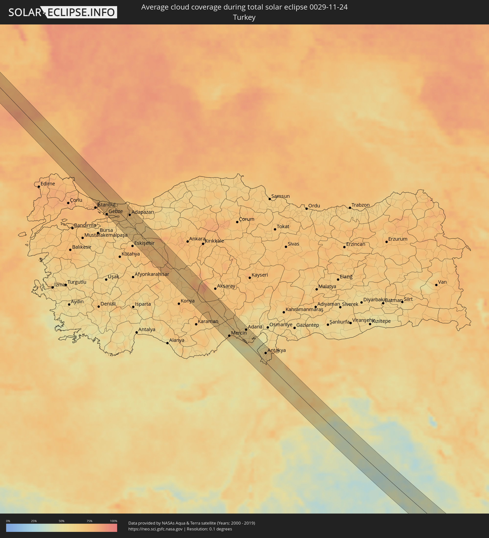 Türkei
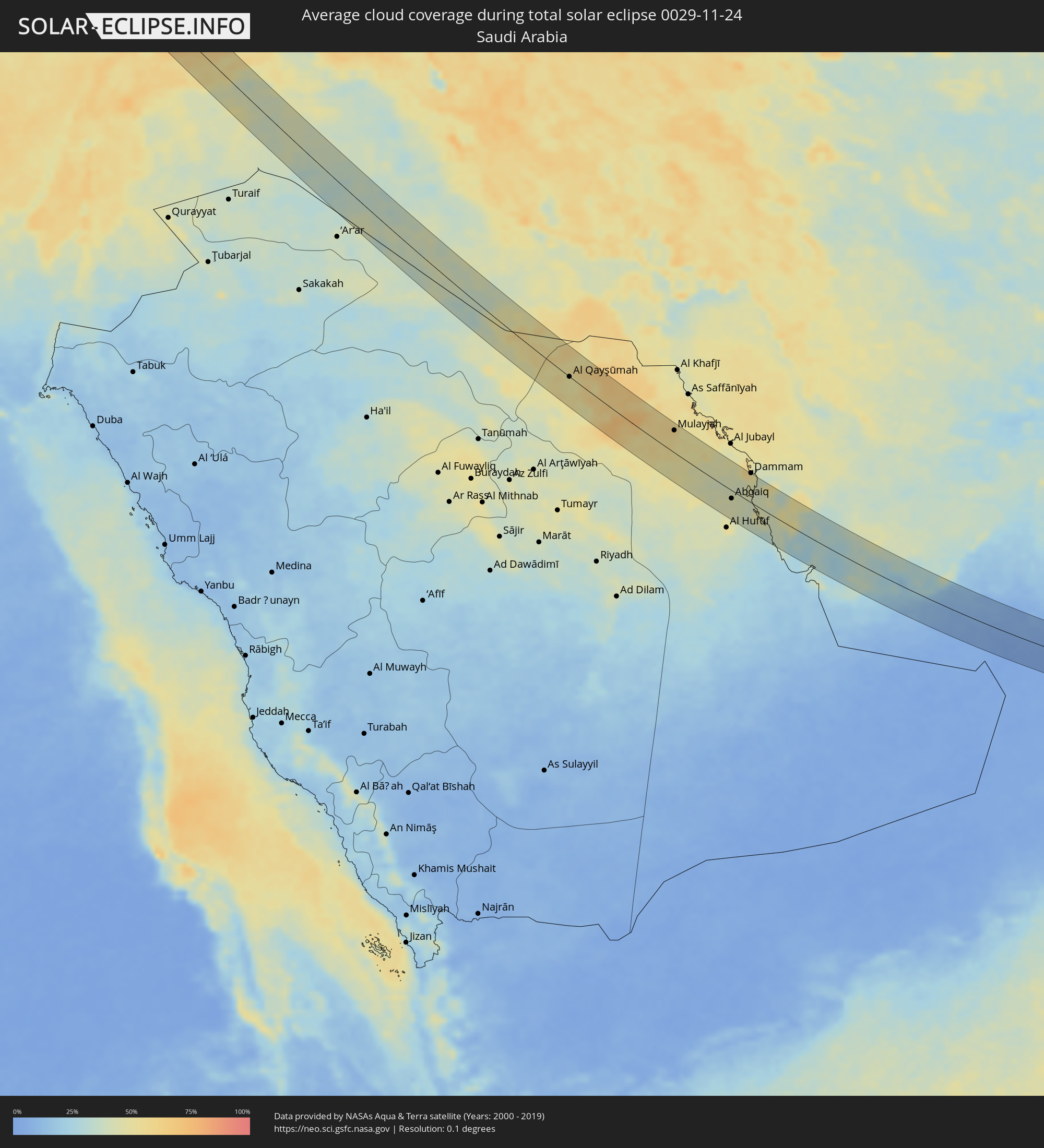 Saudi-Arabien
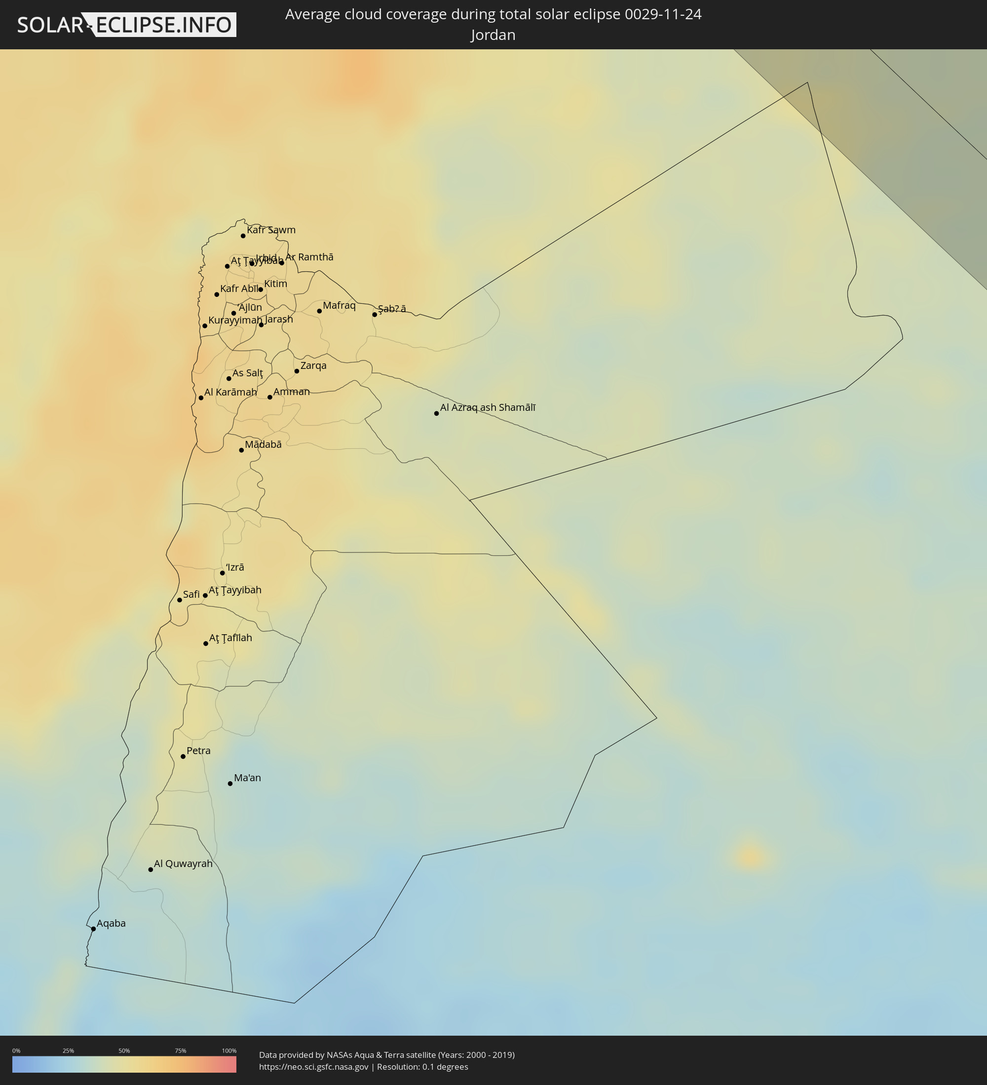 Jordanien
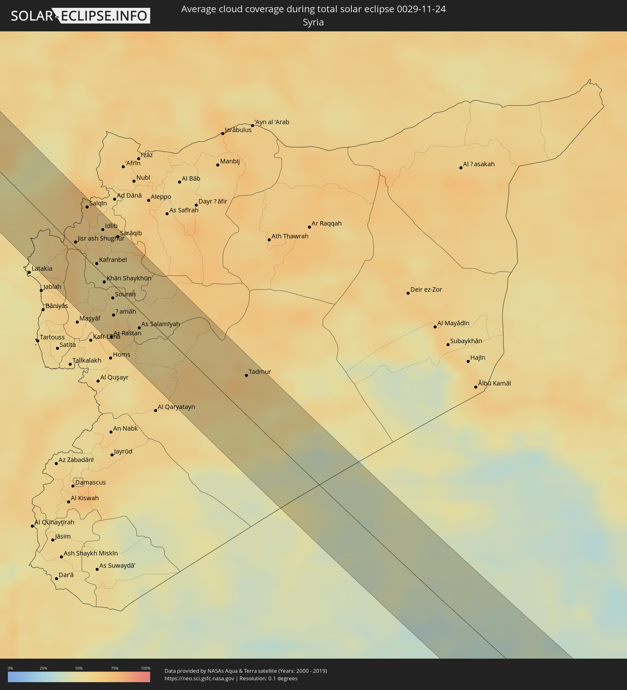 Syrien
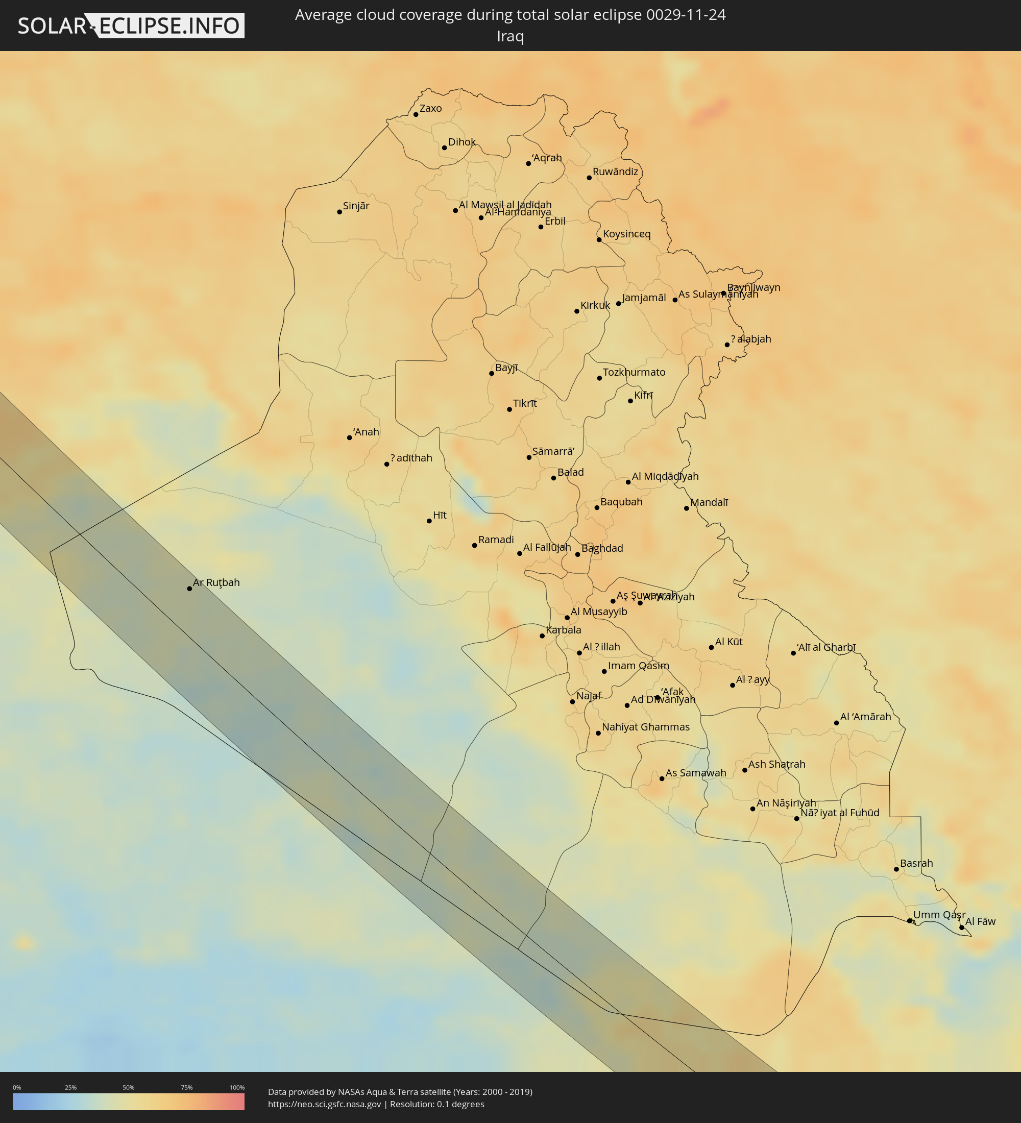 Irak
Irak
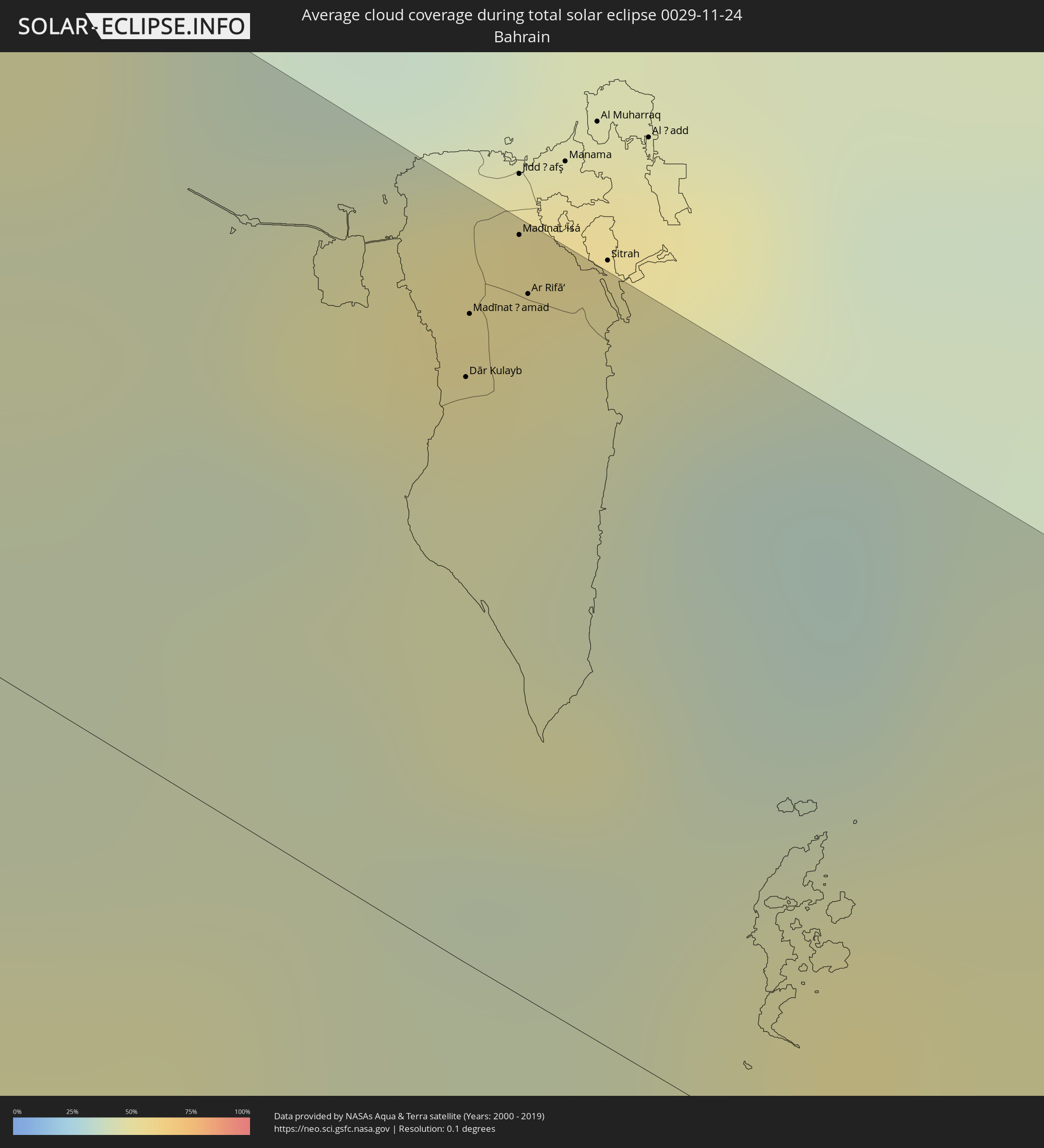 Bahrain
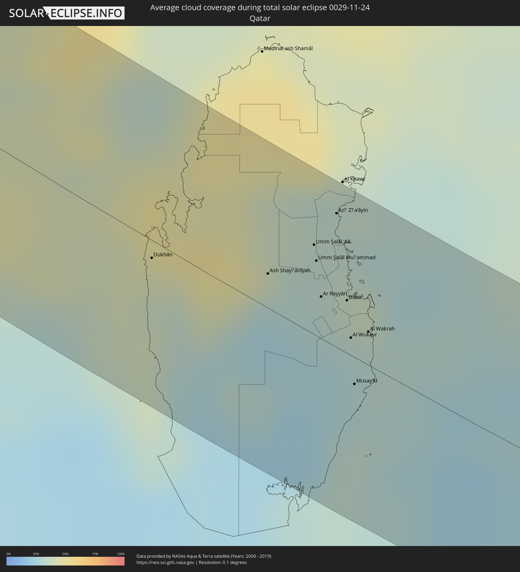 Katar
Katar
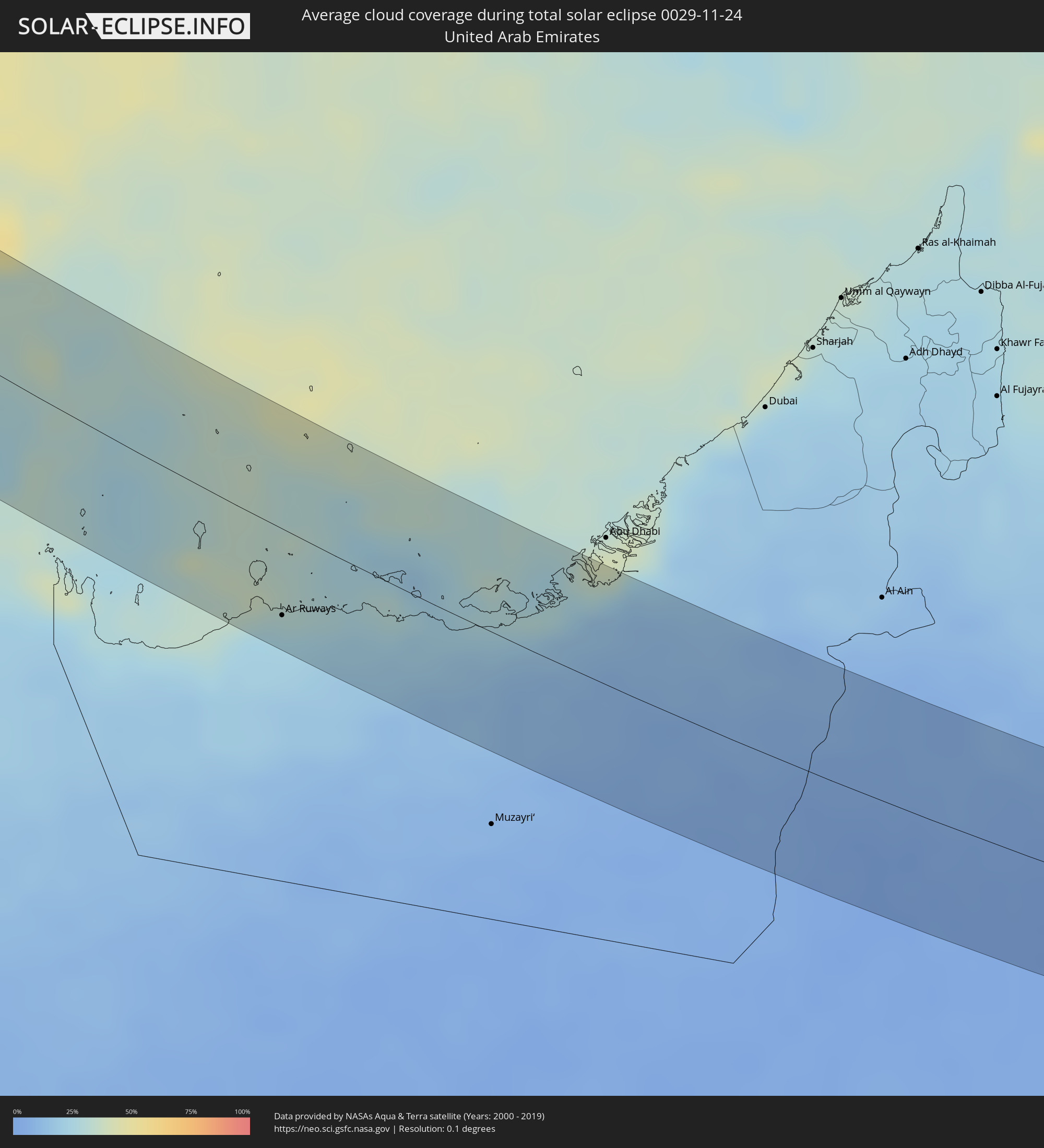 Vereinigte Arabische Emirate
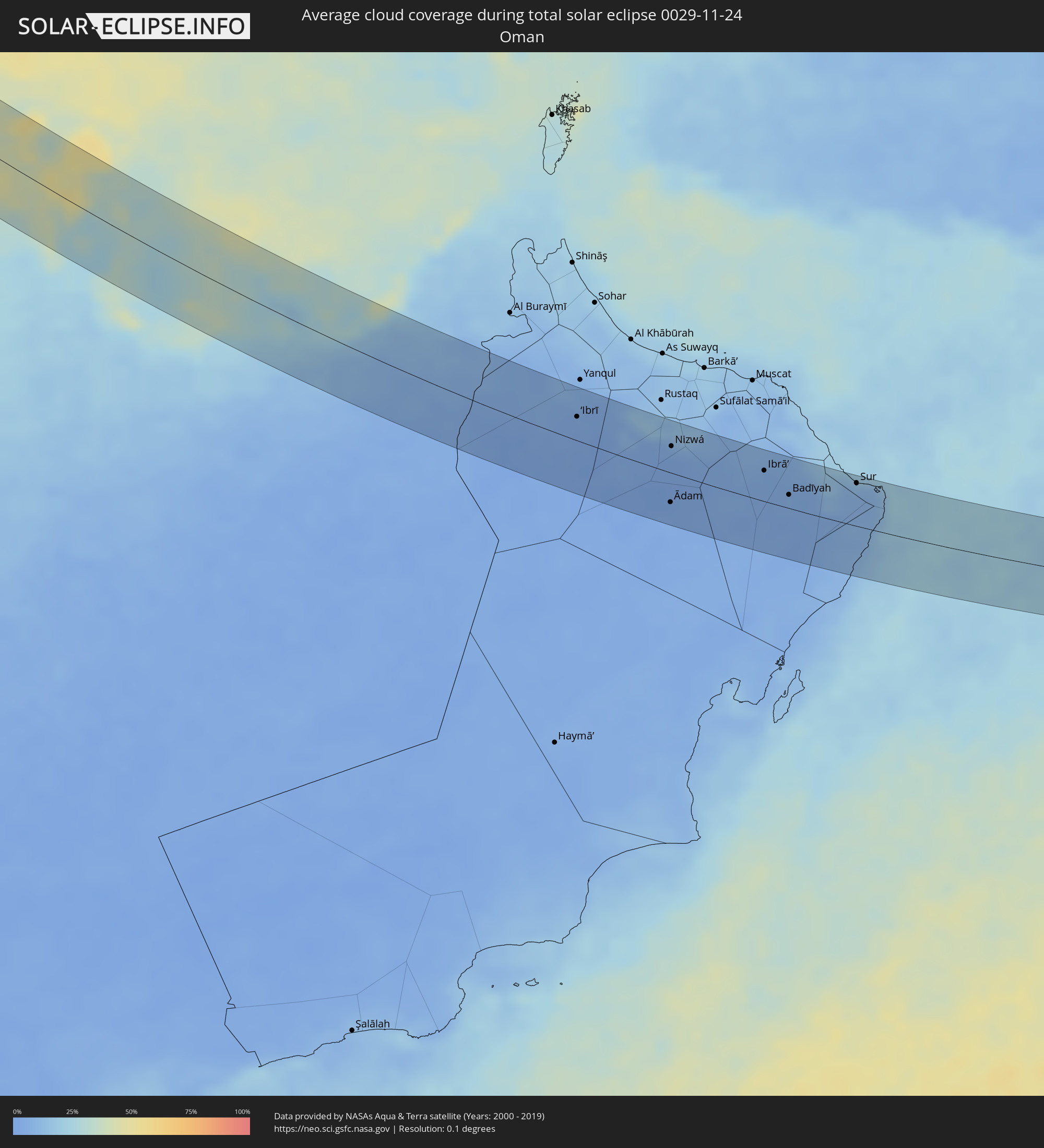 Oman
Oman
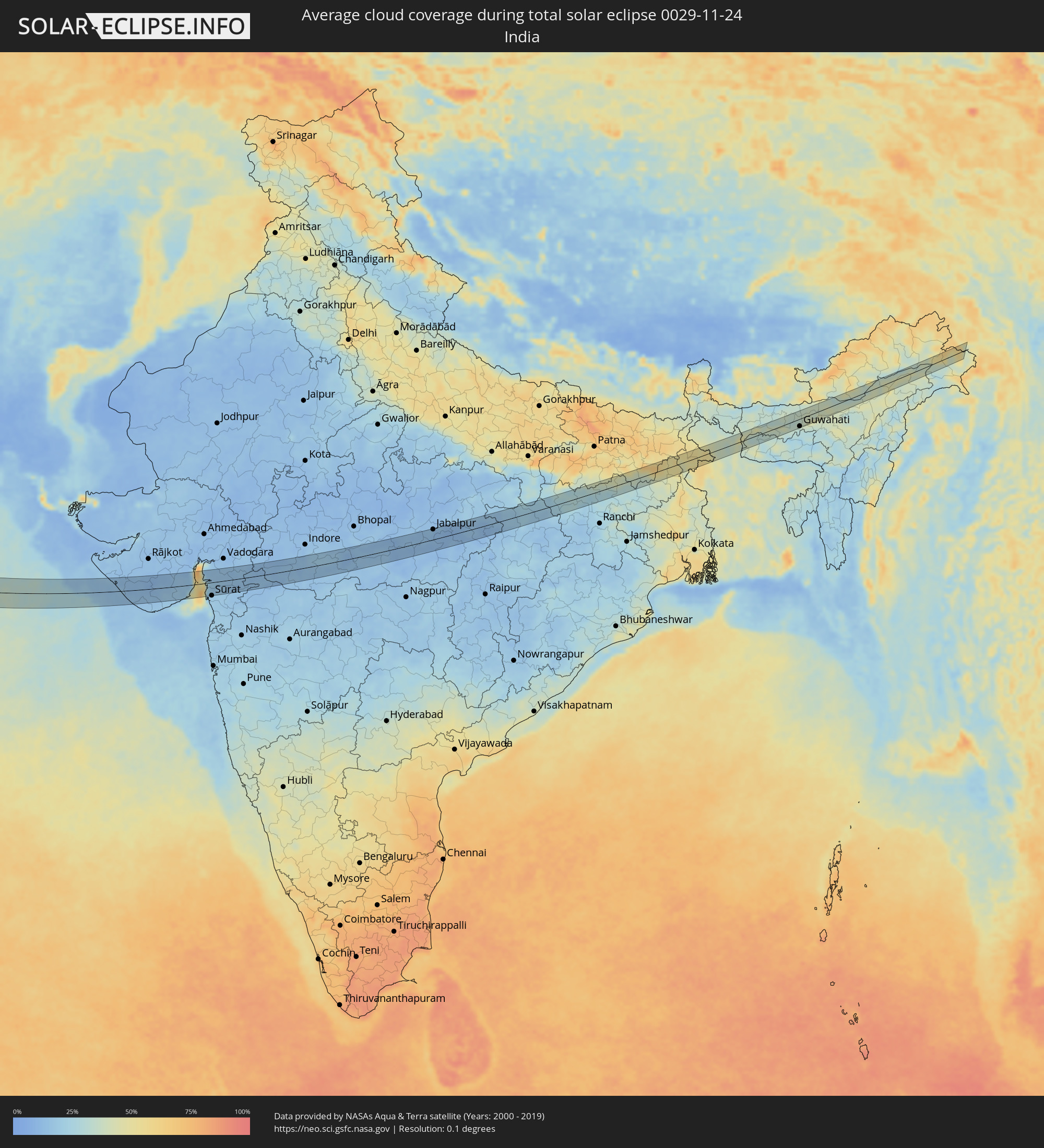 Indien
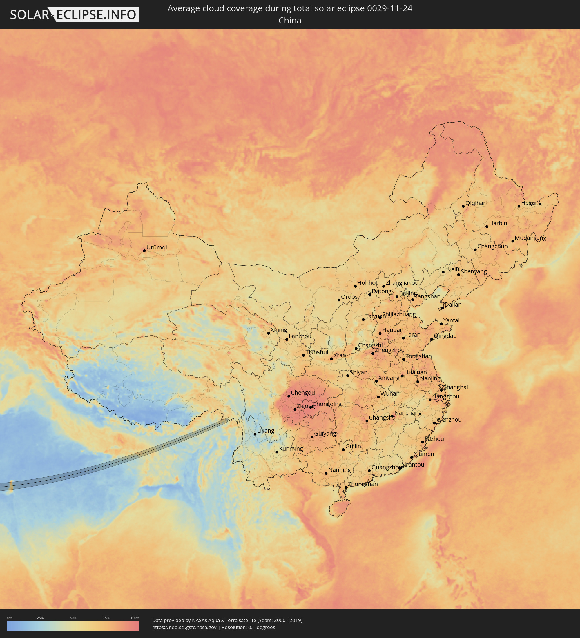 Volksrepublik China
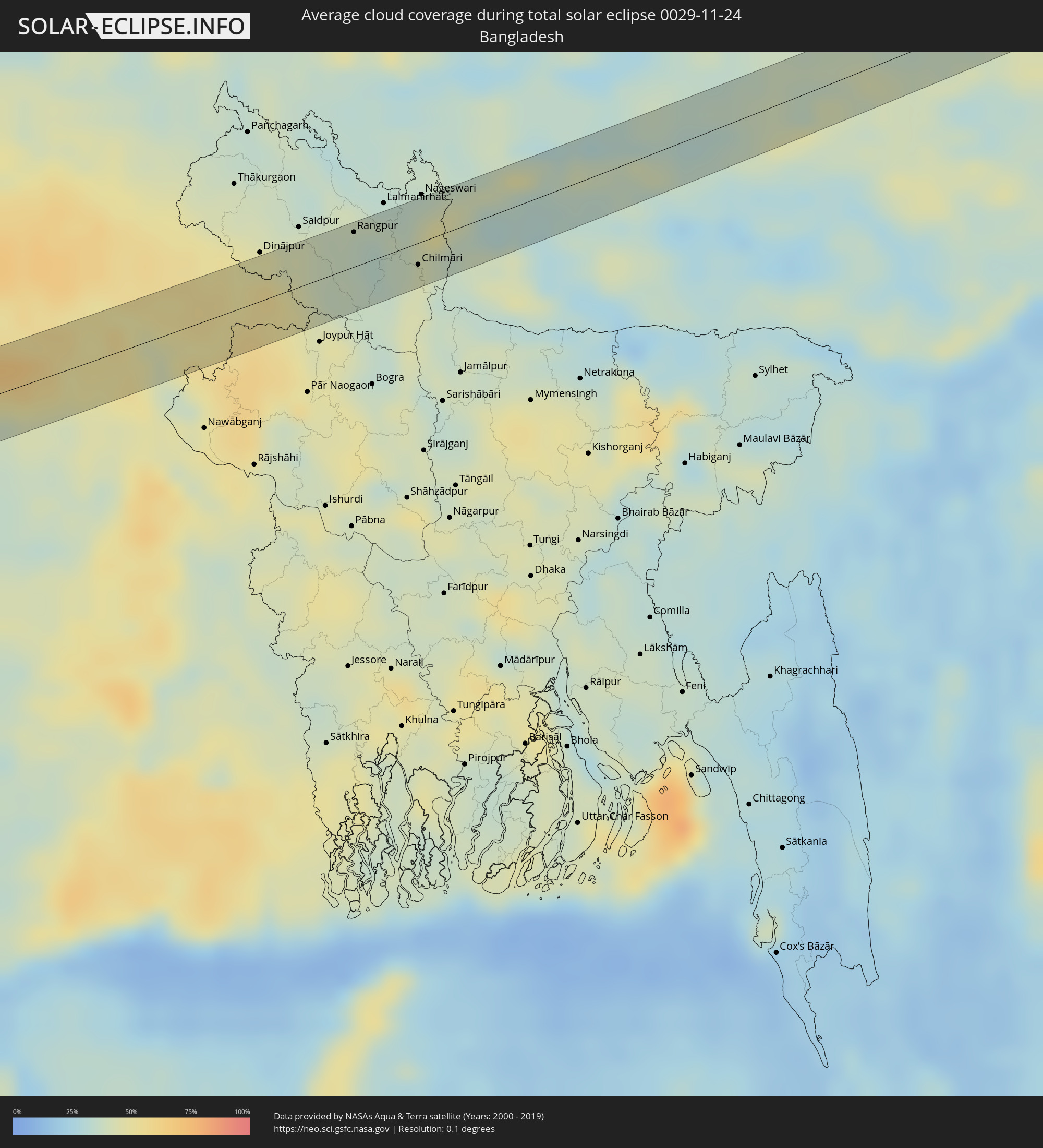 Bangladesch
Orte im Finsternispfad
Die nachfolgene Tabelle zeigt Städte und Orte mit mehr als 5.000 Einwohnern, die sich im Finsternispfad befinden. Städte mit mehr als 100.000 Einwohnern sind dick gekennzeichnet. Mit einem Klick auf den Ort öffnet sich eine Detailkarte die die Lage des jeweiligen Ortes zusammen mit dem Verlauf der zentralen Finsternis präsentiert.
| Ort | Typ | Dauer der Verfinsterung | Ortszeit bei maximaler Verfinsterung | Entfernung zur Zentrallinie | Ø Bewölkung |
|
Esbjerg, South Denmark
|
total | - | 09:15:27 UTC+01:00 | 9 km | 82% |
|
Varde, South Denmark
|
total | - | 09:15:36 UTC+01:00 | 22 km | 82% |
|
Bramming, South Denmark
|
total | - | 09:15:37 UTC+01:00 | 19 km | 82% |
|
Ribe, South Denmark
|
total | - | 09:15:33 UTC+01:00 | 11 km | 81% |
|
Tønder, South Denmark
|
total | - | 09:15:17 UTC+01:00 | 16 km | 83% |
|
Rødekro, South Denmark
|
total | - | 09:15:41 UTC+01:00 | 15 km | 80% |
|
Aabenraa, South Denmark
|
total | - | 09:15:44 UTC+01:00 | 17 km | 81% |
|
Flensburg, Schleswig-Holstein
|
total | - | 09:15:33 UTC+01:00 | 2 km | 81% |
|
Sønderborg, South Denmark
|
total | - | 09:15:53 UTC+01:00 | 24 km | 80% |
|
Kiel, Schleswig-Holstein
|
total | - | 09:15:39 UTC+01:00 | 8 km | 80% |
|
Lübeck, Schleswig-Holstein
|
total | - | 09:15:42 UTC+01:00 | 19 km | 82% |
|
Schwerin, Mecklenburg-Vorpommern
|
total | - | 09:16:03 UTC+01:00 | 5 km | 83% |
|
Wismar, Mecklenburg-Vorpommern
|
total | - | 09:16:16 UTC+01:00 | 18 km | 83% |
|
Potsdam, Brandenburg
|
total | - | 09:16:27 UTC+01:00 | 24 km | 87% |
|
Staaken, Berlin
|
total | - | 09:16:36 UTC+01:00 | 9 km | 87% |
|
Oranienburg, Brandenburg
|
total | - | 09:16:49 UTC+01:00 | 12 km | 89% |
|
Berlin, Berlin
|
total | - | 09:16:48 UTC+01:00 | 2 km | 89% |
|
Bernau bei Berlin, Brandenburg
|
total | - | 09:17:03 UTC+01:00 | 23 km | 87% |
|
Cottbus, Brandenburg
|
total | - | 09:17:03 UTC+01:00 | 14 km | 85% |
|
Görlitz, Saxony
|
total | - | 09:17:14 UTC+01:00 | 29 km | 86% |
|
Zgorzelec, Lower Silesian Voivodeship
|
total | - | 09:41:15 UTC+01:24 | 29 km | 85% |
|
Żary, Lubusz
|
total | - | 09:41:39 UTC+01:24 | 16 km | 84% |
|
Lubań, Lower Silesian Voivodeship
|
total | - | 09:41:28 UTC+01:24 | 17 km | 84% |
|
Bolesławiec, Lower Silesian Voivodeship
|
total | - | 09:41:48 UTC+01:24 | 8 km | 86% |
|
Jelenia Góra, Lower Silesian Voivodeship
|
total | - | 09:41:44 UTC+01:24 | 13 km | 81% |
|
Trutnov, Královéhradecký
|
total | - | 09:17:42 UTC+01:00 | 30 km | 92% |
|
Kamienna Góra, Lower Silesian Voivodeship
|
total | - | 09:41:56 UTC+01:24 | 7 km | 90% |
|
Náchod, Královéhradecký
|
total | - | 09:17:51 UTC+01:00 | 29 km | 89% |
|
Jawor, Lower Silesian Voivodeship
|
total | - | 09:42:14 UTC+01:24 | 22 km | 84% |
|
Wałbrzych, Lower Silesian Voivodeship
|
total | - | 09:42:09 UTC+01:24 | 5 km | 84% |
|
Świdnica, Lower Silesian Voivodeship
|
total | - | 09:42:22 UTC+01:24 | 21 km | 82% |
|
Nowa Ruda, Lower Silesian Voivodeship
|
total | - | 09:42:14 UTC+01:24 | 1 km | 87% |
|
Dzierżoniów, Lower Silesian Voivodeship
|
total | - | 09:42:27 UTC+01:24 | 20 km | 83% |
|
Kłodzko, Lower Silesian Voivodeship
|
total | - | 09:42:18 UTC+01:24 | 2 km | 84% |
|
Šumperk, Olomoucký
|
total | - | 09:18:20 UTC+01:00 | 23 km | 95% |
|
Šternberk, Olomoucký
|
total | - | 09:18:32 UTC+01:00 | 25 km | 94% |
|
Bruntál, Moravskoslezský
|
total | - | 09:18:49 UTC+01:00 | 4 km | 91% |
|
Krnov, Moravskoslezský
|
total | - | 09:19:05 UTC+01:00 | 24 km | 87% |
|
Hranice, Olomoucký
|
total | - | 09:18:51 UTC+01:00 | 17 km | 91% |
|
Opava, Moravskoslezský
|
total | - | 09:19:12 UTC+01:00 | 22 km | 85% |
|
Vsetín, Zlín
|
total | - | 09:19:00 UTC+01:00 | 20 km | 90% |
|
Nový Jičín, Moravskoslezský
|
total | - | 09:19:08 UTC+01:00 | 1 km | 88% |
|
Rožnov pod Radhoštěm, Zlín
|
total | - | 09:19:12 UTC+01:00 | 3 km | 87% |
|
Frýdek-Místek, Moravskoslezský
|
total | - | 09:19:30 UTC+01:00 | 25 km | 84% |
|
Považská Bystrica, Trenčiansky
|
total | - | 09:19:18 UTC+01:00 | 15 km | 90% |
|
Prievidza, Nitriansky
|
total | - | 09:19:21 UTC+01:00 | 31 km | 89% |
|
Žilina, Žilinský
|
total | - | 09:19:40 UTC+01:00 | 10 km | 91% |
|
Kysucké Nové Mesto, Žilinský
|
total | - | 09:19:44 UTC+01:00 | 18 km | 90% |
|
Čadca, Žilinský
|
total | - | 09:19:49 UTC+01:00 | 29 km | 89% |
|
Martin, Žilinský
|
total | - | 09:19:46 UTC+01:00 | 7 km | 91% |
|
Zvolen, Banskobystrický
|
total | - | 09:19:47 UTC+01:00 | 19 km | 89% |
|
Banská Bystrica, Banskobystrický
|
total | - | 09:19:52 UTC+01:00 | 6 km | 90% |
|
Ružomberok, Žilinský
|
total | - | 09:20:10 UTC+01:00 | 28 km | 87% |
|
Brezno, Banskobystrický
|
total | - | 09:20:22 UTC+01:00 | 24 km | 86% |
|
Lučenec, Banskobystrický
|
total | - | 09:20:12 UTC+01:00 | 11 km | 84% |
|
Salgótarján, Nógrád
|
total | - | 09:20:15 UTC+01:00 | 22 km | 85% |
|
Parádsasvár, Heves
|
total | - | 09:20:22 UTC+01:00 | 27 km | 84% |
|
Rimavská Sobota, Banskobystrický
|
total | - | 09:20:36 UTC+01:00 | 12 km | 86% |
|
Ózd, Borsod-Abaúj-Zemplén
|
total | - | 09:20:49 UTC+01:00 | 14 km | 84% |
|
Eger, Heves
|
total | - | 09:20:46 UTC+01:00 | 6 km | 83% |
|
Mezőkövesd, Borsod-Abaúj-Zemplén
|
total | - | 09:20:58 UTC+01:00 | 2 km | 81% |
|
Tiszafüred, Jász-Nagykun-Szolnok
|
total | - | 09:21:05 UTC+01:00 | 8 km | 82% |
|
Miskolc, Borsod-Abaúj-Zemplén
|
total | - | 09:21:17 UTC+01:00 | 31 km | 82% |
|
Karcag, Jász-Nagykun-Szolnok
|
total | - | 09:21:09 UTC+01:00 | 22 km | 79% |
|
Balmazújváros, Hajdú-Bihar
|
total | - | 09:21:43 UTC+01:00 | 24 km | 85% |
|
Hajdúszoboszló, Hajdú-Bihar
|
total | - | 09:21:42 UTC+01:00 | 14 km | 85% |
|
Berettyóújfalu, Hajdú-Bihar
|
total | - | 09:21:47 UTC+01:00 | 4 km | 82% |
|
Debrecen, Hajdú-Bihar
|
total | - | 09:21:59 UTC+01:00 | 33 km | 79% |
|
Salonta, Bihor
|
total | - | 10:06:10 UTC+01:44 | 23 km | 83% |
|
Oradea, Bihor
|
total | - | 10:06:33 UTC+01:44 | 11 km | 83% |
|
Brad, Hunedoara
|
total | - | 10:07:15 UTC+01:44 | 12 km | 81% |
|
Deva, Hunedoara
|
total | - | 10:07:20 UTC+01:44 | 25 km | 84% |
|
Petroşani, Hunedoara
|
total | - | 10:07:46 UTC+01:44 | 35 km | 79% |
|
Cugir, Alba
|
total | - | 10:07:52 UTC+01:44 | 2 km | 78% |
|
Alba Iulia, Alba
|
total | - | 10:08:10 UTC+01:44 | 27 km | 89% |
|
Râmnicu Vâlcea, Vâlcea
|
total | - | 10:08:54 UTC+01:44 | 3 km | 78% |
|
Curtea de Argeş, Argeş
|
total | - | 10:09:17 UTC+01:44 | 17 km | 78% |
|
Piteşti, Argeş
|
total | - | 10:09:28 UTC+01:44 | 6 km | 78% |
|
Alexandria, Teleorman
|
total | - | 10:09:56 UTC+01:44 | 34 km | 87% |
|
Giurgiu, Giurgiu
|
total | - | 10:10:44 UTC+01:44 | 5 km | 81% |
|
Ruse, Ruse
|
total | - | 10:26:20 UTC+02:00 | 7 km | 81% |
|
Popovo, Tŭrgovishte
|
total | - | 10:26:38 UTC+02:00 | 31 km | 75% |
|
Razgrad, Razgrad
|
total | - | 10:27:01 UTC+02:00 | 0 km | 72% |
|
Targovishte, Tŭrgovishte
|
total | - | 10:27:05 UTC+02:00 | 18 km | 73% |
|
Veliki Preslav, Shumen
|
total | - | 10:27:24 UTC+02:00 | 11 km | 74% |
|
Isperih, Razgrad
|
total | - | 10:27:27 UTC+02:00 | 33 km | 70% |
|
Shumen, Shumen
|
total | - | 10:27:33 UTC+02:00 | 4 km | 74% |
|
Novi Pazar, Shumen
|
total | - | 10:27:55 UTC+02:00 | 26 km | 73% |
|
Aytos, Burgas
|
total | - | 10:27:58 UTC+02:00 | 21 km | 75% |
|
Provadia, Varna
|
total | - | 10:28:14 UTC+02:00 | 27 km | 73% |
|
Burgas, Burgas
|
total | - | 10:28:15 UTC+02:00 | 23 km | 73% |
|
Pomorie, Burgas
|
total | - | 10:28:30 UTC+02:00 | 9 km | 72% |
|
Sultanbeyli, Istanbul
|
total | - | 10:27:49 UTC+01:56 | 35 km | 74% |
|
Gebze, Kocaeli
|
total | - | 10:28:04 UTC+01:56 | 37 km | 73% |
|
Karamürsel, Kocaeli
|
total | - | 10:28:21 UTC+01:56 | 35 km | 67% |
|
İzmit, Kocaeli
|
total | - | 10:28:47 UTC+01:56 | 11 km | 73% |
|
Adapazarı, Sakarya
|
total | - | 10:29:31 UTC+01:56 | 20 km | 70% |
|
Polatlı, Ankara
|
total | - | 10:32:25 UTC+01:56 | 34 km | 75% |
|
Karapınar, Konya
|
total | - | 10:35:15 UTC+01:56 | 22 km | 70% |
|
Ereğli, Konya
|
total | - | 10:36:10 UTC+01:56 | 7 km | 66% |
|
Mercin, Mersin
|
total | - | 10:37:26 UTC+01:56 | 27 km | 58% |
|
Tarsus, Mersin
|
total | - | 10:37:52 UTC+01:56 | 1 km | 63% |
|
Adana, Adana
|
total | - | 10:38:36 UTC+01:56 | 34 km | 61% |
|
Antakya, Hatay
|
total | - | 10:40:27 UTC+01:56 | 24 km | 64% |
|
Jisr ash Shughūr, Idlib
|
total | - | 11:09:12 UTC+02:25 | 4 km | 63% |
|
Salqīn, Idlib
|
total | - | 11:09:17 UTC+02:25 | 38 km | 65% |
|
Kafranbel, Idlib
|
total | - | 11:09:45 UTC+02:25 | 4 km | 54% |
|
Idlib, Idlib
|
total | - | 11:09:43 UTC+02:25 | 33 km | 63% |
|
Khān Shaykhūn, Idlib
|
total | - | 11:10:00 UTC+02:25 | 5 km | 56% |
|
Ma‘arratmişrīn, Idlib
|
total | - | 11:09:45 UTC+02:25 | 42 km | 62% |
|
Ar Rastan, Homs
|
total | - | 11:10:25 UTC+02:25 | 40 km | 62% |
|
Souran, Hama
|
total | - | 11:10:15 UTC+02:25 | 10 km | 58% |
|
Ḩamāh, Hama
|
total | - | 11:10:21 UTC+02:25 | 22 km | 64% |
|
Sarāqib, Idlib
|
total | - | 11:10:04 UTC+02:25 | 39 km | 59% |
|
As Salamīyah, Hama
|
total | - | 11:10:58 UTC+02:25 | 13 km | 57% |
|
Tadmur, Homs
|
total | - | 11:13:35 UTC+02:25 | 30 km | 64% |
|
Ar Ruţbah, Anbar
|
total | - | 11:50:58 UTC+02:57 | 35 km | 41% |
|
Al Qayşūmah, Eastern Province
|
total | - | 12:17:10 UTC+03:06 | 0 km | 49% |
|
Mulayjah, Eastern Province
|
total | - | 12:23:43 UTC+03:06 | 40 km | 56% |
|
Abqaiq, Eastern Province
|
total | - | 12:28:16 UTC+03:06 | 15 km | 42% |
|
Dhahran, Eastern Province
|
total | - | 12:28:55 UTC+03:06 | 41 km | 45% |
|
Khobar, Eastern Province
|
total | - | 12:29:10 UTC+03:06 | 46 km | 43% |
|
Dār Kulayb, Southern Governorate
|
total | - | 12:49:24 UTC+03:26 | 41 km | 46% |
|
Madīnat Ḩamad, Central Governorate
|
total | - | 12:49:21 UTC+03:26 | 46 km | 46% |
|
Madīnat ‘Īsá, Southern Governorate
|
total | - | 12:49:23 UTC+03:26 | 53 km | 52% |
|
Ar Rifā‘, Southern Governorate
|
total | - | 12:49:27 UTC+03:26 | 50 km | 44% |
|
Dukhān, Baladīyat ar Rayyān
|
total | - | 12:50:51 UTC+03:26 | 6 km | 37% |
|
Ash Shayḩānīyah, Baladīyat ar Rayyān
|
total | - | 12:51:59 UTC+03:26 | 11 km | 31% |
|
Umm Şalāl ‘Alī, Baladīyat Umm Şalāl
|
total | - | 12:52:18 UTC+03:26 | 30 km | 32% |
|
Umm Şalāl Muḩammad, Baladīyat Umm Şalāl
|
total | - | 12:52:23 UTC+03:26 | 25 km | 32% |
|
Ar Rayyān, Baladīyat ar Rayyān
|
total | - | 12:52:35 UTC+03:26 | 14 km | 30% |
|
Az̧ Z̧a‘āyin, Baladīyat az̧ Z̧a‘āyin
|
total | - | 12:52:23 UTC+03:26 | 44 km | 33% |
|
Doha, Baladīyat ad Dawḩah
|
total | - | 12:52:50 UTC+03:26 | 18 km | 33% |
|
Al Wukayr, Al Wakrah
|
total | - | 12:53:02 UTC+03:26 | 6 km | 29% |
|
Musay‘īd, Al Wakrah
|
total | - | 12:53:15 UTC+03:26 | 9 km | 31% |
|
Al Wakrah, Al Wakrah
|
total | - | 12:53:10 UTC+03:26 | 11 km | 31% |
|
Ar Ruways, Abu Dhabi
|
total | - | 13:12:19 UTC+03:41 | 39 km | 25% |
|
‘Ibrī, Az̧ Z̧āhirah
|
total | - | 13:22:47 UTC+03:41 | 25 km | 3% |
|
Bahlā’, Muḩāfaz̧at ad Dākhilīyah
|
total | - | 13:25:01 UTC+03:41 | 25 km | 4% |
|
Ādam, Muḩāfaz̧at ad Dākhilīyah
|
total | - | 13:26:20 UTC+03:41 | 31 km | 3% |
|
Nizwá, Muḩāfaz̧at ad Dākhilīyah
|
total | - | 13:25:38 UTC+03:41 | 28 km | 3% |
|
Izkī, Muḩāfaz̧at ad Dākhilīyah
|
total | - | 13:26:12 UTC+03:41 | 36 km | 5% |
|
Ibrā’, Ash Sharqiyah North Governorate
|
total | - | 13:28:22 UTC+03:41 | 33 km | 6% |
|
Al Qābil, Ash Sharqiyah North Governorate
|
total | - | 13:28:54 UTC+03:41 | 24 km | 5% |
|
Badīyah, Ash Sharqiyah North Governorate
|
total | - | 13:29:19 UTC+03:41 | 14 km | 6% |
|
Sur, Ash Sharqiyah South Governorate
|
total | - | 13:30:54 UTC+03:41 | 46 km | 11% |
|
Porbandar, Gujarat
|
total | - | 15:33:39 UTC+05:21 | 36 km | 14% |
|
Jūnāgadh, Gujarat
|
total | - | 15:35:23 UTC+05:21 | 17 km | 12% |
|
Jetpur, Gujarat
|
total | - | 15:35:23 UTC+05:21 | 42 km | 12% |
|
Bhāvnagar, Gujarat
|
total | - | 15:38:04 UTC+05:21 | 29 km | 21% |
|
Bharūch, Gujarat
|
total | - | 15:39:34 UTC+05:21 | 9 km | 17% |
|
Khandwa, Madhya Pradesh
|
total | - | 15:44:42 UTC+05:21 | 32 km | 15% |
|
Punāsa, Madhya Pradesh
|
total | - | 15:44:16 UTC+05:21 | 12 km | 15% |
|
Jabalpur, Madhya Pradesh
|
total | - | 15:48:00 UTC+05:21 | 32 km | 11% |
|
Ingrāj Bāzār, West Bengal
|
total | - | 15:54:24 UTC+05:21 | 18 km | 45% |
|
Bālurghāt, West Bengal
|
total | - | 15:54:40 UTC+05:21 | 17 km | 52% |
|
Parbatipur, Rangpur Division
|
total | - | 16:26:25 UTC+05:53 | 24 km | 43% |
|
Badarganj, Rangpur Division
|
total | - | 16:26:30 UTC+05:53 | 21 km | 38% |
|
Rangpur, Rangpur Division
|
total | - | 16:26:34 UTC+05:53 | 21 km | 35% |
|
Chilmāri, Rangpur Division
|
total | - | 16:27:08 UTC+05:53 | 13 km | 42% |
|
Guwahati, Assam
|
total | - | 15:55:44 UTC+05:21 | 22 km | 31% |
|
Dibrugarh, Assam
|
total | - | 15:56:07 UTC+05:21 | 7 km | 40% |