Total solar eclipse of 11/24/0029
| Day of week: | Saturday |
| Maximum duration of eclipse: | 01m59s |
| Maximum width of eclipse path: | 109 km |
| Saros cycle: | 62 |
| Coverage: | 100% |
| Magnitude: | 1.0217 |
| Gamma: | 0.7424 |
Wo kann man die Sonnenfinsternis vom 11/24/0029 sehen?
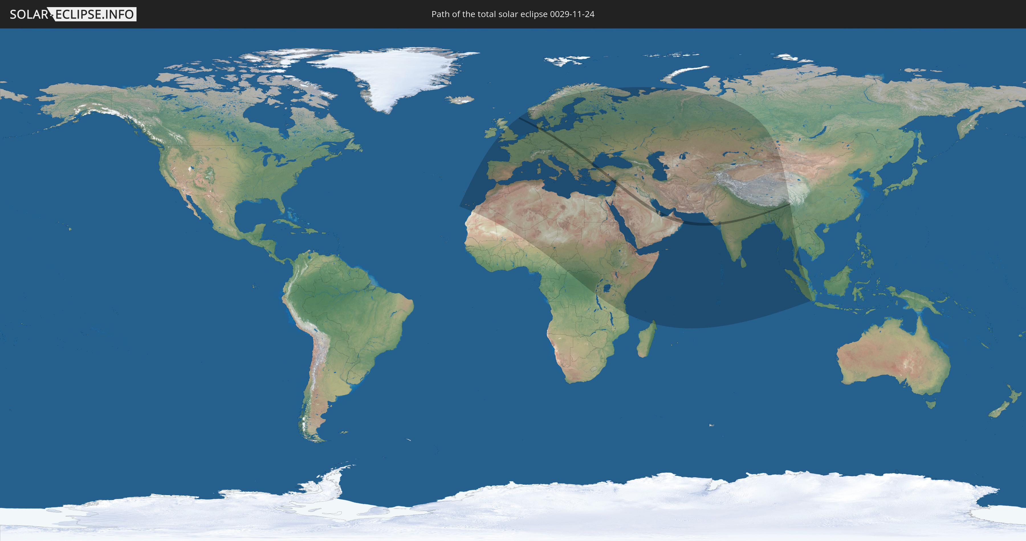
Die Sonnenfinsternis am 11/24/0029 kann man in 113 Ländern als partielle Sonnenfinsternis beobachten.
Der Finsternispfad verläuft durch 20 Länder. Nur in diesen Ländern ist sie als total Sonnenfinsternis zu sehen.
In den folgenden Ländern ist die Sonnenfinsternis total zu sehen
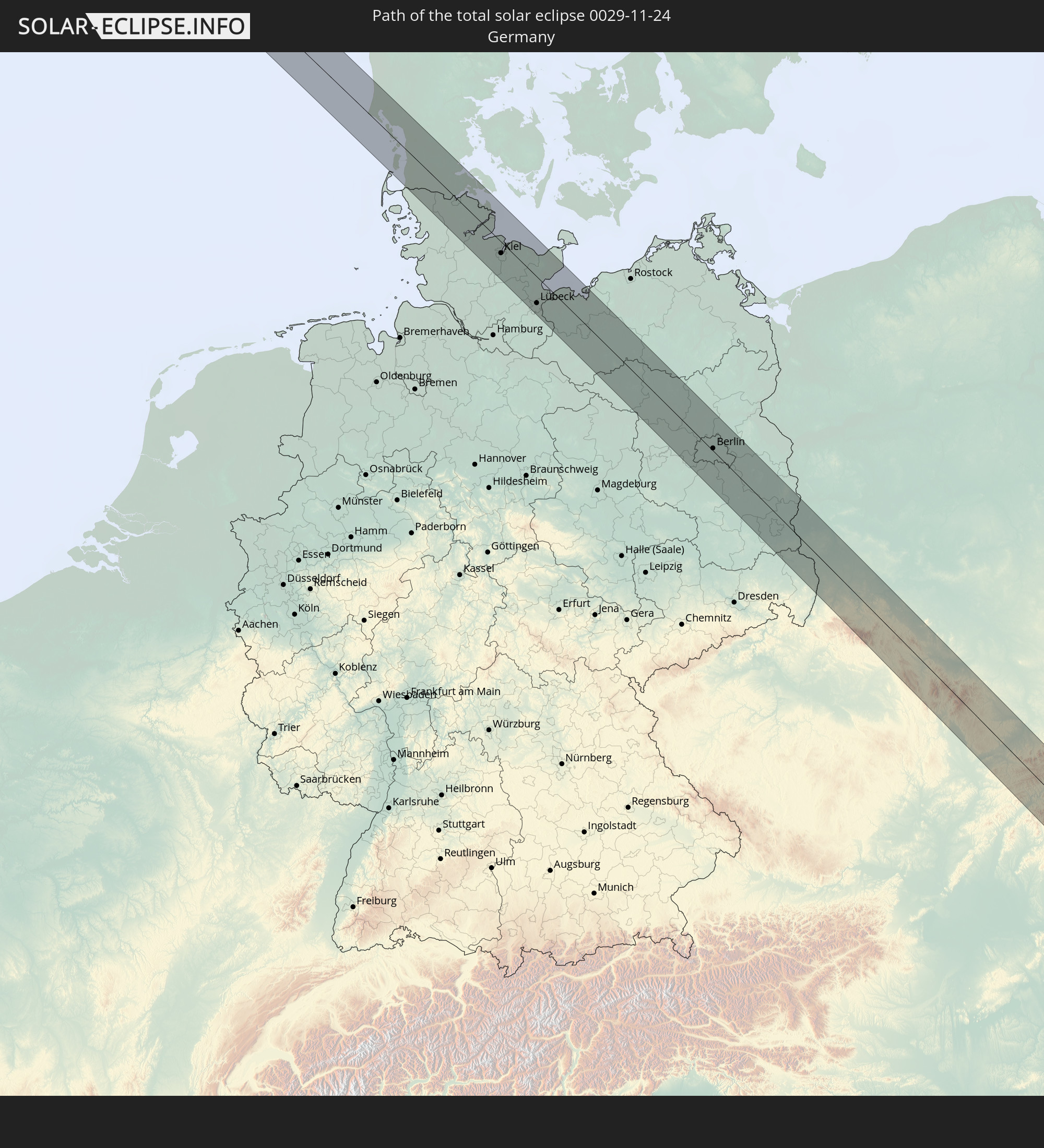 Germany
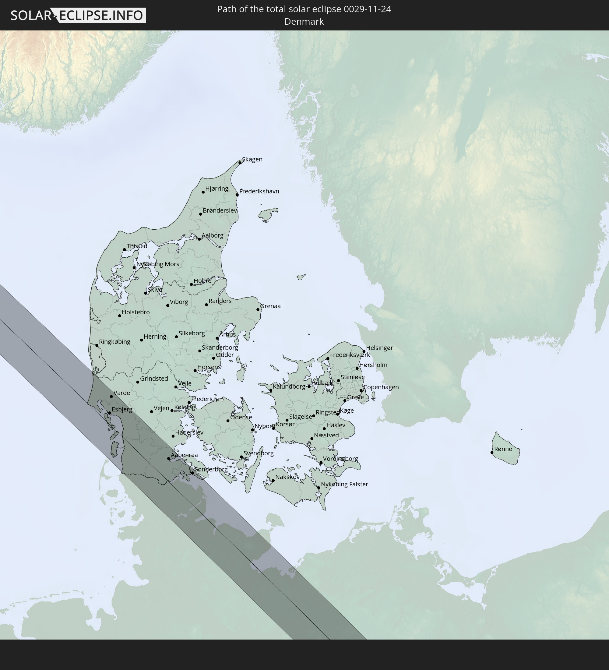 Denmark
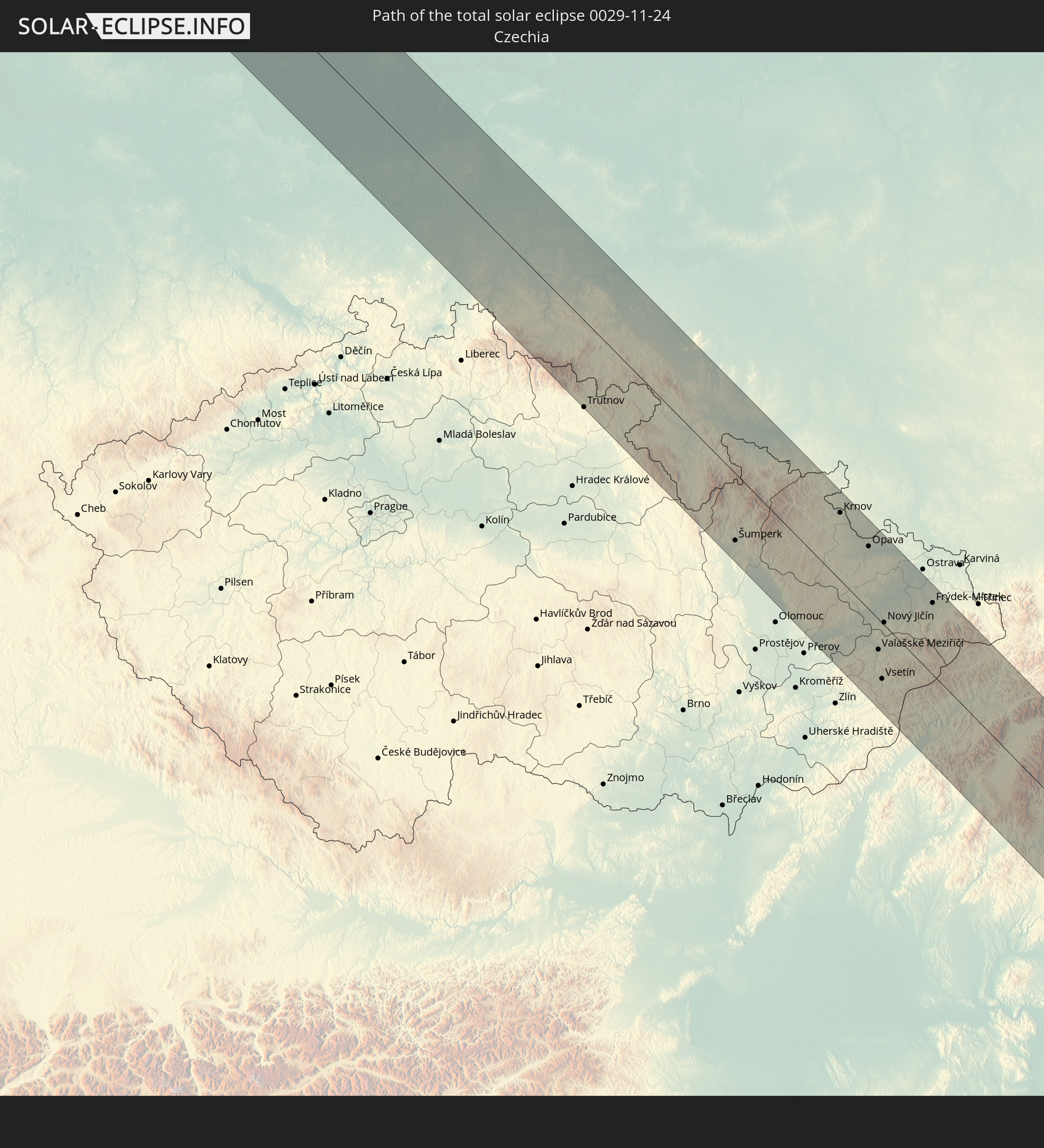 Czechia
 Poland
 Hungary
 Slovakia
 Romania
 Bulgaria
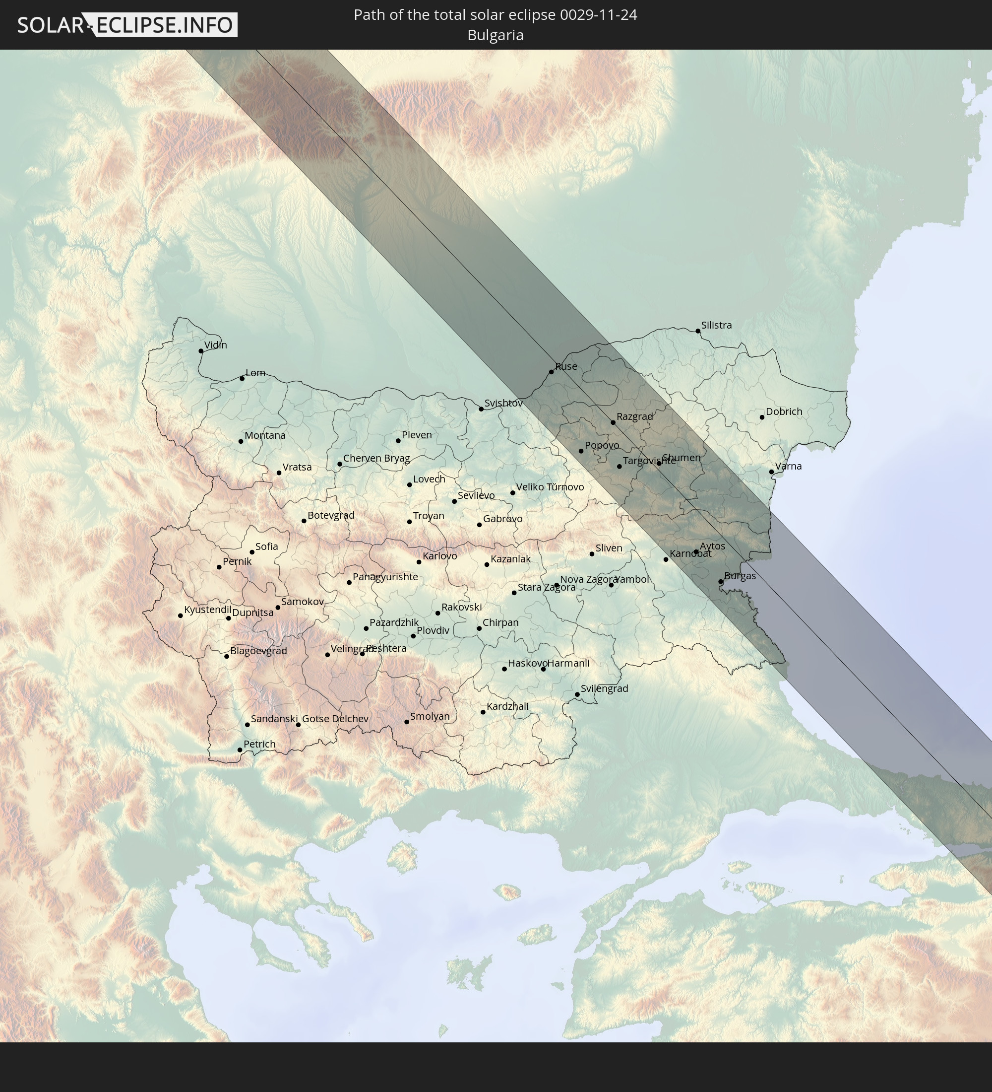
 Turkey
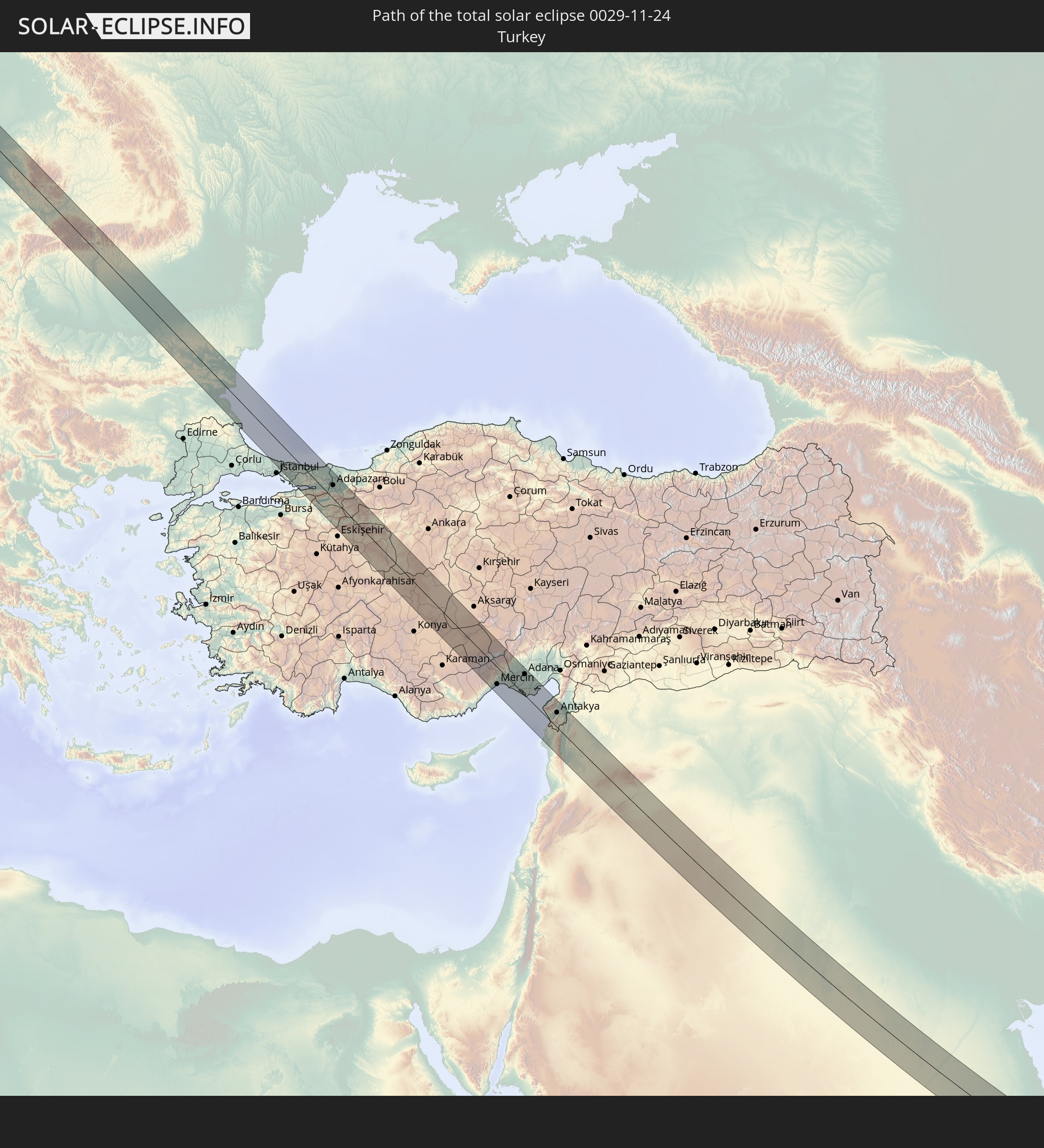
 Saudi Arabia
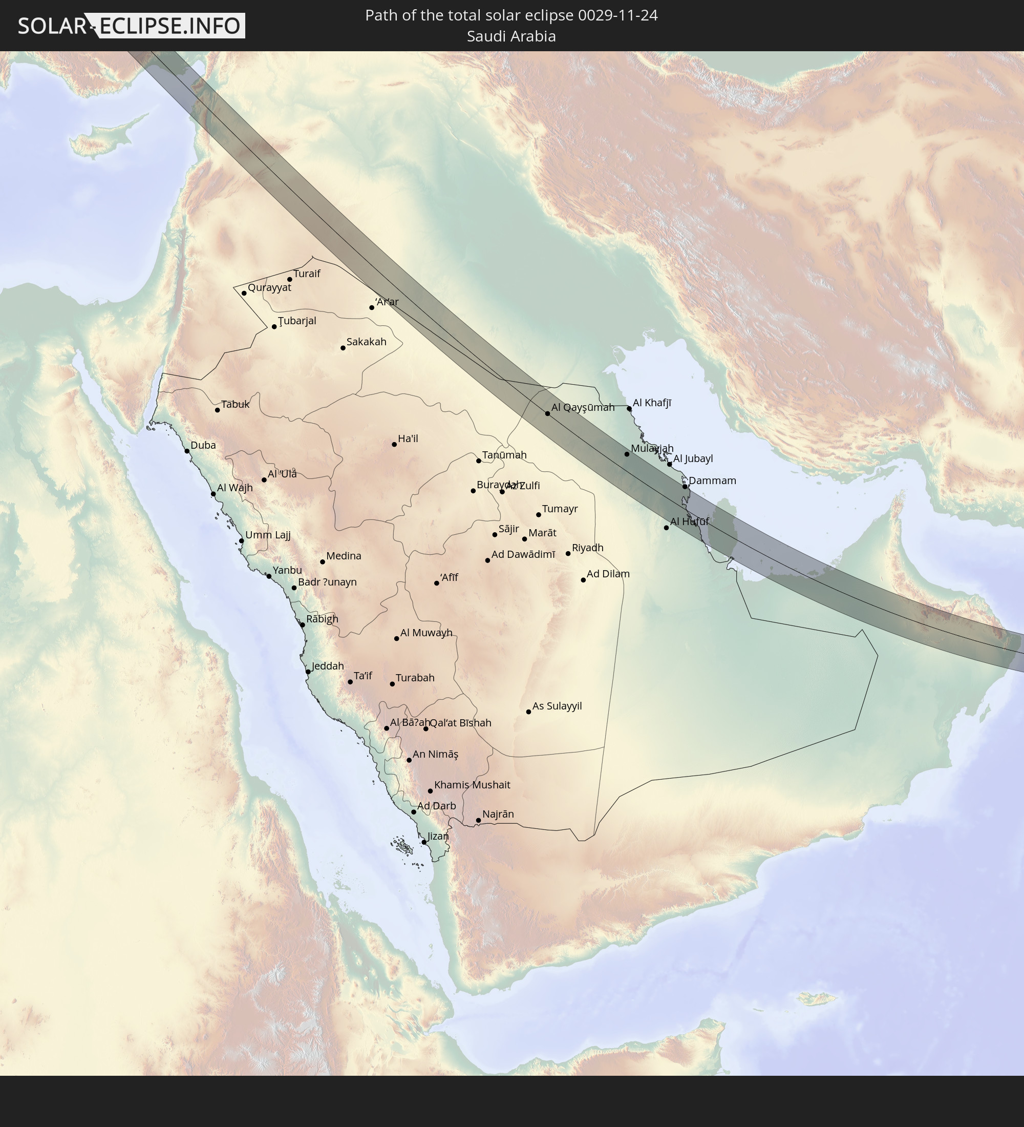
 Jordan
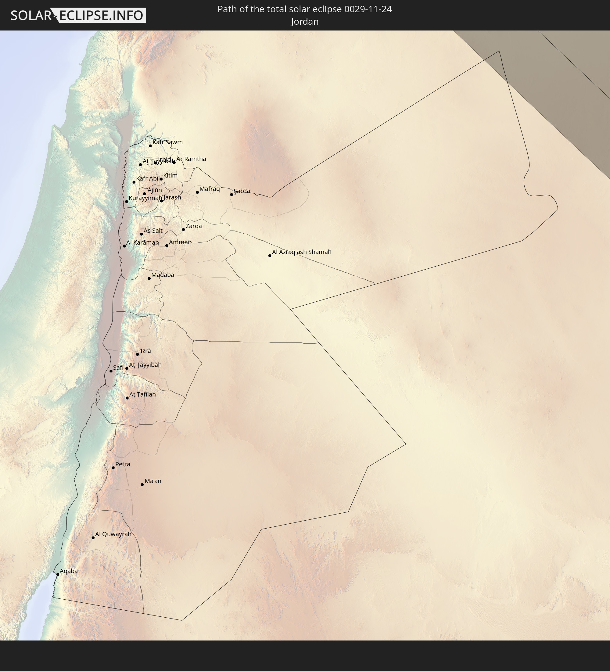
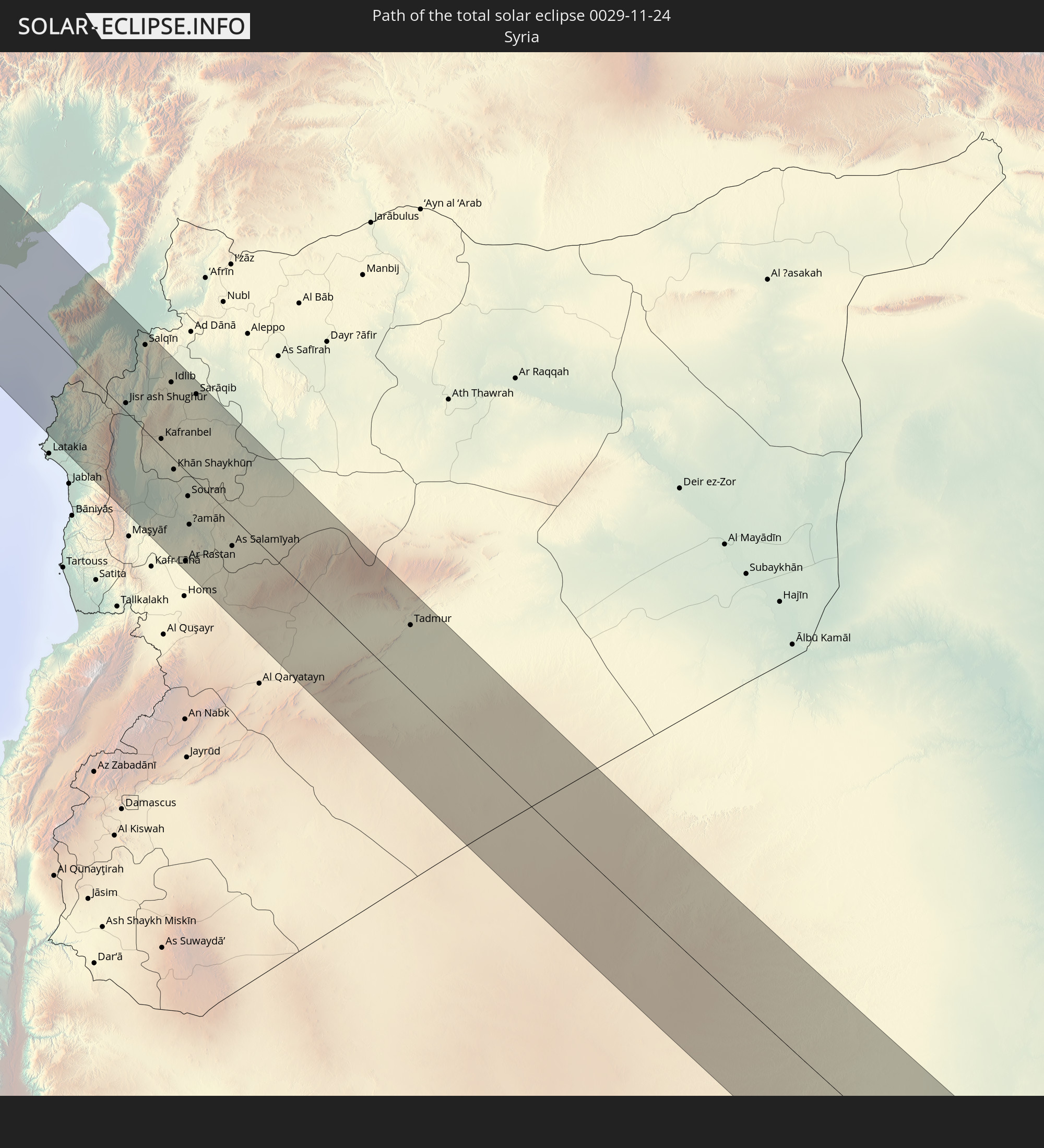 Syria
Syria
 Iraq
Iraq
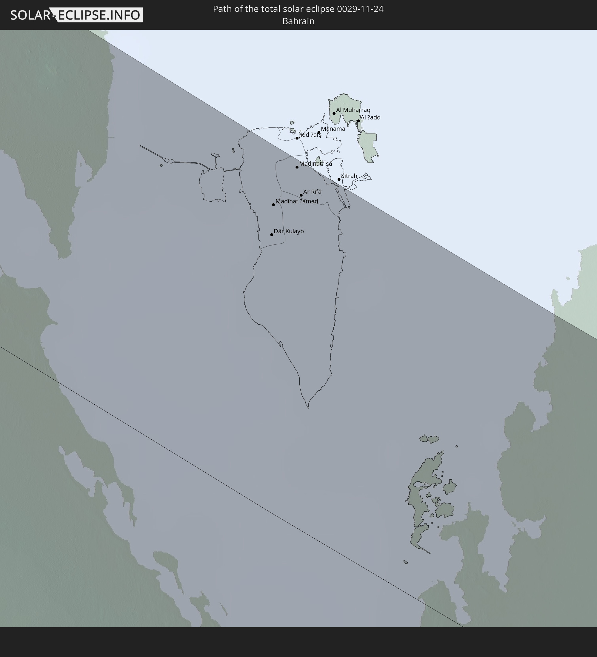 Bahrain
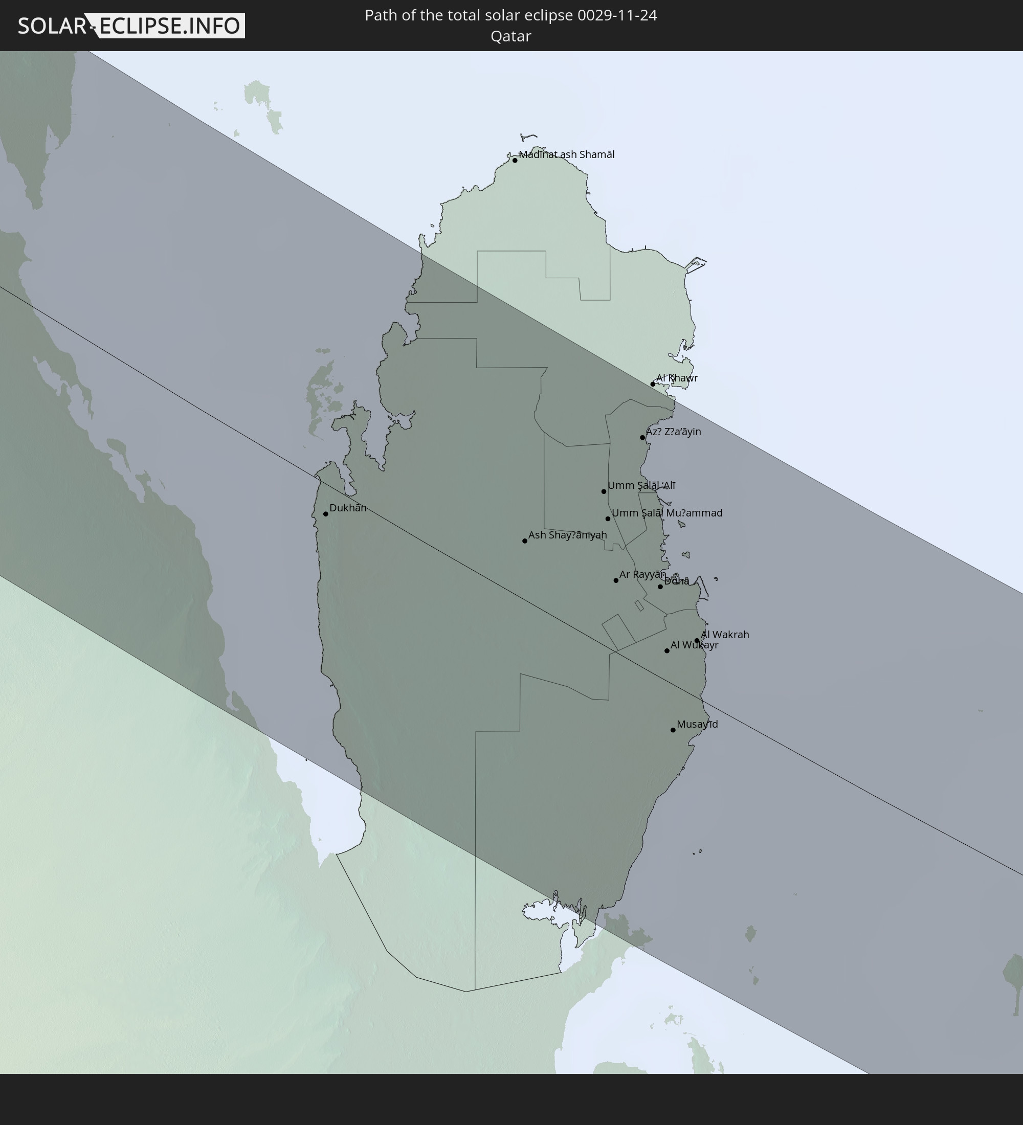 Qatar
Qatar
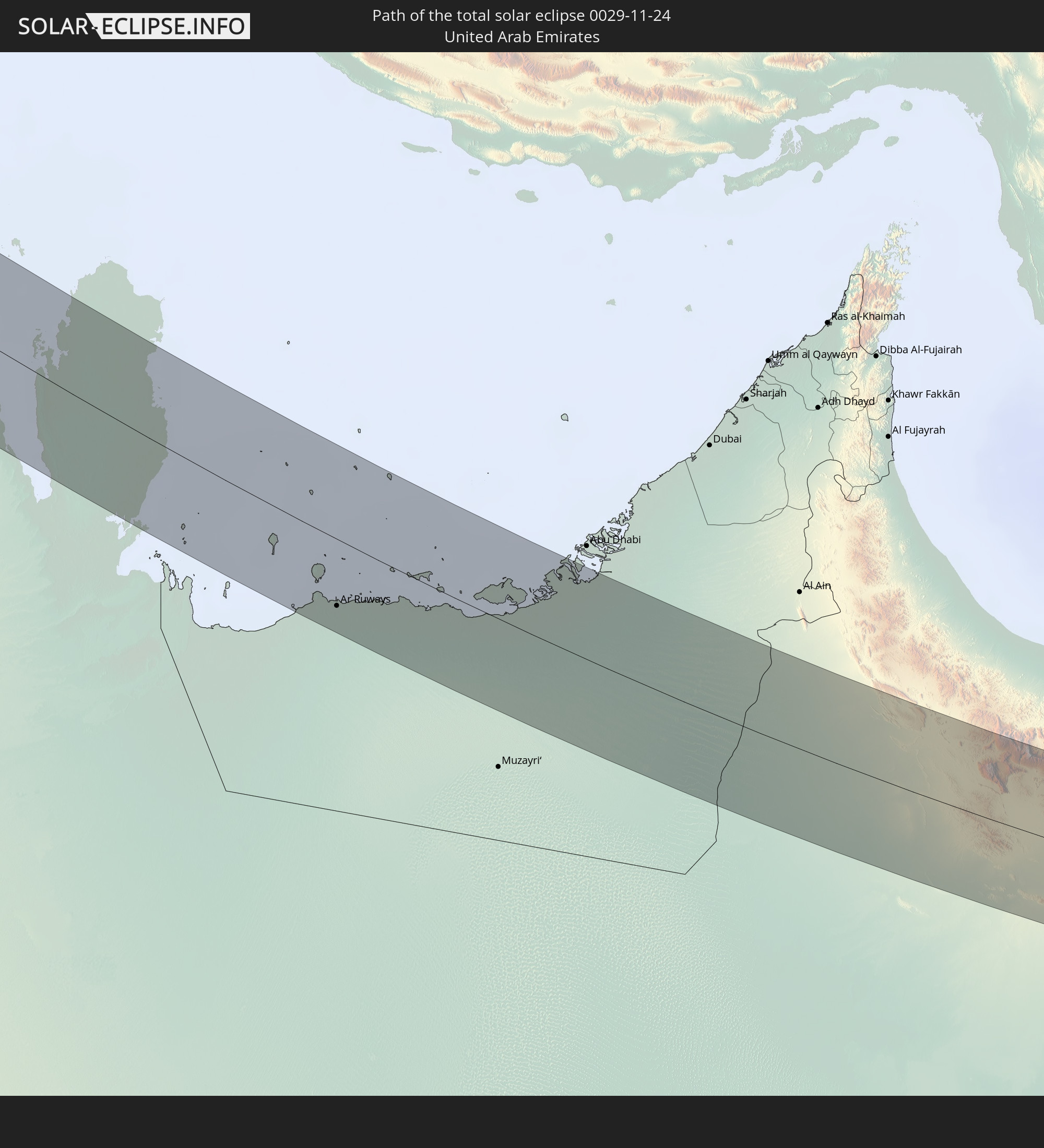 United Arab Emirates
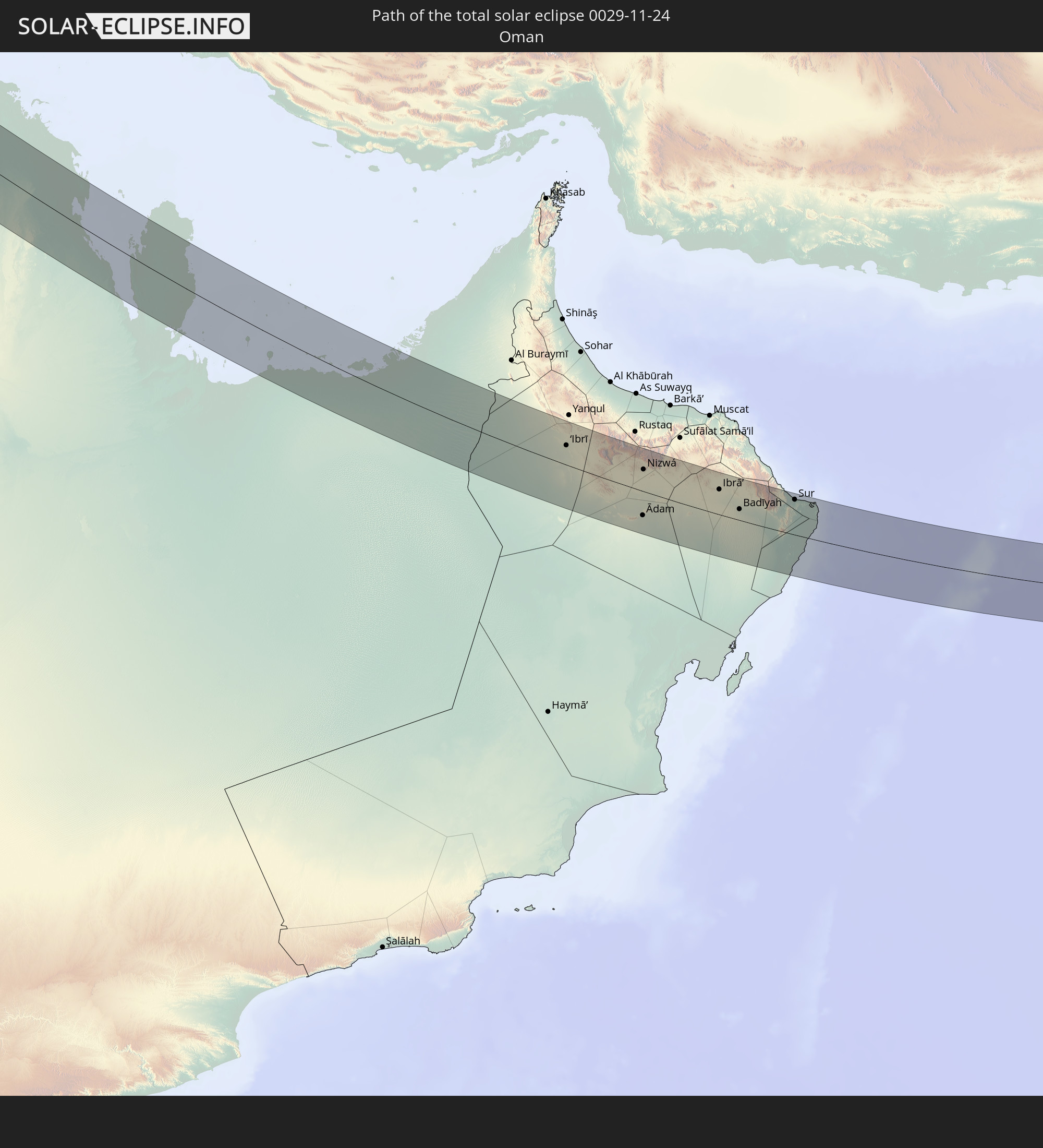 Oman
Oman
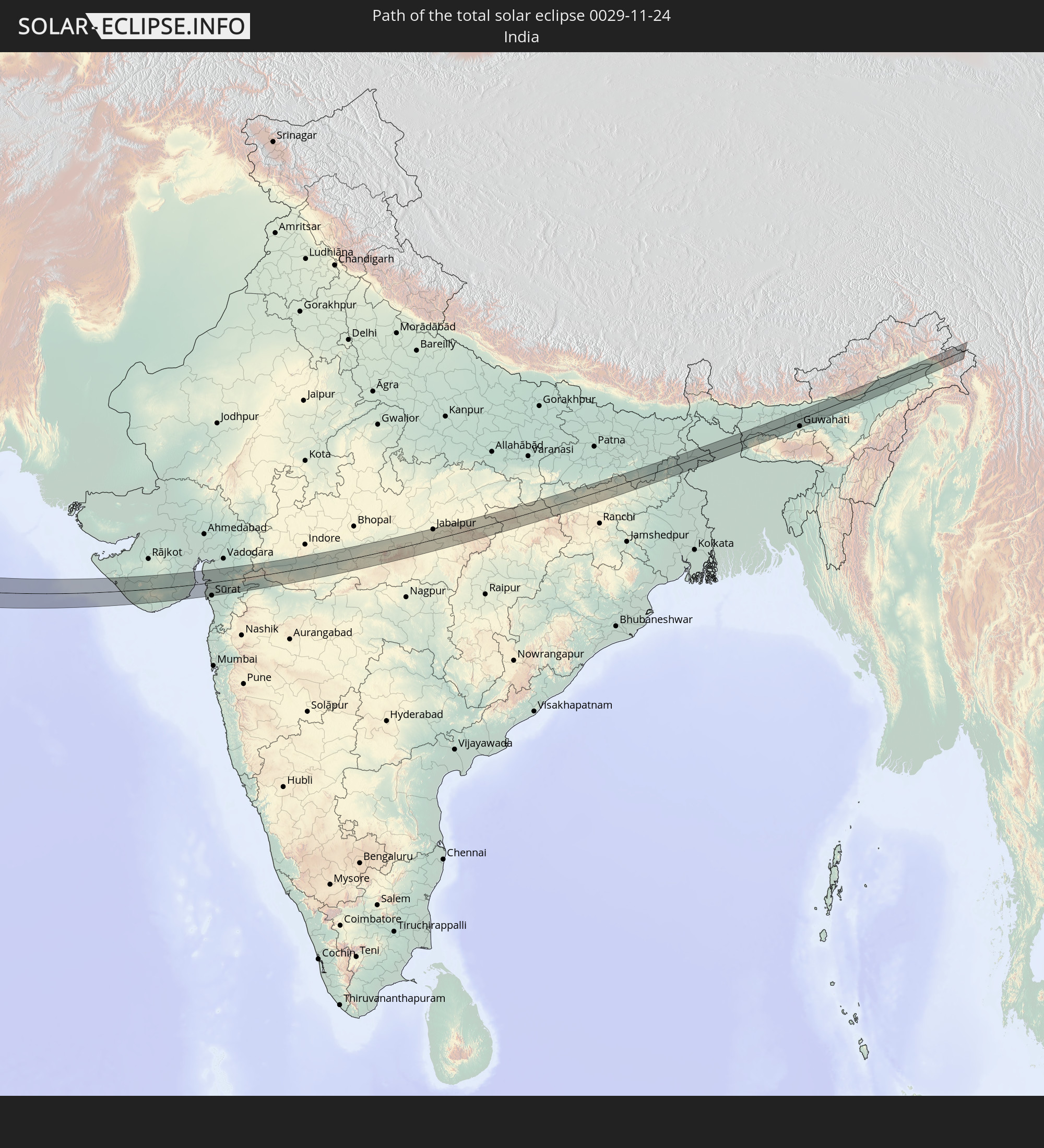 India
India
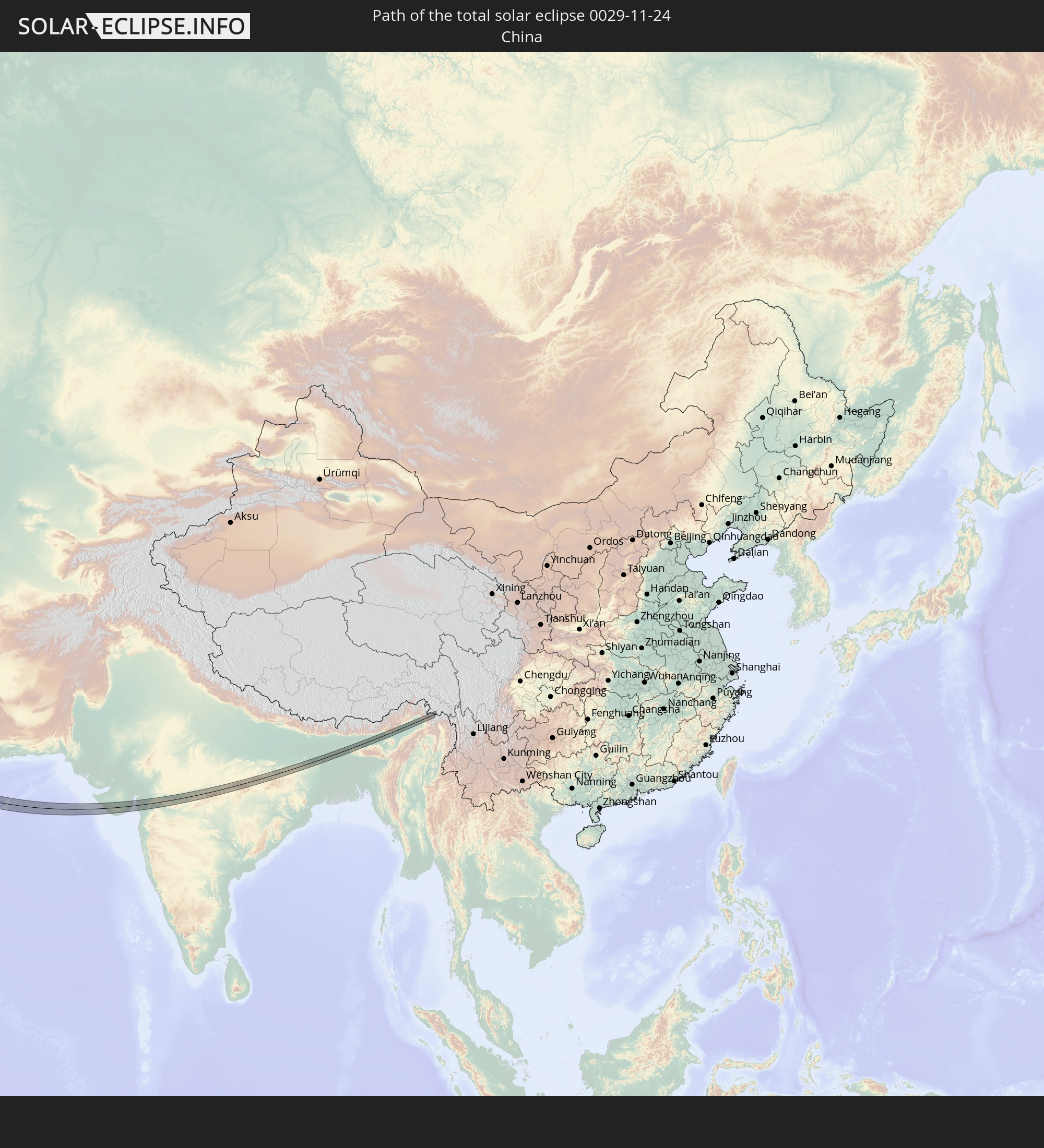 China
China
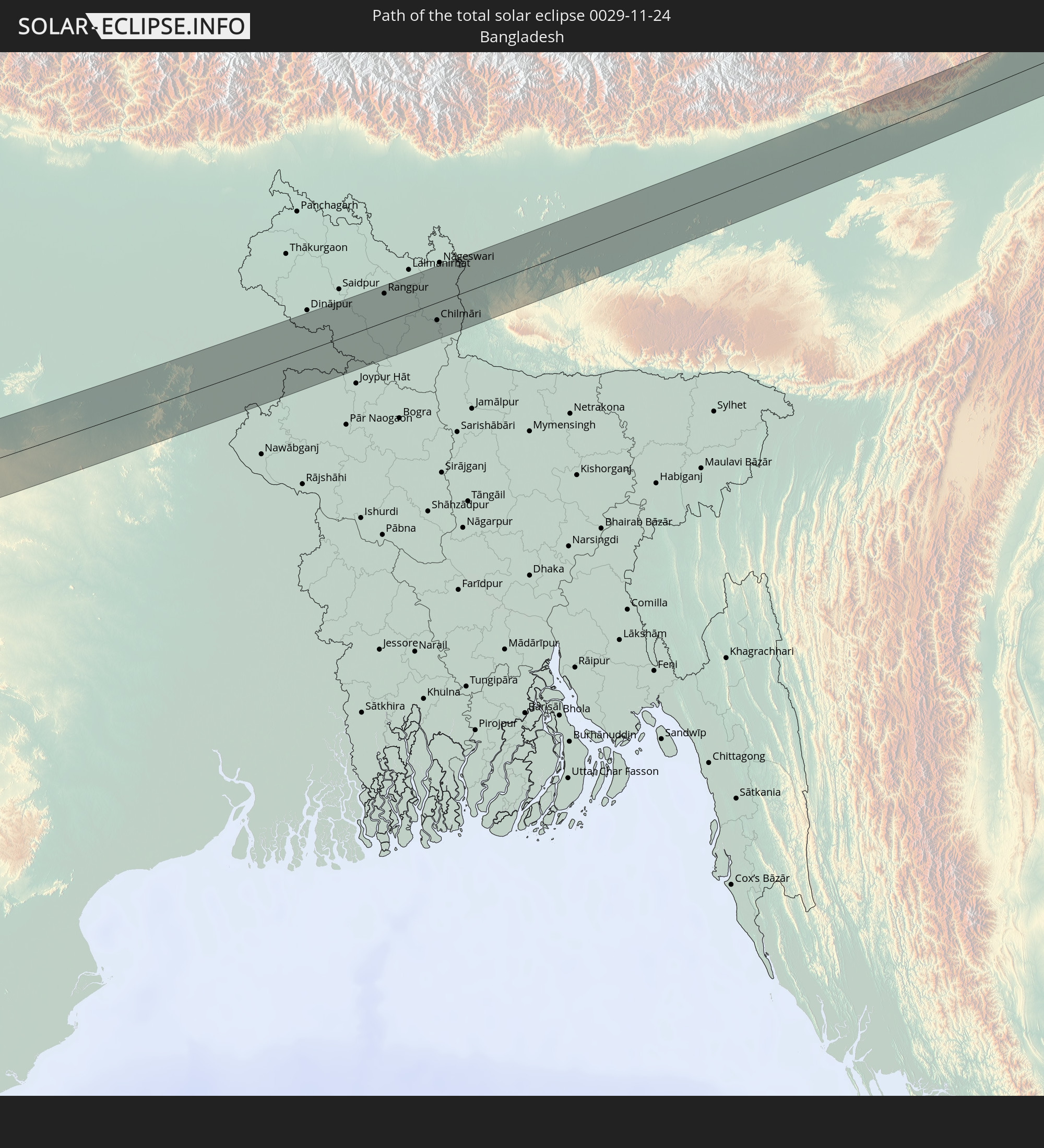 Bangladesh
In den folgenden Ländern ist die Sonnenfinsternis partiell zu sehen
 Russia
 Portugal
 Spain
Spain
 Mauritania
 Morocco
 Mali
Mali
 Algeria
 United Kingdom
 Gibraltar
 France
 Guernsey
 Jersey
 Niger
Niger
 Andorra
 Belgium
 Nigeria
 Netherlands
 Norway
 Luxembourg
 Germany
 Switzerland
 Italy
Italy
 Monaco
 Tunisia
 Denmark
 Cameroon
 Libya
Libya
 Liechtenstein
 Austria
 Sweden
 Czechia
 Democratic Republic of the Congo
 San Marino
 Vatican City
 Slovenia
 Chad
Chad
 Croatia
 Poland
 Malta
Malta
 Central African Republic
 Bosnia and Herzegovina
 Hungary
 Slovakia
 Montenegro
 Serbia
 Albania
 Åland Islands
 Greece
 Romania
 Republic of Macedonia
 Finland
 Lithuania
 Latvia
 Estonia
 Sudan
Sudan
 Ukraine
 Bulgaria
 Belarus
 Egypt
Egypt
 Turkey
 Moldova
 Rwanda
 Burundi
 Tanzania
 Uganda
 Cyprus
 Ethiopia
 Kenya
Kenya
 State of Palestine
 Israel
 Saudi Arabia
 Jordan
 Lebanon
 Syria
Syria
 Eritrea
 Iraq
Iraq
 Georgia
 French Southern and Antarctic Lands
 Somalia
 Djibouti
 Yemen
Yemen
 Madagascar
 Comoros
 Armenia
 Iran
Iran
 Azerbaijan
 Seychelles
 Kazakhstan
 Kuwait
 Bahrain
 Qatar
Qatar
 United Arab Emirates
 Oman
Oman
 Turkmenistan
 Uzbekistan
 Mauritius
 Afghanistan
 Pakistan
 Tajikistan
 India
India
 Kyrgyzstan
 British Indian Ocean Territory
 Maldives
 China
China
 Sri Lanka
 Nepal
Nepal
 Mongolia
 Bangladesh
 Bhutan
 Myanmar
 Indonesia
 Thailand
 Malaysia
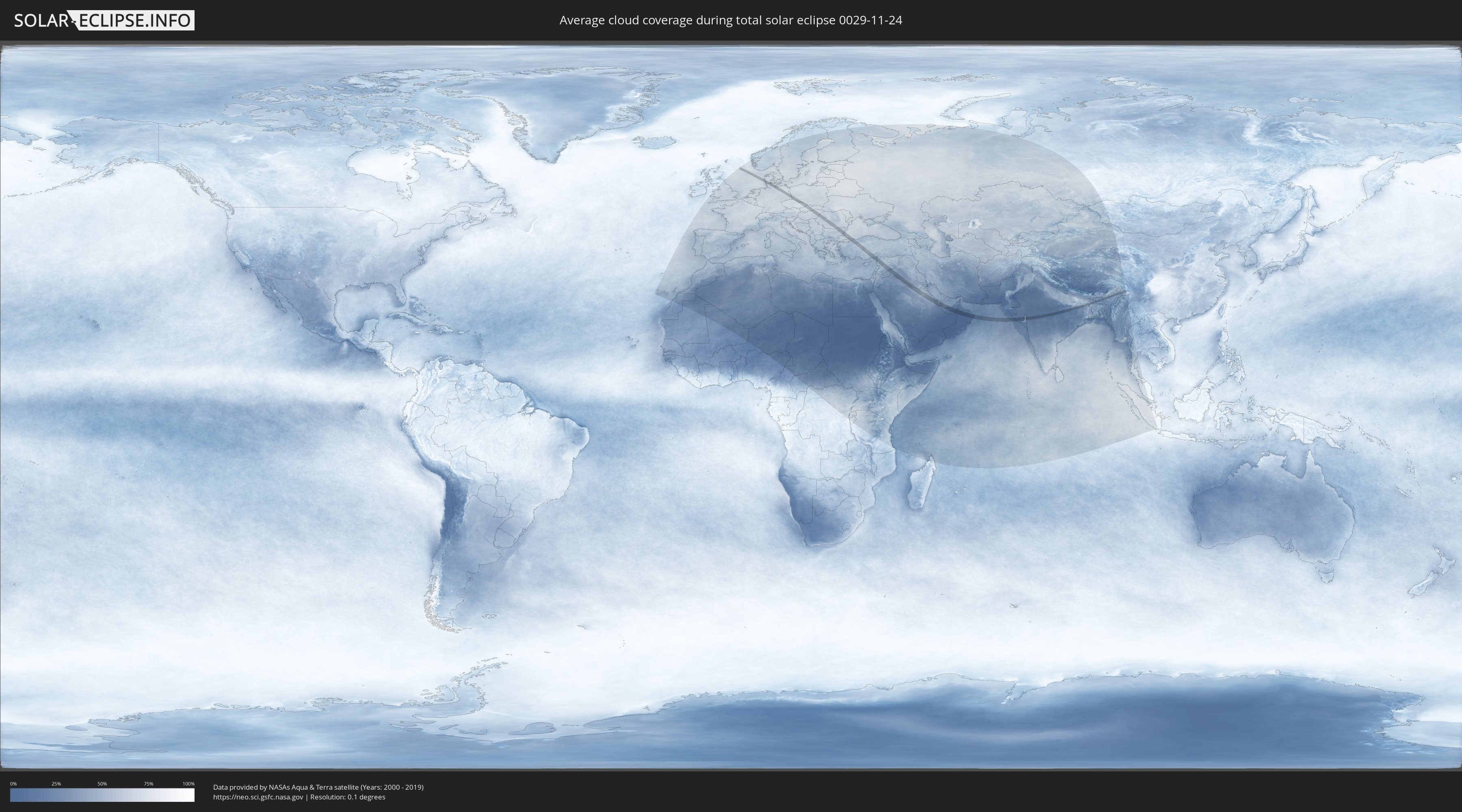
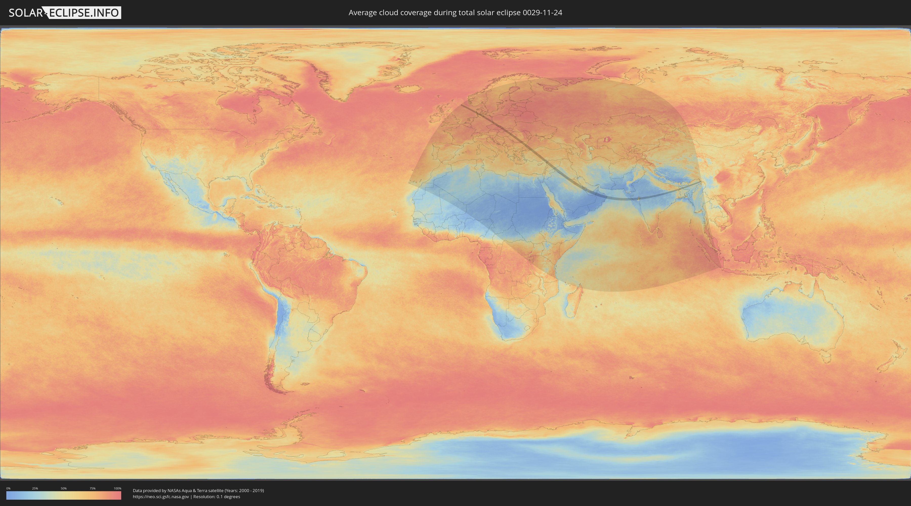
How will be the weather during the total solar eclipse on 11/24/0029?
Where is the best place to see the total solar eclipse of 11/24/0029?
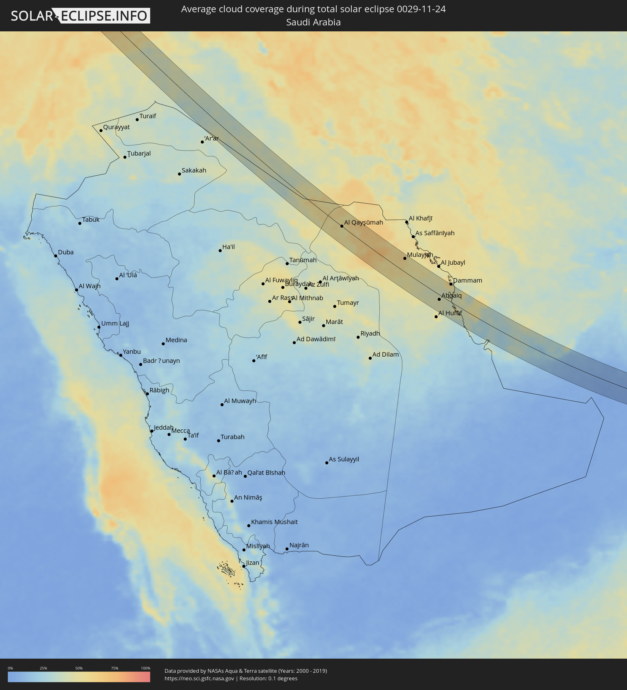
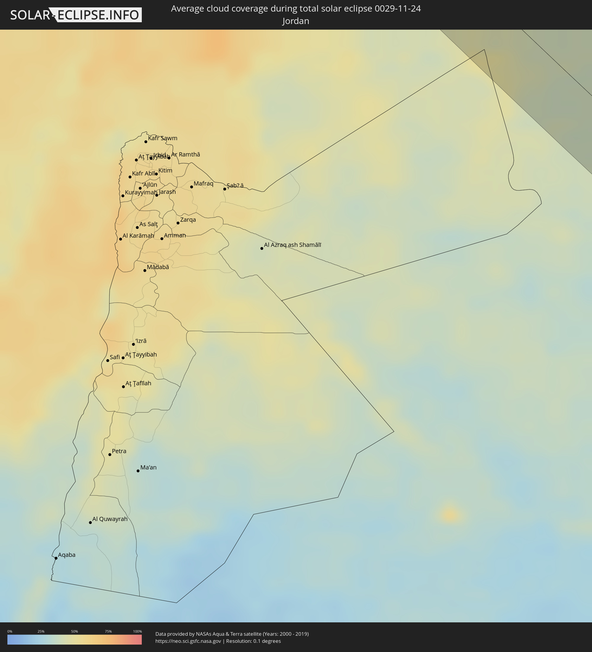
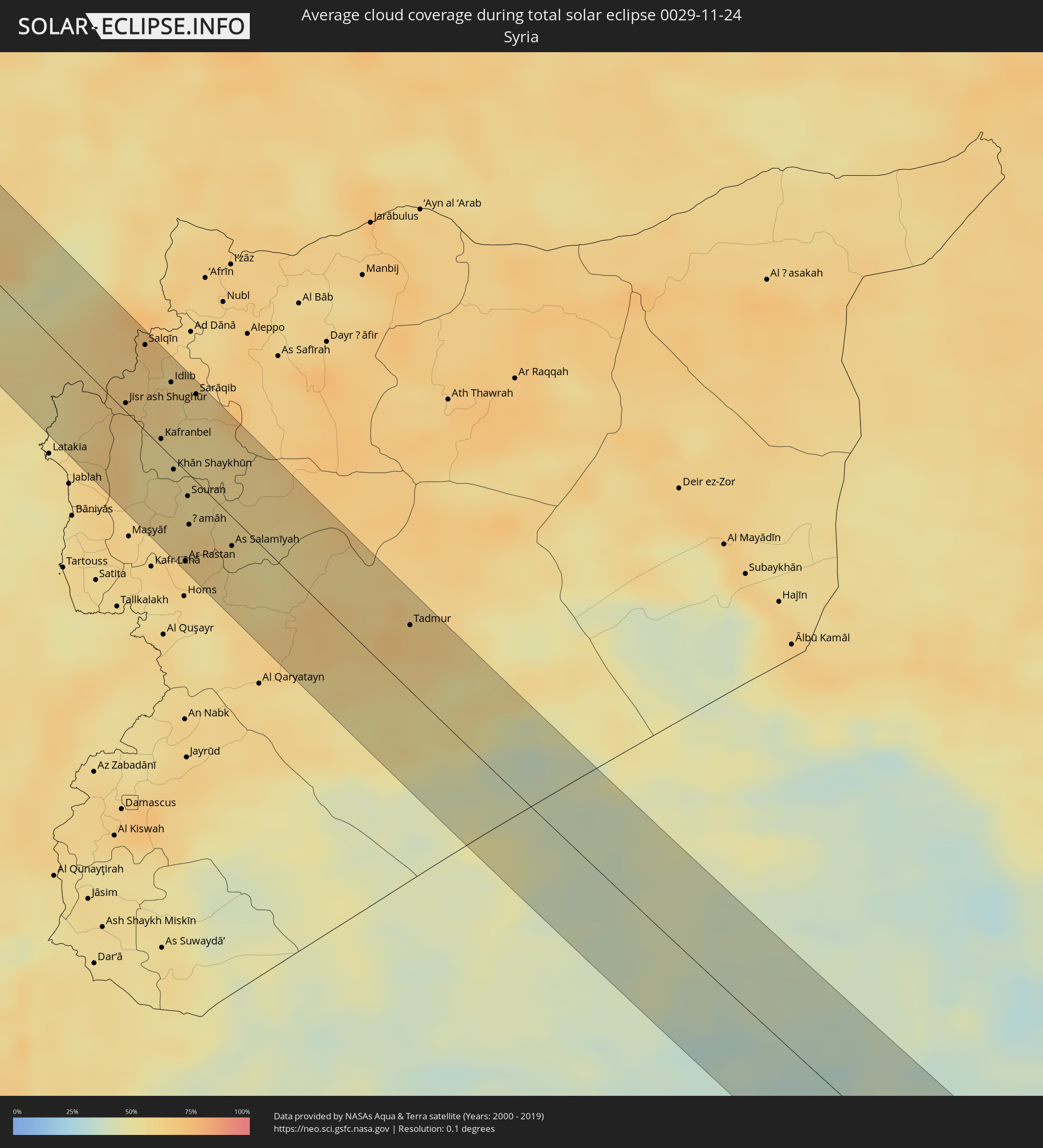
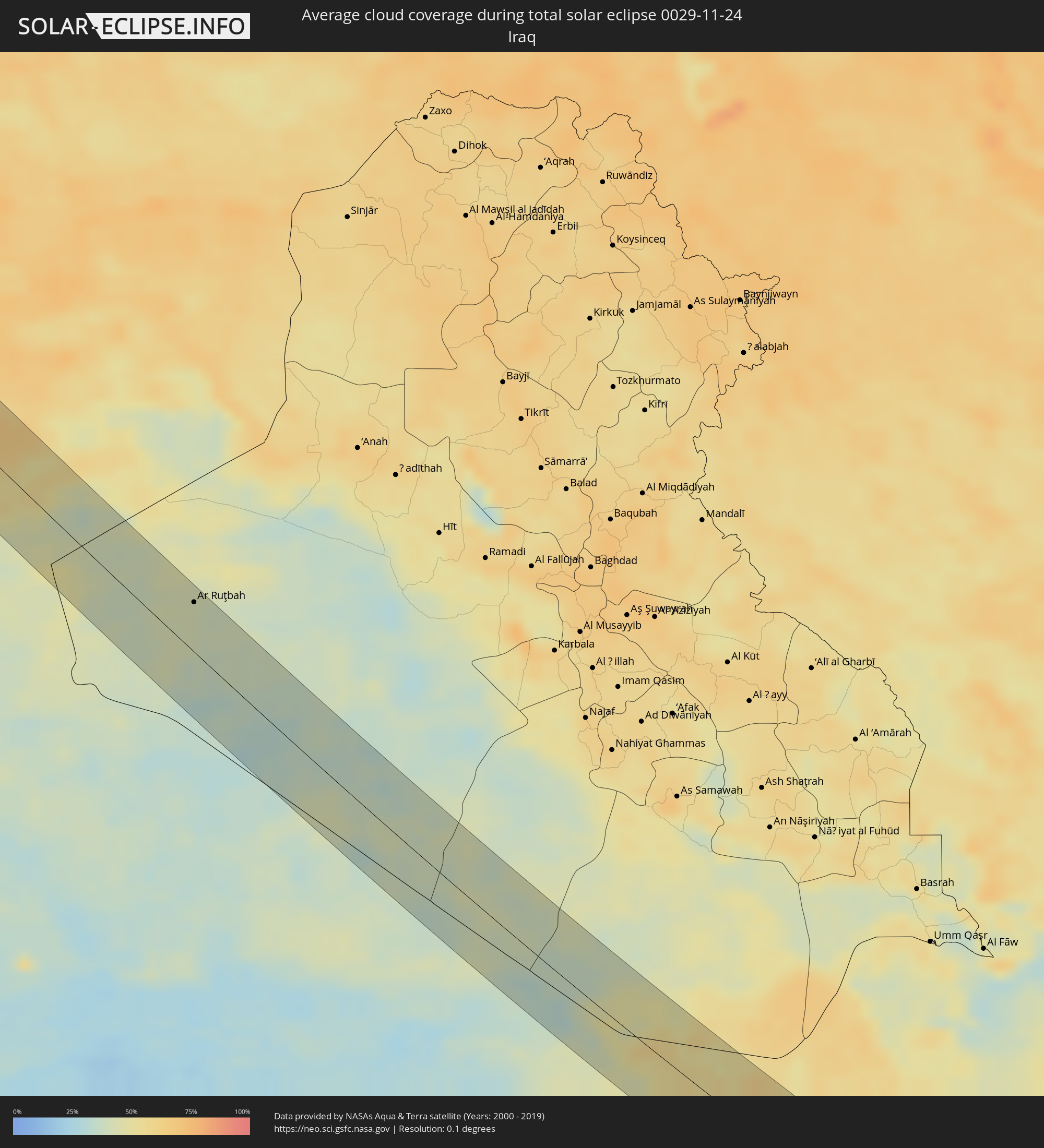
The following maps show the average cloud coverage for the day of the total solar eclipse.
With the help of these maps, it is possible to find the place along the eclipse path, which has the best
chance of a cloudless sky.
Nevertheless, you should consider local circumstances and inform about the weather of your chosen
observation site.
The data is provided by NASAs satellites
AQUA and TERRA.
The cloud maps are averaged over a period of 19 years (2000 - 2019).
Detailed country maps
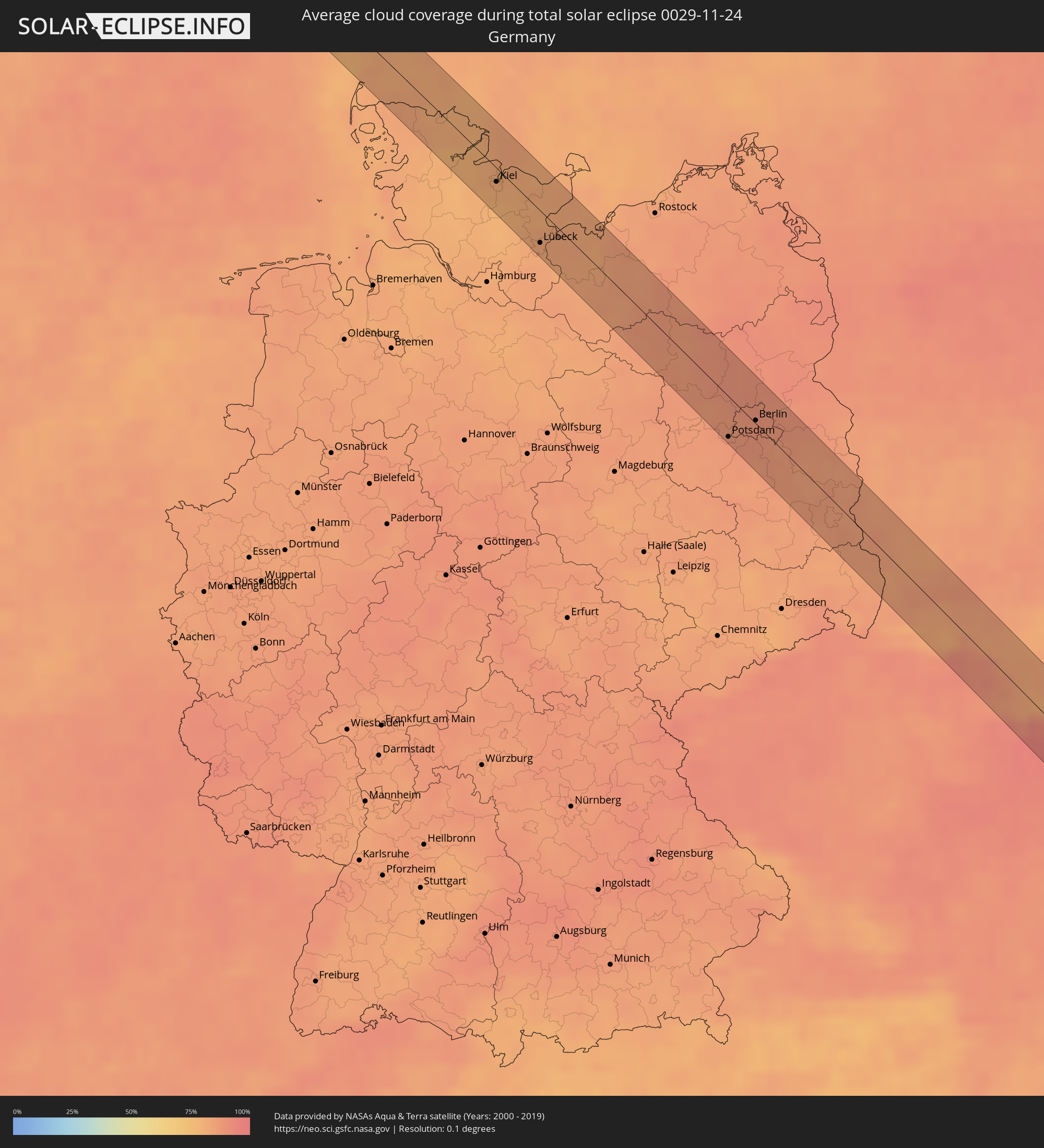 Germany
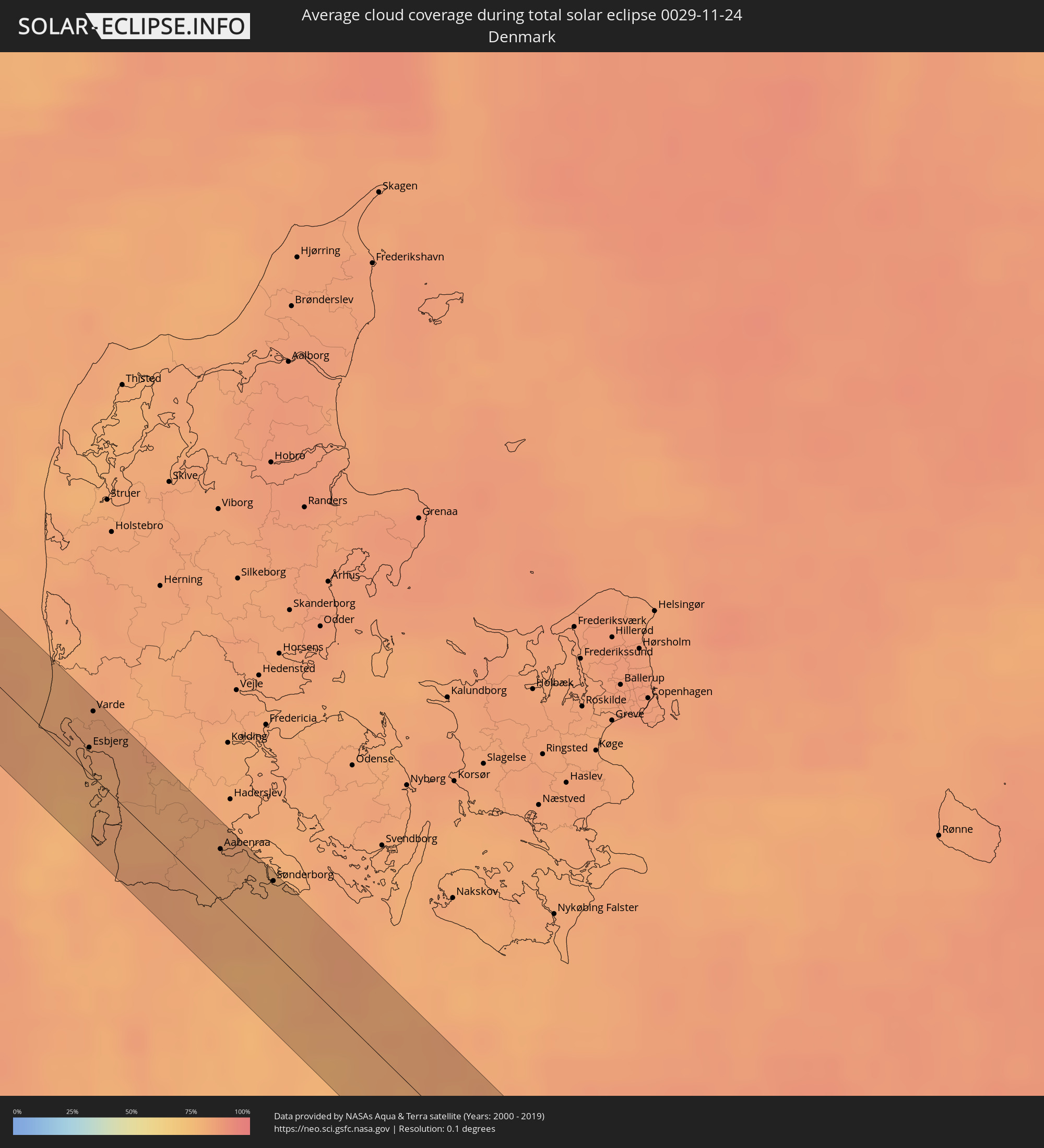 Denmark
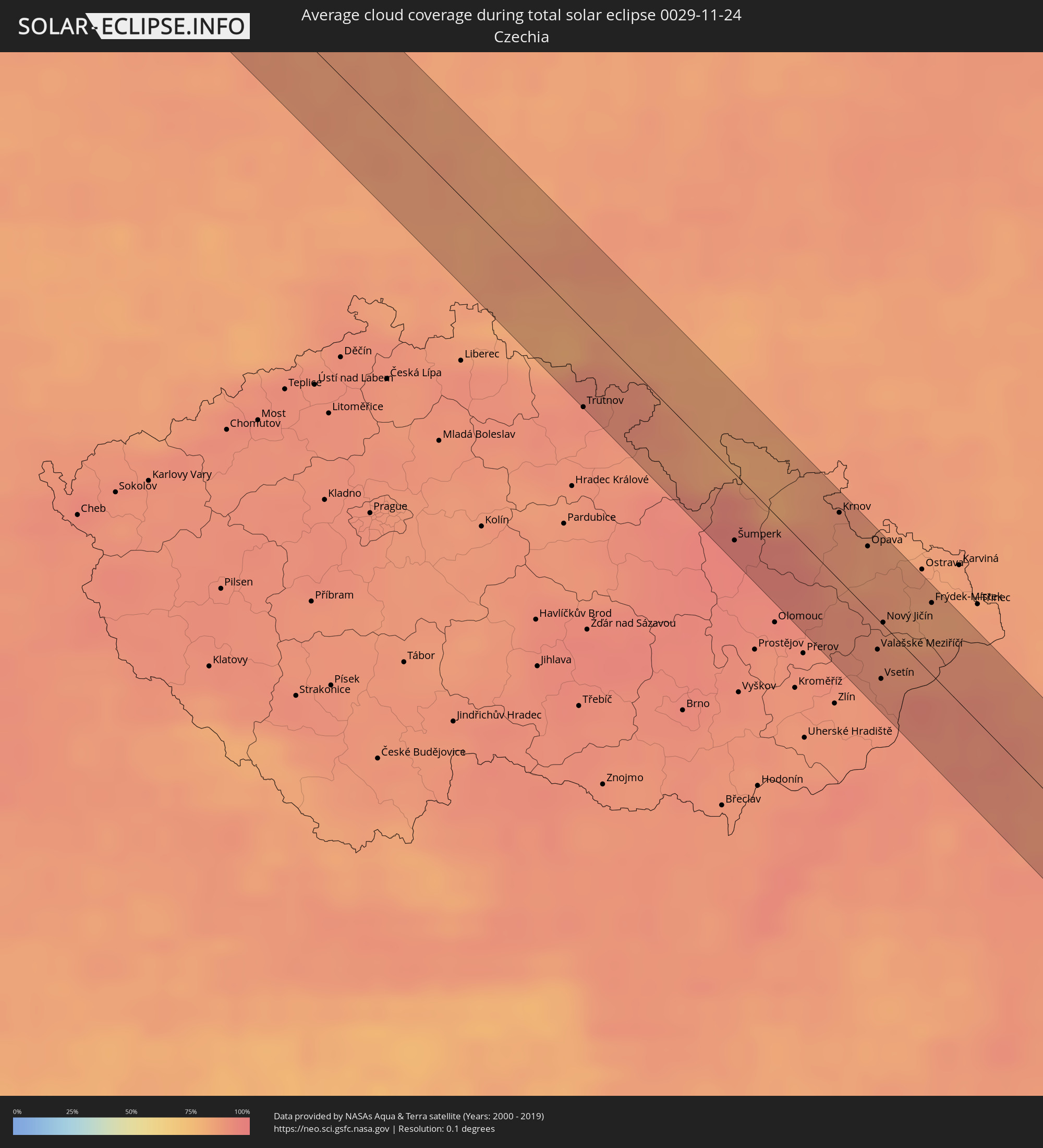 Czechia
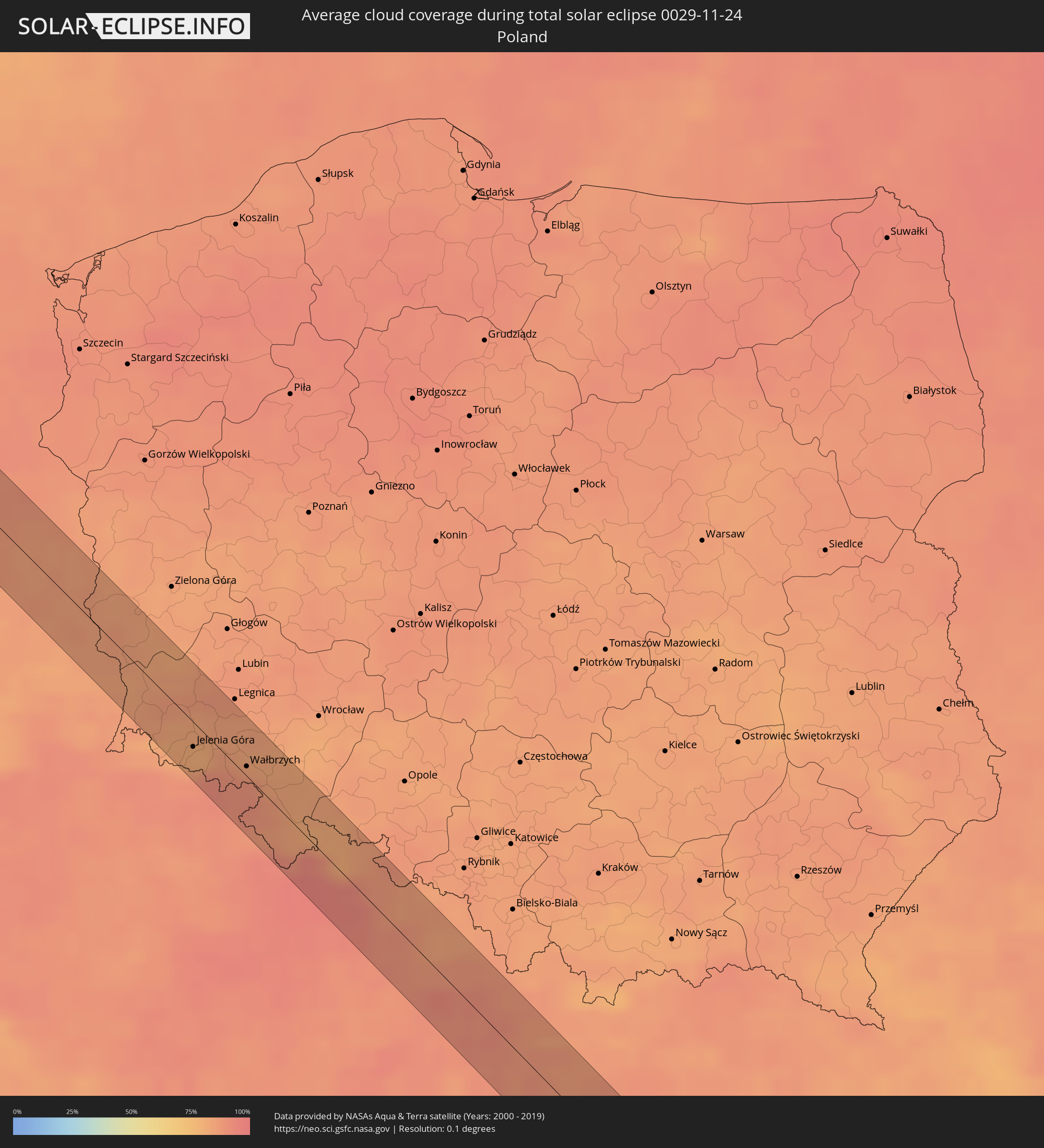 Poland
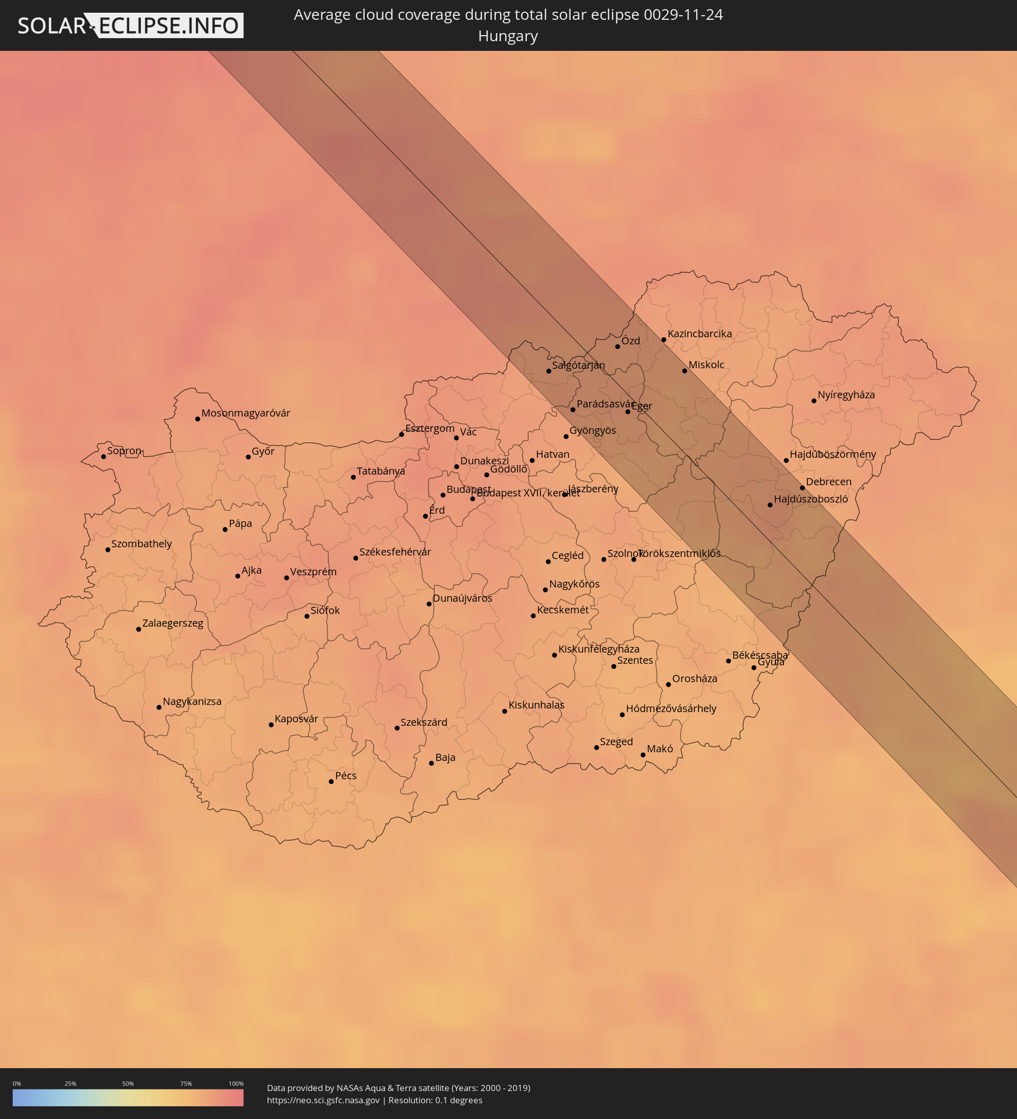 Hungary
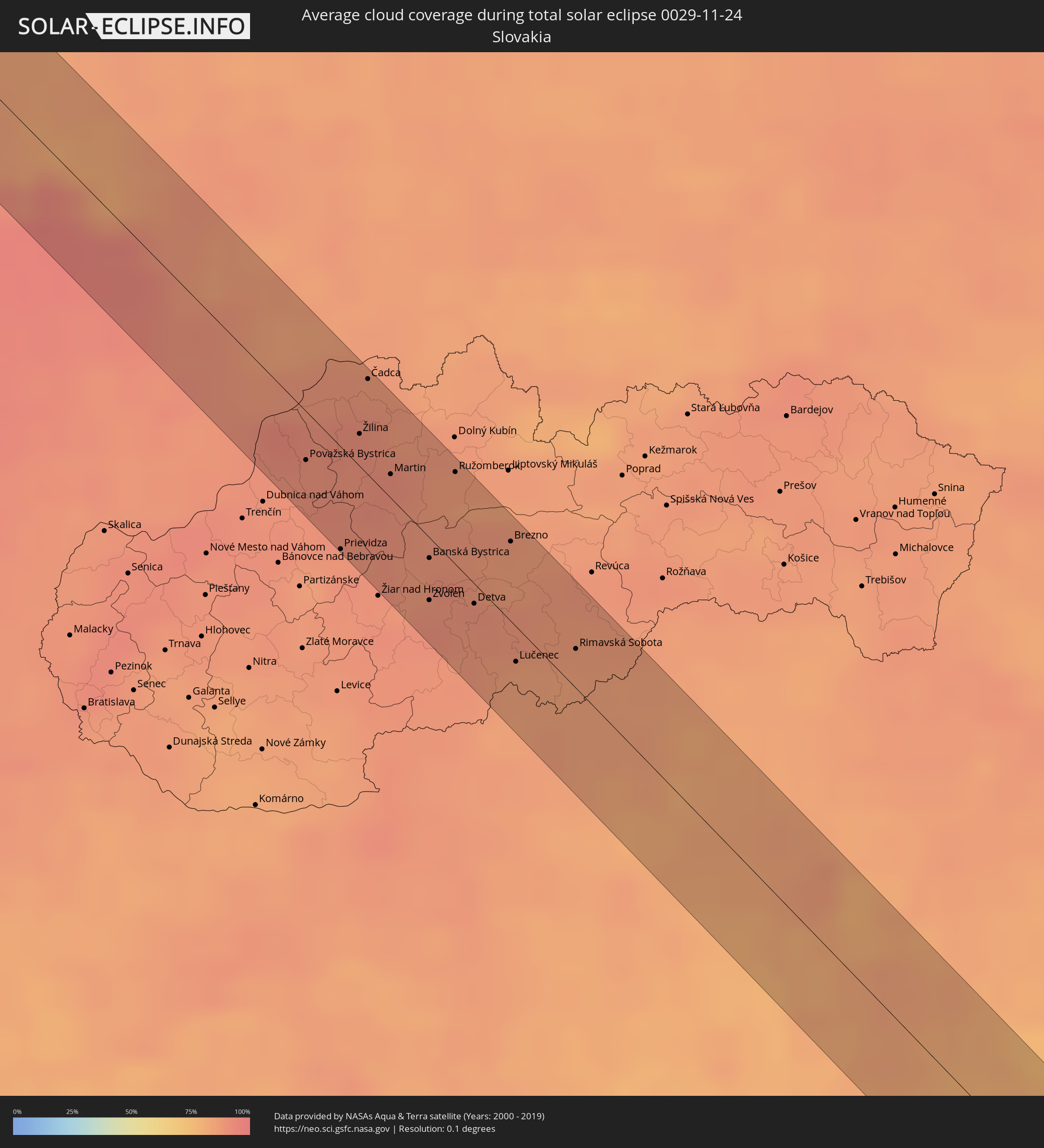 Slovakia
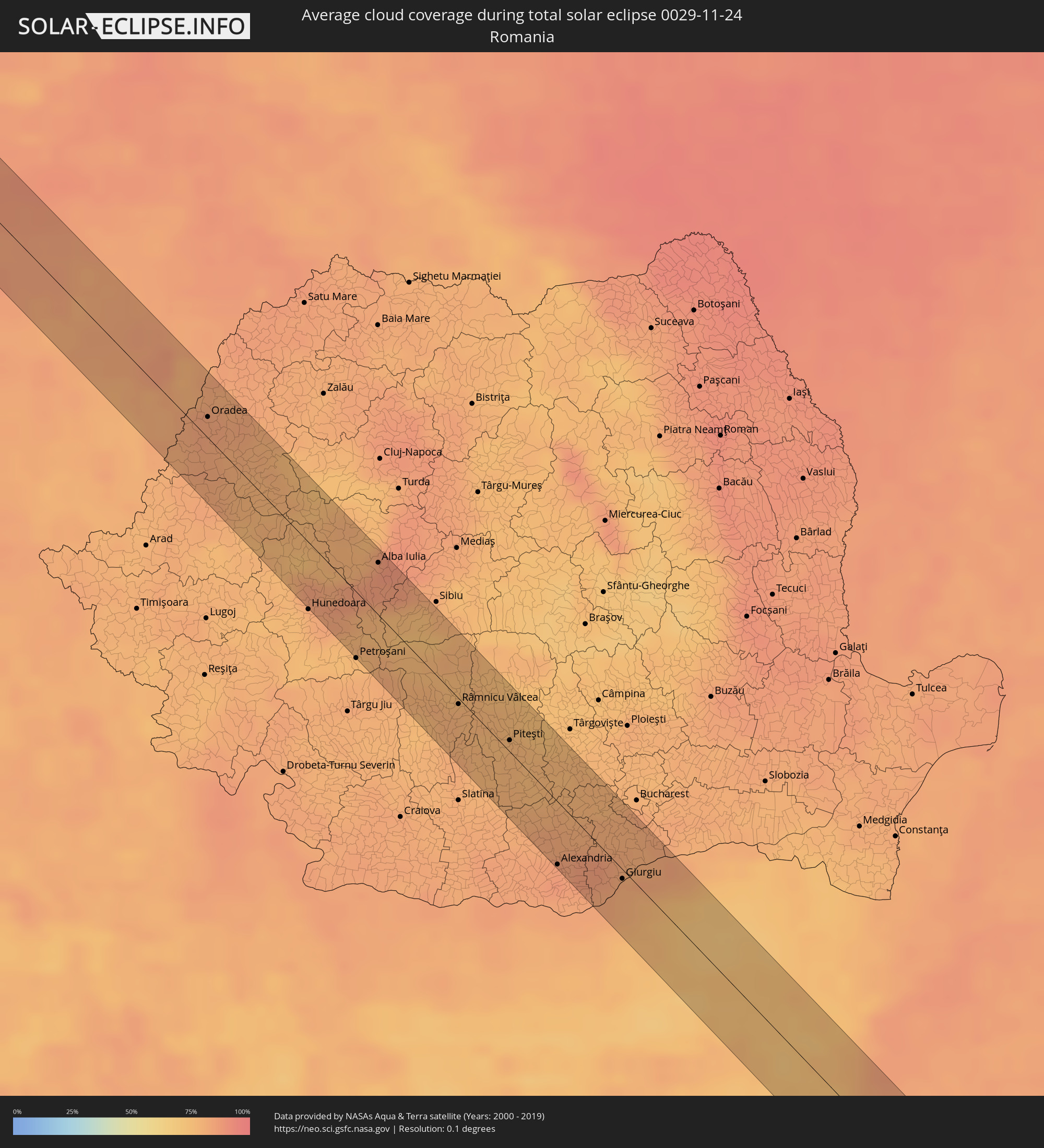 Romania
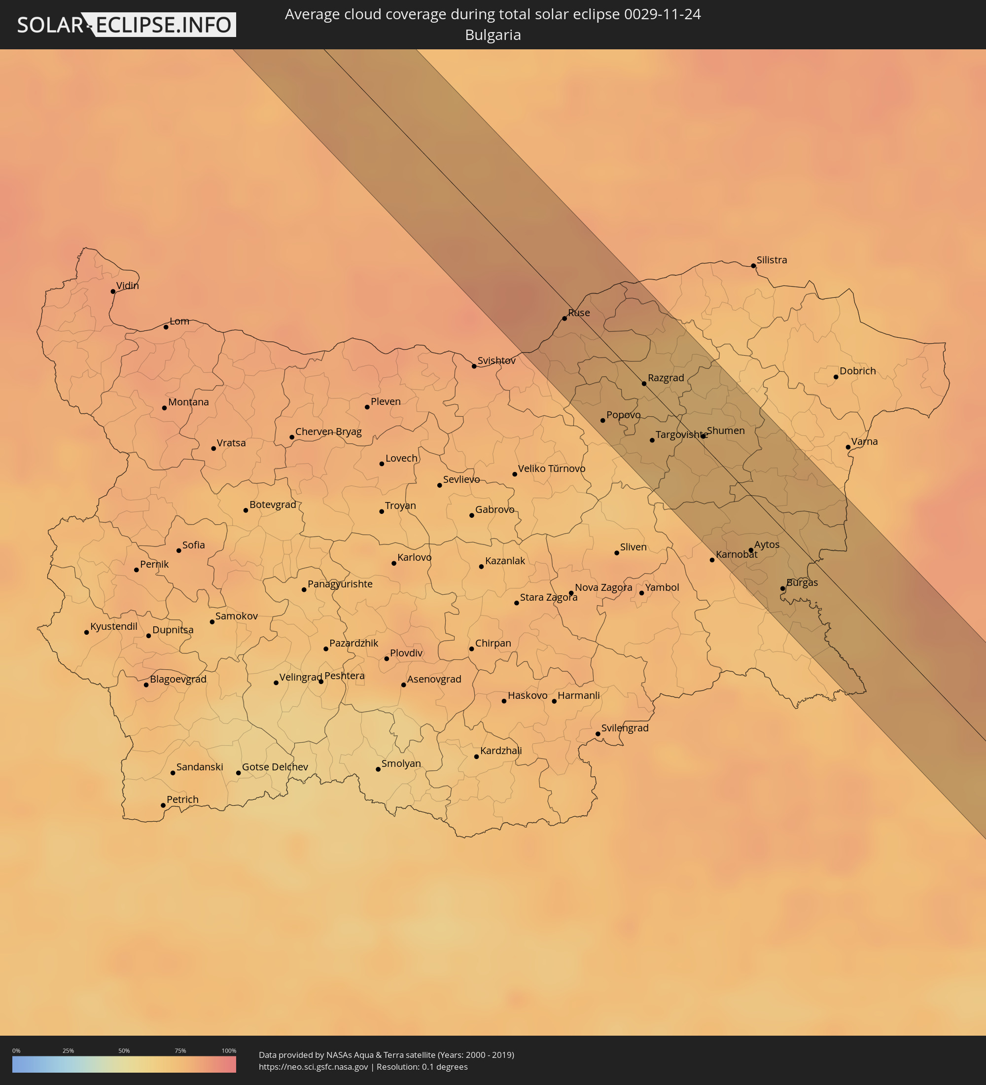 Bulgaria
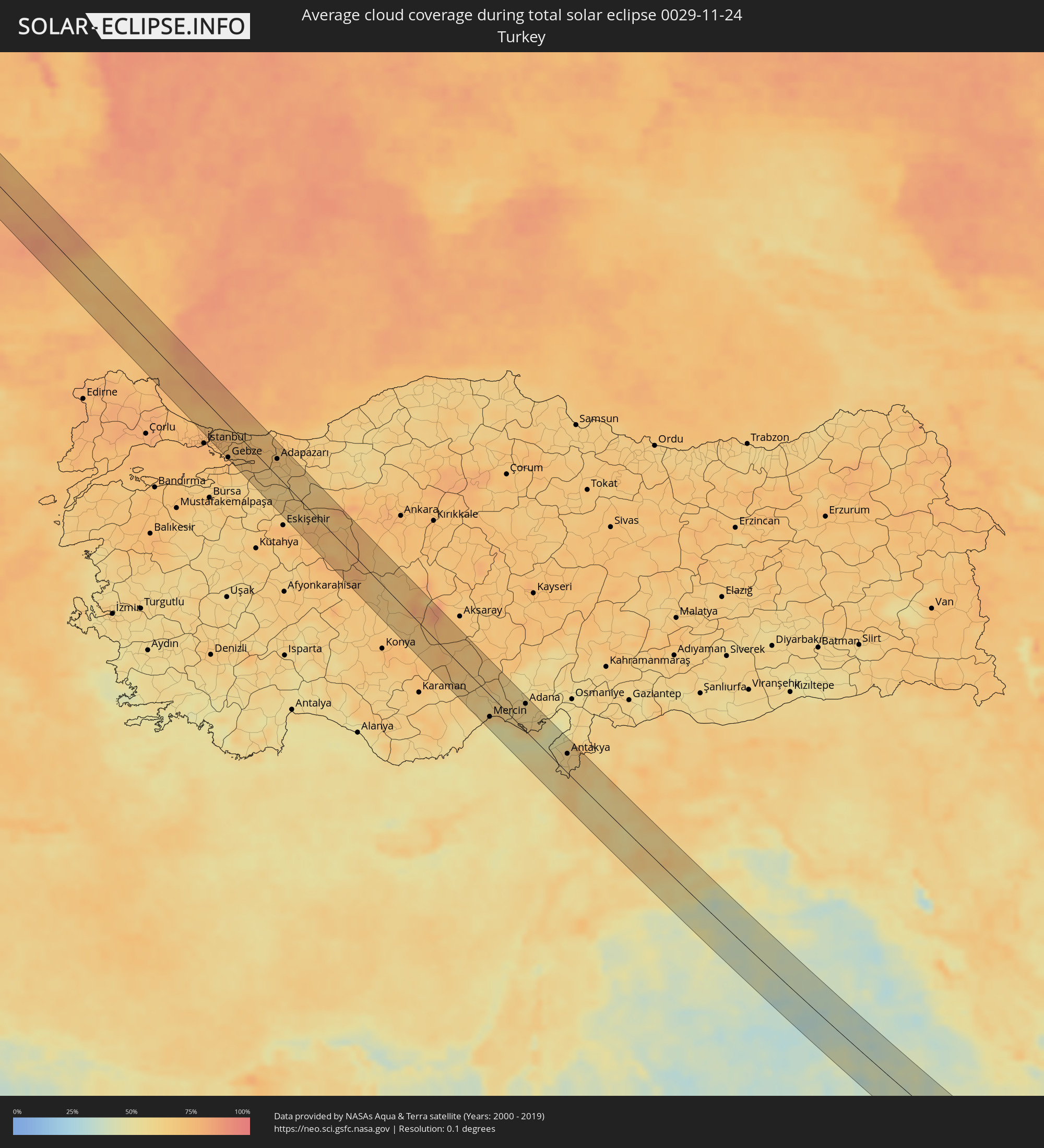 Turkey
 Saudi Arabia
 Jordan
 Syria
Syria
 Iraq
Iraq
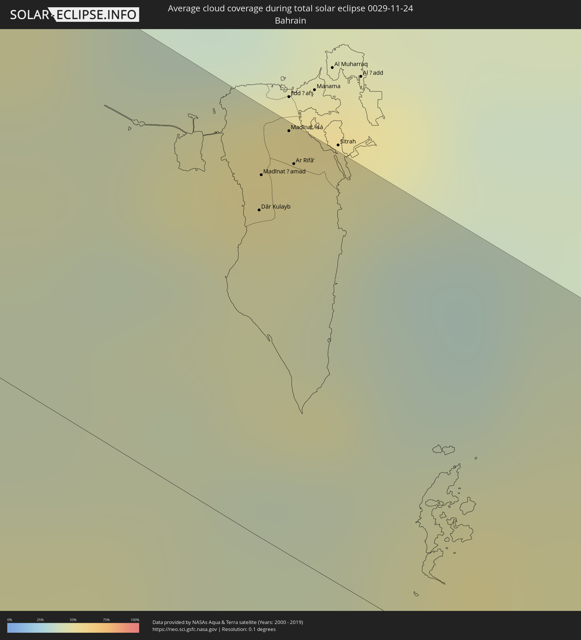 Bahrain
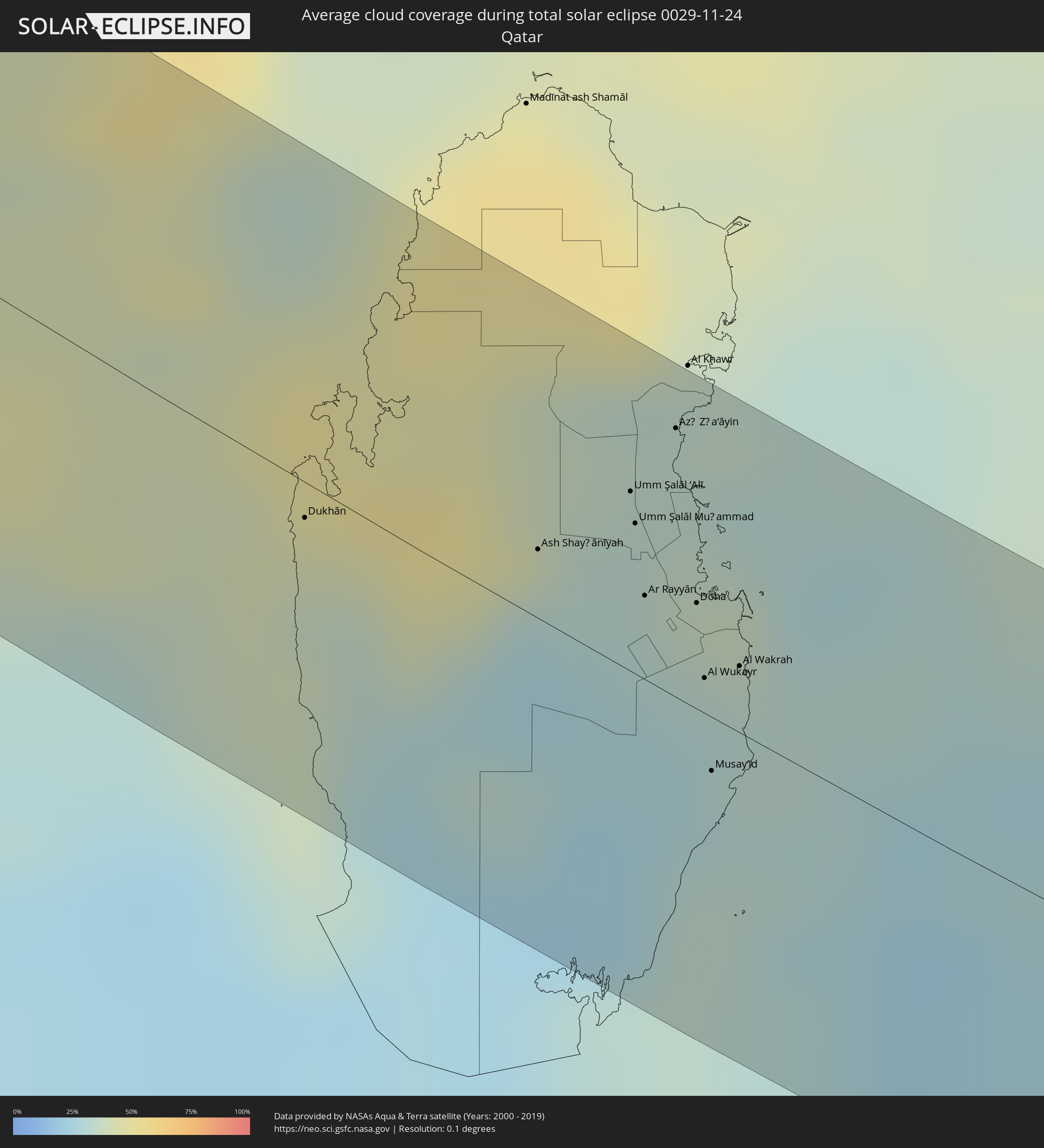 Qatar
Qatar
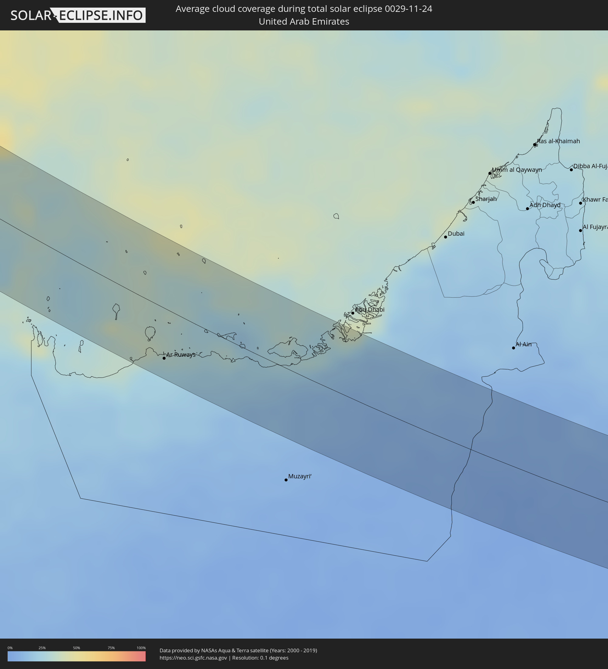 United Arab Emirates
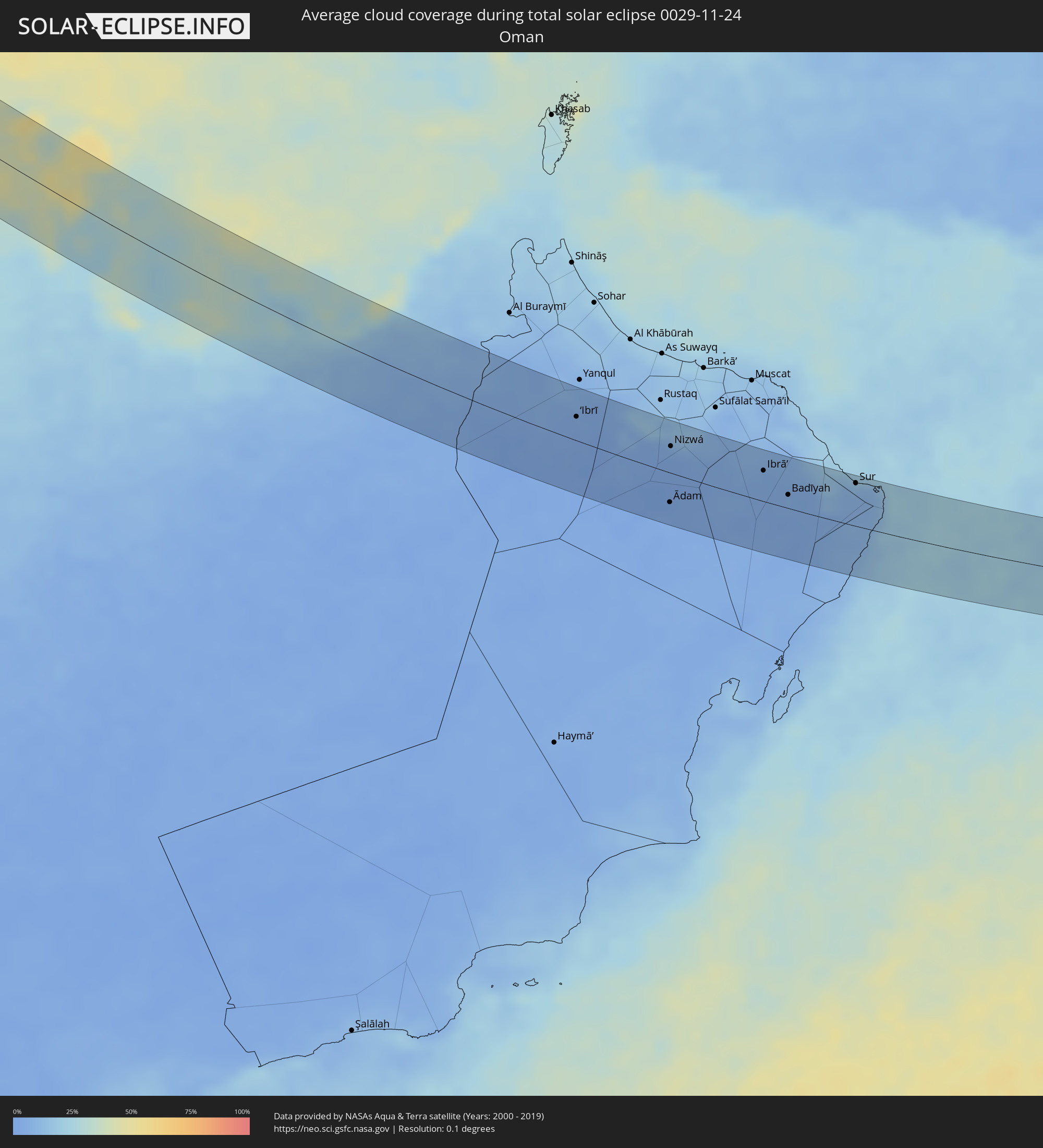 Oman
Oman
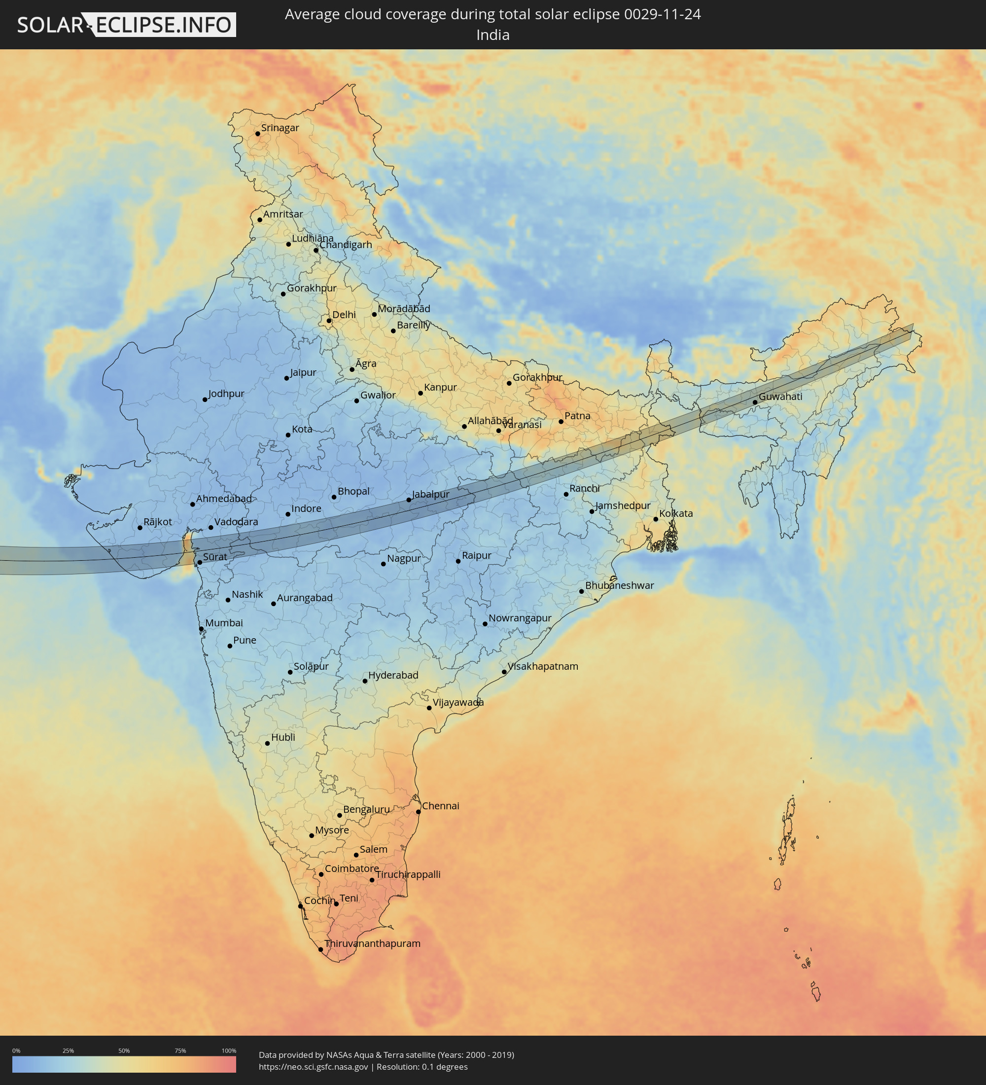 India
India
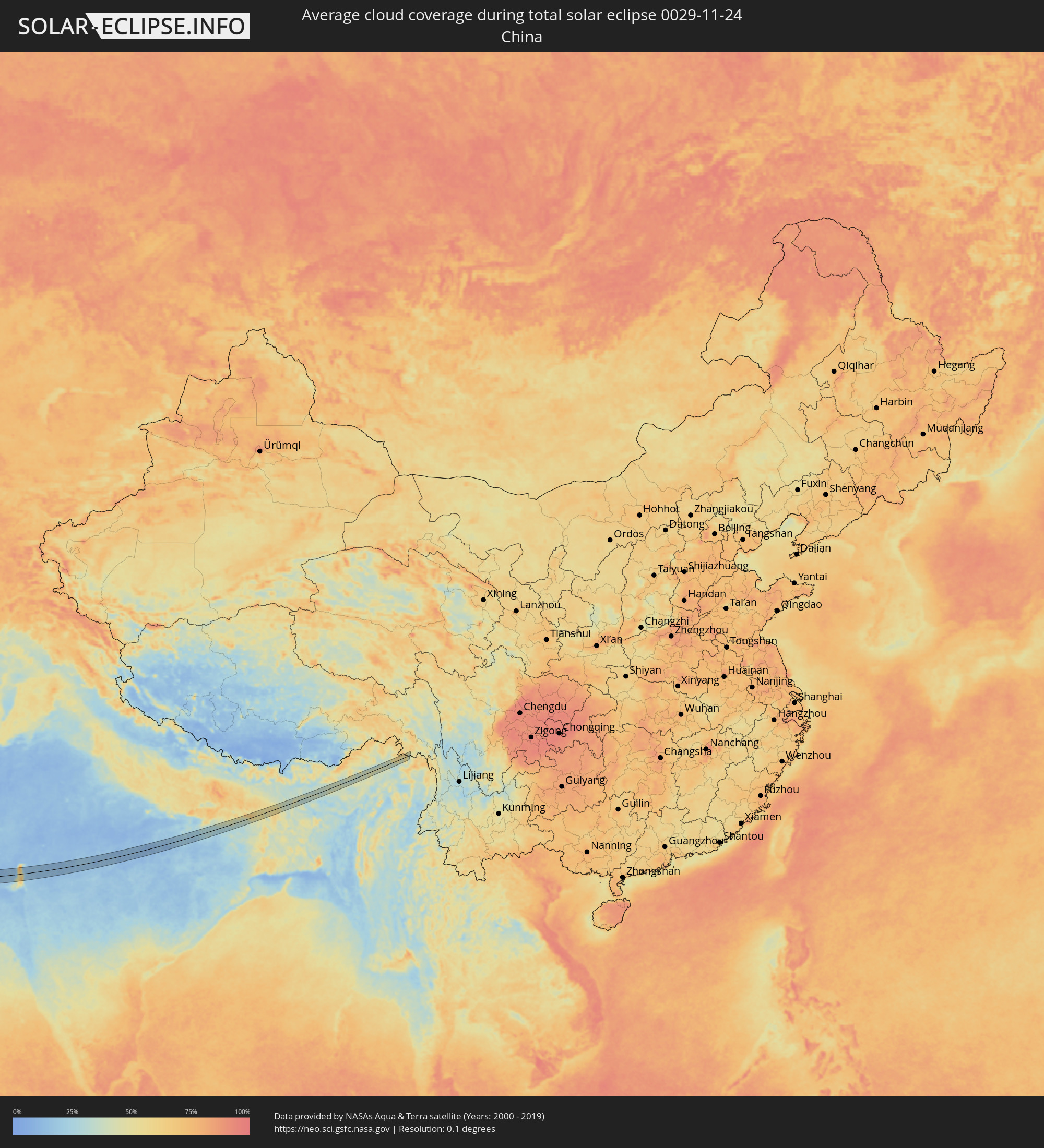 China
China
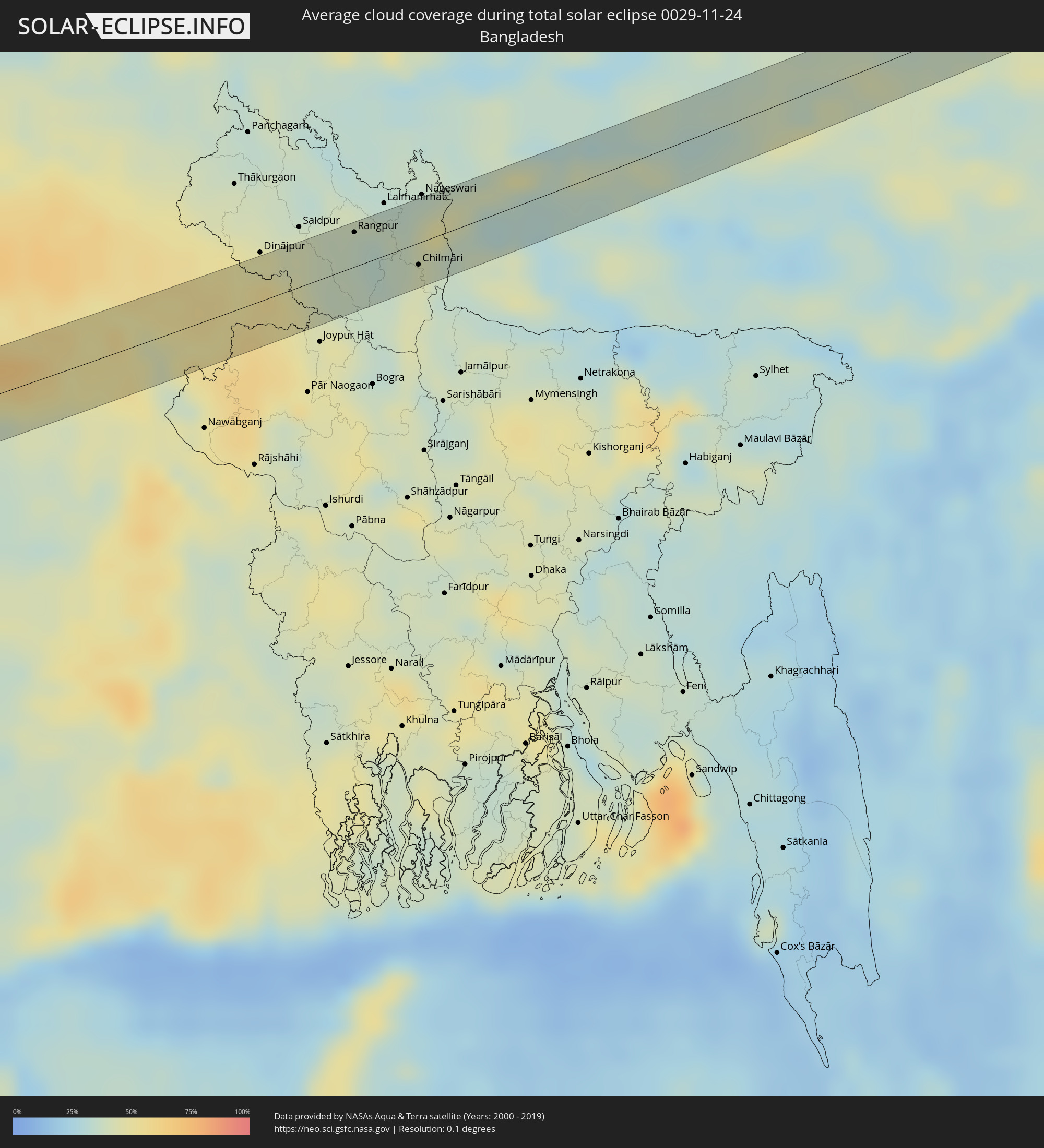 Bangladesh
Cities inside the path of the eclipse
The following table shows all locations with a population of more than 5,000 inside the eclipse path. Cities which have more than 100,000 inhabitants are marked bold. A click at the locations opens a detailed map.
| City | Type | Eclipse duration | Local time of max. eclipse | Distance to central line | Ø Cloud coverage |
|
Esbjerg, South Denmark
|
total | - | 09:15:27 UTC+01:00 | 9 km | 82% |
|
Varde, South Denmark
|
total | - | 09:15:36 UTC+01:00 | 22 km | 82% |
|
Bramming, South Denmark
|
total | - | 09:15:37 UTC+01:00 | 19 km | 82% |
|
Ribe, South Denmark
|
total | - | 09:15:33 UTC+01:00 | 11 km | 81% |
|
Tønder, South Denmark
|
total | - | 09:15:17 UTC+01:00 | 16 km | 83% |
|
Rødekro, South Denmark
|
total | - | 09:15:41 UTC+01:00 | 15 km | 80% |
|
Aabenraa, South Denmark
|
total | - | 09:15:44 UTC+01:00 | 17 km | 81% |
|
Flensburg, Schleswig-Holstein
|
total | - | 09:15:33 UTC+01:00 | 2 km | 81% |
|
Sønderborg, South Denmark
|
total | - | 09:15:53 UTC+01:00 | 24 km | 80% |
|
Kiel, Schleswig-Holstein
|
total | - | 09:15:39 UTC+01:00 | 8 km | 80% |
|
Lübeck, Schleswig-Holstein
|
total | - | 09:15:42 UTC+01:00 | 19 km | 82% |
|
Schwerin, Mecklenburg-Vorpommern
|
total | - | 09:16:03 UTC+01:00 | 5 km | 83% |
|
Wismar, Mecklenburg-Vorpommern
|
total | - | 09:16:16 UTC+01:00 | 18 km | 83% |
|
Potsdam, Brandenburg
|
total | - | 09:16:27 UTC+01:00 | 24 km | 87% |
|
Staaken, Berlin
|
total | - | 09:16:36 UTC+01:00 | 9 km | 87% |
|
Oranienburg, Brandenburg
|
total | - | 09:16:49 UTC+01:00 | 12 km | 89% |
|
Berlin, Berlin
|
total | - | 09:16:48 UTC+01:00 | 2 km | 89% |
|
Bernau bei Berlin, Brandenburg
|
total | - | 09:17:03 UTC+01:00 | 23 km | 87% |
|
Cottbus, Brandenburg
|
total | - | 09:17:03 UTC+01:00 | 14 km | 85% |
|
Görlitz, Saxony
|
total | - | 09:17:14 UTC+01:00 | 29 km | 86% |
|
Zgorzelec, Lower Silesian Voivodeship
|
total | - | 09:41:15 UTC+01:24 | 29 km | 85% |
|
Żary, Lubusz
|
total | - | 09:41:39 UTC+01:24 | 16 km | 84% |
|
Lubań, Lower Silesian Voivodeship
|
total | - | 09:41:28 UTC+01:24 | 17 km | 84% |
|
Bolesławiec, Lower Silesian Voivodeship
|
total | - | 09:41:48 UTC+01:24 | 8 km | 86% |
|
Jelenia Góra, Lower Silesian Voivodeship
|
total | - | 09:41:44 UTC+01:24 | 13 km | 81% |
|
Trutnov, Královéhradecký
|
total | - | 09:17:42 UTC+01:00 | 30 km | 92% |
|
Kamienna Góra, Lower Silesian Voivodeship
|
total | - | 09:41:56 UTC+01:24 | 7 km | 90% |
|
Náchod, Královéhradecký
|
total | - | 09:17:51 UTC+01:00 | 29 km | 89% |
|
Jawor, Lower Silesian Voivodeship
|
total | - | 09:42:14 UTC+01:24 | 22 km | 84% |
|
Wałbrzych, Lower Silesian Voivodeship
|
total | - | 09:42:09 UTC+01:24 | 5 km | 84% |
|
Świdnica, Lower Silesian Voivodeship
|
total | - | 09:42:22 UTC+01:24 | 21 km | 82% |
|
Nowa Ruda, Lower Silesian Voivodeship
|
total | - | 09:42:14 UTC+01:24 | 1 km | 87% |
|
Dzierżoniów, Lower Silesian Voivodeship
|
total | - | 09:42:27 UTC+01:24 | 20 km | 83% |
|
Kłodzko, Lower Silesian Voivodeship
|
total | - | 09:42:18 UTC+01:24 | 2 km | 84% |
|
Šumperk, Olomoucký
|
total | - | 09:18:20 UTC+01:00 | 23 km | 95% |
|
Šternberk, Olomoucký
|
total | - | 09:18:32 UTC+01:00 | 25 km | 94% |
|
Bruntál, Moravskoslezský
|
total | - | 09:18:49 UTC+01:00 | 4 km | 91% |
|
Krnov, Moravskoslezský
|
total | - | 09:19:05 UTC+01:00 | 24 km | 87% |
|
Hranice, Olomoucký
|
total | - | 09:18:51 UTC+01:00 | 17 km | 91% |
|
Opava, Moravskoslezský
|
total | - | 09:19:12 UTC+01:00 | 22 km | 85% |
|
Vsetín, Zlín
|
total | - | 09:19:00 UTC+01:00 | 20 km | 90% |
|
Nový Jičín, Moravskoslezský
|
total | - | 09:19:08 UTC+01:00 | 1 km | 88% |
|
Rožnov pod Radhoštěm, Zlín
|
total | - | 09:19:12 UTC+01:00 | 3 km | 87% |
|
Frýdek-Místek, Moravskoslezský
|
total | - | 09:19:30 UTC+01:00 | 25 km | 84% |
|
Považská Bystrica, Trenčiansky
|
total | - | 09:19:18 UTC+01:00 | 15 km | 90% |
|
Prievidza, Nitriansky
|
total | - | 09:19:21 UTC+01:00 | 31 km | 89% |
|
Žilina, Žilinský
|
total | - | 09:19:40 UTC+01:00 | 10 km | 91% |
|
Kysucké Nové Mesto, Žilinský
|
total | - | 09:19:44 UTC+01:00 | 18 km | 90% |
|
Čadca, Žilinský
|
total | - | 09:19:49 UTC+01:00 | 29 km | 89% |
|
Martin, Žilinský
|
total | - | 09:19:46 UTC+01:00 | 7 km | 91% |
|
Zvolen, Banskobystrický
|
total | - | 09:19:47 UTC+01:00 | 19 km | 89% |
|
Banská Bystrica, Banskobystrický
|
total | - | 09:19:52 UTC+01:00 | 6 km | 90% |
|
Ružomberok, Žilinský
|
total | - | 09:20:10 UTC+01:00 | 28 km | 87% |
|
Brezno, Banskobystrický
|
total | - | 09:20:22 UTC+01:00 | 24 km | 86% |
|
Lučenec, Banskobystrický
|
total | - | 09:20:12 UTC+01:00 | 11 km | 84% |
|
Salgótarján, Nógrád
|
total | - | 09:20:15 UTC+01:00 | 22 km | 85% |
|
Parádsasvár, Heves
|
total | - | 09:20:22 UTC+01:00 | 27 km | 84% |
|
Rimavská Sobota, Banskobystrický
|
total | - | 09:20:36 UTC+01:00 | 12 km | 86% |
|
Ózd, Borsod-Abaúj-Zemplén
|
total | - | 09:20:49 UTC+01:00 | 14 km | 84% |
|
Eger, Heves
|
total | - | 09:20:46 UTC+01:00 | 6 km | 83% |
|
Mezőkövesd, Borsod-Abaúj-Zemplén
|
total | - | 09:20:58 UTC+01:00 | 2 km | 81% |
|
Tiszafüred, Jász-Nagykun-Szolnok
|
total | - | 09:21:05 UTC+01:00 | 8 km | 82% |
|
Miskolc, Borsod-Abaúj-Zemplén
|
total | - | 09:21:17 UTC+01:00 | 31 km | 82% |
|
Karcag, Jász-Nagykun-Szolnok
|
total | - | 09:21:09 UTC+01:00 | 22 km | 79% |
|
Balmazújváros, Hajdú-Bihar
|
total | - | 09:21:43 UTC+01:00 | 24 km | 85% |
|
Hajdúszoboszló, Hajdú-Bihar
|
total | - | 09:21:42 UTC+01:00 | 14 km | 85% |
|
Berettyóújfalu, Hajdú-Bihar
|
total | - | 09:21:47 UTC+01:00 | 4 km | 82% |
|
Debrecen, Hajdú-Bihar
|
total | - | 09:21:59 UTC+01:00 | 33 km | 79% |
|
Salonta, Bihor
|
total | - | 10:06:10 UTC+01:44 | 23 km | 83% |
|
Oradea, Bihor
|
total | - | 10:06:33 UTC+01:44 | 11 km | 83% |
|
Brad, Hunedoara
|
total | - | 10:07:15 UTC+01:44 | 12 km | 81% |
|
Deva, Hunedoara
|
total | - | 10:07:20 UTC+01:44 | 25 km | 84% |
|
Petroşani, Hunedoara
|
total | - | 10:07:46 UTC+01:44 | 35 km | 79% |
|
Cugir, Alba
|
total | - | 10:07:52 UTC+01:44 | 2 km | 78% |
|
Alba Iulia, Alba
|
total | - | 10:08:10 UTC+01:44 | 27 km | 89% |
|
Râmnicu Vâlcea, Vâlcea
|
total | - | 10:08:54 UTC+01:44 | 3 km | 78% |
|
Curtea de Argeş, Argeş
|
total | - | 10:09:17 UTC+01:44 | 17 km | 78% |
|
Piteşti, Argeş
|
total | - | 10:09:28 UTC+01:44 | 6 km | 78% |
|
Alexandria, Teleorman
|
total | - | 10:09:56 UTC+01:44 | 34 km | 87% |
|
Giurgiu, Giurgiu
|
total | - | 10:10:44 UTC+01:44 | 5 km | 81% |
|
Ruse, Ruse
|
total | - | 10:26:20 UTC+02:00 | 7 km | 81% |
|
Popovo, Tŭrgovishte
|
total | - | 10:26:38 UTC+02:00 | 31 km | 75% |
|
Razgrad, Razgrad
|
total | - | 10:27:01 UTC+02:00 | 0 km | 72% |
|
Targovishte, Tŭrgovishte
|
total | - | 10:27:05 UTC+02:00 | 18 km | 73% |
|
Veliki Preslav, Shumen
|
total | - | 10:27:24 UTC+02:00 | 11 km | 74% |
|
Isperih, Razgrad
|
total | - | 10:27:27 UTC+02:00 | 33 km | 70% |
|
Shumen, Shumen
|
total | - | 10:27:33 UTC+02:00 | 4 km | 74% |
|
Novi Pazar, Shumen
|
total | - | 10:27:55 UTC+02:00 | 26 km | 73% |
|
Aytos, Burgas
|
total | - | 10:27:58 UTC+02:00 | 21 km | 75% |
|
Provadia, Varna
|
total | - | 10:28:14 UTC+02:00 | 27 km | 73% |
|
Burgas, Burgas
|
total | - | 10:28:15 UTC+02:00 | 23 km | 73% |
|
Pomorie, Burgas
|
total | - | 10:28:30 UTC+02:00 | 9 km | 72% |
|
Sultanbeyli, Istanbul
|
total | - | 10:27:49 UTC+01:56 | 35 km | 74% |
|
Gebze, Kocaeli
|
total | - | 10:28:04 UTC+01:56 | 37 km | 73% |
|
Karamürsel, Kocaeli
|
total | - | 10:28:21 UTC+01:56 | 35 km | 67% |
|
İzmit, Kocaeli
|
total | - | 10:28:47 UTC+01:56 | 11 km | 73% |
|
Adapazarı, Sakarya
|
total | - | 10:29:31 UTC+01:56 | 20 km | 70% |
|
Polatlı, Ankara
|
total | - | 10:32:25 UTC+01:56 | 34 km | 75% |
|
Karapınar, Konya
|
total | - | 10:35:15 UTC+01:56 | 22 km | 70% |
|
Ereğli, Konya
|
total | - | 10:36:10 UTC+01:56 | 7 km | 66% |
|
Mercin, Mersin
|
total | - | 10:37:26 UTC+01:56 | 27 km | 58% |
|
Tarsus, Mersin
|
total | - | 10:37:52 UTC+01:56 | 1 km | 63% |
|
Adana, Adana
|
total | - | 10:38:36 UTC+01:56 | 34 km | 61% |
|
Antakya, Hatay
|
total | - | 10:40:27 UTC+01:56 | 24 km | 64% |
|
Jisr ash Shughūr, Idlib
|
total | - | 11:09:12 UTC+02:25 | 4 km | 63% |
|
Salqīn, Idlib
|
total | - | 11:09:17 UTC+02:25 | 38 km | 65% |
|
Kafranbel, Idlib
|
total | - | 11:09:45 UTC+02:25 | 4 km | 54% |
|
Idlib, Idlib
|
total | - | 11:09:43 UTC+02:25 | 33 km | 63% |
|
Khān Shaykhūn, Idlib
|
total | - | 11:10:00 UTC+02:25 | 5 km | 56% |
|
Ma‘arratmişrīn, Idlib
|
total | - | 11:09:45 UTC+02:25 | 42 km | 62% |
|
Ar Rastan, Homs
|
total | - | 11:10:25 UTC+02:25 | 40 km | 62% |
|
Souran, Hama
|
total | - | 11:10:15 UTC+02:25 | 10 km | 58% |
|
Ḩamāh, Hama
|
total | - | 11:10:21 UTC+02:25 | 22 km | 64% |
|
Sarāqib, Idlib
|
total | - | 11:10:04 UTC+02:25 | 39 km | 59% |
|
As Salamīyah, Hama
|
total | - | 11:10:58 UTC+02:25 | 13 km | 57% |
|
Tadmur, Homs
|
total | - | 11:13:35 UTC+02:25 | 30 km | 64% |
|
Ar Ruţbah, Anbar
|
total | - | 11:50:58 UTC+02:57 | 35 km | 41% |
|
Al Qayşūmah, Eastern Province
|
total | - | 12:17:10 UTC+03:06 | 0 km | 49% |
|
Mulayjah, Eastern Province
|
total | - | 12:23:43 UTC+03:06 | 40 km | 56% |
|
Abqaiq, Eastern Province
|
total | - | 12:28:16 UTC+03:06 | 15 km | 42% |
|
Dhahran, Eastern Province
|
total | - | 12:28:55 UTC+03:06 | 41 km | 45% |
|
Khobar, Eastern Province
|
total | - | 12:29:10 UTC+03:06 | 46 km | 43% |
|
Dār Kulayb, Southern Governorate
|
total | - | 12:49:24 UTC+03:26 | 41 km | 46% |
|
Madīnat Ḩamad, Central Governorate
|
total | - | 12:49:21 UTC+03:26 | 46 km | 46% |
|
Madīnat ‘Īsá, Southern Governorate
|
total | - | 12:49:23 UTC+03:26 | 53 km | 52% |
|
Ar Rifā‘, Southern Governorate
|
total | - | 12:49:27 UTC+03:26 | 50 km | 44% |
|
Dukhān, Baladīyat ar Rayyān
|
total | - | 12:50:51 UTC+03:26 | 6 km | 37% |
|
Ash Shayḩānīyah, Baladīyat ar Rayyān
|
total | - | 12:51:59 UTC+03:26 | 11 km | 31% |
|
Umm Şalāl ‘Alī, Baladīyat Umm Şalāl
|
total | - | 12:52:18 UTC+03:26 | 30 km | 32% |
|
Umm Şalāl Muḩammad, Baladīyat Umm Şalāl
|
total | - | 12:52:23 UTC+03:26 | 25 km | 32% |
|
Ar Rayyān, Baladīyat ar Rayyān
|
total | - | 12:52:35 UTC+03:26 | 14 km | 30% |
|
Az̧ Z̧a‘āyin, Baladīyat az̧ Z̧a‘āyin
|
total | - | 12:52:23 UTC+03:26 | 44 km | 33% |
|
Doha, Baladīyat ad Dawḩah
|
total | - | 12:52:50 UTC+03:26 | 18 km | 33% |
|
Al Wukayr, Al Wakrah
|
total | - | 12:53:02 UTC+03:26 | 6 km | 29% |
|
Musay‘īd, Al Wakrah
|
total | - | 12:53:15 UTC+03:26 | 9 km | 31% |
|
Al Wakrah, Al Wakrah
|
total | - | 12:53:10 UTC+03:26 | 11 km | 31% |
|
Ar Ruways, Abu Dhabi
|
total | - | 13:12:19 UTC+03:41 | 39 km | 25% |
|
‘Ibrī, Az̧ Z̧āhirah
|
total | - | 13:22:47 UTC+03:41 | 25 km | 3% |
|
Bahlā’, Muḩāfaz̧at ad Dākhilīyah
|
total | - | 13:25:01 UTC+03:41 | 25 km | 4% |
|
Ādam, Muḩāfaz̧at ad Dākhilīyah
|
total | - | 13:26:20 UTC+03:41 | 31 km | 3% |
|
Nizwá, Muḩāfaz̧at ad Dākhilīyah
|
total | - | 13:25:38 UTC+03:41 | 28 km | 3% |
|
Izkī, Muḩāfaz̧at ad Dākhilīyah
|
total | - | 13:26:12 UTC+03:41 | 36 km | 5% |
|
Ibrā’, Ash Sharqiyah North Governorate
|
total | - | 13:28:22 UTC+03:41 | 33 km | 6% |
|
Al Qābil, Ash Sharqiyah North Governorate
|
total | - | 13:28:54 UTC+03:41 | 24 km | 5% |
|
Badīyah, Ash Sharqiyah North Governorate
|
total | - | 13:29:19 UTC+03:41 | 14 km | 6% |
|
Sur, Ash Sharqiyah South Governorate
|
total | - | 13:30:54 UTC+03:41 | 46 km | 11% |
|
Porbandar, Gujarat
|
total | - | 15:33:39 UTC+05:21 | 36 km | 14% |
|
Jūnāgadh, Gujarat
|
total | - | 15:35:23 UTC+05:21 | 17 km | 12% |
|
Jetpur, Gujarat
|
total | - | 15:35:23 UTC+05:21 | 42 km | 12% |
|
Bhāvnagar, Gujarat
|
total | - | 15:38:04 UTC+05:21 | 29 km | 21% |
|
Bharūch, Gujarat
|
total | - | 15:39:34 UTC+05:21 | 9 km | 17% |
|
Khandwa, Madhya Pradesh
|
total | - | 15:44:42 UTC+05:21 | 32 km | 15% |
|
Punāsa, Madhya Pradesh
|
total | - | 15:44:16 UTC+05:21 | 12 km | 15% |
|
Jabalpur, Madhya Pradesh
|
total | - | 15:48:00 UTC+05:21 | 32 km | 11% |
|
Ingrāj Bāzār, West Bengal
|
total | - | 15:54:24 UTC+05:21 | 18 km | 45% |
|
Bālurghāt, West Bengal
|
total | - | 15:54:40 UTC+05:21 | 17 km | 52% |
|
Parbatipur, Rangpur Division
|
total | - | 16:26:25 UTC+05:53 | 24 km | 43% |
|
Badarganj, Rangpur Division
|
total | - | 16:26:30 UTC+05:53 | 21 km | 38% |
|
Rangpur, Rangpur Division
|
total | - | 16:26:34 UTC+05:53 | 21 km | 35% |
|
Chilmāri, Rangpur Division
|
total | - | 16:27:08 UTC+05:53 | 13 km | 42% |
|
Guwahati, Assam
|
total | - | 15:55:44 UTC+05:21 | 22 km | 31% |
|
Dibrugarh, Assam
|
total | - | 15:56:07 UTC+05:21 | 7 km | 40% |