Totale Sonnenfinsternis vom 26.07.0203
| Wochentag: | Dienstag |
| Maximale Dauer der Verfinsterung: | 02m09s |
| Maximale Breite des Finsternispfades: | 229 km |
| Saroszyklus: | 68 |
| Bedeckungsgrad: | 100% |
| Magnitude: | 1.0355 |
| Gamma: | 0.8516 |
Wo kann man die Sonnenfinsternis vom 26.07.0203 sehen?
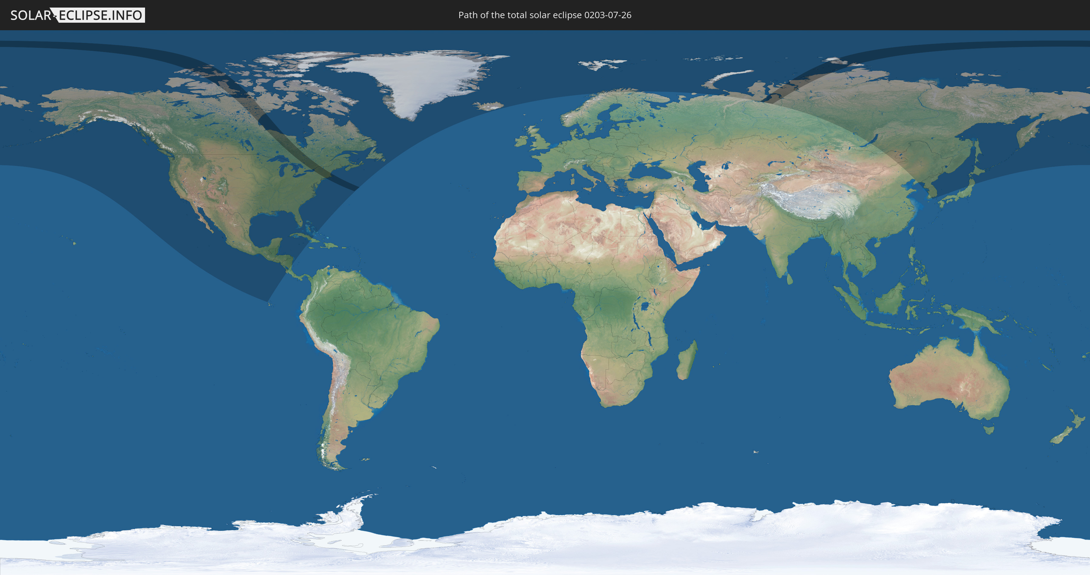
Die Sonnenfinsternis am 26.07.0203 kann man in 25 Ländern als partielle Sonnenfinsternis beobachten.
Der Finsternispfad verläuft durch 3 Länder. Nur in diesen Ländern ist sie als totale Sonnenfinsternis zu sehen.
In den folgenden Ländern ist die Sonnenfinsternis total zu sehen
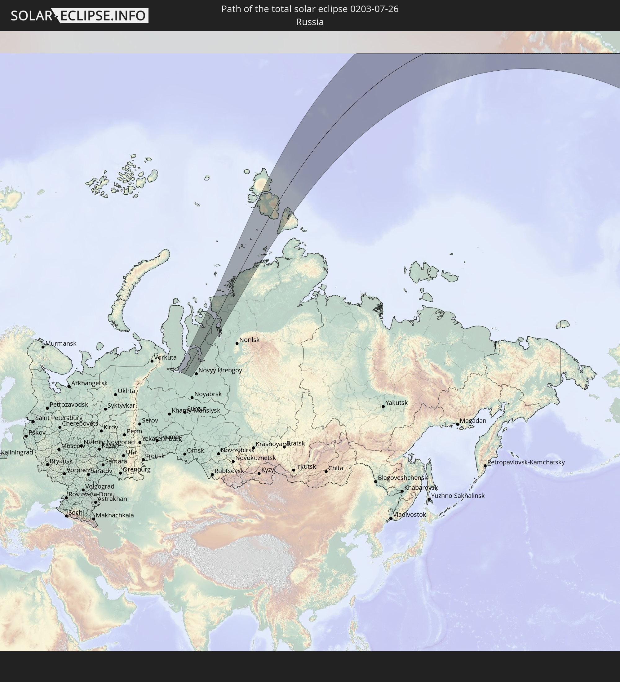 Russland
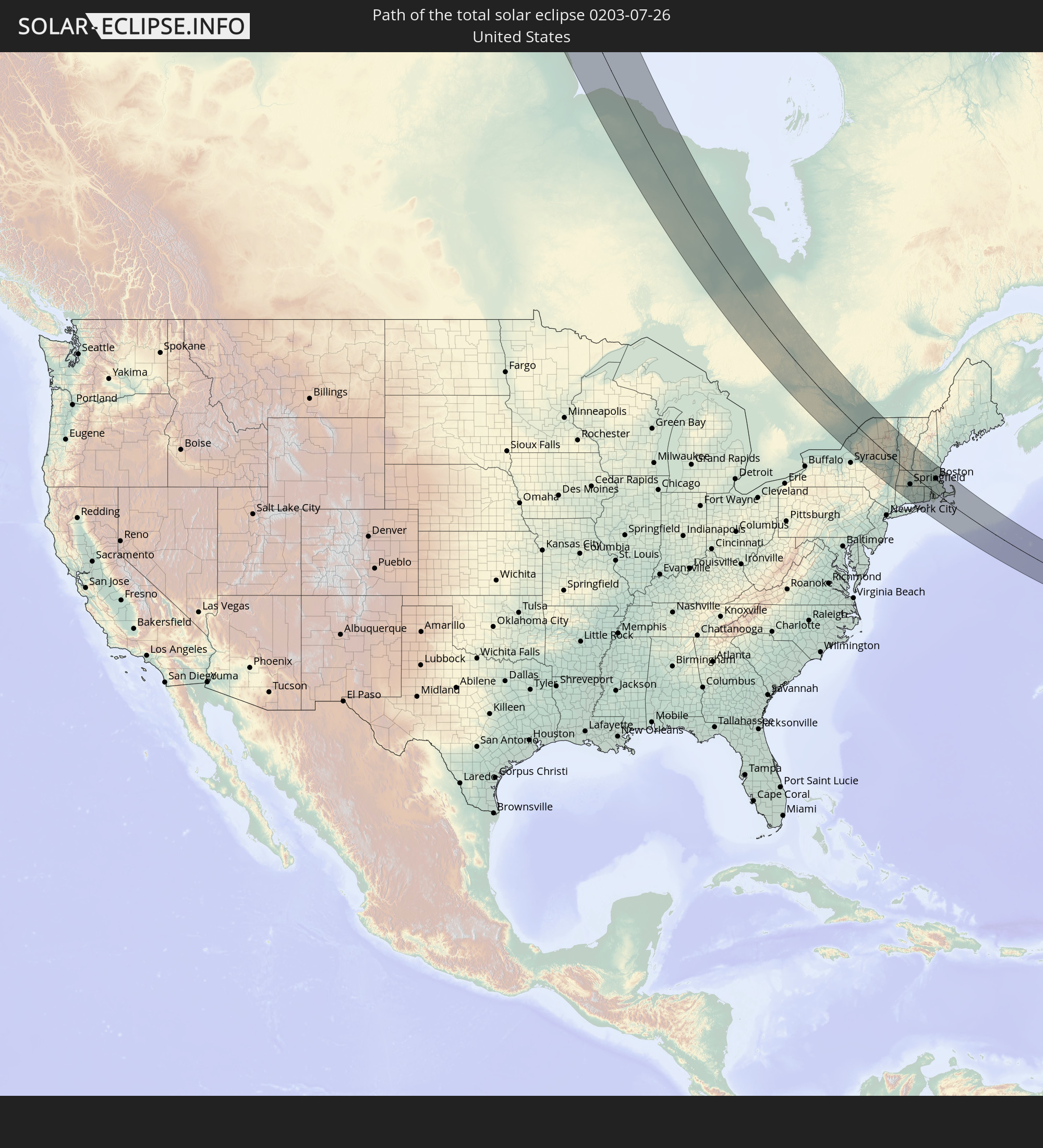 Vereinigte Staaten
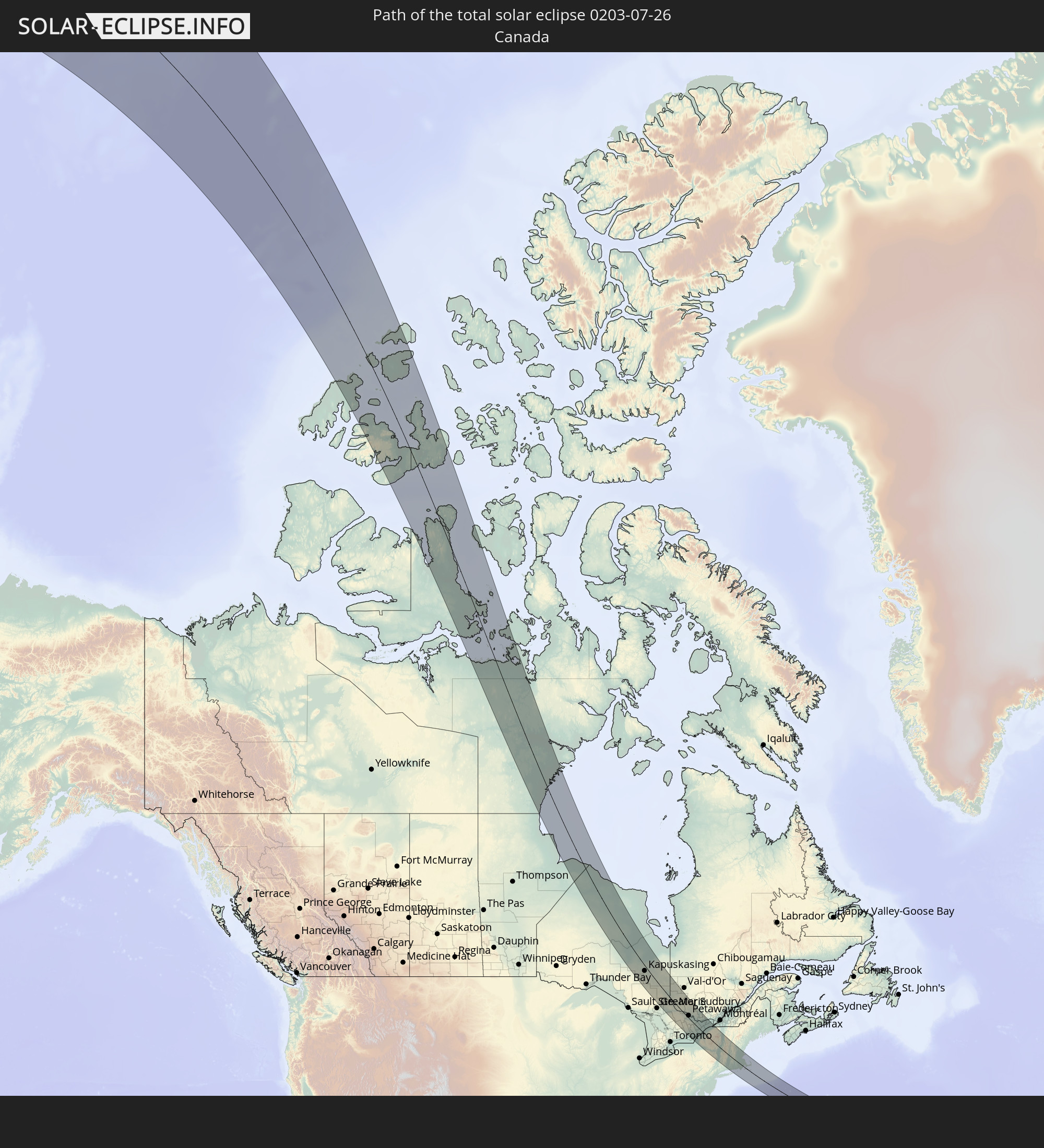 Kanada
In den folgenden Ländern ist die Sonnenfinsternis partiell zu sehen


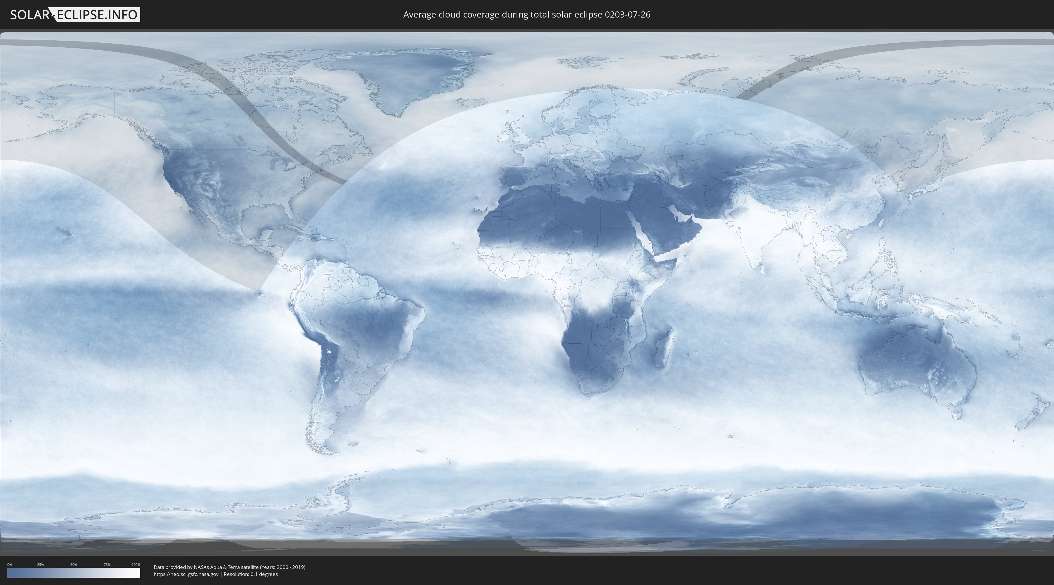
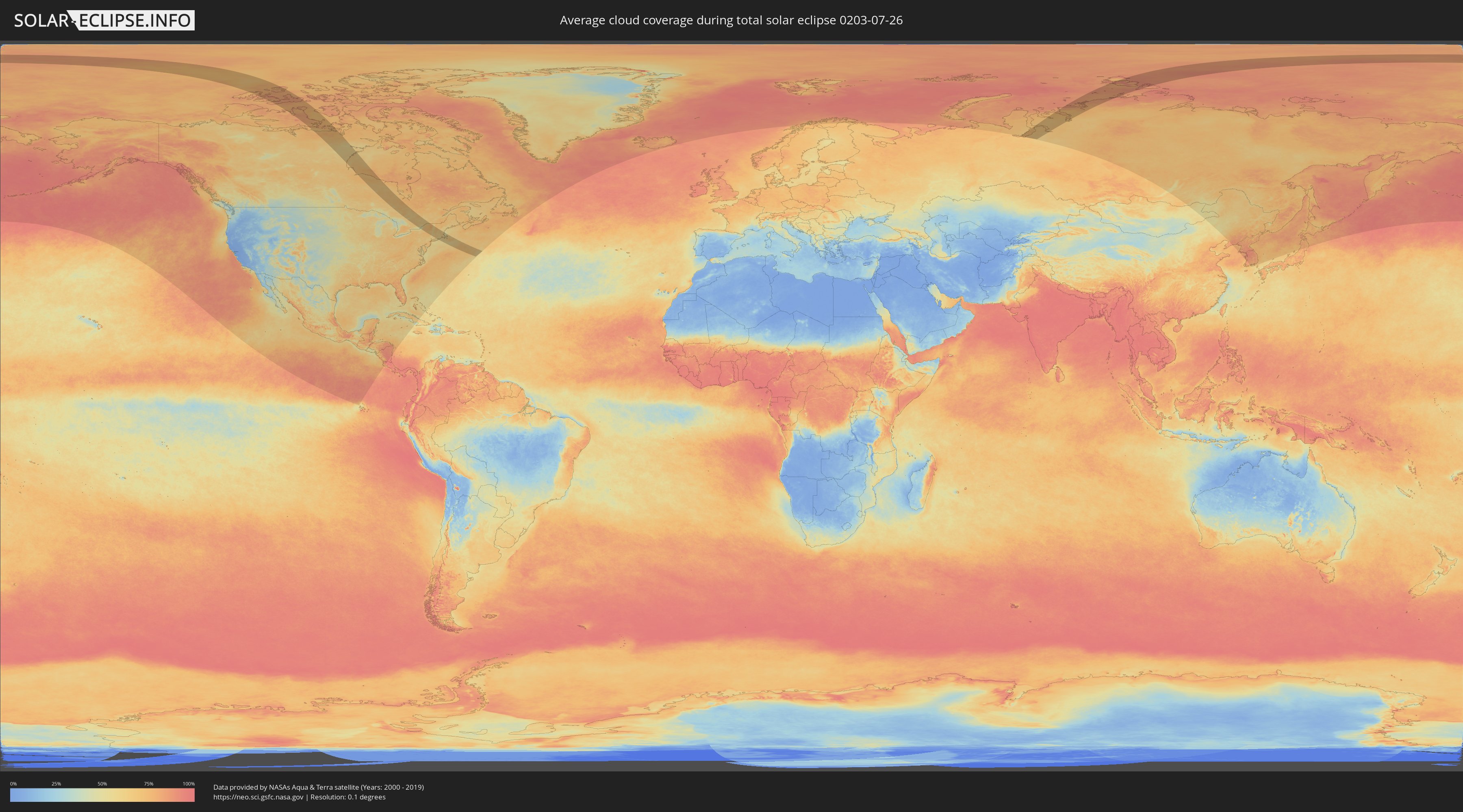
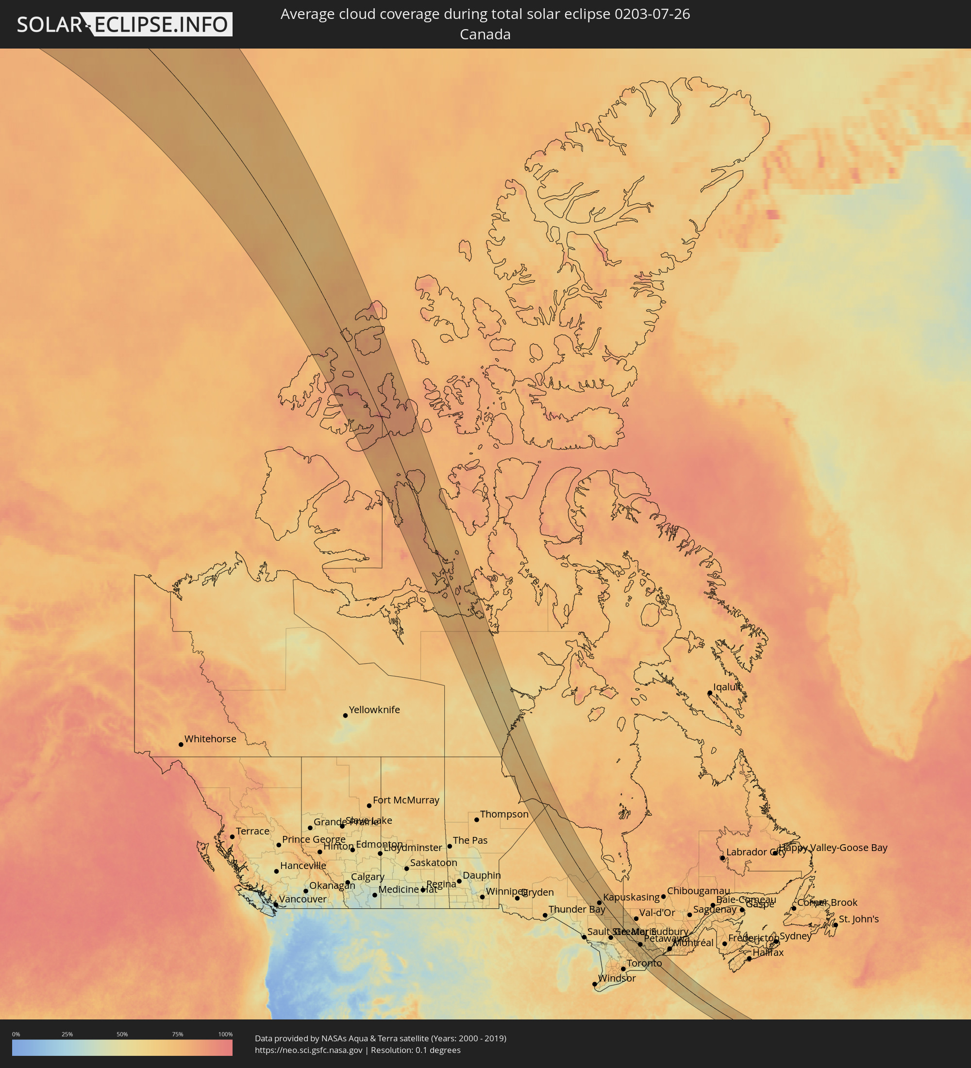
Wie wird das Wetter während der totalen Sonnenfinsternis am 26.07.0203?
Wo ist der beste Ort, um die totale Sonnenfinsternis vom 26.07.0203 zu beobachten?
Die folgenden Karten zeigen die durchschnittliche Bewölkung für den Tag, an dem die totale Sonnenfinsternis
stattfindet. Mit Hilfe der Karten lässt sich der Ort entlang des Finsternispfades eingrenzen,
der die besten Aussichen auf einen klaren wolkenfreien Himmel bietet.
Trotzdem muss man immer lokale Gegenenheiten beachten und sollte sich genau über das Wetter an seinem
gewählten Beobachtungsort informieren.
Die Daten stammen von den beiden NASA-Satelliten
AQUA und TERRA
und wurden über einen Zeitraum von 19 Jahren (2000 - 2019) gemittelt.
Detaillierte Länderkarten
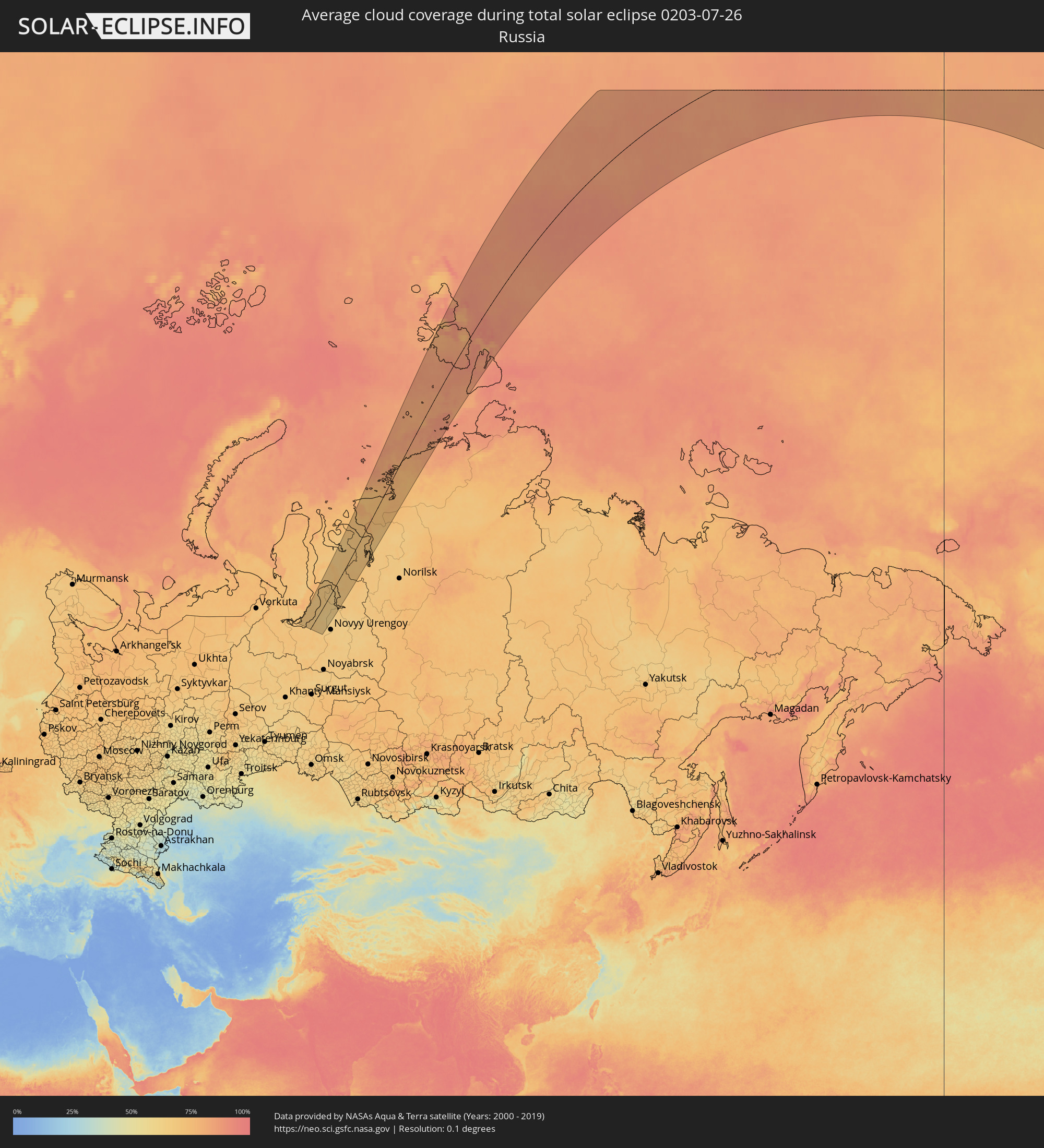 Russland
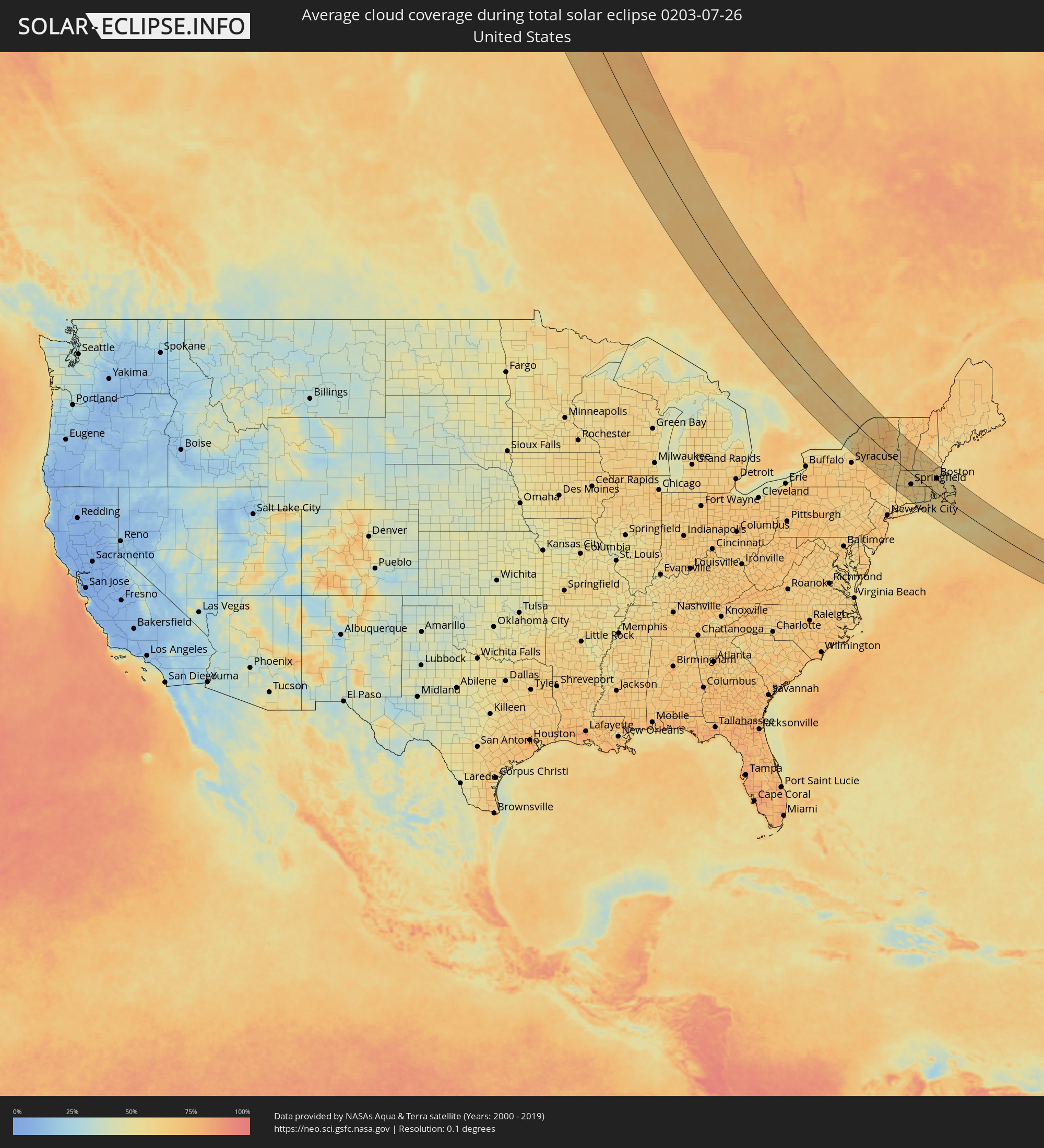 Vereinigte Staaten
 Kanada
Orte im Finsternispfad
Die nachfolgene Tabelle zeigt Städte und Orte mit mehr als 5.000 Einwohnern, die sich im Finsternispfad befinden. Städte mit mehr als 100.000 Einwohnern sind dick gekennzeichnet. Mit einem Klick auf den Ort öffnet sich eine Detailkarte die die Lage des jeweiligen Ortes zusammen mit dem Verlauf der zentralen Finsternis präsentiert.
| Ort | Typ | Dauer der Verfinsterung | Ortszeit bei maximaler Verfinsterung | Entfernung zur Zentrallinie | Ø Bewölkung |
 Kapuskasing, Ontario
|
total | - | 18:04:23 UTC-05:00 | 31 km | 68% |
|
Timmins, Ontario
|
total | - | 18:05:59 UTC-05:00 | 27 km | 67% |
|
Kirkland Lake, Ontario
|
total | - | 18:06:27 UTC-05:00 | 25 km | 66% |
|
Temiskaming Shores, Ontario
|
total | - | 18:07:32 UTC-05:00 | 3 km | 63% |
|
North Bay, Ontario
|
total | - | 18:09:29 UTC-05:00 | 75 km | 51% |
|
La Sarre, Quebec
|
total | - | 18:05:15 UTC-05:00 | 119 km | 68% |
|
Rouyn-Noranda, Quebec
|
total | - | 18:06:11 UTC-05:00 | 90 km | 63% |
|
Petawawa, Ontario
|
total | - | 18:09:53 UTC-05:00 | 16 km | 64% |
|
Pembroke, Ontario
|
total | - | 18:09:59 UTC-05:00 | 19 km | 64% |
|
Greater Napanee, Ontario
|
total | - | 18:12:30 UTC-05:00 | 95 km | 62% |
|
Renfrew, Ontario
|
total | - | 18:10:29 UTC-05:00 | 16 km | 65% |
|
Kingston, Ontario
|
total | - | 18:12:26 UTC-05:00 | 71 km | 49% |
|
Arnprior, Ontario
|
total | - | 18:10:28 UTC-05:00 | 32 km | 65% |
|
Perth, Ontario
|
total | - | 18:11:19 UTC-05:00 | 4 km | 58% |
|
Gananoque, Ontario
|
total | - | 18:12:13 UTC-05:00 | 45 km | 50% |
|
Carleton Place, Ontario
|
total | - | 18:10:55 UTC-05:00 | 20 km | 65% |
|
Smiths Falls, Ontario
|
total | - | 18:11:16 UTC-05:00 | 9 km | 63% |
 Watertown, New York
|
total | - | 18:12:44 UTC-05:00 | 60 km | 67% |
|
Bells Corners, Ontario
|
total | - | 18:10:34 UTC-05:00 | 52 km | 64% |
|
le Plateau, Quebec
|
total | - | 18:10:22 UTC-05:00 | 64 km | 63% |
|
Fort Drum, New York
|
total | - | 18:12:34 UTC-05:00 | 45 km | 64% |
|
Gatineau, Quebec
|
total | - | 18:10:17 UTC-05:00 | 72 km | 66% |
|
Ottawa, Ontario
|
total | - | 18:10:23 UTC-05:00 | 67 km | 66% |
|
Brockville, Ontario
|
total | - | 18:11:42 UTC-05:00 | 2 km | 61% |
|
Val-des-Monts, Quebec
|
total | - | 18:09:59 UTC-05:00 | 87 km | 61% |
|
Ogdensburg, New York
|
total | - | 18:11:30 UTC-05:00 | 21 km | 62% |
|
Rome, New York
|
total | - | 18:13:51 UTC-05:00 | 98 km | 64% |
|
Clarence-Rockland, Ontario
|
total | - | 18:10:05 UTC-05:00 | 100 km | 62% |
|
Utica, New York
|
total | - | 18:13:58 UTC-05:00 | 96 km | 69% |
|
Ilion, New York
|
total | - | 18:14:03 UTC-05:00 | 92 km | 69% |
|
Herkimer, New York
|
total | - | 18:14:02 UTC-05:00 | 89 km | 69% |
|
Potsdam, New York
|
total | - | 18:11:26 UTC-05:00 | 47 km | 65% |
|
Massena, New York
|
total | - | 18:11:00 UTC-05:00 | 73 km | 65% |
|
Cornwall, Ontario
|
total | - | 18:10:49 UTC-05:00 | 89 km | 62% |
|
Gloversville, New York
|
total | - | 18:13:50 UTC-05:00 | 52 km | 66% |
|
Amsterdam, New York
|
total | - | 18:13:58 UTC-05:00 | 54 km | 63% |
|
Scotia, New York
|
total | - | 18:14:05 UTC-05:00 | 51 km | 67% |
|
Schenectady, New York
|
total | - | 18:14:06 UTC-05:00 | 51 km | 65% |
|
Colonie, New York
|
total | - | 18:14:13 UTC-05:00 | 54 km | 65% |
|
Saratoga Springs, New York
|
total | - | 18:13:39 UTC-05:00 | 20 km | 63% |
|
Oakdale, New York
|
total | - | 18:14:56 UTC-05:00 | 91 km | 58% |
|
Albany, New York
|
total | - | 18:14:18 UTC-05:00 | 55 km | 65% |
|
Glens Falls, New York
|
total | - | 18:13:15 UTC-05:00 | 7 km | 61% |
|
Pittsfield, Massachusetts
|
total | - | 18:14:29 UTC-05:00 | 46 km | 59% |
|
Bennington, Vermont
|
total | - | 18:13:49 UTC-05:00 | 7 km | 68% |
|
Torrington, Connecticut
|
total | - | 18:15:26 UTC-05:00 | 96 km | 66% |
|
North Adams, Massachusetts
|
total | - | 18:14:04 UTC-05:00 | 17 km | 64% |
|
Winsted, Connecticut
|
total | - | 18:15:14 UTC-05:00 | 82 km | 64% |
|
Rutland, Vermont
|
total | - | 18:12:37 UTC-05:00 | 67 km | 66% |
|
Bristol, Connecticut
|
total | - | 18:15:35 UTC-05:00 | 98 km | 66% |
|
Meriden, Connecticut
|
total | - | 18:15:45 UTC-05:00 | 102 km | 62% |
|
Southwick, Massachusetts
|
total | - | 18:14:57 UTC-05:00 | 55 km | 61% |
|
Hartford, Connecticut
|
total | - | 18:15:22 UTC-05:00 | 76 km | 66% |
|
Northampton, Massachusetts
|
total | - | 18:14:30 UTC-05:00 | 25 km | 62% |
|
Windsor Locks, Connecticut
|
total | - | 18:15:06 UTC-05:00 | 59 km | 64% |
|
Greenfield, Massachusetts
|
total | - | 18:14:06 UTC-05:00 | 0 km | 58% |
|
Springfield, Massachusetts
|
total | - | 18:14:50 UTC-05:00 | 42 km | 63% |
|
Southwood Acres, Connecticut
|
total | - | 18:15:02 UTC-05:00 | 53 km | 63% |
|
East Haddam, Connecticut
|
total | - | 18:15:47 UTC-05:00 | 92 km | 58% |
|
Rockville, Connecticut
|
total | - | 18:15:09 UTC-05:00 | 55 km | 61% |
|
Old Saybrook, Connecticut
|
total | - | 18:16:00 UTC-05:00 | 102 km | 60% |
|
Tolland, Connecticut
|
total | - | 18:15:07 UTC-05:00 | 51 km | 61% |
|
Hebron, Connecticut
|
total | - | 18:15:26 UTC-05:00 | 69 km | 62% |
|
Claremont, New Hampshire
|
total | - | 18:12:49 UTC-05:00 | 80 km | 64% |
|
Palmer, Massachusetts
|
total | - | 18:14:40 UTC-05:00 | 24 km | 64% |
|
Keene, New Hampshire
|
total | - | 18:13:28 UTC-05:00 | 46 km | 63% |
|
Lebanon, New Hampshire
|
total | - | 18:12:23 UTC-05:00 | 108 km | 68% |
|
Mansfield City, Connecticut
|
total | - | 18:15:14 UTC-05:00 | 53 km | 63% |
|
Athol, Massachusetts
|
total | - | 18:13:58 UTC-05:00 | 20 km | 61% |
|
New London, Connecticut
|
total | - | 18:15:49 UTC-05:00 | 82 km | 57% |
|
Norwich, Connecticut
|
total | - | 18:15:33 UTC-05:00 | 66 km | 55% |
|
Southbridge, Massachusetts
|
total | - | 18:14:43 UTC-05:00 | 16 km | 61% |
|
Gardner, Massachusetts
|
total | - | 18:13:56 UTC-05:00 | 30 km | 63% |
|
Plainfield, Connecticut
|
total | - | 18:15:17 UTC-05:00 | 45 km | 60% |
|
Killingly Center, Connecticut
|
total | - | 18:15:01 UTC-05:00 | 28 km | 64% |
|
Westerly, Rhode Island
|
total | - | 18:15:42 UTC-05:00 | 67 km | 59% |
|
Worcester, Massachusetts
|
total | - | 18:14:21 UTC-05:00 | 12 km | 62% |
|
West Boylston, Massachusetts
|
total | - | 18:14:12 UTC-05:00 | 22 km | 61% |
|
Leominster, Massachusetts
|
total | - | 18:13:57 UTC-05:00 | 37 km | 62% |
|
Weare, New Hampshire
|
total | - | 18:13:04 UTC-05:00 | 88 km | 66% |
|
Coventry, Rhode Island
|
total | - | 18:15:10 UTC-05:00 | 31 km | 59% |
|
Lancaster, Massachusetts
|
total | - | 18:14:02 UTC-05:00 | 36 km | 63% |
|
Milford, New Hampshire
|
total | - | 18:13:27 UTC-05:00 | 70 km | 66% |
|
Charlestown, Rhode Island
|
total | - | 18:15:38 UTC-05:00 | 57 km | 59% |
|
Hollis, New Hampshire
|
total | - | 18:13:34 UTC-05:00 | 65 km | 65% |
|
Hudson, Massachusetts
|
total | - | 18:14:06 UTC-05:00 | 36 km | 64% |
|
Concord, New Hampshire
|
total | - | 18:12:51 UTC-05:00 | 108 km | 65% |
|
Milford, Massachusetts
|
total | - | 18:14:27 UTC-05:00 | 16 km | 63% |
|
Woonsocket, Rhode Island
|
total | - | 18:14:40 UTC-05:00 | 4 km | 61% |
|
Nashua, New Hampshire
|
total | - | 18:13:30 UTC-05:00 | 73 km | 66% |
|
Cumberland Hill, Rhode Island
|
total | - | 18:14:41 UTC-05:00 | 4 km | 61% |
|
North Kingstown, Rhode Island
|
total | - | 18:15:20 UTC-05:00 | 33 km | 57% |
|
Manchester, New Hampshire
|
total | - | 18:13:09 UTC-05:00 | 94 km | 66% |
|
Acton, Massachusetts
|
total | - | 18:13:55 UTC-05:00 | 51 km | 66% |
|
Framingham, Massachusetts
|
total | - | 18:14:13 UTC-05:00 | 33 km | 64% |
|
Providence, Rhode Island
|
total | - | 18:14:54 UTC-05:00 | 6 km | 63% |
|
Plainville, Massachusetts
|
total | - | 18:14:36 UTC-05:00 | 14 km | 63% |
|
Norfolk, Massachusetts
|
total | - | 18:14:26 UTC-05:00 | 24 km | 62% |
|
Lowell, Massachusetts
|
total | - | 18:13:39 UTC-05:00 | 70 km | 66% |
|
Derry Village, New Hampshire
|
total | - | 18:13:16 UTC-05:00 | 92 km | 62% |
|
Newport East, Rhode Island
|
total | - | 18:15:19 UTC-05:00 | 27 km | 60% |
|
Attleboro, Massachusetts
|
total | - | 18:14:41 UTC-05:00 | 11 km | 62% |
|
Needham, Massachusetts
|
total | - | 18:14:09 UTC-05:00 | 43 km | 64% |
|
Tiverton, Rhode Island
|
total | - | 18:15:08 UTC-05:00 | 14 km | 55% |
|
Fall River, Massachusetts
|
total | - | 18:15:00 UTC-05:00 | 4 km | 56% |
|
Woburn, Massachusetts
|
total | - | 18:13:50 UTC-05:00 | 64 km | 66% |
|
Plaistow, New Hampshire
|
total | - | 18:13:17 UTC-05:00 | 99 km | 60% |
|
Taunton, Massachusetts
|
total | - | 18:14:41 UTC-05:00 | 17 km | 59% |
|
Haverhill, Massachusetts
|
total | - | 18:13:22 UTC-05:00 | 94 km | 60% |
|
Boston, Massachusetts
|
total | - | 18:13:59 UTC-05:00 | 59 km | 63% |
|
Brockton, Massachusetts
|
total | - | 18:14:23 UTC-05:00 | 36 km | 61% |
|
Middleton, Massachusetts
|
total | - | 18:13:37 UTC-05:00 | 81 km | 60% |
|
Bridgewater, Massachusetts
|
total | - | 18:14:31 UTC-05:00 | 30 km | 60% |
|
Lynn, Massachusetts
|
total | - | 18:13:48 UTC-05:00 | 74 km | 61% |
|
Weymouth, Massachusetts
|
total | - | 18:14:10 UTC-05:00 | 52 km | 60% |
|
New Bedford, Massachusetts
|
total | - | 18:15:02 UTC-05:00 | 1 km | 60% |
|
Amesbury, Massachusetts
|
total | - | 18:13:12 UTC-05:00 | 109 km | 57% |
|
Halifax, Massachusetts
|
total | - | 18:14:29 UTC-05:00 | 36 km | 60% |
|
Hanover, Massachusetts
|
total | - | 18:14:17 UTC-05:00 | 49 km | 56% |
|
Kingston, Massachusetts
|
total | - | 18:14:26 UTC-05:00 | 43 km | 58% |
|
Plymouth, Massachusetts
|
total | - | 18:14:28 UTC-05:00 | 43 km | 58% |
|
Gloucester, Massachusetts
|
total | - | 18:13:29 UTC-05:00 | 101 km | 57% |
|
Mashpee, Massachusetts
|
total | - | 18:14:52 UTC-05:00 | 29 km | 61% |
|
Barnstable, Massachusetts
|
total | - | 18:14:44 UTC-05:00 | 39 km | 60% |
|
Harwich, Massachusetts
|
total | - | 18:14:41 UTC-05:00 | 49 km | 63% |