Totale Sonnenfinsternis vom 09.10.0348
| Wochentag: | Samstag |
| Maximale Dauer der Verfinsterung: | 04m07s |
| Maximale Breite des Finsternispfades: | 185 km |
| Saroszyklus: | 78 |
| Bedeckungsgrad: | 100% |
| Magnitude: | 1.0501 |
| Gamma: | 0.454 |
Wo kann man die Sonnenfinsternis vom 09.10.0348 sehen?
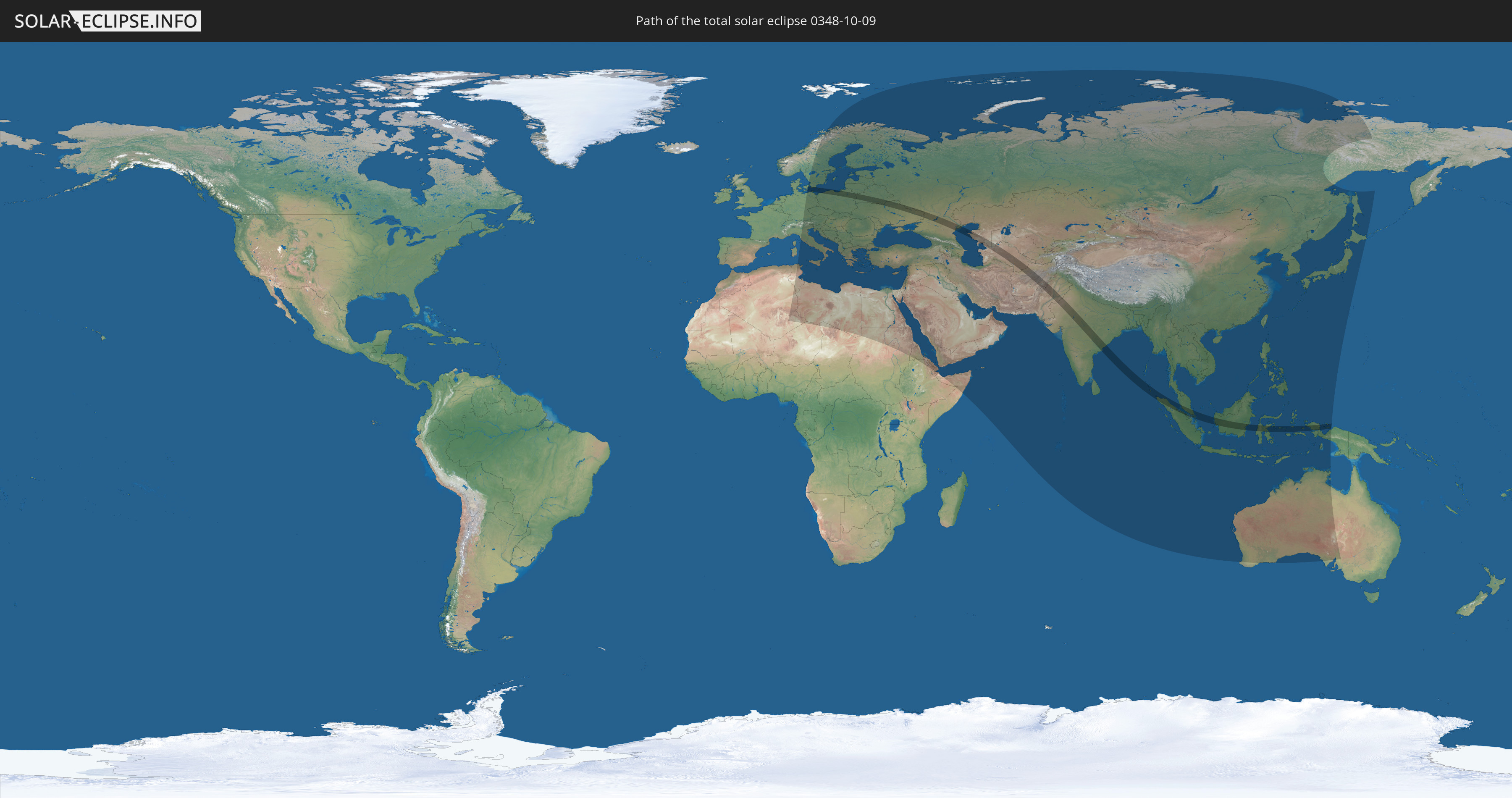
Die Sonnenfinsternis am 09.10.0348 kann man in 100 Ländern als partielle Sonnenfinsternis beobachten.
Der Finsternispfad verläuft durch 17 Länder. Nur in diesen Ländern ist sie als totale Sonnenfinsternis zu sehen.
In den folgenden Ländern ist die Sonnenfinsternis total zu sehen
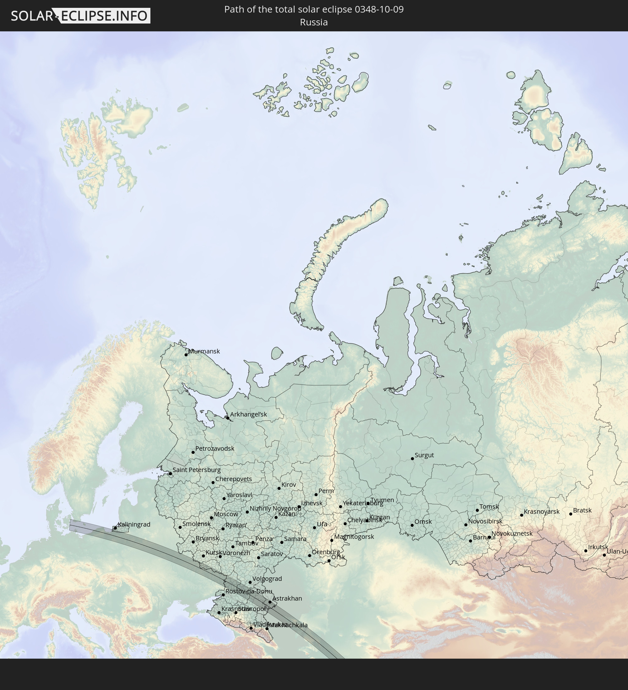 Russland
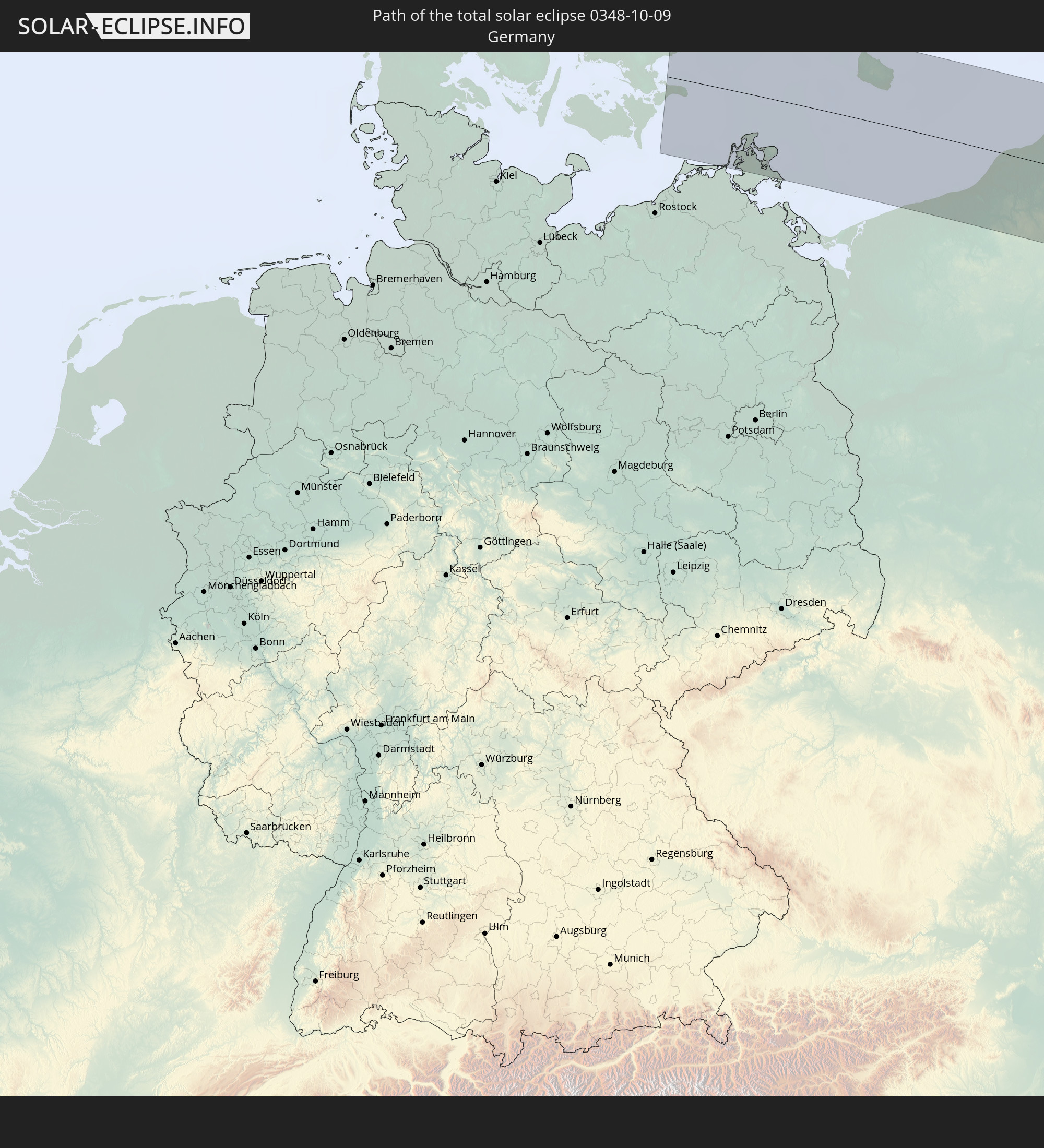 Deutschland
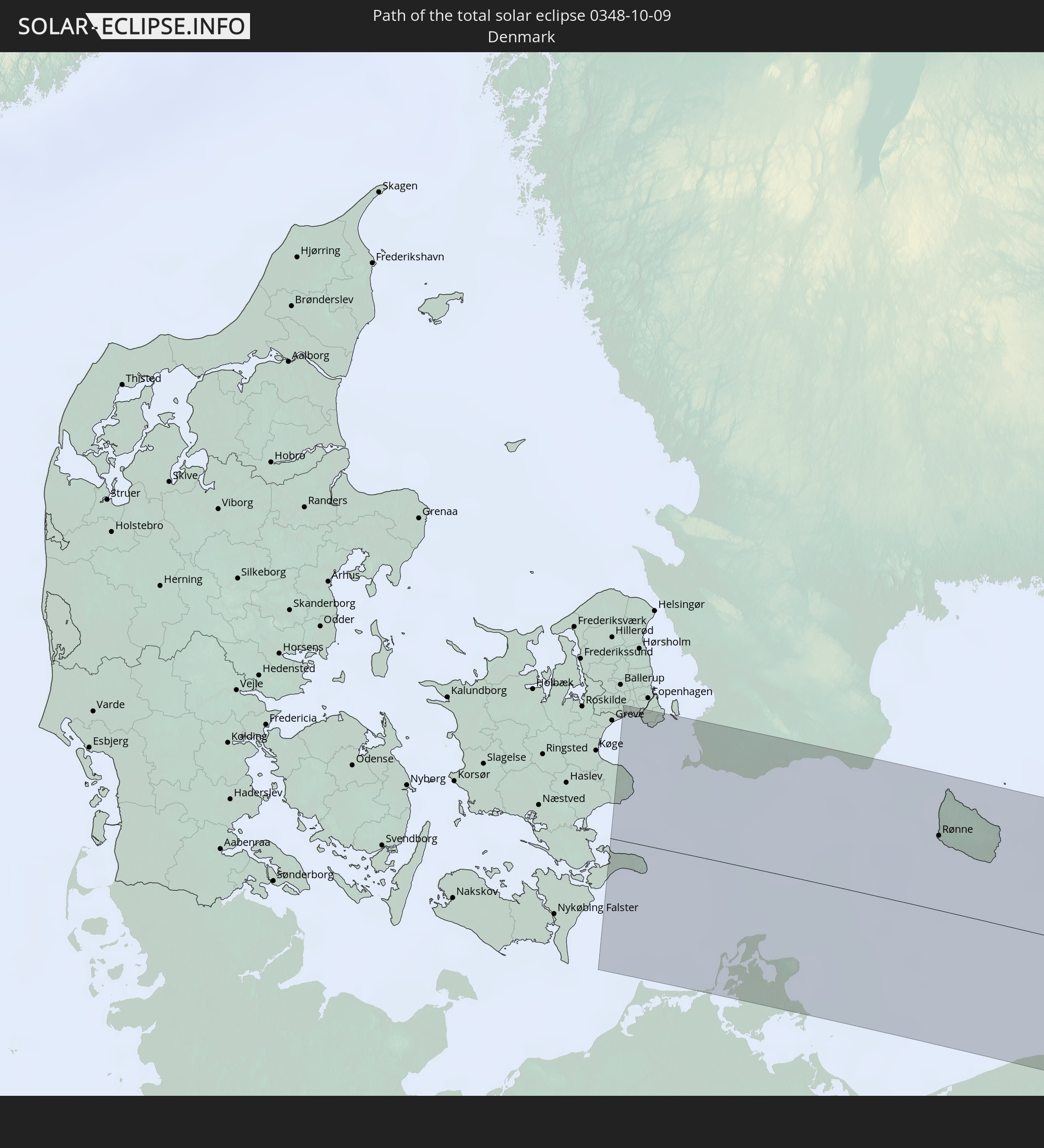 Dänemark
 Schweden
 Polen
Polen
 Litauen
 Ukraine
 Weißrussland
 Kasachstan
 Turkmenistan
 Usbekistan
 Afghanistan
 Pakistan
 Indien
 Indonesien
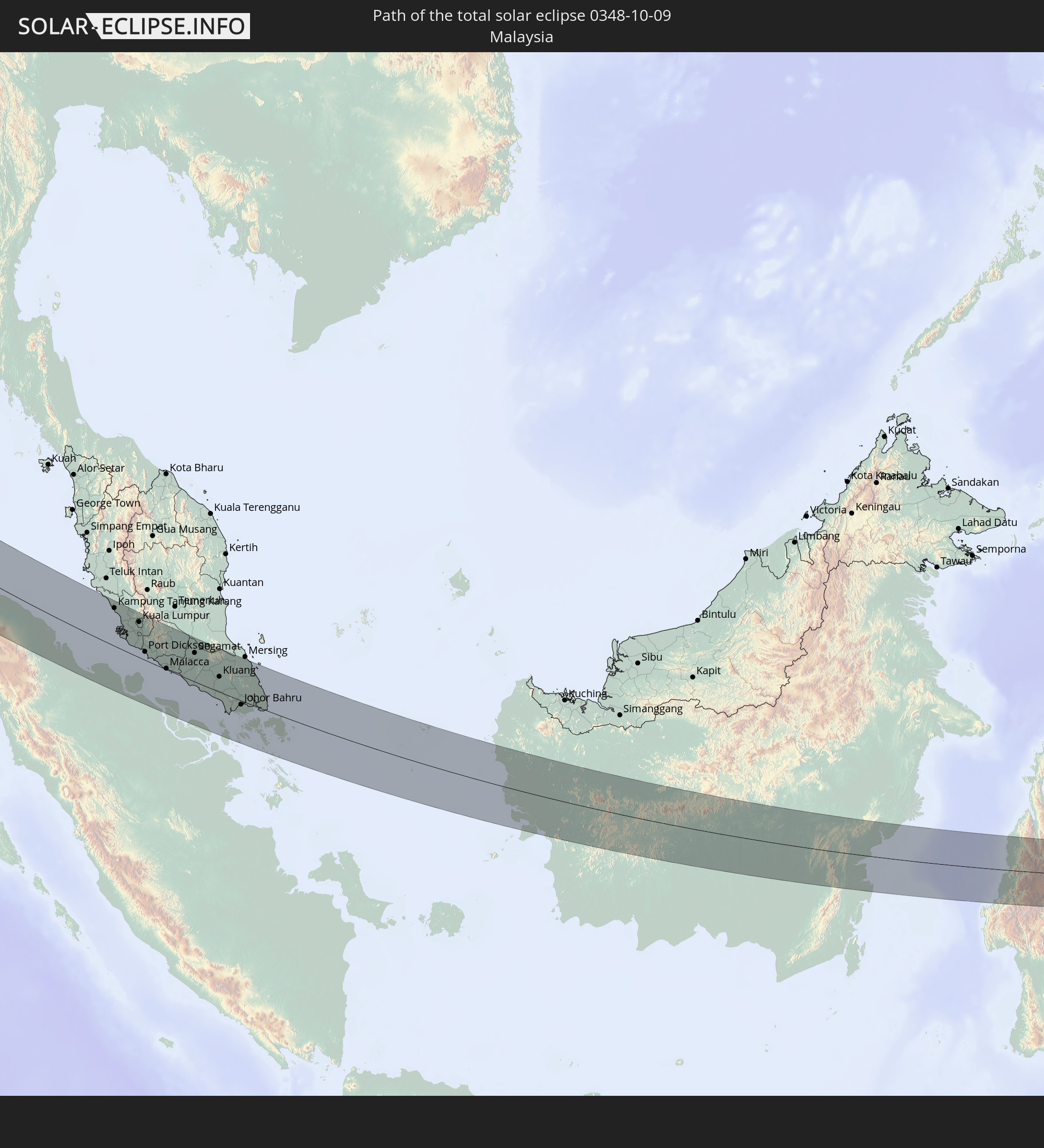 Malaysia
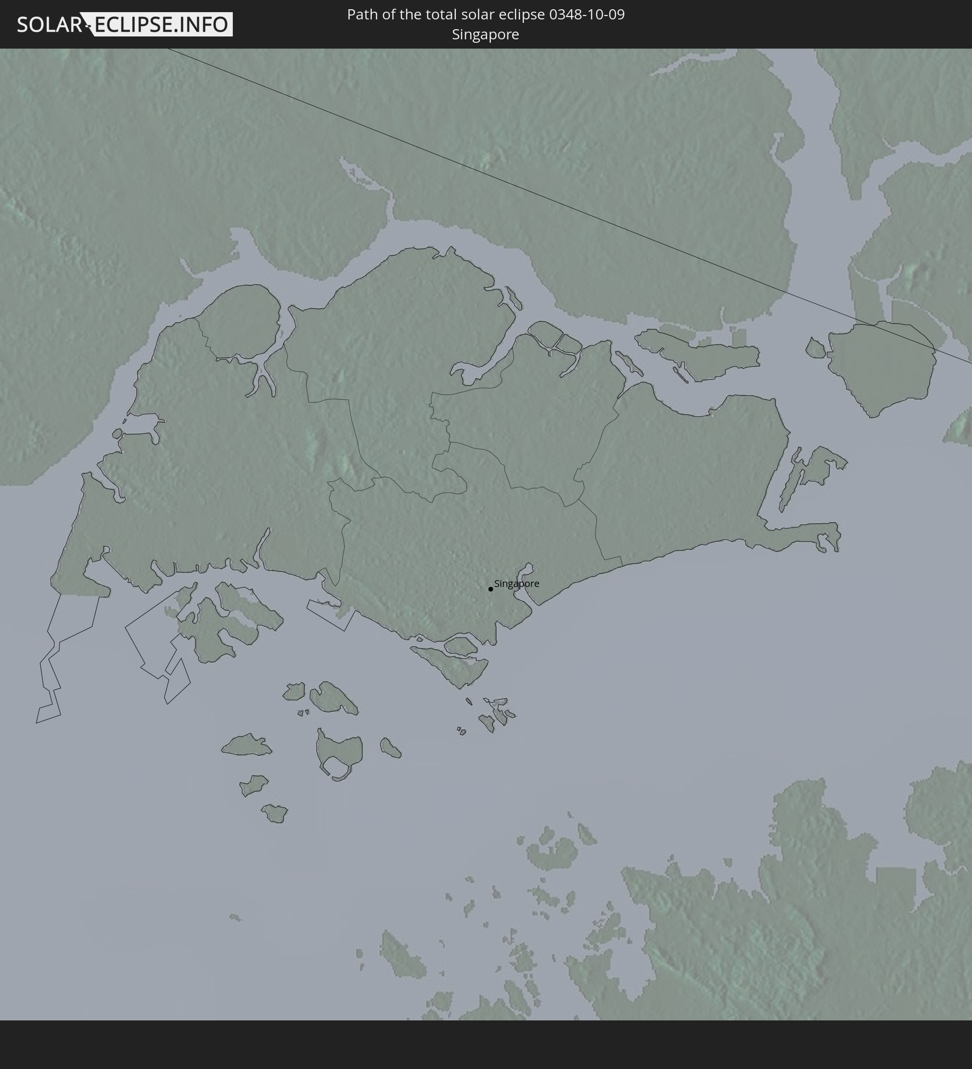 Singapur
In den folgenden Ländern ist die Sonnenfinsternis partiell zu sehen
 Russland
 Algerien
 Niger
Niger
 Norwegen
 Deutschland
 Italien
 Tunesien
 Dänemark
 Libyen
 Österreich
 Schweden
 Tschechien
 San Marino
 Vatikanstadt
 Slowenien
 Tschad
 Kroatien
 Polen
Polen
 Malta
Malta
 Bosnien und Herzegowina
 Ungarn
 Slowakei
 Montenegro
 Serbien
 Albanien
 Åland Islands
 Griechenland
 Rumänien
 Mazedonien
 Finnland
 Litauen
 Lettland
 Estland
 Sudan
Sudan
 Ukraine
 Bulgarien
 Weißrussland
 Ägypten
 Türkei
 Moldawien
 Republik Zypern
 Äthiopien
 Staat Palästina
 Israel
 Saudi-Arabien
 Jordanien
 Libanon
 Syrien
 Eritrea
 Irak
Irak
 Georgien
 Somalia
 Dschibuti
 Jemen
Jemen
 Armenien
 Iran
Iran
 Aserbaidschan
 Kasachstan
 Kuwait
 Bahrain
 Katar
Katar
 Vereinigte Arabische Emirate
 Oman
Oman
 Turkmenistan
 Usbekistan
 Afghanistan
 Pakistan
 Tadschikistan
 Indien
 Kirgisistan
 Britisches Territorium im Indischen Ozean
 Malediven
 Volksrepublik China
 Sri Lanka
 Nepal
Nepal
 Mongolei
 Bangladesch
 Bhutan
 Myanmar
 Indonesien
 Kokosinseln
 Thailand
 Malaysia
 Laos
Laos
 Vietnam
 Kambodscha
 Singapur
 Weihnachtsinsel
 Australien
 Macau
Macau
 Hongkong
 Brunei
 Taiwan
 Philippinen
 Japan
Japan
 Osttimor
 Nordkorea
 Südkorea
 Palau
Palau
 Föderierte Staaten von Mikronesien
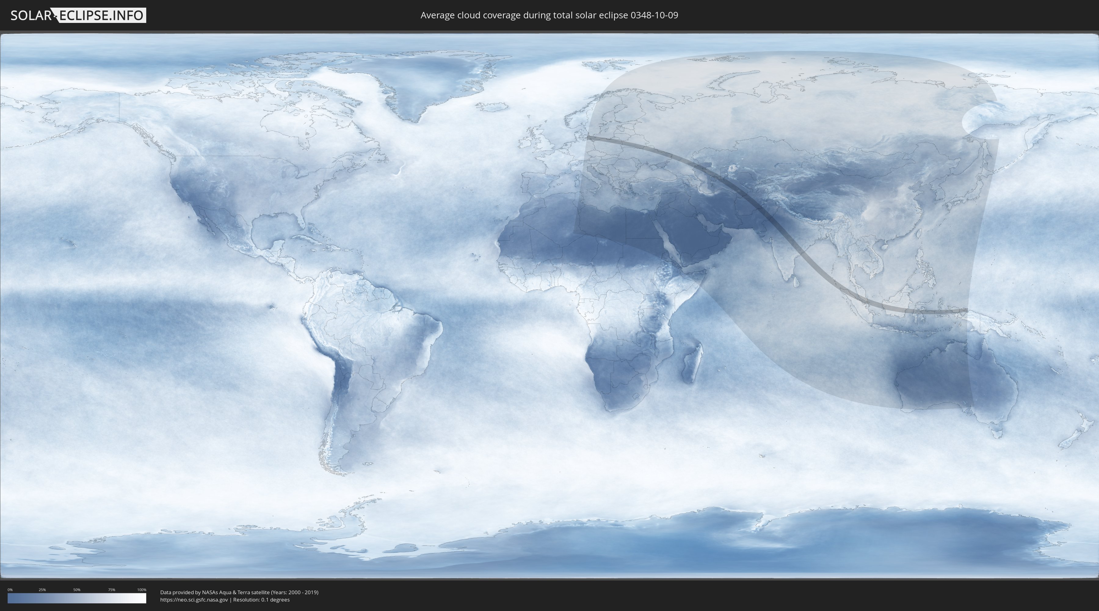
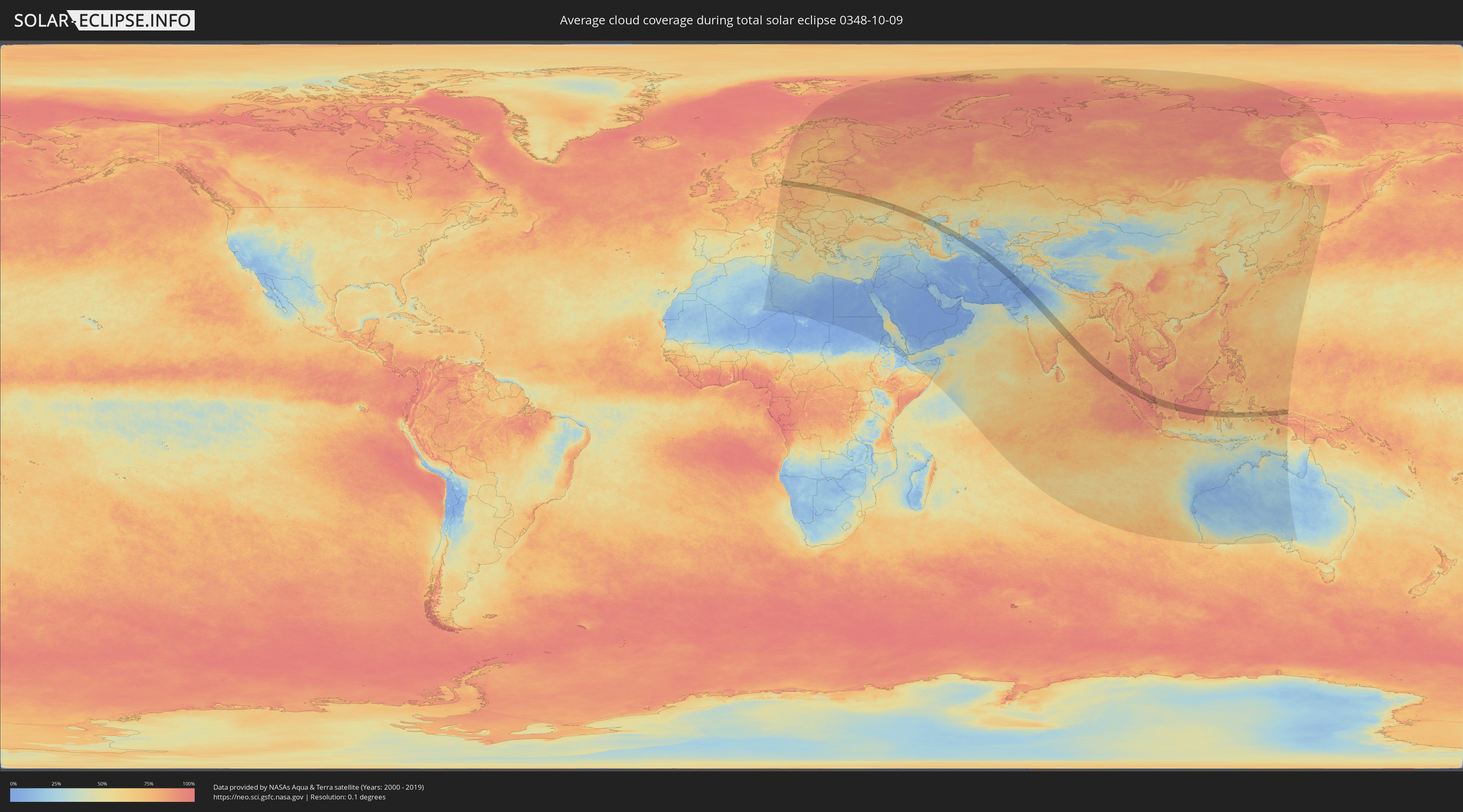
Wie wird das Wetter während der totalen Sonnenfinsternis am 09.10.0348?
Wo ist der beste Ort, um die totale Sonnenfinsternis vom 09.10.0348 zu beobachten?
Die folgenden Karten zeigen die durchschnittliche Bewölkung für den Tag, an dem die totale Sonnenfinsternis
stattfindet. Mit Hilfe der Karten lässt sich der Ort entlang des Finsternispfades eingrenzen,
der die besten Aussichen auf einen klaren wolkenfreien Himmel bietet.
Trotzdem muss man immer lokale Gegenenheiten beachten und sollte sich genau über das Wetter an seinem
gewählten Beobachtungsort informieren.
Die Daten stammen von den beiden NASA-Satelliten
AQUA und TERRA
und wurden über einen Zeitraum von 19 Jahren (2000 - 2019) gemittelt.
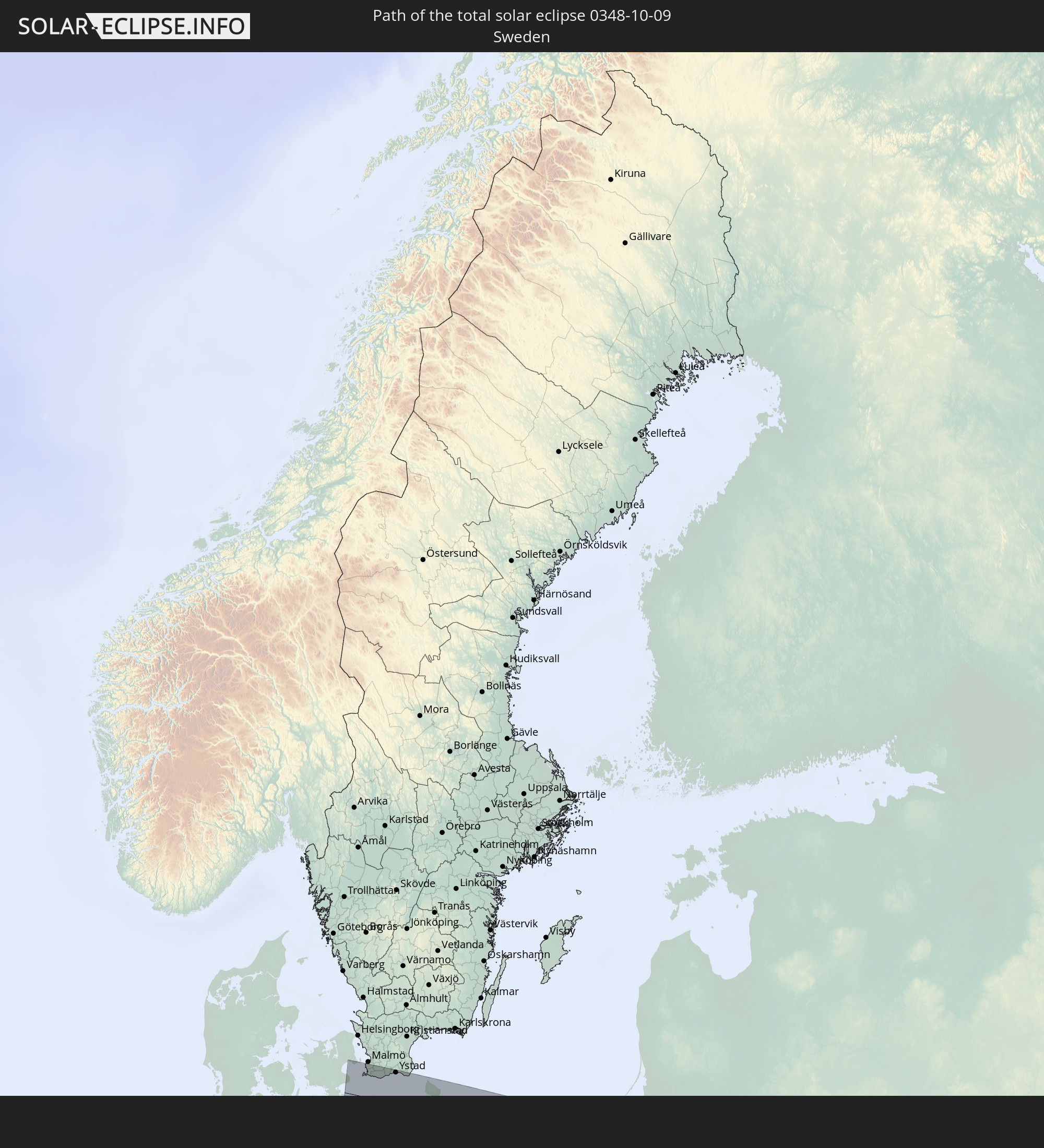
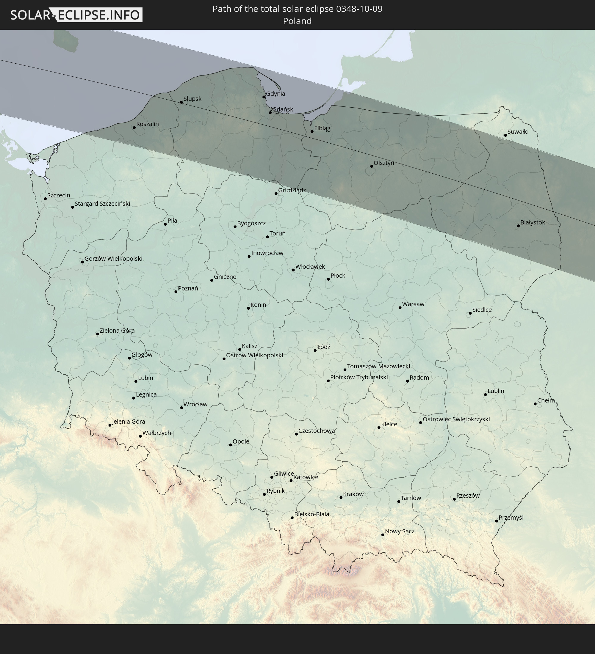
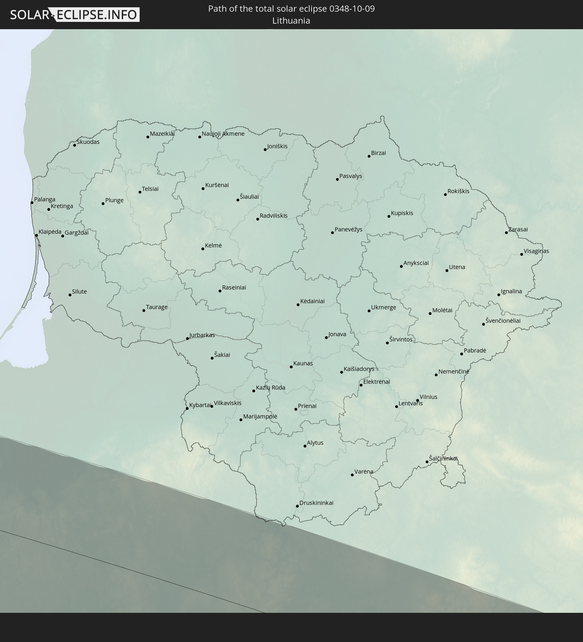
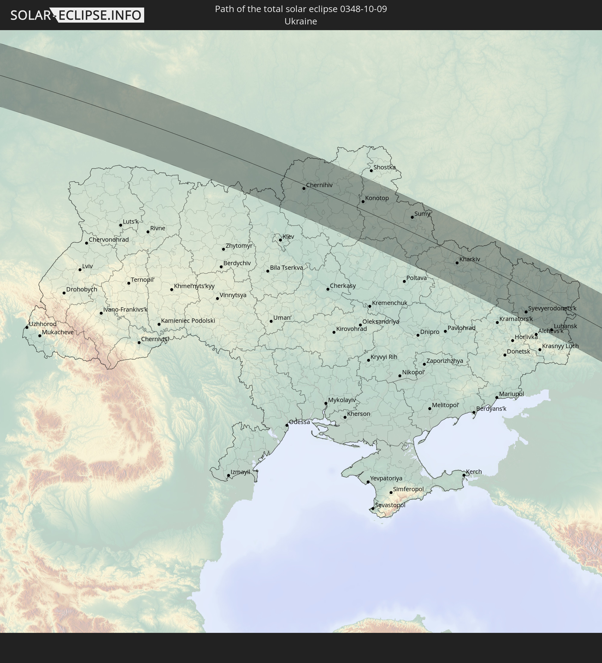
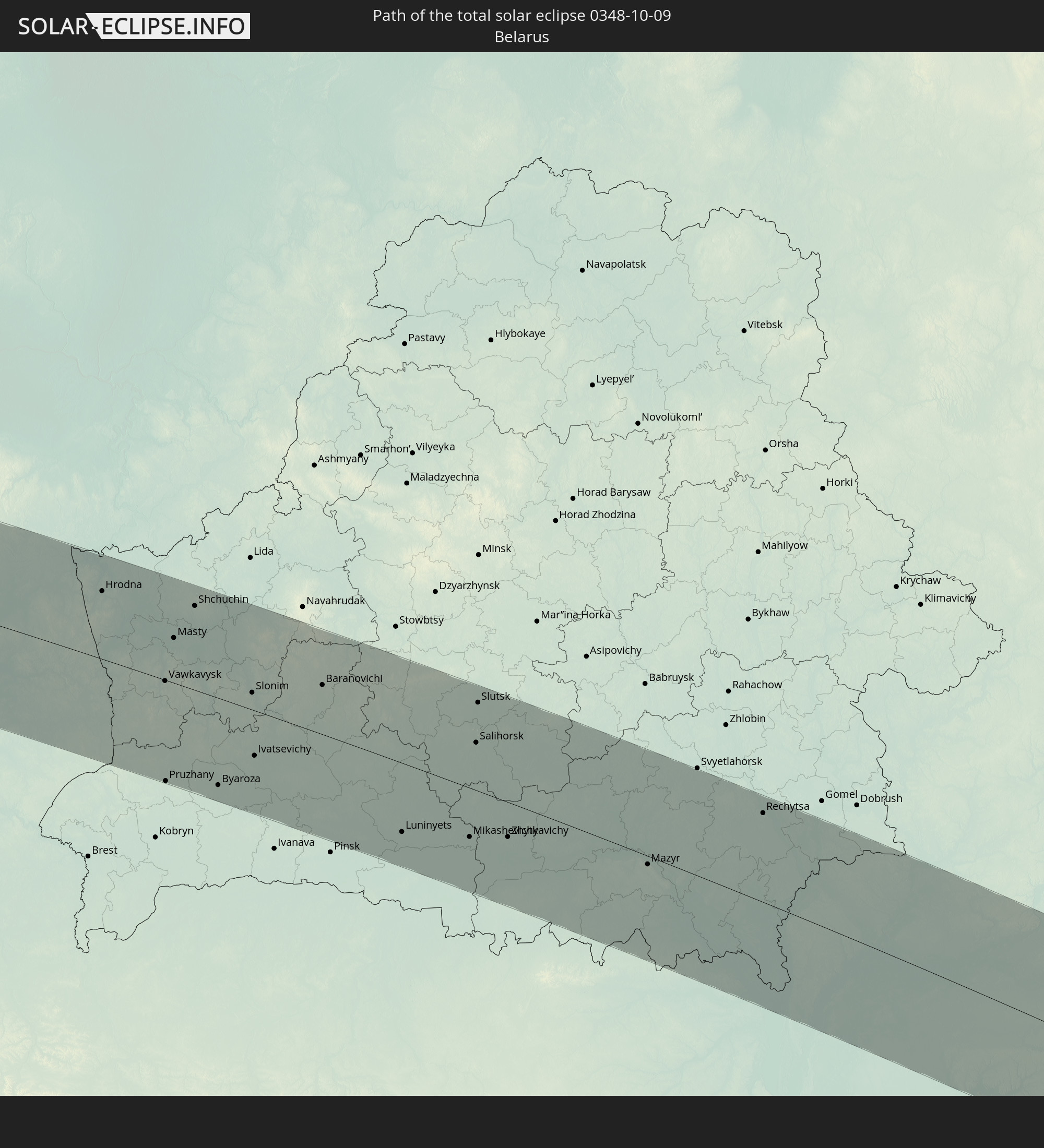
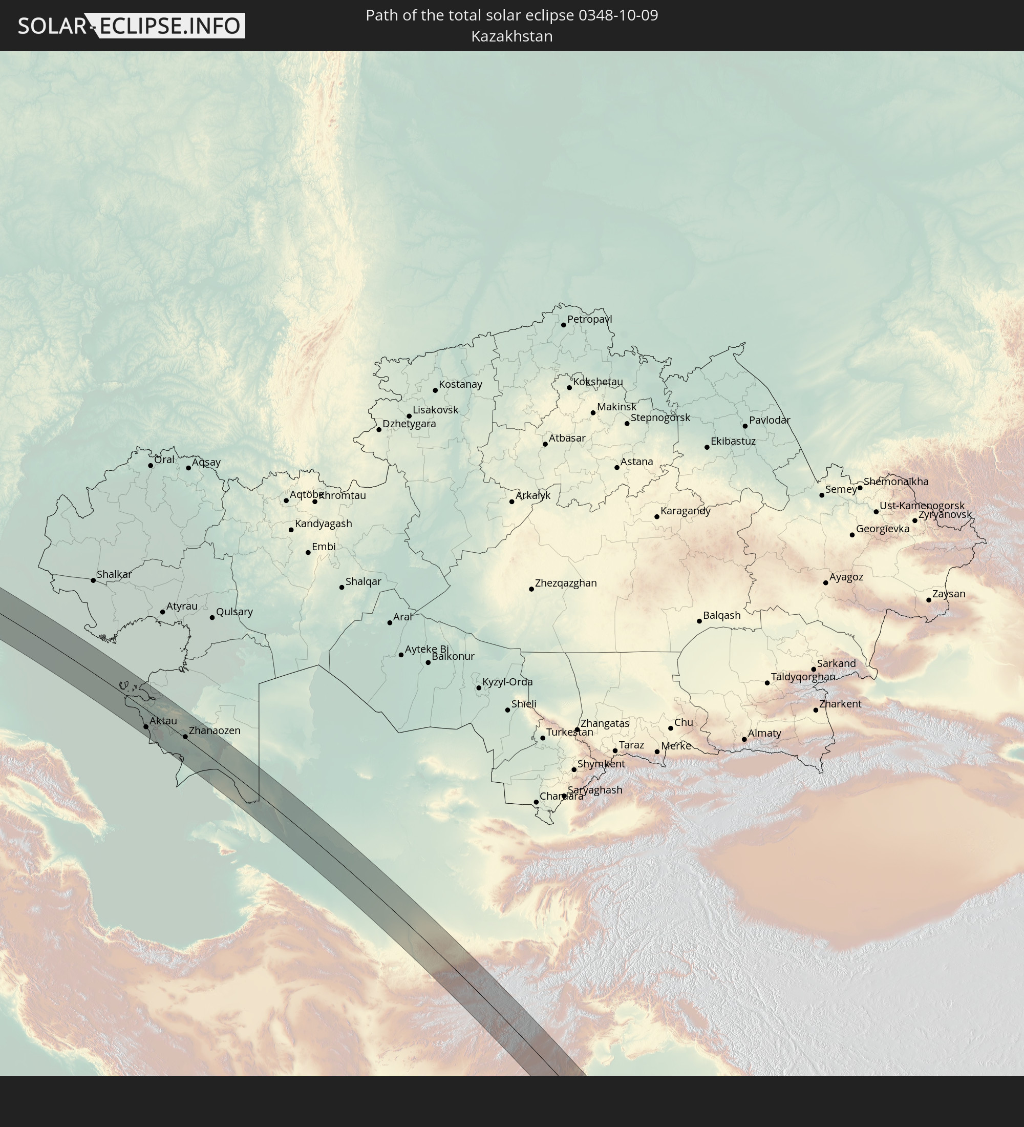
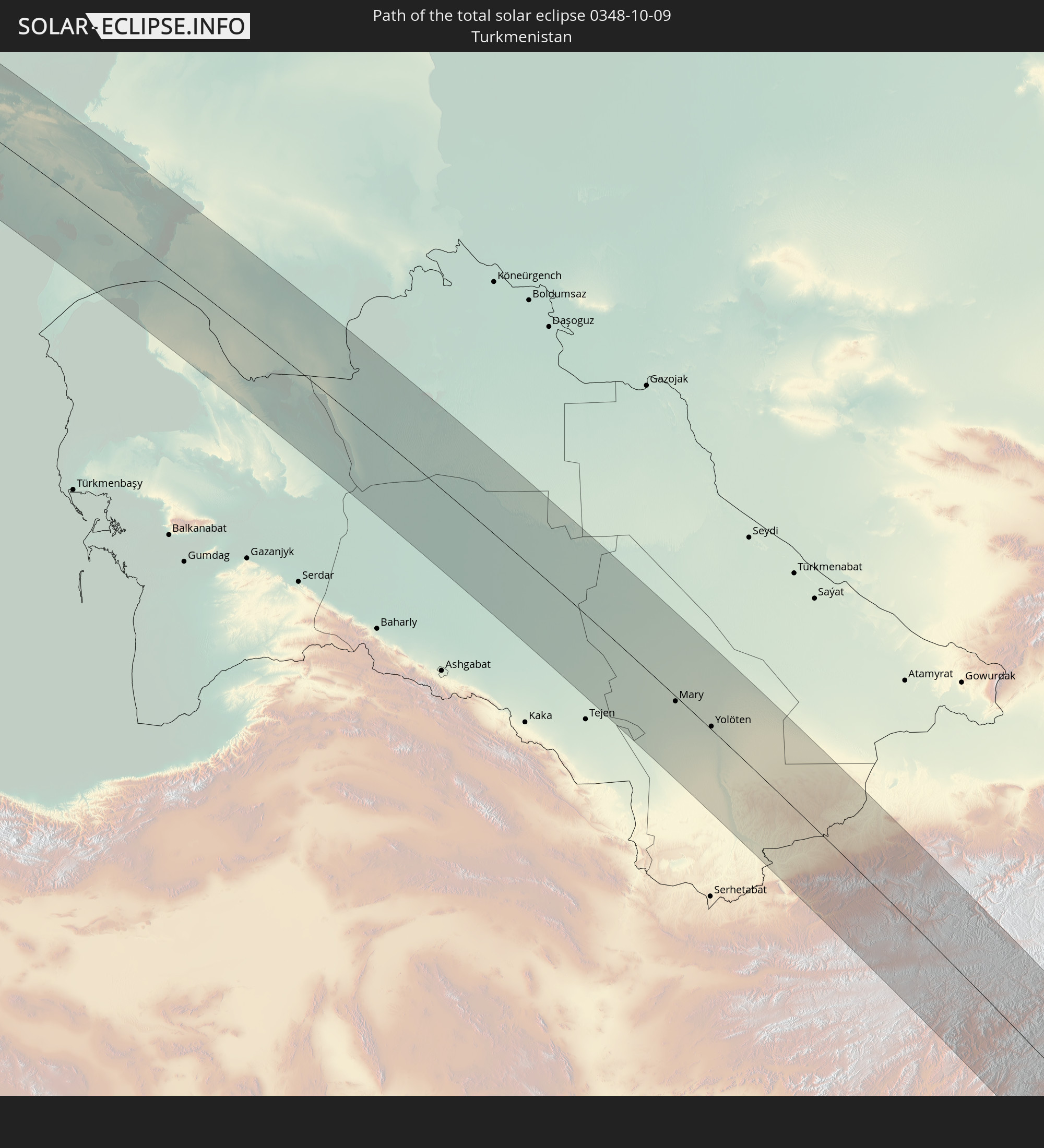
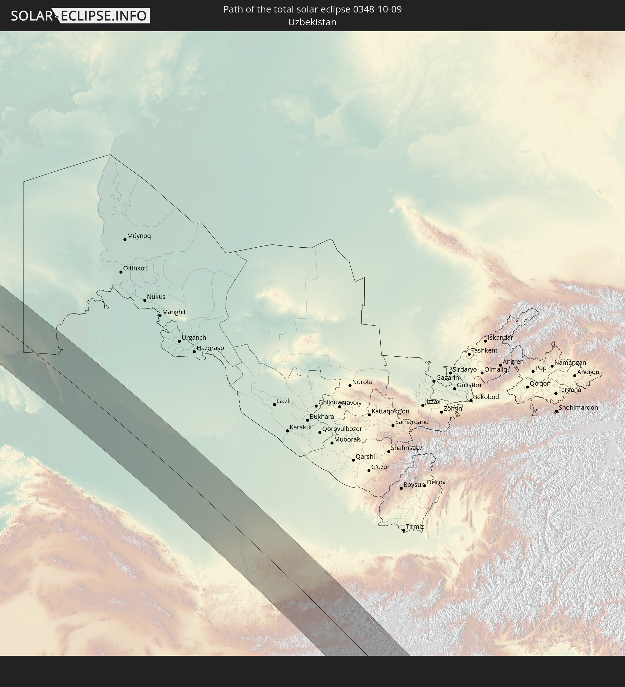
Detaillierte Länderkarten
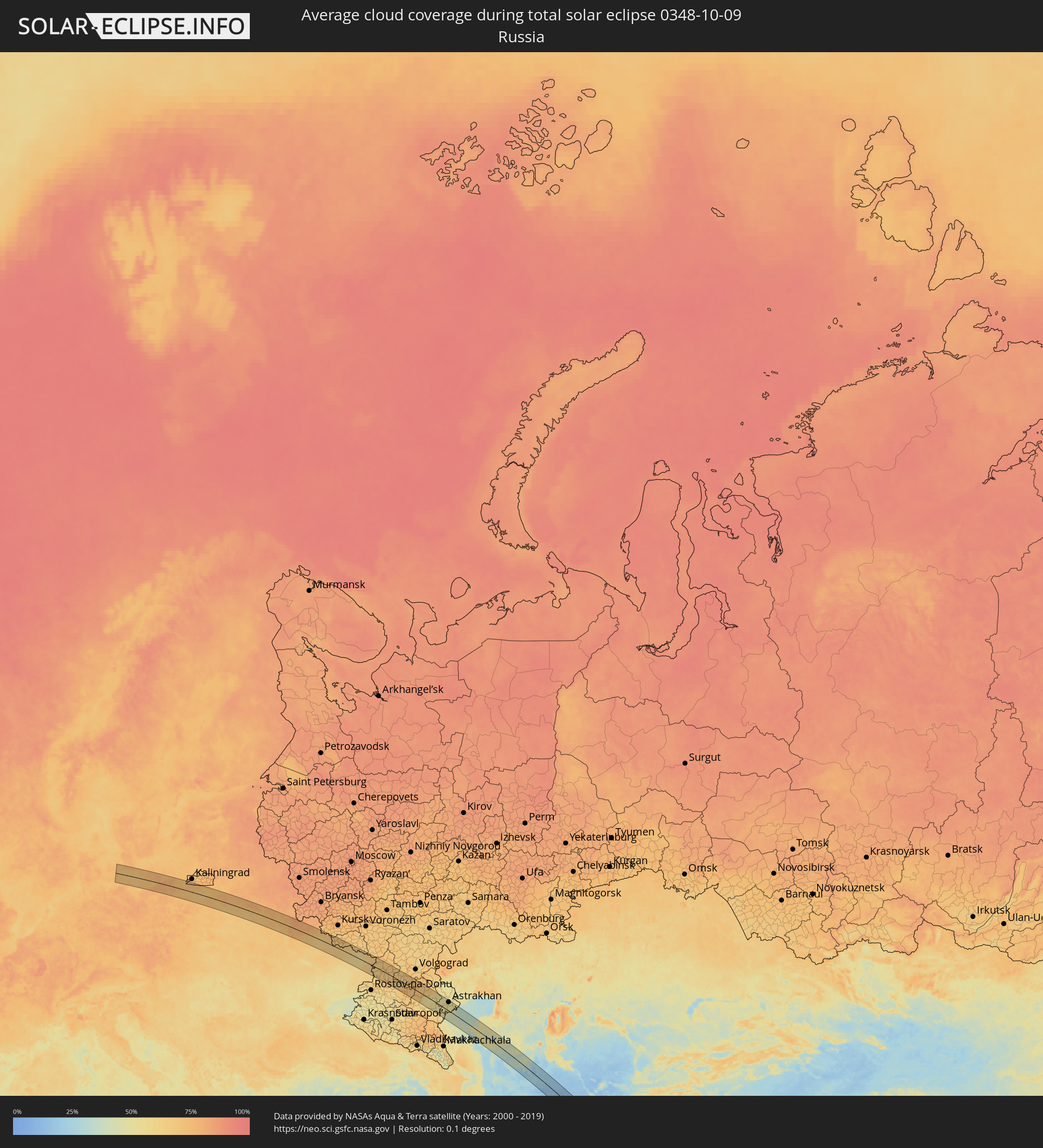 Russland
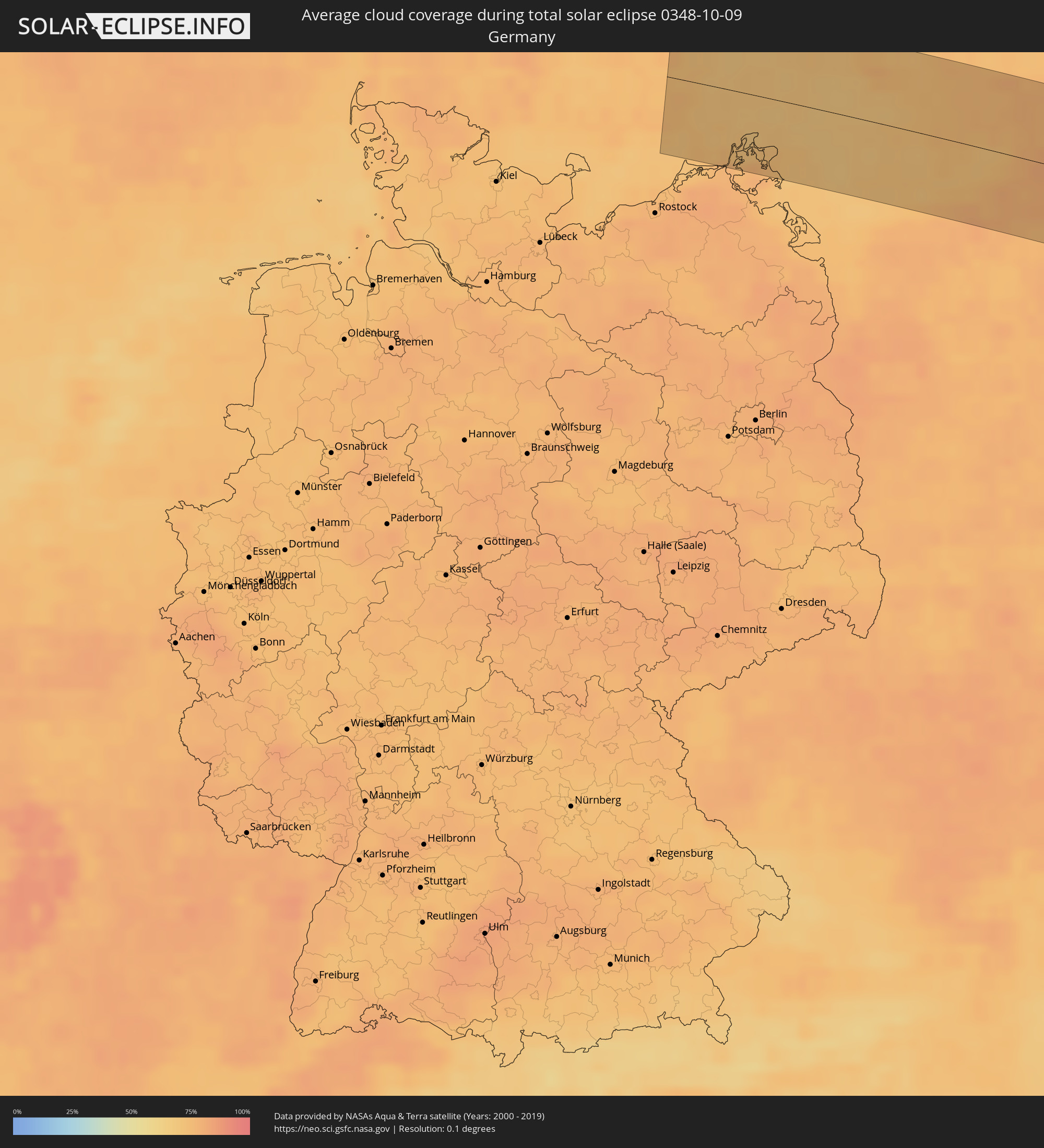 Deutschland
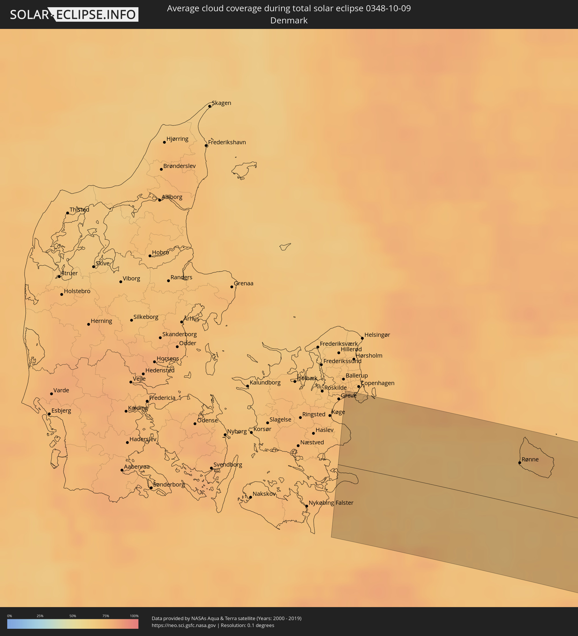 Dänemark
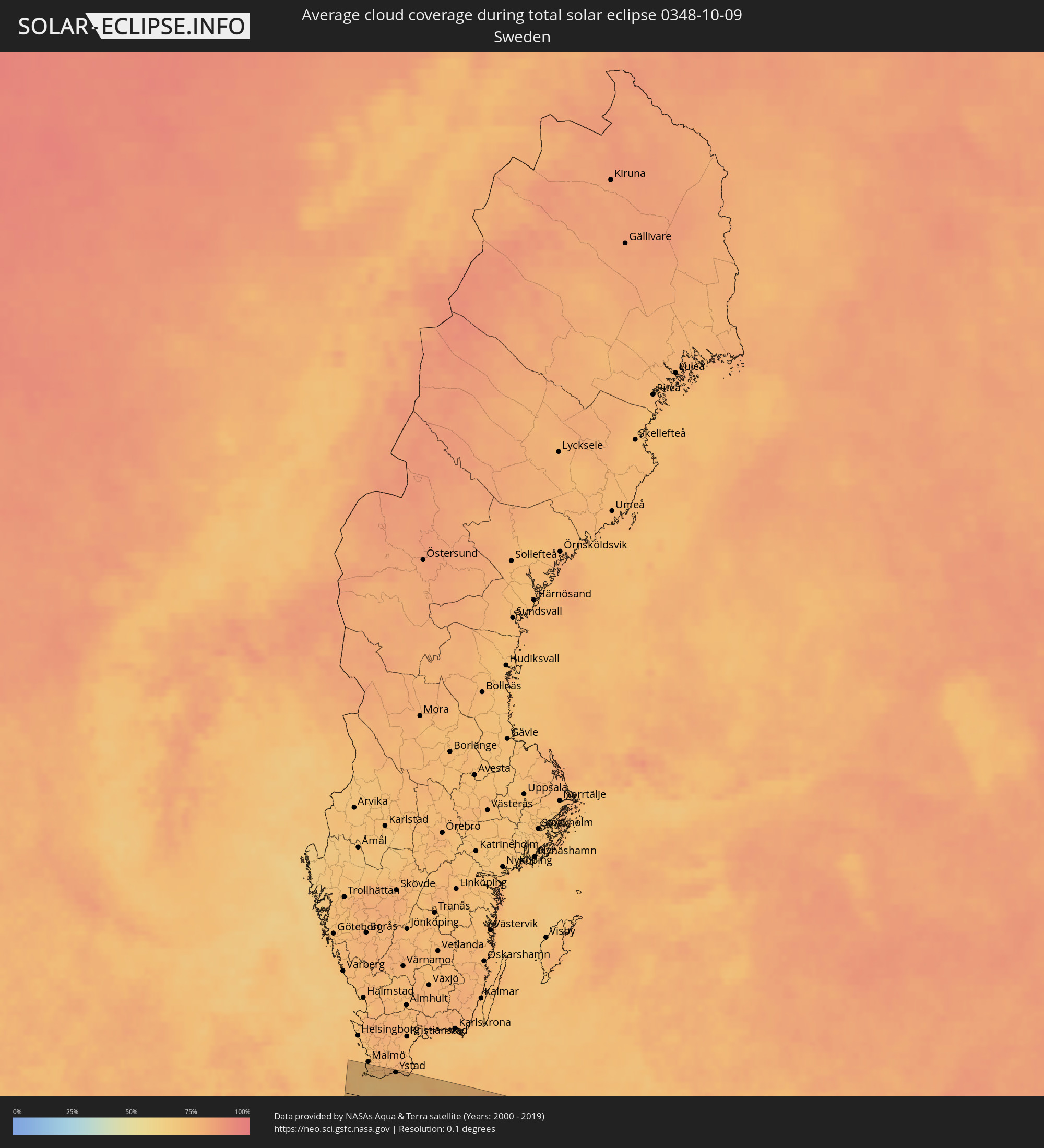 Schweden
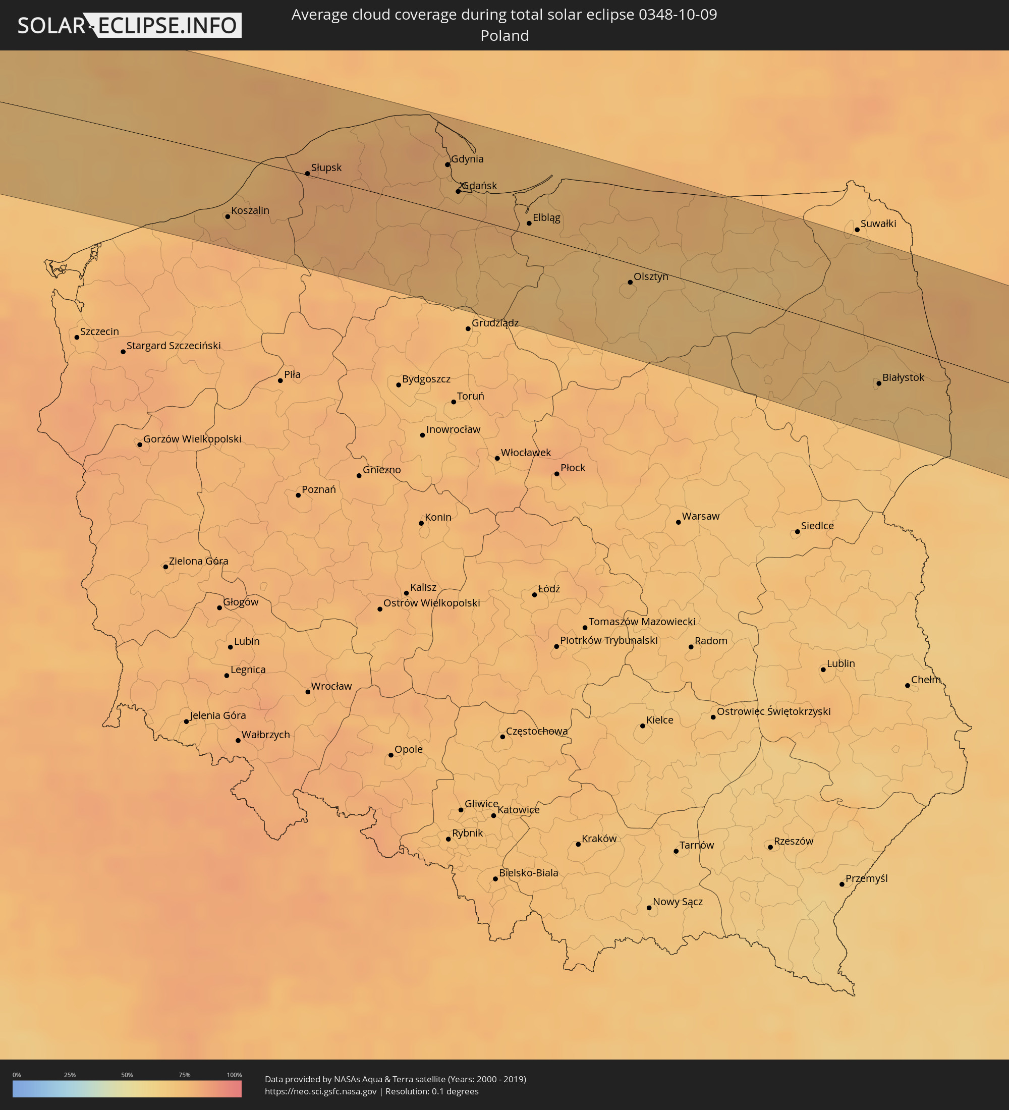 Polen
Polen
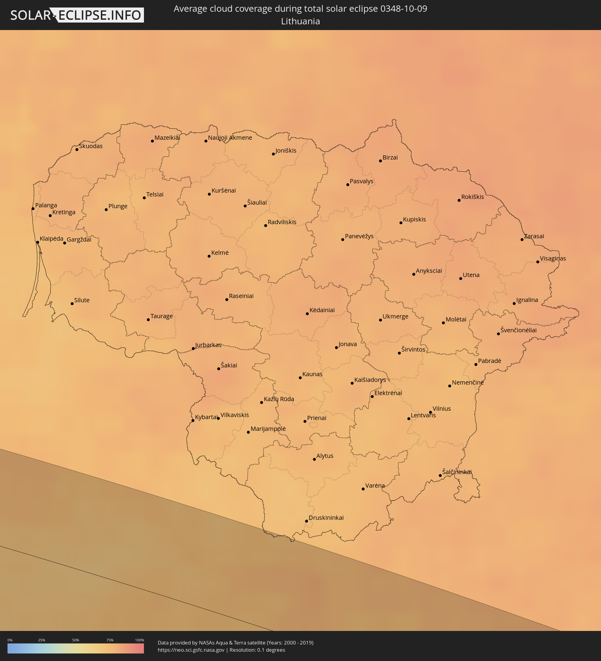 Litauen
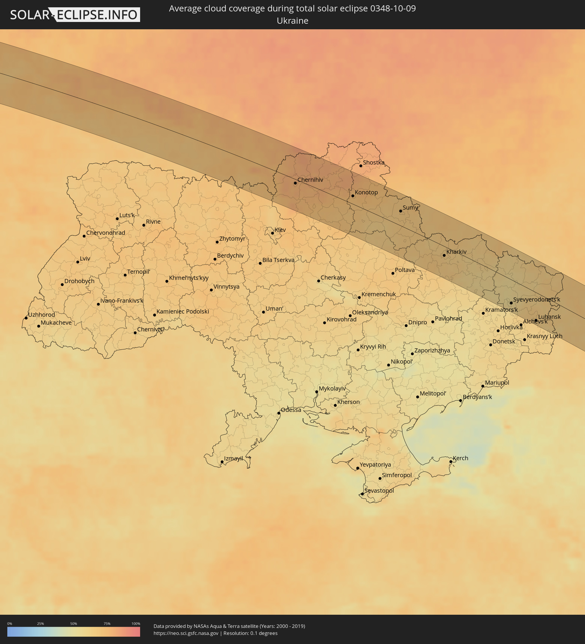 Ukraine
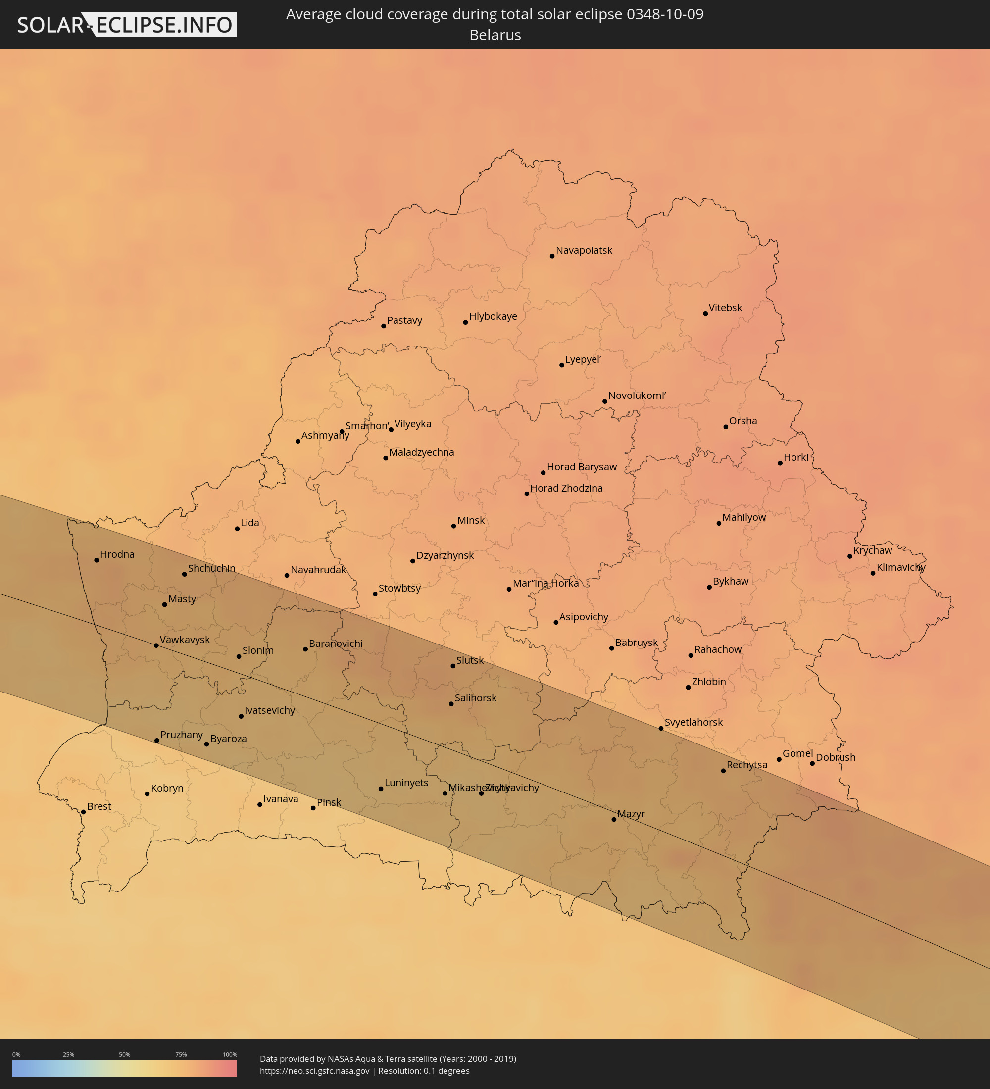 Weißrussland
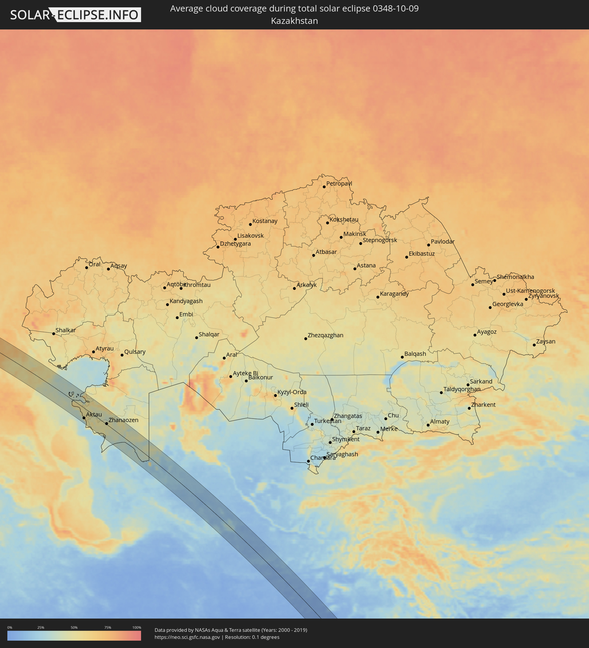 Kasachstan
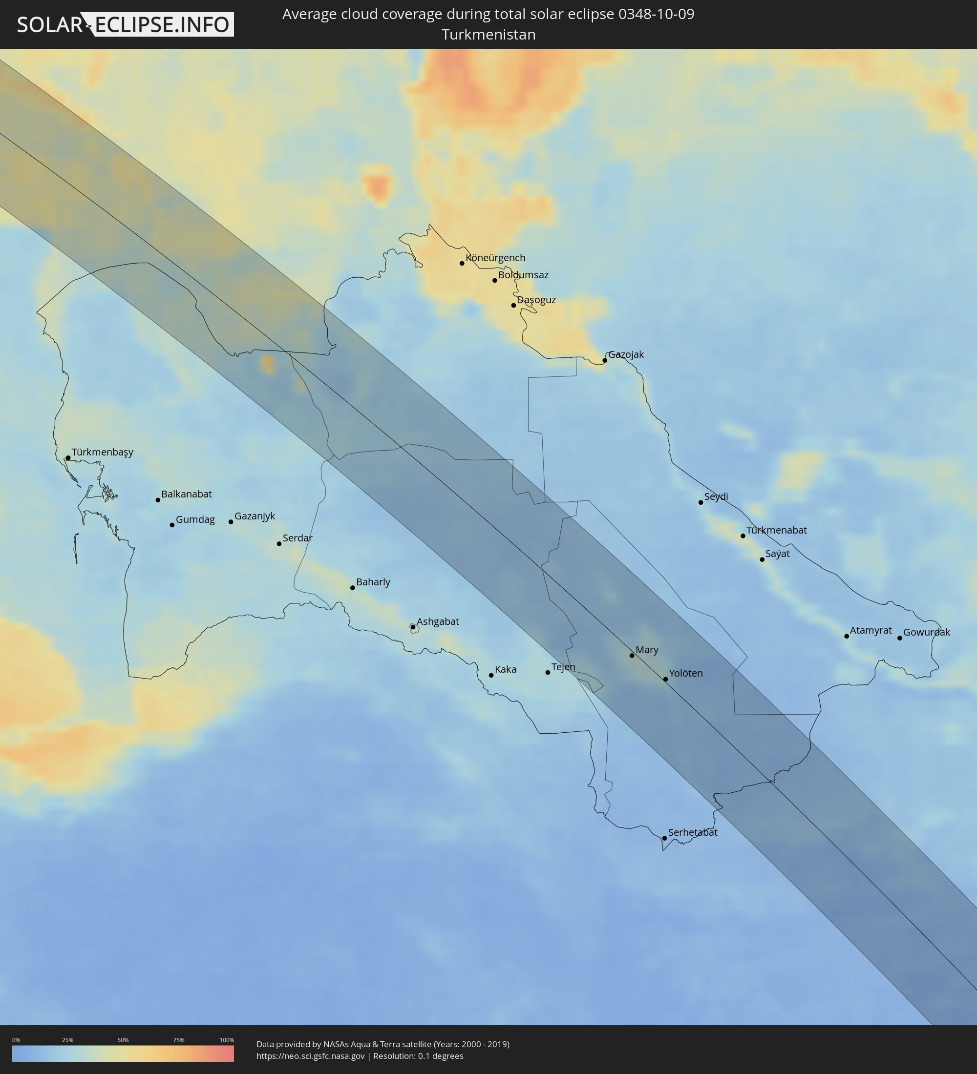 Turkmenistan
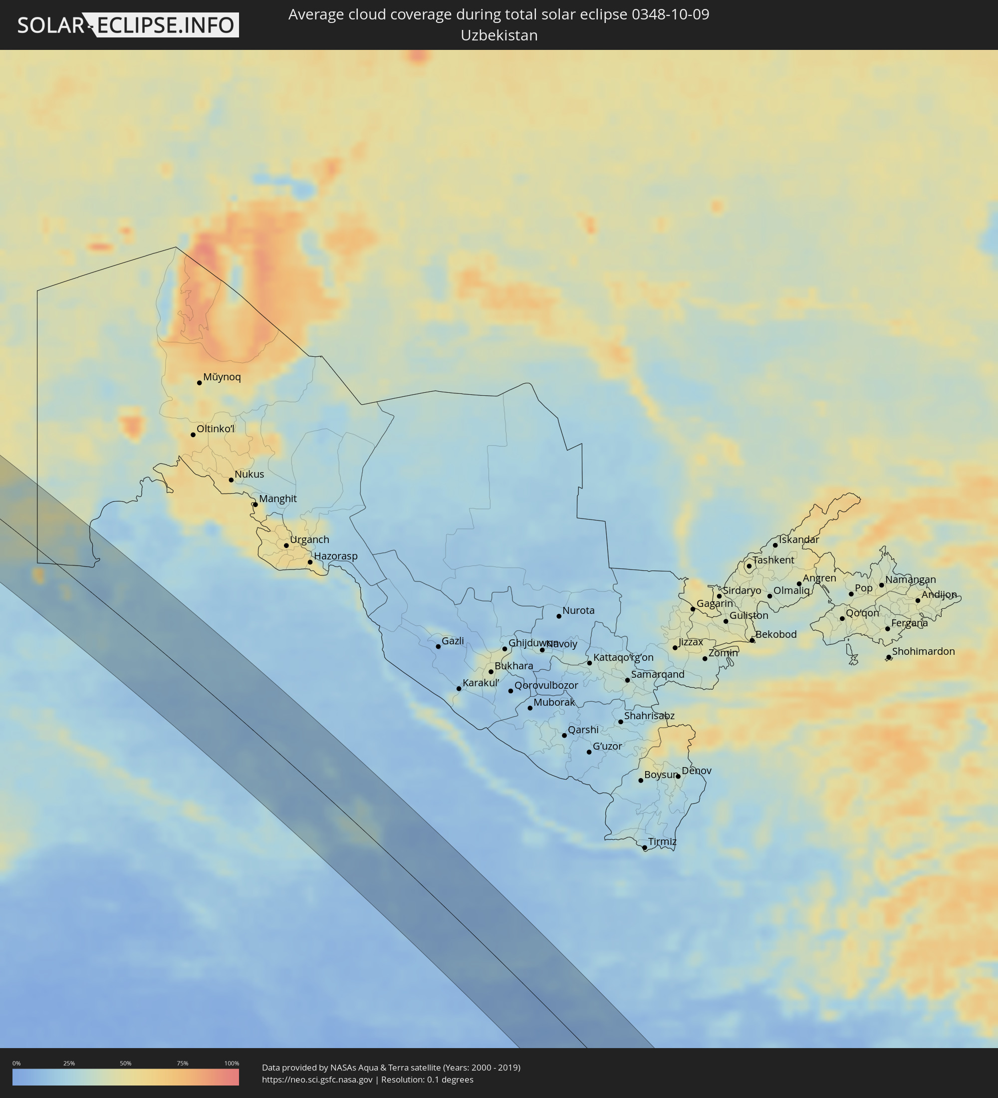 Usbekistan
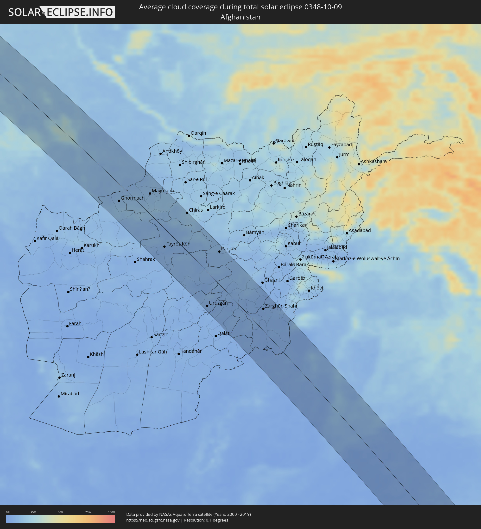 Afghanistan
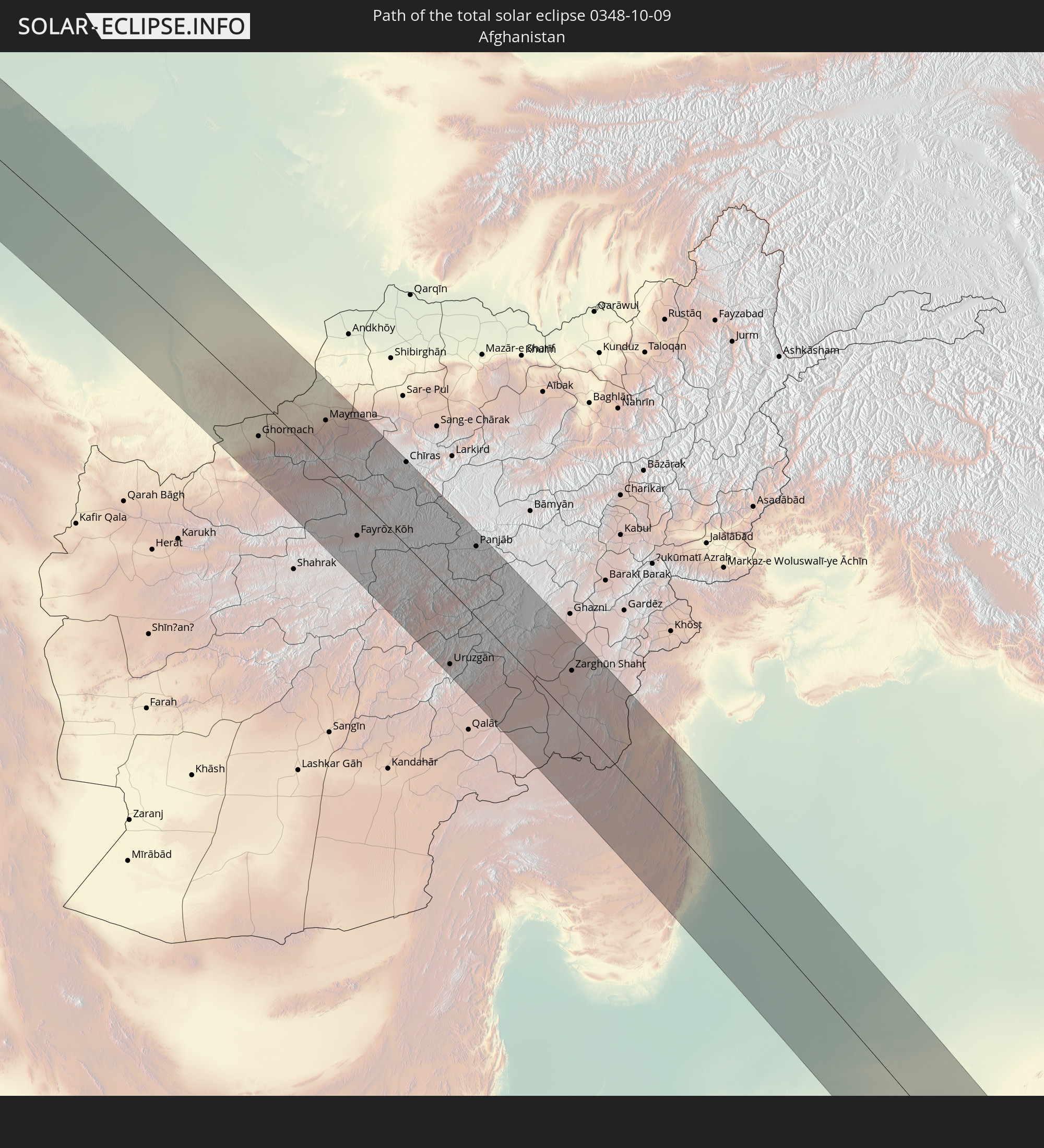
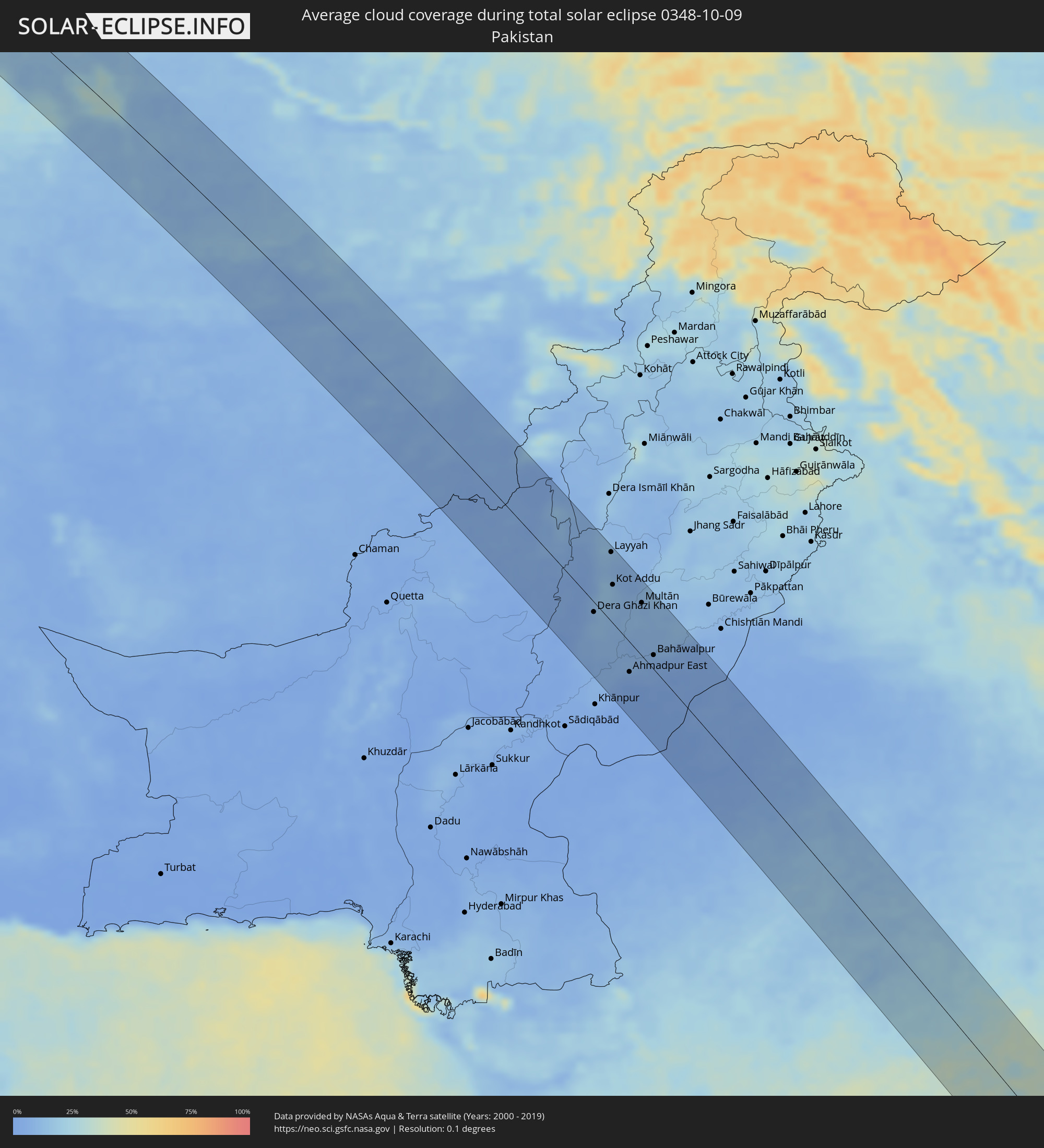 Pakistan
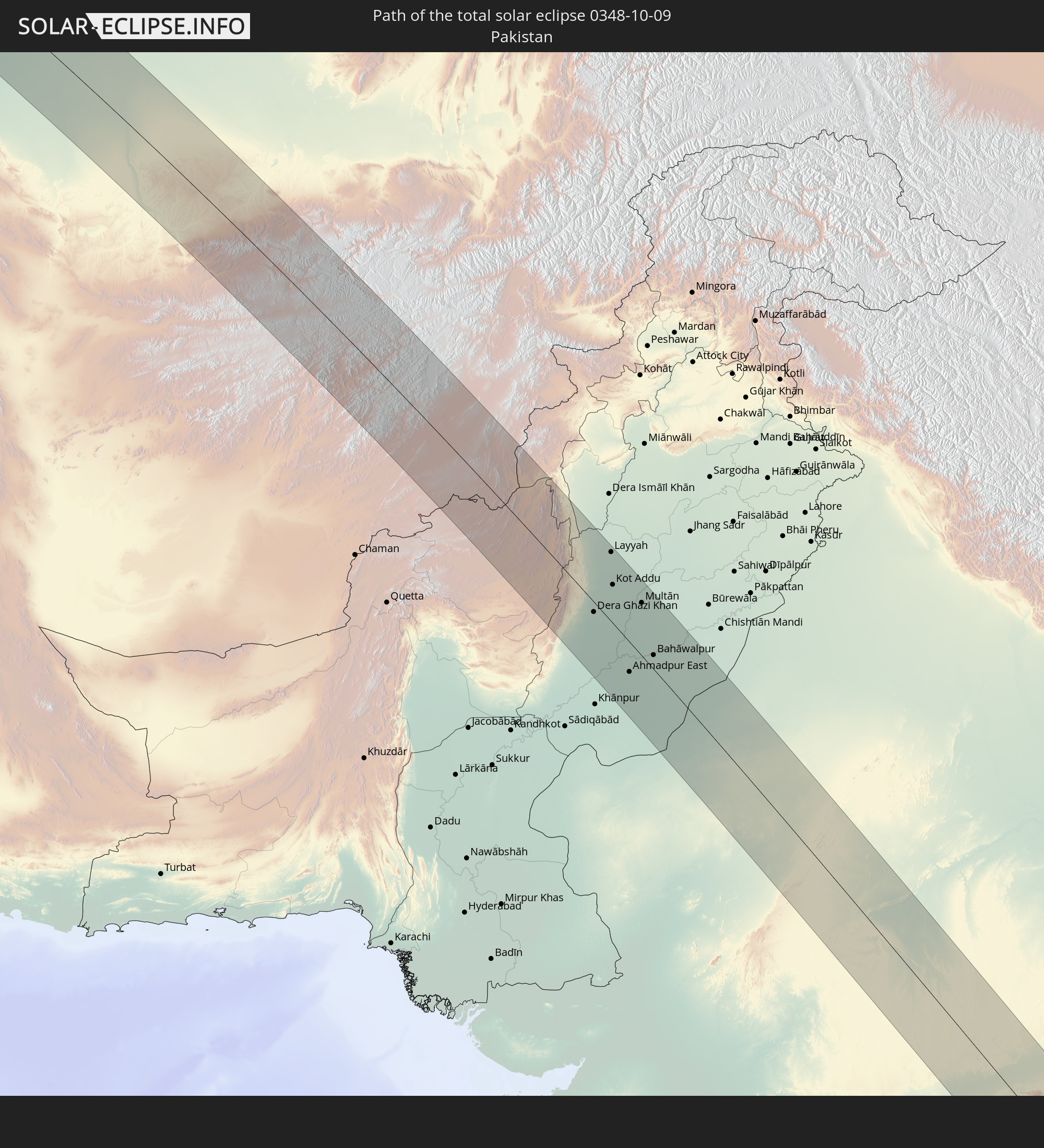
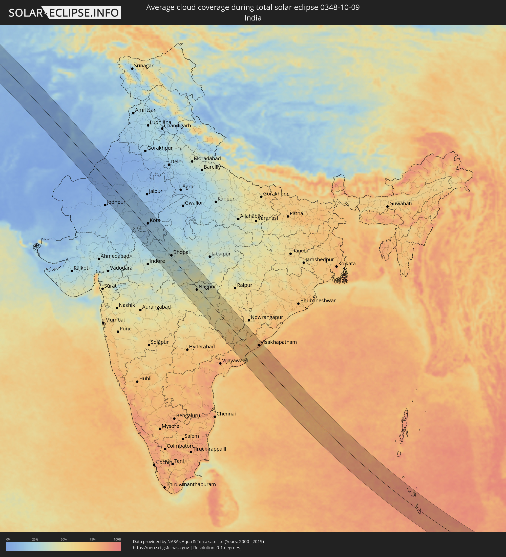 Indien
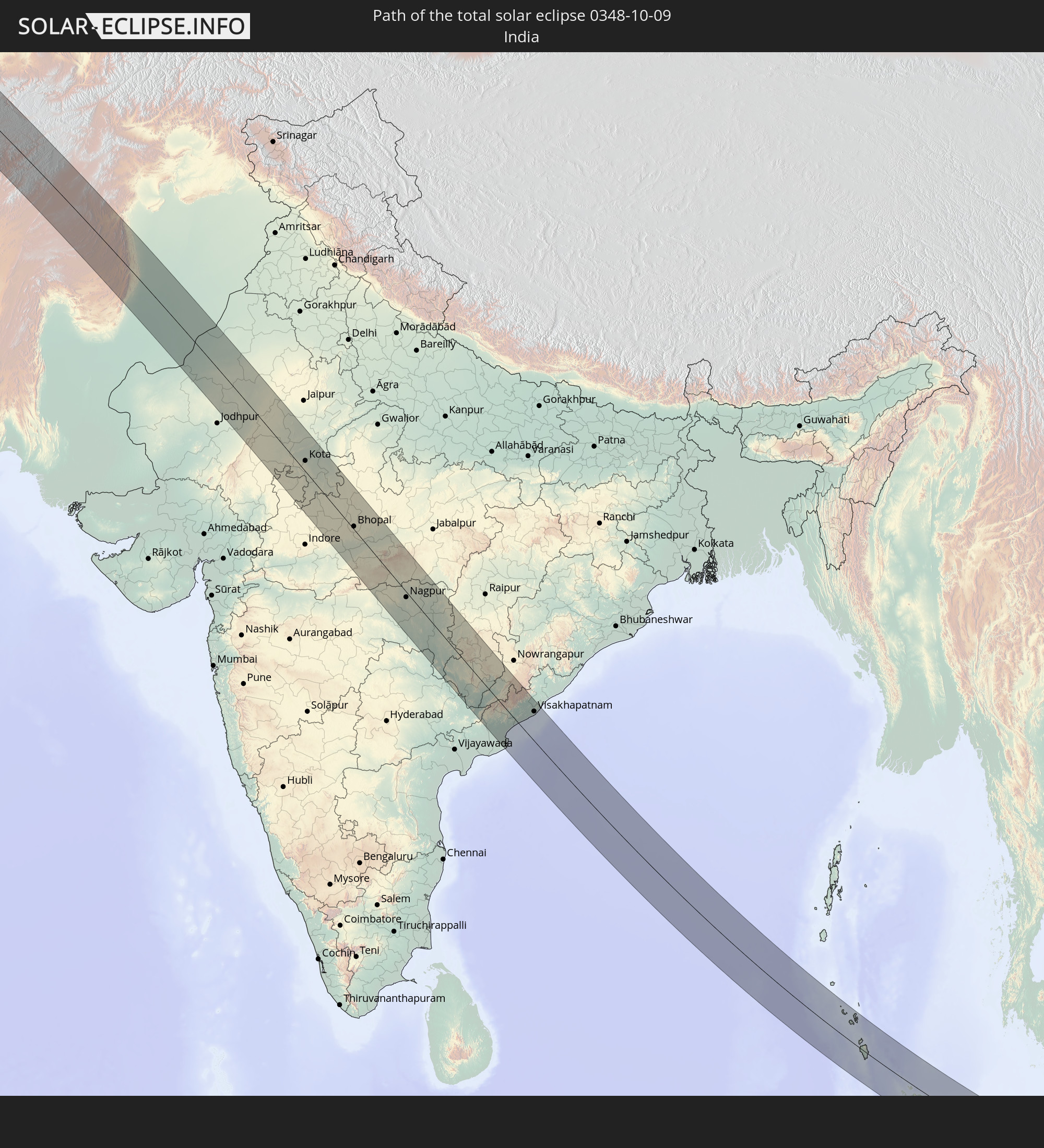
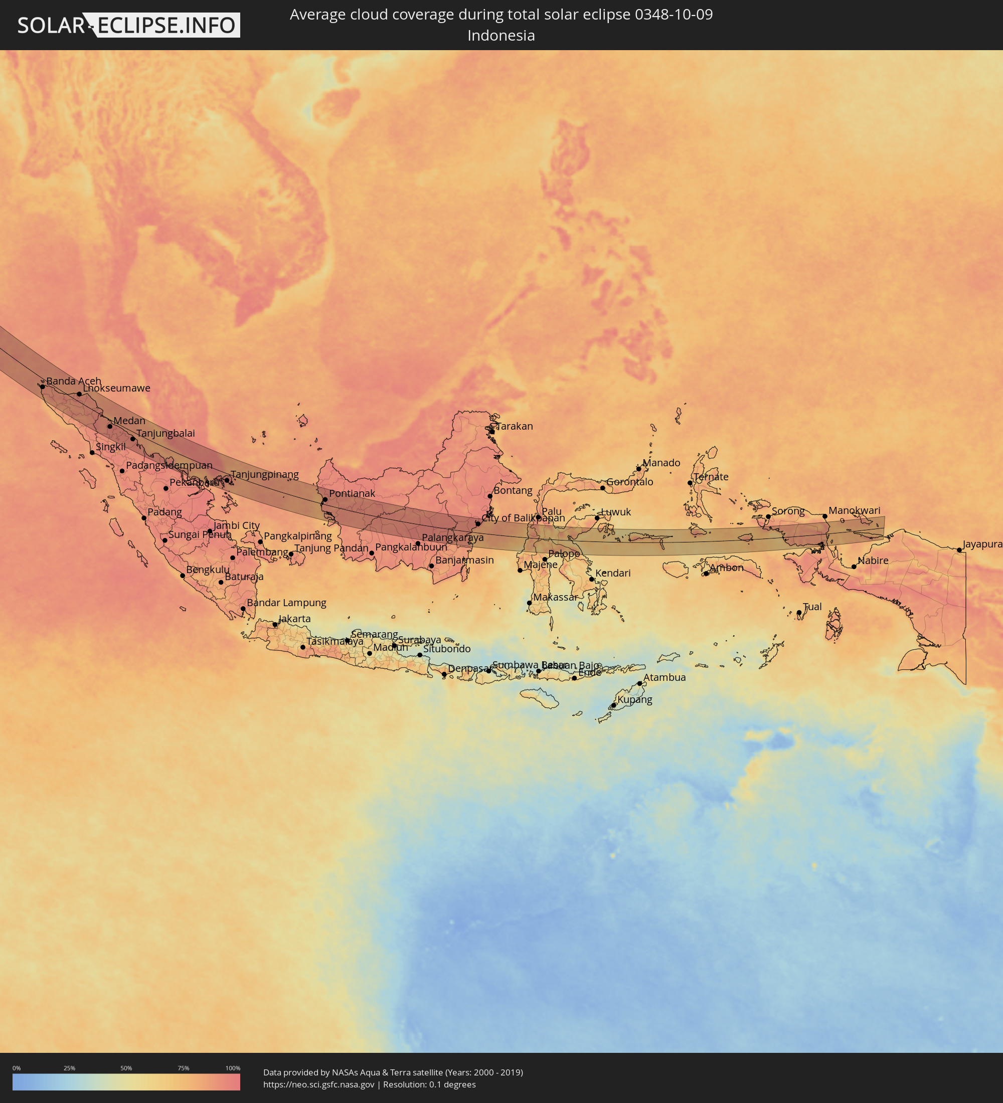 Indonesien
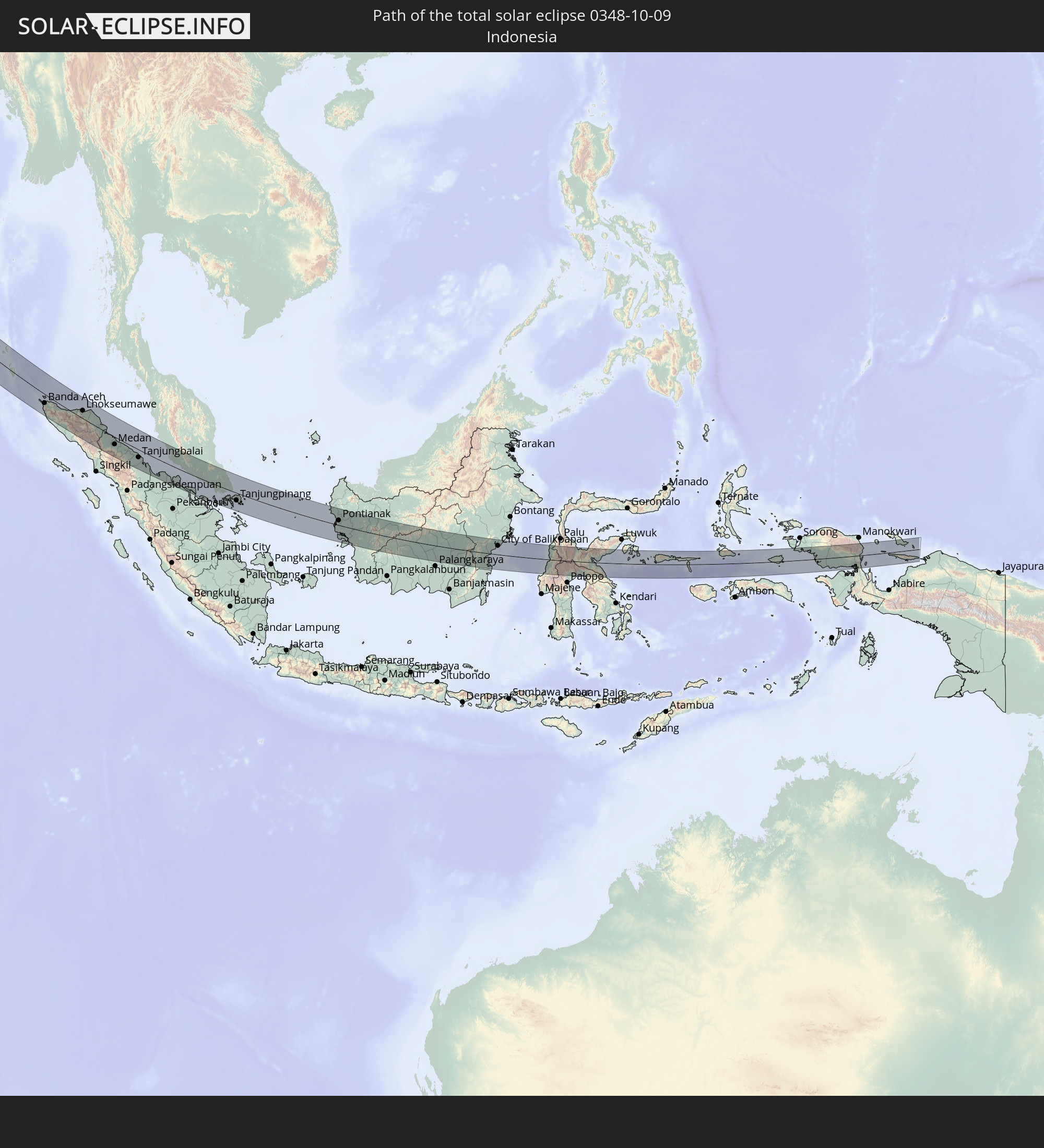
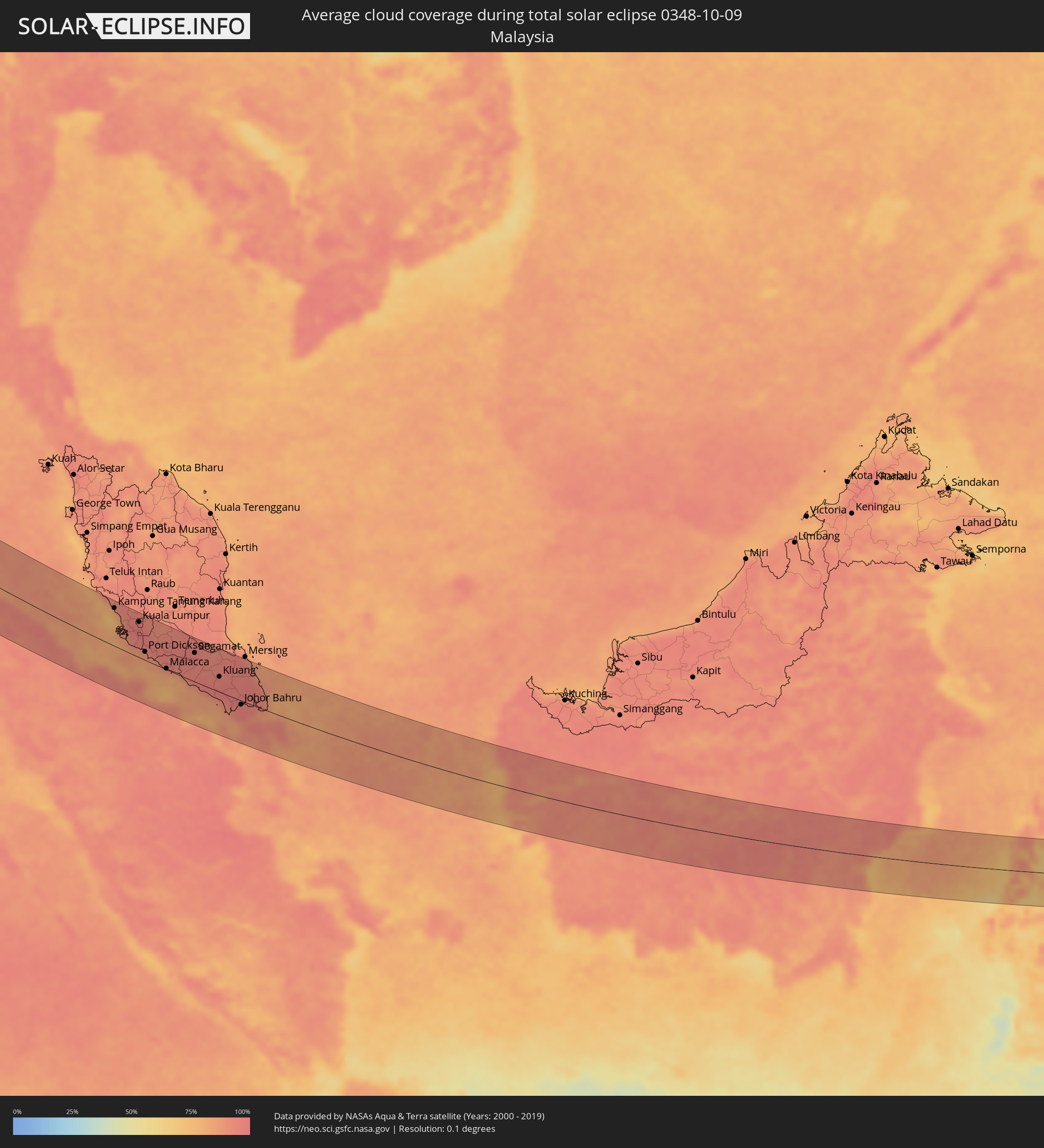 Malaysia
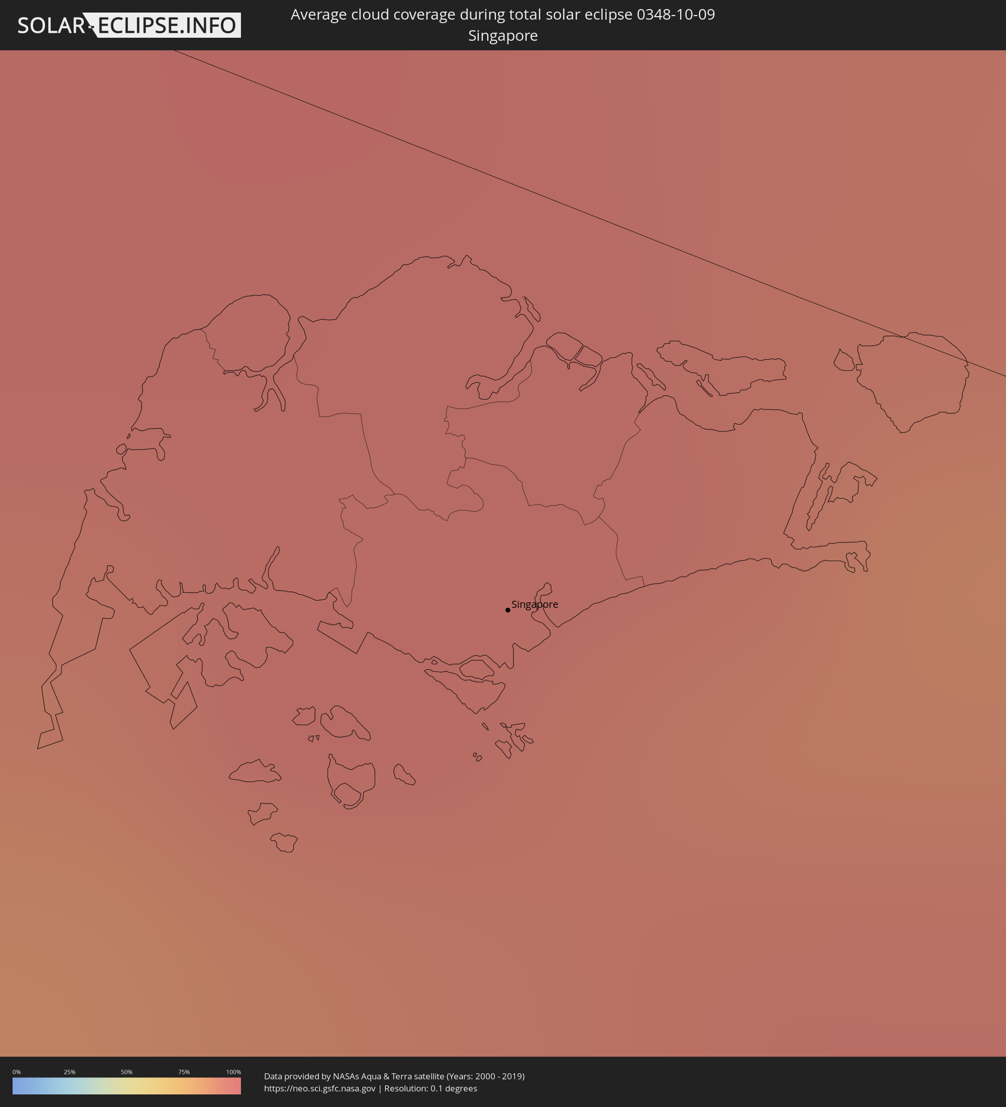 Singapur
Orte im Finsternispfad
Die nachfolgene Tabelle zeigt Städte und Orte mit mehr als 5.000 Einwohnern, die sich im Finsternispfad befinden. Städte mit mehr als 100.000 Einwohnern sind dick gekennzeichnet. Mit einem Klick auf den Ort öffnet sich eine Detailkarte die die Lage des jeweiligen Ortes zusammen mit dem Verlauf der zentralen Finsternis präsentiert.
| Ort | Typ | Dauer der Verfinsterung | Ortszeit bei maximaler Verfinsterung | Entfernung zur Zentrallinie | Ø Bewölkung |
|
Dragør, Capital Region
|
total | - | 06:37:52 UTC+01:00 | 60 km | 71% |
|
Skanör med Falsterbo, Skåne
|
total | - | 06:37:44 UTC+01:00 | 41 km | 71% |
|
Bunkeflostrand, Skåne
|
total | - | 06:37:50 UTC+01:00 | 57 km | 72% |
|
Höllviken, Skåne
|
total | - | 06:37:45 UTC+01:00 | 44 km | 71% |
|
Vellinge, Skåne
|
total | - | 06:37:48 UTC+01:00 | 51 km | 72% |
|
Skåre, Skåne
|
total | - | 06:37:44 UTC+01:00 | 42 km | 70% |
|
Oxie, Skåne
|
total | - | 06:37:52 UTC+01:00 | 60 km | 73% |
|
Trelleborg, Skåne
|
total | - | 06:37:44 UTC+01:00 | 43 km | 70% |
|
Svedala, Skåne
|
total | - | 06:37:51 UTC+01:00 | 58 km | 75% |
|
Bergen auf Rügen, Mecklenburg-Vorpommern
|
total | - | 06:37:04 UTC+01:00 | 58 km | 79% |
|
Skurup, Skåne
|
total | - | 06:37:51 UTC+01:00 | 58 km | 76% |
|
Ostseebad Binz, Mecklenburg-Vorpommern
|
total | - | 06:37:04 UTC+01:00 | 57 km | 76% |
|
Saßnitz, Mecklenburg-Vorpommern
|
total | - | 06:37:09 UTC+01:00 | 44 km | 74% |
|
Ystad, Skåne
|
total | - | 06:37:51 UTC+01:00 | 57 km | 72% |
|
Rønne, Capital Region
|
total | - | 06:37:43 UTC+01:00 | 34 km | 69% |
|
Kołobrzeg, West Pomeranian Voivodeship
|
total | - | 07:01:10 UTC+01:24 | 53 km | 75% |
|
Koszalin, West Pomeranian Voivodeship
|
total | - | 07:01:16 UTC+01:24 | 42 km | 78% |
|
Słupsk, Pomeranian Voivodeship
|
total | - | 07:01:35 UTC+01:24 | 1 km | 80% |
|
Wejherowo, Pomeranian Voivodeship
|
total | - | 07:01:54 UTC+01:24 | 36 km | 78% |
|
Starogard Gdański, Pomeranian Voivodeship
|
total | - | 07:01:31 UTC+01:24 | 28 km | 75% |
|
Gdynia, Pomeranian Voivodeship
|
total | - | 07:01:54 UTC+01:24 | 31 km | 75% |
|
Gdańsk, Pomeranian Voivodeship
|
total | - | 07:01:48 UTC+01:24 | 15 km | 75% |
|
Tczew, Pomeranian Voivodeship
|
total | - | 07:01:39 UTC+01:24 | 10 km | 75% |
|
Malbork, Pomeranian Voivodeship
|
total | - | 07:01:39 UTC+01:24 | 12 km | 74% |
|
Elbląg, Warmian-Masurian Voivodeship
|
total | - | 07:01:49 UTC+01:24 | 7 km | 74% |
|
Olsztyn, Warmian-Masurian Voivodeship
|
total | - | 07:01:48 UTC+01:24 | 13 km | 70% |
|
Łomża, Podlasie
|
total | - | 07:01:47 UTC+01:24 | 47 km | 73% |
|
Ełk, Warmian-Masurian Voivodeship
|
total | - | 07:02:17 UTC+01:24 | 28 km | 73% |
|
Białystok, Podlasie
|
total | - | 07:02:03 UTC+01:24 | 30 km | 70% |
|
Hrodna, Grodnenskaya
|
total | - | 07:28:35 UTC+01:50 | 42 km | 77% |
|
Vawkavysk, Grodnenskaya
|
total | - | 07:28:26 UTC+01:50 | 1 km | 72% |
|
Pruzhany, Brest
|
total | - | 07:28:05 UTC+01:50 | 64 km | 70% |
|
Masty, Grodnenskaya
|
total | - | 07:28:37 UTC+01:50 | 28 km | 74% |
|
Shchuchin, Grodnenskaya
|
total | - | 07:28:48 UTC+01:50 | 53 km | 77% |
|
Byaroza, Brest
|
total | - | 07:28:13 UTC+01:50 | 55 km | 69% |
|
Slonim, Grodnenskaya
|
total | - | 07:28:40 UTC+01:50 | 11 km | 72% |
|
Ivatsevichy, Brest
|
total | - | 07:28:27 UTC+01:50 | 28 km | 70% |
|
Baranovichi, Brest
|
total | - | 07:28:55 UTC+01:50 | 31 km | 72% |
|
Luninyets, Brest
|
total | - | 07:28:40 UTC+01:50 | 44 km | 68% |
|
Salihorsk, Minsk
|
total | - | 07:29:14 UTC+01:50 | 30 km | 74% |
|
Slutsk, Minsk
|
total | - | 07:29:22 UTC+01:50 | 55 km | 77% |
|
Mazyr, Gomel
|
total | - | 07:29:28 UTC+01:50 | 5 km | 74% |
|
Rechytsa, Gomel
|
total | - | 07:30:05 UTC+01:50 | 56 km | 75% |
|
Chernihiv, Chernihiv
|
total | - | 07:42:06 UTC+02:02 | 9 km | 77% |
|
Nizhyn, Chernihiv
|
total | - | 07:42:09 UTC+02:02 | 39 km | 72% |
|
Konotop, Sumy
|
total | - | 07:42:50 UTC+02:02 | 17 km | 70% |
|
Romny, Sumy
|
total | - | 07:42:45 UTC+02:02 | 25 km | 67% |
|
Sumy, Sumy
|
total | - | 07:43:29 UTC+02:02 | 31 km | 67% |
|
Okhtyrka, Sumy
|
total | - | 07:43:17 UTC+02:02 | 28 km | 68% |
|
Kharkiv, Kharkiv
|
total | - | 07:43:53 UTC+02:02 | 20 km | 65% |
|
Stroitel’, Belgorod
|
total | - | 08:12:31 UTC+02:30 | 68 km | 69% |
|
Belgorod, Belgorod
|
total | - | 08:12:30 UTC+02:30 | 53 km | 67% |
|
Chuhuyiv, Kharkiv
|
total | - | 07:44:04 UTC+02:02 | 21 km | 64% |
|
Balakliya, Kharkiv
|
total | - | 07:44:02 UTC+02:02 | 53 km | 61% |
|
Shebekino, Belgorod
|
total | - | 08:12:37 UTC+02:30 | 44 km | 67% |
|
Izyum, Kharkiv
|
total | - | 07:44:11 UTC+02:02 | 66 km | 60% |
|
Kupjansk, Kharkiv
|
total | - | 07:44:33 UTC+02:02 | 4 km | 60% |
|
Krasnyy Lyman, Donetsk
|
partiell | - | 07:44:26 UTC+02:02 | 70 km | 58% |
|
Valuyki, Belgorod
|
total | - | 08:13:13 UTC+02:30 | 61 km | 70% |
|
Syevyerodonets’k, Luhansk
|
total | - | 07:44:50 UTC+02:02 | 51 km | 59% |
|
Luhansk, Luhansk
|
total | - | 07:45:14 UTC+02:02 | 61 km | 63% |
|
Donetsk, Rostov Oblast
|
total | - | 08:13:47 UTC+02:30 | 62 km | 63% |
|
Kamensk-Shakhtinskiy, Rostov Oblast
|
total | - | 08:13:59 UTC+02:30 | 53 km | 66% |
|
Millerovo, Rostov Oblast
|
total | - | 08:14:13 UTC+02:30 | 11 km | 65% |
|
Belaya Kalitva, Rostov Oblast
|
total | - | 08:14:17 UTC+02:30 | 47 km | 66% |
|
Morozovsk, Rostov Oblast
|
total | - | 08:15:02 UTC+02:30 | 7 km | 66% |
|
Volgodonsk, Rostov Oblast
|
total | - | 08:15:05 UTC+02:30 | 63 km | 61% |
|
Surovikino, Volgograd
|
total | - | 08:15:46 UTC+02:30 | 68 km | 69% |
|
Kotel’nikovo, Volgograd
|
total | - | 08:15:48 UTC+02:30 | 15 km | 67% |
|
Astrakhan, Astrakhan
|
total | - | 09:09:31 UTC+03:20 | 60 km | 54% |
|
Kamyzyak, Astrakhan
|
total | - | 09:09:32 UTC+03:20 | 39 km | 50% |
|
Fort-Shevchenko, Mangghystaū
|
total | - | 09:16:37 UTC+03:25 | 13 km | 60% |
|
Aktau, Mangghystaū
|
total | - | 09:17:35 UTC+03:25 | 50 km | 51% |
|
Yeraliyev, Mangghystaū
|
total | - | 09:18:09 UTC+03:25 | 68 km | 49% |
|
Zhetibay, Mangghystaū
|
total | - | 09:18:27 UTC+03:25 | 12 km | 52% |
|
Shetpe, Mangghystaū
|
total | - | 09:18:22 UTC+03:25 | 42 km | 43% |
|
Zhanaozen, Mangghystaū
|
total | - | 09:19:16 UTC+03:25 | 3 km | 47% |
|
Mary, Mary
|
total | - | 10:00:11 UTC+03:53 | 5 km | 29% |
|
Murgab
|
total | - | 10:00:26 UTC+03:53 | 4 km | 29% |
|
Bayramaly, Mary
|
total | - | 10:00:35 UTC+03:53 | 17 km | 29% |
|
Yolöten, Mary
|
total | - | 10:01:04 UTC+03:53 | 3 km | 20% |
|
Ghormach, Badghis
|
total | - | 10:10:40 UTC+04:00 | 36 km | 13% |
|
Maymana, Faryab
|
total | - | 10:11:50 UTC+04:00 | 43 km | 13% |
|
Fayrōz Kōh, Ghowr
|
total | - | 10:13:46 UTC+04:00 | 38 km | 7% |
|
Qal‘ah-ye Shahr, Sar-e Pol
|
total | - | 10:13:14 UTC+04:00 | 63 km | 11% |
|
Chīras, Sar-e Pol
|
total | - | 10:13:56 UTC+04:00 | 80 km | 15% |
|
Nīlī, Daykundi
|
total | - | 10:15:47 UTC+04:00 | 43 km | 8% |
|
Uruzgān, Oruzgan
|
total | - | 10:17:20 UTC+04:00 | 71 km | 6% |
|
Panjāb, Bamyan
|
total | - | 10:16:23 UTC+04:00 | 68 km | 9% |
|
Zarghūn Shahr, Paktika
|
total | - | 10:20:04 UTC+04:00 | 45 km | 5% |
|
Zhob, Balochistān
|
total | - | 10:51:31 UTC+04:28 | 1 km | 4% |
|
Jāmpur, Punjab
|
total | - | 10:55:26 UTC+04:28 | 45 km | 7% |
|
Dera Ghazi Khan, Punjab
|
total | - | 10:54:57 UTC+04:28 | 11 km | 7% |
|
Jatoi Shimāli, Punjab
|
total | - | 10:56:00 UTC+04:28 | 36 km | 7% |
|
Layyah, Punjab
|
total | - | 10:54:16 UTC+04:28 | 78 km | 13% |
|
Kot Addu, Punjab
|
total | - | 10:54:56 UTC+04:28 | 43 km | 13% |
|
Muzaffargarh, Punjab
|
total | - | 10:55:48 UTC+04:28 | 30 km | 10% |
|
Ahmadpur East, Punjab
|
total | - | 10:57:08 UTC+04:28 | 34 km | 3% |
|
Shujāābād, Punjab
|
total | - | 10:56:13 UTC+04:28 | 23 km | 10% |
|
Multān, Punjab
|
total | - | 10:56:05 UTC+04:28 | 60 km | 9% |
|
Lodhrān, Punjab
|
total | - | 10:57:12 UTC+04:28 | 23 km | 7% |
|
Bahāwalpur, Punjab
|
total | - | 10:57:28 UTC+04:28 | 16 km | 5% |
|
Kohror Pakka, Punjab
|
total | - | 10:57:32 UTC+04:28 | 49 km | 10% |
|
Mailsi, Punjab
|
total | - | 10:57:42 UTC+04:28 | 81 km | 11% |
|
Bīkaner, Rajasthan
|
total | - | 11:54:59 UTC+05:21 | 35 km | 2% |
|
Beāwar, Rajasthan
|
total | - | 11:59:30 UTC+05:21 | 28 km | 14% |
|
Ajmer, Rajasthan
|
total | - | 11:59:30 UTC+05:21 | 22 km | 14% |
|
Bhīlwāra, Rajasthan
|
total | - | 12:01:13 UTC+05:21 | 58 km | 17% |
|
Kishangarh, Rajasthan
|
total | - | 11:59:42 UTC+05:21 | 48 km | 12% |
|
Kota, Rajasthan
|
total | - | 12:03:31 UTC+05:21 | 23 km | 15% |
|
Bhopal, Madhya Pradesh
|
total | - | 12:09:24 UTC+05:21 | 7 km | 30% |
|
Vidisha, Madhya Pradesh
|
total | - | 12:09:40 UTC+05:21 | 58 km | 33% |
|
Wardha, Maharashtra
|
total | - | 12:15:55 UTC+05:21 | 79 km | 49% |
|
Chhindwāra, Madhya Pradesh
|
total | - | 12:14:12 UTC+05:21 | 42 km | 44% |
|
Nagpur, Maharashtra
|
total | - | 12:16:04 UTC+05:21 | 11 km | 49% |
|
Chānda, Maharashtra
|
total | - | 12:18:36 UTC+05:21 | 80 km | 50% |
|
Kākināda, Andhra Pradesh
|
total | - | 12:29:34 UTC+05:21 | 63 km | 71% |
|
Visakhapatnam, Andhra Pradesh
|
total | - | 12:29:59 UTC+05:21 | 67 km | 77% |
|
Banda Aceh, Aceh
|
total | - | 15:01:19 UTC+07:07 | 39 km | 90% |
|
Lhokseumawe, Aceh
|
total | - | 15:05:01 UTC+07:07 | 35 km | 89% |
|
Binjai, North Sumatra
|
total | - | 15:09:52 UTC+07:07 | 42 km | 93% |
|
Medan, North Sumatra
|
total | - | 15:10:11 UTC+07:07 | 34 km | 97% |
|
Belawan, North Sumatra
|
total | - | 15:09:53 UTC+07:07 | 15 km | 90% |
|
Percut, North Sumatra
|
total | - | 15:10:25 UTC+07:07 | 20 km | 95% |
|
Pematangsiantar, North Sumatra
|
total | - | 15:11:50 UTC+07:07 | 75 km | 94% |
|
Tebingtinggi, North Sumatra
|
total | - | 15:11:23 UTC+07:07 | 33 km | 94% |
|
Kisaran, North Sumatra
|
total | - | 15:12:39 UTC+07:07 | 44 km | 95% |
|
Tanjungbalai, North Sumatra
|
total | - | 15:12:58 UTC+07:07 | 36 km | 94% |
|
Dumai, Riau
|
total | - | 15:17:29 UTC+07:07 | 88 km | 95% |
|
Klang, Selangor
|
total | - | 15:03:36 UTC+06:55 | 51 km | 95% |
|
Kampung Baru Subang, Selangor
|
total | - | 15:03:32 UTC+06:55 | 66 km | 96% |
|
Rawang, Selangor
|
total | - | 15:03:20 UTC+06:55 | 86 km | 94% |
|
Kuala Lumpur, Kuala Lumpur
|
total | - | 15:03:47 UTC+06:55 | 73 km | 95% |
|
Sepang, Selangor
|
total | - | 15:04:34 UTC+06:55 | 30 km | 90% |
|
Port Dickson, Negeri Sembilan
|
total | - | 15:04:54 UTC+06:55 | 17 km | 85% |
|
Semenyih, Selangor
|
total | - | 15:04:19 UTC+06:55 | 61 km | 97% |
|
Seremban, Negeri Sembilan
|
total | - | 15:04:48 UTC+06:55 | 43 km | 95% |
|
Malacca, Melaka
|
total | - | 15:06:04 UTC+06:55 | 2 km | 83% |
|
Muar, Johor
|
total | - | 15:06:46 UTC+06:55 | 1 km | 83% |
|
Batu Pahat, Johor
|
total | - | 15:07:35 UTC+06:55 | 3 km | 93% |
|
Kluang, Johor
|
total | - | 15:07:52 UTC+06:55 | 32 km | 95% |
|
Johor Bahru, Johor
|
total | - | 15:09:19 UTC+06:55 | 8 km | 95% |
|
Ulu Tiram, Johor
|
total | - | 15:09:12 UTC+06:55 | 8 km | 96% |
|
Singapore, Central Singapore
|
total | - | 15:09:42 UTC+06:55 | 23 km | 92% |
|
Tanjungpinang, Riau Islands
|
total | - | 15:22:52 UTC+07:07 | 37 km | 92% |
|
Pontianak, West Kalimantan
|
total | - | 15:30:16 UTC+07:07 | 25 km | 93% |
|
City of Balikpapan, East Kalimantan
|
total | - | 16:29:35 UTC+07:57 | 46 km | 90% |