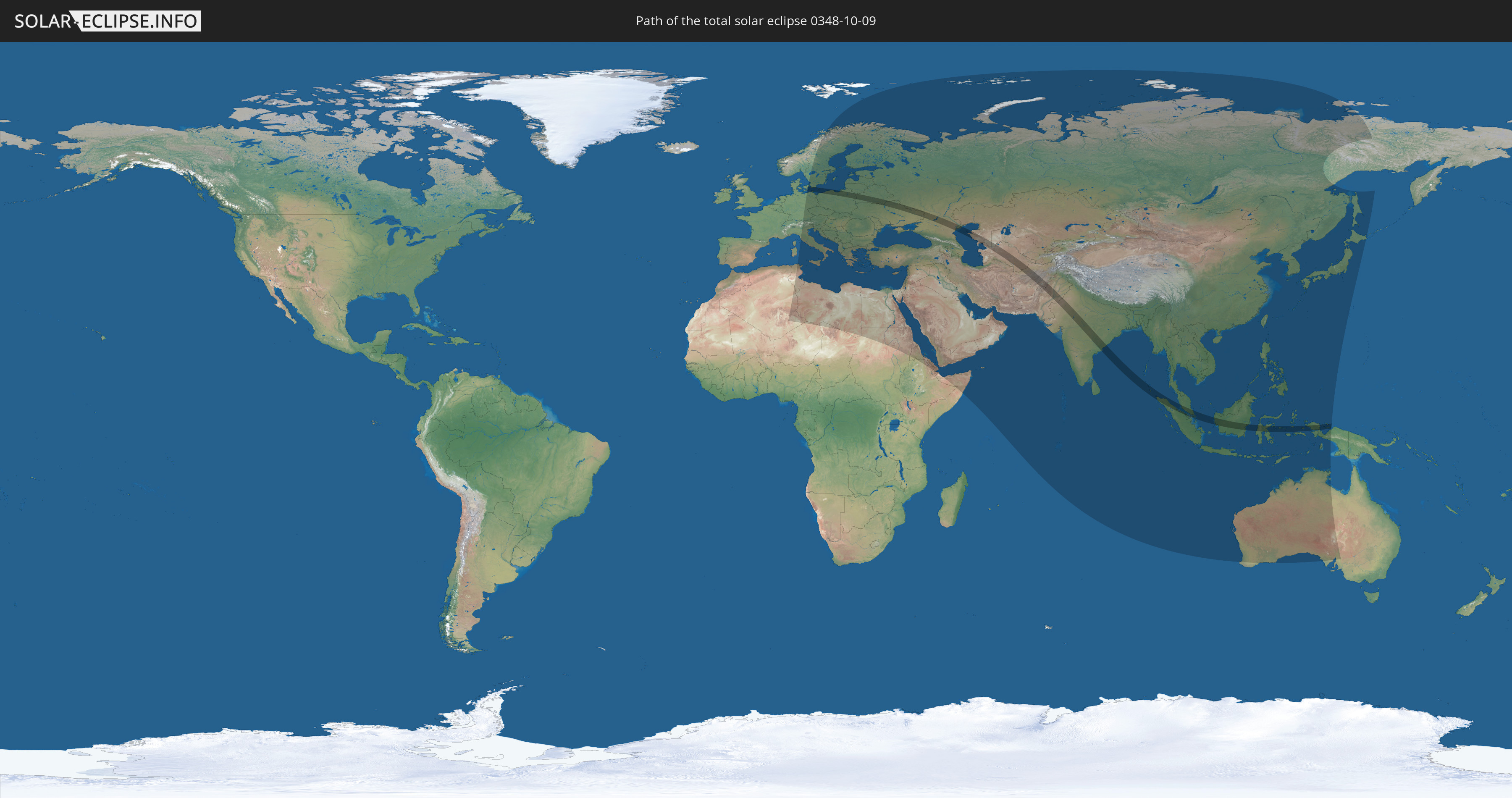
Total solar eclipse of 10/09/0348
| Day of week: | Saturday |
| Maximum duration of eclipse: | 04m07s |
| Maximum width of eclipse path: | 185 km |
| Saros cycle: | 78 |
| Coverage: | 100% |
| Magnitude: | 1.0501 |
| Gamma: | 0.454 |
Wo kann man die Sonnenfinsternis vom 10/09/0348 sehen?
Die Sonnenfinsternis am 10/09/0348 kann man in 100 Ländern als partielle Sonnenfinsternis beobachten.
Der Finsternispfad verläuft durch 17 Länder. Nur in diesen Ländern ist sie als total Sonnenfinsternis zu sehen.
In den folgenden Ländern ist die Sonnenfinsternis total zu sehen
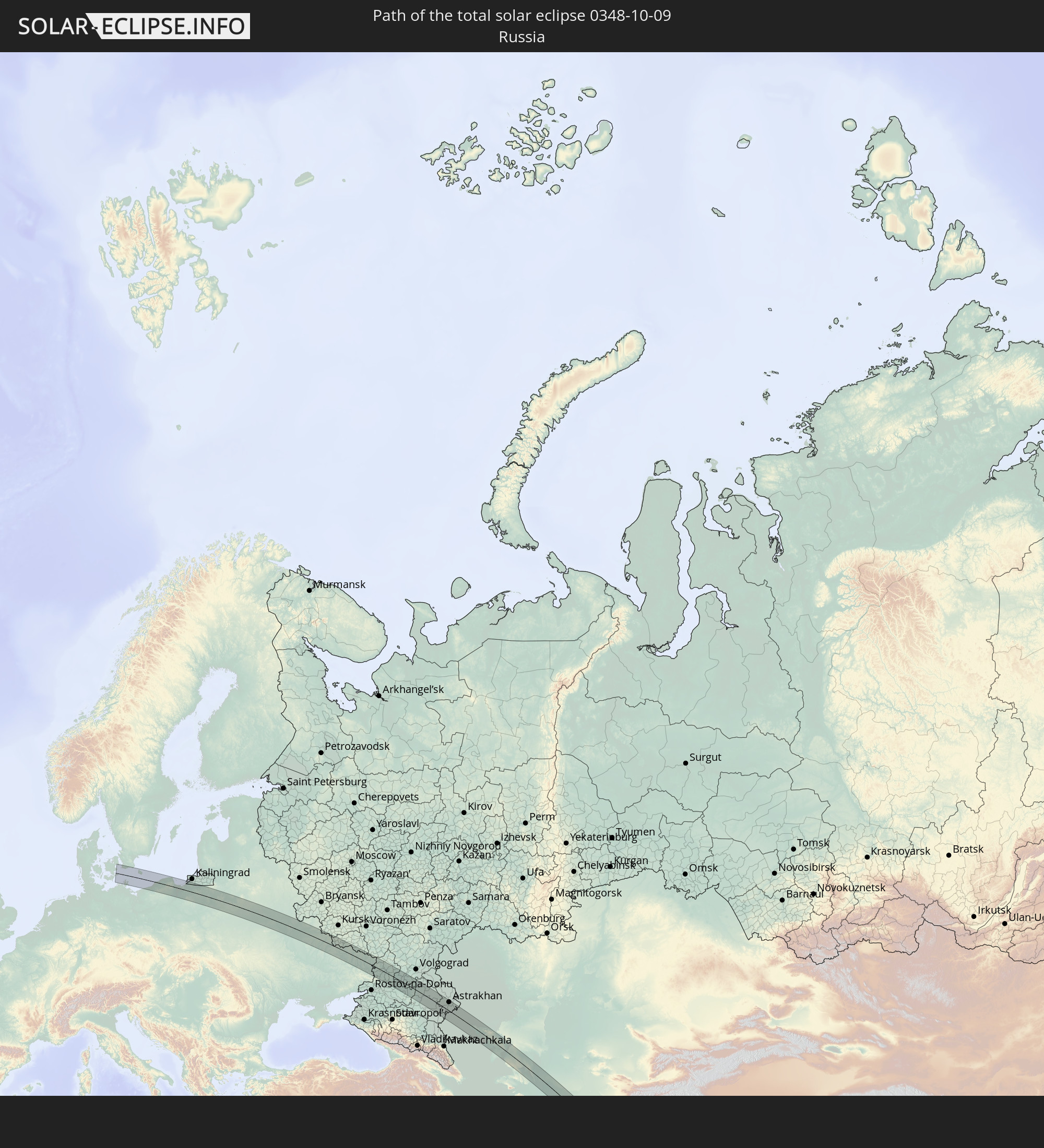 Russia
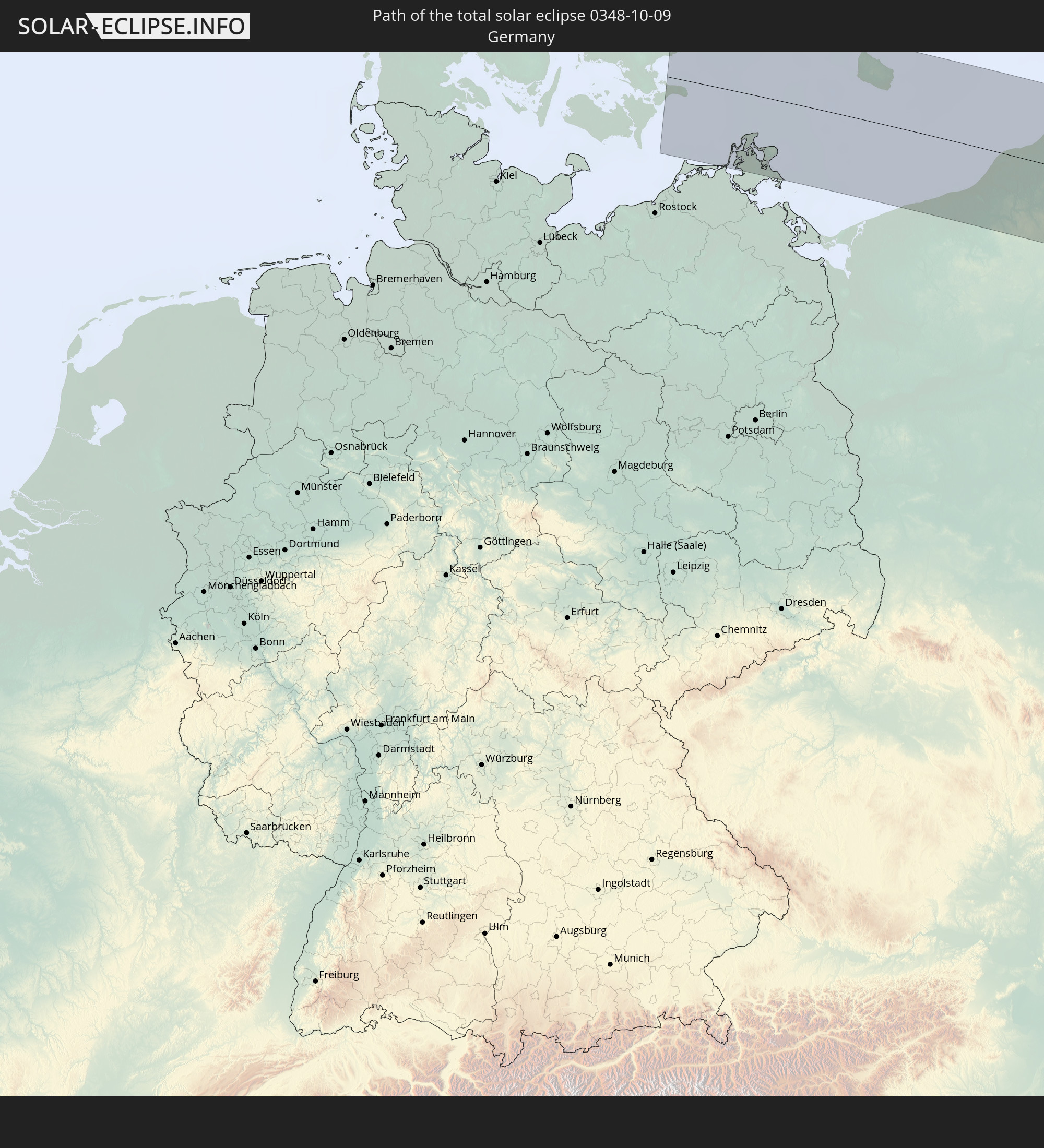 Germany
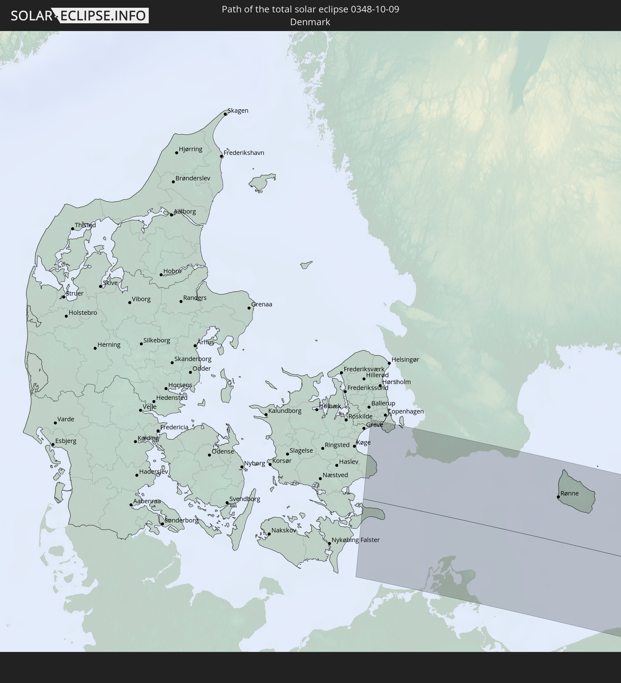 Denmark
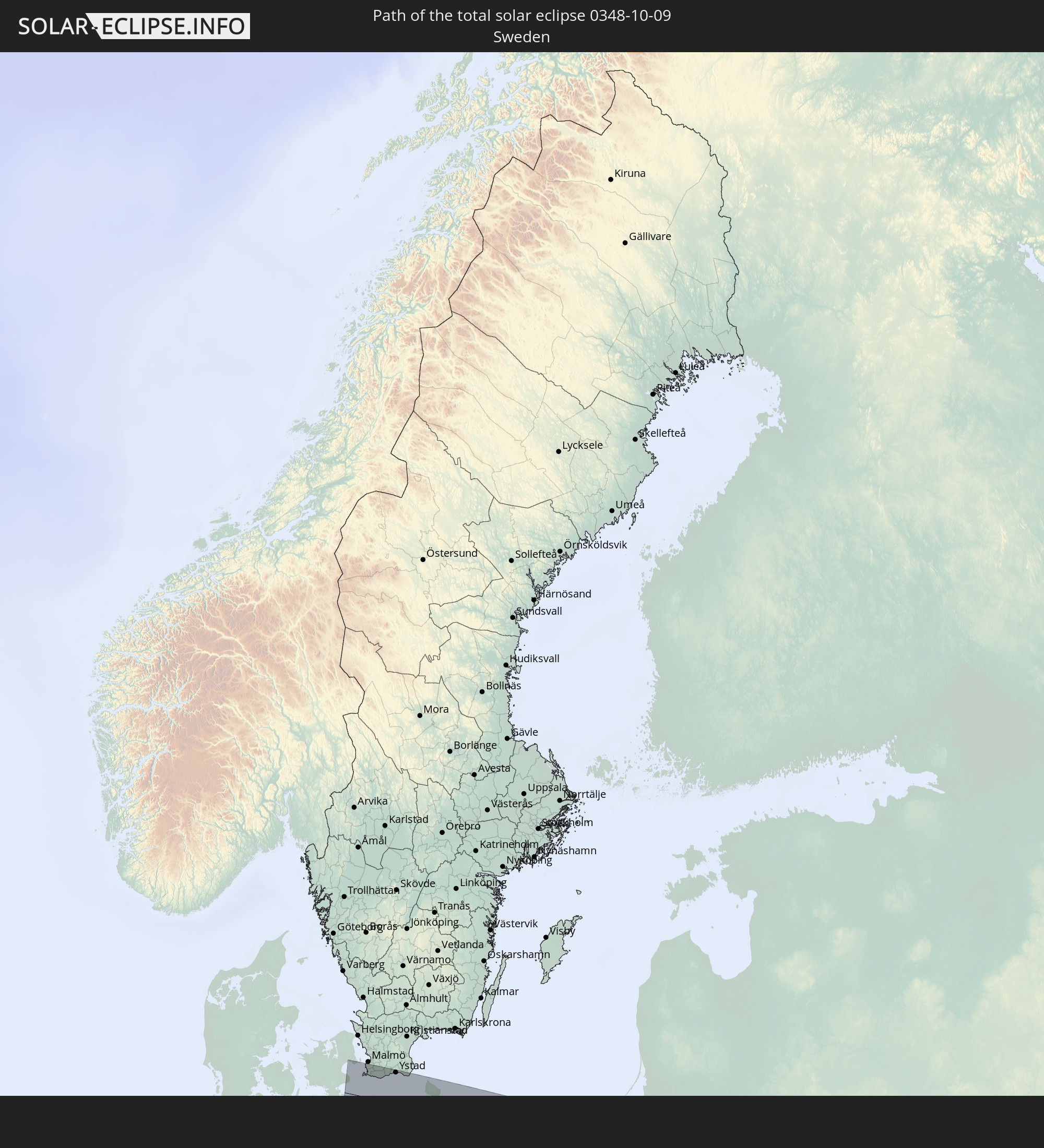 Sweden
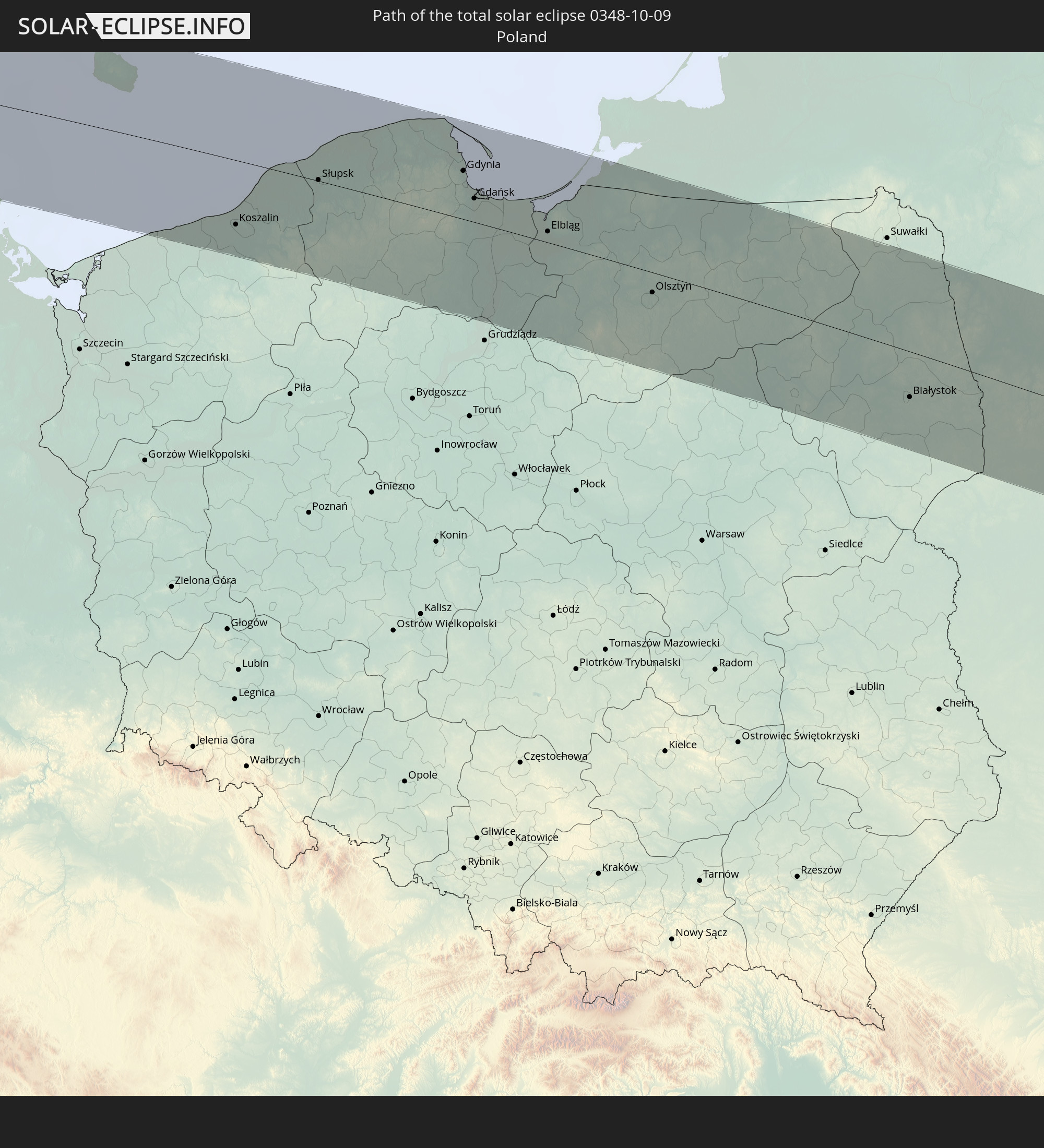 Poland
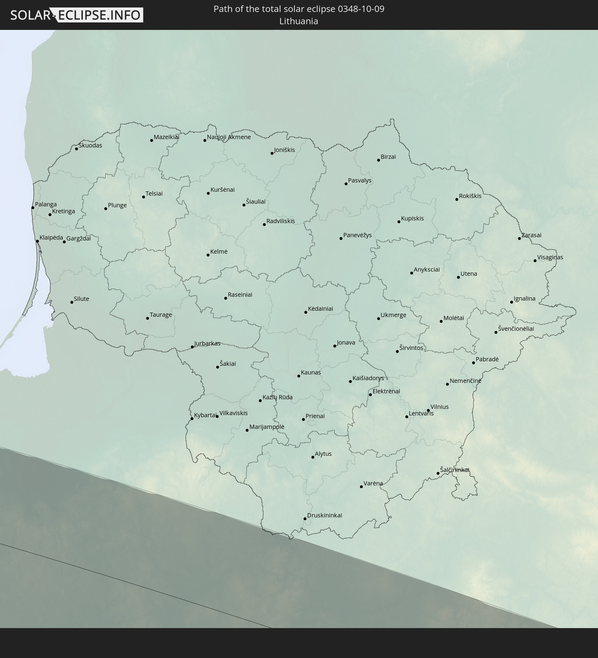 Lithuania
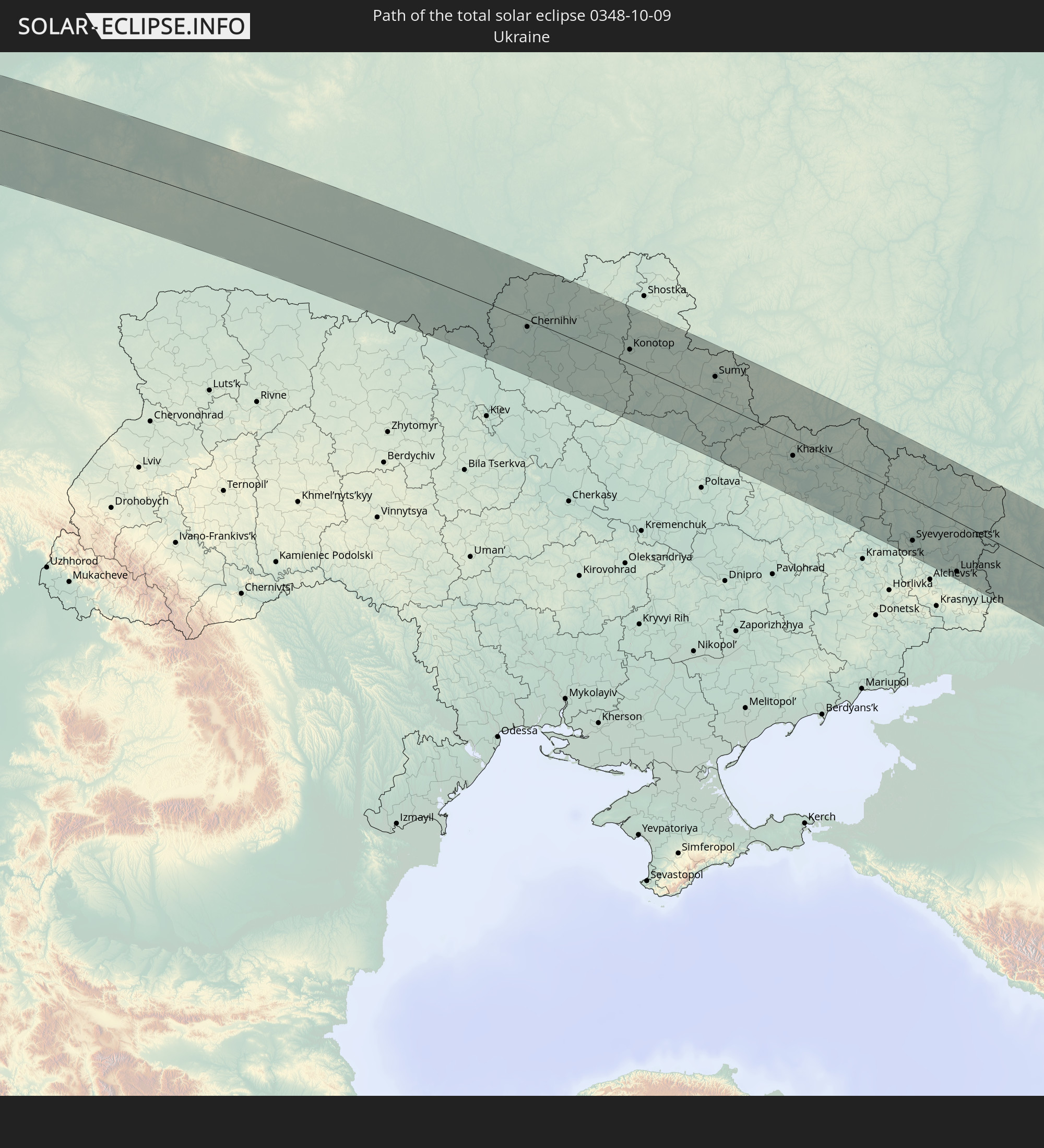 Ukraine
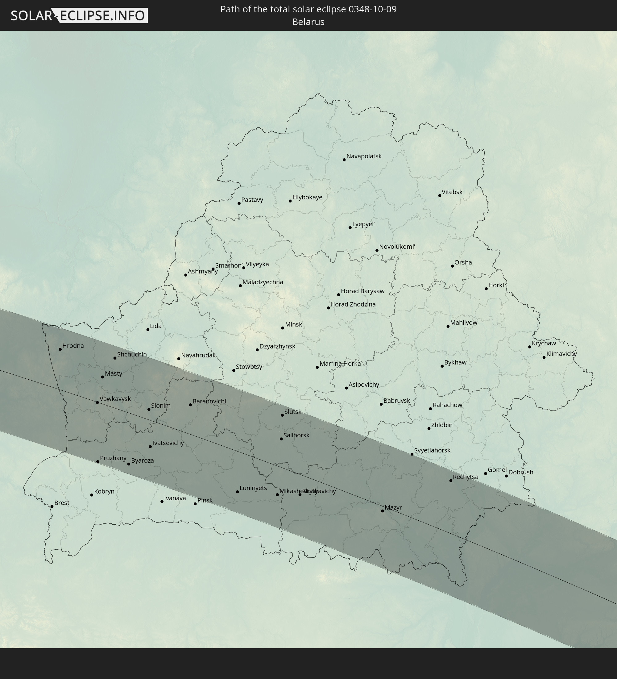 Belarus
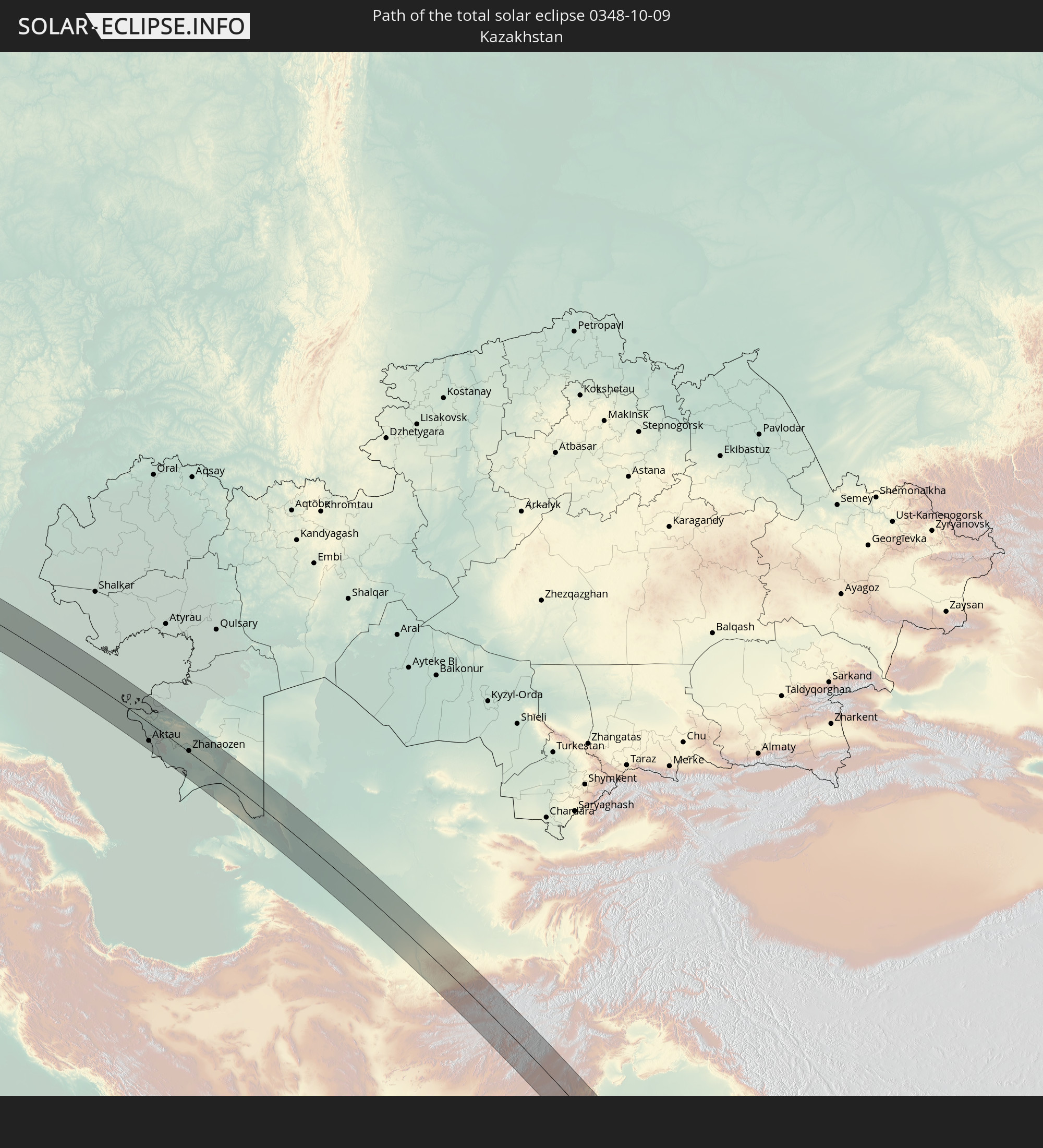 Kazakhstan
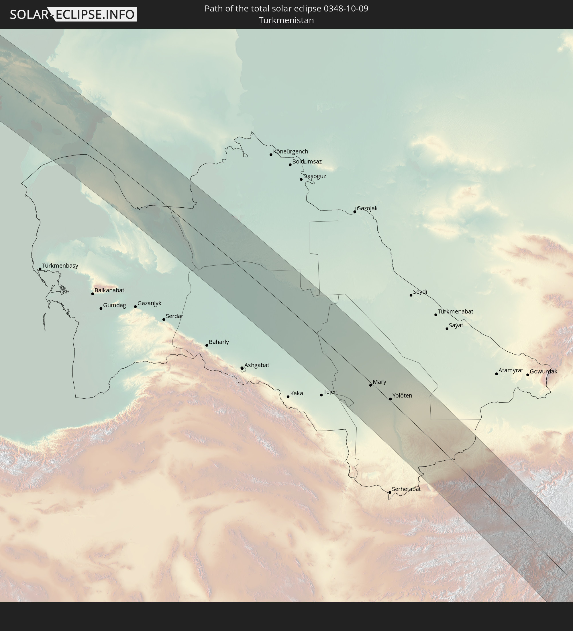 Turkmenistan
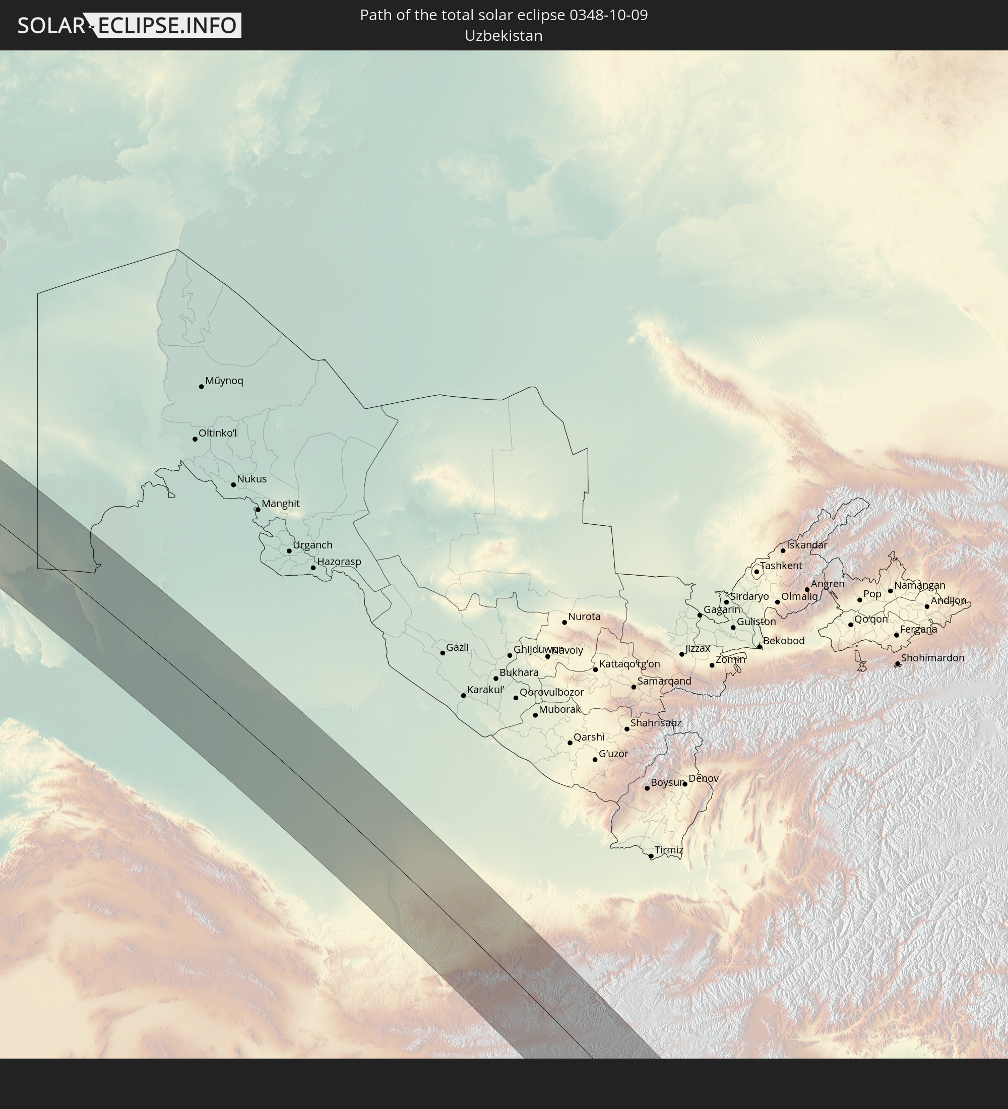 Uzbekistan
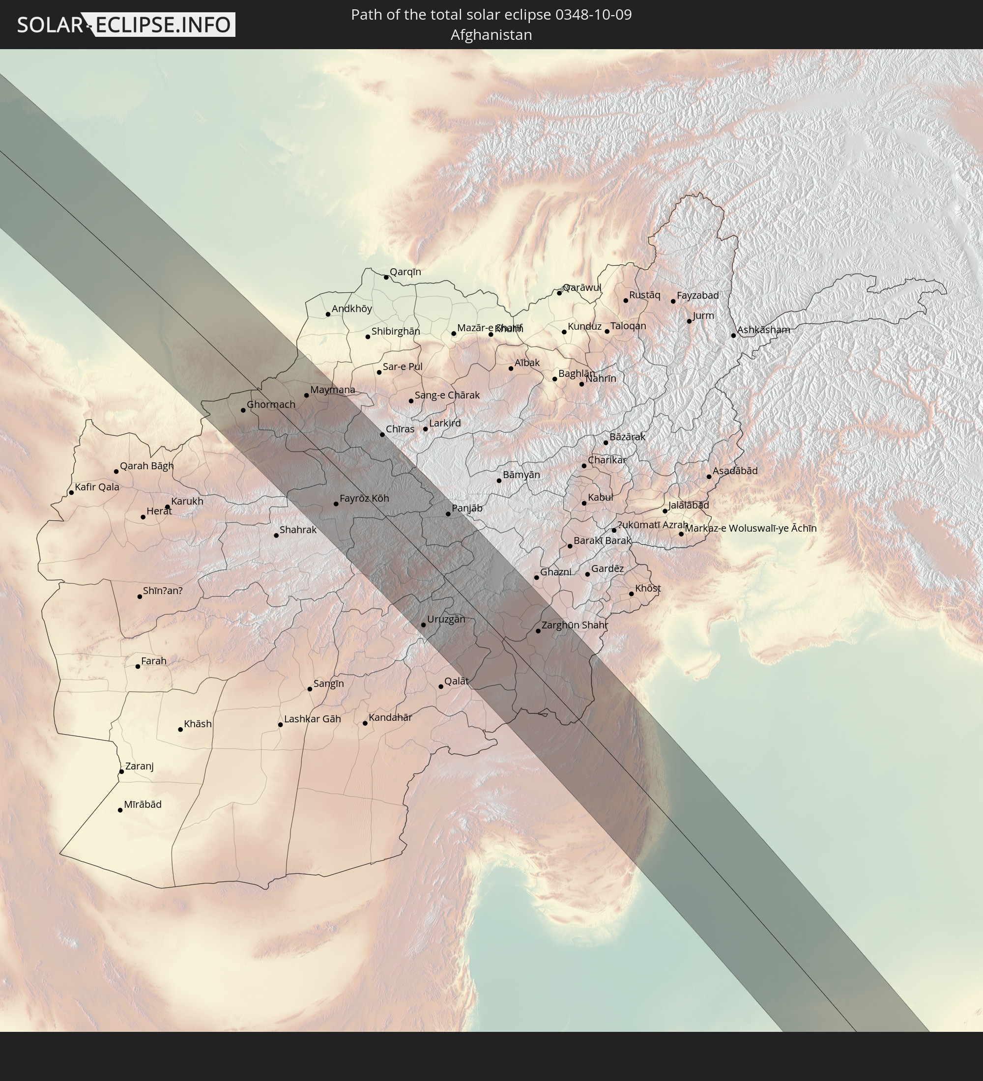 Afghanistan
 Pakistan
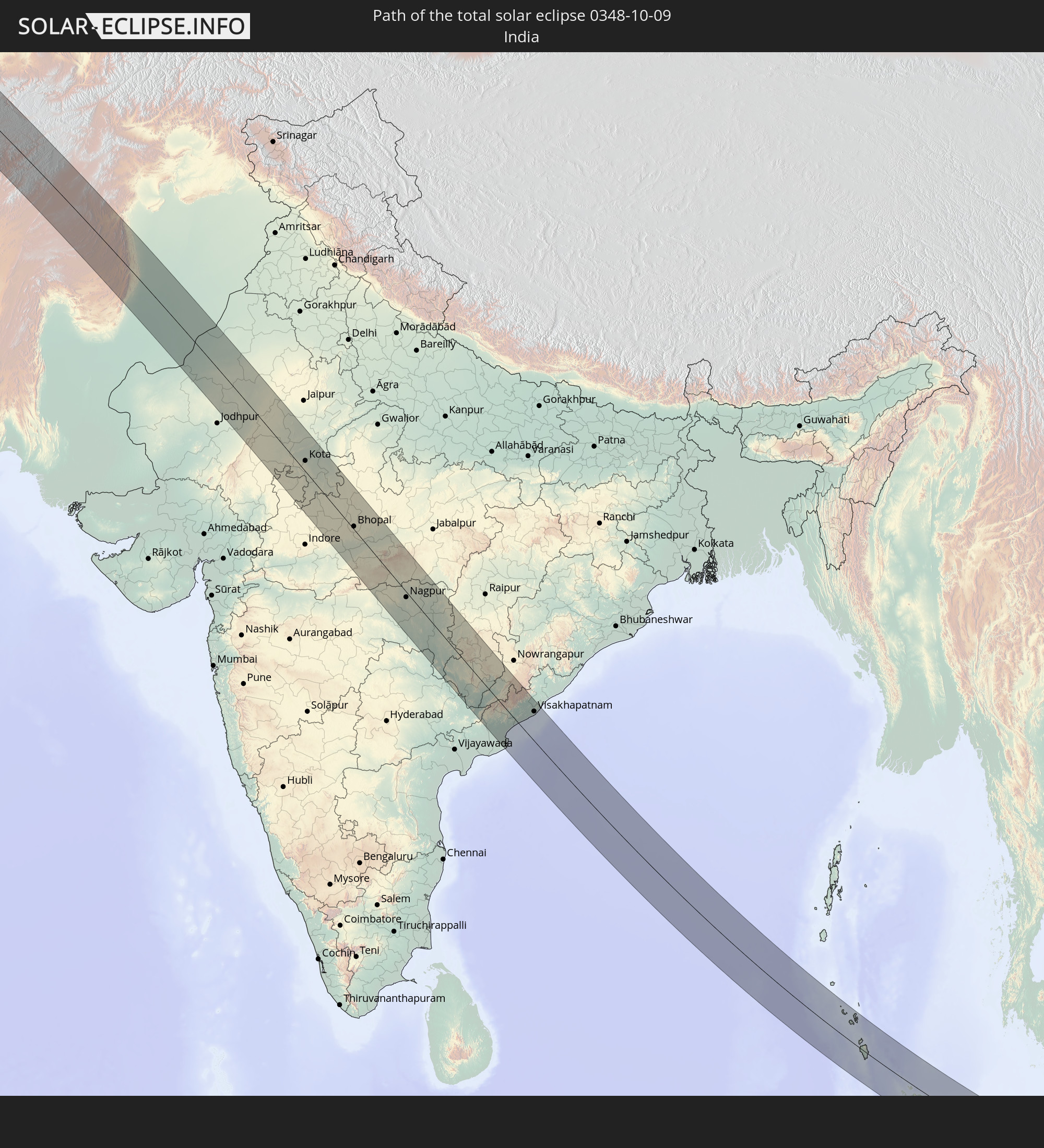 India
India
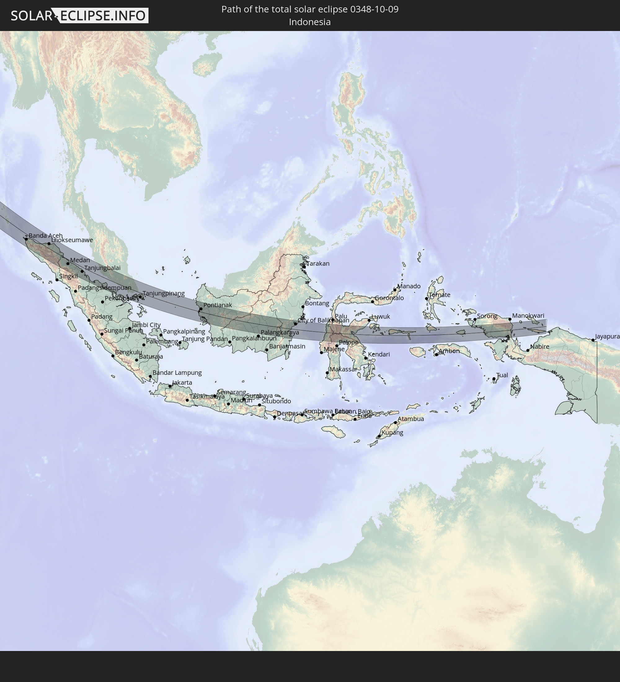 Indonesia
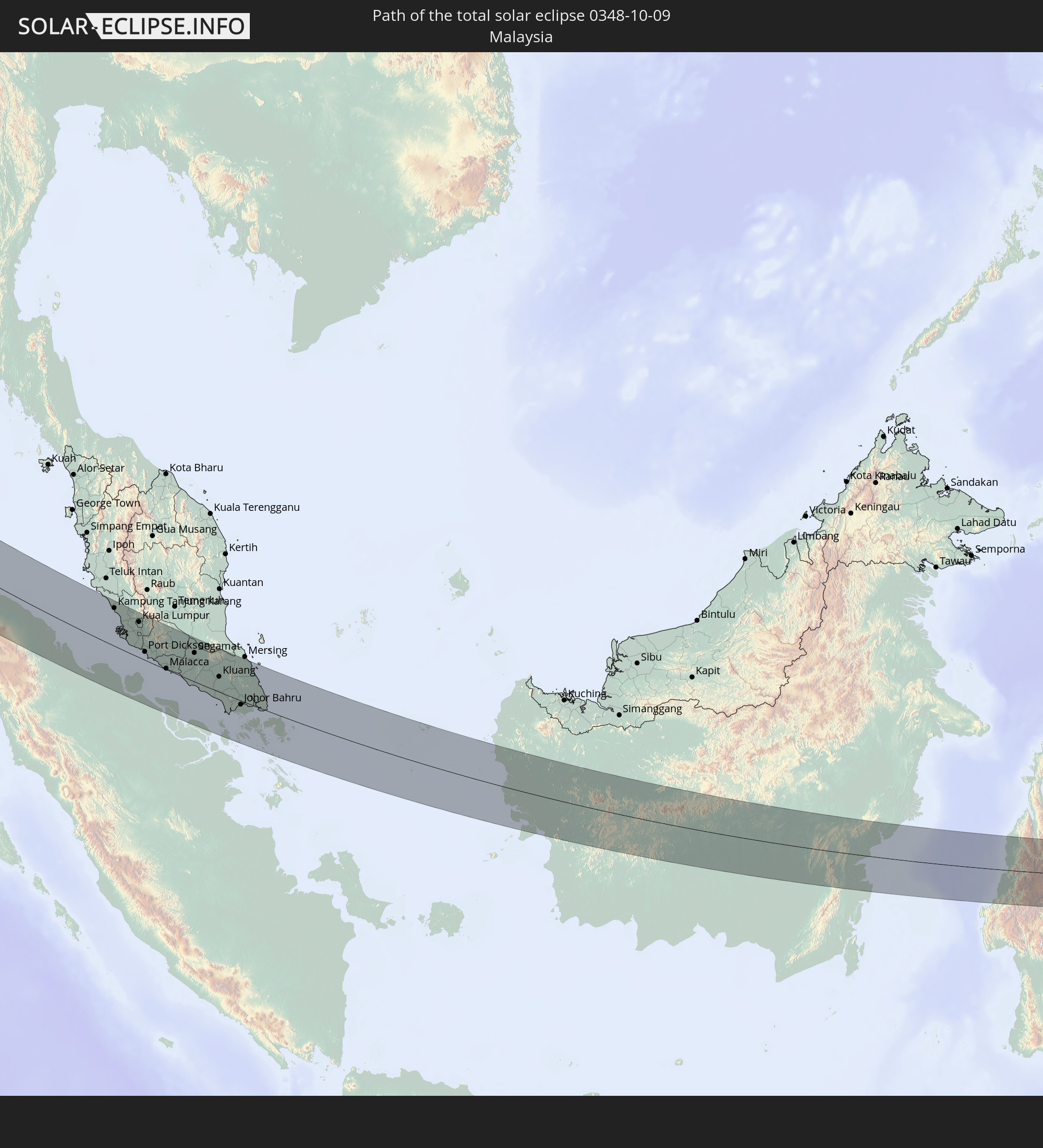 Malaysia
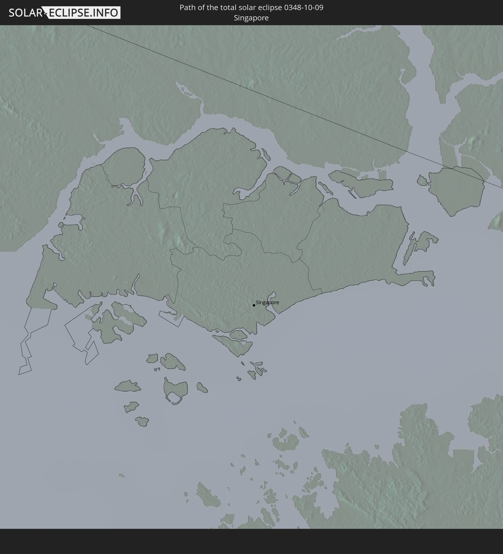 Singapore
In den folgenden Ländern ist die Sonnenfinsternis partiell zu sehen
 Russia
 Algeria
 Niger
Niger
 Norway
 Germany
 Italy
Italy
 Tunisia
 Denmark
 Libya
Libya
 Austria
 Sweden
 Czechia
 San Marino
 Vatican City
 Slovenia
 Chad
Chad
 Croatia
 Poland
 Malta
Malta
 Bosnia and Herzegovina
 Hungary
 Slovakia
 Montenegro
 Serbia
 Albania
 Åland Islands
 Greece
 Romania
 Republic of Macedonia
 Finland
 Lithuania
 Latvia
 Estonia
 Sudan
Sudan
 Ukraine
 Bulgaria
 Belarus
 Egypt
Egypt
 Turkey
 Moldova
 Cyprus
 Ethiopia
 State of Palestine
 Israel
 Saudi Arabia
 Jordan
 Lebanon
 Syria
Syria
 Eritrea
 Iraq
Iraq
 Georgia
 Somalia
 Djibouti
 Yemen
Yemen
 Armenia
 Iran
Iran
 Azerbaijan
 Kazakhstan
 Kuwait
 Bahrain
 Qatar
Qatar
 United Arab Emirates
 Oman
Oman
 Turkmenistan
 Uzbekistan
 Afghanistan
 Pakistan
 Tajikistan
 India
India
 Kyrgyzstan
 British Indian Ocean Territory
 Maldives
 China
China
 Sri Lanka
 Nepal
Nepal
 Mongolia
 Bangladesh
 Bhutan
 Myanmar
 Indonesia
 Cocos Islands
 Thailand
 Malaysia
 Laos
Laos
 Vietnam
 Cambodia
 Singapore
 Christmas Island
 Australia
 Macau
Macau
 Hong Kong
 Brunei
 Taiwan
 Philippines
 Japan
Japan
 East Timor
 North Korea
 South Korea
 Palau
Palau
 Federated States of Micronesia
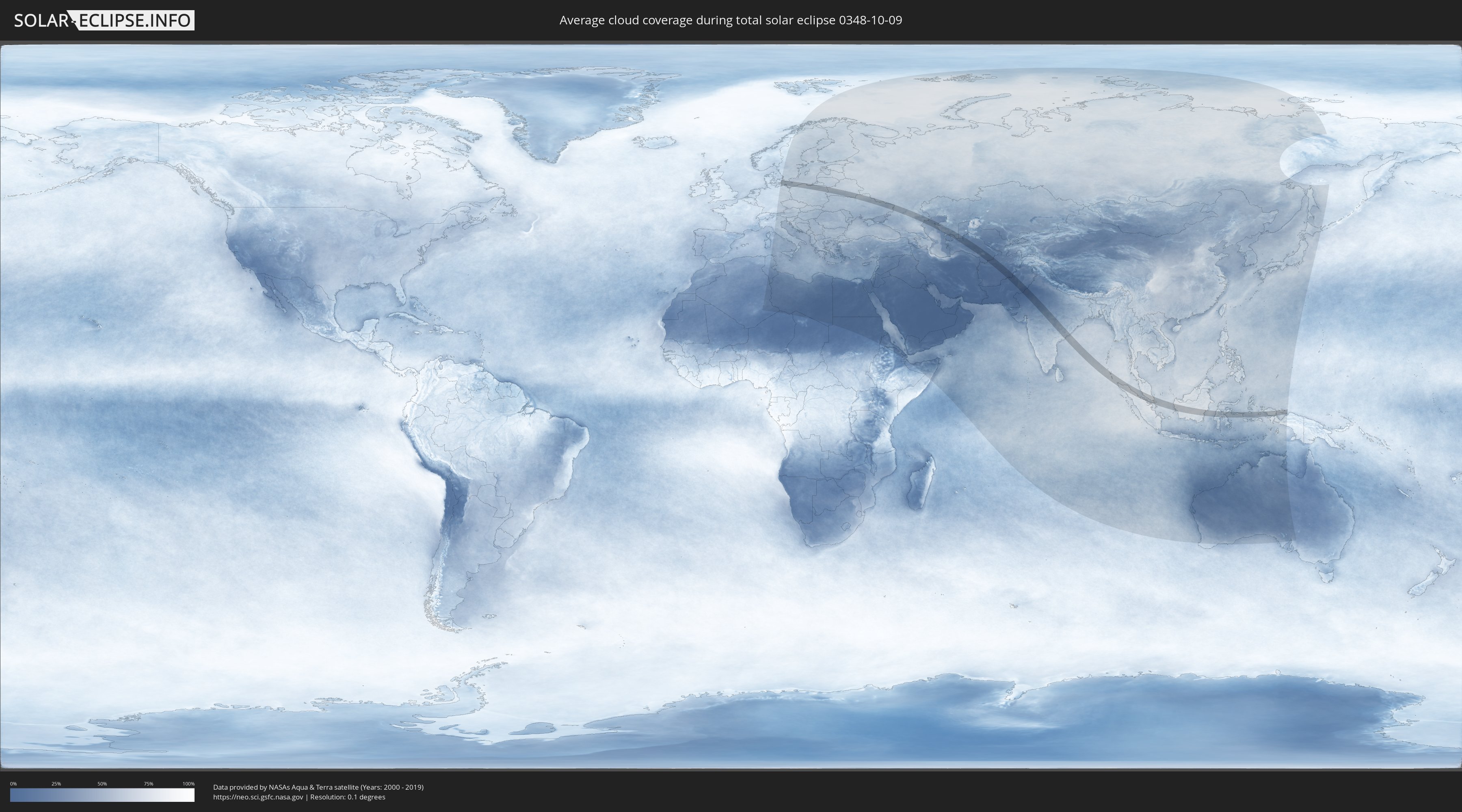
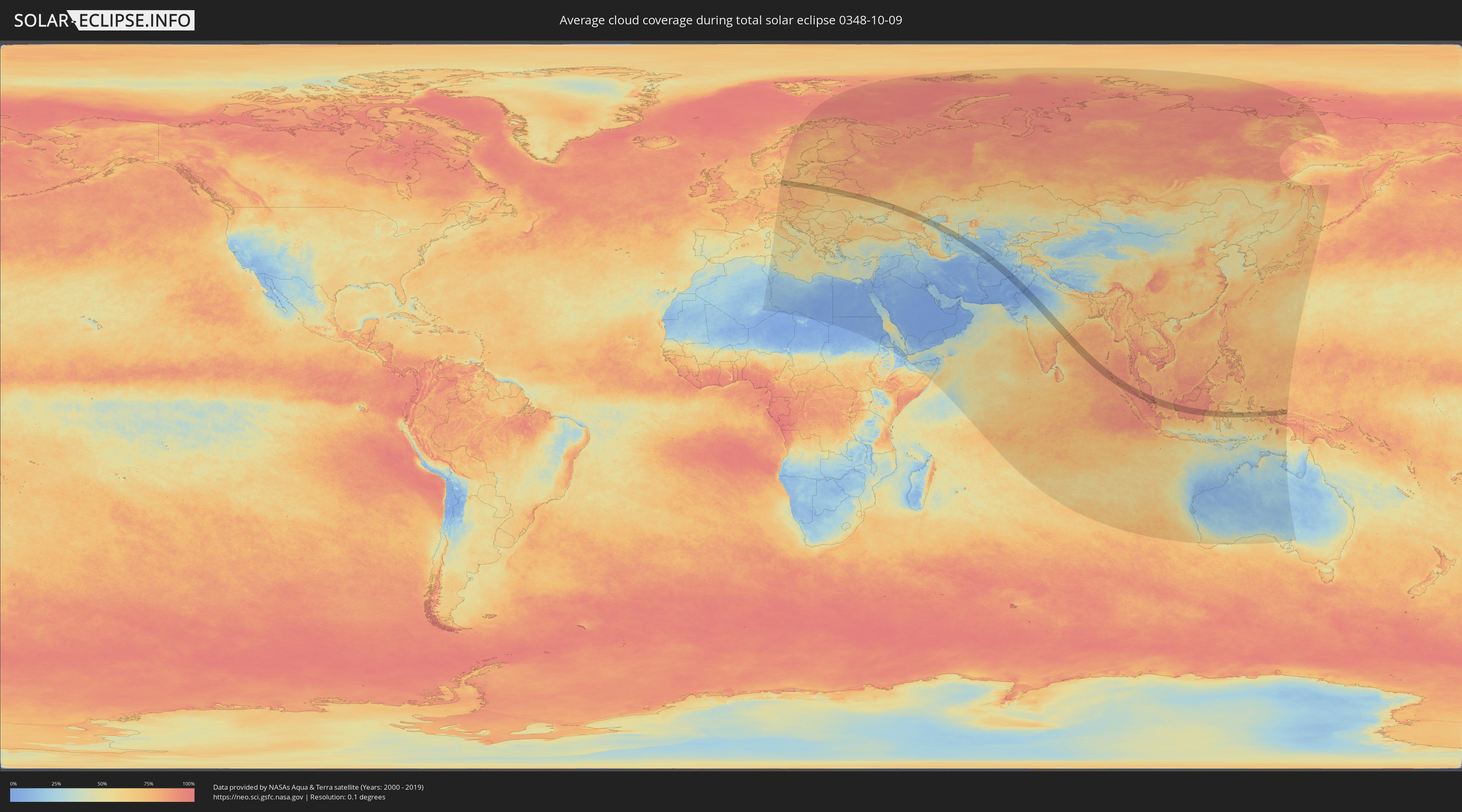
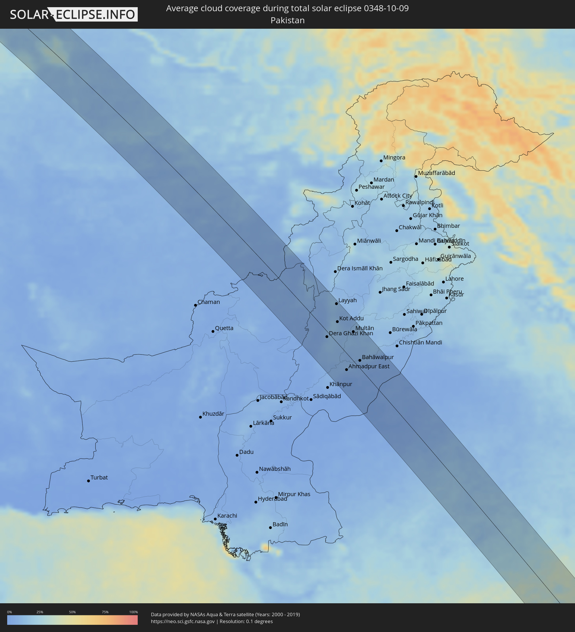
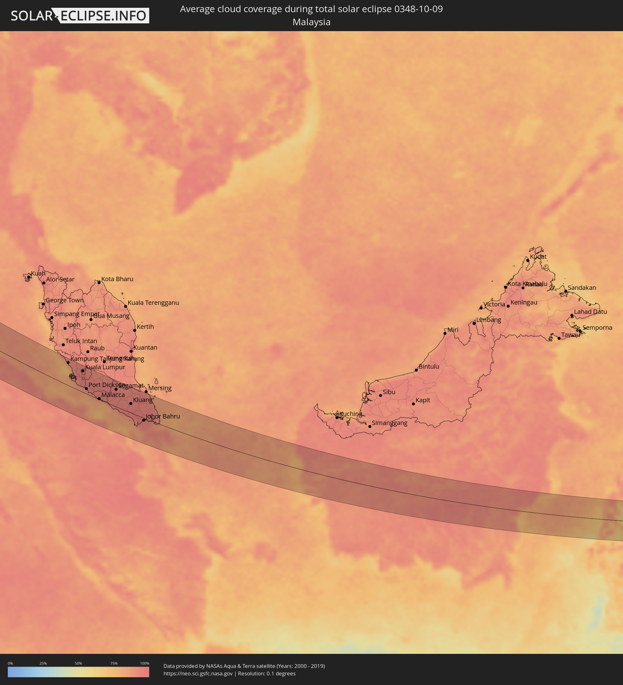
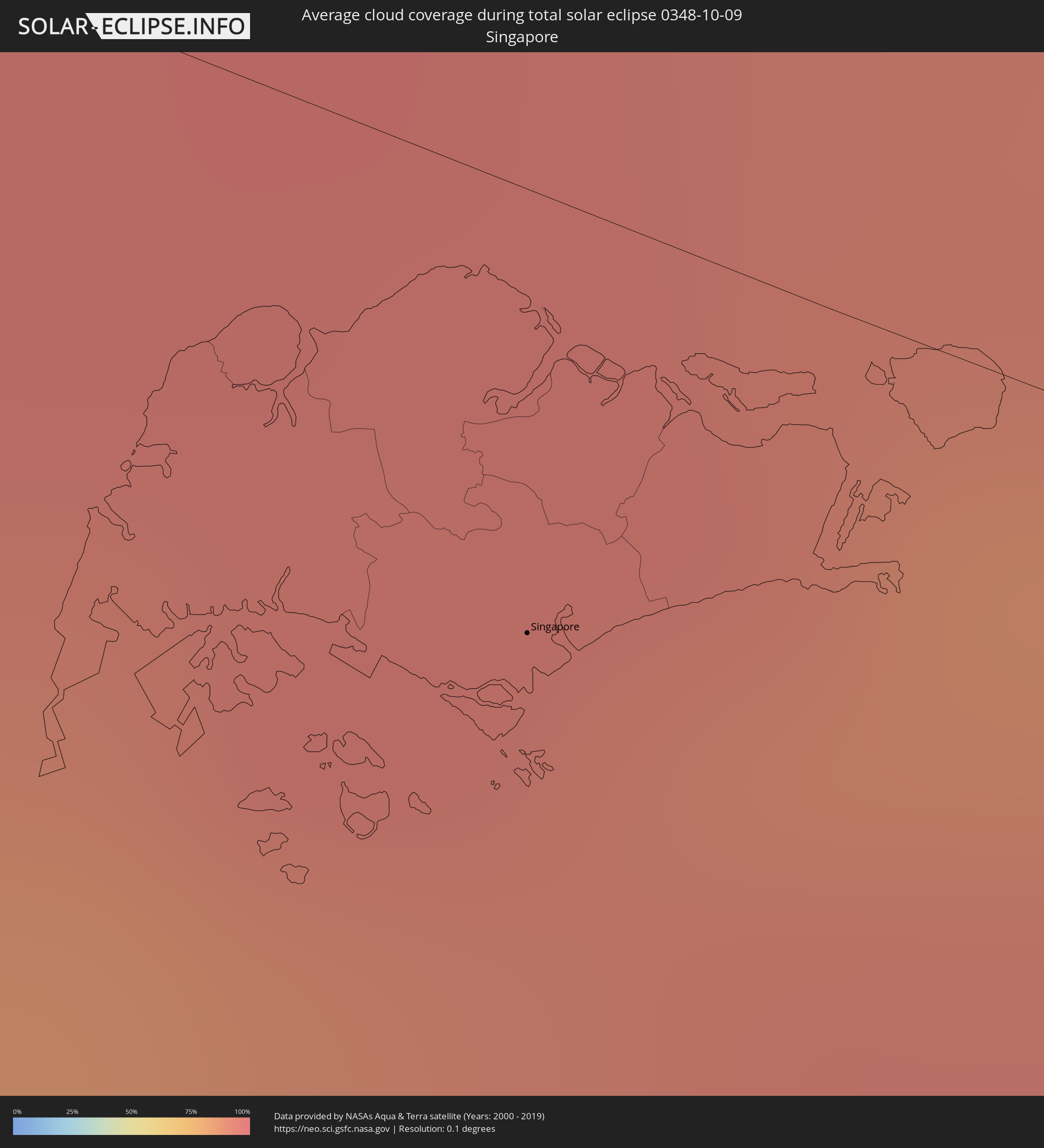
How will be the weather during the total solar eclipse on 10/09/0348?
Where is the best place to see the total solar eclipse of 10/09/0348?
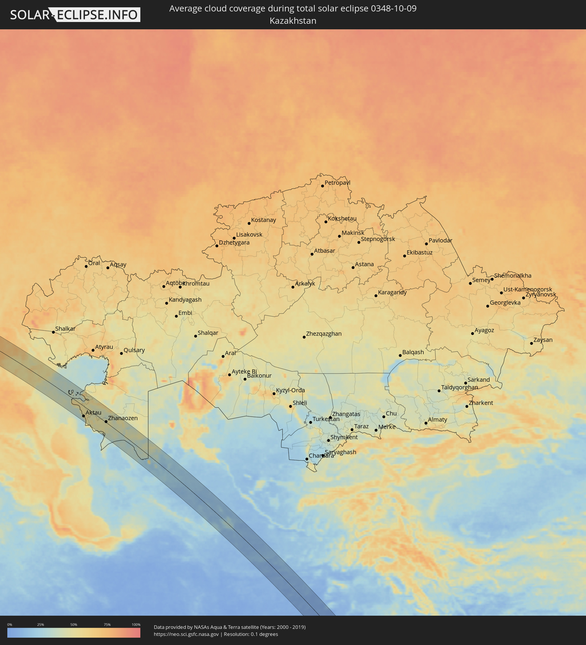
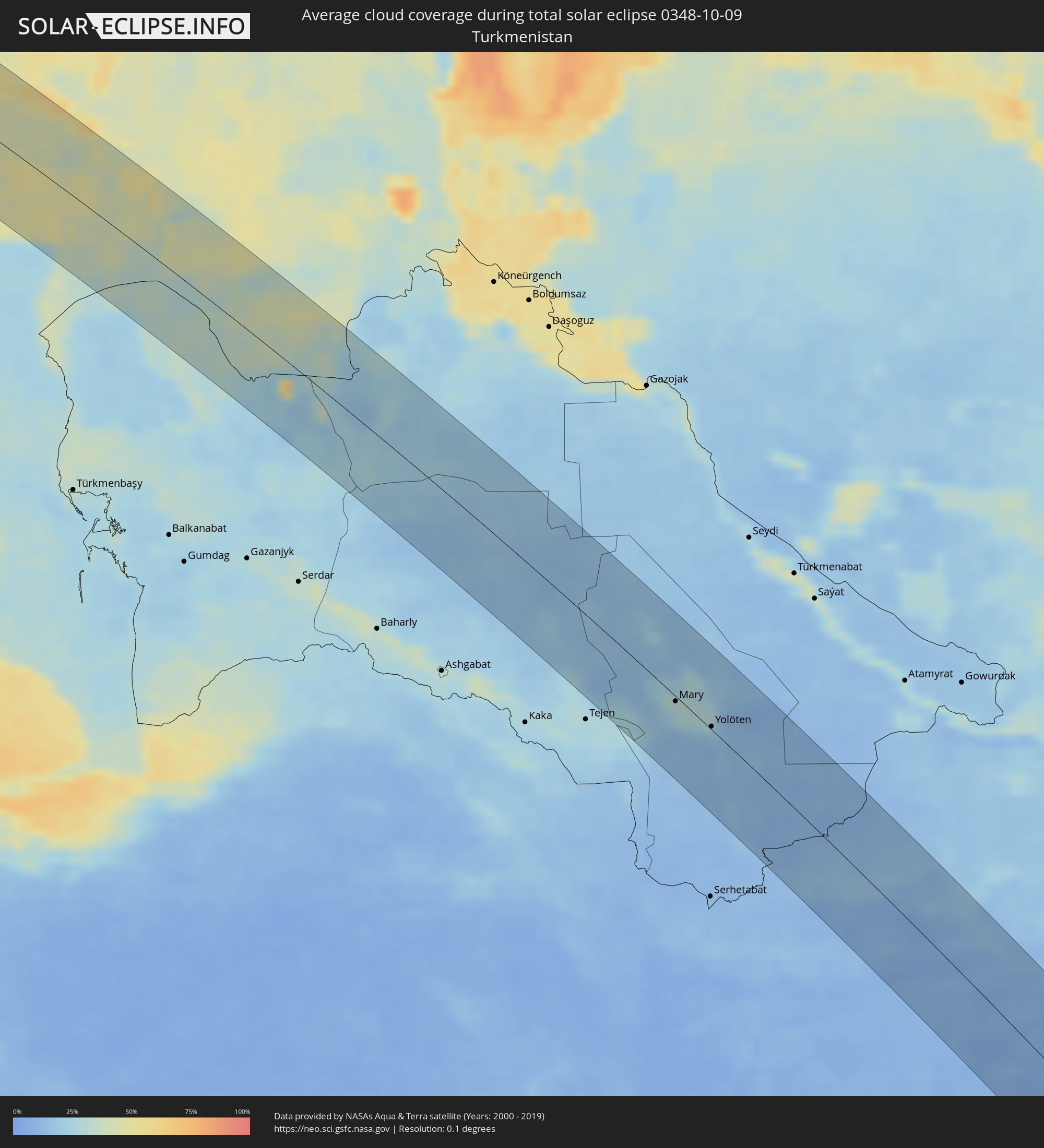
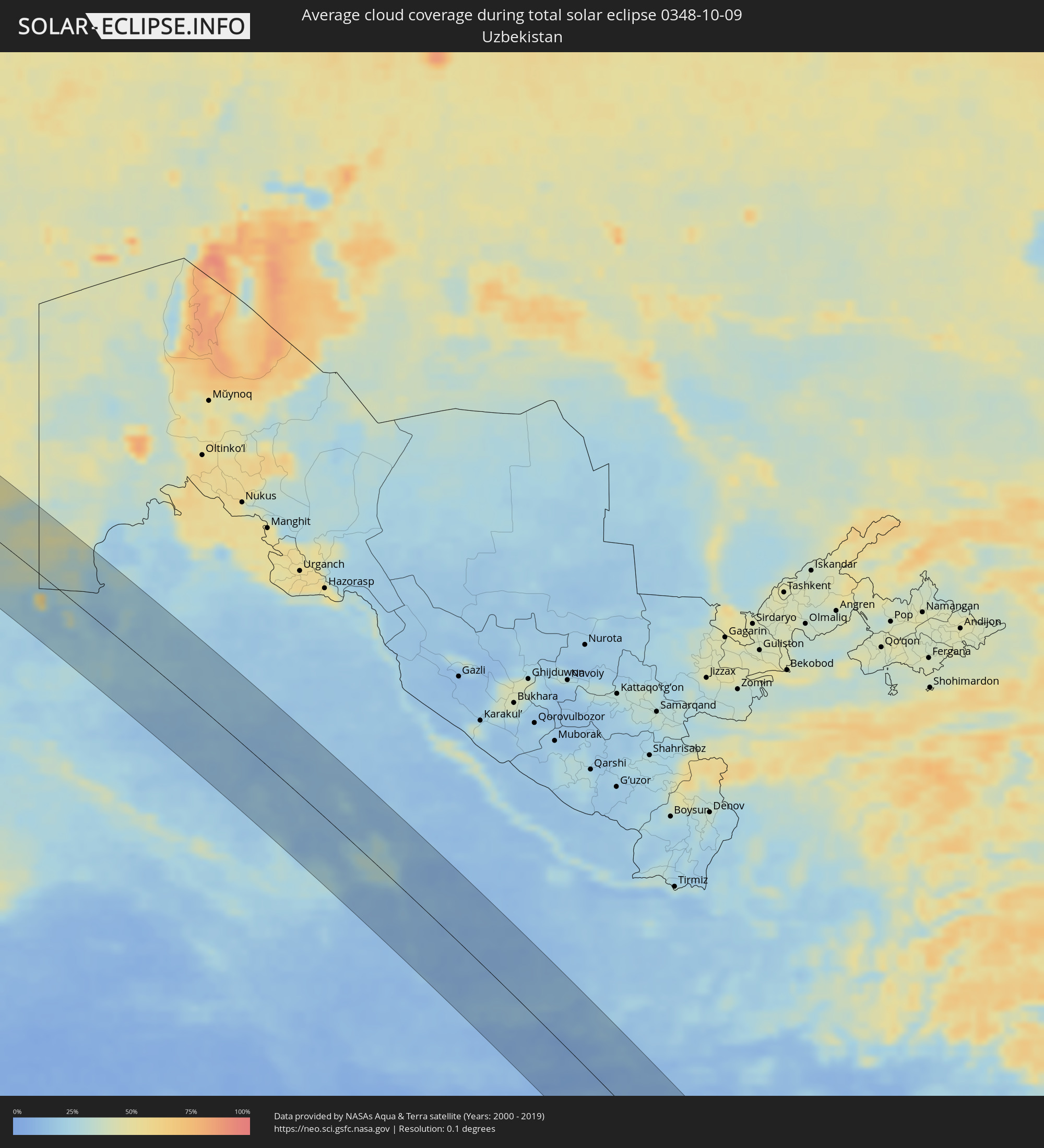
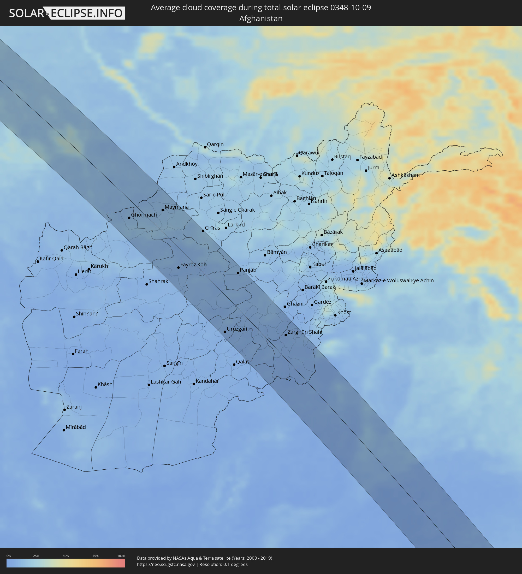
The following maps show the average cloud coverage for the day of the total solar eclipse.
With the help of these maps, it is possible to find the place along the eclipse path, which has the best
chance of a cloudless sky.
Nevertheless, you should consider local circumstances and inform about the weather of your chosen
observation site.
The data is provided by NASAs satellites
AQUA and TERRA.
The cloud maps are averaged over a period of 19 years (2000 - 2019).
Detailed country maps
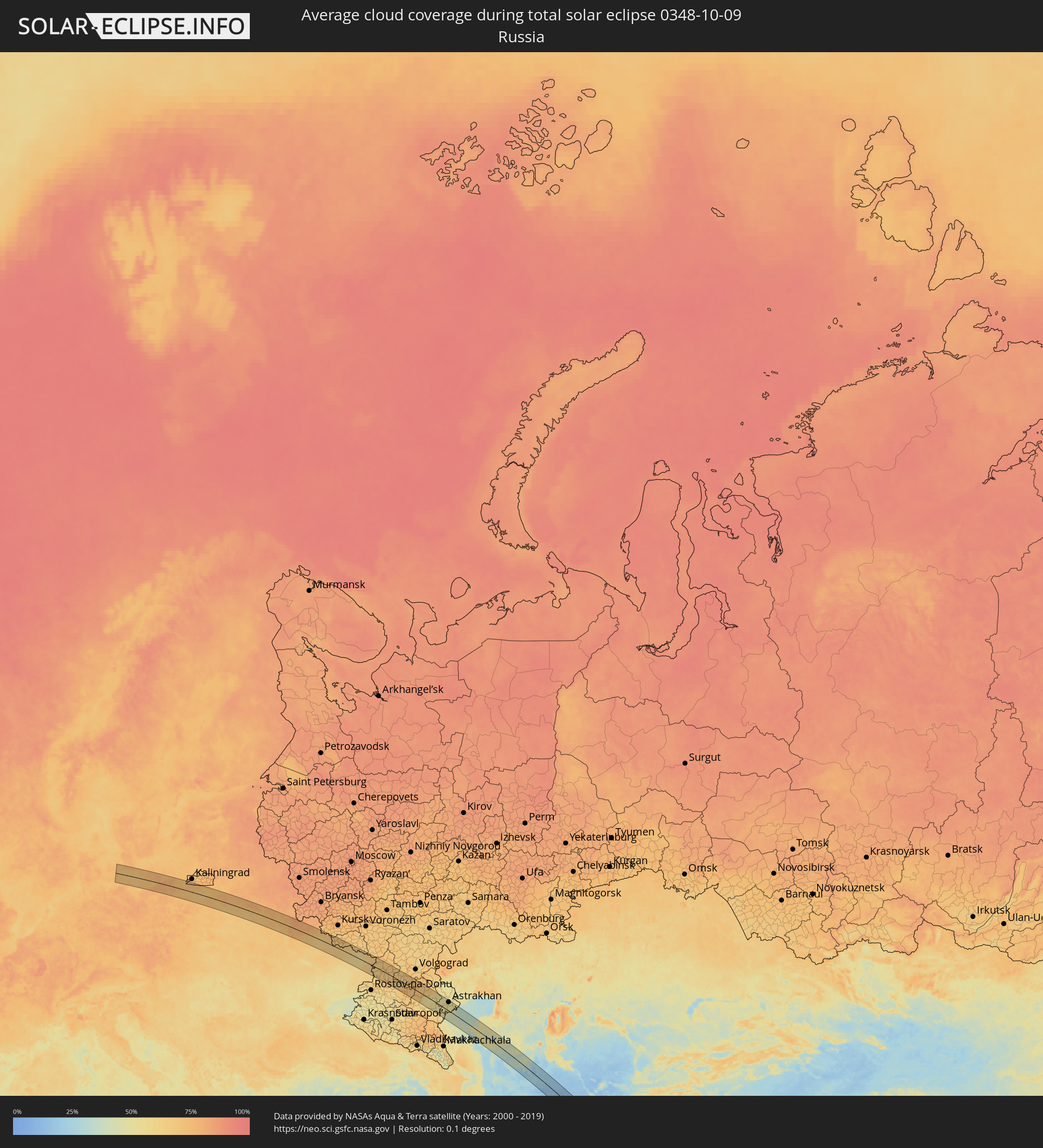 Russia
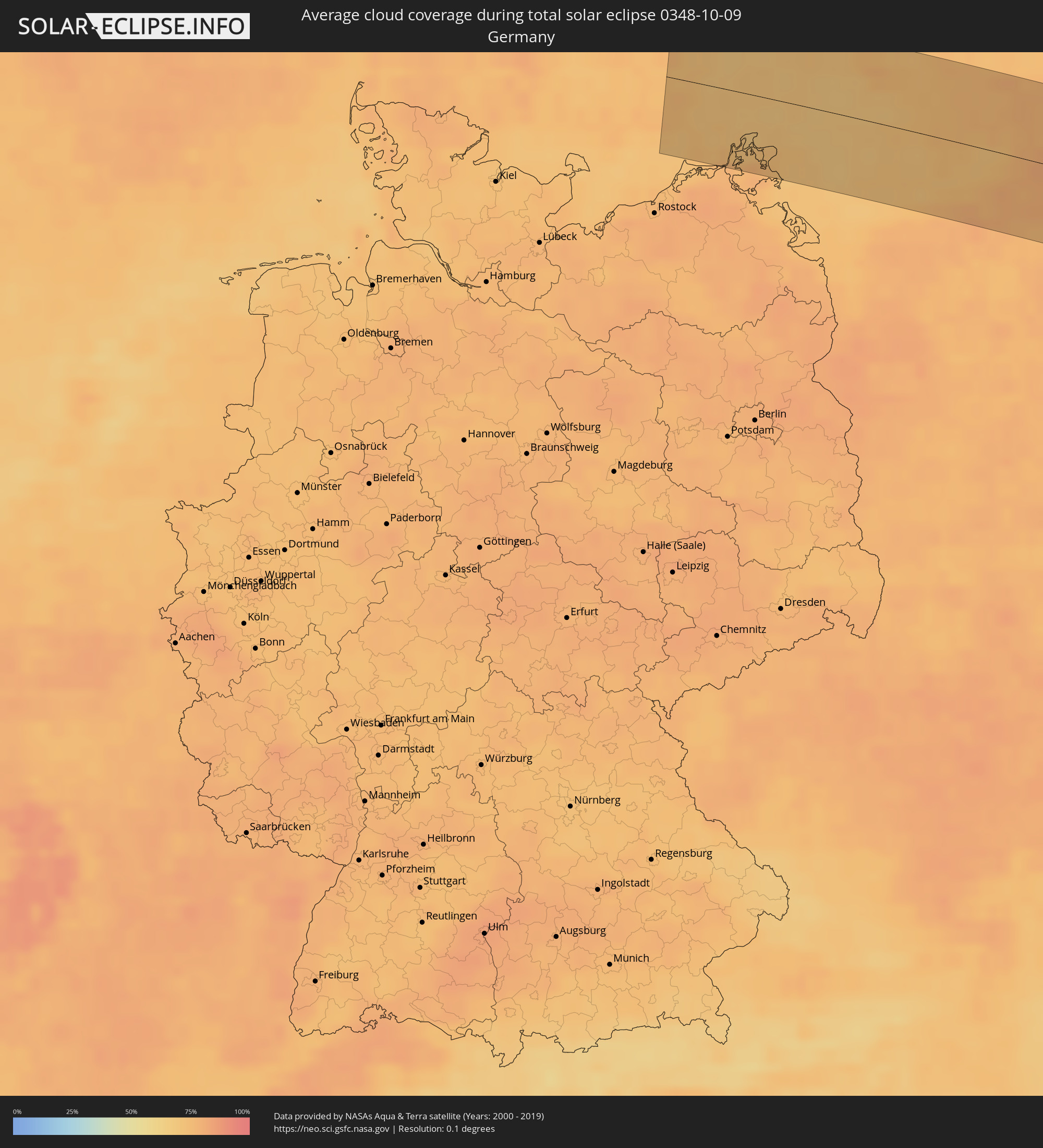 Germany
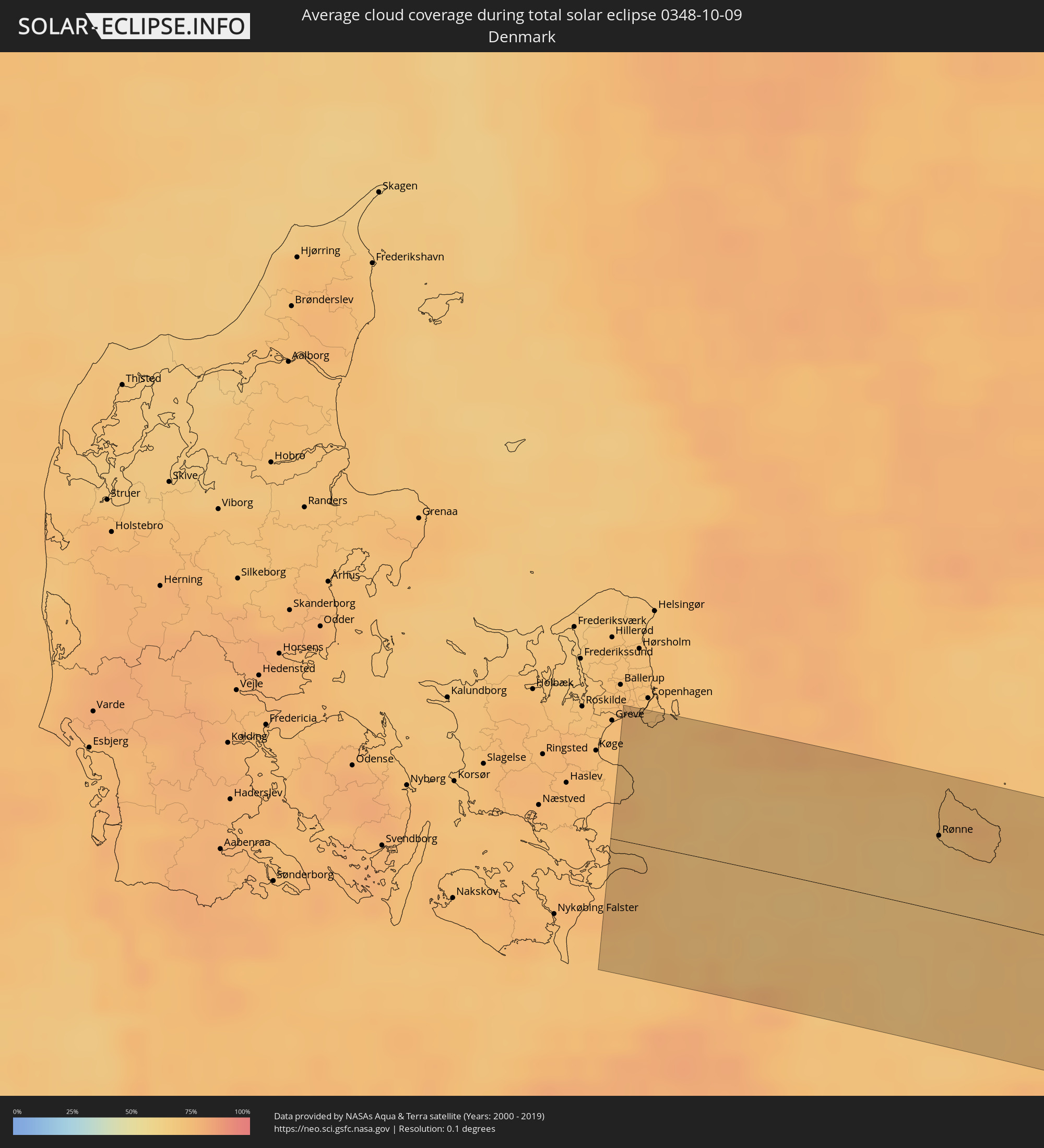 Denmark
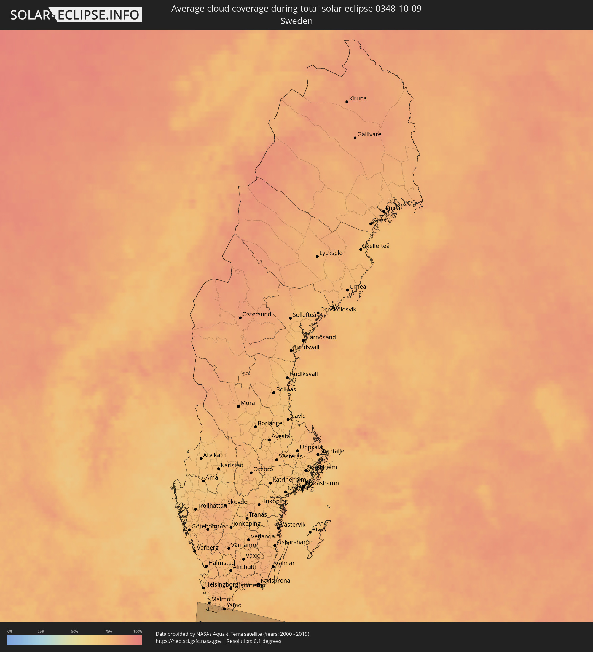 Sweden
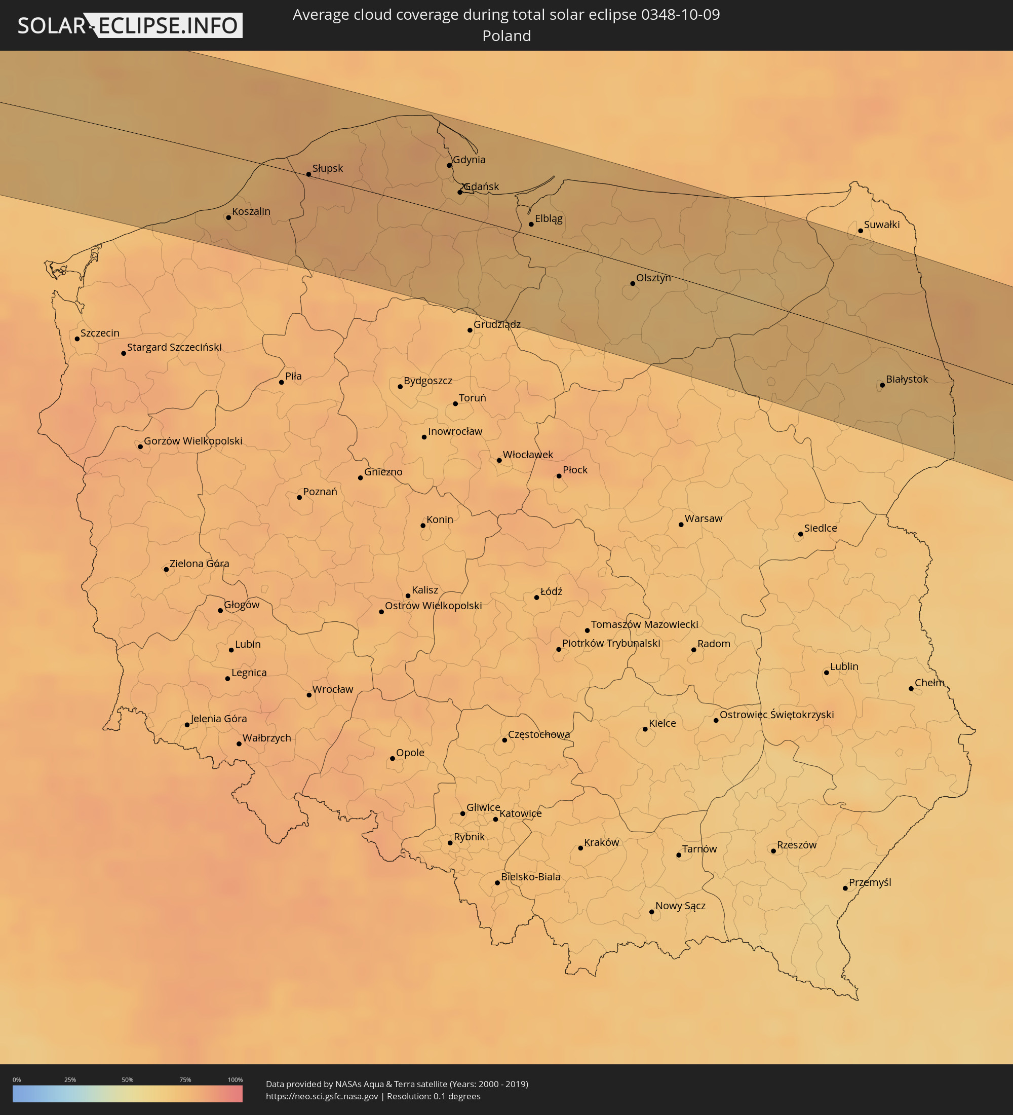 Poland
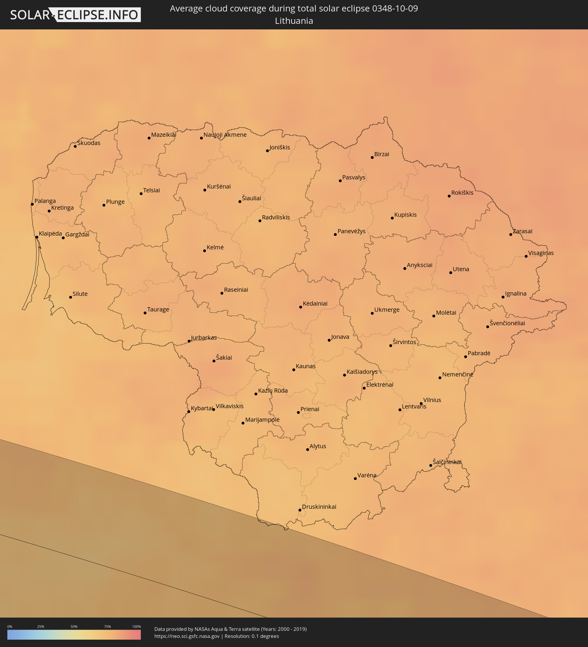 Lithuania
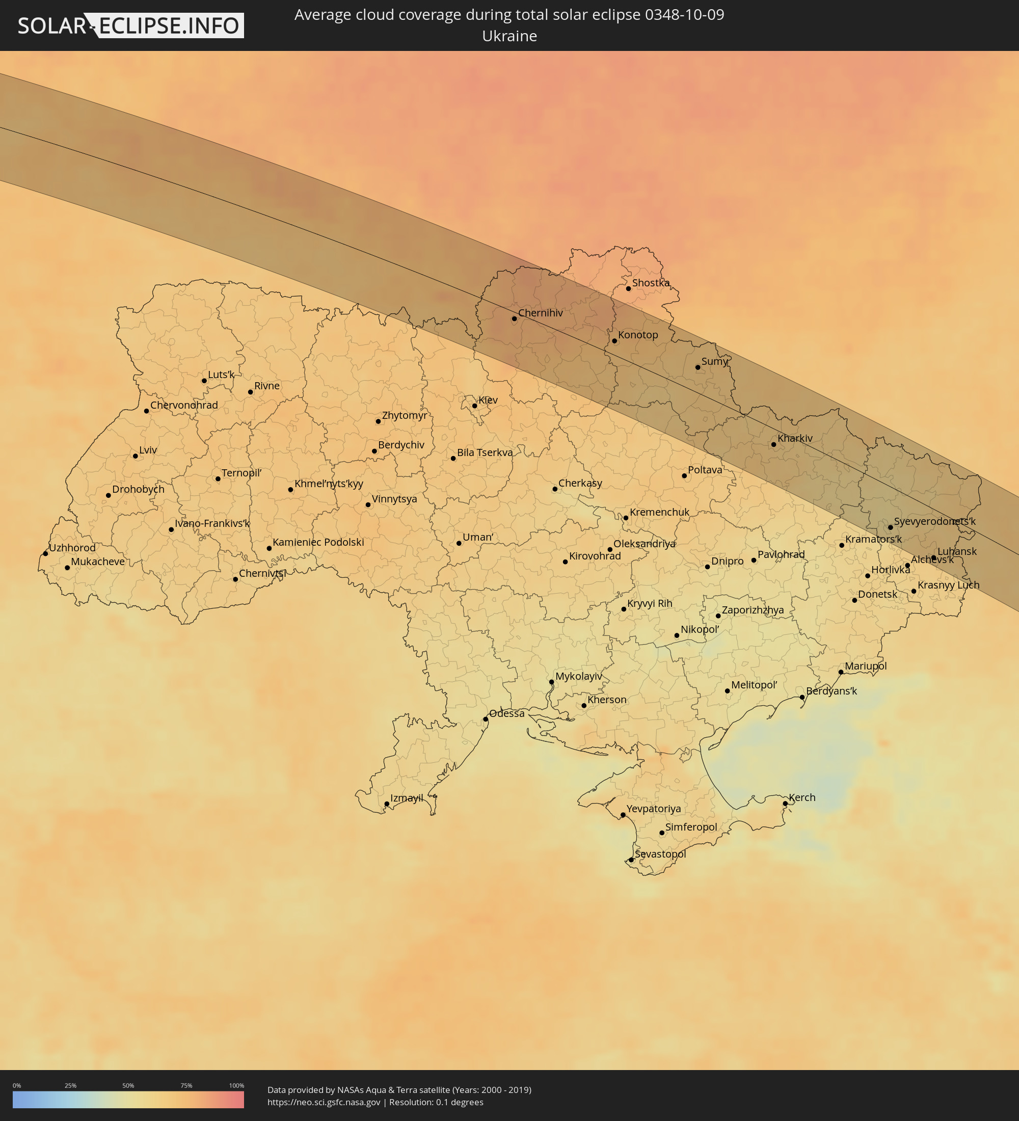 Ukraine
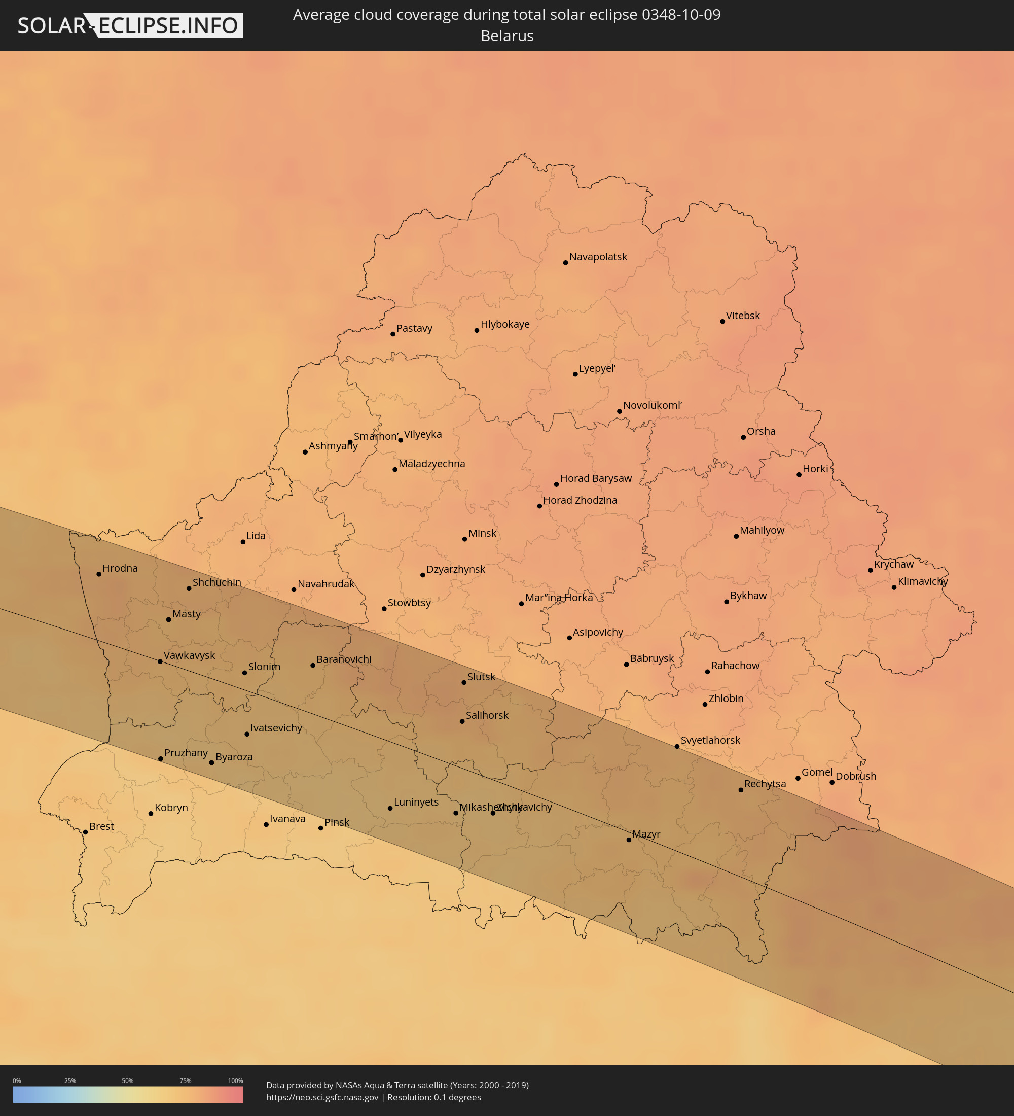 Belarus
 Kazakhstan
 Turkmenistan
 Uzbekistan
 Afghanistan
 Pakistan
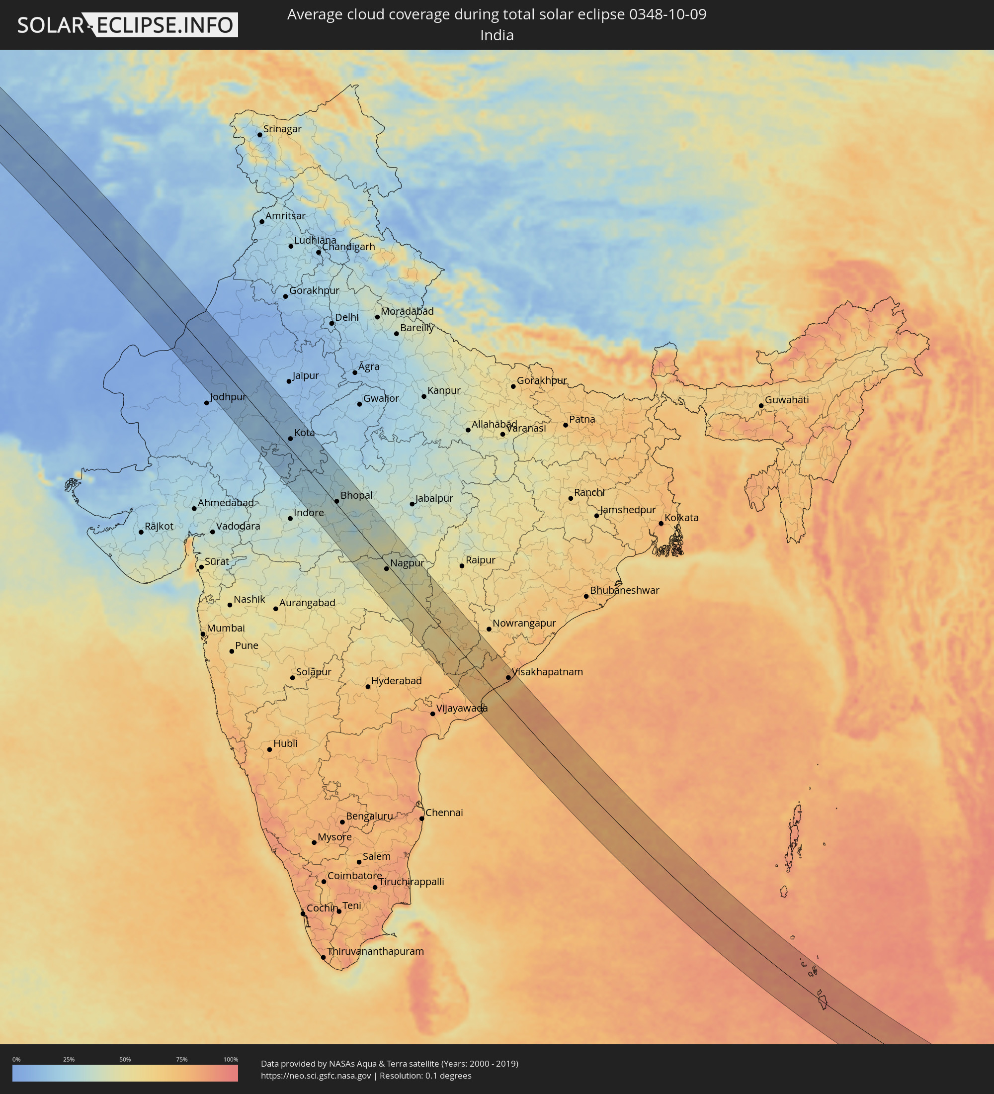 India
India
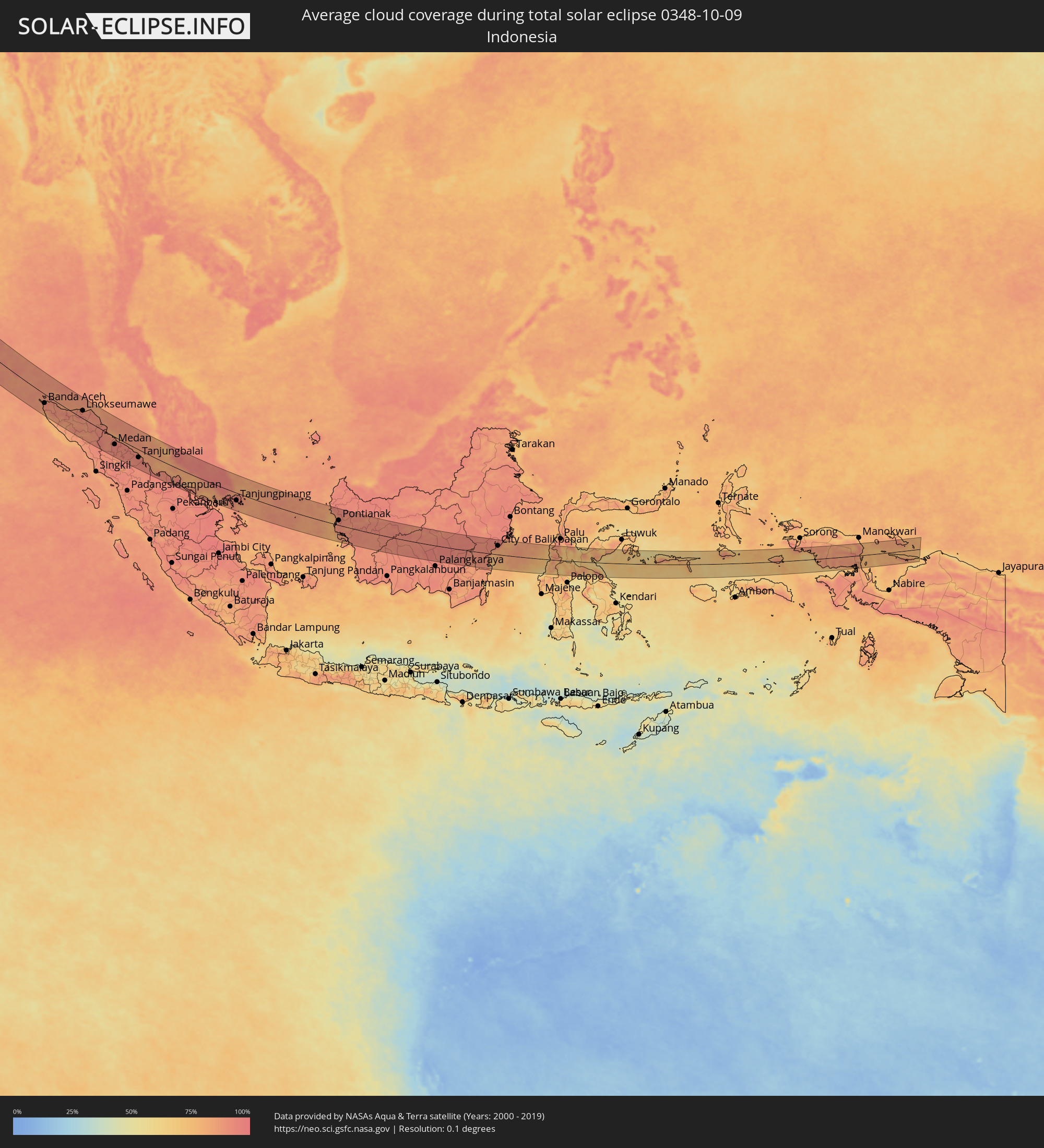 Indonesia
 Malaysia
 Singapore
Cities inside the path of the eclipse
The following table shows all locations with a population of more than 5,000 inside the eclipse path. Cities which have more than 100,000 inhabitants are marked bold. A click at the locations opens a detailed map.
| City | Type | Eclipse duration | Local time of max. eclipse | Distance to central line | Ø Cloud coverage |
|
Dragør, Capital Region
|
total | - | 06:37:52 UTC+01:00 | 60 km | 71% |
|
Skanör med Falsterbo, Skåne
|
total | - | 06:37:44 UTC+01:00 | 41 km | 71% |
|
Bunkeflostrand, Skåne
|
total | - | 06:37:50 UTC+01:00 | 57 km | 72% |
|
Höllviken, Skåne
|
total | - | 06:37:45 UTC+01:00 | 44 km | 71% |
|
Vellinge, Skåne
|
total | - | 06:37:48 UTC+01:00 | 51 km | 72% |
|
Skåre, Skåne
|
total | - | 06:37:44 UTC+01:00 | 42 km | 70% |
|
Oxie, Skåne
|
total | - | 06:37:52 UTC+01:00 | 60 km | 73% |
|
Trelleborg, Skåne
|
total | - | 06:37:44 UTC+01:00 | 43 km | 70% |
|
Svedala, Skåne
|
total | - | 06:37:51 UTC+01:00 | 58 km | 75% |
|
Bergen auf Rügen, Mecklenburg-Vorpommern
|
total | - | 06:37:04 UTC+01:00 | 58 km | 79% |
|
Skurup, Skåne
|
total | - | 06:37:51 UTC+01:00 | 58 km | 76% |
|
Ostseebad Binz, Mecklenburg-Vorpommern
|
total | - | 06:37:04 UTC+01:00 | 57 km | 76% |
|
Saßnitz, Mecklenburg-Vorpommern
|
total | - | 06:37:09 UTC+01:00 | 44 km | 74% |
|
Ystad, Skåne
|
total | - | 06:37:51 UTC+01:00 | 57 km | 72% |
|
Rønne, Capital Region
|
total | - | 06:37:43 UTC+01:00 | 34 km | 69% |
|
Kołobrzeg, West Pomeranian Voivodeship
|
total | - | 07:01:10 UTC+01:24 | 53 km | 75% |
|
Koszalin, West Pomeranian Voivodeship
|
total | - | 07:01:16 UTC+01:24 | 42 km | 78% |
|
Słupsk, Pomeranian Voivodeship
|
total | - | 07:01:35 UTC+01:24 | 1 km | 80% |
|
Wejherowo, Pomeranian Voivodeship
|
total | - | 07:01:54 UTC+01:24 | 36 km | 78% |
|
Starogard Gdański, Pomeranian Voivodeship
|
total | - | 07:01:31 UTC+01:24 | 28 km | 75% |
|
Gdynia, Pomeranian Voivodeship
|
total | - | 07:01:54 UTC+01:24 | 31 km | 75% |
|
Gdańsk, Pomeranian Voivodeship
|
total | - | 07:01:48 UTC+01:24 | 15 km | 75% |
|
Tczew, Pomeranian Voivodeship
|
total | - | 07:01:39 UTC+01:24 | 10 km | 75% |
|
Malbork, Pomeranian Voivodeship
|
total | - | 07:01:39 UTC+01:24 | 12 km | 74% |
|
Elbląg, Warmian-Masurian Voivodeship
|
total | - | 07:01:49 UTC+01:24 | 7 km | 74% |
|
Olsztyn, Warmian-Masurian Voivodeship
|
total | - | 07:01:48 UTC+01:24 | 13 km | 70% |
|
Łomża, Podlasie
|
total | - | 07:01:47 UTC+01:24 | 47 km | 73% |
|
Ełk, Warmian-Masurian Voivodeship
|
total | - | 07:02:17 UTC+01:24 | 28 km | 73% |
|
Białystok, Podlasie
|
total | - | 07:02:03 UTC+01:24 | 30 km | 70% |
|
Hrodna, Grodnenskaya
|
total | - | 07:28:35 UTC+01:50 | 42 km | 77% |
|
Vawkavysk, Grodnenskaya
|
total | - | 07:28:26 UTC+01:50 | 1 km | 72% |
|
Pruzhany, Brest
|
total | - | 07:28:05 UTC+01:50 | 64 km | 70% |
|
Masty, Grodnenskaya
|
total | - | 07:28:37 UTC+01:50 | 28 km | 74% |
|
Shchuchin, Grodnenskaya
|
total | - | 07:28:48 UTC+01:50 | 53 km | 77% |
|
Byaroza, Brest
|
total | - | 07:28:13 UTC+01:50 | 55 km | 69% |
|
Slonim, Grodnenskaya
|
total | - | 07:28:40 UTC+01:50 | 11 km | 72% |
|
Ivatsevichy, Brest
|
total | - | 07:28:27 UTC+01:50 | 28 km | 70% |
|
Baranovichi, Brest
|
total | - | 07:28:55 UTC+01:50 | 31 km | 72% |
|
Luninyets, Brest
|
total | - | 07:28:40 UTC+01:50 | 44 km | 68% |
|
Salihorsk, Minsk
|
total | - | 07:29:14 UTC+01:50 | 30 km | 74% |
|
Slutsk, Minsk
|
total | - | 07:29:22 UTC+01:50 | 55 km | 77% |
|
Mazyr, Gomel
|
total | - | 07:29:28 UTC+01:50 | 5 km | 74% |
|
Rechytsa, Gomel
|
total | - | 07:30:05 UTC+01:50 | 56 km | 75% |
|
Chernihiv, Chernihiv
|
total | - | 07:42:06 UTC+02:02 | 9 km | 77% |
|
Nizhyn, Chernihiv
|
total | - | 07:42:09 UTC+02:02 | 39 km | 72% |
|
Konotop, Sumy
|
total | - | 07:42:50 UTC+02:02 | 17 km | 70% |
|
Romny, Sumy
|
total | - | 07:42:45 UTC+02:02 | 25 km | 67% |
|
Sumy, Sumy
|
total | - | 07:43:29 UTC+02:02 | 31 km | 67% |
|
Okhtyrka, Sumy
|
total | - | 07:43:17 UTC+02:02 | 28 km | 68% |
|
Kharkiv, Kharkiv
|
total | - | 07:43:53 UTC+02:02 | 20 km | 65% |
|
Stroitel’, Belgorod
|
total | - | 08:12:31 UTC+02:30 | 68 km | 69% |
|
Belgorod, Belgorod
|
total | - | 08:12:30 UTC+02:30 | 53 km | 67% |
|
Chuhuyiv, Kharkiv
|
total | - | 07:44:04 UTC+02:02 | 21 km | 64% |
|
Balakliya, Kharkiv
|
total | - | 07:44:02 UTC+02:02 | 53 km | 61% |
|
Shebekino, Belgorod
|
total | - | 08:12:37 UTC+02:30 | 44 km | 67% |
|
Izyum, Kharkiv
|
total | - | 07:44:11 UTC+02:02 | 66 km | 60% |
|
Kupjansk, Kharkiv
|
total | - | 07:44:33 UTC+02:02 | 4 km | 60% |
|
Krasnyy Lyman, Donetsk
|
partial | - | 07:44:26 UTC+02:02 | 70 km | 58% |
|
Valuyki, Belgorod
|
total | - | 08:13:13 UTC+02:30 | 61 km | 70% |
|
Syevyerodonets’k, Luhansk
|
total | - | 07:44:50 UTC+02:02 | 51 km | 59% |
|
Luhansk, Luhansk
|
total | - | 07:45:14 UTC+02:02 | 61 km | 63% |
|
Donetsk, Rostov Oblast
|
total | - | 08:13:47 UTC+02:30 | 62 km | 63% |
|
Kamensk-Shakhtinskiy, Rostov Oblast
|
total | - | 08:13:59 UTC+02:30 | 53 km | 66% |
|
Millerovo, Rostov Oblast
|
total | - | 08:14:13 UTC+02:30 | 11 km | 65% |
|
Belaya Kalitva, Rostov Oblast
|
total | - | 08:14:17 UTC+02:30 | 47 km | 66% |
|
Morozovsk, Rostov Oblast
|
total | - | 08:15:02 UTC+02:30 | 7 km | 66% |
|
Volgodonsk, Rostov Oblast
|
total | - | 08:15:05 UTC+02:30 | 63 km | 61% |
|
Surovikino, Volgograd
|
total | - | 08:15:46 UTC+02:30 | 68 km | 69% |
|
Kotel’nikovo, Volgograd
|
total | - | 08:15:48 UTC+02:30 | 15 km | 67% |
|
Astrakhan, Astrakhan
|
total | - | 09:09:31 UTC+03:20 | 60 km | 54% |
|
Kamyzyak, Astrakhan
|
total | - | 09:09:32 UTC+03:20 | 39 km | 50% |
|
Fort-Shevchenko, Mangghystaū
|
total | - | 09:16:37 UTC+03:25 | 13 km | 60% |
|
Aktau, Mangghystaū
|
total | - | 09:17:35 UTC+03:25 | 50 km | 51% |
|
Yeraliyev, Mangghystaū
|
total | - | 09:18:09 UTC+03:25 | 68 km | 49% |
|
Zhetibay, Mangghystaū
|
total | - | 09:18:27 UTC+03:25 | 12 km | 52% |
|
Shetpe, Mangghystaū
|
total | - | 09:18:22 UTC+03:25 | 42 km | 43% |
|
Zhanaozen, Mangghystaū
|
total | - | 09:19:16 UTC+03:25 | 3 km | 47% |
|
Mary, Mary
|
total | - | 10:00:11 UTC+03:53 | 5 km | 29% |
|
Murgab
|
total | - | 10:00:26 UTC+03:53 | 4 km | 29% |
|
Bayramaly, Mary
|
total | - | 10:00:35 UTC+03:53 | 17 km | 29% |
|
Yolöten, Mary
|
total | - | 10:01:04 UTC+03:53 | 3 km | 20% |
|
Ghormach, Badghis
|
total | - | 10:10:40 UTC+04:00 | 36 km | 13% |
|
Maymana, Faryab
|
total | - | 10:11:50 UTC+04:00 | 43 km | 13% |
|
Fayrōz Kōh, Ghowr
|
total | - | 10:13:46 UTC+04:00 | 38 km | 7% |
|
Qal‘ah-ye Shahr, Sar-e Pol
|
total | - | 10:13:14 UTC+04:00 | 63 km | 11% |
|
Chīras, Sar-e Pol
|
total | - | 10:13:56 UTC+04:00 | 80 km | 15% |
|
Nīlī, Daykundi
|
total | - | 10:15:47 UTC+04:00 | 43 km | 8% |
|
Uruzgān, Oruzgan
|
total | - | 10:17:20 UTC+04:00 | 71 km | 6% |
|
Panjāb, Bamyan
|
total | - | 10:16:23 UTC+04:00 | 68 km | 9% |
|
Zarghūn Shahr, Paktika
|
total | - | 10:20:04 UTC+04:00 | 45 km | 5% |
|
Zhob, Balochistān
|
total | - | 10:51:31 UTC+04:28 | 1 km | 4% |
|
Jāmpur, Punjab
|
total | - | 10:55:26 UTC+04:28 | 45 km | 7% |
|
Dera Ghazi Khan, Punjab
|
total | - | 10:54:57 UTC+04:28 | 11 km | 7% |
|
Jatoi Shimāli, Punjab
|
total | - | 10:56:00 UTC+04:28 | 36 km | 7% |
|
Layyah, Punjab
|
total | - | 10:54:16 UTC+04:28 | 78 km | 13% |
|
Kot Addu, Punjab
|
total | - | 10:54:56 UTC+04:28 | 43 km | 13% |
|
Muzaffargarh, Punjab
|
total | - | 10:55:48 UTC+04:28 | 30 km | 10% |
|
Ahmadpur East, Punjab
|
total | - | 10:57:08 UTC+04:28 | 34 km | 3% |
|
Shujāābād, Punjab
|
total | - | 10:56:13 UTC+04:28 | 23 km | 10% |
|
Multān, Punjab
|
total | - | 10:56:05 UTC+04:28 | 60 km | 9% |
|
Lodhrān, Punjab
|
total | - | 10:57:12 UTC+04:28 | 23 km | 7% |
|
Bahāwalpur, Punjab
|
total | - | 10:57:28 UTC+04:28 | 16 km | 5% |
|
Kohror Pakka, Punjab
|
total | - | 10:57:32 UTC+04:28 | 49 km | 10% |
|
Mailsi, Punjab
|
total | - | 10:57:42 UTC+04:28 | 81 km | 11% |
|
Bīkaner, Rajasthan
|
total | - | 11:54:59 UTC+05:21 | 35 km | 2% |
|
Beāwar, Rajasthan
|
total | - | 11:59:30 UTC+05:21 | 28 km | 14% |
|
Ajmer, Rajasthan
|
total | - | 11:59:30 UTC+05:21 | 22 km | 14% |
|
Bhīlwāra, Rajasthan
|
total | - | 12:01:13 UTC+05:21 | 58 km | 17% |
|
Kishangarh, Rajasthan
|
total | - | 11:59:42 UTC+05:21 | 48 km | 12% |
|
Kota, Rajasthan
|
total | - | 12:03:31 UTC+05:21 | 23 km | 15% |
|
Bhopal, Madhya Pradesh
|
total | - | 12:09:24 UTC+05:21 | 7 km | 30% |
|
Vidisha, Madhya Pradesh
|
total | - | 12:09:40 UTC+05:21 | 58 km | 33% |
|
Wardha, Maharashtra
|
total | - | 12:15:55 UTC+05:21 | 79 km | 49% |
|
Chhindwāra, Madhya Pradesh
|
total | - | 12:14:12 UTC+05:21 | 42 km | 44% |
|
Nagpur, Maharashtra
|
total | - | 12:16:04 UTC+05:21 | 11 km | 49% |
|
Chānda, Maharashtra
|
total | - | 12:18:36 UTC+05:21 | 80 km | 50% |
|
Kākināda, Andhra Pradesh
|
total | - | 12:29:34 UTC+05:21 | 63 km | 71% |
|
Visakhapatnam, Andhra Pradesh
|
total | - | 12:29:59 UTC+05:21 | 67 km | 77% |
|
Banda Aceh, Aceh
|
total | - | 15:01:19 UTC+07:07 | 39 km | 90% |
|
Lhokseumawe, Aceh
|
total | - | 15:05:01 UTC+07:07 | 35 km | 89% |
|
Binjai, North Sumatra
|
total | - | 15:09:52 UTC+07:07 | 42 km | 93% |
|
Medan, North Sumatra
|
total | - | 15:10:11 UTC+07:07 | 34 km | 97% |
|
Belawan, North Sumatra
|
total | - | 15:09:53 UTC+07:07 | 15 km | 90% |
|
Percut, North Sumatra
|
total | - | 15:10:25 UTC+07:07 | 20 km | 95% |
|
Pematangsiantar, North Sumatra
|
total | - | 15:11:50 UTC+07:07 | 75 km | 94% |
|
Tebingtinggi, North Sumatra
|
total | - | 15:11:23 UTC+07:07 | 33 km | 94% |
|
Kisaran, North Sumatra
|
total | - | 15:12:39 UTC+07:07 | 44 km | 95% |
|
Tanjungbalai, North Sumatra
|
total | - | 15:12:58 UTC+07:07 | 36 km | 94% |
|
Dumai, Riau
|
total | - | 15:17:29 UTC+07:07 | 88 km | 95% |
|
Klang, Selangor
|
total | - | 15:03:36 UTC+06:55 | 51 km | 95% |
|
Kampung Baru Subang, Selangor
|
total | - | 15:03:32 UTC+06:55 | 66 km | 96% |
|
Rawang, Selangor
|
total | - | 15:03:20 UTC+06:55 | 86 km | 94% |
|
Kuala Lumpur, Kuala Lumpur
|
total | - | 15:03:47 UTC+06:55 | 73 km | 95% |
|
Sepang, Selangor
|
total | - | 15:04:34 UTC+06:55 | 30 km | 90% |
|
Port Dickson, Negeri Sembilan
|
total | - | 15:04:54 UTC+06:55 | 17 km | 85% |
|
Semenyih, Selangor
|
total | - | 15:04:19 UTC+06:55 | 61 km | 97% |
|
Seremban, Negeri Sembilan
|
total | - | 15:04:48 UTC+06:55 | 43 km | 95% |
|
Malacca, Melaka
|
total | - | 15:06:04 UTC+06:55 | 2 km | 83% |
|
Muar, Johor
|
total | - | 15:06:46 UTC+06:55 | 1 km | 83% |
|
Batu Pahat, Johor
|
total | - | 15:07:35 UTC+06:55 | 3 km | 93% |
|
Kluang, Johor
|
total | - | 15:07:52 UTC+06:55 | 32 km | 95% |
|
Johor Bahru, Johor
|
total | - | 15:09:19 UTC+06:55 | 8 km | 95% |
|
Ulu Tiram, Johor
|
total | - | 15:09:12 UTC+06:55 | 8 km | 96% |
|
Singapore, Central Singapore
|
total | - | 15:09:42 UTC+06:55 | 23 km | 92% |
|
Tanjungpinang, Riau Islands
|
total | - | 15:22:52 UTC+07:07 | 37 km | 92% |
|
Pontianak, West Kalimantan
|
total | - | 15:30:16 UTC+07:07 | 25 km | 93% |
|
City of Balikpapan, East Kalimantan
|
total | - | 16:29:35 UTC+07:57 | 46 km | 90% |