Totale Sonnenfinsternis vom 10.08.0454
| Wochentag: | Montag |
| Maximale Dauer der Verfinsterung: | 03m17s |
| Maximale Breite des Finsternispfades: | 122 km |
| Saroszyklus: | 91 |
| Bedeckungsgrad: | 100% |
| Magnitude: | 1.0355 |
| Gamma: | 0.2243 |
Wo kann man die Sonnenfinsternis vom 10.08.0454 sehen?
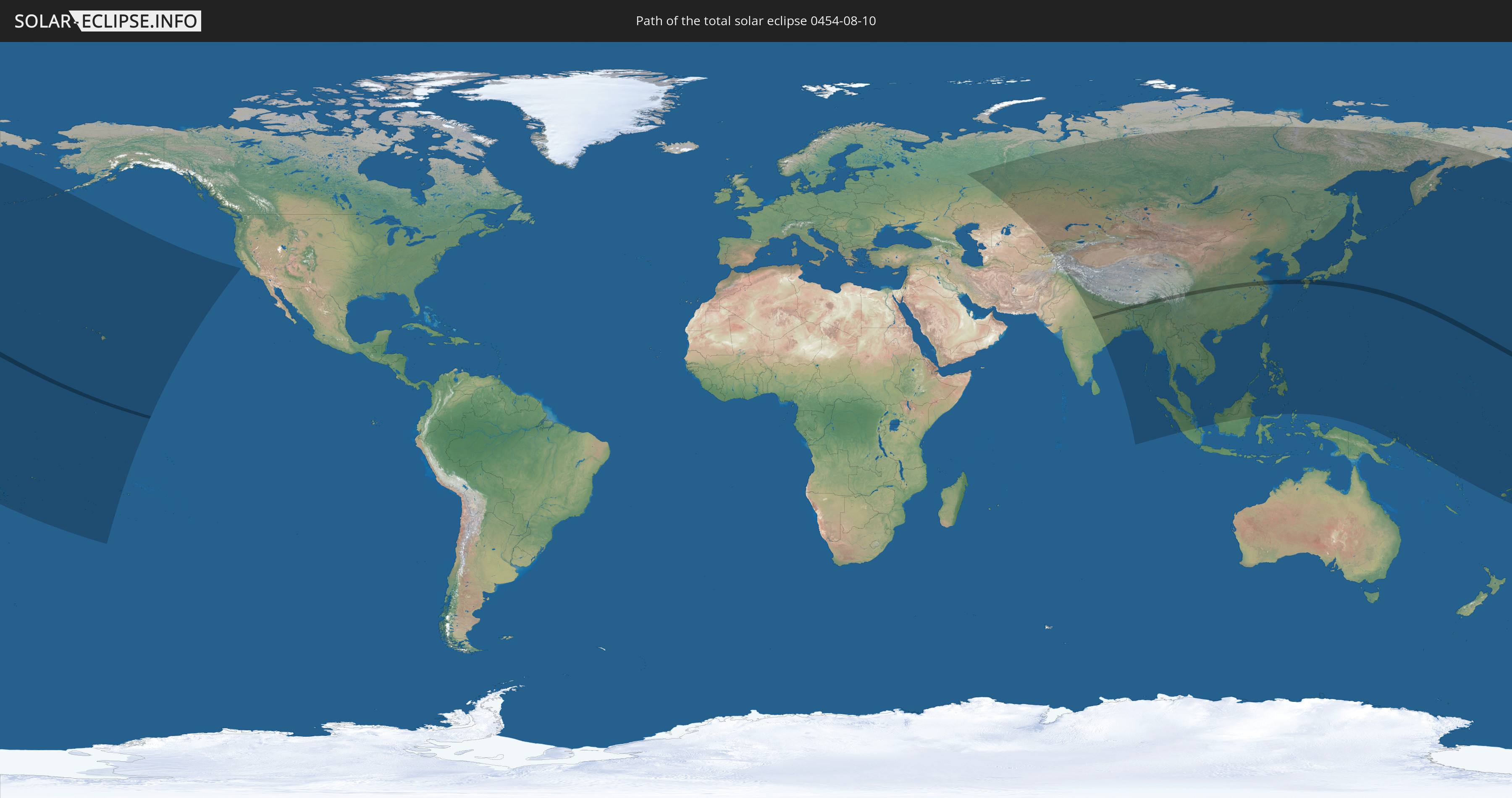
Die Sonnenfinsternis am 10.08.0454 kann man in 51 Ländern als partielle Sonnenfinsternis beobachten.
Der Finsternispfad verläuft durch 8 Länder. Nur in diesen Ländern ist sie als totale Sonnenfinsternis zu sehen.
In den folgenden Ländern ist die Sonnenfinsternis total zu sehen
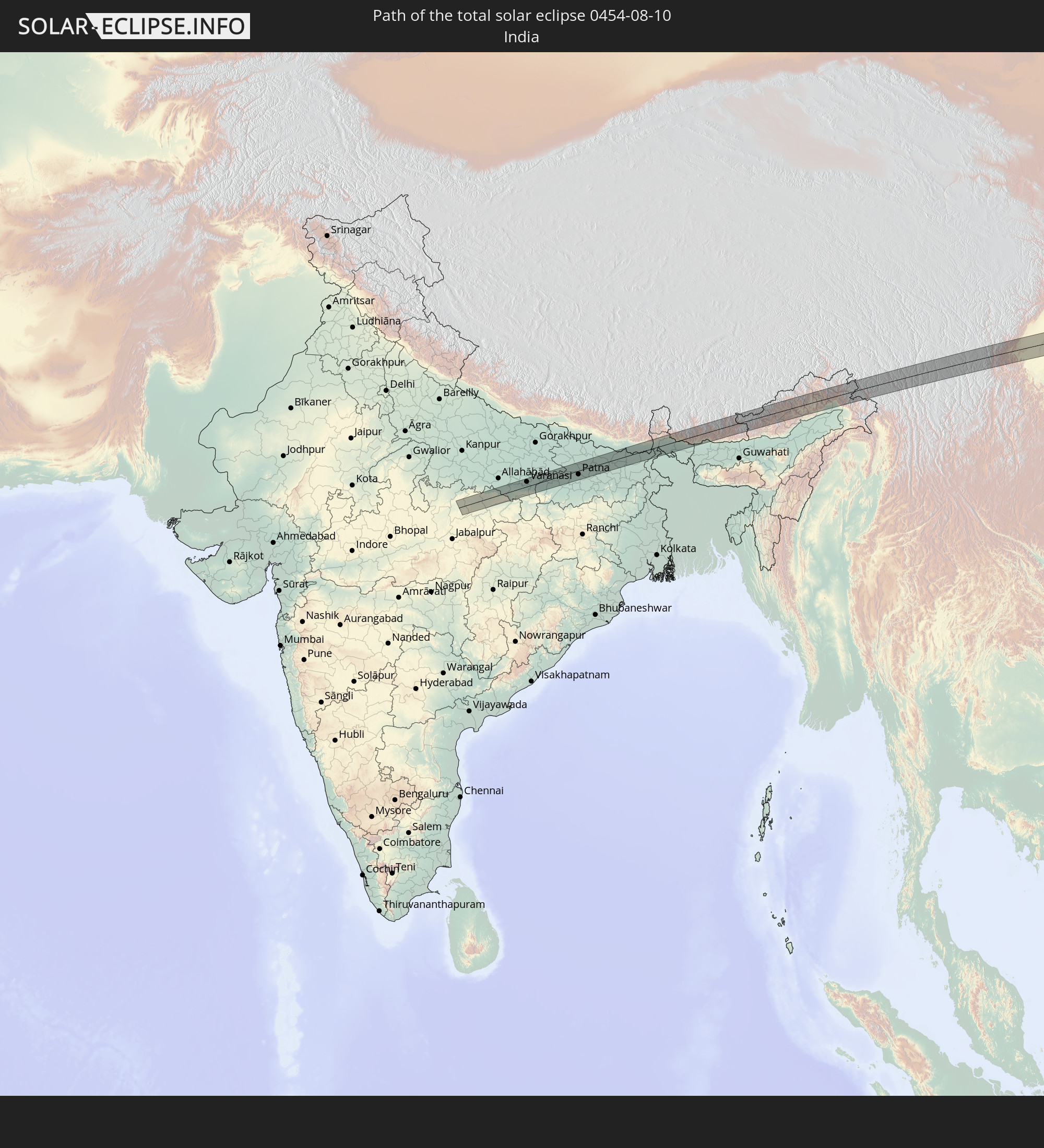 Indien
 Volksrepublik China
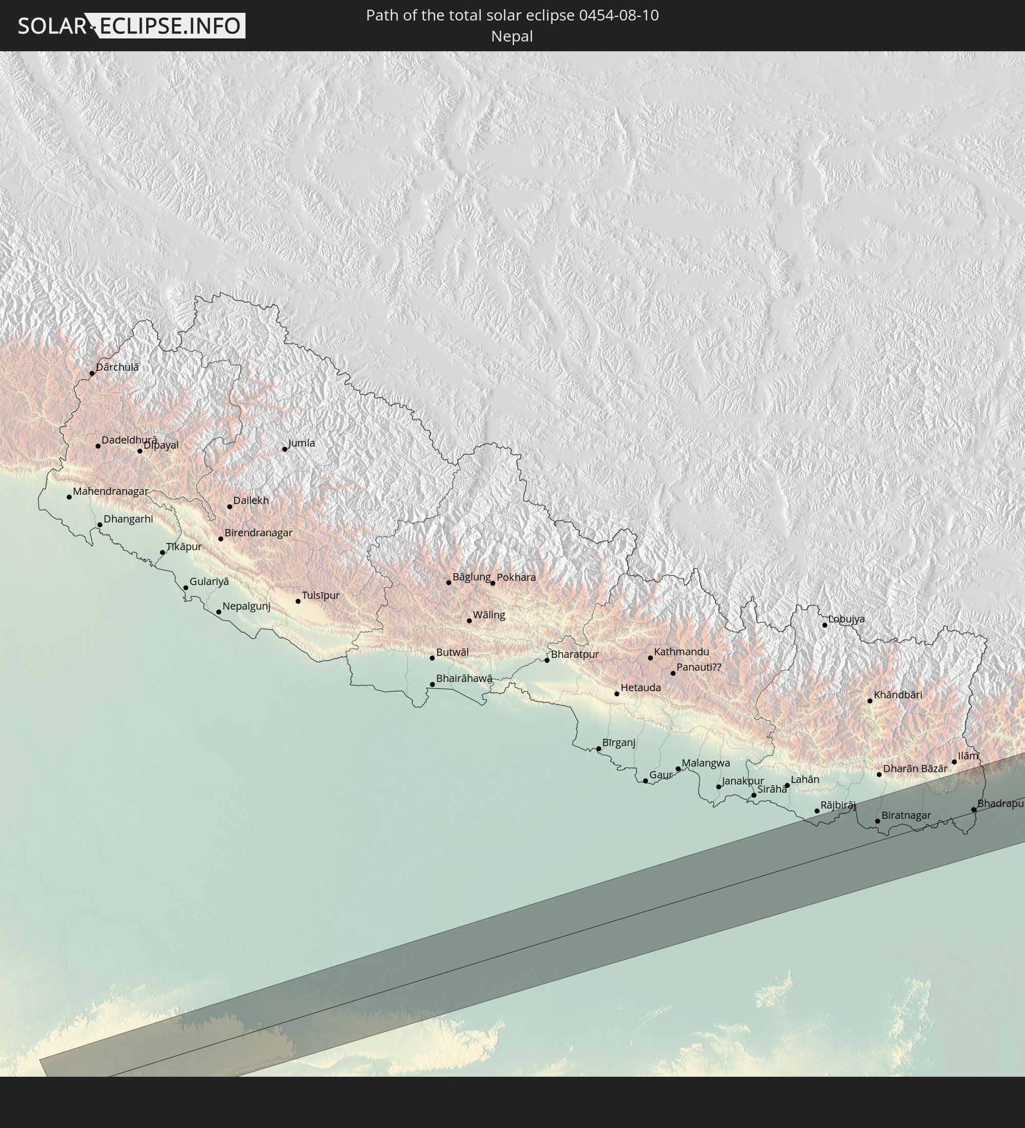 Nepal
Nepal
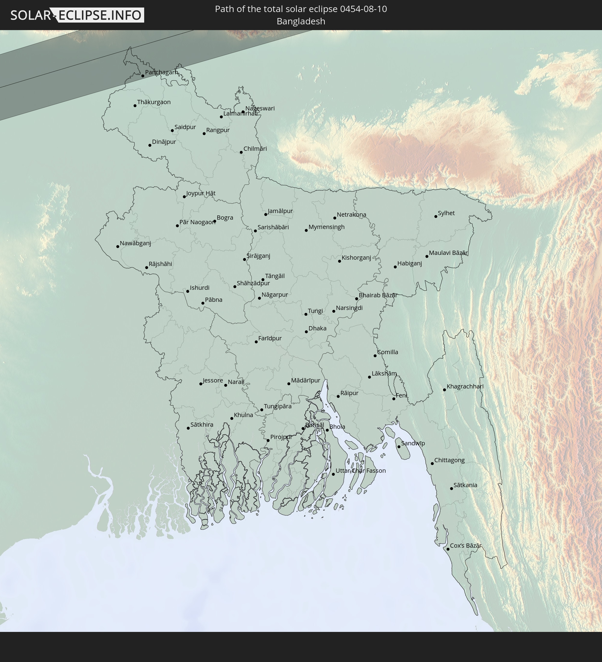 Bangladesch
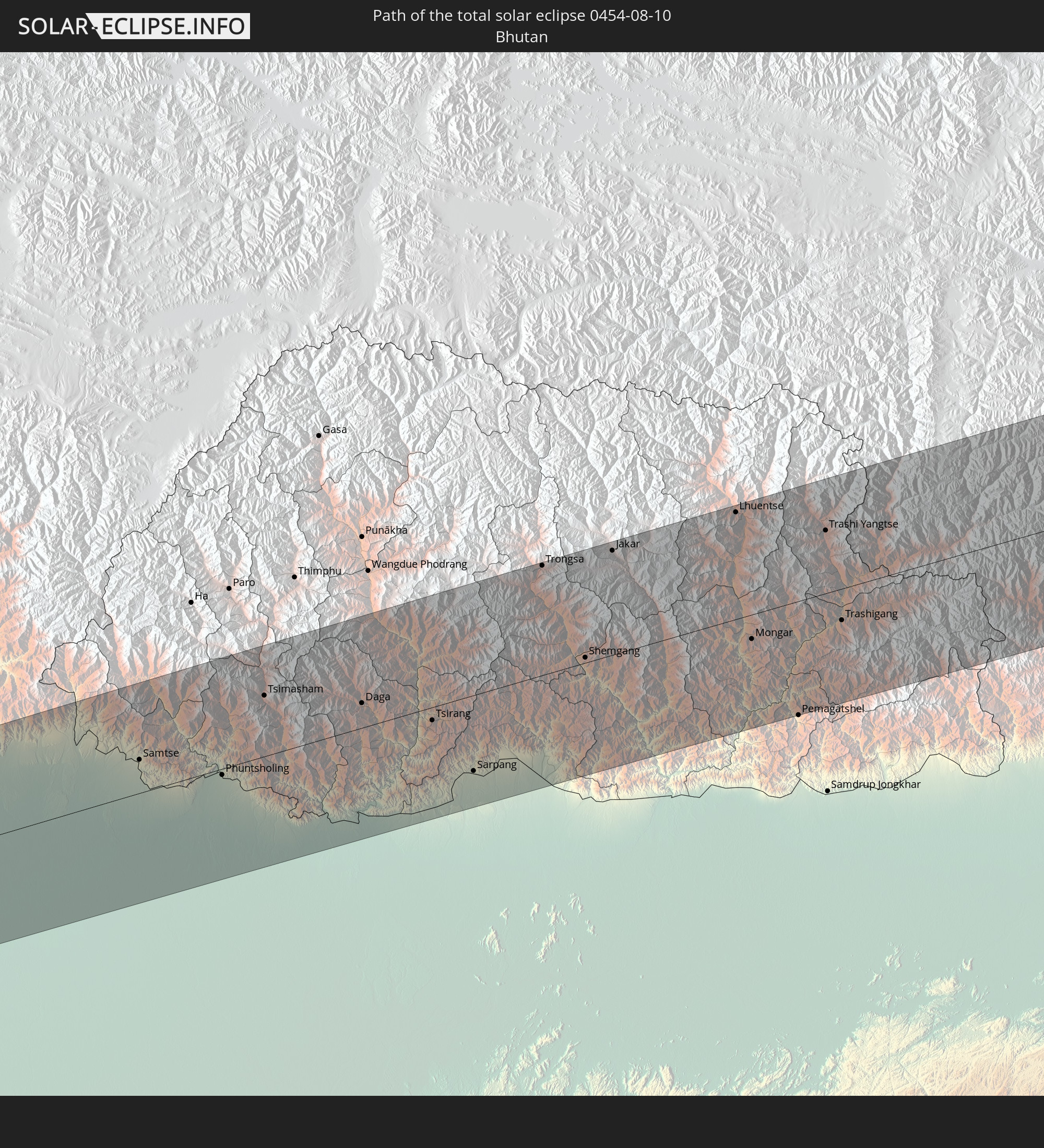 Bhutan
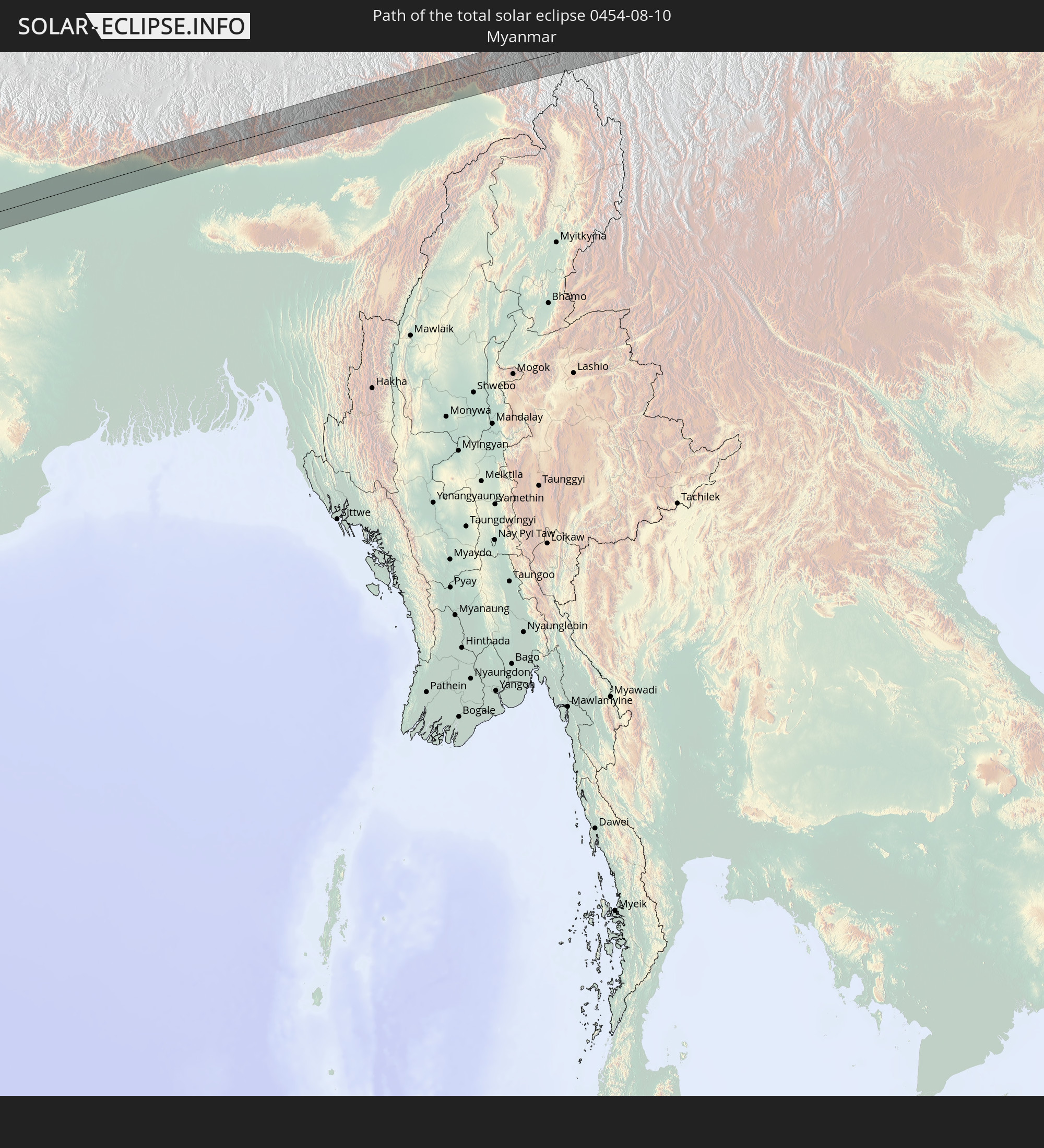 Myanmar
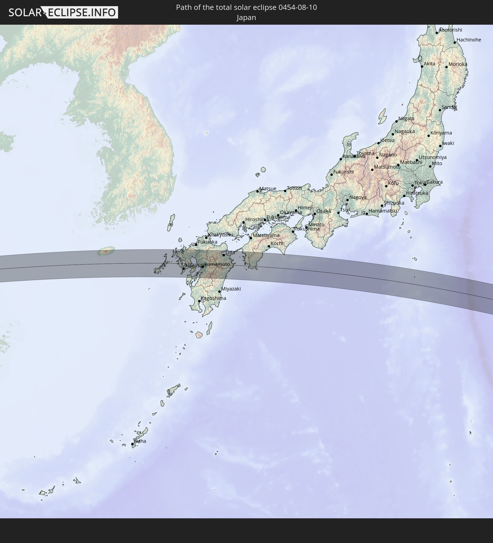 Japan
Japan
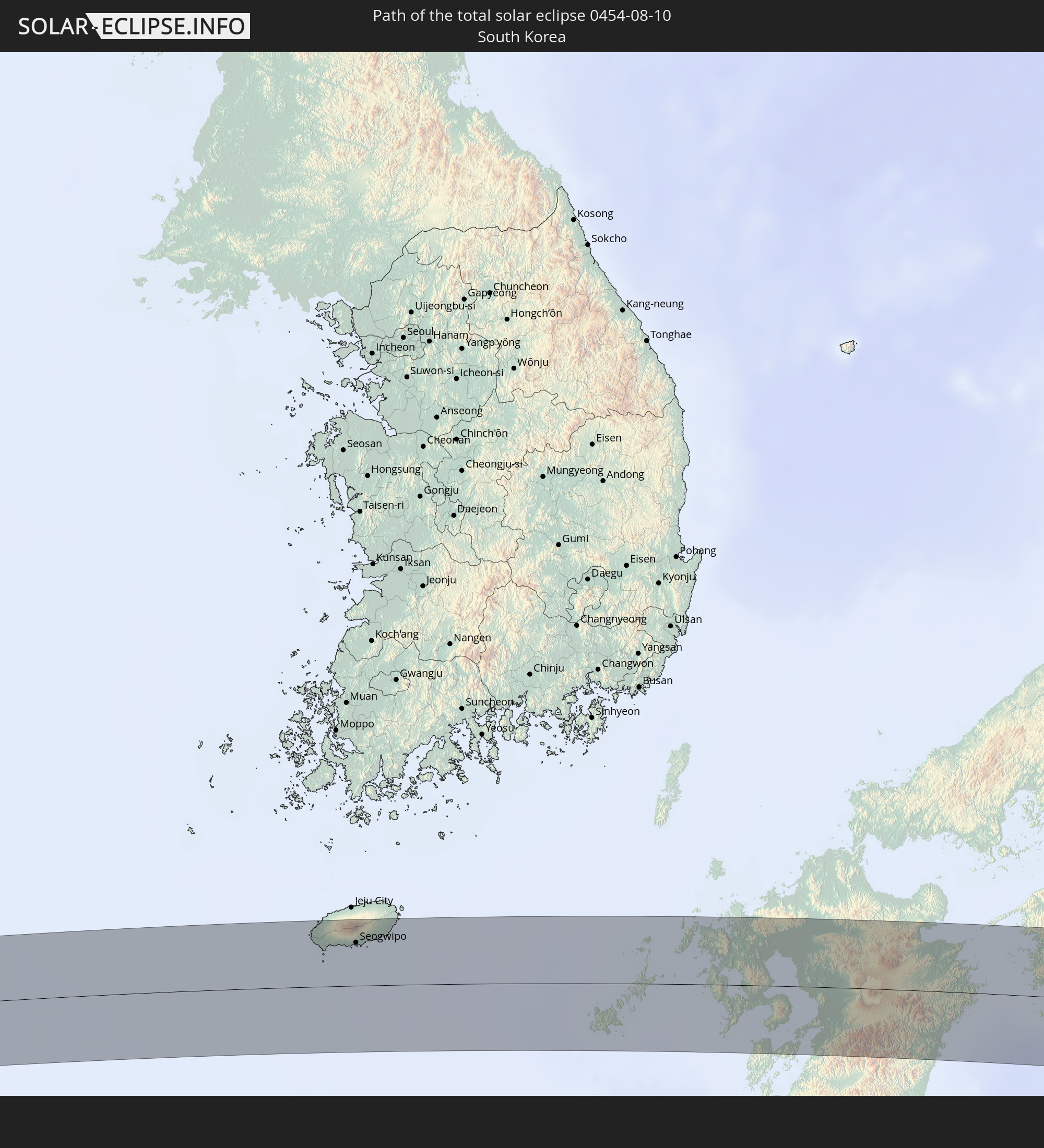 Südkorea
In den folgenden Ländern ist die Sonnenfinsternis partiell zu sehen
 Fidschi
 Russland
 Vereinigte Staaten
 United States Minor Outlying Islands
 Wallis und Futuna
 Tonga
Tonga
 Kiribati
 Samoa
Samoa
 Tokelau
 Amerikanisch-Samoa
 Niue
Niue
 Cookinseln
 Französisch-Polynesien
 Kasachstan
 Usbekistan
 Afghanistan
 Pakistan
 Tadschikistan
 Indien
 Kirgisistan
 Volksrepublik China
 Nepal
Nepal
 Mongolei
 Bangladesch
 Bhutan
 Myanmar
 Indonesien
 Thailand
 Malaysia
 Laos
Laos
 Vietnam
 Kambodscha
 Singapur
 Macau
Macau
 Hongkong
 Brunei
 Taiwan
 Philippinen
 Japan
Japan
 Nordkorea
 Südkorea
 Palau
Palau
 Föderierte Staaten von Mikronesien
 Papua-Neuguinea
 Guam
Guam
 Nördliche Marianen
 Salomonen
 Marshallinseln
 Vanuatu
 Nauru
Nauru
 Tuvalu
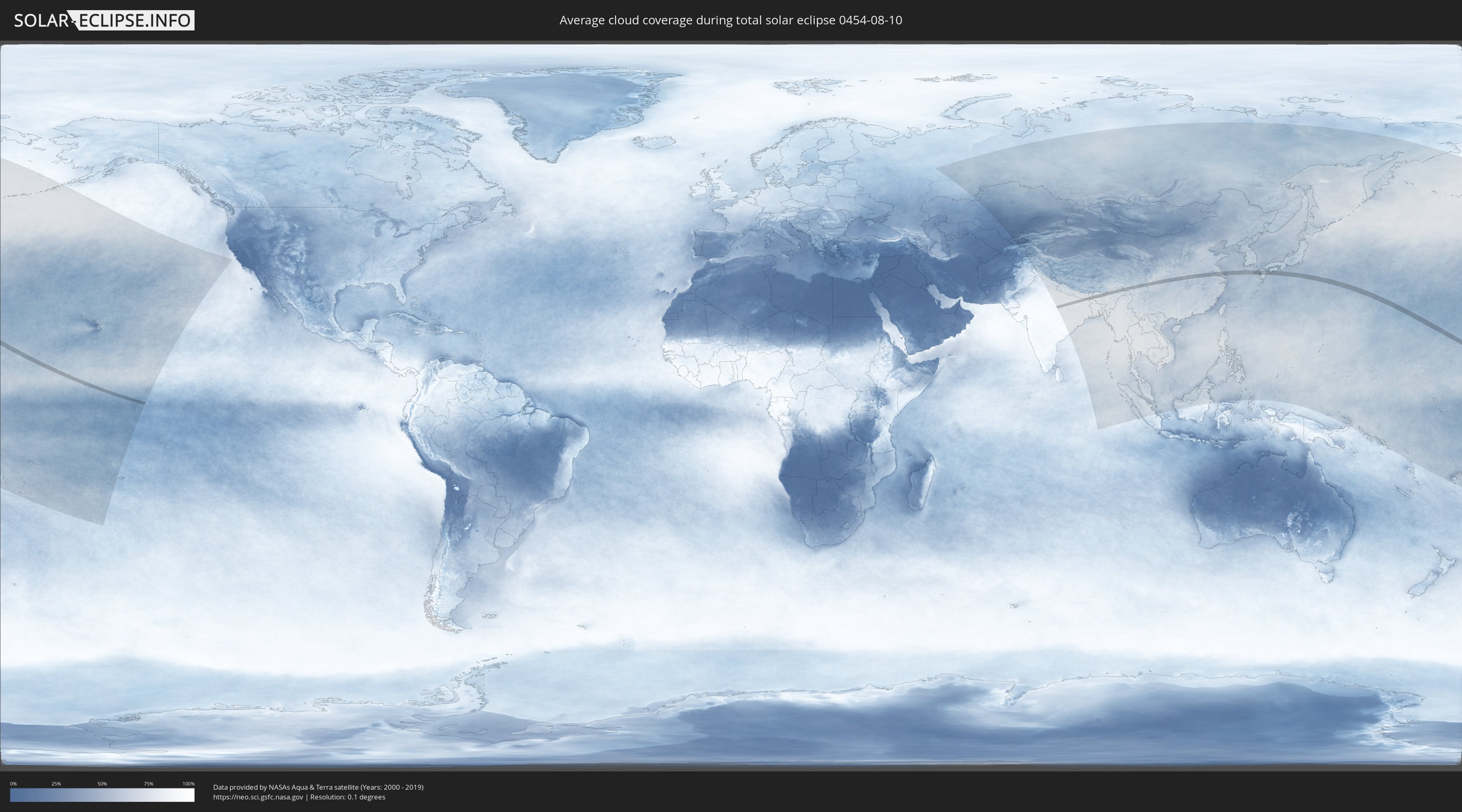
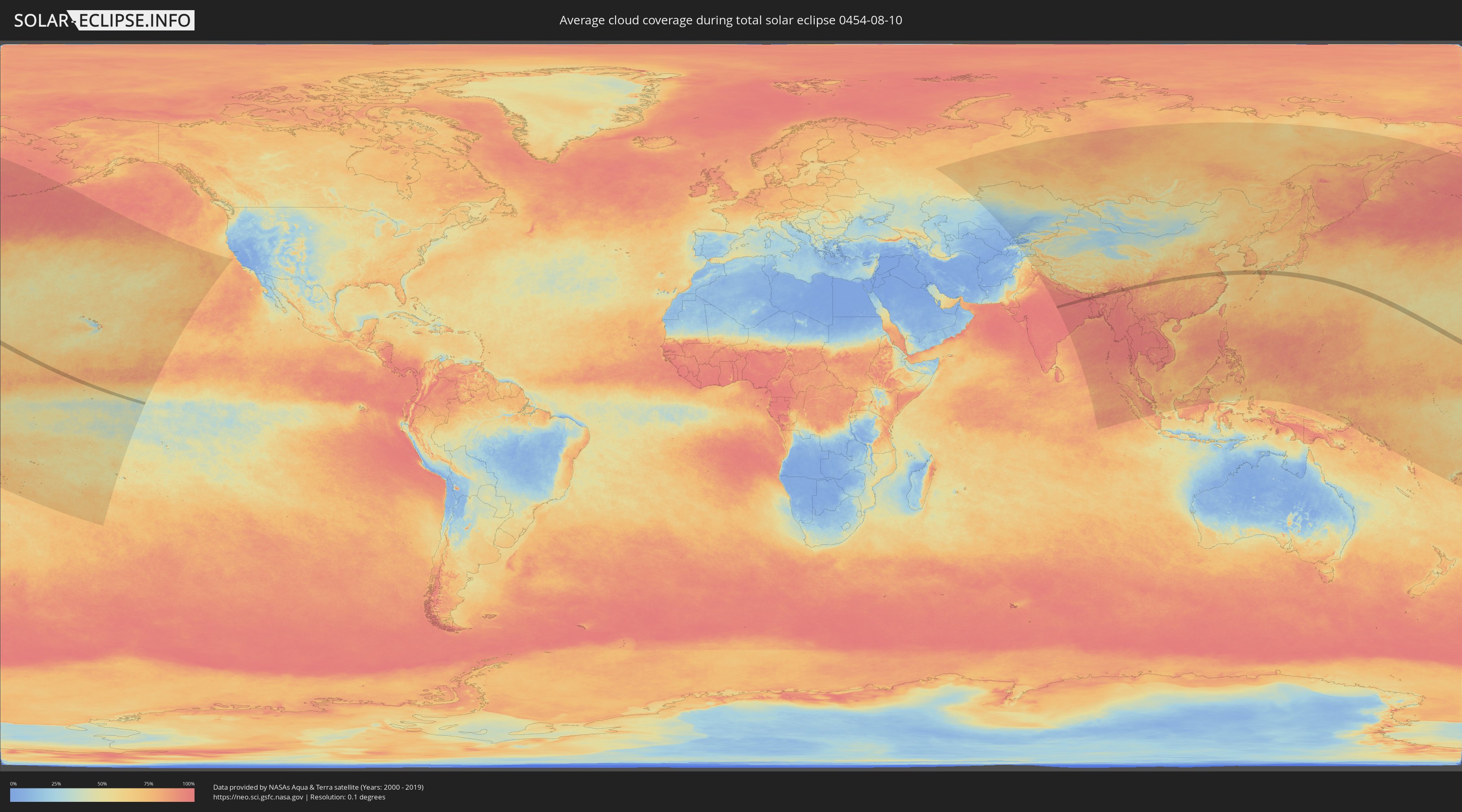
Wie wird das Wetter während der totalen Sonnenfinsternis am 10.08.0454?
Wo ist der beste Ort, um die totale Sonnenfinsternis vom 10.08.0454 zu beobachten?
Die folgenden Karten zeigen die durchschnittliche Bewölkung für den Tag, an dem die totale Sonnenfinsternis
stattfindet. Mit Hilfe der Karten lässt sich der Ort entlang des Finsternispfades eingrenzen,
der die besten Aussichen auf einen klaren wolkenfreien Himmel bietet.
Trotzdem muss man immer lokale Gegenenheiten beachten und sollte sich genau über das Wetter an seinem
gewählten Beobachtungsort informieren.
Die Daten stammen von den beiden NASA-Satelliten
AQUA und TERRA
und wurden über einen Zeitraum von 19 Jahren (2000 - 2019) gemittelt.
Detaillierte Länderkarten
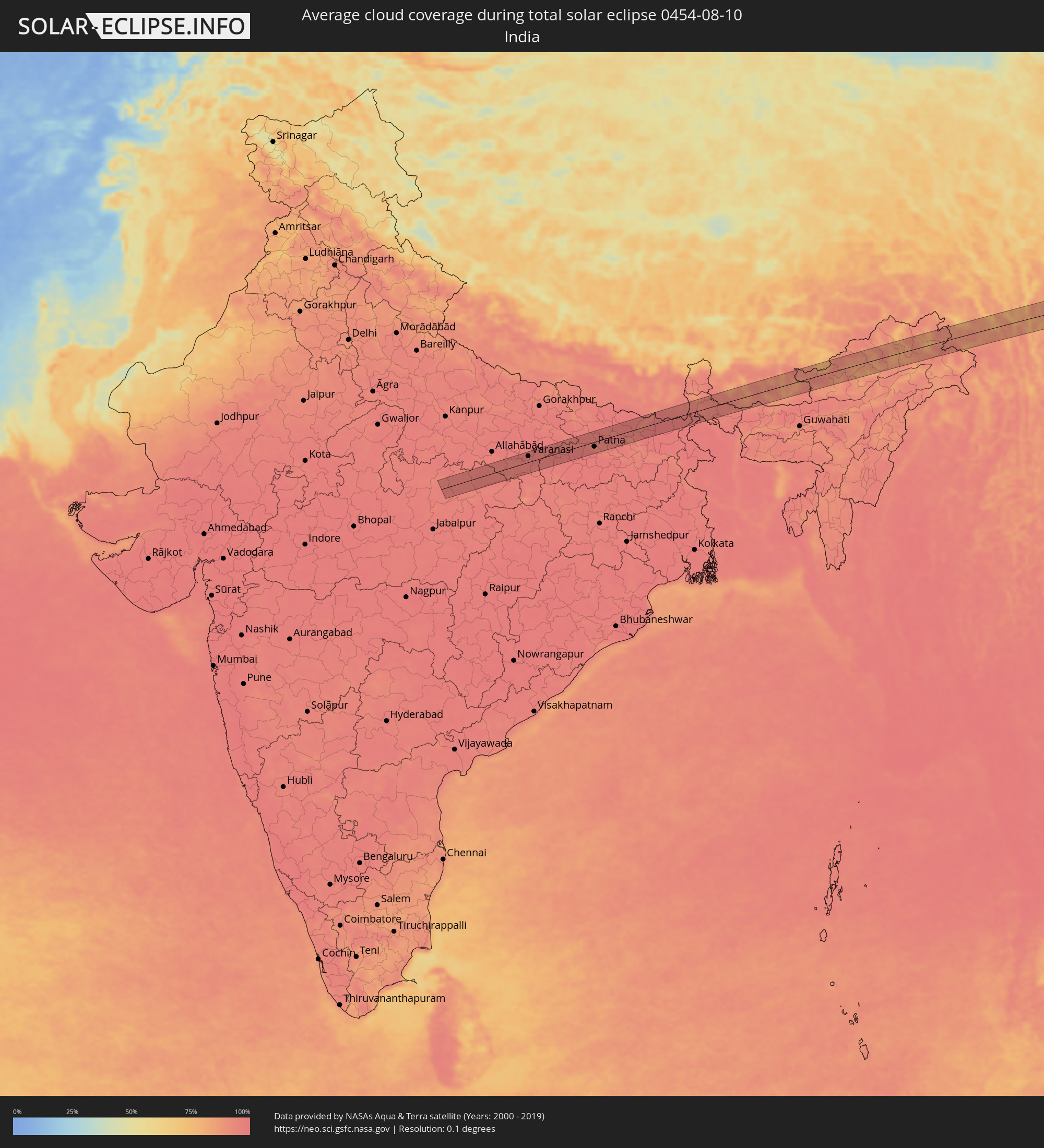 Indien
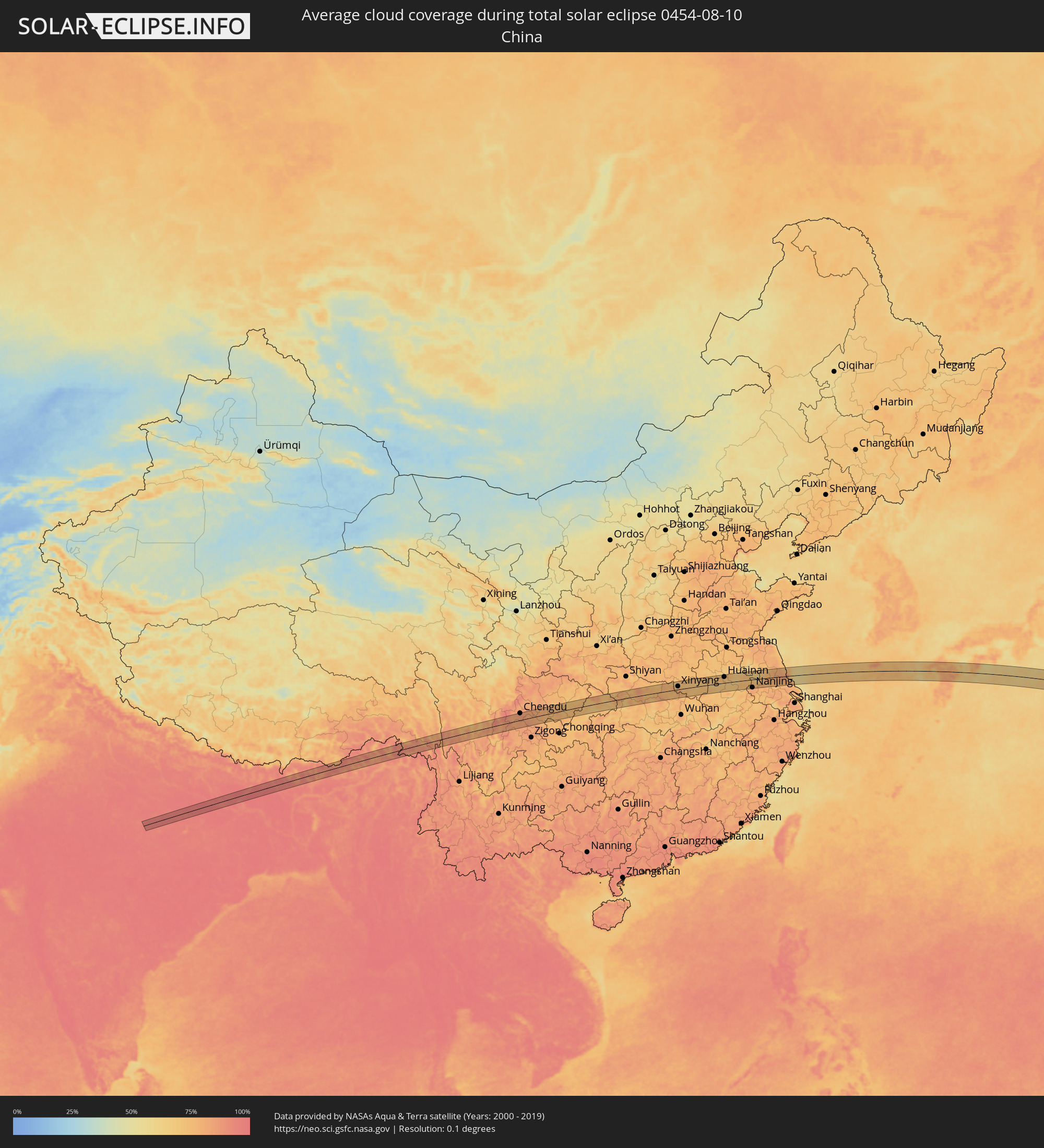 Volksrepublik China
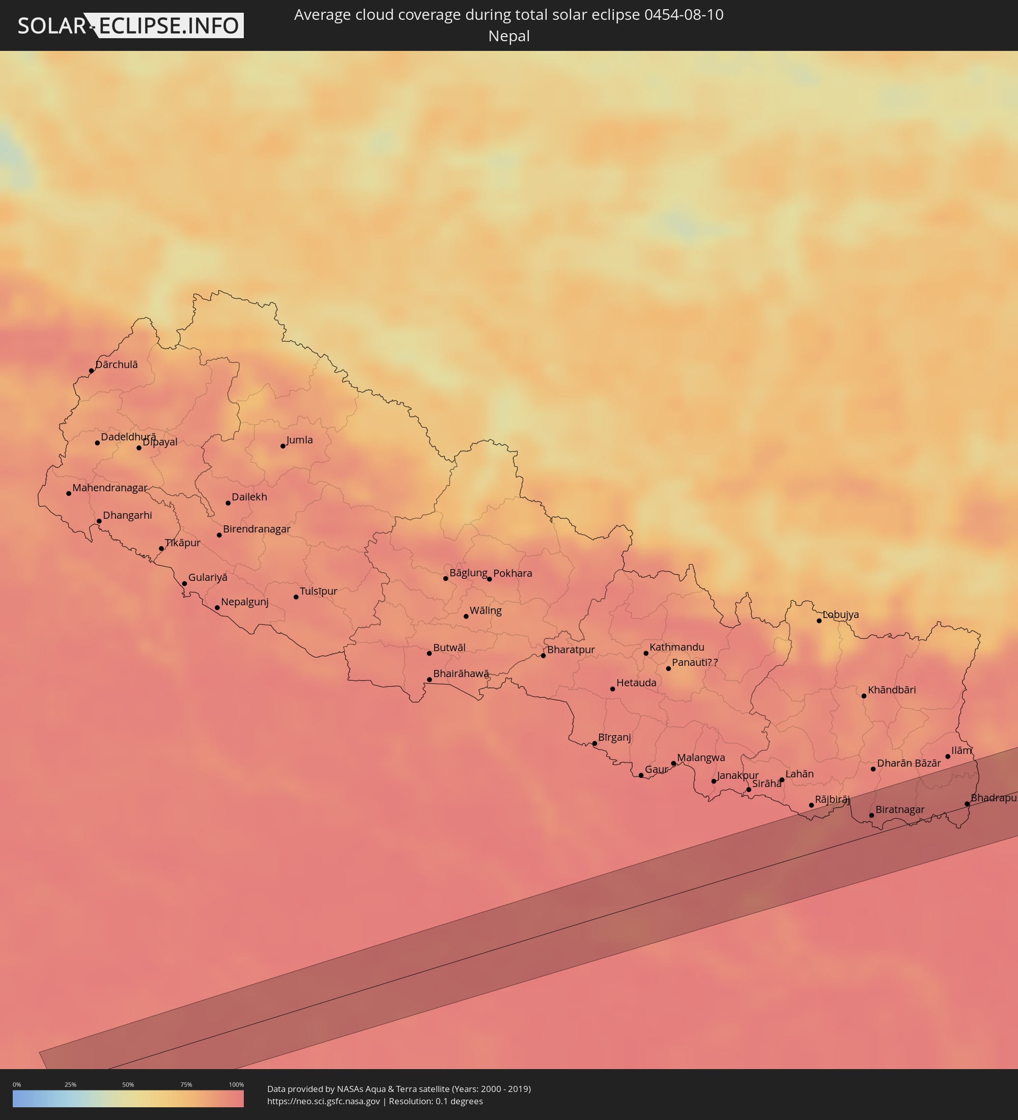 Nepal
Nepal
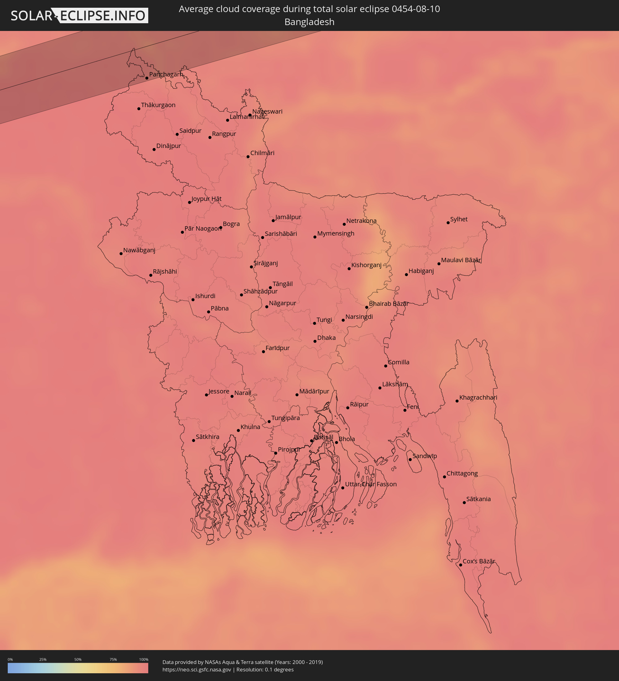 Bangladesch
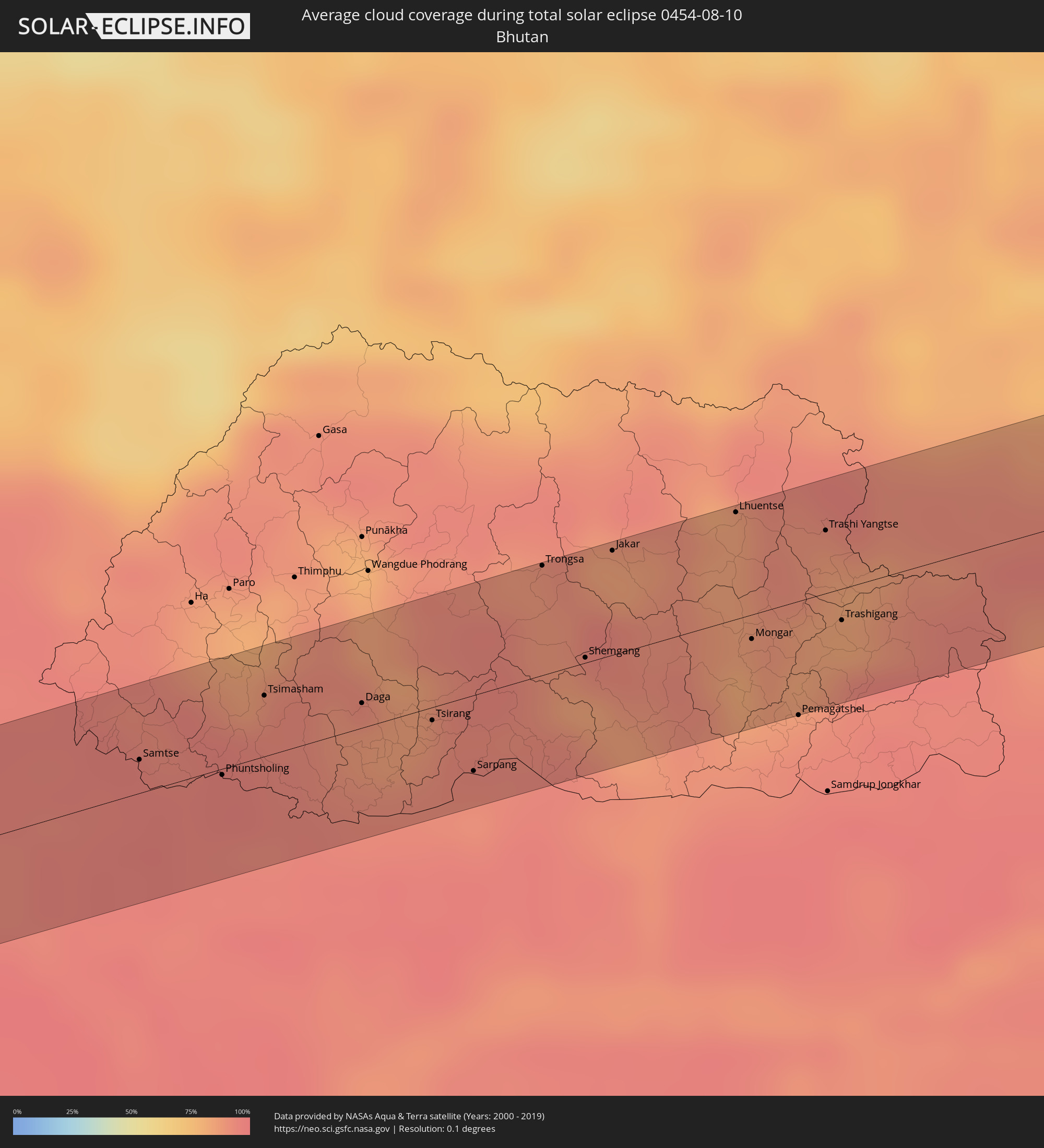 Bhutan
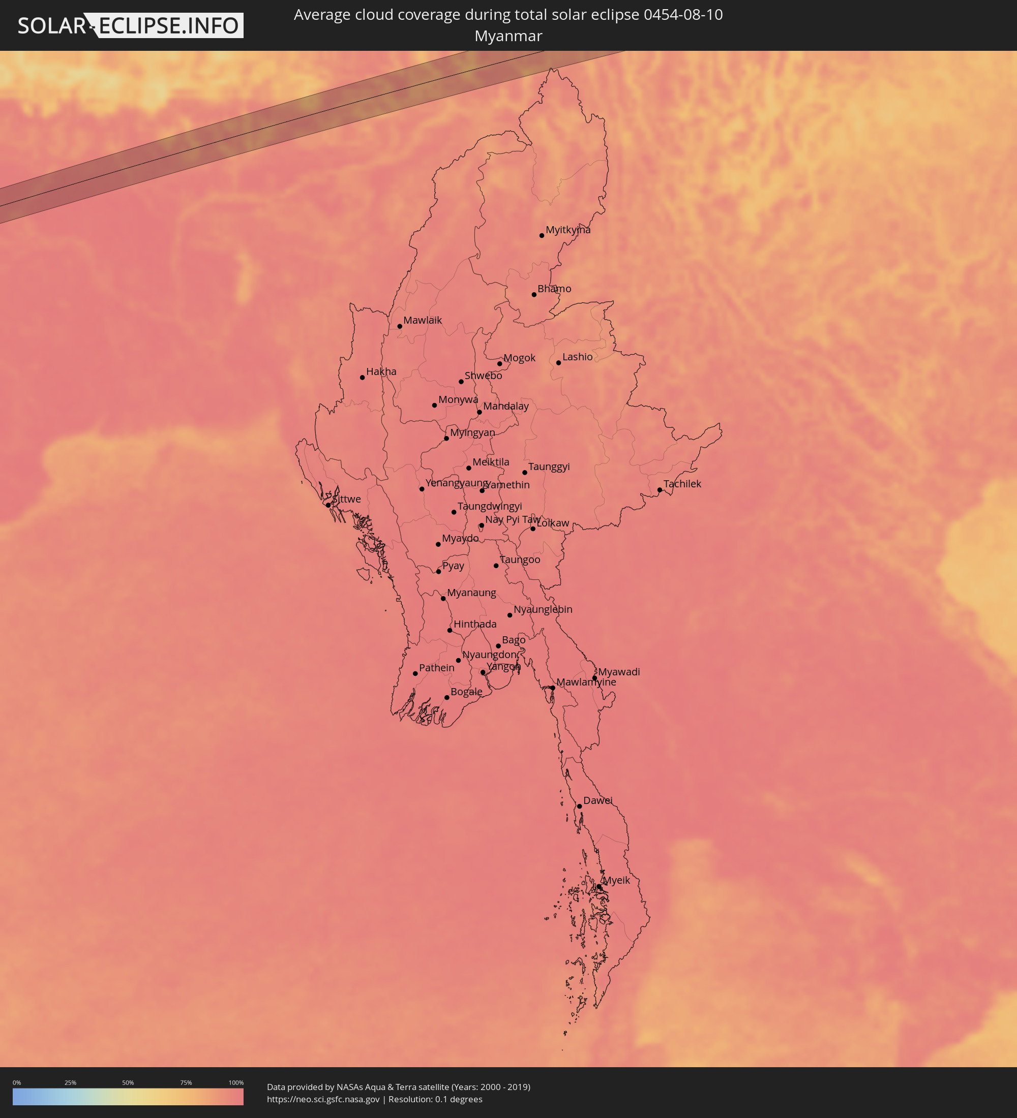 Myanmar
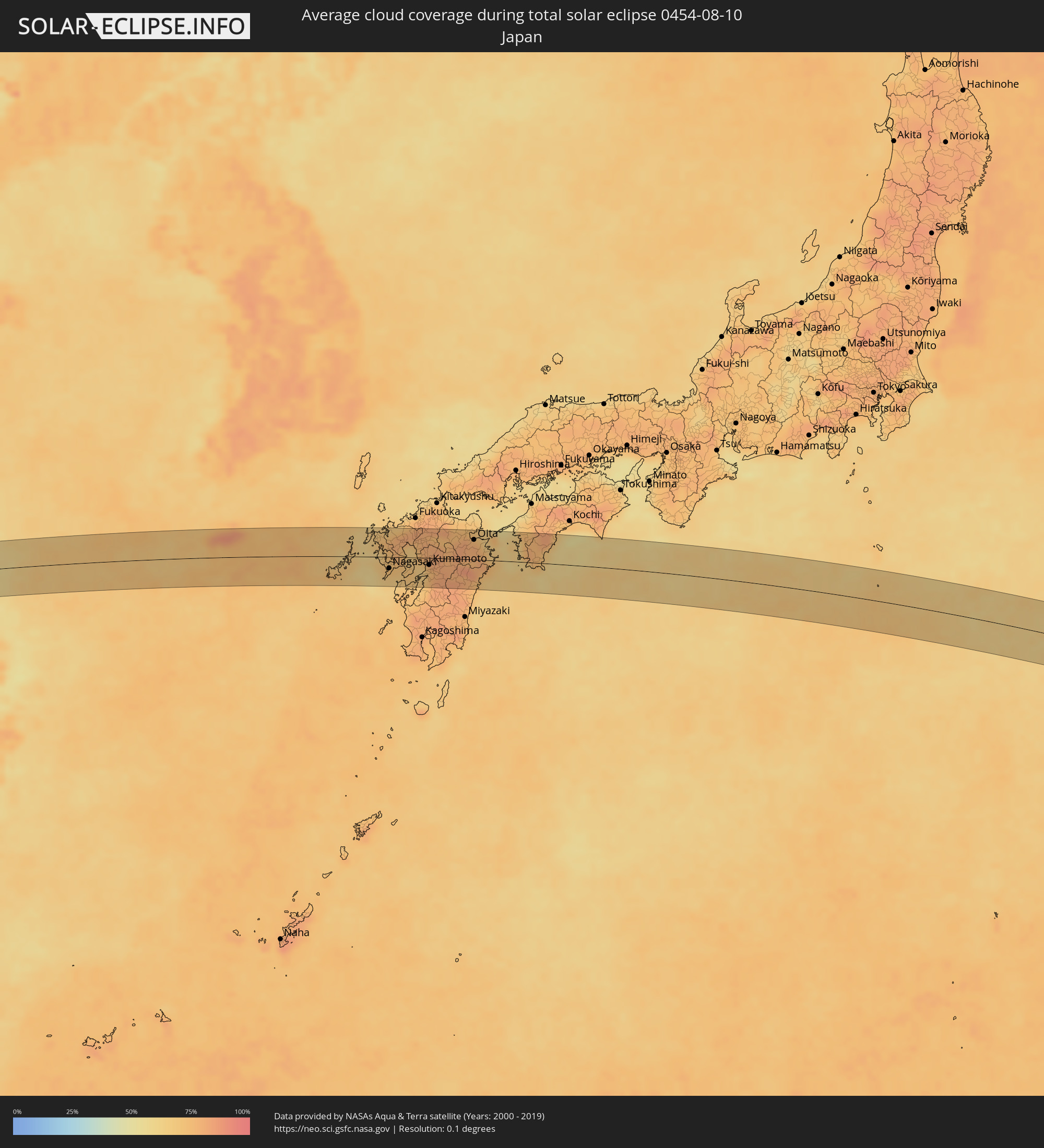 Japan
Japan
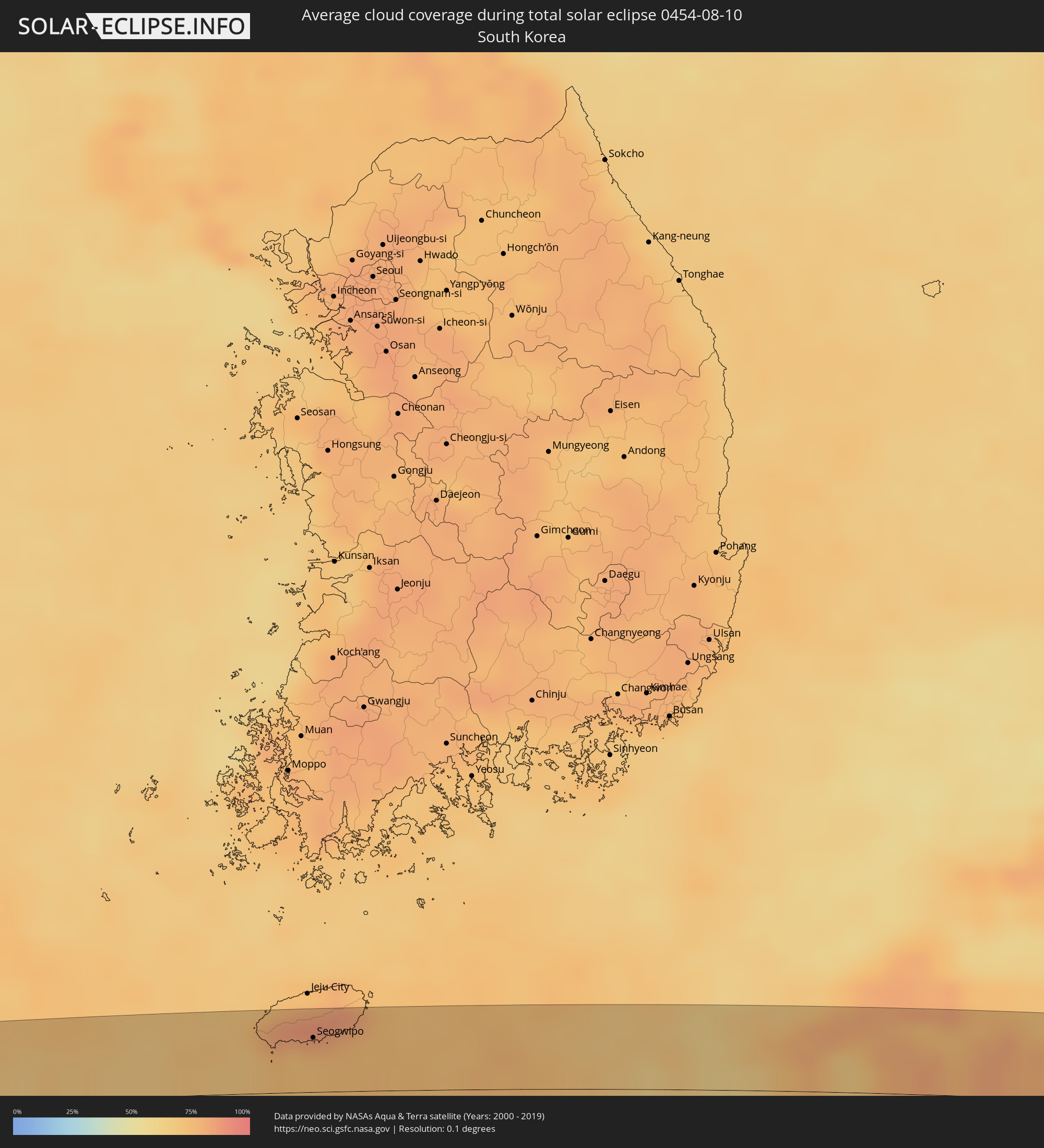 Südkorea
Orte im Finsternispfad
Die nachfolgene Tabelle zeigt Städte und Orte mit mehr als 5.000 Einwohnern, die sich im Finsternispfad befinden. Städte mit mehr als 100.000 Einwohnern sind dick gekennzeichnet. Mit einem Klick auf den Ort öffnet sich eine Detailkarte die die Lage des jeweiligen Ortes zusammen mit dem Verlauf der zentralen Finsternis präsentiert.
| Ort | Typ | Dauer der Verfinsterung | Ortszeit bei maximaler Verfinsterung | Entfernung zur Zentrallinie | Ø Bewölkung |
|
Maihar, Madhya Pradesh
|
total | - | 05:34:09 UTC+05:21 | 26 km | 96% |
|
Satna, Madhya Pradesh
|
total | - | 05:34:20 UTC+05:21 | 5 km | 96% |
|
Rewa, Madhya Pradesh
|
total | - | 05:34:14 UTC+05:21 | 13 km | 96% |
|
Mirzāpur, Uttar Pradesh
|
total | - | 05:34:27 UTC+05:21 | 14 km | 96% |
|
Varanasi, Uttar Pradesh
|
total | - | 05:34:31 UTC+05:21 | 19 km | 96% |
|
Ghazīpur, Uttar Pradesh
|
total | - | 05:34:39 UTC+05:21 | 30 km | 95% |
|
Bhabhua, Bihar
|
total | - | 05:34:18 UTC+05:21 | 28 km | 96% |
|
Buxar, Bihar
|
total | - | 05:34:37 UTC+05:21 | 17 km | 96% |
|
Dumraon, Bihar
|
total | - | 05:34:36 UTC+05:21 | 10 km | 97% |
|
Bikramganj, Bihar
|
total | - | 05:34:22 UTC+05:21 | 29 km | 98% |
|
Arrah, Bihar
|
total | - | 05:34:34 UTC+05:21 | 5 km | 97% |
|
Chāpra, Bihar
|
total | - | 05:34:43 UTC+05:21 | 17 km | 95% |
|
Patna, Bihar
|
total | - | 05:34:35 UTC+05:21 | 14 km | 96% |
|
Fatwa, Bihar
|
total | - | 05:34:31 UTC+05:21 | 28 km | 96% |
|
Muzaffarpur, Bihar
|
total | - | 05:34:55 UTC+05:21 | 34 km | 97% |
|
Samāstipur, Bihar
|
total | - | 05:34:45 UTC+05:21 | 5 km | 98% |
|
Darbhanga, Bihar
|
total | - | 05:34:56 UTC+05:21 | 23 km | 96% |
|
Supaul, Bihar
|
total | - | 05:34:55 UTC+05:21 | 1 km | 97% |
|
Saharsa, Bihar
|
total | - | 05:34:46 UTC+05:21 | 27 km | 97% |
|
Madhipura, Bihar
|
total | - | 05:34:48 UTC+05:21 | 28 km | 98% |
|
Forbesganj, Bihar
|
total | - | 05:35:04 UTC+05:21 | 1 km | 98% |
|
Biratnagar, Eastern Region
|
total | - | 05:55:16 UTC+05:41 | 16 km | 98% |
|
Arāria, Bihar
|
total | - | 05:34:59 UTC+05:21 | 24 km | 98% |
|
Bhadrapur, Eastern Region
|
total | - | 05:55:23 UTC+05:41 | 2 km | 97% |
|
Islāmpur, West Bengal
|
total | - | 05:35:06 UTC+05:21 | 31 km | 98% |
|
Naksalbāri, West Bengal
|
total | - | 05:35:23 UTC+05:21 | 13 km | 96% |
|
Kārsiyāng, West Bengal
|
total | - | 05:35:31 UTC+05:21 | 33 km | 95% |
|
Shiliguri, West Bengal
|
total | - | 05:35:25 UTC+05:21 | 10 km | 96% |
|
Panchagarh, Rangpur Division
|
total | - | 06:07:20 UTC+05:53 | 34 km | 97% |
|
Jalpāiguri, West Bengal
|
total | - | 05:35:19 UTC+05:21 | 19 km | 94% |
|
Goyerkāta, West Bengal
|
total | - | 05:35:28 UTC+05:21 | 8 km | 95% |
|
Samtse, Samchi
|
total | - | 06:13:03 UTC+05:58 | 11 km | 95% |
|
Jaigaon, West Bengal
|
total | - | 05:35:36 UTC+05:21 | 2 km | 96% |
|
Phuntsholing, Chukha District
|
total | - | 05:35:37 UTC+05:21 | 2 km | 96% |
|
Tsimasham, Chukha District
|
total | - | 06:13:14 UTC+05:58 | 20 km | 93% |
|
Daga, Dagana District
|
total | - | 06:13:15 UTC+05:58 | 8 km | 87% |
|
Tsirang, Chirang
|
total | - | 06:13:15 UTC+05:58 | 4 km | 88% |
|
Sarpang, Geylegphug
|
total | - | 06:13:10 UTC+05:58 | 25 km | 92% |
|
Trongsa, Tongsa
|
total | - | 06:13:39 UTC+05:58 | 36 km | 88% |
|
Shemgang, Shemgang
|
total | - | 06:13:28 UTC+05:58 | 2 km | 84% |
|
Jakar, Bumthang
|
total | - | 06:13:43 UTC+05:58 | 35 km | 85% |
|
Lhuentse, Lhuntse District
|
total | - | 06:13:53 UTC+05:58 | 35 km | 85% |
|
Mongar, Mongar District
|
total | - | 06:13:36 UTC+05:58 | 8 km | 81% |
|
Trashi Yangtse, Trashi Yangste
|
total | - | 06:13:54 UTC+05:58 | 21 km | 86% |
|
Trashigang, Tashigang
|
total | - | 06:13:42 UTC+05:58 | 11 km | 93% |
|
Kangding, Sichuan
|
total | - | 08:21:05 UTC+08:00 | 20 km | 78% |
|
Chengdu, Sichuan
|
total | - | 08:22:53 UTC+08:00 | 40 km | 88% |
|
Yanjiang, Sichuan
|
total | - | 08:22:51 UTC+08:00 | 31 km | 84% |
|
Suining, Sichuan
|
total | - | 08:23:49 UTC+08:00 | 9 km | 78% |
|
Nanchong, Sichuan
|
total | - | 08:24:25 UTC+08:00 | 12 km | 75% |
|
Gaoping, Sichuan
|
total | - | 08:24:25 UTC+08:00 | 10 km | 75% |
|
Dazhou, Sichuan
|
total | - | 08:25:51 UTC+08:00 | 30 km | 74% |
|
Wanxian, Chongqing
|
total | - | 08:26:16 UTC+08:00 | 30 km | 68% |
|
Nanzhang Chengguanzhen, Hubei
|
total | - | 08:30:14 UTC+08:00 | 15 km | 78% |
|
Xiangyang, Hubei
|
total | - | 08:30:45 UTC+08:00 | 38 km | 77% |
|
Zaoyang, Hubei
|
total | - | 08:31:27 UTC+08:00 | 38 km | 74% |
|
Suizhou, Hubei
|
total | - | 08:31:48 UTC+08:00 | 17 km | 78% |
|
Xihe, Hubei
|
total | - | 08:31:53 UTC+08:00 | 21 km | 75% |
|
Guangshui, Hubei
|
total | - | 08:32:26 UTC+08:00 | 36 km | 74% |
|
Xinyang, Henan
|
total | - | 08:32:52 UTC+08:00 | 18 km | 78% |
|
Wuyang, Anhui
|
total | - | 08:35:20 UTC+08:00 | 26 km | 73% |
|
Huainan, Anhui
|
total | - | 08:36:42 UTC+08:00 | 35 km | 72% |
|
Chuzhou, Anhui
|
total | - | 08:38:10 UTC+08:00 | 14 km | 76% |
|
Nanjing, Jiangsu
|
total | - | 08:38:38 UTC+08:00 | 47 km | 82% |
|
Zhenzhou, Jiangsu
|
total | - | 08:39:19 UTC+08:00 | 27 km | 77% |
|
Yangzhou, Jiangsu
|
total | - | 08:39:45 UTC+08:00 | 17 km | 80% |
|
Gaoyou, Jiangsu
|
total | - | 08:40:01 UTC+08:00 | 26 km | 72% |
|
Zhenjiang, Jiangsu
|
total | - | 08:39:39 UTC+08:00 | 38 km | 82% |
|
Xiannü, Jiangsu
|
total | - | 08:39:56 UTC+08:00 | 15 km | 75% |
|
Xinghua, Jiangsu
|
total | - | 08:40:39 UTC+08:00 | 39 km | 77% |
|
Taizhou, Jiangsu
|
total | - | 08:40:28 UTC+08:00 | 11 km | 80% |
|
Taixing, Jiangsu
|
total | - | 08:40:25 UTC+08:00 | 48 km | 76% |
|
Dongtai, Jiangsu
|
total | - | 08:41:15 UTC+08:00 | 25 km | 81% |
|
Juegang, Jiangsu
|
total | - | 08:42:12 UTC+08:00 | 41 km | 79% |
|
Seogwipo, Jeju-do
|
total | - | 09:19:07 UTC+08:27 | 35 km | 82% |
|
Sasebo, Nagasaki
|
total | - | 09:56:52 UTC+09:00 | 24 km | 71% |
|
Togitsu, Nagasaki
|
total | - | 09:57:00 UTC+09:00 | 12 km | 72% |
|
Imarichō-kō, Saga Prefecture
|
total | - | 09:57:12 UTC+09:00 | 37 km | 78% |
|
Nagasaki, Nagasaki
|
total | - | 09:57:03 UTC+09:00 | 21 km | 72% |
|
Takeochō-takeo, Saga Prefecture
|
total | - | 09:57:26 UTC+09:00 | 28 km | 80% |
|
Isahaya, Nagasaki
|
total | - | 09:57:22 UTC+09:00 | 11 km | 71% |
|
Kashima, Saga Prefecture
|
total | - | 09:57:32 UTC+09:00 | 19 km | 75% |
|
Hondomachi-hondo, Kumamoto
|
total | - | 09:57:30 UTC+09:00 | 53 km | 72% |
|
Saga, Saga Prefecture
|
total | - | 09:57:58 UTC+09:00 | 33 km | 68% |
|
Ōkawa, Saga Prefecture
|
total | - | 09:58:04 UTC+09:00 | 30 km | 73% |
|
Shimabara, Nagasaki
|
total | - | 09:57:58 UTC+09:00 | 17 km | 68% |
|
Yanagawa, Fukuoka
|
total | - | 09:58:09 UTC+09:00 | 26 km | 73% |
|
Ōmuta, Fukuoka
|
total | - | 09:58:12 UTC+09:00 | 11 km | 72% |
|
Kurume, Fukuoka
|
total | - | 09:58:24 UTC+09:00 | 43 km | 78% |
|
Tamana, Kumamoto
|
total | - | 09:58:23 UTC+09:00 | 1 km | 72% |
|
Honmachi, Kumamoto
|
total | - | 09:58:20 UTC+09:00 | 47 km | 72% |
|
Amagi, Fukuoka
|
total | - | 09:58:42 UTC+09:00 | 55 km | 76% |
|
Uto, Kumamoto
|
total | - | 09:58:31 UTC+09:00 | 27 km | 76% |
|
Yamaga, Kumamoto
|
total | - | 09:58:38 UTC+09:00 | 10 km | 81% |
|
Uekimachi-mōno, Kumamoto
|
total | - | 09:58:37 UTC+09:00 | 3 km | 79% |
|
Kumamoto, Kumamoto
|
total | - | 09:58:36 UTC+09:00 | 13 km | 75% |
|
Ōzu, Kumamoto
|
total | - | 09:58:58 UTC+09:00 | 4 km | 81% |
|
Hita, Oita
|
total | - | 09:59:13 UTC+09:00 | 45 km | 74% |
|
Ōita, Oita
|
total | - | 10:00:28 UTC+09:00 | 37 km | 80% |
|
Nobeoka, Miyazaki
|
total | - | 10:00:27 UTC+09:00 | 35 km | 71% |
|
Usuki, Oita
|
total | - | 10:00:50 UTC+09:00 | 26 km | 74% |
|
Saiki, Oita
|
total | - | 10:00:59 UTC+09:00 | 7 km | 71% |
|
Uwajima, Ehime
|
total | - | 10:02:21 UTC+09:00 | 41 km | 75% |
|
Nakamura, Kochi
|
total | - | 10:03:03 UTC+09:00 | 16 km | 74% |