Total solar eclipse of 08/10/0454
| Day of week: | Monday |
| Maximum duration of eclipse: | 03m17s |
| Maximum width of eclipse path: | 122 km |
| Saros cycle: | 91 |
| Coverage: | 100% |
| Magnitude: | 1.0355 |
| Gamma: | 0.2243 |
Wo kann man die Sonnenfinsternis vom 08/10/0454 sehen?
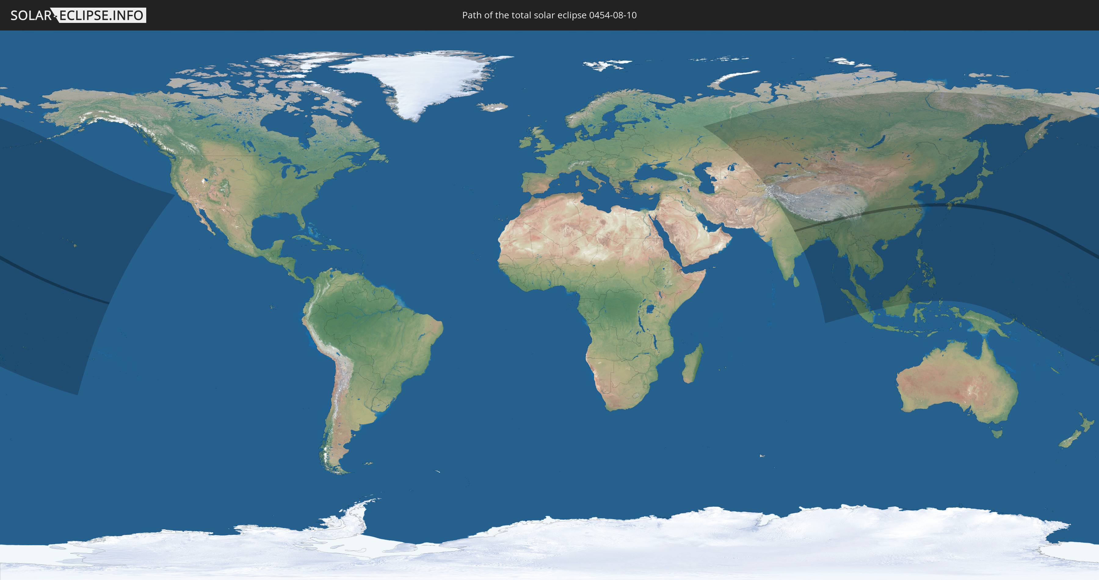
Die Sonnenfinsternis am 08/10/0454 kann man in 51 Ländern als partielle Sonnenfinsternis beobachten.
Der Finsternispfad verläuft durch 8 Länder. Nur in diesen Ländern ist sie als total Sonnenfinsternis zu sehen.
In den folgenden Ländern ist die Sonnenfinsternis total zu sehen
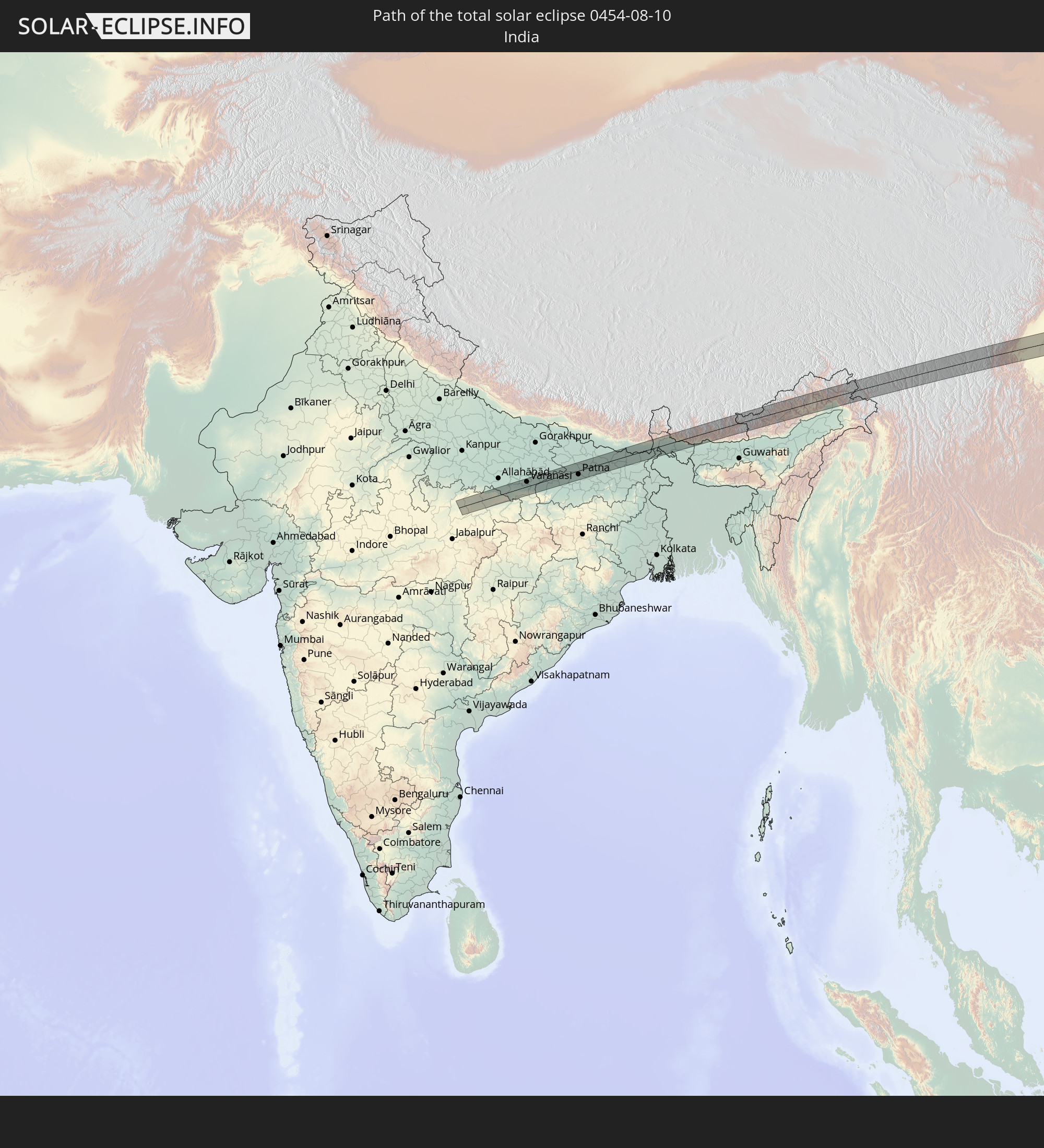 India
India
 China
China
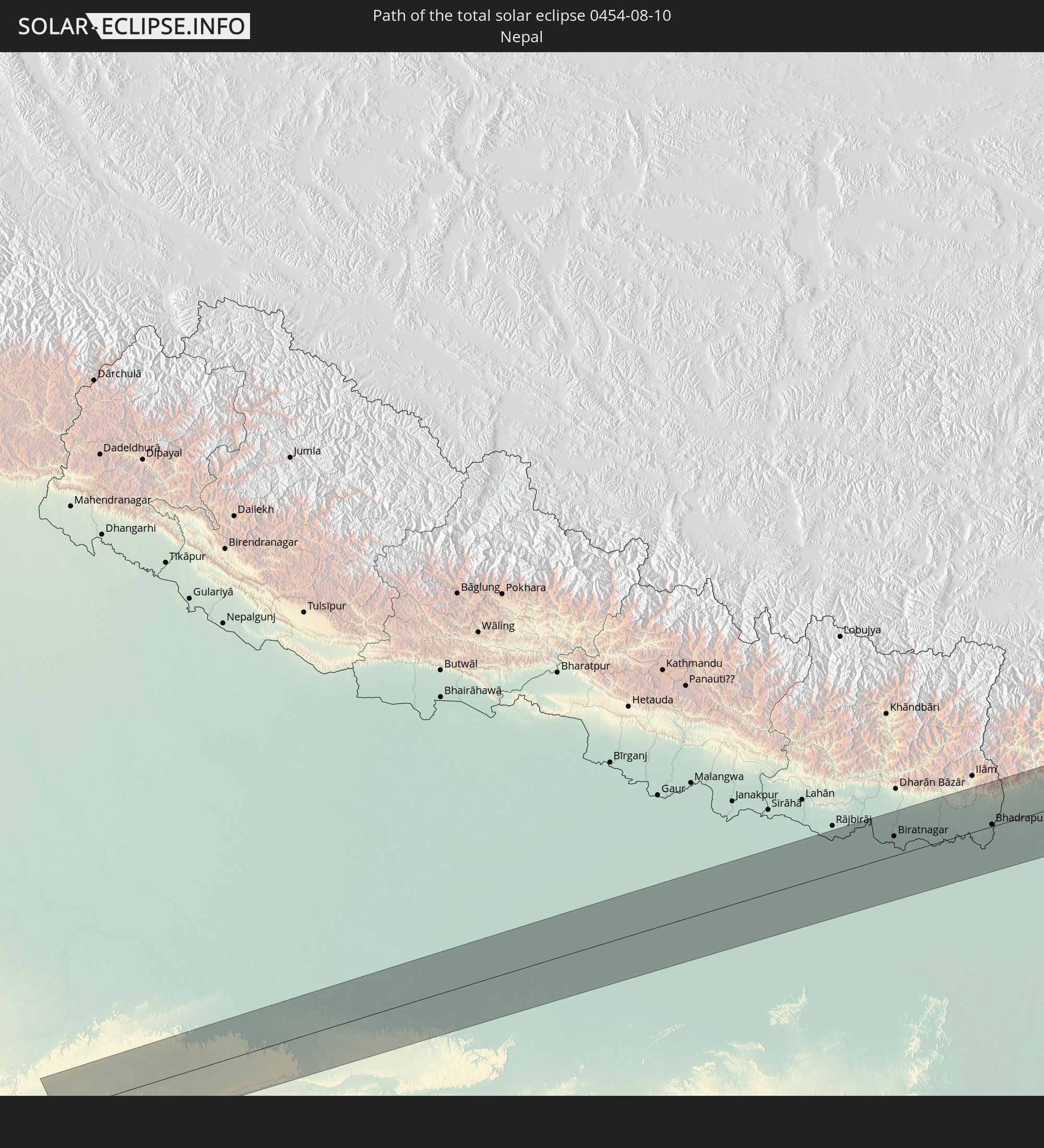 Nepal
Nepal
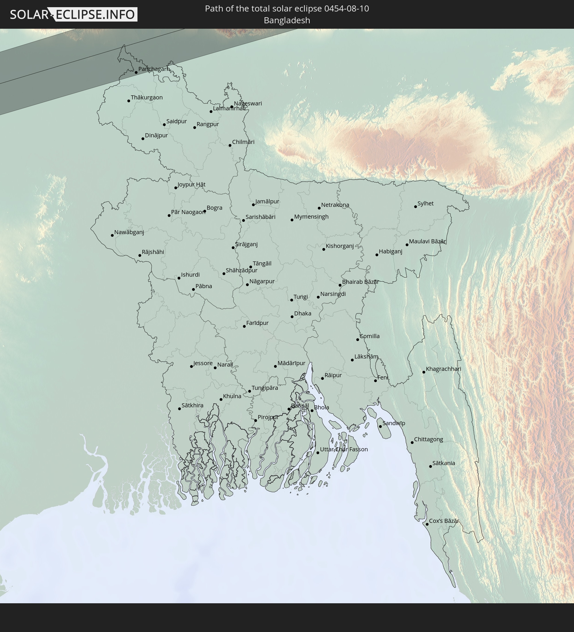 Bangladesh
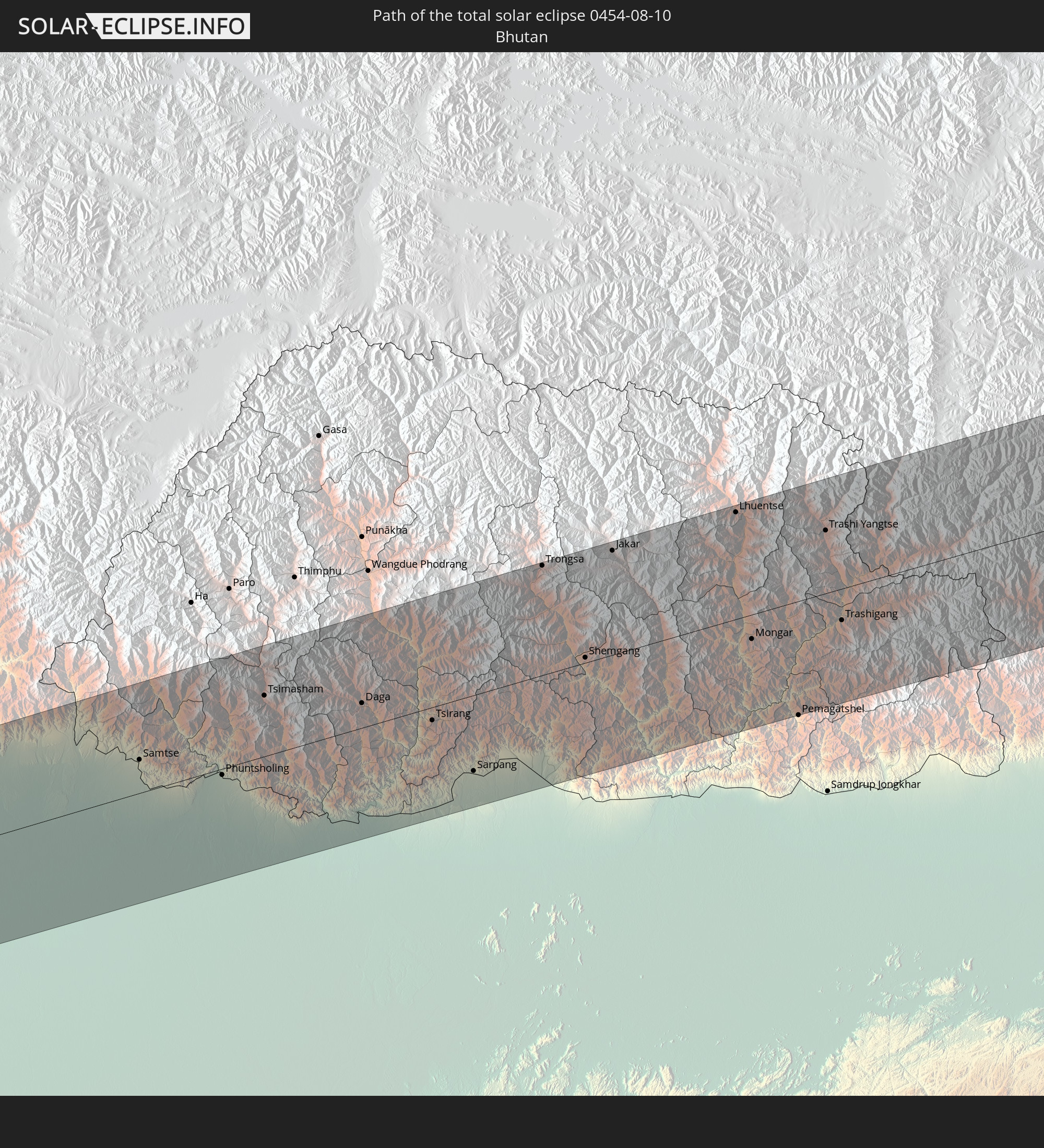 Bhutan
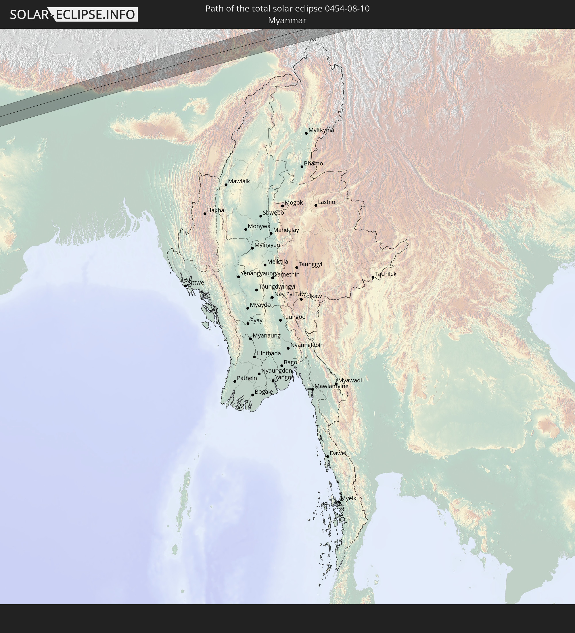 Myanmar
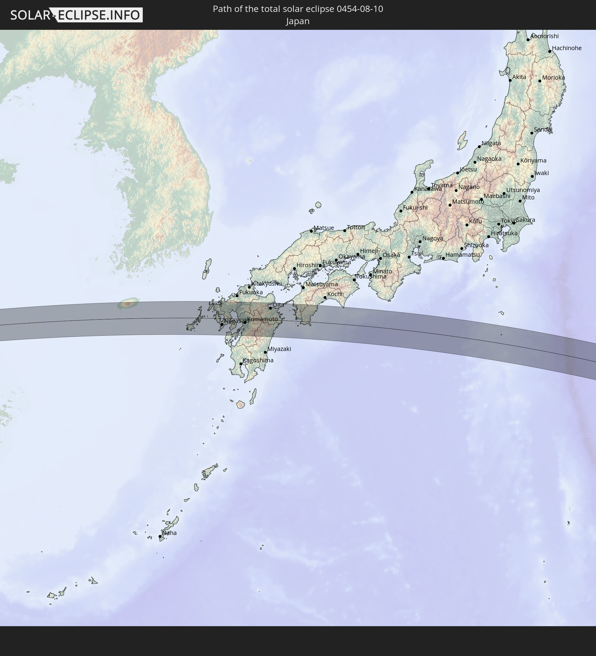 Japan
Japan
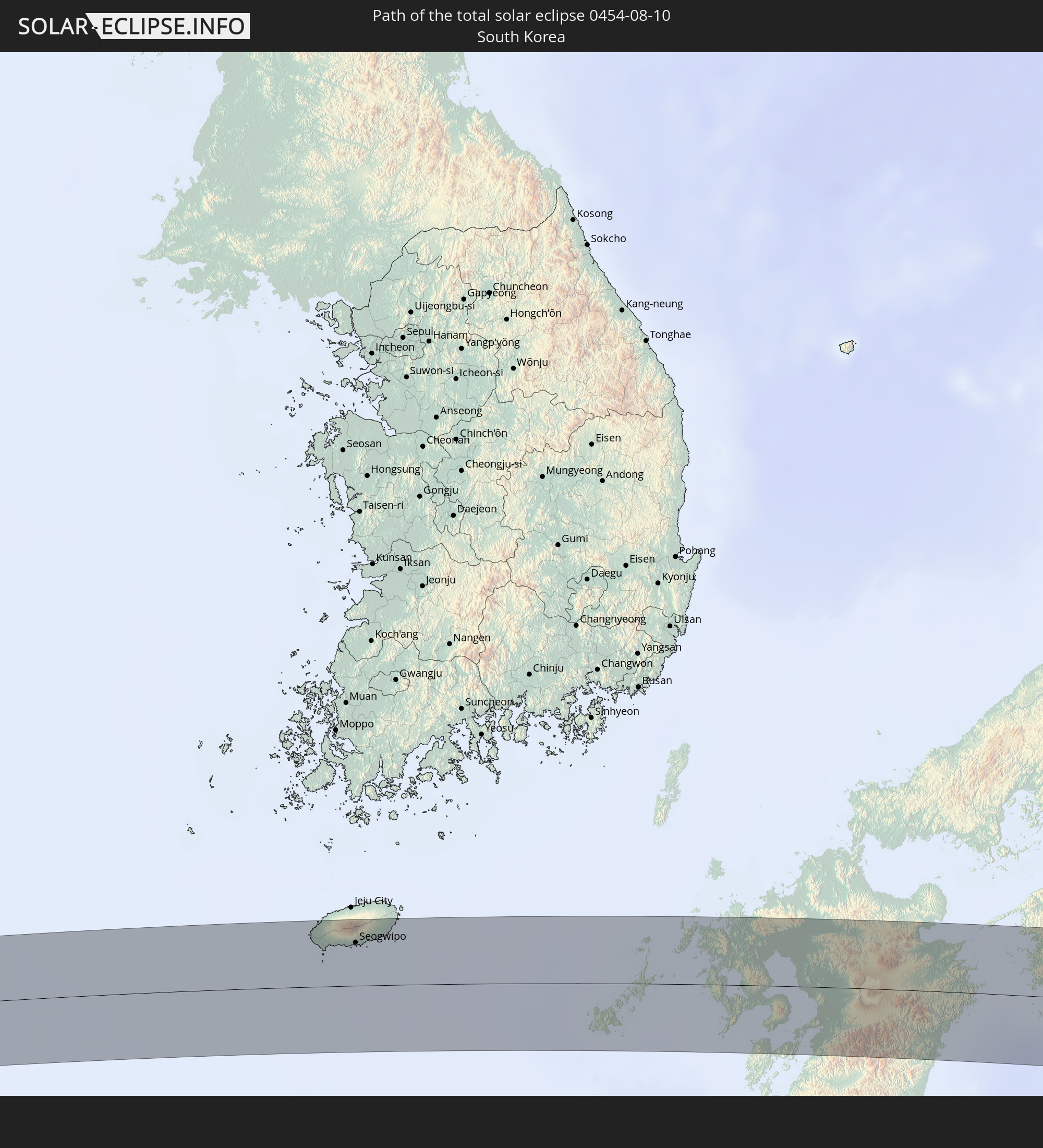 South Korea
In den folgenden Ländern ist die Sonnenfinsternis partiell zu sehen
 Russia
 Fiji
Fiji
 United States
 United States Minor Outlying Islands
 Wallis and Futuna
 Tonga
Tonga
 Kiribati
 Samoa
Samoa
 Tokelau
 American Samoa
 Niue
Niue
 Cook Islands
 French Polynesia
 Kazakhstan
 Uzbekistan
 Afghanistan
 Pakistan
 Tajikistan
 India
India
 Kyrgyzstan
 China
China
 Nepal
Nepal
 Mongolia
 Bangladesh
 Bhutan
 Myanmar
 Indonesia
 Thailand
 Malaysia
 Laos
Laos
 Vietnam
 Cambodia
 Singapore
 Macau
Macau
 Hong Kong
 Brunei
 Taiwan
 Philippines
 Japan
Japan
 North Korea
 South Korea
 Palau
Palau
 Federated States of Micronesia
 Papua New Guinea
 Guam
Guam
 Northern Mariana Islands
 Solomon Islands
 Marshall Islands
 Vanuatu
 Nauru
Nauru
 Tuvalu
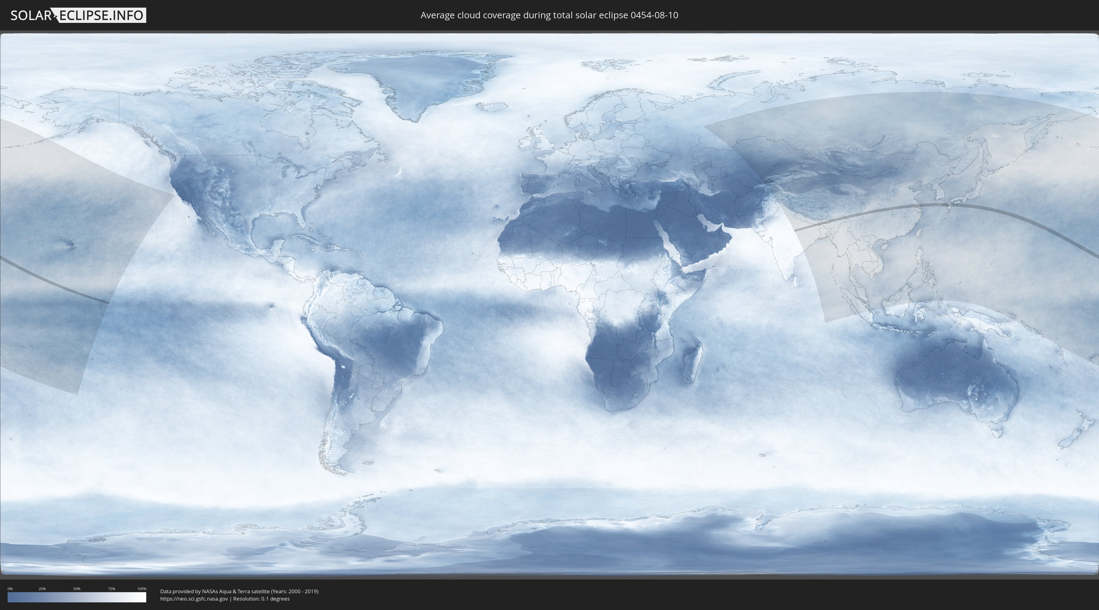
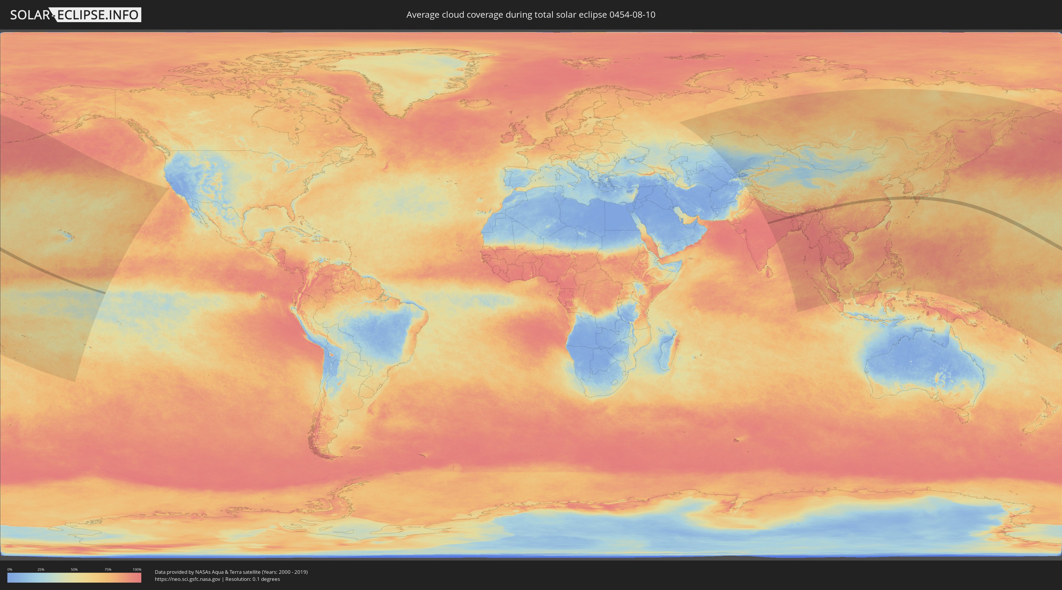
How will be the weather during the total solar eclipse on 08/10/0454?
Where is the best place to see the total solar eclipse of 08/10/0454?
The following maps show the average cloud coverage for the day of the total solar eclipse.
With the help of these maps, it is possible to find the place along the eclipse path, which has the best
chance of a cloudless sky.
Nevertheless, you should consider local circumstances and inform about the weather of your chosen
observation site.
The data is provided by NASAs satellites
AQUA and TERRA.
The cloud maps are averaged over a period of 19 years (2000 - 2019).
Detailed country maps
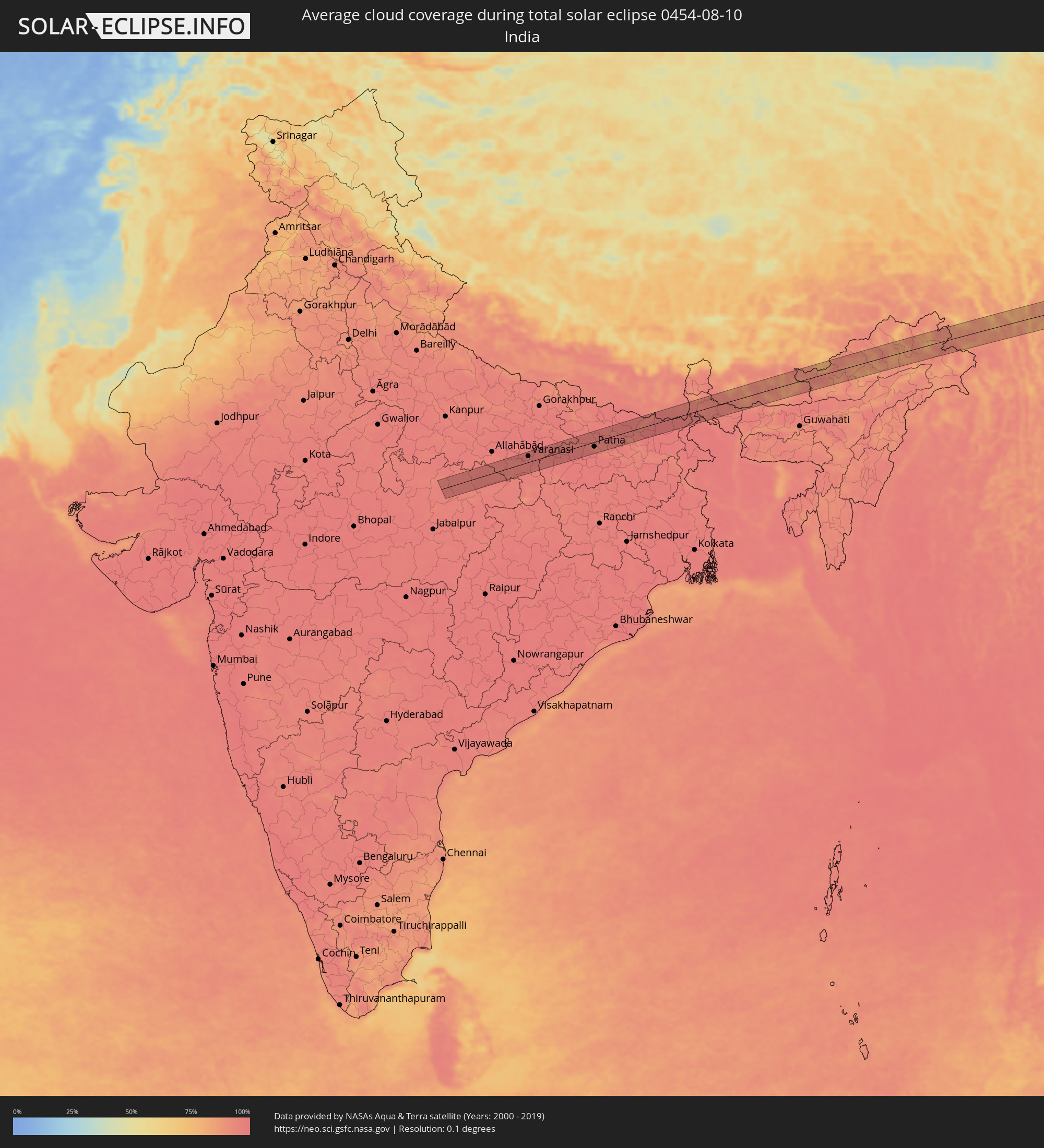 India
India
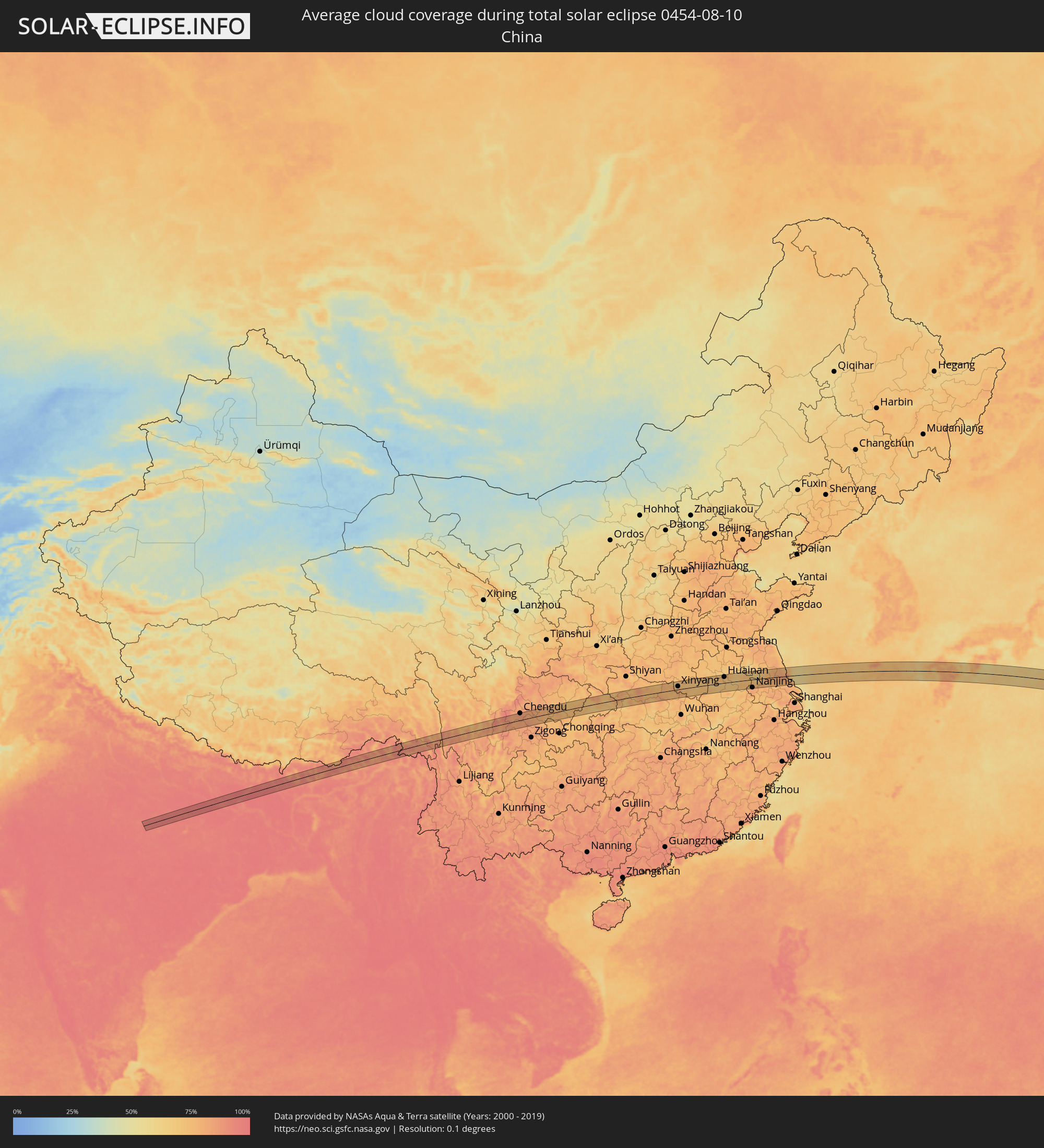 China
China
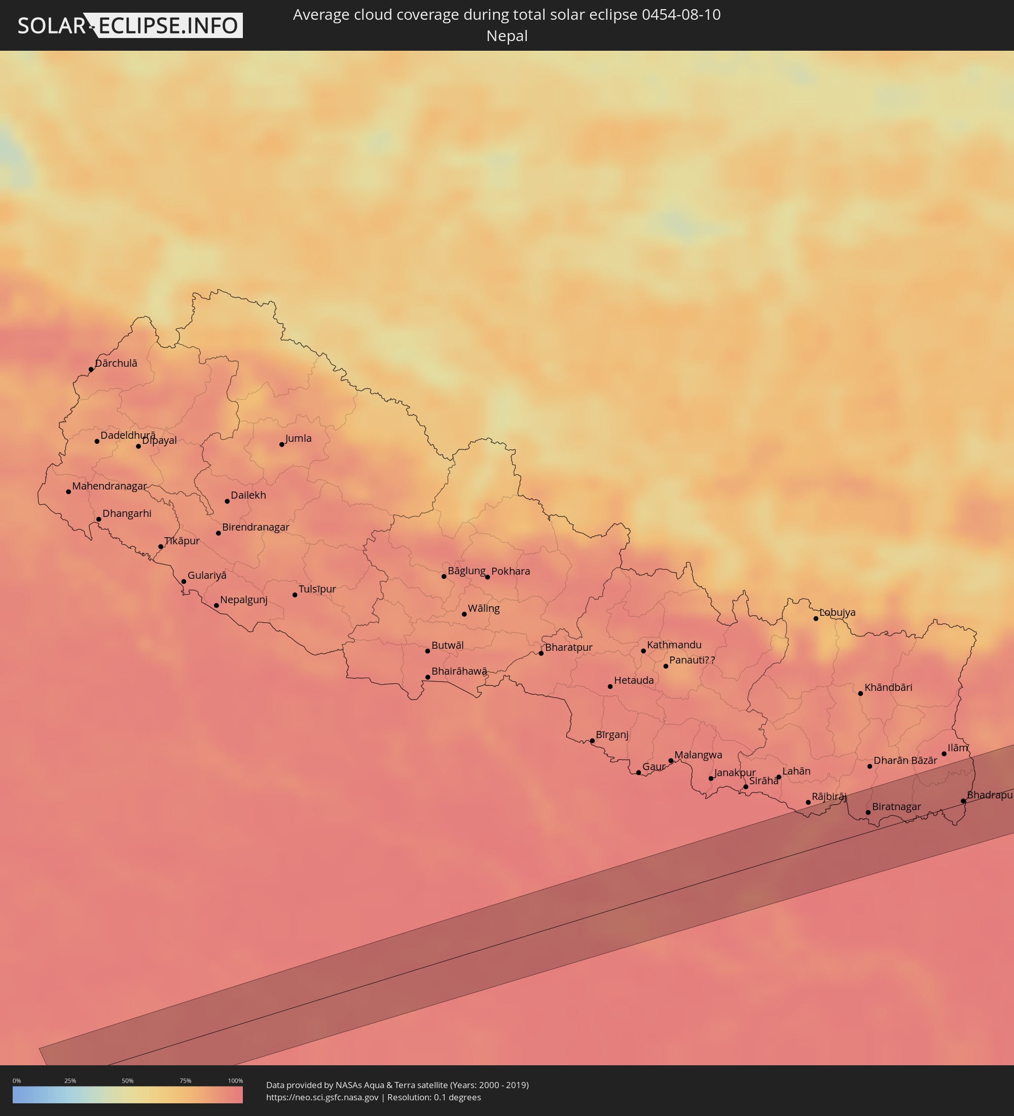 Nepal
Nepal
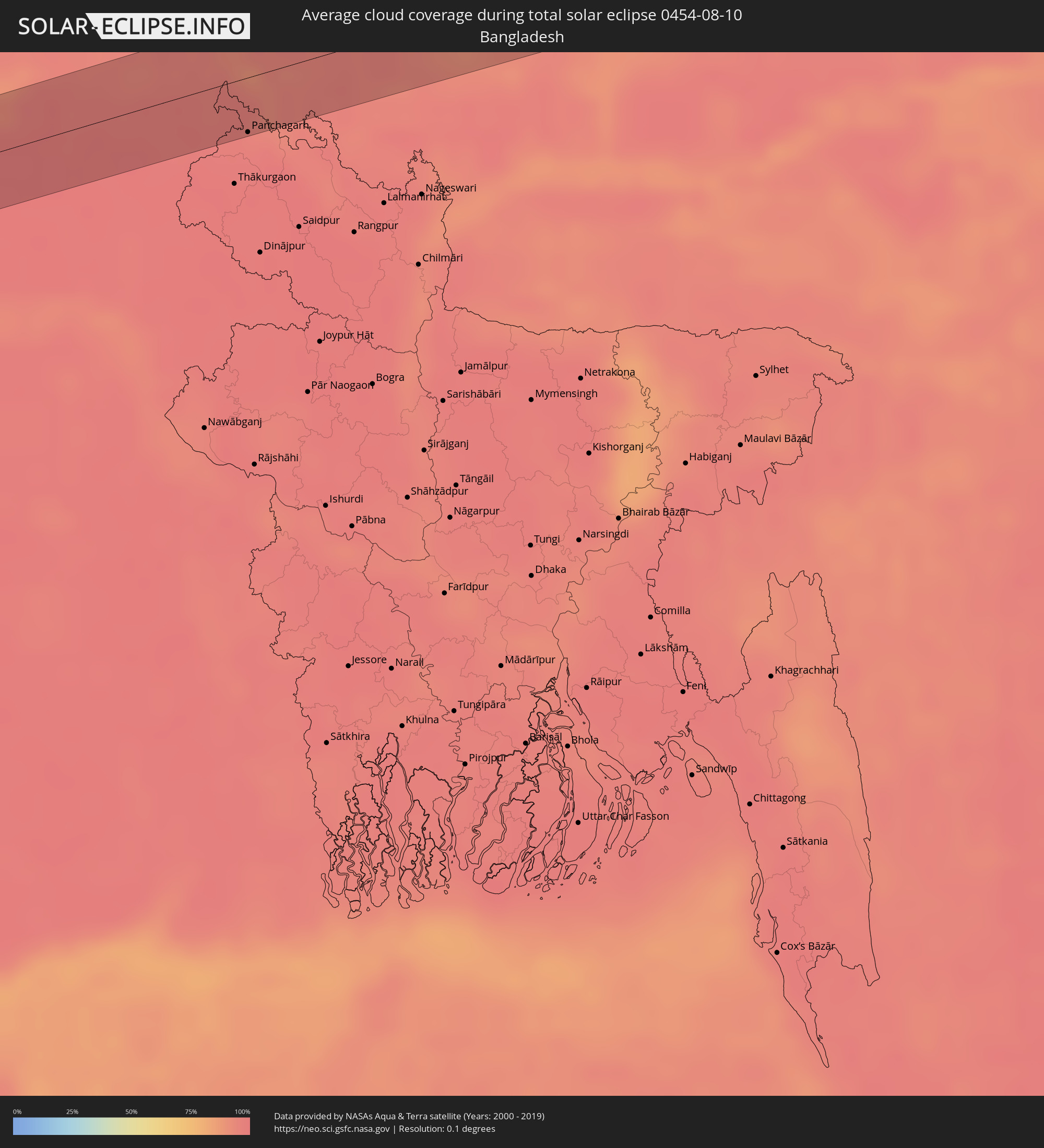 Bangladesh
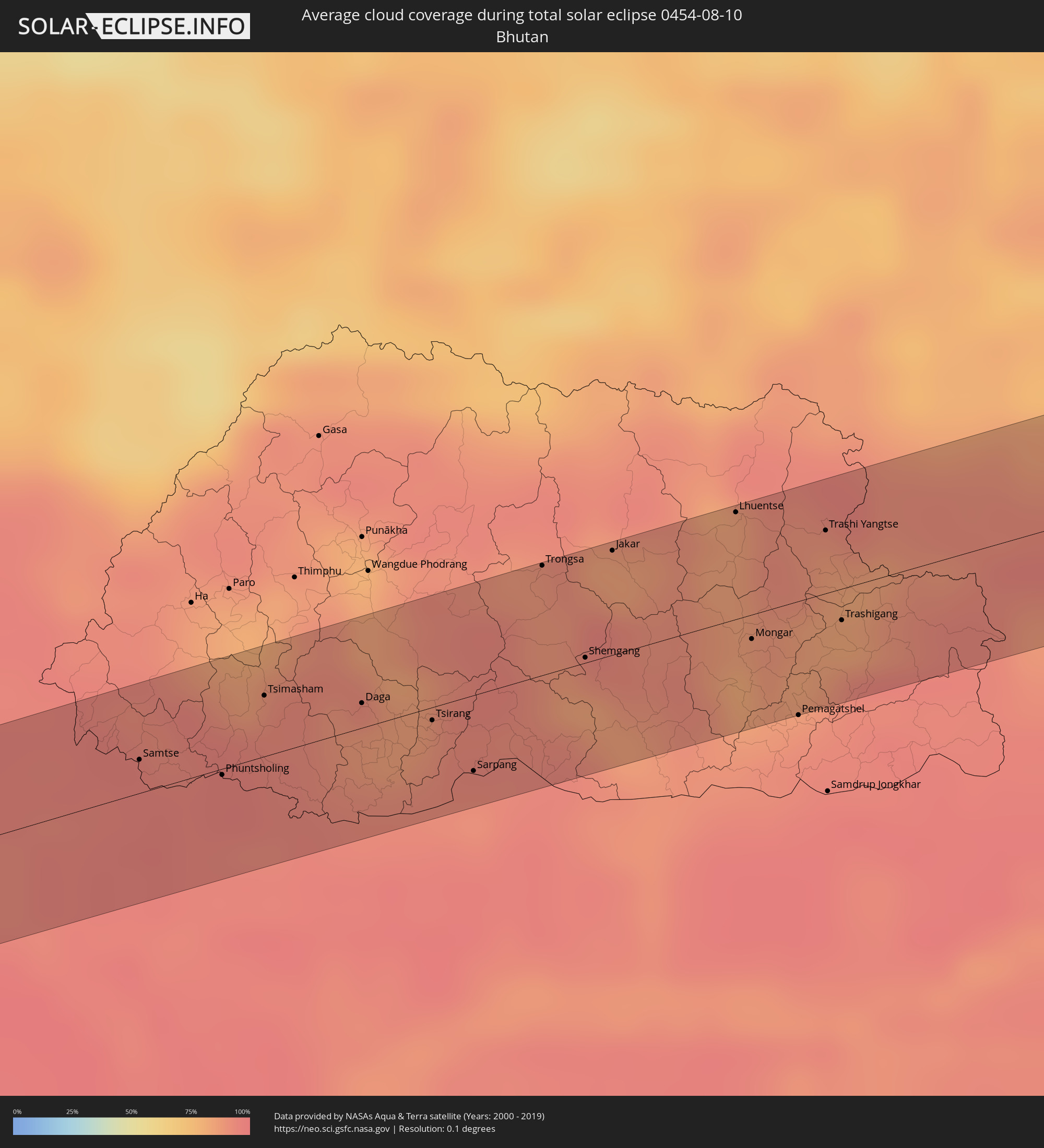 Bhutan
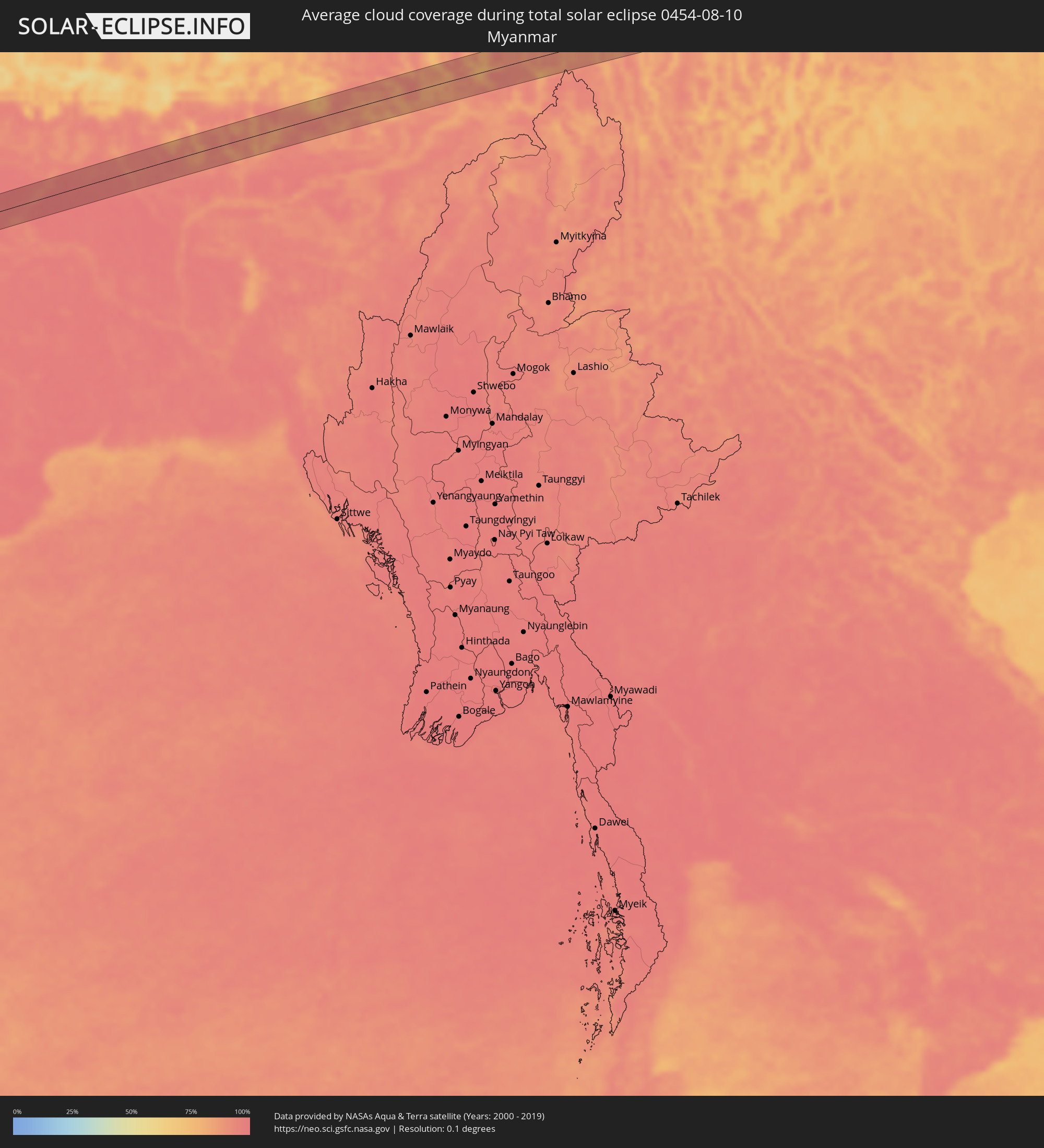 Myanmar
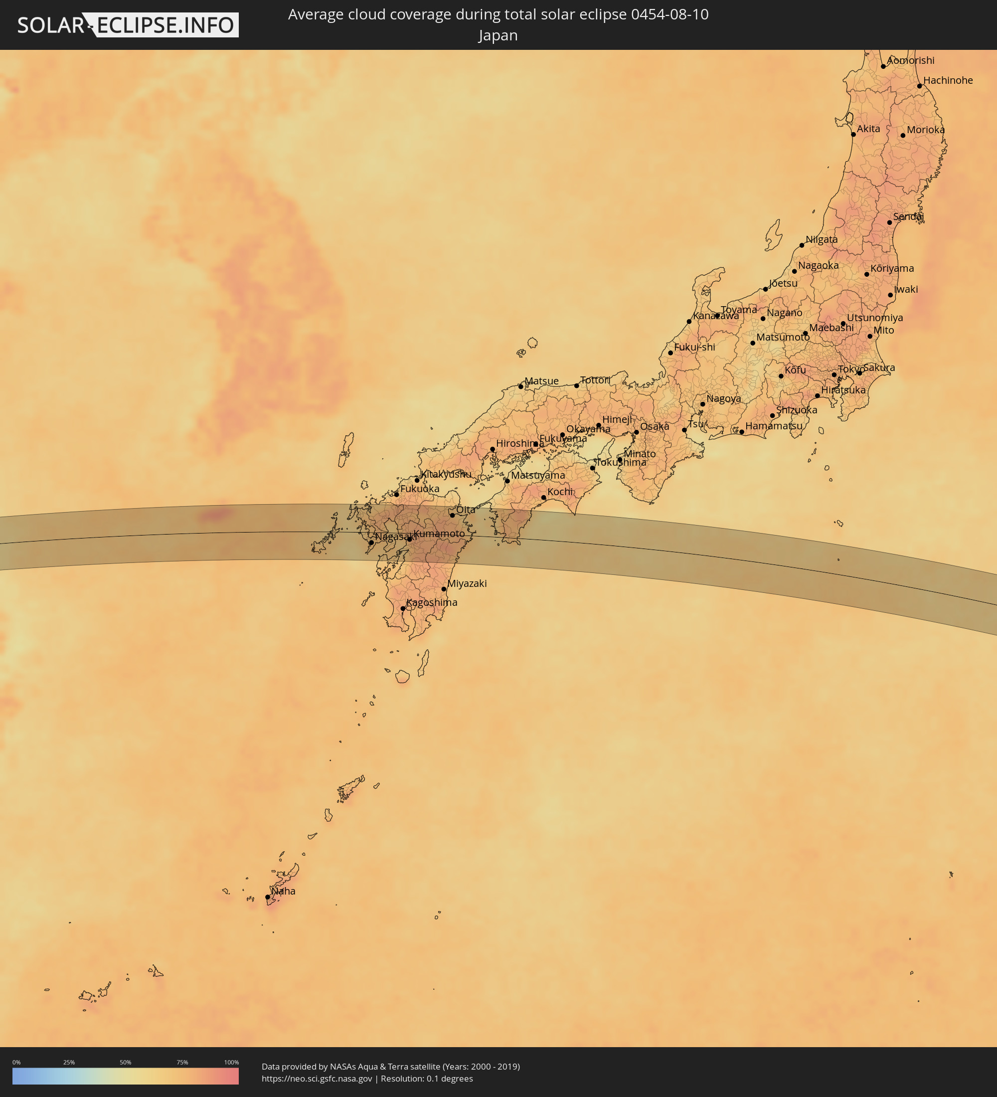 Japan
Japan
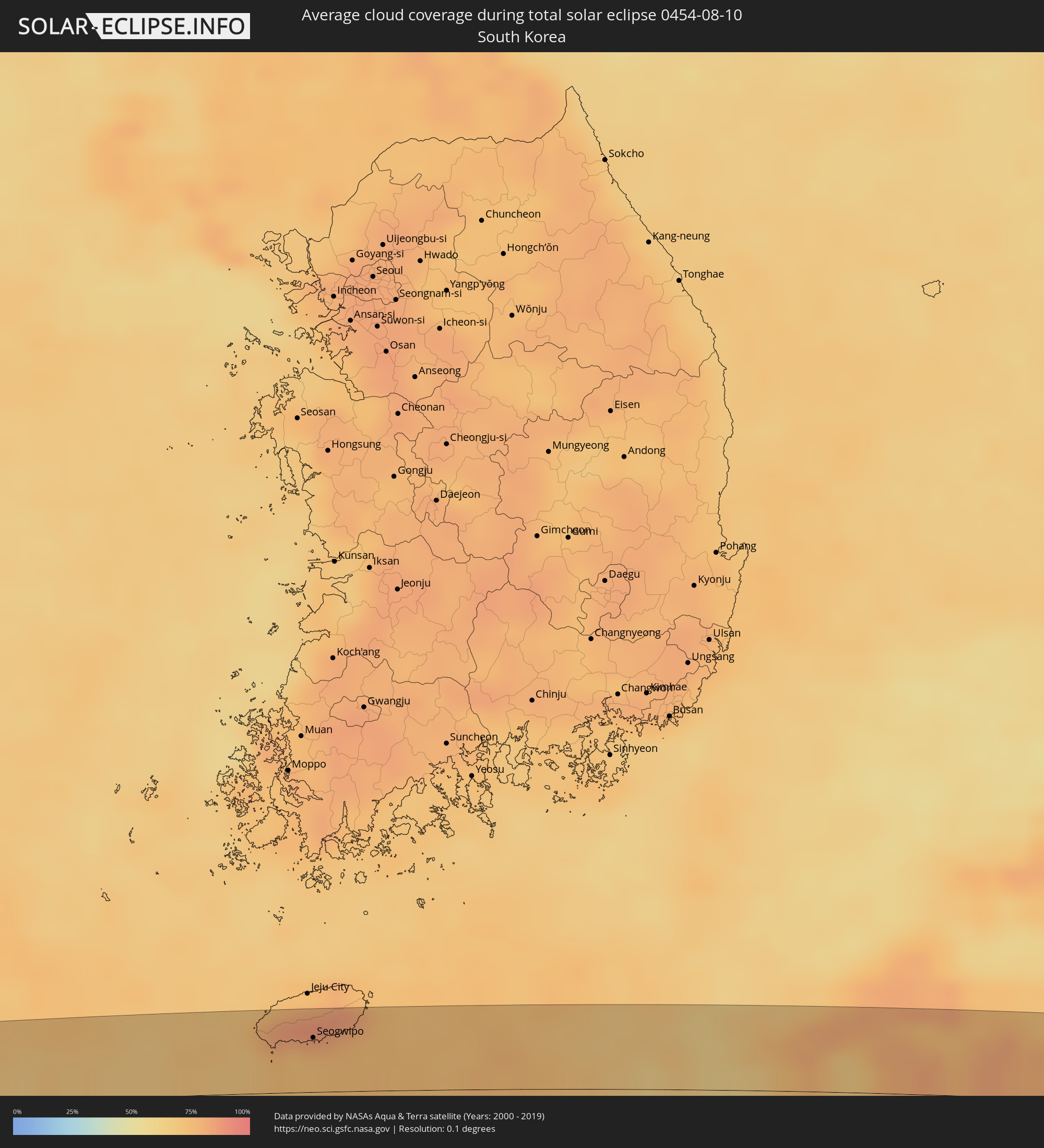 South Korea
Cities inside the path of the eclipse
The following table shows all locations with a population of more than 5,000 inside the eclipse path. Cities which have more than 100,000 inhabitants are marked bold. A click at the locations opens a detailed map.
| City | Type | Eclipse duration | Local time of max. eclipse | Distance to central line | Ø Cloud coverage |
|
Maihar, Madhya Pradesh
|
total | - | 05:34:09 UTC+05:21 | 26 km | 96% |
|
Satna, Madhya Pradesh
|
total | - | 05:34:20 UTC+05:21 | 5 km | 96% |
|
Rewa, Madhya Pradesh
|
total | - | 05:34:14 UTC+05:21 | 13 km | 96% |
|
Mirzāpur, Uttar Pradesh
|
total | - | 05:34:27 UTC+05:21 | 14 km | 96% |
|
Varanasi, Uttar Pradesh
|
total | - | 05:34:31 UTC+05:21 | 19 km | 96% |
|
Ghazīpur, Uttar Pradesh
|
total | - | 05:34:39 UTC+05:21 | 30 km | 95% |
|
Bhabhua, Bihar
|
total | - | 05:34:18 UTC+05:21 | 28 km | 96% |
|
Buxar, Bihar
|
total | - | 05:34:37 UTC+05:21 | 17 km | 96% |
|
Dumraon, Bihar
|
total | - | 05:34:36 UTC+05:21 | 10 km | 97% |
|
Bikramganj, Bihar
|
total | - | 05:34:22 UTC+05:21 | 29 km | 98% |
|
Arrah, Bihar
|
total | - | 05:34:34 UTC+05:21 | 5 km | 97% |
|
Chāpra, Bihar
|
total | - | 05:34:43 UTC+05:21 | 17 km | 95% |
|
Patna, Bihar
|
total | - | 05:34:35 UTC+05:21 | 14 km | 96% |
|
Fatwa, Bihar
|
total | - | 05:34:31 UTC+05:21 | 28 km | 96% |
|
Muzaffarpur, Bihar
|
total | - | 05:34:55 UTC+05:21 | 34 km | 97% |
|
Samāstipur, Bihar
|
total | - | 05:34:45 UTC+05:21 | 5 km | 98% |
|
Darbhanga, Bihar
|
total | - | 05:34:56 UTC+05:21 | 23 km | 96% |
|
Supaul, Bihar
|
total | - | 05:34:55 UTC+05:21 | 1 km | 97% |
|
Saharsa, Bihar
|
total | - | 05:34:46 UTC+05:21 | 27 km | 97% |
|
Madhipura, Bihar
|
total | - | 05:34:48 UTC+05:21 | 28 km | 98% |
|
Forbesganj, Bihar
|
total | - | 05:35:04 UTC+05:21 | 1 km | 98% |
|
Biratnagar, Eastern Region
|
total | - | 05:55:16 UTC+05:41 | 16 km | 98% |
|
Arāria, Bihar
|
total | - | 05:34:59 UTC+05:21 | 24 km | 98% |
|
Bhadrapur, Eastern Region
|
total | - | 05:55:23 UTC+05:41 | 2 km | 97% |
|
Islāmpur, West Bengal
|
total | - | 05:35:06 UTC+05:21 | 31 km | 98% |
|
Naksalbāri, West Bengal
|
total | - | 05:35:23 UTC+05:21 | 13 km | 96% |
|
Kārsiyāng, West Bengal
|
total | - | 05:35:31 UTC+05:21 | 33 km | 95% |
|
Shiliguri, West Bengal
|
total | - | 05:35:25 UTC+05:21 | 10 km | 96% |
|
Panchagarh, Rangpur Division
|
total | - | 06:07:20 UTC+05:53 | 34 km | 97% |
|
Jalpāiguri, West Bengal
|
total | - | 05:35:19 UTC+05:21 | 19 km | 94% |
|
Goyerkāta, West Bengal
|
total | - | 05:35:28 UTC+05:21 | 8 km | 95% |
|
Samtse, Samchi
|
total | - | 06:13:03 UTC+05:58 | 11 km | 95% |
|
Jaigaon, West Bengal
|
total | - | 05:35:36 UTC+05:21 | 2 km | 96% |
|
Phuntsholing, Chukha District
|
total | - | 05:35:37 UTC+05:21 | 2 km | 96% |
|
Tsimasham, Chukha District
|
total | - | 06:13:14 UTC+05:58 | 20 km | 93% |
|
Daga, Dagana District
|
total | - | 06:13:15 UTC+05:58 | 8 km | 87% |
|
Tsirang, Chirang
|
total | - | 06:13:15 UTC+05:58 | 4 km | 88% |
|
Sarpang, Geylegphug
|
total | - | 06:13:10 UTC+05:58 | 25 km | 92% |
|
Trongsa, Tongsa
|
total | - | 06:13:39 UTC+05:58 | 36 km | 88% |
|
Shemgang, Shemgang
|
total | - | 06:13:28 UTC+05:58 | 2 km | 84% |
|
Jakar, Bumthang
|
total | - | 06:13:43 UTC+05:58 | 35 km | 85% |
|
Lhuentse, Lhuntse District
|
total | - | 06:13:53 UTC+05:58 | 35 km | 85% |
|
Mongar, Mongar District
|
total | - | 06:13:36 UTC+05:58 | 8 km | 81% |
|
Trashi Yangtse, Trashi Yangste
|
total | - | 06:13:54 UTC+05:58 | 21 km | 86% |
|
Trashigang, Tashigang
|
total | - | 06:13:42 UTC+05:58 | 11 km | 93% |
|
Kangding, Sichuan
|
total | - | 08:21:05 UTC+08:00 | 20 km | 78% |
|
Chengdu, Sichuan
|
total | - | 08:22:53 UTC+08:00 | 40 km | 88% |
|
Yanjiang, Sichuan
|
total | - | 08:22:51 UTC+08:00 | 31 km | 84% |
|
Suining, Sichuan
|
total | - | 08:23:49 UTC+08:00 | 9 km | 78% |
|
Nanchong, Sichuan
|
total | - | 08:24:25 UTC+08:00 | 12 km | 75% |
|
Gaoping, Sichuan
|
total | - | 08:24:25 UTC+08:00 | 10 km | 75% |
|
Dazhou, Sichuan
|
total | - | 08:25:51 UTC+08:00 | 30 km | 74% |
|
Wanxian, Chongqing
|
total | - | 08:26:16 UTC+08:00 | 30 km | 68% |
|
Nanzhang Chengguanzhen, Hubei
|
total | - | 08:30:14 UTC+08:00 | 15 km | 78% |
|
Xiangyang, Hubei
|
total | - | 08:30:45 UTC+08:00 | 38 km | 77% |
|
Zaoyang, Hubei
|
total | - | 08:31:27 UTC+08:00 | 38 km | 74% |
|
Suizhou, Hubei
|
total | - | 08:31:48 UTC+08:00 | 17 km | 78% |
|
Xihe, Hubei
|
total | - | 08:31:53 UTC+08:00 | 21 km | 75% |
|
Guangshui, Hubei
|
total | - | 08:32:26 UTC+08:00 | 36 km | 74% |
|
Xinyang, Henan
|
total | - | 08:32:52 UTC+08:00 | 18 km | 78% |
|
Wuyang, Anhui
|
total | - | 08:35:20 UTC+08:00 | 26 km | 73% |
|
Huainan, Anhui
|
total | - | 08:36:42 UTC+08:00 | 35 km | 72% |
|
Chuzhou, Anhui
|
total | - | 08:38:10 UTC+08:00 | 14 km | 76% |
|
Nanjing, Jiangsu
|
total | - | 08:38:38 UTC+08:00 | 47 km | 82% |
|
Zhenzhou, Jiangsu
|
total | - | 08:39:19 UTC+08:00 | 27 km | 77% |
|
Yangzhou, Jiangsu
|
total | - | 08:39:45 UTC+08:00 | 17 km | 80% |
|
Gaoyou, Jiangsu
|
total | - | 08:40:01 UTC+08:00 | 26 km | 72% |
|
Zhenjiang, Jiangsu
|
total | - | 08:39:39 UTC+08:00 | 38 km | 82% |
|
Xiannü, Jiangsu
|
total | - | 08:39:56 UTC+08:00 | 15 km | 75% |
|
Xinghua, Jiangsu
|
total | - | 08:40:39 UTC+08:00 | 39 km | 77% |
|
Taizhou, Jiangsu
|
total | - | 08:40:28 UTC+08:00 | 11 km | 80% |
|
Taixing, Jiangsu
|
total | - | 08:40:25 UTC+08:00 | 48 km | 76% |
|
Dongtai, Jiangsu
|
total | - | 08:41:15 UTC+08:00 | 25 km | 81% |
|
Juegang, Jiangsu
|
total | - | 08:42:12 UTC+08:00 | 41 km | 79% |
|
Seogwipo, Jeju-do
|
total | - | 09:19:07 UTC+08:27 | 35 km | 82% |
|
Sasebo, Nagasaki
|
total | - | 09:56:52 UTC+09:00 | 24 km | 71% |
|
Togitsu, Nagasaki
|
total | - | 09:57:00 UTC+09:00 | 12 km | 72% |
|
Imarichō-kō, Saga Prefecture
|
total | - | 09:57:12 UTC+09:00 | 37 km | 78% |
|
Nagasaki, Nagasaki
|
total | - | 09:57:03 UTC+09:00 | 21 km | 72% |
|
Takeochō-takeo, Saga Prefecture
|
total | - | 09:57:26 UTC+09:00 | 28 km | 80% |
|
Isahaya, Nagasaki
|
total | - | 09:57:22 UTC+09:00 | 11 km | 71% |
|
Kashima, Saga Prefecture
|
total | - | 09:57:32 UTC+09:00 | 19 km | 75% |
|
Hondomachi-hondo, Kumamoto
|
total | - | 09:57:30 UTC+09:00 | 53 km | 72% |
|
Saga, Saga Prefecture
|
total | - | 09:57:58 UTC+09:00 | 33 km | 68% |
|
Ōkawa, Saga Prefecture
|
total | - | 09:58:04 UTC+09:00 | 30 km | 73% |
|
Shimabara, Nagasaki
|
total | - | 09:57:58 UTC+09:00 | 17 km | 68% |
|
Yanagawa, Fukuoka
|
total | - | 09:58:09 UTC+09:00 | 26 km | 73% |
|
Ōmuta, Fukuoka
|
total | - | 09:58:12 UTC+09:00 | 11 km | 72% |
|
Kurume, Fukuoka
|
total | - | 09:58:24 UTC+09:00 | 43 km | 78% |
|
Tamana, Kumamoto
|
total | - | 09:58:23 UTC+09:00 | 1 km | 72% |
|
Honmachi, Kumamoto
|
total | - | 09:58:20 UTC+09:00 | 47 km | 72% |
|
Amagi, Fukuoka
|
total | - | 09:58:42 UTC+09:00 | 55 km | 76% |
|
Uto, Kumamoto
|
total | - | 09:58:31 UTC+09:00 | 27 km | 76% |
|
Yamaga, Kumamoto
|
total | - | 09:58:38 UTC+09:00 | 10 km | 81% |
|
Uekimachi-mōno, Kumamoto
|
total | - | 09:58:37 UTC+09:00 | 3 km | 79% |
|
Kumamoto, Kumamoto
|
total | - | 09:58:36 UTC+09:00 | 13 km | 75% |
|
Ōzu, Kumamoto
|
total | - | 09:58:58 UTC+09:00 | 4 km | 81% |
|
Hita, Oita
|
total | - | 09:59:13 UTC+09:00 | 45 km | 74% |
|
Ōita, Oita
|
total | - | 10:00:28 UTC+09:00 | 37 km | 80% |
|
Nobeoka, Miyazaki
|
total | - | 10:00:27 UTC+09:00 | 35 km | 71% |
|
Usuki, Oita
|
total | - | 10:00:50 UTC+09:00 | 26 km | 74% |
|
Saiki, Oita
|
total | - | 10:00:59 UTC+09:00 | 7 km | 71% |
|
Uwajima, Ehime
|
total | - | 10:02:21 UTC+09:00 | 41 km | 75% |
|
Nakamura, Kochi
|
total | - | 10:03:03 UTC+09:00 | 16 km | 74% |