Totale Sonnenfinsternis vom 20.06.0540
| Wochentag: | Montag |
| Maximale Dauer der Verfinsterung: | 06m07s |
| Maximale Breite des Finsternispfades: | 275 km |
| Saroszyklus: | 84 |
| Bedeckungsgrad: | 100% |
| Magnitude: | 1.0801 |
| Gamma: | 0.3414 |
Wo kann man die Sonnenfinsternis vom 20.06.0540 sehen?
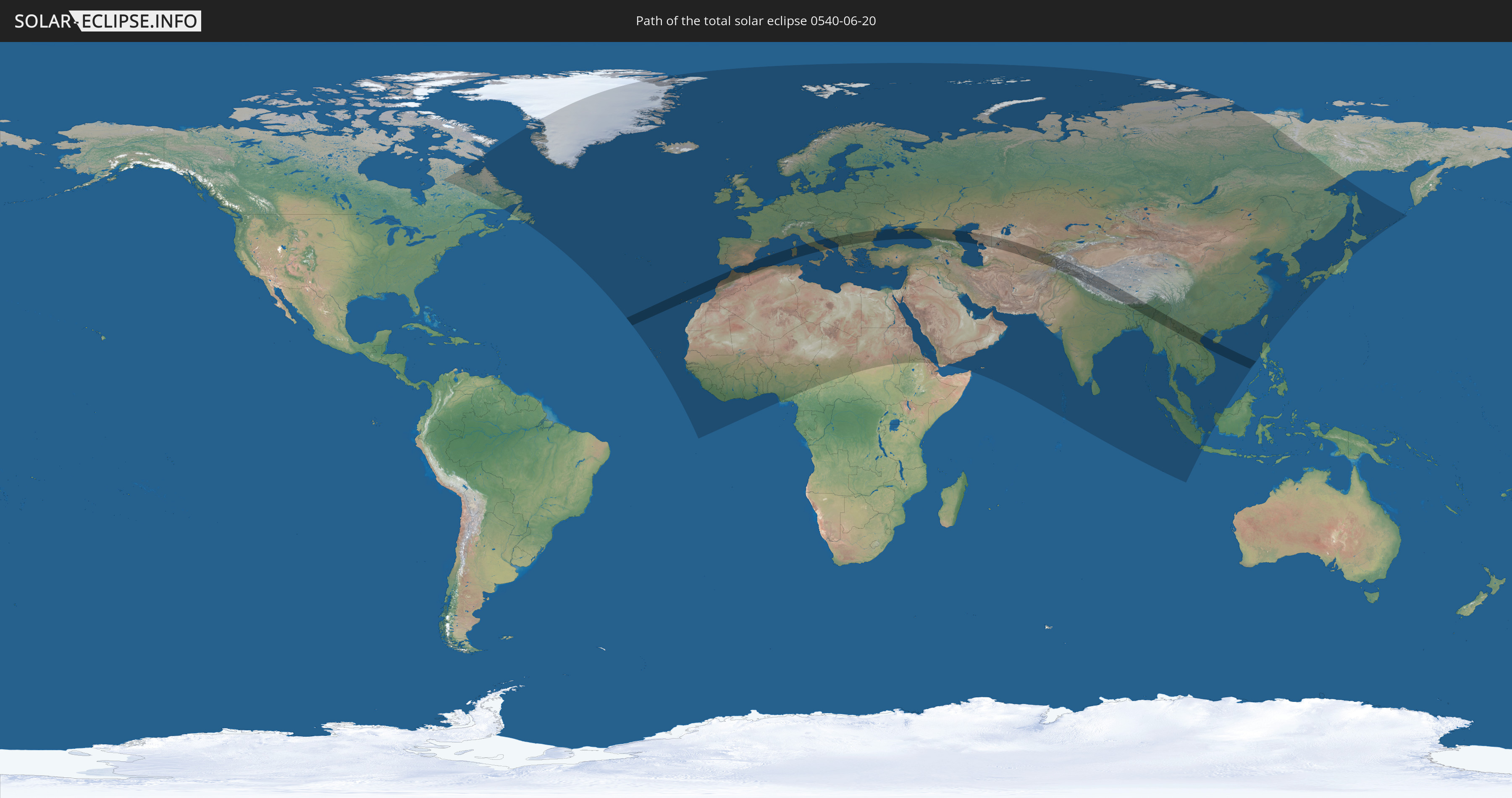
Die Sonnenfinsternis am 20.06.0540 kann man in 131 Ländern als partielle Sonnenfinsternis beobachten.
Der Finsternispfad verläuft durch 31 Länder. Nur in diesen Ländern ist sie als totale Sonnenfinsternis zu sehen.
In den folgenden Ländern ist die Sonnenfinsternis total zu sehen
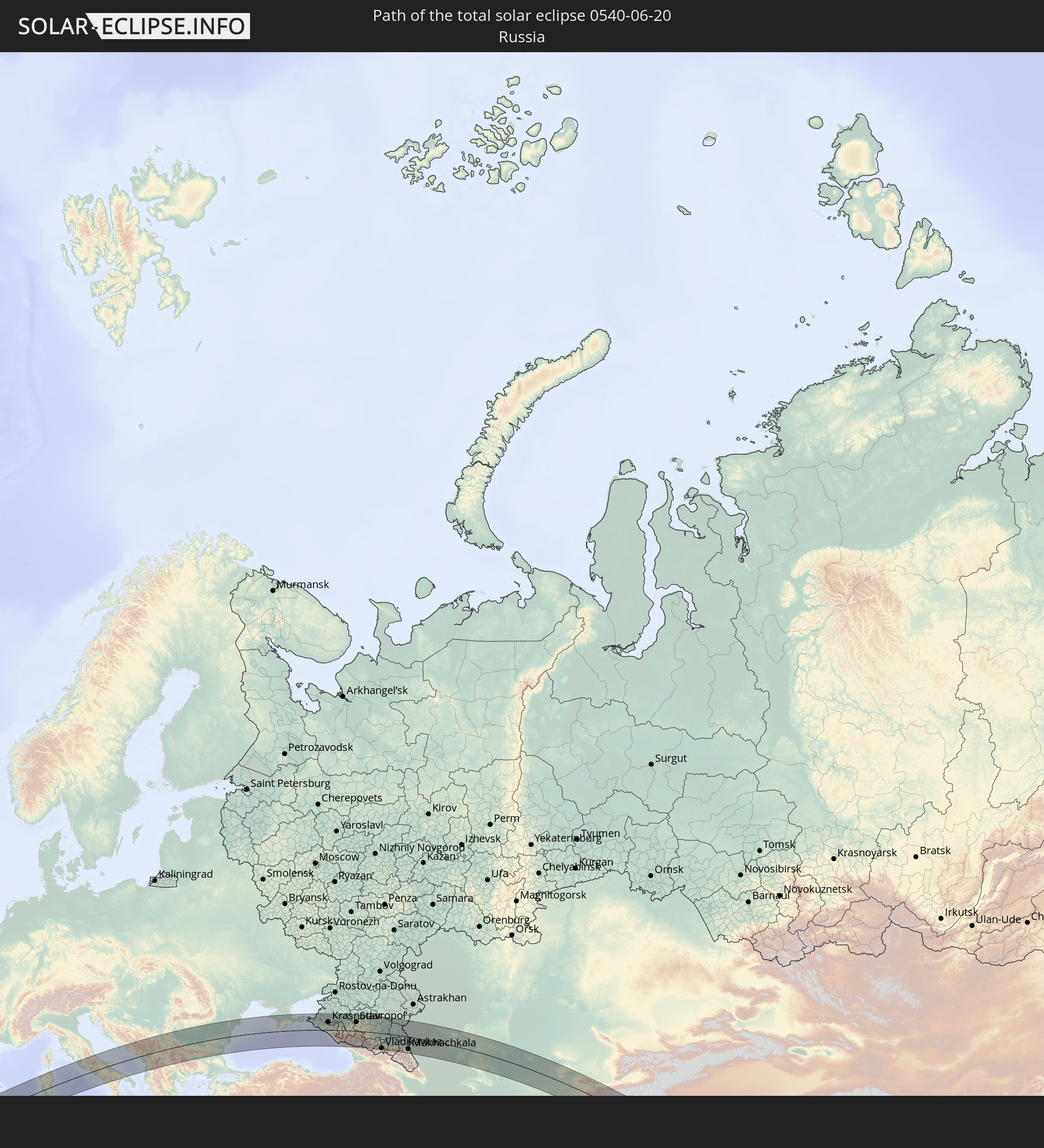 Russland
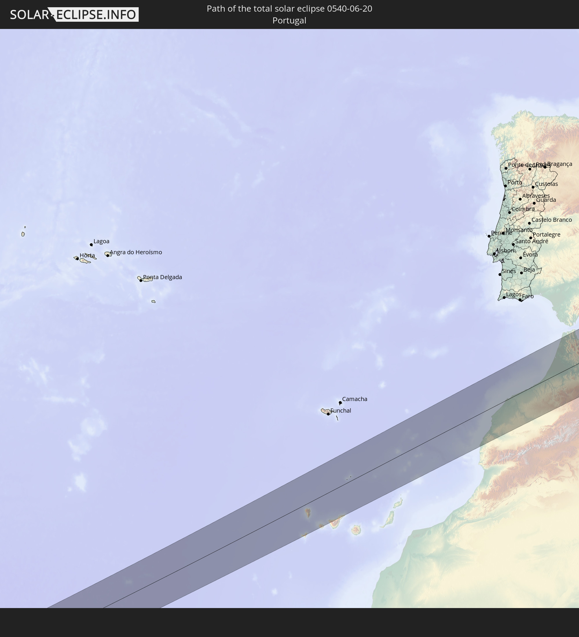 Portugal
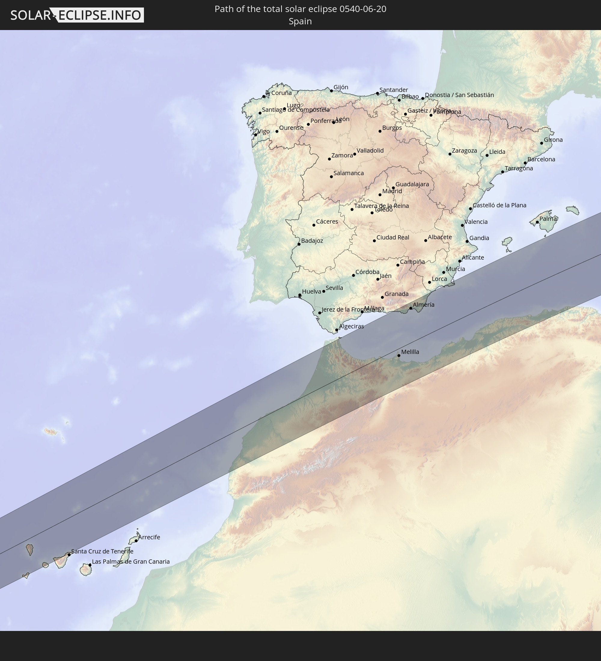 Spanien
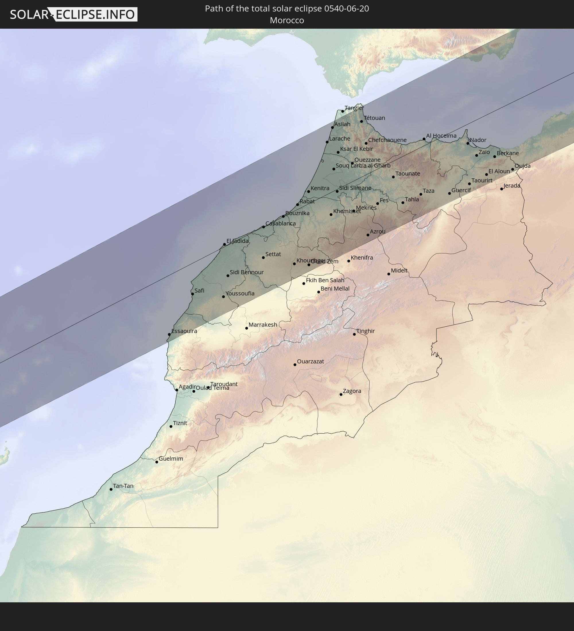 Marokko
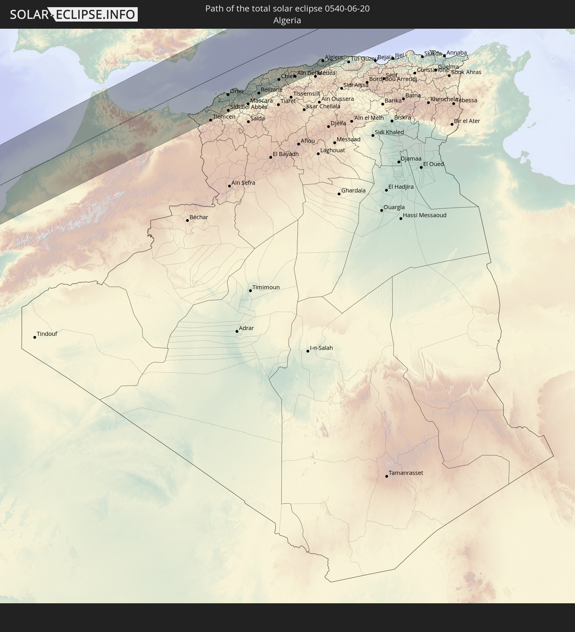 Algerien
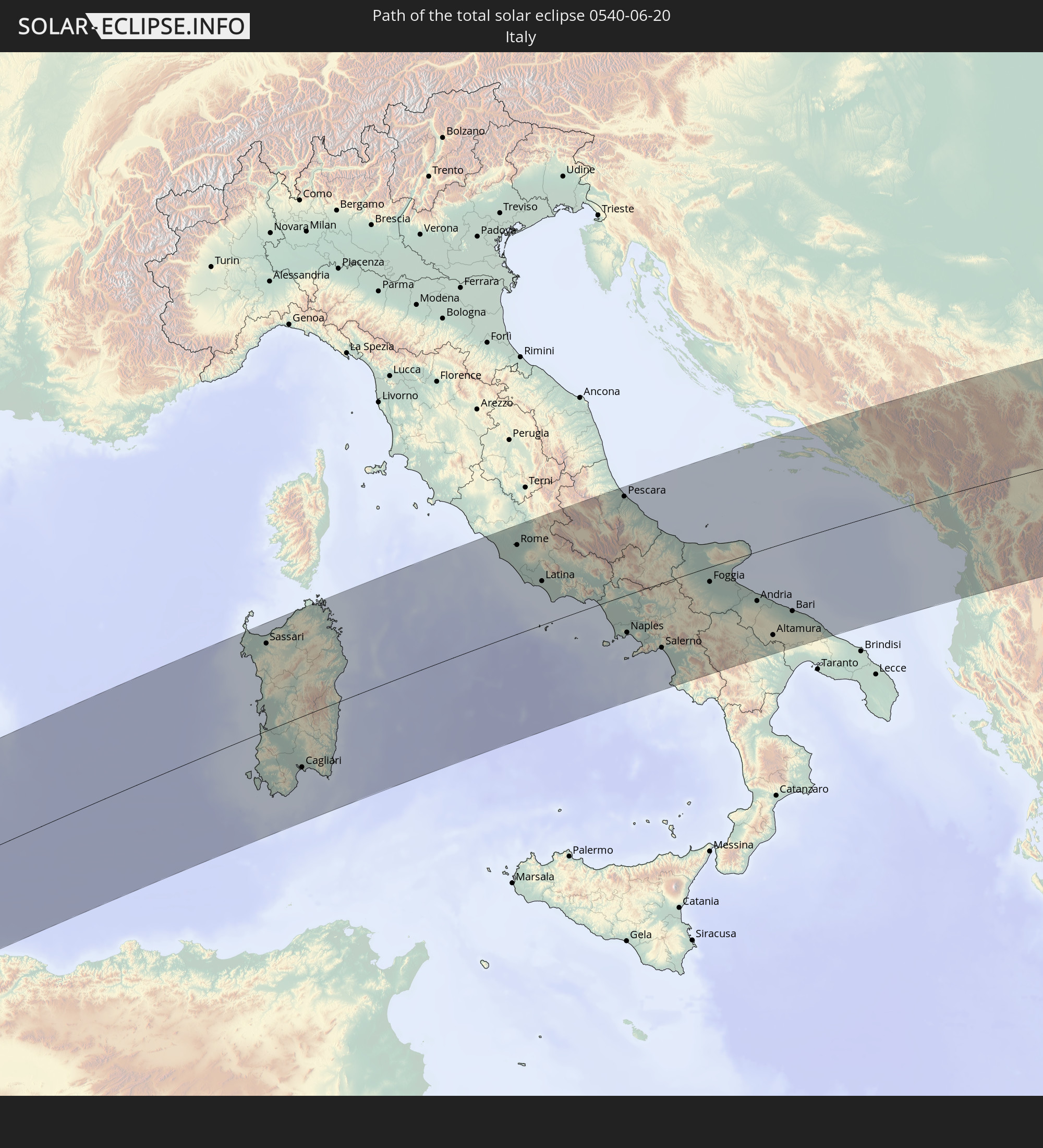 Italien
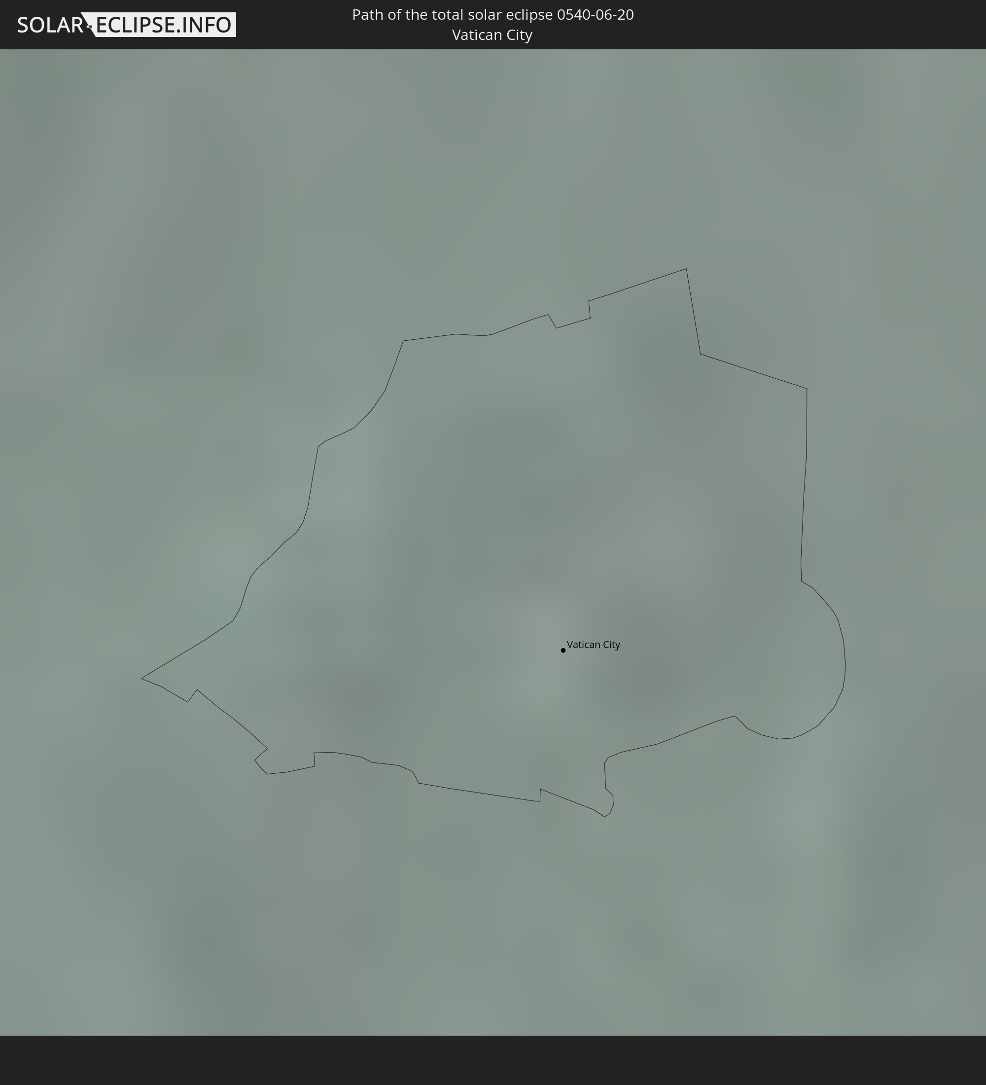 Vatikanstadt
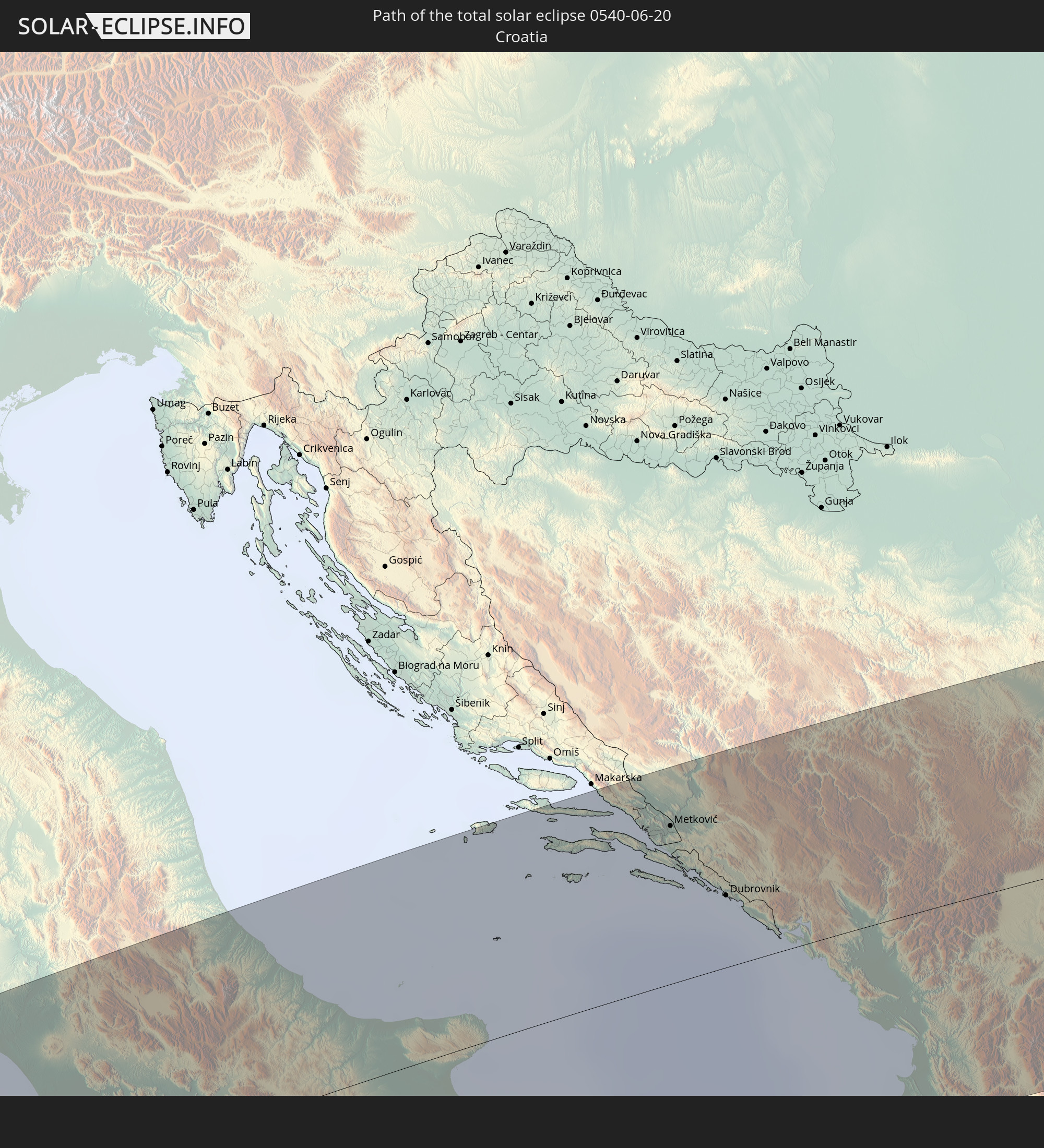 Kroatien
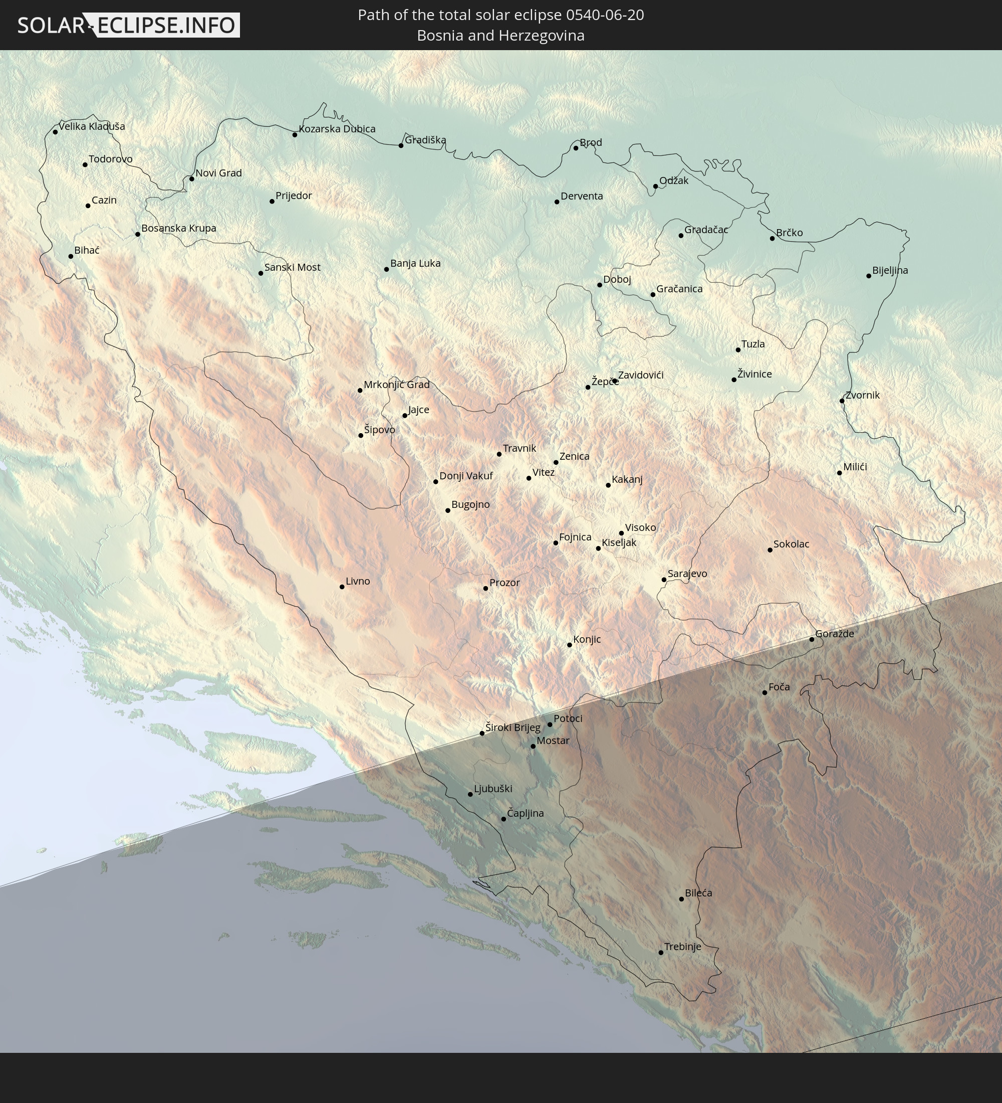 Bosnien und Herzegowina
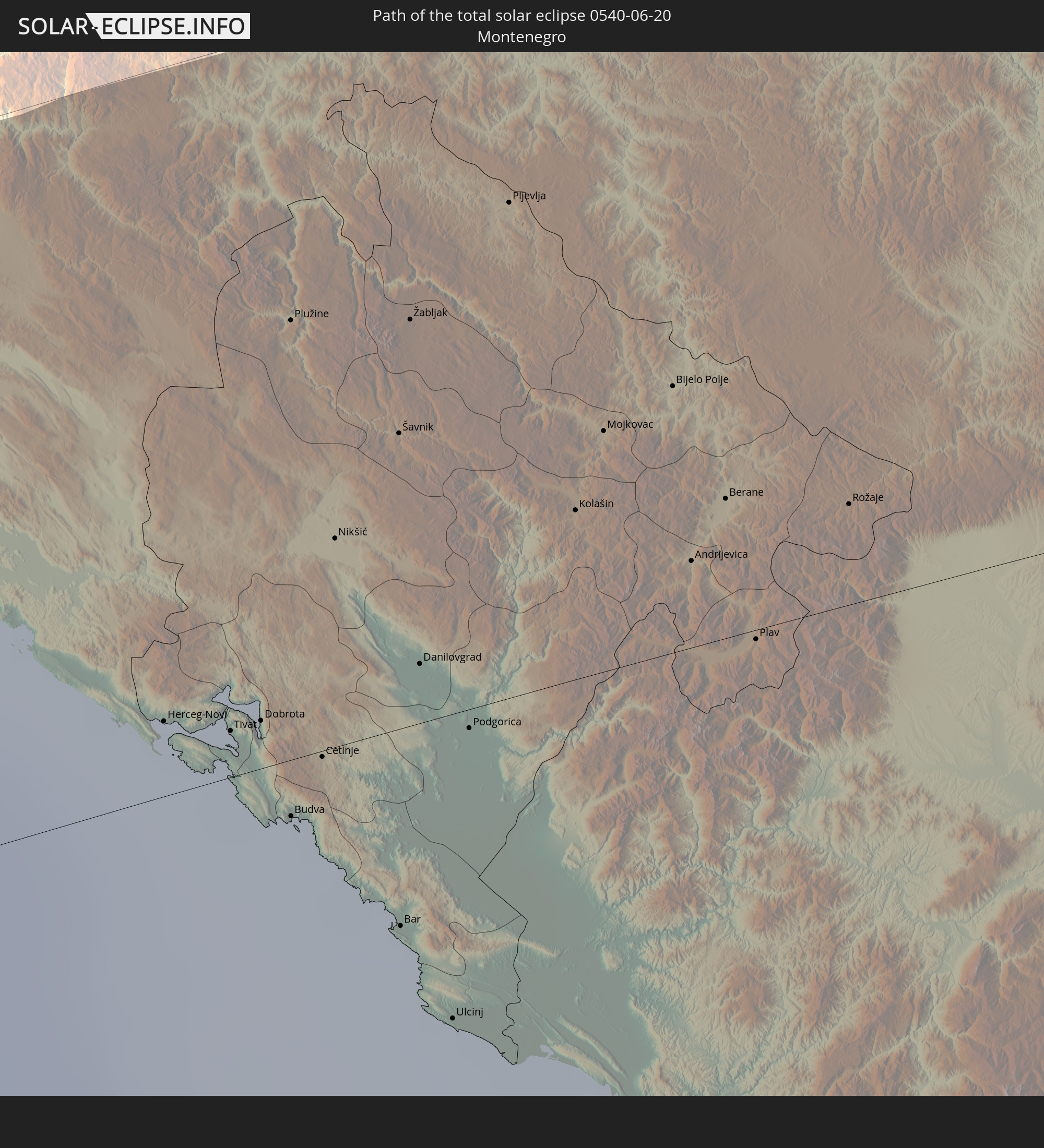 Montenegro
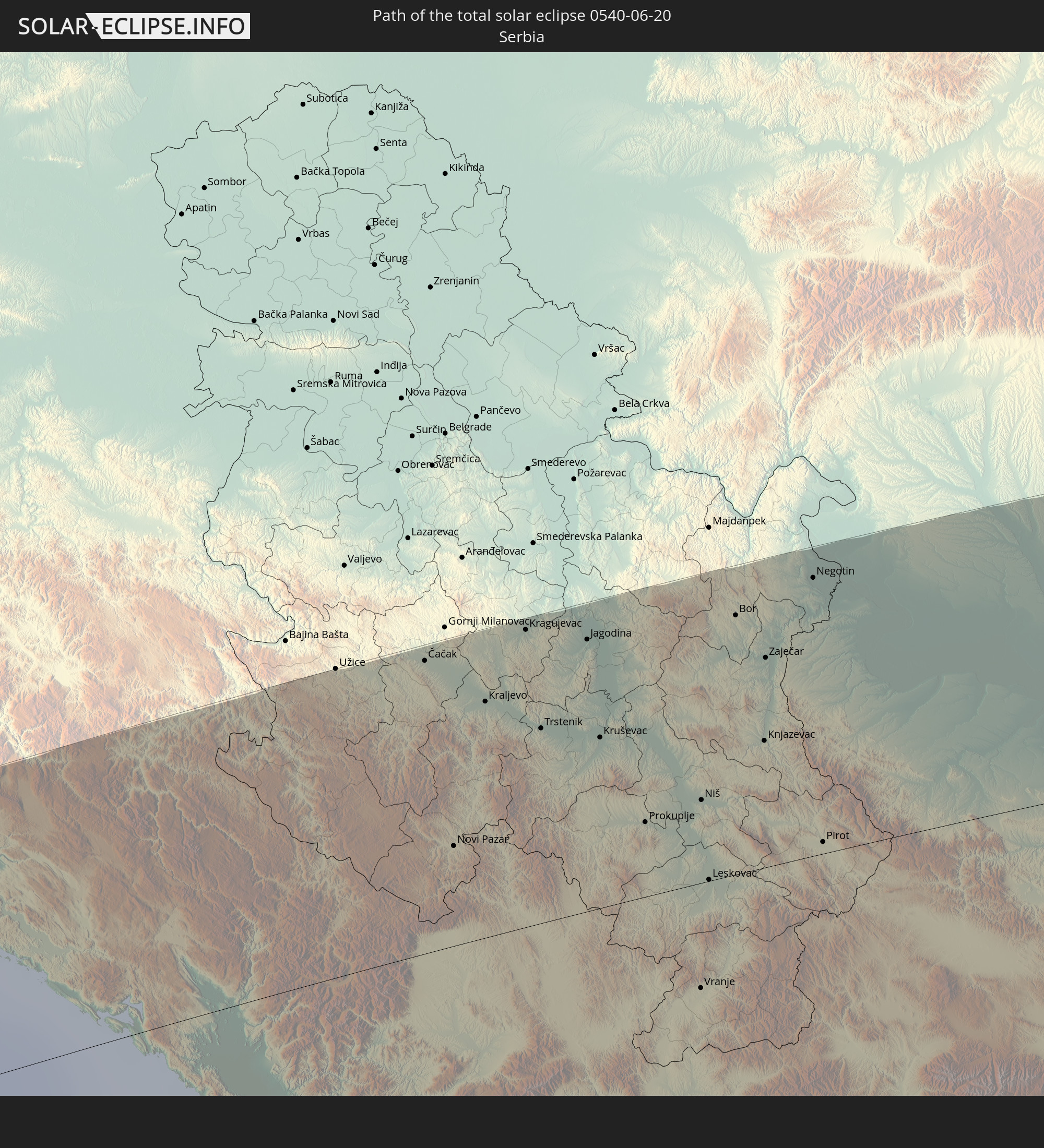 Serbien
 Albanien
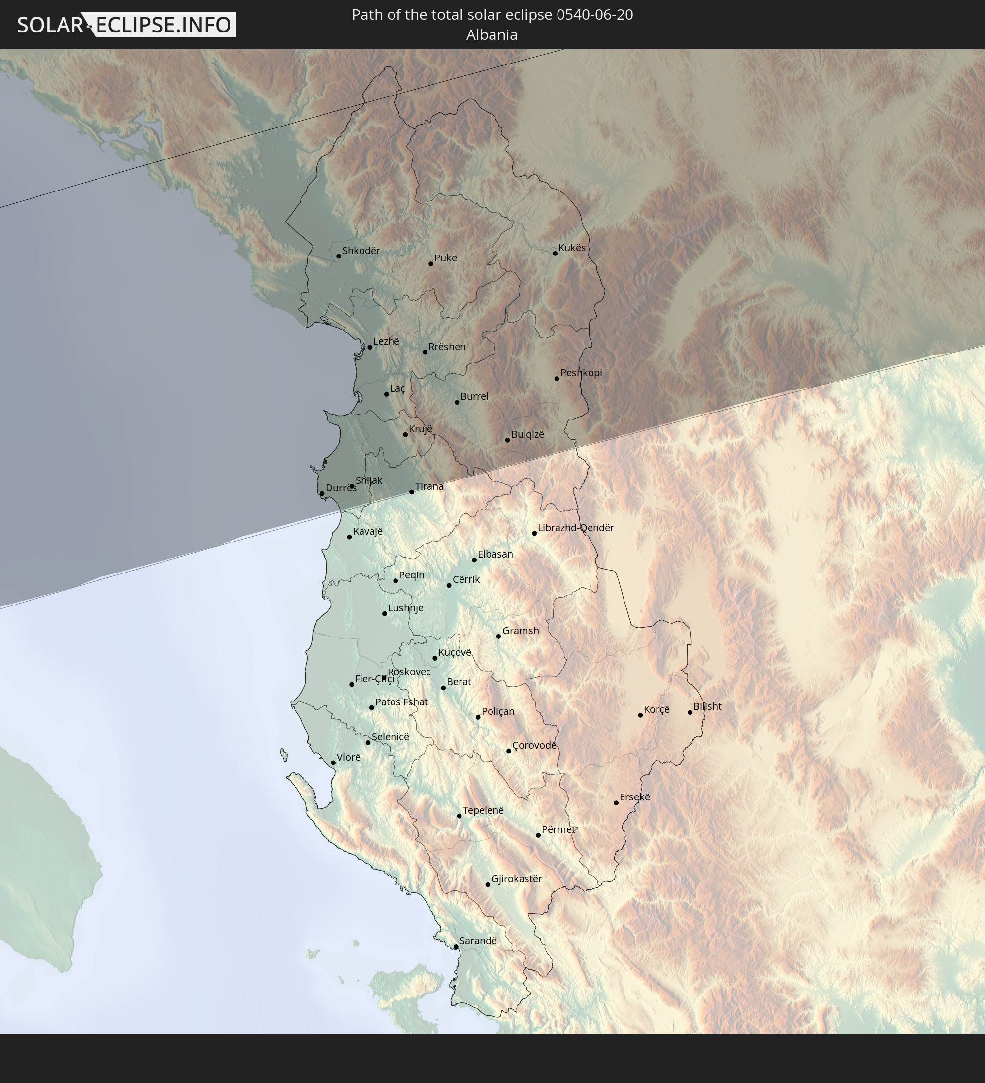
 Rumänien
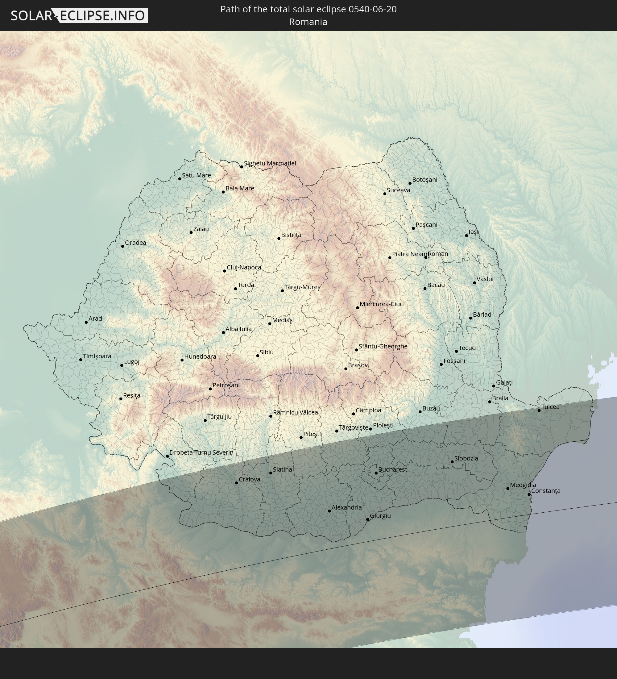
 Mazedonien
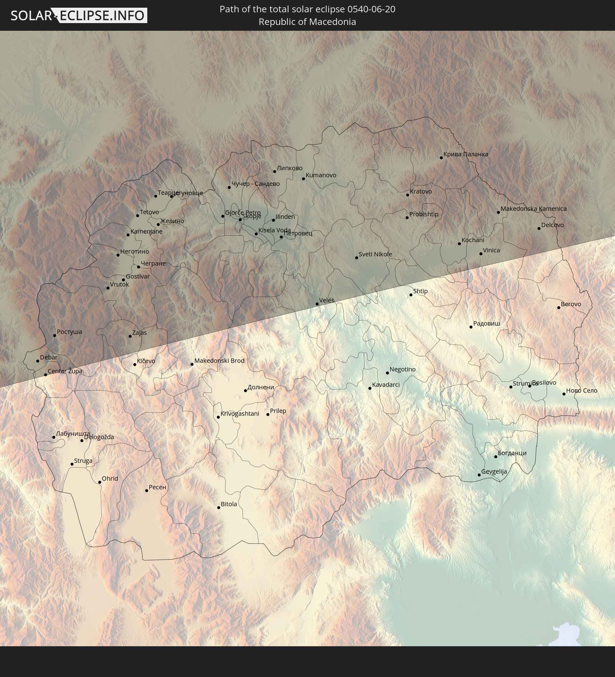
 Ukraine
 Bulgarien
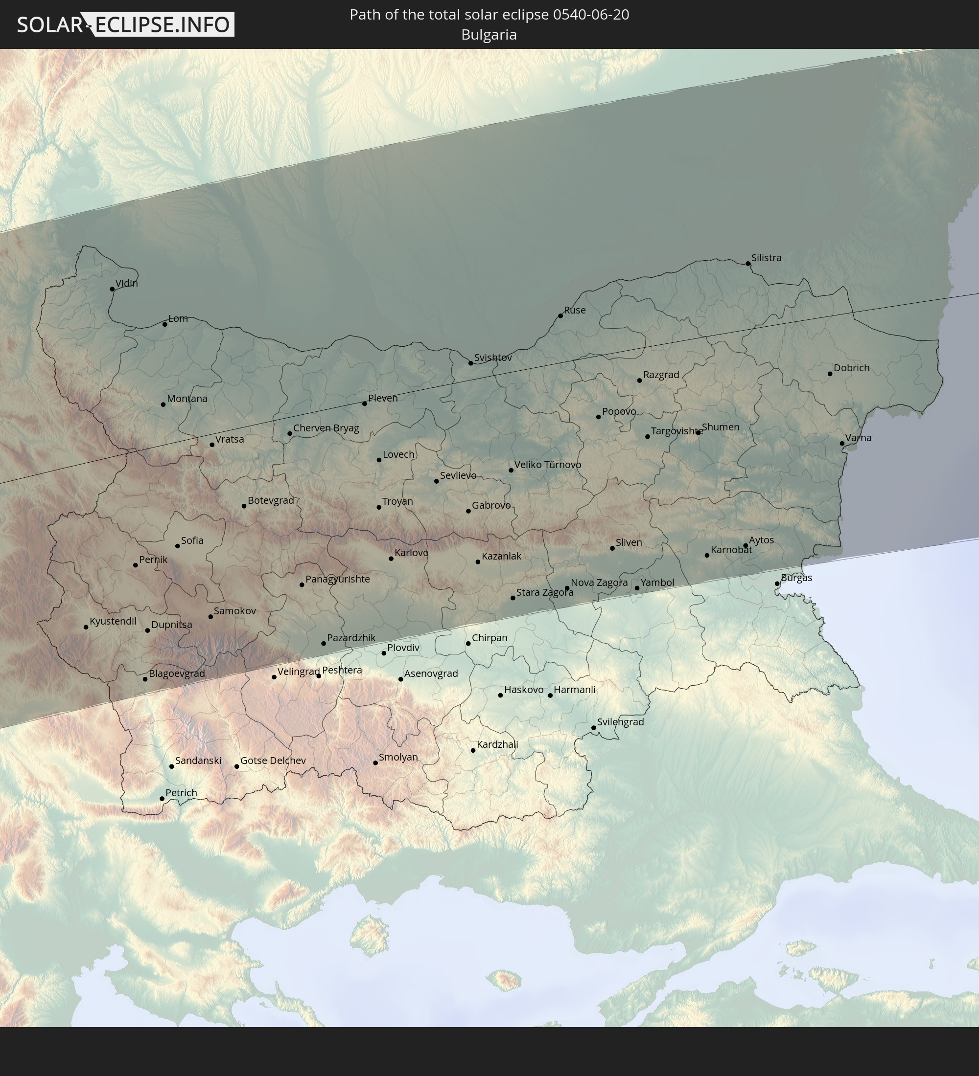
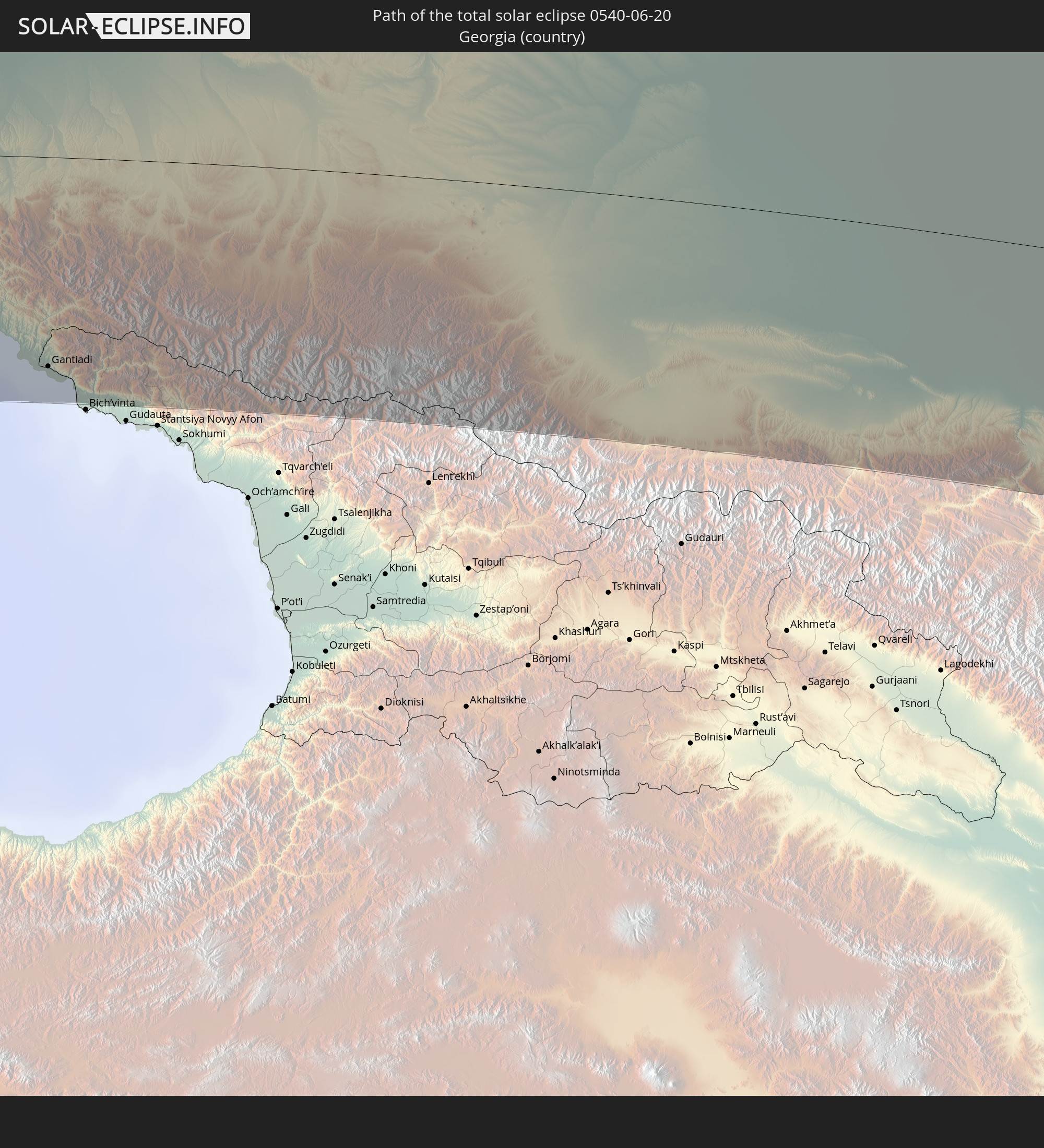 Georgien
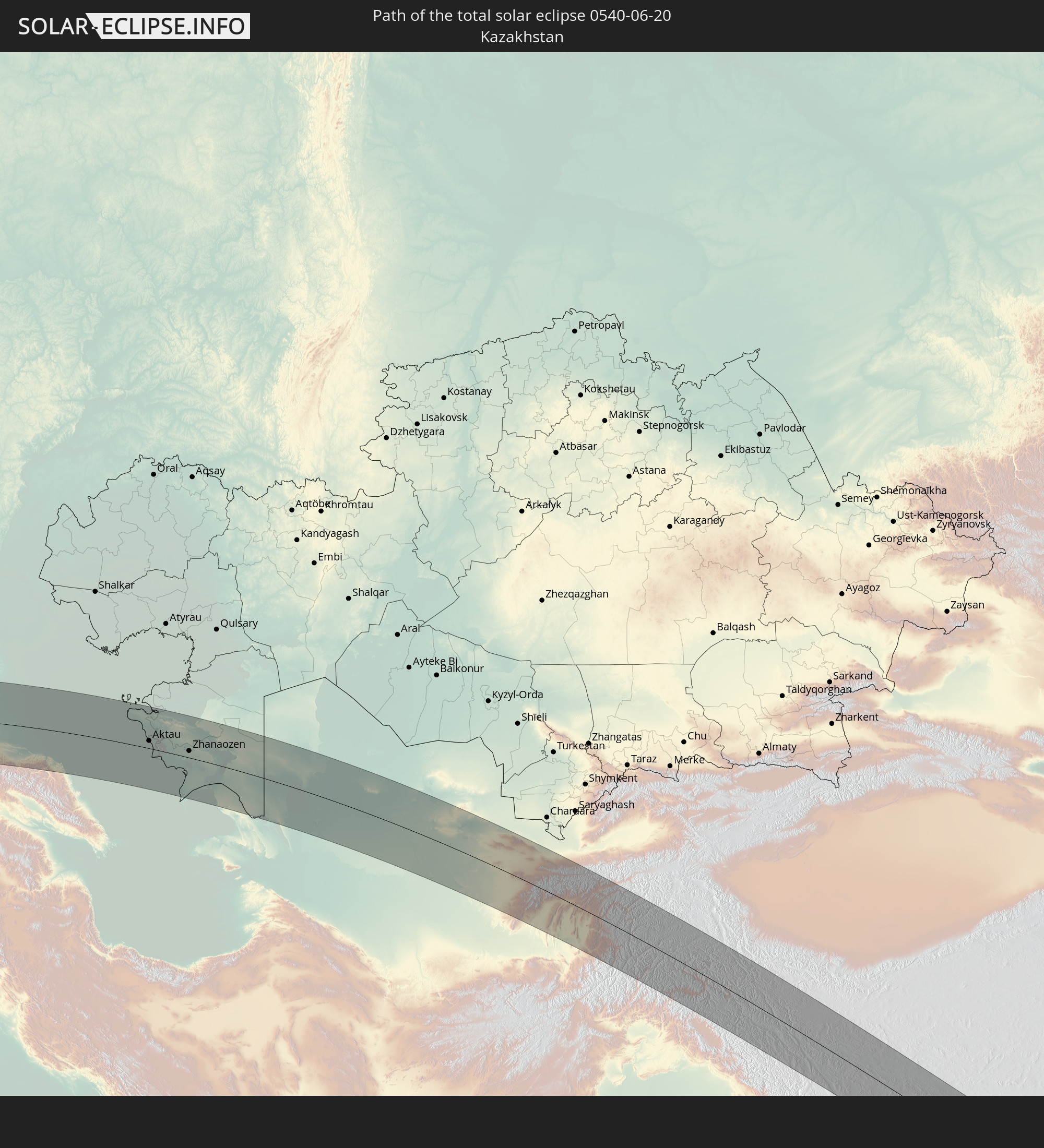 Kasachstan
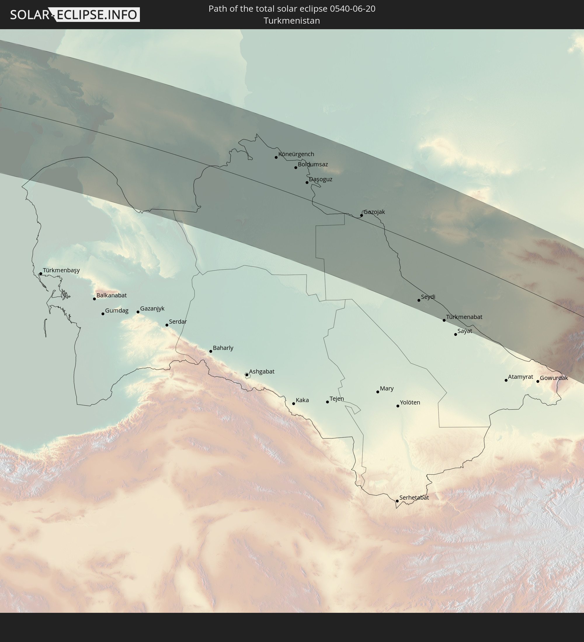 Turkmenistan
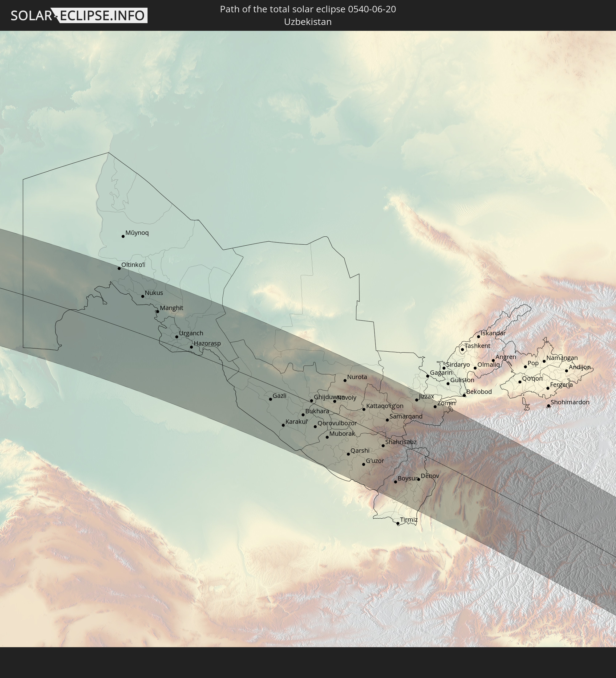 Usbekistan
 Afghanistan
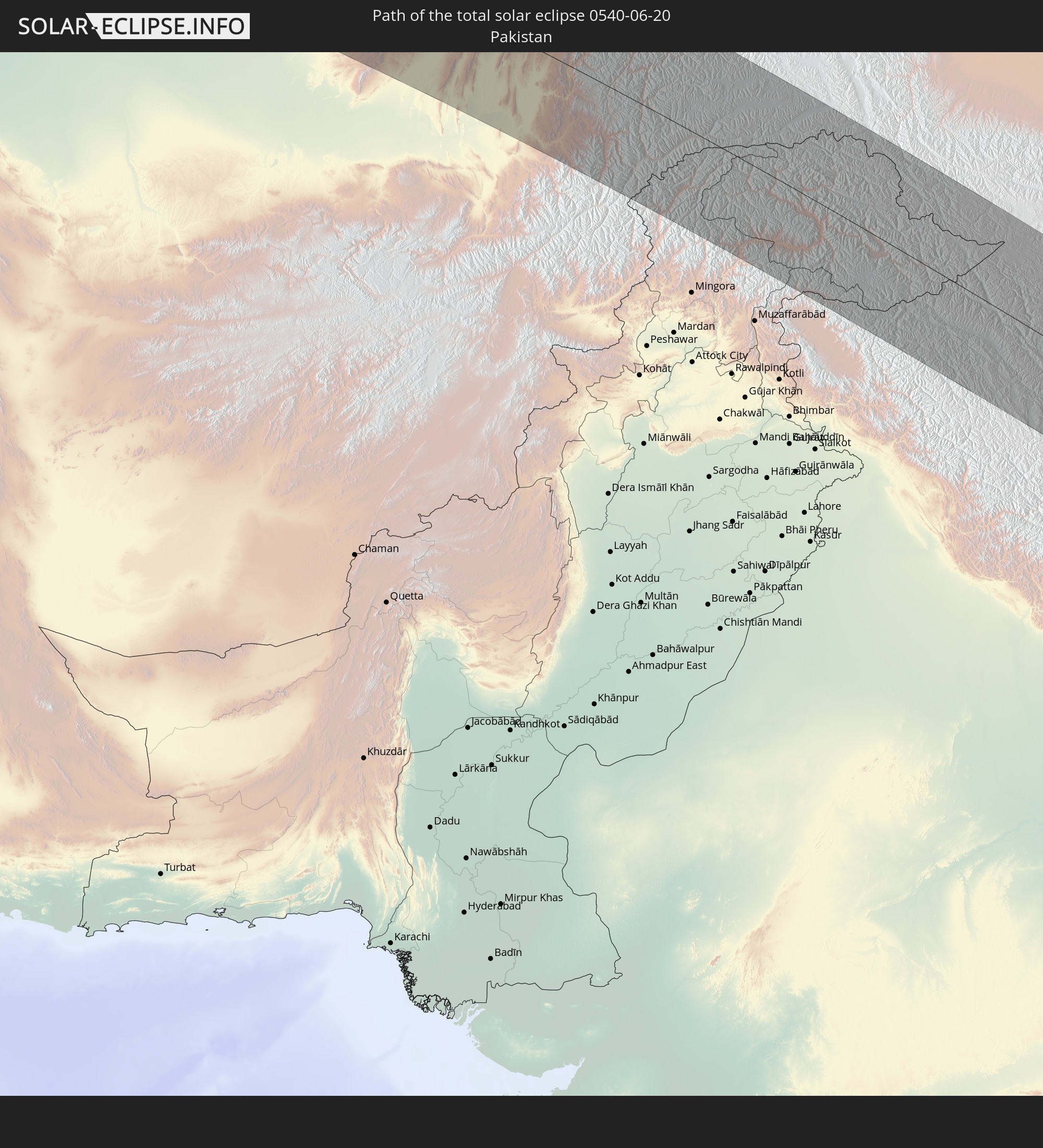 Pakistan
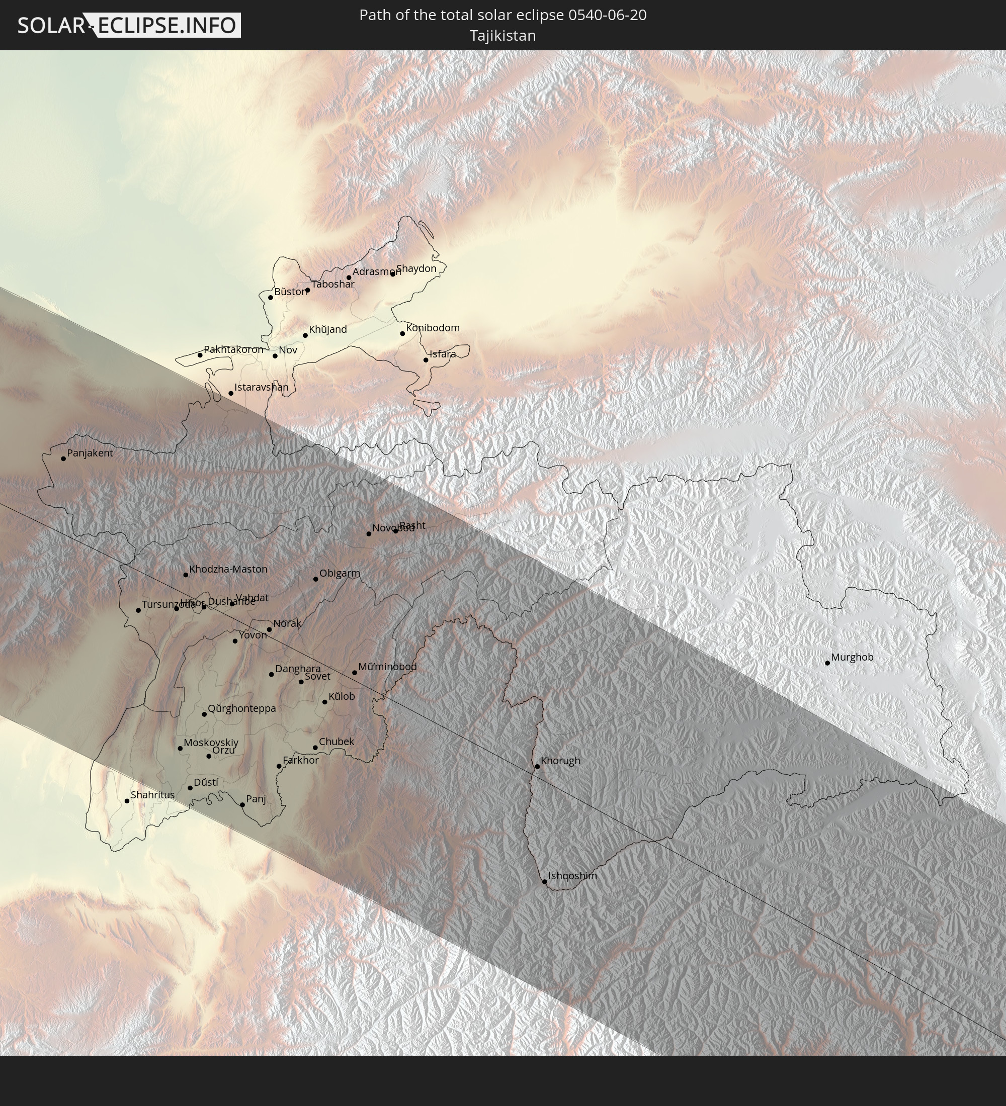 Tadschikistan
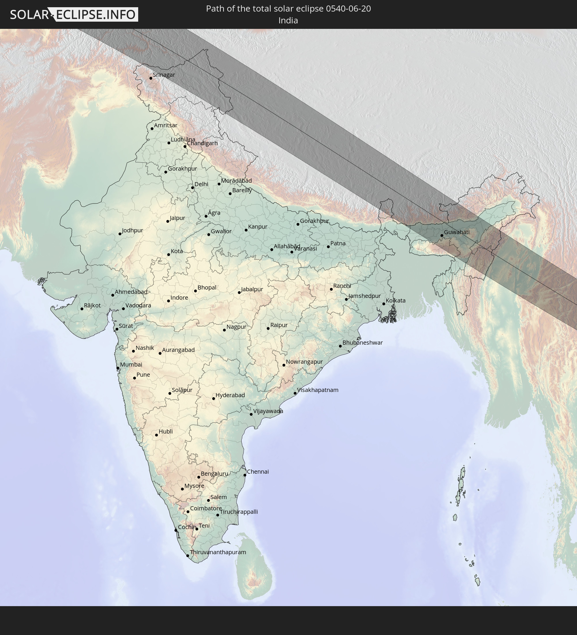 Indien
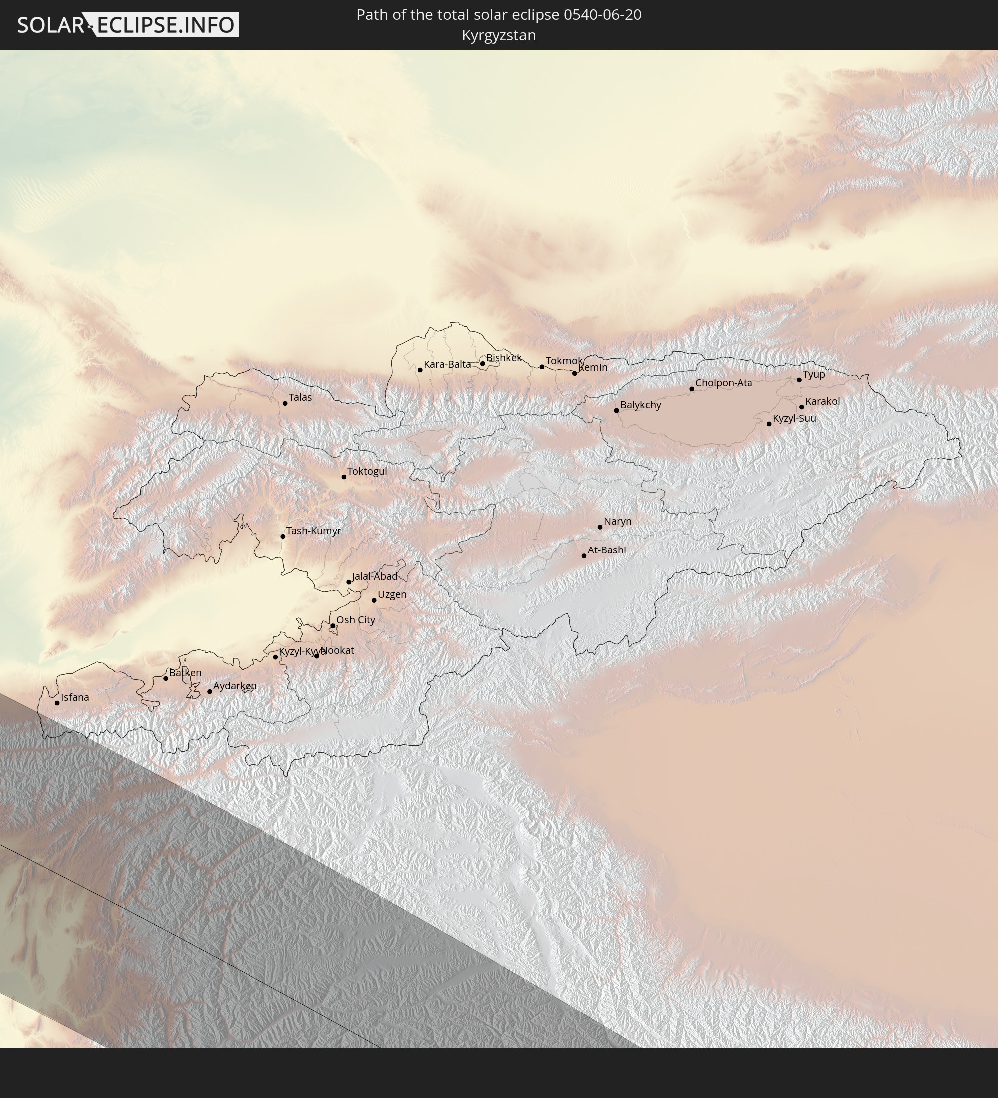 Kirgisistan
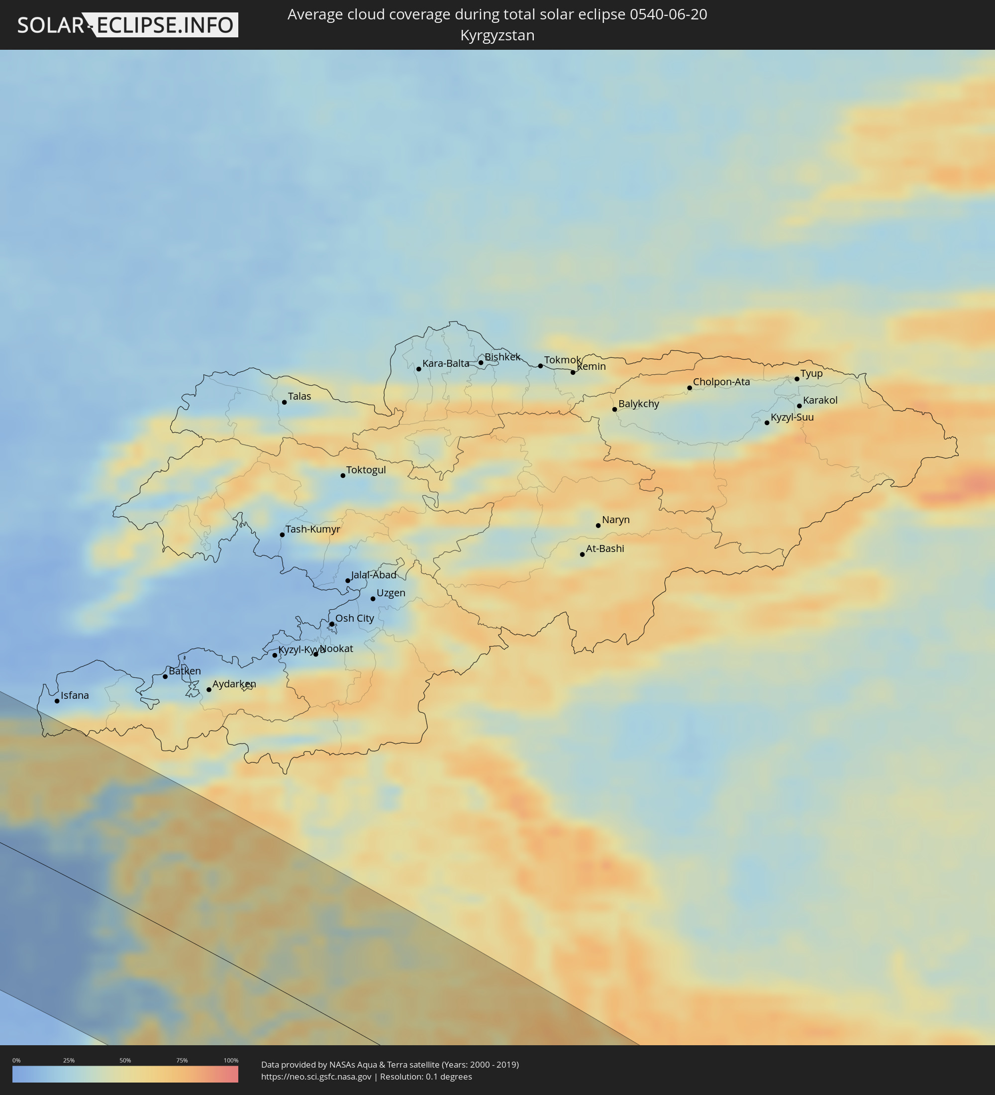
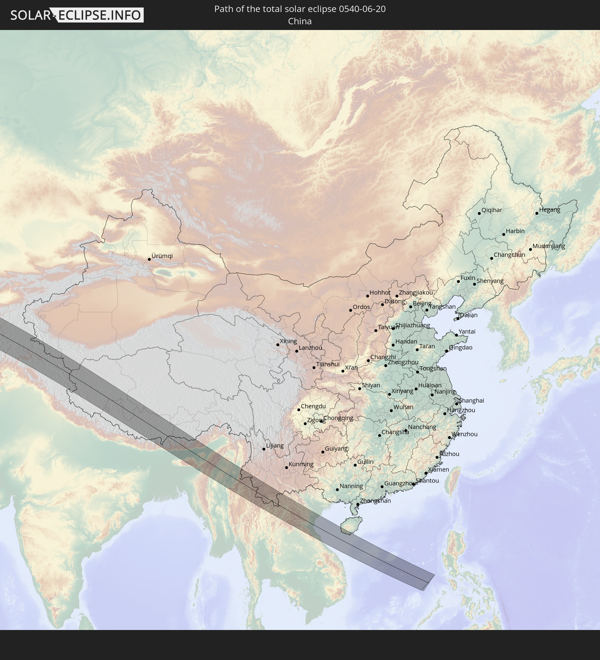 Volksrepublik China
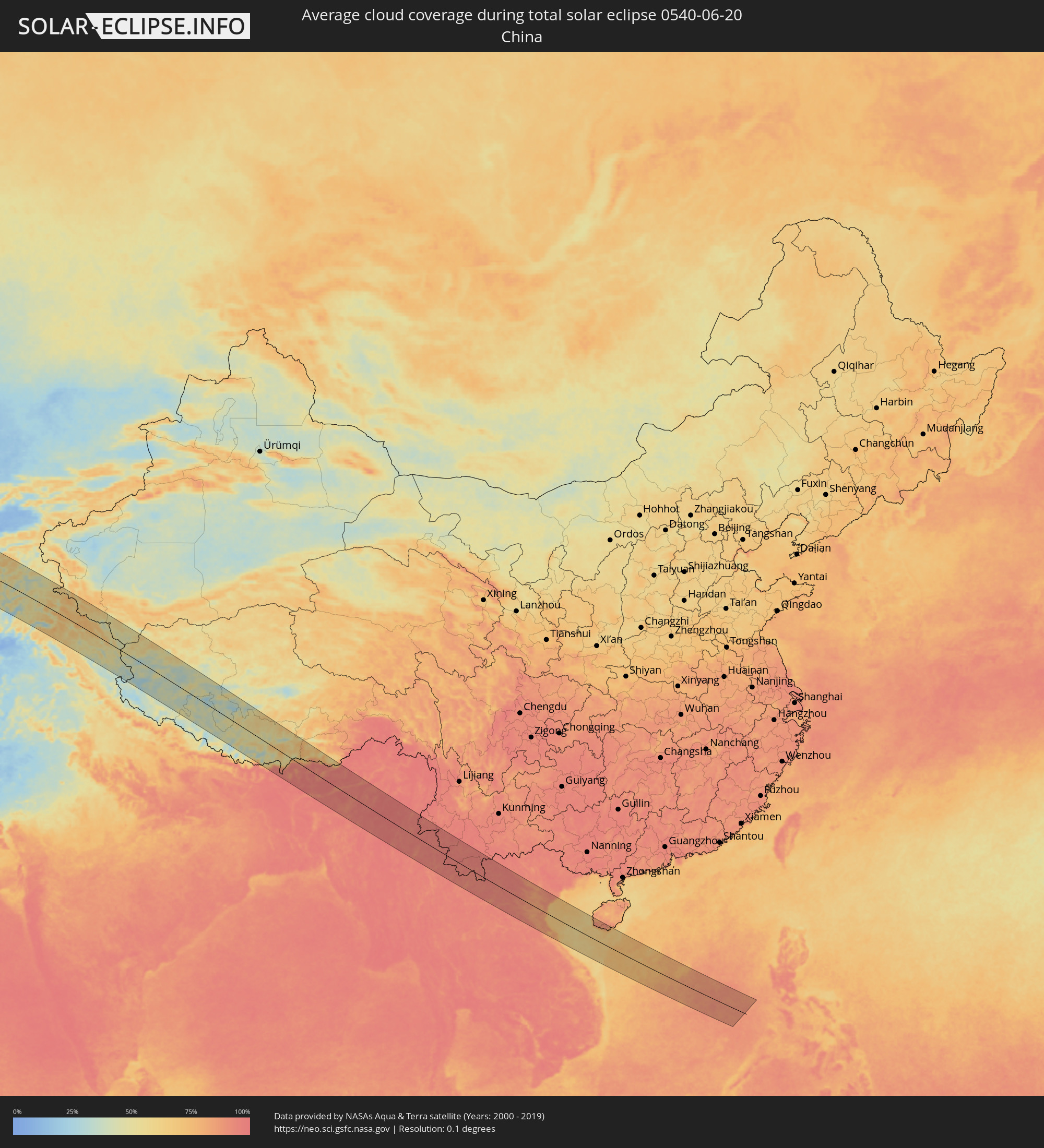
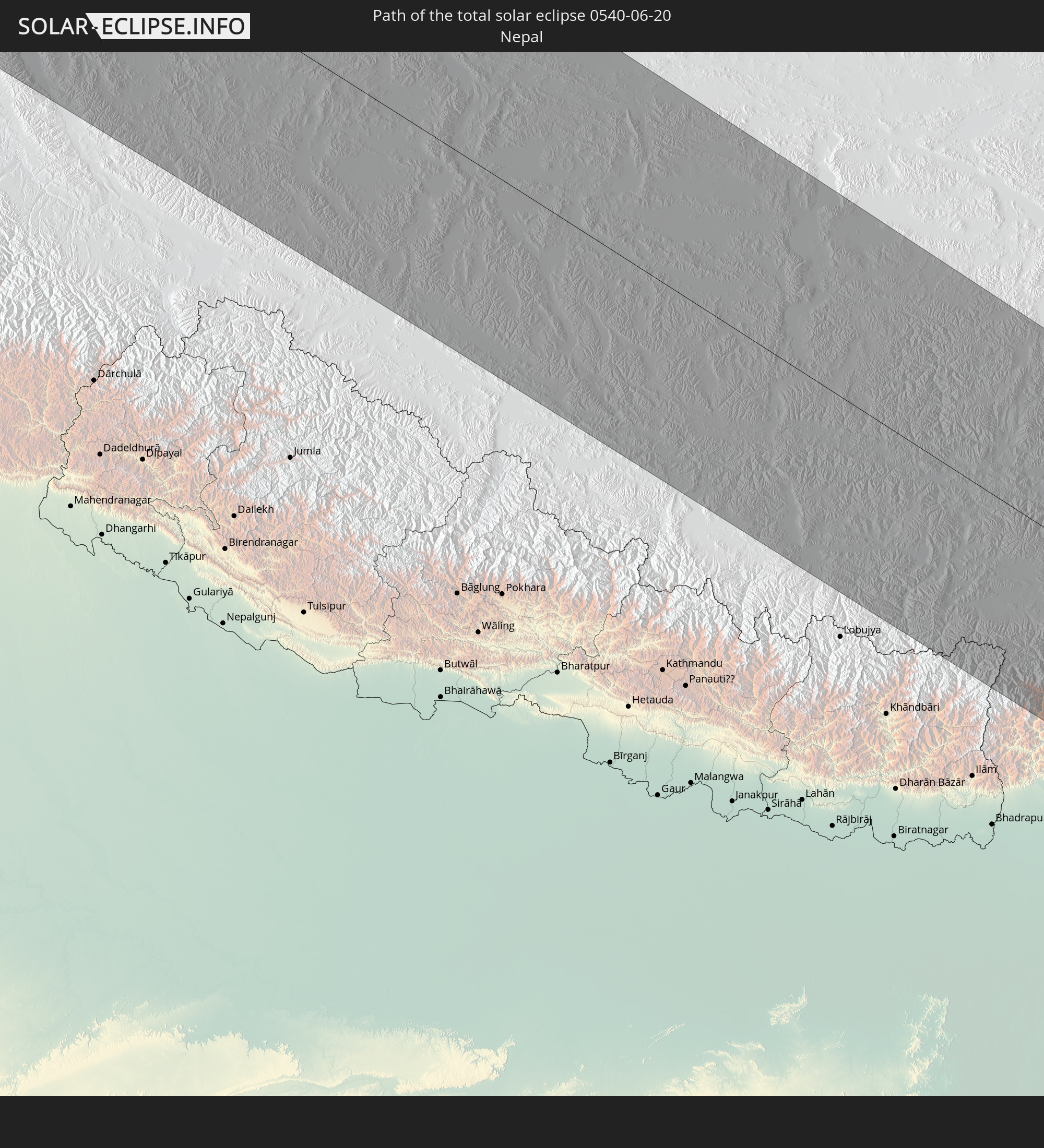 Nepal
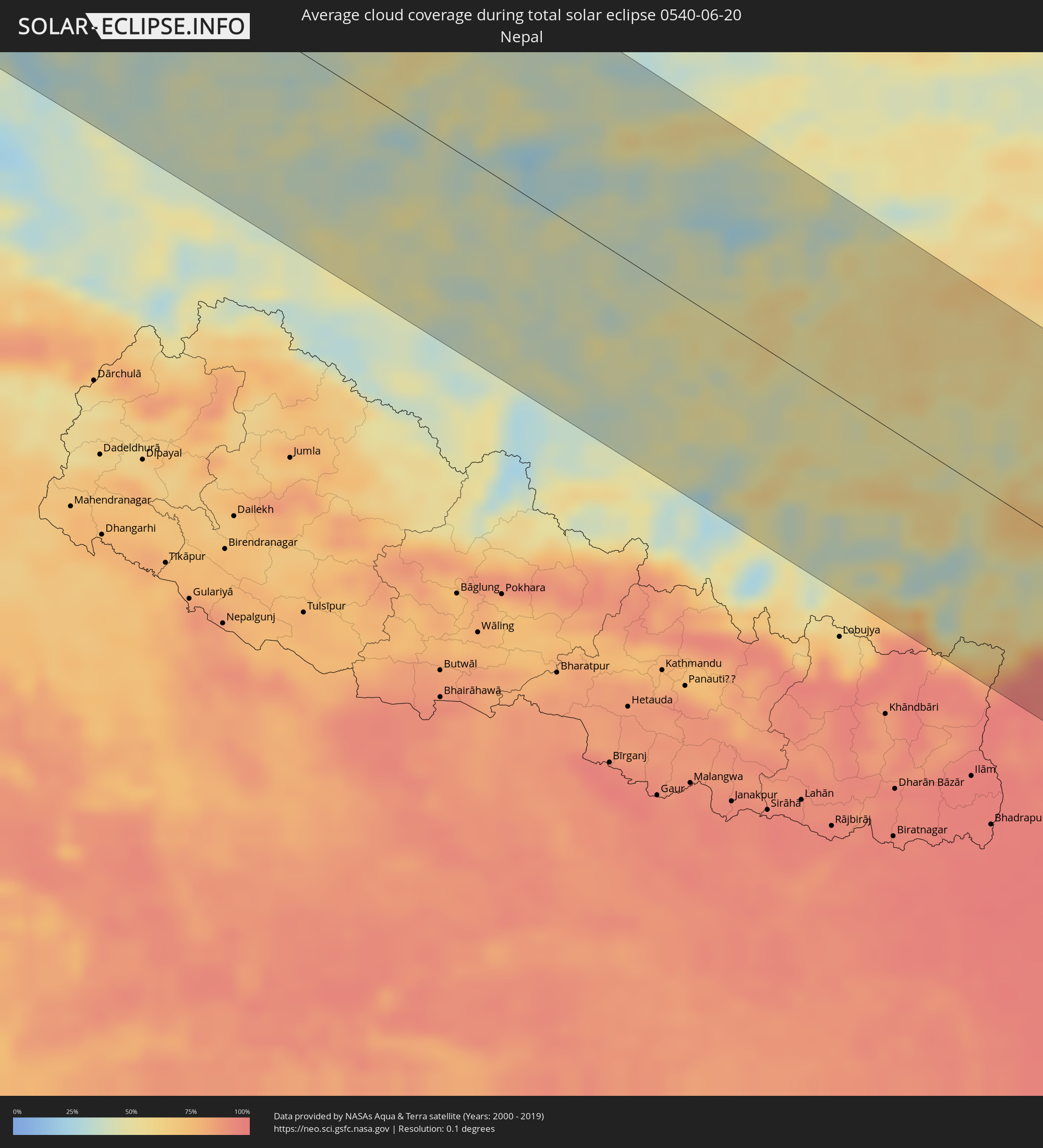
Nepal
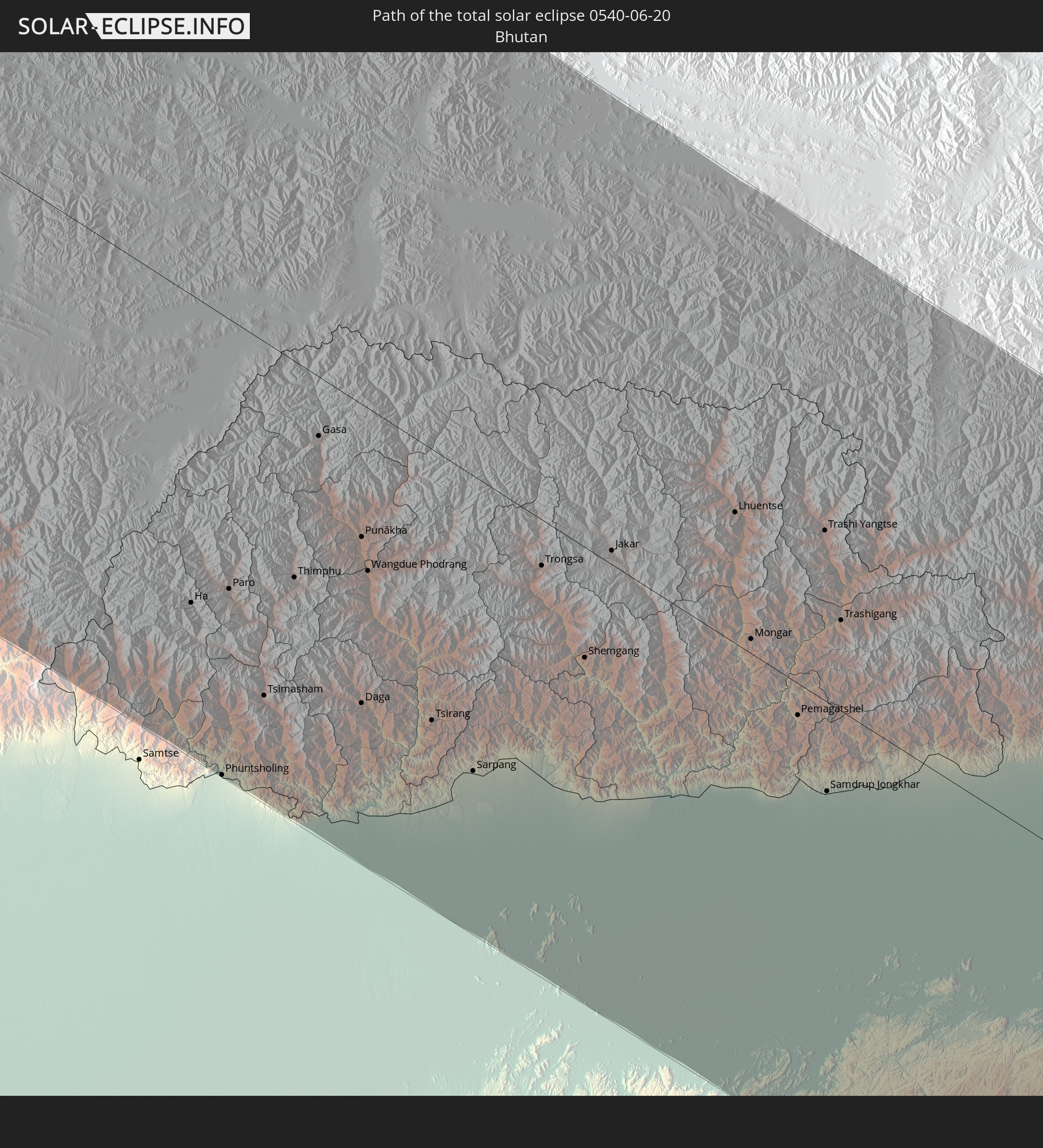 Bhutan
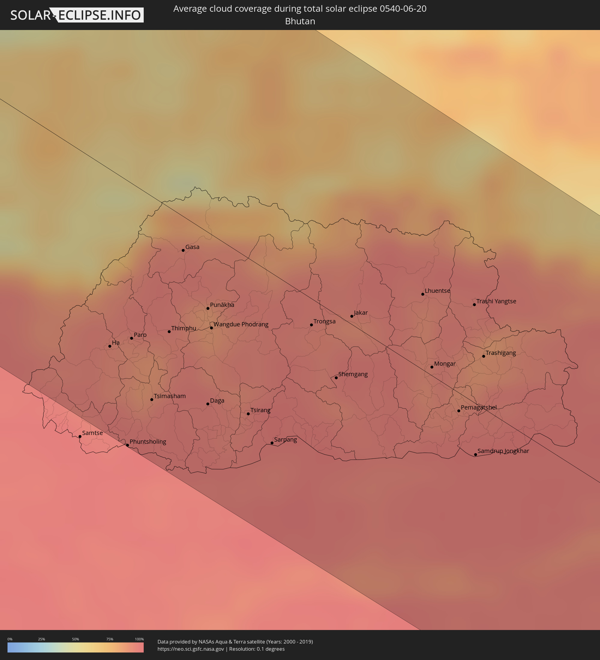
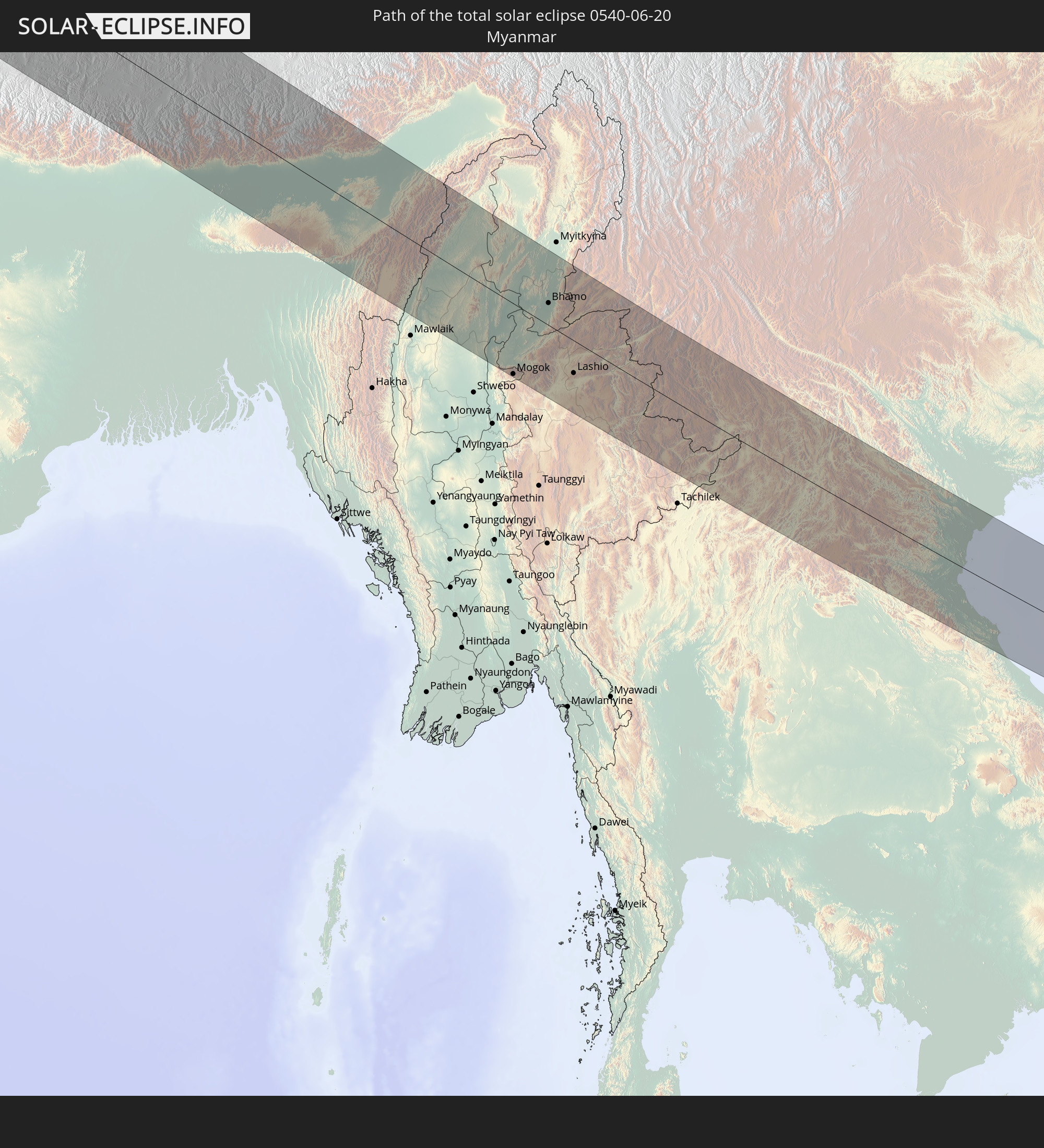 Myanmar
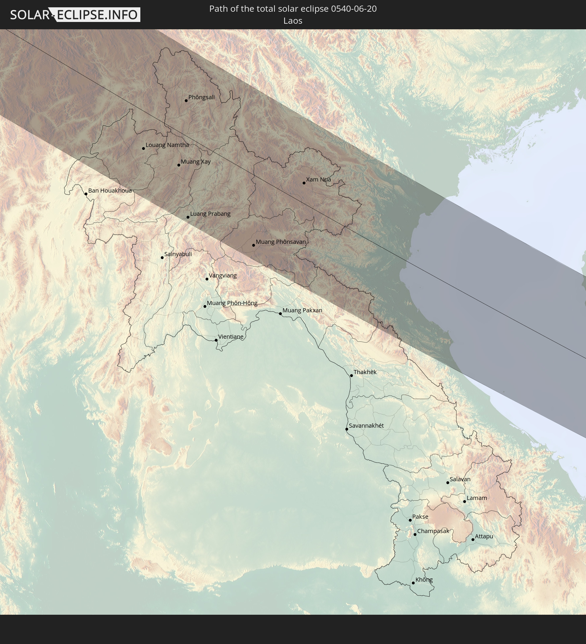 Laos
Laos
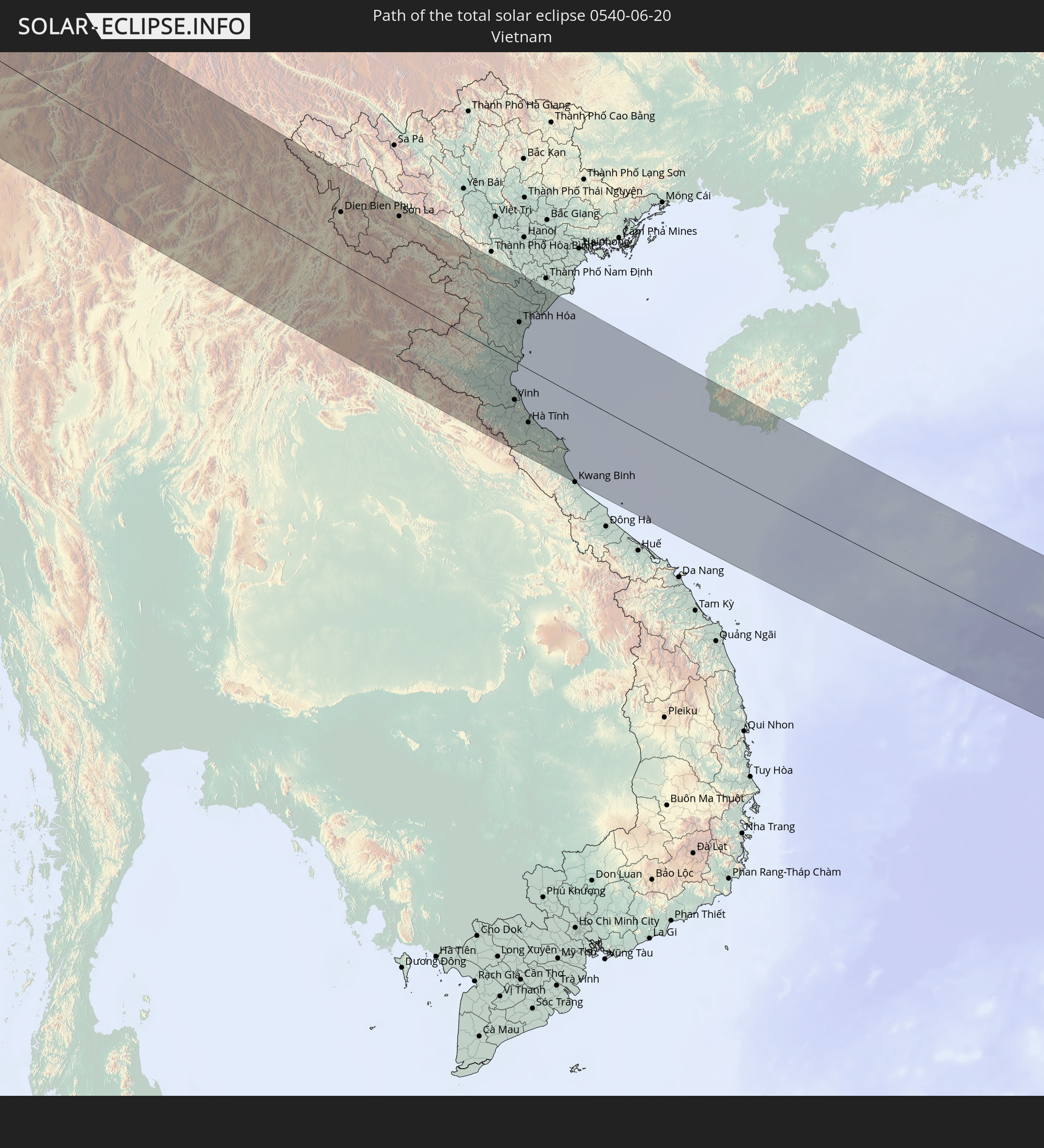 Vietnam
In den folgenden Ländern ist die Sonnenfinsternis partiell zu sehen
 Russland
 Kanada
 Grönland
 Portugal
 Kap Verde
 Island
 Spanien
 Senegal
 Mauretanien
 Gambia
 Guinea-Bissau
 Guinea
 Sierra Leone
 Marokko
 Mali
Mali
 Liberia
 Irland
 Spitzbergen
 Algerien
 Vereinigtes Königreich
 Elfenbeinküste
 Färöer
 Burkina Faso
 Gibraltar
 Frankreich
 Isle of Man
 Ghana
Ghana
 Guernsey
 Jersey
 Togo
Togo
 Niger
Niger
 Benin
Benin
 Andorra
 Belgien
 Nigeria
 Niederlande
 Norwegen
 Luxemburg
 Deutschland
 Schweiz
 Italien
 Monaco
 Tunesien
 Dänemark
 Kamerun
 Libyen
 Liechtenstein
 Österreich
 Schweden
 Tschechien
 San Marino
 Vatikanstadt
 Slowenien
 Tschad
 Kroatien
 Polen
Polen
 Malta
Malta
 Zentralafrikanische Republik
 Bosnien und Herzegowina
 Ungarn
 Slowakei
 Montenegro
 Serbien
 Albanien
 Åland Islands
 Griechenland
 Rumänien
 Mazedonien
 Finnland
 Litauen
 Lettland
 Estland
 Sudan
Sudan
 Ukraine
 Bulgarien
 Weißrussland
 Ägypten
 Türkei
 Moldawien
 Republik Zypern
 Äthiopien
 Staat Palästina
 Israel
 Saudi-Arabien
 Jordanien
 Libanon
 Syrien
 Eritrea
 Irak
Irak
 Georgien
 Somalia
 Jemen
Jemen
 Armenien
 Iran
Iran
 Aserbaidschan
 Kasachstan
 Kuwait
 Bahrain
 Katar
Katar
 Vereinigte Arabische Emirate
 Oman
Oman
 Turkmenistan
 Usbekistan
 Afghanistan
 Pakistan
 Tadschikistan
 Indien
 Kirgisistan
 Malediven
 Volksrepublik China
 Sri Lanka
 Nepal
Nepal
 Mongolei
 Bangladesch
 Bhutan
 Myanmar
 Indonesien
 Kokosinseln
 Thailand
 Malaysia
 Laos
Laos
 Vietnam
 Kambodscha
 Singapur
 Macau
Macau
 Hongkong
 Taiwan
 Philippinen
 Japan
Japan
 Nordkorea
 Südkorea
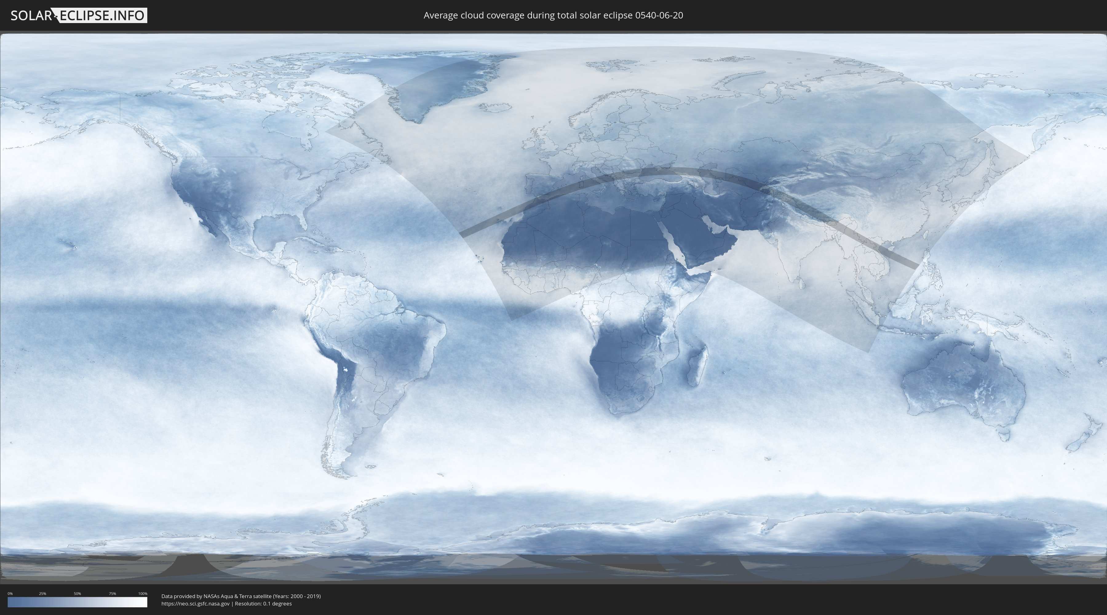
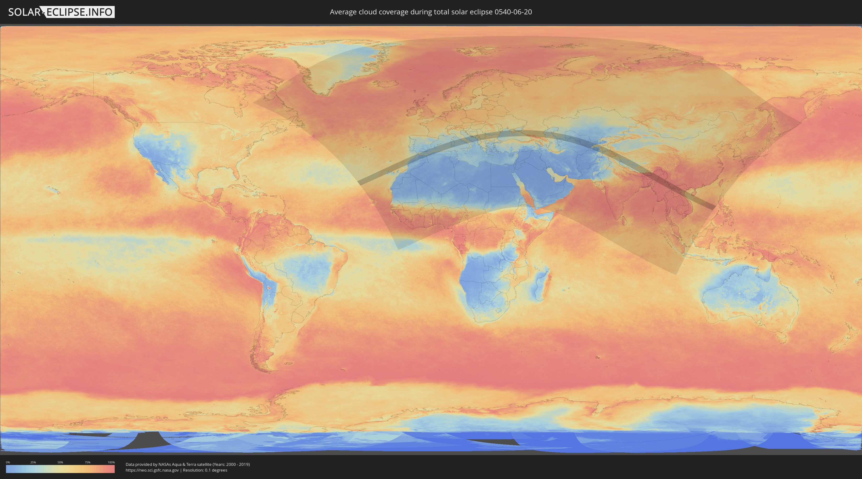
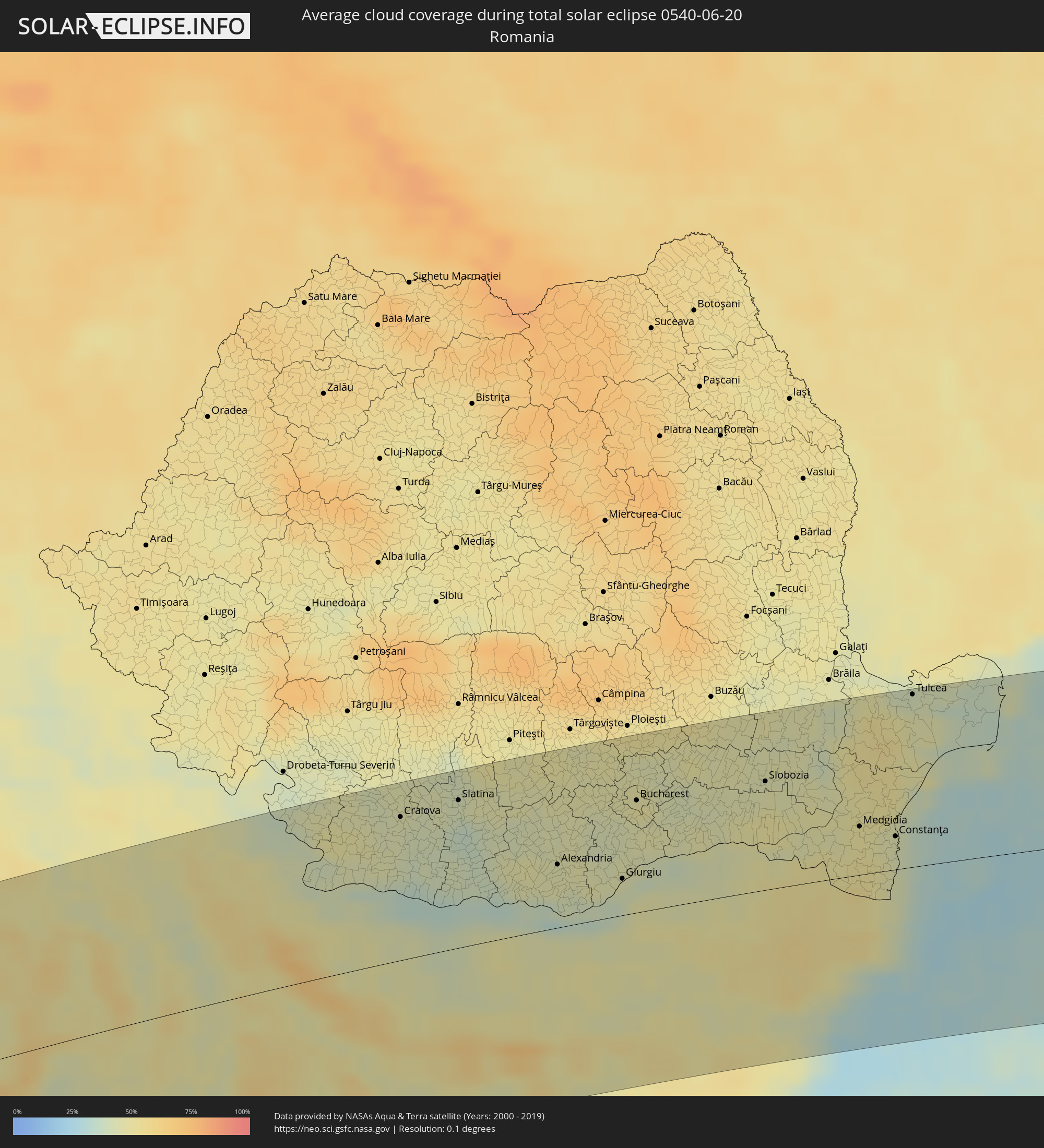
Wie wird das Wetter während der totalen Sonnenfinsternis am 20.06.0540?
Wo ist der beste Ort, um die totale Sonnenfinsternis vom 20.06.0540 zu beobachten?
Die folgenden Karten zeigen die durchschnittliche Bewölkung für den Tag, an dem die totale Sonnenfinsternis
stattfindet. Mit Hilfe der Karten lässt sich der Ort entlang des Finsternispfades eingrenzen,
der die besten Aussichen auf einen klaren wolkenfreien Himmel bietet.
Trotzdem muss man immer lokale Gegenenheiten beachten und sollte sich genau über das Wetter an seinem
gewählten Beobachtungsort informieren.
Die Daten stammen von den beiden NASA-Satelliten
AQUA und TERRA
und wurden über einen Zeitraum von 19 Jahren (2000 - 2019) gemittelt.
Detaillierte Länderkarten
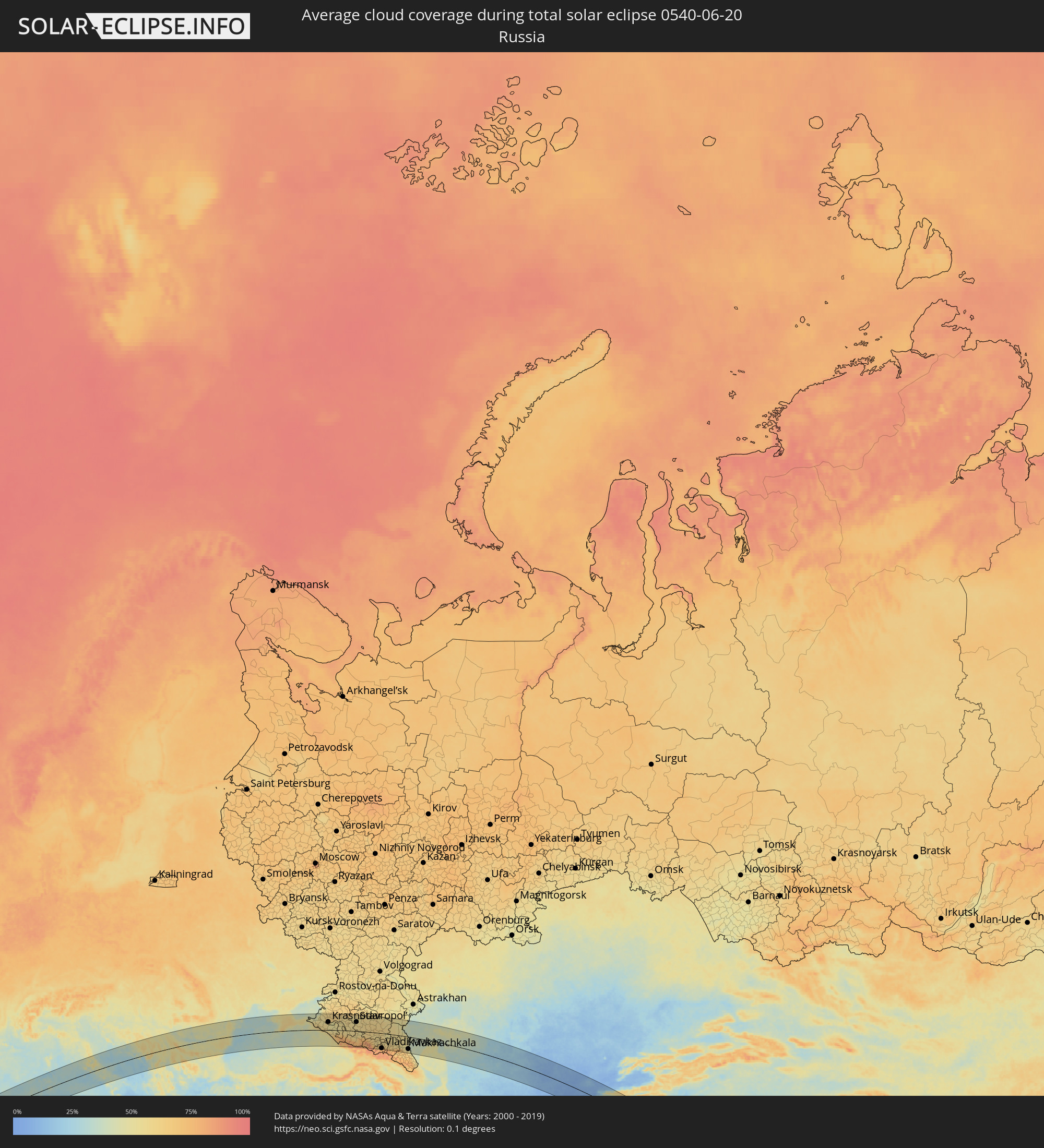 Russland
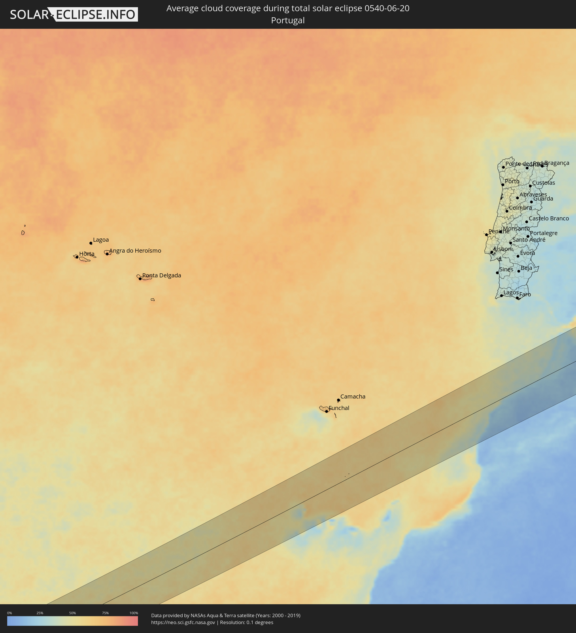 Portugal
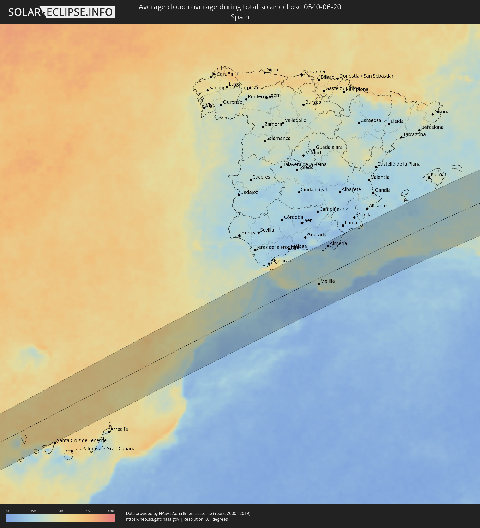 Spanien
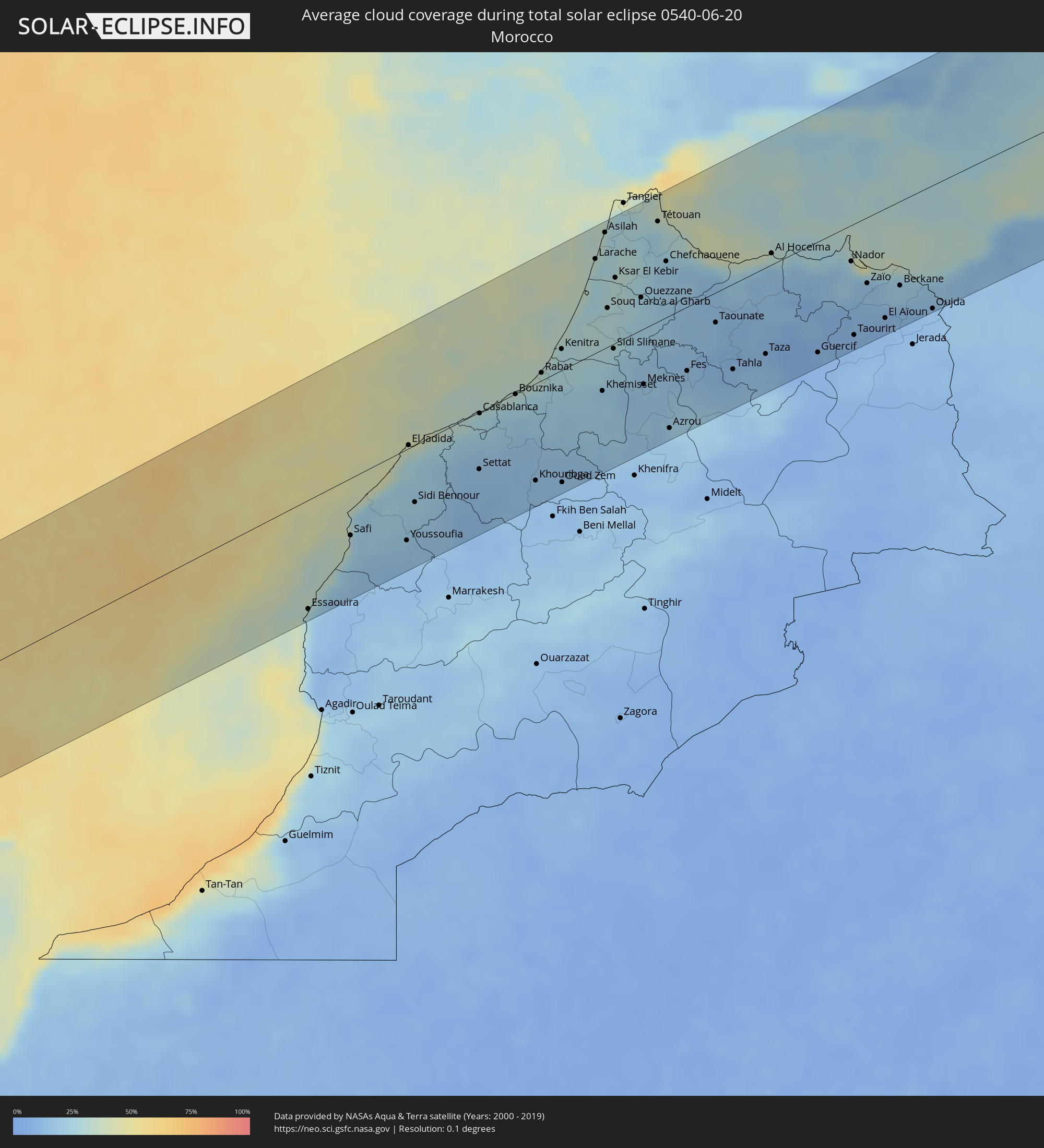 Marokko
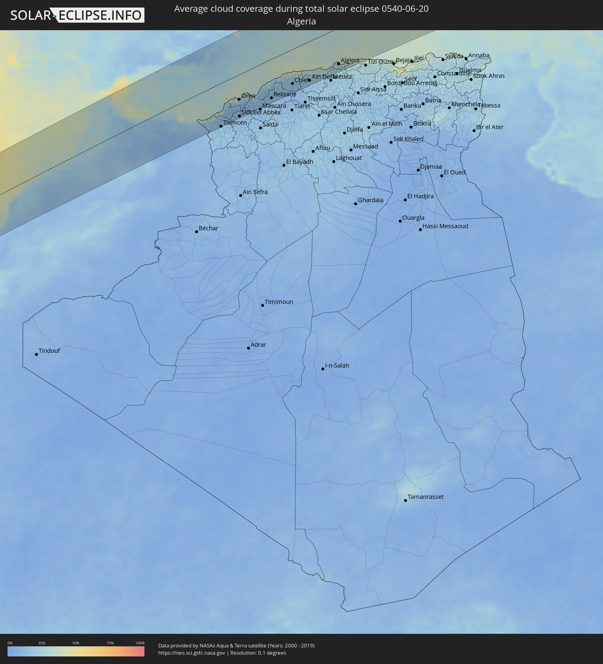 Algerien
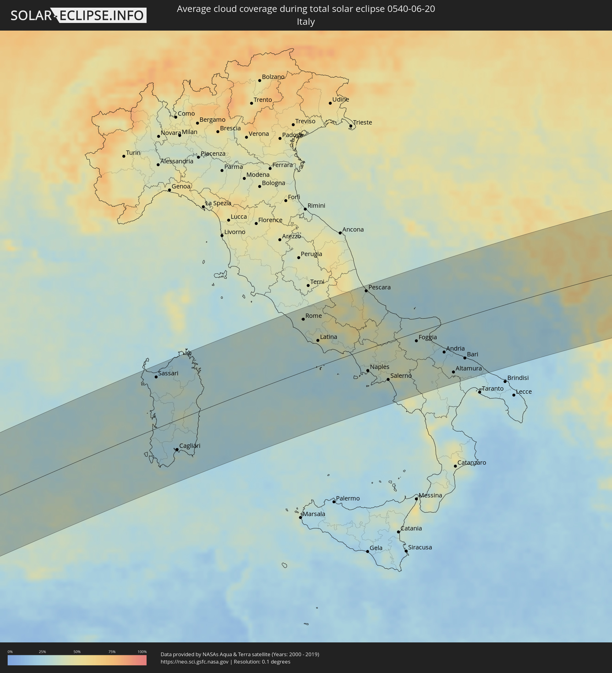 Italien
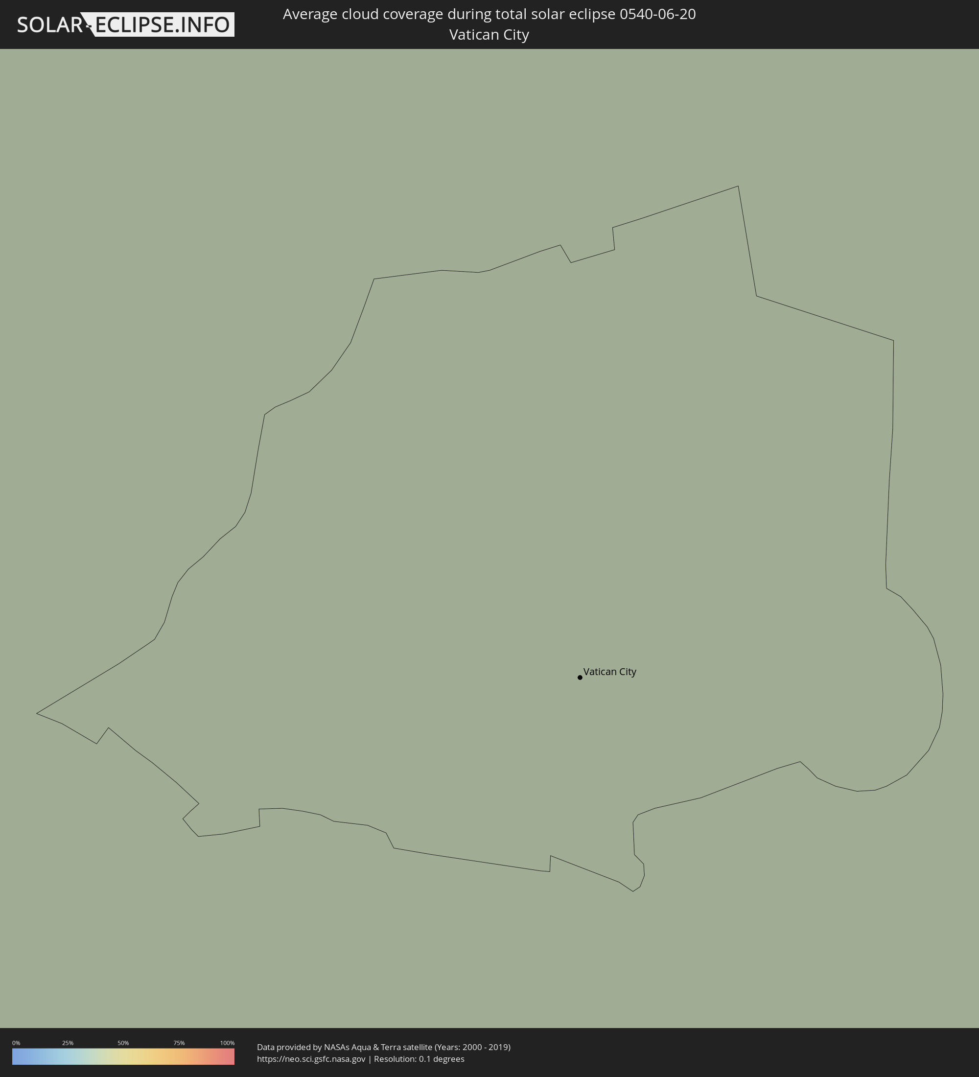 Vatikanstadt
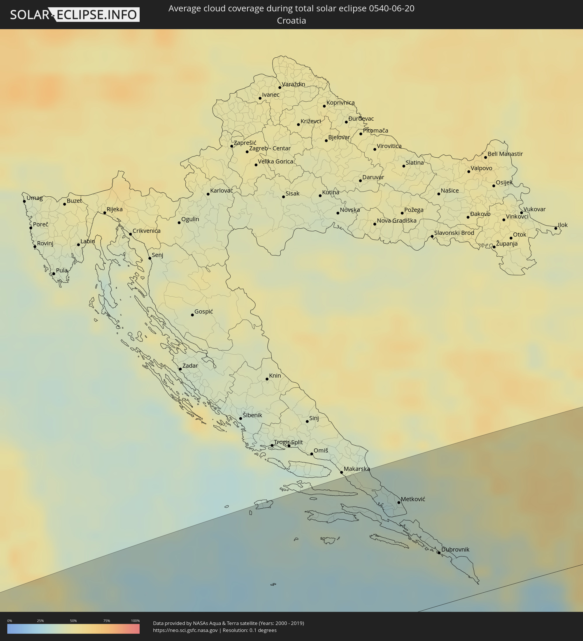 Kroatien
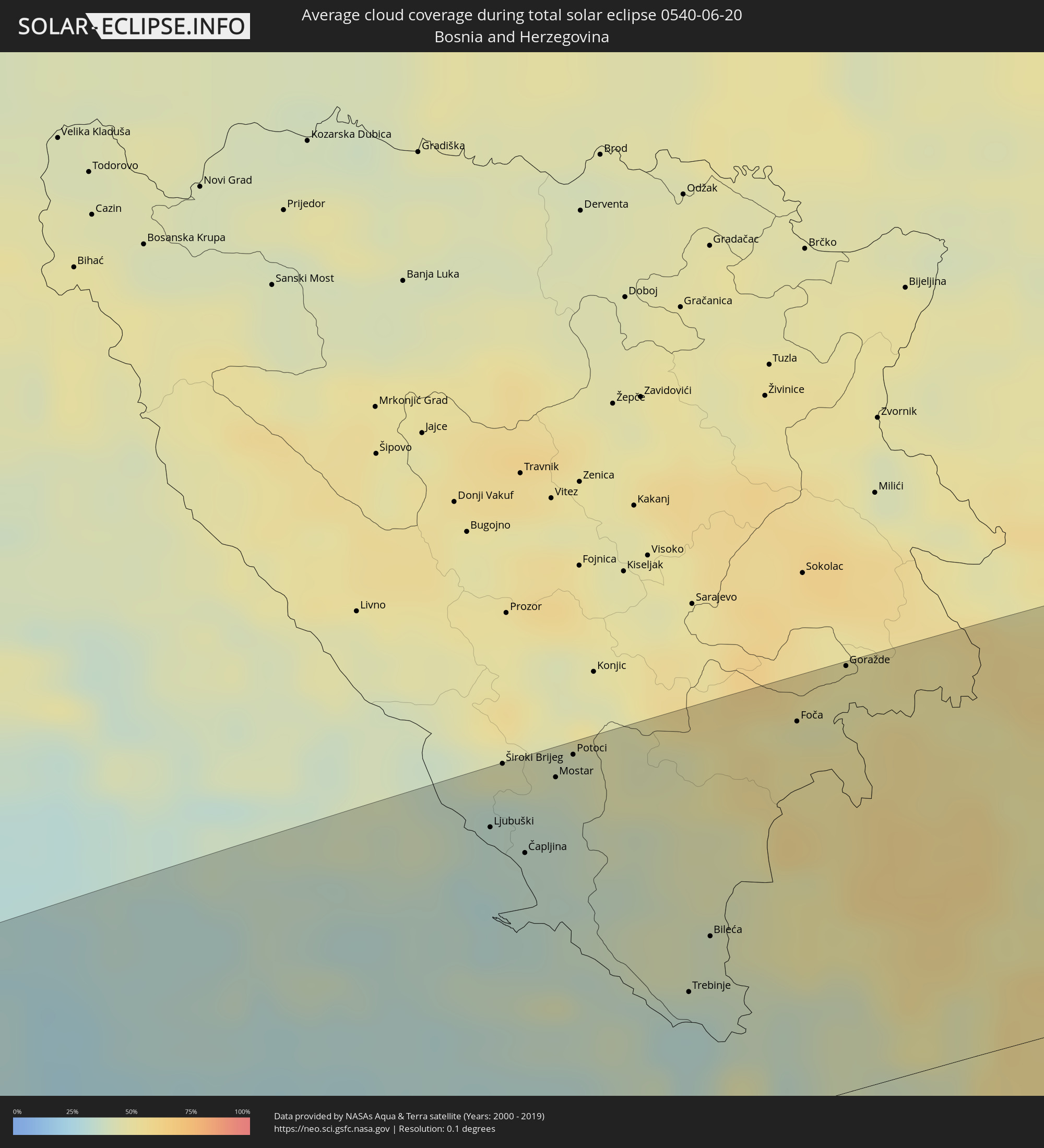 Bosnien und Herzegowina
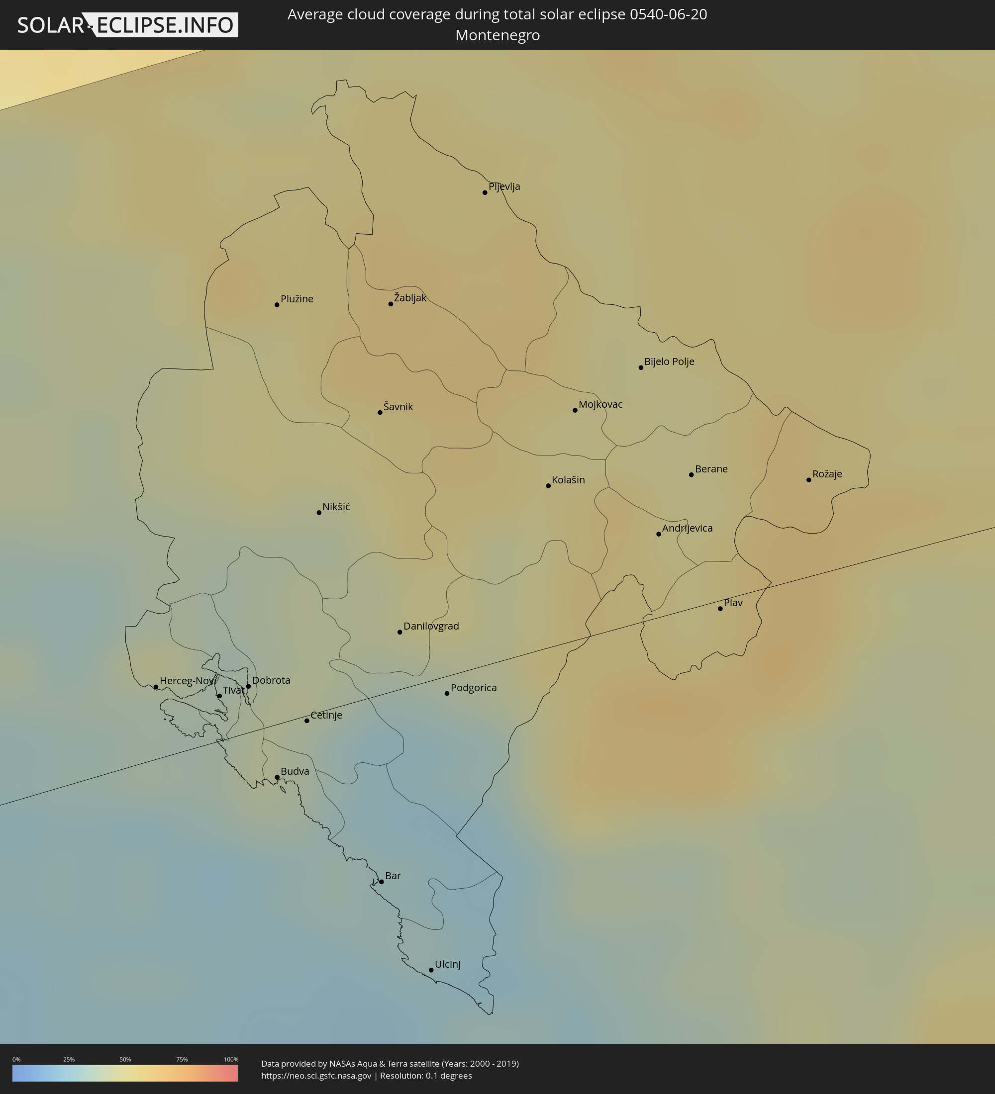 Montenegro
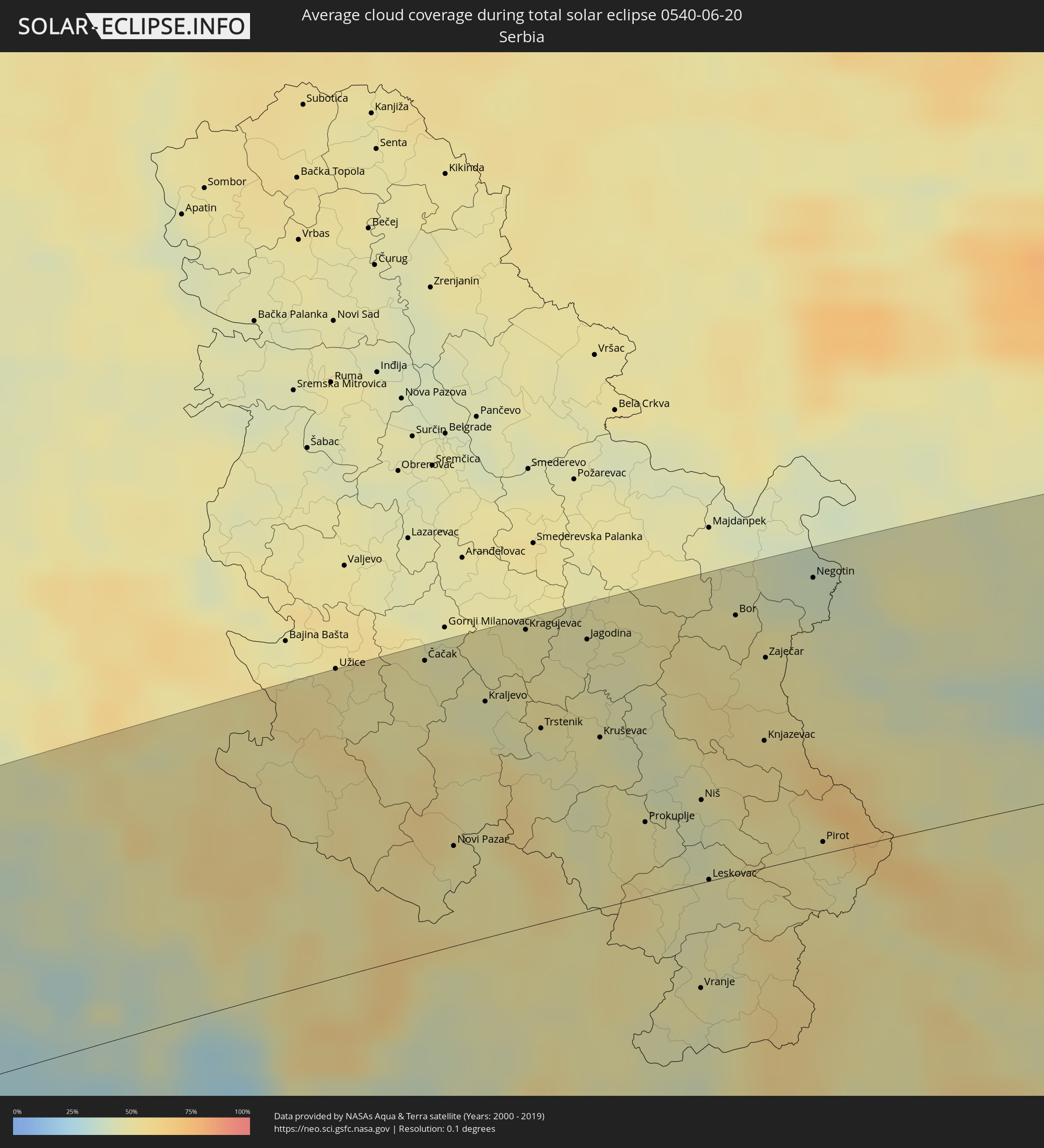 Serbien
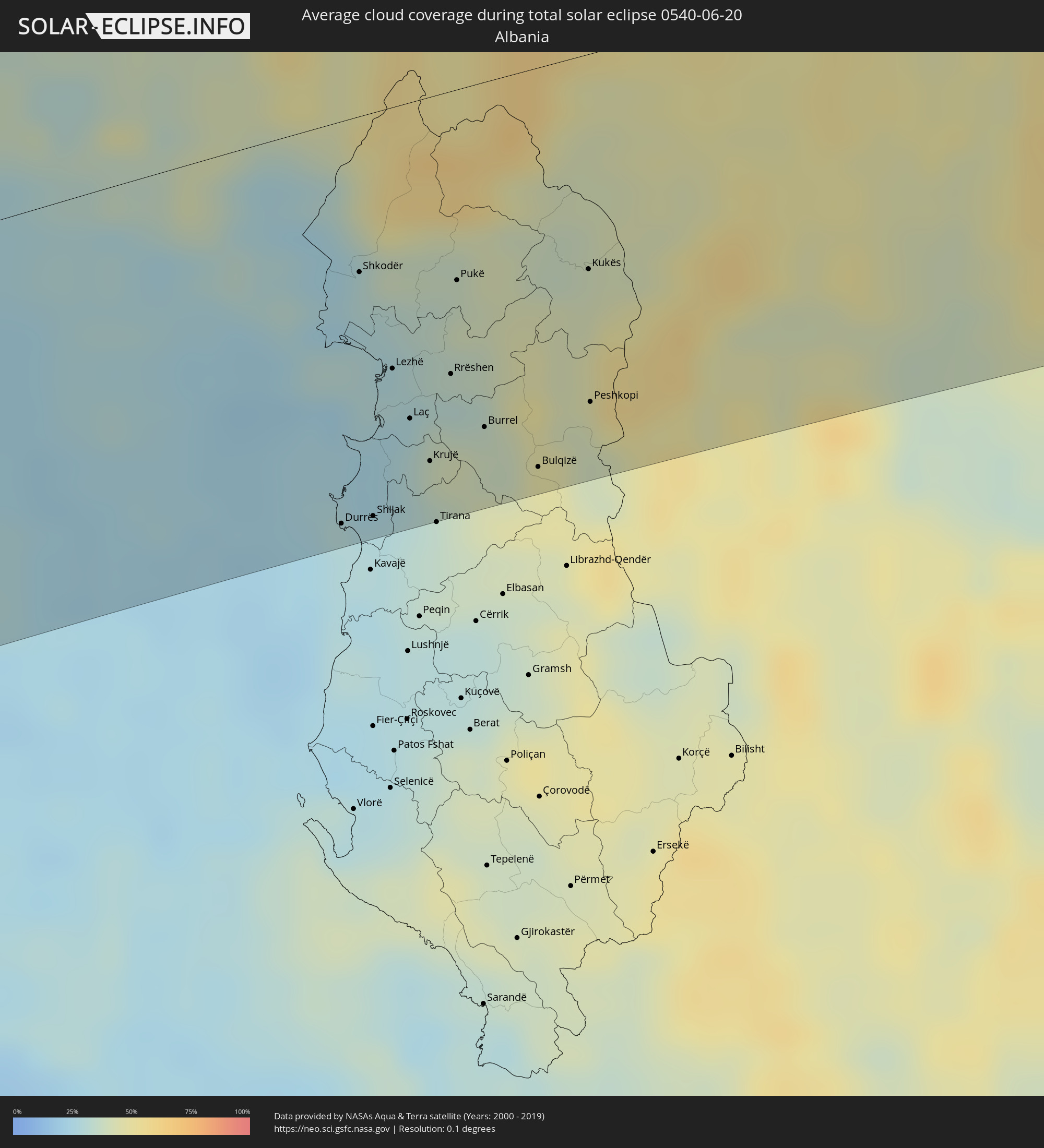 Albanien
 Rumänien
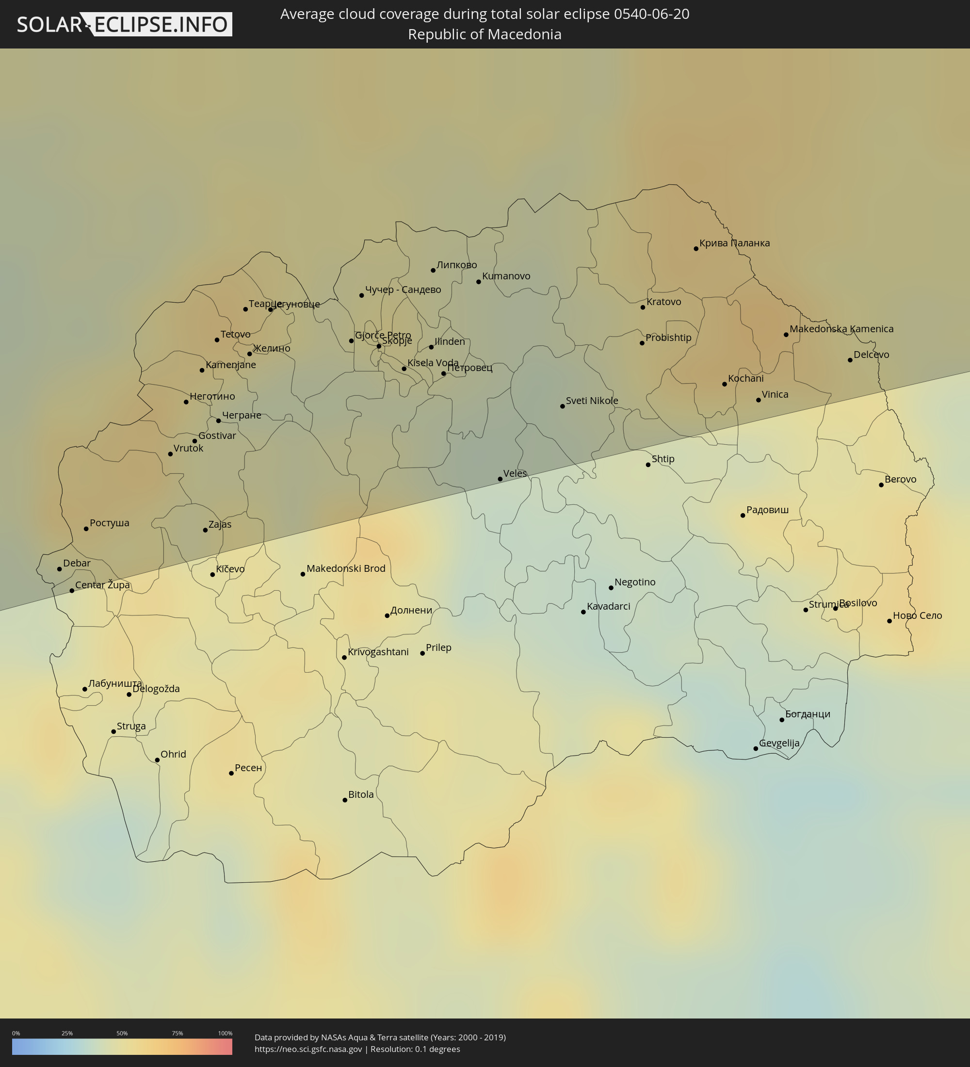 Mazedonien
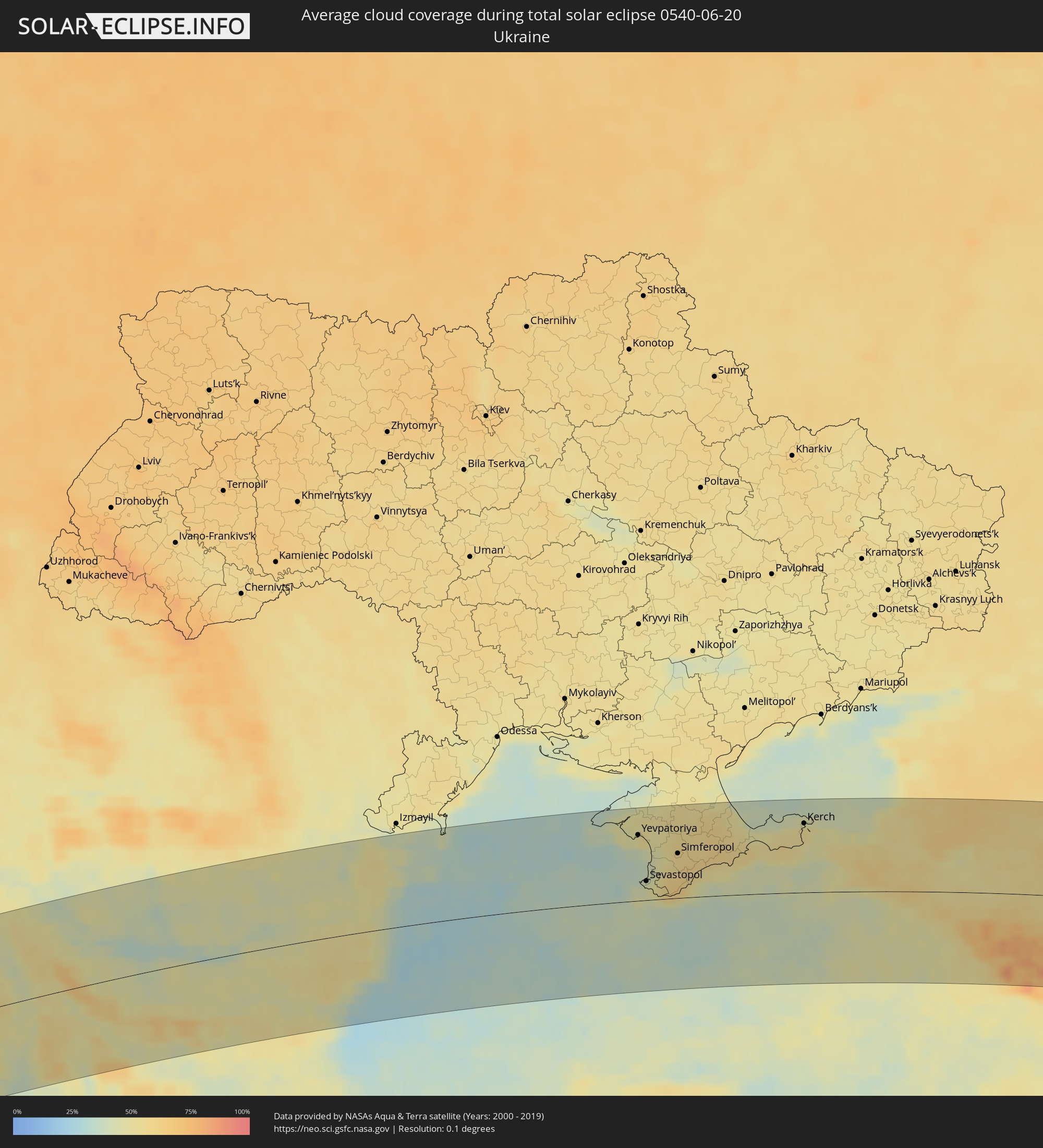 Ukraine
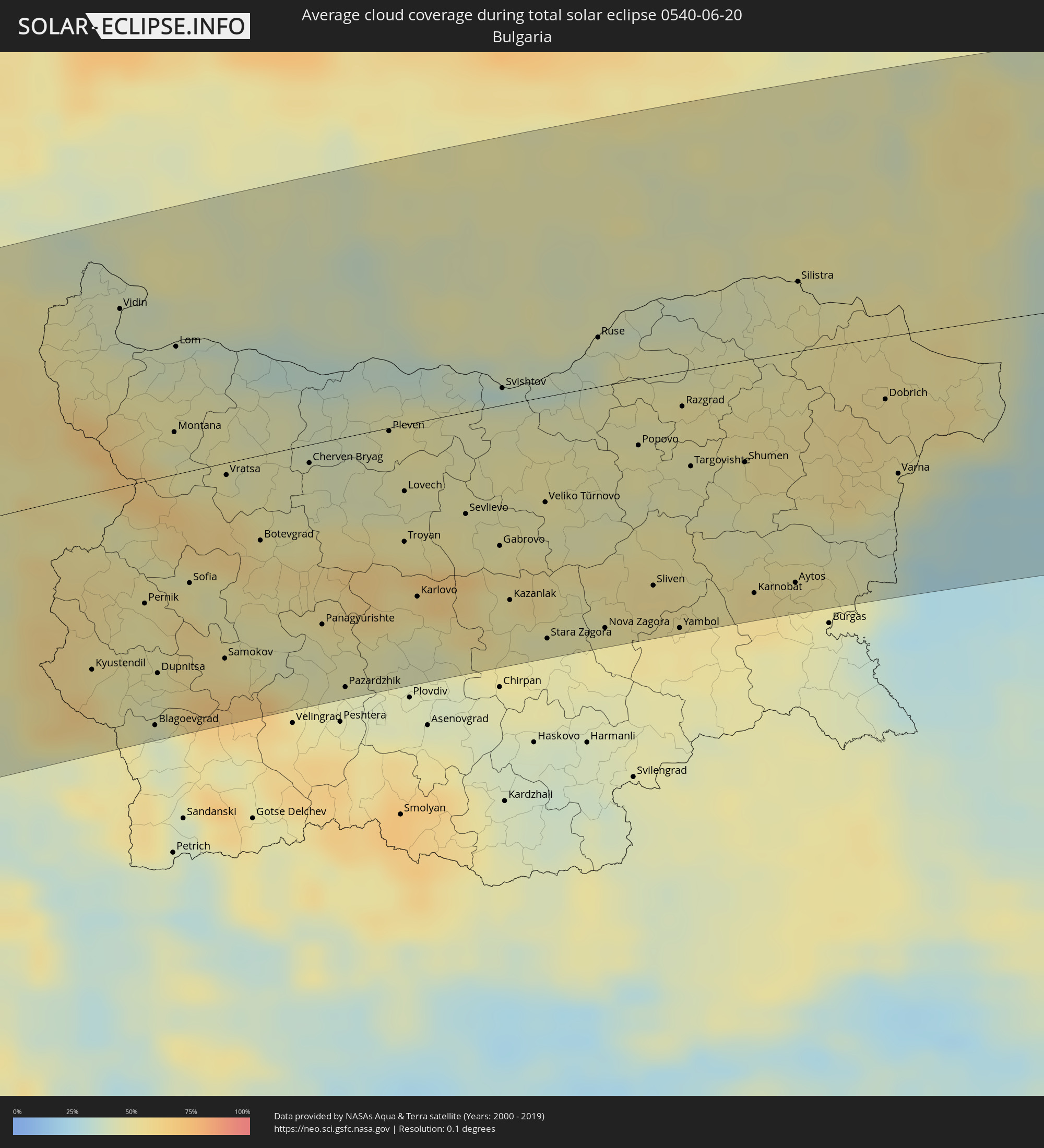 Bulgarien
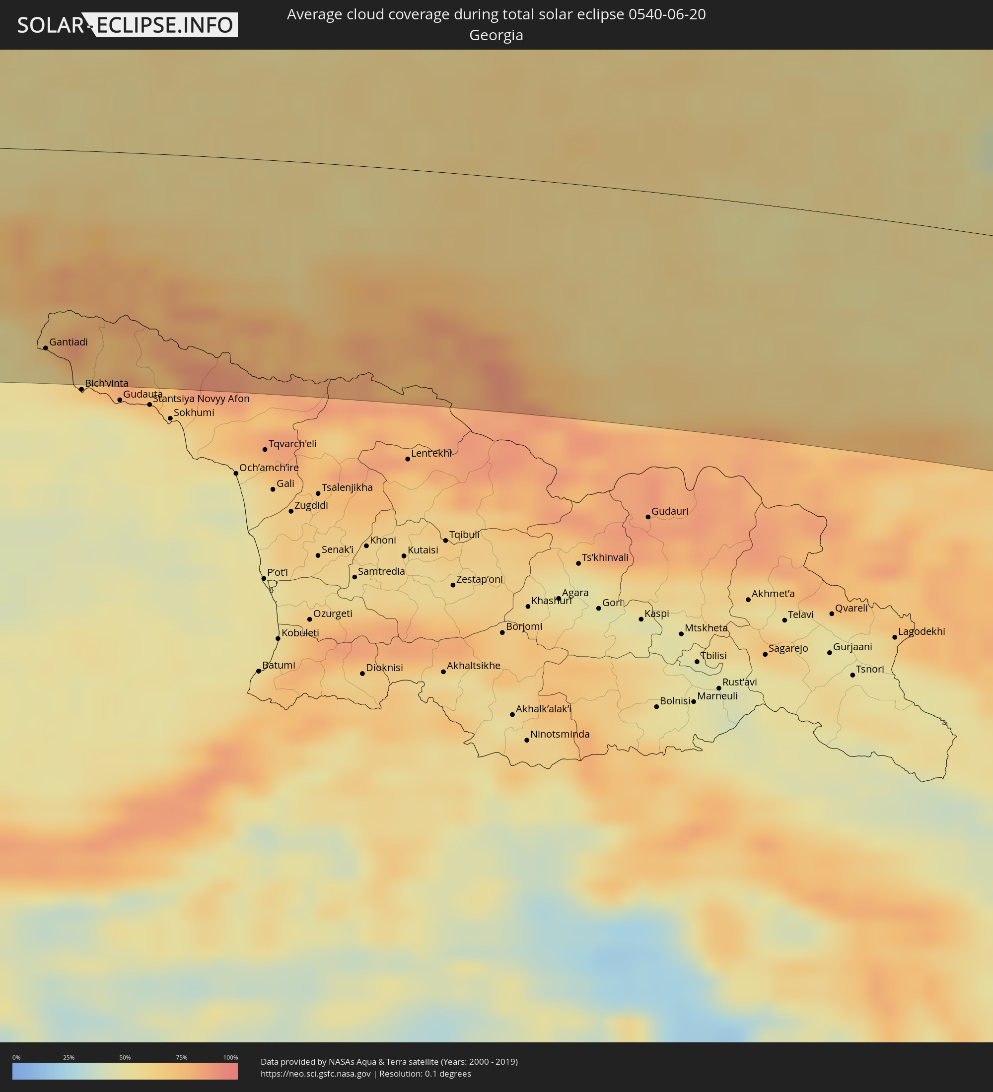 Georgien
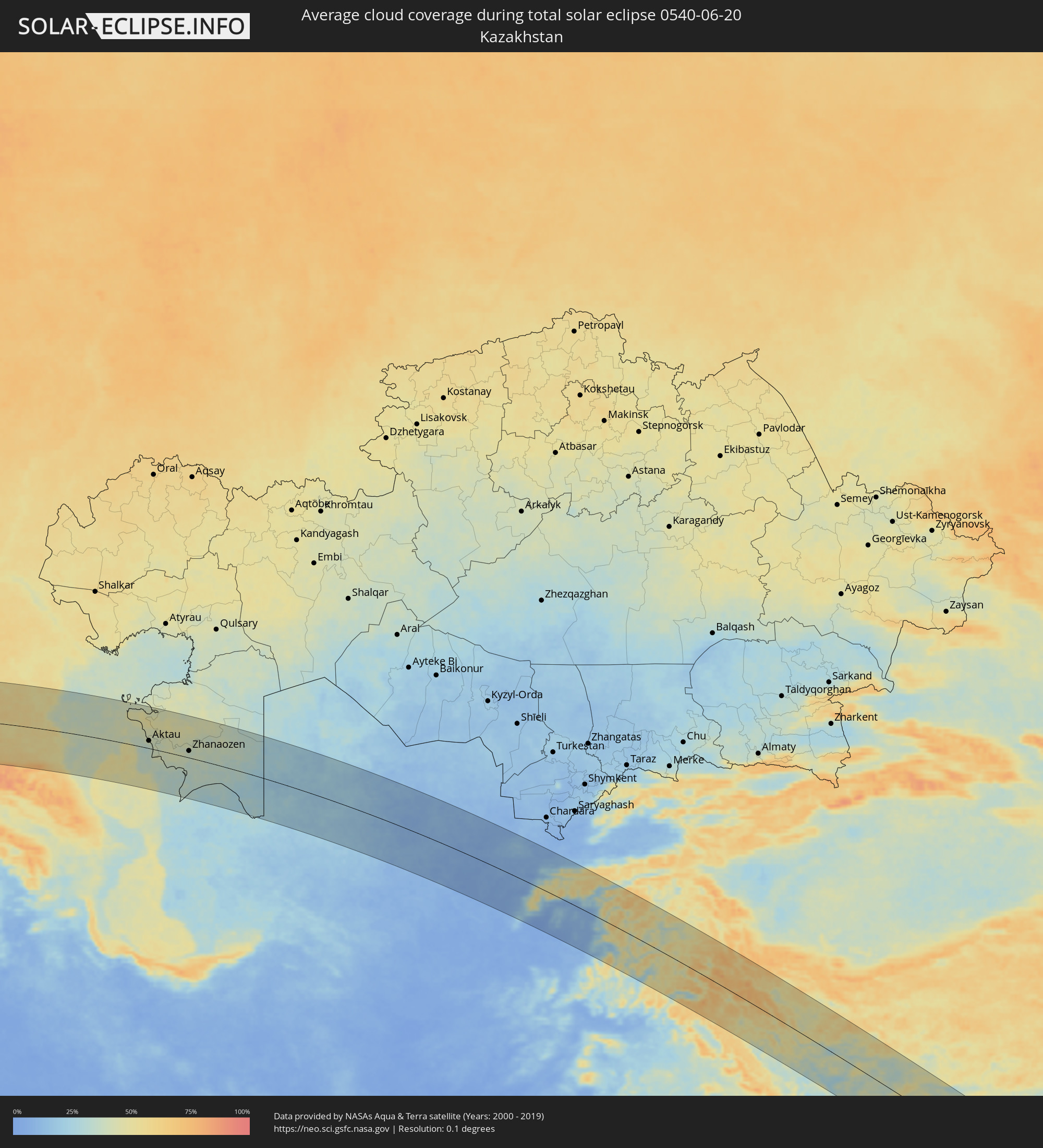 Kasachstan
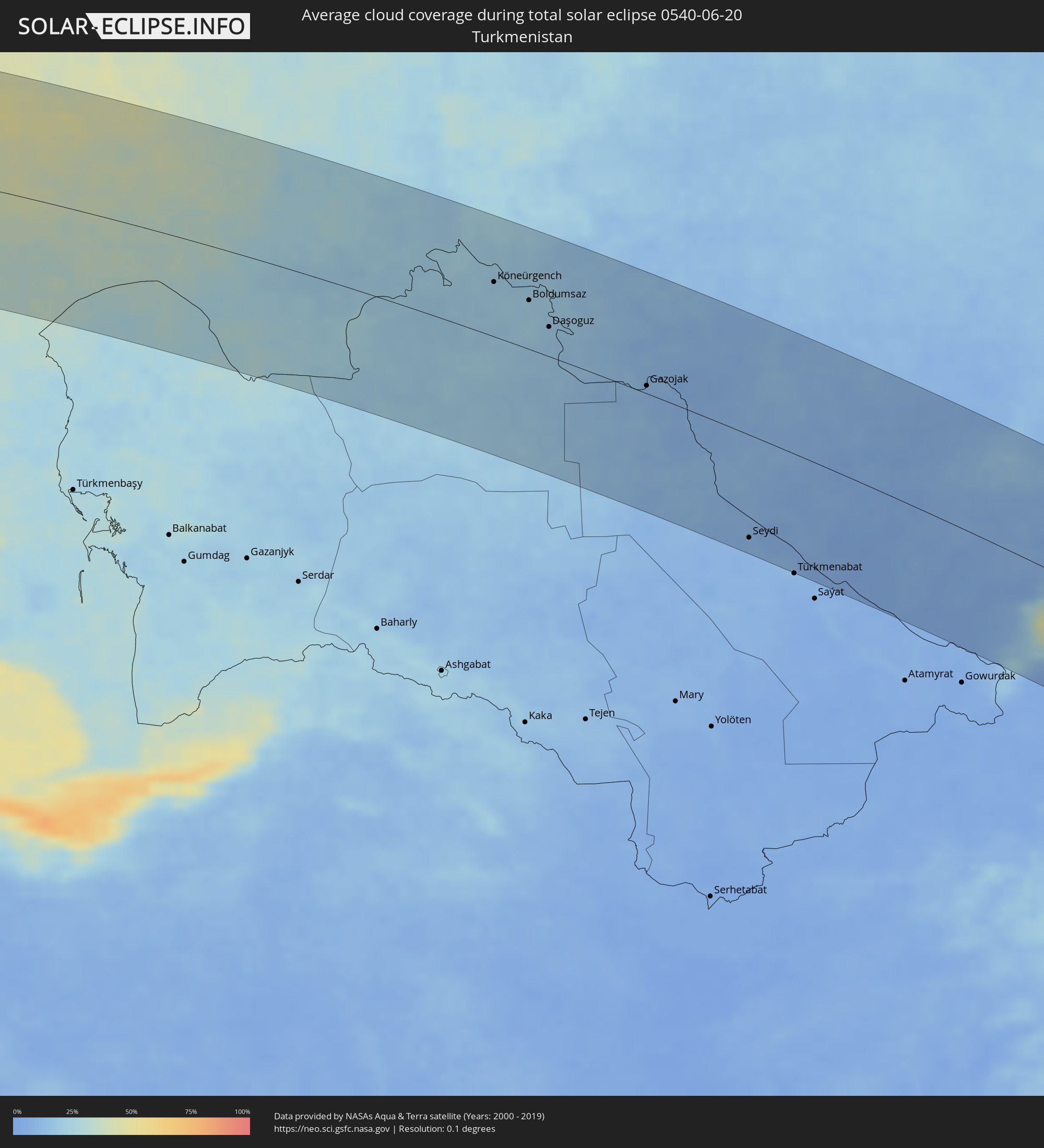 Turkmenistan
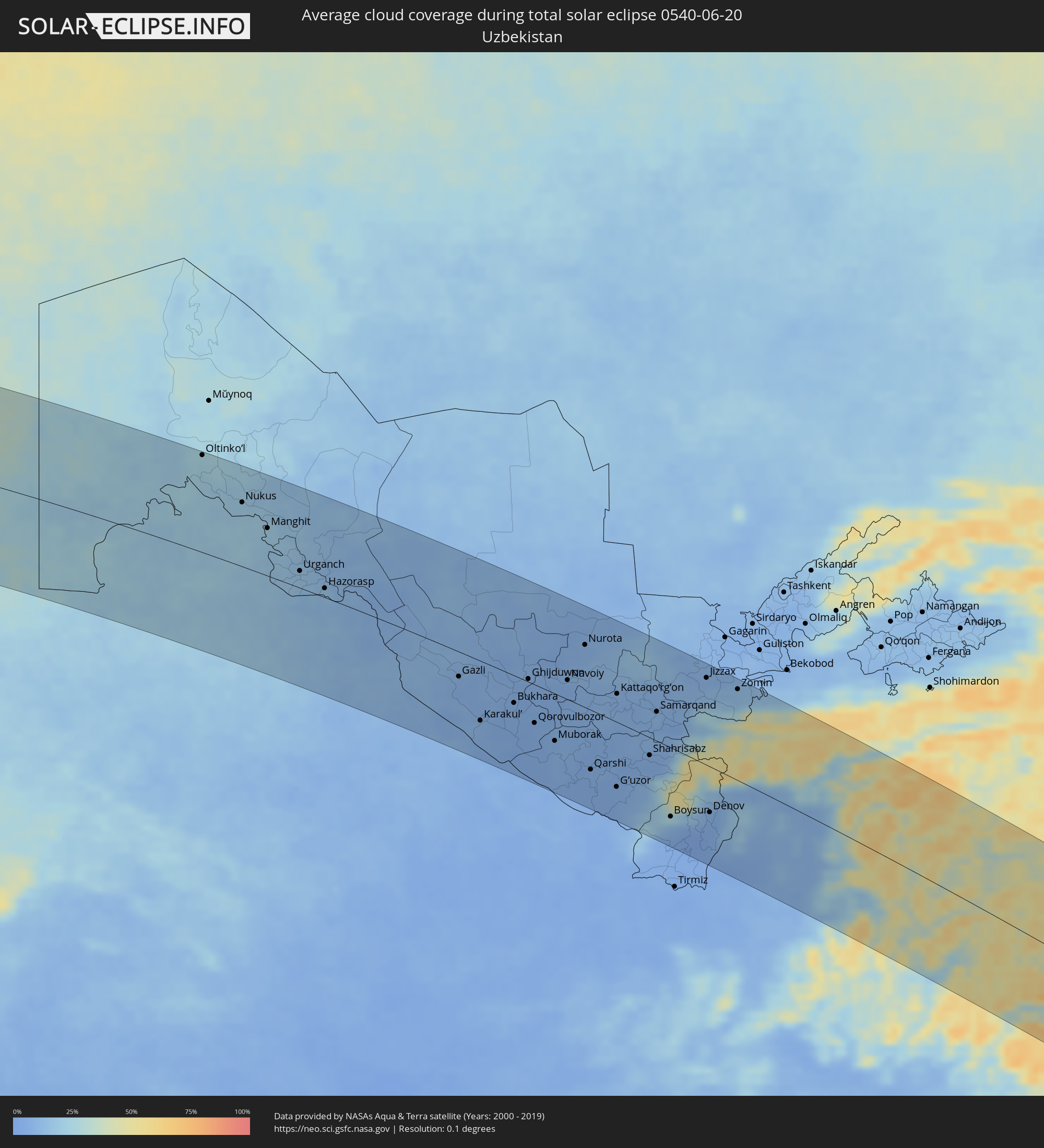 Usbekistan
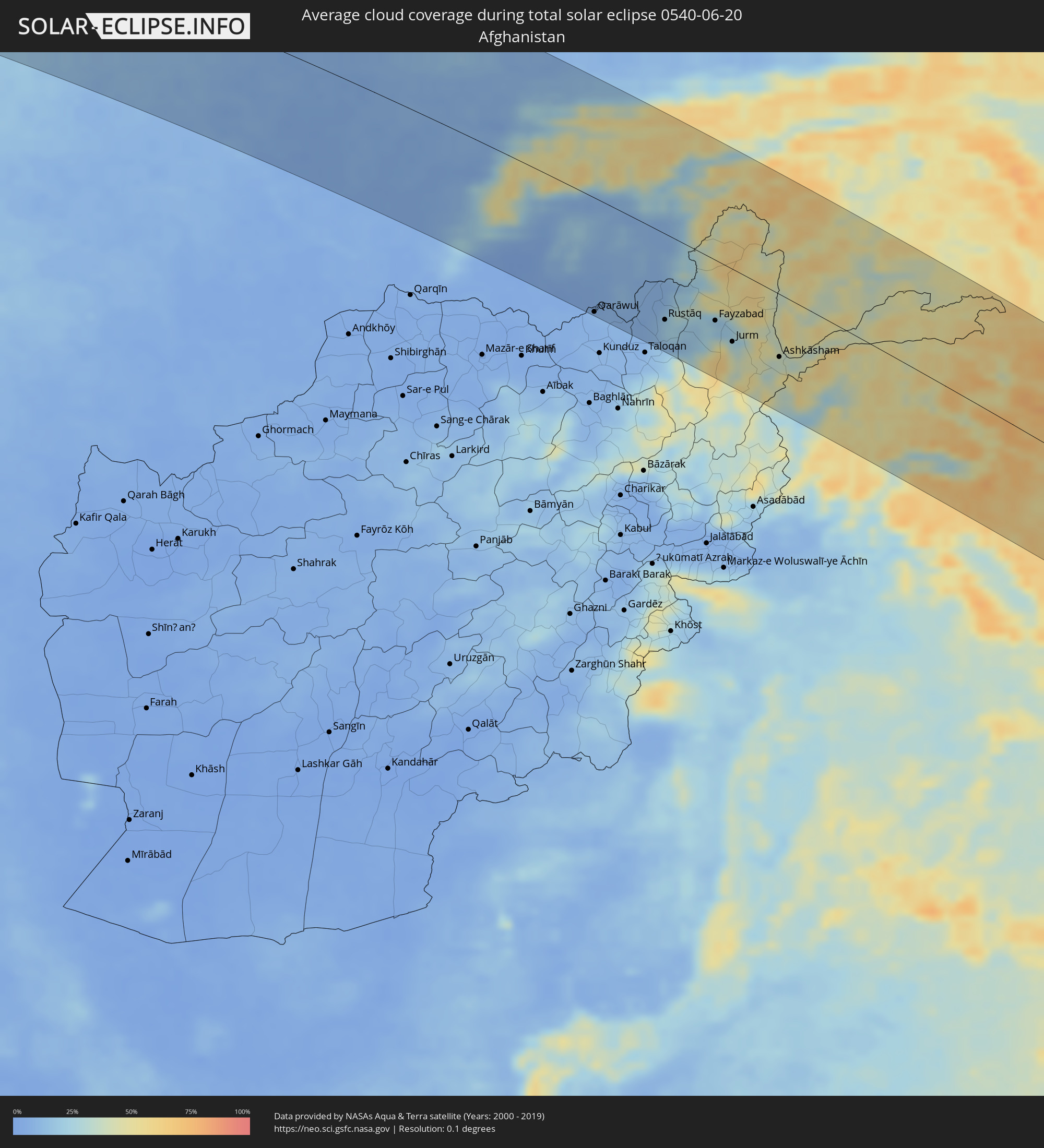 Afghanistan
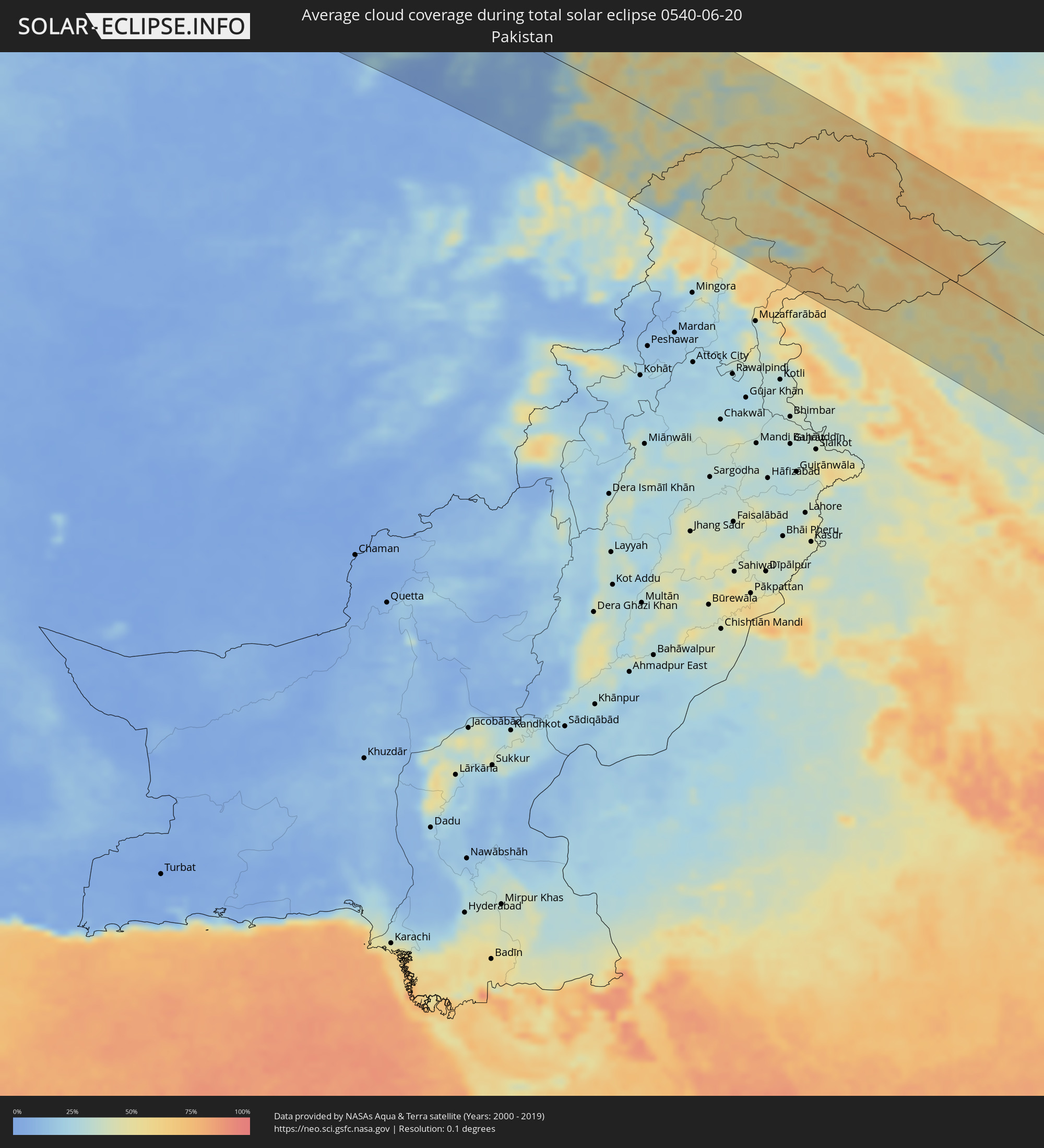 Pakistan
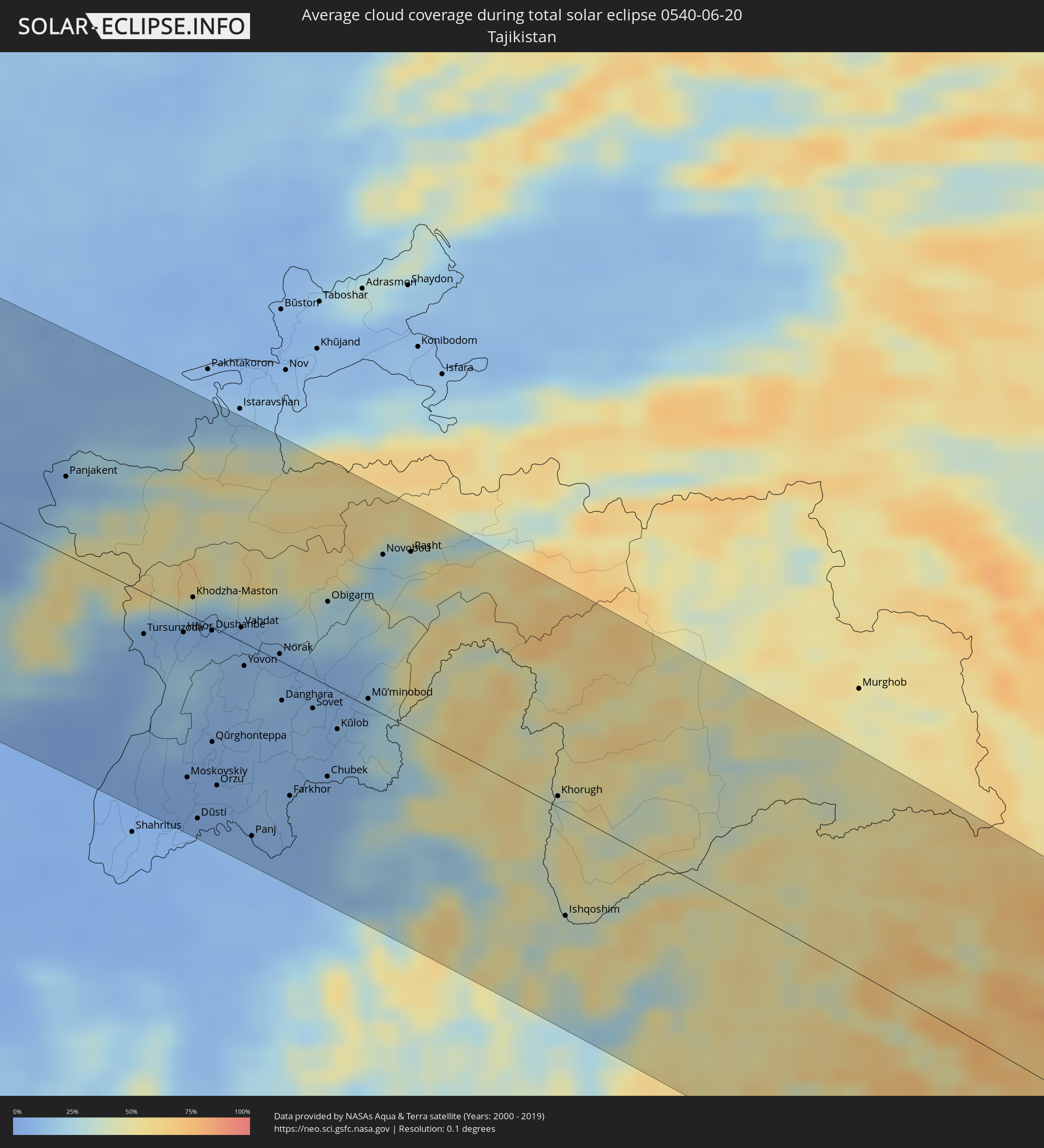 Tadschikistan
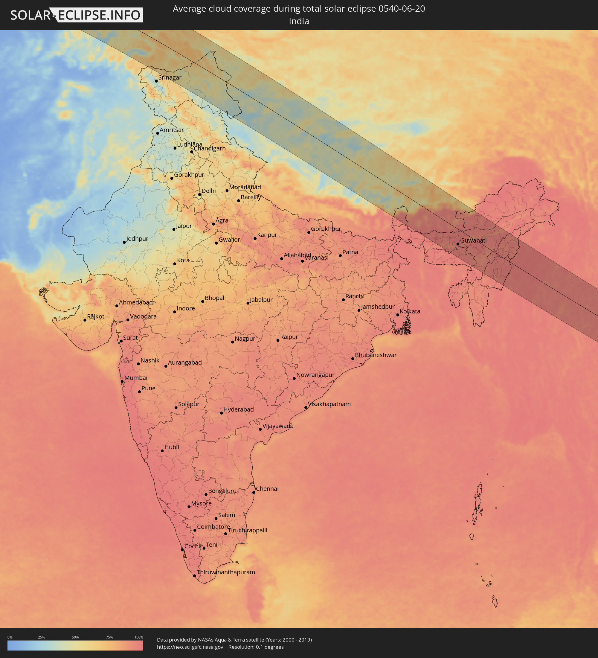 Indien
 Kirgisistan
 Volksrepublik China
 Nepal
Nepal
 Bhutan
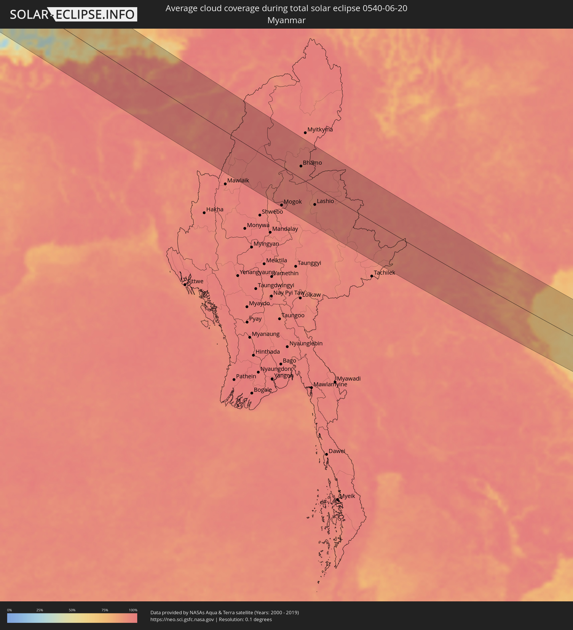 Myanmar
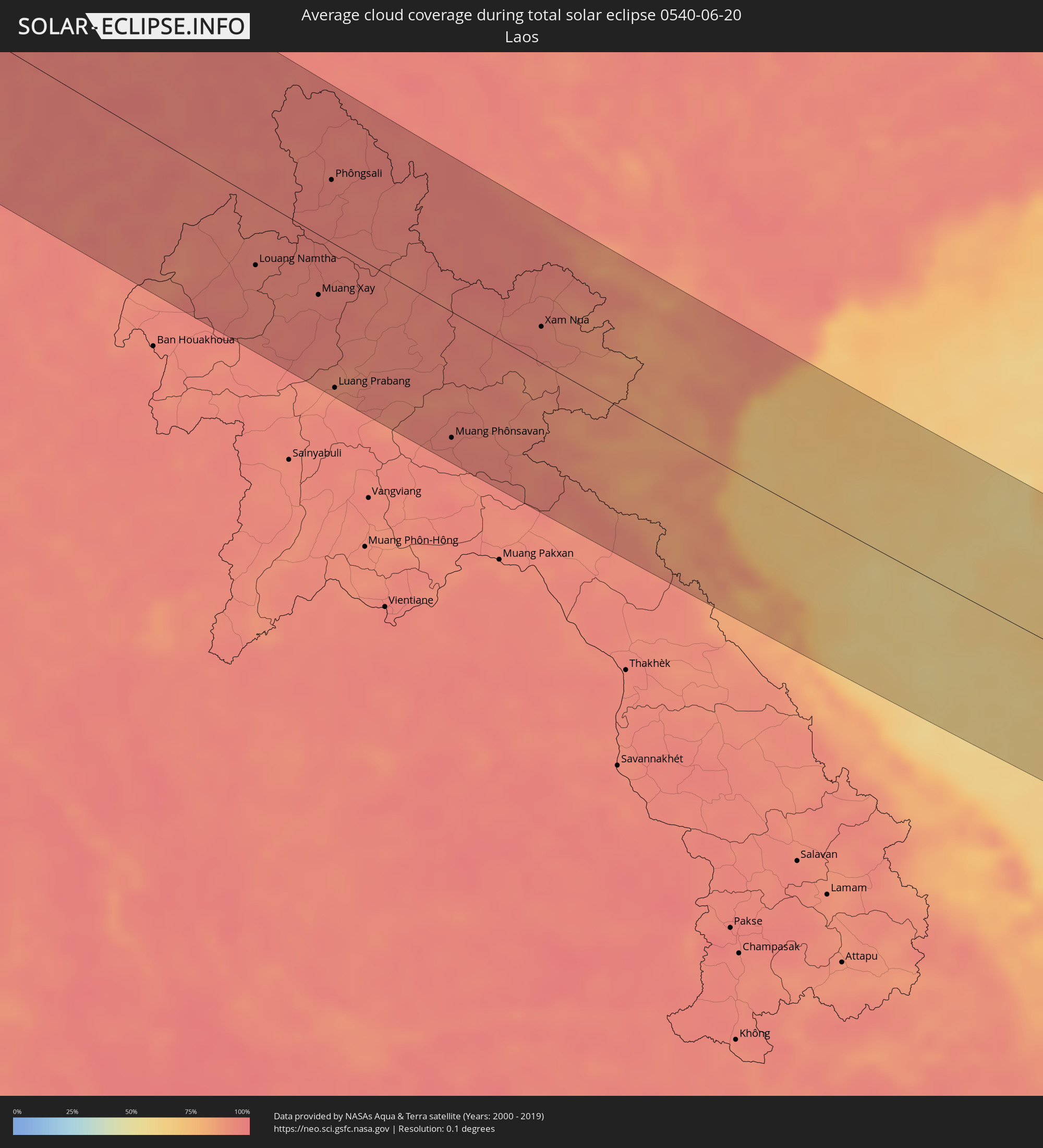 Laos
Laos
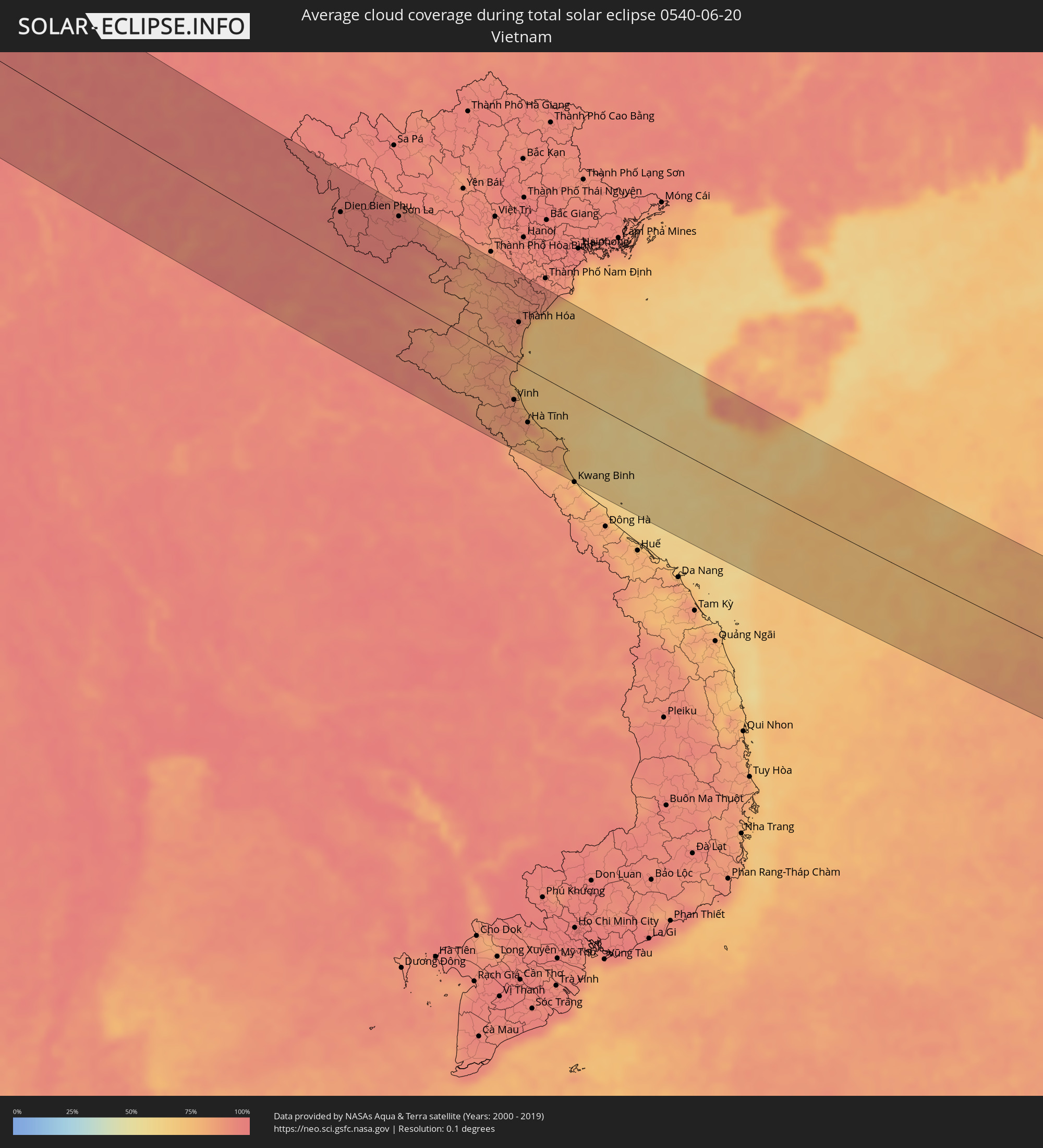 Vietnam
Orte im Finsternispfad
Die nachfolgene Tabelle zeigt Städte und Orte mit mehr als 5.000 Einwohnern, die sich im Finsternispfad befinden. Städte mit mehr als 100.000 Einwohnern sind dick gekennzeichnet. Mit einem Klick auf den Ort öffnet sich eine Detailkarte die die Lage des jeweiligen Ortes zusammen mit dem Verlauf der zentralen Finsternis präsentiert.
| Ort | Typ | Dauer der Verfinsterung | Ortszeit bei maximaler Verfinsterung | Entfernung zur Zentrallinie | Ø Bewölkung |
|
Puerto de la Cruz, Canary Islands
|
total | - | 06:15:58 UTC-01:01 | 123 km | 44% |
|
Casablanca, Grand Casablanca
|
total | - | 06:54:31 UTC-00:30 | 1 km | 25% |
|
Rabat, Rabat-Salé-Zemmour-Zaër
|
total | - | 06:55:18 UTC-00:30 | 8 km | 25% |
|
Kenitra, Gharb-Chrarda-Beni Hssen
|
total | - | 06:55:41 UTC-00:30 | 22 km | 27% |
|
Meknès, Meknès-Tafilalet
|
total | - | 06:55:42 UTC-00:30 | 58 km | 17% |
|
Tétouan, Tanger-Tétouan
|
total | - | 06:57:45 UTC-00:30 | 103 km | 27% |
|
Fes, Fès-Boulemane
|
total | - | 06:56:06 UTC-00:30 | 66 km | 16% |
|
Al Hoceïma, Taza-Al Hoceima-Taounate
|
total | - | 06:58:03 UTC-00:30 | 12 km | 28% |
|
Melilla, Melilla
|
total | - | 07:28:56 UTC+00:00 | 24 km | 43% |
|
El Ejido, Andalusia
|
total | - | 07:30:48 UTC+00:00 | 119 km | 25% |
|
Roquetas de Mar, Andalusia
|
total | - | 07:30:53 UTC+00:00 | 109 km | 26% |
|
Almería, Andalusia
|
total | - | 07:31:04 UTC+00:00 | 111 km | 27% |
|
Níjar, Andalusia
|
total | - | 07:31:22 UTC+00:00 | 114 km | 12% |
|
Oujda, Oriental
|
total | - | 06:58:27 UTC-00:30 | 127 km | 13% |
|
Cartagena, Murcia
|
total | - | 07:32:52 UTC+00:00 | 130 km | 25% |
|
Atamaría, Murcia
|
total | - | 07:32:58 UTC+00:00 | 122 km | 23% |
|
Oran, Oran
|
total | - | 07:40:06 UTC+00:09 | 75 km | 14% |
|
Sidi Bel Abbès, Sidi Bel Abbès
|
total | - | 07:39:30 UTC+00:09 | 126 km | 13% |
|
Mostaganem, Mostaganem
|
total | - | 07:40:51 UTC+00:09 | 80 km | 17% |
|
Relizane, Relizane
|
total | - | 07:40:55 UTC+00:09 | 117 km | 14% |
|
Chlef, Chlef
|
total | - | 07:41:58 UTC+00:09 | 104 km | 15% |
|
Blida, Blida
|
total | - | 07:43:26 UTC+00:09 | 129 km | 25% |
|
Algiers, Algiers
|
total | - | 07:43:56 UTC+00:09 | 108 km | 27% |
|
Boumerdas, Boumerdes
|
total | - | 07:44:17 UTC+00:09 | 123 km | 29% |
|
Cagliari, Sardinia
|
total | - | 08:42:57 UTC+01:00 | 64 km | 35% |
|
Acilia-Castel Fusano-Ostia Antica, Latium
|
total | - | 08:49:21 UTC+01:00 | 102 km | 31% |
|
Vatican City
|
total | - | 08:49:38 UTC+01:00 | 113 km | 37% |
|
Rome, Latium
|
total | - | 08:49:41 UTC+01:00 | 110 km | 37% |
|
Pescara, Abruzzo
|
total | - | 08:52:16 UTC+01:00 | 123 km | 34% |
|
Naples, Campania
|
total | - | 08:50:29 UTC+01:00 | 47 km | 31% |
|
Salerno, Campania
|
total | - | 08:50:56 UTC+01:00 | 81 km | 35% |
|
Foggia, Apulia
|
total | - | 08:52:45 UTC+01:00 | 18 km | 33% |
|
Bari, Apulia
|
total | - | 08:54:00 UTC+01:00 | 89 km | 25% |
|
Ljubuški, Federation of Bosnia and Herzegovina
|
total | - | 08:57:08 UTC+01:00 | 117 km | 33% |
|
Široki Brijeg, Federation of Bosnia and Herzegovina
|
total | - | 08:57:24 UTC+01:00 | 135 km | 35% |
|
Metković, Dubrovačko-Neretvanska
|
total | - | 08:57:07 UTC+01:00 | 99 km | 33% |
|
Mostar, Federation of Bosnia and Herzegovina
|
total | - | 08:57:38 UTC+01:00 | 126 km | 35% |
|
Potoci, Federation of Bosnia and Herzegovina
|
total | - | 08:57:47 UTC+01:00 | 131 km | 41% |
|
Dubrovnik, Dubrovačko-Neretvanska
|
total | - | 08:57:15 UTC+01:00 | 45 km | 37% |
|
Trebinje, Republic of Srspka
|
total | - | 08:57:39 UTC+01:00 | 46 km | 31% |
|
Bileća, Republic of Srspka
|
total | - | 08:57:56 UTC+01:00 | 62 km | 39% |
|
Herceg-Novi, Herceg Novi
|
total | - | 08:57:38 UTC+01:00 | 14 km | 36% |
|
Foča, Republic of Srspka
|
total | - | 08:59:03 UTC+01:00 | 121 km | 51% |
|
Budva, Budva
|
total | - | 08:57:52 UTC+01:00 | 11 km | 36% |
|
Nikšić, Opština Nikšić
|
total | - | 08:58:31 UTC+01:00 | 39 km | 40% |
|
Goražde, Federation of Bosnia and Herzegovina
|
total | - | 08:59:29 UTC+01:00 | 134 km | 47% |
|
Bar, Bar
|
total | - | 08:58:01 UTC+01:00 | 37 km | 30% |
|
Podgorica, Podgorica
|
total | - | 08:58:36 UTC+01:00 | 4 km | 29% |
|
Pljevlja, Pljevlja
|
total | - | 08:59:40 UTC+01:00 | 93 km | 56% |
|
Durrës, Durrës
|
total | - | 09:17:02 UTC+01:19 | 127 km | 28% |
|
Shkodër, Shkodër
|
total | - | 09:17:54 UTC+01:19 | 49 km | 30% |
|
Lezhë, Lezhë
|
total | - | 09:17:47 UTC+01:19 | 82 km | 29% |
|
Laç, Lezhë
|
total | - | 09:17:44 UTC+01:19 | 100 km | 31% |
|
Bijelo Polje, Bijelo Polje
|
total | - | 08:59:52 UTC+01:00 | 50 km | 50% |
|
Krujë, Durrës
|
total | - | 09:17:43 UTC+01:19 | 115 km | 35% |
|
Užice, Central Serbia
|
total | - | 09:00:50 UTC+01:00 | 136 km | 53% |
|
Berane, Berane
|
total | - | 08:59:50 UTC+01:00 | 26 km | 50% |
|
Burrel, Dibër
|
total | - | 09:18:08 UTC+01:19 | 109 km | 38% |
|
Čačak, Central Serbia
|
total | - | 09:01:32 UTC+01:00 | 129 km | 49% |
|
Kukës, Kukës
|
total | - | 09:19:10 UTC+01:19 | 68 km | 41% |
|
Peshkopi, Dibër
|
total | - | 09:18:48 UTC+01:19 | 110 km | 41% |
|
Novi Pazar, Central Serbia
|
total | - | 09:01:01 UTC+01:00 | 44 km | 47% |
|
Debar, Debar
|
total | - | 08:59:26 UTC+01:00 | 129 km | 40% |
|
Kraljevo, Central Serbia
|
total | - | 09:01:50 UTC+01:00 | 104 km | 48% |
|
Gostivar, Gostivar
|
total | - | 09:00:15 UTC+01:00 | 108 km | 46% |
|
Kragujevac, Central Serbia
|
total | - | 09:02:26 UTC+01:00 | 131 km | 50% |
|
Tetovo, Tetovo
|
total | - | 09:00:33 UTC+01:00 | 87 km | 43% |
|
Kruševac, Central Serbia
|
total | - | 09:02:35 UTC+01:00 | 75 km | 48% |
|
Skopje, Karpoš
|
total | - | 09:01:12 UTC+01:00 | 97 km | 42% |
|
Kumanovo, Kumanovo
|
total | - | 09:01:45 UTC+01:00 | 88 km | 43% |
|
Veles, Veles
|
total | - | 09:01:27 UTC+01:00 | 135 km | 35% |
|
Niš, Central Serbia
|
total | - | 09:03:09 UTC+01:00 | 37 km | 43% |
|
Leskovac, Central Serbia
|
total | - | 09:02:54 UTC+01:00 | 1 km | 46% |
|
Крива Паланка, Kriva Palanka
|
total | - | 09:02:43 UTC+01:00 | 93 km | 55% |
|
Kochani, Kočani
|
total | - | 09:02:35 UTC+01:00 | 125 km | 43% |
|
Sofia, Sofia-Capital
|
total | - | 10:04:39 UTC+02:00 | 58 km | 50% |
|
Craiova, Dolj
|
total | - | 09:51:12 UTC+01:44 | 110 km | 43% |
|
Slatina, Olt County
|
total | - | 09:52:08 UTC+01:44 | 113 km | 39% |
|
Pleven, Pleven
|
total | - | 10:07:14 UTC+02:00 | 2 km | 48% |
|
Alexandria, Teleorman
|
total | - | 09:53:12 UTC+01:44 | 49 km | 45% |
|
Stara Zagora, Stara Zagora
|
total | - | 10:08:01 UTC+02:00 | 126 km | 48% |
|
Giurgiu, Giurgiu
|
total | - | 09:54:06 UTC+01:44 | 28 km | 41% |
|
Ruse, Ruse
|
total | - | 10:09:41 UTC+02:00 | 25 km | 41% |
|
Bucharest, Bucureşti
|
total | - | 09:54:45 UTC+01:44 | 86 km | 46% |
|
Sliven, Sliven
|
total | - | 10:09:20 UTC+02:00 | 108 km | 54% |
|
Shumen, Shumen
|
total | - | 10:10:44 UTC+02:00 | 53 km | 50% |
|
Slobozia, Ialomiţa
|
total | - | 09:56:48 UTC+01:44 | 83 km | 46% |
|
Dobrich, Dobrich
|
total | - | 10:12:25 UTC+02:00 | 32 km | 54% |
|
Varna, Varna
|
total | - | 10:12:18 UTC+02:00 | 72 km | 44% |
|
Constanţa, Constanța
|
total | - | 09:58:33 UTC+01:44 | 26 km | 43% |
|
Tulcea, Tulcea
|
total | - | 09:59:29 UTC+01:44 | 132 km | 43% |
|
Yevpatoriya, Republic of Crimea
|
total | - | 10:38:35 UTC+02:16 | 97 km | 50% |
|
Sevastopol, Gorod Sevastopol
|
total | - | 10:38:35 UTC+02:16 | 28 km | 44% |
|
Saki, Republic of Crimea
|
total | - | 10:38:57 UTC+02:16 | 88 km | 46% |
|
Simferopol, Republic of Crimea
|
total | - | 10:39:45 UTC+02:16 | 66 km | 56% |
|
Yalta, Republic of Crimea
|
total | - | 10:39:40 UTC+02:16 | 15 km | 53% |
|
Alushta, Republic of Crimea
|
total | - | 10:40:09 UTC+02:16 | 33 km | 53% |
|
Feodosiya, Republic of Crimea
|
total | - | 10:41:59 UTC+02:16 | 70 km | 56% |
|
Kerch, Republic of Crimea
|
total | - | 10:43:59 UTC+02:16 | 102 km | 53% |
|
Novorossiysk, Krasnodarskiy
|
total | - | 11:00:24 UTC+02:30 | 30 km | 60% |
|
Krasnodar, Krasnodarskiy
|
total | - | 11:02:38 UTC+02:30 | 67 km | 54% |
|
Sochi, Krasnodarskiy
|
total | - | 11:03:50 UTC+02:30 | 93 km | 51% |
|
Gantiadi
|
total | - | 11:33:23 UTC+02:59 | 116 km | 59% |
|
Gagra, Abkhazia
|
total | - | 11:33:45 UTC+02:59 | 127 km | 64% |
|
Stavropol’, Stavropol'skiy
|
total | - | 11:08:04 UTC+02:30 | 76 km | 55% |
|
Nal’chik, Kabardino-Balkariya
|
total | - | 11:11:16 UTC+02:30 | 85 km | 68% |
|
Vladikavkaz, North Ossetia
|
total | - | 11:13:22 UTC+02:30 | 128 km | 77% |
|
Groznyy, Chechnya
|
total | - | 11:15:17 UTC+02:30 | 88 km | 60% |
|
Makhachkala, Dagestan
|
total | - | 11:18:54 UTC+02:30 | 104 km | 51% |
|
Fort-Shevchenko, Mangghystaū
|
total | - | 12:18:32 UTC+03:25 | 103 km | 46% |
|
Aktau, Mangghystaū
|
total | - | 12:20:39 UTC+03:25 | 25 km | 38% |
|
Yeraliyev, Mangghystaū
|
total | - | 12:21:53 UTC+03:25 | 17 km | 41% |
|
Zhetibay, Mangghystaū
|
total | - | 12:22:23 UTC+03:25 | 35 km | 43% |
|
Shetpe, Mangghystaū
|
total | - | 12:22:06 UTC+03:25 | 98 km | 48% |
|
Zhanaozen, Mangghystaū
|
total | - | 12:23:59 UTC+03:25 | 23 km | 37% |
|
Köneürgench, Daşoguz
|
total | - | 13:04:18 UTC+03:53 | 63 km | 21% |
|
Nukus, Karakalpakstan
|
total | - | 13:39:19 UTC+04:27 | 88 km | 19% |
|
Yylanly, Daşoguz
|
total | - | 13:05:40 UTC+03:53 | 25 km | 21% |
|
Boldumsaz, Daşoguz
|
total | - | 13:05:24 UTC+03:53 | 56 km | 21% |
|
Tagta, Daşoguz
|
total | - | 13:06:19 UTC+03:53 | 13 km | 17% |
|
Daşoguz, Daşoguz
|
total | - | 13:06:13 UTC+03:53 | 34 km | 17% |
|
Urganch, Xorazm
|
total | - | 13:42:01 UTC+04:27 | 23 km | 15% |
|
Gazojak, Lebap
|
total | - | 13:09:23 UTC+03:53 | 9 km | 10% |
|
Seydi, Mary
|
total | - | 13:13:55 UTC+03:53 | 119 km | 9% |
|
Farap, Lebap
|
total | - | 13:15:29 UTC+03:53 | 128 km | 10% |
|
Bukhara, Bukhara
|
total | - | 13:50:29 UTC+04:27 | 38 km | 6% |
|
Navoiy, Navoiy
|
total | - | 13:51:39 UTC+04:27 | 27 km | 6% |
|
Qarshi, Qashqadaryo
|
total | - | 13:53:51 UTC+04:27 | 83 km | 6% |
|
Samarqand, Samarqand
|
total | - | 13:54:42 UTC+04:27 | 40 km | 10% |
|
Panjakent, Viloyati Sughd
|
total | - | 14:03:13 UTC+04:35 | 48 km | 11% |
|
Jizzax, Jizzax
|
total | - | 13:55:27 UTC+04:27 | 119 km | 8% |
|
Denov, Surxondaryo
|
total | - | 13:57:59 UTC+04:27 | 63 km | 7% |
|
Tursunzoda, Republican Subordination
|
total | - | 14:05:29 UTC+04:35 | 26 km | 9% |
|
Dushanbe, Dushanbe
|
total | - | 14:06:17 UTC+04:35 | 2 km | 11% |
|
Qarāwul, Kunduz
|
total | - | 13:32:53 UTC+04:00 | 133 km | 7% |
|
Qŭrghonteppa, Khatlon
|
total | - | 14:07:15 UTC+04:35 | 72 km | 7% |
|
Imām Şāḩib, Kunduz
|
total | - | 13:33:10 UTC+04:00 | 130 km | 8% |
|
Vahdat, Republican Subordination
|
total | - | 14:06:37 UTC+04:35 | 9 km | 9% |
|
Dasht-e Archī, Kunduz
|
total | - | 13:33:35 UTC+04:00 | 126 km | 7% |
|
Ārt Khwājah, Takhar
|
total | - | 13:34:08 UTC+04:00 | 119 km | 8% |
|
Kŭlob, Khatlon
|
total | - | 14:08:38 UTC+04:35 | 24 km | 11% |
|
Rustāq, Takhar
|
total | - | 13:34:36 UTC+04:00 | 100 km | 18% |
|
Fayzabad, Badakhshan
|
total | - | 13:35:43 UTC+04:00 | 70 km | 19% |
|
Jurm, Badakhshan
|
total | - | 13:36:26 UTC+04:00 | 85 km | 33% |
|
Ashkāsham, Badakhshan
|
total | - | 13:37:42 UTC+04:00 | 73 km | 36% |
|
Khorugh, Gorno-Badakhshan
|
total | - | 14:11:47 UTC+04:35 | 7 km | 39% |
|
Ishqoshim, Gorno-Badakhshan
|
total | - | 14:12:57 UTC+04:35 | 66 km | 38% |
|
Gilgit, Gilgit-Baltistan
|
total | - | 14:10:47 UTC+04:28 | 27 km | 59% |
|
Rikaze, Tibet Autonomous Region
|
total | - | 18:06:52 UTC+08:00 | 64 km | 40% |
|
Phuntsholing, Chukha District
|
total | - | 15:31:42 UTC+05:21 | 134 km | 97% |
|
Jiangzi, Tibet Autonomous Region
|
total | - | 18:07:49 UTC+08:00 | 71 km | 56% |
|
Thimphu, Thimphu
|
total | - | 16:08:27 UTC+05:58 | 63 km | 91% |
|
Punākha, Punakha
|
total | - | 16:08:26 UTC+05:58 | 39 km | 85% |
|
Tsirang, Chirang
|
total | - | 16:09:22 UTC+05:58 | 79 km | 95% |
|
Sarpang, Geylegphug
|
total | - | 16:09:40 UTC+05:58 | 86 km | 96% |
|
Bongaigaon, Assam
|
total | - | 15:32:56 UTC+05:21 | 107 km | 97% |
|
Jakar, Bumthang
|
total | - | 16:09:02 UTC+05:58 | 4 km | 93% |
|
Pemagatshel, Pemagatshel District
|
total | - | 16:10:06 UTC+05:58 | 9 km | 97% |
|
Samdrup Jongkhar, Samdrup Jongkhar
|
total | - | 16:10:29 UTC+05:58 | 26 km | 97% |
|
Guwahati, Assam
|
total | - | 15:34:00 UTC+05:21 | 71 km | 94% |
|
Shillong, Meghalaya
|
total | - | 15:34:53 UTC+05:21 | 122 km | 96% |
|
Tezpur, Assam
|
total | - | 15:33:58 UTC+05:21 | 27 km | 91% |
|
Dimāpur, Nagaland
|
total | - | 15:35:22 UTC+05:21 | 9 km | 96% |
|
Imphal, Manipur
|
total | - | 15:36:54 UTC+05:21 | 84 km | 95% |
|
Kohima, Nagaland
|
total | - | 15:35:52 UTC+05:21 | 7 km | 97% |
|
Jorhāt, Assam
|
total | - | 15:34:30 UTC+05:21 | 114 km | 97% |
|
Mogok, Mandalay
|
total | - | 16:43:54 UTC+06:24 | 126 km | 95% |
|
Bhamo, Kachin
|
total | - | 16:42:31 UTC+06:24 | 39 km | 92% |
|
Lashio, Shan
|
total | - | 16:44:17 UTC+06:24 | 58 km | 95% |
|
Jinghong, Yunnan
|
total | - | 18:21:23 UTC+08:00 | 9 km | 95% |
|
Louang Namtha, Loungnamtha
|
total | - | 17:04:44 UTC+06:42 | 56 km | 93% |
|
Muang Xay, Oudômxai
|
total | - | 17:05:07 UTC+06:42 | 50 km | 94% |
|
Phôngsali, Phôngsali
|
total | - | 17:04:02 UTC+06:42 | 52 km | 95% |
|
Luang Prabang, Louangphabang
|
total | - | 17:06:01 UTC+06:42 | 120 km | 91% |
|
Dien Bien Phu, Tỉnh Ðiện Biên
|
total | - | 17:29:06 UTC+07:06 | 71 km | 95% |
|
Muang Phônsavan, Xiangkhoang
|
total | - | 17:06:36 UTC+06:42 | 106 km | 94% |
|
Xam Nua, Houaphan
|
total | - | 17:05:40 UTC+06:42 | 31 km | 93% |
|
Yên Vinh, Nghệ An
|
total | - | 17:32:10 UTC+07:06 | 56 km | 86% |
|
Vinh, Nghệ An
|
total | - | 17:32:10 UTC+07:06 | 54 km | 86% |
|
Thanh Hóa, Thanh Hóa
|
total | - | 17:31:02 UTC+07:06 | 59 km | 88% |
|
Bỉm Sơn, Thanh Hóa
|
total | - | 17:30:45 UTC+07:06 | 91 km | 90% |
|
Hà Tĩnh, Hà Tĩnh
|
total | - | 17:32:30 UTC+07:06 | 76 km | 84% |
|
Thành Phố Ninh Bình, Ninh Bình
|
total | - | 17:30:34 UTC+07:06 | 115 km | 92% |
|
Kwang Binh, Quảng Bình
|
total | - | 17:33:22 UTC+07:06 | 125 km | 83% |
|
Sanya, Hainan
|
total | - | 18:25:50 UTC+08:00 | 95 km | 73% |