Totale Sonnenfinsternis vom 21.04.0627
| Wochentag: | Samstag |
| Maximale Dauer der Verfinsterung: | 06m19s |
| Maximale Breite des Finsternispfades: | 248 km |
| Saroszyklus: | 87 |
| Bedeckungsgrad: | 100% |
| Magnitude: | 1.0758 |
| Gamma: | -0.1462 |
Wo kann man die Sonnenfinsternis vom 21.04.0627 sehen?
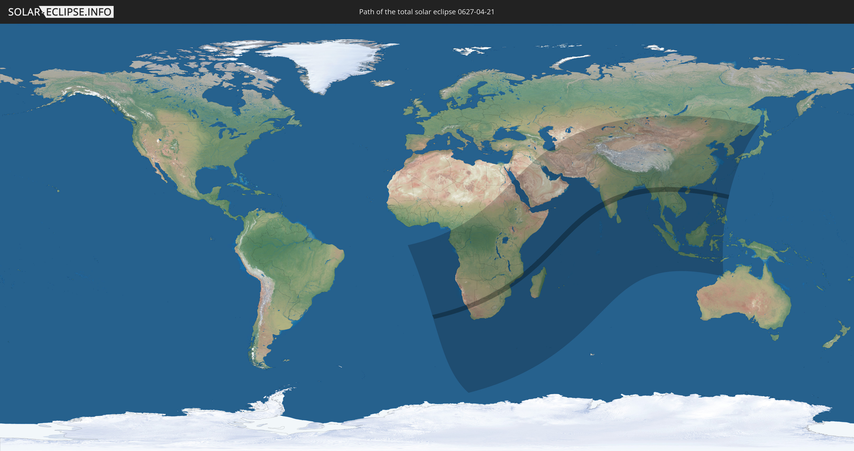
Die Sonnenfinsternis am 21.04.0627 kann man in 82 Ländern als partielle Sonnenfinsternis beobachten.
Der Finsternispfad verläuft durch 16 Länder. Nur in diesen Ländern ist sie als totale Sonnenfinsternis zu sehen.
In den folgenden Ländern ist die Sonnenfinsternis total zu sehen
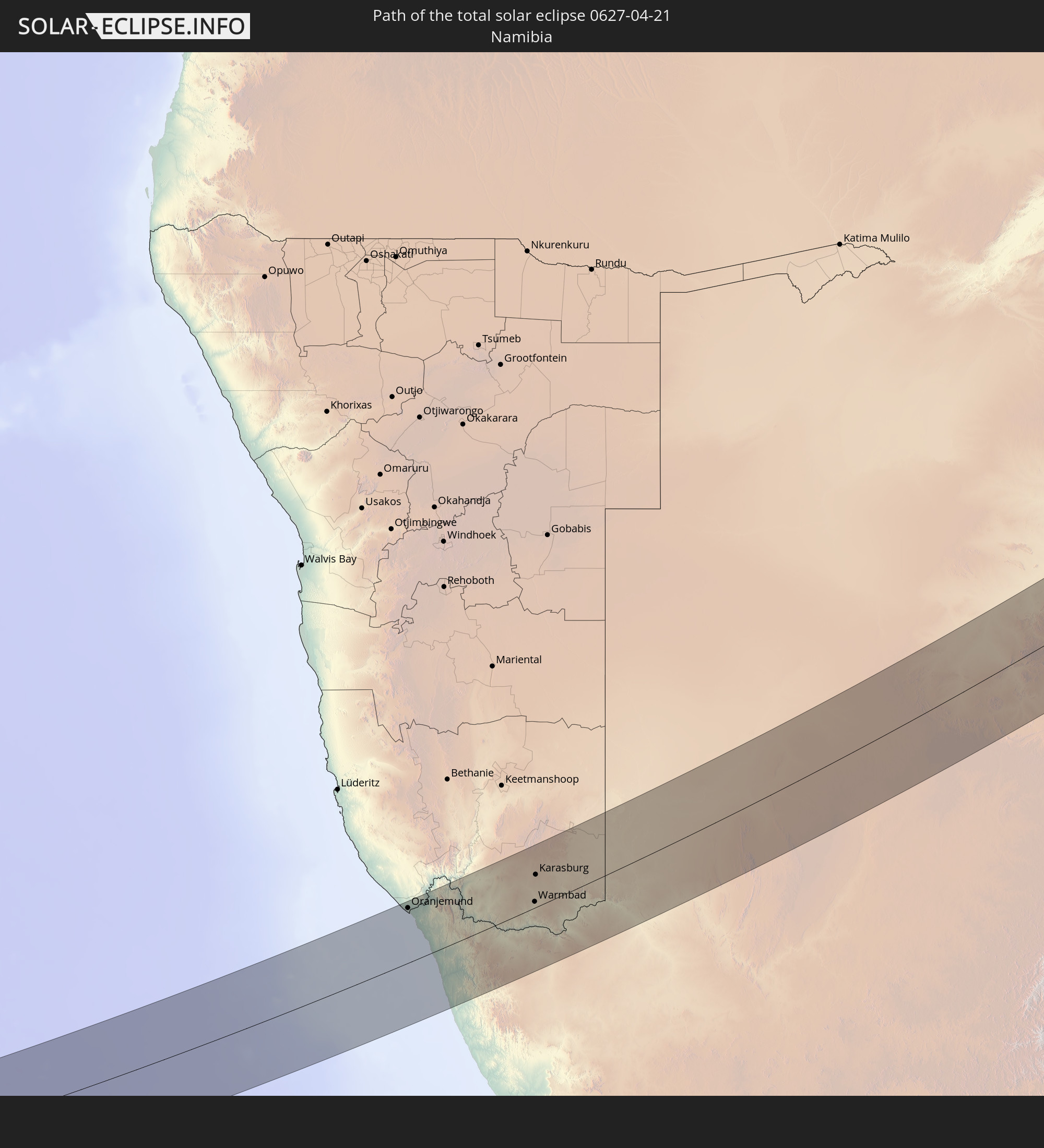 Namibia
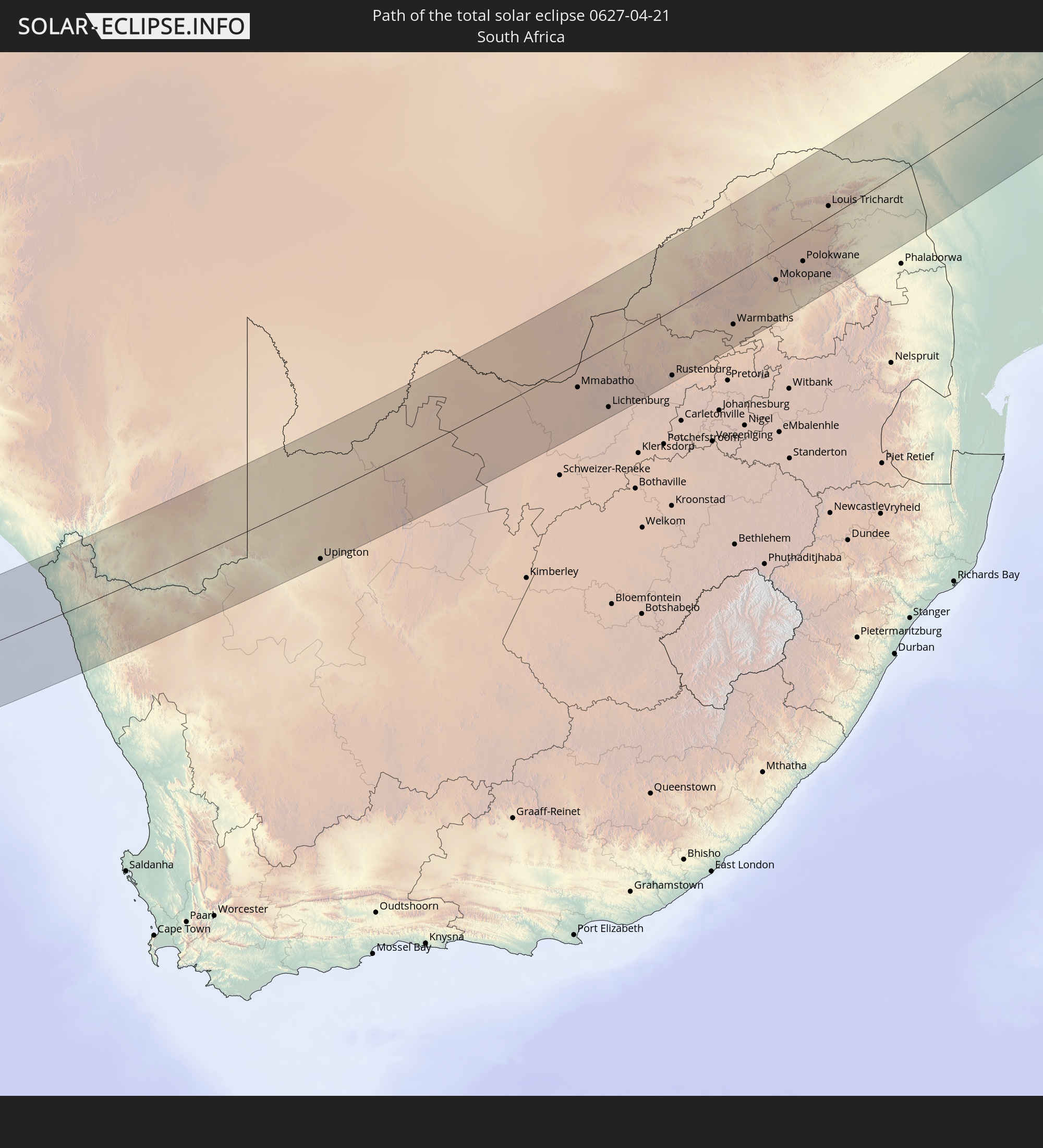 Südafrika
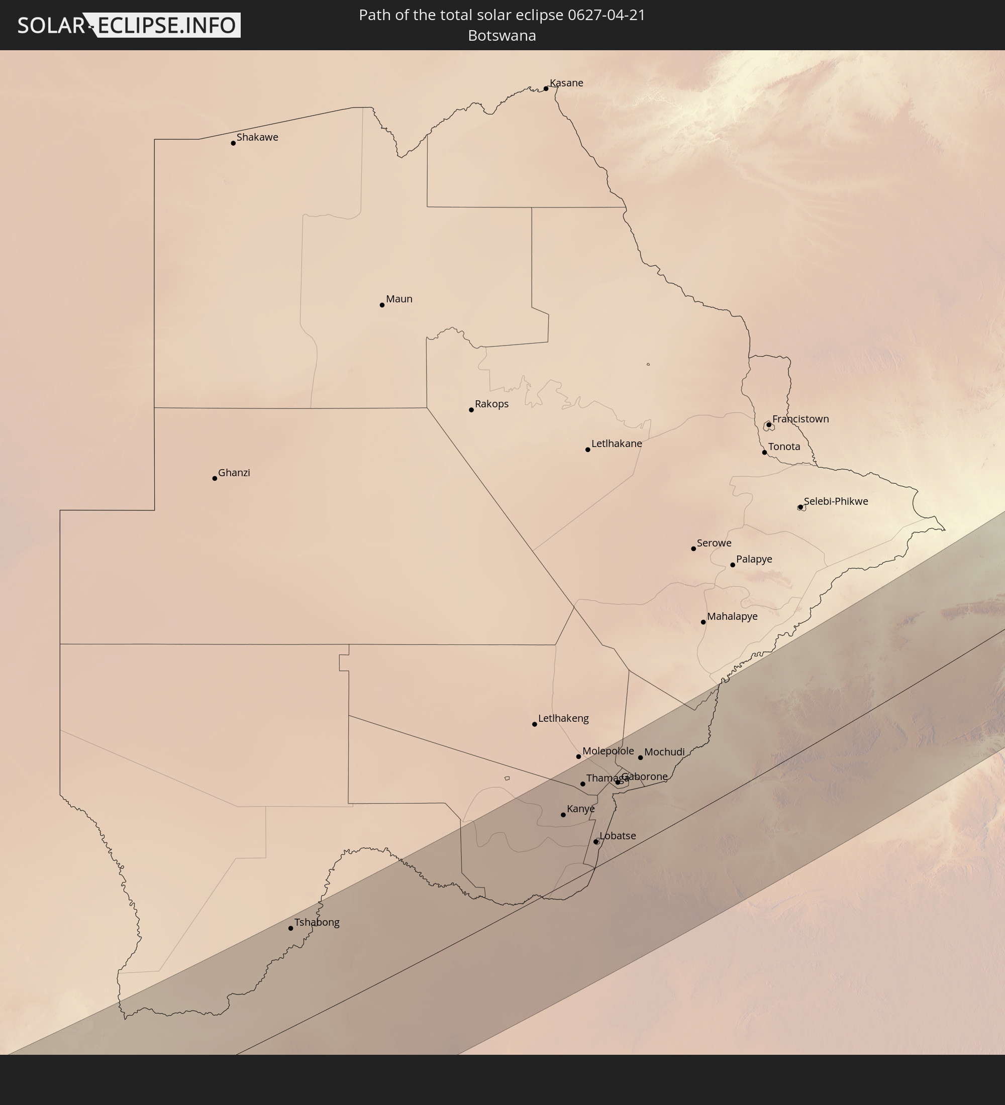 Botswana
 Simbabwe
 Mosambik
 Französische Süd- und Antarktisgebiete
 Komoren
 Mayotte
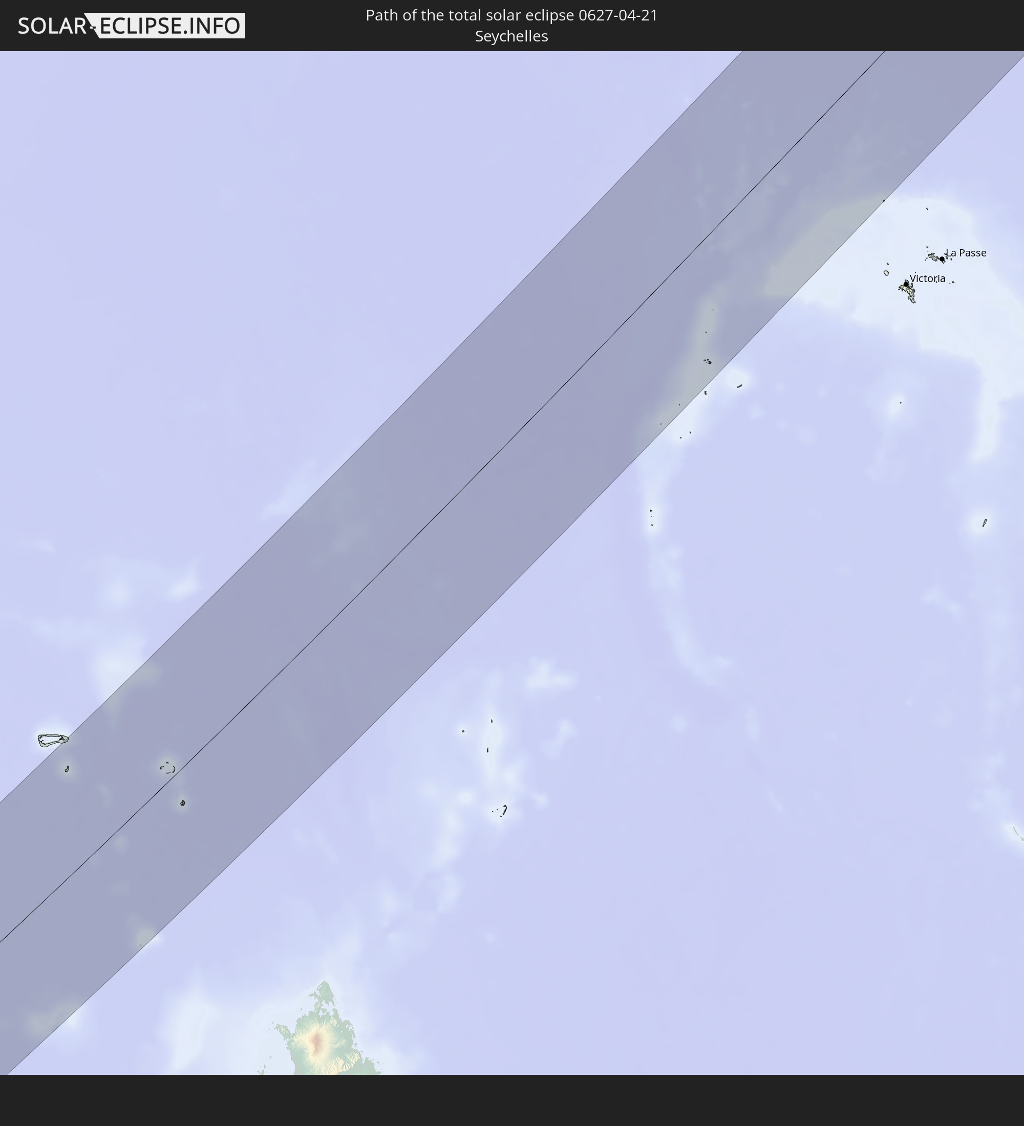 Seychellen
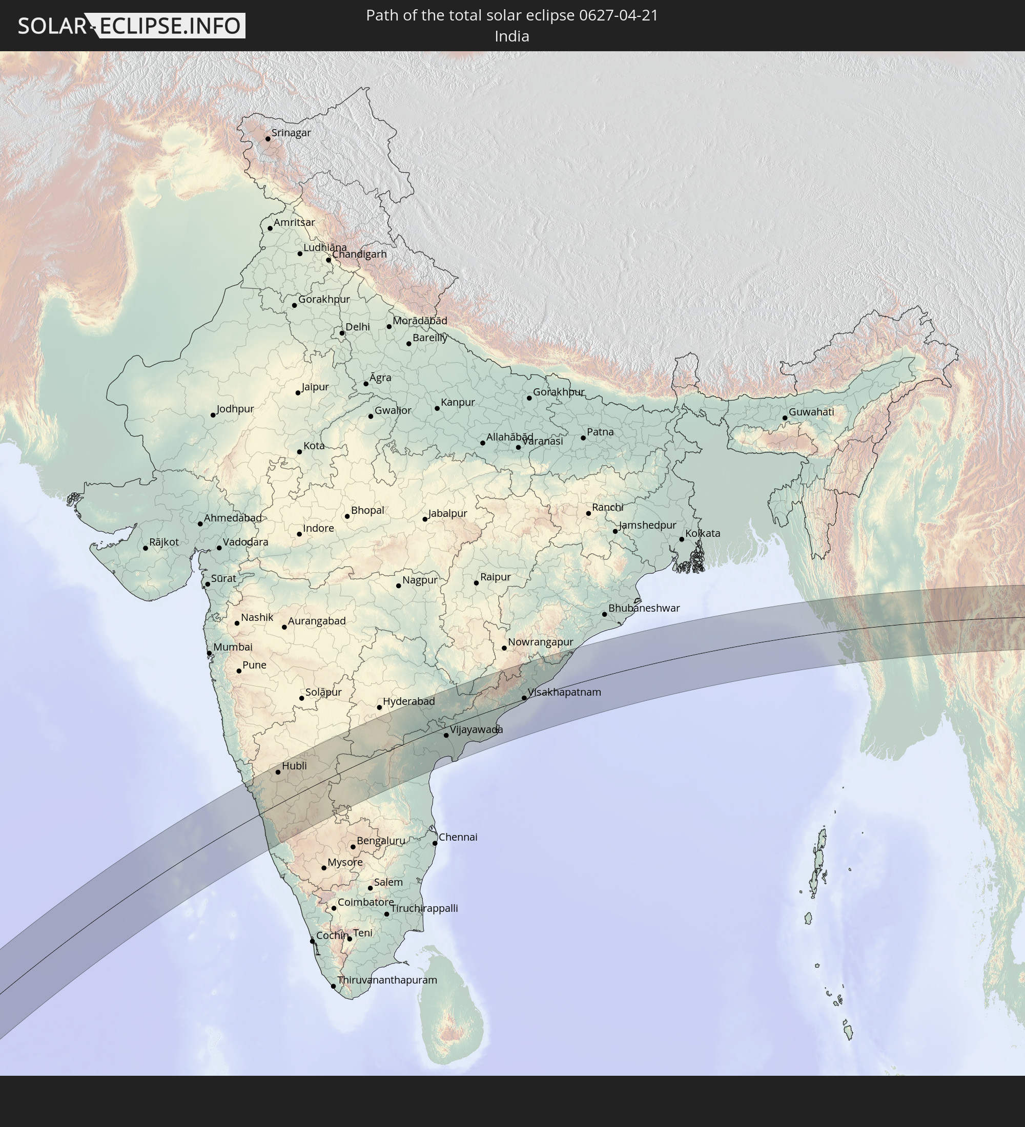 Indien
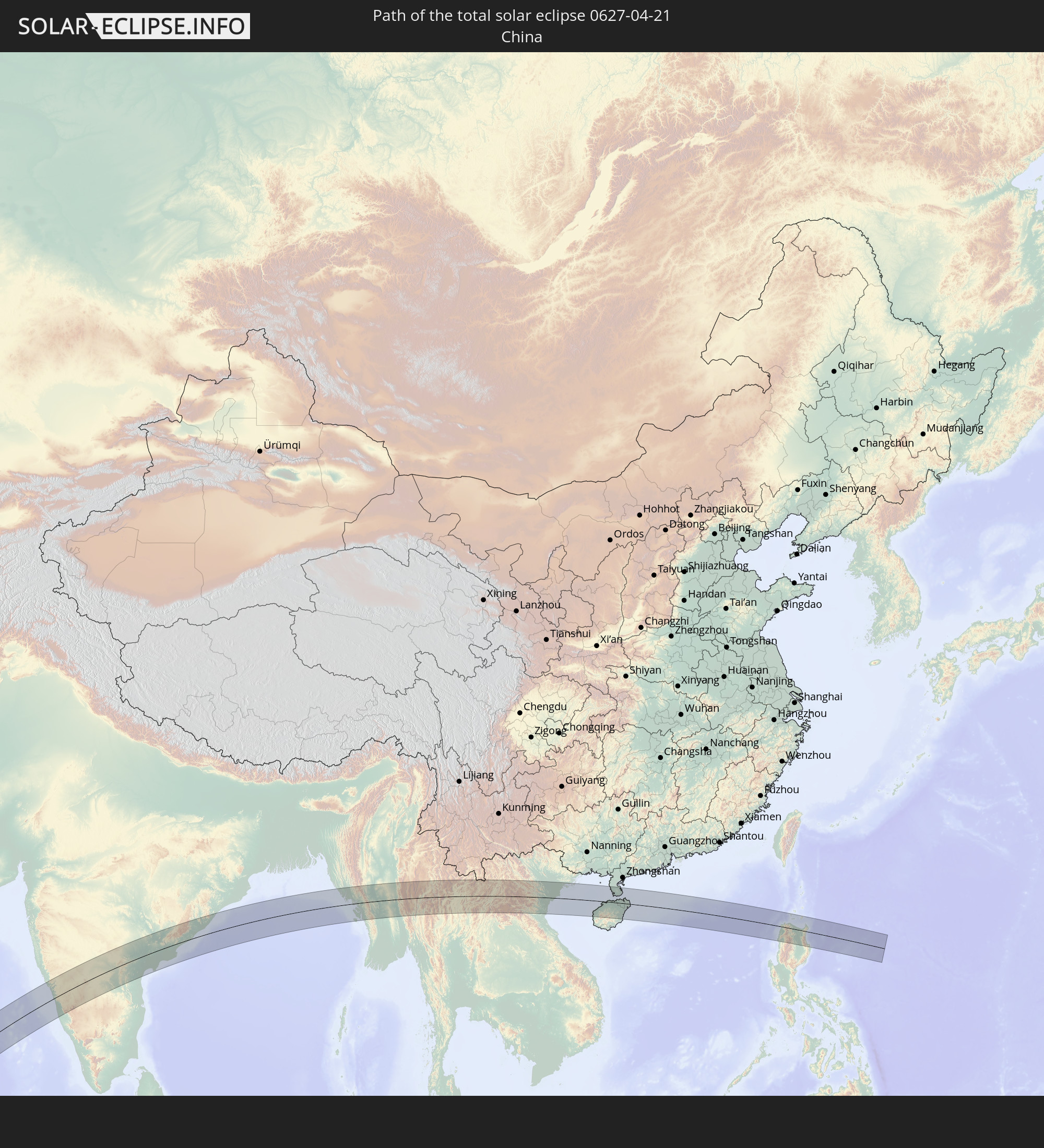 Volksrepublik China
 Myanmar
 Thailand
 Laos
Laos
 Vietnam
 Philippinen
In den folgenden Ländern ist die Sonnenfinsternis partiell zu sehen
 Russland
 Äquatorialguinea
 São Tomé und Príncipe
 Kamerun
 Gabun
Gabun
 Republik Kongo
 Angola
 Namibia
 Demokratische Republik Kongo
 Tschad
 Zentralafrikanische Republik
 Südafrika
 Botswana
 Sudan
Sudan
 Sambia
 Ägypten
 Simbabwe
 Lesotho
 Ruanda
 Burundi
 Tansania
 Uganda
 Mosambik
 Swasiland
 Malawi
 Äthiopien
 Kenia
Kenia
 Saudi-Arabien
 Eritrea
 Irak
Irak
 Französische Süd- und Antarktisgebiete
 Somalia
 Dschibuti
 Jemen
Jemen
 Madagaskar
 Komoren
 Iran
Iran
 Mayotte
 Seychellen
 Kasachstan
 Kuwait
 Bahrain
 Katar
Katar
 Vereinigte Arabische Emirate
 Oman
Oman
 Turkmenistan
 Réunion
 Usbekistan
 Mauritius
 Afghanistan
 Pakistan
 Tadschikistan
 Indien
 Kirgisistan
 Britisches Territorium im Indischen Ozean
 Malediven
 Volksrepublik China
 Sri Lanka
 Nepal
Nepal
 Mongolei
 Bangladesch
 Bhutan
 Myanmar
 Indonesien
 Kokosinseln
 Thailand
 Malaysia
 Laos
Laos
 Vietnam
 Kambodscha
 Singapur
 Weihnachtsinsel
 Australien
 Macau
Macau
 Hongkong
 Brunei
 Taiwan
 Philippinen
 Japan
Japan
 Osttimor
 Nordkorea
 Südkorea
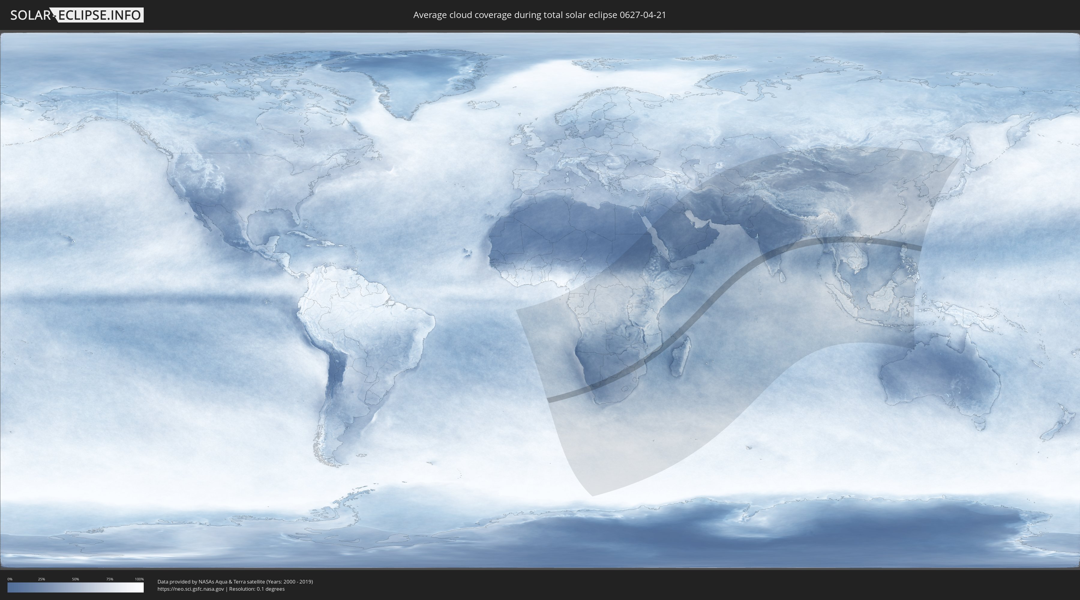
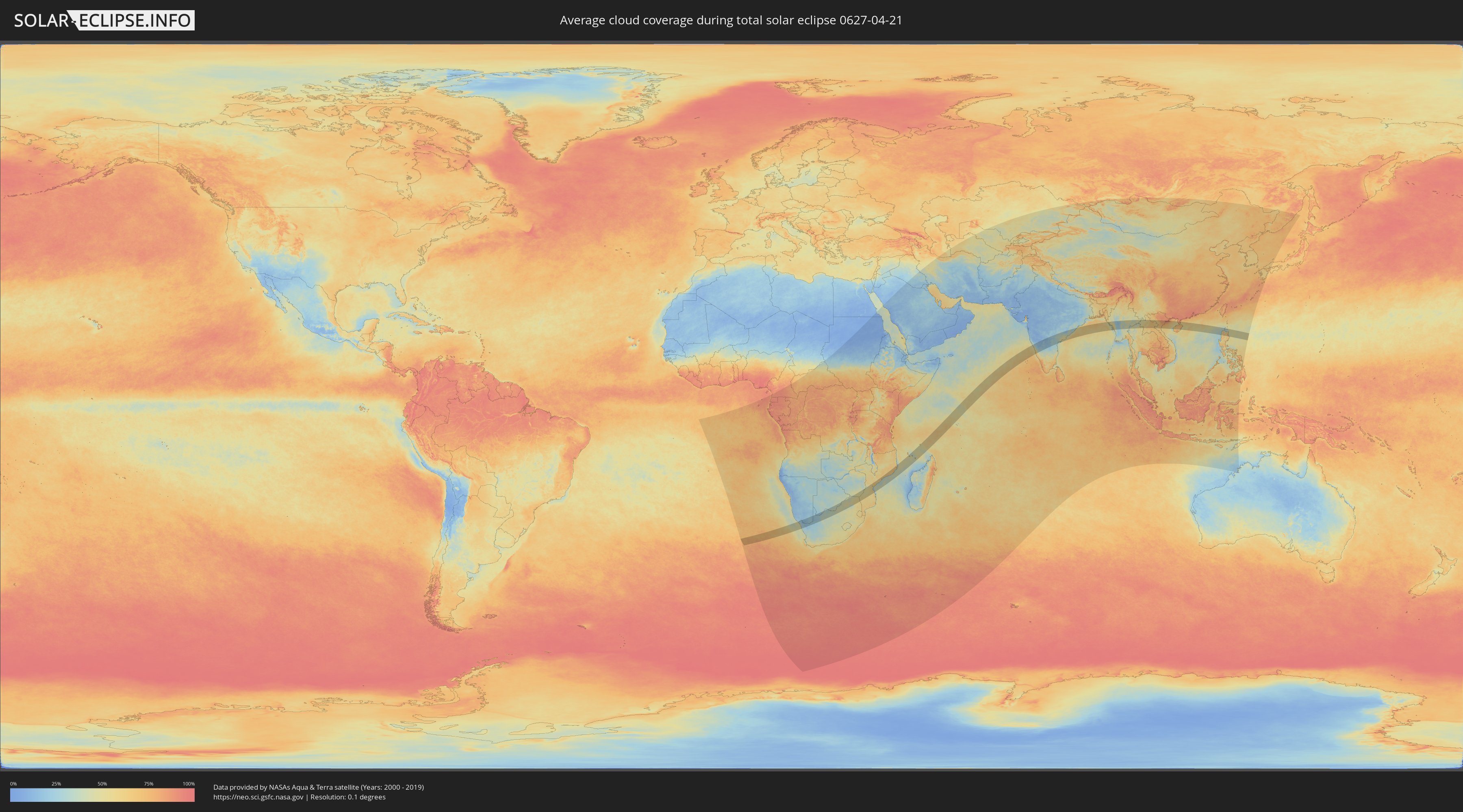
Wie wird das Wetter während der totalen Sonnenfinsternis am 21.04.0627?
Wo ist der beste Ort, um die totale Sonnenfinsternis vom 21.04.0627 zu beobachten?
Die folgenden Karten zeigen die durchschnittliche Bewölkung für den Tag, an dem die totale Sonnenfinsternis
stattfindet. Mit Hilfe der Karten lässt sich der Ort entlang des Finsternispfades eingrenzen,
der die besten Aussichen auf einen klaren wolkenfreien Himmel bietet.
Trotzdem muss man immer lokale Gegenenheiten beachten und sollte sich genau über das Wetter an seinem
gewählten Beobachtungsort informieren.
Die Daten stammen von den beiden NASA-Satelliten
AQUA und TERRA
und wurden über einen Zeitraum von 19 Jahren (2000 - 2019) gemittelt.
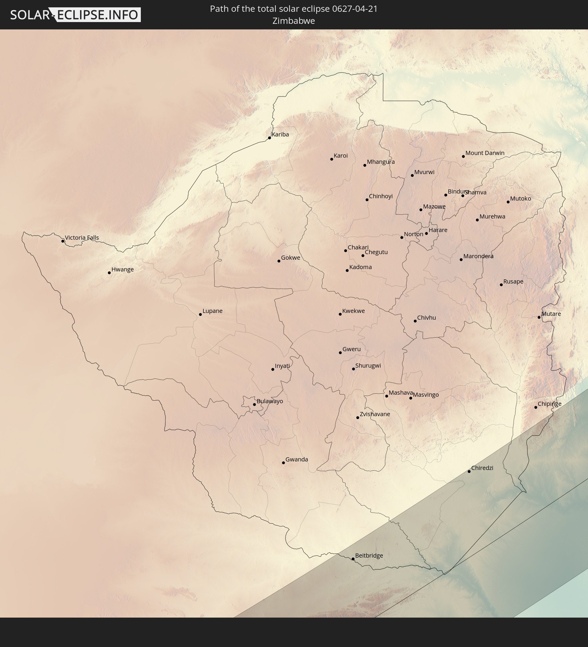
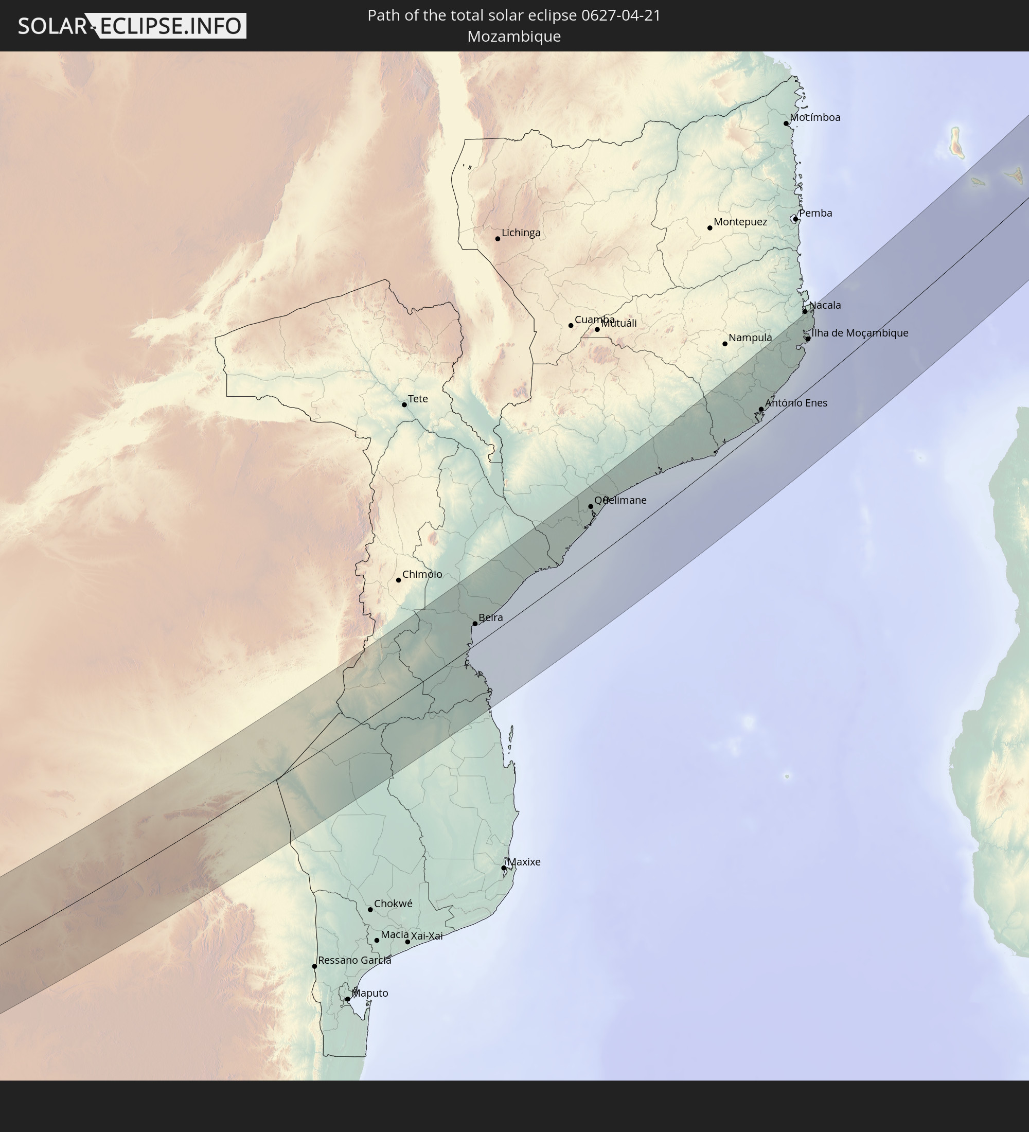
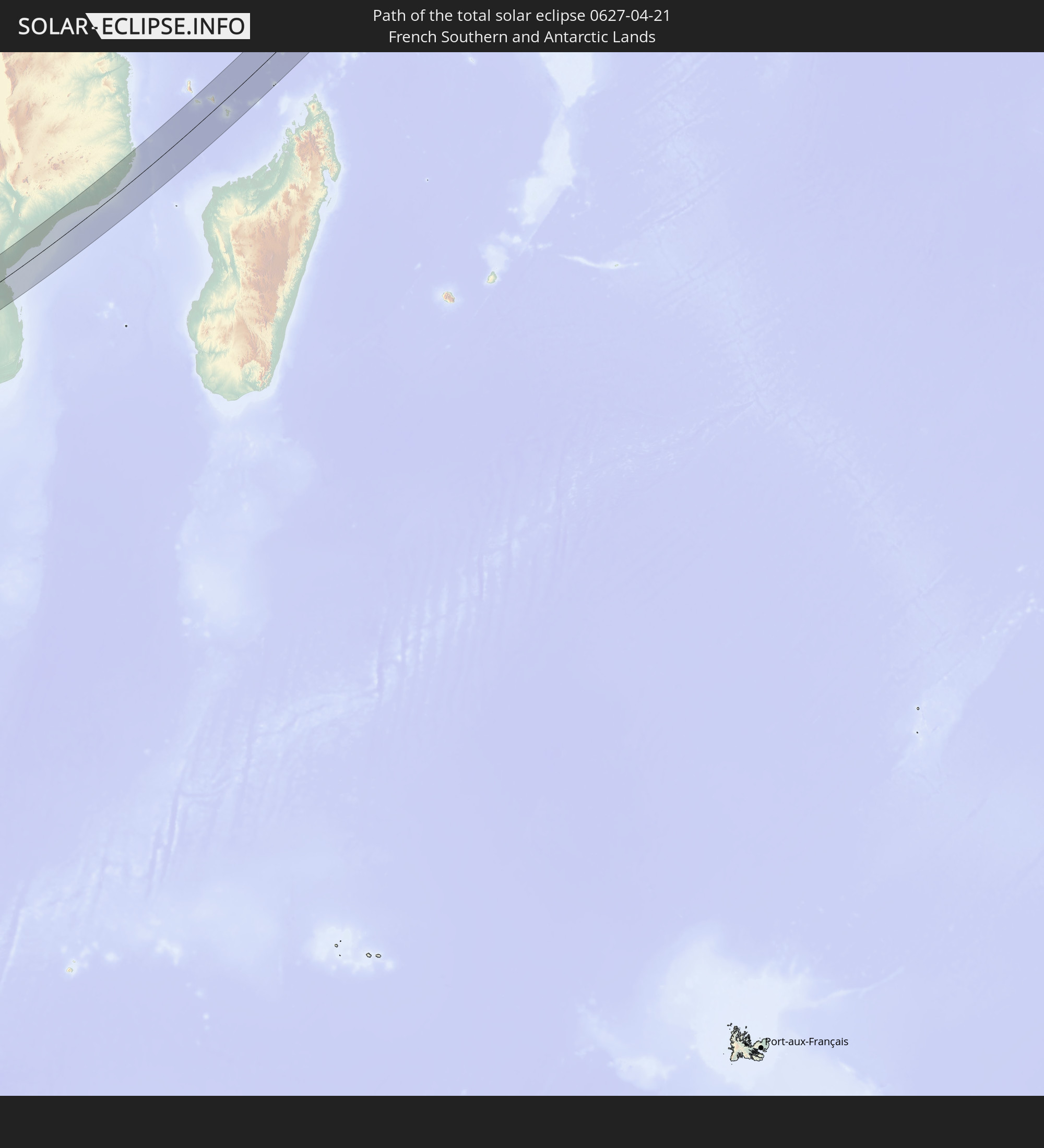
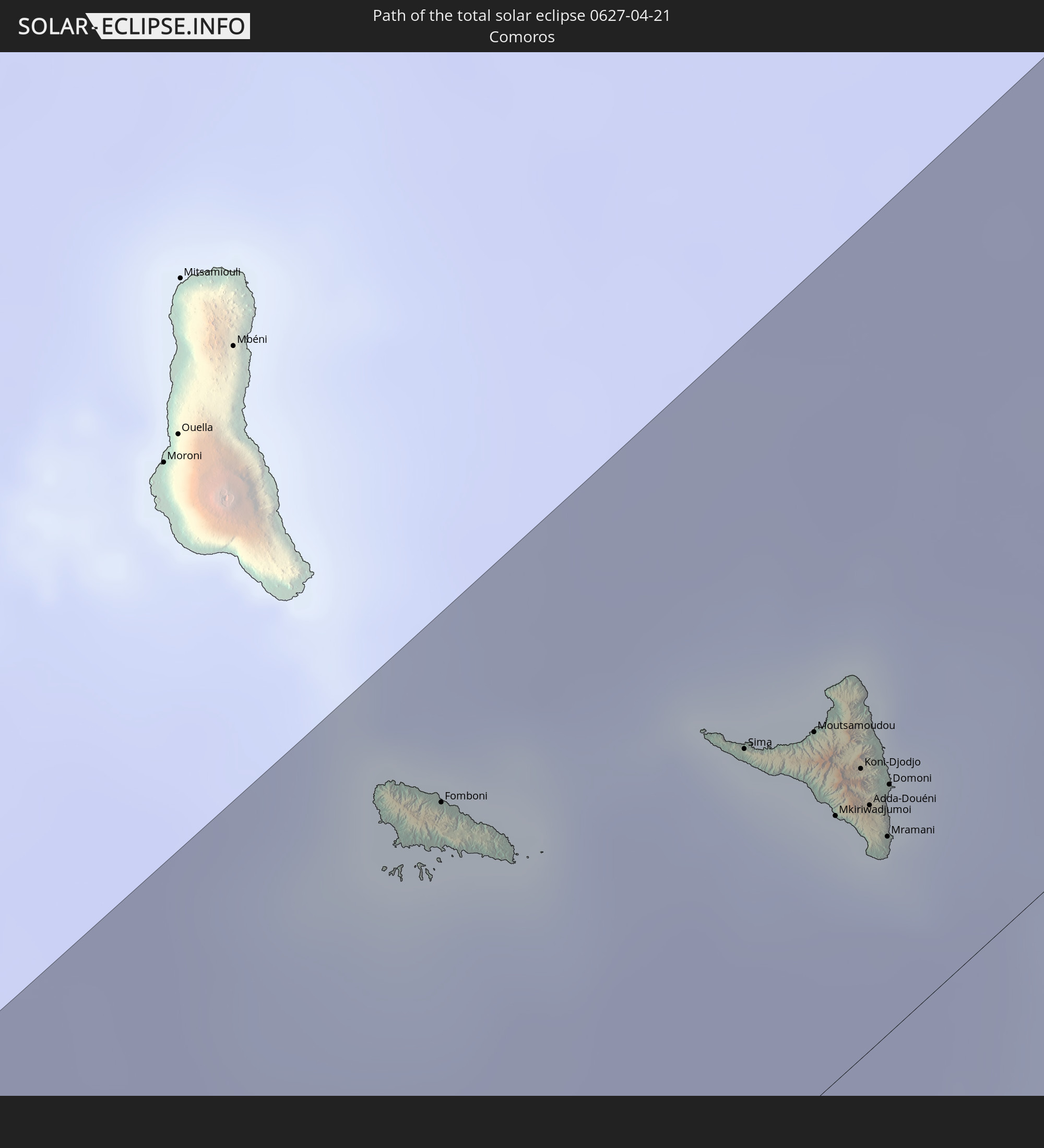
Detaillierte Länderkarten
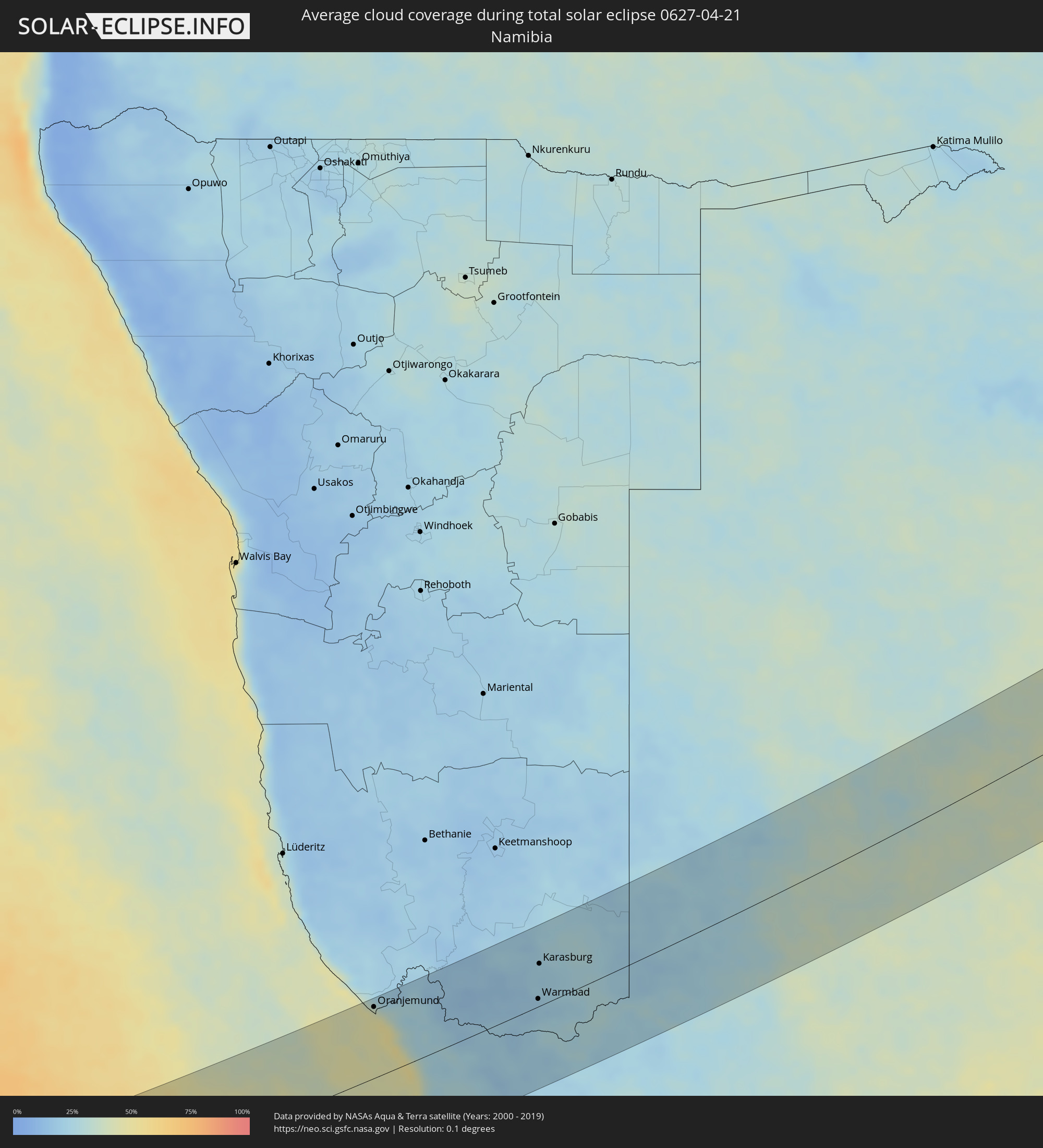 Namibia
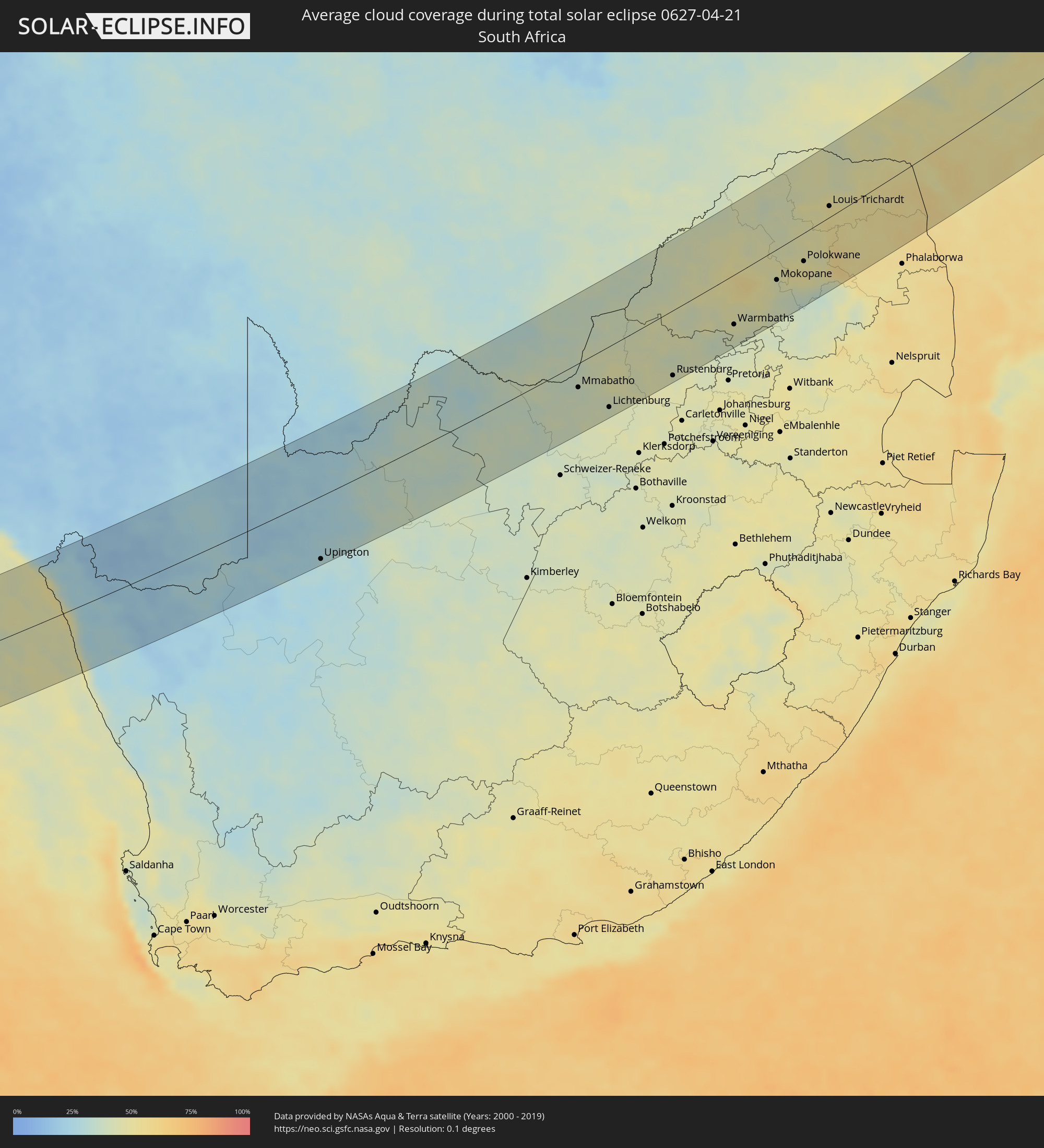 Südafrika
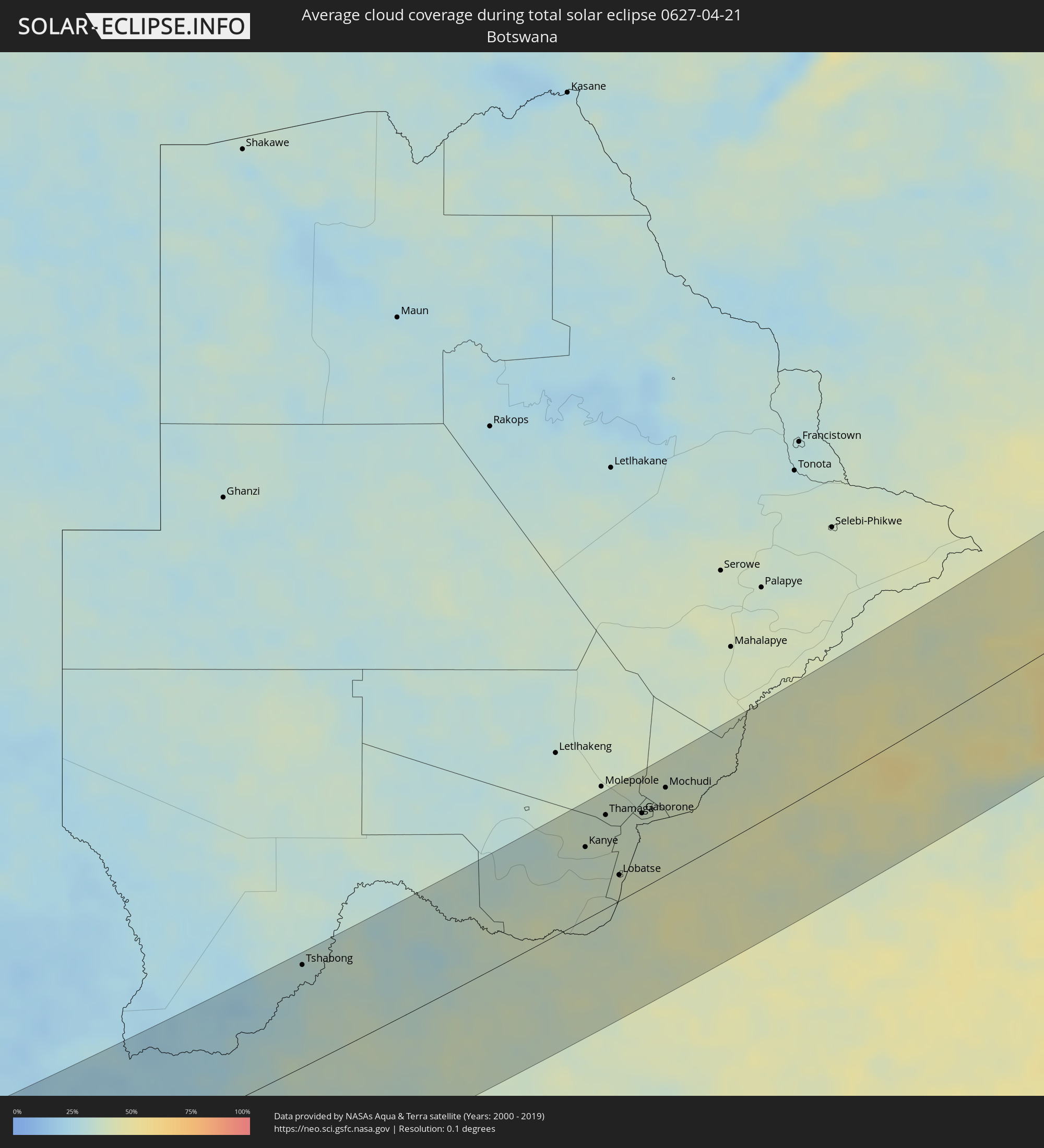 Botswana
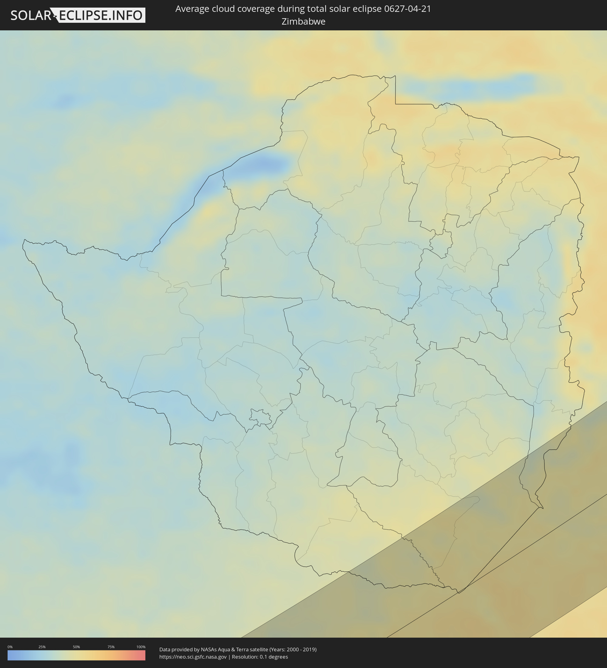 Simbabwe
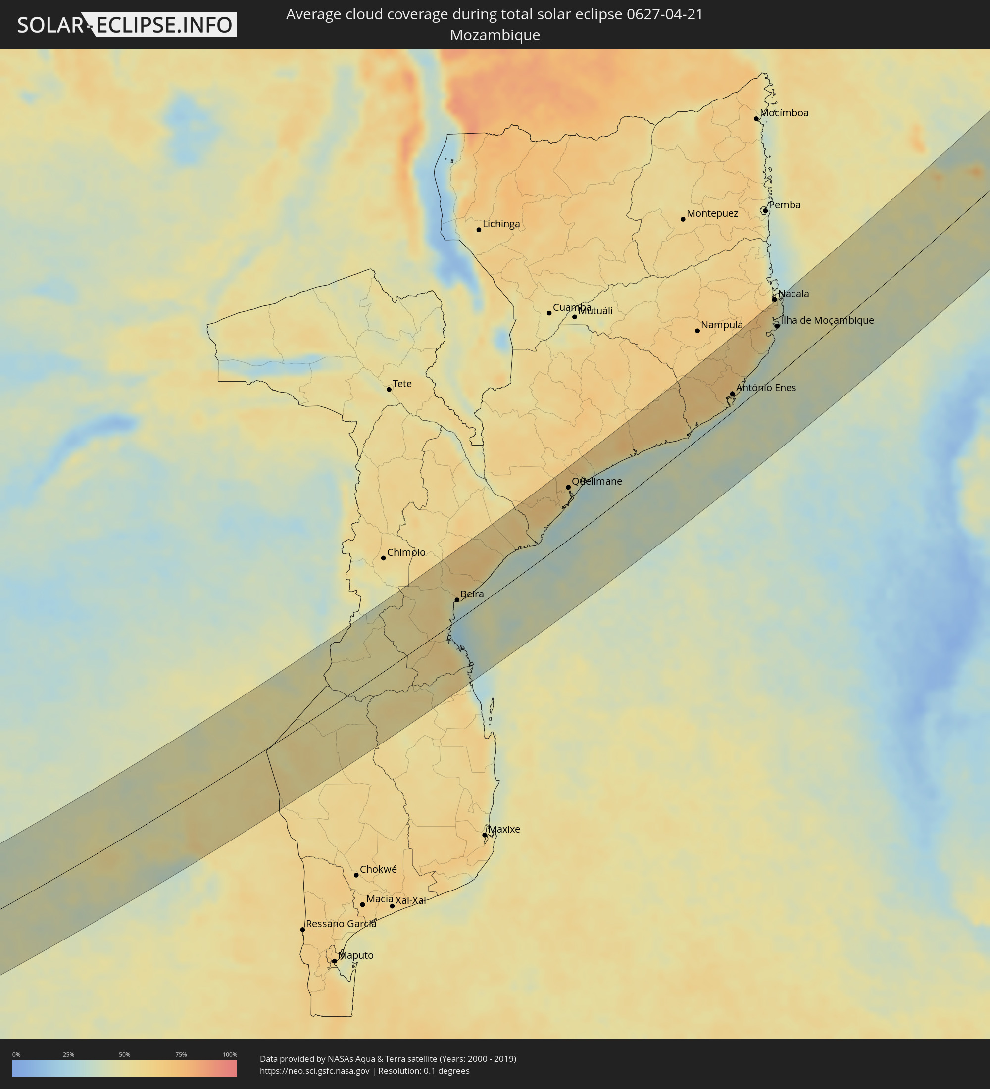 Mosambik
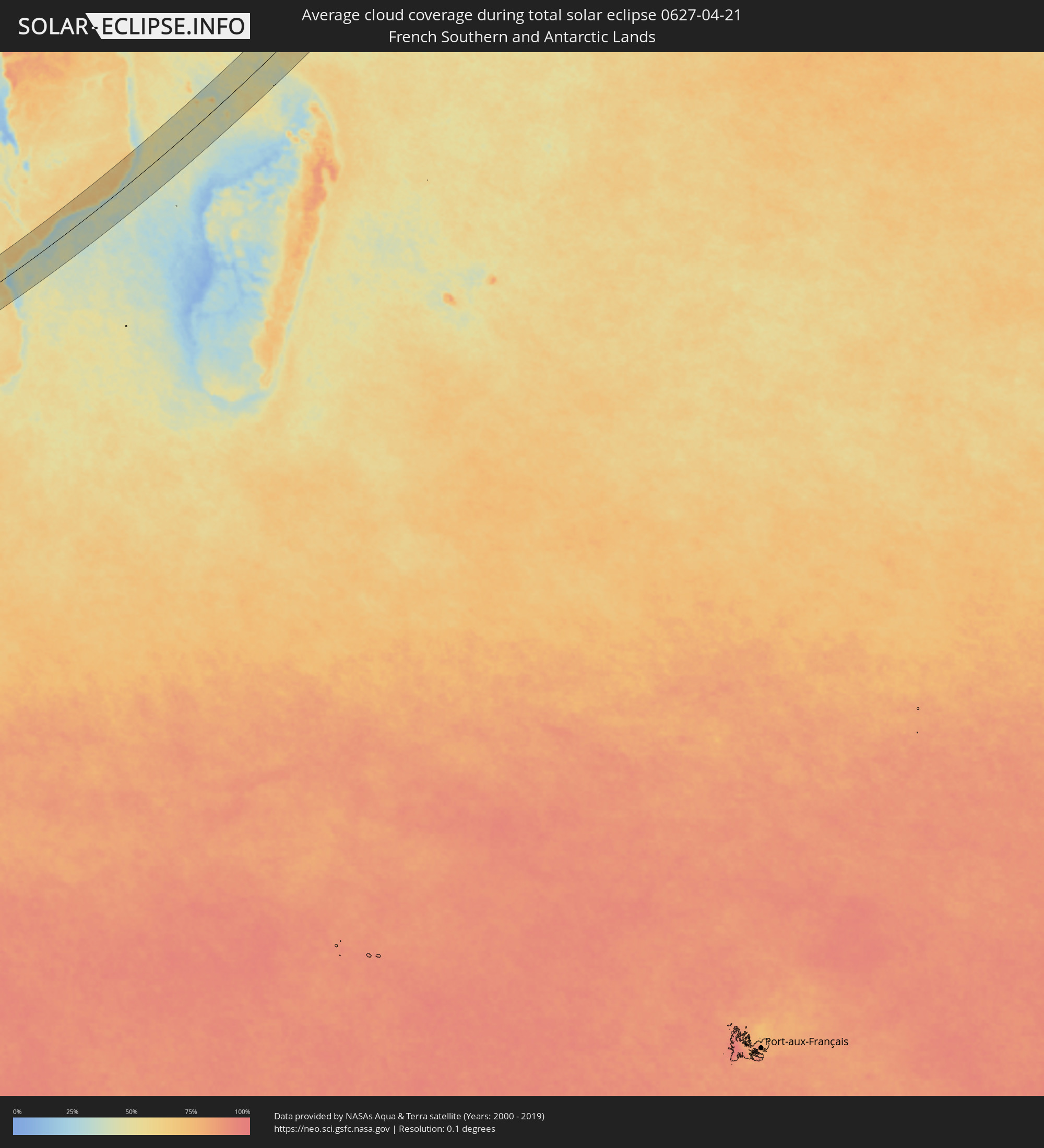 Französische Süd- und Antarktisgebiete
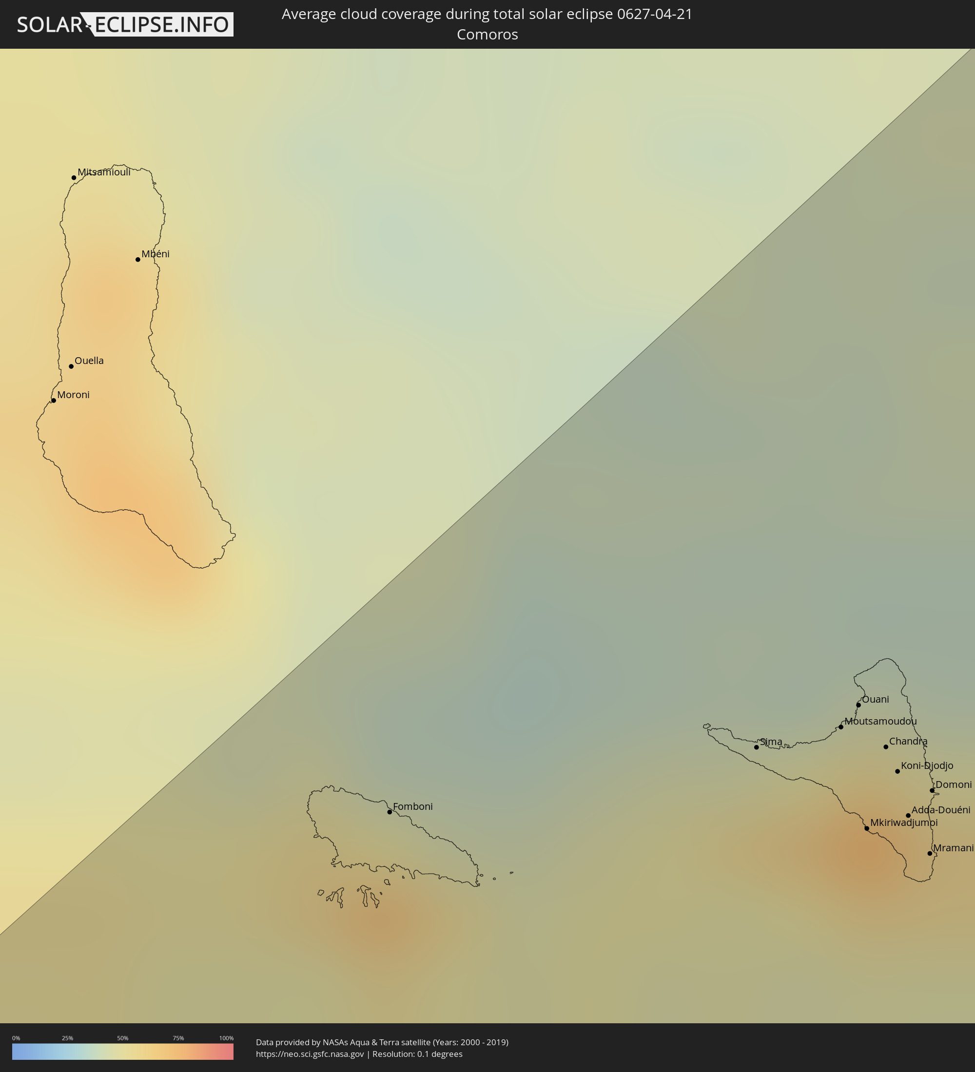 Komoren
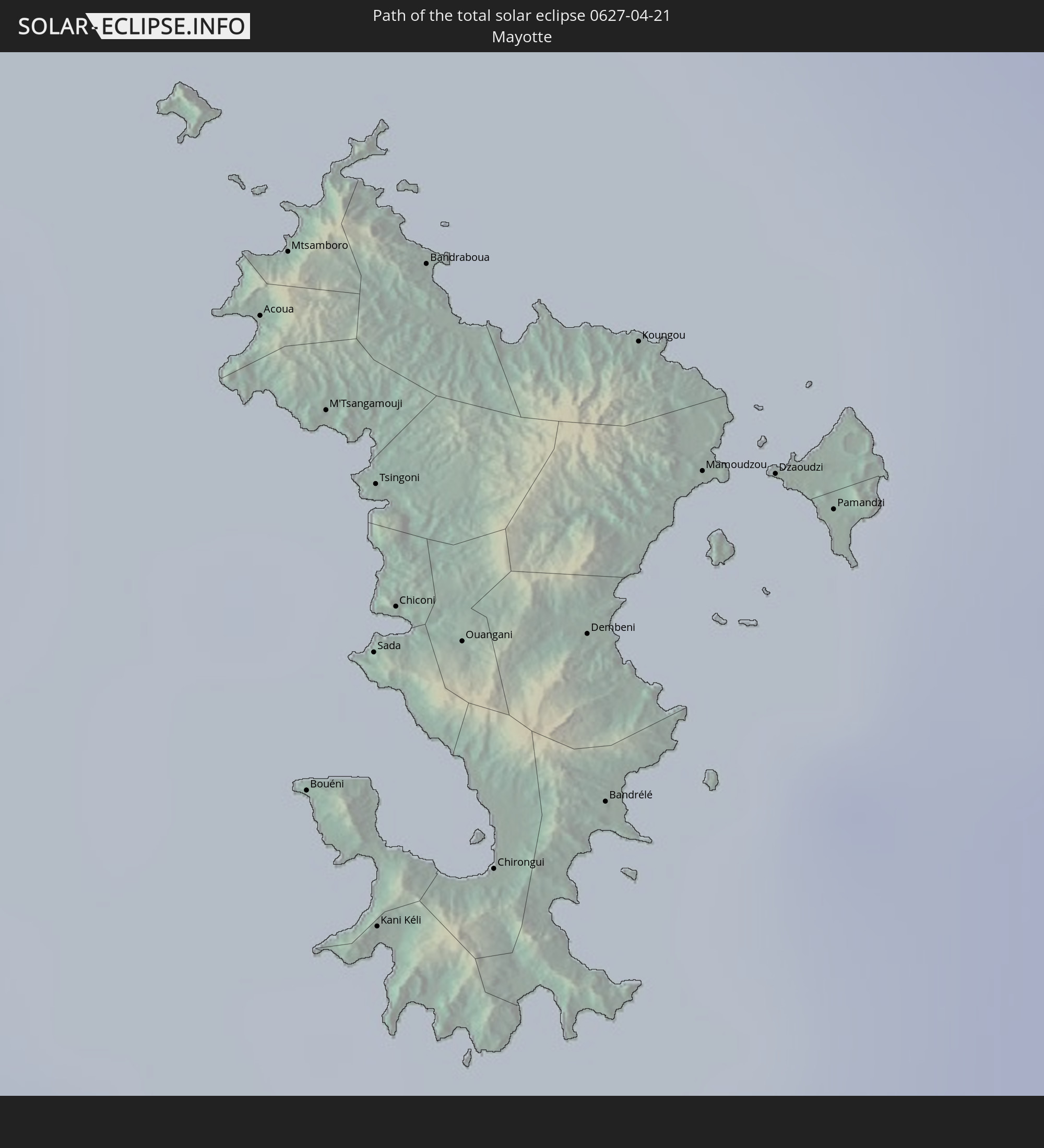
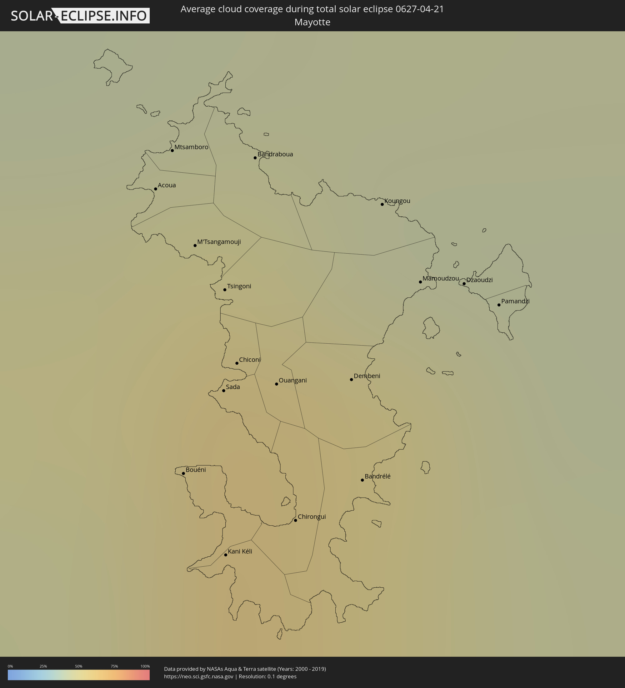 Mayotte
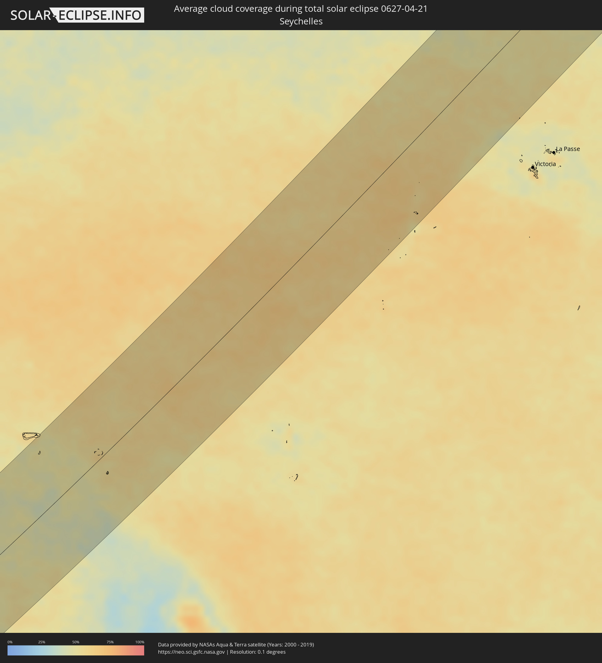 Seychellen
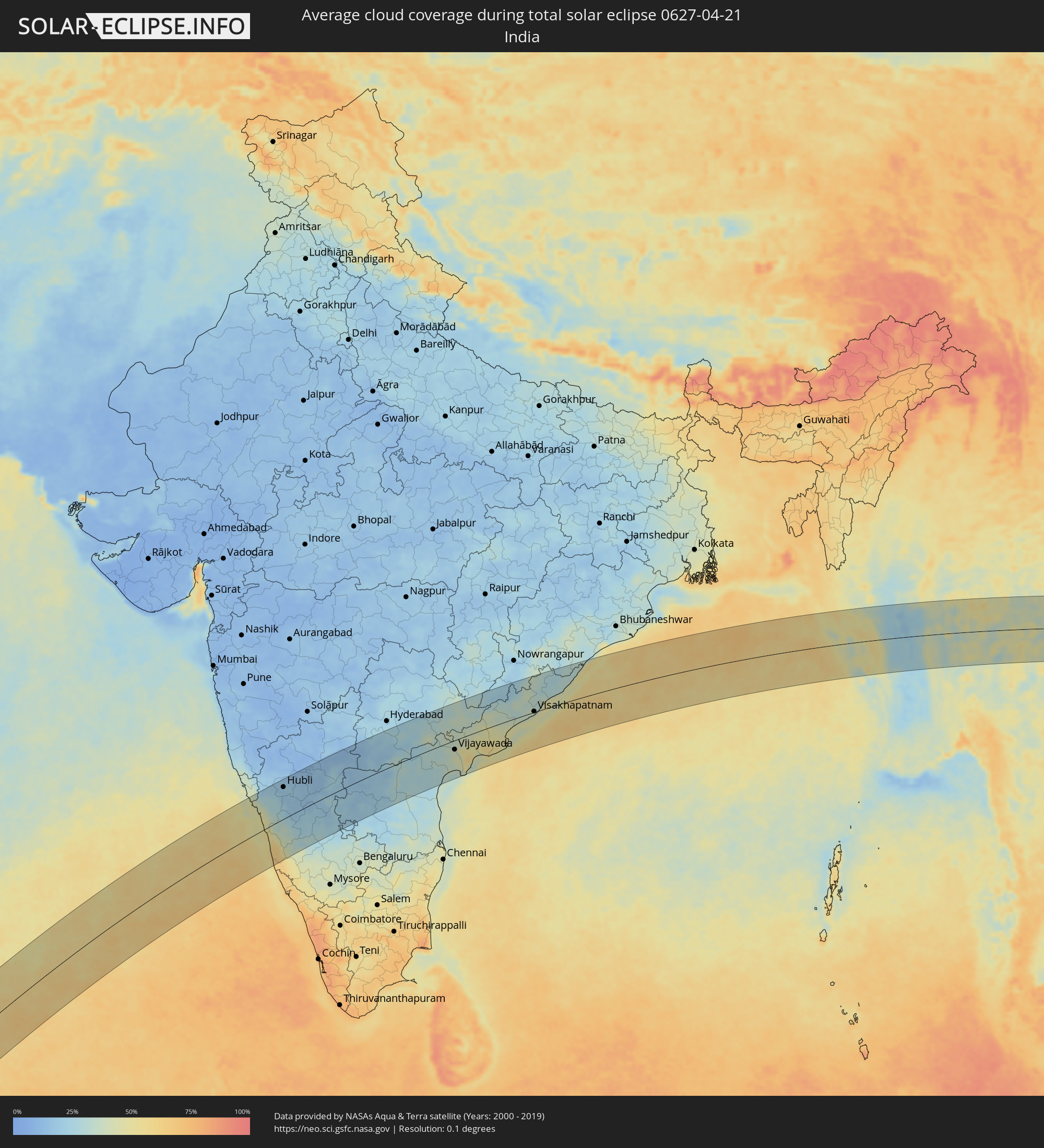 Indien
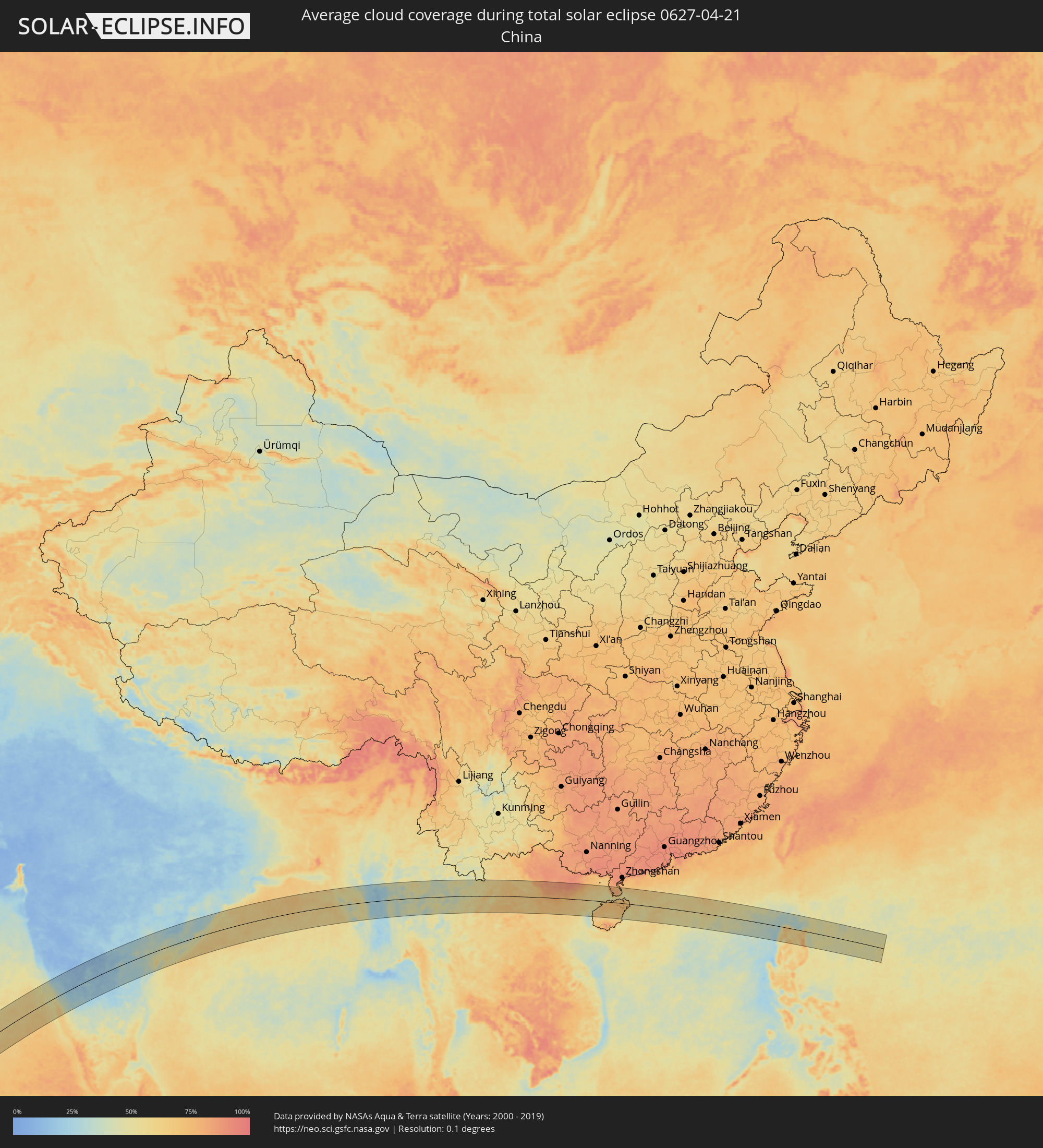 Volksrepublik China
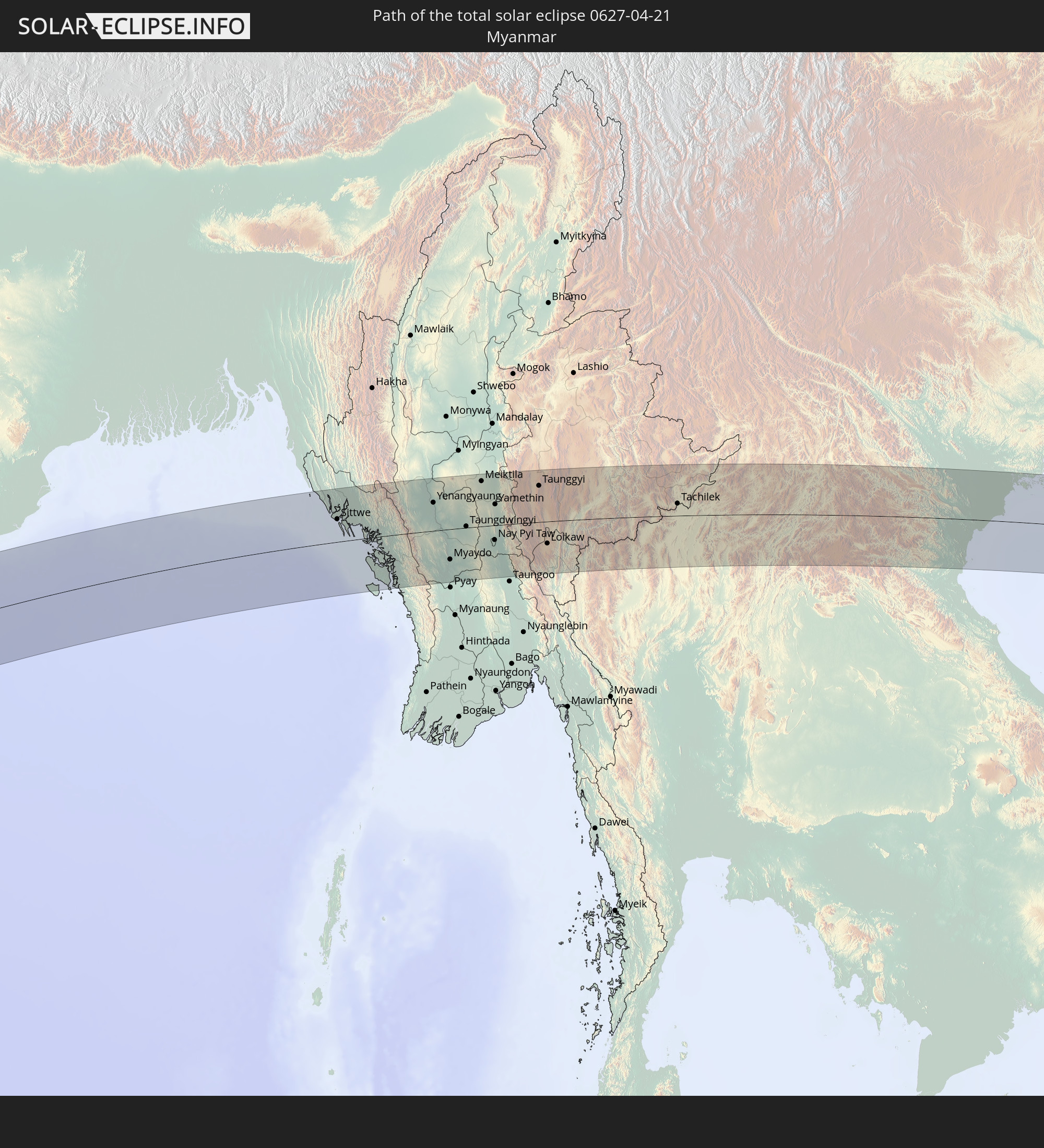
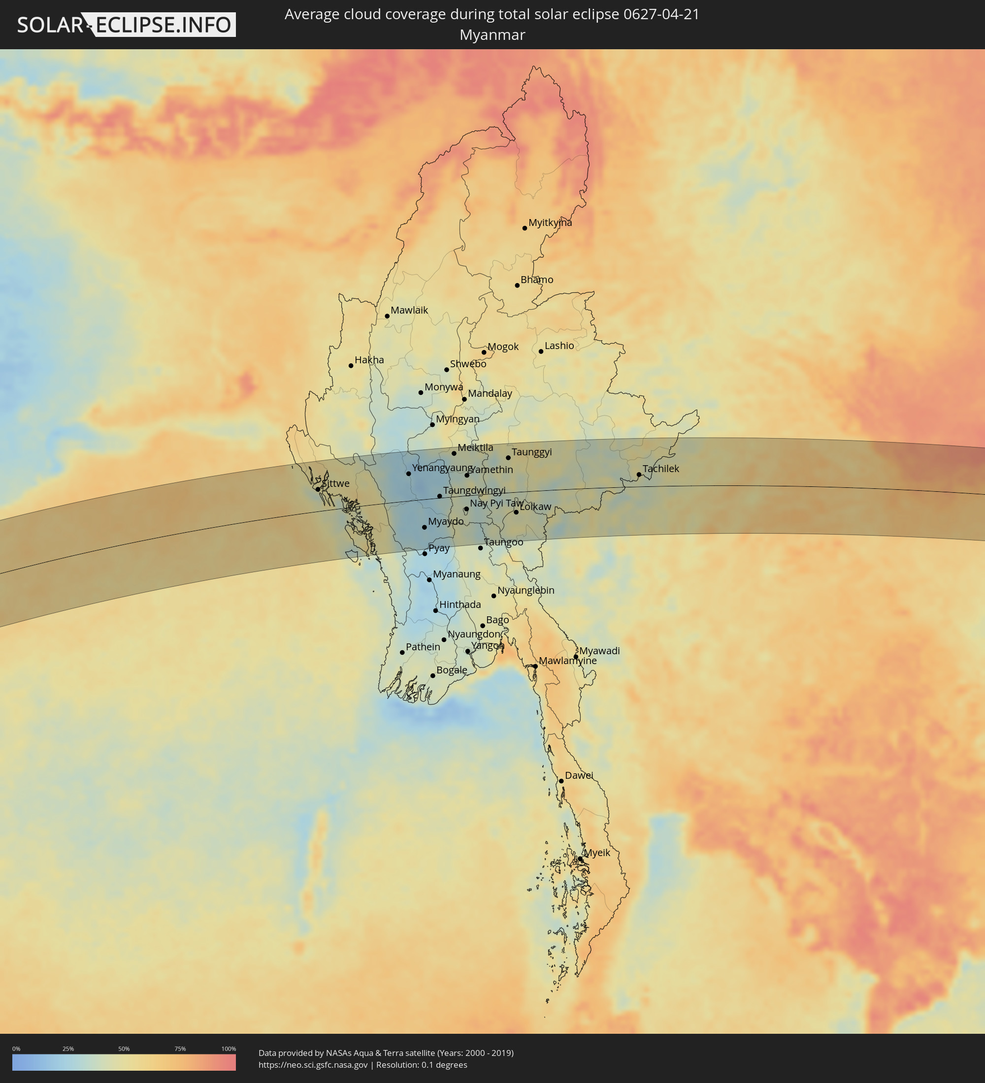 Myanmar
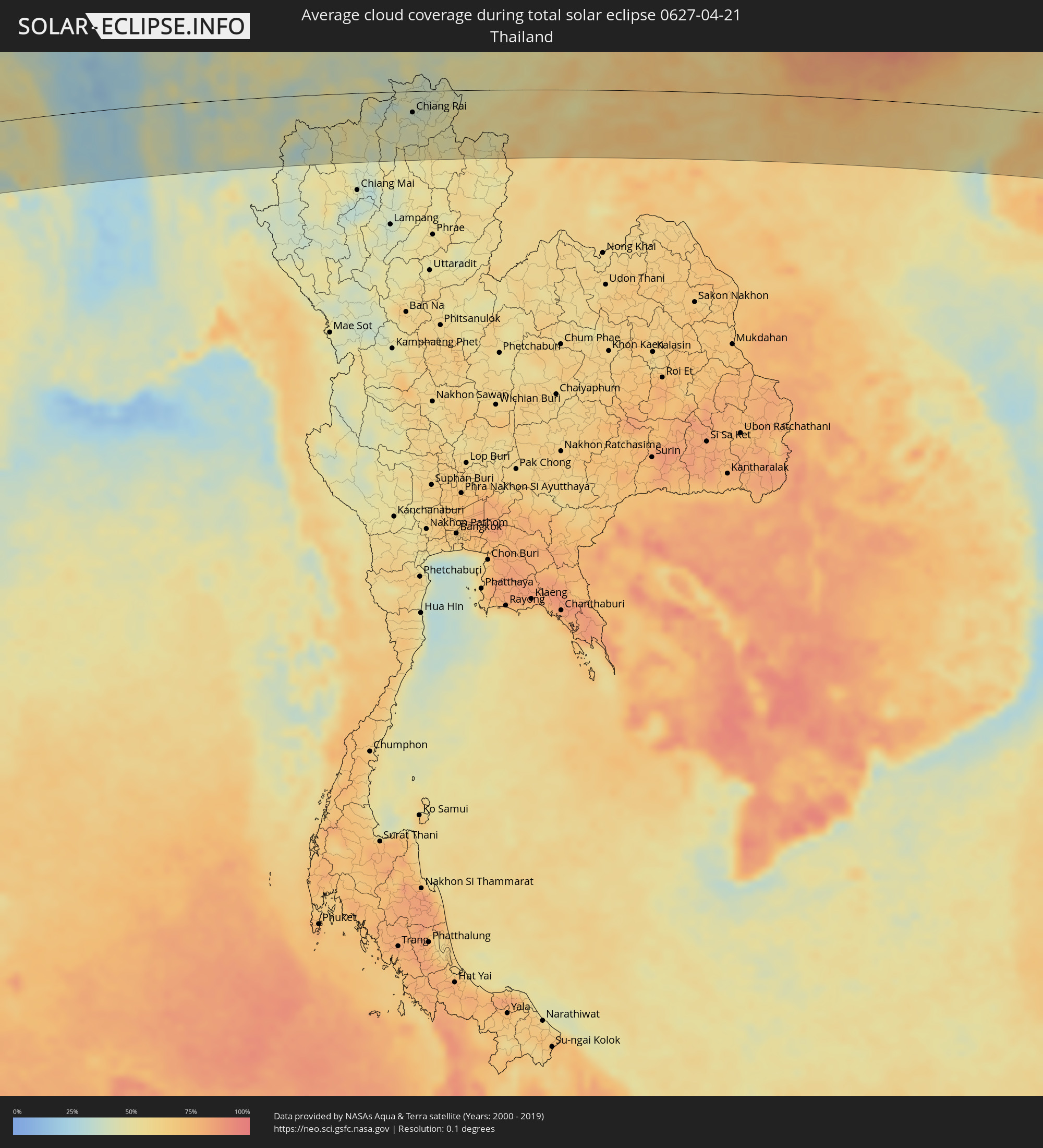 Thailand
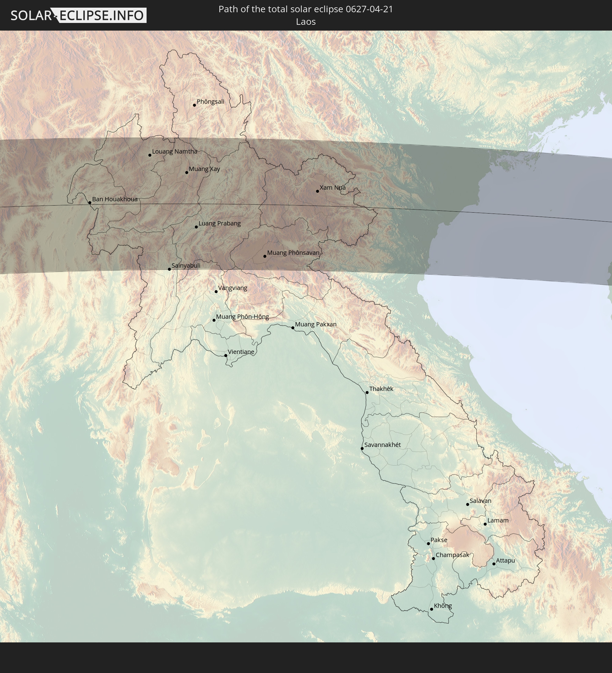
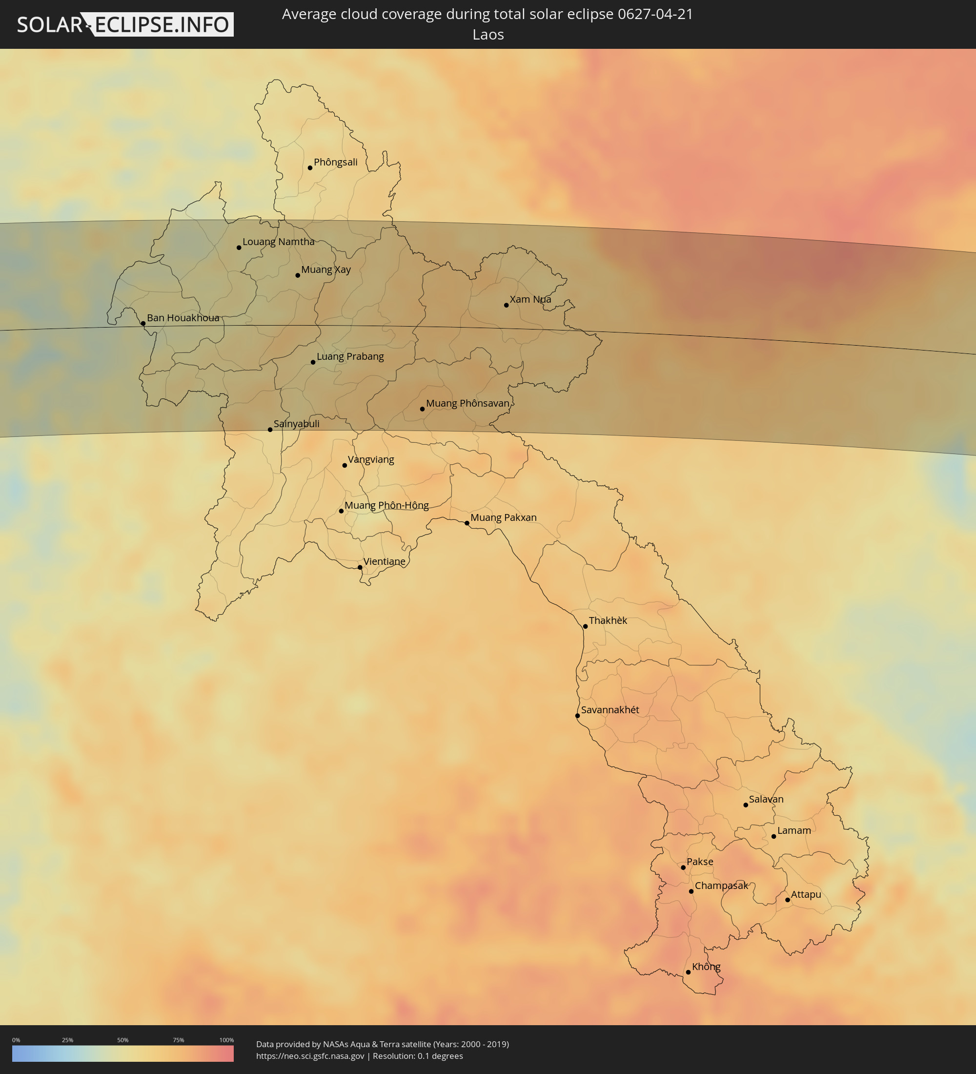 Laos
Laos
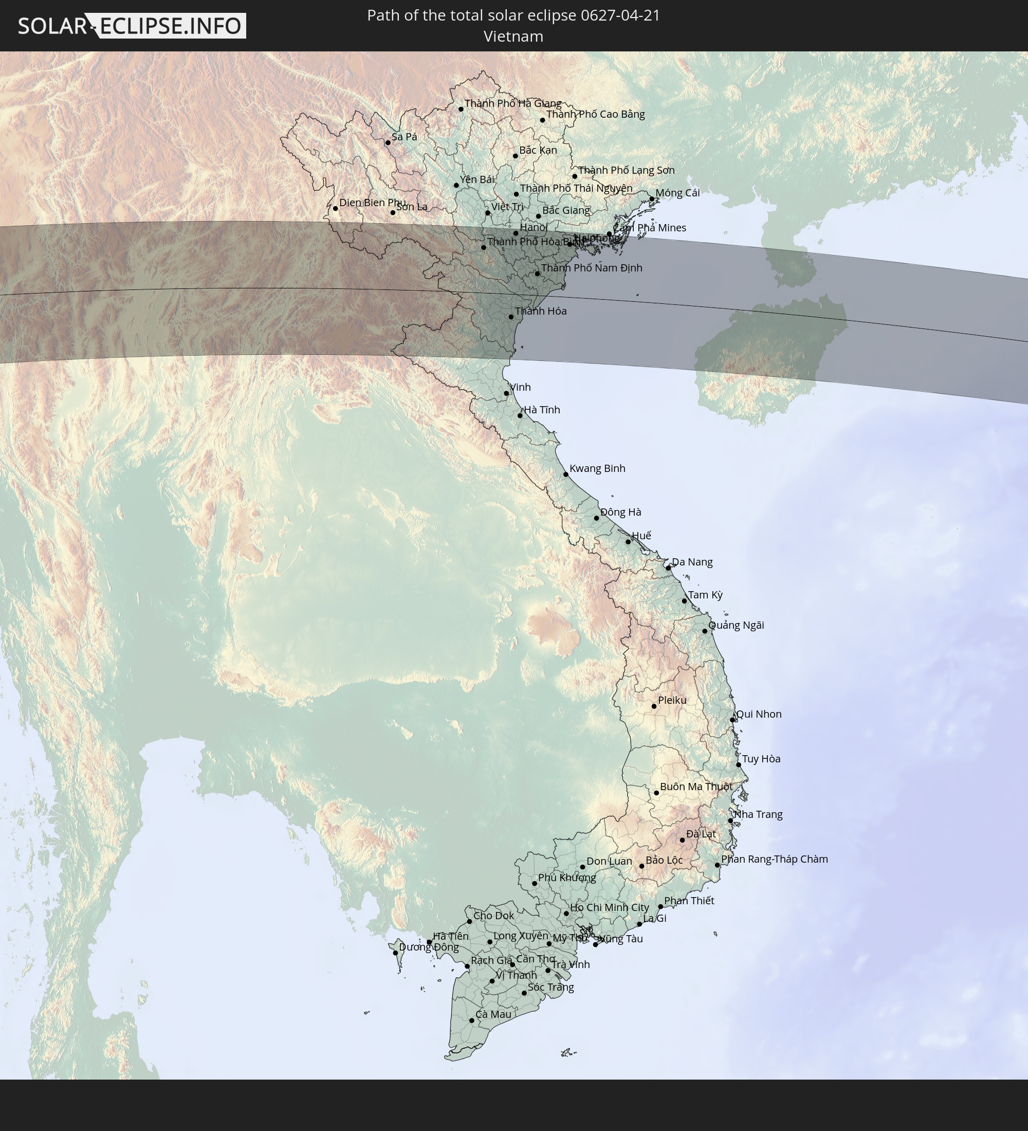
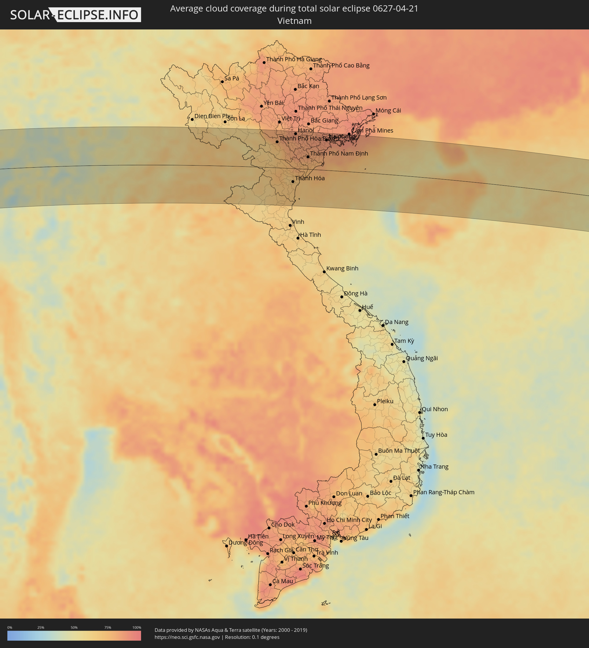 Vietnam
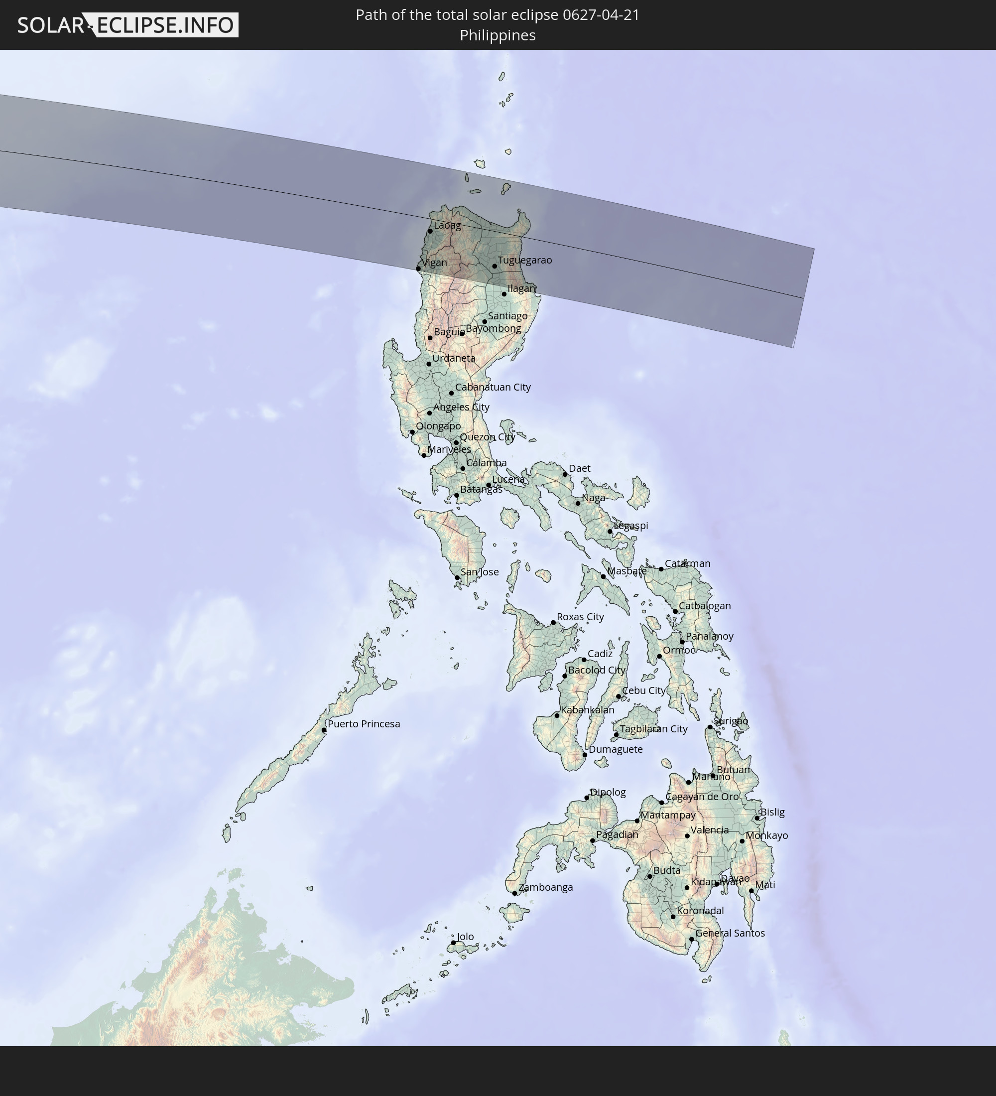
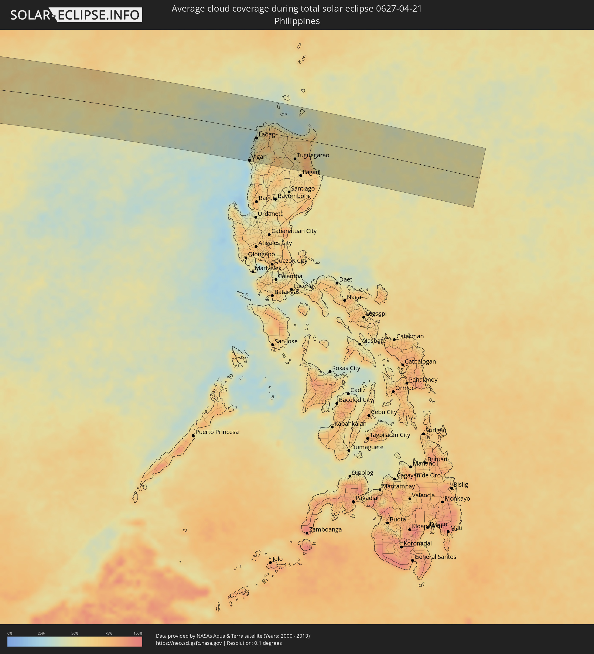 Philippinen
Orte im Finsternispfad
Die nachfolgene Tabelle zeigt Städte und Orte mit mehr als 5.000 Einwohnern, die sich im Finsternispfad befinden. Städte mit mehr als 100.000 Einwohnern sind dick gekennzeichnet. Mit einem Klick auf den Ort öffnet sich eine Detailkarte die die Lage des jeweiligen Ortes zusammen mit dem Verlauf der zentralen Finsternis präsentiert.
| Ort | Typ | Dauer der Verfinsterung | Ortszeit bei maximaler Verfinsterung | Entfernung zur Zentrallinie | Ø Bewölkung |
|
Oranjemund, Karas
|
total | - | 07:53:55 UTC+01:30 | 89 km | 47% |
|
Warmbad, Karas
|
total | - | 07:54:52 UTC+01:30 | 10 km | 21% |
|
Karasburg, Karas
|
total | - | 07:54:58 UTC+01:30 | 53 km | 22% |
|
Upington, Northern Cape
|
total | - | 07:56:01 UTC+01:30 | 95 km | 31% |
|
Tshabong, Kgalagadi
|
total | - | 08:37:45 UTC+02:10 | 93 km | 31% |
|
Vryburg, North-West
|
total | - | 07:58:23 UTC+01:30 | 101 km | 36% |
|
Kanye, Ngwaketsi
|
total | - | 08:39:56 UTC+02:10 | 65 km | 35% |
|
Mosopa, Ngwaketsi
|
total | - | 08:40:05 UTC+02:10 | 80 km | 38% |
|
Thamaga, Kweneng
|
total | - | 08:40:13 UTC+02:10 | 84 km | 37% |
|
Janeng, South-East
|
total | - | 08:39:52 UTC+02:10 | 11 km | 37% |
|
Mmabatho, North-West
|
total | - | 07:59:24 UTC+01:30 | 36 km | 39% |
|
Lobatse, South-East
|
total | - | 08:40:03 UTC+02:10 | 23 km | 41% |
|
Otse, South-East
|
total | - | 08:40:11 UTC+02:10 | 41 km | 39% |
|
Gabane, Kweneng
|
total | - | 08:40:23 UTC+02:10 | 72 km | 37% |
|
Metsemotlhaba, Kweneng
|
total | - | 08:40:27 UTC+02:10 | 83 km | 37% |
|
Mogoditshane, Kweneng
|
total | - | 08:40:27 UTC+02:10 | 72 km | 37% |
|
Ramotswa, South-East
|
total | - | 08:40:20 UTC+02:10 | 48 km | 37% |
|
Kopong, South-East
|
total | - | 08:40:32 UTC+02:10 | 85 km | 37% |
|
Gaborone, South-East
|
total | - | 08:40:28 UTC+02:10 | 67 km | 40% |
|
Zeerust, North-West
|
total | - | 07:59:49 UTC+01:30 | 27 km | 45% |
|
Mochudi, Kgatleng
|
total | - | 08:40:45 UTC+02:10 | 79 km | 39% |
|
Lichtenburg, North-West
|
total | - | 07:59:36 UTC+01:30 | 91 km | 41% |
|
Rustenburg, North-West
|
total | - | 08:00:33 UTC+01:30 | 97 km | 45% |
|
Warmbaths, Limpopo
|
total | - | 08:01:40 UTC+01:30 | 74 km | 42% |
|
Modimolle, Limpopo
|
total | - | 08:01:50 UTC+01:30 | 62 km | 43% |
|
Mokopane, Limpopo
|
total | - | 08:02:34 UTC+01:30 | 45 km | 44% |
|
Polokwane, Limpopo
|
total | - | 08:03:05 UTC+01:30 | 42 km | 53% |
|
Lebowakgomo, Limpopo
|
total | - | 08:02:56 UTC+01:30 | 72 km | 43% |
|
Louis Trichardt, Limpopo
|
total | - | 08:03:56 UTC+01:30 | 17 km | 52% |
|
Duiwelskloof, Limpopo
|
total | - | 08:03:44 UTC+01:30 | 58 km | 54% |
|
Nkowakowa, Limpopo
|
total | - | 08:03:44 UTC+01:30 | 84 km | 52% |
|
Thohoyandou, Limpopo
|
total | - | 08:04:28 UTC+01:30 | 6 km | 52% |
|
Giyani, Limpopo
|
total | - | 08:04:26 UTC+01:30 | 52 km | 52% |
|
Dondo, Sofala
|
total | - | 08:51:08 UTC+02:10 | 58 km | 51% |
|
Beira, Sofala
|
total | - | 08:51:01 UTC+02:10 | 31 km | 41% |
|
Quelimane, Zambézia
|
total | - | 08:54:56 UTC+02:10 | 80 km | 52% |
|
António Enes, Nampula
|
total | - | 09:00:05 UTC+02:10 | 26 km | 49% |
|
Ilha de Moçambique, Nampula
|
total | - | 09:02:28 UTC+02:10 | 72 km | 41% |
|
Fomboni, Mohéli
|
total | - | 09:26:50 UTC+02:27 | 90 km | 66% |
|
Sima, Anjouan
|
total | - | 09:27:41 UTC+02:27 | 59 km | 61% |
|
Moutsamoudou, Anjouan
|
total | - | 09:27:54 UTC+02:27 | 52 km | 73% |
|
Mirontsi, Anjouan
|
total | - | 09:27:55 UTC+02:27 | 52 km | 73% |
|
Ouani, Anjouan
|
total | - | 09:27:59 UTC+02:27 | 53 km | 55% |
|
Barakani, Anjouan
|
total | - | 09:27:59 UTC+02:27 | 52 km | 55% |
|
Mkiriwadjumoi
|
total | - | 09:27:45 UTC+02:27 | 38 km | 58% |
|
Moya, Anjouan
|
total | - | 09:27:46 UTC+02:27 | 38 km | 58% |
|
Chandra, Anjouan
|
total | - | 09:27:57 UTC+02:27 | 45 km | 59% |
|
Koni-Djodjo, Anjouan
|
total | - | 09:27:56 UTC+02:27 | 41 km | 59% |
|
Adda-Douéni, Anjouan
|
total | - | 09:27:52 UTC+02:27 | 35 km | 55% |
|
Mramani, Anjouan
|
total | - | 09:27:50 UTC+02:27 | 28 km | 55% |
|
Domoni, Anjouan
|
total | - | 09:27:58 UTC+02:27 | 35 km | 55% |
|
Acoua, Acoua
|
total | - | 09:28:03 UTC+02:27 | 42 km | 56% |
|
Mtsamboro, Mtsamboro
|
total | - | 09:28:06 UTC+02:27 | 41 km | 56% |
|
Bouéni, Bouéni
|
total | - | 09:27:50 UTC+02:27 | 58 km | 54% |
|
M'Tsangamouji, M'Tsangamouji
|
total | - | 09:28:03 UTC+02:27 | 47 km | 58% |
|
Sada, Sada
|
total | - | 09:27:57 UTC+02:27 | 56 km | 54% |
|
Tsingoni, Tsingoni
|
total | - | 09:28:02 UTC+02:27 | 50 km | 58% |
|
Kani Kéli, Kani-Kéli
|
total | - | 09:27:48 UTC+02:27 | 64 km | 48% |
|
Chiconi, Chiconi
|
total | - | 09:27:59 UTC+02:27 | 55 km | 58% |
|
Bandraboua, Bandraboua
|
total | - | 09:28:10 UTC+02:27 | 45 km | 56% |
|
Ouangani, Ouangani
|
total | - | 09:28:00 UTC+02:27 | 58 km | 58% |
|
Chirongui, Chirongui
|
total | - | 09:27:54 UTC+02:27 | 66 km | 54% |
|
Dembeni, Dembeni
|
total | - | 09:28:04 UTC+02:27 | 61 km | 52% |
|
Bandrélé, Bandrele
|
total | - | 09:28:00 UTC+02:27 | 67 km | 51% |
|
Mamoudzou, Mamoudzou
|
total | - | 09:28:13 UTC+02:27 | 59 km | 52% |
|
Dzaoudzi, Dzaoudzi
|
total | - | 09:28:15 UTC+02:27 | 61 km | 45% |
|
Pamandzi, Pamandzi
|
total | - | 09:28:16 UTC+02:27 | 64 km | 45% |
|
Hubli, Karnataka
|
total | - | 14:08:50 UTC+05:21 | 97 km | 20% |
|
Shimoga, Karnataka
|
total | - | 14:07:45 UTC+05:21 | 64 km | 28% |
|
Hospet, Karnataka
|
total | - | 14:11:15 UTC+05:21 | 28 km | 18% |
|
Bellary, Karnataka
|
total | - | 14:12:10 UTC+05:21 | 10 km | 24% |
|
Rāichūr, Karnataka
|
total | - | 14:14:23 UTC+05:21 | 77 km | 17% |
|
Anantapur, Andhra Pradesh
|
total | - | 14:12:56 UTC+05:21 | 88 km | 21% |
|
Ongole, Andhra Pradesh
|
total | - | 14:18:48 UTC+05:21 | 110 km | 28% |
|
Khammam, Telangana
|
total | - | 14:20:58 UTC+05:21 | 66 km | 32% |
|
Guntur, Andhra Pradesh
|
total | - | 14:20:30 UTC+05:21 | 44 km | 37% |
|
Vijayawada, Andhra Pradesh
|
total | - | 14:21:06 UTC+05:21 | 30 km | 38% |
|
Ellore, Andhra Pradesh
|
total | - | 14:22:11 UTC+05:21 | 26 km | 47% |
|
Machilīpatnam, Andhra Pradesh
|
total | - | 14:21:40 UTC+05:21 | 82 km | 52% |
|
Rājahmundry, Andhra Pradesh
|
total | - | 14:23:45 UTC+05:21 | 20 km | 49% |
|
Kākināda, Andhra Pradesh
|
total | - | 14:24:33 UTC+05:21 | 41 km | 46% |
|
Visakhapatnam, Andhra Pradesh
|
total | - | 14:27:00 UTC+05:21 | 2 km | 39% |
|
Vizianagaram, Andhra Pradesh
|
total | - | 14:27:47 UTC+05:21 | 42 km | 36% |
|
Sittwe, Rakhine
|
total | - | 15:47:36 UTC+06:24 | 48 km | 39% |
|
Chauk, Magway
|
total | - | 15:50:25 UTC+06:24 | 109 km | 27% |
|
Yenangyaung, Magway
|
total | - | 15:50:18 UTC+06:24 | 60 km | 25% |
|
Minbu, Magway
|
total | - | 15:50:10 UTC+06:24 | 29 km | 23% |
|
Magway, Magway
|
total | - | 15:50:13 UTC+06:24 | 25 km | 22% |
|
Thayetmyo, Magway
|
total | - | 15:50:09 UTC+06:24 | 70 km | 27% |
|
Myaydo, Magway
|
total | - | 15:50:13 UTC+06:24 | 65 km | 28% |
|
Taungdwingyi, Magway
|
total | - | 15:50:55 UTC+06:24 | 3 km | 31% |
|
Meiktila, Mandalay
|
total | - | 15:51:40 UTC+06:24 | 97 km | 40% |
|
Nay Pyi Taw, Nay Pyi Taw
|
total | - | 15:51:31 UTC+06:24 | 31 km | 41% |
|
Yamethin, Mandalay
|
total | - | 15:51:49 UTC+06:24 | 45 km | 43% |
|
Pyinmana, Nay Pyi Taw
|
total | - | 15:51:36 UTC+06:24 | 33 km | 36% |
|
Taunggyi, Shan
|
total | - | 15:53:00 UTC+06:24 | 78 km | 45% |
|
Loikaw, Kayah
|
total | - | 15:52:46 UTC+06:24 | 47 km | 43% |
|
Mae Hong Son, Mae Hong Son
|
total | - | 16:10:46 UTC+06:42 | 94 km | 37% |
|
Fang, Chiang Mai
|
total | - | 16:12:22 UTC+06:42 | 31 km | 39% |
|
Mae Chai, Phayao
|
total | - | 16:12:48 UTC+06:42 | 96 km | 49% |
|
Chiang Rai, Chiang Rai
|
total | - | 16:13:01 UTC+06:42 | 34 km | 40% |
|
Mae Chan, Chiang Rai
|
total | - | 16:13:07 UTC+06:42 | 7 km | 42% |
|
Mae Sai, Chiang Rai
|
total | - | 16:13:14 UTC+06:42 | 25 km | 40% |
|
Tachilek, Shan
|
total | - | 16:13:15 UTC+06:42 | 26 km | 40% |
|
Pa Daet, Chiang Rai
|
total | - | 16:13:03 UTC+06:42 | 79 km | 49% |
|
Chiang Saen, Chiang Rai
|
total | - | 16:13:24 UTC+06:42 | 6 km | 41% |
|
Chiang Kham, Phayao
|
total | - | 16:13:23 UTC+06:42 | 78 km | 49% |
|
Chiang Khong, Chiang Rai
|
total | - | 16:13:43 UTC+06:42 | 4 km | 45% |
|
Ban Houayxay, Bokeo Province
|
total | - | 16:13:44 UTC+06:42 | 6 km | 45% |
|
Ban Houakhoua, Bokeo Province
|
total | - | 16:13:46 UTC+06:42 | 2 km | 43% |
|
Chiang Klang, Nan
|
total | - | 16:13:52 UTC+06:42 | 104 km | 48% |
|
Louang Namtha, Loungnamtha
|
total | - | 16:14:54 UTC+06:42 | 79 km | 53% |
|
Muang Xay, Oudômxai
|
total | - | 16:15:23 UTC+06:42 | 51 km | 58% |
|
Luang Prabang, Louangphabang
|
total | - | 16:15:18 UTC+06:42 | 39 km | 56% |
|
Muang Phônsavan, Xiangkhoang
|
total | - | 16:16:10 UTC+06:42 | 86 km | 64% |
|
Xam Nua, Houaphan
|
total | - | 16:17:09 UTC+06:42 | 23 km | 66% |
|
Thành Phố Hòa Bình, Hòa Bình
|
total | - | 16:42:53 UTC+07:06 | 73 km | 72% |
|
Thanh Hóa, Thanh Hóa
|
total | - | 16:43:00 UTC+07:06 | 38 km | 69% |
|
Hà Đông, Ha Nội
|
total | - | 16:43:15 UTC+07:06 | 92 km | 83% |
|
Hanoi, Ha Nội
|
total | - | 16:43:18 UTC+07:06 | 98 km | 83% |
|
Bỉm Sơn, Thanh Hóa
|
total | - | 16:43:08 UTC+07:06 | 7 km | 75% |
|
Thành Phố Phủ Lý, Hà Nam
|
total | - | 16:43:16 UTC+07:06 | 45 km | 83% |
|
Thành Phố Ninh Bình, Ninh Bình
|
total | - | 16:43:16 UTC+07:06 | 14 km | 76% |
|
Hưng Yên, Hưng Yên
|
total | - | 16:43:24 UTC+07:06 | 57 km | 81% |
|
Thành Phố Nam Định, Nam Định
|
total | - | 16:43:27 UTC+07:06 | 34 km | 78% |
|
Thành Phố Hải Dương, Hải Dương
|
total | - | 16:43:40 UTC+07:06 | 92 km | 86% |
|
Thành Phố Thái Bình, Thái Bình
|
total | - | 16:43:35 UTC+07:06 | 37 km | 79% |
|
Haiphong, Hải Phòng
|
total | - | 16:43:54 UTC+07:06 | 85 km | 87% |
|
Thành Phố Uông Bí, Quảng Ninh
|
total | - | 16:44:00 UTC+07:06 | 105 km | 87% |
|
Cát Bà, Hải Phòng
|
total | - | 16:44:09 UTC+07:06 | 72 km | 82% |
|
Thành Phố Hạ Long, Quảng Ninh
|
total | - | 16:44:12 UTC+07:06 | 97 km | 90% |
|
Lincheng, Hainan
|
total | - | 17:39:06 UTC+08:00 | 2 km | 74% |
|
Jinjiang, Hainan
|
total | - | 17:39:17 UTC+08:00 | 14 km | 68% |
|
Xucheng, Guangdong
|
total | - | 17:39:28 UTC+08:00 | 54 km | 60% |
|
Xiuying, Hainan
|
total | - | 17:39:29 UTC+08:00 | 19 km | 75% |
|
Haikou, Hainan
|
total | - | 17:39:32 UTC+08:00 | 24 km | 75% |
|
Qiongshan, Hainan
|
total | - | 17:39:32 UTC+08:00 | 20 km | 74% |
|
Vigan, Ilocos
|
total | - | 17:43:21 UTC+08:00 | 96 km | 43% |
|
Cabugao, Ilocos
|
total | - | 17:43:24 UTC+08:00 | 71 km | 58% |
|
Batac City, Ilocos
|
total | - | 17:43:27 UTC+08:00 | 40 km | 52% |
|
Laoag, Ilocos
|
total | - | 17:43:28 UTC+08:00 | 24 km | 45% |
|
Dingras, Ilocos
|
total | - | 17:43:29 UTC+08:00 | 32 km | 59% |
|
Claveria, Cagayan Valley
|
total | - | 17:43:36 UTC+08:00 | 31 km | 51% |
|
Tabuk, Cordillera
|
total | - | 17:43:35 UTC+08:00 | 85 km | 56% |
|
Cabaritan East, Cagayan Valley
|
total | - | 17:43:40 UTC+08:00 | 18 km | 51% |
|
Lasam, Cagayan Valley
|
total | - | 17:43:40 UTC+08:00 | 18 km | 59% |
|
Aparri, Cagayan Valley
|
total | - | 17:43:42 UTC+08:00 | 15 km | 45% |
|
Magapit, Aguiguican, Cagayan Valley
|
total | - | 17:43:41 UTC+08:00 | 12 km | 63% |
|
Bauan, Cagayan Valley
|
total | - | 17:43:39 UTC+08:00 | 54 km | 56% |
|
Atulayan, Cagayan Valley
|
total | - | 17:43:39 UTC+08:00 | 60 km | 56% |
|
Tuguegarao, Cagayan Valley
|
total | - | 17:43:39 UTC+08:00 | 64 km | 55% |
|
Cabagan, Cagayan Valley
|
total | - | 17:43:38 UTC+08:00 | 84 km | 54% |
|
Gonzaga, Cagayan Valley
|
total | - | 17:43:45 UTC+08:00 | 11 km | 51% |