Totale Sonnenfinsternis vom 25.06.0735
| Wochentag: | Dienstag |
| Maximale Dauer der Verfinsterung: | 07m02s |
| Maximale Breite des Finsternispfades: | 300 km |
| Saroszyklus: | 87 |
| Bedeckungsgrad: | 100% |
| Magnitude: | 1.0756 |
| Gamma: | -0.5781 |
Wo kann man die Sonnenfinsternis vom 25.06.0735 sehen?

Die Sonnenfinsternis am 25.06.0735 kann man in 35 Ländern als partielle Sonnenfinsternis beobachten.
Der Finsternispfad verläuft durch 3 Länder. Nur in diesen Ländern ist sie als totale Sonnenfinsternis zu sehen.
In den folgenden Ländern ist die Sonnenfinsternis total zu sehen
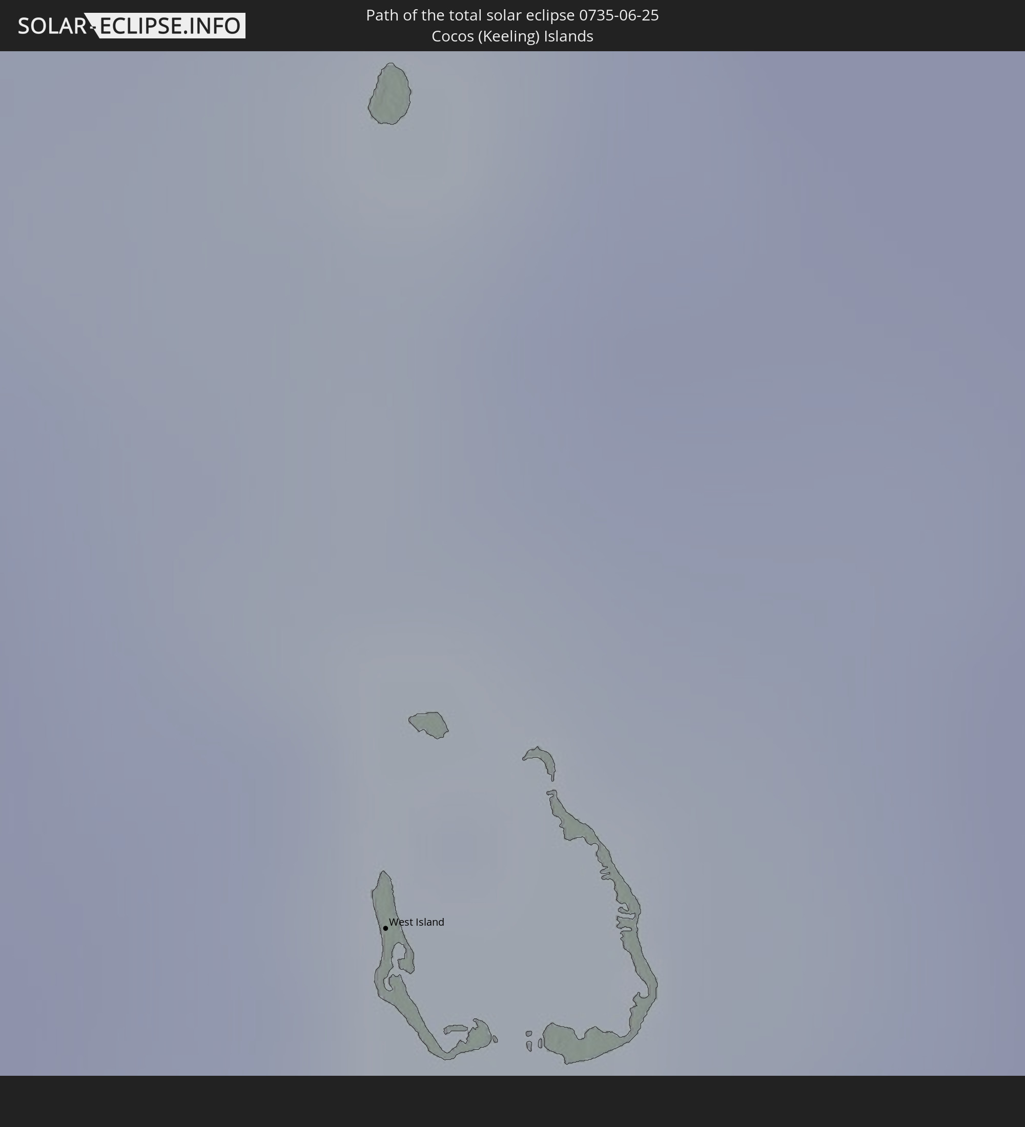 Kokosinseln
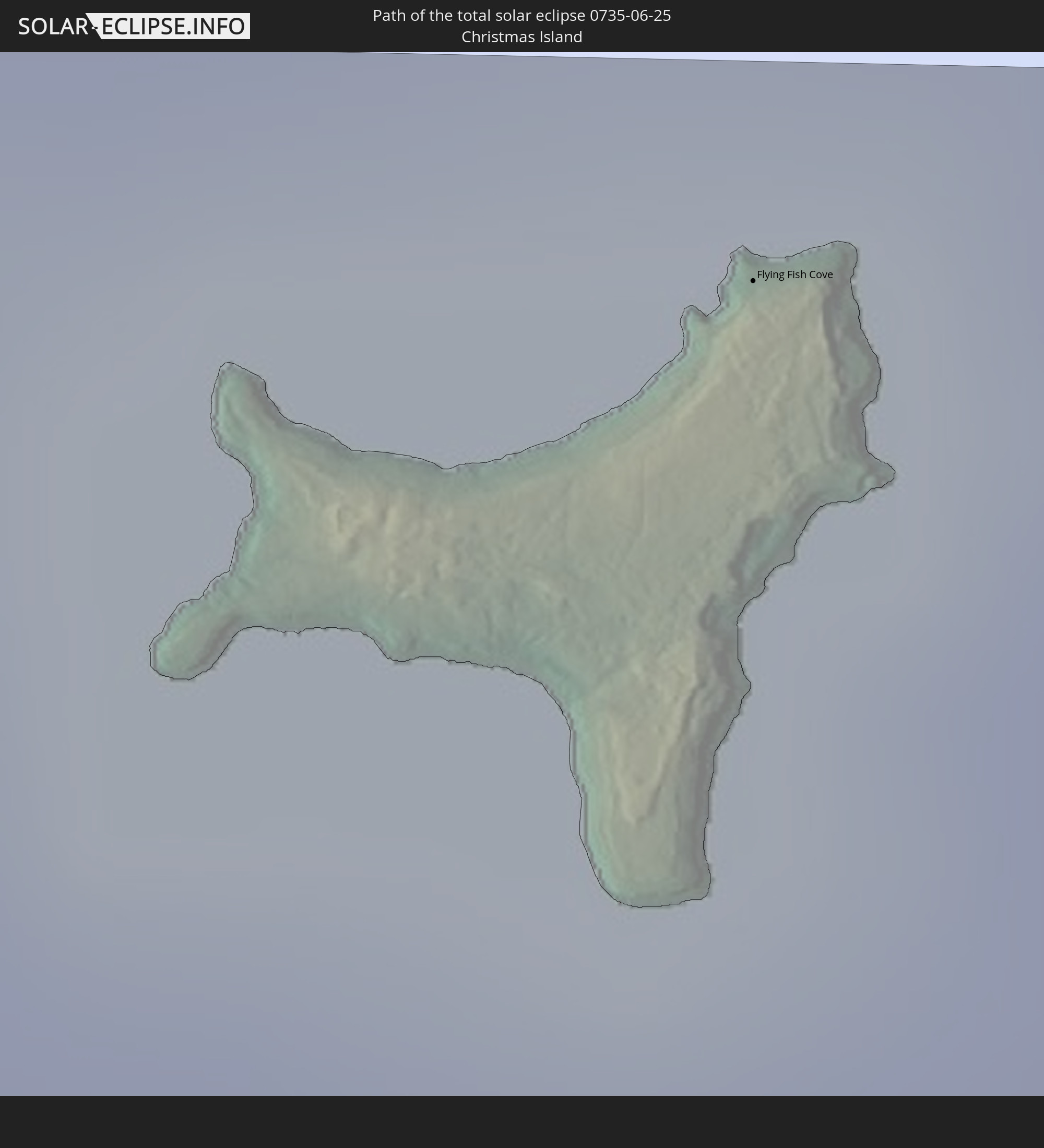 Weihnachtsinsel
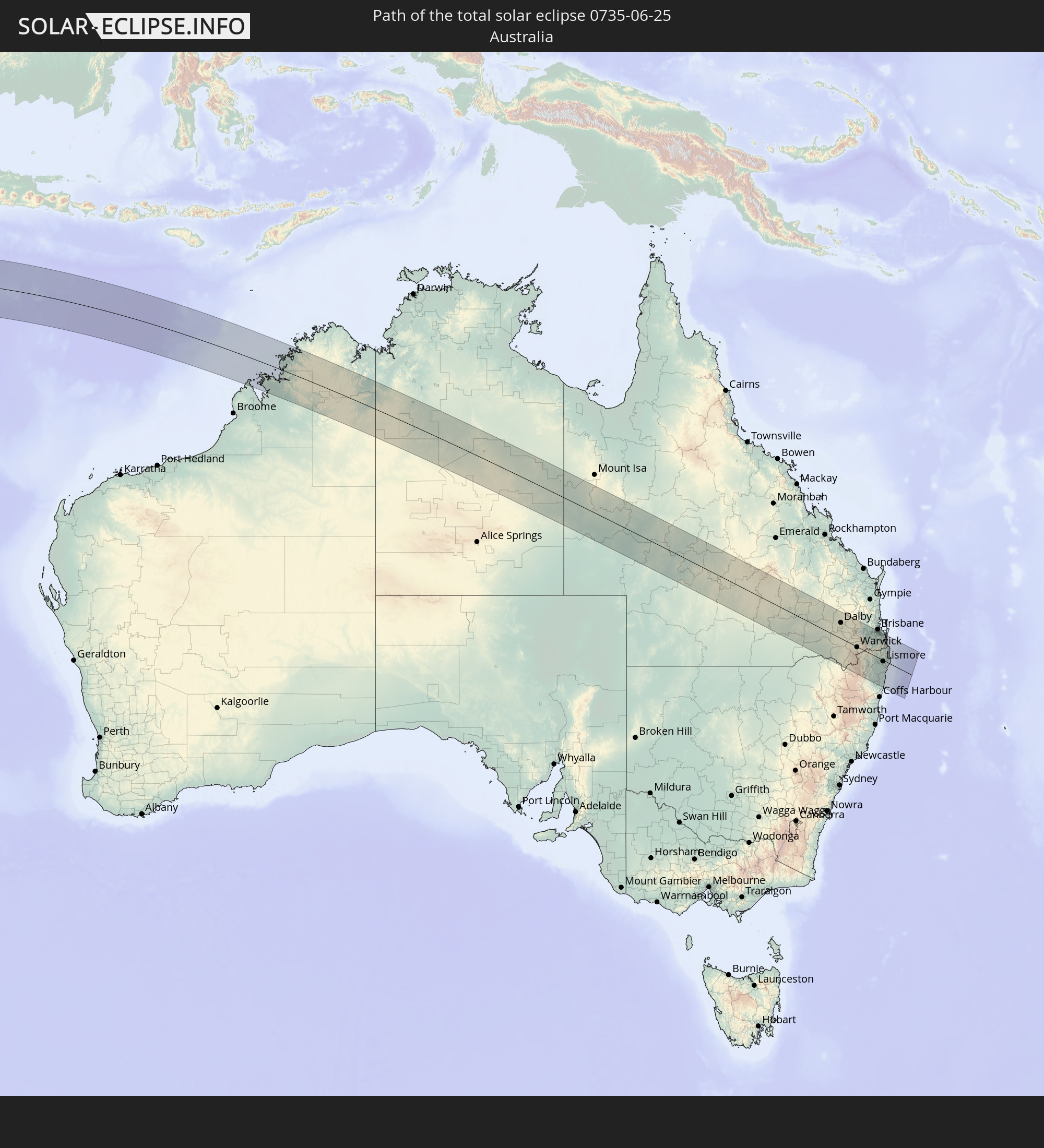 Australien
In den folgenden Ländern ist die Sonnenfinsternis partiell zu sehen
 Antarktika
 Tansania
 Mosambik
 Kenia
Kenia
 Französische Süd- und Antarktisgebiete
 Madagaskar
 Komoren
 Mayotte
 Seychellen
 Réunion
 Mauritius
 Indien
 Britisches Territorium im Indischen Ozean
 Heard und McDonaldinseln
 Malediven
 Volksrepublik China
 Sri Lanka
 Myanmar
 Indonesien
 Kokosinseln
 Thailand
 Malaysia
 Laos
Laos
 Vietnam
 Kambodscha
 Singapur
 Weihnachtsinsel
 Australien
 Brunei
 Philippinen
 Osttimor
 Palau
Palau
 Föderierte Staaten von Mikronesien
 Papua-Neuguinea
 Salomonen
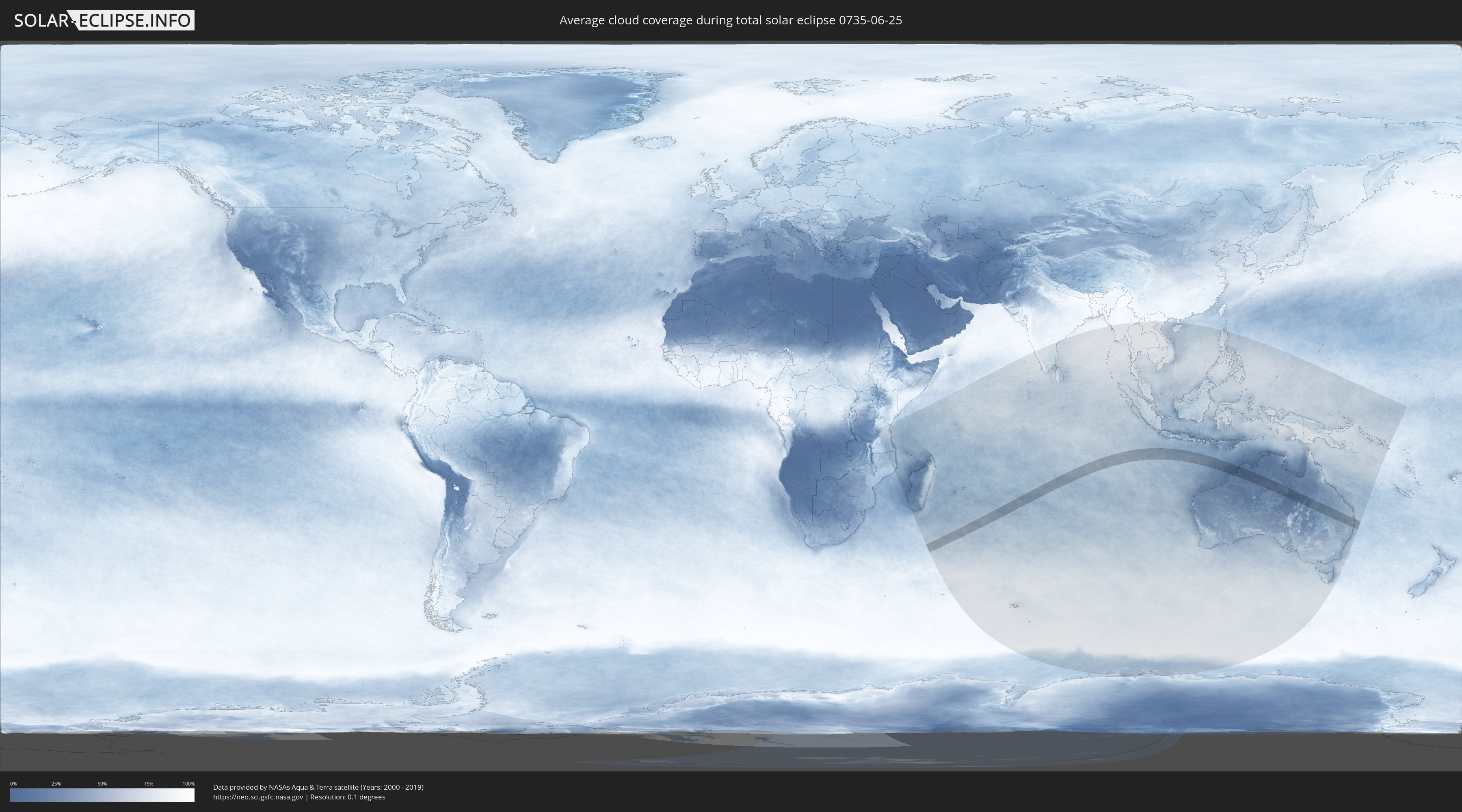
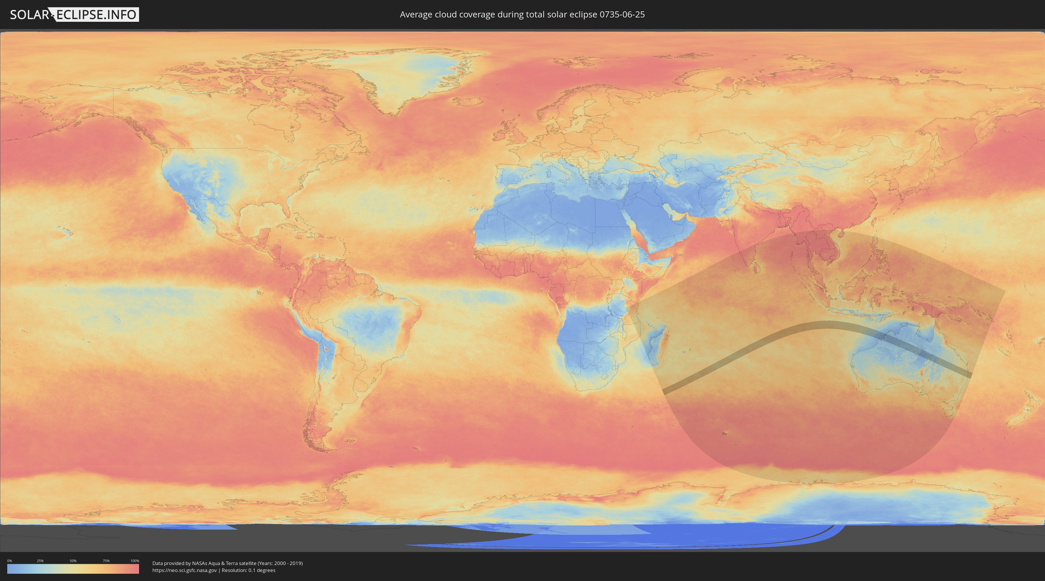
Wie wird das Wetter während der totalen Sonnenfinsternis am 25.06.0735?
Wo ist der beste Ort, um die totale Sonnenfinsternis vom 25.06.0735 zu beobachten?
Die folgenden Karten zeigen die durchschnittliche Bewölkung für den Tag, an dem die totale Sonnenfinsternis
stattfindet. Mit Hilfe der Karten lässt sich der Ort entlang des Finsternispfades eingrenzen,
der die besten Aussichen auf einen klaren wolkenfreien Himmel bietet.
Trotzdem muss man immer lokale Gegenenheiten beachten und sollte sich genau über das Wetter an seinem
gewählten Beobachtungsort informieren.
Die Daten stammen von den beiden NASA-Satelliten
AQUA und TERRA
und wurden über einen Zeitraum von 19 Jahren (2000 - 2019) gemittelt.
Detaillierte Länderkarten
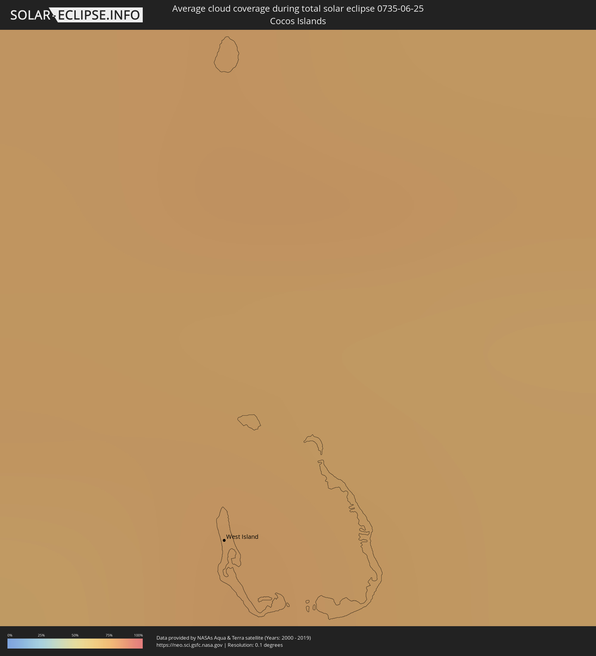 Kokosinseln
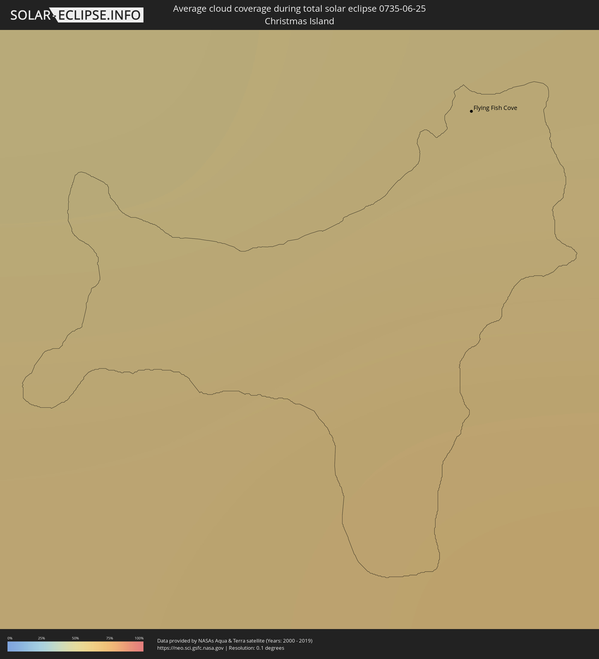 Weihnachtsinsel
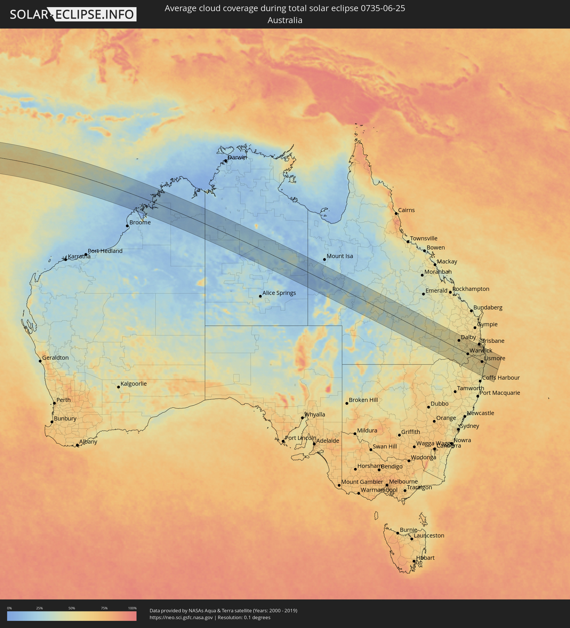 Australien
Orte im Finsternispfad
Die nachfolgene Tabelle zeigt Städte und Orte mit mehr als 5.000 Einwohnern, die sich im Finsternispfad befinden. Städte mit mehr als 100.000 Einwohnern sind dick gekennzeichnet. Mit einem Klick auf den Ort öffnet sich eine Detailkarte die die Lage des jeweiligen Ortes zusammen mit dem Verlauf der zentralen Finsternis präsentiert.
| Ort | Typ | Dauer der Verfinsterung | Ortszeit bei maximaler Verfinsterung | Entfernung zur Zentrallinie | Ø Bewölkung |
|
West Island
|
total | - | 11:36:14 UTC+06:30 | 50 km | 72% |
|
Flying Fish Cove
|
total | - | 12:34:03 UTC+07:00 | 144 km | 62% |
|
Roma, Queensland
|
total | - | 16:44:25 UTC+10:00 | 14 km | 48% |
|
Goondiwindi, Queensland
|
total | - | 16:43:47 UTC+10:00 | 113 km | 51% |
|
Dalby, Queensland
|
total | - | 16:45:15 UTC+10:00 | 65 km | 55% |
|
Darling Heights, Queensland
|
total | - | 16:45:15 UTC+10:00 | 55 km | 54% |
|
Toowoomba, Queensland
|
total | - | 16:45:18 UTC+10:00 | 59 km | 54% |
|
East Toowoomba, Queensland
|
total | - | 16:45:18 UTC+10:00 | 59 km | 54% |
|
Rangeville, Queensland
|
total | - | 16:45:17 UTC+10:00 | 58 km | 54% |
|
Warwick, Queensland
|
total | - | 16:44:51 UTC+10:00 | 2 km | 52% |
|
Gatton, Queensland
|
total | - | 16:45:26 UTC+10:00 | 74 km | 57% |
|
Gordon, New South Wales
|
total | - | 16:44:19 UTC+10:00 | 78 km | 54% |
|
Brassall, Queensland
|
total | - | 16:45:36 UTC+10:00 | 91 km | 59% |
|
Flinders View, Queensland
|
total | - | 16:45:35 UTC+10:00 | 87 km | 57% |
|
Raceview, Queensland
|
total | - | 16:45:35 UTC+10:00 | 89 km | 59% |
|
Booval, Queensland
|
total | - | 16:45:36 UTC+10:00 | 92 km | 59% |
|
Bundamba, Queensland
|
total | - | 16:45:37 UTC+10:00 | 93 km | 59% |
|
Redbank Plains, Queensland
|
total | - | 16:45:37 UTC+10:00 | 92 km | 60% |
|
Collingwood Park, Queensland
|
total | - | 16:45:38 UTC+10:00 | 95 km | 60% |
|
Goodna, Queensland
|
total | - | 16:45:39 UTC+10:00 | 97 km | 60% |
|
Springfield, Queensland
|
total | - | 16:45:38 UTC+10:00 | 93 km | 56% |
|
South Grafton, New South Wales
|
total | - | 16:44:05 UTC+10:00 | 109 km | 55% |
|
Grafton, New South Wales
|
total | - | 16:44:06 UTC+10:00 | 106 km | 55% |
|
Forest Lake, Queensland
|
total | - | 16:45:40 UTC+10:00 | 98 km | 62% |
|
Inala, Queensland
|
total | - | 16:45:42 UTC+10:00 | 102 km | 62% |
|
Tarragindi, Queensland
|
total | - | 16:45:46 UTC+10:00 | 110 km | 60% |
|
Casino, New South Wales
|
total | - | 16:44:48 UTC+10:00 | 20 km | 58% |
|
Sunnybank, Queensland
|
total | - | 16:45:44 UTC+10:00 | 106 km | 61% |
|
Sunnybank Hills, Queensland
|
total | - | 16:45:43 UTC+10:00 | 104 km | 61% |
|
Upper Mount Gravatt, Queensland
|
total | - | 16:45:46 UTC+10:00 | 110 km | 61% |
|
Woodridge, Queensland
|
total | - | 16:45:43 UTC+10:00 | 104 km | 61% |
|
Logan City, Queensland
|
total | - | 16:45:43 UTC+10:00 | 103 km | 61% |
|
Rochedale South, Queensland
|
total | - | 16:45:45 UTC+10:00 | 108 km | 61% |
|
Springwood, Queensland
|
total | - | 16:45:45 UTC+10:00 | 107 km | 61% |
|
Waterford West, Queensland
|
total | - | 16:45:41 UTC+10:00 | 99 km | 59% |
|
Slacks Creek, Queensland
|
total | - | 16:45:44 UTC+10:00 | 104 km | 60% |
|
Tamborine Mountain, Queensland
|
total | - | 16:45:31 UTC+10:00 | 75 km | 54% |
|
Beenleigh, Queensland
|
total | - | 16:45:42 UTC+10:00 | 100 km | 60% |
|
Lismore, New South Wales
|
total | - | 16:44:55 UTC+10:00 | 5 km | 60% |
|
East Lismore, New South Wales
|
total | - | 16:44:55 UTC+10:00 | 6 km | 60% |
|
Upper Coomera, Queensland
|
total | - | 16:45:36 UTC+10:00 | 86 km | 56% |
|
Oxenford, Queensland
|
total | - | 16:45:37 UTC+10:00 | 88 km | 56% |
|
Goonellabah, New South Wales
|
total | - | 16:44:56 UTC+10:00 | 4 km | 60% |
|
Nerang, Queensland
|
total | - | 16:45:33 UTC+10:00 | 79 km | 54% |
|
Murwillumbah, New South Wales
|
total | - | 16:45:20 UTC+10:00 | 48 km | 57% |
|
Southport, Queensland
|
total | - | 16:45:36 UTC+10:00 | 84 km | 58% |
|
Varsity Lakes, Queensland
|
total | - | 16:45:31 UTC+10:00 | 72 km | 55% |
|
Burleigh Waters, Queensland
|
total | - | 16:45:31 UTC+10:00 | 72 km | 55% |
|
Surfers Paradise, Queensland
|
total | - | 16:45:35 UTC+10:00 | 82 km | 58% |
|
Gold Coast, Queensland
|
total | - | 16:45:35 UTC+10:00 | 82 km | 58% |
|
Palm Beach, Queensland
|
total | - | 16:45:31 UTC+10:00 | 72 km | 55% |
|
Tweed Heads West, New South Wales
|
total | - | 16:45:29 UTC+10:00 | 68 km | 56% |
|
Banora Point, New South Wales
|
total | - | 16:45:28 UTC+10:00 | 66 km | 56% |
|
Ballina, New South Wales
|
total | - | 16:45:00 UTC+10:00 | 3 km | 54% |
|
Kingscliff, New South Wales
|
total | - | 16:45:27 UTC+10:00 | 63 km | 53% |
|
East Ballina, New South Wales
|
total | - | 16:45:00 UTC+10:00 | 3 km | 54% |
|
Byron Bay, New South Wales
|
total | - | 16:45:11 UTC+10:00 | 27 km | 56% |